CO-364
FRENCH TOPOGRAPHIC AND HYDROGRAPHIC SURVEYS OF DALMATIA IN THE
NAPOLEONIC PERIOD
ALTIC M. Institute of Social Sciences, ZAGREB, CROATIA The Treaty of Pressburg signed between Austria and France in December 1805 incorporated the entire Croatian coast into Napoleon's French Empire. Though only seven years under the French rule, Croatia owes France a debt of gratitude for the first systematic topographic survey of Dalmatia, conducted between 1806 and 1811, as well as for the first hydrographic survey of the Adriatic, conducted between 1806 and 1809. This paper analyzes all the above stated maps and charts that were created during the French topographic and hydrographic surveys of the Croatian coast, presenting the results of new research and displaying some of the hitherto unpublished maps and charts from the period of the French administration of Dalmatia. At the same time, the paper assesses the overall contribution of French cartography to the mapping of the Croatian Adriatic coast, discussing the impact of the above stated surveys on the French-Croatian cultural and scientific connections during the Napoleonic period.
I – THE FIRST HYDROGRAPHIC SURVEY OF THE EASTERN ADRIATIC COAST (1806-1809)
The interest of the French in mapping the Croatian littoral was due to the geostrategic position of Dalmatia in the Napoleonic Wars. From 1806, when the French gained control of Dalmatia, through 1813, when the entire Dalmatian coast was re-incorporated into Austria, the Croatian side of the Adriatic was playing an important role in the war between France, Russia and England. Because of numerous naval operations of the French against the English in the Adriatic, as early as 1806, Napoleon ordered a hydrographic reconnaissance of the entire Croatian Adriatic coast. The survey, conducted under the leadership of the French cartographer Charles-François Beautemps-Beaupré, took three years. The hydrographic reconnaissance of the Adriatic in the Napoleonic period was the first hydrographic survey of the Adriatic in history and one of the oldest such surveys in the world . The Napoleonic Atlas of the Adriatic Coast (1806)
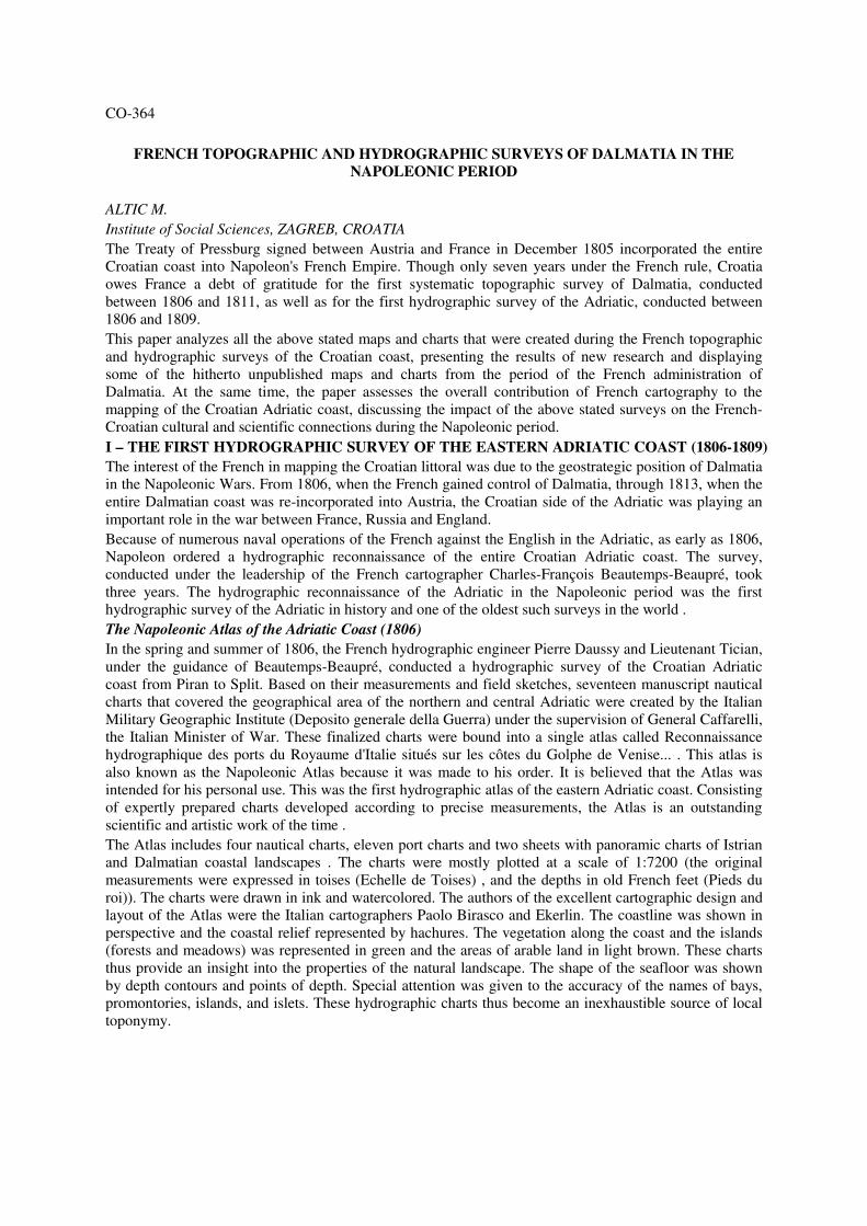
In the spring and summer of 1806, the French hydrographic engineer Pierre Daussy and Lieutenant Tician, under the guidance of Beautemps-Beaupré, conducted a hydrographic survey of the Croatian Adriatic coast from Piran to Split. Based on their measurements and field sketches, seventeen manuscript nautical charts that covered the geographical area of the northern and central Adriatic were created by the Italian Military Geographic Institute (Deposito generale della Guerra) under the supervision of General Caffarelli, the Italian Minister of War. These finalized charts were bound into a single atlas called Reconnaissance hydrographique des ports du Royaume d'Italie situés sur les côtes du Golphe de Venise... . This atlas is also known as the Napoleonic Atlas because it was made to his order. It is believed that the Atlas was intended for his personal use. This was the first hydrographic atlas of the eastern Adriatic coast. Consisting of expertly prepared charts developed according to precise measurements, the Atlas is an outstanding scientific and artistic work of the time . The Atlas includes four nautical charts, eleven port charts and two sheets with panoramic charts of Istrian and Dalmatian coastal landscapes . The charts were mostly plotted at a scale of 1:7200 (the original measurements were expressed in toises (Echelle de Toises) , and the depths in old French feet (Pieds du roi)). The charts were drawn in ink and watercolored. The authors of the excellent cartographic design and layout of the Atlas were the Italian cartographers Paolo Birasco and Ekerlin. The coastline was shown in perspective and the coastal relief represented by hachures. The vegetation along the coast and the islands (forests and meadows) was represented in green and the areas of arable land in light brown. These charts thus provide an insight into the properties of the natural landscape. The shape of the seafloor was shown by depth contours and points of depth. Special attention was given to the accuracy of the names of bays, promontories, islands, and islets. These hydrographic charts thus become an inexhaustible source of local toponymy.
Fig 1 Detail of the Beautemps-Beaupré’s nautical chart showing surroundings of town of Pula The Atlas also includes a comprehensive military report which testifies to the fact that the survey was conducted for military purposes and by order of Napoleon . The report manuscript, with its 65 pages, forms an integral part of the Atlas. It is written on the paper embellished with the portrait of Napoleon and the symbol of the French Imperial Eagle. The introductory part of the report describes the shortcomings of the existing nautical charts of the Adriatic, showing the general geographical and geopolitical situation of that part of eastern Adriatic coast. Then follow detailed descriptions of all individual ports shown on the charts in the Atlas. Special attention is given not only to detailed description of anchorages, ocean currents, tides, prevailing winds, and magnetic declination, but also to descriptions of coastal configuration, sources of potable water, possibilities of obtaining fuelwood, and conditions for possible human habitation on the coast in general. The report was autographed by Minister François-Marie Caffarelli du Forga and Charles François Beautemps-Beaupré. One of the first such surveys in the world, Beautemps-Beaupré's hydrographic survey of the eastern Adriatic coast represented the state of the art in cartographic science at that time. The manuscript Napoleonic Atlas, which was based on information obtained in the aforementioned survey, is a unique cartographic monument that stands testament to the invaluable contribution of French cartographers to the mapping of the Croatian territory. Although some charts from this Atlas were reproduced in several manuscript copies , the Atlas itself was probably made in a single copy alone, and is thus unique and of inestimable value . Hydrographic Survey of Southern Adriatic in 1808 and 1809
The Napoleonic Atlas of the Adriatic only includes the cartographic views of northern and central Adriatic. This was due to Napoleon' war operations against the Russians in southern Adriatic in 1806 and 1807. The coast and islands south of Split, especially the area between Dubrovnik and the Bay of Kotor were the scenes of constant conflict and struggle to control the territory partially occupied by the Russian fleet. Since a hydrographic survey of southern Adriatic was not possible at that time, and the hydrographic data on northern and central Adriatic that were already collected were required in order to control the remaining part of the Adriatic, Beautemps-Beaupré only decided to finish the atlas with the charts he had completed until autumn 1806. Thereafter, further surveying was temporarily suspended due to the escalated war, and Beautemps-Beaupré returned to France on 26 September 1806. Only after the Russians were pushed out of southern Adriatic in August 1807 the decision was made to resume the hydrographic survey. During 1808 and 1809, aided by Lieutenant Tician, Beautemps-Beaupré conducted a hydrographic survey of the area between Dubrovnik and the Bay of Kotor. Eleven manuscript charts were created based on that survey, and were subsequently published under the common title Reconnaissance hydrographique du
Golfe de Cattaro et des environs de Raguse… . These charts were created according to the same principle and plotted by using the same technique as in the charts of the year 1806 . On 1 May 1810, in addition to the charts of southern Adriatic, Beautemps-Beaupré compiled a comprehensive military report modeled according to his 1806 report. After the survey of the areas of Dubrovnik and the Bay of Kotor was completed, the hydrographic survey of the Adriatic was not resumed during the remaining period of the French rule. Thus, the areas between Split and Dubrovnik remained largely hydrographically uncharted. Publication of Beautemps-Beaupré's Charts of the Adriatic in the Neptune de la Méditerranée
Even though France had lost control over Dalmatia in 1813, and they were only reproduced in a number of manuscript copies, due to the strategic importance of the Adriatic, Beautemps-Beaupré's hydrographic manuscript charts of eastern Adriatic did not sink into oblivion. In 1820 and 1821, they were printed as copper engravings by the Depot-general de la Marine. For that purpose, the charts were reduced to a smaller format; this will later facilitate their binding into atlases of more manageable sizes. The chart scale was reduced accordingly and was now much smaller (most of the charts were reduced to scales ranging from 1:11200 for more detailed charts to 1:30000 for charts covering larger areas). The chart scale was now expressed in nautical miles (Mille Marin), while the depth remained in French feet. The engraving was made by Etienne Collin. The selected charts, eleven in total, were then added to the Neptune de la Méditerranée, the maritime atlas of the Mediterranean published in Paris in about 1825 . Beautemps-Beaupré's charts of the Adriatic, until then known only to relatively few high ranking officers, thus became available to a wider number of seafarers. In 1877, the Depot-general de la Marine reprinted all Beautemps-Beaupré's charts of the Adriatic, incorporating corrections to the survey that were made by Austrian hydrographers in the meantime. II – THE FIRST SYSTEMATIC TOPOGRAPHIC SURVEY OF DALMATIA (1806-1811)
Immediately after establishing sovereignty, in addition to the hydrographic survey of the Adriatic, in order to assess the possibilities for moving his troops in the coastal hinterland, Napoleon ordered a topographic survey as well. Already in 1806, General Mathieu Dumas issued an order to conduct a topographic survey of Dalmatia. As the matter was urgent, the first topographic map was created by joint efforts of Italian and French engineers. In the next months, four engineers-geographers were singled out from the Italian topographic office and placed under the command of General Poitevin, a military engineer commander based in Split . The urgency of the work and the proximity of the enemy in certain areas did not allow for engaging in detailed mapping, and on-site inspections were carried out in a hurry, especially those in the vicinity of Zadar and Dubrovnik. Despite such problems, the engineers managed to measure the depths of harbors and passages, the positions of islands, and their exact distance from the mainland. The position of single measuring points was determined using a clinometer and compass, because there was unfortunately not enough time to wait for the completion of coastal height measurements that were carried out by the hydrographer Beautemps-Beaupré. For the first time, the survey included measuring of lake depths, and information of the Venetian cadastre was used to indicate agricultural crops. As early as 1807, the topographic map of central and southern Dalmatia was completed at a scale of 1:80000, and included 48 sheets . Until 1811, the map of northern Dalmatia with Kvarner islands had
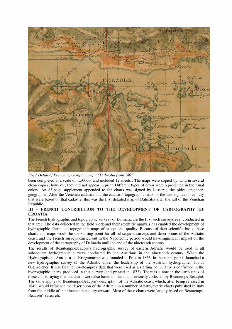
Fig 2 Detail of French topographic map of Dalmatia from 1807 been completed at a scale of 1:50000, and included 12 sheets . The maps were copied by hand in several clean copies; however, they did not appear in print. Different types of crops were represented in the usual colors. An 83-page supplement appended to the charts was signed by Lassaret, the oldest engineer-geographer. After the Venetian cadastre and the cadastral-topographic maps of the late eighteenth century that were based on that cadastre, this was the first detailed map of Dalmatia after the fall of the Venetian Republic. III - FRENCH CONTRIBUTION TO THE DEVELOPMENT OF CARTOGRAPHY OF
CROATIA
The French hydrographic and topographic surveys of Dalmatia are the first such surveys ever conducted in that area. The data collected in the field work and their scientific analysis has enabled the development of hydrographic charts and topographic maps of exceptional quality. Because of their scientific basis, these charts and maps would be the starting point for all subsequent surveys and descriptions of the Adriatic coast, and the French surveys carried out in the Napoleonic period would have significant impact on the development of the cartography of Dalmatia until the end of the nineteenth century. The results of Beautemps-Beaupré's hydrographic survey of eastern Adriatic would be used in all subsequent hydrographic surveys conducted by the Austrians in the nineteenth century. When the Hydrograpische Amt k. u. k. Kriegsmarine was founded in Pula in 1866, in the same year it launched a new hydrographic survey of the Adriatic under the leadership of the Austrian hydrographer Tobias Österreicher. It was Beautemps-Beaupré's data that were used as a starting point. This is confirmed in the hydrographic charts produced in that survey (and printed in 1872). There is a note in the cartouches of these charts saying that the charts were also based on the data previously collected by Beautemps-Beaupré. The same applies to Beautemps-Beaupré's description of the Adriatic coast, which, after being released in 1849, would influence the description of the Adriatic in a number of bathymetric charts published in Italy from the middle of the nineteenth century onward. Most of these charts were largely based on Beautemps-Beaupré's research.

The topographic survey of Dalmatia conducted by the French from 1806-1811 was of inestimable importance not only for military but also for economic issues in Dalmatia. Until that time, there had not been any systematic topographic survey of Dalmatia, and the French topographic maps that were based on the triangulation method and geodetic measurements modeled on Cassini's survey of France, were unprecedented in that part of Croatia. Their importance and quality is confirmed by the fact that the aforementioned French topographic maps were also used by Austrian authorities following the restoration of the Austrian administration in Dalmatia in 1813 . The road network development projects that were resumed by the Austrians after the departure of the French were plotted on the base of French topographic maps. These maps thus played a significant role in the economic development of Dalmatia as well. Based on the foregoing, we can conclude that the brief French rule in Dalmatia left a lasting mark on the history of mapping of that part of the Croatian territory. The scientific foundation and accuracy of the data obtained in the hydrographic and topographic surveys of Dalmatia were recognized and acknowledged by all later cartographers who largely used the data of the stated surveys, thus giving recognition to the high achievements of the French cartography.


