
Carbon stock changes and carbon sequestration potentialof Flemish cropland soils
S T E V E N S L E U T E L *, S T E F A A N D E N E V E *, G E O R G E S H O F M A N *, PA S C A L B O E C K X w,
D A A N B E H E Y D Tw, O S WA L D VA N C L E E M P U Tz, I N G E M E S T D A G H z, P E T E R L O O T E N S z,L U C I E N C A R L I E R z, N A N C Y VA N C A M Pw, H A N S V E R B E E C Kw, I N G E VA N D E WA L L Ew,
R O E L A N D S A M S O Nw, N O E L L U S T w and R A O U L L E M E U R w*Department of Soil Management and Soil Care (Ghent University), Coupure Links 653, 9000 Gent, Belgium, wFaculty of
Agricultural and Applied Biological Sciences (Ghent University), Coupure Links 653, 9000 Gent, Belgium zAgriculturalResearch Centre – Gent, Burg. Van Gansberghelaan 96, 9820 Merelbeke, Belgium
Abstract
Evaluations of soil organic carbon (SOC) stocks are often based on assigning a carbon
density to each one of a number of ecosystems or soil classes considered, using data from
soil profiles within these categories. A better approach, in which the use of classification
methods by which extrapolation of SOC data to larger areas is avoided, can only be used
if enough data are available at a sufficiently small scale. Over 190 000 SOCmeasurements
(0–24 cm) have been made in the Flemish cropland (the Northern part of Belgium) in the
1989–2000 period. These SOC data were grouped into 3-year periods and as means plus
standard deviation per (part of) community (polygons). This large dataset was used to
calculate SOC stocks and their evolution with time, without data extrapolation. Using a
detailed soil map, larger spatial groups of polygons were created based on soil texture
and spatial location. Linear regression analysis showed that in the entire study area, SOC
stocks had decreased or at best had remained stable. In total, a yearly decrease of
354kton OCyr� 1 was calculated, which corresponds with a net CO2 emission of
1238 kton CO2 yr� 1. Specific regions with a high carbon sequestration potential were
identified, based on SOC losses during the 1989–2000 period and the mean 1999 SOC
content, compared to the average SOC content of soils in Flanders with a similar soil
texture. When restoring the SOC stocks to their 1990 level, we estimated the carbon
sequestration potential of the Flemish cropland soils to be some 300kton CO2 yr� 1 at
best, which corresponds to a 40-year restoration period. In conclusion, we can say that in
regions where agricultural production is very intense, carbon sequestration in the
cropland may make only a very modest contribution to a country’s effort to reduce
greenhouse gas emissions.
Keywords: Belgium, carbon sequestration, carbon stock, Kyoto protocol, land-use change, soil
management
Received 3 March 2003; revised version received 7 April 2003 and accepted 8 April 2003
Introduction
In its article 3.4, the Kyoto Protocol allows carbon
dioxide emissions to be offset by demonstrable removal
of carbon from the atmosphere by improved manage-
ment of agricultural soils. In order to use this
possibility, a good estimate of soil organic carbon
(SOC) stocks and baseline emissions (in 1990) from
agricultural soils are crucial factors. Moreover, article
3.4 literally states: ‘Each Party included in Annex I shall
provide, for consideration by the Subsidiary Body for
Scientific and Technological Advice, data to establish its
level of carbon stocks in 1990 and to enable an estimate
to be made of its changes in carbon stocks in
subsequent years’. Many countries are currently trying
to estimate the carbon sequestration potential of their
agricultural sector, but are facing a serious shortage of
historic as well as current SOC data. For Belgium,
however, to date no concrete estimates have so far been
made.Correspondence: Steven Sleutel, tel.1 32 9 264 6055,
fax1 32 9 264 6247, e-mail: [email protected]
Global Change Biology (2003) 9, 1193–1203
r 2003 Blackwell Publishing Ltd 1193
Evaluations of SOC stocks on a global scale are often
based on assigning a carbon density to each one of a
number of ecosystems or soil classes considered using
data from soil profiles within these categories (Rodrı-
guez-Murillo, 2001). Kern (1994) found that this so-
called ecosystem approach is convenient at a global
scale, but not so at more detailed scales; in that case a
soil classification is preferred. For example, Howard
et al. (1995), Arrouays et al. (2001) and Rodrıguez-
Murillo (2001) estimated carbon stocks for a number of
soil type and land use combinations, and then extra-
polated these data to a national level, based on soil and
land use maps. The relative scarcity of SOC data hence
always leads to the need for extrapolation when
regional or national SOC surveys are to be made,
which leads to increased uncertainties on the estimated
stocks. Estimation of SOC stocks without the need to
extrapolate and classify soils would lead to more
precise estimates of those stocks. However, this is
possible only when SOC data are available for the
whole study area and at the same scale for which other
data necessary for calculating the stocks are available.
Over 190 000 topsoil (0–24 cm) measurements have been
made on the Flemish cropland in the period 1989–2000
by the Belgian Pedological Service (Vanongeval et al.,
2000). With this very large amount of data that are
spread over the entire Flemish cropland area at our
disposal, we decided that this last approach was
eligible in our case, and would lead to less error
sources which are inherent to the use of a classification
method in which profile data are spatially extrapolated.
We used this unique large dataset to estimate SOC
stocks for the Kyoto baseline year 1990 and to estimate
changes in the SOC stock to a depth of 1 m during the
1990–1999 period for the Northern part of Belgium
(Flanders). We also tried to identify regions that had a
larger C-sequestration potential than others, and where
future carbon sequestration efforts should be concen-
trated.
Materials and methods
OC data
Our study area covered entire Flanders (the Northern
part of Belgium), containing about half of the total
cropland area of Belgium. Within Flanders, 7 agro-
pedological regions are defined based mainly on soil
texture, namely the Dunes, the Polders, the Sandy
region, the Sandy Loam Region, the Silt Region, the
Campines and the Pasture area of Liege. Over 190 000
SOC measurements were made in the Flemish cropland
in the period 1989–2000 to a depth of 24 cm. We
generated a map by overlaying these agro-pedological
regions with the administrative map of Flemish com-
munities, thereby splitting them into different poly-
gons. The SOC content data were available as means
and standard deviation per polygon. The data were
grouped into 3-year periods and in each period, the
middle year was taken as the representative date and
used in further calculations (Table 1). The distributions
of the mean SOC content for 1990 and 1999 in all
polygons were positively skewed (Fig. 1). After a
logarithmic transformation of both datasets (1990 and
1999), both skewness and kurtosis approached zero
(Table 2).
Regression of the SOC data against time
The coefficient of variation (CV) of the SOC content
within each polygon had a mean value of 32%. In
previous SOC survey studies, very large CVs were
obtained, e.g. within the biomes of the study of Jobbagy
& Jackson (2000), the average CV of SOC content was
64%. These results were in close agreement with a CV of
79% when grouping profiles in soil taxonomic units in
previous SOC budgets by Batjes (1996). Compared to
the above-cited results the CV found here seems small.
However, the polygons used here are much smaller
than in the other studies cited above and hence the CV
should still be considered as relatively large. We
wanted to use linear regression to calculate the changes
in SOC stocks between 1990 and 1999. However, since
only the mean SOC contents per polygon were
available to us, a simple regression model could not
be used because it would not take this large standard
deviation into account. Therefore, a weighted least
squares difference regression (WLS regression) (Neter
et al., 1996) was more appropriate for our data. In WLS
regression, the ‘weight’ used for each data point is
defined as the inverse of the variance of the dependent
(here the measured SOC content). The variance of the
dependent is composed of two terms: the sum of the
variance of the residuals and the variance of the mean
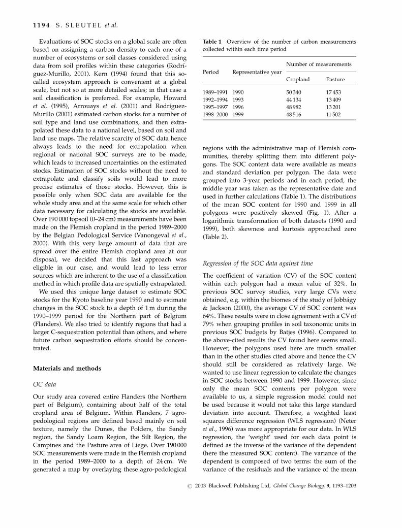
Table 1 Overview of the number of carbon measurements
collected within each time period
Period Representative year
Number of measurements
Cropland Pasture
1989–1991 1990 50 340 17 453
1992–1994 1993 44 134 13 409
1995–1997 1996 48 982 13 201
1998–2000 1999 48 516 11 502
1 1 9 4 S . S L E U T E L et al.
r 2003 Blackwell Publishing Ltd, Global Change Biology, 9, 1193–1203

SOC content per polygon itself. The latter is known, but
the variance of the residuals has to be estimated. The
following procedure was used. First, ordinary linear
regression was used to fit the regular regression model.
The unknown variance component can be estimated by
fitting the square of the obtained residuals themselves
against time, a process known as residualization of a
variable. The fitted values of this second regression are
an estimate of the unknown variance. The inverse sum
of the variance of the mean SOC content and the
estimated variances of the residuals was then used as
the weight in the WLS regression for each polygon
using SPSS 11.0.
Grouping of the polygons
For only 18% of all polygons, the WLS regression was
significant due to the low amount of data points (four
points per polygon, one for each date). Therefore, in
order to increase the number of data points in each
regression, the communities were grouped based on
their dominant soil textural class and their spatial
location.
A raster version (100 m� 100 m squares) of the digital
soil map of Flanders (Soil map 2001 distributed by OC-
GIS Flanders) was created in Arc View. This digital soil
map is based on the Belgian National Soil Survey that
was conducted between 1947 and 1962. It gives the soil
texture, drainage class and profile formation (according
to the Belgian Soil classification) on a 1 : 20 000 scale. In
the raster version used here only the soil texture was
included. The Belgian soil classification system distin-
guishes 8 different textural symbols. The correspon-
dence between each one of these classes and the USDA
classification is shown in Fig. 2. Using this map, the
predominant soil texture in each polygon was assigned
to the polygon in Arc View 3.1 and a map with
continuous areas of clustered polygons having the same
textural symbol was created. Grouping the polygons
based on soil texture only, however, would create too
large and too diverse areas to be practical and therefore
the grouping was also based on the spatial location of
the polygons. Indeed, the best classification must be
Fig. 1 Distribution of the mean SOC content per polygon for the years 1990 (left) and 1999 (right).
Table 2 Descriptive statistics of the measured mean SOC contents of all polygons for 1990 and 1999
Original data Ln-transformed data
1990 1999 Difference 1990 1999
(%OC) (%OC) (%OC) (ln(%OC)) (ln(%OC))
Mean 1.993 1.778 0.215 0.651 0.539
Variance 0.333 0.251 0.100 0.073 0.071
Skewness 1.413 1.105 1.403 0.312 0.380
Kurtosis 4.782 1.953 13.283 0.188 � 0.355
C A R B O N S T O C K C H A N G E S A N D C A R B O N S E Q U E S T R A T I O N 1 1 9 5
r 2003 Blackwell Publishing Ltd, Global Change Biology, 9, 1193–1203

that which gives the smallest coefficients of variation
(CVs) (Rodrıguez-Murillo, 2001). Based on these criter-
ia, 23 groups of polygons were then identified (Fig. 3).
No soil texture data were available for the most
Western coastal border of Flanders. The grouping of
polygons in that area was therefore based on another
soil map that describes soil texture and landscapes
(scale 1 : 100000) for the province of West-Flanders and
that was constructed at our department during the
National Soil classification. Three groups of polygons
were identified in that area, namely light polder soils
(light clay texture, group 24), heavy polder soils (heavy
clay texture, group 25) and the dunes (sandy texture,
group 26).
The condition of normality of the SOC data was
tested for each of the 26 groups of polygons. The data
were normally distributed for all groups except for
groups 8, 12, 16, 17, 20 and 22. Van Meirvenne et al.
(1996) also tested a large dataset containing over 900
SOC measurements made in the province of West-
Flanders. The distribution of these data was positively
skewed. Therefore, they used a logarithmic transforma-
tion to obtain a normally distributed dataset. None of
our non-normally distributed groups, however, had a
log normal distribution. However, after leaving out
outliers, group 22 was found to have a normal
distribution. Also, for groups 12, 16 and 17 the
deviation from normality was small as was indicated
by their histograms and the values of the associated
skewness and kurtosis (data not shown). Since F-tests
are fairly robust against small deviations of normality,
we decided that WLS regression could still be used to
analyse these groups, always bearing in mind that
results with P-values close to 0.05 would have to be
handled with caution. The large group 10 had a
binominal distribution and was therefore split into
two different groups (named 10 and 27), both then
having a normal distribution. The requirement of
equality of variances of the SOC content within each
group among the four different dates was tested using
Levene’s test. We chose to use Levene’s test as it is less
dependent on the condition of normality than other
tests used for this purpose, and it could therefore alsoFig. 2 Belgian soil classification textural symbols in relation to
the USDA soil classification.
Fig. 3 Map of clustered polygons based on soil texture and spatial location.
1 1 9 6 S . S L E U T E L et al.
r 2003 Blackwell Publishing Ltd, Global Change Biology, 9, 1193–1203

be used to analyse the data of groups 12, 16 and 17,
which were only approximately normally distributed.
Estimation of the carbon stock changes from the SOCcontent data
The results of the linear regression can be extrapolated
to carbon stock changes by taking into account the bulk
density and the cropland surface per polygon. There
are no indications that the average ploughing depth in
the study area had changed during the 1990s, therefore,
the measured changes of the SOC content correspond
directly with SOC stock changes. The term ‘cropland’
here refers to all land on which typical yearly crops are
grown (e.g. sugar beet, potato and wheat), but also
parcels with temporary pasture and vegetables in open
air. Cropland area figures on a community scale are
published yearly by the National Institute for Statistics
(NIS), which conducts a general poll with all Belgian
farmers (NIS, 1990). Assuming that the cropland area
within each community is spread uniformly, the crop-
land area of each one of the polygons constituting a
community could be calculated as a simple fraction of
the cropland area per community. The cropland area for
each group was then obtained by summing the area
from all of its constituting polygons.
Garnett et al. (2001) stated that uncertainty of SOC
inventories, which are based on the extrapolation of
profile data to a number of spatial classes, arises as a
consequence of: (i) problems in the classification of
vegetation and soil; (ii) inaccurate area estimates and
(iii) unrepresentative values for C content of soil and
vegetation types. Errors (i) and (iii) are not relevant to
our approach, error (ii) is also largely excluded in our
calculations as both cropland area figures and SOC data
were available at the same scale for almost all
communities.
Soil bulk density and extrapolation of OC content withdepth
The soil bulk density of each polygon was estimated
from its dominant soil texture, using the class-pedo-
transfer function presented by Van Hove (1969),
which gives a relationship between soil texture and
the bulk density for cropland in the northern part of
Belgium. The soil bulk density for a group was
calculated as a weighted mean of the individual bulk
densities of its polygons. In order to extrapolate the
carbon measurements (which were made in the upper
24 cm) to deeper soil layers, we used a carbon depth
distribution model, based on the exponential model
proposed by Hilinski (2001), which is the equation
currently implemented in the CENTURY 5.3.2. model,
and which was fitted to the Flemish profile data by
Sleutel et al. (2003) :
CðzÞ ¼ Cb þ C0 � Cbð Þe�Kz ð1Þ
where C(z), C0 and Cb are the carbon contents (g C g� 1
dry soil) at depth z (cm), at the surface layer and at the
bottom of the profile, respectively, and K is a scaling
constant (cm� 1). The parameters Cb and K were
calculated per agro-pedological region by Sleutel et al.
(2003) and C0 was known to us per polygon. For each
one of the groups, a weighted mean value of K and Cb
was calculated based on the spread of their constituting
polygons over the seven Flemish agro-pedological
regions. By integrating Eq. (1) between 0 and 100 cm
and multiplying with the soil bulk density, the carbon
stock could be calculated to a depth of 1 m.
Results and discussion
The sum of the SOC stocks of each group individually
yielded a total Flemish 1990 stock of 28 162 kton OC.
Levene’s test showed that for each group, the condition
of homoscedasticity (equal variance of the mean SOC
content between each of the four dates) was fulfilled.
The results of the WLS-linear regression:
%OC5 b01b1t, where b0 is the intercept (%OC), b1
the slope (%OC yr� 1) and t the time in years, are given
in Table 3. The regressions for groups 8 and 20 were not
valid since the distributions of their OC data were
strongly different from normality, but were still
performed in order to calculate total stock changes for
Flanders. The WLS-linear regression was significant for
all groups except for groups 4, 9, 14, 24, 25 and 26. This
insignificance of the regression can be due to either the
changes in SOC content being too small, or to the
groups being not homogeneous enough. For these
groups, no statistically significant conclusion can be
drawn about an increase or decrease of the SOC
content. For all other groups, the regression coefficient
b1 was negative and this implicated a significant
decrease of the measured SOC content. The 95%
confidence intervals of b1 were rather large (Fig. 4).
These large confidence intervals are a consequence of
the within-group variability (which had an average CV
of 16%) and the large standard deviation of the SOC
data within the polygons themselves. For group 13, an
unrealistically high value of b1 was obtained. However,
because this b1 had a very large standard error, the
reliability of this result seems very doubtful. The
regression parameters were recalculated to a yearly
SOC stock change for each group (Table 3). The sum of
these changes for all groups yielded a total SOC stock
change for Flanders of � 354 kton OC yr� 1.
C A R B O N S T O C K C H A N G E S A N D C A R B O N S E Q U E S T R A T I O N 1 1 9 7
r 2003 Blackwell Publishing Ltd, Global Change Biology, 9, 1193–1203

Assuming then that no mentionable differences
occurred in the loss of OC by leaching or soil erosion,
the decrease of the OC content can be expressed as a net
CO2 emission. The assumption of no erosion for this
study is a reasonable one, since the largest part of
Flanders shows very little or no relief at all, except for
Fig. 4 Confidence intervals of the estimated regression parameter b1 for each polygon group.
Table 3 Number of polygons, cropland area in 1990, estimated regression parameters and yearly OC stock changes per group
Group
Number of
polygons
(dimensionless) Cropland area (1990) (ha) b0 (% OC) b1 (% OC yr� 1) Stock change (kton OC yr� 1)
1 7 9246 1.75 � 0.026 � 14.4
2 18 6054 2.00 � 0.026 � 9.0
3 30 17 991 2.11 � 0.040 � 40.8
4 35 9014 1.66* � 0.012* � 6.5
5 25 40 903 1.23 � 0.014 � 33.0
6 11 4073 1.65 � 0.029 � 6.7
7 17 14 043 1.24 � 0.013 � 10.8
8 26 11 764 1.02w � 0.014w � 9.2
9 8 4618 0.94* � 0.006* � 1.6
10 26 19 559 1.10 � 0.012 � 13.8
11 19 5687 1.37 � 0.025 � 8.5
12 20 10 908 1.63 � 0.024 � 13.9
13 5 3004 1.96 � 0.061 � 16.4
14 5 2839 1.55* 0.001* 0.2
15 11 9825 1.42 � 0.023 � 3.8
16 35 36400 1.58 � 0.017 � 8.5
17 24 15 200 1.18 � 0.017 � 43.5
18 13 15 663 1.51 � 0.021 � 14.4
19 9 8282 1.23 � 0.016 � 16.7
20 21 14 449 1.13w � 0.009w � 4.8
21 8 3693 1.10 � 0.015 � 13.7
22 23 47 016 1.22 � 0.017 � 3.2
23 6 8308 1.19 � 0.020 � 51.2
24 9 13 129 1.33* � 0.004* � 1.6
25 10 12 838 1.57* � 0.010* � 5.0
26 9 4393 1.57a � 0.004* � 1.7
27 12 10 513 1.24 � 0.022 � 7.2
*Weighted linear regression was not significant (P5 0.05).
wRegression not statistically valid due to large deviation of normality (see explanation in text).
1 1 9 8 S . S L E U T E L et al.
r 2003 Blackwell Publishing Ltd, Global Change Biology, 9, 1193–1203

the Southern border, hence water erosion in the study
area is very limited. Furthermore, as precipitation is
spread uniformly over the year, soils are moist
throughout the year and wind erosion is a marginal
phenomenon. Carbon loss by methane emissions was
not considered as most cropland soils in Flanders are
adequately drained. Belgium reported a net emission of
0 kton CO2 in the period 1990–1997 from agricultural
soils, which implies that no changes of the OC content
would have occurred during that period due to human-
induced activities in the Belgian cropland. However,
from the results of this study, it is clear that no such
condition of steady state existed in that period, but
rather there was a net emission of 1319 kton CO2 yr� 1
for the Northern part of Belgium.
The greatest potential to increase current soil carbon
stocks will probably be through improved management
of agricultural land, particularly degraded croplands
(Batjes, 1999). To identify the carbon sequestration
potential of soils, two factors are of particular impor-
tance, namely their current SOC content compared to
average SOC contents for those climatic conditions, and
recent changes in SOC stocks that have occurred.
Increases in soil carbon are finite with systems
tending toward new equilibria after 50–100 years,
whereby carbon accumulation slows and eventually
stops (Smith et al., 1997). Hassink & Whitmore (1997)
observed that the net rate of accumulation of SOC
depends on the extent to which the soil is already
saturated with SOC (i.e. the size and capacity of the
reservoir). Consequently, a soil’s carbon sequestration
potential at a given time depends on the carbon stock
present in that soil at that time. Many studies have
reported a relationship between stabilization of OC in
soils and clay or (silt1 clay) content, which is under-
stood to be the result of the chemical or physicochem-
ical binding between SOM and soil minerals, i.e. clay
and silt particles (Six et al., 2002). The individual SOC
content of each polygon should therefore be rated by a
comparison within textural groups. The mean of the
1999 SOC contents of all polygons for each textural
class are given in Table 4. By comparing the mean SOC
content within a polygon with the mean SOC content
for its textural symbol (Table 4), areas with small or
large SOC contents were identified (Fig. 5). Based on
this comparison three main areas with small SOC
contents could be identified.
The first area corresponds to the arable cropping
region lying east of Brussel near Leuven (location see
Fig. 3). Soils in this area have a silt or silt loam texture.
Historically (starting mainly after WWII), most of the
traditional mixed farms with livestock and arable crops
in this region were replaced by arable cropping farms,
with a concomitant reduction in the input of organic
material from animal manure. Between 1990 and 2000,
the number of pigs in the district Leuven (30 commu-
nities) still decreased by 10% (NIS, 1990, 2000). The
relative density of pigs to the cropland area of each
community (i.e. number of pigs per community/ha
cropland area per community) (year 2000) was posi-
tively correlated (Pearson’s corr. coeff. (R)5 0.455;
P5 0.05) with the relative difference between the mean
SOC content per community and the average SOC
content of their corresponding textural class (Fig. 6).
Similarly, the correlation was also significant and
positive (R5 0.375; P5 0.05) for the relative number
of cattle (Fig. 6) per cropland area, but only when one
community was left out of the correlation (this was a
Table 4 Number of polygons, soil bulk density, mean SOC content and standard deviation (stdev) per textural class
Textural class* –
predominant
USDA textural
class
Number of
polygons (dimensionless)
Soil bulk
density (g cm� 3)
Mean SOC
content 1999 (%OC)
stdev SOC
content 1999 (%OC)
Z – sand 85 1.37 1.73 0.35
S – loamy sand 68 1.42 1.50 0.40
P – sandy loam 46 1.47 1.27 0.30
L – silt loam 121 1.44 1.14 0.21
A – silt/(silt loam) 85 1.43 1.07 0.18
E – (clay) loam 7 1.34 1.33 0.28
U – (sandy/silty) clay 1 1.20 1.84 0.00
LP – clay 6 1.34 1.49 0.19
HP – clay 9 1.20 1.54 0.24
D – sand 7 1.37 1.49 0.26
*LP: light polder soils, HP: heavy polder soils, D: dunes; for a more precise description of the other symbols, see Fig. 2.
C A R B O N S T O C K C H A N G E S A N D C A R B O N S E Q U E S T R A T I O N 1 1 9 9
r 2003 Blackwell Publishing Ltd, Global Change Biology, 9, 1193–1203

community with an extremely high SOC content as
compared to the surrounding communities, and with a
very large CV). These results indicate that in the region
surrounding Leuven communities with less dense
animal production, and which are thus more focused
on arable farming, have relatively lower SOC contents
when taking into account soil texture. This seems to
support our hypothesis that the low SOC content of this
region is a consequence of the shift from mixed farming
to pure arable cropping.
For the other two areas, no direct correlation could be
found between farming management and the mean
SOC content of the polygons. The second area having a
relatively low SOC content is located North and North-
East of Kortrijk. Soils in this region have a soil texture
between sand and silt loam. We could not designate a
possible reason for the relatively low SOC content of
these soils. The area cannot be distinguished from other
agricultural regions in Flanders with the same soil
texture as adopting a farming management which is
very different. A third region, which is characterized by
polygons that have relatively small SOC contents, is
located along the North-western border of Flanders.
Most of these soils have sandy and loamy sand
textures. The relatively low SOC contents, compared
to the textural average, were probably also associated
with very large SOC contents of polygons in other
regions that belong to the same textural class (such as
the Northern Campine soils, see below).
From Table 3 it can be concluded that high losses
occurred in the North-eastern part of Flanders (groups
1, 2, 3 and 6), and the restoration of lost SOC may be
easier there than in other parts of Flanders. These
groups correspond with the Northern Campine soils,
which have sandy and loamy sand soil textures and in
which a large part of the Belgian intensive livestock
breeding (pigs and poultry) is located, hence the very
large SOC contents in 1990. However, the application of
manure in Flanders has been restricted by law since the
beginning of the 1990s when the Manure Action Plan
Fig. 5 Difference between the mean SOC content of each polygon and the mean SOC content for all the polygons of its textural class.
Fig. 6 Scatter plot between the livestock density per commu-
nity (number of livestock units per hectare cropland) in the
Leuven district and the difference between the mean SOC
content per community with the Flemish average SOC content of
the corresponding textural class (D% SOC).
1 2 0 0 S . S L E U T E L et al.
r 2003 Blackwell Publishing Ltd, Global Change Biology, 9, 1193–1203

(De Batselier, 1993) came into force. This, in combina-
tion with the very light texture of these soils, may
explain the strong decrease of the SOC content in this
region during the 1990–1999 period. Almost all Cam-
pine soils still had a relatively high mean SOC content
in 1999 (Fig. 5). This shows how management for
carbon sequestration in some cases may be in conflict
with management designed to mitigate other environ-
mental problems, such as nitrogen leaching. Areas in
Europe, with an intensive agricultural activity, compar-
able to our study area, can be deduced from manure
and fertilizer use on a per ha basis. In general, livestock
production in Belgium (Flanders), Denmark, Ireland,
The Netherlands and the UK is intensive, while in other
countries intensive livestock production is limited to
specific regions such as the Po Valley in Italy, Brittany in
France, Catalunia in Spain and the North-western part
of Germany (De Clercq et al., 2001). Furthermore, long-
term data suggest that the manure production in the EU
is declining (De Clercq et al., 2001; OECD, 2001). De
Clercq et al. (2001) then showed that the trend in
nutrient use during the 1990s in Belgium is occurring in
most other countries as well, with a slight decrease of
the yearly national N-surpluses. This slight extensifica-
tion of European agriculture may have contributed to
the recent carbon stock changes by reducing organic
matter input from manure applications.
Our study seriously questions the assumption that no
recent changes have occurred in SOC stocks within
regions with an intensive cropland production.
Although our results apply only to Flanders, there are
other indicators that similar evolutions possibly have
occurred in many other regions in Europe with
comparable agricultural activity. Vleeshouwers & Ver-
hagen (2002) simulated fluxes in SOC content in Europe
(t C ha� 1 yr� 1) for the commitment period 2008–2012,
taking into account climatic, soil and crop factors.
Results were rendered on a 0.5� 0.51 grid and were
taken as the weighted average of eight arable crop
categories considered in each grid cell. For the
business-as-usual scenario all arable fields in Europe
showed to be net sources with an average decrease of
the SOC stock of � 0.84 t C ha� 1 yr� 1. Our calculations
yielded an average decrease of � 0.90 t C ha� 1 yr� 1 for
Flanders, which corresponds very well with the
simulation results obtained by Vleeshouwers & Verha-
gen (2002). They clearly showed that this decreasing
trend is a general trend in Europe. These findings
support the hypothesis that the decrease of the mean
SOC% of Flemish cropland soils during the 1990s is also
applicable to other regions in Europe that have a
comparable agricultural management.
The problem of data availability will be a major
obstruction for verifying whether stocks have actually
changed in regions other than the study area. We had
0.12 measurements ha� 1 cropland per 3-year period on
average, an unusual sampling density which is not
available for other regions in Europe. However, the
average standard deviation of the measurements
remained about one-third of the mean SOC% at the
small community scale. The quality of SOC maps may
be improved and spatial sampling intensities reduced
by incorporating secondary data to enhance spatial
estimates (Mueller & Pierce, 2003). In our approach, we
used soil texture as a second soil property by which
SOC data could be grouped into larger, more or less
homogeneous groups. For these groups statistically
significant results could be obtained, where this was
first impossible with the ungrouped results. For the
temporal analysis of SOC data in other regions with
much less available data, the grouping of SOC data
based on other meaningful and readily available soil
properties (e.g. soil texture, drainage class and profile
development) will be needed.
In theory, by merely restoring SOC content in Flemish
cropland soils to their pre-1990 condition, a total of
3200 kton OC or 11 700 kton CO2 would be sequestered.
Smith et al. (2000) summarized the yearly potential SOC
accumulation rates (in % of the SOC present in the soil)
for a number of land management practices: on average
0.43% for use of animal manure, 0.49% for use of
sewage sludge, 0.73% for no-till farming (including
fossil fuel savings) and 1.02% for agricultural extensi-
fication (e.g. ley-arable rotations). Assuming that these
management practices are applicable to restore the SOC
losses in the Flemish cropland reported here, theoreti-
cally at best a time period of about 13–30 years would
be necessary to restore the pre-1990 SOC stocks. If we
therefore assume that a period of 20 years (more than
twice the period in which the SOC was lost) is needed
for this restoration, about 600 kton CO2 can be
sequestered per year. Belgium has committed itself to
an average 7.5% reduction of its 1990 baseline emis-
sions during the 2008–2012 commitment period, i.e.
a reduction of 10080 kton CO2 yr� 1. The 600 kton
CO2 yr� 1 due to restoration of pre-1990 SOC contents
of the Flemish cropland could thus only account for
about 6% of the total Belgian CO2-emission reduction
under the Kyoto Protocol. These calculations, however,
are theoretical, and in practice we cannot expect that
these management options will be implemented on all
Flemish cropland soils, nor do we expect them to
always yield as high SOC accumulations as mentioned
by Smith et al. (2000). Van Meirvenne et al. (1996)
studied changes in SOC in the province of West-
Flanders covering a 40-year period, revisiting 983
locations that were used as arable land. An increase
of 9.3 t OC ha� 1 of the mean SOC content was observed
C A R B O N S T O C K C H A N G E S A N D C A R B O N S E Q U E S T R A T I O N 1 2 0 1
r 2003 Blackwell Publishing Ltd, Global Change Biology, 9, 1193–1203
over a 40-year period, for which they indicated the
concomitant large increase in pig breeding in that
period to be the major source. These data may be more
realistic and would mean that a longer period of
perhaps 40 years may be necessary to restore the 1990
SOC stocks, which would mean a yearly C sequestra-
tion of only 300 kton CO2 yr� 1.
Conclusions
Identification of regions with a high carbon sequestra-
tion potential should be based on detailed and accurate
maps of SOC content. A massive database of SOC
measurements in Flanders was used to calculate SOC
stocks and stock changes between 1990 and 1999. The
regression analysis showed a general declining trend in
SOC content. A detailed soil map allowed us to identify
regions with SOC contents larger or smaller than
average. Three regions with a mean SOC content
smaller than average may specifically qualify for
carbon sequestration efforts to be aimed at by partially
restoring their SOC stocks. In the sandy Campine soils
in the most North-eastern part of Flanders, in which the
largest SOC stock losses have occurred, efforts should
be aimed at stopping this trend of declining SOC stocks.
However, these efforts could come into conflict with
efforts to reduce the nutrient inputs and nutrient losses
from agricultural soils (restriction on use of animal
manures). Practically, the restoration of all SOC lost
since 1990 in Flemish cropland soils may well take
about 40 years. Realistic scenarios of restoration of SOC
showed that in regions where intensive agricultural
production already makes up a large part of the
territory, as is the case in Flanders, carbon sequestration
may only make a very modest contribution to reducing
a country’s greenhouse gas emissions. Our study
challenges the assumption that no recent changes have
occurred in SOC stocks within regions with an
intensive cropland production. Cropland soils in other
regions in Europe (The Netherlands, Denmark, Brit-
tany, the Po Valley and North-western Germany) may
very well have undergone the same decrease of their
SOC stocks. The insufficient availability of SOC data for
these regions for the 1990s will make it nearly
impossible to verify this hypothesis.
Acknowledgements
This study was part of the CASTEC research project (Carbonsequestration potential in different Belgian terrestrial ecosys-tems: quantification and strategic exploration), funded by theBelgian Federal Office for Scientific, Technical and CulturalAffairs (OSTC).
References
Arrouays D, Deslais W, Badeau V (2001) The carbon content of
topsoil and its geographical distribution in France. Soil Use and
Management, 17, 7–11.
Batjes NH (1996) Total carbon and nitrogen in the soils of the
world. European Journal of Soil Science, 47, 151–163.
Batjes NH (1999) Management options for reducing CO2-
concentrations in the atmosphere by increasing carbon
sequestration in the soil. Report 410-200-031, Dutch National
Research Programme on Global Air Pollution and Climate
Change & Technical Paper 30, International Soil Reference and
Information Centre, Wageningen.
De Batselier N (1993) Mestactieplan. Vlaamse Landmaatschappij,
Brussels.
De Clercq P, Gertsis AC, Hofman G, Jarvis SC, Neeteson JJ,
Sinabel F (2001) Nutrient Management Legislation in European
Countries. Department of Soil Management and Soil Care,
Faculty of Agricultural and Applied Biological Sciences,
Wageningen.
Garnett MH, Ineson P, Stevenson AC, Howard DC (2001)
Terrestrial organic carbon storage in a British moorland.
Global Change Biology, 7, 375–388.
Hassink J, Whitmore AP (1997) A model of the physical
protection of organic matter in soils. Soil Science Society of
America Journal, 61, 131–139.
Hilinski TE (2001) Implementation of exponential depth
distribution of organic carbon in the CENTURY model.
http://www.nrel.colostate.edu/projects/century5/reference/
html /century/exp-c-distrib.html.
Howard PJA, Loveland PJ, Bradley RI, Dry FT, Howard DM,
Howard DC (1995) The carbon content of soil and its
geographical distribution in Great Britain. Soil Use and
Management, 11, 9–15.
Jobbagy EG, Jackson RB (2000) The vertical distribution of soil
organic carbon and its relation to climate and vegetation.
Ecological Applications, 10, 423–436.
Kern JS (1994) Spatial patterns of soil organic carbon in the
contiguous United States. Soil Science Society of America Journal,
58, 439–455.
Mueller TG, Pierce FJ (2003) Soil carbon maps: enhancing
spatial estimates with simple terrain attributes at
multiple scales. Soil Science Society of America Journal, 67,
258–267.
Neter J, Kutner MH, Nachtsheim CJ, Wasserman W (1996)
Applied Linear Statistical Models 4th edn. McGraw-Hill, New
York.
NIS (1990) Nationaal Instituut voor de Statistiek. Ministerie van
Economische Zaken, Brussels.
NIS (2000) Nationaal Instituut voor de Statistiek. Ministerie van
Economische Zaken, Brussels.
OECD (2001) OECD nitrogen balance database, http://
www.oecd.org/agr/env/indicators.env
Rodrıguez-Murillo JC (2001) Organic carbon content under
different types of land use and soil in peninsular Spain.
Biology and Fertility of Soils, 33, 53–61.
Six J, Conant RT, Paul EA, Paustian K (2002) Stabilization
mechanisms of soil organic matter: Implications for C-
saturation of soils. Plant and Soil, 241, 155–176.
1 2 0 2 S . S L E U T E L et al.
r 2003 Blackwell Publishing Ltd, Global Change Biology, 9, 1193–1203

Sleutel S, De Neve S, Hofman G (2003) Estimates of 1990 carbon
stock changes in Belgian cropland. Soil Use and Management,
19, 166–171.
Smith P, Powlson DS, Glendining MJ, Smith JU (1997)
Potential for carbon sequestration in European soils:
preliminary estimates of five scenarios using results
from long-term experiments. Global Change Biology, 3,
67–79.
Smith P, Powlson DS, Simth JU, Falloon P, Coleman K (2000)
Meeting Europe’s climate change commitments: quantitative
estimates of the potential for carbon mitigation by agriculture.
Global Change Biology, 6, 525–539.
Van Hove J (1969) Variation of the Content of Organic Matter and
the C/N-ratio in the Surface Horizons of Soils in Low- and Mid-
Belgium (in Dutch). Aggregaat voor het Hoger Onderwijs,
Rijksuniversiteit Gent, Ghent.
Van Meirvenne M, Pannier J, Hofman G, Louwagie G (1996)
Regional characterisation of the long-term change in soil
organic carbon under intensive agriculture. Soil Use and
Management, 12, 86–94.
Vanongeval L, Bries J, Meykens J, Boon W, Vandendri-
essche H, Geypens M (2000) The Chemical Soil Fertility
of the Belgian Cropland- and Pasture Areas (1996–1999)
(in Dutch). Bodemkundige Dienst van Belgie vzw, Heverlee.
Vleeshouwers LM, Verhagen A (2002) Carbon emission and
sequestration by agricultural land use: a model study for
Europe. Global Change Biology, 8, 519–530.
C A R B O N S T O C K C H A N G E S A N D C A R B O N S E Q U E S T R A T I O N 1 2 0 3
r 2003 Blackwell Publishing Ltd, Global Change Biology, 9, 1193–1203


