
Appendix B
Big Creek Watershed Wetlands Analysis 2008


Appendix B: Big Creek Watershed Wetlands Analysis 2008
PRIORITIZING WETLAND RESTORATION POTENTIALIN THE
TRIBUTARIES OF THE CUYAHOGA RIVERAREA OF CONCERN (AOC)
CUYAHOGA RIVERCOMMUNITY PLANNING
ORGANIZATION
JUNE 2008
AcknowledgmentsFunding for this project was made possible from the Ohio Environmental Protection Agency. Wewould like to specifically thank Julie Letterhouse and Kelvin Rogers from Ohio EPA, and for hertechnical assistance, Dr. Siobhan Fennessey from Keyon College.

B • 2
Table of Contents
B • 3 INTRODUCTIONGoals & ObjectivesStudy Area: Cuyahoga River Watershed & Area of Concern (AOC)
B • 12 METHODS OF ANALYSISPhase I: Analyze & Integrate Existing Wetland DataPhase II: Developing the Cuyahoga River Wetlands Model Ranking System
B • 18 RESULTS & DISCUSSIONSSelection of Wetland Sites
Big Creek
(not included in this Appendix)West CreekMill CreekTinkers CreekSagamore CreekChippewa CreekBrandywine CreekFurnace RunYellow CreekSand RunMud BrookLittle Cuyahoga River

B • 3
INTRODUCTION
Many organizations and agencies in the region, when asked to identify wetland sites forconservation projects, focus primarily on opportunistic or “easy” sites. Opportunistic modelslack the strategy to identify key wetland sites that provide optimal watershed benefits and tend tooverlook long-term restoration potential of the site. With limited resources and funding forwatershed protection, we need to be strategic in where and how we conserve our remainingwetlands.
Wetlands are complex and fascinating ecosystems that perform a variety of functions. Wetlandsregulate water flow by detaining storm flows for short time periods. This reduces flood peaksand improves water quality by retaining or transforming excess nutrients and by trappingsediment and heavy metals. Wetlands also provide many other habitat and recreational benefits.However, not all wetlands perform all functions nor do they perform all functions equally well.The size and location of a wetland within a watershed determine its hydrologic and water-qualityfunctions.
Since wetlands provide valuable ecosystem services, a watershed planning model is needed tostrategically identify key wetlands for conservation. Systematically identifying and conservingsuch sites can help maximize stormwater management, non-point source pollution control andwatershed protection efforts in the Cuyahoga River AOC.
GOALS & OBJECTIVES
GoalsThe goal of this project is to identify wetland sites to target for future conservation efforts. Aranking model has been developed to assist in identifying the “top wetland sites” in eachtributary watershed of the Cuyahoga River AOC. By identifying wetland sites, this project willhelp expedite and focus efforts to meet mitigation needs, as well as make the best use of otherpublic or private funding sources.
A watershed-level model was developed by using Geographic Information System (GIS) toidentify wetland sites based on analysis of overall:
1) Watershed Performance- We identified key wetland sites based on a ranking system. Theranking system highlights wetland sites that are specifically important for managingwater quality and quantity. Directing conservation efforts at these sites can helpmaximize the improvement of our stream resources.
We used GIS data to analyze several landscape variables on a watershed basis to helpdetermine wetland performance. The size of a wetland, its location in the watershed, andother performance-based characteristics were considered. This kind of watershed analysisprovides a means to prioritize conservation activities for organizations and agencies inthe field of watershed protection.

B • 4
The top wetland sites identified through the ranking system are then examined forrestoration potential.
2) Restoration Potential- We analyzed land cover in the 50m buffer surrounding the keywetland sites. The intensity of land cover (measured in percent) surrounding a wetlandaffects restoration and enhancement options and influences the long-term effectiveness ofprojects. Many wetland functions are affected by land use activities; on the other handthese same functions can be enhanced or restored by addressing and minimizing theimpacts from those same stressors. Restoration and enhancement options are examined inrelation to land cover stressors. Options will be examined in the wetland itself and theland area or buffer around the wetland.
Options for restoration and enhancement are analyzed from field analysis data and/oraerial photography. Not all wetland sites in the study area have field data. However,when available, field data is the primary source for guiding conservation options. Aerialphotography, supporting literature and best professional judgment will guideconservation options for wetland sites lacking field data.
We define restoration, enhancement, preservation, and conservation as:• Restoration the rehabilitation of a degraded wetland or a hydric soil area that was
previously a wetland.• Enhancement means improving upon the function of an already existing wetland• Preservation means the protection of ecologically important wetlands, other aquatic
resources, or other natural habitats in perpetuity through the implementation ofappropriate legal and physical mechanisms.
• Conservation refers to any one or combination of: restoration, enhancement andpreservation.
ObjectivesThe objectives in this project included:
1. Identify all existing wetlands in each tributary watershed. This involves gathering andintegrating data from multiple credible sources.
2. Develop a ranking methodology to prioritize all the wetland sites, within each tributary, basedon water quantity and quality performance.
3. Identify the top ten wetland sites in each of the eleven tributary watersheds to the CuyahogaRiver in the AOC, with a goal of 110 wetland project sites assembled.
4. Establish restoration and enhancement options for each wetland site.
5. Assemble a library of cost estimates for the various types of conservation options.

B • 5
Detailed Site DescriptionsEach selected wetland site has a detailed site description. Due to the multiple data sources usedfor this project some sites may have more detailed data than others, such as field visitobservations.
The detailed site description includes:• Map of Wetland- Orthophoto basemap with:
o Wetland Boundaryo Streamso Parcel Lineso Roads
• Wetland Classification- Hydrogeomorphic and/or Cowardin Class (based on plantcommunity type)
• Size- acreage• Ohio Rapid Assessment Method (ORAM) Score: Indicates wetland ecological condition:
Category 3 (High), Category 2 (Medium), Category 1 (Low)• Wetland Buffer Condition- Surrounding 50m Buffer (forest cover quantity)
o Based on Forest Cover Condition Category >75-100% Forest Cover- “High Quality >50-75% Forest Cover- “Moderate Quality” 25-50% Forest Cover-“Low Quality”
• Ownership- Public or Private• Number of Parcels- An indication the of possible number of owners• Impacts- Stressors identified during Field Visits (if available)• Restoration Potential- Restoration, Enhancement or Preservation• Cost Estimates- Estimated costs for restoration or enhancement options• Latitude/Longitude- lat/long was established by calculating the centroid point of the
wetland polygon• Community- Local jurisdiction of the wetland site
ClassificationCowardin wetland classifications identified in this study include palustrine emergent (PEM), theseare marshes and wet meadows; palustrine scrub/shrub (PSS), which are wetlands dominated byshrubs and saplings; and palustrine forested (PFO), that include all forested wetlands.
Common species in the PEM (emergent) and PSS (scrub/shrub) wetlands include:• Cornus amomum (silky dogwood)• Viburnum recognitum (northern arrow-wood)• Rhamnus frangula (European buckthorn)• Ulmus americana (American elm)• Fraxinus pennsylvanica (green ash)• Euthamia graminifolia (fragrant flat-topped goldenrod)• Aster spp. (asters)• Onoclea sensibilis (sensitive fern)

B • 6
• Typha spp. (cattails)• Leersia oryzoides (rice cutgrass)
Common species found in the PFO (forested wetlands) include:• Ulmus americana (American elm)• Fraxinus pennsylvanica (green ash)• Acer rubrum (red maple)• Glyceria striata (fowl manna grass)• Rhamnus frangula (European buckthorn)• Viburnum recognitum (northern arrow-wood)• Carex spp. (wetland sedges)
Hydrogeomorphic classification organizes wetlands based on hydrology and geomorphology.1. Depression (Permanent inundation / Regular inundation / Seasonal inundation / Seasonalsaturation)2. Impoundment (Beaver / Human)3. Riverine (Headwater / Mainstem / Channel)4. Slope (Headwater / Mainstem / Isolated / Fringing)5. Fringing (Reservoir / Natural lake)6. Bog (Strongly ombrotrophic / Moderately ombrotrophic / Weakly ombrotrophic)(Ombrotrophic ("cloud-fed") refers to soil or vegetation which receive all of their water andnutrients from precipitation, rather than from streams or springs.)
This model, developed for the Cuyahoga River, serves as an initial study that can be expandedand improved upon as newer data becomes available for each tributary watershed. Our modelcould be easily applied or adapted in different watershed settings and prove useful for otherorganizations and agencies. This study was undertaken to address the problems of stormwaterquantity, water quality degradation and dwindling wetland habitat.
Study Area: Cuyahoga River Watershed & Area of Concern
The U-shaped Cuyahoga River basin, located in northeast Ohio, drains 813 square miles andincludes 1,220 stream miles spanning parts of 83 local jurisdictions and 6 counties.The Cuyahoga River Watershed is organized into three sections: Upper River (Geauga andPortage Counties), Middle River (Portage and Summit Counties) and Lower River (Summit andCuyahoga Counties). The Lower Cuyahoga River is part of the Area of Concern (AOC)designation. (See Map 1 on next page.)
The river’s headwaters originate in northeastern Geauga County and flow southwest to Akron.The river turns sharply to the northwest at the confluence with the Little Cuyahoga River innorthern Akron, and then winds through the Cuyahoga Valley National Park before reaching theCity of Cleveland and emptying into Lake Erie. The geo-political complexity of the watershedadds a unique dimension to achieving sustainable improvements in water quality.

B • 7
Map 1: Cuyahoga River Watershed and Lake Erie Tributaries
Land use patterns vary greatly throughout the Cuyahoga River Watershed. The Upper andMiddle River are still relatively healthy with an abundance of wetlands and a State Scenic Riverdesignation. The health of the Upper River can be attributed to a low level of urban developmentand 19,000 acres the City of Akron has preserved for drinking water purposes. Organic andnutrient enrichment, flow and habitat alterations are cited as the primary pollutants or impacts in

B • 8
these reaches, which restricts sections of the river from meeting Ohio EPA’s water qualitystandards. The major sources of these impacts come from channelization, home sewagetreatment systems, reservoirs and agriculture.
Map 2: Lower Cuyahoga River Watershed Tributaries within the Area of Concern

B • 9
Cuyahoga River Area of Concern (AOC)The lower 50 miles of the Cuyahoga River and its tributary watersheds between the city ofAkron and Cleveland are part of the Area of Concern. The Lower River is among the mostdensely populated and industrialized urban areas in the state. In 1985, the International JointCommission identified the area from the Ohio Edison Dam to the mouth and the Lake Erie near-shore areas as one of 43 Areas of Concern on the Great Lakes. In 1988, a Remedial Action Plan(RAP) was formed to address pollution problems affecting the Lower River’s beneficial useimpairments. This includes concerns about the health and habitat of fish and other aquatic life,limited recreation and public access to the river and harbor areas and human health and socio-economic concerns. The primary pollutants or impacts that restrict the Lower River and itstributaries from meeting Ohio EPA’s water quality standards include organic and nutrientenrichment, low dissolved oxygen, toxicity, sedimentation, and habitat degradation. Sources ofthese impacts include combined sewer overflows, urban development and stormwater runoff.Twenty-two miles of the Lower Cuyahoga River flow through the Cuyahoga Valley NationalPark, before entering the 5.6 mile Navigation Channel and discharging into Lake Erie.
Wetland Resources in the Area of ConcernRecent studies have shown that wetland resources are scarce, the majority are small (< 1 acre),privately held and are showing signs of stress from the surrounding development. All together,this presents many challenges from accessing property to addressing land use stressors in orderfor restoration to occur.
Mack et al (2007) found that the ecological condition of wetlands deteriorates from the Upperand Middle to the Lower Cuyahoga River watershed. There are two indicators of this trend: thenumber of high quality (Category 3) wetlands and the acreage of low quality wetlands.
The first indicator is a decrease in the number of high quality wetlands from Upper to Middle toLower portions of the watershed. In the Upper watershed, in Geauga county, 49.3% of thewetlands were Category 3. While in the Middle watershed, in Portage and Summit counties,18.5% and 19.6% of the wetlands were Category 3. The Lower Cuyahoga River Watershed(AOC) had merely 8.3% of its wetlands as Category 3.
The second indicator is the increase in acreage of lower quality Category 1 and ModifiedCategory 2 wetlands from Upper to Middle to Lower portions of the watershed. Category 1 andModified Category 2 combined represent 4.5% and 5.6% of wetland acres in the Upper andMiddle portions of the watershed, respectively. While in the Lower Cuyahoga River Watershed(AOC) 19.3% of the wetland acres are Category 1 and Modified Category 2. The ecologicalconditions of wetlands in the Lower Cuyahoga River Watershed are due to the relatively smallwetland sizes and fragmented landscapes within the AOC.
Causes & Sources of DegradationThere is an inverse relationship between the quality of a wetland and the number of land usestressors. Category 3 and 2 wetlands have a lower number of hydrologic and habitat stressorscompared to a higher number of stressors found at Category 1 and Modified Category 2 wetlandsites. In the Cuyahoga River Watershed the most important hydrologic stressors related tocondition were ditching, dikes, stormwater input, filling, and roads.

B • 10
Hydrologic Stressors in the Cuyahoga River Watershed
Region of Watershed
Ditching Tiling Dikes WeirsStormwater
InputPoint
SourceFilling Roads
Dredging
Upper River 33% 5% 12% 3% 10% 0% 18% 29% 3%
Middle River 27% 1% 4% 0% 6% 3% 31% 40% 6%
Lower River (AOC) 27% 7% 13% 2% 4% 2% 24% 38% 7%
A 2002-03 field analysis of wetlands in the Lower Cuyahoga River showed adjacent land use asthe most commonly noted impact. In most cases, this was the result of development on theadjacent land. Impacts associated with development of adjacent land include destruction of thebuffer zone, isolation from adjacent natural areas, and runoff from lawns and impervioussurfaces.
Another commonly noted impact is addition of fill. The old fill occurs mostly in small, isolatedareas. The fill consists of subsoil, concrete, block, brick, and household debris. Some of the filledareas may contain hazardous waste or other unknown materials; on-site testing would berequired to determine actual contents. In most areas, the extent and thickness of the fill isdifficult to determine because of its age. New fill is in many cases associated with recentdevelopment projects.
Scattered debris, such as bottles, cans, tires, furniture, appliances, and car parts, is commonwithin the wetlands, particularly the floodplain areas where these items are deposited by floodwaters. Household dumps ranging in age from around 1880 to the present were found throughoutthe study area. These dumps tend to occur near old house sites, in ravines, and along roadsides.Dumping was noted where relatively large areas of household debris appear to have impacted thewetlands.
Drainage ditching and drainage tiling were observed in some areas. The ditches and tiles are old,and, in most cases, are only partially functioning to drain wetlands. Most of the ditches and tileswere associated with former agricultural fields. It is likely that tiles exist in more areas than
Habitat Stressors in the Cuyahoga River Watershed
Region ofWatershed
Mow
ing
Gra
zing
Cle
arC
uttin
g
Sele
ctC
uttin
g
Woo
dyD
ebri
sR
emov
al
Sedi
men
t-at
ion
Tox
icPo
lluta
nt
Shru
bR
emov
al
Aqu
atic
Bed
Rem
oval
Farm
ing
Enr
ich-
Dre
dgin
g
Upper River 32% 4% 4% 15% 5% 4% 1% 11% 0% 5% 4% 6%
Middle River 25% 4% 4% 10% 12% 16% 1% 12% 1% 14% 18% 8%
Lower River(AOC)
29% 2% 2% 16% 9% 13% 2% 11% 0% 13% 11% 9%
B • 11
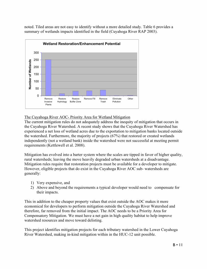
noted. Tiled areas are not easy to identify without a more detailed study. Table 6 provides asummary of wetlands impacts identified in the field (Cuyahoga River RAP 2003).
Wetland Restoration/Enhancement Potential
0
50
100
150
200
250
300
RemoveInvasivePlants
RestoreHydrology
RestoreBuffer Zone
Remove Fill RemoveTrash
EliminatePollution
Other
Nu
mb
er o
f W
etla
nd
s
The Cuyahoga River AOC- Priority Area for Wetland MitigationThe current mitigation rules do not adequately address the inequity of mitigation that occurs inthe Cuyahoga River Watershed. A recent study shows that the Cuyahoga River Watershed hasexperienced a net loss of wetland acres due to the exportation to mitigation banks located outsidethe watershed. Furthermore, the majority of projects (67%) that restored or created wetlandsindependently (not a wetland bank) inside the watershed were not successful at meeting permitrequirements (Kettlewell et al. 2008).
Mitigation has evolved into a barter system where the scales are tipped in favor of higher quality,rural watersheds; leaving the move heavily degraded urban watersheds at a disadvantage.Mitigation rules require that restoration projects must be available for a developer to mitigate.However, eligible projects that do exist in the Cuyahoga River AOC sub- watersheds aregenerally:
1) Very expensive, and2) Above and beyond the requirements a typical developer would need to compensate for
their impacts.
This in addition to the cheaper property values that exist outside the AOC makes it moreeconomical for developers to perform mitigation outside the Cuyahoga River Watershed andtherefore, far removed from the initial impact. The AOC needs to be a Priority Area forCompensatory Mitigation. We must have a net gain in high quality habitat to help improvewatershed resources and move toward delisting.
This project identifies mitigation projects for each tributary watershed in the Lower CuyahogaRiver Watershed, making in-kind mitigation within in the HUC-12 unit possible.

B • 12
METHODS OF ANALYSIS
Phase I- Collect, Analyze & Integrate Existing Wetland Data
Summary of Wetland Data Sources
Each of the files listed below exists as a separate GIS polygon file.1. Ohio EPA & Cuyahoga River RAP ORAM Analysis Summer 2005
-Actually two projects completed together:-Ohio EPA project covers the entire Cuyahoga River Watershed-RAP project is a more in-depth analysis of three tributaries to theCuyahoga River
2. Cuyahoga River RAP & Davey Resource Group Study 2001-03-Interpretation of aerial photos (1993-Cuyahoga County Engineer) & field workDecember 2002–April 2003-Covers only the Cuyahoga County portion of the Cuyahoga River Watershed
3. Cleveland Metroparks ORAM analysis Summer 2005 & 2006-Covers park reservations in Cuyahoga County portion of the Cuyahoga RiverWatershed-Follows same protocols as Ohio EPA & Cuyahoga River RAP ORAM project
4. Davey Resource Group Summit County Wetlands Project 2000-Interpretation of orthophotos photos (2000-Summit County Engineer)
5. Portage County Natural Resource Inventory compiled by Davey Resource Group, Inc-Interpretation of aerial photos (ASMAT 2000) & field work in 2004 & 2005
6. Cuyahoga Valley National Park Wetlands Inventory (covered in Summit County file)
7. Metroparks Serving Summit County Wetlands Project (covered in Summit Co. file)
In order to produce the best quality model for each tributary watershed, each data source, orGIS file, was divided into tributary watershed files, and then each set of tributary watershedfiles was combined and then updated to the 2006 orthophotos provided by Ohio DNR. Inareas where wetland boundaries overlapped, ORAM boundaries were kept and others wereedited.

B • 13
Phase II- Developing the Cuyahoga River Wetlands Model Ranking System
The basic premise of the Cuyahoga River Wetland Model is to numerically evaluateconservation alternatives by developing a set of criteria that can be used to judge each wetland.Each criterion was assigned either a positive or negative point range that reflects its importanceto the function or dysfunction of the wetland within the tributary watershed. Each wetland earnsnumerical scores that depend on how well the wetland meets that particular criterion. Thepositive and negative points are each summed separately for each wetland. For the purpose ofthis project, the numeric totals for each potential conservation site were compared with all othersites within the tributary watershed and then a rank order was assigned. The rationale for thescoring system was to equate high positive scores with the most important wetland sites, whilekeeping separate negative scores that indicate the amount of stressors for each wetland.
The model is broken into two categories:
Positive Attributes looked at specific criteria that were both useful in evaluating a wetland’secological importance and were supported in scientific literature. We used a GeographicInformation System (GIS) to analyze several landscape variables on a watershed basis asindicators of wetland performance. Three of the variable pertained to the wetland itself: wetlandsize, proximity to riparian corridor, and proximity to mapped flood zones. Two other variablespertained to the 50m buffer surrounding the wetland: the amount of area of other wetlands withinthe buffer, and the overall quality of the buffer based on the percent of forest cover area in thebuffer.
The top wetland sites identified through the ranking system are then examined for StressorAttributes which helps identify restoration potential.
Stressor Attributes included the wetland’s proximity to roadways and three types of land cover inthe 50m buffer surrounding the wetland sites. The percent of urban, residential and agriculturalland covers were analyzed, since the intensity of these land uses surrounding a wetland affectsrestoration and enhancement options and influences the long-term effectiveness of the project.
Additional options for restoration and enhancement are gathered from either field analysis dataor aerial photography. Not all wetland sites in the study area have field data. However, whenavailable, field data is the primary source for guiding conservation options. Orthophotography(2005), supporting literature and best professional judgment will guide conservation options forwetland sites lacking field data.

B • 14
MODEL RANKING SYSTEM
CUYAHOGA RIVER WETLANDS MODEL
POSITIVE ATTRIBUTES (+) STRESSORS (-)
Wetland Size Groups Points LAND COVER
<.5 acre 0 Urban Area in 50m Buffer Points>.5-1 acre 1 >75% thru 100% -7>1 thru 5 acres 2 >50% thru 75% -6>5 thru 10 acres 3 25% thru 50% -5>10 thru 20 acres 4 Residential Area in Buffer Points> 20 thru 100 acres 5 >75% thru 100% -6
>100 thru 150 acres 6 >50% thru 75% -5
>150 thru 200 acres 7 25% thru 50% -4
>200 thru 250 acres 8 Agriculture Area in Buffer Points>250 thru 300 acres 9 >75% thru 100% -3>300 acres 10 >50% thru 75% -2Wetland's Proximity to Riparian Setback Points 25% thru 50% -1Beyond 100m 0 Wetland's Proximity to Roadways Points75m thru 100m 1 0m thru 25m -650m up to 75m 2 25m thru 50m -525m up to 50m 3 50m thru 75m -40m up to 25m 4 75m thru 100m -3Intersect with 5 100m thru 125m -2Fully within 6 125m thru 150m -1Wetland's Proximity to Flood Zones Points >150m 0None 0Intersect with 1Fully within 2Forests in Buffer of Wetland >75% thru 100% 5>50% thru 75% 425% thru 50% 3Other Wetland Area in Buffer Points61% thru 100% 326% thru 60% 24% thru 25% 1

B • 15
Rationale for the Cuyahoga Model
Size (Wetland Size)- Larger wetlands are better protected from the negative impact of externalinputs. This is due to the greater distance between the core habitat and input sources, and largerareas of vegetation that can act as sediment and nutrient sinks.
Hydrology (Proximity to Riparian Corridor and/or Flood Zone)- For the purpose of thisproject, we identified wetlands associated with the riparian corridor and 100 year flood zone. Inmost cases these wetlands could be classified as riverine wetlands. “Riverine” refers to a class ofwetlands that has a floodplain or riparian geomorphic setting with a dominant water source beingover bank flow. These types of wetlands are especially valuable in their ability to absorbstormwater and slow the discharge of stormwater downstream (Krieger 2001). An urbanwetlands study (Mack et al. 2007) found that riverine wetlands were clearly valuable indesynchronizing stream flood events (ie. capturing and slowly releasing precipitation).Desynchronizing helps to alleviate large peak flows in streams, which minimizes flooding anderosion downstream.
Vegetative Cover (Forest Cover in Wetland Buffer)- Houlahan et al. (2006) found a relationshipbetween forest cover and exotic plant species richness, suggesting that loss of forest coverfacilitates the infiltration of exotic plant species. The amount of natural vegetation adjacent to awetland affects the quantity and quality of surface runoff in a wetland, particularly nutrient andsediment loads. In Wardrop et al. (2007) they developed a landcover condition category forforest cover surrounding wetlands. We adapted their category table for this project and ratedforested cover by “High, Moderate and Low” quality.
Wetland Connectivity (Other Wetlands within Buffer)- Fenessey, Sullivan 2008 found acorrelation between predicting ecological condition of a wetland and the presence of otherwetlands located with the surrounding 50m buffer. This “wetland connectivity” is quite possiblyfunctioning as a complex of wetlands, providing a buffering effect from upland stressors andenhancing watershed benefits.
Stressors
Land Cover- Research shows that surrounding land-use affects ecological condition of awetland. The condition of a wetland declines significantly as the surrounding land use changesfrom natural to urban. This is demonstrated by the change of wetland conditions from the Upperto the Lower Cuyahoga River Watershed. Research by Fennessy & Sullivan (2008) examinesthis issue by analyzing land-uses within different size buffers (30m 50m, 100m, 500m, 1000m)around the wetlands. Results show that land use characteristics in the 30m and 50m buffers hadthe strongest correlation with ecological condition of a wetland. This indicates that preservationof the buffer areas around wetlands can offer substantial protection and dramatically increasetheir conservation value.
For the purpose of the project, the land cover scoring coefficients were adapted from theLandscape Development Intensity (LDI) index. LDI integrates the impacts of human land use ona given site (Brown and Vivas 2005).

B • 16
Distance to Roadways- Proximity of wetlands to road systems is correlated with higher levels ofpolluted runoff, and poorer water and sediment quality. There is evidence that wetlands locateddownstream of a road system are at an increased risk of receiving sodium, potassium and nitratepollutants (Houlahan and Scott 2004). These pollutant loadings result from road salt applicationsand soil erosion due to increased stormwater runoff. The ranking model provides a range ofnegative scores based on a wetland’s distance to a roadway. The closer a wetland is to aroadway, the higher the risk of impacts from polluted runoff and therefore the more negative thescore.
RESULTS & SELECTION OF WETLAND SITES
The study identified a total of 3,007 wetlands covering 9,710 acres within the tributarywatersheds of the Cuyahoga River Area of Concern. All of the wetlands were analyzed withinthe context of their individual tributary watershed. Together, the top wetlands of each tributarywatershed received further examination. These wetlands are highlighted in this report. 2459 acresof wetlands or 25.3% of total AOC tributary wetlands as part of the wetland analysis.
Wetlands Summary- Cuyahoga River Area of Concern (AOC)Total Number of Wetlands 3,007
Total Acres of Wetlands 9,710
Average Wetland Size (acres) 2.4
Average Wetland Buffer Condition (Percent Forest Cover) Low Quality (25- 50%)
All Top Selected Wetlands Total Acres (160 total) 2473
All Top Selected Wetlands Average Size (acres) 22.3
All Top Selected Wetlands Average Buffer Condition (Percent Forest Cover) High Quality (>75-100%)
Total Restoration Potential Costs $17,522,144

B • 17
Map 3: Wetlands in the Tributaries of the Lower Cuyahoga River Watershed Area of Concern

B • 18
BIG CREEKGeneral Watershed CharacteristicsBig Creek, in northeast Ohio, is the third largest tributary in the Lower Cuyahoga RiverWatershed. This urban watershed has some of the highest population densities in the region. BigCreek’s original drainage patterns and riparian zones have been altered and fragmented as aresult of channelization, spillway structures, culverts, and changing land-use. This has increasedflow volumes and polluted runoff, decreased diversity and livability of habitat, and limited thepotential for stream recovery.
Location: Northeast Ohio, Cuyahoga County and drains the communities of: Cleveland,Brooklyn, Linndale, Brook Park, Parma, Parma Heights and North Royalton
Characteristics:Drainage: 38 square milesLength: mainstem is 12 miles.Gradient: creek drops an average of 23ft/mile.
Wetlands Summary- Big Creek Watershed
Number of Wetlands 74Total Acres 137.52 acresAverage Size 1.86 acresAverage Wetland Buffer Condition (FC) Low Quality (25-50%)Top Ten Wetland Acres 28.20 acresTop Ten Average Size 2.82 acresTop Ten Average Wetland Buffer Condition (FC) High Quality (>75-100%)Total Restoration Potential Costs $1,801,406
Big Creek Wetland ResultsA total of 137.5 acres of wetlands were identified in the Big Creek Watershed. Through ouranalysis we picked the top 10 wetlands. These 10 sites equal 28 acres, or nearly 20% of the totalwetland acreage in the watershed. Of the selected wetlands, sizes ranged from 9 acres to 0.75acres.
Land Cover Characteristics(2001)
Percent ofDrainage Area
Urban 52.06
Agriculture & Open Urban 31.78
Shrub & Scrub land 3.49
Wooded 13.91
Barren & Unclassified 1.00
Streams & Surface Water .21

B • 19
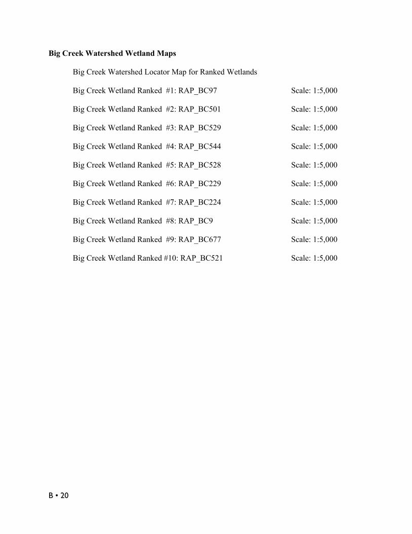
Big Creek Watershed Locator Map for Ranked Wetlands(Map shows top 19 of 74 identified wetlands.)
B • 20
Big Creek Watershed Wetland Maps
Big Creek Watershed Locator Map for Ranked Wetlands
Big Creek Wetland Ranked #1: RAP_BC97 Scale: 1:5,000
Big Creek Wetland Ranked #2: RAP_BC501 Scale: 1:5,000
Big Creek Wetland Ranked #3: RAP_BC529 Scale: 1:5,000
Big Creek Wetland Ranked #4: RAP_BC544 Scale: 1:5,000
Big Creek Wetland Ranked #5: RAP_BC528 Scale: 1:5,000
Big Creek Wetland Ranked #6: RAP_BC229 Scale: 1:5,000
Big Creek Wetland Ranked #7: RAP_BC224 Scale: 1:5,000
Big Creek Wetland Ranked #8: RAP_BC9 Scale: 1:5,000
Big Creek Wetland Ranked #9: RAP_BC677 Scale: 1:5,000
Big Creek Wetland Ranked #10: RAP_BC521 Scale: 1:5,000

B • 21
BIG CREEK WETLAND ID# RAP_BC97Ranked No. 1
Site Description
Wetland Classification(Hydrogeomorphic or Corwardin) Palustrine Forested Wetland (PFO)
Size (acres) 3.33
Wetland Buffer Condition Moderate Quality
Impacts (Field Assessments) N/A
Restoration PotentialRemove Invasive Plants*Riparian/Wetland Plantings*
Ownership (Public or Private) Private
Number of Parcels 4 Parcels / 2 Owners
Cost Estimates $12,648
Location (Lat/Long) 41.447197326681 / -81.707625155485
Community Cleveland* Extrapolated Restoration Potential
Wetland BC97 is a 3-acre forested wetland on the lower mainstem of Big Creek, just upstreamfrom the confluence with the Cuyahoga River. Notable features include a moderate forestedbuffer, neighboring wetland to the west and the connection with Big Creek’s riparian corridorand floodplain. Wetland BC97 is located in the city of Cleveland. Ownership complexity is fairlyeasy with 4 parcels and 2 property owners. B & O Railroads owns 3 out of the 4 parcels.
Wetland BC97 is most likely a moderate to moderately low quality wetland. This is due to theintensity of land use in the surrounding urban watershed. Further investigation may show thatBC97 and its neighboring wetland are part one large wetland system.
Next steps include a more detailed site assessment of this wetland. The site assessment shouldinclude completion of an ORAM and Penn State Stressor Checklist. This will help provide thelocation and extent of surrounding impacts, restoration potential and ultimately cost estimates.Preliminary cost estimates for this site are based on and extrapolated from previous wetlandassessment projects. This site is landlocked and further development in this area is unlikely. Thissite should be targeted for a conservation easement and invasive species removal. Wetland andriparian plantings should be native, but also tolerant of urban conditions.
Cost EstimateItem Unit Cost Unit CostDetailed Sight Assessment $720 1 $720Plans & Specification $5,000 1 $5,000Remove Invasive Plants $660 0.8acres $528Riparian / Wetland Plantings $8,000 0.8acres $6,400Conservation Easement $??? 3.3acres $???TOTAL $12,648

B • 22
Big Creek Wetland Ranked #1: RAP_BC97 Scale: 1:5,000
Map KeyYellow Lines -Wetland boundary Yellow Points -Centroid point calculated from wetland polygonBlack Lines -Wetland 50m bufferGreen Lines -Other wetlandsBlue Lines -StreamsRed Lines -Parcel boundary
Base Layer -Ohio 2006 orthophotosProjection -Ohio State Plane North, NAD83

B • 23
BIG CREEK WETLAND ID# RAP_BC501Ranked No. 2
Site Description
Wetland Classification(Hydrogeomorphic or Corwardin)
Palustrine Forested & Shrub/ScrubWetland (PFO) (PSS)
Size (acres) 9.59
Wetland Buffer Condition Moderate Quality
Impacts (Field Assessments)New FillAdjacent Land Use
Restoration Potential
Remove Invasive PlantsSeeding/Wetland PlantingRestore Buffer Zone
Ownership (Public or Private) Private
Number of Parcels 12 Parcels / 12 Property Owners
Cost Estimates $36,308
Location (Lat/Long) 41.338571793973 / -81.729672609727
Community North Royalton
Wetland BC501 is a nice 9-acre forested and shrub/scrub wetland located in the headwaters ofthe Big Creek Watershed. Notable features include a headwater stream, forested buffer zonealong the north perimeter and the connection with the riparian corridor and floodplain. WetlandBC501 is located in the city of North Royalton. Ownership complexity is relatively high with 12parcels and approximately 12 property owners.
Wetland BC501 is most likely a moderate quality wetland. This is due to the urban nature of thewatershed, the relatively light residential land use surrounding the site and the moderate qualityforested buffer. Sources of water include precipitation, seasonal surface water and groundwater.
This site has been field visited in a 2003 RAP funded project. Field notes indicate new fill andadjacent land use (i.e. residential development) were impacts on-site. A future enhancementproject should include, targeting the sparse amounts of invasive plants (Glossy Buckthorn,Narrow Leafed Cattail) and restoring the buffer zone along the southern perimeter. This siteshould also be targeted for conservation easements on the developed parcels.
Cost EstimateItem Unit Cost Unit CostPlans & Specification $5,000 1 $5,000Remove Invasive Plants $220 1.4acres $308Seeding / Wetland Plantings $5,000 1.4acres $7,000Riparian Planting/ Buffer Zone $8,000 3acres $24,000Conservation Easement $??? 3.3acres $???TOTAL $36,308

B • 24
Big Creek Wetland Ranked #2: RAP_BC501 Scale: 1:5,000
Map KeyYellow Lines -Wetland boundary Yellow Points -Centroid point calculated from wetland polygonBlack Lines -Wetland 50m bufferBlue Lines -StreamsRed Lines -Parcel boundary
Base Layer -Ohio 2006 orthophotosProjection -Ohio State Plane North, NAD83

B • 25
BIG CREEK WETLAND ID# RAP_BC529Ranked No. 3
Site Description
Wetland Classification(Hydrogeomorphic or Corwardin) Palustrine Forested Wetland (PFO)
Size (acres) 2.15
Wetland Buffer Condition Moderate to High Quality
Impacts (Field Assessments) None
Restoration PotentialRemove Invasive PlantsRiparian/Wetland Planting
Ownership (Public or Private) Public & Private
Number of Parcels 4 Parcels / 3 Property Owners
Cost Estimates $9,330
Location (Lat/Long) 41.44888022871 / -81.730643155097
Community Cleveland
Wetland BC529 is a 2-acre forested wetland, dominated by Black Willow, along a tributarystream near the mainstem of Big Creek. Notable features include the connection with Big Creekand the riparian corridor, a neighboring wetland to the northeast, moderate quality forestedbuffer zone and the nearby Cleveland Metroparks’ Brookside Reservation. Wetland BC529 islocated in the city of Cleveland. Ownership complexity is relatively easy with 4 parcels and 3property owners. City of Cleveland owns two of those parcels.
Wetland BC501 is most likely a moderately low quality wetland. This is due to the urban nature ofthe watershed, the altered tributary stream, potential runoff from upstream residential developmentand the moderate quality forested buffer. Sources of water feeding this wetland site includeprecipitation and surface water.
This site has been field visited in a 2003 RAP funded project. Field notes indicate no impacts to thewetland site. Future enhancement project should include removing invasive plants (Common Reed),which covers approximately 25% of the area, and adding riparian/wetland plantings. These plansshould be made in cooperation with the city of Cleveland, other property owners and possiblyCleveland Metroparks. Equipment accessibility is easy.
Cost EstimateItem Unit Cost Unit CostPlans & Specification $5,000 1 $5,000Remove Invasive Plants $660 0.5acres $330Riparian / Wetland Plantings $8,000 0.5acres $4,000TOTAL $9,330

B • 26
Big Creek Wetland Ranked #3: RAP_BC529 Scale: 1:5,000
Map KeyYellow Lines -Wetland boundary Yellow Points -Centroid point calculated from wetland polygonBlack Lines -Wetland 50m bufferGreen Lines -Other wetlandsBlue Lines -StreamsRed Lines -Parcel boundary
Base Layer -Ohio 2006 orthophotosProjection -Ohio State Plane North, NAD83
B • 27
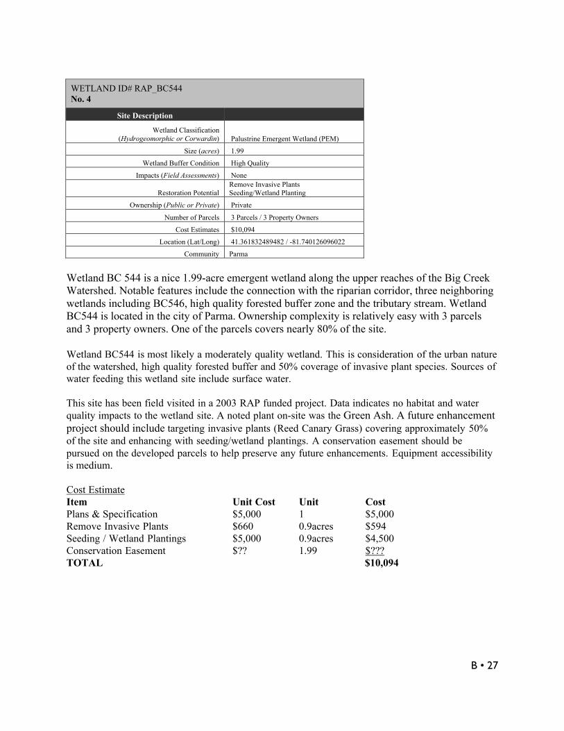
WETLAND ID# RAP_BC544No. 4
Site Description
Wetland Classification(Hydrogeomorphic or Corwardin) Palustrine Emergent Wetland (PEM)
Size (acres) 1.99
Wetland Buffer Condition High Quality
Impacts (Field Assessments) None
Restoration PotentialRemove Invasive PlantsSeeding/Wetland Planting
Ownership (Public or Private) Private
Number of Parcels 3 Parcels / 3 Property Owners
Cost Estimates $10,094
Location (Lat/Long) 41.361832489482 / -81.740126096022
Community Parma
Wetland BC 544 is a nice 1.99-acre emergent wetland along the upper reaches of the Big CreekWatershed. Notable features include the connection with the riparian corridor, three neighboringwetlands including BC546, high quality forested buffer zone and the tributary stream. WetlandBC544 is located in the city of Parma. Ownership complexity is relatively easy with 3 parcelsand 3 property owners. One of the parcels covers nearly 80% of the site.
Wetland BC544 is most likely a moderately quality wetland. This is consideration of the urban natureof the watershed, high quality forested buffer and 50% coverage of invasive plant species. Sources ofwater feeding this wetland site include surface water.
This site has been field visited in a 2003 RAP funded project. Data indicates no habitat and waterquality impacts to the wetland site. A noted plant on-site was the Green Ash. A future enhancementproject should include targeting invasive plants (Reed Canary Grass) covering approximately 50%of the site and enhancing with seeding/wetland plantings. A conservation easement should bepursued on the developed parcels to help preserve any future enhancements. Equipment accessibilityis medium.
Cost EstimateItem Unit Cost Unit CostPlans & Specification $5,000 1 $5,000Remove Invasive Plants $660 0.9acres $594Seeding / Wetland Plantings $5,000 0.9acres $4,500Conservation Easement $?? 1.99 $???TOTAL $10,094

B • 28
Big Creek Wetland Ranked #4: RAP_BC544 Scale: 1:5,000(Big Creek Wetland Ranked #19: RAP_BC546)
Map KeyYellow Lines -Wetland boundary Yellow Points -Centroid point calculated from wetland polygonBlack Lines -Wetland 50m bufferGreen Lines -Other wetlandsBlue Lines -StreamsRed Lines -Parcel boundary
Base Layer -Ohio 2006 orthophotos

B • 29
Projection -Ohio State Plane North, NAD83WETLAND ID# RAP_BC528No. 5
Site Description
Wetland Classification(Hydrogeomorphic or Corwardin) Palustrine Forested Wetland (PFO)
Size (acres) 2.05
Wetland Buffer Condition Moderate Quality
Impacts (Field Assessments) None
Restoration PotentialStream RestorationRiparian Plantings
Ownership (Public or Private) Public & Private
Number of Parcels 3 Parcels / 3 Property Owners
Cost Estimates $372,600
Location (Lat/Long) 41.44424936687 / -81.739892552962
Community Brooklyn
Wetland BC528 is a nice 2-acre forested wetland located along the lower reaches of the BigCreek Mainstem. The wetland is located in the area referred to as the “Oxbow Property”.Notable features include a small neighboring wetland, the mainstem of Big Creek, theconnection with the riparian corridor and floodplain and the oxbow, which is an abandonedmeander in the river. This wetland is located in the city of Brooklyn. Ownership complexity iseasy with 3 parcels and 3 property owners, in the city of Brooklyn owns 2 parcels.
Wetland BC528 is most likely a moderately to moderately low quality wetland. This is considerationof the urban nature of the watershed, residential land use intensity surrounding the site and themoderate quality forested buffer zone. Sources of water feeding this wetland site include seasonalsurface water, precipitation and groundwater.
This site has been field visited in a 2003 RAP funded project. Field notes indicate no habitat andwater quality impacts to the wetland site. A future conservation project should include preserving thissite, possibly by purchasing parcel 431-21-001. Parcels 431-20-009 and 013-30-004 are owned bythe city of Brooklyn. These parcels could be protected through and easement or other form ofprotection. A stream restoration will be needed to create a connection (inflow) with the mainstem ofBig Creek. Discussions should begin with the city of Brooklyn considering they own majority of thesite. This site would make an attractive project due to the close proximity of the Metroparks and theunique situation along the oxbow of lower Big Creek. Cost EstimateItem Unit Cost Unit CostPlans & Specification $5,000 1 $5,000Mobilizing Equipment $2,500 $2,500Parcel 431-20-009 City propertyParcel 013-30-004 City PropertyPurchase Parcel 431-21-001 Market Land Value $4,100Stream Restoration $300/LF 1,150/LF $345,000Riparian Plantings $8,000 2acres $16,000TOTAL $372,600

B • 30
Big Creek Wetland Ranked #5: RAP_BC528 Scale: 1:5,000
Map KeyYellow Lines -Wetland boundary Yellow Points -Centroid point calculated from wetland polygonBlack Lines -Wetland 50m bufferGreen Lines -Other wetlandsBlue Lines -StreamsRed Lines -Parcel boundary
Base Layer -Ohio 2006 orthophotosProjection -Ohio State Plane North, NAD83

B • 31
WETLAND ID# RAP_BC229No. 6
Site Description
Wetland Classification(Hydrogeomorphic or Corwardin) Palustrine Forested Wetland (PFO)
Size (acres) 1.16
Wetland Buffer Condition High Quality
Impacts (Field Assessments) Old Fill
Restoration Potential
Remove Invasive PlantsRiparian/Wetland PlantingsWetland Expansion
Ownership (Public or Private) Private
Number of Parcels 1 Parcel / 1 Property Owner
Cost Estimates $73,737
Location (Lat/Long) 41.354784046663 / -81.730015992294
Community Parma
Wetland BC229 is a nice 1.16-acre forested wetland located in the upper reaches of the BigCreek Watershed. Notable features include the high quality forested buffer, numerous adjacentwetlands and the location along multiple tributary streams and related riparian corridors.Wetland BC229 is located in the city of Parma. Ownership complexity is easy with only oneparcel and owner. Arbor Park Village Homeowners currently own this site.
Wetland BC229 is most likely a moderately quality wetland. This is consideration of the urban natureof the watershed, adjacent land use intensity and the high quality forested buffer zone. Sources ofwater feeding this wetland site include seasonal surface water and precipitation.
This site has been field visited in a 2003 RAP funded project. Field notes indicate the site wasimpacted from old fill, most likely resulting from the neighboring land use. However, no waterquality impacts were noted. A plant noted on-site was the Green Ash. A future enhancement projectshould include targeting invasive plant species and enhancing with riparian/wetland plantings.Small areas of invasive plants cover the site, these include Reed Canary Grass and Buckthorn. Also,suitable hydric soils exist onsite to allow for a wetland expansion project (expand 3 acres).Discussion should begin the Village to discuss long-term management options, purchasing or aconservation easement.
Cost EstimateItem Unit Cost Unit CostPlans & Specification $5,000 1 $5,000Mobilize Equipment $2,500 $2,500Remove Invasive Plants $220 0.17acres $37Riparian / Wetland Plantings $8,000 3.17acres $25,360Onsite Excavation $1.75CY 9,680CY $16,940Purchase Property 454-28-004 Land Market Value $23,900TOTAL $73,737

B • 32
Big Creek Wetland Ranked #6: RAP_BC229 Scale: 1:5,000
Map KeyYellow Lines -Wetland boundary Yellow Points -Centroid point calculated from wetland polygonBlack Lines -Wetland 50m bufferGreen Lines -Other wetlandsBlue Lines -StreamsRed Lines -Parcel boundary
Base Layer -Ohio 2006 orthophotosProjection -Ohio State Plane North, NAD83

B • 33
WETLAND ID# RAP_BC224No. 7
Site Description
Wetland Classification(Hydrogeomorphic or Corwardin) Palustrine Forested Wetland (PFO)
Size (acres) 1.46
Wetland Buffer Condition High Quality
Impacts (Field Assessments) N/A
Restoration Potential
Remove Invasive Plants*Riparian/Wetland Plantings*Wetland Expansion
Ownership (Public or Private) Private
Number of Parcels 2 Parcels / 2 Property Owners
Cost Estimates $1,416,158
Location (Lat/Long) 41.372992972344 / -81.721973172006
Community Parma* Extrapolated Restoration Potential
Wetland BC224 is a nice 1.46-acre forested wetland located on a tributary to Big Creek, justupstream from Stearns Farm Homestead. Notable features include a high quality forested bufferzone, the location along multiple tributaries and riparian corridors and this site is nearby both StearnsFarm and West Creek Preserve. Plans have been discussed to preserve this site as a greenwayconnector for both parks. Wetland BC224 is located in the city of Parma. Ownership complexity isfairly easy with 2 parcels and 2 property owners. Citicasters Co. and Scripps Howard Radio Inc. arethe owners.
Wetland BC224 is most likely a moderate quality wetland. This is consideration of the urban natureof the watershed, relatively low land use intensity, the location along an altered tributary stream andhigh quality buffer zone.
Next steps include a more detailed site assessment of this wetland. The site assessment shouldinclude an ORAM and Penn State Stressor Checklist completed. This will help provide the locationand extent of surrounding impacts, restoration potential and ultimately cost estimates. Preliminarycost estimates for this site are based on and extrapolated from previous wetland assessment projects.A future conservation project should include preserving this site through a conservation easement orpurchasing the parcels. Invasive specie removal and enhancements with riparian/wetland plantingswill be likely needed. Also, suitable hydric soils exist onsite to allow for a wetland expansion project(expand 3 acres)
Cost EstimateItem Unit Cost Unit CostDetailed Sight Assessment $720 1 $720Plans & Specification $5,000 1 $5,000Mobilize Equipment $2,500 $2,500Remove Invasive Plants $660 0.3acres $198Riparian / Wetland Plantings $8,000 3.3acres $26,400Onsite Excavation $1.75CY 9,680CY $16,940Parcel 450-26-002 Land Market Value $836,300Parcel 450-27-001 Land Market Value $528,100 TOTAL $1,416,158

B • 34
Big Creek Wetland Ranked #7: RAP_BC224 Scale: 1:5,000
Map KeyYellow Lines -Wetland boundary Yellow Points -Centroid point calculated from wetland polygonBlack Lines -Wetland 50m bufferBlue Lines -StreamsRed Lines -Parcel boundary
Base Layer -Ohio 2006 orthophotosProjection -Ohio State Plane North, NAD83

B • 35
WETLAND ID# RAP_BC9No. 8
Site Description
Wetland Classification(Hydrogeomorphic or Corwardin) Palustrine Forested Wetland (PFO)
Size (acres) 1.82
Wetland Buffer Condition High Quality
Impacts (Field Assessments) N/A
Restoration Potential
Remove Invasive Plants*Riparian/Wetland Plantings*Wetland Expansion
Ownership (Public or Private) Private
Number of Parcels 3 Parcels / 3 Owners
Cost Estimates $30,063
Location (Lat/Long) 41.376832375224 / -81.716885024115
Community Parma* Extrapolated Restoration Potential
Wetland BC9 is a nice 1.82-acre forested wetland located on a tributary to Big Creek, just upstreamfrom Stearns Farm Homestead. Notable features include a high quality forested buffer zone, locationalong a tributary stream and related riparian corridor this site is nearby both Stearns Farm and WestCreek Preserve. Plans have been discussed to preserve this site and connect the two parks. WetlandBC9 is located in the city of Parma. Ownership complexity is fairly easy with 3 parcels and 3property owners. Scripps Howard Radio Inc. is the major landowner.
Wetland BC9 is most likely a moderate quality wetland. This is consideration of the surroundingurban watershed and fairly low land use intensity, its location along an altered tributary stream andhigh quality buffer zone.
Next steps include a more detailed site assessment of this wetland. The site assessment shouldinclude an ORAM and Penn State Stressor Checklist completed. This will help provide the locationand extent of surrounding impacts, restoration potential and ultimately cost estimates. Preliminarycost estimates for this site are based on and extrapolated from previous wetland assessment projects.A future conservation project should include preserving this site, which would help link the WestCreek Preserve and Strearns Farm. Invasive specie removal and enhancements with riparian/wetlandplantings will be likely needed. Buffer Plantings should also be targeted on the two homeownerproperties. Also, suitable hydric soils exist onsite to allow for a wetland expansion project (expand 1acre).
Cost EstimateItem Unit Cost Unit CostDetailed Sight Assessment $720 1 $720Plans & Specification $5,000 1 $5,000Mobilize Equipment $2,500 $2,500Remove Invasive Plants $660 0.3acres $198Riparian / Wetland Plantings $8,000 2acres $16,000Onsite Excavation $1.75CY 3,226CY $5,645Purchase Property# 450-26-002 Land Market Value $836,300 (not included in
total- Calculated in BC224)TOTAL $30,063

B • 36
Big Creek Wetland Ranked #8: RAP_BC9 Scale: 1:5,000
Map KeyYellow Lines -Wetland boundary Yellow Points -Centroid point calculated from wetland polygonBlack Lines -Wetland 50m bufferGreen Lines -Other wetlandsBlue Lines -StreamsRed Lines -Parcel boundary
Base Layer -Ohio 2006 orthophotosProjection -Ohio State Plane North, NAD83

B • 37
WETLAND ID# RAP_BC677No. 9
Site Description
Wetland Classification(Hydrogeomorphic or Corwardin)
Palustrine Emergent & Forested Wetland(PEM) (PFO)
Size (acres) 1.29
Wetland Buffer Condition Moderate Quality
Impacts (Field Assessments) N/A
Restoration PotentialRemove Invasive Plants*Riparian/Wetland Plantings*
Ownership (Public or Private) Private
Number of Parcels 1 Parcel / 1 Property Owner
Cost Estimates $8,318
Location (Lat/Long) 41.422453410072 / -81.793402877907
Community Cleveland* Extrapolated Restoration Potential
Wetland BC677 is a 1.29-acre emergent and forested wetland located near an industrial park on atributary to the West Branch of Big Creek. Notable features include a neighboring wetland, amoderate quality forested buffer zone and the location along a tributary stream and related ripariancorridor. Also notable is the Puritas stormwater basin located north of this site. Puritas basin is largebirding habitat and has evolved into an urban wetland area. Wetland B677 is located in the city ofCleveland. Ownership complexity is fairly easy with 1 parcel and 1 property owners. ConsolidatedRail Corp. is the landowner.
Wetland BC677 is most likely a moderate to moderately low quality wetland. This is consideration ofthe surrounding urban watershed, nearby industrial park and rail system and its location along analtered tributary stream. A sustainable restoration could be challenging in this area due to theintensity of land use.
Next steps include a more detailed site assessment of this wetland. The site assessment shouldinclude an ORAM and Penn State Stressor Checklist completed. This will help provide the locationand extent of surrounding impacts, restoration potential and ultimately cost estimates. Preliminarycost estimates for this site are based on and extrapolated from previous wetland assessment projects.This site should be targeted for invasive plant removal and enhancements with seeding / wetlandplantings.
Cost EstimateItem Unit Cost Unit CostDetailed Sight Assessment $720 1 $720Plans & Specification $5,000 1 $5,000Remove Invasive Plants $660 0.3acres $198Seeding / Wetland Plantings $5,000 0.3acres $2,400TOTAL $8,318

B • 38
Big Creek Wetland Ranked #9: RAP_BC677 Scale: 1:5,000
Map KeyYellow Lines -Wetland boundary Yellow Points -Centroid point calculated from wetland polygonBlack Lines -Wetland 50m bufferGreen Lines -Other wetlandsBlue Lines -StreamsRed Lines -Parcel boundary
Base Layer -Ohio 2006 orthophotosProjection -Ohio State Plane North, NAD83

B • 39
WETLAND ID# RAP_BC521No. 10
Site Description
Wetland Classification(Hydrogeomorphic or Corwardin) Palustrine Emergent Wetland (PEM)
Size (acres) 3.37
Wetland Buffer Condition Low Quality
Impacts (Field Assessments)
Old & New FillAdjacent Land UseDrainage Ditch
Restoration PotentialRemove Invasive PlantsSeeding/Wetland Planting
Ownership (Public or Private) Public
Number of Parcels 1 Parcel / 1 Property Owner
Cost Estimates $23,960
Location (Lat/Long) 41.430260643306 / -81.792454232715
Community Cleveland
Wetland BC521 is a 3-acre emergent wetland located in what is a large detention basin of theWest Branch of the Big Creek Watershed. Notable features include its location within the Puritasstormwater basin. This basin, over the years, has turned into a large wetland habitat in the middleof an industrial park. This site has also been noted by the Museum of Natural History as a greatbirding habitat. In addition, a small wetland enhancement project occurred in the spring of 2008just to the south in the same detention basin. Wetland BC521 is located in the city of Cleveland.Ownership complexity is easy with only one parcel and owner. City of Cleveland WaterPollution Control is the landowner.
Wetland BC521 is most likely a low to moderate quality wetland. This is consideration of the urbannature of the watershed, adjacent land use intensity and this site receives runoff directly from I-480.Sources of water feeding this wetland site include seasonal surface water, precipitation and one ormore storm drains.
This site has been field visited in a 2003 RAP funded project. Data indicates the site was impactedfrom old and new fill, adjacent landuse and a concrete drainage ditch flows through the site. Invasivespecies is a big problem not only at this site but the entire detention basin. Wetland BC521 is hasapproximately 90% coverage of narrow leaved cattail. An invasive species removal project shouldtarget this site and the rest of the basin, along with enhancements of seeding/wetland plantings. Costswill be approximated just for site BC521.
Cost EstimateItem Unit Cost Unit CostPlans & Specification $5,000 1 $5,000Remove Invasive Plants $1,320 3acres $3,960Seeding / Wetland Plantings $5,000 3acres $15,000 TOTAL $23,960

B • 40
Big Creek Wetland Ranked #10: RAP_BC521 Scale: 1:5,000
Map KeyYellow Lines -Wetland boundary Yellow Points -Centroid point calculated from wetland polygonBlack Lines -Wetland 50m bufferGreen Lines -Other wetlandsBlue Lines -StreamsRed Lines -Parcel boundary
Base Layer -Ohio 2006 orthophotosProjection -Ohio State Plane North, NAD83


