CES Environmental Services Voluntary Cleanup Program Application
Project No. 4006 May 2015
Attachment 5 Phase II Environmental Site Assessment Holiday Place Townhome Lots (2011)
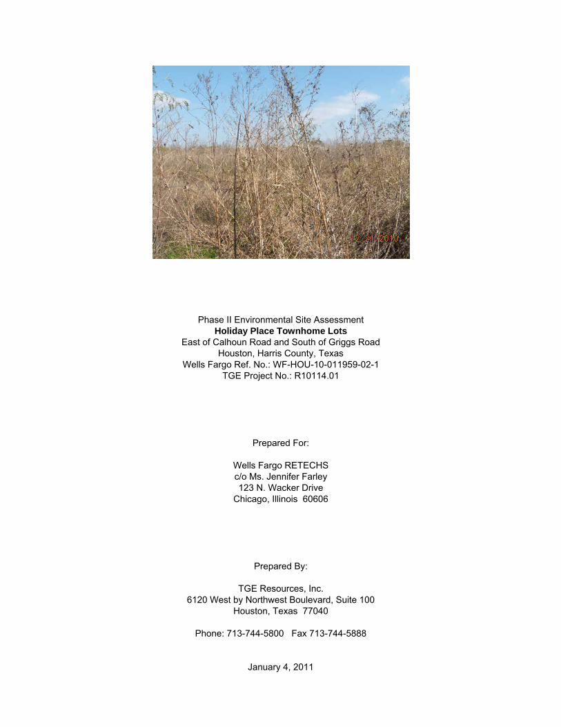
Phase II Environmental Site Assessment Holiday Place Townhome Lots
East of Calhoun Road and South of Griggs Road Houston, Harris County, Texas
Wells Fargo Ref. No.: WF-HOU-10-011959-02-1 TGE Project No.: R10114.01
Prepared For:
Wells Fargo RETECHS c/o Ms. Jennifer Farley 123 N. Wacker Drive
Chicago, Illinois 60606
Prepared By:
TGE Resources, Inc. 6120 West by Northwest Boulevard, Suite 100
Houston, Texas 77040
Phone: 713-744-5800 Fax 713-744-5888
January 4, 2011
R10114.01 Phase II ESA – Holiday Place Townhome Lots
TABLE OF CONTENTS EXECUTIVE SUMMARY .................................................................................................................................... i 1.0 INTRODUCTION ......................................................................................................................................... 1 2.0 SUBSURFACE CONDITIONS ................................................................................................................... 3 3.0 SOIL BORING AND WELL SCREEN INSTALLATION ............................................................................. 4 4.0 SAMPLING AND LABORATORY ANALYSIS .......................................................................................... 5
4.1 Cleanup Goals ............................................................................................................................... 5 4.2 Soil Sample Collection and Analysis .......................................................................................... 6 4.3 Groundwater Sample Collection and Analysis .......................................................................... 7 4.4 Project Deviations ......................................................................................................................... 8 4.5 Laboratory Data Validation .......................................................................................................... 9
5.0 WATER GAUGING AND POTENTIOMETRIC SURFACE DATA ........................................................... 10 6.0 FINDINGS ................................................................................................................................................. 11
6.1 Findings ....................................................................................................................................... 11 6.2 Recommendations ...................................................................................................................... 12
7.0 QUALIFICATIONS ............................................................................................................................... 13 8.0 REFERENCES .......................................................................................................................................... 14 FIGURES
Figure 1 - Site Location Map Figure 2 - Site Map Figure 3 - Groundwater Potentiometric Surface Map
TABLES
Table 1 - Soil Analytical Results Table 2 - Groundwater Analytical Results Table 3 - Groundwater Elevation Data
APPENDICES Appendix A - Photographic Documentation Appendix B - Soil Boring Logs Appendix C - Laboratory Analytical Report
i R10114.01 Phase II ESA – Holiday Place Townhome Lots
EXECUTIVE SUMMARY TGE Resources, Inc., (“TGE”) has completed a Limited Phase II Environmental Site Assessment (ESA) at the Holiday Place Townhome Lots located east of Calhoun Road and south of Griggs Road in Houston, Harris County, Texas, hereinafter referred to as the "Site" or “subject property”, in general compliance with American Society of Testing Materials (ASTM) Standard Guide for Environmental Site Assessments: Phase II Site Assessment Process (E 1903-97), Re-approved 2002. This assessment was performed in an effort to preliminarily characterize Site soil and groundwater in the presence of recognized environmental conditions (RECs) associated with the subject property consistent with ASTM guidance. It is TGE’s understanding that Wells Fargo RETECHS requires knowledge of the environmental status of the subject property prior to pending property foreclosure. According to an October 2010, Phase I ESA prepared by Ninyo & Moore for the benefit of Wells Fargo Bank, the subject property is comprised of approximately 6.40 acres of land. The subject property was residentially developed and platted with 120 lots. Per the Ninyo & Moore Phase I ESA, review of historical resources indicated that Site was used as a “storage area from as early as 1944 to approximately 1979.” Between 1989 to 2006 “the site was graded and a parking lot was developed on the eastern portion of the site. By 2010, the site was vacant, graded, residential lots within the Holiday Place Townhomes subdivision. Residential development commenced east and west of the site in approximately 1944. Commercial development commenced north of the site as early as 1944, south of the site in approximately 1953, and east of the site in approximately 1973.” According to the Ninyo & Moore Phase I ESA, adjoining property east, which is occupied by CES Environmental Services, Inc. (CES), has operated as a hazardous, non-hazardous, recyclable, municipal and universal material removal and transport company since at least 1973. According to regulatory database information, CES is listed as a Comprehensive Environmental Response, Compensation and Liability Information System (CERCLIS), a RCRA-Large Quantity Generator (LQG) and an underground petroleum storage tanks (PSTs) facility. Per the October, 2010 Ninyo & Moore Phase I ESA, CES was considered an off-Site REC due to an August 2009 explosion incident that resulted in a possible release of “methanol or other hazardous materials stored at the facility,” as well as historical use and the presence of PSTs in close proximity to the Site. Ninyo & Moore reported that a 1950 Sanborn Fire Insurance Map, reviewed for the Phase I ESA, depicted the subject property as occupied by a “piping yard.” The referenced Sanborn Fire Insurance Map and/or historical aerial photographs were not provided within the Phase I ESA. However, TGE obtained aerial photographs dated 1953, 1969, 1978 and 1989 from the Texas Natural Resource Information System (TNRIS), a division of the Texas Water Development Board (TWDB) Historical Aerial Photograph Database. Based on review of historical aerial photographs, it appears that the subject property was part of a larger tract of land (adjoining property east, currently occupied by CES) that operated as a trucking/transport facility from at least 1940 through 2000. Based upon Findings from the October, 2010 Phase I ESA of the Site prepared by Ninyo & Moore, the following REC was identified in connection with the subject property:
• "The property located at 4904 Griggs Road, adjacent to the eastern boundary of the site, is considered an off-Site REC. Ninyo & Moore considers it possible that methanol or other hazardous materials stored at this facility may have been released to the subsurface during the aforementioned explosion incident, or in the past prior to this explosion incident and Ninyo & Moore considers it possible the historical activities conducted at this adjacent property have impacted the environmental integrity of the site. Additionally, based on the lack of information regarding the USTs at this adjacent property and on the close proximity of the USTs at this facility to the site, Ninyo & Moore considers these USTs a REC for the site.”
ii R10114.01 Phase II ESA – Holiday Place Townhome Lots
Based upon Client’s desire to preliminarily characterize Site soil and groundwater prior to pending property foreclosure, TGE installed three temporary screened boreholes (TSB-1 through TSB-3) at the site. The three temporary screened boreholes were completed within the limits of the subject property to depths of 36 feet below grade (fbg). Temporary screened borehole locations were advanced/installed at the Site at the following locations, given associated rational:
• TSB-1 – centrally located within the limits of the subject property near an on-Site material storage area (as per historical aerial photographs);
• TSB-2 and TSB-3 – along the eastern perimeter of the subject property proximal of CES (to assess for potential impact from off-Site property).
Following TGE’s assessment efforts, and related sample analyses, analytical data was obtained from soil and groundwater samples pursuant to this investigation. Likewise, TGE determined at the time of this investigation that depths to static groundwater beneath the Site ranged from 23.90 fbg to 25.11 fbg; the calculated groundwater flow direction at the time of groundwater sampling was toward the east. The following summary of material results/findings is presented below for Client review. A full reporting and account of specific project efforts and findings are provided in detail within the attached document.
• Soil samples collected from boreholes TSB-1 through TSB-3 were reported by the analytical laboratory to not contain volatile organic compounds (VOCs) or total petroleum hydrocarbons (TPH) in excess of laboratory detection limits, or if detected, concentrations were below their respective TCEQ residential assessment levels.
• Soil samples collected from boreholes TSB-1 through TSB-3 were reported by the analytical laboratory to not contain RCRA-8 metals in excess of limits of laboratory quantitation, or if detected, concentrations were below their respective TCEQ residential assessment levels with the exception of lead. Soil samples collected from TSB-1 through TSB-3 were reported to contain lead at concentrations ranging from 23.7 milligrams per kilogram (mg/kg) to 61.2 mg/kg, which slightly exceed the Texas Specific Background Concentration (TSBC) of 15.0 mg/kg. However, such concentrations are well below the TCEQ Texas Risk Reduction Program (TRRP) Protective Concentration Level (PCL) of 500 mg/kg for exposure to lead in surface soils. Given exceedances of the residential assessment level for lead, TGE referred to the TRRP PCL equation for the soil-to-groundwater pathway (GWSoilIng). An equation was used to calculate Site-specific levels for lead in soil that is considered protective of groundwater in lieu of the TSBC or TRRP Tier 1 PCL.
• Based on Site-specific conditions, a Tier 2 GWSoilIng PCL of 274.725 mg/kg for lead can be established in soil at the Site. The previously detected maximum concentration of 61.2 mg/kg for lead in soil sample TSB-1 (2-3’) is well below the calculated Tier 2 PCL for the Site. As such, the reported lead value is not believed representative of an environmental condition in connection with the Site and may be “screened” from further response actions.
• Groundwater samples collected from boreholes TSB-1 through TSB-3 were reported by the analytical laboratory to not contain VOCs or TPH in excess of laboratory detection limits, or if detected, concentrations were below their respective TCEQ residential assessment levels.
iii R10114.01 Phase II ESA – Holiday Place Townhome Lots
• Groundwater analytical results from temporary screened boreholes TSB-1 through TSB-3 were reported by the analytical laboratory to not contain RCRA-8 metals in excess of laboratory detection limits, or if detected, concentrations were below their respective TCEQ residential assessment levels with the exception of lead and chromium. Groundwater samples collected from TSB-2 were found to contain lead at a concentration of 0.025 milligrams per liter (mg/L), which is above the TRRP residential assessment level (based on the Tier 1 Residential PCL) of 0.015 mg/L. Additionally, the groundwater sample collected from TSB-2 was found to contain chromium at a concentration of 0.116 mg/L which is slightly above the TRRP residential assessment level of 0.10 mg/L. Due to exceedance of TCEQ assessment levels for lead and chromium, the potential of such elevated values being a result of high naturally occurring suspended sediment in unfiltered groundwater samples was believed of issue. However, due to the very limited availability of groundwater recovered from the borehole, TSB-2, no filtered groundwater sample could be collected for confirmation analyses.
It should be noted that while soil sample analyses reported concentrations of RCRA-8 metals lead and chromium in excess of current TRRP residential assessment levels, per TRRP guidance document TRRP-10, titled “Selecting Target Chemicals of Concern”, professional judgment may be used to advance a position that further consideration (and assessment) of these analytes with respect to the subject investigation is not indicated. Specifically, based on findings provided within the foregoing Phase I ESA, lead and chromium are not interpreted as “target COCs” with respect to current/historic Site use as a retail gasoline station. Additionally, groundwater gradient was determined to be toward (and not from) the property of concern (CES) located adjacent east. Furthermore, lead and chromium concentrations detected within groundwater collected from boring TSB-2 are more likely than not the result of naturally present, high suspended sediment in the limited groundwater available in the first water bearing unit at the time of this investigation. Given that groundwater collected from borings TSB-1 and TSB-3 were below their respective TCEQ residential assessment levels for RCRA-8 metals, detections of the RCRA-8 metals lead and chromium within boring TSB-2 are considered representative of naturally-occurring conditions, and not indicated per Site knowledge to have resulted from human activity at the project location. As such, these metals may be “screened” from further consideration for purposes of TRRP, per 30 TAC §350.71(k)(2)(E). Such screening of COCs should be considered “internally” to determine whether further corrective action activity (or follow-up characterization assessment) at the Site would be warranted. However, agency response would require preparation and submittal of a complete Affected Property Assessment Report (APAR), as specified in 30 TAC §350.51 to solicit state agency concurrence with this professional opinion.
Recommendation Based on results of this Site characterization effort, and within stated project limitations and qualifications made part of this work, TGE does not provide recommendations for further soil or groundwater assessment at the subject property. However, the following suggested courses of action may be advised.
• Drummed investigation-derived soil and groundwater from the current subsurface investigation, which is currently stored at the Site in two (2) 55-gallon drums (one containing soil and one containing groundwater) are not considered to require special handling. This material may be properly disposed via a licensed transporter at a regulated facility in compliance with applicable regulations; or may be discharged on-Site.
1 R10114.01 Phase II ESA – Holiday Place Townhome Lots
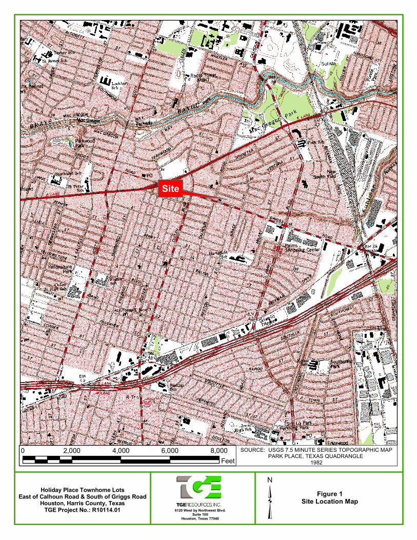
1.0 INTRODUCTION TGE Resources, Inc., (“TGE”) has completed a Limited Phase II Environmental Site Assessment (ESA) at the Holiday Place Townhome Lots located east of Calhoun Road and south of Griggs Road in Houston, Harris County, Texas (Figure 1 – Site Location Map), hereinafter referred to as the "Site" or “subject property”, in general compliance with American Society of Testing Materials (ASTM) Standard Guide for Environmental Site Assessments: Phase II Site Assessment Process (E 1903-97), Re-approved 2002. This assessment was performed in an effort to preliminarily characterize Site soil, and groundwater in the presence of recognized environmental conditions (RECs) associated with the subject property consistent with ASTM guidance. It is TGE’s understanding that Wells Fargo RETECHS (“Client”) requires knowledge of the environmental status of the subject property prior to pending property foreclosure. According to an October 2010, Phase I ESA prepared by Ninyo & Moore for the benefit of Wells Fargo Bank, the subject property is comprised of approximately 6.40 acres of land. The subject property was residentially developed and platted with 120 lots. Per the Ninyo & Moore Phase I ESA, review of historical resources indicated that Site was used as a “storage area from as early as 1944 to approximately 1979.” Between 1989 to 2006 “the site was graded and a parking lot was developed on the eastern portion of the site. By 2010, the site was vacant, graded, residential lots within the Holiday Place Townhomes subdivision. Residential development commenced east and west of the site in approximately 1944. Commercial development commenced north of the site as early as 1944, south of the site in approximately 1953, and east of the site in approximately 1973.” According to the Ninyo & Moore Phase I ESA, adjoining property east, which is occupied by CES Environmental Services, Inc. (CES), has operated as a hazardous, non-hazardous, recyclable, municipal and universal material removal and transport company since at least 1973. According to regulatory database information, CES is listed as a Comprehensive Environmental Response, Compensation and Liability Information System (CERCLIS), a RCRA-Large Quantity Generator (LQG) and an underground petroleum storage tanks (PSTs) facility. Per the October, 2010 Ninyo & Moore Phase I ESA, CES was considered an off-Site REC due to an August 2009 explosion incident that resulted in a possible release of “methanol or other hazardous materials stored at the facility,” as well as historical use and the presence of PSTs in close proximity to the Site. Ninyo & Moore reported that a 1950 Sanborn Fire Insurance Map, reviewed for the Phase I ESA, depicted the subject property as occupied by a “piping yard.” The referenced Sanborn Fire Insurance Map and/or historical aerial photographs were not provided within the Phase I ESA. However, TGE obtained aerial photographs dated 1953, 1969, 1978 and 1989 from the Texas Natural Resource Information System (TNRIS), a division of the Texas Water Development Board (TWDB) Historical Aerial Photograph Database. Based on review of historical aerial photographs, it appears that the subject property was part of a larger tract of land (adjoining property east, currently occupied by CES) that operated as a trucking/transport facility from at least 1940 through 2000. Based upon Findings from the October, 2010 Phase I ESA of the Site prepared by Ninyo & Moore, the following REC was identified in connection with the subject property:
• "The property located at 4904 Griggs Road, adjacent to the eastern boundary of the site, is considered an off-Site REC. Ninyo & Moore considers it possible that methanol or other hazardous materials stored at this facility may have been released to the subsurface during the aforementioned explosion incident, or in the past prior to this explosion incident and Ninyo & Moore considers it possible the historical activities conducted at this adjacent property have impacted the environmental integrity of the site. Additionally, based on the lack of information regarding the USTs at this adjacent property and on the close proximity of the USTs at this facility to the site, Ninyo & Moore considers these USTs a REC for the site.”
2 R10114.01 Phase II ESA – Holiday Place Townhome Lots
Based upon Client’s desire to preliminarily characterize Site soil and groundwater prior to pending property foreclosure, TGE installed three temporary screened boreholes (TSB-1 through TSB-3) at the site. The three temporary screened boreholes were completed within the limits of the subject property to depths of 36 feet below grade (fbg). Temporary screened borehole locations were advanced/installed at the Site at the following locations, given associated rational:
• TSB-1 – centrally located within the limits of the subject property near an on-Site material storage area (as per historical aerial photographs);
• TSB-2 and TSB-3 – along the eastern perimeter of the subject property proximal of CES (to assess for potential impact from off-Site property).
As stipulated in 30 TAC §350.51, “an affected property assessment is to be conducted in a manner appropriate for the affected property considering the hydrogeology, physical and chemical properties of the COCs, location of human and ecological receptors and the complete or reasonably anticipated to be completed exposure pathways” and is to detect the vertical and horizontal extent of COC concentrations in excess of assessment levels. The TCEQ Texas Risk Reduction Program (TRRP) guidance document titled “Determining Which Releases are Subject to TRRP” defines residential assessment levels as “the lowest applicable Tier 1 residential protective concentration limit (PCL) for a given COC, assuming a 0.5 acre source area and Class 1 groundwater.” Therefore, the current subsurface investigation was performed in general compliance with this TCEQ requirement in that COC concentrations in Site media were compared to “residential” PCLs or “residential assessment levels” for purposes of this limited investigation (30 TAC §350.51(a)-(e)). The prescribed residential assessment level in surface and/or subsurface soil is generally established as the lowest of the values for the Tier 1 combined soil protective concentration level (PCL) (TOTSoilComb) or the soil PCL that is protective of groundwater (GWSoilIng) for the appropriate groundwater classification (§350.78). The combined soil PCL (TOTSoilComb) is the classification of combined inhalation (volatile emissions and particulates), ingestion (above and below-ground vegetables), or dermal contact from chemicals of concern (COCs) in surface soil. Where inorganic analytes (i.e., RCRA metals) within soil are designated as potential Site COCs, the residential assessment level for those analytes is set as the published TSMBC when the TSMBC is greater than the lowest Tier 1 PCL. The groundwater protective PCL is the maximum allowable concentration of a chemical in soils considering cross-media impact of groundwater from impacted soil. This level of assessment is to be conducted for purposes of supporting notification of affected landowners and remedy selection, evaluation of whether water resources are affected or threatened, and evaluation of the effectiveness of existing physical controls. Actual designation of a specific property as “commercial/industrial” with subsequently less stringent PCLs is to follow such an assessment.
3 R10114.01 Phase II ESA – Holiday Place Townhome Lots
2.0 SUBSURFACE CONDITIONS
PHYSICAL SETTING INFORMATION FOR SITE AND SURROUNDING AREA
Topography Site and surrounding topography is generally to the west.
Site Elevation Approximately 35 to 40 feet above mean sea level.
Closest Surface Water Brays Bayou located approximately 5,115 feet north of the subject property.
Depth to Groundwater Approximately 25 to 35 fbg.
Soil Characteristics
Soil Type Site and local soils were identified as Urban Land Series (Ur)
Description
Urban land soils are located in the central part of Harris County and the hub of the Houston Urban land soils are located in the central part of Harris County and the hub of the Houston metropolitan area. Urban land is made up of extensively built-up areas where 75 to 100 percent of each mapped area is either covered by structures or disturbed by cutting, filling or grading. Also included in the Urban land mapping area are moderately built-up locations where buildings and other structures cover 40 to 60 percent of the surface; as well as areas of natural soil that have been covered by fill material. In general, the natural soils making up Urban land have been so altered and obscured that they cannot be classified.
Geology/Hydrogeology
Formation The Site appears to overlie the Pleistocene-age Beaumont Formation (Qb).
Description
The upper part of this formation is composed of clay, silt, and sand with minor siliceous gravel. Locally calcareous concretions of calcium carbonate, iron oxide and iron-manganese oxide are present. The surface is fairly flat and featureless except for numerous rounded, shallow depressions and pimple mounds. The lower portion of the Beaumont formation is composed of sand, silt, clay and a minor amount of gravel. Formation thickness, where it has been measured in other locations, is approximately 200 feet. Within the locality of the subject property, the Beaumont Formation is composed of dominantly clay and mud that is highly compressible, with a high water-holding capacity, high shrink-swell potential, high plasticity and poor drainage.
Primary Aquifer Gulf Coast Aquifer System.
Hydrogeologic Gradient
Site-specific hydrogeologic gradient was field-identified as flowing toward the east.
4 R10114.01 Phase II ESA – Holiday Place Townhome Lots
3.0 SOIL BORING AND WELL SCREEN INSTALLATION
On December 21, 2010, Alpine Field Services (“Alpine”) under the supervision of TGE Project Manager Kristi Barnette, P.G. and TGE Senior Project Environmental Scientist Scott Foord mobilized to the Site to drill and install three temporary screened boreholes (TSB-1 through TSB-3) to depths of 36 fbg at the subject property. Temporary screened borehole locations were advanced/installed at the Site at the following locations, given associated rational:
• TSB-1 – centrally located within the limits of the subject property near an on-Site material storage area (as per historical aerial photographs);
• TSB-2 and TSB-3 – along the eastern perimeter of the subject property proximal of CES (to assess for potential impact from off-Site property).
A Site Map depicting the locations of the temporary screened boreholes is presented as Figure 2. Photographs of drilling and sampling activities are contained in Appendix A.
Sediments encountered during drilling operations were logged and classified in accordance with the Unified Soil Classification System and the ASTM Standard D 2488-90, Standard Practice for Description and Identification of Soils (Visual-Manual Procedure). Boring logs describing sediments encountered, depth to groundwater and well construction details are presented in Appendix B – Soil Boring Logs.
Surface cover and sediments generally encountered at the Site consisted of grass and organic matter to depths ranging from the surface to approximately six inches below ground. This surfacing layer was underlain by moist, dark gray, clay that extended to depths ranging from 11 fbg to 13 fbg, which in turn was underlain by stiff, red and tan, moist, silty/sandy clay that extended to depths ranging from approximately 13 fbg to 21 fbg. The penultimate strata consisted of a red, wet silty sand with intermittent clay lenses throughout to depths ranging from 30 to 35 fbg. The silty/sandy clay was underlain by a red and tan, silty clay layer to the terminal depths of the boreholes.
TGE personnel used an organic vapor meter (OVM) in an effort to qualitatively identify the presence of total VOCs in Site sediments. In this field screening method, a portion of the soil sample attained was placed into a designated field screening sample jar and aluminum foil is immediately placed over the mouth of the jar. The jar was left under ambient conditions for approximately five to ten minutes to permit any volatile gases present within the soil pore space to equilibrate within the sample jar headspace. Following this equilibration period, the probe of the OVM was inserted through the aluminum foil into the jar headspace to obtain a qualitative measurement of volatile gases. This method of field screening should not be considered a quantitative analysis, but rather a qualitative indication that VOCs may be present. OVM readings were recorded in units of parts per million (ppm) total VOCs and are listed on boring logs contained in Appendix B. OVM responses were generally absent in ambient air monitored in the work area during field activities. Appreciable OVM responses from the Site were not indicated in soil headspace samples collected from the boreholes (TSB-1 through TSB-3).
Sampling equipment was decontaminated before completing each borehole. Temporary screened boreholes TSB-1 through TSB-3 were constructed of one-inch inside diameter (ID), Schedule 40 polyvinyl chloride (PVC) casing with 0.010-inch slotted PVC screen. The screened interval within the temporary screened boreholes were placed at approximately 26 to 36 fbg; and blank PVC riser casing was installed from approximately 26 fbg to the ground surface.
Following completion of sampling activities on December 21, 2010, the annular space of the boreholes were filled with bentonite (pellet) to grade to seal the borehole. Drill cuttings were not returned to their respective boreholes but were stored in a 55-gallon drum and staged at the Site. Drill cuttings were stored in one 55-gallon drum, appropriately-labeled and staged at the southwestern limits of the property near the entrance gate, pending later off-property management, if warranted.
5 R10114.01 Phase II ESA – Holiday Place Townhome Lots
4.0 SAMPLING AND LABORATORY ANALYSIS Samples of Site soil and groundwater were collected and analyzed during the Limited Phase II ESA at the Holiday Place Townhome Lots located east of Calhoun Road and south of Griggs Road in Houston, Harris County, Texas. Sample collection, analytical parameters, and laboratory results are discussed below. Both soil and groundwater samples collected from TSB-1 through TSB-3 were analyzed for volatile organic compounds (VOCs: EPA Method 8260b), TPH (Texas Method 1005), and RCRA metals (EPA Method 6010b/7470a). Additionally, one sample was analyzed for pH (EPA Method SW 9095A). All sample containers were sealed, labeled according to soil boring designation and placed immediately on ice for delivery to ALS Laboratory Group in Houston, Texas. Analytical results of soil and groundwater samples are summarized in Table 1 and Table 2. Laboratory reports and sample chain-of-custody documentation are contained in Appendix C. Laboratory quantitation limits for the analyzed parameters are included in laboratory reports in Appendix C and comply with EPA Solid Waste (SW) 846 and TCEQ TRRP criteria. 4.1 Cleanup Goals The TCEQ TRRP rule establishes human-health PCLs for exposure via prescribed risk-based formulas (published numerical values). PCLs are based upon specific receptor and exposure pathways (as specified in §350.71(b-c)) with consideration of land use classification (residential or commercial), groundwater classification, distribution of COCs in environmental media and the presence of receptors. Assessment levels may be different in surface soils (the upper 15 feet extending from the ground surface for residential land use and from ground surface to five fbg for commercial/industrial land use) when compared to subsurface soil (between the base of the surface soil and the top of the groundwater-bearing unit). In order to assess a property as commercial/industrial, one must establish an institutional control which is “[a] legal instrument…in the form of a deed notice, VCP Certificate of Completion, or restrictive covenant which indicates the limitations on or the conditions governing use of the property which ensures protection of human health and the environment or equivalent zoning and governmental ordinances.” As stipulated in 30 TAC §350.51, “an affected property assessment is to be conducted in a manner appropriate for the affected property considering the hydrogeology, physical and chemical properties of the COCs, location of human and ecological receptors and the complete or reasonably anticipated to be completed exposure pathways” and is to detect the vertical and horizontal extent of COC concentrations in excess of assessment levels. The TCEQ TRRP guidance document titled “Determining Which Releases are Subject to TRRP” defines residential assessment levels as “the lowest applicable Tier 1 residential PCL for a given COC, assuming a 0.5 acre source area and Class 1 groundwater.” Therefore, the current subsurface investigation was performed in general compliance with this TCEQ requirement in that COC concentrations in Site media were compared to “residential” PCLs or “residential assessment levels” for purposes of this limited investigation (30 TAC §350.51(a)-(e)). The prescribed residential assessment level in surface and/or subsurface soil is generally established as the lowest of the values for the Tier 1 combined soil protective concentration level (PCL) (TOTSoilComb) or the soil PCL that is protective of groundwater (GWSoilIng) for the appropriate groundwater classification (§350.78). The combined soil PCL (TOTSoilComb) is the classification of combined inhalation (volatile emissions and particulates), ingestion (above and below-ground vegetables), or dermal contact from chemicals of concern (COCs) in surface soil. Where inorganic analytes (i.e., RCRA metals) within soil are designated as potential Site COCs, the residential assessment level for those analytes is set as the published Texas-specific median background concentration (TSBC) when the TSBC is greater than the lowest Tier 1 PCL. The groundwater protective PCL is the maximum allowable concentration of a chemical in soils considering cross-media impact of groundwater from impacted soil.
6 R10114.01 Phase II ESA – Holiday Place Townhome Lots
This level of assessment is to be conducted for purposes of supporting notification of affected landowners and remedy selection, evaluation of whether water resources are affected or threatened, and evaluation of the effectiveness of existing physical controls. Actual designation of a specific property as “commercial/industrial” with subsequently less stringent PCLs is to follow such an assessment. 4.2 Soil Sample Collection and Analysis 4.2.1 Soil Sample Collection Soil samples collected from each soil boring (six soil samples total) were submitted to the analytical laboratory. Soil samples were field screened using an OVM to assist in the selection of samples for possible analysis. In each boring, the soil sample with greatest recognizable environmental impact, if any, was collected for laboratory analysis. Additional (contingency) soil samples were also collected within the upper five feet of each boring or within the subsoil profile to the terminal depth of the borehole if deemed appropriate as a result of field assessment observations. Sampling protocol included close adherence to EPA SW 846 protocol and TGE Standard Operating Procedures (SOP). Specifically, soil samples were collected in decontaminated samplers and placed into sterile, glass containers in a manner which minimized available “head space” within the container. 4.2.2 Soil Sample Analytical Results Soil samples collected from boreholes TSB-1 through TSB-3 were reported by the analytical laboratory to not contain VOCs or TPH in excess of laboratory detection limits, or if detected, concentrations were below their respective TCEQ residential assessment levels.
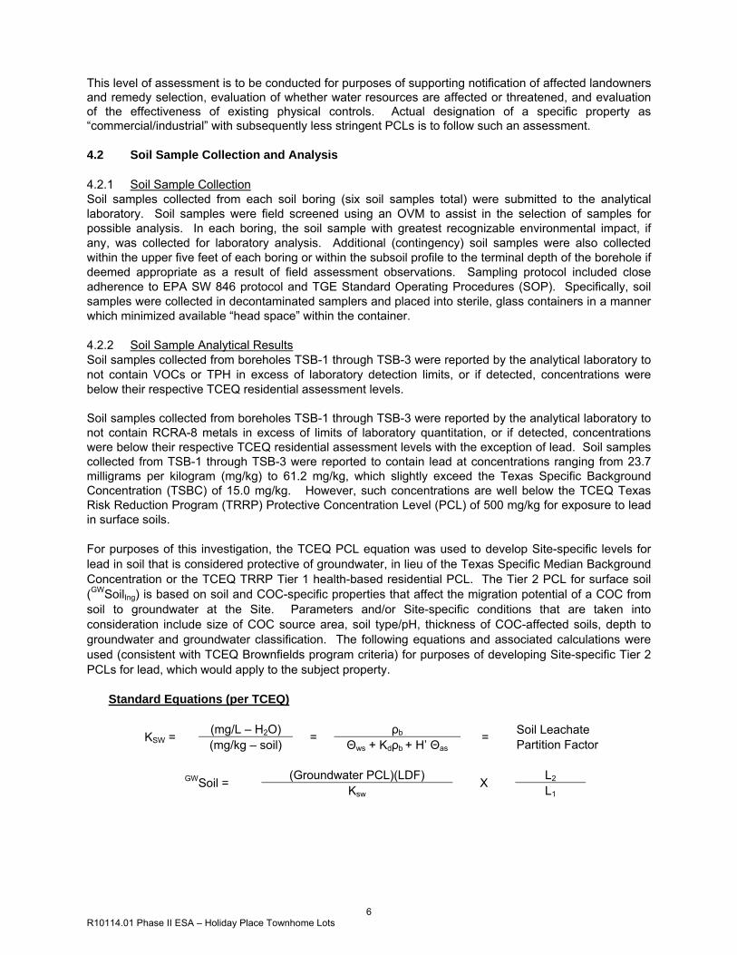
Soil samples collected from boreholes TSB-1 through TSB-3 were reported by the analytical laboratory to not contain RCRA-8 metals in excess of limits of laboratory quantitation, or if detected, concentrations were below their respective TCEQ residential assessment levels with the exception of lead. Soil samples collected from TSB-1 through TSB-3 were reported to contain lead at concentrations ranging from 23.7 milligrams per kilogram (mg/kg) to 61.2 mg/kg, which slightly exceed the Texas Specific Background Concentration (TSBC) of 15.0 mg/kg. However, such concentrations are well below the TCEQ Texas Risk Reduction Program (TRRP) Protective Concentration Level (PCL) of 500 mg/kg for exposure to lead in surface soils. For purposes of this investigation, the TCEQ PCL equation was used to develop Site-specific levels for lead in soil that is considered protective of groundwater, in lieu of the Texas Specific Median Background Concentration or the TCEQ TRRP Tier 1 health-based residential PCL. The Tier 2 PCL for surface soil (GWSoilIng) is based on soil and COC-specific properties that affect the migration potential of a COC from soil to groundwater at the Site. Parameters and/or Site-specific conditions that are taken into consideration include size of COC source area, soil type/pH, thickness of COC-affected soils, depth to groundwater and groundwater classification. The following equations and associated calculations were used (consistent with TCEQ Brownfields program criteria) for purposes of developing Site-specific Tier 2 PCLs for lead, which would apply to the subject property.
Standard Equations (per TCEQ)
KSW = (mg/L – H2O) = ρb = Soil Leachate Partition Factor (mg/kg – soil) Θws + Kdρb + H’ Θas
GWSoil = (Groundwater PCL)(LDF) X L2
Ksw L1
7 R10114.01 Phase II ESA – Holiday Place Townhome Lots
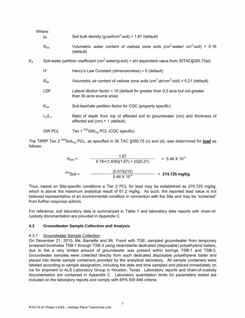
Where: ρb Soil bulk density (g-soil/cm3-soil) = 1.67 (default)
Θws Volumetric water content of vadose zone soils (cm3-water/ cm3-soil) = 0.16
(default) Kd Soil-water partition coefficient (cm3-water/g-soil) = pH dependent value from 30TAC§350.73(e)
H’ Henry’s Law Constant (dimensionless) = 0 (default)
Θas Volumetric air content of vadose zone soils (cm3-air/cm3-soil) = 0.21 (default)
LDF Lateral dilution factor = 10 (default for greater than 0.5 acre but not greater than 30 acre source area)
Ksw Soil-leachate partition factor for COC (property specific)
L2/L1 Ratio of depth from top of affected soil to groundwater (cm) and thickness of affected soil (cm) = 1 (default)
GW PCL Tier 1 GWGWIng PCL (COC specific) The TRRP Tier 2 GWSoilIng PCL, as specified in 30 TAC §350.75 (c) and (d), was determined for lead as follows:
KSW = 1.67 = 5.46 X 10⁻⁴ 0.16+(1,830)(1.67) + (0)(0.21)
GWSoil = (0.015)(10) = 274.725 mg/kg 5.46 X 10⁻⁴ Thus, based on Site-specific conditions a Tier 2 PCL for lead may be established as 274.725 mg/kg, which is above the maximum analytical result of 61.2 mg/kg. As such, the reported lead value is not believed representative of an environmental condition in connection with the Site and may be “screened” from further response actions. For reference, soil laboratory data is summarized in Table 1 and laboratory data reports with chain-of-custody documentation are provided in Appendix C. 4.3 Groundwater Sample Collection and Analysis 4.3.1 Groundwater Sample Collection On December 21, 2010, Ms. Barnette and Mr. Foord with TGE, sampled groundwater from temporary screened boreholes TSB-1 through TSB-3 using clean/sterile dedicated (disposable) polyethylene bailers, due to the a very limited amount of groundwater was present within borings TSB-1 and TSB-3. Groundwater samples were collected directly from each dedicated disposable polyethylene bailer and placed into sterile sample containers provided by the analytical laboratory. All sample containers were labeled according to sample designation, including the date and time sampled and placed immediately on ice for shipment to ALS Laboratory Group in Houston, Texas. Laboratory reports and chain-of-custody documentation are contained in Appendix C. Laboratory quantitation limits for parameters tested are included on the laboratory reports and comply with EPA SW-846 criteria.
8 R10114.01 Phase II ESA – Holiday Place Townhome Lots
4.3.2 Groundwater Sample Analytical Results Groundwater samples collected from boreholes TSB-1 through TSB-3 were reported by the analytical laboratory to not contain VOCs or TPH in excess of laboratory detection limits, or if detected, concentrations were below their respective TCEQ residential assessment levels.
Groundwater analytical results from temporary screened boreholes TSB-1 through TSB-3 were reported by the analytical laboratory to not contain RCRA-8 metals in excess of laboratory detection limits, or if detected, concentrations were below their respective TCEQ residential assessment levels with the exception of lead and chromium. Groundwater samples collected from TSB-2 were found to contain lead at a concentration of 0.025 milligrams per liter (mg/L), which is above the TRRP residential assessment level (based on the Tier 1 Residential PCL) of 0.015 mg/L. Additionally, the groundwater sample collected from TSB-2 was found to contain chromium at a concentration of 0.116 mg/L which is slightly above the TRRP residential assessment level of 0.10 mg/L. Due to exceedance of TCEQ assessment levels for lead and chromium, the potential of such elevated values being a result of high naturally occurring suspended sediment in unfiltered groundwater samples was believed of issue. However, due to the very limited availability of groundwater recovered from the borehole, TSB-2, no filtered groundwater sample could be collected for confirmation analyses. It should be noted that while soil sample analyses reported concentrations of RCRA-8 metals lead and chromium in excess of current TRRP residential assessment levels, per TRRP guidance document TRRP-10, titled “Selecting Target Chemicals of Concern”, professional judgment may be used to advance a position that further consideration (and assessment) of these analytes with respect to the subject investigation is not indicated. Specifically, based on findings provided within the foregoing Phase I ESA, lead and chromium are not interpreted as “target COCs” with respect to current/historic Site use as a retail gasoline station. Additionally, groundwater gradient was determined to be toward (and not from) the property of concern (CES) located adjacent east. Furthermore, lead and chromium concentrations detected within groundwater collected from boring TSB-2 are more likely than not the result of naturally present, high suspended sediment in the limited groundwater available in the first water bearing unit at the time of this investigation. Given that groundwater collected from borings TSB-1 and TSB-3 were below their respective TCEQ residential assessment levels for RCRA-8 metals, detections of the RCRA-8 metals lead and chromium within boring TSB-2 are considered representative of naturally-occurring conditions, and not indicated per Site knowledge to have resulted from human activity at the project location. As such, these metals may be “screened” from further consideration for purposes of TRRP, per 30 TAC §350.71(k)(2)(E). Such screening of COCs should be considered “internally” to determine whether further corrective action activity (or follow-up characterization assessment) at the Site would be warranted. However, agency response would require preparation and submittal of a complete Affected Property Assessment Report (APAR), as specified in 30 TAC §350.51 to solicit state agency concurrence with this professional opinion. For reference, groundwater laboratory data is summarized in Table 2 and laboratory data reports with chain-of-custody documentation and are provided in Appendix C. 4.4 Project Deviations Per TGE Proposal Number P10114.01, dated December 8, 2010, the following deviation from the proposal were realized during performance of the Phase II ESA conducted for the subject property by TGE.
• Although a saturated unit was encountered the day of temporary screened borehole installation, a filtered groundwater sample was not collected from boring TSB-2 due to the limited amount of groundwater available from the groundwater bearing unit.
9 R10114.01 Phase II ESA – Holiday Place Townhome Lots
4.5 Laboratory Data Validation TGE reviewed data packages prepared by ALS Laboratory Group relative to soil and groundwater sample analyses for the subject property. The intended use of data generated by the current investigation was to provide limited Site characterization details relative to targeted COC’s. Analyses performed were limited to the following:
• SW-846 8260b – VOCs by gas chromatography mass spectroscopy (GC/MS); • TNRCC 1005 – Total Petroleum (TPH) Hydrocarbons by GC; • SM-2540g – moisture/solid percentage by general chemistry; • SW-846 7470a/7471 – mercury by cold vapor atomic absorption (CVAA); • SW-846 6020b – RCRA metals by inductively coupled plasma (ICP); and • SW-846 9095A – per hydrogen ion (pH).
Laboratory analytical reports are provided in Appendix C. The data was evaluated based upon the following parameters: completeness of the data package, quality control batch reports, hold times and laboratory case narratives. Based on the above-referenced review and the project level of required performance (LORP), data present herein was considered valid as qualified.
10 R10114.01 Phase II ESA – Holiday Place Townhome Lots
5.0 WATER GAUGING AND POTENTIOMETRIC SURFACE DATA TGE determined the relative top of casing (TOC) elevations at each monitoring well using a transit and stadia rod. Because there were no available benchmarks at or near the Site, TGE established an assumed base elevation for the subject property. Temporary screened borehole TSB-2 was assigned an arbitrary elevation of 100.00 feet. Prior to groundwater sampling, static groundwater levels were measured and recorded for each monitor well. Measured depths to groundwater and relative groundwater surface elevations are summarized in Table 3. Static groundwater levels in the subject monitor wells were measured at depths ranging from 23.90 to 25.11 feet below TOC. Localized groundwater flow direction for the December 21, 2010, groundwater gauging event was generally toward the east with a hydraulic gradient of approximately 0.002 feet per foot (ft/ft). A potentiometric surface map for the portion of the Site subject to the current investigation on December 21, 2010, is provided as Figure 3.
11 R10114.01 Phase II ESA – Holiday Place Townhome Lots
6.0 FINDINGS TGE has completed a Limited Phase II ESA at Holiday Place Townhome Lots located east of Calhoun Road and south of Griggs Road in Houston, Harris County, Texas. These assessment efforts were performed in an effort to preliminarily characterize the RECs identified by TGE associated with the subject property, consistent with ASTM Standard Practice for Environmental Site Assessments (E1527-05). 6.1 Findings Based on analytical data obtained following soil and groundwater sample analyses pursuant to this assessment effort, TGE prepared the following summary of results/findings:
• Soil samples collected from boreholes TSB-1 through TSB-3 were reported by the analytical laboratory to not contain volatile organic compounds (VOCs) or total petroleum hydrocarbons (TPH) in excess of laboratory detection limits, or if detected, concentrations were below their respective TCEQ residential assessment levels.
• Soil samples collected from boreholes TSB-1 through TSB-3 were reported by the analytical laboratory to not contain RCRA-8 metals in excess of limits of laboratory quantitation, or if detected, concentrations were below their respective TCEQ residential assessment levels with the exception of lead. Soil samples collected from TSB-1 through TSB-3 were reported to contain lead at concentrations ranging from 23.7 milligrams per kilogram (mg/kg) to 61.2 mg/kg, which slightly exceed the Texas Specific Background Concentration (TSBC) of 15.0 mg/kg. However, such concentrations are well below the TCEQ Texas Risk Reduction Program (TRRP) Protective Concentration Level (PCL) of 500 mg/kg for exposure to lead in surface soils. Given exceedances of the residential assessment level for lead, TGE referred to the TRRP PCL equation for the soil-to-groundwater pathway (GWSoilIng). An equation was used to calculate Site-specific levels for lead in soil that is considered protective of groundwater in lieu of the TSBC or TRRP Tier 1 PCL.
• Based on Site-specific conditions, a Tier 2 GWSoilIng PCL of 274.725 mg/kg for lead can be established in soil at the Site. The previously detected maximum concentration of 61.2 mg/kg for lead in soil sample TSB-1 (2-3’) is well below the calculated Tier 2 PCL for the Site. As such, the reported lead value is not believed representative of an environmental condition in connection with the Site and may be “screened” from further response actions.
• Groundwater samples collected from boreholes TSB-1 through TSB-3 were reported by the analytical laboratory to not contain VOCs or TPH in excess of laboratory detection limits, or if detected, concentrations were below their respective TCEQ residential assessment levels.
• Groundwater analytical results from temporary screened boreholes TSB-1 through TSB-3 were reported by the analytical laboratory to not contain RCRA-8 metals in excess of laboratory detection limits, or if detected, concentrations were below their respective TCEQ residential assessment levels with the exception of lead and chromium. Groundwater samples collected from TSB-2 were found to contain lead at a concentration of 0.025 milligrams per liter (mg/L), which is above the TRRP residential assessment level (based on the Tier 1 Residential PCL) of 0.015 mg/L. Additionally, the groundwater sample collected from TSB-2 was found to contain chromium at a concentration of 0.116 mg/L which is slightly above the TRRP residential assessment level of 0.10 mg/L. Due to exceedance of TCEQ assessment levels for lead and chromium, the potential of such elevated values being a result of high naturally occurring suspended sediment in unfiltered groundwater samples was believed of issue. However, due to the very limited availability of groundwater recovered from the borehole, TSB-2, no filtered groundwater sample could be collected for confirmation analyses.
12 R10114.01 Phase II ESA – Holiday Place Townhome Lots
It should be noted that while soil sample analyses reported concentrations of RCRA-8 metals lead and chromium in excess of current TRRP residential assessment levels, per TRRP guidance document TRRP-10, titled “Selecting Target Chemicals of Concern”, professional judgment may be used to advance a position that further consideration (and assessment) of these analytes with respect to the subject investigation is not indicated. Specifically, based on findings provided within the foregoing Phase I ESA, lead and chromium are not interpreted as “target COCs” with respect to current/historic Site use as a retail gasoline station. Additionally, groundwater gradient was determined to be toward (and not from) the property of concern (CES) located adjacent east. Furthermore, lead and chromium concentrations detected within groundwater collected from boring TSB-2 are more likely than not the result of naturally present, high suspended sediment in the limited groundwater available in the first water bearing unit at the time of this investigation. Given that groundwater collected from borings TSB-1 and TSB-3 were below their respective TCEQ residential assessment levels for RCRA-8 metals, detections of the RCRA-8 metals lead and chromium within boring TSB-2 are considered representative of naturally-occurring conditions, and not indicated per Site knowledge to have resulted from human activity at the project location. As such, these metals may be “screened” from further consideration for purposes of TRRP, per 30 TAC §350.71(k)(2)(E). Such screening of COCs should be considered “internally” to determine whether further corrective action activity (or follow-up characterization assessment) at the Site would be warranted. However, agency response would require preparation and submittal of a complete Affected Property Assessment Report (APAR), as specified in 30 TAC §350.51 to solicit state agency concurrence with this professional opinion.
6.2 Recommendation Based on results of this Site characterization effort, and within stated project limitations and qualifications made part of this work, TGE does not provide recommendations for further soil or groundwater assessment at the subject property. However, the following suggested courses of action may be advised.
• Drummed investigation-derived soil and groundwater from the current subsurface investigation, which is currently stored at the Site in two (2) 55-gallon drums (one containing soil and one containing groundwater) are not considered to require special handling. This material may be properly disposed via a licensed transporter at a regulated facility in compliance with applicable regulations; or may be discharged on-Site.
13 R10114.01 Phase II ESA – Holiday Place Townhome Lots
7.0 QUALIFICATIONS
Our professional services have been performed, our findings obtained and our recommendations prepared in accordance with customary principles and practices in the fields of environmental science and engineering. This company is not responsible for independent conclusions, opinions or recommendations made by others based on the field exploration and laboratory test data presented in this report. Work performed in conjunction with this assessment and data developed are intended as a description of available information at the dates and locations given. This report does not warrant against future operations or conditions, nor does it warrant against operations or conditions present of a type or at a location not investigated. Conclusions presented in this report are professional opinions based solely upon visual observations and preliminary testing of soil and groundwater at the subject property, as described in this report. They are intended exclusively for the purpose outlined herein and at the Site and project indicated. This report is intended exclusively for the purpose outlined herein and at the Site location indicated. This report is intended for the sole use of Client, and their representatives. The scope of services performed in execution of this investigation may not be appropriate to satisfy the needs of other users, and any use or re-use of this document or the findings, conclusions, or recommendations presented herein is at the sole risk of said user. It should be recognized that this study was not intended to be a definitive investigation of contamination across the subject property. Although the scope of services for this investigation included exploratory borings and analytical testing of soil and groundwater, it is possible that currently unrecognized contamination may exist at the Site and that the levels of this potential contamination may vary across the Site. Opinions and recommendations presented herein apply to Site conditions existing at the time of our investigation and those reasonable foreseeable. They cannot necessarily apply to Site changes of which this company is not aware and has not had the opportunity to evaluate.
14 R10114.01 Phase II ESA – Holiday Place Townhome Lots
8.0 REFERENCES ASTM Guidance ASTM Standard Guide for Environmental Site Assessments: Phase II Site Assessment Process (E 1903-97), Re-approved 2002. Topographic Map USGS 7.5 minute Topographic Map, Park Place, Texas Quadrangle, (1982). Area Soil Map US Department of Agriculture Soil Conservation Service Soil Survey of Harris County, Texas. Geologic Map University of Texas, Bureau of Economic Geology, Geologic Atlas of Texas, Houston Sheet, Revised 1974. PCL Tables TCEQ Tier 1 Protective Concentration Levels Tables for TRRP Rule, last revised March, 2010, http://www.tceq.state.tx.us/comm_exec/forms_pubs/pubs/rg/rg-366_trrp_23.html. General Guidance TDLR, Water Well Drillers and Water Well Pump Installers, Administrative Rules of the Texas Department of Licensing and Regulation, 16 TAC, Chapter 76. TCEQ, Industrial Solid Waste Management, Technical Guidance 6, Revised 10-2004.
TGE Resources, Inc.
FIGURES
6120 West by Northwest Blvd.Suite 100
Houston, Texas 77040
Holiday Place Townhome LotsEast of Calhoun Road & South of Griggs Road
Houston, Harris County, TexasTGE Project No.: R10114.01
Figure 1Site Location Map
Site
0 2,000 4,000 6,000 8,000Feet
SOURCE: USGS 7.5 MINUTE SERIES TOPOGRAPHIC MAPPARK PLACE, TEXAS QUADRANGLE
1982


