distribution of noxious weeds in riparian corridor …€¦ · general location of colorado...
TRANSCRIPT
Distribution of Noxious Weeds In Riparian Corridor Habitat of
Threatened Plant and Animal Species on F.E. Warren Air Force Base
Prepared for the US Air Force by: Bonnie Heidel and Scott Laursen Wyoming Natural Diversity Database University of Wyoming
PO Box 3381 Laramie, WY 82071
Prepared for:
Ms. Cathryn Pesenti Environmental Management Flight Francis E. Warren Air Force Base
90 CES / CEVN 300 Vesle Drive
Francis E. Warren Air Force Base, Wyoming 82005
January 2002
Insert 2 photos.
2
TABLE OF CONTENTS Page Introduction . . . . . . . . . . . . . . . . . . . . . . . . . . . . . . . . . . . . . . . . . . . . . . . . . . . . . . . . . . . . . 5 Methods . . . . . . . . . . . . . . . . . . . . . . . . . . . . . . . . . . . . . . . . . . . . . . . . . . . . . . . . . . . . . . . . 5 Study Area . . . . . . . . . . . . . . . . . . . . . . . . . . . . . . . . . . . . . . . . . . . . . . . . . . . . . . . . 5 1999 Distribution-Modeling . . . . . . . . . . . . . . . . . . . . . . . . . . . . . . . . . . . . . . . . . . . 8 2000 Weed Mapping . . . . . . . . . . . . . . . . . . . . . . . . . . . . . . . . . . . . . . . . . . . . . . . . 9 2001 Weed Mapping . . . . . . . . . . . . . . . . . . . . . . . . . . . . . . . . . . . . . . . . . . . . . . . . 9 Results . . . . . . . . . . . . . . . . . . . . . . . . . . . . . . . . . . . . . . . . . . . . . . . . . . . . . . . . . . . . . . . . . 10 Weed Mapping (2000-2001) . . . . . . . . . . . . . . . . . . . . . . . . . . . . . . . . . . . . . . . . . . . 10 Comparison between Distribution Modeling and Field Mapping . . . . . . . . . . . . . . 12 Overlap between Weeds and Colorado butterfly plant . . . . . . . . . . . . . . . . . . . . . . . 13 Discussion . . . . . . . . . . . . . . . . . . . . . . . . . . . . . . . . . . . . . . . . . . . . . . . . . . . . . . . . . . . . . . 13 Weed Mapping (2000-2001) . . . . . . . . . . . . . . . . . . . . . . . . . . . . . . . . . . . . . . . . . . . 13 Comparison between Distribution Modeling and Field Mapping . . . . . . . . . . . . . . 14 Overlap between Weeds and Colorado butterfly plant . . . . . . . . . . . . . . . . . . . . . . . 15 Conclusions . . . . . . . . . . . . . . . . . . . . . . . . . . . . . . . . . . . . . . . . . . . . . . . . . . . . . . . . 16 Literature Cited . . . . . . . . . . . . . . . . . . . . . . . . . . . . . . . . . . . . . . . . . . . . . . . . . . . . . . . . . . . 18 Acknowledgements . . . . . . . . . . . . . . . . . . . . . . . . . . . . . . . . . . . . . . . . . . . . . . . . . . . . . . . 18
3
Figures, Tables, and Appendices
Figure 1. General location of Colorado butterfly plant and Preble’s meadow jumping mouse populations on
F.E. Warren Air Force Base. . . . . . . . . . . . . . . . . . . . . . . . . . . . . . . . 6 2. Weed-mapping areas on F.E. Warren Air Force Base . . . . . . . . . . . . . . . . . . . . . . . . . . . 7 3. Distribution of Canada thistle and Colorado butterfly plant along upper Crow Creek . . . . . . . . . . . . . . . . . . . . . . . . . . . . . . . . . . . . . . . . . . . . . . . . . . . . . . . . . . . . . 19 4. Distribution of Canada thistle and Colorado butterfly plant along upper and lower
Crow Creek . . . . . . . . . . . . . . . . . . . . . . . . . . . . . . . . . . . . . . . . . . . . . . . . . . . . . . . . 20 5. Distribution of Canada thistle along lower Crow Creek . . . . . . . . . . . . . . . . . . . . . . . . . 21 6. Distribution of Canada thistle and Colorado butterfly plant along Diamond Creek . . . . 22 7. Distribution of Canada thistle along lower Unnamed drainage. . . . . . . . . . . . . . . . . . . . 23 8. Distribution of Canada thistle and Colorado butterfly plant along upper Unnamed drainage . . . . . . . . . . . . . . . . . . . . . . . . . . . . . . . . . . . . . . . . . . . . . . . . . . . . . . . . . . . 24
9. Distribution of Leafy spurge and Colorado butterfly plant along upper Crow Creek . . . . . . . . . . . . . . . . . . . . . . . . . . . . . . . . . . . . . . . . . . . . . . . . . . . . . . . . . . 25 10. Distribution of Leafy spurge and Colorado butterfly plant along upper and
lower Crow Creek . . . . . . . . . . . . . . . . . . . . . . . . . . . . . . . . . . . . . . . . . . . . . . . . 26 11. Distribution of Leafy spurge along lower Crow Creek . . . . . . . . . . . . . . . . . . . . . . . 27 12. Distribution of Leafy spurge and Colorado butterfly plant along Diamond Creek . . . . . . . . . . . . . . . . . . . . . . . . . . . . . . . . . . . . . . . . . . . . . . . . . . . . . . . . . . 28 13. Distribution of Leafy spurge along lower Unnamed drainage. . . . . . . . . . . . . . . . . . 29 14. Distribution of Leafy spurge and Colorado butterfly plant along upper Unnamed drainage . . . . . . . . . . . . . . . . . . . . . . . . . . . . . . . . . . . . . . . . . . . . . . . . 30 15. Distribution of Dalmatian toadflax and Colorado butterfly plant along upper
Crow Creek . . . . . . . . . . . . . . . . . . . . . . . . . . . . . . . . . . . . . . . . . . . . . . . . . . . . . 31 16. Distribution of Dalmatian toadflax and Colorado butterfly plant along upper
and lower Crow Creek . . . . . . . . . . . . . . . . . . . . . . . . . . . . . . . . . . . . . . . . . . . . 32 17. Distribution of Dalmatian toadflax along lower Crow Creek . . . . . . . . . . . . . . . . . . 33 18. Distribution of Dalmatian toadflax and Colorado butterfly plant along Diamond Creek . . . . . . . . . . . . . . . . . . . . . . . . . . . . . . . . . . . . . . . . . . . . . . . . . 34 19. Distribution of Dalmatian toadflax along lower Unnamed drainage. . . . . . . . . . . . . 35 20. Distribution of Dalmatian toadflax and Colorado butterfly plant along upper Unnamed drainage . . . . . . . . . . . . . . . . . . . . . . . . . . . . . . . . . . . . . . . . . . . . . . . 36 21. Distribution of Common hound’s tongue and Colorado butterfly plant along
upper Crow Creek . . . . . . . . . . . . . . . . . . . . . . . . . . . . . . . . . . . . . . . . . . . . . . . . 37 22. Distribution of Common hound’s tongue and Colorado butterfly plant along
upper and lower Crow Creek . . . . . . . . . . . . . . . . . . . . . . . . . . . . . . . . . . . . . . . 38 23. Distribution of Common hound’s tongue along lower Crow Creek . . . . . . . . . . . . 39 24. Distribution of Common hound’s tongue and Colorado butterfly plant along
4
Diamond Creek . . . . . . . . . . . . . . . . . . . . . . . . . . . . . . . . . . . . . . . . . . . . . . . . . 40 25. Distribution of Common hound’s tongue along lower Unnamed drainage. . . . . . . . 41 26. Distribution of Common hound’s tongue and Colorado butterfly plant along upper Unnamed drainage. . . . . . . . . . . . . . . . . . . . . . . . . . . . . . . . . . . . . . . . . . . 42 27. Distribution of Purple loosestrife and Colorado butterfly plant along upper Crow Creek . . . . . . . . . . . . . . . . . . . . . . . . . . . . . . . . . . . . . . . . . . . . . . . . . . . . 43 Table 1. Extent of Noxious Weeds in Riparian Corridor Habitat on F. E. Warren AFB . . . . . . . 11 2. Extent of Noxious Weed Species Predicted and Mapped Along Upper Crow Creek and Diamond Creek . . . . . . . . . . . . . . . . . . . . . . . . . . . . . . . . . . . . . . . . . . . . . . . . . 12 3. Extent of Distribution Overlap between Noxious Weeds and the Colorado Butterfly Plant . . . . . . . . . . . . . . . . . . . . . . . . . . . . . . . . . . . . . . . . . . . . . . . . . . . 13
5
Appendix A. Non-native plant species of F.E. Warren Air Force Base . . . . . . . . . . . . . . . . . . . . . . 44 B. Noxious weeds of F.E. Warren Air Force Base . . . . . . . . . . . . . . . . . . . . . . . . . . . . . 47 Canada thistle . . . . . . . . . . . . . . . . . . . . . . . . . . . . . . . . . . . . . . . . . . . . . . . . . . . . . 47 Leafy spurge . . . . . . . . . . . . . . . . . . . . . . . . . . . . . . . . . . . . . . . . . . . . . . . . . . . . . 49 Dalmatian toadflax . . . . . . . . . . . . . . . . . . . . . . . . . . . . . . . . . . . . . . . . . . . . . . . . 50
Common hound’s tongue . . . . . . . . . . . . . . . . . . . . . . . . . . . . . . . . . . . . . . . . . . . . 48 Purple loosestrife . . . . . . . . . . . . . . . . . . . . . . . . . . . . . . . . . . . . . . . . . . . . . . . . . . 51 Cover Images (left to right): Dense Canada thistle patch by “No Mowing” sign along the Unnamed drainage. Photo by Walter Fertig, 1 September 1999. Map of Canada thistle distribution along Upper Crow Creek.
6
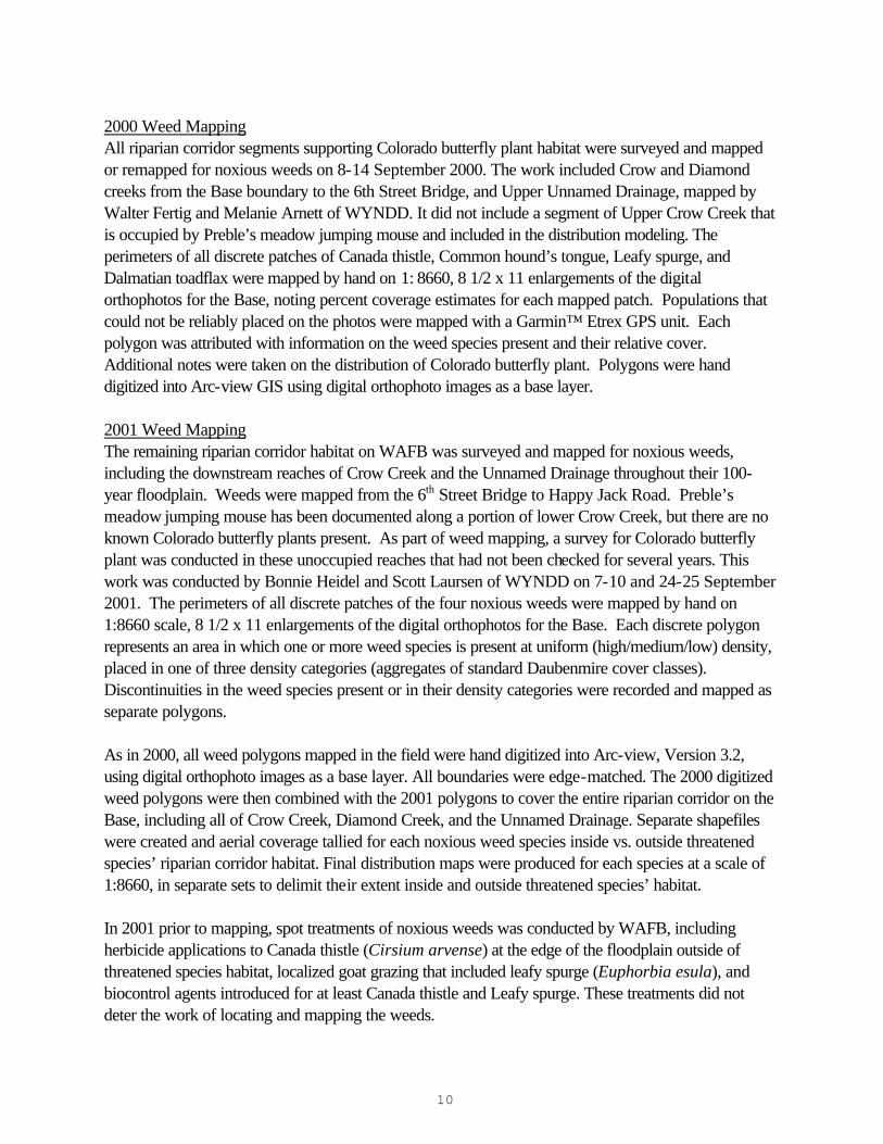
INTRODUCTION F.E. Warren Air Force Base (WAFB) provides riparian habitat for the federally Threatened Preble’s meadow jumping mouse (Zapus hudsonius preblei) and Colorado butterfly plant (Gaura neomexicana ssp. coloradensis) (Fertig 1995, 2001; Dark-Smiley and Keinath 2002) as well as several species of reptiles, amphibians, and birds that considered rare in Wyoming (Keinath 2002, Bennett 2002). Among the many threats to these species are competition and habitat degradation resulting from the invasion of non-native plants. Statewide, approximately 350 plant taxa are considered non-native (12.6% of the total flora), of which 67 occur on WAFB (Appendix A, Easter and Douglas 1996, Hazlett 1999, Fertig 1999a). Five non-native plants (Canada thistle, Common hound’s tongue, Leafy spurge, Dalmatian toadflax, and Purple loosestrife) are of particularly high management concern because of their ability to invade riparian and floodplain areas occupied by these rare species (Jones 1996, Hollingsworth 1996.) Beginning in 1999, the US Air Force contracted with University of Wyoming and the Wyoming Natural Diversity Database (WYNDD) to map the distribution of these five noxious weed species in the Crow and Diamond creek watersheds. Hiemstra and Fertig (2000) produced a series of weed distribution maps based on limited Global Positioning System (GPS) field mapping and distribution modeling using a computerized modeling algorithm and digital orthophoto images of the Base. In September 2000, these distribution-modeling maps were ground-truthed in segments with Colorado butterfly plant, and revised with new ocular and GPS data. In August-September 2001, the rest of the stream reaches that support Preble’s meadow jumping mouse were surveyed, in addition to riparian corridors downstream on the Base that do not support Threatened plant or animal species. The field mapping and modeling efforts of 1999, 2000, and 2001 offer three final products: 1) the field maps and distribution modeling maps of noxious weeds within riparian corridors on the Base, 2) the final analysis comparing results between field mapping and distribution modeling of noxious weeds, and 3) the final analysis comparing the distribution of noxious weeds with that of Colorado butterfly plant. These three sets of results provide a reference for assessing conditions and management needs. METHODS Study Area The study area includes all riparian corridor habitat on WAFB within the 100-year floodplain (Figures 1 and 2.). Mapping in 1999-2000 was restricted to the known range of Colorado butterfly plant on Crow and Diamond creeks and the “Unnamed Drainage” (an ephemeral tributary of Crow Creek). Mapping in 2001 completed a small area of the stream reaches that support Preble’s meadow jumping mouse. It also covered all downstream reaches of Crow Creek and the “Unnamed Drainage.” We refer to five units of weed mapping throughout this report (Figure 2). Threatened species habitat is in Upper Crow Creek, Diamond Creek and Upper Unnamed Drainage. Results are presented separately for Lower Crow Creek and Lower Unnamed Drainage that do not support Threatened species.

7
Figure 1. General Location of Colorado Butterfly Plant and Preble’s Meadow Jumping Mouse Populations on F.E. Warren Air Force Base. Colorado butterfly plant Preble’s meadow jumping mouse
Note: Both species overlap at the far northeastern end of Crow Creek.
8
Figure 2. Weed-mapping areas on F.E.Warren Air Force Base
(scale 1:25,000)
Upper Crow Creek
Lower Crow Creek
Diamond Creek
Upper Unnamed Drainage
Lower Unnamed Drainage

9
Riparian areas within the floodplain are a mosaic of Coyote willow/Strapleaf willow thickets (Salix exigua/S. eriocephala var. ligulifolia), Green ash/Lanceleaf cottonwood woodlands (Fraxinus pennsylvanica/Populus x acuminata), Cattail marshes (Typha latifolia), Nebraska sedge/Woolly sedge wetlands (Carex nebrascensis/C. lanuginosa), and moist meadows of Redtop (Agrostis stolonifera), Baltic rush (Juncus balticus), Kentucky bluegrass (Poa pratensis), Little bluestem (Schizachyrium scoparium), and Licorice-root (Glycyrrhiza lepidota). Dry upland areas have scattered patches of ash and cottonwood or grasslands of Blue grama (Bouteloua gracilis), Kentucky bluegrass, Western wheatgrass (Elymus smithii), or Needle-and-thread (Stipa comata) (Marriott and Jones 1988). The upper reaches of Crow Creek in particular have more braided channels and meandering while the lower stream reaches of Crow Creek follow a single channel that is incised in places. The lower reaches also have a broad, well-drained floodplain, defined as the 100-year floodplain. Extensive areas in the riparian zone are currently dominated by four noxious weed species targeted in this study: Canada thistle, Common hound’s tongue, Leafy spurge, and Dalmatian toadflax. 1999 Distribution Modeling In 1999, field mapping was limited to the upper reach of Crow Creek (north of the FamCamp access road) and the westernmost bend of Diamond Creek. Within these areas, all discrete patches of the 5 target weed species were mapped using a Trimble GeoExplorer® II GPS. The perimeter of each patch was traversed on foot, with the GPS recording positions at approximately 15-second intervals. Each polygon mapped in the field was attributed with the names of the weed species present in the patch. These data were differentially corrected using Trimble’s Pathfinder Office™ (v. 2.11, 1999) software and data from the University of Wyoming/BLM Casper Field Office base station in Casper, Wyoming. Once corrected, the data were exported into Arc-Info® Geographical Information System (GIS) on a Unix® Workstation for processing and analysis. Also in 1999, remote sensing weed distribution maps were created for the entire upper half of Crow Creek and all of Diamond Creek. Individual field-mapped polygons were overlain onto digital orthophotograph images of WAFB available from the University of Wyoming’s Spatial Data and Visualization Center (http://www.sdvc.uwyo.edu). These aerial photos were taken on 23 June 1994. The arc and orthophoto coverages were converted to grid format in Arc-view® and color-coded using a grayscale of 255 units. A query command was used to identify the subset of grayscale colors that were positively associated with the GPS-mapped distribution of each weed species. In Arc-Info, the Describe command was used to determine the average numeric value (DN) and standard deviation (SD) of the selected grayscale colors. Using this information, the study area was reclassified for each target species using the formula:
extrapolated DN range = average DN ? ½ SD
All grayscale values falling within the extrapolated DN range were selected in Arc-Info to represent the potential distribution of the target species. Distribution maps (Figures 5-8 in Hiemstra and Fertig 2000) were created in Arc-view by overlaying the selected grid cells on the orthophoto base image. The maps predicted where weeds could occur at the time the model was generated, based on relationships among known occurrences.
10
2000 Weed Mapping All riparian corridor segments supporting Colorado butterfly plant habitat were surveyed and mapped or remapped for noxious weeds on 8-14 September 2000. The work included Crow and Diamond creeks from the Base boundary to the 6th Street Bridge, and Upper Unnamed Drainage, mapped by Walter Fertig and Melanie Arnett of WYNDD. It did not include a segment of Upper Crow Creek that is occupied by Preble’s meadow jumping mouse and included in the distribution modeling. The perimeters of all discrete patches of Canada thistle, Common hound’s tongue, Leafy spurge, and Dalmatian toadflax were mapped by hand on 1: 8660, 8 1/2 x 11 enlargements of the digital orthophotos for the Base, noting percent coverage estimates for each mapped patch. Populations that could not be reliably placed on the photos were mapped with a Garmin™ Etrex GPS unit. Each polygon was attributed with information on the weed species present and their relative cover. Additional notes were taken on the distribution of Colorado butterfly plant. Polygons were hand digitized into Arc-view GIS using digital orthophoto images as a base layer. 2001 Weed Mapping The remaining riparian corridor habitat on WAFB was surveyed and mapped for noxious weeds, including the downstream reaches of Crow Creek and the Unnamed Drainage throughout their 100-year floodplain. Weeds were mapped from the 6th Street Bridge to Happy Jack Road. Preble’s meadow jumping mouse has been documented along a portion of lower Crow Creek, but there are no known Colorado butterfly plants present. As part of weed mapping, a survey for Colorado butterfly plant was conducted in these unoccupied reaches that had not been checked for several years. This work was conducted by Bonnie Heidel and Scott Laursen of WYNDD on 7-10 and 24-25 September 2001. The perimeters of all discrete patches of the four noxious weeds were mapped by hand on 1:8660 scale, 8 1/2 x 11 enlargements of the digital orthophotos for the Base. Each discrete polygon represents an area in which one or more weed species is present at uniform (high/medium/low) density, placed in one of three density categories (aggregates of standard Daubenmire cover classes). Discontinuities in the weed species present or in their density categories were recorded and mapped as separate polygons. As in 2000, all weed polygons mapped in the field were hand digitized into Arc-view, Version 3.2, using digital orthophoto images as a base layer. All boundaries were edge-matched. The 2000 digitized weed polygons were then combined with the 2001 polygons to cover the entire riparian corridor on the Base, including all of Crow Creek, Diamond Creek, and the Unnamed Drainage. Separate shapefiles were created and aerial coverage tallied for each noxious weed species inside vs. outside threatened species’ riparian corridor habitat. Final distribution maps were produced for each species at a scale of 1:8660, in separate sets to delimit their extent inside and outside threatened species’ habitat. In 2001 prior to mapping, spot treatments of noxious weeds was conducted by WAFB, including herbicide applications to Canada thistle (Cirsium arvense) at the edge of the floodplain outside of threatened species habitat, localized goat grazing that included leafy spurge (Euphorbia esula), and biocontrol agents introduced for at least Canada thistle and Leafy spurge. These treatments did not deter the work of locating and mapping the weeds.
11
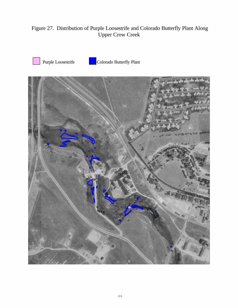
A fifth species, Purple loosestrife (Lythrum salicaria) was documented in the riparian corridor in 1998. No extrapolations were made of its distribution due to insufficient location information. No populations of Purple loosestrife were observed during field surveys in 1999, 2000 and 2001. The single known population on WAFB may have been extirpated in September 1998 following manual removal of all aboveground shoots and underground roots and soil. The location of the last known population is mapped in Figure 27 (Fertig 1999b). Data analysis First, for the four major noxious weed species, the total area and proportion of area (acres/ha) covered by the species within all five riparian corridor units on WAFB was calculated. Second, for each noxious weed species, the percentage differences between the field mapping results and the distribution-modeling results were calculated. The overall study area boundary was altered slightly from 1999 to 2000 to better represent the floodplain and exclude study area overlap with roads where possible. This adjustment of boundaries resulted in a 5.8% increase of the mapped extent relative to the 1999 modeling area. For this reason the percentage comparison between overall mapped area of noxious weeds vs. predicted area has this error factor associated with it and must be interpreted with some caution. Third, for each noxious weed species, the total area occupied by Colorado butterfly plant was calculated, plus the proportion of Colorado butterfly plant habitat covered by the noxious weed. Finally, the net area covered by noxious weeds was calculated in each riparian corridor segment, to determine the relative amount of weed-free versus weed-occupied habitat. RESULTS Weed Mapping (1999-2001) Collectively, noxious weeds occupy 180.2 acres (35.5%) of the 508 acres of riparian corridor on WAFB as determined by overlaying field maps of the weed species in GIS. The two most extensive noxious weeds in the riparian corridor are Canada thistle and Leafy spurge at 108.1 acres and 96.8 acres, respectively (Table 1). Upper Crow Creek has the most extensive weed invasion for three of the four noxious weed species. Canada Thistle invasion is most severe in Upper Crow Creek and Upper Unnamed Drainage (32.5 and 35.6 %, respectively; Table 1). Although it is not evenly distributed, it is present throughout the five riparian corridor segments (Figures 3-8). Leafy spurge is a close second to Canada thistle in its extensiveness, covering 96.8 acres (19.1%) of riparian corridor habitat (Table 1, Figures 9-14). It is most severe in Upper and Lower Crow Creek (20.7 and 30.6%, respectively), and is very unevenly distributed, differing by orders of magnitude with Upper Unnamed Drainage (0.02%).
12
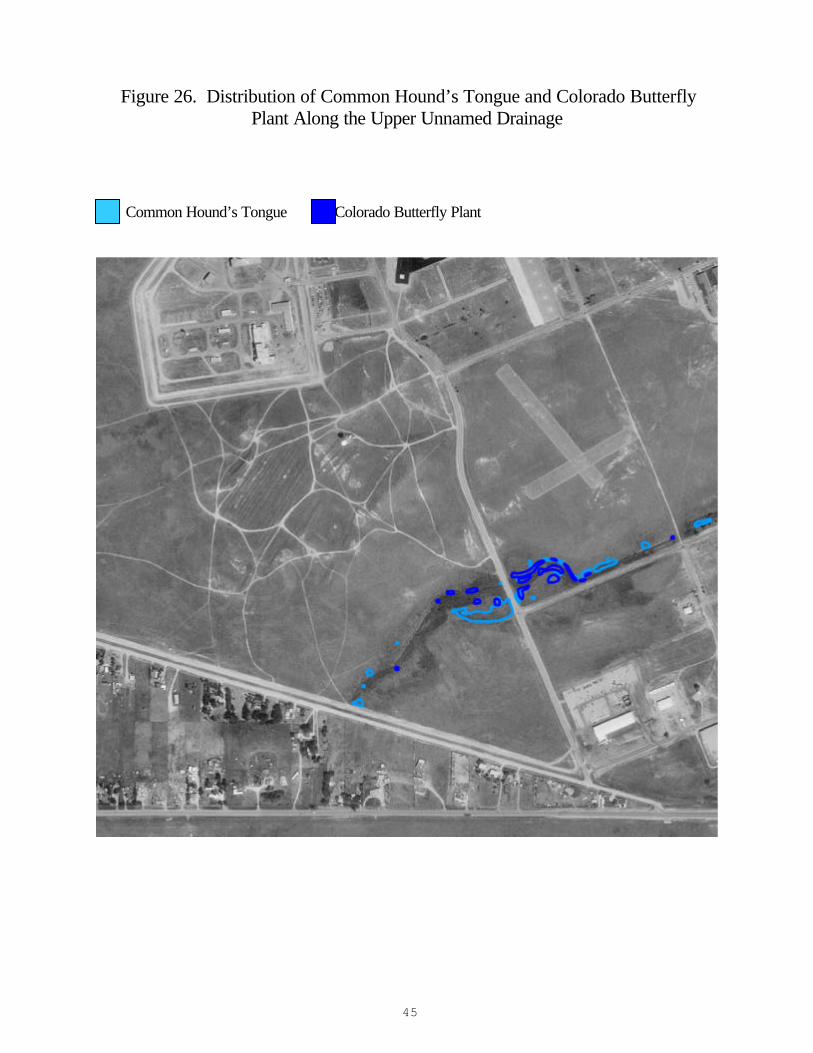
Dalmatian toadflax is a close third to Leafy spurge in its extensiveness, covering 88.2 acres (17.4 %) of riparian corridor habitat (Table 1, Figures 15-20). Like Leafy spurge, it is unevenly distributed between riparian corridor segments, and, like most of the noxious weed species, it is most extensive in Upper Crow Creek at 31.7%. Unlike the other noxious weeds, Dalmatian toadflax invasion is widespread in the uplands and dispersal does not appear to be radiating out from the riparian corridor. Common Hound’s tongue is the least extensive noxious weed in all five riparian segments, ranging from 3.8-14.4% in Diamond Creek and Upper Crow Creek, respectively (Table 1, Figures 21-26). No Colorado butterfly plants were found in surveys downstream of known colonies.
Table 1. Extent of Noxious Weeds in Riparian Corridor Habitat on
F. E. Warren Air Force Base
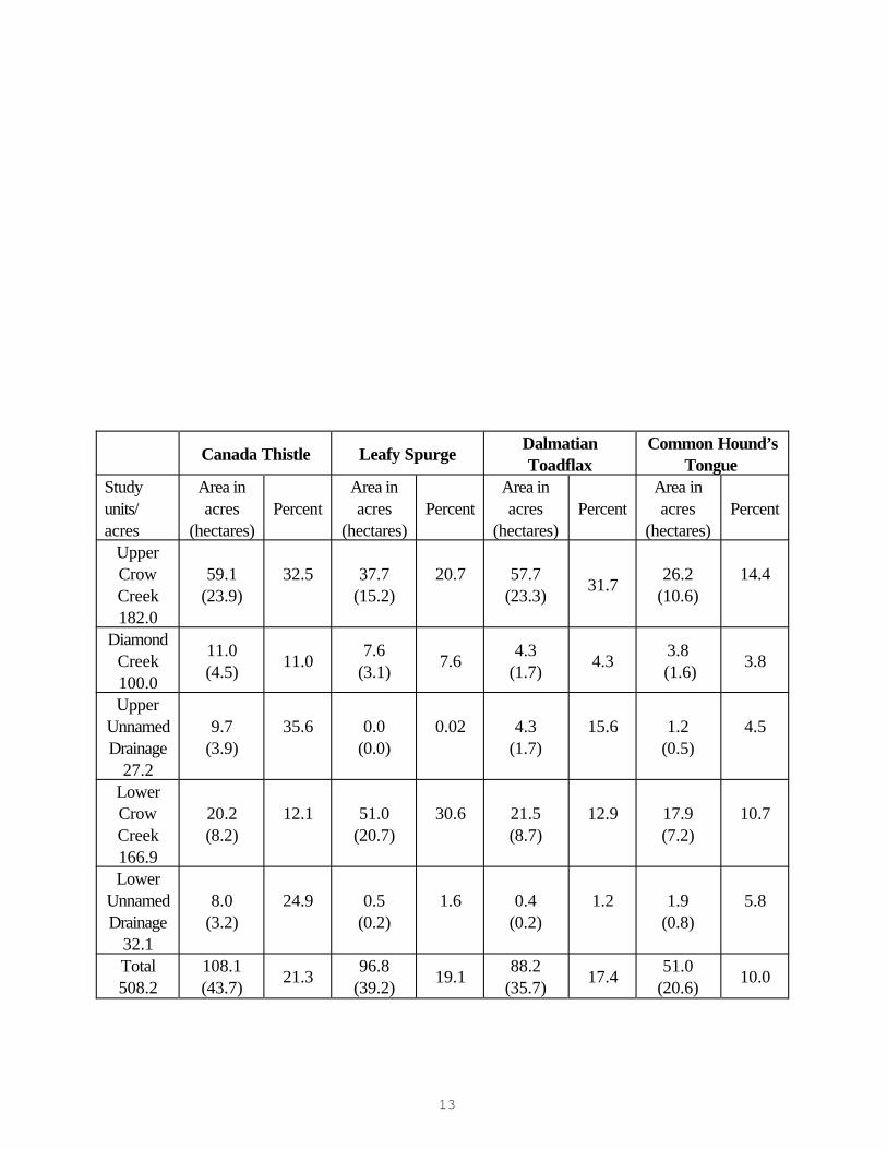
13
Canada Thistle Leafy Spurge
Dalmatian Toadflax
Common Hound’s Tongue
Study units/ acres
Area in acres
(hectares) Percent
Area in acres
(hectares) Percent
Area in acres
(hectares) Percent
Area in acres
(hectares) Percent
Upper Crow Creek 182.0
59.1 (23.9)
32.5 37.7
(15.2)
20.7 57.7
(23.3)
31.7
26.2 (10.6)
14.4
Diamond Creek 100.0
11.0 (4.5)
11.0 7.6
(3.1)
7.6
4.3 (1.7)
4.3 3.8
(1.6) 3.8
Upper Unnamed Drainage
27.2
9.7 (3.9)
35.6 0.0
(0.0)
0.02 4.3
(1.7)
15.6 1.2
(0.5)
4.5
Lower Crow Creek 166.9
20.2 (8.2)
12.1 51.0
(20.7)
30.6 21.5
(8.7)
12.9 17.9
(7.2)
10.7
Lower Unnamed Drainage
32.1
8.0 (3.2)
24.9 0.5
(0.2)
1.6 0.4
(0.2)
1.2 1.9
(0.8)
5.8
Total 508.2
108.1 (43.7)
21.3 96.8
(39.2) 19.1
88.2 (35.7)
17.4 51.0
(20.6) 10.0
14
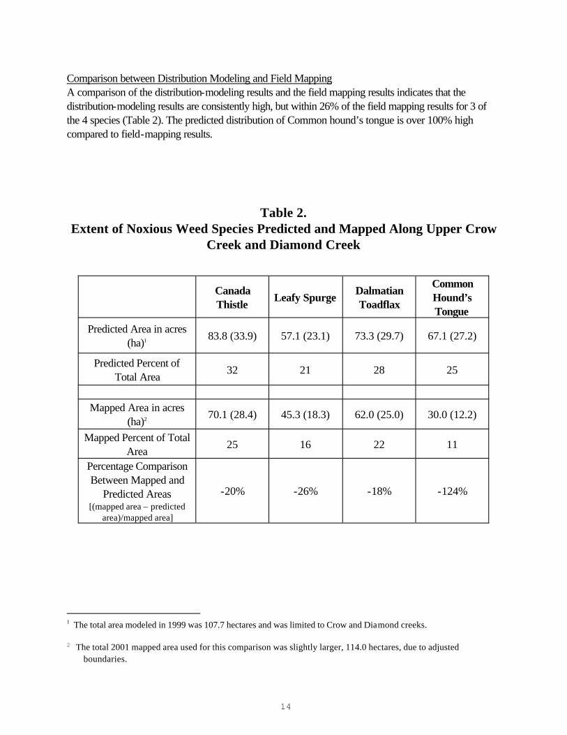
Comparison between Distribution Modeling and Field Mapping A comparison of the distribution-modeling results and the field mapping results indicates that the distribution-modeling results are consistently high, but within 26% of the field mapping results for 3 of the 4 species (Table 2). The predicted distribution of Common hound’s tongue is over 100% high compared to field-mapping results.
Table 2. Extent of Noxious Weed Species Predicted and Mapped Along Upper Crow
Creek and Diamond Creek
1 The total area modeled in 1999 was 107.7 hectares and was limited to Crow and Diamond creeks. 2 The total 2001 mapped area used for this comparison was slightly larger, 114.0 hectares, due to adjusted
boundaries.
Canada Thistle
Leafy Spurge Dalmatian Toadflax
Common Hound’s Tongue
Predicted Area in acres (ha)1
83.8 (33.9) 57.1 (23.1) 73.3 (29.7) 67.1 (27.2)
Predicted Percent of Total Area
32 21 28 25
Mapped Area in acres
(ha)2 70.1 (28.4) 45.3 (18.3) 62.0 (25.0) 30.0 (12.2)
Mapped Percent of Total Area
25 16 22 11
Percentage Comparison Between Mapped and
Predicted Areas [(mapped area – predicted
area)/mapped area]
-20% -26% -18% -124%

15
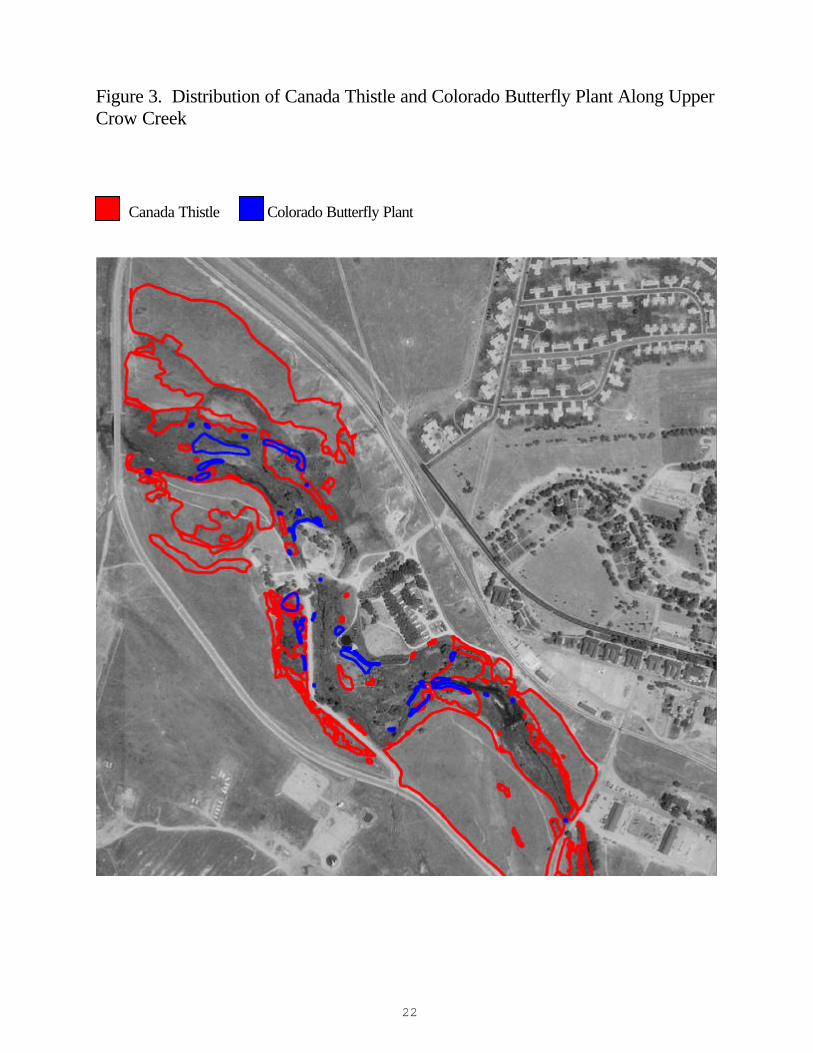
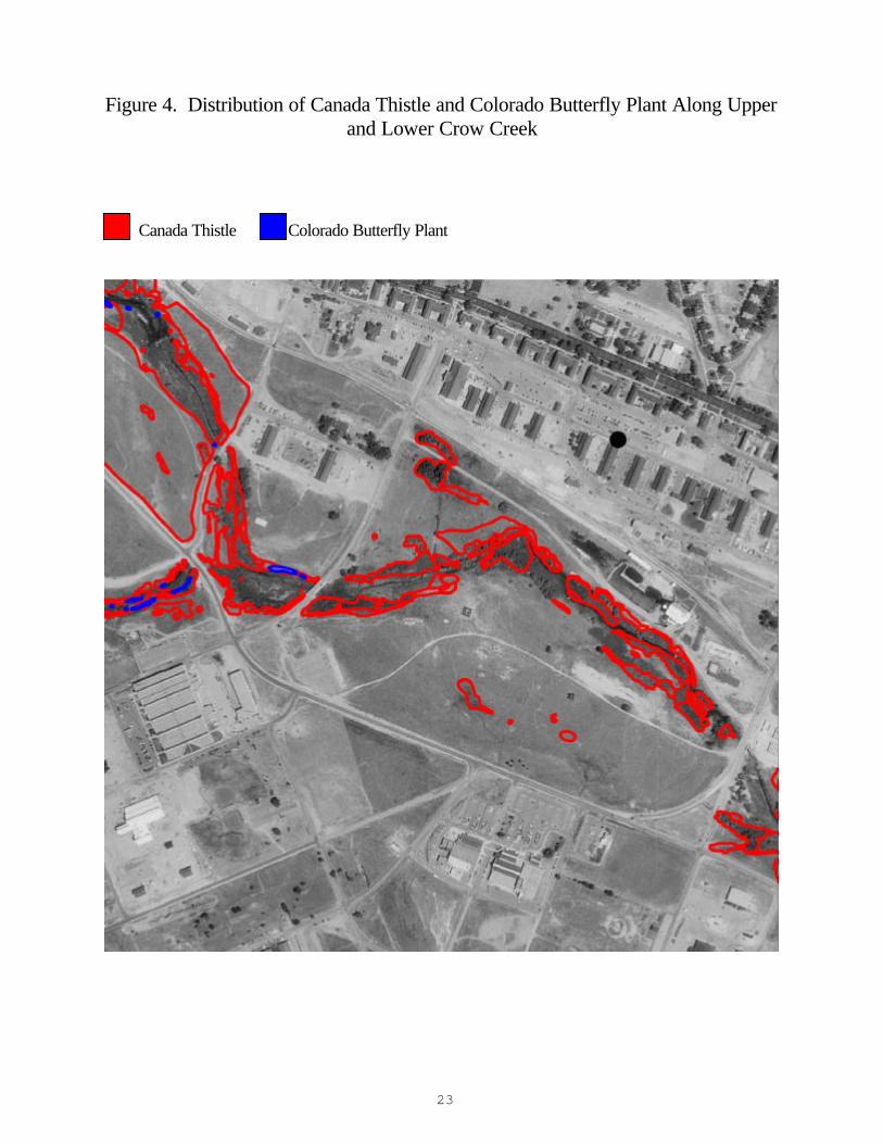
Overlap between Weeds and Colorado butterfly plant There are only 5.2 acres of Colorado butterfly plant habitat, a small fraction of area compared to the distribution of noxious weed species collectively or individually. A direct comparison of noxious weed field mapping results and Colorado butterfly plant field mapping results indicates that Canada thistle and Leafy spurge have the most overlap with Colorado butterfly plant distribution, covering 30.6 and 20.3% of Colorado butterfly plant habitat, respectively. Mapped results include Figures 3, 4, 6, 8; 9,10,12,14; 15,16, 18, 20; and 21, 22, 24, and 26.
Table 3. Extent of Distribution Overlap between Noxious Weeds
and the Colorado Butterfly Plant
DISCUSSION Weed Mapping (2000-2001) In 2000, the use of high-resolution enlargements of digital orthophotos proved to be a useful tool for relatively rapid manual mapping of large weed patches in the field. Terrain features could be easily located on these images, allowing a trained mapper to cover ground more quickly than someone using a GPS. Drawbacks of this technique, however, are the greater probability for error in the subjective location and delimitation of polygons and in transcribing the polygons to GIS, and the difficulty in discerning and mapping a few individual weed plants in dense vegetation. Considering these drawbacks, any field mapping techniques are likely to produce low estimates of weed-occupied habitat. Mapping with GPS units offers the advantage of high spatial accuracy (within 4 meters horizontally). Digital GPS data can be combined with other spatial data layers to answer a variety of management questions. GPS mapping can be very slow, however, especially if vegetation and terrain conditions interfere with satellite reception. Our initial efforts to map the entire Crow and Diamond creek watersheds with GPS in 1999 had to be abandoned because of time constraints. Mapping with the use of high-resolution enlargements of digital orthophotos is an effective tool, and is the procedure-of-choice unless distribution-modeling techniques can be refined.
Canada Thistle Leafy Spurge Dalmatian
Toadflax Common Hounds
Tongue Distrib.
overlap in acres (ha)
Percent Distrib.
overlap in acres (ha)
Percent Distrib.
overlap in acres (ha)
Percent Distrib.
overlap in acres (ha)
Percent
Colorado Butterfly
Plant 1.6 (0.6) 30.6 1.1 (0.4) 20.3 0.5 (0.2) 10.2 0.6 (0.2) 10.9
16
Comparison between Distribution Modeling and Field Mapping Field mapping in 2000 and 2001 corroborated most of the predictions made by the distribution model of Hiemstra and Fertig (2000). The greatest differences between the models and field observations was an 124% difference in cover estimate of Common hound’s. It probably does not occur in all potential habitat due to competition from Canada thistle and its inability to spread vegetatively. Of the four weeds, it also tends to be the most restricted to woody cover, such as willow in this case. The willow mapping and monitoring project may, therefore, be more directly relevant to Colorado butterfly plant. The smallest difference was an 18.1% difference in cover estimate of Dalmatian toadflax. The two most serious weeds, Canada thistle and Leafy spurge, also had minimal levels of difference between modeling and field mapping efforts. The weed area calculations based on distribution modeling were consistently higher than field mapping results. The distribution modeling was developed to represent hypothesized potential niche space as opposed to occupied niche space (Hiemstra and Fertig 2000, Fertig and Arnett 2001) so the objectives are broader than field mapping objectives. Willow encroachment occurred in the 1990’s (Fertig pers. commun.), and it is possible that willows have encroached and displaced weeds in areas that appeared suitable for noxious weeds in 1994. Another possible factor in the differences between these two methods is seasonality. The aerial photographs used for modeling were taken early in the growing season. The grayscales differentiated early on in the growing season may be quite different than grayscales late in the season due to variable phenological development of multiple plants species. The early-season polygon signature used to identify a weedy species’ habitat in 1999 may identify a gray scheme, or plant cover type, that is different than the habitat signature late in the growing season. Using aerial photographs taken late in the growing season, when noxious weeds are still relatively more active than the surrounding vegetation, would most likely increase the modeling accuracy, as well as increase the ability to ground truth such techniques. Other possible explanations for the high estimates relative to field mapping results were the resolution differences, the breadth of potential habitat picked up in the June aerial photos compared to occupied habitat, the drawbacks of field mapping (discussed previously), or the 5.8% difference in area between the modeled and the mapped riparian corridor. The paired sets of weed area calculations derived from modeled and field-mapped methods are interpreted as bracketing actual weed area values at upper and lower ends, respectively. The primary advantage of modeling the distribution of weed species is that it is potentially less labor intensive than traditional manual mapping. Ideally, a network of randomly located sampling points (measured with GPS) could be used to accurately monitor and extrapolate the distribution of target species. A refinement of weed distribution modeling may require use of aerial photos flown in the latter part of the growing season. In addition to using the gray-scale patterns from digital orthophotos, models could be constructed using local or regional digital environmental datasets for temperature, precipitation, bedrock geology, soil type, land cover, topography, and elevation. Statistical tools, including logistic regression and classification tree analysis are available to quantify spatial patterns in the presence and
17
absence of target species (Frankin 1995; Fertig 2000). The distribution modeling that was developed in 1999 is a prototype, subject to testing and refinement if it is to be used for either monitoring or extrapolation by WAFB. Overlap between Noxious Weeds and Colorado butterfly plant The completion of weed-mapping (Hiemstra and Fertig 2000, Fertig and Arnett 2001, and this report) documents the magnitude of weed invasion in the riparian corridor occupied by Colorado butterfly plant, including Canada thistle (Cirsium arvense), Leafy spurge (Euphorbia esula), Common hounds tongue (Cynoglossum officinale), and Dalmatian toadflax (Linaria dalmatica). Competition from noxious weeds may be the most significant long-term threat to Colorado butterfly plant populations on WAFB. Noxious weeds cover 67% of Colorado butterfly plant habitat (Fertig and Arnett 2001). The relatively low overlap rates with individual weed species are based on current occupation patterns of Colorado butterfly plant. The somewhat lesser degree of overlap, however, does not suggest only minimal direct competition between the weed species and the Colorado butterfly plant. The progressive dominance of noxious weeds at many riparian sites may have already displaced the Colorado butterfly plant, preventing it from occupying the full extent of its available habitat because of competition for water, light, soil nutrients, and space (Fertig 2001). These maps indicate that Colorado butterfly plant populations are negatively correlated with dense stands of Canada thistle, probably because of intense competition for light, nutrients, and space, or due to allelopathic interactions (Figure 13, Wilson 1981). Yet 30.6% of all Colorado butterfly plant habitat on WAFB is invaded by Canada thistle, suggesting further reduction of the Colorado butterfly plant’s realized niche space in the future (Table 3). An experiment to determine the effects of herbicides on Colorado butterfly plant and on Canada thistle was identified as one of three critical study needs for WAFB weed control (Jones 1986). Such a study was pursued by Munk (1999) who concluded that herbicide removal of thistle has little to no impact on increasing Gaura rosette establishment one year after treatment. Munk used the herbicide Clopyralid to remove Canada thistle in her sample plots, a chemical known to persist in the soil and to be injurious to broadleaf forbs. The poor response of Gaura neomexicana ssp. coloradensis could be due to this chemical as well as allelopathic compounds produced by Cirsium arvense litter. Floyd (1995a) found that multiple years of thistle control were needed to achieve long-term reductions in weed density. Mechanical vegetation treatments, including different mowing and prescribed burn regimes, are being evaluated by Burgess (in progress) to consider its effects as well as the effects of alternate herbicides in treating Canada thistle. Leafy spurge is the other noxious weed, beside Canada thistle, that has the adaptations to invade riparian corridor habitat at densities that assume dominance (Heidel 1982). Prospective biocontrol agents have been identified and critiqued by Hollingsworth (1996). Consistent with the study recommendations of Jones (1996), flea beetles have been released. We are not aware of information on the study design or results, but defoliated leafy spurge plants were observed in low numbers and patchy patterns during the 2001 Colorado butterfly plant census (pers. obs.). The pattern of leafy spurge distribution shows its distribution to be of slightly lesser extent and more uneven than that of Canada thistle, perhaps indicating significant current expansion. Leafy spurge ranges from 20.7% - 0.02% of the riparian corridors with Colorado butterfly plant in Upper Crow Creek and Upper Unnamed Drainage, respectively (Table 1). Yet 20.3% of all Colorado butterfly plant habitat on
18
WAFB is also occupied by Leafy spurge (Table 3). Expansion of noxious weeds potentially affects threatened fauna as well as flora. Past capture localities and the presumed range of Preble’s meadow jumping mouse on WAFB overlap with the distribution of large patches of Canada thistle, Leafy spurge, and Dalmatian toadflax. Beauvais (1998) noted that the full effects of noxious weeds on Preble’s meadow jumping mouse are poorly understood. Previous studies in Colorado have suggested that jumping mice are more dependent on the amount of vegetative cover rather than its species composition. Garber (1995) however, suggested that the displacement of the native flora by introduced weeds may be reducing the amount of food available to the jumping mouse population on the Base. Conclusions This report provides an overview of the seriousness of the noxious weed problem in riparian corridors of F.E. Warren Air Force Base. It is a baseline to use in consultation and coordination with other researchers working in the same habitat and with the Base personnel and weed control experts who are in the position to affect on-the-ground management actions. Weed mapping is an ineffective exercise without concerted efforts towards reversing the tide of Canada thistle and Leafy spurge invasion. The invasive potentials of Canada thistle and Leafy spurge place a premium on trying to curtail or eliminate these species where they exist in only trace amounts among Colorado butterfly plant. The prime example is Leafy spurge control in the Unnamed Drainage. It is also critical to reverse the expansion of large colonies as they overlap with large Colorado butterfly plant colonies. The prime examples are Canada thistle and Leafy spurge control in Upper Crow Creek and Canada thistle control on the Unnamed Drainage. It is secondarily important to control seed production in large weed colonies elsewhere in the corridor that are seed-sources. The prime example is Leafy spurge control in Lower Crow Creek. Weed distribution modeling and field mapping may be refined for riparian corridor weed monitoring throughout WAFB, but intensive field monitoring is needed for any management actions to determine the effects on the Colorado butterfly plant. New weed species continue to arrive on the Base, and species like Cicer milkvetch (Astragalus cicer) and Yellow sweetclover (Melilotus officinalis) show signs of rapid expansion, and warrant documentation in the future. LITERATURE CITED Beauvais, G.P. 1998. Survey for Preble’s meadow jumping mouse (Zapus hudsonius preblei) on F.E. Warren Air Force Base, Wyoming, September 1998. Report prepared for the US Air Force by the Wyoming Natural Diversity Database, Laramie, WY. Bennett, J. 2002. Survey for breeding birds on Crow Creek, F.E. Warren Air Force Base, Wyoming. Report prepared for the US Air Force by the Wyoming Natural Diversity Database, Laramie, WY. Cronquist, A., A.H. Holmgren, N.H. Holmgren, J.L. Reveal, and P.K. Holmgren. 1984. Vol. 4: Subclass Asteridae (excluding Asteraceae). Intermountain Flora: Vascular Plants of the Intermountain West, USA. New York Botanical Garden, Bronx, NY.
19
Cronquist, A., N.H. Holmgren, and P.K. Holmgren. 1997. Volume 3, Part A. Subclass Rosidae (except Fabales). Intermountain Flora, Vascular Plants of the Intermountain West, USA. New York Botanical Garden, Bronx, NY. Dark-Smiley, Darby and Douglas A. Keinath. 2002. Survey for Preble’s meadow jumping mouse (Zapus hudsonius preblei) on F.E. Warren Air Force Base, Cheyenne, Wyoming. Report prepared by the Wyoming Natural Diversity Database, Laramie, WY. Dorn, R.D. 1992. Vascular Plants of Wyoming, second edition. Mountain West Publ., Cheyenne, WY. Easter, M.J. and P.P. Douglas. 1996. Floristic survey of F.E. Warren Air Force Base, Wyoming. Center for Ecological Management of Military Lands, Dept. of Forest Sciences, Colorado State University, Ft. Collins, CO. Fertig, W. 1995. Rare plants of F.E. Warren Air Force Base, Cheyenne, Wyoming. Report prepared for the US Air Force by the Wyoming Natural Diversity Database, Laramie,WY. Fertig, W. 1999a. Non-native plants of Wyoming. Castilleja 18(2):7-10. Fertig, W. 1999b. Purple loosestrife (Lythrum salicaria) on F.E. Warren Air Force Base. Report prepared for the US Air Force by the Wyoming Natural Diversity Database, Laramie, WY. Fertig, W. 2000. Predictive modeling of rare plant species. Gap Analysis Bulletin 8:18-19. Fertig, W. 2001. 2000 census of Colorado butterfly plant (Gaura neomexicana ssp. coloradensis) on F.E. Warren Air Force Base. Report prepared for the US Air Force by the Wyoming Natural Diversity Database, Laramie, WY. Fertig, W. and M. Arnett. 2001. Distribution of noxious weeds within the habitat of Threatened plant and animal species on F.E. Warren Air Force Base. Report prepared for the US Air Force by the Wyoming Natural Diversity Database, Laramie, WY. Franklin, J. 1995. Predictive vegetation mapping: geographic modelling of biospatial patterns in relation to environmental gradients. Progress in Physical Geography 19:474-499. Garber, C. 1995. A status survey for Preble’s meadow jumping mouse (Zapus hudsonius preblei) in southeastern Wyoming, including the F.E. Warren Air Force Base. Report prepared for the Wyoming Natural Diversity Database. Gleason, H.A. and A. Cronquist. 1991. Manual of the Vascular Plants of Northeastern United States and Adjacent Canada, second edition. New York Botanical Garden, Bronx, NY. Great Plains Flora Association. 1986. Flora of the Great Plains. University Press of Kansas, Lawrence, KS. Hazlett, D.L. 1999. Plant biochemical/plant use inventory F.E. Warren Air Force Base, Wyoming. Report prepared for the US Air Force by New World Plants and People, Pierce, CO.
20
Heidel, B. 1982. Leafy spurge – a challenge in natural areas management. Natural Areas Journal 2(2): 10-13. Heidel, B., S. Laursen, and W. Fertig. 2002. Census of Colorado Butterfly Plant (Gaura neomexicana ssp. coloradensis) on F. E. Warren Air Force Base in 2001. Prepared for the US Air Force by the Wyoming Natural Diversity Database, Laramie, WY. Hiemstra, C. and W. Fertig. 2000. The distribution of noxious weeds on F.E. Warren Air Force Base. Report prepared for the US Air Force by the Wyoming Natural Diversity Database, Laramie, WY. Hight, S.D. and J.J. Drea, Jr. 1991. Prospects for a classical biological control project against purple loosestrife (Lythrum salicaria L.). Natural Areas Journal 11(3): 151-157. Hollingsworth, C. 1996. Canada thistle (Cirsium arvense) and leafy spurge (Euphorbia esula) biological control program as proposed for the Colorado butterfly plant Research Natural Area on F.E. Warren Air Force Base. A report to the Wyoming Nature Conservancy. Keinath, Douglas A. 2002. Riparian herpetofauna of F.E. Warren Air Force Base, Wyoming. Report prepared by the Wyoming Natural Diversity Database, Laramie, WY. Jones, G. P. 1996. A proposed weed control program for F.E. Warren Air Force Base. Report prepared for the US Air Force by the Wyoming Natural Diversity Database, Laramie, WY. Marriott, H. and G. Jones. 1988. Preserve design package for a proposed Colorado butterfly plant Research Natural Area on F.E. Warren Air Force Base. Report prepared for the US Air Force by the Wyoming Natural Diversity Database, Laramie, WY. Thompson, D.Q., R.L. Stuckey, and E.B. Thompson. 1987. Spread, impact, and control of purple loosestrife (Lythrum salicaria) in North American wetlands. Fish and Wildlife Service Research No. 2. US Department of Interior, Washington, DC. Welsh, S.L., N.D. Atwood, S. Goodrich, and L.C. Higgins. 1993. A Utah Flora, second edition, revised. Brigham Young University, Provo, UT. Whitson, T.D., L.C. Burrill, S.A. Dewey, D.W. Cudney, B.E. Nelson, R.D. Lee, and R. Parker. 1991. Weeds of the West. Western Society of Weed Science, Western United States Land Grant Universities Cooperative Extension Service, and the University of Wyoming. Wilson, R.G. 1981. Effect of Canada thistle (Cirsium arvense) residue on growth of some crops. Weed Science 29:159-164.
ACKNOWLEDGEMENTS We thank Cathryn Pesenti of F.E. Warren Air Force Base for her coordination in this project, Tom Smith formerly of F.E. Warren Air Force Base for his support through the two previous years of this

21
project, Robert Thurston of WYNDD for providing assistance with Arc-view analysis, and Walter Fertig for his project expertise and review of this report in draft form.
22
Figure 3. Distribution of Canada Thistle and Colorado Butterfly Plant Along Upper Crow Creek Canada Thistle Colorado Butterfly Plant
23
Figure 4. Distribution of Canada Thistle and Colorado Butterfly Plant Along Upper and Lower Crow Creek
Canada Thistle Colorado Butterfly Plant
24
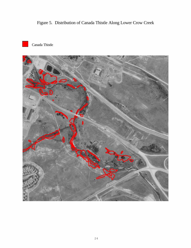
Figure 5. Distribution of Canada Thistle Along Lower Crow Creek Canada Thistle
25
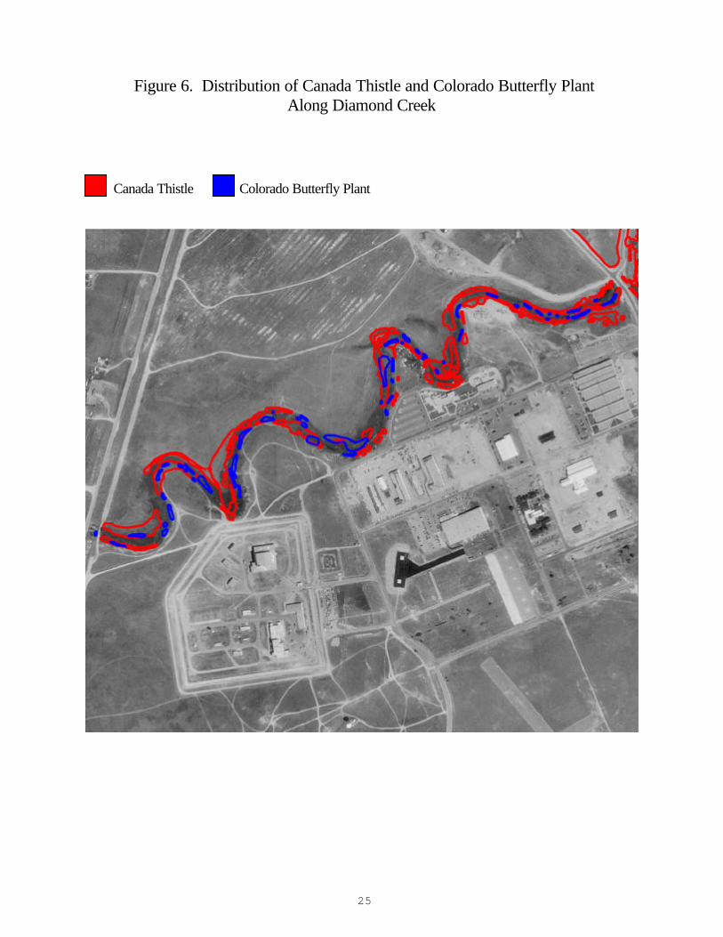
Figure 6. Distribution of Canada Thistle and Colorado Butterfly Plant Along Diamond Creek
Canada Thistle Colorado Butterfly Plant
26
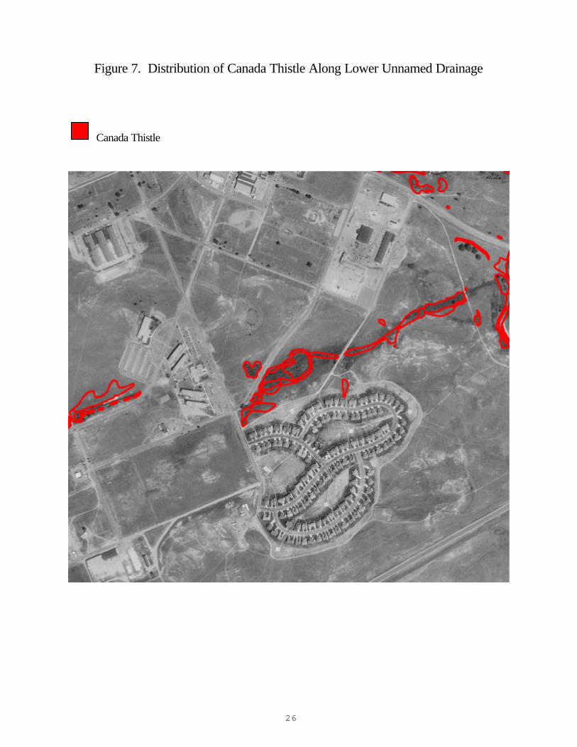
Figure 7. Distribution of Canada Thistle Along Lower Unnamed Drainage Canada Thistle
27
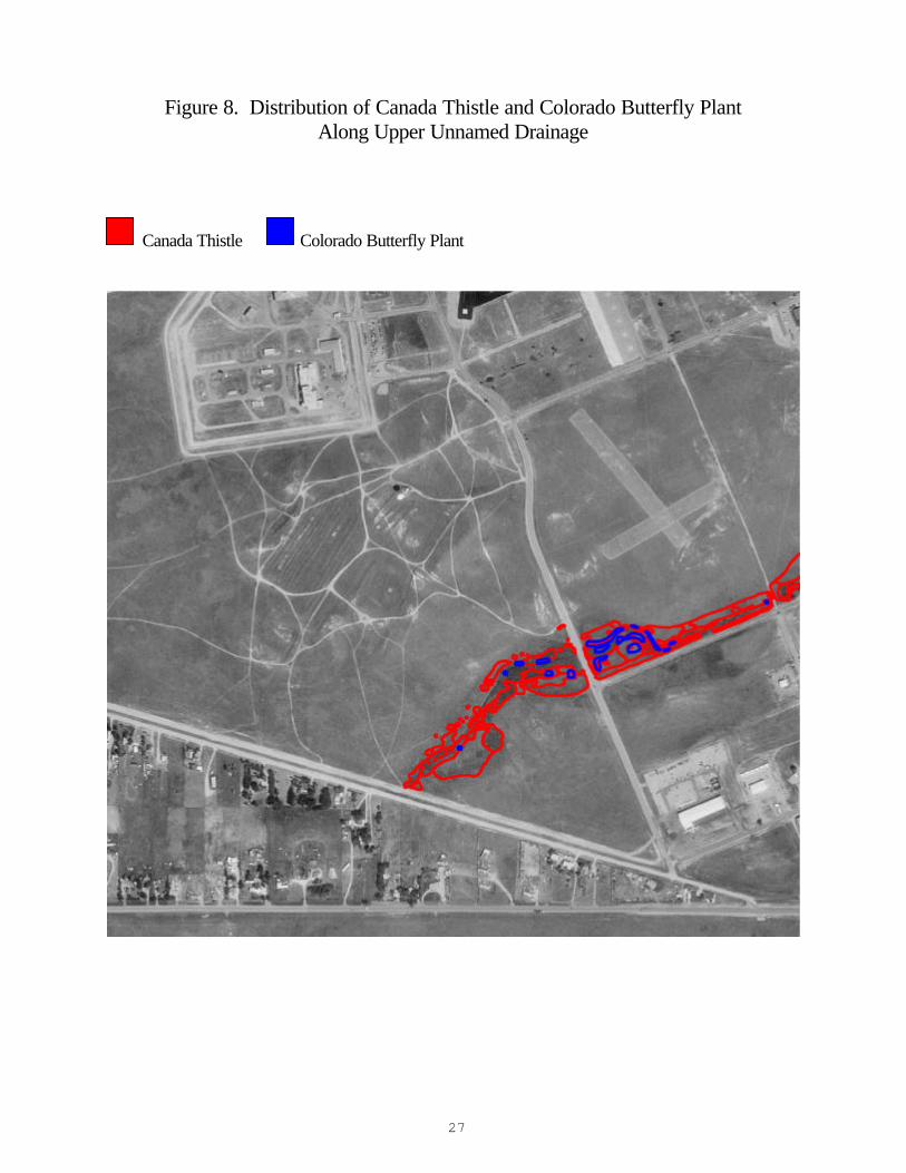
Figure 8. Distribution of Canada Thistle and Colorado Butterfly Plant Along Upper Unnamed Drainage
Canada Thistle Colorado Butterfly Plant
28
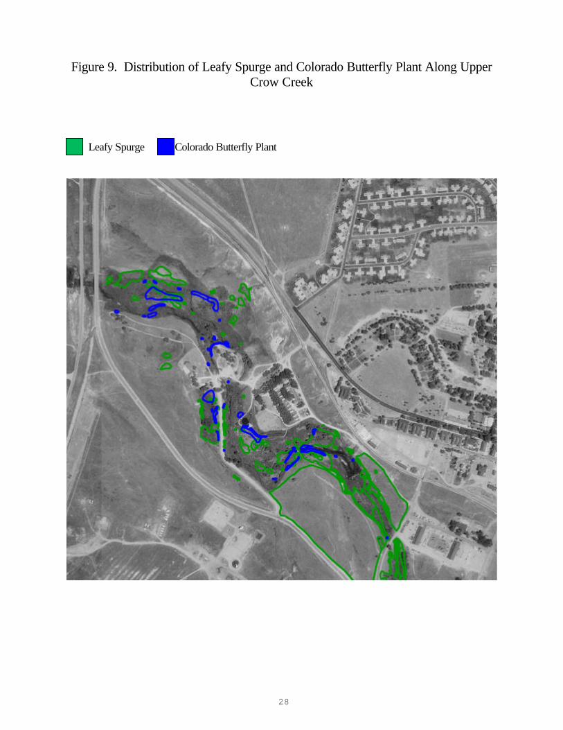
Figure 9. Distribution of Leafy Spurge and Colorado Butterfly Plant Along Upper Crow Creek
Leafy Spurge Colorado Butterfly Plant
29
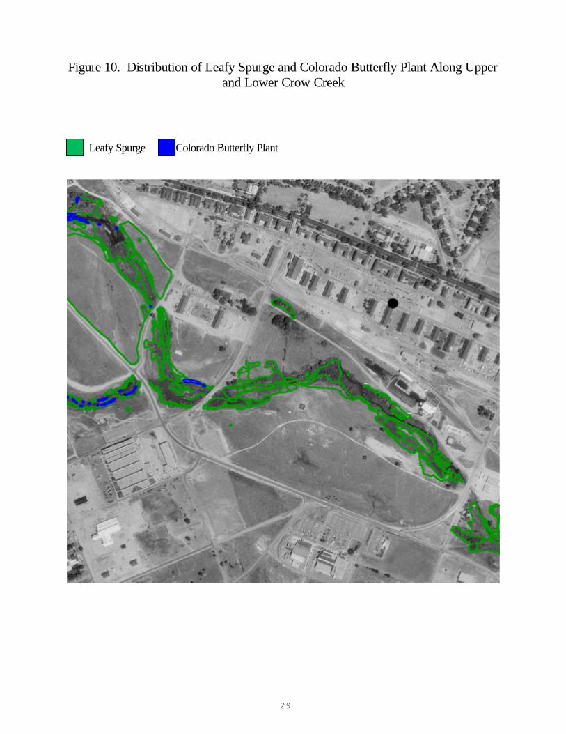
Figure 10. Distribution of Leafy Spurge and Colorado Butterfly Plant Along Upper and Lower Crow Creek
Leafy Spurge Colorado Butterfly Plant
30
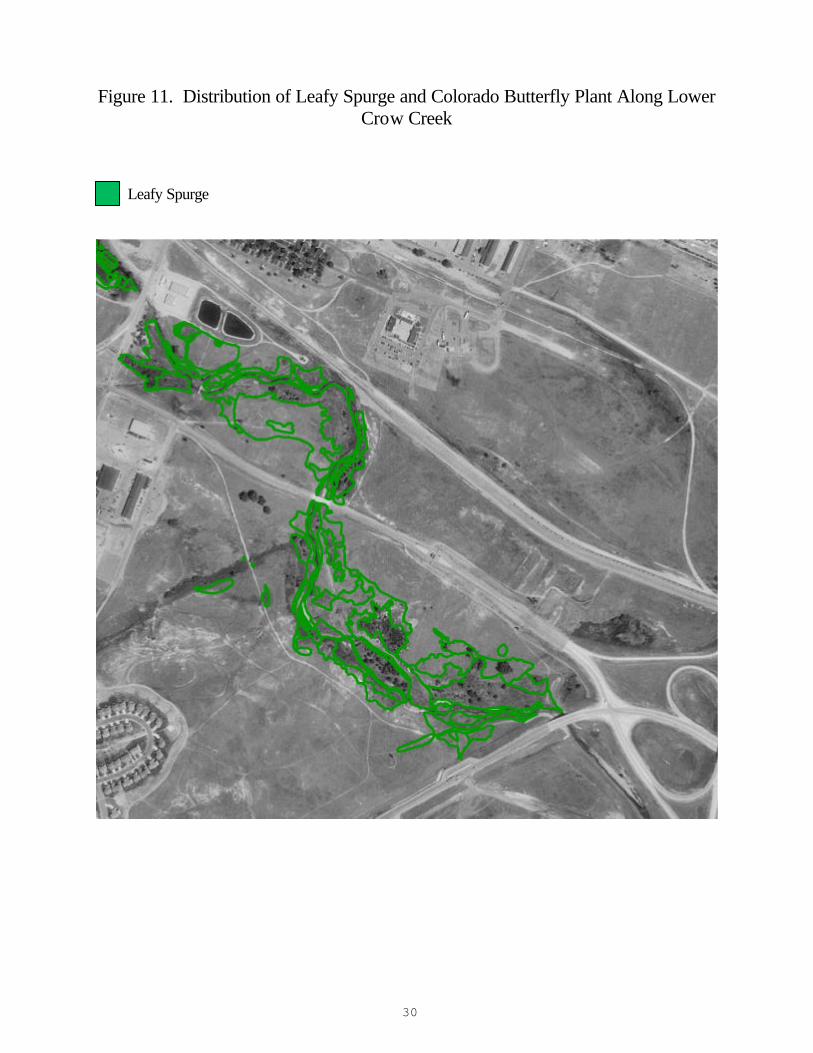
Figure 11. Distribution of Leafy Spurge and Colorado Butterfly Plant Along Lower Crow Creek
Leafy Spurge
31
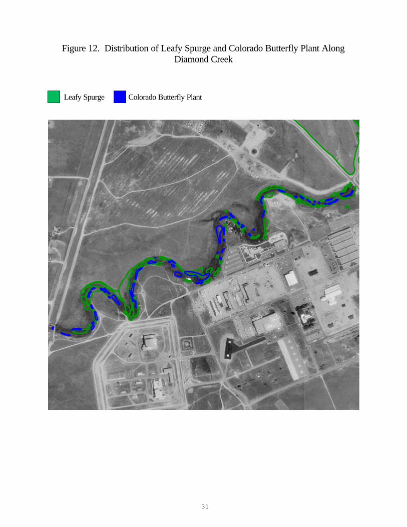
Figure 12. Distribution of Leafy Spurge and Colorado Butterfly Plant Along Diamond Creek
Leafy Spurge Colorado Butterfly Plant
32
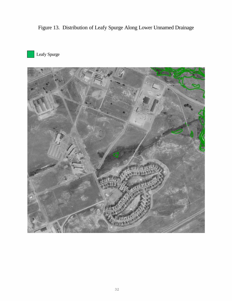
Figure 13. Distribution of Leafy Spurge Along Lower Unnamed Drainage Leafy Spurge
33
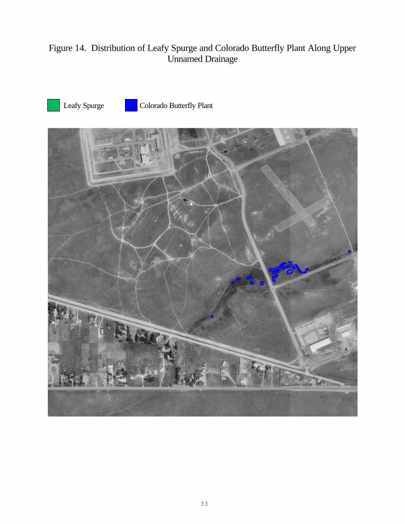
Figure 14. Distribution of Leafy Spurge and Colorado Butterfly Plant Along Upper Unnamed Drainage
Leafy Spurge Colorado Butterfly Plant
34
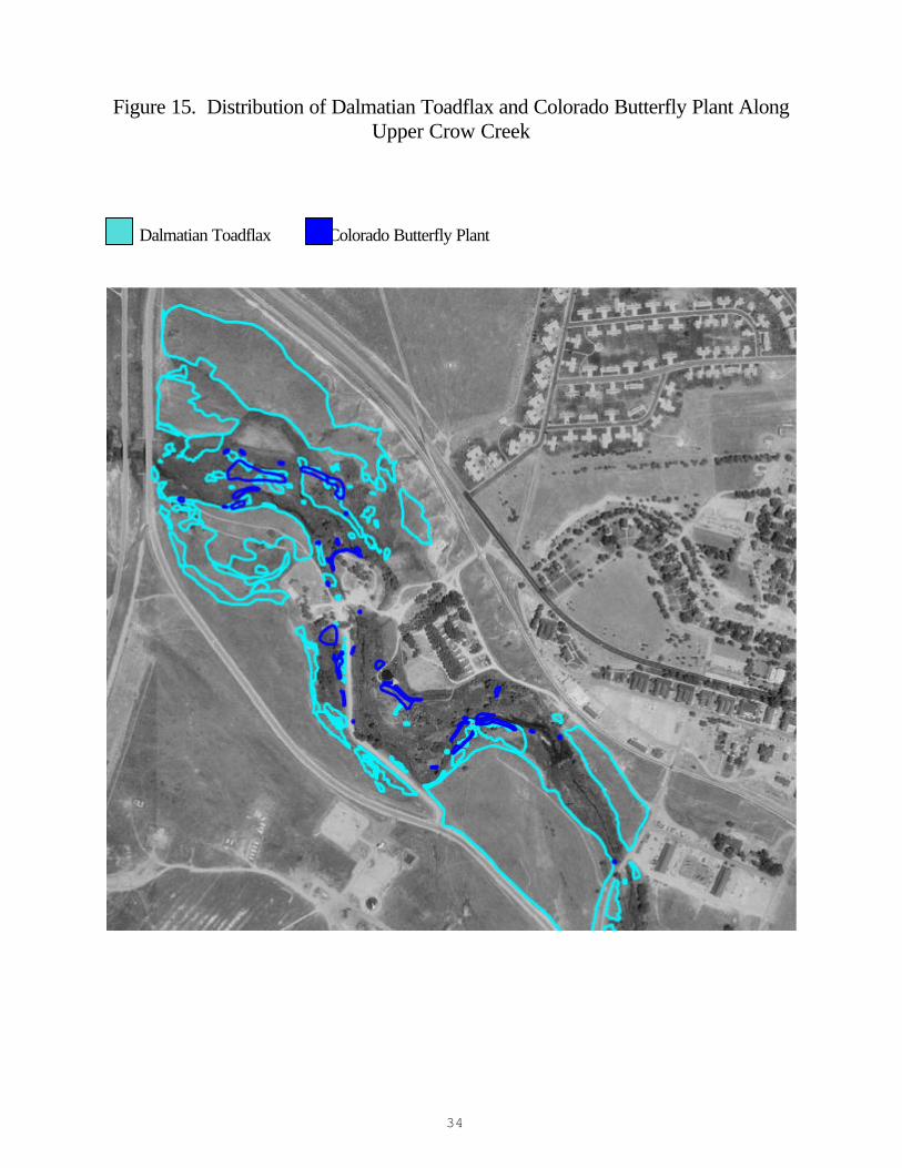
Figure 15. Distribution of Dalmatian Toadflax and Colorado Butterfly Plant Along Upper Crow Creek
Dalmatian Toadflax Colorado Butterfly Plant
35
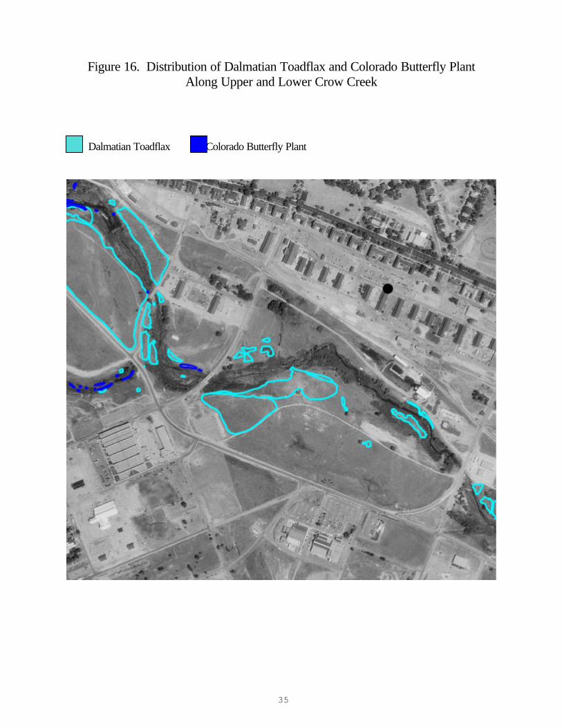
Figure 16. Distribution of Dalmatian Toadflax and Colorado Butterfly Plant Along Upper and Lower Crow Creek
Dalmatian Toadflax Colorado Butterfly Plant
36
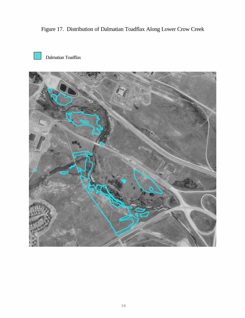
Figure 17. Distribution of Dalmatian Toadflax Along Lower Crow Creek Dalmatian Toadflax
37
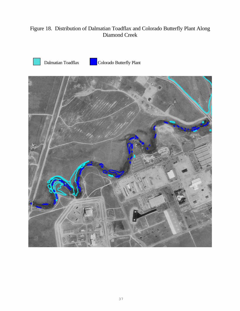
Figure 18. Distribution of Dalmatian Toadflax and Colorado Butterfly Plant Along Diamond Creek
Dalmatian Toadflax Colorado Butterfly Plant
38
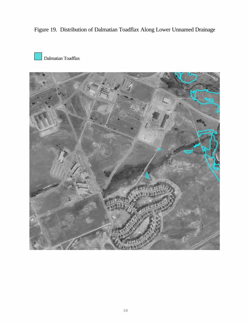
Figure 19. Distribution of Dalmatian Toadflax Along Lower Unnamed Drainage Dalmatian Toadflax
39
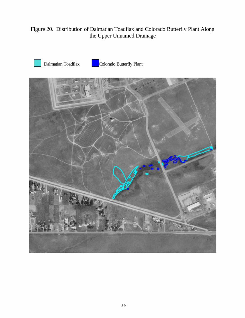
Figure 20. Distribution of Dalmatian Toadflax and Colorado Butterfly Plant Along the Upper Unnamed Drainage
Dalmatian Toadflax Colorado Butterfly Plant
40
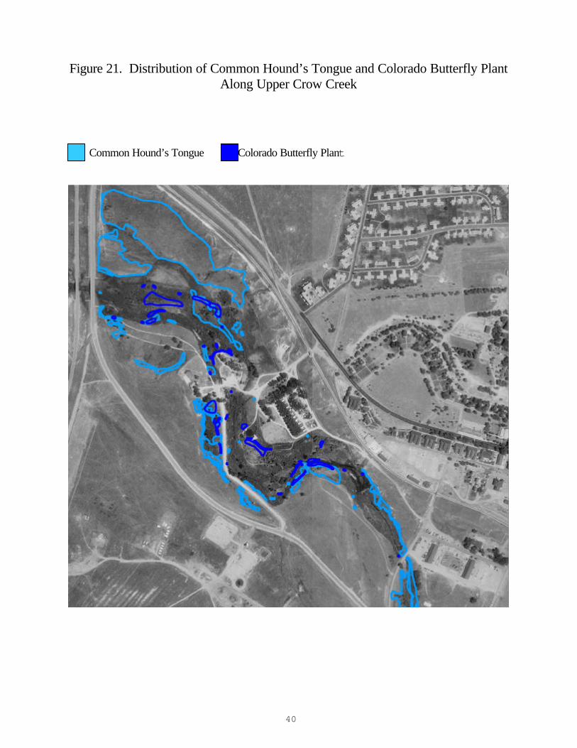
Figure 21. Distribution of Common Hound’s Tongue and Colorado Butterfly Plant Along Upper Crow Creek
Common Hound’s Tongue Colorado Butterfly Plant
41
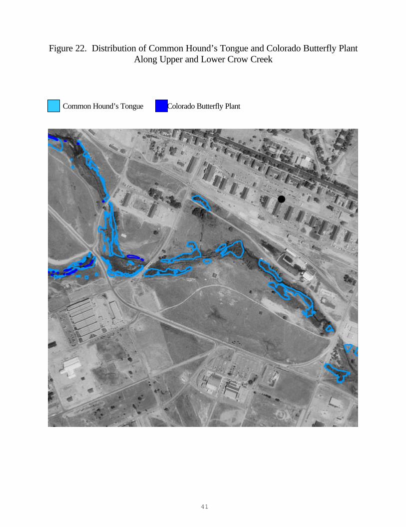
Figure 22. Distribution of Common Hound’s Tongue and Colorado Butterfly Plant Along Upper and Lower Crow Creek
Common Hound’s Tongue Colorado Butterfly Plant
42
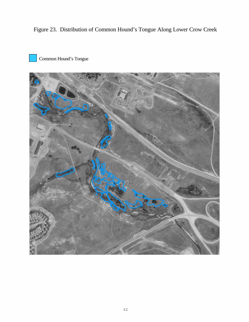
Figure 23. Distribution of Common Hound’s Tongue Along Lower Crow Creek Common Hound’s Tongue
43
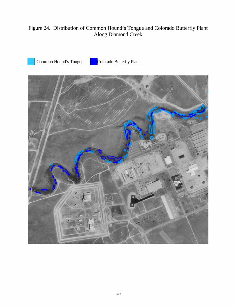
Figure 24. Distribution of Common Hound’s Tongue and Colorado Butterfly Plant Along Diamond Creek
Common Hound’s Tongue Colorado Butterfly Plant
44
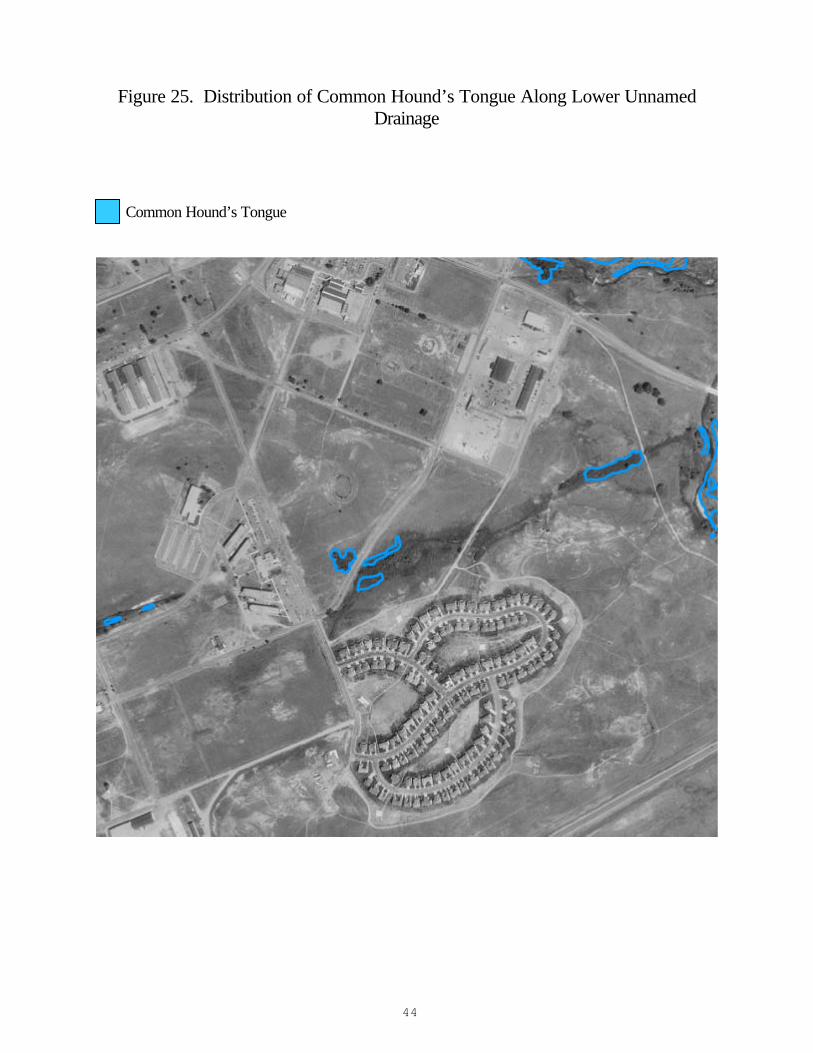
Figure 25. Distribution of Common Hound’s Tongue Along Lower Unnamed Drainage
Common Hound’s Tongue
45
Figure 26. Distribution of Common Hound’s Tongue and Colorado Butterfly Plant Along the Upper Unnamed Drainage
Common Hound’s Tongue Colorado Butterfly Plant
46
Figure 27. Distribution of Purple Loosestrife and Colorado Butterfly Plant Along Upper Crow Creek
Purple Loosestrife Colorado Butterfly Plant
47
Appendix A. Non-Native Plant Species of F.E. Warren Air Force Base
(From Fertig and Arnett 2001)
Species list derived from the Easter and Douglas (1996), Hazlett (1999) and collections by Walter Fertig. Exotic species list follows Fertig (1999a). Species with a “$” are listed as Noxious Weeds under the Wyoming Weed and Pest Control Act. Nomenclature follows Dorn (1992).
Asteraceae Anthemis cotula (Stinking mayweed) $ Arctium minus (Common burdock) Centaurea cyanus (Bachelor’s button) $ Cirsium arvense (Canada thistle) Lactuca serriola (Prickly lettuce) Scorzonera laciniata (False salsify) Taraxacum officinale (Common dandelion) Tragopogon dubius (Yellow salsify) Boraginaceae $ Cynoglossum officinale (Common hound’s tongue) Brassicaceae Alyssum desertorum (Desert alyssum) Camelina microcarpa (Littlepod falseflax) Descurainia sophia (Flixweed) Sisymbrium altissimum (Tumblemustard) Thlaspi arvense (Field pennycress) Caprifoliaceae Lonicera tatarica (Tatarian honeysuckle) Caryophyllaceae Gypsophila paniculata (Baby’s breath) Chenopodiaceae Chenopodium album (Lambsquarter) Kochia scoparia (Summer cypress) Salsola collina (Tumbleweed) Convolvulaceae $ Convolvulus arvensis (Field bindweed)
48
Crassulaceae Sedum acre (Mossy stonecrop) Elaeagnaceae Elaeagnus angustifolia (Russian olive) Euphorbiaceae $ Euphorbia esula var. esula (Leafy spurge) $ Euphorbia esula var. uralensis (Leafy spurge) Fabaceae Astragalus cicer (Chick-pea milkvetch) Caragana arborescens (Pea-tree) Coronilla varia (Crown vetch) Medicago lupulina (Black medic) Medicago sativa (Alfalfa) Melilotus albus (White sweetclover) Meliltous officinalis (Yellow sweetclover) Trifolium pratense (Red clover) Juncaceae Juncus compressus (Compressed rush) Lamiaceae Nepeta cataria (Common catnip) Liliaceae Asparagus officinalis (Asparagus) Lythraceae $ Lythrum salicaria (Purple loosestrife) Malvaceae Malva neglecta (Common mallow) Oleaceae Syringa vulgaris (Common lilac) Plantaginaceae Plantago major (Common plantain) Poaceae Agropyron cristatum (Crested wheatgrass) Agrostis stolonifera (Redtop)
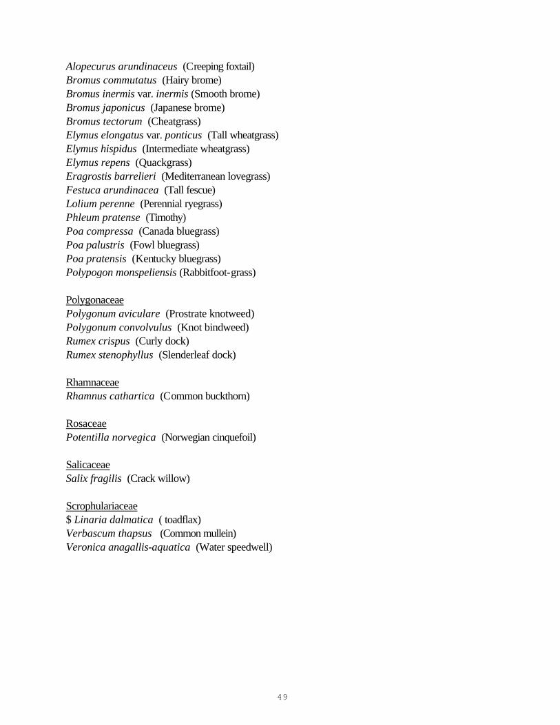
49
Alopecurus arundinaceus (Creeping foxtail) Bromus commutatus (Hairy brome) Bromus inermis var. inermis (Smooth brome) Bromus japonicus (Japanese brome) Bromus tectorum (Cheatgrass) Elymus elongatus var. ponticus (Tall wheatgrass) Elymus hispidus (Intermediate wheatgrass) Elymus repens (Quackgrass) Eragrostis barrelieri (Mediterranean lovegrass) Festuca arundinacea (Tall fescue) Lolium perenne (Perennial ryegrass) Phleum pratense (Timothy) Poa compressa (Canada bluegrass) Poa palustris (Fowl bluegrass) Poa pratensis (Kentucky bluegrass) Polypogon monspeliensis (Rabbitfoot-grass) Polygonaceae Polygonum aviculare (Prostrate knotweed) Polygonum convolvulus (Knot bindweed) Rumex crispus (Curly dock) Rumex stenophyllus (Slenderleaf dock) Rhamnaceae Rhamnus cathartica (Common buckthorn) Rosaceae Potentilla norvegica (Norwegian cinquefoil) Salicaceae Salix fragilis (Crack willow) Scrophulariaceae $ Linaria dalmatica ( toadflax) Verbascum thapsus (Common mullein) Veronica anagallis-aquatica (Water speedwell)
50
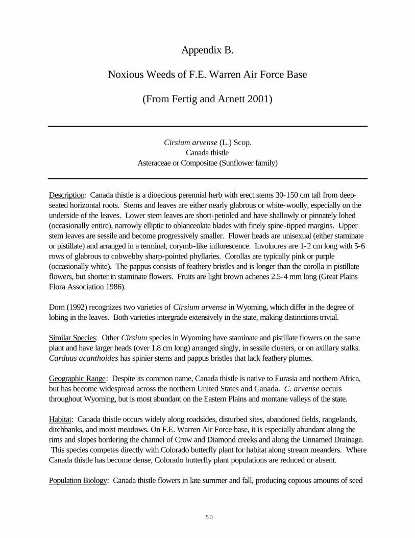
Appendix B.
Noxious Weeds of F.E. Warren Air Force Base
(From Fertig and Arnett 2001)
Cirsium arvense (L.) Scop. Canada thistle
Asteraceae or Compositae (Sunflower family)
Description: Canada thistle is a dioecious perennial herb with erect stems 30-150 cm tall from deep-seated horizontal roots. Stems and leaves are either nearly glabrous or white-woolly, especially on the underside of the leaves. Lower stem leaves are short-petioled and have shallowly or pinnately lobed (occasionally entire), narrowly elliptic to oblanceolate blades with finely spine-tipped margins. Upper stem leaves are sessile and become progressively smaller. Flower heads are unisexual (either staminate or pistillate) and arranged in a terminal, corymb-like inflorescence. Involucres are 1-2 cm long with 5-6 rows of glabrous to cobwebby sharp-pointed phyllaries. Corollas are typically pink or purple (occasionally white). The pappus consists of feathery bristles and is longer than the corolla in pistillate flowers, but shorter in staminate flowers. Fruits are light brown achenes 2.5-4 mm long (Great Plains Flora Association 1986). Dorn (1992) recognizes two varieties of Cirsium arvense in Wyoming, which differ in the degree of lobing in the leaves. Both varieties intergrade extensively in the state, making distinctions trivial. Similar Species: Other Cirsium species in Wyoming have staminate and pistillate flowers on the same plant and have larger heads (over 1.8 cm long) arranged singly, in sessile clusters, or on axillary stalks. Carduus acanthoides has spinier stems and pappus bristles that lack feathery plumes. Geographic Range: Despite its common name, Canada thistle is native to Eurasia and northern Africa, but has become widespread across the northern United States and Canada. C. arvense occurs throughout Wyoming, but is most abundant on the Eastern Plains and montane valleys of the state. Habitat: Canada thistle occurs widely along roadsides, disturbed sites, abandoned fields, rangelands, ditchbanks, and moist meadows. On F.E. Warren Air Force base, it is especially abundant along the rims and slopes bordering the channel of Crow and Diamond creeks and along the Unnamed Drainage. This species competes directly with Colorado butterfly plant for habitat along stream meanders. Where Canada thistle has become dense, Colorado butterfly plant populations are reduced or absent. Population Biology: Canada thistle flowers in late summer and fall, producing copious amounts of seed
51
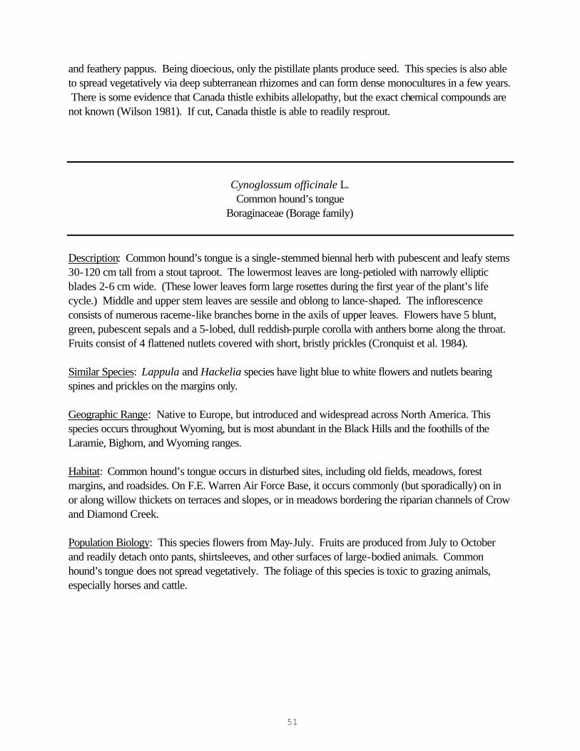
and feathery pappus. Being dioecious, only the pistillate plants produce seed. This species is also able to spread vegetatively via deep subterranean rhizomes and can form dense monocultures in a few years. There is some evidence that Canada thistle exhibits allelopathy, but the exact chemical compounds are not known (Wilson 1981). If cut, Canada thistle is able to readily resprout.
Cynoglossum officinale L. Common hound’s tongue
Boraginaceae (Borage family)
Description: Common hound’s tongue is a single-stemmed biennal herb with pubescent and leafy stems 30-120 cm tall from a stout taproot. The lowermost leaves are long-petioled with narrowly elliptic blades 2-6 cm wide. (These lower leaves form large rosettes during the first year of the plant’s life cycle.) Middle and upper stem leaves are sessile and oblong to lance-shaped. The inflorescence consists of numerous raceme-like branches borne in the axils of upper leaves. Flowers have 5 blunt, green, pubescent sepals and a 5-lobed, dull reddish-purple corolla with anthers borne along the throat. Fruits consist of 4 flattened nutlets covered with short, bristly prickles (Cronquist et al. 1984). Similar Species: Lappula and Hackelia species have light blue to white flowers and nutlets bearing spines and prickles on the margins only. Geographic Range: Native to Europe, but introduced and widespread across North America. This species occurs throughout Wyoming, but is most abundant in the Black Hills and the foothills of the Laramie, Bighorn, and Wyoming ranges.
Habitat: Common hound’s tongue occurs in disturbed sites, including old fields, meadows, forest margins, and roadsides. On F.E. Warren Air Force Base, it occurs commonly (but sporadically) on in or along willow thickets on terraces and slopes, or in meadows bordering the riparian channels of Crow and Diamond Creek. Population Biology: This species flowers from May-July. Fruits are produced from July to October and readily detach onto pants, shirtsleeves, and other surfaces of large-bodied animals. Common hound’s tongue does not spread vegetatively. The foliage of this species is toxic to grazing animals, especially horses and cattle.
52
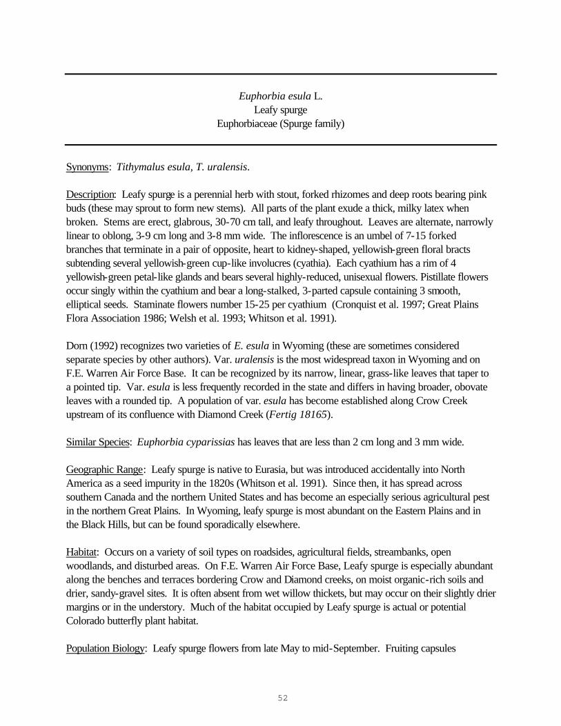
Euphorbia esula L. Leafy spurge
Euphorbiaceae (Spurge family)
Synonyms: Tithymalus esula, T. uralensis. Description: Leafy spurge is a perennial herb with stout, forked rhizomes and deep roots bearing pink buds (these may sprout to form new stems). All parts of the plant exude a thick, milky latex when broken. Stems are erect, glabrous, 30-70 cm tall, and leafy throughout. Leaves are alternate, narrowly linear to oblong, 3-9 cm long and 3-8 mm wide. The inflorescence is an umbel of 7-15 forked branches that terminate in a pair of opposite, heart to kidney-shaped, yellowish-green floral bracts subtending several yellowish-green cup-like involucres (cyathia). Each cyathium has a rim of 4 yellowish-green petal-like glands and bears several highly-reduced, unisexual flowers. Pistillate flowers occur singly within the cyathium and bear a long-stalked, 3-parted capsule containing 3 smooth, elliptical seeds. Staminate flowers number 15-25 per cyathium (Cronquist et al. 1997; Great Plains Flora Association 1986; Welsh et al. 1993; Whitson et al. 1991). Dorn (1992) recognizes two varieties of E. esula in Wyoming (these are sometimes considered separate species by other authors). Var. uralensis is the most widespread taxon in Wyoming and on F.E. Warren Air Force Base. It can be recognized by its narrow, linear, grass-like leaves that taper to a pointed tip. Var. esula is less frequently recorded in the state and differs in having broader, obovate leaves with a rounded tip. A population of var. esula has become established along Crow Creek upstream of its confluence with Diamond Creek (Fertig 18165). Similar Species: Euphorbia cyparissias has leaves that are less than 2 cm long and 3 mm wide. Geographic Range: Leafy spurge is native to Eurasia, but was introduced accidentally into North America as a seed impurity in the 1820s (Whitson et al. 1991). Since then, it has spread across southern Canada and the northern United States and has become an especially serious agricultural pest in the northern Great Plains. In Wyoming, leafy spurge is most abundant on the Eastern Plains and in the Black Hills, but can be found sporadically elsewhere. Habitat: Occurs on a variety of soil types on roadsides, agricultural fields, streambanks, open woodlands, and disturbed areas. On F.E. Warren Air Force Base, Leafy spurge is especially abundant along the benches and terraces bordering Crow and Diamond creeks, on moist organic-rich soils and drier, sandy-gravel sites. It is often absent from wet willow thickets, but may occur on their slightly drier margins or in the understory. Much of the habitat occupied by Leafy spurge is actual or potential Colorado butterfly plant habitat.
Population Biology: Leafy spurge flowers from late May to mid-September. Fruiting capsules
53
“explode” when dried, forcibly ejecting their seeds for distances of up to 5 meters. Seeds can disperse via water, and wildlife, ingested by mourning doves and whitetail deer. This plant is also able to persist and spread via deep rhizomes and roots.
Linaria dalmatica (L.) Mill. Dalmatian toadflax
Scrophulariaceae (Figwort family)
Synonym: Linaria genistifolia ssp. dalmatica Description: Dalmatian toadflax is a glabrous, waxy blue-green perennial herb with erect, multi-branched stems 40-70 cm tall from a creeping horizontal rootstalk. The overlapping leaves are ovate to lance-ovate, sessile, clasping, alternate, and 2-4 cm long x 10-16 mm wide. The inflorescence is an elongate raceme of yellow, bi-lobed, short-stalked, irregular flowers borne in the axils of short bracts. The corolla lips and tube are 14-24 mm long and have a sharp-tipped spur 9-17 mm long. The lower lip has a densely pubescent white to orangish “beard”. Fruits are dry capsules 6-7 mm long that split at the tip to release the seeds (Cronquist et al. 1984). The name Linaria genistifolia is sometimes applied to this species. True L. genistifolia is a closely related European taxon with smaller flowers (entire corolla, including spur, is less than 23 mm) and narrow, lance-shaped leaves (Gleason and Cronquist 1991). This species has been reported from the northern Great Plains, but has not been documented in Wyoming (Great Plains Flora Association 1986). Similar Species: Linaria vulgaris has linear to elliptic, non-clasping leaves. L. canadensis is a native annual with blue flowers. Geographic Range: Dalmatian toadflax is native to southeastern Europe, but has been widely introduced across southern Canada and the northern United States. In Wyoming, it is currently most abundant in the Southeastern Plains, Laramie Basin, Jackson Hole, and South Fork Shoshone River Valley, but is rapidly spreading into new areas. Habitat: Occurs along roadsides, dry to moist meadows, and rangelands, where it can be an aggressive spreader. On F.E. Warren Air Force base, Dalmatian toadflax occurs widely along the drier margins of the Crow and Diamond Creek floodplain on steep slopes or gravelly terraces, but is occurring with increasing frequency in more mesic areas. Population Biology: Dalmatian toadflax flowers from late July to mid September. Once established, it can be extremely difficult to eradicate because of its waxy foliage that does not readily accept foliar herbicides and its deep root system.
54
Lythrum salicaria L.
Purple loosestrife Lythraceae (Loosestrife family)
Description: Purple loosestrife is a robust, rhizomatous perennial herb with slightly tomentose, square stems 50-200 cm tall. Leaves are sessile, opposite or whorled, and have pubescent, oblong or lance-shaped blades 3-10 cm long and 5-20 mm wide. The inflorescence is an elongated, terminal spike with 3 or more flowers arranged in a whorl at each leafy node. The flowers have 6 rose-purple petals 7-12 mm long inserted at the top of a 4-6 mm long, multi-nerved, greenish floral tube. Flowers may consist of three morphological types (all in the same inflorescence), differing in the relative length of the style and stigma. Flowers also have 12 anthers, each alternating in length (long and short). Fruits are small capsules contained within the floral tube (Cronquist et al. 1997; Fertig 1999b; Great Plains Flora Association 1986). Similar Species: Lythrum alatum, an uncommon native species in Wyoming, has glabrate herbage, ovate to oblong leaves less than 4 cm long, and flowers with 6 stamens arranged singly or in pairs at each node of the leafy inflorescence. Epilobium angustifolium has 4-petaled flowers and rounded stems. Liatris spp. have slender leaves, spike-like inflorescences of thistle-like flower heads, and typically occur in drier habitats. Verbena hastata has smaller flowers with a 5-lobed, blue corolla and short-petioled upper stem leaves (Dorn 1992; Great Plains Flora Association 1986). Geographic Range: Purple loosestrife is native to Eurasia, but has been widely introduced in northeastern and central North America and the Pacific coast (Cronquist et al. 1997; Thompson et al. 1987). In Wyoming, it is currently known from the vicinity of Lovell (Park County), Lusk (Niobrara County), and Cheyenne (Laramie County). Habitat: Lythrum salicaria is an emergent, aquatic, or semi-aquatic plant adapted to streambanks, small ponds, ditches, marshes, and other wetlands or areas with permanently wet soils (Hight and Drea 1991). On F.E. Warren Air Force Base, Purple loosestrife has been found along Crow Creek on damp soil at the edge of thickets of Coyote willow (Salix exigua) and Bebb willow (S. bebbiana) and moist meadows of Redtop (Agrostis stolonifera), Baltic rush (Juncus balticus) and Canada thistle (Cirsium arvense). Population Biology: Purple loosestrife flowers from early July to mid August and can produce fruits and seeds over most of the summer. The species is able to spread rapidly by rhizomes or broken stem and root pieces, and is a prolific seed producer. Additional Comments: Fertig (1999b) documented a small colony of Purple loosestrife near the bridge on the Crow Creek nature trail in September 1996. This patch was manually removed in September 1998, and has not been relocated in 1999, 2000 or 2001.