discussion paper: the potential oil and gas...
TRANSCRIPT
Discussion Paper: The Potential Oil and Gas Resource Base in Nova Scotia Accessible by
Hydraulic Fracturing Nova Scotia Hydraulic Fracturing Independent Review and Public Engagement Process
Lead Authors(s): Dr. Brad Hayes & Ray Ritcey
Expert Panellists: Expert Panellists: Dr. Frank Atherton, Dr. Michael Bradfield, Kevin Christmas, Dr. Shawn Dalton, Dr. Maurice Dusseault, Dr. Graham Gagnon, Constance MacIntosh & Dr. Ian Mauro
Supporting Contributor(s): Fred Baechler, Margo MacGregor, Keith MacLeod & David Wheeler
This discussion paper provides a basic overview of the prospective oil and gas resource base of onshore Nova Scotia, and context is provided regarding the infrastructure in the province relevant to petroleum industry activities. This paper assesses the issues and opportunities that may exist with the development of unconventional oil and gas using modern oilfield techniques, including hydraulic fracturing.
Discussion Paper: The Potential Oil and Gas Resource Base in Nova Scotia Accessible by
Hydraulic Fracturing
How to Read this Paper
This discussion paper will in due course form the basis of a chapter in the full report produced for the
Hydraulic Fracturing Independent Review and Public Engagement Process in Nova Scotia.1 The paper
should be read in conjunction with the Primer on Hydraulic Fracturing2 which we released on March 10th
2014. This paper has been prepared to describe the resource potential for oil and gas extraction in Nova
Scotia. This paper does not address economic risks or benefits. The paper does not address any of the
potential environmental impacts of hydraulic fracturing or issues relating to land rights or ownership of
resource (these subjects, among others, will be covered in other discussion papers and the final report).
To see a full list of other topics being considered in chapters of the final report, and to view the tentative
release schedule for discussion papers, please visit the project document page on our website.
How to Provide Feedback on this Paper
We now invite feedback on this discussion paper – for example if there are any aspects that are not
clear or which require further explanation. Please email your feedback to [email protected] with
‘Resource’ in the subject line using the feedback form available on the website3. We request that you do
not make comments directly in the PDF document and prefer to receive feedback using the form
provided, in an email or word attachment, or alternatively please write to HF Review, Verschuren Centre
for Sustainability in Energy and the Environment, Cape Breton University, P.O.Box 5300, 1250 Grand
Lake Road, Sydney, Nova Scotia, B1P 6L2. Feedback on this chapter can be received at any time until
June 5th, 2014. All feedback received will be taken into account in the final version of the document.
Thank you
Dr David Wheeler President of Cape Breton University, on Behalf of the Expert Panel, 20th May 2014
1 See the Verschuren Centre (Cape Breton University) website http://www.cbu.ca/hfstudy for full details of the
study and all project documentation. 2 Available from http://www.cbu.ca/hfstudy
3 The discussion paper feedback form is available here: http://www.cbu.ca/hfstudy/resources/project-documents
Contents
LIST OF FIGURES ........................................................................................................................................ ii
1. EXECUTIVE SUMMARY ...................................................................................................................... 1
2. INTRODUCTION ................................................................................................................................. 1
3. NOVA SCOTIA INFRASTRUCTURE AND MARKETS ............................................................................. 2
3.1. Terrain ....................................................................................................................................... 2
3.2. Roads and Bridges ..................................................................................................................... 2
3.3. Pipeline Infrastructure .............................................................................................................. 3
3.4. Oil Infrastructure ....................................................................................................................... 5
3.5. Markets ..................................................................................................................................... 5
4. OIL AND GAS RESOURCE ASSESSMENT – BACKGROUND ................................................................. 6
4.1. Recovery Factors ....................................................................................................................... 7
4.2. Summary ................................................................................................................................... 7
5. PROSPECTIVE PETROLEUM BASINS IN NOVA SCOTIA ....................................................................... 8
5.1. Regional Petroleum Geology .................................................................................................... 8
5.2. Unconventional Oil and Gas Potential in Nova Scotia Basins ................................................. 12
6. INDUSTRY ACTIVITY ......................................................................................................................... 13
7. APPLICATION OF HYDRAULIC FRACTURING TECHNOLOGY ............................................................ 14
8. SUMMARY AND CONCLUSIONS ...................................................................................................... 16
REFERENCES ............................................................................................................................................ 19
APPENDIX A: GEOLOGICAL REVIEW OF OIL AND GAS POTENTIAL IN NOVA SCOTIA BASINS ................. 23
ii Hydraulic Fracturing Independent Review and Public Consultation in Nova Scotia
LIST OF FIGURES
Figure 1: Maritimes & Northeast Pipeline System Map ............................................................................... 4
Figure 2: Sedimentary basins of Eastern Canada. ......................................................................................... 9
Figure 3: Sedimentary Basins of Nova Scotia .............................................................................................. 10
Figure 4: Stratigraphic cross-section of the Central Magdalen Basin ......................................................... 11
Figure 5: Stratigraphic cross-sections across Stoney Creek and McCully Fields in New Brunswick. .......... 12
Figure 6: Litho Column Edited ..................................................................................................................... 23
1 Hydraulic Fracturing Independent Review and Public Consultation in Nova Scotia
Discussion Paper: The Potential Oil and Gas Resource Base in Nova Scotia
Accessible by Hydraulic Fracturing
1. EXECUTIVE SUMMARY
This paper looks at the resource and infrastructure potential for onshore oil and gas extraction in Nova
Scotia including the use of hydraulic fracturing techniques. The physical geology does recognize
resource potential for conventional and unconventional oil and gas in specific areas (sedimentary
basins) in the Province, mostly in rural areas. Limited on-shore petroleum development has occurred to
date, but no commercial oil and gas production has been established. Local and export markets exist
for both oil and natural gas with demand growing.
As knowledge of the subsurface, including sedimentary rocks and hydrocarbons, is extremely limited, it
is very difficult to quantify the potential or even rank the various basins in terms of overall prospectivity.
The shales in basins closest to New Brunswick are of most interest to developers to date because New
Brunswick basins have demonstrated commercial production of both gas and oil, and pipeline
infrastructure is in place. Using published information, potential gas volumes have been estimated at
17-69 TCF in the Windsor- Kennetcook Basin and coal bed methane volumes at .28-1.18 TCF in the
Sydney, Stellarton and Cumberland Basins. Other basins may or may not have potential but very limited
data or information exists. Exploration activity is likely to be limited, at least for the next several years,
until such time as the moratorium on hydraulic fracturing is reviewed, additional seismic and well data
are acquired, and the complexities of developing frontier basins are addressed.
2. INTRODUCTION
An understanding of the prospective oil and gas resource base of onshore Nova Scotia is required for the Expert Panel to develop assessments of the issues and opportunities that may exist with the development of unconventional oil and gas using modern oilfield techniques, including hydraulic fracturing. In this report, we will describe in-place oil and gas potential for the prospective areas of Nova Scotia, and also provide context regarding the infrastructure in the province relevant to petroleum industry activities. The oil and gas industry in Nova Scotia dates back to 1869, when the first exploration well was drilled in the Lake Ainslie area on Cape Breton Island. While a few discoveries have been made onshore in the Maritime Provinces, such as the Stoney Creek and McCully fields in New Brunswick, onshore Nova Scotia has not been seen as highly prospective for conventional oil and gas and no commercial discoveries have been made to date. Commercial gas discoveries
2 Hydraulic Fracturing Independent Review and Public Consultation in Nova Scotia
have been made in the offshore, where oil has been produced from the Cohasset and Panuke fields, and where gas is produced today from the Sable Island complex and Deep Panuke Field. In recent years, the development of horizontal drilling and hydraulic fracture completion technologies has rendered low-quality (‘unconventional’) reservoirs capable of production at commercial rates. Explorers are thus re-evaluating the production potential of many areas, including onshore Nova Scotia.
3. NOVA SCOTIA INFRASTRUCTURE AND MARKETS
3.1. Terrain
Nova Scotia is 55,000 km2 in size, the second smallest province in Canada. It is connected to
the province of New Brunswick by the Isthmus of Chignecto and is surrounded by the Atlantic
Ocean (Figure 1). The Canso Causeway joins mainland Nova Scotia with Cape Breton Island.
Nova Scotia has a mixed landscape including farmlands, rolling hills, forests, rivers and lakes,
and rocky coasts with the occasional cliffs and mountains. There are over 3000 lakes in the
province, with Bras d’Or Lake in Cape Breton the largest.
Hydrocarbon development potential exists largely in rural areas, where the terrain is a mixed landscape, mostly fertile, with rolling hills and watercourses. Farming, livestock, tourism and some industry exist in the prospective areas.
3.2. Roads and Bridges
There are over 23,000 km of roads and 4,100 bridges in Nova Scotia. The Province has responsibility for the 100-series highways, secondary highways, local paved and gravel/dirt roads and many concrete, steel and wooden bridges. The 100 series of highways, including the TransCanada, connects all parts of the Province. They are in generally good condition and have capacity to move large volumes of traffic including oversized vehicles. Secondary highways, trunks, routes and local municipal roads are important links to communities around the province. They are less travelled and are in varying states of repair. The Department of Transportation and Infrastructure Renewal five-year plan outlines a road repair priority program for the Province. Each municipality has its own plan for road and bridge repair. Hydrocarbon development would utilize a cross section of this highway, road and bridge infrastructure, plus roads and bridges on privately owned lands. Many of the roads and bridges have weight and height restrictions in place.
3 Hydraulic Fracturing Independent Review and Public Consultation in Nova Scotia
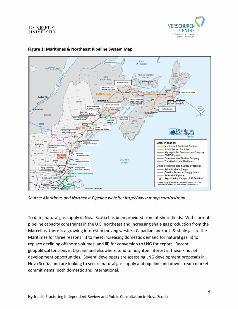
3.3. Pipeline Infrastructure
Natural gas was introduced into Maritimes Canada with the completion of the Maritimes &
NorthEast Pipeline (M&NP) in December 1999. The 1100 km pipeline moves natural gas from
Goldboro, Nova Scotia, where it lands from the Sable Offshore Energy Project (SOEP) and
Encana’s Deep Panuke facilities, located 225 and 250 km offshore, respectively. Gas is
transported to markets in Nova Scotia, New Brunswick and New England (Figure 1).
The M&NP 30” Canadian line (567 km) traverses both Nova Scotia and New Brunswick,
supplying natural gas to local gas distribution companies (LDCs) and several direct connect
customers in both provinces. It has an operational capacity of 550,000 mmbtu/day, and there
are no compression facilities on the system. There are several lateral pipelines off the Mainline
(Figure 1). In Nova Scotia, the 12” Halifax Lateral is 124 km long and has a design capacity of
122,100 mmbtu/day. The 8” and 6” diameter Point Tupper Lateral is 60 km long, with an
operational capacity of 30,000 mmbtu/day.
The M&NP US system (capacity 833,317 mmbtu/day) includes approximately 534 km of 24” and
30” diameter pipeline extending from St. Stephen, New Brunswick to interconnections with
Tennessee Gas Transmission near Dracut, Massachusetts and the Algonquin Gas Transmission
Company near Beverly, Massachusetts. M&NP US also receives natural gas from the Emera
Brunswick Pipeline, which transports regasified Liquid Natural Gas (“LNG”) from the
Repsol/Irving-owned Canaport terminal (1.2 BCF/day) near Saint John, New Brunswick.
Prior to the Sable Gas connection in 1999, M&NP flowed natural gas from western Canada
through the TransCanada PipeLines (“TCPL”) Canadian mainline onto the Portland Natural Gas
Transmission System (“PNGTS”) and back into the M&NP Canadian system via the M&NP US
system. U.S. natural gas supply can also be accessed from the Marcellus and Utica shale gas
areas through inter- and intra-state U.S. and Canadian pipelines in eastern Canada.
4 Hydraulic Fracturing Independent Review and Public Consultation in Nova Scotia
Figure 1: Maritimes & Northeast Pipeline System Map
Source: Maritimes and Northeast Pipeline website: http://www.mnpp.com/us/map
To date, natural gas supply in Nova Scotia has been provided from offshore fields. With current
pipeline capacity constraints in the U.S. northeast and increasing shale gas production from the
Marcellus, there is a growing interest in moving western Canadian and/or U.S. shale gas to the
Maritimes for three reasons: i) to meet increasing domestic demand for natural gas; ii) to
replace declining offshore volumes; and iii) for conversion to LNG for export. Recent
geopolitical tensions in Ukraine and elsewhere tend to heighten interest in these kinds of
development opportunities. Several developers are assessing LNG development proposals in
Nova Scotia, and are looking to secure natural gas supply and pipeline and downstream market
commitments, both domestic and international.
5 Hydraulic Fracturing Independent Review and Public Consultation in Nova Scotia
New domestic onshore and offshore natural gas production in the Maritimes would support
these development opportunities, and would supplement a declining offshore production
profile. New onshore natural gas production that is not used locally would require gathering
lines and an interconnection with either M&NP or local LDC infrastructure. Hydrocarbon
exploration in Nova Scotia has been undertaken in areas close to existing pipeline
infrastructure, as it has in New Brunswick. Without local supply, the cost for acquiring natural
gas in Nova Scotia would increase by the added cost of transportation in having the gas sourced
from outside suppliers.
3.4. Oil Infrastructure
With the recent conversion of the only oil refinery in Nova Scotia to a marine terminal, all
gasoline, heating oil and other petroleum products consumed in Nova Scotia are sourced from
New Brunswick, Newfoundland & Labrador and international markets. The product is delivered
by ship, rail and truck.
3.5. Markets
Natural gas consumption in Canada dates back over 150 years, with significant growth in
domestic use beginning in the late 1950’s. The use of natural gas is the culmination of an
evolution from coal to oil to natural gas, driven largely by affordable pricing and convenience.
It is the fuel of choice for residential, commercial and industrial applications in most of Canada.
Domestic natural gas was produced originally from conventional sources in Western Canada
and over time sales volumes for both domestic and exports increased significantly. Prior to the
SOEP project in Nova Scotia, natural gas expansion to Maritimes Canada was pursued by
moving western Canadian gas through an expansion of the TCPL system beginning in the early
1970’s, and culminating with the Trans Quebec and Maritimes Pipeline system (TQMP)
terminating near Quebec City. Expansion to the Maritimes at the time could not be justified on
economic grounds.
Natural gas was introduced in Maritimes Canada when the SOEP and M&NP facilities became
operational in 2000. Initially the majority of SOEP gas was delivered to the U.S. northeast and
to large direct access industrial customers in Nova Scotia and New Brunswick, primarily for
electricity generation. LDC’s were established in the early 2000’s in New Brunswick (Enbridge
Gas New Brunswick) and Nova Scotia (Heritage Gas Limited) as they built out their smaller
diameter and lower-pressure systems to residential, commercial and industrial customers.
While the majority of natural gas consumption in Nova Scotia is for the generation of electricity,
the core natural gas distribution market continues to experience strong growth. This growth is
6 Hydraulic Fracturing Independent Review and Public Consultation in Nova Scotia
due largely to the price advantage of natural gas over alternative fuels (primarily oil and
electricity), along with some inherent environmental benefits, including cleaner burning/lower
emissions, elimination of fuel leaks, and convenience. In addition, compressed natural gas
(“CNG”) deliveries by truck now occur in both provinces and provide access to areas not
currently served by LDC pipelines.
The Maritimes market now takes up to 50% of production from offshore Nova Scotia, or 200-
300,000 mmbtu/day (Statistics Canada).
4. OIL AND GAS RESOURCE ASSESSMENT – BACKGROUND
Historically, assessments of oil and gas resources have targeted ‘conventional’ reservoirs – those with characteristics that allow production of oil and/or gas at commercial rates from wells drilled vertically. The key measures of reservoir quality are:
Porosity – the amount of pore space between mineral grains making up the rock – a measure of the rock’s capacity to hold oil and gas;
Permeability – a measure of how readily fluids can flow through the pore spaces in a rock – and therefore how rapidly oil and/or gas can be produced.
There are well-established procedures for conducting resource assessments for conventional reservoirs. Agencies such as the Geological Survey of Canada (e.g., Lee, 1993; Lavoie et al., 2009; Hu and Dietrich, 2010; Hannigan et al., 2011) have completed conventional oil and gas resource assessments for most prospective areas in Canada. The combination of horizontal wells with multiple hydraulic fracture completions now offer the potential to produce from ‘unconventional’ reservoirs, which feature much poorer porosity and permeability characteristics. Procedures to assess petroleum resources in unconventional reservoirs are being developed, as geologists are working to understand exactly how the resources are contained within a reservoir, and how effectively they can be extracted (Lavoie et al., 2012). For example, gas molecules within an unconventional reservoir are held not only in pore spaces and naturally-occurring fractures, but may also be ‘adsorbed’, or chemically bonded, to organic material within the rock. In addition, there is often uncertainty about whether a particular reservoir contains oil or gas, or a mixture of both, until after horizontal wells with hydraulic fractures are completed. Under appropriate conditions, coal seams represent a special class of unconventional reservoir, and can host significant resources of methane gas. While production techniques vary, both
7 Hydraulic Fracturing Independent Review and Public Consultation in Nova Scotia
vertical and horizontal wells employing small fracture stimulations, usually with a gas such as nitrogen as opposed to water, are common. Many assessments of oil and gas potential in unconventional reservoirs do not attempt to quantify potential, but instead are more descriptive in nature (e.g., Hamblin, 2006; Hayes, 2011; Hayes and Archibald, 2012). For unconventional reservoirs in areas where abundant data are available from conventional wells, quantitative analyses have been published, but with wide ranges of probabilistically-generated estimates reflecting inherent uncertainties (e.g., B.C. Ministry of Energy and Mines and National Energy Board, 2011; Rokosh et al., 2012; U.S. EIA, 2013; National Energy Board et al., 2013).
4.1. Recovery Factors Once one has calculated the volumes of oil and gas in place in a reservoir, a recovery factor – the percentage of the resource in place that can actually be extracted – must be assigned in order to estimate the actual oil and gas volumes that may be produced. Regardless of the reservoir type, recovery factor estimates depend upon many assumptions, including reservoir characteristics, development methods and costs, and oil and gas prices. Based on production histories of conventional reservoir types, one can make standard assumptions about recovery factors for many conventional reservoirs. These can range up to more than 90% for gas reservoirs, and >50% for the best oil reservoirs. Conversely, oil and gas have been produced from unconventional reservoirs only over the last decade or so, and so we have little guidance to understanding how much of the in-place resource can be produced, and thus what recovery factors might be. Most unconventional resource assessments published to date routinely assume relatively low recovery factors – typically on the order of 5-25%. Potential to attain higher recovery factors will be governed by the economic viability of greater well density, more effective fracturing, and other technologies.
4.2. Summary Our assessment of oil and gas resources that may be available for production from unconventional reservoirs in Nova Scotia is subject to several uncertainties:
Calculation of volumes of oil and/or gas contained within each reservoir;
Whether oil or gas or both will be produced in commercial quantities;
What fraction of the in-place resource can actually be extracted economically?
8 Hydraulic Fracturing Independent Review and Public Consultation in Nova Scotia
For this report, we use available information to describe in-place oil and gas potential for the prospective areas of Nova Scotia. However, we do not attempt to generate area-specific recovery factor estimates, as we lack appropriate data and comparisons to do so.
5. PROSPECTIVE PETROLEUM BASINS IN NOVA SCOTIA
5.1. Regional Petroleum Geology
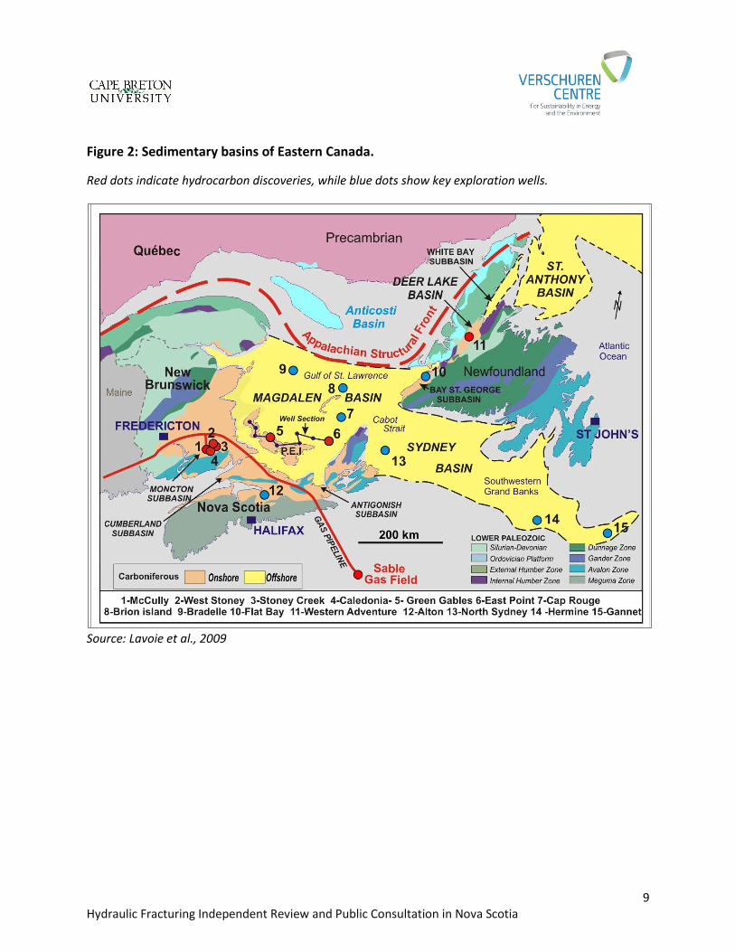
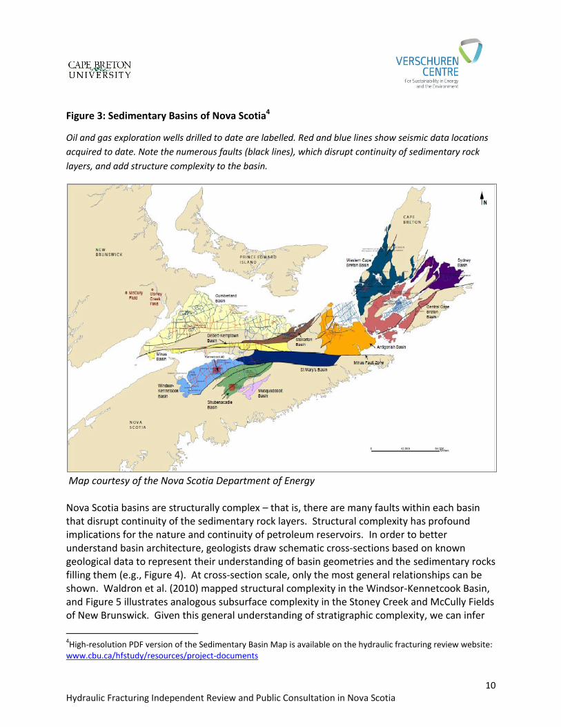
Oil and gas were generated over tens of millions of years, as heat and pressure acted upon organic material deposited in sediments – such as sands deposited in a river delta – which later evolved into sedimentary rocks. Organic content is dominated by remains of plankton and algae in marine settings, and by plant materials in land settings. Oil and gas are thus almost always hosted in reservoirs made up of sedimentary rocks (including coal), buried at depths of hundreds to thousands of metres. These occur in discrete areas known as sedimentary basins. Figure 2 shows the major sedimentary basins of eastern Canada. The prospective basins of Nova Scotia are part of a complex of basins (‘Maritimes Basin’) which underlies parts of the offshore, much of the Maritimes, and western Newfoundland. Figure 3 shows in more detail the sedimentary basins of onshore Nova Scotia, and the locations of oil and gas wells drilled and geophysical (seismic) data acquired to date. Note that very few wells have been drilled, and very little seismic data acquired, compared to more mature, or developed, petroleum-bearing basins. In areas outside the major sedimentary basins, the bedrock is composed of older sedimentary rocks and/or metamorphic rocks, which have little or no potential to contain oil and gas. The Maritimes Basin formed during late Paleozoic time (about 350 to 300 million years ago), in response to movements of large plates on the Earth’s crust carrying the North American and African continents. Stresses arising from these movements deformed the Earth’s crust, causing some areas to sink and form basins. Many basin boundaries are sharp discontinuities, now expressed as breaks, or faults (shown as heavy black lines in Figure 3; note as a particular example the Minas Fault Zone, which crosses Nova Scotia from west to east). Sedimentary rocks in Nova Scotia basins range up to several thousand metres thick, but they are understood only in very general terms because only a small sampling of rocks can be examined at the surface, and there are relatively few deep boreholes drilled through them (Figure 3). Seismic data, acquired along the lines shown in Figure 3, can assist in mapping subsurface rock units, but impart only limited levels of detail. Other geophysical remote sensing methods, such as magnetic and gravity surveys, provide additional broad support but relatively little detail.
9 Hydraulic Fracturing Independent Review and Public Consultation in Nova Scotia
Figure 2: Sedimentary basins of Eastern Canada.
Red dots indicate hydrocarbon discoveries, while blue dots show key exploration wells.
Source: Lavoie et al., 2009
10 Hydraulic Fracturing Independent Review and Public Consultation in Nova Scotia
Figure 3: Sedimentary Basins of Nova Scotia4
Oil and gas exploration wells drilled to date are labelled. Red and blue lines show seismic data locations
acquired to date. Note the numerous faults (black lines), which disrupt continuity of sedimentary rock
layers, and add structure complexity to the basin.
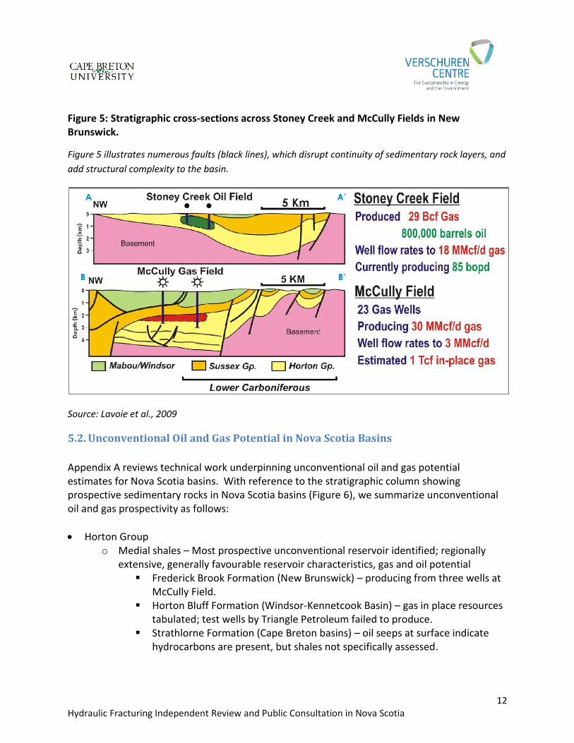
Map courtesy of the Nova Scotia Department of Energy Nova Scotia basins are structurally complex – that is, there are many faults within each basin that disrupt continuity of the sedimentary rock layers. Structural complexity has profound implications for the nature and continuity of petroleum reservoirs. In order to better understand basin architecture, geologists draw schematic cross-sections based on known geological data to represent their understanding of basin geometries and the sedimentary rocks filling them (e.g., Figure 4). At cross-section scale, only the most general relationships can be shown. Waldron et al. (2010) mapped structural complexity in the Windsor-Kennetcook Basin, and Figure 5 illustrates analogous subsurface complexity in the Stoney Creek and McCully Fields of New Brunswick. Given this general understanding of stratigraphic complexity, we can infer
4High-resolution PDF version of the Sedimentary Basin Map is available on the hydraulic fracturing review website:
www.cbu.ca/hfstudy/resources/project-documents
11 Hydraulic Fracturing Independent Review and Public Consultation in Nova Scotia
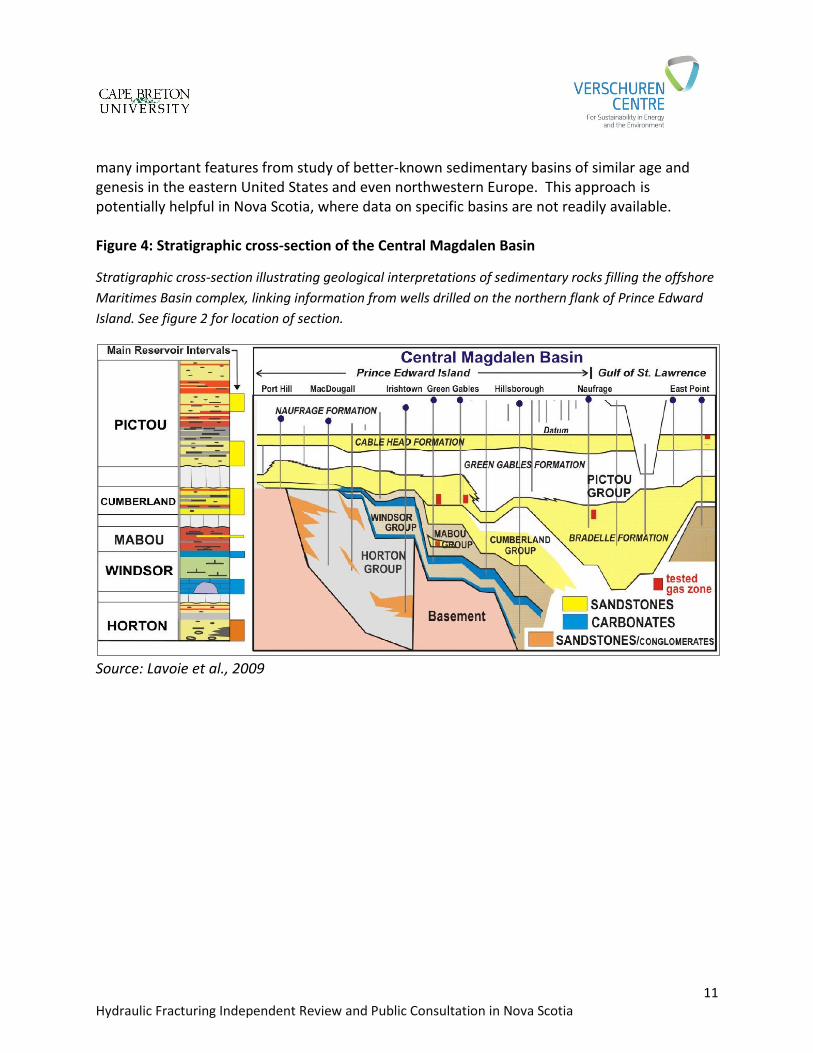
many important features from study of better-known sedimentary basins of similar age and genesis in the eastern United States and even northwestern Europe. This approach is potentially helpful in Nova Scotia, where data on specific basins are not readily available. Figure 4: Stratigraphic cross-section of the Central Magdalen Basin
Stratigraphic cross-section illustrating geological interpretations of sedimentary rocks filling the offshore
Maritimes Basin complex, linking information from wells drilled on the northern flank of Prince Edward
Island. See figure 2 for location of section.
Source: Lavoie et al., 2009
12 Hydraulic Fracturing Independent Review and Public Consultation in Nova Scotia
Figure 5: Stratigraphic cross-sections across Stoney Creek and McCully Fields in New Brunswick.
Figure 5 illustrates numerous faults (black lines), which disrupt continuity of sedimentary rock layers, and
add structural complexity to the basin.
Source: Lavoie et al., 2009
5.2. Unconventional Oil and Gas Potential in Nova Scotia Basins
Appendix A reviews technical work underpinning unconventional oil and gas potential estimates for Nova Scotia basins. With reference to the stratigraphic column showing prospective sedimentary rocks in Nova Scotia basins (Figure 6), we summarize unconventional oil and gas prospectivity as follows:
Horton Group o Medial shales – Most prospective unconventional reservoir identified; regionally
extensive, generally favourable reservoir characteristics, gas and oil potential Frederick Brook Formation (New Brunswick) – producing from three wells at
McCully Field. Horton Bluff Formation (Windsor-Kennetcook Basin) – gas in place resources
tabulated; test wells by Triangle Petroleum failed to produce. Strathlorne Formation (Cape Breton basins) – oil seeps at surface indicate
hydrocarbons are present, but shales not specifically assessed.
13 Hydraulic Fracturing Independent Review and Public Consultation in Nova Scotia
o Upper sandstones – Producing gas at McCully Field in New Brunswick. Analogous potential seen in Nova Scotia basins, but not tested.
Windsor-Mabou Groups o Oil and gas potential has been discussed for several unconventional reservoir
intervals, but no exploration has taken place, nor have estimates of oil and gas volumes been published.
Cumberland and Pictou Groups o Coalbed methane (CBM) has been tested, and several assessments of CBM
resources on specific properties have been completed, but commercial production has not been established. Tight sandstones may be prospective but have not been assessed.
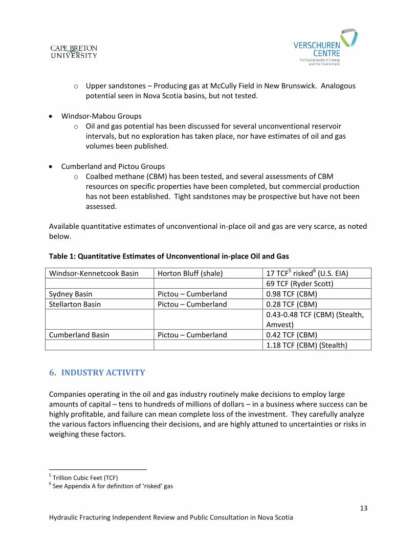
Available quantitative estimates of unconventional in-place oil and gas are very scarce, as noted below. Table 1: Quantitative Estimates of Unconventional in-place Oil and Gas
Windsor-Kennetcook Basin Horton Bluff (shale) 17 TCF5 risked6 (U.S. EIA)
69 TCF (Ryder Scott)
Sydney Basin Pictou – Cumberland 0.98 TCF (CBM)
Stellarton Basin Pictou – Cumberland 0.28 TCF (CBM)
0.43-0.48 TCF (CBM) (Stealth, Amvest)
Cumberland Basin Pictou – Cumberland 0.42 TCF (CBM)
1.18 TCF (CBM) (Stealth)
6. INDUSTRY ACTIVITY
Companies operating in the oil and gas industry routinely make decisions to employ large amounts of capital – tens to hundreds of millions of dollars – in a business where success can be highly profitable, and failure can mean complete loss of the investment. They carefully analyze the various factors influencing their decisions, and are highly attuned to uncertainties or risks in weighing these factors.
5 Trillion Cubic Feet (TCF)
6 See Appendix A for definition of ‘risked’ gas
14 Hydraulic Fracturing Independent Review and Public Consultation in Nova Scotia
To attract industry investment, there must be good promise of large, potentially profitable discoveries, and appropriate knowledge and management of risks. To realize the promise and potential value of new discoveries, it is necessary to maximize the certainty of large oil and gas resources in place, and to establish that they can be extracted economically. To minimize uncertainties and risk, industry looks to find successful comparator situations or analogues – places where oil and gas have been extracted economically from similar reservoirs using recognized techniques. In ‘frontier areas’ like the basins of Nova Scotia, where there is little existing subsurface information and petroleum infrastructure, potential rewards are poorly defined and uncertainties and risks are large, and so the search for successful analogues is particularly important. Nova Scotia basins hold the potential for large conventional and unconventional oil and gas resources. Exploration companies are thus attracted but are hesitant to move quickly in light of the high levels of risk and uncertainty. In fact, there are only four existing exploration agreements between companies and the Province, and three more for CBM exploration. Technical risks – the existence of the hydrocarbon resources and the existence of technology capable of extracting those resources at economic rates – have been addressed to some extent by the successful development of reasonable analogues. These include:
Commercial development, through horizontal drilling and hydraulic fracturing, of gas and liquids production from Marcellus shales in analogous, structurally-complex basins of the eastern United States, and
Commercial development of low-permeability Horton Group sandstones in the Moncton Basin (McCully and Stoney Creek fields), and initial success in developing gas production from Horton Group (Frederick Brook) shales, also in the Moncton Basin.
The closer the analogue, the better – so Corridor Resources’ success in New Brunswick is focusing industry’s attention on the nearest analogues. Thus, the correlative shales in basins closest to New Brunswick, such as the Horton Bluff shales in the Windsor-Kennetcook Basin, are attracting the most attention and activity.
7. APPLICATION OF HYDRAULIC FRACTURING TECHNOLOGY
Hydraulic fracturing is employed in both vertical and horizontal wells to enhance production rates and recovery volumes from oil and gas reservoirs, both conventional and unconventional. Hydraulic fracturing design is dictated primarily by the nature of the reservoir; as the ultimate goal is to maximize the economic value of production from a well, the cost of the fracturing treatment must be balanced off against the estimated gains in production.
15 Hydraulic Fracturing Independent Review and Public Consultation in Nova Scotia
In conventional reservoirs, small fracture stimulations may be used to enhance productivity of the reservoir. These use relatively small volumes of water (tens to hundreds of cubic metres), or either inert gas (such as nitrogen) or hydrocarbons (such as propane) to transmit pressure to fracture the reservoir rock. In unconventional reservoirs, stimulation scenarios include:
For coals, drilling targets are generally quite shallow and the coals very brittle, so relatively small fracture stimulations are needed. Nitrogen gas is commonly used, as introducing water to the coal may inhibit production.
For reservoirs that have been fractured naturally through large-scale rock movements (as in basin formation, discussed above), wells are drilled to intercept a maximum number of natural fractures, and little or no induced fracturing attempted. Some of Alberta and B.C.’s longest-producing and most prolific gas reservoirs fall into this category, as do some of the current oil plays in shales. In structurally-complex Nova Scotia basins, it appears likely that there will be at least some naturally-fractured plays that could be developed without hydraulic fracturing.
For many unconventional reservoirs, particularly tight sandstones and siltstones, relatively small fracture jobs are required to optimally stimulate the very brittle rocks. Long horizontal wells may be drilled and several, perhaps tens, of hydraulic fractures will be emplaced, but each may employ only small water volumes, or will use gas or hydrocarbon-driven fracturing, as discussed above. Some of western Canada’s most significant unconventional plays, including the Cardium, Montney and Bakken, are treated this way. For example, industry commonly uses 12,500 to 37,500m3 water per Montney well. In Nova Scotia, tight sandstone reservoirs in the Horton and Cumberland-Pictou groups would likely require to be stimulated using this methodology, as would tight carbonates in the Windsor and Mabou groups.
For shale plays, larger hydraulic fracture stimulations are employed, including ‘slickwater’ fracturing, which use the largest water volumes but relatively low concentrations of supporting chemicals. The major Canadian shale plays – the Duvernay of Alberta and Horn River of northeastern B.C., use 30,000 to 100,000m3 of water for each horizontal wellbore. In Nova Scotia, Horton Group shales (Frederick Brook, Strathlorne) in settings without
16 Hydraulic Fracturing Independent Review and Public Consultation in Nova Scotia
structural complexity would likely be most effectively stimulated using large-volume hydraulic fracs.
8. SUMMARY AND CONCLUSIONS
The sedimentary basins of onshore Nova Scotia are prospective for oil and gas in unconventional reservoirs. The essential elements – thick unconventional reservoir rocks and organic materials to generate oil and gas – are present and widespread. As knowledge of the sedimentary rocks and hydrocarbons in these basins is extremely limited, it is very difficult to quantify unconventional potential, or even to rank the basins in terms of overall prospectivity. More exploration, and particularly more deep wells targeted to investigate unconventional reservoirs, would be required to add to our knowledge. Prospectivity occurs in three major rock units, within the basins outlined in Figure 3:
Horton Group (oldest) o Production of gas and oil occur from Horton Group sandstones in the Moncton Basin
of New Brunswick. While these reservoirs are technically conventional, horizontal drilling and hydraulic fracturing have been used to enhance production.
Resources in conventional Horton reservoirs are estimated at 300 to 1185 million barrels of oil, and from 6.1 to 23.7 TCF of gas.
o High gas flow rates have been attained from hydraulically-fractured horizontal wells in Horton Group shales in the Moncton Basin. Vertical test wells (with small hydraulic fractures) drilled into analogous shales of the Windsor-Kennetcook Basin in Nova Scotia did not produce gas.
Resources in Horton Group shales are estimated at 17 to 69 TCF over much of the Windsor-Kennetcook Basin.
Analogous shales in other Nova Scotia basins are seen as generally prospective, but no resource assessments have been published.
o Thick tight sandstones occur in the Horton Group across all Nova Scotia basins, but no assessment of their oil and gas resource potential has been published.
Windsor and Mabou Groups o Carbonate reefs in the basal Windsor Group are the targets for oil exploration, and
exploration wells have been drilled in the Shubenacadie Basin. As a productive pool has not been encountered, it is unclear whether fracturing would be required to produce it.
o Oil and gas potential may occur in tight carbonate (and sandstone) reservoirs in the basal and upper parts of the Windsor-Mabou section, but no assessment of their resource potential has been published.
17 Hydraulic Fracturing Independent Review and Public Consultation in Nova Scotia
Cumberland and Pictou Groups (youngest) o Widespread coals are prospective in several basins for coalbed methane, and
resource estimates on the order of 1 TCF have been published. o Resources in conventional Cumberland/Pictou sandstone reservoirs (including
offshore areas) are estimated at 317-1230 million barrels of oil and 12.1-36.8 TCF of gas.
o Thick tight sandstones occur in the Cumberland and Pictou groups across all Nova Scotia basins, but no assessment of their resource potential has been published.
Nova Scotia has limited existing pipeline infrastructure, built primarily to bring offshore gas onshore, servicing both domestic and export markets. Additional pipeline infrastructure would need to be built to gather gas from new onshore discoveries. Existing road and bridge infrastructure is extensive, although it has not been designed to handle the demands of an active petroleum industry. Given regional petroleum geology, existing resource assessments, industry activity to date, and logistics of creating new infrastructure, we conclude:
1. Exploration companies see attractive oil and gas potential in the unconventional reservoirs of Nova Scotia.
2. Exploration activity is likely to be limited, at least for the next several years, because technical risks are considerable, little petroleum production infrastructure is in place, and companies see challenges in commencing operations in a frontier area.
3. While Nova Scotia basins are considered to be gas-prone, developments seen to have greater oil or gas liquids potential will focus interest more sharply, as economics for oil development tend to be more favourable than gas development in North America.
4. Reservoirs of the Horton Group, and particularly the medial shale formations, will attract the most industry interest because of large assessed gas in place volumes, and the existence of oil and gas production in nearby New Brunswick.
5. The Cumberland, Windsor-Kennetcook and Shubenacadie basins, being relatively close to existing production in New Brunswick and having experienced exploratory activity already, would likely be the focus of any unconventional exploration activity in the foreseeable future. Most existing pipeline infrastructure is close to these basins.
6. The market for natural gas in the Maritime Provinces has grown significantly over the past 10 years and continues to demonstrate strong growth potential. LNG exports also
18 Hydraulic Fracturing Independent Review and Public Consultation in Nova Scotia
present a potential market for Nova Scotia discoveries.
7. Cape Breton and Anticosti basins are likely to see little or no exploratory activity in the near future, as their CBM potential does not appear to be economic, and other unconventional prospectivity has not been tested.
19 Hydraulic Fracturing Independent Review and Public Consultation in Nova Scotia
REFERENCES
Amvest Nova Scotia Inc., 1999. Stellarton Basin, Nova Scotia coal gas resource assessment.
Report submitted to Nova Scotia Petroleum Directorate, October 20 1999. B.C. Ministry of Energy and Mines and NEB (National Energy Board), 2011. Ultimate Potential
for Unconventional Natural Gas in Northeastern British Columbia’s Horn River Basin. Victoria (BC): B.C. Ministry of Energy and Mines and NEB Oil and Gas Reports 2011-1. http://www.neb-one.gc.ca/clf-nsi/rnrgynfmtn/nrgyrprt/ntrlgs/hrnrvr/hrnrvrm-eng.html
Brake, V., D. Lavoie, G. Huot-Vezina, R. Theriault, G. Kennedy, A. MacDonald, J. Drage, E. Bianco,
M. Hall, D. Pupek, A. Daigle, S. Hinds, P. Rennick, and C. Lamontagne, 2013. GIS compilation of prospective Paleozoic shale gas areas of Eastern Canada. Geological Survey of Canada Open File 7368.
Contact Exploration, 2014. Investor presentation.
http://www.contactexp.com/Presentation_2_files/CEX%20Corporate%20Presentation%20Apr%202.pdf
Corridor Resources, 2014. Investor presentation.
http://www.corridor.ca/documents/InvestorPresJan2014.pdf Dawson, F.M., D.L. Marchioni, T.C. Anderson, and W.J. McDougall, 2000. An assessment of
coalbed methane exploration projects in Canada. Geological Survey of Canada Bulletin 549.
Forent Energy, 2014. Investor presentation.
http://www.forentenergy.com/files/ip-2014_01_21_ip.pdf Globe and Mail, May 6, 2014. “Nova Scotia’s LNG Hopes Rest on Securing Gas Supply”:
http://www.theglobeandmail.com/report-on-business/industry-news/energy-and-
resources/nova-scotias-lng-hopes-rest-on-securing-gas-supply/article18502184/
Government of Nova Scotia. Geography and Climate page: http://www.novascotia.ca/playground/geography.asp
Hamblin, A.P., 2006. The “shale gas” concept in Canada: a preliminary inventory of possibilities.
Geological Survey of Canada Open File 5384.
20 Hydraulic Fracturing Independent Review and Public Consultation in Nova Scotia
Hannigan, P.K., Morrow, D.W., and MacLean, B.C., 2011. Petroleum resource potential of the northern mainland of Canada (Mackenzie Corridor). Geological Survey of Canada Open File 6757.
Hayes, B.J.R., 2011. Regional characterization of shale gas and shale oil potential, Northwest
Territories. Northwest Territories Geoscience Office, NWT Open File 2011-08, 34p. Hayes, B.J.R. and H.B. Archibald, 2012. Scoping study of unconventional oil and gas potential,
Yukon. Yukon Geological Survey, Miscellaneous Report 7, 100 p. Hu, K., and J. Dietrich, 2010. Petroleum reservoir potential of upper Paleozoic sandstones in
the offshore Maritimes Basin, Eastern Canada. Geological Survey of Canada Open File 6679.
Hughes, J.D., 2003. Assessment of Nova Scotia coalfields for production of coalbed methane
and CO2 storage in deep coal seams. Keighley, D.G., and C. St. Peter, 2003. Oil, gas and oil shale resources of southern New
Brunswick, Eastern Canada. Abstract, American Association of Petroleum Geologists Search and Discovery Article #90013. http://www.searchanddiscovery.com/pdfz/abstracts/pdf/2003/annual/short/ndx_78841.pdf.html
Lavoie, D., N. Pinet, J. Dietrich, P. Hannigan, S. Castonguay, A.P. Hamblin and P. Giles, 2009.
Petroleum resource assessment, Paleozoic successions of the St. Lawrence Platform and Appalachians of eastern Canada. Geological Survey of Canada Open File 6174.
Lavoie, D., Z. Chen, N. Pinet, and S. Lyster, 2012. A Review of November 24-25, 2011 Shale Gas
Workshop, Calgary, Alberta – 1. Resource Evaluation Methodology. Geological Survey of Canada Open File 7088.
Lee, P.J., 1993. The Petroleum Exploration and Resource Evaluation System (PETRIMES).
Geological Survey of Canada Open File 2703. MacDonald, A.W.A., 2011. The Horton Bluff Formation gas shale, frontier shale play fairway
analysis, Nova Scotia, Canada. Abstract, American Association of Petroleum Geologists Search and Discovery Article #90131. http://www.searchanddiscovery.com/abstracts/html/2011/annual/abstracts/MacDonald.html?q=%2BtextStrip%3Ahorton+textStrip%3Abluff
21 Hydraulic Fracturing Independent Review and Public Consultation in Nova Scotia
Martel, T., 2013. Pitfalls in assessing lacustrine shale versus marine shale prospects. American Association of Petroleum Geologists Search and Discovery Article #41188. http://www.searchanddiscovery.com/documents/2013/41188martel/ndx_martel.pdf
Mukhopadhyay, P.K., 1991. Source rock potential and maturation of Paleozoic sediments
(Devonian-Permian) from onshore Nova Scotia. Report to Petroleum Section, Nova Scotia Department of Mines and Energy.
Mukhopadhyay, P.K., 1994. Coalbed methane potential of selected coal seams from the
Stellarton Basin, Nova Scotia, Canada based on maturation, and important physical and chemical properties. Report for Nova Scotia Department of Natural Resources.
Mukhopadhyay, P.K., 2004. Evaluation of petroleum potential of the Devonian-Carboniferous
rocks from Cape Breton Island, onshore Nova Scotia. Report for Nova Scotia Department of Energy.
National Energy Board, British Columbia Oil & Gas Commission, Alberta Energy Regulator, and
British Columbia Ministry of Natural Gas Development, 2013. The ultimate potential for unconventional petroleum from the Montney Formation of British Columbia and Alberta. Energy Briefing Note, November 2013. http://www.neb-one.gc.ca/clf-nsi/rnrgynfmtn/nrgyrprt/ntrlgs/ltmtptntlmntnyfrmtn2013/ltmtptntlmntnyfrmtn2013-eng.html
Nova Scotia Department of Transportation and Infrastructure Renewal. Five Year Plan:
http://novascotia.ca/tran/highways/fiveyearplan.asp
Pascucci, V., M.R. Gibling, and M.A. Williamson, 2000. Late Paleozoic to Cenozoic history of the offshore Sydney Basin, Atlantic Canada. Canadian Journal of Earth Sciences, v. 37, p. 1143-1165.
Protected Areas Branch, Nova Scotia Department of Environment and Labour, 2002. Natural
Landscapes of Nova Scotia: https://www.novascotia.ca/nse/protectedareas/docs/ landscapes_report.pdf
Rokosh, C.D., S. Lyster, S.D.A. Andreson, A.P. Beaton, H. Berhane, T. Brazzoni, D. Chen, Y, Cheng,
T. Mack, C. Pana and J.G. Pawlowicz, 2012. Summary of Alberta’s shale- and siltstone-hosted hydrocarbons. Energy Resources Conservation Board / Alberta Geological Survey Open File Report 2012-06.
Ryder Scott Petroleum Consultants, 2008. Elmworth Energy Corporation resource potential,
Horton Bluff Formation, Windsor Basin, Nova Scotia, Canada.
22 Hydraulic Fracturing Independent Review and Public Consultation in Nova Scotia
Statistics Canada. Table 129-0003. Sales of natural gas.
Statistics Canada. Table 129-0004. Exports and Imports of natural gas to and from the United
States.
Stealth Ventures, 2014. Operations page of corporate website: http://www.stealthventures.ca/operations/canada/
The Maritimes & Northeast Pipeline System description obtained from latest Debt application
provided by M&NP Limited Partnership. Source M&NP Halifax offices.
The Maritimes & NorthEast Pipeline system Map outlining Mainlines and Laterals including
diameter and lengths for Canada and the US. Source M&NP Halifax offices.
U.S. Energy Information Administration, 2013. Technically recoverable shale oil and shale gas resources: an assessment of 137 shale formations in 41 countries outside the United States. June 2013, Washington, D.C.
Waldron, J.W.F., C.G. Roselli, J. Utting, and S.K. Johnston, 2010. Kennetcook thrust system: late
Paleozoic transpression near the southern margin of the Maritimes Basin, Nova Scotia. Canadian Journal of Earth Sciences, v. 47, p. 137-159.
23 Hydraulic Fracturing Independent Review and Public Consultation in Nova Scotia
APPENDIX A: GEOLOGICAL REVIEW OF OIL AND GAS POTENTIAL IN NOVA
SCOTIA BASINS
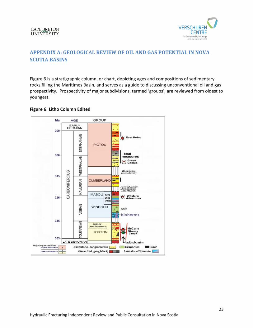
Figure 6 is a stratigraphic column, or chart, depicting ages and compositions of sedimentary rocks filling the Maritimes Basin, and serves as a guide to discussing unconventional oil and gas prospectivity. Prospectivity of major subdivisions, termed ‘groups’, are reviewed from oldest to youngest. Figure 6: Litho Column Edited
24 Hydraulic Fracturing Independent Review and Public Consultation in Nova Scotia
Horton Group Horton Group rocks are of Early Carboniferous age, about 353 to 345 million years old (Figure 6). They were deposited when the Maritimes Basin complex was first being formed, and consist generally of:
sandstones and conglomerates (deposited as sands and gravels) at the base,
shales (deposited as organic-rich muds in widespread lakes) in the middle, and
sandstones and finer-grained sedimentary rocks (deposited as sands, silts, and muds on river floodplains) at the top.
Gas and oil occur in both conventional sandstone / conglomerate reservoirs, and in unconventional ‘tight’ (low-permeability) sandstones and shales of the Horton Group, throughout the Maritimes Basin. Organic-rich material in the medial Horton Group shales provided a source for oil and gas in the Horton Group; some of these fluids have been retained within the shales, and some have migrated into other sedimentary rock layers. Locally, Horton Group rocks have been exposed to so much heat and pressure that they have no petroleum potential. Conventional Oil and Gas In the Moncton Basin of New Brunswick, Corridor Resources produces gas from upper Horton Group sandstones at McCully Field, and Contact Exploration produces oil from reservoirs of the same age at Stoney Creek Field (locations shown in Figure 3). While reservoir quality in both fields is viewed as conventional, horizontal drilling and hydraulic fracturing have enhanced productivity and improved economics. Based on data from these fields and other mapping, Lavoie et al. (2009) estimated hydrocarbon potential in conventional Horton Group reservoirs in the Maritimes Basin complex (including offshore) to range from 300 to 1185 million barrels of oil, and from 6.1 to 23.7 TCF of gas. Unconventional Oil and Gas Distribution and quality of unconventional Horton sandstone reservoirs is not well understood, and no estimates of their resource potential have been published. We assume, however, that unconventional oil and gas potential is widespread, as all the necessary components exist – thick sandstone reservoirs which exhibit low permeability in many areas, a rich source of oil and gas in the organic material of the medial Horton shales, deep burial depths, and impermeable rocks in the overlying Windsor Group to prevent hydrocarbons from escaping. In a similar fashion, Hayes (2011) postulated the presence of unconventional gas and oil plays in the Northwest Territories based on knowledge gained from existing boreholes (drilled for
25 Hydraulic Fracturing Independent Review and Public Consultation in Nova Scotia
conventional reservoir targets). Lacking more specific information about Horton sandstones, we assume greater prospectivity in the basins closest to the known production. The most widespread and well recognized Horton Group unconventional prospectivity occurs in the medial shales. They have abundant organic material, and are at sufficient depths to generate oil and gas, as discussed by Hamblin (2006) and Lavoie et al. (2009). There is sufficient information to merit reviewing medial Horton shale prospectivity for specific basins.
Moncton Basin (New Brunswick) – In the Moncton Basin, where the medial Horton Group is called the Frederick Brook Shale, Corridor Resources (2014) estimated in-place gas resources of 67 TCF on lands where they hold petroleum rights, while Contact Exploration (2014) estimated 10.9 TCF gas in place on their lands. Corridor is producing gas from the Frederick Brook in three wells stimulated with hydraulic fractures. Martel (2013) provided additional detail on assessment work by Corridor, and recent news releases indicate Corridor will spend significantly in 2014 on developing Frederick Brook shale resources. To the northwest of the Corridor and Contact operations, Southwestern Energy is prospecting for oil and gas in the Frederick Brook and other Horton Group unconventional reservoirs. U.S. E.I.A. (2013) assessed prospectivity of the Frederick Brook in the Moncton Basin, and found positive indicators in that the shales contain reasonably abundant organic material, and experienced sufficient burial and heating (termed “maturity”). However, they found no available information on Frederick Brook shale mineralogy, and thus its general suitability for stimulation by hydraulic fracturing (“brittleness”) could not be assessed. Keighley and St. Peter (2003) cited a “long-identified but still undeveloped” 67 million barrels of shale oil in the Moncton Basin, but gave no background for derivation of this volume.
Windsor-Kennetcook Basin (Figure 3) – In the Windsor-Kennetcook Basin, the medial Horton Group shale is called the Horton Bluff Formation. U.S. EIA (2013) made the following observations:
o The regional extent of the Horton Bluff shale is poorly understood, but a 520 mi2 prospective area is a best estimate;
o There is a thick prospective shale section, ranging up to about 150m; o Organic material is abundant, and has experienced significant heat and pressure,
making it prospective primarily for gas.
26 Hydraulic Fracturing Independent Review and Public Consultation in Nova Scotia
Using this information, U.S. EIA (2013) assigned a ‘risked’ gas in place of 17 TCF for the basin. The ‘risk’ factor is a discount applied to the total gas in place calculated (about 43 TCF) to reflect uncertainties in shale reservoir parameters.
By comparison, Ryder Scott (2008) calculated (‘unrisked’) gas in place of 69 TCF over a property of about 580 mi2 held by Triangle Petroleum. Ryder Scott based their assessment on shale reservoir parameters measured from cores taken at the Kennetcook #1 well. However, relatively small hydraulic fracture stimulations in three wells drilled by Triangle failed to result in any gas production. Instead, water injected during the hydraulic fracturing process, plus some saline formation water, flowed back from the wells after stimulation. Technical staff working the Triangle operations reported indications that induced fractures did not propagate in the subsurface exactly as expected, and therefore may not have effectively stimulated the reservoir. While Triangle’s results do not support the existence of productive capacity in the Horton Bluff, they do not conclusively condemn the reservoir. Additional work, including horizontal drilling and re-designed multiple hydraulic fracture stimulations, are required to further assess the shale.
Cape Breton Basins (Figure 3) – Mukhopadhyay (2004) surveyed petroleum potential of the various basins on Cape Breton Island, although primarily from a conventional reservoir point of view. Very few wells and limited seismic data are available, and so much has been inferred from surface studies and the few (generally old) boreholes available. While no quantitative estimates of oil and gas potential were made, it is important to note that oil shows at the surface in many of these basins demonstrate that oil is present. Geochemical analysis demonstrates that much of this oil originated from the Horton Group shales, here called the Strathlorne Formation. Significant prospectivity for medial Horton (Strathlorne) shales is inferred for Cape Breton basins, as all the necessary ingredients for unconventional prospectivity are present, even though quantitative measures are lacking.
General Observations on Horton Group Prospectivity in Nova Scotia MacDonald (2011) reported that the Nova Scotia Department of Energy had undertaken an effort to more systematically understand the gas in place resource potential in the Horton Bluff shales of Nova Scotia basins. Although results of this study are not yet available, MacDonald noted that examination of the available seismic data and ongoing studies on outcrops of the potential reservoirs flanking the basin would be important in better understanding productive potential. While the focus has been on gas potential, it is important to note that oil may occur as well, depending largely on the heat and burial maturation affecting the organic source
27 Hydraulic Fracturing Independent Review and Public Consultation in Nova Scotia
materials. Hamblin (2006) cited studies indicating that the medial shales of the Horton Group are well-developed in all Nova Scotia basins, and that they include substantial thicknesses of organic-rich, prospective shale reservoirs. He also noted that shale maturities in some basins indicate oil potential as opposed to gas, but additional work is necessary to better understand both oil and gas potential. Windsor and Mabou Groups Windsor-Mabou rocks are of Early Carboniferous age, about 345 to 326 million years old (Figure 6). They were deposited in open marine waters that flooded the Maritimes Basin and consist generally of:
fossil-rich limestones (carbonate rocks), including local reef build-ups, at the base,
salts (evaporite minerals), indicating reduced marine water supply and drying-up of the basins, in the middle, and
sandstones and finer-grained sedimentary rocks (deposited as sands, silts, and muds on river floodplains and in lakes) at the top.
Lavoie et al. (2009) noted that marine rocks in the Windsor Group above the basal limestones grade to more continentally-derived (river and delta) sandstones in northeastern New Brunswick and adjacent Nova Scotia. However, the Windsor Group can range up to several thousand metres thick, and is prospective in many areas. Carbonate reefs in the basal Windsor, termed the Gays River Formation, are viewed as prospective oil reservoir targets in the Shubenacadie Basin (Figure 3). Forent Energy has explored for oil in Gays River reefs on their Alton property, using seismic and other geophysical methods (Forent, 2014). As reservoir properties of Gays River reefs have not been assessed in the subsurface, it is unknown whether hydraulic fracturing would be required to establish commercial flow rates from a reef discovery. However, Forent was not successful in finding a reef reservoir in two wells drilled to date, and has elected to suspend exploration operations in Nova Scotia. Mukhopadhyay (2004) noted that basal Windsor carbonates and shales deposited in deeper areas in Cape Breton basins may have similar oil potential, but was not able to quantify it. Lavoie et al. (2009) confirmed analogous basal Windsor carbonate prospectivity throughout the Maritimes Basin complex. Salts (evaporite minerals) in the medial Windsor Group have essentially no reservoir quality and therefore are not prospective. However, they are important in providing an impermeable barrier between under- and overlying rocks, meaning that oil and gas generated in the organic-
28 Hydraulic Fracturing Independent Review and Public Consultation in Nova Scotia
rich shales of the Horton Group generally cannot migrate upward through the salts to charge overlying reservoirs. In the upper Windsor Group and Mabou Group, limited shale and carbonate reservoir potential may exist in thin beds, continuous over large areas, deposited in shallow marine waters. Mukhopadhyay (2004) noted oil and condensate (very light petroleum liquids) potential in these rocks in Cape Breton basins, but did not consider their potential as tight reservoirs. Most interesting from an unconventional point of view, Hamblin (2006) noted that widespread shales up to 325m thick, deposited in organic-rich lake settings, might have oil and gas prospectivity similar to underlying Horton Bluff shales. In conclusion, while both conventional and unconventional reservoirs, prospective for oil and gas, exist in lower and upper Windsor Group and the Mabou Group, they have not been explored for their unconventional potential, nor have estimates of oil and gas volumes been published. Cumberland and Pictou Groups Cumberland and Pictou rocks are of Middle to Late Carboniferous age, about 320 to 300 million years old, and cap the prospective reservoir section in the Maritimes Basin (Figure 6). They consist primarily of thick sandstones with siltstones and shales, deposited by rivers over broad floodplains and large deltas. Total thicknesses range up to thousands of metres. Also in this setting, thick coal seams formed through accumulation of wood and related materials in vast coal swamps. Nova Scotia’s historic coal mining industry has tapped into these seams in many coalfields, particularly in Sydney, West Cape Breton, Stellarton and Cumberland basins. Coalbed Methane When buried, coal-based organic material can produce natural gas, primarily methane (CH4). Where hosted within coal seams – within pores, fractures, and adsorbed onto organic matter – this gas is termed coalbed methane (CBM) (Dawson et al., 2000). There is little potential for more hydrogen-rich hydrocarbons, such as gas liquids or oil, when coaly material is the source. Dawson et al. (2000) noted substantial CBM potential in Nova Scotia basins, but data available at the time did not support quantitative assessments. Lavoie et al. (2009) characterized Cumberland-Pictou coals as having “major natural gas source potential”. In the Cumberland Basin, two vertical wells and three horizontal wells were drilled by Amvest Nova Scotia, Contact Exploration, and Stealth Ventures. Stealth (2014) estimated CBM gas in place in the Cumberland Basin coals as 1.18 TCF.
29 Hydraulic Fracturing Independent Review and Public Consultation in Nova Scotia
In the Stellarton Basin, after drilling three wells and undertaking extensive analyses, Amvest Nova Scotia (1999) estimated Stellarton Basin CBM gas in place resources at 0.480 TCF. Stealth Ventures acquired Amvest’s interests and after additional drilling, commissioned a report estimating 0.426 TCF CBM gas in place in the basin (http://www.stealthventures.ca/pdf/StealthVentures_StellartonCBMProject.pdf). East Coast Energy Inc. continues to drill and evaluate the commercial viability of this project (http://www.ngnews.ca/News/Local/2014-03-10/article-3643227/Update-on-East-Coast-Energy-Inc.-coal-bed-methane-project/1). Hughes (2003) completed an extensive analysis of coal beds and their reservoir properties in three basins, and tabulated the following gas in place resources:
Sydney Basin: 0.977 TCF
Stellarton Basin (Pictou coalfield): 0.284 TCF
Cumberland Basin: 0.422 TCF Despite this widely-recognized potential and the drilling of more than 30 CBM test wells, there is at present no commercial coalbed methane production in Nova Scotia. From the perspective of the present study, any CBM accumulations developed will likely not be hydraulic fractured. Where fracture stimulation of coal seams is deemed necessary, a gas such as nitrogen is generally used instead of water, particularly at relatively shallow depths (500m or less). Where gas fracturing is used, naturally-occurring formation water may flow from coal seams, but there will be no input or flowback of other waters or chemicals associated with hydraulic fracturing. Sandstone Reservoirs Lavoie et al. (2009) estimated oil and gas in place in conventional sandstone reservoirs of the Cumberland and Pictou groups, throughout the entire Maritimes Basin complex, at 317-1230 million barrels and 12.1-36.8 TCF, respectively. There has been no assessment of unconventional sandstone reservoir potential, and it is very
difficult to make definitive statements about such potential without more exploratory well
drilling and detailed knowledge of individual basins. If regionally-extensive tight sandstone
plays do exist in the Cumberland and Pictou group rocks in Nova Scotia basins, oil and gas in
place volumes could be quite large – and prospectivity might exist in several basins, particularly
in Cape Breton.