development of wildland fire emission inventories with the bluesky smoke modeling framework sean...
TRANSCRIPT
Development of Wildland Fire Emission Inventories with the BlueSky Smoke Modeling Framework
Sean Raffuse, Erin Gilliland, Dana Sullivan, Neil Wheeler, and Lyle ChinkinSonoma Technology, Inc., Petaluma, California
Sim Larkin, Robert Solomon, Tara StrandU.S. Forest Service AirFIRE Team
Thompson PaceU.S. EPA OAQPS
Presented at the7th Annual Community Modeling and Analysis System (CMAS) Conference
Chapel Hill, North CarolinaOctober 7, 2008
STI-3457
2
Background
• NASA Decision Support• NASA-STI-USFS Partnership• SMARTFIRE* – Fire Information• BlueSky Framework – Fuels, Consumption,
and Emissions• EPA Work Assignment• Emission Inventory for Wildland Fires
* Satellite Mapping Automatic Reanalysis Tool for Fire Incident Reconciliation
3
Emission Inventory Processing
Scope Contiguous United States August 2002 through 2006 Wildfires, Wildfire Use, prescribed burning Agricultural burning excluded
BlueSky Pathway Fire information: SMARTFIRE Fuel loading: FCCS (Fuel Characteristic Classification
System) Fuel consumption: Consume 3.0 Emissions: FEPS (Fire Emission Production Simulator)
4
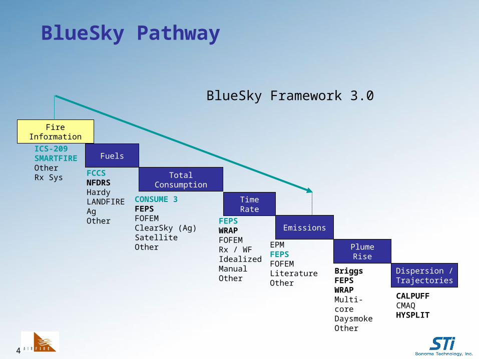
BlueSky Pathway
ICS-209SMARTFIREOtherRx Sys FCCS
NFDRSHardyLANDFIREAg Other
CONSUME 3FEPSFOFEMClearSky (Ag)SatelliteOther
FEPSWRAPFOFEMRx / WFIdealizedManualOther
EPMFEPSFOFEMLiteratureOther
BriggsFEPSWRAPMulti-coreDaysmokeOther
CALPUFFCMAQHYSPLIT
BlueSky Framework 3.0
FireInformation
Fuels
Total Consumption
TimeRate
Emissions
PlumeRise
Dispersion /Trajectories
5
Data Sources
• ICS-209 reports: AirFIRE, Fire and Aviation Management Web Applications (FAMWEB) web site, and Tom Pace
• HMS fire detects: NOAA Hazard Mapping System (Mark Ruminski)
• MODIS* fire detects: USFS Remote Sensing Applications Center (used to fill gaps in HMS data)
• Fuel moisture: USFS Wildland Fire Assessment System
* Moderate Resolution Imaging Spectroradiometer
6
0
50
100
150
200
250
300
350
400
Jan Feb Mar Apr May Jun Jul Aug Sep Oct Nov Dec
PM
2.5
(kt
ons) 2003 2004 2005 2006
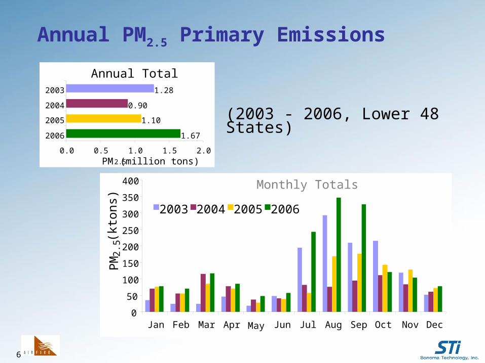
Annual PM2.5 Primary Emissions
Annual Total
1.67
1.10
0.90
1.28
0.0 0.5 1.0 1.5 2.0
2006
2005
2004
2003
PM2.5 (million tons)
Monthly Totals
(2003 - 2006, Lower 48 States)
7
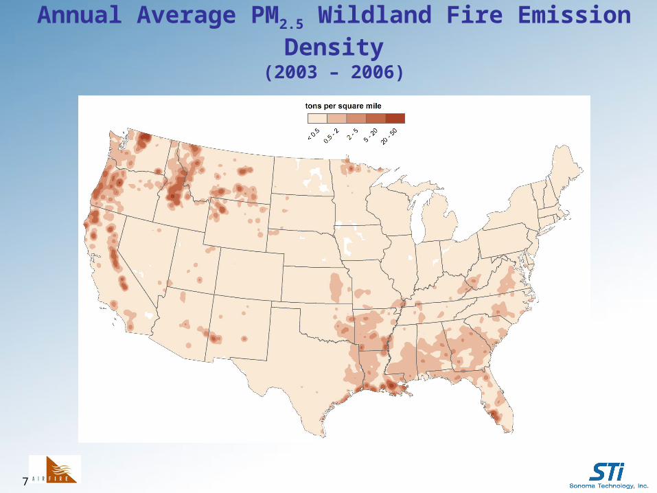
Annual Average PM2.5 Wildland Fire Emission Density(2003 – 2006)
8
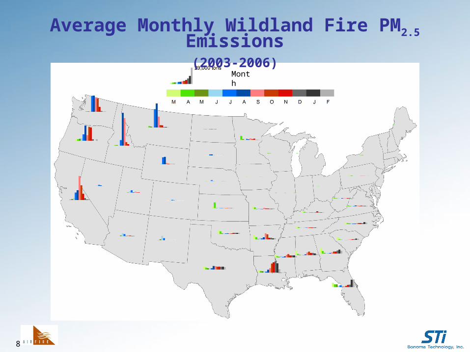
Average Monthly Wildland Fire PM2.5 Emissions(2003-2006)
Month
9
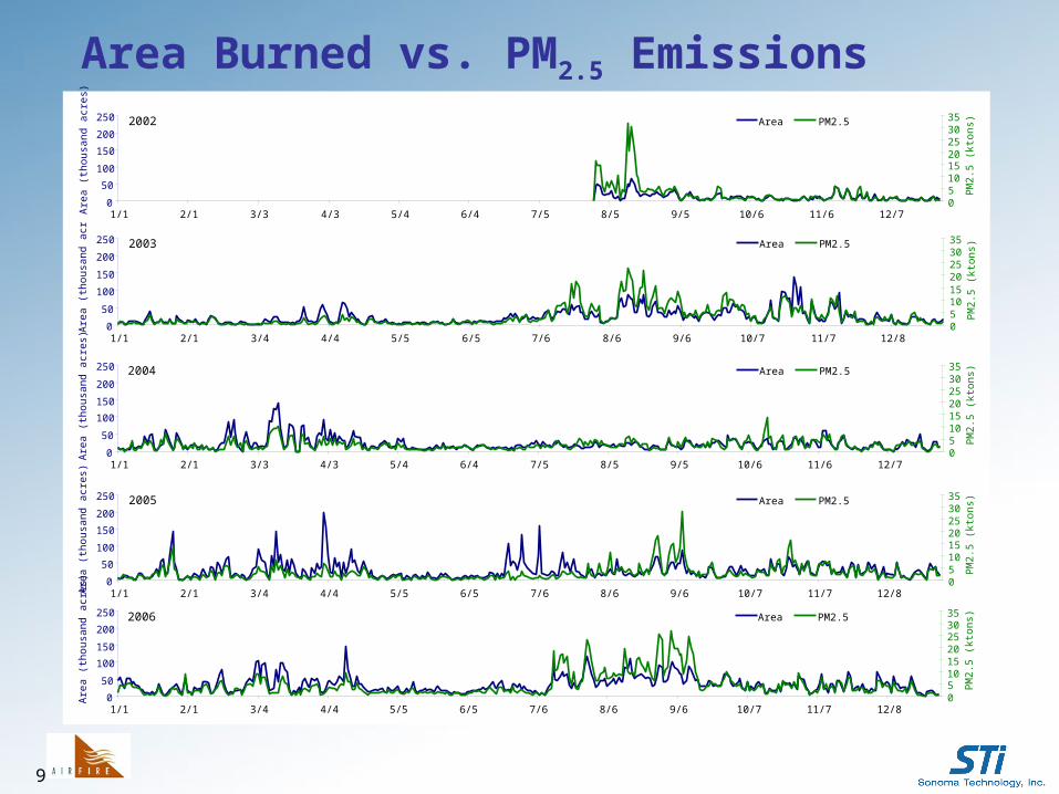
2003
0
50
100
150
200
250
1/1 2/1 3/4 4/4 5/5 6/5 7/6 8/6 9/6 10/7 11/7 12/8
Are
a (t
hous
and
acre
s)
05101520253035
PM
2.5
(kto
ns) Area PM2.5
2004
0
50
100
150
200
250
1/1 2/1 3/3 4/3 5/4 6/4 7/5 8/5 9/5 10/6 11/6 12/7
Are
a (t
hous
and
acre
s)
05101520253035
PM
2.5
(kto
ns)Area PM2.5
2005
0
50
100
150
200
250
1/1 2/1 3/4 4/4 5/5 6/5 7/6 8/6 9/6 10/7 11/7 12/8
Are
a (t
hous
and
acre
s)
05101520253035
PM
2.5
(kto
ns)Area PM2.5
2006
0
50
100
150
200
250
1/1 2/1 3/4 4/4 5/5 6/5 7/6 8/6 9/6 10/7 11/7 12/8
Are
a (t
hous
and
acre
s)
05101520253035
PM
2.5
(kto
ns)Area PM2.5
2002
0
50
100
150
200
250
1/1 2/1 3/3 4/3 5/4 6/4 7/5 8/5 9/5 10/6 11/6 12/7
Are
a (t
hous
and
acre
s)
05101520253035
PM
2.5
(kto
ns)Area PM2.5
Area Burned vs. PM2.5 Emissions
10
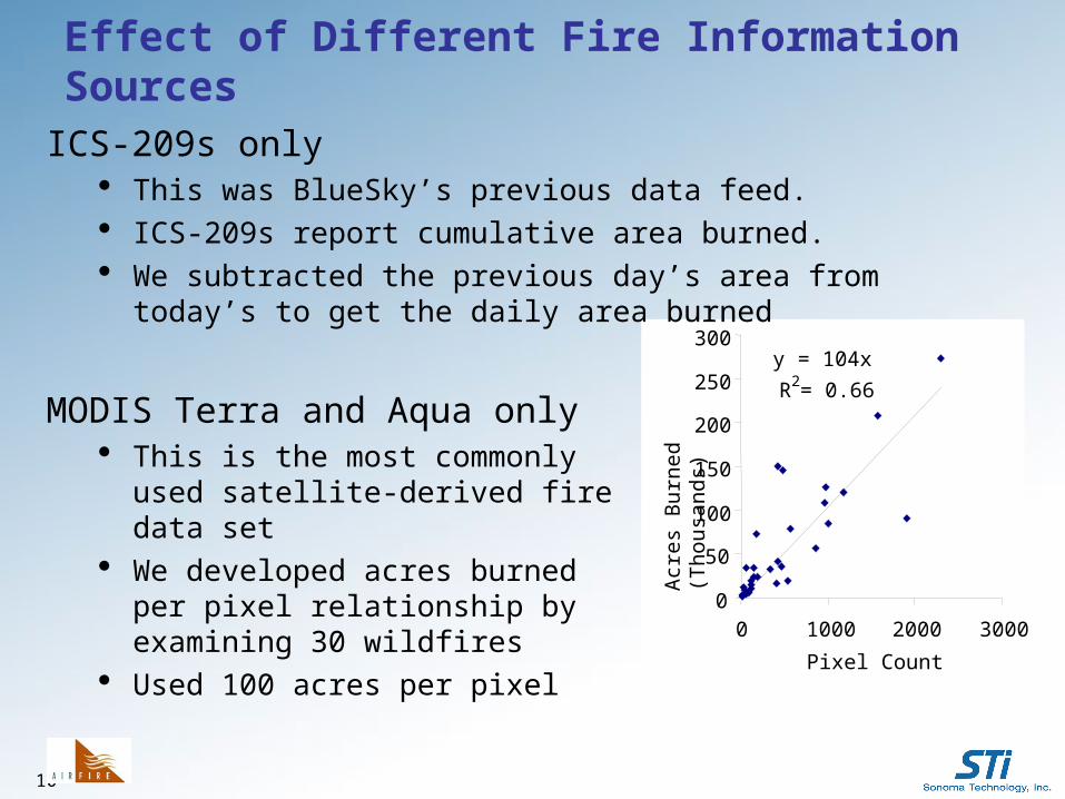
Effect of Different Fire Information Sources
y = 104x
R2 = 0.66
0
50
100
150
200
250
300
0 1000 2000 3000
Pixel CountA
cres
Bur
ned
(Tho
usa
nds
)
ICS-209s only This was BlueSky’s previous data feed. ICS-209s report cumulative area burned. We subtracted the previous day’s area from today’s to get the
daily area burned
MODIS Terra and Aqua only This is the most commonly used
satellite-derived fire data set We developed acres burned per pixel
relationship by examining 30 wildfires Used 100 acres per pixel
11
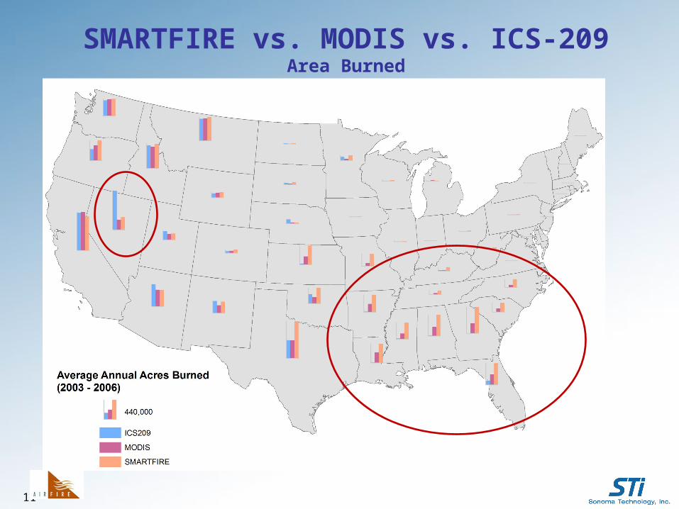
SMARTFIRE vs. MODIS vs. ICS-209Area Burned
12
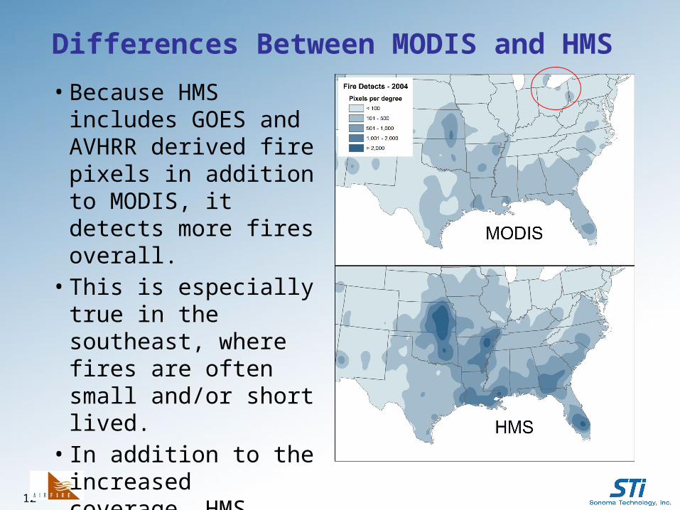
Differences Between MODIS and HMS
• Because HMS includes GOES and AVHRR derived fire pixels in addition to MODIS, it detects more fires overall.
• This is especially true in the southeast, where fires are often small and/or short lived.
• In addition to the increased coverage, HMS provides human quality control.
13
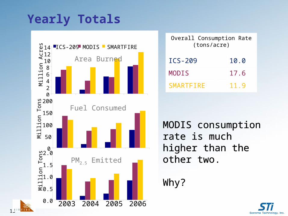
MODIS consumption rate is much higher than the other two.
Why?
Yearly Totals
Overall Consumption Rate (tons/acre)
ICS-209 10.0
MODIS 17.6
SMARTFIRE 11.9
MODIS consumption rate is much higher than the other two.
Why?
Area Burned
Fuel Consumed
02468
101214
Mill
ion
Acr
esICS-209 MODIS SMARTFIRE
0
50
100
150
200
Mill
ion
Ton
s
0.0
0.5
1.0
1.5
2.0
2003 2004 2005 2006
Mill
ion
Ton
s
Fuel Consumed
Area Burned
PM2.5 Emitted
14
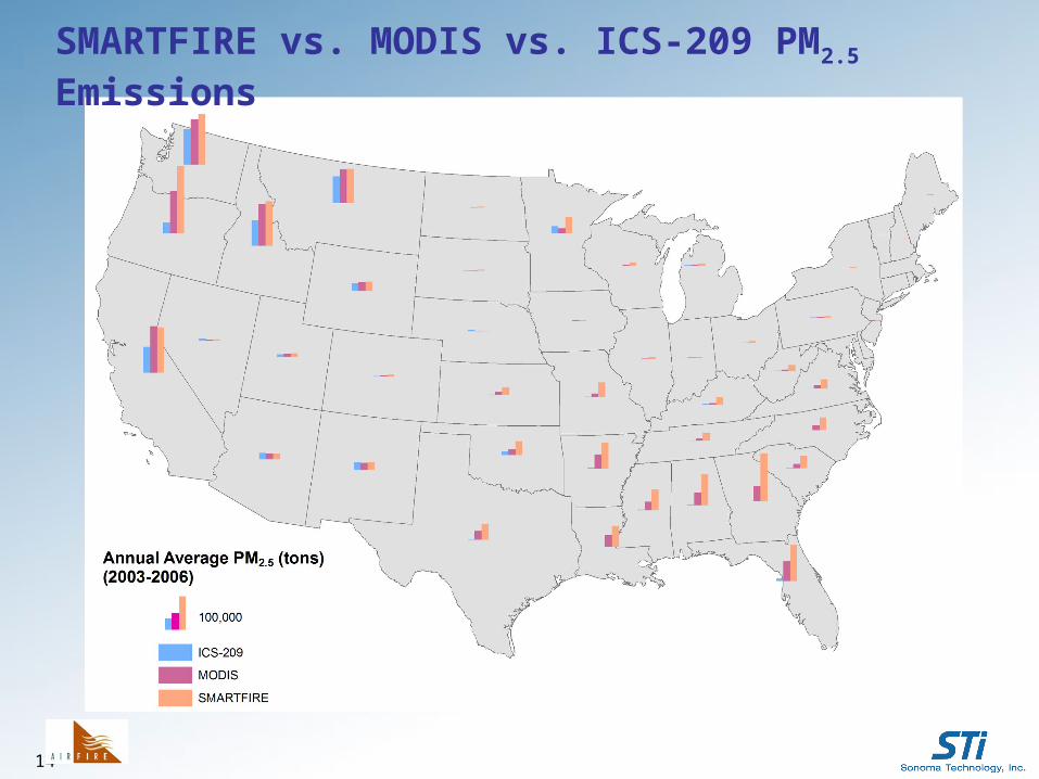
SMARTFIRE vs. MODIS vs. ICS-209 PM2.5 Emissions
15
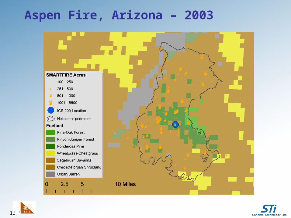
Aspen Fire, Arizona – 2003
16
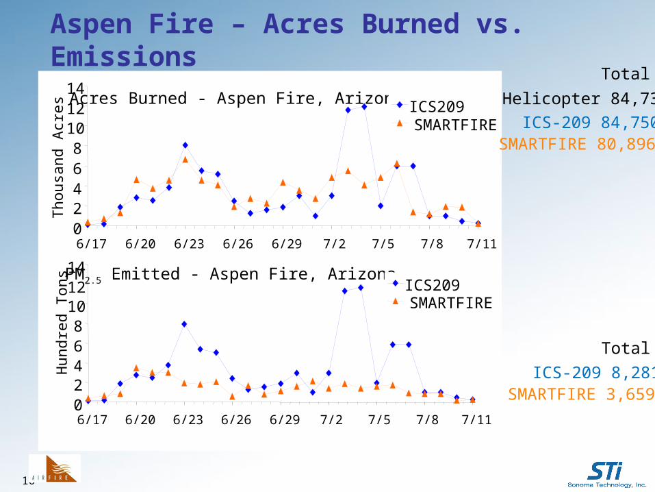
Acres Burned - Aspen Fire, Arizona
02468
101214
6/17 6/20 6/23 6/26 6/29 7/2 7/5 7/8 7/11
Tho
usan
d A
cres ICS209
SMARTFIRE
PM2.5 Emitted - Aspen Fire, Arizona
02468
101214
6/17 6/20 6/23 6/26 6/29 7/2 7/5 7/8 7/11
Hun
dred
Ton
s ICS209SMARTFIRE
Total
ICS-209 84,750SMARTFIRE 80,896
Helicopter 84,733
ICS-209 8,281SMARTFIRE 3,659
Total
Aspen Fire – Acres Burned vs. Emissions
17
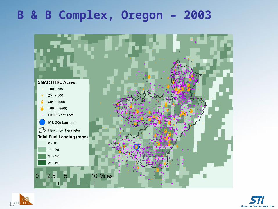
B & B Complex, Oregon – 2003
18
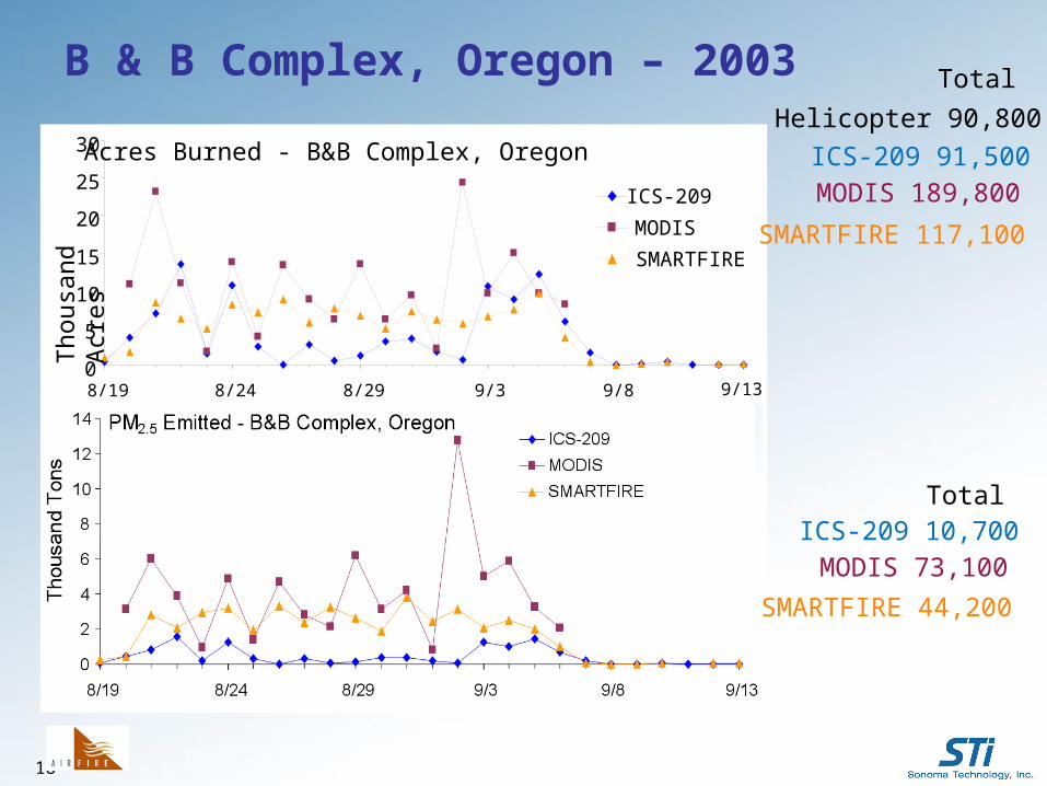
Acres Burned - B&B Complex, Oregon
0
5
10
15
20
25
30
8/19 8/24 8/29 9/3 9/8 9/13
Th
ousa
nd A
cre
s ICS-209
MODIS
SMARTFIRE
Total
ICS-209 91,500
SMARTFIRE 117,100
Helicopter 90,800
MODIS 189,800
TotalICS-209 10,700
SMARTFIRE 44,200
MODIS 73,100
B & B Complex, Oregon – 2003
19
Future Work
• Continued validation and improvement of fire size parameters
• Further exploration of high consumption rate when using MODIS
• Differences with high resolution fuel loading data (LANDFIRE)– 30-m spatial resolution is finer scale than the satellite
fire information– Will use helicopter-flown perimeters or high resolution
satellite burn scars to determine area burned
• Smoke and Emissions Model Intercomparison Project (SEMIP)
20
Acknowledgments
• Funding from National Fire Plan, USFS, Joint Fire Science Program, EPA, DOI, and NASA ROSES DSS
• Our many collaborators and partners Tom Pace (EPA) Amber Soja (NIA) Mark Ruminski and John Simko (NOAA NESDIS) Roger Ottmar and Susan Pritchard (USFS-FERA)
Thank you!
Contact: [email protected]
Information: www.getBlueSky.org