designing the urban landscape inside and out · 2018-02-20 · designing the urban landscape inside...
TRANSCRIPT
14 au Winter 2018 esri.com
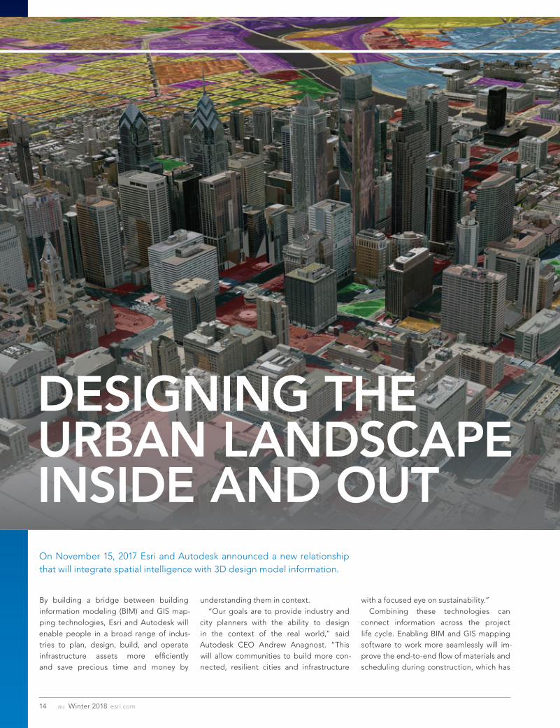
DESIGNING THE URBAN LANDSCAPE INSIDE AND OUT
By building a bridge between building information modeling (BIM) and GIS map-ping technologies, Esri and Autodesk will enable people in a broad range of indus-tries to plan, design, build, and operate infrastructure assets more efficiently and save precious time and money by
understanding them in context. “Our goals are to provide industry and city planners with the ability to design in the context of the real world,” said Autodesk CEO Andrew Anagnost. “This will allow communities to build more con-nected, resilient cities and infrastructure
with a focused eye on sustainability.” Combining these technologies can connect information across the project life cycle. Enabling BIM and GIS mapping software to work more seamlessly will im-prove the end-to-end flow of materials and scheduling during construction, which has
On November 15, 2017 Esri and Autodesk announced a new relationship that will integrate spatial intelligence with 3D design model information.
15esri.com Winter 2018 au
Focus
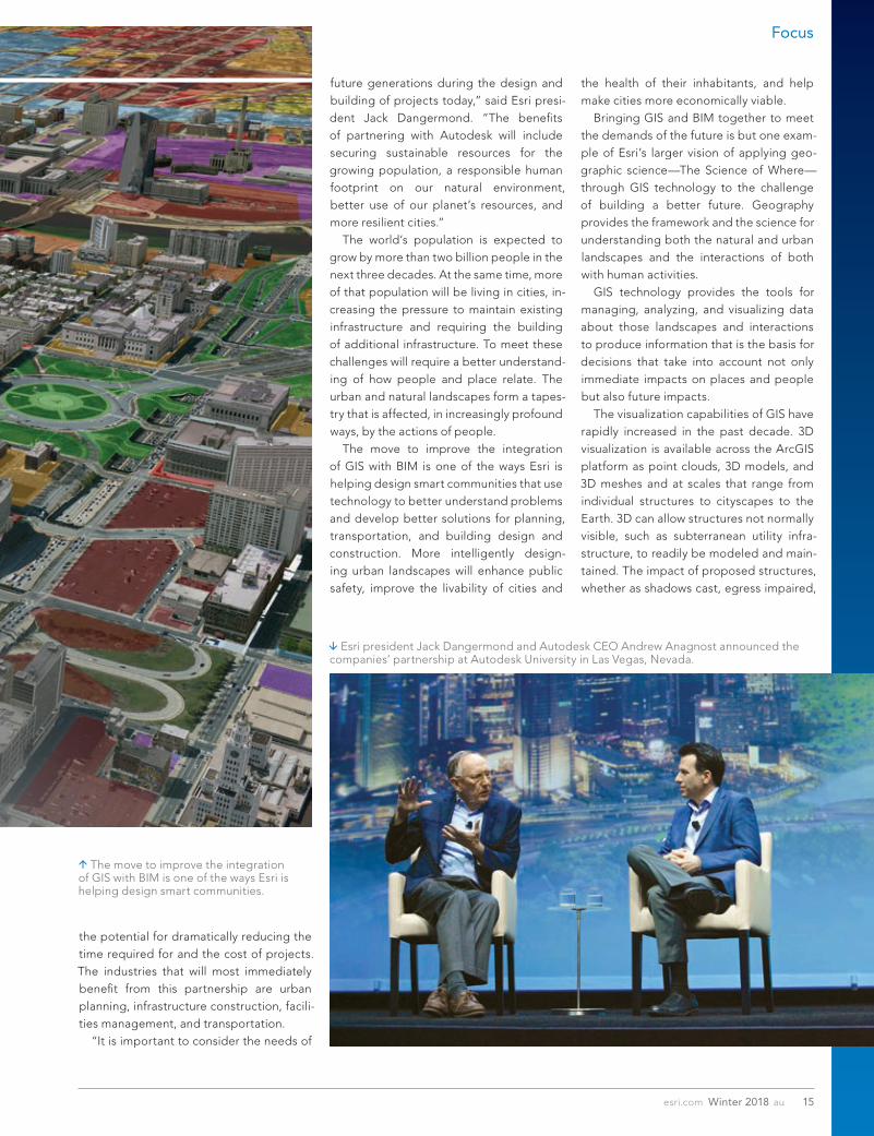
Esri president Jack Dangermond and Autodesk CEO Andrew Anagnost announced the companies’ partnership at Autodesk University in Las Vegas, Nevada.
the potential for dramatically reducing the time required for and the cost of projects. The industries that will most immediately benefit from this partnership are urban planning, infrastructure construction, facili-ties management, and transportation. “It is important to consider the needs of
future generations during the design and building of projects today,” said Esri presi-dent Jack Dangermond. “The benefits of partnering with Autodesk will include securing sustainable resources for the growing population, a responsible human footprint on our natural environment, better use of our planet’s resources, and more resilient cities.” The world’s population is expected to grow by more than two billion people in the next three decades. At the same time, more of that population will be living in cities, in-creasing the pressure to maintain existing infrastructure and requiring the building of additional infrastructure. To meet these challenges will require a better understand-ing of how people and place relate. The urban and natural landscapes form a tapes-try that is affected, in increasingly profound ways, by the actions of people. The move to improve the integration of GIS with BIM is one of the ways Esri is helping design smart communities that use technology to better understand problems and develop better solutions for planning, transportation, and building design and construction. More intelligently design-ing urban landscapes will enhance public safety, improve the livability of cities and
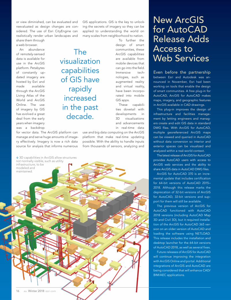
the health of their inhabitants, and help make cities more economically viable. Bringing GIS and BIM together to meet the demands of the future is but one exam-ple of Esri’s larger vision of applying geo-graphic science—The Science of Where—through GIS technology to the challenge of building a better future. Geography provides the framework and the science for understanding both the natural and urban landscapes and the interactions of both with human activities. GIS technology provides the tools for managing, analyzing, and visualizing data about those landscapes and interactions to produce information that is the basis for decisions that take into account not only immediate impacts on places and people but also future impacts. The visualization capabilities of GIS have rapidly increased in the past decade. 3D visualization is available across the ArcGIS platform as point clouds, 3D models, and 3D meshes and at scales that range from individual structures to cityscapes to the Earth. 3D can allow structures not normally visible, such as subterranean utility infra-structure, to readily be modeled and main-tained. The impact of proposed structures, whether as shadows cast, egress impaired,
The move to improve the integration of GIS with BIM is one of the ways Esri is helping design smart communities.
The visualization capabilities of GIS have
rapidly increased in the past decade.
16 au Winter 2018 esri.com
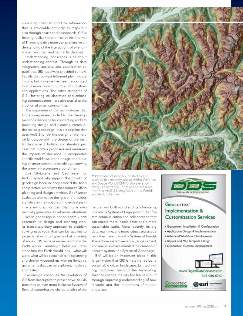
or view diminished, can be evaluated and reevaluated as design changes are con-sidered. The use of Esri CityEngine can realistically render urban landscapes and share them through a web browser. An abundance of remotely-sensed data is available for use in the ArcGIS platform. Petabytes of constantly up-dated imagery are hosted by Esri and made available through the ArcGIS Living Atlas of the World and ArcGIS Online. The use of imagery by GIS has evolved a great deal from the early years when imagery was a backdrop for vector data. The ArcGIS platform can manage and serve huge amounts of image-ry effectively. Imagery is now a rich data source for analysis that informs numerous
Even before the partnership between Esri and Autodesk was an-nounced in November, Esri had been working on tools that enable the design of smart communities. A free plug-in for AutoCAD, ArcGIS for AutoCAD makes maps, imagery, and geographic features in ArcGIS available in CAD drawings. This plug-in improves the design of infrastructure and facilities manage-ment by letting engineers and manag-ers create and edit GIS data in standard DWG files. With ArcGIS for AutoCAD, multiple georeferenced ArcGIS maps can be viewed and queried in AutoCAD without data conversion so interior and exterior spaces can be visualized and analyzed within a real-world context. The latest release of ArcGIS for AutoCAD provides AutoCAD users with access to ArcGIS web services and the ability to share ArcGIS data in AutoCAD DWG files. ArcGIS for AutoCAD 370 is an incre-mental update that includes certification for 64-bit versions of AutoCAD 2015–2018. Although this release marks the deprecation of 32-bit versions of ArcGIS for AutoCAD, 32-bit versions and sup-port for them will still be available. The previous version of ArcGIS for AutoCAD functioned with AutoCAD 2018 versions (including AutoCAD Map 3D and Civil 3D), but it required installa-tion of the ArcGIS for AutoCAD 365 ver-sion on an older version of AutoCAD and loading the software using NETLOAD. This release includes the installation and desktop launcher for the 64-bit versions of AutoCAD 2018, as well as several fixes. Future releases of ArcGIS for AutoCAD will continue improving the integration with ArcGIS Online and portal. Additional integrations of ArcGIS and AutoCAD are being considered that will enhance CAD/BIM/AEC applications.
New ArcGIS for AutoCAD Release Adds Access to Web Services
GIS applications. GIS is the key to unlock-ing the secrets of imagery so they can be applied to understanding the world on many scales from neighborhood to nation.
To further the design of smart communities, these ArcGIS capabilities are available from mobile devices that can go into the field. Immersive tech-nologies, such as augmented reality and virtual reality, have been incorpo-rated into mobile GIS apps. These capabili-ties dovetail with developments in 3D visualizations and advancements in real-time data
use and big data computing on the ArcGIS platform that make real-time updating possible. With the ability to handle inputs from thousands of sensors, analyzing and
3D capabilities in ArcGIS allow structures not normally visible, such as utility infrastructure, to be modeled and maintained.
17esri.com Winter 2018 au
visualizing them to produce information that is actionable not only as maps but also through charts and dashboards, GIS is helping realize the promise of the Internet of Things to gain a more comprehensive un-derstanding of the interactions of phenom-ena across urban and natural landscapes. Understanding landscapes is all about understanding context. Through its data integration, analysis, and visualization ca-pabilities, GIS has always provided context. Initially that context informed planning de-cisions, but its value has been recognized in an ever-increasing number of industries and applications. The other strengths of GIS—fostering collaboration and enhanc-ing communication—are also crucial to the creation of smart communities. The expansion of the technologies that GIS encompasses has led to the develop-ment of a discipline for connecting and em-powering design and planning communi-ties called geodesign. It is a discipline that uses ArcGIS to join the design of the natu-ral landscape with the design of the built landscape in a holistic and iterative pro-cess that models proposals and measures the impacts of decisions. It incorporates specific workflows in the design and build-ing of smart communities while preserving the green infrastructure around them. Esri CityEngine and GeoPlanner for ArcGIS specifically support the growth of geodesign because they embed the tools and practical workflows that connect GIS to planning and design activities. GeoPlanner evaluates alternative designs and provides statistics on the impacts of those designs in charts and graphics. Esri CityEngine auto-matically generates 3D urban visualizations. While geodesign is not an entirely new approach to design and planning work, its transdisciplinary approach to problem solving uses tools that can be applied to projects of various types and at a variety of scales. GIS helps us understand how the Earth works. Geodesign helps us under-stand how the Earth should look—what will work, what will be sustainable. It is planning and design wrapped up with resiliency re-quirements that can be explored, modeled, and tested. Geodesign continues the evolution of GIS from descriptive to prescriptive. As GIS becomes an ever more inclusive System of Record, capturing the characteristics of the
natural and built world and its inhabitants, it is also a System of Engagement that fos-ters communication and collaboration that can enable more livable cities and a more sustainable world. More recently, its big data, real time, and more robust analysis ca-pabilities have made it a System of Insight. These three systems—record, engagement, and analysis—have enabled the creation of a fourth system, the System of Geodesign. BIM will be an important piece in this larger vision that GIS is helping realize: a sustainable urban landscape. Esri technol-ogy continues building the technology that can change the way the future is built through improving understanding of how it works and the interactions of people and place.
Petabytes of imagery, hosted by Esri (such as this recently added AirBus Defence and Space WorldDEM4Ortho elevation data), is constantly updated and available from the ArcGIS Living Atlas of the World and ArcGIS Online.