design of tsunami safe haven structures - apwa...
TRANSCRIPT

4/19/2017
1
Design of Tsunami Safe Haven Structures
Cale Ash, PE, SE – Degenkolb
Dan Trisler, PE, GE – Hart Crowser, Inc.

4/19/2017
2
Outline
• Tsunami and Other Seismic Hazards
• Safe Haven Structures
• Ocosta Case Study– Geotechnical Considerations
– Structural Considerations
Cale Ash, PE, SE Dan Trisler, PE, [email protected] [email protected]
600 University StreetSeattle, WA 98101
206.262.9240
www.degenkolb.com
300 West 15th StreetVancouver, WA 98660
360.448.4189
www.hartcrowser.com

4/19/2017
3
Tsunami / Seismic Hazard
• Earthquake Sources• Tsunami• Strong Ground Shaking• Fault Rupture• Liquefaction• Lateral Spread
Northwest Earthquake Sources
Source: USGS

4/19/2017
4
Washington Faults
Tsunami Generation

4/19/2017
5
Tsunami Generation
Tsunami

4/19/2017
6
Source: Presentation by Dr. Reiji Tanaka, Tohoku Institute of Technologyand Junji Ogawa, Akita Prefectural University
Tsunami (before)
Source: Presentation by Dr. Reiji Tanaka, Tohoku Institute of Technologyand Junji Ogawa, Akita Prefectural University
Tsunami (after)

4/19/2017
7
Strong Ground Shaking
Source: USGS
Design EQ Estimated PGA: 2% probability in 50 years
Washington
Fault Rupture/Subsidence-Uplift
2016 Kaikoura, New Zealand (Mw = 7.8)

4/19/2017
8
Liquefaction
February 28, 2001 Nisqually, WA: Boeing Field
Liquefaction
1964 Niigata, Japan

4/19/2017
9
Lateral Spreading
2016 Kaikoura, New Zealand (Mw = 7.8)
Lateral Spreading
2016 Kaikoura, New Zealand (Mw = 7.8)

4/19/2017
10
Tsunami Safe Havens
• What Are They?
• When/Where Needed?
• Design Considerations
• Preference given to high ground
• Manmade high ground in form of mound
• Building or other structure designed for tsunami loads
Vertical Evacuation Options
4/19/2017
11
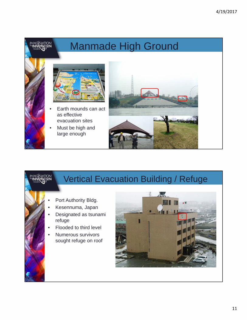
• Earth mounds can act as effective evacuation sites
• Must be high and large enough
Manmade High Ground
• Port Authority Bldg.
• Kesennuma, Japan
• Designated as tsunami refuge
• Flooded to third level
• Numerous survivors sought refuge on roof
Vertical Evacuation Building / Refuge

4/19/2017
12
Tsunami Inundation Mapping
Westport Area(ASCE-7-16) Ocosta
Elementary
Tsunami Inundation Mapping
Westport Area(WADNR, 2000)
Ocosta Elementary

4/19/2017
13
Tsunami Inundation Mapping
Puget Sound(ASCE-7-16)
• 2008 – FEMA P646
• 2012 IBC Appendix M– Not adopted in WA
• 2016 ASCE 7 Chapter 6
• 2018 IBC – 2019 Adoption in WA
Building Code Status

4/19/2017
14
• Hydrostatic Forces• Buoyant Forces• Hydrodynamic Forces• Impulsive Forces• Debris Impact Forces• Damming of Waterborne Debris• Uplift on Elevated Floors• Additional Gravity Loads on Elevated
Floors
ASCE 7-16 Chapter 6
Lessons from Tohoku

4/19/2017
15
Foundations – Toppling
Foundations – Scour

4/19/2017
16
Debris Impact
Wood Construction1.5 m to 2 m: 34% destroyed2 m to 2.5 m: 72% destroyed4 m and over: 100% destroyed

4/19/2017
17
Steel Construction
Concrete Construction

4/19/2017
18
Ocosta Elementary School
The nation’s first tsunami safe haven!
• Paula Akerlund/Ocosta & Doug Nichols/CSG• Brian Ho & Brian Fitzgerald/TCF Architecture • Cale Ash/Degenkolb• Dan Trisler/Hart Crowser• Ken Goettel/Goettel & Associates• Frank Gonzalez, et al./UW• John Schelling/WA EMD• Tim Walsh/WA DNR• Chuck Wallace/Grays Harbor County EM• Gary Chock, Ian Robertson (ASCE 7-16 subcommittee)
Project Team

4/19/2017
19
Project Site – Westport, WA
Project Site – Westport, WA

4/19/2017
20
• Incorporate refuge into elementary school– 25’ safe refuge elevation (50’ above MHW)
– 700 students/faculty/staff
– 1000 “total” capacity
– 36,000 sf
• Access & Egress– Security & 24/7 access
– Stairs
– Shelter & supplies
• Limited Budget (~$13m)
Project Scope
• CSZ Scenario– M9– 1,000 km long– 85 km wide– 1-2 m subsidence at site– 8-10 m uplift
• GeoClaw Model – Developed at UW– NTHMP validated
Inundation Modeling

4/19/2017
21
• Bathymetry
• Topography
• Scour of dunes
• Sea level rise
• Friction coefficient
Site-Specific Inputs
Modeling Resultshmax= 5.3 ft(14.4’ for design)
umax= 3.9 ft/s(10 ft/s for design)
4/19/2017
22
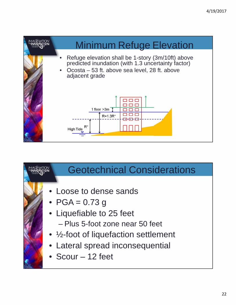
• Refuge elevation shall be 1-story (3m/10ft) above predicted inundation (with 1.3 uncertainty factor)
• Ocosta – 53 ft. above sea level, 28 ft. above adjacent grade
Minimum Refuge Elevation
• Loose to dense sands• PGA = 0.73 g• Liquefiable to 25 feet
– Plus 5-foot zone near 50 feet
• ½-foot of liquefaction settlement • Lateral spread inconsequential• Scour – 12 feet
Geotechnical Considerations

4/19/2017
23
• Auger-cast piles (18-inch by 25-foot and 24-inch by 48-foot)
• Six design conditions:– Static, long-term loading without scour– Static loading with scour– Seismic loading with and without scour– Post-seismic, static loading with down drag
(with and without scour)
Foundation Design
• Overturning • Hydrostatic
• Hydrodynamic
• Impact• Logs
• Vehicles
• Progressive collapse
Structural Design

4/19/2017
24
Safe Refuge Design
Construction

4/19/2017
25
Foundation Construction
Foundation Construction

4/19/2017
26
Foundation Construction
Construction
(8) 24” x 50’ piles24” thick pile cap 14” walls

4/19/2017
27
Construction
Construction

4/19/2017
28
June 11th Ribbon Cutting
June 11th Ribbon Cutting

4/19/2017
29
June 11th Ribbon Cutting
June 11th Ribbon Cutting

4/19/2017
30
June 11th Ribbon Cutting
June 11th Ribbon Cutting

4/19/2017
31
Questions?