delivery plan 2016 2036 - wordpress.com
TRANSCRIPT

DELIVERY PLAN
2016 – 2036
Contents
Foreword 1
1. Background and Introduction 2
2. Solihull Connected Transport Programme Priorities 4
3. Complementary Studies and Strategies 19
4. Funding 24
5. Programme Management 27
6. Next Steps 28
Appendix A – Solihull and Partner Transport Programme (Scheme Schedule) Appendix B – Solihull Transport Programme Priorities Gantt Chart Appendix C – Scheme Location Plans Appendix D – Draft Risk Register
1
Foreword The Borough has exciting and ambitious plans for growth with the first HS2 station north of London, the UKC Programme and our ‘Managed Growth’ agenda. In summer 2016 we published our Solihull Connected Transport Strategy setting out our ambitions for a step change in transport investment to support the growth agenda with greatly enhanced connectivity and better places for people. Importantly, it promotes better integrated land use and transport planning, catering for the car but placing an increasing emphasis on high quality public transport (mass-transit) and cycling networks, community focussed safer and healthier transport initiatives and also achieving a low carbon future – enhancing all that makes Solihull unique today. This Delivery Plan aims to turn the Solihull Connected Vision in to reality by identifying our specific transport priorities for development to an investment ready state. It will help make our case nationally and regionally for transport investment and is timely in aligning with the West Midlands Combined Authority (WMCA) Devolution Agreement aims, the West Midlands ‘Movement for Growth’ Transport Strategy, Birmingham Connected, the Greater Birmingham and Solihull Local Enterprise Plan (GBSLEP) Strategic Economic Plan and the emerging Midlands Connect. Key highlights of our Delivery Plan include:
Birmingham Business Park southern link road
North Solihull Regeneration – opening access to housing (Simon Digby)
Enabling the HS2 Growth Strategy and Local Plan review – developing primary infrastructure
around the HS2 station (Arden Cross), M42 overbridge connecting the Airport and NEC to
HS2, a new public transport interchange at Birmingham International and enhanced access
and public realm serving the Rural East (Balsall Common Bypass)
Public Transport Improvements – improving Solihull train station capacity and access in the
short-medium term and public transport network journey time reliability improvements
UKC Hub to Town Centre Route Access Improvements – alleviating congestion hot-spots on
the A45, A41 bypass and Warwick Road and improving strategic cycle links
Community Liveability Programme – local transport and place initiatives for communities
Complementary new specific studies and strategies – A452 and A34 Transport Studies and
Road Safety, Sustainable Travel, Walking and Cycling, Technology Roadmap and Solihull Rail
Vision Strategies enabling positions and programmes
The Delivery Plan is a strong basis for transforming investment in our transport system and will be reviewed every 6 months to report progress and stay current recognising any significant changes in the growth and planning context. Councillor Ted Richards OBE, Cabinet Member for Transport and Highways

2
1. Background and Introduction In summer 2016 we published our Solihull Connected Transport Strategy in response to the national, regional and local growth agenda affecting the borough. Our Vision is: “Solihull Connected will enable great mobility and connections for all by attracting major investment in our transport system and places – enhancing the Borough as an attractive, sustainable and economically vibrant place to live, work and visit.” Our objectives are:
At that time we set out our intention to develop a Delivery Plan clearly defining our specific transport priorities and routes to investment. With a number of exciting national, regional and local key moves that will affect and shape the Borough and a changed funding landscape with the WMCA and GBSLEP devolution of powers and funding and emerging regional transport devolution with Midlands Connect the Delivery Plan is timely.
National, regional and local key moves
Our growth aspirations as set out in the Transport Strategy could bring as many as 77,000 additional car trips to our network each day. We need to plan differently if we are not to experience severe congestion and adversely affect the attractiveness of the borough in terms of growth and connectivity. Many of our residents and stakeholders agreed with us through the public consultation in 2015. The growth story will be finalised through the Local Plan Review. However, there are investments that Solihull and its partners can be making now in the context of the current adopted Solihull Local Plan and in preparation for the enactment of the HS2 Hybrid Bill. Furthermore, there are studies we will need to undertake as part of the evidence base for the Local Plan Review and related growth needs.
National
•HS2 Interchange Station
•Highways England M42 Jun 6 Solution
Regional
•WMCA
•HS2 Growth Strategy and UKC Programme
•GBSLEP SEP
•TfWM Movement for Growth
•Midlands Connect
Local
•Solihull Connected
•Local Plan Review
•UKC Programme and Urban Growth Company

3
This means integrating land use and transport better, and there is a particularly strong narrative in this respect with the emerging Local Plan Review, with planning for the car but placing an increasing emphasis on high quality public transport (mass-transit) and cycling networks and community focussed safer and healthier transport initiatives. There are very direct benefits which the Delivery Plan will help to achieve:
Enabling a growing borough over the next 20 years with HS2 in place – providing access to 32,000 more jobs and 8,000 new households (Solihull Connected Transport Strategy 2016)
Working with partners – to maximise opportunities for transport investment in connectivity especially cross-boundary
A low carbon future – reducing transport CO2 emissions with partners from 36% of all emissions in Solihull
Enhancing the environment – transport investment that positively enhances Solihull’s character and attractiveness for inward investment
Securing investment – getting our fair share of investment in our transport system
Improving public health – transport investment that positively promotes active travel its health benefits
In addition government is increasingly looking for growth plans and supporting transport investment to be aligned across many partners and exploiting synergies to maximise opportunities for jobs, homes and access to training. Solihull Connected enables this to happen and the Delivery Plan has been developed to realise strategic planning opportunities to unlock UKC growth areas and connectivity improvements, bring local transport and place improvement to communities and also set in motion key forward looking behaviour change strategies like for example Road Safety, Sustainable Travel and Technology and Innovation. Ensuring that Solihull is engaged to attract transport investment and influence partner programmes for the benefit of Solihull and the region. In early 2016 we identified and commissioned a number of technical studies with the purpose of producing a prioritised set of investable transport schemes and interventions. These studies focussed on the Solihull Connected’s strategic themes and their outputs were tailored towards the objectives stated in the Transport Strategy. These studies will also provide some of the evidence base for the Local Plan Review. Section 2 describes the work undertaken, the development of the priorities and scheme by scheme summary case statements including what will be done next.
4
2. Solihull Connected Transport Programme Priorities
Overview Solihull Connected sets out the future direction for investment in our transport system. What we then needed to do was to identify specific schemes and interventions that will enable us to deliver the Vision and objectives we are promoting. We identified a number of technical studies as shown below.
Highway Schemes Identification – identify priority schemes measured against Solihull
Connected objectives and a plan of action for these to be developed to an investment ready
state.
A Town Centre Masterplan – a detailed examination of residential, retail and office land use
potential for Solihull Town Centre.
A Town Centre Access and Movement Strategy – linked to the masterplanning examining
how to make the centre more accessible for sustainable modes of transport.
A town centre traffic model – to help model planning scenarios and the impact on the
network.
A Community Liveability Programme – looking at new ways to promote and deliver place
and transport initiatives in local neighbourhoods.
A Smarter Choices Programme – how we can use research into behavioural change and
marketing techniques to encourage a greater shift to sustainable modes as we invest in new
infrastructure.
These studies were undertaken over the last 9 months and their outputs were formulated into programmes to inform the Delivery Plan both for infrastructure and smarter choices (education, training and promotion measures). Infrastructure needs were evaluated and prioritised against Solihull Connected objectives, sub-criteria such as current and future traffic congestion, safety and planned growth in the area and idealised timeframes. They were then mapped and quickly revealed ‘sets’ of inter-linked infrastructure interventions that would support UKC centres and rural east area growth, improve connectivity and importantly prove attractive for investment. An important consideration in their assembly was the ability to ‘unlock’ and prepare the ground for growth with transforming major highway, high quality public transport and cycle schemes, especially working with partners’ aspirations and programmes. Enabling access to the UKC Hub and its relationship with Solihull town centre was particularly strong in this sense. Although these are an initial set of priorities there are future schemes that would be brought forward but are subject currently to further study work and growth development timescale considerations, e.g. the final outcome of the Solihull Town Centre Masterplan and the Local Plan Review. These infrastructure ‘sets’ are described as Priority Areas and shown below in greater detail setting out their strategic fit, the situation today and what will be done to take them to an investment ready state. Solihull schemes were evaluated together with partner projects/programmes to build a complete and inter-linked picture. This was important in terms of planning as for example the HE M42 Junction 6 solution will be essential to enabling access to the UKC Hub and promoting growth in the location. The Solihull and Partner Transport Programme is shown in Appendix A and includes the Smarter Choices Programme and Policy Development Strategies that will complement the delivery of infrastructure schemes and help achieve Solihull Connected outcomes. The Solihull
5
Transport Programme Priorities are shown in Appendix B in indicative gantt chart form. The Solihull and Partner Transport Programme location plans are shown in Appendix C. Solihull Transport Infrastructure Programme Priorities
Priority Area 1 Birmingham Business Park
SCHEME NAME SUMMARY
Birmingham Business Park Southern Link Road
Birmingham Business Park has a sole point of access, off the A452 / A446 roundabout junction over the M42; a junction that is currently subject to significant volumes of traffic which will increase with the arrival of HS2. A southern link road between Bickenhill Parkway and Solihull Parkway will safeguard access and growth and provide high quality multi-modal access.
Reference: P1.1
Timescale to investment ready:
Fit with strategic plans: Adopted Solihull Local Plan (2013)
HS2 Readiness
TfWM (Metro)
TfWM (Sprint)
Highways England (RIS & HS2)
Local Plan Review / UKC
Situation Today Birmingham Business Park currently has one sole point of access, off the A452 / A446 roundabout junction over the M42; a junction that is currently subject to significant volumes of traffic and will make way for HS2. The Business Park has a concentration of high value added, knowledge based businesses to draw on a wide labour catchment area to access the range of talent and skills required – some 6,500 people will work there. Major investors include Changan Automotive’s new worldwide powertrain and R&D HQ, Fujitsu, Rolls Royce Controls & Data Services, SMMT Industry Forum and the HQ of IMI plc. To safeguard and enable productivity and provide opportunity for additional jobs a southern link road is proposed between Bickenhill Parkway and Solihull Parkway to better distribute traffic, relieve congestion, provide network resilience and accommodate high quality rapid transit, walking and cycle transport links substantially influencing modal choices in this location. What will be done This scheme is at pre-feasibility stage. An estimated budget of £750,000 and 18-24 months will be required to develop this scheme to a shovel ready position. Stage 1 Concept and Stage 2 preliminary designs and the development of a strategic outline business case would be undertaken in months 1-10. Modelling and assessments would be carried out from month 1-24. Stage 3 Detailed design, statutory consents, land assembly and procurement would commence around month 6 and continue to month 24. The initial work required to develop this scheme is Stage 1 scoping and optioneering work. Scoping – The objectives for the scheme are already well established, however the design approach for access and ancillary transport interventions at Solihull Parkway to accommodate the new route along with accessibility for all modes of transport including a designated metro and/or bus link will be essential to defining a methodology for the assessment of demand and benefits associated with the scheme. Agreeing this with both the funding body and stakeholder partners will be essential to the timely delivery of the five cases for the funding and delivery of the
6
project. Optioneering - This work will begin the technical analysis to underpin the objectives of the scheme. At this early stage, it is proposed that the Birmingham Business Park Access will not only serve vehicular traffic but will in the longer term look to introduce Metro infrastructure to provide better connectivity to the Hub Triangle linking into the NEC and Birmingham International Airport. There will be a requirement to undertake a detailed assessment of existing conditions in and around the hub area with regards to travel demand across all modes of transport along with testing of the proposals in public transport demand and highway models alike. Collaborative working with the combined authority will be essential to the delivery of the full scheme. Timescale to investment ready state – November 2018 Programme Risk –scheme development and implementation funding and land assembly issues Dependencies – HS2 planning, partner schemes and landowner negotiations
Priority Area 2 North Solihull Regener-ation
SCHEME NAME SUMMARY
Simon Digby Access Road
Simon Digby is a key housing site which can accommodate up to 200 new homes. In order to open up this site an access road is required from the A452 Chester Road. Reference: P2.1
Fit with strategic plans: Adopted Solihull Local Plan (2013)
HS2 Readiness
TfWM (Metro)
TfWM (Sprint)
Highways England (RIS & HS2)
Local Plan Review / UKC
Situation Today Simon Digby is a key housing site in North Solihull and is allocated in the Solihull Local Plan which was adopted 2013. At 4.5 hectares, it is envisaged that the site can accommodate between 180 and 200 new dwellings. An access road is required from the A452 to open up the site and enable housing development. This offers the opportunity to help to increase housing choice within North Solihull and diversifying the community. This in turn can underpin wider community facilities and services with wider socio-economic profiles. The development of Simon Digby also contributes to the GBSLEP pillars and strategic enablers of ‘Place’ and ‘People’. What will be done This scheme is currently at pre-feasibility stage. Approximately 18-24 months, and an estimated budget of £250,000 will be required to develop a shovel ready scheme at this location. Scheme development work will include Stage 1 scoping, concept design, Stage 2 preliminary design and development of a strategic outline business case in the first 0-12 months. Modelling and assessments would be required in months 6-24, and Stage 3 detailed design, statutory consents, planning consent and land assembly work would be carried out from month 4-24. The initial work required to develop this scheme is Stage 1 scoping and optioneering work.
7
Scoping – The objectives for the scheme are already well established, however the site has not been developed due to high construction costs that are associated with the requirement for a new site access from the Chester Road, flood risk mitigation and potential noise mitigation from the M6. Optioneering – This work will begin the technical analysis to underpin the objectives of the scheme. It is anticipated that the access link will only serve the housing development. There will be a requirement to undertake a detailed assessment of existing conditions in and around the access area with regards to travel demand across all modes of transport along with testing of the proposals in PT demand and Highway Models alike. Collaborative working with the Homes and Communities Agency will be essential to the delivery of the full scheme. Timescale to investment ready – August 2018 Programme Risk – scheme development and implementation funding and land assembly issues Dependencies – planning with other regeneration and A452 route study and landowner negotiations
Priority Area 3 UKC Hub to Solihull Town Centre Improve-ments
SCHEME NAME SUMMARY
A45/Damson Parkway Junction Improvements
Growth within UKC Hub, a new M42 Junction 6, A45 Sprint Route and improved cycle links between Birmingham and Solihull will impact on this junction. Currently it is the subject of significant congestion and improvements are required to accommodate future growth but also ensure balance with public transport and active modes and maximise benefits of A45 Sprint to unlock jobs at Birmingham Airport and Jaguar Land Rover.
Reference: P3.1
Fit with strategic plans: Adopted Solihull Local Plan (2013)
HS2 Readiness
TfWM (Metro)
TfWM (Sprint)
Highways England (RIS & HS2)
Local Plan Review / UKC
Situation Today The A45 Damson Parkway/Terminal Road junction is located on the A45 which is a heavily trafficked main arterial route connecting the M42 with Birmingham City Centre, Birmingham International Airport and the National Exhibition Centre (NEC). Damson Parkway provides access off the A45 to Jaguar Land Rover, whilst Terminal Road provides access into the airport for operational vehicles and public transport. The planned growth of local businesses including JLR and Birmingham Airport make the A45 Damson Parkway a key junction. Congestion currently observed at the junction is a result of not only traditional highway peak demands but also influenced by the demand from shift patterns of local businesses. Current levels of congestion are likely to be exacerbated as a result of growth proposals within the UKC Hub area, particularly by growth at Birmingham Airport and Jaguar Land Rover. Furthermore, Transport for West Midlands is currently progressing work to deliver Sprint on the A45 corridor, and Birmingham City Council is developing plans to deliver improved cycle infrastructure on the same corridor through its Cycle Revolution initiative.

8
Delivery of improvements to the A45 / Damson Parkway junction are required to unlock growth and jobs within the UKC Hub and Solihull Town Centre, and facilitate the delivery of improved access to both via sustainable transport modes. The milestones below provide an indicative view of the likely timetable required in developing the scope of the project to take the intervention from optioneering stage through to the completion of detailed design and procurement. What will be done
Stage 1 – Optioneering & Outline Business Case; complete by the end of August 2018
Stage 2 – Full Business Case; complete by the end of April 2019
Stage 3 – Detailed Design and Planning Approval; by the end of October 2019
Optioneering and concept design work has already commenced. It is anticipated that approximately 24 months, and an estimated budget of £3m, will be required to develop a shovel ready scheme at this location. In months 0-15 optioneering will be completed, concept and structures designs developed, and the strategic outline business case developed. Run almost concurrently will be technical assessments and modelling work, and from month 6 onwards the detailed design, statutory consents, planning permission and land assembly will be progressed. The estimated total project cost is £30m, with delivery anticipated between 2020/21 and 2023/24. Timescale to investment ready – October 2019 Programme Risk – scheme development and implementation funding and land assembly issues Dependencies – planning with partner schemes including Sprint and A45 cycle route and landowner negotiations
SCHEME NAME SUMMARY
Strategic Cycle Network Improvements
Network of Cycle Routes radiating from the UK Central Hub to link North Solihull and East Birmingham in the north and the A45 corridor and the town centre in the south.
Reference: P3.2
Fit with strategic plans: Adopted Solihull Local Plan (2013)
HS2 Readiness
TfWM (Metro)
TfWM (Sprint)
Highways England (RIS & HS2)
Local Plan Review / UKC
Situation Today Whilst North Solihull has benefitted from investment in cycle infrastructure in recent years, there is now a need to more widely connect cycle infrastructure with the wider urban area around East Birmingham and the UK Central Hub to facilitate the Council’s ambitious UK Central growth plans and ensure sustainable travel options complement delivery of wider infrastructure. Damson Parkway forms a key radial corridor into Solihull Town Centre from A45
9
Coventry Road and an important movement corridor for people into Jaguar Land Rover (JLR) from the A45 in the north and A41 in the South. The road currently has a 40mph speed limit and, due to existing geometry, generates relatively high vehicle speed. The road is currently bereft of any cycle facilities which both creates safety issues for those few that do wish to cycle but also serves as barrier to sustainable access to Solihull Town Centre and JLR. When considering the growth aspirations of the Council and JLR, an increasing emphasis on walking/cycle and public transport is required to ensure that transport does not become a barrier to growth. The proposal will deliver a comprehensive network of cycle routes radiating from the UK Central Hub to connect into North Solihull and East Birmingham as well as planned cycle infrastructure (Birmingham Cycle Revolution) along the A45 Coventry Road. The scheme has two elements; a new cycle corridor between A45 Coventry Road and Solihull Town Centre via Damson Parkway and network of cycle routes in North Solihull that link the area with the UK Central Hub with East Birmingham, building upon the spine of cycle routes delivered as part of the North Solihull Strategic Cycle Network (NSSCN) and ANITA project. What will be done Damson Parkway – the scheme is at Stage 2 outline design stage; a provisional scheme has been designed by Atkins with some high level costings based on ‘cycling levels of service’ methodology. The scheme lends itself to be delivered in phases and there is funding available in 2016/17 to deliver a first phase of the project, comprising LTP - £130,000 / S106 - £100,000. Highway Services will be commissioned in October 2016 to take over delivery of the first phase scheme, including stakeholder engagement, early contractor involvement (to develop robust costing) and developing a delivery programme. The extent and location of the first phase has not been agreed and will be informed through further discussion with Highway Services. A key implication for the project is JLR’s proposal for a Logistics Operation Centre (LOC) at Damson Parkway which necessitates the re-alignment of Damson Parkway. It is proposed to negotiate with JLR upon submission of the planning application to ensure its proposal fully include cycle infrastructure consistent with the outline design. Timescale to investment ready – December 2016 UKC Hub – This aspect of the scheme is at output definition stage. An estimated budget of £150,000 will be required to develop the scheme through to ‘shovel ready’ stage with the following notional programme:
Stage Duration Programme
0 – Pre-feasibility 2 months January 2017
1 – Optioneering 2 months March 2017
2 – Single option business case development
2 months May 2017
3 – Detailed design 3 months August 2017
Timescale to investment ready – August 2017 Programme Risk – scheme development and implementation funding, ensuring synergy with other schemes and adverse stakeholder engagements Dependencies – partner schemes including SPRINT and A45 to Solihull TC Cycle route
SCHEME NAME SUMMARY

10
B4102 Warwick Road/New Road and Hampton Lane Junction Improvements
The project will deliver improvements at the B4102 Warwick Road/New Road/Hampton Lane junction to improve highway capacity and cycle infrastructure.
Reference: P3.3
Fit with strategic plans: Adopted Solihull Local Plan (2013)
HS2 Readiness
TfWM (Metro)
TfWM (Sprint)
Highways England (RIS & HS2)
Local Plan Review / UKC
Situation Today The B4102 Warwick Road/New Road/Hampton Lane junction is a heavily trafficked gateway into the Town Centre. During AM and Peak periods the junction acts as a significant delay point on the town centre arterial road network as well as being a significant barrier to walking and cycling (because of its relatively wide geometry a limited space for pedestrians and cyclists). During school drop-off times at Solihull School, the junction becomes particularly problematic and can result in blocking back to the B4102/George Road junction as well as significant queue lengths along New Road. More importantly, the junction is closely linked with the A41/Yew Tree Lane/Hampton Lane junction and blocking back between each junction is common during peak periods. What will be done Intervention at this location is required to unlock further growth within Solihull Town Centre as part of the Council’s growth proposals and to ensure that transport does not become a barrier to growth. The scheme will also need to accommodate emerging proposals for the A45 to Solihull Town Centre cycle route, which will pass through the junction. As part of the construction of the extension to Touchwood, officers are currently considering options to make Churchill Road one-way only (northbound) to facilitate construction. This is likely to have significant impacts of the operation of the junction, both positive and negative, which will need careful examination. Further examination on whether the scheme would simply displace delay and queuing further up/down stream is also required, particularly at the A41/Yew Tree Lane/Hampton Lane junction. The scheme will comprise of junction interventions to improve traffic flow and provide cycle facilities, possibly comprising a signalised gyratory. This scheme is currently at Stage 0 Pre-feasibility stage and an estimated budget of £70,000 will be required to develop the scheme through to ‘shovel ready’ stage with the following notional programme:
Stage Duration Programme
Stage 0 –Pre-feasibility 2 months December 2016
Stage 1 – Optioneering 3 months March 2017
Stage 2 – Single option business case development
2 months May 2017
Stage 3 –Detailed design 2 months July 2017
Timescale to investment ready – July 2017
11
Programme Risk – scheme development and implementation funding and close synergies with A45 to Town Centre cycle route and A41/Yew Tree Lane/Hampton Lane junction improvement Dependencies – delivery of A45 to Town Centre cycle route and A41/Yew Tree Lane/Hampton Lane improvements
SCHEME NAME SUMMARY
A41 bypass/Yew Tree Lane and Hampton Lane junction improvements
The project will deliver highway capacity and active travel improvements along the A41 corridor between M42 J5 and B425 Lode Lane to improve highway capacity, journey time reliability and multi-modal improvements, particularly focussing on the staggered signalised junction of A41 Yew Tree Lane/Hampton Lane/Marsh Lane junction. Reference: P3.4
Fit with strategic plans: Adopted Solihull Local Plan (2013)
HS2 Readiness
TfWM (Metro)
TfWM (Sprint)
Highways England (RIS & HS2)
Local Plan Review / UKC
Situation Today The A41 corridor between Lode Lane and M42 J5 is a heavily traffic arterial route connecting M42 with Solihull Town Centre and the A41 Warwick Road (which forms a radial route into Birmingham City Centre). The corridor generates significant peak hour delay and congestion, mostly due to the high junction throughput of the A41/Marsh Lane/Hampton Road/Yew Tree Lane junction which effectively intersects 4 relatively busy minor arms with the major A41 arm. Because of safety issues some right turn movements at the A41/Marsh Lane/Hampton Road/Yew Tree Lane signals are segregated which significantly adds to delay by virtue of increased cycle and inter-green times. However, the single carriageway nature of the corridor between Lode Lane and Yew Tree Lane means that eastbound saturation flow is throttled through the junction. In the main the junction offers poor levels of service for pedestrians and cyclists with multiple staggered crossings to be negotiated, dependent on origin and destination. The A41/Marsh Lane/Hampton Road/Yew Tree Lane junction also forms part of the route identified for SPRINT between Hall Green and UK Central Hub and the need to maintain journey time reliability and minimum speeds through this junction is critical in ensuring SPRINT standards are maintained. What will be done Junction improvement at this location is required to unlock further growth at Solihull Town Centre and the Hub as part of the Council’s growth proposals and to ensure that transport does not become a barrier to growth. The scheme will also need to accommodate emerging proposals for the A45 to Solihull Town Centre cycle route, which will pass through the junction. Thus, the scheme will comprise multi-modal capacity and permeability enhancements, including link and junction car carrying capacity increases and cycle infrastructure whilst safeguarding further improvements for SPRINT. This scheme is currently at Stage 0 Pre-feasibility. An estimated budget of £300,000

12
will be required to develop the scheme through to ‘shovel ready’ stage with the following programme:
Stage Duration Programme
Stage 0 –Pre-feasibility 3 months January 2017
Stage 1 – Optioneering 4 months May 2017
Stage 2 – Single option business case development
4 months September 2017
Stage 3 –Detailed design 4 months January 2018
Timescale to investment ready – January 2018 Programme Risk –alignment and visibility with other programmes Dependencies –partner schemes including SPRINT, A45 to Solihull TC Cycle route and Warwick Road/New Road/Hampton Lane junction improvement
Priority Area 4 Enabling the HS2 Growth Strategy and Local Plan Review
SCHEME NAME SUMMARY
Birmingham International Integrated Transport HUB (CEF)
Delivery of a multi-modal (HS2 Automated People Mover / Sprint / Bus / Rail / Metro / Air) Transport Interchange Hub at Birmingham International Station to ensure fully integrated access and movement by sustainable modes of transport to, from and throughout the UKC Hub.
Reference: P4.1
Fit with strategic plans: Adopted Solihull Local Plan (2013)
HS2 Readiness
TfWM (Metro)
TfWM (Sprint)
Highways England (RIS & HS2)
Local Plan Review / UKC
Situation Today Birmingham International Station currently provides access from the West Coast Main Line (WCML) to Birmingham Airport, the NEC and the surrounding area and, whilst capacity issues are currently rarely an issue, it is likely that in its current form it will act as a constraint to growth within the UKC Hub. Furthermore, International Station will be connected to HS2 via a nearby Automated People Mover station and will need to serve as a focal point for the Metro and Sprint interventions proposed by the HS2 Growth Strategy Connectivity Package. The development and delivery of a truly integrated, multi-modal station is critical in realising the full potential of the UKC Hub area to deliver growth and achieve the ambition of the Combined Authority and GBS LEP in becoming the major driver of the UK economy outside London. It will enable a coordinated approach to be taken in delivering multi-modal access improvements to the UKC Hub, whilst providing an iconic piece of infrastructure that contributes towards the promotion of connectivity and place functions of the area as a whole. The importance of this scheme is recognised by the EU’s Connecting Europe Facility as the WCML forms part of the Trans-European Transport Network and integration with HS2, and access to it, is considered significant on a European scale. As such, EU funding has been secured to develop the outline design and Business Case for a Multi-modal Hub, with the outputs programmed to be delivered in Q2 2017.

13
What will be done Following completion of the work currently underway and delivery of an outline design and Business case (Stage 2), the next stage of the process will be to develop detailed design and secure the planning permission and funding necessary to deliver the project (Stage 3). The estimated total project cost is £200m, with delivery anticipated between 2019/20 and 2022/23. Timescale to investment ready – November 2019 Programme Risk – land assembly issues and programming of infrastructure delivery. Dependencies – partner schemes including Metro and Sprint
SCHEME NAME SUMMARY
Enhanced access and public realm serving the Rural East (Balsall Common Bypass)
The scale of growth in the UKC Hub area is likely to generate additional traffic movements in the surrounding area and, when combined with additional housing growth within the Borough, there may be a case to reinstate the Balsall Common Bypass Improvement Line. Through the Local Plan process the need for a Bypass will be reviewed, along with the opportunities it may generate to enhance public realm and the place function of the village centre.
Reference: P4.2
Fit with strategic plans: Adopted Solihull Local Plan (2013)
HS2 Readiness
TfWM (Metro)
TfWM (Sprint)
Highways England (RIS & HS2)
Local Plan Review / UKC
Situation Today The Solihull Local Plan 2013 removed three long-standing Bypass Improvement Lines at Balsall Common, Hockley Heath and Knowle as it was considered, at the time, that there were insufficient grounds to justify their on-going retention. However, since development of the 2013 Local Plan, the economic climate has shifted substantially and the combination of opportunities presented by HS2 and the need to accommodate substantially more housing could give rise to the need to reinstate Improvement Lines, particularly at Balsall Common. Balsall Common Bypass could open up development opportunities, remove through-traffic from the village centre and provide the opportunity to enhance public realm, pedestrian movement and public transport access within the village. What will be done The Solihull Local Plan Review process will review the need to reinstate Bypass Improvement Lines at Balsall Common, Hockley Heath and Knowle, along with identifying preferred route alignments should reinstatement be considered necessary. Reinstatement at Balsall Common is considered most likely due to its proximity to the UKC Hub area and the fact that Balsall Common is already subject to traffic through-movements. Further scoping / feasibility work will be required subsequently to consider the costs, benefits and potential funding / delivery options and timescales, should the
14
implementation of any bypass be considered necessary.
SCHEME NAME SUMMARY
HS2 Interchange Station site primary infrastructure
Ensuring that the enabling works for HS2 optimise the potential for managed growth at the same time as delivering the needs of the railway.
Reference: P4.3
Fit with strategic plans: Adopted Solihull Local Plan (2013)
HS2 Readiness
TfWM (Metro)
TfWM (Sprint)
Highways England (RIS & HS2)
Local Plan Review / UKC
Situation Today and What will be Done The Council secured agreement in petitioning the Hybrid Bill towards a collaborative approach to the detailed design and implementation of the railway at the site of the proposed Interchange Station. Enabling works are likely to commence in 2017 following enactment these will include access roads and utilities diversions that may affect the potential of the area to deliver high quality place making. The UKC Hub Urban Growth Company will be instrumental in this on-going process.
SCHEME NAME SUMMARY
M42 overbridge NEC to HS2
A new multi-modal bridge is required over the M42 to connect the HS2 Interchange Station, and Arden Cross area, with the NEC and Birmingham Airport. Delivery of the bridge will reduce severance issues within the UKC Hub, ensuring a cohesive and connected place, as well as providing the infrastructure necessary to accommodate Metro and Sprint access to the Interchange Triangle area, also acting as a conduit for utilities and energy infrastructure.
Reference: P4.4
Fit with strategic plans: Adopted Solihull Local Plan (2013)
HS2 Readiness
TfWM (Metro)
TfWM (Sprint)
Highways England (RIS & HS2)
Local Plan Review / UKC
Situation Today Access from the Arden Cross (Interchange Triangle) area is currently severed from the rest of the UKC Hub area by the M42; delivery of a multi-modal bridge connection between the NEC and Interchange Triangle is necessary to overcome those severance issues to ensure that the UKC Hub is a well-connected and inter-related place; whilst also being vital in enabling Metro and Sprint access to an area which will contain circa 2,000 homes and support up to 20,000 jobs. The scheme will require collaboration with Transport for West Midlands and Highways England to deliver the intervention. The scheme timeline provided below is indicative of the likely timetable required to take intervention from optioneering stage through to the completion of detailed design and procurement. What will be done
Stage 1 – Optioneering, Outline Design & Outline Business Case; complete by the end of June 2018

15
Stage 2 – Full Business Case; complete by the end of February 2019
Stage 3 – Detailed Design and Planning Approval; by the end of August 2019
Preliminary costing work has been undertaken, but further scoping, optioneering and concept design work is required. It is anticipated that approximately 21 months, and an estimated budget of £2.5m, will be required to develop a shovel ready scheme at this location. In months 0-9 optioneering will be completed, concept and structures designs developed, and the strategic outline business case developed. Run almost concurrently will be technical assessments and modelling work, and from month 6 onwards the detailed design, statutory consents, planning permission and land assembly will be progressed. The estimated total project cost is £25m, with delivery anticipated between 2020/21 and 2023/24. Timescale to investment ready – August 2019 Programme Risk – scheme development and implementation funding, land assembly issues, programming of infrastructure delivery in locality Dependencies – planning with partner schemes and landowner negotiations
Priority Area 5 Public Transport Improve-ments
SCHEME NAME SUMMARY
Journey Time Reliability Programme
The Journey Time Reliability to Growth Areas (JTR) project is a joint initiative being delivered in partnership between Birmingham City Council (BCC) and SMBC. The project is focussed on delivery of ‘quick win’ type measures to relieve congestion and bottlenecks on key growth corridors which, in Solihull, primarily comprises the radial routes into the town centre.
Reference: P5.1
Fit with strategic plans: Adopted Solihull Local Plan (2013)
HS2 Readiness
TfWM (Metro)
TfWM (Sprint)
Highways England (RIS & HS2)
Local Plan Review / UKC
Situation Today There are various highway ‘hot spots’ on Solihull’s highway network that aggregate delays and reliability for bus services accessing key growth areas, including Solihull Town Centre and the UK Central Hub. Often congestion can be relieved by relatively small ‘quick win’ measures, including traffic signal optimisation, kerb line amendments and/or traffic regulation order. The JTR scheme seeks to deliver these types of small, quick win measures that cumulatively could have a significant impact of bus journey time and reliability. The JTR allocation is £1.3m across five years; however, the GBSLEP (the funders) has asked the Council to bring forward schemes and accelerate project delivery in 2016/17 up to a maximum of £900,000. What will be done
16
In order to accommodate the GBSLEP’s request, several schemes have been brought forward for delivery in 2016/17. The current programme current comprises (including scheme development): Blossomfield Road/Danford Lane junction – £290,000 Traffic signal technology optimisation – £200,000 Traffic Signal – CCTV junction roll out and upgrade of UTC Centre infrastructure £200,000 Blossomfield Road southbound approach to Longmore Road –£80,000 A41 approach to Marsh Lane junction – £130,000 The schemes are currently being progressed through option development stage. It is expected, subject to satisfactory stakeholder consultation, that a business case will be submitted to the GBSLEP in November 2016 with delivery of schemes to commence December 2016 with programme completion in March 2017. Programme Risk – adverse stakeholder consultation would trigger need for wider consultation and timescales in gaining GBSLEP approval to business case Dependencies – GBSLEP approval to business case
SCHEME NAME SUMMARY
Solihull Train Station to town centre Accessibility Improvements
The project will deliver a transformational package to improve the physical relationship between Solihull Rail Station and the wider Solihull Town Centre and improve footfall capacity at Solihull Rail Station.
Reference: P5.2
Fit with strategic plans: Adopted Solihull Local Plan (2013)
HS2 Readiness
TfWM (Metro)
TfWM (Sprint)
Highways England (RIS & HS2)
Local Plan Review / UKC
Situation Today Solihull Rail Station is no longer a Birmingham-centric commuter hub and has rightly become a destination in its own right: the station generated nearly two million passengers in 14/15, representing nearly 50% growth since 2005. This trajectory is expected to continue with passenger numbers expected to increase by 114% by 2043. The Council is actively working with Government to secure more long distance connectivity to the station, through the renewal of the Cross Country Franchise whilst using its role within West Midlands Rail Ltd to lobby for service improvements through the new West Midlands Rail franchise. A recent station master plan has been completed on behalf of Centro as part of a failed bid for Network Rail SCPF funding. The current station building is, however, a significant constraint on growth: access to both platforms is taken by only one stairwell, creating very significant habitual congestion during peak periods. The subsequent decrease in levels of service not only supresses current and future demand by reducing the attractiveness and comfort of the station, but further likely to affect future decision-making around train service capacity improvements. Combined with the station’s poor relationship to the wider town centre in movement terms, the station’s constraints are likely to have much wider implications in delivering the Council’s growth agenda.

17
What will be done The scheme scope comprises:
A widened underpass within the station linking the booking office to the stairwell up to the platform level with wider aesthetic improvements.
An additional stairwell from the widened pedestrian underpass providing additional capacity between the underpass and platform level.
Enhanced pedestrian, cycling and associated environmental improvements between the rail station and the town centre including footway widening, step-change crossing facilities at Prince’s Way and Blossomfield Road, public realm intervention on Homer Road between Prince’s Way and Blossomfield Road, carriageway amendments and new cycle tracks.
The total project cost is estimated at £5M and achieves a benefit to cost ratio of 1:1.6. Stage 1 Outline design and a strategic outlines business case have been completed. Total project cost: £5m; a further £300,000 and 12 months would be required to advance the scheme to ‘shovel ready’ whilst delivery would take up to 24 months. Timescale to investment ready – September 2017 Programme Risk – station access, complexities with detailed station design, stakeholder engagements and delivery of scheme on live railway Dependencies – GBSLEP approval to business case and Station access
Priority Area 6
Community Liveability Programme
SCHEME NAME SUMMARY
Community Liveability Programme
The Community Liveability Programme is about local transport interventions, of small impactful schemes, that support local neighbours and centres and improve people’s everyday lives but also link to wider agendas like health, community engagement and place making.
Reference: P6.1
Fit with strategic plans: Adopted Solihull Local Plan (2013)
HS2 Readiness
TfWM (Metro)
TfWM (Sprint)
Highways England (RIS & HS2)
Local Plan Review / UKC
Situation Today Liveability is a world-wide concept looking at the issues, principles and opportunities to plan sustainable communities and promote significant improvements in multi-modal travel choices. Solihull’s significant growth aspirations, population increases and changing demographics over the next 20 years will require us to invest in local communities to provide supporting transport system that will sustain and improve access to good jobs, housing, schools, health, local centres, leisure and safe streets.
During the Green Paper consultation ‘a local community infrastructure programme’ secured the most popular support of all the strategic themes put to the public (64%). It was also evident from the consultation that there is latent demand for sustainable travel if significant improvement is made in provision.
This programme will identify and assess local transport and place needs in communities through existing and new Local Transport Plan initiatives and potentially community sponsored projects and importantly think differently to

18
optimise council, partner and community resources (described below). This will ensure the best community outcomes in terms quality of life, enhancing the environment, increasing travel choices and supporting economic vitality, in both urban and rural settings, promoting the liveability concept.
What will be done
The Community Liveability Programme will be implemented from 2017/18 with preparatory work done in 2016/17 with four main aspects: gather data and ideas, setup an evaluation process and panel, designs and determine the community sponsoring of projects model including a community funding pot. An outline of the programme development process from project inception to delivery is shown below. A key feature will be a multi-disciplined panel evaluation of projects and funding opportunities.
This programme has the potential to maximise community outcomes by aligning planning and resources and importantly bring on stream community resources, e.g. locally inspired demonstrator projects (DIY Streets by Sustrans). However, in the main it will be SMBC funded and there are a number of options: a) top slice the LTP, b) a Neighbourhood funding model that draws on multiple SMBC sources, c) improve the street scene as part of highway capital maintenance schemes, d) from planning applications and e) Local Growth Funding bids focussed on Active Travel.
Programme Origins
•Data on accessibility, deprivation and health issues
•SMBC local projects from RS and TM assessment programmes
•SMBC local smarter choices programmes
•SMBC Health initiatives
•Neighbourhood Action Plans
•Community Sponsored Projects
•Neighbourhood Plans
•Online community resouces
Evaluation Panel and Resources
•Multi-disciplined
•Resouce sharing
•Governance Community Liveability
Programme
19
3. Complementary Studies and Strategies Solihull Connected is inclusive seeking transformative changes in infrastructure and policy development leading to a step change in accessibility to growth areas, public transport, walking and cycling networks and community focussed initiatives. So in addition to the priority infrastructure needs identified in Section 2 a number of complementary studies and strategies will be delivered to support strategic route planning along the A452 and A34 corridors and give essential policy direction positions and programmes in terms of Road Safety, Sustainable Travel, Walking and Cycling, Car Parking, a Technology Roadmap and a Solihull Rail Vision. This section provides a summary of those complementary areas of work.
Priority Area 7
Complemen-tary studies and strategies to be developed
SCHEME NAME SUMMARY
A452 Chester Road Corridor Enhancements
An A452 Chester Road Corridor transport planning study leading number of multi-modal route and place growth unlocking improvements recognising its dual function for strategic and local traffic, supporting N Solihull regeneration and exploiting the impact of Metro.
Reference: P7.1
Fit with strategic plans: Adopted Solihull Local Plan (2013)
HS2 Readiness
TfWM (Metro)
TfWM (Sprint)
Highways England (RIS & HS2)
Local Plan Review / UKC
Details
The A452 corridor will play an increasingly important role in ensuring high levels of accessibility and connectivity to UKC zones 1 and 2 and HS2 Interchange Station and delivery of wider land use regeneration objectives for North Solihull. It will support Regeneration and be affected by the Birmingham to UKC Hub Metro route. At present the A452 experiences significant congestion at certain locations and will be a construction route for HS2. Given this background it is important to plan for the new role of the A452 and a transport planning study (Stage 1) is proposed to lead to a number of multi-modal route and place growth unlocking improvements recognising its dual function for strategic and local traffic and exploiting the impact of Metro. An outline programme is shown below. Stage 0 – Pre-feasibility by December 2016 Stage 1 – Options, Outline Business Case and Preliminary Design by October 2017 Stage 2 – Full Business Case Development for Funding by May 2018 Stage 3 – Detailed Design, Procurement Strategy and Planning Approvals by April 2019
SCHEME NAME SUMMARY
A34 Stratford Road Enhancements including Shirley Centre
An A34 Stratford Road Corridor transport planning study leading number of multi-modal link and place growth unlocking improvements recognising its dual function for strategic and local traffic and supporting Shirley town centre regeneration.
Reference: P7.2
Fit with Strategic Plans Adopted Solihull Local Plan
HS2 Readiness
TfWM (Metro)
TfWM (Sprint)
Highways England (RIS & HS2)
Local Plan Review /

20
(2013) UKC
Details The A34 is a strategic and busy radial route linking the M42 via Solihull to Birmingham with key access points to UKC town centre and BVBP zones and includes Shirley centre. It experiences significant congestion at some locations and is potentially subject to future development especially at BVBP. Shirley centre is important locally and economic sustainability is sought. TfWM are considering the feasibility of Sprint along this route via the town centre as part of the HS2 Connectivity Package. As development comes forward it will be essential that a multi-modal route approach / future proofing is taken to promote growth and high levels of accessibility respecting the different link and place environments along the Stratford Road. A transport planning study (Stage 1) is proposed at this stage which will lead to a number of improvements. An outline programme is shown below. Stage 0 – Pre-feasibility by December 2016 Stage 1 – Options, Outline Business Case and Preliminary Design by October 2017 Stage 2 – Full Business Case Development for Funding by May 2018 Stage 3 – Detailed Design, Procurement Strategy and Planning Approvals by April 2019
SCHEME NAME SUMMARY
Road Safety Strategy
New 15 Year Road Safety Strategy building on the recent excellent success in casualty reduction numbers.
Reference: P7.3
Fit with strategic plans: Adopted Solihull Local Plan (2013)
HS2 Readiness
TfWM (Metro)
TfWM (Sprint)
Highways England (RIS & HS2)
Local Plan Review / UKC
Details
Refresh of the Road Safety Strategy building on the excellent results seen in casualty reduction numbers in recent years (55% since 1999) and link to new the Solihull Connected vision and objectives. The new updated strategy will cover a 15 year horizon for Solihull, providing a flexible response to road safety issues and themes as they evolve. It will encourage strong, good quality partnership working – playing to the strengths of the different agencies involved and co-ordinating the use of complementary skills. It will also consider the emerging ‘Movement for Growth’ Regional Road Safety Charter for the West Midlands The new strategy is expected in Spring/Summer 2017.
SCHEME NAME SUMMARY
Sustainable Travel Strategy
Sustainable Travel Strategy aims to create a step change in walking and cycling levels and it will outline active travel mode share targets and how they will be achieved. Reference: P7.4
Fit with strategic plans: Adopted Solihull Local Plan
HS2 Readiness
TfWM (Metro)
TfWM (Sprint)
Highways England (RIS & HS2)
Local Plan Review / UKC
21
(2013)
Details Increasingly across the country more and more people are experiencing health issues due to a lack of physical activity. It is proven that building physical activity in to the daily routine such as active travel can have a very positive effect on physical and mental health and also reduce car dependency. There’s great potential to increase walking and cycling in Solihull:
In 2011 38% of Solihull residents commuted less than 5km to work (of these just 2.8% cycled and 15.4% walked).
The age category of 20-44 year olds, generally more likely to cycle to work, is underperforming in Solihull.
There is also a great opportunity to target the ’16-19’ age bracket and children below this age bracket to encourage walking and cycling so that they are more likely to use these modes when starting work.
Over 50% of households in Solihull own cycles. The Sustainable Travel Strategy (Smarter Choices) will create a step change in walking and cycling levels and outline active travel mode share targets and how they will be achieved. It is separate but closely linked to the new Walking and Cycling Strategy (Infrastructure). The new strategy is expected in Summer 2017.
SCHEME NAME SUMMARY
Walking and Cycling Strategy
The new Walking and Cycling will set out infrastructure investment and best practice, link to regional and local transport strategies, define service priorities and respond to the government’s Cycling and Walking Investment Strategy.
Reference: P7.5
Fit with strategic plans: Adopted Solihull Local Plan (2013)
HS2 Readiness
TfWM (Metro)
TfWM (Sprint)
Highways England (RIS & HS2)
Local Plan Review / UKC
Details
The new Walking and Cycling Strategy will set out an infrastructure investment plan and be built on references to national and regional best practice. This will be linked to regional and local transport strategies such as ‘Movement for Growth’ and Solihull Connected and the new local Rights of Way Improvement Plan. It will set out opportunities to structure and define service priorities moving forward. The key element will be the development of an action plan which will set out specific opportunities to deliver local and strategic network improvements. As such the strategy will reference and be guided by the government’s Cycling and Walking Investment Strategy when published in 2017, through which future funding opportunities are most likely to be offered and realised. The new strategy is expected in Summer 2017.
SCHEME NAME SUMMARY
Borough-wide A Borough-wide car parking strategy will provide a policy
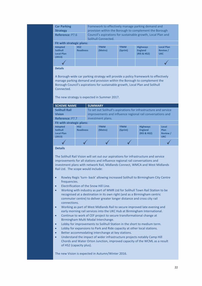
22
Car Parking Strategy
framework to effectively manage parking demand and provision within the Borough to complement the Borough Council’s aspirations for sustainable growth, Local Plan and Solihull Connected.
Reference: P7.6
Fit with strategic plans: Adopted Solihull Local Plan (2013)
HS2 Readiness
TfWM (Metro)
TfWM (Sprint)
Highways England (RIS & HS2)
Local Plan Review / UKC
Details
A Borough-wide car parking strategy will provide a policy framework to effectively manage parking demand and provision within the Borough to complement the Borough Council’s aspirations for sustainable growth, Local Plan and Solihull Connected. The new strategy is expected in Summer 2017.
SCHEME NAME SUMMARY
Solihull Rail Vision
To set out Solihull’s aspirations for infrastructure and service improvements and influence regional rail conversations and investment plans. Reference: P7.7
Fit with strategic plans: Adopted Solihull Local Plan (2013)
HS2 Readiness
TfWM (Metro)
TfWM (Sprint)
Highways England (RIS & HS2)
Local Plan Review / UKC
Details The Solihull Rail Vision will set out our aspirations for infrastructure and service improvements for all stations and influence regional rail conversations and investment plans with network Rail, Midlands Connect, WMCA and West Midlands Rail Ltd. The scope would include:
Rowley Regis ‘turn- back’ allowing increased Solihull to Birmingham City Centre frequencies.
Electrification of the Snow Hill Line.
Working with industry as part of WMR Ltd for Solihull Town Rail Station to be recognised at a destination in its own right (and as a Birmingham centric commuter centre) to deliver greater longer distance and cross city rail connections.
Working as part of West Midlands Rail to secure improved late evening and early morning rail services into the UKC Hub at Birmingham International.
Continue to work of CEF project to secure transformational change at Birmingham Multi Modal Interchange.
Lobby for improvements to Solihull Station in the short to medium term.
Lobby for expansions to Park and Ride capacity at other local stations.
Better accommodating interchange at key stations.
Understand the impact of wider infrastructure projects notably Camp Hill Chords and Water Orton Junction, improved capacity of the WCML as a result of HS2 (capacity plus).
The new Vision is expected in Autumn/Winter 2016.

23
SCHEME NAME SUMMARY
Technology and Innovation Roadmap
The Technology and Innovation Roadmap will help achieve Solihull Connected objectives and a Low Carbon Economy.
Reference: P7.8
Fit with strategic plans: Adopted Solihull Local Plan (2013)
HS2 Readiness
TfWM (Metro)
TfWM (Sprint)
Highways England (RIS & HS2)
Local Plan Review / UKC
Details
The Technology Roadmap will help achieve Solihull Connected objectives and a Low Carbon Economy. It will do this by making the most of opportunities presented to us through new technologies and innovations. Our approach will be to capitalise on the opportunities presented to us, recognise that we must work collaboratively with partners through national and regional programmes, that our ability to influence this agenda will vary and to adopt an integrated ‘whole place’ approach including transport. The scope of technologies include: Smart approaches to behaviour change, travel planning and sustainable travel incentives, Low and Ultra Low Emission Vehicles and Refuelling Infrastructure and Connected and Autonomous Vehicles. The Roadmap is expected in Spring/Summer 2017.

24
4. Funding The Solihull Connected approach is a balance of large infrastructure, community needs and ‘soft’ non-infrastructure measures. All of which will require funding in order for our plans to be delivered. Having our Transport Strategy and Delivery Plan in place puts the Borough in a strong position to secure funding from a number of sources particularly as it demonstrates strategic fit with national, regional and local growth and transport strategies. Increasingly, government is asking for synergies to be exploited for maximum outcomes and levering in funding. West Midlands Combined Authority In June 2016 the West Midlands Combined Authority was established following which a Devolution Agreement was finalised which set out an £8.8bn of programmes and initiatives to be funded; for Solihull this amounts to some £636m comprising £317m for the HS2 Interchange Station; £31m to support the HS2 Automated People Mover single stop and £288m for UK Central infrastructure. The allocation of this resource will be subject to business cases being submitted through the WMCA Assurance Process for approval. The WMCA (via its ‘Movement for Growth’ Transport Strategy) has a strong emphasis towards the development of a regional mass-transit network. Solihull will work with the WMCA to develop our Sprint and Metro aspirations set out in Solihull Connected. In addition, the WMCA has taken on the responsibility of managing a ‘Key Route Network’ of roads across the whole region. These routes are those which have been designated as important to the regional economy. A number of these key routes lie within Solihull and they align with many of our priorities for investment. We are currently engaging with TfWM in developing our investment needs to align with the priorities of the WMCA, which will give us the best chances of success to gain funding, as part of the ‘Movement for Growth’ 10 Year Plan. It is expected that the 10 Year Plan will be approved in March 2017 to access Devolution Agreement Funding from 2017/18. Urban Growth Company The Council has established an Urban Growth Company to focus on the delivery of infrastructure within the UK Central Hub, in particular additional infrastructure around the HS2 Station that will unlock the development opportunity of Arden Cross and the wider connectivity with the NEC and Birmingham Airport. The UGC will have the potential to either deliver schemes directly, as an agent or through a third party such as HS2 or Highways England. West Midlands Local Transport Funding TfWM ‘Movement for Growth’ has superseded the West Midlands Local Transport Plan 2011 – 2026 which previously was used to secure Local Transport Plan funding. This funding has now been devolved to the WMCA and the DfT has committed to providing this funding up to 2020/21. We have access to Integrated Transport (ITB) and Highways Capital Maintenance (HCMB) Blocks which are distributed on a population-basis and DfT criteria respectively. This funding will be continued to be used to support our transport programme priorities from small schemes to major project match funding and highway maintenance.
25
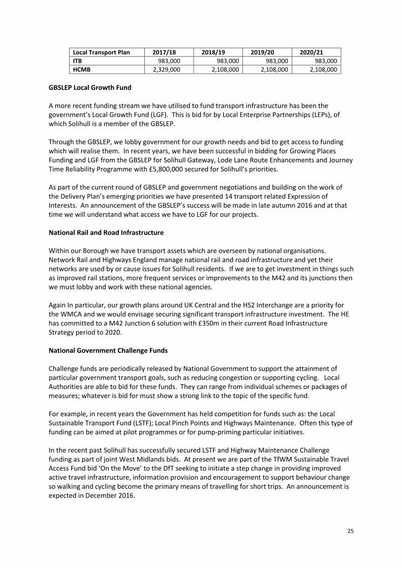
Local Transport Plan 2017/18 2018/19 2019/20 2020/21
ITB 983,000 983,000 983,000 983,000
HCMB 2,329,000 2,108,000 2,108,000 2,108,000
GBSLEP Local Growth Fund A more recent funding stream we have utilised to fund transport infrastructure has been the government’s Local Growth Fund (LGF). This is bid for by Local Enterprise Partnerships (LEPs), of which Solihull is a member of the GBSLEP. Through the GBSLEP, we lobby government for our growth needs and bid to get access to funding which will realise them. In recent years, we have been successful in bidding for Growing Places Funding and LGF from the GBSLEP for Solihull Gateway, Lode Lane Route Enhancements and Journey Time Reliability Programme with £5,800,000 secured for Solihull’s priorities. As part of the current round of GBSLEP and government negotiations and building on the work of the Delivery Plan’s emerging priorities we have presented 14 transport related Expression of Interests. An announcement of the GBSLEP’s success will be made in late autumn 2016 and at that time we will understand what access we have to LGF for our projects. National Rail and Road Infrastructure Within our Borough we have transport assets which are overseen by national organisations. Network Rail and Highways England manage national rail and road infrastructure and yet their networks are used by or cause issues for Solihull residents. If we are to get investment in things such as improved rail stations, more frequent services or improvements to the M42 and its junctions then we must lobby and work with these national agencies. Again In particular, our growth plans around UK Central and the HS2 Interchange are a priority for the WMCA and we would envisage securing significant transport infrastructure investment. The HE has committed to a M42 Junction 6 solution with £350m in their current Road Infrastructure Strategy period to 2020. National Government Challenge Funds Challenge funds are periodically released by National Government to support the attainment of particular government transport goals, such as reducing congestion or supporting cycling. Local Authorities are able to bid for these funds. They can range from individual schemes or packages of measures; whatever is bid for must show a strong link to the topic of the specific fund. For example, in recent years the Government has held competition for funds such as: the Local Sustainable Transport Fund (LSTF); Local Pinch Points and Highways Maintenance. Often this type of funding can be aimed at pilot programmes or for pump-priming particular initiatives. In the recent past Solihull has successfully secured LSTF and Highway Maintenance Challenge funding as part of joint West Midlands bids. At present we are part of the TfWM Sustainable Travel Access Fund bid ‘On the Move’ to the DfT seeking to initiate a step change in providing improved active travel infrastructure, information provision and encouragement to support behaviour change so walking and cycling become the primary means of travelling for short trips. An announcement is expected in December 2016.

26
Section 106 Funding In addition, we also fund transport infrastructure schemes through developer contributions, termed ‘Section 106 Agreements’ whereby developers are required to fund or part fund schemes which reduce their impact on the network that would otherwise have resulted in a harmful effect. With increasing development taking place in Solihull, we will ensure that the impacts of such development on the transport network are fully acknowledged at the planning stage, with developers continuing to contribute to the local network to mitigate harmful effects. Community Infrastructure Levy Community Infrastructure Levy is a tariff charged on development, at a locally set rate, to fund infrastructure needs arising from new development in the Borough. This can include transport schemes; flood defences; schools; health & social care facilities; parks & green spaces; cultural & sports facilities, as identified in the Regulation 123 List. Following the Examination and approval at Full Council in April 2016, charging commenced on Monday 4 July 2016. The Regulation 123 List currently includes infrastructure and travel planning measures that ease access by all modes to Solihull Town Centre. Section 106 planning obligations and Section 278 highway agreements can still be negotiated and delivered on development sites, where the planning proposal has a direct impact that requires mitigation or compensation.

27
5. Programme Management Effective programme and project management will be fundamental to the successful delivery of this plan and achievement of the objectives of Solihull Connected. Strong project management principles will be applied to the delivery of all schemes in the plan from conception through to delivery on site, and a common approach will be taken to governance, change control, risk management, and stakeholder management. The Solihull Transport Programme Priorities are shown in Appendix B in gantt chart form. Governance Schemes for which SMBC is the lead sponsor or promotor will be governed in accordance with the Council’s programme and project governance arrangements. For those schemes for which an external partner is the lead sponsor or promotor, standard actions will apply to these schemes including proactive engagement of Solihull Council at both member and officer level, and relevant departments or companies, e.g. West Midlands Combined Authority, GBSLEP and Urban Growth Company. Risk Management There will be a strong focus on the monitoring and management of risk at both a programme and individual scheme level. This will involve the identification of risks, assessment of their likelihood of occurrence and their potential impacts both qualitatively and quantitatively, and the development of suitable strategies to eliminate the risks or reduce their impact. It shall include the completion of Quantitative Risk Assessments (QRAs), both for cost and schedule (the latter if required), to ascertain realistic cost and time estimates and to highlight any areas of significant risk within the project. A draft Delivery Plan Risk Register is attached in Appendix D. This is a live document which will be continually reviewed and updated. Stakeholder Management A stakeholder consultation matrix will be developed for the Delivery Plan, which will provide an exhaustive list of stakeholders that have an interest in or influence over the delivery of the schemes. The matrix will be tailored to suit individual schemes; however, the specific key stakeholders identified for this Delivery Plan are as follows:
Highways England, HS2
West Midlands Combined Authority, GBSLEP, Resorts world, Transport for West Midlands
Birmingham Airport, NEC, Jaguar Land Rover, Arden Cross, Urban Growth Company
Rail Industry Partners – including Network Rail, Chiltern Railways and Transport for West Midlands
Bus and other public transport operators
Local Residents, Local Members, Employers and business owners
Other stakeholders will be (not exclusive): Town and Parish Councils, Mobility groups, Solihull Cycle Steering Group

28
6. Next Steps Next Steps The Delivery Plan set outs our transport priorities and plan of action, particularly for the next 12 months. Over the coming months we will prepare business cases for investment, allocate resources and continue our planning engagement with partners identifying routes to funding and influencing interventions led by others. Work is already currently ongoing with WMCA (TfWM), the GBSLEP, HE and HS2 on that basis. This will enable the planning and mobilising of a resourced transport programme of priorities for scheme development to an investment ready state and then implementation. The Delivery Plan will be reviewed every 6 months and brought before Cabinet Member for Transport and Highways for approval. This will allow us to bring progress reports, accommodate changes to the programme and recognise any changing context. For example the Local Plan Review is ongoing and it could impact on or further inform the planning of our priorities. This will be a potentially key consideration over the next 9 months as the Local Plan is concluded. This review mechanism enables us flexibility to ensure that Solihull Connected objectives and outcomes are being achieved. It is expected that the first update will be reported in early 2017 giving details on the planning and resourcing our transport priorities programme.
Appendices
Appendix A – Solihull and Partner Transport Programme (Scheme Schedule) Appendix B – Solihull Transport Programme Priorities – Indicative Gantt Chart Appendix C – Scheme Location Plans Appendix D – Draft Risk Register
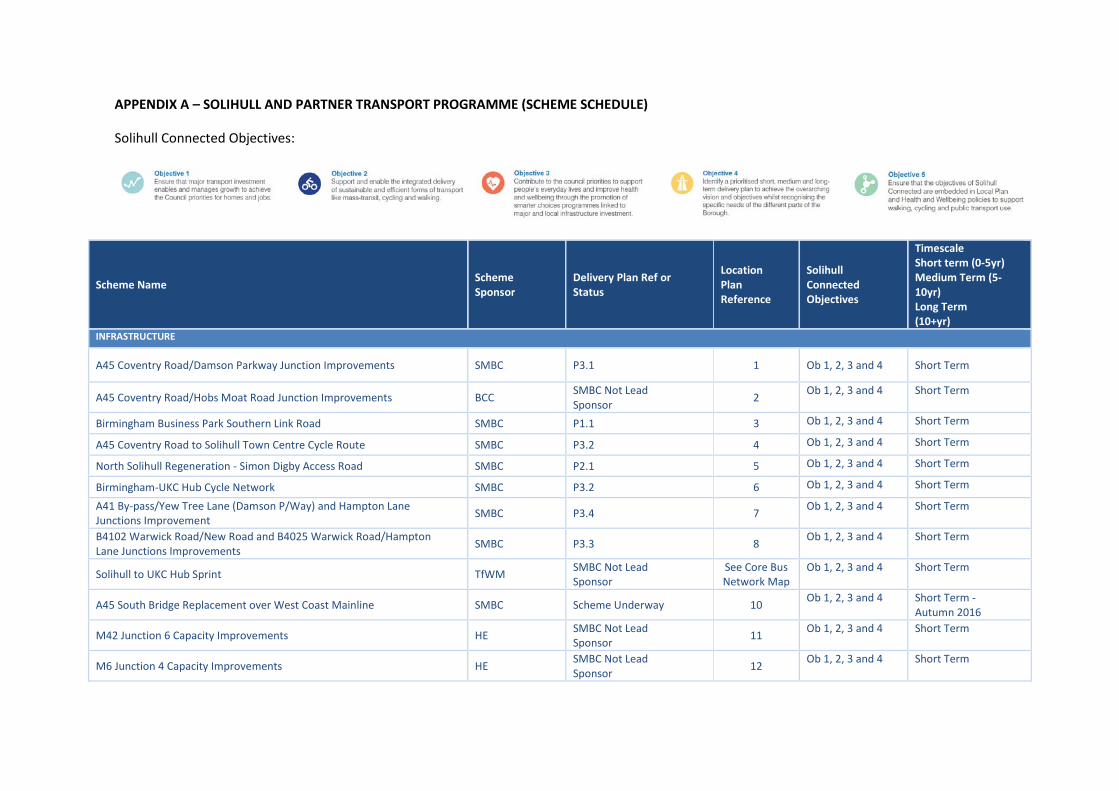
APPENDIX A – SOLIHULL AND PARTNER TRANSPORT PROGRAMME (SCHEME SCHEDULE)
Solihull Connected Objectives:
Scheme Name Scheme Sponsor
Delivery Plan Ref or Status
Location Plan Reference
Solihull Connected Objectives
Timescale Short term (0-5yr) Medium Term (5-10yr) Long Term (10+yr)
INFRASTRUCTURE
A45 Coventry Road/Damson Parkway Junction Improvements SMBC P3.1 1 Ob 1, 2, 3 and 4 Short Term
A45 Coventry Road/Hobs Moat Road Junction Improvements BCC SMBC Not Lead Sponsor
2 Ob 1, 2, 3 and 4 Short Term
Birmingham Business Park Southern Link Road SMBC P1.1 3 Ob 1, 2, 3 and 4 Short Term
A45 Coventry Road to Solihull Town Centre Cycle Route SMBC P3.2 4 Ob 1, 2, 3 and 4 Short Term
North Solihull Regeneration - Simon Digby Access Road SMBC P2.1 5 Ob 1, 2, 3 and 4 Short Term
Birmingham-UKC Hub Cycle Network SMBC P3.2 6 Ob 1, 2, 3 and 4 Short Term
A41 By-pass/Yew Tree Lane (Damson P/Way) and Hampton Lane Junctions Improvement
SMBC P3.4 7 Ob 1, 2, 3 and 4 Short Term
B4102 Warwick Road/New Road and B4025 Warwick Road/Hampton Lane Junctions Improvements
SMBC P3.3 8 Ob 1, 2, 3 and 4 Short Term
Solihull to UKC Hub Sprint TfWM SMBC Not Lead Sponsor
See Core Bus Network Map
Ob 1, 2, 3 and 4 Short Term
A45 South Bridge Replacement over West Coast Mainline SMBC Scheme Underway 10 Ob 1, 2, 3 and 4 Short Term -
Autumn 2016
M42 Junction 6 Capacity Improvements HE SMBC Not Lead Sponsor
11 Ob 1, 2, 3 and 4 Short Term
M6 Junction 4 Capacity Improvements HE SMBC Not Lead Sponsor
12 Ob 1, 2, 3 and 4 Short Term

Lode Lane Route Enhancements SMBC Scheme Underway 13 Ob 1, 2, 3 and 4 Short Term
Autumn 2016
Journey Time Reliability Programme SMBC P5.1 Borough-wide Ob 1, 2, 3 and 4 Short Term up to
2019/20
A41 By-pass/Lode Lane Junction Improvements SMBC Subject to further work 14 Ob 1, 2, 3 and 4 Short - Medium Term
Solihull Rail Station Short - Medium Term Capacity and Accessibility Improvements to Town Centre
SMBC P5.2 15 Ob 1, 2, 3 and 4 Short - Medium Term
Town Centre Public Realm Improvements SMBC Subject to further work 16a Ob 1, 2, 3 and 4 Short - Medium Term
Town Centre Cycle Network SMBC Subject to further work 16b Ob 1, 2, 3 and 4 Short - Medium Term
Birmingham to UKC Sprint via A45 and Coventry TfWM SMBC Not Lead Sponsor
See Core Bus Network Map
Ob 1, 2, 3 and 4 Short - Medium Term
Village Centres Infrastructure – Kingshurst and Chelmsley Wood SMBC Subject to further work 18a, 18b Ob 1, 2, 3 and 4 Short - Medium
Term
A45 Coventry Road/Stonebridge Junction Improvements HE SMBC Not Lead Sponsor
19 Ob 1, 2, 3 and 4
Medium Term
M42 Overbridge NEC to HS2 SMBC P4.4 20 Ob 1, 2, 3 and 4 Medium Term
HS2 Interchange Station Site Primary Infrastructure SMBC P4.3 21 Ob 1, 2, 3 and 4 Medium Term
Birmingham International Integrated Transport Hub (CEF) SMBC/TfWM P4.1 22 Ob 1, 2, 3 and 4 Medium Term
HS2 Birmingham Interchange Station HS2 SMBC Not Lead Sponsor
23 Ob 1, 2, 3 and 4 Medium Term
A452 Chester Road Corridor Enhancements SMBC P7.1 24 Ob 1, 2, 3 and 4 Medium Term
M42 Junction 5 Capacity Improvements HE SMBC Not Lead Sponsor
25 Ob 1, 2, 3 and 4 Medium Term
B4102 Lode Lane/Blossomfield Road Junction Improvements SMBC Subject to further work 26 Ob 1, 2, 3 and 4 Medium Term
B4102 Warwick Road/Lode Lane Junction Improvements SMBC Subject to further work 27 Ob 1, 2, 3 and 4 Medium Term
M42 Jun 4 Junction Capacity Improvements HE SMBC Not Lead Sponsor
28 Ob 1, 2, 3 and 4 Medium Term
Birmingham to UKC Hub Metro TfWM SMBC Not Lead Sponsor
See Core Bus Network Map
Ob 1, 2, 3 and 4 Medium Term
A41 Solihull-Birmingham Core Bus route Improvements TfWM SMBC Not Lead Sponsor
See Core Bus Network Map
Ob 1, 2, 3 and 4 Medium Term
Emerging NEC and Airport Masterplans Network Improvements NEC/Airport SMBC Not Lead Sponsor
31 Ob 1, 2, 3 and 4 Medium – Long
Term
Emerging Town Centre Masterplan Network Improvements SMBC Subject to further work 16c Ob 1, 2, 3 and 4 Medium – Long
Term

A34 Stratford Road High Quality Multi-Modal Route Enhancements including Shirley Centre
SMBC P7.2 32 Ob 1, 2, 3 and 4 Medium – Long
term
M42 Mainline Improvements HE SMBC Not Lead Sponsor
33 Ob 1, 2, 3 and 4 Medium – Long
Term Local stations multi-modal interchange and access improvements (not including Solihull or Birmingham International Rail stations see elsewhere)
SMBC/TfWM Subject to further work 34 Ob 1, 2, 3 and 4 Medium – Long
Term
Solihull Rail Station Long Term capacity and public transport inter-connectivity improvements
SMBC Subject to further work 35 Ob 1, 2, 3 and 4
Long Term
Enhanced access and public realm serving the Rural East (Balsall Common Bypass)
SMBC P4.2 36 Ob 1, 2, 3 and 4 Long Term
Solihull to Hall Green Sprint TfWM SMBC Not Lead Sponsor See Core Bus
Network Map Ob 1, 2, 3 and 4 Long Term
Sutton Coldfield to UKC Hub via Coleshill TfWM SMBC Not Lead Sponsor See Core Bus
Network Map Ob 1, 2, 3 and 4 Long Term
Warwick to UKC Hub Sprint TfWM SMBC Not Lead Sponsor See Core Bus
Network Map Ob 1, 2, 3 and 4 Long Term
North Solihull-UKC Hub-Solihull-BVBP Sprint TfWM SMBC Not Lead Sponsor See Core Bus
Network Map Ob 1, 2, 3 and 4 Long Term
Community Liveability Programme SMBC P6.1 Borough-wide Ob 1, 2, 3 and 4 Ongoing
Strategic Cycle Network SMBC Subject to further work See Cycle Plan Ob 1, 2, 3 and 4 Ongoing
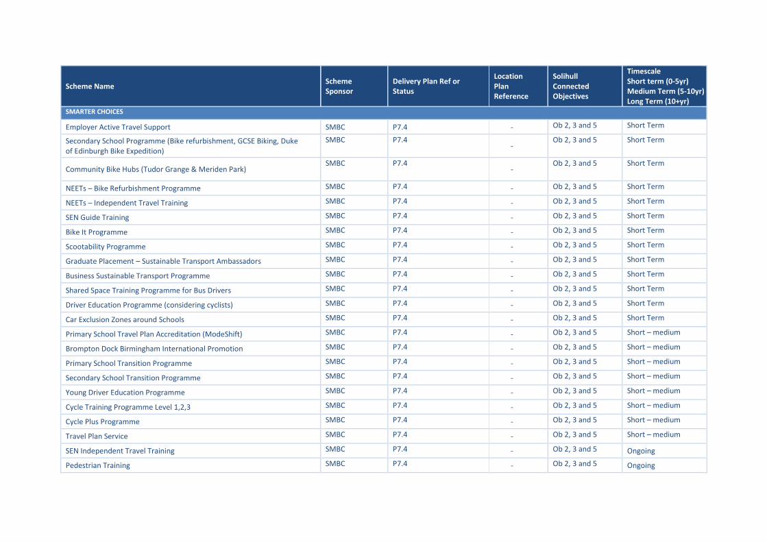
Scheme Name Scheme Sponsor
Delivery Plan Ref or Status
Location Plan Reference
Solihull Connected Objectives
Timescale Short term (0-5yr) Medium Term (5-10yr) Long Term (10+yr)
SMARTER CHOICES
Employer Active Travel Support SMBC P7.4 - Ob 2, 3 and 5 Short Term
Secondary School Programme (Bike refurbishment, GCSE Biking, Duke of Edinburgh Bike Expedition)
SMBC P7.4 -
Ob 2, 3 and 5 Short Term
Community Bike Hubs (Tudor Grange & Meriden Park) SMBC P7.4
- Ob 2, 3 and 5 Short Term
NEETs – Bike Refurbishment Programme SMBC P7.4 - Ob 2, 3 and 5 Short Term
NEETs – Independent Travel Training SMBC P7.4 - Ob 2, 3 and 5 Short Term
SEN Guide Training SMBC P7.4 - Ob 2, 3 and 5 Short Term
Bike It Programme SMBC P7.4 - Ob 2, 3 and 5 Short Term
Scootability Programme SMBC P7.4 - Ob 2, 3 and 5 Short Term
Graduate Placement – Sustainable Transport Ambassadors SMBC P7.4 - Ob 2, 3 and 5 Short Term
Business Sustainable Transport Programme SMBC P7.4 - Ob 2, 3 and 5 Short Term
Shared Space Training Programme for Bus Drivers SMBC P7.4 - Ob 2, 3 and 5 Short Term
Driver Education Programme (considering cyclists) SMBC P7.4 - Ob 2, 3 and 5 Short Term
Car Exclusion Zones around Schools SMBC P7.4 - Ob 2, 3 and 5 Short Term
Primary School Travel Plan Accreditation (ModeShift) SMBC P7.4 - Ob 2, 3 and 5 Short – medium
Brompton Dock Birmingham International Promotion SMBC P7.4 - Ob 2, 3 and 5 Short – medium
Primary School Transition Programme SMBC P7.4 - Ob 2, 3 and 5 Short – medium
Secondary School Transition Programme SMBC P7.4 - Ob 2, 3 and 5 Short – medium
Young Driver Education Programme SMBC P7.4 - Ob 2, 3 and 5 Short – medium
Cycle Training Programme Level 1,2,3 SMBC P7.4 - Ob 2, 3 and 5 Short – medium
Cycle Plus Programme SMBC P7.4 - Ob 2, 3 and 5 Short – medium
Travel Plan Service SMBC P7.4 - Ob 2, 3 and 5 Short – medium
SEN Independent Travel Training SMBC P7.4 - Ob 2, 3 and 5 Ongoing
Pedestrian Training SMBC P7.4 - Ob 2, 3 and 5 Ongoing
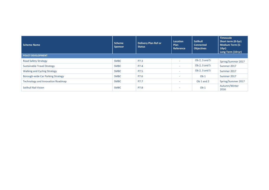
Scheme Name Scheme Sponsor
Delivery Plan Ref or Status
Location Plan Reference
Solihull Connected Objectives
Timescale Short term (0-5yr) Medium Term (5-10yr) Long Term (10+yr)
POLICY DEVELOPMENT
Road Safety Strategy SMBC P7.3 - Ob 2, 3 and 5 Spring/Summer 2017
Sustainable Travel Strategy SMBC P7.4 - Ob 2, 3 and 5 Summer 2017
Walking and Cycling Strategy SMBC P7.5 - Ob 2, 3 and 5 Summer 2017
Borough-wide Car Parking Strategy SMBC P7.6 - Ob 1 Summer 2017
Technology and Innovation Roadmap SMBC P7.7 - Ob 1 and 2 Spring/Summer 2017
Solihull Rail Vision SMBC P7.8 - Ob 1 Autumn/Winter 2016

APPENDIX B – SOLIHULL TRANSPORT PROGRAMME PRIORITIES GANTT CHART

Appendix B - Solihull Connected Transport Programme Priorities - Indicative Gantt Chart
16 17 18 19 20
Sep Oct Nov Dec Jan Feb Mar Apr May Jun Jul Aug Sep Oct Nov Dec Jan Feb Mar Apr May Jun Jul Aug Sep Oct Nov Dec Jan Feb Mar Apr May Jun Jul Aug Sep Oct Nov Dec Jan Feb Mar
Ref Scheme Stage 1 2 3 4 5 6 7 8 9 10 11 12 13 14 15 16 17 18 19 20 21 22 23 24 25 26 27 28 29 30 31 32 33 34 35 36 37 38 39 40 41 42 43
1.1 Birmingham BP Southern Link Road Stage 0 - Pre-feasibility
Stage 1 - Options and Outline Business Case
Stage 2 - Preliminary Design and Full Business Case
Stage 3 - Detailed Design and Planning Approval
2.1 Simon Digby Access Road Stage 0 - Pre-feasibility
Stage 1 - Options and Outline Business Case
Stage 2 - Preliminary Design and Full Business Case
Stage 3 - Detailed Design and Planning Approval
3.1 A45/Damson Parkway Jun Imp Stage 0 - Pre-feasibility
Stage 1 - Options and Outline Business Case
Stage 2 - Preliminary Design and Full Business Case
Stage 3 - Detailed Design and Planning Approval
3.2 Strategic Cycle Network - Damson Parkway Stage 0 - Pre-feasibility
Stage 1 - Options and Outline Business Case
Stage 2 - Preliminary Design and Full Business Case
Stage 3 - Detailed Design and Planning Approval
3.2 Strategic Cycle Network - UKC Hub Stage 0 - Pre-feasibility
Stage 1 - Options and Outline Business Case
Stage 2 - Preliminary Design and Full Business Case
Stage 3 - Detailed Design and Planning Approval
3.3 Warwick Rd/New Rd/Hampton Ln Jun Imps Stage 0 - Pre-feasibility
Stage 1 - Options and Outline Business Case
Stage 2 - Preliminary Design and Full Business Case
Stage 3 - Detailed Design and Planning Approval
3.4 A41 bypass/Yew Tree Ln/Hampton Ln Jun Imps Stage 0 - Pre-feasibility
Stage 1 - Options and Outline Business Case
Stage 2 - Preliminary Design and Full Business Case
Stage 3 - Detailed Design and Planning Approval
4.1 Birmingham Int Integrated Transport Hub (CEF) Stage 0 - Pre-feasibility
Stage 1 - Options and Outline Business Case
Stage 2 - Preliminary Design and Full Business Case
Stage 3 - Detailed Design and Planning Approval
4.2 Enhanced Access Rural East (Balsall Common) Stage 0 - Pre-feasibility Local Plan Review to identfy need and timescales to progress
4.3 HS2 Interchange Site Primary Infrastructure Enabling works from 2017 Enabling works from 2017
4.4 M42 overbridge NEC to HS2 Stage 0 - Pre-feasibility
Stage 1 - Options and Outline Business Case
Stage 2 - Preliminary Design and Full Business Case
Stage 3 - Detailed Design and Planning Approval
5.1 Journey Time Reliability Programme Programme brough forward from 20/21 to 16/17
5.2 Solihull Train and Access Imps Stage 0 - Pre-feasibility
Stage 1 - Options and Outline Business Case
Stage 2 - Preliminary Design and Full Business Case
Stage 3 - Detailed Design and Planning Approval
6.1 Community Liveability Programme Annual Programme starts 17/18 Start Assessment, Evaluation and Design from October
7.1 A452 Chester Rd Corridor Enhancement Stage 0 - Pre-feasibility
Stage 1 - Options and Outline Business Case
7.2 A34 Stratford Rd Enhancements Stage 0 - Pre-feasibility
Stage 1 - Options and Outline Business Case
7.3 Road Safety Strategy Strategy
7.4 Sustainable Travel Strategy Strategy
7.5 Walking and Cycling Strategy Strategy
7.6 Borough-wide Car Parking Strategy Strategy
7.7 Solihull Rail Vision Vision
7.8 Technology and Innovation Roadmap Roadmap

APPENDIX C – SCHEME LOCATION PLANS
Solihull and Partner Scheme Locations
Movement for Growth Core Bus Network Plan
Cycle Plan
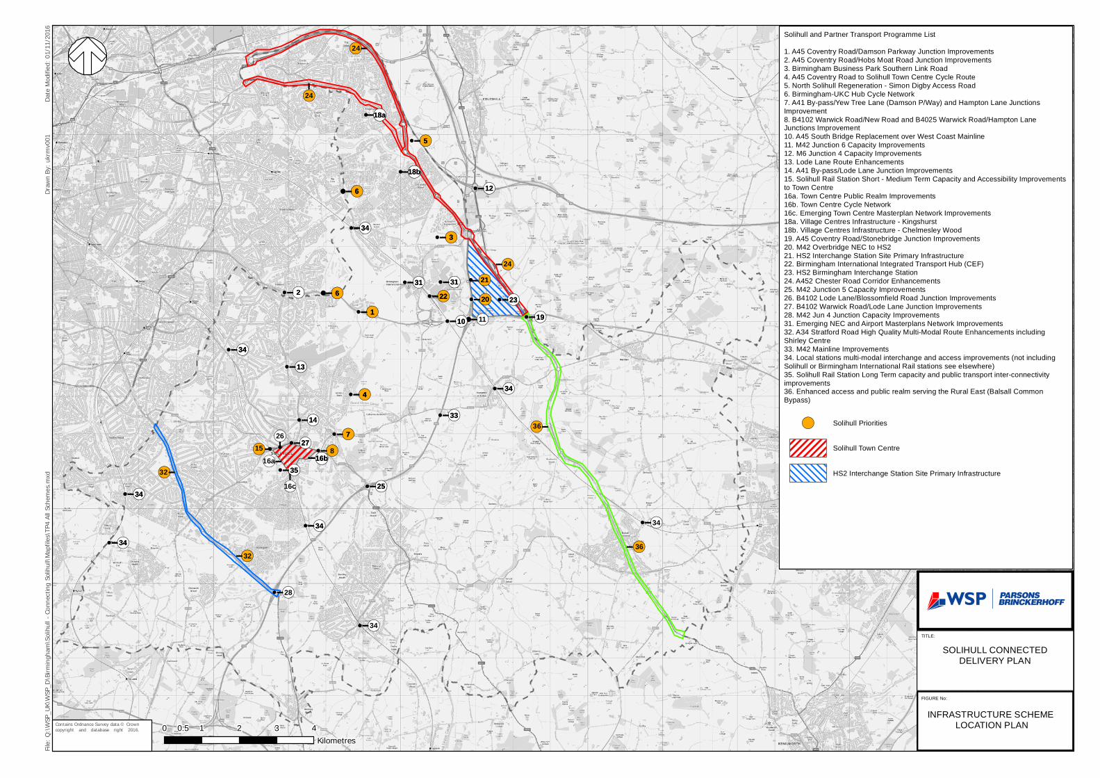
!(§!
!(§!
!(§!
!(§!!(§!
!(§!
!(§!
!(§!
!(§!!(§!
!(§!!(§! !(§!
!(§!!(§!
!(§!
!(§!
!(§!
!(§!
!(§!
!(§!
!(§!
!(§!
!(§!
!(§!
!(§!
!(§!
!(§!
!(§!
!(§!!(§
!(§
!(§
!(§!
!(§!!(§!
!(§!!(§
!(§!
!(§!
!(§
!(§
!(§
(!§
!§!( !
§
!(
§
(!
§
!(24
16c
2615
32
24
16a
36
1
87
4
2 6
3
6
5
34
23
35
10
24
3234
34
34
27
34
25
3314
13
313122
11 19
20
21
12
34
16b
18a
18b
1
7
4
2 6
3
6
5
34
23
35
10
3634
34
34
28
34
34
27
34
25
3314
13
313122
19
20
21
12
34
16b
18a
18b
File: Q
:\WSP
_UK\W
SP_D
\Birm
ingha
m\So
lihull
- Co
nnec
ting S
olihu
ll\Map
files\T
P4 Al
l Sch
emes.
mxd
Draw
n By:
ukrm
v001
Date
Modif
ied: 0
1/11/2
016
Contains Ordnance Survey data © Crowncopyright and database right 2016.
P R O JE C T T IT LE
FIG U R E X0 1 2 3 40.5Kilometres
FIG U R E N o :
T ITL E :
S O L IH U L L C O N N E C T E DD E L IV E R Y P L A N
IN F R A S T R U C T U R E S C H E M E L O C AT IO N P L A N
S o l ihu l l an d P a r tn e r T ran s p o rt P ro g ra m m e L ist1 . A 4 5 C o v en try R o ad /D a m so n P a rk w ay J u n ctio n Im p ro v e m en ts2 . A 4 5 C o v en try R o ad /H o b s M oa t R oa d Ju nc tion Im p rov e m e n ts3 . B irm in g h am B u sines s P a rk S ou th e rn L in k R oa d4 . A 4 5 C o v en try R o ad to S o lih u ll To w n C en tre C yc le R o u te5 . N o rth S o lihu ll R eg en e ra t io n - S im o n D igb y A c c es s R o a d6 . B irm in g h am -U K C H u b C y c le N e tw o rk7 . A 4 1 B y -p as s /Ye w T ree La n e (D a m so n P /W a y) a nd H a m p to n L an e Ju nc tio n sIm p rov e m e n t8 . B 41 02 W a rw ic k R o a d /N e w R o ad a n d B 40 2 5 W arw ic k R o ad /H a m p ton L a neJu n c tion s Im p rov e m e n t10 . A 45 S o u th B rid g e R e p lac e m en t ov e r W es t C o as t M a in line11 . M 4 2 J un c tion 6 C a pa c ity Im p rov e m e n ts12 . M 6 J u n ctio n 4 C ap ac ity Im p ro v em e n ts13 . Lod e La ne R o u te E n h a nc em e n ts14 . A 41 B y-pas s /L o d e L an e J u nc tio n Im p ro v em e n ts15 . S o lih u ll R a il S ta tion S h o r t - M ed ium Te rm C ap ac ity a nd A c c es s ib i lity Im p ro v e m e n tsto Tow n C e n tre16 a . To w n C e n tre P u b lic R ea lm Im p ro v e m en ts16 b . To w n C e n tre C y cle N e tw o rk16 c . E m e rg in g To w n C e n tre M a s te rp lan N e tw o rk Im p rov e m e n ts18 a . V illa ge C e n tre s In fra stru c tu re - K in gs h u rs t18 b . V illa ge C e n tre s In fra stru c tu re - C h e lm es le y W o o d19 . A 45 C o ve n try R oad /S to n eb r id g e Ju n c tion Im p rov em en ts20 . M 42 O v e rb rid g e N E C to H S 221 . H S 2 In te rc ha n g e S ta tio n S ite P rim a ry In fras truc tu re22 . B irm in g ham In te rna tio n a l In teg ra te d T ra ns po rt H u b (C E F)23 . H S 2 B irm in g h a m In te rc ha ng e S ta t io n24 . A 452 C h es te r R o ad C o rrid o r E n ha nc e m e n ts25 . M 42 J u n c tion 5 C a pa c ity Im p ro v e m en ts26 . B 4 10 2 L od e L a ne /B lo s s om fie ld R oa d J u nc tio n Im p ro v e m en ts27 . B 4 10 2 W a rw ic k R oa d /Lo d e La n e J u nc tion Im p ro v e m e n ts28 . M 42 J u n 4 J un c t ion C a pa c ity Im p ro v em e n ts31 . E m e rg in g N E C an d A irp o rt M a s te rp la n s N e tw o rk Im p ro v e m en ts32 . A 34 S tra tfo rd R oa d H ig h Q u a lity M u lt i-M o da l R o u te E n ha nc e m e n ts in c lud ingS h irle y C e n tre33 . M 42 M a in line Im p ro v e m e n ts34 . Loc a l sta tio n s m u lt i-m o da l in te rc h an g e an d a c c es s im p rov em e n ts (no t in c lu d in gS o l ihu l l o r B irm in g ha m In te rna tio n a l R a il s ta tion s s ee e ls e w h e re )35 . S o lih u ll R a il S ta tion Lo ng Te rm c a p a c ity a n d p ub l ic tra ns po rt in te r-c o n ne c tiv i tyim p ro v em en ts36 . E n ha n c ed a cc e ss a n d pu b lic re a lm s e rv in g th e R u ra l E a s t (B a ls a ll C o m m o nB y p a ss )
!( S o l ihu l l P rio rit ie s
S o l ihu l l Tow n C e n tre
H S 2 In te rc h an ge S ta tio n S i te P rim a ry In fra s truc tu re

Core Bus Network Map
Stourbridge
Brierley
Hill
Dudley
Dudley
Wednesbury
Hale
sow
en
Frankley
Longbridge
Cofton Hackett
Haw
kesley
Solihull
Bir
min
gham
Airport
/NEC
Colesh
ill P
arkw
ay
Interchange
Sutton Coldfield
Walsall
Wolv
erham
pton
Brownhills
Aldridge
i54/B
rinsf
ord
Codsall
Underh
ill
Moss
ley
Pelsall
Hill
Hook
Perton
Wate
r O
rton
Port
Coventr
y
Kenilworth
Nuneaton
Leamington Spa
West
Bro
mw
ich
Hamstead
Kingstanding
Perry Common
Penn
Oxhill
Road
Bartley Green
Druids H
eathQuinton
Blythe Valley
Business Park
Roughle
y
Birmingham
Metro
Tram Train/Rail
SPRINT
Core Bus
Main CentreInterchange

File: Q
:\WSP
_UK\W
SP_D
\Birm
ingha
m\So
lihull
- Co
nnec
ting S
olihu
ll\Map
files\T
P4 Cy
cle Ro
utes.m
xdDr
awn B
y: uk
mjt00
5Da
te Mo
dified
: 26/0
9/201
6
Contains Ordnance Survey data © Crowncopyright and database right 2016.
P R O J E C T T IT L E
F IG U R E X0 1 2 3 40.5Kilometres
F IG U R E N o :
T IT L E :
S O L IH U L L C O N N E C T E D D E L IV E R Y P L A N
S O L IH U L L C O N N E C T E D C Y C L E N E T W O R K
KeySolihullConnectedCycle Network
P rim a ry
S e c o n d a ry
G re e n w a yC a n a lTo w p a th

APPENDIX D – RISK REGISTER
Delivery Plan Risks
Risk Status
Risk Ref.
Risk description Time / Cost Impact Proximity Person
Responsible
Inherent Risk
Response Residual Risk
Open 1
Procurement – Failure to effectively manage contracts
- Poor delivery - Contract breach - Poor performance - Poor cost control - No audit trail
On going Medium
Project Managers to be briefed / trained in respect of Contract Management. Review of current procedures to ensure that they are fit for purpose.
Medium
Open 2
Procurement – Failure to follow appropriate procurement rules / process
- Legal & financial implications - breach of procurement rules; - Additional costs - Challenge - Inability to award commission - Lack of contract protection (IPR) - Lack of contract in place - Potential duplication of work packages
On going Medium
Commissioning for schemes must be approved through agreed governance structure. Instruction to officers that no commitments be made without approval.
Low
Open 3 Finance – Poor financial management
- Overspend of costs or shortfall of funding required
On going Low Project briefs to contain financial info & regular meetings to review costs.
Low
Open 4
Partnerships - failure to have effective partnership arrangements
- Delayed or no delivery - Key partnerships breakdown - Increased costs
On going Medium
Robust governance structure is in place to support programme and escalation of issues.
Low
Open 5
Communications – Failure to effectively engage with stakeholders
- Mistrust and miss information and political damage - Potential challenge
On going Medium
Ensure mechanisms and processes are in place to respond through briefings and the website.
Low

- Project delays
Open 6
Programme Delivery – Lack of robust programme management arrangements
- Delivery failure or challenge to delivery - Financial and reputational damage
On going Medium
Ensure robust programme and project management arrangements are in place. Low
Open 9
Procurement – Failure to appoint a suitable contractor / consultant
- Financial implications - increase in costs - Project delay and poor decision process - Not fit for purpose outcome / output
On going Medium
Monitor market conditions and where necessary review processes / frameworks. HoS to remind staff that they need to identify procurement requirements as part of A3 Project Justification process. Engage with market. Ensure appropriate questioning in specification and at interview.
Low
Open 10
Information Sharing – confidential data is breached
- Legal challenge - Reputational damage - Financial loss - Delays to Project
On going High
Ensure that when sharing confidential data that it is done so with either explicit instructions or through an NDA.
Low
Open 11
Programme Delivery – Complexity of projects
- Stretched resources - Project delays - Lack of understanding of major projects
On going High
Align major projects into a single infrastructure plan.
Low
Open 12
Programme Delivery – Failure to align major infrastructure projects
- Project delays - Additional costs - Business delays - Reputational impact - Duplication of work - Scope creep
On going Medium
Align major projects into a single infrastructure plan.
Low
Open 13 Time – Insufficient time - Project delays
- Increased costs - Loss of staff resources
On going Medium Maintain a resource plan.
Low
Open 14 Procurement – scope creep
- Increased costs - Commission fails to
On going Medium Governance process established to ensure Project Managers are
Low
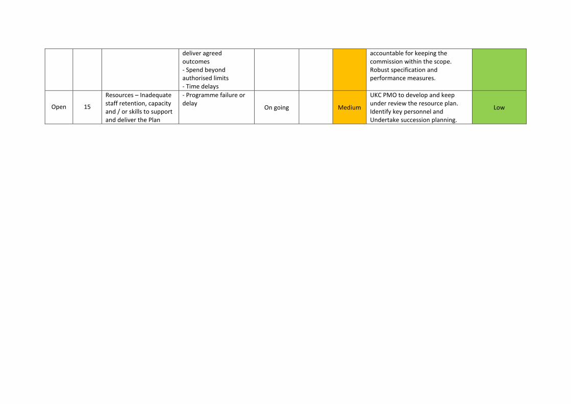
deliver agreed outcomes - Spend beyond authorised limits - Time delays
accountable for keeping the commission within the scope. Robust specification and performance measures.
Open 15
Resources – Inadequate staff retention, capacity and / or skills to support and deliver the Plan
- Programme failure or delay
On going Medium
UKC PMO to develop and keep under review the resource plan. Identify key personnel and Undertake succession planning.
Low