delaware national estuarine research reserve management ... · delaware national estuarine research...
TRANSCRIPT

Delaware National EstuarineResearch ReserveManagement Plan
2004 - 2009


Prepared by:Delaware National
Estuarine Research Reserve818 Kitts Hummock Road
Dover, Delaware 19901
Delaware National EstuarineResearch ReserveManagement Plan
2004–2009
Prepared for:United States
Department of CommerceNational Oceanic and
Atmospheric AdministrationEstuarine Reserves Division
Document No. 40-07-05/05/03/02


i
DNERR Management Plan 2004–2009

ii
DNERR Management Plan 2004–2009
Advisory Committee Members

iii
DNERR Management Plan 2004–2009
Acknowledgments
The preparation of this document was funded by Award Number NA17OR1243, Office of Oceanand Coastal Resource Management (OCRM) of the National Oceanic and AtmosphericAdministration (NOAA), U.S. Department of Commerce.
This management plan was prepared by the staff and Advisory Committee of the Delaware NationalEstuarine Research Reserve, in collaboration with the Delaware Department of Natural Resourcesand Environmental Control (DNREC), Division of Soil and Water Conservation. Participants in theplanning process included: Mark Del Vecchio, Reserve Manager; Dr. Robert Scarborough,Research Coordinator; and Katy Lamborn, Education Coordinator, with input from the AdvisoryCommittee Members listed below. Guidance was provided by Dave Carter, Program Manager, andSarah Cooksey, Program Administrator, of the Delaware Coastal Programs, as well as by theEstuarine Reserves Division of the OCRM at NOAA.

iv
DNERR Management Plan 2004–2009

v
DNERR Management Plan 2004–2009
Table of ContentsList of Acronyms and Abbreviations ................................................................................................ x
I. OverviewA. Purpose and Scope of this Management Plan ......................................................................... 2B. Brief Introduction to the Delaware National Estuarine Research Reserve ............................. 3
II. IntroductionA. The Value of Estuaries ............................................................................................................. 8B. The National Estuarine Research Reserve System ................................................................. 8
1. The Coastal Zone Management Act .................................................................................... 82. Mission and Goals of the National Estuarine Research Reserve System ........................... 93. Administrative Framework of the National Estuarine Research Reserve System .............. 94. Designation and Operation of National Estuarine Research Reserves ............................. 105. Reserve Management Plans .............................................................................................. 126. Nationwide Programs of the National Estuarine Research Reserve System .................... 12
C. The Delaware National Estuarine Research Reserve ........................................................... 141. Establishment and Mission of the Reserve ........................................................................ 142. Setting, Boundaries, and Ownership of the Two Reserve Sites ........................................ 14
- Upper Blackbird Creek Reserve Component ................................................................ 15- Lower St. Jones River Reserve Component .................................................................. 17
III. Mission, Goals, and Objectives of the DNERRA. Overall Mission of the DNERR ............................................................................................. 20B. Administration Goals and Objectives ...................................................................................... 20C. Facilities and Construction Goals and Objectives ................................................................... 20D. Public Access Goals and Objectives ...................................................................................... 21E. Education, Interpretation, and Outreach Goals and Objectives .............................................. 21F. Research and Monitoring Goals and Objectives ..................................................................... 22G. Stewardship Goals and Objectives .......................................................................................... 23
1. Resource Protection Goals and Objectives ........................................................................ 232. Boundaries and Land Acquisition Goals and Objectives .................................................... 23
IV. AccomplishmentsA. Organizational Realignment ................................................................................................... 26B. Development of Sites and Facilities ....................................................................................... 26
1. St. Jones Center ................................................................................................................ 262. Trail/Boardwalk.................................................................................................................. 273. Blackbird Creek Reserve Component ............................................................................... 27
C. Development of Educational Exhibits and Publications .......................................................... 27D. Expansion of Education Program ........................................................................................... 28E. Research and Monitoring Program......................................................................................... 28F. Establishment of Partnerships ................................................................................................. 30G. Section 312 Evaluation ............................................................................................................ 30

vi
DNERR Management Plan 2004–2009
V. Administration PlanA. Historical Perspective ............................................................................................................ 34B. Goals and Objectives .............................................................................................................. 34C. State Administration of the Reserve and Related Programs .................................................. 34D. Reserve Staff Responsibilities ................................................................................................ 35
1. Reserve Management ........................................................................................................ 352. St. Jones Center Operations and Maintenance .................................................................. 363. Research and Monitoring ................................................................................................... 364. Education, Interpretation, and Outreach ............................................................................ 365. Resource Protection .......................................................................................................... 37
- Enforcement ................................................................................................................... 37- Stewardship .................................................................................................................... 37
E. Volunteers ............................................................................................................................... 38F. Interns ..................................................................................................................................... 39G. Cooperative Efforts ................................................................................................................. 39H. Advisory Committee – Structure and Responsibilities ........................................................... 40
1. Management Subcommittee .............................................................................................. 402. Research Subcommittee .................................................................................................... 403. Education Subcommittee .................................................................................................... 40
I. Federal Review and Regulation ............................................................................................... 411. Roles and Responsibilities of the National Oceanic and Atmospheric Administration ....... 412. National Historic Preservation Act .................................................................................... 41
J. Action Plan for Administration ................................................................................................ 42
VI. Facilities and Construction PlanA. Goals and Objectives.............................................................................................................. 44B. Existing Facilities .................................................................................................................... 44
1. Public Access ................................................................................................................... 442. Research Laboratories ...................................................................................................... 453. Education Facilities and Exhibits ....................................................................................... 454. Conference Facilities ........................................................................................................ 455. Coastal Resource Library ................................................................................................. 456. Trail/Boardwalk ................................................................................................................ 46
C. Proposed Facility Expansion Plan .......................................................................................... 461. Connecting Structure ......................................................................................................... 462. Conference Space ............................................................................................................. 473. Dormitory ........................................................................................................................... 484. Library ............................................................................................................................... 48
D. Blackbird Facility Development ............................................................................................. 481. Visitor Center ..................................................................................................................... 482. Interpretive Trail ................................................................................................................ 483. Canoe/Kayak Launch ........................................................................................................ 48
E. Action Plan for Facilities and Construction............................................................................. 49
VII. Public Access PlanA. Goals and Objectives.............................................................................................................. 52B. General Access Policy ........................................................................................................... 52C. Site-Specific Access Policies ................................................................................................. 53
1. Lower St. Jones River Reserve Component ..................................................................... 53

vii
DNERR Management Plan 2004–2009
2. Upper Blackbird Creek Reserve Component .................................................................... 53D. Boat and Canoe Access ......................................................................................................... 53E. Fishing, Hunting, and Trapping ................................................................................................ 53F. Other Uses .............................................................................................................................. 54G. Action Plan for Public Access ................................................................................................ 54
VIII. Education, Interpretation, and Outreach PlanA. Goals and Objectives.............................................................................................................. 58B. Site-Specific Facilities and Resources .................................................................................... 59
1. St. Jones Reserve Component and Adjacent Areas .......................................................... 592. Blackbird Creek Reserve Component ............................................................................... 60
C. Types of Activities .................................................................................................................. 601. Workshops and Training in Informed Coastal Decision-Making ........................................ 602. Programs for the General Public ....................................................................................... 613. Programs for Students ....................................................................................................... 614. Programs for Educators ..................................................................................................... 62
D. Publications and Promotional Events ..................................................................................... 63E. Coordination and Cooperative Efforts .................................................................................... 63
1. Coordination of Educational Activities at the Reserve ....................................................... 632. Coordination with the National Estuarine Research Reserve System ............................... 633. Coordination with Other Educational Programs ................................................................ 63
F. Coastal Training Program........................................................................................................ 64G. Action Plan for Education, Interpretation, and Outreach ........................................................ 65
IX. Research and Monitoring PlanA. Issues Facing the DNERR..................................................................................................... 70B. Goals and Objectives .............................................................................................................. 71C. Research and Monitoring Topics and Priorities ...................................................................... 71
1. National Programs ............................................................................................................. 71- System-Wide Monitoring Program ................................................................................. 71- Protected Areas Geographic Information System.......................................................... 72- Graduate Research Fellowship Program ....................................................................... 72
2. Research and Monitoring at the Delaware Reserve ......................................................... 73- Physical Estuarine Research .......................................................................................... 73- Cultural Estuarine Research ........................................................................................... 74
D. Research Value of the Reserve ............................................................................................. 741. St. Jones River Reserve Component ................................................................................. 742. Blackbird Creek Reserve Component ............................................................................... 75
E. Research Policies and Procedures ......................................................................................... 761. Guidelines ........................................................................................................................... 762. Recruitment ........................................................................................................................ 773. Off-Reserve Projects ......................................................................................................... 774. Coordination of Efforts ...................................................................................................... 77
- Coordination between Reserve Components ................................................................. 77- Coordination with the National Estuarine Research Reserve System ........................... 79- Coordination with Other Coastal/Estuarine Research Programs ................................... 79
F. Funding Opportunities .............................................................................................................. 80G. Dissemination of Information and Results .............................................................................. 80H. Action Plan for Research and Monitoring .............................................................................. 80

viii
DNERR Management Plan 2004–2009
X. Stewardship PlanA. Resource Protection ............................................................................................................... 84
1. Goals and Objectives ......................................................................................................... 842. General Policies ................................................................................................................. 853. Land Protection Outside Reserve Boundaries ................................................................... 874. Laws and Regulations ........................................................................................................ 885. Stewardship Coordinator .................................................................................................... 88
B. Boundaries and Land Acquisition ........................................................................................... 891. Goals and Objectives ......................................................................................................... 902. Acquisition Areas ............................................................................................................... 913. Fee-simple versus Conservation Easements ...................................................................... 914. St. Jones Component ......................................................................................................... 925. Blackbird Creek Component .............................................................................................. 926. Watershed Protection......................................................................................................... 93
C. Boundary Amendment ............................................................................................................ 931. Lowe Tract ........................................................................................................................ 942. Manwaring Tract ............................................................................................................... 94
D. Action Plan for Stewardship .................................................................................................. 95
Appendices
Appendix A. Projected Five-Year Implementation Plan for the Delaware National EstuarineResearch Reserve ................................................................................................................ A-1
Appendix B. Establishment of the National Estuarine Research Reserve System by the CoastalZone Management Act ........................................................................................................ B-1
Appendix C. National Estuarine Research Reserve System Regulations ............................... C-1Appendix D. Biogeographic Classification and Typology of the Delaware National Estuarine
Research Reserve ................................................................................................................ D-1Appendix E. Memoranda of Understanding .............................................................................E-1• Memorandum of Understanding between the State of Delaware and the National Oceanic
and Atmospheric Administration ...........................................................................................E-2• .. Memorandum of Understanding between the Delaware Native Plant Society and the Division of Soil and Water Conservation, Delaware Coastal Programs.......................................... E-7Appendix F. Certification of Consistency with the Delaware Coastal Management Program......
.............................................................................................................................................. F-1Appendix G. Past and Present Advisory Committee Members ............................................... G-1Appendix H. State and County Legal Authorities Affecting Resource Protection in the Delaware
National Estuarine Research Reserve ................................................................................. H-1Appendix H-1 Wetlands Act ..................................................................................................... H-1Appendix H-2 Coastal Zone Act ............................................................................................... H-6Appendix H-3. Subaqueous Lands Act ................................................................................... H-11Appendix H-4. Antiquities Act ................................................................................................ H-15Appendix H-5. Natural Areas Preservation System Act ........................................................ H-17Appendix H-6. Conservation Easements ................................................................................ H-21Appendix H-7. Erosion and Sedimentation Control and Stormwater Management ................ H-23Appendix H-8. Endangered Species ....................................................................................... H-49Appendix H-9. Hunting and Fishing Regulations .................................................................... H-52Appendix H-10. Environmental Protection Act ....................................................................... H-71

ix
DNERR Management Plan 2004–2009
Appendix H-11. Land Use and Zoning Restrictions.............................................................. H-121Appendix I. Environmental Research and Monitoring Projects of the Delaware National
Estuarine Research Reserve, 1999–2003 .............................................................................. I-1Appendix J. Outline of Environmental Issues Affecting the Delaware National Estuarine
Research Reserve ................................................................................................................. J-1Appendix K. Description of Public Process for Management Plan Revision .......................... K-1

x
DNERR Management Plan 2004–2009
List of Acronyms and Abbreviations
BMP Best Management PracticeCDMO Central Data Management OfficeCFR Code of Federal RegulationsCICEET Cooperative Institute for Coastal and Estuarine Environmental TechnologyCMS College of Marine StudiesCTI Coastal Training InitiativeCTP Coastal Training ProgramCZMA Coastal Zone Management Act (of 1972, and subsequently amended)DCMP Delaware Coastal Management ProgramDCP Delaware Coastal ProgramsDELEP Delaware Estuary ProgramDFW Division of Fish and WildlifeDNERR Delaware National Estuarine Research ReserveDNREC Department of Natural Resources and Environmental ControlDNS Delaware Nature SocietyDSU Delaware State UniversityEPA Environmental Protection AgencyEPO Environmental Protection OfficerERD Estuarine Reserves DivisionECSC Environmental Cooperative Science CenterGIS Geographic Information SystemGRF Graduate Research Fellow(ship)KCD Kent County Conservation DistrictMOU Memorandum of UnderstandingNCCD New Castle County Conservation DistrictNEP National Estuary ProgramNERR National Estuarine Research ReserveNERRS National Estuarine Research Reserve SystemNMFS National Marine Fisheries ServiceNMS National Marine SanctuariesNOAA National Oceanic and Atmospheric AdministrationNOS National Ocean ServiceNRCS Natural Resources Conservation ServiceOCRM Ocean and Coastal Resource Management, Office ofPAGIS Protected Area Geographic Information SystemPCB Polychlorinated BiphenylSCS Soil Conservation ServiceSHPO State Historic Preservation OfficeSPO Special Projects OfficeSWMP System-Wide Monitoring ProgramTMDL Total Maximum Daily LoadTNC The Nature ConservancyUD University of DelawareUSDA U.S. Department of AgricultureUSEPA U.S. Environmental Protection AgencyUSFWS U.S. Fish and Wildlife ServiceUSGS U.S. Geological Survey

1
I. Overview

2
DNERR Management Plan 2004–2009
I. Overview
A. Purpose and Scope of this Management PlanThis document is the second edition of the management plan for the Delaware National EstuarineResearch Reserve (DNERR), and covers the period of 2004–2009. This plan is an addendum to theoriginal management plan that was approved by the National Oceanic and Atmospheric Administration(NOAA) and adopted by the DNERR in 1993.
The original management plan established the inclusion of the DNERR in the National EstuarineResearch Reserve System (NERRS). At that time, administration and management of the Reservewere provided by the Delaware Department of Natural Resources and Environmental Control(DNREC) through the combined efforts of the Divisions of Fish and Wildlife, Soil and WaterConservation, and Parks and Recreation. The management plan included a detailed acquisition agendaand site information for the two Reserve components: sites at the Lower St. Jones River and UpperBlackbird Creek. Plans for facilities and staffing detailed the sites’ needs for full implementation of theReserve’s intended programs. Plans for education/interpretation, research, and resource protectionwere established to guide the major functions of these programs.
The objectives of the original plan and the Implementation Plan were established with the intent ofguiding the Reserve through its first 5 years of operations. Many of the original plan’s generalobjectives for research and education are presently ongoing. Although a great deal has beenaccomplished by the DNERR since 1993, some achievements and improvements are not reflected inthe outdated plan. This update reflects the new achievements and improvements. The basic structureof Reserve administration and management has been considerably altered, as the DNERR is nowadministered at the State level by the DNREC’s Division of Soil and Water Conservation in theDelaware Coastal Programs (DCP) Section. The Reserve’s St. Jones Center does not, as wasoriginally conceived, house DNREC offices for the Division of Fish and Wildlife. The original plan wasset with high expectations for numerous State-funded positions; although NERRS appropriations havesteadily increased, allowing for increased efforts at each site, State matching funds have becomeincreasingly difficult to attain (especially for staff positions).
This second edition of the management plan describes the mission, goals, and objectives of theNERRS and the DNERR, and describes the accomplishments of the DNERR since the publication ofthe 1993 plan. In addition, action plans reflect current circumstances and are presented for theReserve’s administration; facilities and construction; public access; education, interpretation, andoutreach; environmental research and monitoring; and stewardship. Over the next 5 years, as fundingpermits, it is the overarching goal of the DNERR to increase its efforts in all aspects of Reserveoperations. For example:
• State funding for several positions will be explored.• Volunteers will be recruited to assist with numerous Reserve activities.• A Proposed Facility Expansion Plan will be implemented to meet needs for space and
other resources.• Public access to the St. Jones Reserve component will be promoted, while the
integrity of both Reserve sites will be maintained.
3
Chapter I. Overview
• Public educational programs, school programs, outreach programs, Coastal Decision-Maker Workshops, and exhibit construction will continue and expand.
• Prescribed tasks will be fulfilled in order for the Coastal Training Program (CTP) tobecome operational.
• The Research and Monitoring Program will focus on habitat characterization andanthropogenic impacts at both sites, in cooperation with the Delaware CoastalManagement Program (DCMP), other coastal research agencies, and universities,and will continue to participate in System-wide research initiatives.
• The adoption of conservation practices and monitoring at both sites will further theReserve’s resource protection objectives.
• Aggressive efforts will be taken to identify funds for land acquisition to protectessential habitat within the Reserve’s boundaries and watersheds.
This next phase of development and expansion will be largely dependent upon future grant allocations.Throughout its administrative and programmatic efforts, the DNERR will continue to be directedtoward providing focused, integrated research and education to foster the wise use and managementof estuarine and coastal ecosystems.
This revised management plan has been developed by the DNERR in accordance with NOAAregulations and Section 315 of the Coastal Zone Management Act (CZMA). This plan is intended toguide the future direction and accomplishments of the DNERR, and its implementation will be subjectto evaluation as required by Federal regulation (15 CFR Part 921.40).
B. Brief Introduction to the Delaware National Estuarine ResearchReserveDuring the early 1980s, the DNREC examined the precursor to the NERRS, the National EstuarineSanctuary Program, which had been established by Section 315 of the CZMA in 1972. Although thatprogram had several desirable attributes, it did not have enough flexibility or utility within the context ofDelaware’s resource needs to warrant the State’s support. However, when the CZMA wasreauthorized in 1986 and Section 315 was amended, the National Estuarine Sanctuary Programevolved into today’s NERRS, which has a greater emphasis on applied research and environmentaleducation while allowing more flexibility in the administration of reserve components to accommodatemultiple uses and respond to management needs. Given this new direction for estuarine reserves, theState of Delaware began in 1988 to identify potential sites. The intensive site-selection criteria thatwere used assessed ecological representation, values for environmental research and education, andacquisition and management considerations. Two sites were selected and nominated to then-GovernorMichael Castle to be a multiple-site Reserve. In 1993, following NOAA’s approval of the submittedmanagement plan, the DNERR became the 22nd Reserve in the System.
The DNERR consists of two Reserve components, the Upper Blackbird Creek and Lower St. JonesRiver sites, which are about 30 miles apart. These components include both brackish and freshwaterestuaries, and represent the diverse estuarine ecosystems found throughout the Mid-Atlantic states.The more landward Blackbird Creek Reserve component, located in southern New Castle County, is1,180 acres in designated size. It represents a low-salinity brackish or freshwater tidal estuarineecosystem. The more seaward St. Jones Reserve component, located just south of the State capital of

4
DNERR Management Plan 2004–2009
Dover, is about 3,750 acres in designated size. It represents a medium-salinity tidal river estuarineecosystem; 2,560 acres of the site consist of Delaware Bay bottom and near-shore waters, running for2.0 miles along the Ted Harvey Conservation Area’s bay shoreline and extending outward 2.0 milesinto the open bay. Both Reserve components include tidal marsh, upland field, woodland, and croplandhabitats.
Approximately 5,000 people visit the Reserve annually as part of school programs, seasonal publicprograms, volunteer projects, and other activities. The St. Jones Reserve component is home to the
Figure I-1. Map showing the location of the two DNERR components in Delaware.

5
Chapter I. Overview
DNERR St. Jones Center, an education and research facility that opened in May of 1999. The buildinghouses offices, laboratories, and conference space, along with numerous exhibits. A boardwalk forinterpretive and research activities is constructed through part of the marsh at the St. Jones site and,along with the Center, is open to the public Monday through Friday from 8:00 a.m. to 4:30 p.m. andduring specially scheduled events. The Blackbird Creek Component is primarily protected for researchuse. Public access is currently conducted in close coordination with the Reserve Manager to reducethe potential for human impact on this fragile ecological system. For research and special educationevents, the Reserve Manager is willing to accomodate requests for guidance and access.Environmental research and monitoring efforts, including the gathering of meteorological and waterquality data, take place at both Reserve components. The DNERR also conducts research projectsthroughout Delaware and nationally, involving numerous professional collaborations with universities,environmental agencies, and nonprofit organizations.
The DNERR is a partnership program between the DNREC and NOAA. At the State level, theReserve is administered through the DNREC’s Division of Soil and Water Conservation within theDelaware Coastal Programs (DCP). Currently, the full-time DNERR staff consists of a ReserveManager, Education Coordinator, Research Coordinator, Research Technician, and Conservationist. Inaddition, the Reserve employs a part-time Estuarine Educator. Seasonal interns also assists the staffwhen funding permits.

6
DNERR Management Plan 2004–2009

7
II. Introduction

8
DNERR Management Plan 2004–2009
II. Introduction
A. The Value of EstuariesEstuaries, in simplest terms, are defined as areas where freshwater rivers and the salty oceans meetand mix. These areas are transformed with the tides, making estuarine ecosystems crucial transitionzones between land and water. Bays, sounds, marshes, swamps, inlets, and sloughs are all types ofestuarine systems.
Estuaries are dynamic ecosystems that are formed and controlled mainly by physical processes, all ofwhich determine their biotic makeup. These ecosystems are variable as a result of exchange with theirsurrounding environs. The stressors of salinity and temperature greatly affect the species found inestuarine systems; adaptability is key for survival. Estuarine trophic levels are complex, includingseveral types of primary producers, grazing and detrital food chains, interactions between the watercolumn and the bottom, complex food webs, and many generalist feeders.
Estuaries have not always been seen as valuable ecosystems worthy of protection and conscientiousmanagement. However, they have always served important economic, aesthetic, and intrinsicpurposes in both the natural and the “human” world. Estuaries act as buffers for coastal storms thatwould otherwise flood inland development. They serve as nurseries for numerous plant and animalspecies, some of which we greatly depend on—in fact, most of the seafood that we consume spendsat least part of its life cycle in an estuary. Many pollutants produced by human society are filteredfrom the waters as they travel through estuarine ecosystems. Estuaries provide beautiful recreationalareas for people who fish, boat, hunt, or simply enjoy the outdoors. By supporting a plethora ofspecies, estuarine systems contribute to biodiversity and help to sustain the natural balance of life onearth.
Recognition of all the vital functions of estuaries highlights the obvious need for coastal zonemanagement, not only for the protection of the natural world but for human sustenance as well. Often,however, it is only with the assistance of governmental programs that we come to appreciate ourvaluable coastal ecosystems, and thus to safeguard them through legislation and action. The NERRSis one such program, enabling scientists and educators to provide decision-makers, from the local tonational level, with research findings that uphold the value of estuaries and reflect their importance tothe public.
B. The National Estuarine Research Reserve System1. The Coastal Zone Management Act and Establishment of the National EstuarineResearch Reserve SystemIn the original CZMA and its subsequent reauthorizations, Congress recognizes that the resources ofthe coastal zone are of national significance, and are rapidly disappearing. The CZMA cites theinterrelationship between uplands and tidelands: the “coastal zone” was defined in the Act asincluding all uplands “to the extent necessary to control shorelands.” The CZMA also noted thatcoastal waters are significantly affected by land uses. Portions of the 1990 reauthorization of theCZMA state:
The increasing and competing demands upon the lands and waters of our coastalzone…have resulted in the loss of living marine resources, wildlife, nutrient-rich areas,

9
Chapter II. Introduction
permanent, and adverse changes to ecological systems, decreasing open space for publicuse, and shoreline erosion.
The habitat areas of the coastal zone, and the fish, shellfish, other living marineresources, and wildlife therein, are ecologically fragile and consequently extremelyvulnerable to destruction by man’s alteration.
Land uses in the coastal zone, and the uses of adjacent lands which drain into the coastalzone, may significantly affect the quality of coastal waters and habitats, and efforts tocontrol coastal water pollution from land use activities must be improved.
In recognition of these growing problems, the CZMA set a national goal: “to preserve, protect,develop, and where possible, to restore and enhance the resources of the Nation’s coastal zone for thisand succeeding generations.”
To help address the current and potential degradation of coastal resources brought about byincreasing and competing demands for these resources, Section 315 of the amended CZMAestablished the NERRS. Through this legislation, coastal states can receive grant money to developand administer plans for coastal management. A NOAA-approved coastal management plan gives thestate some control over Federal actions affecting that state’s coastal zone. The Act also authorizes theprovision of Federal technical assistance to support the state’s coastal zone management planning andplan implementation.
2. Mission and Goals of the National Estuarine Research Reserve SystemThe mission of the NERRS is defined in the CZMA as “…the establishment and management,through federal-state cooperation, of a national system of Estuarine Research Reserves representativeof the various region and estuarine types in the United States. Estuarine Research Reserves areestablished to provide opportunities for long-term research, education, and interpretation.” Inaccordance with that mission, the following goals for the NERRS are established by 15 CFR Part921.1(b):
• Ensure a stable environment for research through long-term protection of NationalEstuarine Research Reserve resources;
• Address coastal management issues identified as significant through coordinatedestuarine research within the System;
• Enhance public awareness and understanding of estuarine areas and provide suitableopportunities for public education and interpretation;
• Promote Federal, state, public and private use of one or more reserves within theSystem when such entities conduct estuarine research; and
• Conduct and coordinate estuarine research within the System, gathering and makingavailable information necessary for improved understanding and management ofestuarine areas.
3. Administrative Framework of the National Estuarine Research Reserve SystemOnce an estuarine reserve is designated as part of the NERRS, it receives Federal support through theOffice of Ocean and Coastal Resource Management (OCRM). The OCRM is part of NOAA’sNational Ocean Service (NOS).

10
DNERR Management Plan 2004–2009
The OCRM has reorganized its existing divisional units to create a new Estuarine Reserves Division(ERD), which has day-to-day responsibility for implementation of the NERRS. This includesdisbursing Federal funds to the reserves for land acquisition, development, operations, research, andeducation, and overseeing these expenditures. The ERD also provides coordination and policyguidance to the NERRS. The OCRM’s National Policy and Evaluation Division has the primaryresponsibility for reserve evaluation, which includes assessment of compliance with reservemanagement plans and with Federal requirements.
4. Designation and Operation of National Estuarine Research ReservesPrior to establishment of the NERRS, the management of estuarine resources was inadequate, and thescientific understanding of estuarine processes necessary for improving management was increasingslowly and without national coordination. There were no ready mechanisms to detect trends inestuarine conditions, or to provide information on these trends, the overall significance of estuaries,and possible solutions to the growing problems. The NERRS is one part of the solution formaintaining healthy coastal resources. NERRS research, education, and resource stewardshipprograms are tools that can help fill the knowledge gaps and guide decision-making so that ourestuaries can sustain multiple uses over the long term.
Under the NERRS, healthy estuarine ecosystems that typify different regions of the United States aredesignated and managed as sites for long-term research, and are used as a base for estuarine education
Figure II-1. NERRS Bio-Regions
Figure II-1. National Estuarine Research Reserve Bio-Regions.

11
Chapter II. Introduction
and interpretation programs. The System also provides a framework through which research resultsand techniques for estuarine education and interpretation can be shared with other programs.
NOAA has identified 11 distinct biogeographic regions and 29 subregions (provinces) in the UnitedStates, each of which contains several types of estuarine ecosystems. This typology system isdescribed in the NERRS implementing regulations (see Appendix C). When complete, the NERRSwill contain examples of estuarine hydrologic and biological types characteristic of eachbiogeographic region. Each reserve will be responsible for conducting research and providingeducational and interpretive services that are applicable to its region.
As of 2004, the NERRS included 26 reserves with a proposed Reserve in Texas. The DNERR isrepresentative of the Virginian biogeographic region and is located in the Middle Atlantic subregion(see Appendix D).
Under CZMA Section 315, a state can nominate an estuarine ecosystem for Research Reserve statusas long as the site meets the following conditions:
• The area is representative of its biogeographic region, is suitable for long-termresearch and contributes to the biogeographical and typological balance of theSystem;
Figure II-2. National Estuarine Research Reserve System.

12
DNERR Management Plan 2004–2009
• The law of the coastal state provides long-term protection for the proposed reserve’sresources to ensure a stable environment for research;
• Designation of the site as a reserve will enhance public awareness and understandingof estuarine areas, and provide suitable opportunities for public education andinterpretation; and
• The coastal state has complied with the requirements of any regulations issued by theSecretary of Commerce.
Reserve boundaries must include an adequate portion of the key land and water areas of the naturalsystem to approximate an ecological unit and to ensure effective conservation. If the proposed site isaccepted into the NERRS, it is eligible for financial assistance from NOAA on a cost-share basis withthe state. An Estuarine Research Reserve may apply to NOAA for funds to help support operations,research, monitoring, education/interpretation, development projects, facility construction, andacquisition. The state exercises administrative and management control, consistent with itsobligations to NOAA.
5. Reserve Management PlansEvery reserve is required by Federal regulation to have a NOAA-approved management plan. Theplan must describe the reserve’s intended strategies or actions for research, education/interpretation,public access, construction, acquisition, and resource preservation, restoration, and manipulation.Staff roles in each of these areas must also be addressed. A new reserve’s initial plan, and any majorproposed changes to a plan, are made available for public comment at national and local levels beforereceiving NOAA’s final approval.
Reserve management plans are important for a variety of reasons, which include:• Providing a framework to evaluate and direct reserve programs;• Gauging how successfully reserve goals have been met;• Determining desired changes in direction; and• Guiding Section 312 evaluations of the reserve.
To serve these purposes, management plans are currently required by NOAA to be updated every 5years. This revised management plan for the Delaware Reserve has been developed according toNOAA regulations, using information gathered by DNERR staff and by public involvement. It isconsistent with CZMA Section 315 and with the provisions of the Delaware Coastal ManagementProgram (DCMP).
6. Nationwide Programs of the National Estuarine Research Reserve SystemThe two major emphases of the NERRS are (1) research and monitoring of estuarine habitats andprocesses, and (2) education and interpretation about estuarine habitats.
The NERRS Research and Monitoring Program is designed to facilitate and coordinate scientificunderstanding of estuarine ecosystems, and to establish and regularly monitor the baseline conditionsof estuaries in the System. In creating the NERRS, Congress mandated that research priorities,objectives, and methodologies should be coordinated nationally for the broadest application ofresearch results and maximum use of the System. The NERRS has developed a strategic plan toaddress the range of research activities.

13
Chapter II. Introduction
The NERRS Research andMonitoring Program includesthe Graduate ResearchFellowship (GRF) program aswell as a three-phased agendathat includes:
• Phase I –environmentalcharacterization,including the studiesnecessary forinventory andcomprehensive sitedescription;• Phase II – Site
Profile development, including a synthesis of data and information; and• Phase III – monitoring, including implementation of a systematic long-term
monitoring program focusing on selected parameters. Phase III incorporatesimplementation of the new System-Wide Monitoring Program (SWMP) and its threeparameters. (These activities are presented in more detail in Chapter VIII, theResearch and Monitoring Plan.)
These and other NERRS-funded and non-NERRS-funded research and monitoring activities areintended to generate and supply information to state and local governments, such as to fish andwildlife management and land use management/permitting agencies, as well as to variousstakeholders and users of coastal resources. Coastal state governments, policy-makers, and the publicshould be able to use these research results to make informed land use and management decisions, togauge the effects of human activities, and to restore estuarine habitat. Researchers should also haveaccess to a database that describes estuarine conditions on a variety of geographic and temporalscales.
The NERRS Education, Interpretation, and Outreach Program is designed to interpret anddisseminate information about estuarine processes. Development of new techniques and approachesto these activities also receives NERRS support. A primary goal of the program is to provide the linkbetween research results and the groups that manage and use coastal resources. Programs andtechniques developed by one reserve may be shared with other reserves, educators, and interpretersthroughout the System. To aid in the transfer of information the National Estuarine ResearchReserve system initiated the Coastal Training Program over the past few years. The Coastal TrainingProgram is designed to provide science-based information to people who make decisions that impactestuarine and coastal resources.
Each reserve may develop an education, interpretation, and outreach plan tailored to its site and itsregion’s educational system. The NERRS provides a national strategic plan to guide programdevelopment at individual reserves.
Figure II-3. Estuarine Reserves Division organizational chart.

14
DNERR Management Plan 2004–2009
C. The Delaware National Estuarine Research Reserve1. Establishment and Mission of the ReserveFollowing several years of background work and site selection, the DNERR was established in 1993,pursuant to Section 315 of the CZMA.
It is the intent of the DNERR to, whenever appropriate, integrate research, stewardship, andeducation/outreach activities. It is the responsibility of Reserve staff to inform each other of projectsand activities that promote this effort. Integrated projects will translate Reserve research into usableformats such as lectures, brochures and other documents, multimedia, and exhibits. When feasible,Coastal Decision-Maker Workshops feature topics relevant to Reserve site stewardship and/oreducation. Reserve volunteers are often enlisted to perform research and stewardship tasks and toparticipate in educational activities.
This management plan defines the DNERR’s goals and objectives for administration; facilities andconstruction; public access; education, interpretation, and outreach; environmental research andmonitoring; and stewardship. Please refer to each individual chapter for specific information andaction plans.
2. Setting, Boundaries, and Ownership of the Two Reserve SitesThe St. Jones Component is located in the central part of the state and lies within Kent County. Aportion of the boundaries are withinthe limits of the City of Dover andthe site is only six miles from theState capitol complex, includingheadquarters of DNREC. Themajority of the surrounding area ofthe St. Jones Component remainsundeveloped farm and woodlands asit has been for more than 300 years.However, the upper less brackishreaches of the St. Jones River, whereit travels through downtown Dover,have been intensely developed. Bycontrast the Blackbird CreekComponent is located in southernNew Castle County, in an almostentirely rural setting. Thecomponent is approximately 30 miles Figure II-4. Overlooking the Upper Blackbird Creek component.
The DNERR’s mission is to preserve and manage the natural resources withinthe Reserve as a place for research, to provide education and outreach programsthat promote better understanding of Delaware’s estuarine and coastal areas, and to promote informed coastal decision-making.

15
Chapter II. Introduction
north of the St. Jones Component.Like the St. Jones area, theBlackbird Creek area has beenprimarily used for agriculture forover 300 years. Recently however,this has become a highly desirablebedroom community for the cities ofWilmington and Philadelphia. TheReserve is experiencing largeresidential development pressure onits northern edges. Local landpreservation organizations areworking hard to slow developmentand direct it into logical areas thatwill protect the integrity of theBlackbird Creek watershed.
The following has been adapted from the DNERR Estuarine Profile, 1999.
The DNERR components are classified as Washover Barrier Marsh Systems, typical of the lower andmiddle-western Delaware Bay. These systems include broad coastal salt marshes with relativelynarrow washover barriers and broad tidal flats. Erosion of pre-Holocene sediments, from local, low-lying highlands of the coastal plain, provided sediment to the system. The deposition of muds in thetidal salt marshes is a dominant process at the leading edge of the transgression.
Many factors are responsible for degradation of water quality in the Upper Blackbird Creek and theLower St. Jones River. These factors are common throughout the Delaware Estuary, and includechemical toxins such as heavy metals, pesticides, polychlorinated biphenyls (PCBs), andhydrocarbons, as well as excessive levels of nutrients (nitrogen and phosphorus) and bacteria. Naturalresource management issues that affect the Reserve include, but are not limited to, PCBcontamination, point and nonpoint source pollution, land use conversions and corollary impacts,dredging and channel maintenance, shoreline erosion, and relative sea-level rise. These issues will beaddressed through research and stewardship activities that are mentioned in respective chapters in themanagement plan.
Upper Blackbird Creek Reserve ComponentThe more landward upper Blackbird Creek Reserve component is 1,180 acres in designated size,situated along 5.7 miles of low-salinity brackish and freshwater tidal creek, starting about 5.8 milesupstream from where Blackbird Creek empties into the lower Delaware River. The total length oftidal Blackbird Creek is about 11.5 miles.
The Upper Blackbird Creek Reserve component contains 50 parcels of land held by 44 privatelandholders, plus the DNERR and the Division of Fish and Wildlife. Within the Blackbird Creeksite’s designated boundaries, about 212 acres of tidal marshes, upland fields, woodlots, and croplandswere purchased by the DNERR in 1990, but the remaining majority of the reserve component is stillin private ownership. An additional 183 acres of tidal marsh, woodlands, and croplands, acrossBlackbird Creek from the DNERR property and within the Reserve’s designated boundaries, werepurchased in 1996 by DNREC’s Division of Fish and Wildlife (as part of the Division’s CedarSwamp Wildlife Area), and is available for use in DNERR activities. Two additional properties,
Figure II-5. Aerial photo of the Lower St. Jones River ReserveComponent.

16
DNERR Management Plan 2004–2009
totaling 147 acres, werepurchased in 2004 and 2005.They will be incorporatedinto the Reserve boundarieswith the approval of this plan.Figure II-6 shows thedistribution of core and bufferareas. The core areas weredetermined to be all areas theState exercised directmanagement control overeither through ownership orlegislative authroity Thebuffer areas are comprised ofprivate landholdings that areprotected under the stateWetlands act. The majority ofbuffer areas end at the limit ofthe high tide line. The bufferareas are permanentlyprotected but held in privateownership. Refer to ChapterX Figure X-2 for informationregarding the level of landprotection surrounding theReserve. At the time ofReserve designation allprivate landowners wereinformed that a portion oftheir property was to beincluded in the Reserve bufferboundaries. The Reservemust receive permission fromany private landowners toconduct research or education
on their property.
The largest tributary of the upper creek segment is Beaver Branch, entering on the north side ofBlackbird Creek about midway within the Reserve. Downstream of the seaward end of the Reserve,from Taylors Bridge to Delaware Bay, Lower Blackbird Creek passes by Red Bank and StaveLanding before reaching the bay. Much of the expansive tidal marshes and upland borders alongLower Blackbird Creek, downstream of the Upper Blackbird Creek Reserve component’s designatedboundaries, primarily consisting of a large parcel known as The Rocks (which is also part of theCedar Swamp State Wildlife Area), are owned and managed by DNREC’s Division of Fish andWildlife (DFW). Upstream of the reserve component, in non-tidal areas west of Route 13, areextensive areas of forested wetlands containing unique coastal plain ponds (“Delmarva Bays”), muchwithin Blackbird State Forest, which is managed by the Delaware Forest Service.
Figure II-6. DNERR Upper Blackbird Creek watershed, boundaries, andgeneral land features.

17
Chapter II. Introduction
A total of 73 prehistoric archaeological sites in upland areas fringing Blackbird Creek Marsh werereported in the Cultural Resource Survey maintained by the Delaware Bureau of Archaeology andHistoric Preservation. Blackbird Creek uplands and stream courses were intensively used from 3000B.C. to A.D. 1000. Changes in settlement patterns from A.D. 1000 to A.D. 1650 focused primarily onestuarine resources in the floodplain, rather than in upland areas. The earliest historic periodsettlement in the Upper Blackbird Creek is the Huguenot House (built in the first quarter of the 18th
century), which is listed on the National Register of Historic Places.
Blackbird Creek’s watershed is still primarily agricultural or forested, although low-densityresidential development is increasing.
Lower St. Jones River Reserve ComponentThe more seaward Lower St. Jones River Reserve component is about 3,750 acres in designated size,situated along 5.5 miles of medium-salinity tidal river at the lower end of the St. Jones Riverwatershed, with the riverdischarging into Delaware Bay.The river continues upstreamanother 5 miles, flowing out ofSilver Lake near downtownDover. The total length of tidalSt. Jones River isapproximately 10.5 miles.
The Lower St. Jones Reservecomponent contains 35 parcelsof land held by 23 privatelandowners, the DNERR, andtwo other state agencies (theDivision of Fish and Wildlifeand the Division of Historicaland Cultural Affairs). Withinthe St. Jones site’s designatedboundaries, about 698.5 acresof tidal marshes, upland fields,woodlots, and croplands werepurchased or protected by theDNERR in 1991–1992 (431.3acres purchased through fee-simple acquisition, and 267.2acres protected throughconservation easement). Theremaining majority of the St.Jones Reserve component isstill in private ownership.
Figure II-7 shows thedistribution of core and bufferareas. The core areas weredetermined to be all areas the
Figure II-7. DNERR Lower St. Jones River watershed, boundaries,and general land features.

18
DNERR Management Plan 2004–2009
State exercised direct management control over either through ownership or legislative authority Thebuffer areas are comprised of private landholdings that are protected under the state Wetlands act.The majority of buffer areas end at the limit of the high tide line. The buffer areas are permanentlyprotected but held in private ownership. Refer to Chapter X Figure X-1 for information regarding thelevel of land protection surrounding the St. Jones Component. At the time of Reserve designation allprivate landowners were informed that a portion of their property was to be included in the Reservebuffer boundaries. The Reserve must receive permission from any private landowners to conductresearch or education on their property.
Adjacent to the Lower St. Jones River Reserve component on its eastern side is the Ted HarveyConservation Area, owned and managed by DNREC’s DFW, consisting of 2,019 acres of woodlands,upland fields, croplands, freshwater ponds and wetlands, coastal wetland impoundments, andDelaware Bay shoreline. Although the Ted Harvey Conservation Area is not within the designatedReserve boundaries, it is nonetheless available through cooperative arrangements with the DFW foruse in DNERR research and educational activities. The DFW’s Roberts Tract, a 176-acre parcel of theLittle Creek State Wildlife Area, borders the St. Jones Reserve component at its western end. Inconjunction with the Ted Harvey Conservation Area, the Roberts Tract provides conservation-oriented land ownership on both upstream and downstream ends of the St. Jones site.
A small boat ramp and fishing pier at Scotton Landing, owned and managed by the DFW, providesgood boat and water access to the main channel of the St. Jones River towards the reservecomponent’s western end. On its far eastern end, the Lower St. Jones River Reserve component alsocontains about 2,560 acres of Delaware Bay subtidal bottom and near-shore waters, running for 2miles along the Ted Harvey Conservation Area’s bay shoreline and extending outward 2 miles intothe open bay.
A total of 32 prehistoric archeological sites in upland areas fringing the St. Jones River marsh havebeen reported in the Cultural Resource Survey. Historic period sites in the reserve component includethe earliest settlements in Kent County (i.e., Kingston-Upon-Hull and Town Point), and present anopportunity to study an early period of European settlement, removed from population centers in NewCastle and Philadelphia.
The historic John Dickinson Plantation and Mansion, owned and managed by the Delaware Divisionof Historical and Cultural Affairs, provides another 262.8 acres of protected area within the Reserve’sdesignated boundaries, adjacent to the DNERR property’s western border. Dover Air Force Base is aconsiderable presence on the north/northwestern sides of the Reserve. The largest tributaries of theLower St. Jones River Reserve component are Trunk Ditch, Beaver Gut Ditch, and Cypress Branch,all entering on the south side of the St. Jones River.
The St. Jones River watershed has significant development in upstream non-tidal areas, whereurbanized Dover (Delaware’s state Capital) dominates the middle and upper watershed. However,downstream portions of the St. Jones River watershed, where the Lower St. Jones River Reservecomponent is located, are still primarily agricultural, although Dover Air Force Base is nearby.

19
III. Mission, Goals, andObjectives of the DNERR

20
DNERR Management Plan 2004–2009
III. Mission, Goals, and Objectives of the DNERR
A. Overall Mission of the DNERR
B. Administration Goals and ObjectivesThe DNERR has these primary goals for administration of the Reserve:
• Establish a strong volunteer program that is involved in both the research andeducation conducted at the Reserve
• Maintain current staff positions• Provide the education and research programs with all necessary support to ensure
successful programs• Promote science based management
Specific objectives to aid in achieving these goals include:• Contracting with an outside organization to provide a Volunteer Coordinator• Ensuring that all staff positions are fully funded through State and Federal monies. As
stable non-federal monies become available, the objective is to switch position fundingto non-federal sources.
• Continuing the efforts of the Reserve Manager to (1) work with the Research andEducation Coordinators to ensure proper funding and staffing levels for each year'sactivities, and (2) track all grants and tasks.
C. Facilities and Construction Goals and ObjectivesThe goals and objectives of the DNERR related to facilities and construction revolve around the St.Jones Center at the St. Jones Reserve component. The DNERR has these primary goals for theCenter:
• Provide and maintain facilities that enable research to be conducted at the Reserve.• Provide and maintain facilities that support education and outreach programming for
both the general public and coastal decision-makers.• Increase awareness that outside individuals and groups working in environmental
science and management fields can use the DNERR’s labs and meeting space.
The DNERR’s mission is to preserve and manage the natural resources withinthe Reserve as a place for research, to provide education and outreach programsthat promote better understanding of Delaware’s estuarine and coastal areas, and to promote informed coastal decision-making.

21
Chapter III. Mission, Goals, and Objectives
• Explore an increased presence and establishment of a facility in the Blackbird CreekComponent.
Specific objectives to aid in achieving these goals include:
• Maintaining all meeting spaces, visiting researcher dormitory quarters and educationalfacilities at the St. Jones Center.
• Featuring the DNERR’s facilities in Reserve publications, on the website, and atpublic events and speaking engagements to promote their use by outside groups.Scientists, educators, environmental nonprofit groups, and other State agencies will bethe primary groups targeted.
• Explore facility establishment at the Blackbird component.
D. Public Access Goals and ObjectivesThe DNERR has these primary goals for public access to the Reserve:
• Maintain each Reserve component’s integrity for research, long-term resourceprotection, and education while permitting traditional uses that do not conflict withReserve goals.
• Minimize adverse impacts to the Reserve resulting from illegal and/or improperconduct of visitors.
• Enhance public access to the St. Jones component and allow compatible low impactpublic access to the Blackbird component.
• Continue to expand the visibility of the DNERR and its recreational and educationalofferings.
Specific objectives to aid in achieving these goals include:
• Assisting in the coordination of hunting regulation efforts with the DNREC’s Divisionof Fish and Wildlife (DFW).
• Exploring the feasibility of using volunteers to open the St. Jones Center onweekends.
• Heightening the visibility of the Reserve through participation in local public eventsand advertisement in the local media.
• Developing partnerships with local agencies and organizations, and cosponsoring and/or participating in public events in order to promote public awareness of the Reserveand its opportunities for visitation.
• Conducting an assessment, and development of a public access plan that protects theecosystem of the Blackbird component.
E. Education, Interpretation, and Outreach Goals and ObjectivesThe DNERR has these primary goals for education, interpretation, and outreach:
• Enhance public awareness and understanding of the value and functions of estuarineecosystems in the Middle Atlantic Region.
• Promote the wise use of estuarine resources and encourage an environmental

22
DNERR Management Plan 2004–2009
stewardship ethic among Reserve users and visitors as well as coastal decision-makers.
Specific objectives to aid in achieving these goals include:
• Promoting the Reserve, its resources, and its programs through publication of theReserve newsletter and Public Programs Brochure, public displays, and guestspeaking appearances to community groups.
• Promoting awareness of the NERRS and the values of estuarine/marine protectedareas by maintaining interpretive displays at the St. Jones Center, maintaining theReserve website, and participating in a variety of public events.
• Providing on-site educational and interpretive services directly to students, coastaldecision-makers, and the general public through field-trip experiences, in-classroomactivities, workshops, and regularly scheduled public activity programs. Theseprograms include boat and canoe trips, marsh walks, nature crafts, and lectures.
• Implementing the Coastal Training Program (CTP) to address conservation andprotection of Delaware’s estuarine and coastal areas through the translation ofresearch into usable management tools. This Program will target specific audiencessuch as landowners, the farming community, government officials, and scienceprofessionals.
• Providing teacher training, internships, and guidance for student projects, wherebyenrollees work jointly with scientists to gain field experience and learn how researchactivities guide management decisions.
F. Research and Monitoring Goals and ObjectivesThe research and monitoring task of greatest importance to the DNERR and the entire DelawareEstuary is the characterization of habitats and of anthropogenic impacts that contribute to habitatdegradation or loss. In addressing these issues, the goals of the Reserve’s Research and MonitoringProgram are:
• To identify the various types, quality, and quantity of habitats available in the estuaryto facilitate the proper management and protection of the estuarine ecosystem; and
• To identify, monitor, and limit the anthropogenic impacts to the estuarine system.
Specific objectives to aid in achieving these goals include:
• Collecting and building baseline databases for use in long-term and interdisciplinarystudies, for monitoring differences over time, and for making comparisons to otherareas to increase the knowledge of habitats and anthropogenic changes;
• Continuing to develop the on-site library’s collection of research and referencematerials and data repository;
• Promoting the Reserve’s components in the research community as long-term fieldlaboratories to be used by State or Federal agencies, academic institutions, and localor private environmental organizations in the study of anthropogenic changes;
• Disseminating research results and other pertinent information to local/regional

23
Chapter III. Mission, Goals, and Objectives
decision-makers to foster proper management and protection of the estuarine system;• Improving laboratory facilities, increasing field monitoring stations, and procuring
scientific equipment and gear as necessary to support the Reserve’s research andmonitoring efforts; and
• Seeking agreements with other research organizations or institutions to facilitate andaugment research and monitoring projects to meet the goals of the Reserve.
G. Stewardship Goals and Objectives1. Resource Protection Goals and ObjectivesThe goals of the DNERR for resource protection are to:
• Promote the adoption of conservation practices within the Reserve’s two watersheds;• Protect the Reserve from disruptive practices occurring inside its boundaries;• Develop invasive-species monitoring and control strategies; and• Provide education and outreach programs that focus on stewardship.
Specific objectives to aid in achieving these goals include:
• Developing conservation plans for each Reserve component;• Monitoring land-use issues within each Reserve component’s watershed and providing
local decision-makers with information that promotes the protection of water quality;• Controlling the invasive species with an emphasis on known problem species including
Autumn Olice, Multiflora Rose, Japanese Honeysuckle, Phragmites australis,Purple Loosestrife, and Canadian Thistle in the Reserve components;
• Developing BMPs for the agricultural lands surrounding both Reserve sites, whereappropriate.
• Seek funding for land acquisition.
2. Boundaries and Land Acqusition Goals and Objectives The goals of the DNERR for land acquisition are to:
• Promote fee-simple acquisition and conservation easements to protect essentialhabitat and water-quality areas within each Reserve component’s watershed.
• Identify significant unprotected estuarine areas within the State of Delaware.
Specific objectives to aid in achieving these goals include:
• Develop a land-acquisition plan that prioritizes properties in each Reservecomponent’s core and buffer areas.
• Increase local awareness of land preservation options.• Seek funds for land protection.

24
DNERR Management Plan 2004–2009

25
IV. Accomplishments

26
DNERR Management Plan 2004–2009
IV. AccomplishmentsSince the Reserve’s official designation in 1993, it has undergone some remarkable changes. It hasevolved from a fledgling program, searching for its place, to become a leader in coastal research andeducation within the state of Delaware. The original DNERR Management Plan was published in1993 as part of the requirements set forth for site designation. The plan was very detailed and allowedfor little flexibility to meet the needs of the growing program; therefore, several of its goals were notmet. This is not meant to imply that the DNERR program has not been successful in its mission. Itsoriginal goals and objectives are still applicable to the Reserve and have guided operations, research,and education for the last 11 years. Additionally, the current operation very accurately reflectsrecognized needs and priorities.
A. Organizational RealignmentAt its inception, the DNERR was managed by three Divisions within the Delaware Department ofNatural Resources and Environmental Control (DNREC): the Division of Soil and WaterConservation, the Division of Parks and Recreation, and the Division of Fish and Wildlife (DFW).Each party brought vital skills and coordination needed for Reserve designation; however, afterdesignation it soon became apparent that co-management by three separate entities was not the mostefficient use of State resources. Differences of philosophy, management style, and vision for theReserve’s role soon necessitated a consolidation of authority under one division. In 1995, the Divisionof Soil and Water Conservation became administratively responsible for the Reserve. This was thelogical choice because the Division houses the Delaware Coastal Programs (DCP) within which theDNERR Program is located. This reorganization was a major step forward for the DNERR, fulfillingits responsibilities, and fostering a partnership that has given the research and education programsstatewide influence. It has also increased the mutual benefits received from closely sharing resourcesfor coastal and estuarine management.
The DNERR works in conjunction with the Delaware Coastal Management Program (DCMP), alsolocated within the DCP. This cooperation is one of several shining achievements of the DNERR. Bysupporting each other, both programs reach large audiences and have a greater impact on the health ofDelaware’s coastal zone. As both programs were mandated through the CZMA (as amended), it is alogical partnership. The DNERR has taken the CZMA directive to heart and is able to provide timelyresearch and educational programs on a statewide basis that deal with real issues facing decision-makers. Apart from specific System-wide initiatives, both programs are working toward the sameoverall goal: the protection and improvement of the coastal zone through sound research, education,and science based management.
With the organizational realignment, it was necessary to also realign the original staff plan.Significantly fewer staff members are currently employed by the Reserve, or even dedicated toReserve tasks, than were planned in 1993. Staffing continues to be an issue, as funding and successfuljustification of positions is a difficult task at the State level.
B. Development of Sites and Facilities1. St. Jones CenterThe DNERR is working to become the focal point for estuarine research in the State. The usefulnessof the St. Jones Center goes even further. The Center is a neutral meeting ground for manyenvironmental groups to exchange points of view on issues facing Delaware’s environment.

27
Chapter IV. Accomplishments
Facilitating dialogue is necessary to achieve positive results. Reserve staff strive to foster anatmosphere where management and academic interests come together to promote science basedmanagement targeted at coastal decision-makers and the environmental community at large.
The St. Jones Center and research facility was opened in May 1999 at the St. Jones Reservecomponent. It was the culmination of years of hard work and planning. The existing facility isdrastically different from the original proposal. Prior to the Reserve’s designation and any construction,the future visitors/research center was envisioned as housing multiple DNREC divisions and asignificant number of state employees. It was redesigned after the original management plan waspublished, as a result of construction funding limitations, the management consolidation and theplacement of several Divisions’ priorities in other areas.
All DNERR staff offices, laboratory, and education facilities are located within the present Center.The facility was constructed with as many environmentally friendly features as possible, whichinclude: geothermal heating system, ceiling fans in all offices, long-lasting concrete-based siding, arecycled concrete entrance lane, and a tertiary septic treatment system. All of these features arehighlighted to visitors through interpretive panels and formal programs.
2. Trail/BoardwalkA one mile trail along the edge of the marsh at the St. Jones Reserve component was constructed in1993. The first quarter-mile of this trail is a raised boardwalk that has several learning stations. Thetrail and boardwalk have been popular attractions and regularly draw hikers, birdwatchers, naturalists,rare-plant enthusiasts, and various other groups.
3. Blackbird Creek Reserve ComponentThe Blackbird Creek Reserve component has seen relatively little development since the Reserve’sdesignation. The underlying philosophy of the DNERR remains to keep this site as pristine as possible.Access gates have been installed, identification signs have been posted, and a maintenance trail ismaintained. Reforestation efforts are underway in select areas.
As additional land is acquired in the coming years, an assessment and evaluation of the need for afacility may be necessary. Consideration will be given to minor facilities development if it is found tobe needed, appropriate and possible to accomplish without impacts to the ecosystem.
C. Development of Educational Exhibits and PublicationsA total of 18 educational exhibits have been designed and installed at the St. Jones Reservecomponent, which has expanded the utility of the St. Jones Center and contributed to Reserveoutreach in general. Because Reserve staff are often not available to guide visitors through the Centeror along the trail, visitors are able to learn about estuarine ecology and Reserve operations throughself-guided exhibits. These on-site exhibits are also used during school programs to facilitate thedescription of complex estuarine ecology and Reserve research. In addition, the Reserve has twotraveling exhibits that can be taken by staff to various public outreach events such as Coast Day, theWater Festival, and the Delaware State Fair.
On a quarterly basis, the Reserve newsletter (“The Skimmer”) and Public Programs Brochure arepublished. Since designation, the mailing list for these publications has grown steadily. The mailing listcurrently contains over 500 names and continually expands. Upon request, individuals’ addresses are

28
DNERR Management Plan 2004–2009
added to the mailing list at public event sign-ups, through calls to the Reserve, and throughadvertisements in local newspapers. The newsletter highlights Reserve events, current researchprojects, and current environmental issues in the State. The brochure gives a detailed listing of publicevents for which the general public may register.
D. Expansion of Education ProgramThe Education program has met with remarkable success:
• Age-appropriate core curricula correlated to state of Delaware teaching standards inMath, Science, Social Studies, and Language Arts have been completed andimplemented.
• Programming for elementary, secondary, and post-secondary participants has beenestablished. Programs include on-site field trips, off-site field trips, and classroomoutreach presentations.
• The Reserve currently hosts over 5,000 school children per year.• Poorly served schools in northern Delaware are being reached through in-classroom
programs.• The Education Coordinator has served on the steering committee for a Tri-State
Horseshoe Crab/Shorebird Education Program entitled “Green Eggs and Sand” sinceits inception in 2000. To date, the program has served over 300 educators in eightstates.
• Reserve education staff also serve on steering committees for the Delaware WaterFestival and the Delaware Envirothon.
• The Reserve participates annually in events including Coast Day and the WaterFestival, each of which draws over 2,000 participants.
E. Research and Monitoring ProgramA wide variety of coastal issues are being addressed byresearch and monitoring activities performed at theReserve or through Reserve partnerships. Following aresome of the accomplishments of the program.
• A network of datasondes and weather stations hasbeen established in the Reserve components andtheir surrounding watersheds. This includes: fourdatasonde locations for SWMP plus two auxiliarysites to monitor development effects on theBlackbird Creek site; one diel and four grab-sample monitoring sites to measure nutrients andChl-A; two SWMP weather stations, one at eachof the components; and four auxiliary weatherstations to monitor site-specific parameters tosupplement Reserve research projects. The St.Jones and Blackbird site’s weather stations offernear real-time web display of the data.
Figure IV-1. SWMP Weatherstation.

29
Chapter IV. Accomplishments
• Data from these deployments has been used by other State and Federal agencies andtheir subcontractors to refine and validate water quality models for Total MaximumDaily Load (TMDL) implementation, wave generation models for beach erosion andhabitat conditions, and estimated nutrient and pesticide loadings from atmosphericdeposition.
• The DNERR staff’s experience and knowledge of atmospheric deposition issuesfacilitated the selection of the DNERR in a regional project with the U.S. Departmentof Agriculture (USDA), the University of Maryland (UM), and the University ofDelaware (UD) for research involving the atmospheric deposition of pesticides.
• The DNERR’s successful history of monitoring stormwater runoff and nonpointsource loads has driven requests by the DNREC’s Sediment and StormwaterProgram, Nonpoint Source Pollution Program and Delaware Department ofTransportation to request the DNERR’s services in monitoring and evaluating newand innovative measures to protect the State’s water supplies.
• In collaboration with the British Trust for Ornithology, the DNERR has become theeastern-U.S. base of operations for an international team of ornithologists studyingmigrating shorebirds. These studies, conducted during the month of May, estimatemigratory shorebird populations, determine weight gain during their stopover in theDelaware Bay, correlate weather data to bird concentrations, and determinecharacteristics of preferred beaches. The DNERR handles all logistics and volunteercoordination, and supplies housing and data-analysis support for the team.
• In conjunction with the shorebird studies is research into horseshoe crabs, whose eggsare the primary food source of the birds. To fully understand spawning and movementof the horseshoe crab, the DNERR has brought together a team of scientists to studythe biological and geophysical properties that affect the crab. The scientific teamincludes researchers from the DNREC, U.S. Geological Survey (USGS), and the UDCollege of Agriculture and Natural Sciences, College of Marine Studies (CMS), andDepartment of Geology. Results from this work will be used in development ofregulations for beach replenishment, dredging operations, horseshoe crab harvesting,and habitat management.
• Through its growing partnership with Delaware State University (DSU), the DNERRwas selected as one of five regional sites for a major NOAA-funded grant to developan Environmental Cooperative Science Center (ECSC) for minority-servinguniversities. These centers will develop conceptual ecological models for their regionsbased on current data and develop future cooperative research to monitor indicatorindices.
• The DNERR and its staff were major contributors in developing environmentalindicators as required by the Delaware Coastal Zone Act of 1974. Through thedevelopment and implementation of these indicators, the Act was finally promulgatedafter 25 years (see Appendix H-2).
In particular, the DNERR has established a complementary working relationship with the DCMP toconduct special targeted projects that address current high-priority issues or concerns affecting theState’s coastal resources.

30
DNERR Management Plan 2004–2009
• The Reserve’s research into water quality in residential dead-end canals contributedto the DNREC’s support of, and the passage of, legislation to develop tax-basedmaintenance organizations to improve the environmental quality of these canals.
• The DNERR has regularly partnered with UD to conduct water quality research inDelaware’s inland bays and to investigate the historic geomorphology of the St. JonesRiver.
F. Establishment of PartnershipsPartnerships are actively sought in the hopes of reaching the largest audience possible for theReserve’s research, education, and outreach efforts. To date, the DNERR Research and MonitoringProgram has collaborated with a variety of organizations. The Reserve has been recognized as a high-quality site for estuarine research that can provide expert knowledge, logistical support, equipment, anda forum location for local, national, and international researchers. These researchers represent variousinstitutions and organizations including: the University of Delaware, the University of Maryland,Delaware State University, USDA, USGS, NOAA, the U.S. Fish and Wildlife Service (USFWS),DCMP, The Nature Conservancy (TNC), The Nature Society, The British Trust for Ornithology, theWash Wader Ringing Group, and others.
The Education, Interpretation, and Outreach Program has also supported or conducted joint programswith environmental education entities throughout the State. These include but are not limited to: theDelaware Nature Society (DNS), Delaware Estuary Program (DELEP), Delaware Native PlantSociety, UD, TNC, USDA, USFWS, and local public and private education institutions. Specifically,the Reserve has:
• Partnered with Aquatic Resources Education Programs in Delaware, Maryland, andNew Jersey to develop educational materials about fisheries management.
• Conducted Coastal Decision-Maker Workshops, in conjunction with UD’sCooperative Extension Service, regarding conservation cost-share programs.
• Assisted with planning, development, and implementation of environmental eventsthroughout the State.
G. Section 312 EvaluationEvery three years the DNERR particpates in a section 312 review. This review is conducted byNOAA and ensures that the DNERR is following the stated objectives in its management plan as wellas the action plan developed for each annual operations award. The 312 review is intended tosupport the reserve by identifiying areas where progress has been accomplished as well as offeringsuggestions for areas that require more attention. A typical review team is composed of NOAA staff,a staff member from another reserve and an Estuarine Reserves Division program specialist.The process involves the 312 team reviewing the current management plan and list of objectivesstated in the annual operations awards. The team visits the reserve for approximately four dayswhere it interviews staff, the public, volunteers and other professionals who have a relationship withthe DNERR. All participants are asked to review progress and discuss success’es and barriers.Upon completion of the interviews the team compiles a document that records successes,recommended actions and necessary actions. The reserve then addresses each issue over the courseof the next three years.

31
Chapter IV. Accomplishments
In August of 2002, the DNERR underwent scheduled Section 312 reviews. The period evaluated wasJune 1999 through July 2002. The review was conducted at the same time as the Delaware CoastalManagement Program. Copies of all 312 evaluations are available at the St. Jones Center. Contactthe Reserve Manager to request information.

32
DNERR Management Plan 2004–2009

33
V. Administration Plan

34
DNERR Management Plan 2004–2009
V. Administration Plan
A. Historical PerspectiveOver the last several years, the administration of the Reserve has undergone some significantchanges. The management and oversight of the Reserve, however, began and remains with theDNREC. At the time of designation, three Divisions within the DNREC—Soil and WaterConservation, Parks and Recreation, and Fish and Wildlife—were responsible for carrying out theDNERR’s mission. This framework provided the best means to pool the necessary resources for asuccessful designation. As the Reserve became operational, it became clear that each Division had itsown priorities and management styles. In the interest of best utilizing State resources, it wasdetermined that one Division would be responsible for the management of the Reserve. The Divisionof Soil and Water Conservation now administers the DNERR Program through the Delaware CoastalPrograms (DCP). This move streamlined decision-making and ensured that national programrequirements will consistently be met.
B. Goals and ObjectivesThe DNERR has these primary goals for administration of the Reserve:
• Establish a strong volunteer program that is involved in both the research andeducation conducted at the Reserve
• Maintain current staff positions• Provide the education and research programs with all necessary support to ensure
successful programs
Specific objectives to aid in achieving these goals include:• Promote science based management• Contracting with an outside organization to provide a Volunteer Coordinator• Ensuring that all staff positions are fully funded through State and Federal monies. As
stable non-federal monies become available, the objective is to switch position fundingto non-federal sources.
• Continuing the efforts of the Reserve Manager to (1) work with the Research andEducation Coordinators to ensure proper funding and staffing levels for each year'sactivities, and (2) track all grants and tasks.
C. State Administration of the Reserve and Related ProgramsThe DCP is located within the Capitol complex in the city of Dover, which is only 6 miles from the St.Jones Reserve component. The Administrator for the DCP is responsible for the administration of allDCP programs including DNERR. The DCP Program Manager II also provides guidance to theReserve Manager and helps promote direct collaboration between the DNERR and DCMP. Statestaff assigned to the DNERR are responsible for both components of the Reserve: the Lower St.Jones River Reserve component and the Upper Blackbird Creek Reserve component.

35
Chapter V. Administration Plan
Figure V-2. Administrative structure of the DNERR.
Figure V-1. Organizational position of the DNERR within the DNREC.
Wetlands regulations, the DelawareCoastal Zone Act, the BeachPreservation Act, the Sediment andStormwater Program, the NonpointSource and Point Source Programs,hunting and fishing regulations, andnatural resource management areall areas that also fall within theauthority of the DNREC, whichsupports this agency’sadministrative lead in regard to theDNERR.
D. Reserve StaffResponsibilitiesThe Reserve Manager, Research Coordinator, and Education Coordinator are core staff positionsprescribed by the NERRS, and assume major responsibilities in the function of the Reserve. AllReserve staff offices are located in the Visitors Center at the St. Jones Reserve component, where allstaff members assume responsibility for handling visitor questions and requests.
1. Reserve ManagementThe DNERR Program Manager I, the Reserve Manager, provides overall coordination of Reserveoperations and programming with the guidance of the Program Manager II of the DCP. The Statefunds 100% of the Reserve Manager position.

36
DNERR Management Plan 2004–2009
2. St. Jones Center Operations and MaintenanceThe Reserve Manager bears overall responsibility for the operations and maintenance of the Center.The DNERR Conservationist maintains the grounds and facilities of the Center and both Reserve sitesas needed. The Conservationist position is supported through Federal monies.
3. Research and MonitoringResearch is one of the fundamental charges of of the NERRS. Information must be collected andmade available to increase understanding of the processes of estuarine ecosystems and the effects ofhuman activity on these processes. This understanding is essential for the best management of theseimportant ecosystems. The underlying mission of the DNERR at its most basic level is to improveDelaware’s and the Mid-Atlantic region’s estuarine environment. By coordinating and integratingresearch projects, resources, and manpower, Reserve influence can be brought to bear on the mostpressing areas of concern and to direct research for environmental management.
The Research Coordinator is responsible for the Reserve’s research and monitoring activities. At thistime, the Research Coordinator position is Federally (NOAA) funded: 50% through CZMA Section315 and 50% through Section 306. The Research Coordinator works for both DNERR and DCMP,and thus conducts Statewide research and monitoring studies for DCMP as well. The relatively smallsize of the state of Delaware and the Federal designation of the entire State as lying within the coastalzone provides an opportunity for Reserve programs to have statewide influence. Through thecombined direction of both DNERR and DCP research efforts, issues affecting Delaware’s entirecoastal zone can be addressed.
A Research Technician was hired in 2002. This is a contractual position averageing 37.5 hours perweek. The Research Technician is responsible for performing a majority of the SWMP monitoring atthe Reserve, conducting lab analysis, and submitting data to the Central Data Management Office(CDMO) at NOAA. As other research projects are developed, the DNERR may find that it needs toaugment the research staff temporarily. If projects warrant extra staffing, positions will be added withspecific project duties.
4. Education, Interpretation, and OutreachEducation and outreach functions are among the highest priorities of the DNERR program initiatives.An important element is the dissemination of research and monitoring results, and their managementimplications, to local, state, regional, and national decision-makers. Teaching children and adults aboutthe value of estuarine ecosystems and what roles they can play individually and collectively is a majorundertaking of the DNERR and is very timely with the needs of environmental education throughoutthe state of Delaware.
The Education Coordinator is responsible for coordinating educational and interpretive activities for theDNERR Program. This full-time position is funded through Federal grant monies. The EducationCoordinator is the primary translator of research and monitoring results to resource professionals,decision-makers, estuary users, and the public. The Education Coordinator provides overall directionand goals for the education program.The Education Coordinator also relies on the Estuarine Educator to assist with this task. This is aFederal-grant funded, seasonal staff position averaging 30–40 hours per week. The EstuarineEducator’s primary responsibilities are coordination of the elementary education programs andfacilitating the decision-maker workshops.

37
Chapter V. Administration Plan
As the education program evolves from the Coastal Decision Maker Workshop model to the CoastalTraining Program (CTP), a CTP coordinator will be required. The CTP coordinator will handle allaspects of planning and coordinating all coastal training for the DNERR. The position will be fundedthrough the dedicated CTP line item. The DNERR is currently exploring all potential options to fill thisposition. When the planning processes for CTP implementation are concluded the DNERR will seekto fill the CTP Coordinator position. The CTP position will be federally funded from the 315 award.
5. Resource ProtectionThe original management plan addressed “resource protection issues” in detail. That topic has becometoo broad and is here broken into two sections: Enforcement and Stewardship. Enforcement is definedas the Reserve’s efforts to legally protect its components and surrounding watershed through theefforts of many different agencies. Stewardship encompasses the broad areas of land management,acquisition, restoration practices, and outreach.
The stewardship function has become a priority of the NERRS. The DNERR Stewardship Programcombines research and education to assist in developing a proactive, preventative approach toresource protection. The amount of land owned and actively managed by the DNERR is relativelysmall but will increase in acreage over time. The Stewardship Program will attempt to improve land-use decision-making at a watershed level through outreach and research projects.
EnforcementSurveillance and enforcement actions at both Reserve components are ongoing responsibilities. Themajority of surveillance occurs through the Center; the St. Jones site is monitored daily. Due to limitedaccess, the Blackbird Creek site is monitored during hunting season, during staff visits, or when acomplaint is received.
The Reserve Manager provides additional surveillance to, and relies on the coordination among, State,Federal, and local agencies’ regulations and authorities, to be enforced by the applicable agency foron-site and surrounding areas at least to the extent of the Reserve’s contributing watersheds. On-siteDNERR staff, capital police of the Department of Administrative Services, Division of Fish andWildlife Enforcement Section officers, and environmental protection officers (EPOs) are responsiblefor surveillance, and enforce access and activity control according to the extent authorized.
The core areas are monitored with the greatest surveillance efforts and maximum enforcementallowable under the rights that the DNREC has as owner. DNERR staff work to limit activities in thebuffer areas that impact the designated core areas in order to maintain the integrity of a naturallyinfluenced estuarine system. This responsibility falls upon the Reserve Manager, ResearchCoordinator, and Conservationist.
The DNERR works with the DCMP in order to improve the effectiveness of addressing cumulativeimpacts of various land-use activities. The DCMP’s policies and supporting authorities are important inthe enforcement of the DNERR management plan.
StewardshipThe primary objectives of the Stewardship Program are to ensure the protection of Reserve property,return any disturbed areas within the Reserve to a properly functioning natural system when possible,and provide educational assistance to decision-makers regarding the proper care and maintenance ofother natural areas within the State. Ideally, these tasks will be the responsibility of a Stewardship

38
DNERR Management Plan 2004–2009
Coordinator. During the next 5 years, the DNERR will consider the establishment of a StewardshipCoordinator position, but will also consider whether these needs can be better met by other programsthat already manage open space in Delaware. Currently, the Reserve Manager and Conservationistwill continue to pursue these stewardship functions jointly.
E. VolunteersThe operation of many DNERR programs has the potential to be enhanced by a well-structuredvolunteer effort. Development of a volunteer program began in earnest in the year 2000. It wasdetermined that “volunteers” generally fall into one of two categories: one-time task-oriented groups(usually scouts or community service organizations), or individuals making a longer-term commitment,who would receive larger amounts ofresponsibility. Task-oriented volunteers areutilized when they express interest. There hasbeen successful participation by scoutinggroups, day schools, and juvenile rehabilitationprograms. Projects and responsibilities for long-term volunteers are being developed.
Volunteer activities have included:• Conducting horseshoe crab spawning
surveys at four beaches on each of 12nights during the months of May andJune
• Guiding field trips for school children• Conducting school outreach programs• Adopting and cleaning a 2-mile stretch
of road along the Blackbird Creek Reserve component• Maintaining trails• Landscaping around the Visitors Center• Landscaping the entrance-way to the St. Jones Reserve component• Installing a butterfly garden at the St. Jones Reserve component• Replacing the handrails along the ¼ mile boardwalk trail of the St. Jones Reserve
component• Assisting with community open space projects in the region
Due to the limited number of staff at the DNERR, individual volunteers will become an increasinglyimportant component of the Public Access Program. Leading nature walks, serving as trail guides, andproviding office assistance are envisioned as primary responsibilities for this group. Aggressive effortsat recruitment are being made, but as with any volunteer effort, success depends on the commitmentof individuals. Current recruiting efforts occur at community outreach events, through solicitation inReserve publications, and through press contacts. When the size of the volunteer program becomessufficient, a Volunteer Coordinator will be an important addition to the Reserve staff. This position iscontingent upon State and Federal funding allocations.
In the late spring of 2002, the DNERR sought a Volunteer Coordinator position through Public Allies, a
Figure V-3. AmeriCorps volunteers at work.

39
Chapter V. Administration Plan
branch of Americorps. Thisarrangement allowed anAmericorps employee to bestationed at the Reserve for aperiod of 10 months (Septemberthrough June) for which he wouldreceived a living allowance andeducation award, at a total cost tothe DNERR of approximately$14,000. The task description forthis Ally position included thefollowing:
• The Ally will develop avolunteer program for theReserve. The programwill increase the generalpublic exposure to theReserve and the workconducted there. The result of the Ally’s efforts will be measured in volunteer hoursaccumulated. The target goal is 1,000 hours of service to the Reserve.
• The Ally will develop activities that will help the Reserve fulfill its research andeducation agenda. This will allow Reserve core staff more time to plan and conduct awider array of programs. Results will be measured as the number of activitiesconducted. Two programs per quarter is the target goal.
• The Ally will assist the Friends of the DNERR in attaining nonprofit status.
F. InternsAs part of the effort to foster a more informed populace, the DNERR offers a small internshipprogram to University students who are majoring in an environmental discipline or who express aninterest in the field. These internships fall into two main tracks: research and education. Generally, oneor two seasonal intern positions are available per year, due to supervisory and funding constraints. TheReserve Manager is responsible for this program.
G. Cooperative EffortsThe DNREC recognizes the need for cooperation and coordination in order to achieve the objectivesof the DNERR’s management plan. The Reserve Manager ensures that the functions required toimplement this plan—education and research activities, land acquisition, facilities development, andresource protection—are coordinated with the agencies, organizations, and landowners presentlyactive within the Reserve’s components. The Reserve Manager acts as the liaison between outsideentities and the Reserve, calling upon the Education and Research Coordinators as appropriate. Incoordinating with other regional institutions, authorities, and groups, the Reserve looks at those that canenhance the Reserve’s values while meeting and expanding their own environmental goals andobjectives.
At the State level, the Reserve Manager meets semimonthly with other program managers in theDNREC’s Division of Soil and Water Conservation to keep abreast of State issues and concerns and
Figure V-4. The completed butterfly garden at the St. Jones Reserve.

40
DNERR Management Plan 2004–2009
to share Reserve and national issues in return. Open communication with the DCP ensures effectivecoordination of DNERR operations. Both Kent and New Castle County governments havecoordinated with the DNERR in land-use zoning, building codes, recreation programs, and in dealingwith other pertinent local authorities on environmental/coastal issues. The USDA Natural ResourcesConservation Service (NRCS) and the Kent County Conservation District (KCD), New CastleCounty Conservation District (NCCD), and National Conservation District programs have providedtechnical services regarding soil conservation. The Delaware Department of Agriculture has providedtechnical services regarding invasive species.
Given Delaware’s relatively small size, it is necessary for the DNERR to identify programs that canwork cooperatively to more soundly address environmental issues within the Reserve and the State,making the most of limited time and resources. Wesley College and the University of Delaware haveprovided the DNERR with environmental intern candidates who have been well prepared for assistingwith both research and education programs. DSU cooperates with the DNERR for implementation ofthe Environmental Cooperative Science Center (ECSC) Program and has provided technical expertisein best management practices (BMPs). Numerous departments at the University of Delaware (UD)have coordinated various cooperative research and education programs. The DNERR regularlypartners with UD’s Sea Grant and Cooperative Extension programs. Coast Day, held annually byUD’s College of Marine Studies (CMS) and the Sea Grant Program, is one of the Reserve’s majorannual partner outreach events. Cooperative Extension has assisted with Coastal Decision-MakerWorkshops regarding the agricultural community. In addition, various environmental and culturalorganizations including the Friends of the Dickinson Mansion, the Friends of the DNERR, theDelaware Native Plant Society, and DNS all work cooperatively with the Reserve to increaseenvironmental and estuarine awareness in the State.
H. Advisory Committee – Structure and Responsibilities1. Management SubcommitteeThe DNERR Advisory Committee is structured to represent many of the Federal, State, county, andlocal agencies, commissions, societies, and organizations that may have an interest in, impact, or beimpacted by the development and management of the Reserve.
The DNERR Management Subcommittee meets at least annually, and more frequently as required, torepresent the cooperating and affected groups of the DNERR. The role of this subcommittee is toprovide assistance to the DNERR staff in the decisions required to implement the management plan.Assistance is especially valuable in the operations of the Reserve’s programs. The ManagementSubcommittee ensures that Reserve goals are realistic and keep pace with relevant issues.
2. Research SubcommitteeThe DNERR Research Subcommittee includes representatives from the DNREC and the academicand scientific communities (see Acknowledgements, page v). Committee members provide advice onresearch and technical matters relevant to achievement of the DNERR Research and MonitoringProgram goals and objectives. This subcommittee meets on an annual basis, or more frequently at thecall of the Research Coordinator, to review research proposals, needs, and results for the DNERR.
3. Education SubcommitteeThe DNERR Education Subcommittee is composed of at least six members, including the EducationCoordinator, who meet annually or more frequently as needed. These members are selected from

41
Chapter V. Administration Plan
various educational and environmental interests in the State. These interests include:• Nature education organization/center• Elementary-level education• Secondary-level education• University-level education• Adult education• Cultural education• Applied environmental education• Teacher training
The Education Subcommittee is responsible for providing guidance for the implementation of acomprehensive estuarine education program, which is a long-outstanding need in Delaware.
I. Federal Review and Regulation1. Roles and Responsibilities of the National Oceanic and Atmospheric AdministrationThe NERRS is intended to operate as a Federal/state partnership. Although the management of aNational Estuarine Research Reserve is a state’s responsibility, NOAA cooperates with and assiststhe states on a periodic basis, and reviews state programs regularly. The purpose of the NOAAreview is to ensure that a state is complying with NERRS goals, approved work plans, and reservemanagement plans. Several primary mechanisms used by NOAA to review state programs, as well asNOAA responsibilities pertaining to reviews, include the following.
NOAA staff, particularly the program specialist for a state’s reserve, communicates directly andregularly with the state reserve staff. Communication builds a level of trust between Federal and statestaff, and familiarizes both NOAA and state personnel with reserve management procedures andpolicies. This cooperative approach is needed for a reserve to be successful. Both oral and writtencommunication are necessary, and site visits are advisable.
Another mechanism available to NOAA is its reserve-funding program. NOAA provides differentcategories of grant funding to a reserve, and quarterly progress reports and a final report are requiredfor each grant or cooperative agreement. NOAA personnel carefully review the progress reports andsemi-annual reports to ensure compliance with program policies and specific award conditions.
Pursuant to the CZMA (Sections 312 and 315), NOAA must conduct performance evaluations of theoperation and management of each reserve while Federal financial assistance continues. Ifdeficiencies in the operation or types of research at a reserve are found, NOAA may redirect financialassistance to the reserve to remedy deficiencies. National Estuarine Research Reserve designationcan be withdrawn by NOAA when a reserve is found to be deficient and fails to correct deficiencieswithin a reasonable time.
2. National Historic Preservation ActUnder Section 106 of the National Historic Preservation Act of 1966, as amended, Federal agenciesare required to take into account the effects of agency undertakings on historic properties, and toafford the Advisory Council on Historic Preservation a reasonable opportunity to comment on suchundertakings. An undertaking is any project, activity, or program that can result in changes in the

42
DNERR Management Plan 2004–2009
character or use of historic properties. Historic properties are any prehistoric or historic district, site,building, structure, or object included in, or eligible for inclusion in, the National Register of HistoricPlaces. Any undertaking that is under the direct or indirect jurisdiction of a Federal agency or licensedor assisted by a Federal agency is subject to the provisions of Section 106.
Because NOAA is a Federal agency, any project, activity, or program affiliated in any way withDNERR programs is subject to the provisions of Section 106. The DNREC agrees to comply with allof the requirements of Section 106 of the National Historic Preservation Act, as amended, and allregulations and guidelines issued thereunder. In Delaware, Section 106 is administered by theDelaware State Historic Preservation Office (SHPO). The DNREC Cultural Heritage Programserves as the DNERR Liaison to the SHPO.
J. Action Plan for AdministrationAs with the expansion and growth of any program, increased resources and staff are necessary toensure effective administration. The DNERR aims to do the following:
• Action 1: Formally establish and promote a volunteer program at the Reserve.The DNERR will explore the feasibility of funding and filling a Volunteer Coordinatorposition, as a prerequisite for development of a volunteer program that can contributeeffectively to all of the Reserve’s programs. This administrative framework will facilitatethe recruitment of volunteers from scout groups, environmental action groups, andinterested individuals through open solicitation at Reserve events and in Reservepublications. To assist in recruiting, the DNERR will develop a brochure about thevolunteering opportunities available at the Reserve.
• Action 2: Pursue additional matching funds for staff positions at the Reserve.The DNERR will explore the feasibility of funding Reserve core staff positions throughState and outside funding sources. A priority will be to identify non-federal funds forcurrent federally funded positions, e.g. Education Coordinator. In particular, the DNERRwill explore the feasibility of funding and filling the Stewardship Coordinator position, toenhance resource protection efforts at the Reserve and possibly statewide (see ChapterX, the Stewardship Plan). The DNERR will also explore funding and hiring of a full-timeCoastal Training Program Coordinator (see Chapter IX, the Education, Interpretation, andOutreach Plan). Finally, the Research Coordinator will explore funding opportunties tosupport research projects as the needs arise.
• Action 3: Continue documentation of administrative activities.The DNERR will keep accurate records of performance to evaluate the Reserve'sadministrative success and to facilitate NOAA Section 312 review.

43
VI. Facilities andConstruction Plan

44
DNERR Management Plan 2004–2009
VI. Facilities and Construction Plan
A. Goals and ObjectivesThe DNERR has these primary goals for the St. Jones Center:
• Provide and maintain facilities that enable research to be conducted at the Reserve.• Provide and maintain facilities that support education and outreach programming for
both the general public and coastal decision-makers.• Increase awareness that outside individuals and groups working in environmental
science and management fields can use the DNERR’s labs and meeting space.
The DNERR is working to become the focal point for estuarine research in the State. The usefulnessof the Center goes even further. It is a neutral meeting ground for many environmental groups toexchange points of view on issues facing Delaware’s environment. Facilitating dialogue is necessaryto achieve positive results. The Center strives to foster an academic atmosphere and the freeexchange of information, targeted at coastal decision-makers and the environmental community atlarge.
Specific objectives to aid in achieving these goals include:
• Featuring the DNERR’s facilities in Reserve publications, on the website, and atpublic events and speaking engagements to promote their use by outside groups.Scientists, educators, environmental nonprofit groups, and other State agencies will bethe primary groups targeted.
• Maintaining and upgrading current assets as needed to ensure a quality experience forReserve visitors.
B. Existing FacilitiesThe DNERR Center is located at the St. Jones Reserve component, 6 miles south of the city ofDover. It is a 7,200-square foot research and education center. Laboratories, classrooms, andconference facilities are located within the Center. During the original designation process, it wasproposed that the facility would include office space for most of the State biologists as well as theDCP and other researchers. To that end, the original building described in the first management planwas intended to be approximately five times as large as the current structure. The reorganization andconsolidation of administrative authority altered the original proposed plan. The current facility issmaller and contains offices for DNERR staff only. The Center was opened in May of 1999.
It is primarily the role of the Conservationist, under the guidance of the Reserve Manager, to providegrounds and facilities maintenance. This includes but is not limited to maintaining security and alarmsystems, telephone systems, and electrical and plumbing services, in addition to landscaping andgrounds upkeep.
1. Public AccessThe St. Jones Reserve component is the only Delaware Reserve site that presently permits publicaccess. The Blackbird Creek Reserve component offers limited access to the public that is required tobe coordinated through the Reserve Manager to ensure that the area remains undisturbed. Keen

45
Chapter VI. Facilities and Construction Plan
neighbor concern about public access at the Blackbird Creek site has also reinforced the limited-access policy. As new lands are acquired, an assessment and evaluation of a compatible use policywill be needed.
The Center at the St. Jones River Reserve component is open Monday through Friday from 8:00 a.m.to 4:30 p.m. The Center offers a variety of educational exhibits. The indoor exhibits highlight marshecology, estuarine functions, and the historical significance of the area. Many Reserve visitors come toenjoy the outdoor exhibits. They are drawn along a 1-mile trail and boardwalk through the estuarywhere learning stations are placed periodically to highlight research projects and natural points ofinterest. All areas are handicapped-accessible.
2. Research LaboratoriesTwo laboratories constitute the principal research areas at the St. Jones Center. The first is a smallbut highly suitable and very well equipped lab used exclusively by Reserve staff and visitingresearchers. The second area is a combination teaching and research “wet laboratory.” The educationprogram makes use of this large classroom-like lab to support its programs the majority of the time.The teaching wet-lab is utilized for research projects as needed. A unique quality of this space is thepublic’s ability to observe projects from a distance when researchers are using the wet-lab. Thisprovides a valuable physical demonstration that true scientific research is being conducted locally.Along with laboratories, the Research and Monitoring Program has several boats, vehicles, andstorage areas at its disposal. All are housed at the St. Jones River Reserve component.
3. Education Facilities and ExhibitsThe education program has one dedicated classroom and use of the teaching wet-lab area. Each roomis equipped to hold approximately 16–20 program participants. The classroom is equipped withaudiovisual equipment. The wet-lab is fully equipped to handle a variety of programming needs.
Indoor and outdoor exhibits are the anchors for many classroom activities. All exhibits reinforcelessons learned during formal educational programs. (See Chapter VIII, the Education, Interpretation,and Outreach Plan, for a detailed list of exhibits.) Outdoor exhibits and teaching stations areparticularly important, as are the canoes and a Carolina skiff used as floating classrooms for visitinggroups. These transport participants into the heart of the estuary, where a true respect for its beautyand a personal connection to the environmental issues of the area can be formed.
4. Conference FacilitiesThe Visitors Center currently has a conference roomwith a capacity for 75 people seated at tables. A fullrange of audiovisual equipment is provided to supportDNERR-hosted meetings. The conference room hasproven to be an invaluable tool in drawing groups to visitthe Reserve, thus accomplishing the goal of making theReserve a place where discussions and exchanges ofideas happen regularly among members of theenvironmental community.
5. Coastal Resource LibraryFigure VI-1. Entrance to Visitor’s Center.

46
DNERR Management Plan 2004–2009
In the winter of 2000, it was decided that a single location was needed for coastal resourcepublications. The Center at the St. Jones Reserve component was selected to house a collection ofhistorical documents and resource publications. To date, the Center has one of the largest collectionsof such documents in a single location in the State. All materials are available to coastal managers,researchers, and the general public.
6. Trail/BoardwalkWithin the St. Jones Reserve component, there is a 1-mile trail through the estuary. This trail links upwith other State property managed by the Division of Fish and Wildlife and provides access toDelaware Bay for a total one-way distance of approximately 5 miles. The trail begins with a quarter-mile raised boardwalk over the marsh. There are several teaching stations along this section. Thereare also several areas where the boardwalk is lowered to allow up-close access to the marsh. Visitorscan learn about the Reserve weather station and atmospheric deposition sampler in this section. Thetrail then follows a narrow corridorbordering farm fields and marsh, allowingvisitors to see prime examples of runoffpotential and habitat encroachment.
C. St. Jones CenterExpansionSince the opening of the St. Jones Centerin May of 1999, demands for addededucational and research spaces havesteadily increased. Limits are now beingplaced on how much research andeducation can be conducted at theReserve because of the lack of adequatespace. The following have been identifiedas potential expansion areas: conference,dormitory, exhibit, and library space. Atwo-phase expansion is addressing most of these issues.
In the fall of 2001, design began on a conference room, meeting room, and visiting researcher quartersaddition. The addition will be constructed in two phases due to funding constraints. Phase I was theconstruction of visiting researcher quarters; this was completed in the fall of 2003. The researcherquarters are connected to the existing St. Jones Center. This section provides a small meeting roomand four small quarters for visiting researchers. Phase II, construction of a conference faciltity beganin the fall of 2004 and has a completion date of early 2005. As with any building expansion, thesephases require additional maintenance responsibilities as compared to the original facilities. Thisupkeep will require minor additional assistance from the Conservationist and Reserve Manager, aswell as an increase in allocations for grounds and facilities maintenance. There will be a modestincrease to the contractual cleaning costs that are covered by federal funds and an increase in energycosts that are covered by State funds.
1. Visiting Reseacher Quarters/Meeting SpacePhase I of the proposed expansion, provides corridor access to the proposed new conference space.Within this connector, there is a small meeting room, four small dorm-style rooms/offices for visiting
Figure VI-2. Aerial view of the boardwalk at the St. JonesReserve.

47
Chapter VI. Facilities and Construction Plan
researchers, and bathrooms with showering facilities.
This space serves several purposes for the Reserve's education and research needs. It also easesthe transition between the Center and conference facility conference space, in that conferenceattendees will no longer interfere with public access or other scheduled programs while still retainingthe ability to enjoy the educational exhibits in the main Center during breaks.
The budget for Phase I was $250,000. This figureincludes the actual addition, site and utilityimprovements, design and construction contingency,architectural and engineering fees, and survey.
2. Conference SpaceThe second phase in facility expansion will address theproblem of conference space. The current room canbe divided in half by a moveable partition; the frontportion serves as a small meeting room and the rearportion as a classroom for education programs. Whena large meeting is held, however, this partition isremoved and thus precludes the use of the classroom.Expansion of the Education Program is constrained bythe lack of a dedicated classroom. Also, large groups are regularly denied use of the facility becausethe conference room does not comfortably seat enough program participants.
With the Reserve's plan to become part of the Coastal Training Program (CTP), the increasedpopularity of Coastal Decision-Maker Workshops, and the larger education programs, there is asignificant need for a larger conference room. The new conference room is designed to handleapproximately 75 people seated at tables. The new facility will also offer an expanded exhibit area willbe created. The potential benefits of this new addition are enormous. A distinct facility for decision-maker workshops, conferences, and meetings will be established, larger groups will be able to come tothe Reserve, and the Education Program will have a dedicated classroom.
The estimated cost for Phase II of the expansion is approximately $675,000. This figure includes costof construction estimated at 2,900 square feet of additional building space, as well as costs of site andutility improvements, design and construction contingency, architectural and engineering fees,reimbursable expenses, and a survey. This cost provides for "green-building" expenses as we hope that
Two-phase Facilities Construction Plan
Figure VI-3. Phase I Addition.
48
DNERR Management Plan 2004–2009
Phase II can model environmentally friendly construction practices.
3. DormitoryAn analysis prior to embarking on the above expansion plan identified the need for a small amount ofdormitory space. That need is addressed in Phase I of the expansion plan by the addition, within theconnecting structure, of four dorm rooms for visiting researchers. Demands at this time do not call foranything larger than the proposed space. However, long-range projections suggest that eventually adormitory facility with the ability to accommodate 15–20 people will be required. The Reserve willcontinue to monitor demand, and when timing and funding are appropriate, a suitable living space forresearchers will be constructed.
4. LibraryThe current location of the Coastal Resource Library is in the St. Jones Center office space commonarea. It is projected to outgrow this space over the course of the next several years. Options toaddress this issue will be developed following the successful completion of Phases I and II of theexpansion plan. After an evaluation of future space requirements, it will be determined if the libraryhas grown enough in size and importance to require a new dedicated space.
D. Blackbird Facility Development The Blackbird Component, until 2004, had no properties suitable for any facilities. This changed withthe addtion of the Lowe Tract. The property offers easy acces to Blackbird Creek, trails andparking areas. The Reserve anticipates establishing a variety of facilties over the next five years. Itis anticipated that new properties will be acquired for inclusion in the Blackbird component. Any newholdings that contain facilities will be evaluated for proper use and maintenance. Any facilityconverted for Reserve use will be designed for maximum efficiency and will offer programs that bestmeet community environmental needs while accomplishing the mission of the Reserve.
1. Visitor CenterThe Reserve will, over the next five years, develop plans for the construction of a Visitor Center forthe Blackbird component. If funding becomes available within that timeframe construction will begin.A visitor center offers many benefits. It will increase Reserve exposure and influence. Educationprogramming for the K through 12 and decision maker audiences will be advanced, and it will allowvisitors to gain an appreciation for the importance of protecting the Blackbird Creek watershed.
2. Interpretive TrailA small trail was in place at the time of purchase of the Lowe tract. The Reserve will improve andexpand this trail to include adjoining Reserve properties. A loop trial will be established andeducational signage will be placed along it’s length. The trail will address public access needs in thearea as well as become an asset to the Reserve education program. The trail head will offer a smallparking area. Trail development and supporting facilities ie.. restrooms, picnic areas etc.. will bedetermined by the public access/development plan.
3. Canoe/Kayak LaunchA recommended action from the most recent 312 evaluation called for the the acquisition of propertywith access to Blackbird Creek. The Lowe Tract satisfied this recommendation. The Reserve is astrong supporter of passive recreational opportunties and conducts quarterly canoe trips on the
49
Chapter VI. Facilities and Construction Plan
Blackbird. The Reserve will establish a canoe and kayak launching area to faciltiate these trips.
E. Action Plan for Facilities and ConstructionAs the DNERR programs expand, it is evident that the facilities must also expand to meet thedemands for space and resources. To accommodate these demands, the DNERR aims to do thefollowing:
• Action 1: Implement the Facility Expansion Plan.As funding allows, the DNERR will proceed with the planned construction to add moreconference space at the St. Jones Reserve component. It is projected that this expansionproject will be completed in 2005.
• Action 2: Consider future space issues at the Reserve.Post-expansion, the DNERR will evaluate the Coastal Resource Library's needs anddetermine whether to enlarge its space or relocate it within the Reserve's facilities. Asproperties are added to the Blackbird component, facility needs and uses will beevaluated.
• Action 3: Encourage greater use of the Reserve facilities.The DNERR will promote the use of the expanded Visitors Center by local schools andeducational institutions through yearly mailings, and will inform State agencies of theconference space available through broad network email.
• Action 4: Develop a public access plan.The DNERR has begun to formulate a public access plan to address increasing visitationto the St. Jones Reserve component (see Chapter VII, the Public Access Plan, fordetails).
• Action 5: Continue the overall monthly and seasonal maintenance procedures forboth Reserve components.
The DNERR has established and will continue standard maintenance procedures for bothReserve components, including: carpet cleaning, floor waxing, geothermal maintenance toinclude monthly filter screen monitoring and bi-annual liquid ph testing, septic systempumping, lawn mowing, and lighting replacement.
• Action 6: Develop facilities at the Blackbird Creek Component.Over the next five years the DNERR will plan for the addition of a visitor center,construct a loop interpretive trail and extablish a canoe/kayak launch site. The timeframefor completion is budget dependent. As funds become available projects will becompleted.

50
DNERR Management Plan 2004–2009

51
VII. Public Access Plan

52
DNERR Management Plan 2004–2009
VII. Public Access Plan
A. Goals and ObjectivesThe DNERR has these primary goals for public access to the Reserve:
• Maintain each Reserve component’s integrity for research, long-term resourceprotection, and education while permitting traditional uses that do not conflict withReserve goals.
• Minimize adverse impacts to the Reserve resulting from illegal and/or improperconduct of visitors.
• Enhance public access to the St. Jones Reserve component. • Continue to expand the visibility of the DNERR and its recreational and educational
offerings.
Specific objectives to aid in achieving these goals include:
• Assisting in the coordination of hunting regulation efforts with the DNREC’s Divisionof Fish and Wildlife (DFW).
• Exploring the feasibility of using volunteers to open the St. Jones Center onweekends.
• Heightening the visibility of the Reserve through participation in local public eventsand advertisement in the local media.
• Developing partnerships with local agencies and organizations, and cosponsoring and/or participating in public events in order to promote public awareness of the Reserveand its opportunities for visitation.
• Conduct a public access assesment of the Blackbird component
B. General Access PolicyPublic access to the Reserve is permitted on a site-specific basis. The objective of controlled accessis to maintain each Reserve component’s integrity for research, long-term resource protection, andeducation while permitting traditional uses that do not conflict with Reserve goals.
Entering or remaining on lands that are under the jurisdiction of the DNERR when such lands areclosed, or entering or remaining within any building, structure, or facility when such building, structure,or facility is closed, shall be prohibited without a written permit from the Reserve Manager.
No structure, facility, building, or area administered by the DNERR will be used for any activity otherthan that for which it was intended without prior written permission of the Reserve Manager.
The Reserve Manager may limit or close specific public-use areas, lands, waters, and facilities, and/ortemporarily prohibit certain activities when such action is deemed necessary for resourcemanagement, research, education, and/or when it is in the best interest of health, safety, and thegeneral welfare of the public.

53
Chapter VII. Public Access Plan
C. Site-Specific Access Policies1. Lower St. Jones River Reserve ComponentThe general public is permitted to access outdoor facilities at the St. Jones River Reserve component,such as the boardwalk, trail, and outdoor exhibits, from 8:00 a.m. to dusk on a year-round basis, exceptas restricted for special uses. General public visitation of the St. Jones Center is permitted from 8:00a.m. to 4:30 p.m., Monday through Friday, excluding holidays. All access is for identified facilities only;free roaming through the site is not permitted without written approval of the Reserve Manager.
All groups are advised to contact the DNERR Education Coordinator or the Reserve Manager toarrange for special programs, guided tours, meeting space, or other uses of the Visitors Center orReserve property.
2. Upper Blackbird Creek Reserve ComponentDue to the ecologically sensitive environment of the Upper Blackbird Creek site access by thegeneral public is not encouraged at this time. However, as properties are added to the BlackbirdComponent opportunties for public access will be reassessed. After the completion of a public accessplan, passive recreation will be encouraged in designated areas. Access to this Reserve componentcan be considered for individuals or groups by special appointment made in advance with the ReserveManager. For information regarding educational field trip opportunities, contact the Reserve EducationCoordinator.
D. Boat and Canoe AccessAccess for canoe and kayak launch or retrieval is permitted only in designated locations and duringtimes permitted for general public visitation. The St. Jones Reserve component is easily accessed byboat from Scotton Landing, approximately 1.5 miles upstream of the core boundary. Lebanon Landingand Legislative Landing, both further upstream, provide canoe and/or kayak access to the St. JonesRiver. The Blackbird Creek Reserve component can be accessed by a boat launch at “The Rocks,” aDFW property several miles downstream of the core boundary. Reserve property adjacent toBlackbird Landing Bridge offers access but no developed launch area. Launch or retrieval of otherboats by the public on either Reserve site is not permitted without written permission of the ReserveManager. Canoe and kayak access may be a compatible low impact public use at the Blackbirdcomponent. This will be considered in the coming years as part of a public access assessment.
E. Fishing, Hunting, and TrappingTraditional activities of fishing, hunting, and trapping will be permitted up to levels currently permittedunder local and State laws (unless these uses interfere with a research or educational activity thatcannot avoid a conflict with these traditional uses). The Reserve adjoins the Ted Harvey ConservationArea, a large State hunting area managed by the DFW. At the appropriate times of year, this Divisionis also responsible for ensuring that appropriate hunting regulations are followed by hunters onDNERR property.
Hunting at the St. Jones site is limited to a small land area due to the numerous public programsconducted at the Center. There is only one deer stand on the property. The DFW also monitors twoduck hunting blinds within the DNERR marsh. No other game hunting is allowed on Reserveproperty. The DNERR and DFW coordinate locations and hunting seasons each year. The Protected

54
DNERR Management Plan 2004–2009
Area Geographic Information System (PAGIS) has been invaluable in producing maps and locating allhunting areas within and surrounding both Reserve components, and will continue to be used in supportof this management issue.
There is currently no hunting on the Blackbird component due to deed restrictions. Hunting accesswill be reviewed for conservation purposes on any newly acquired lands. All hunting activities at theBlack component will be coordianted through the DFW.
F. Other UsesReserve access for uses other than those listed will be permitted on a case-by-case basis. TheReserve Manager’s written authorization must be received prior to initiating any other uses.
G. Action Plan for Public AccessTo date, there have been no significant public access issues with either component of the Reserve. Asthe Reserve becomes more widely known, however, visitor numbers are steadily increasing. Planningis therefore needed to cater to this larger audience, not only to ensure an educational visit, but also toprotect the Reserve’s environmental integrity. The DNERR will do the following:
• Action 1: Monitor traditional use activities at the Reserve.The DNERR will continue to use PAGIS to assist with the coordination of hunting andfishing access and regulations on Reserve property. The Reserve staff will continue tomap hunting locations and public access entry and access points, and will provide allrelevant information to the DFW.
• Action 2: Utilize volunteers to increase public access to the Reserve.The DNERR will develop a strategy to make the St. Jones Reserve component moreaccessible to the general public on weekends through the use of volunteers at the VisitorsCenter. This task is dependent upon an increase in volunteers as well as on funding for aVolunteer Coordinator (see Chapter V, the Administration Plan).
• Action 3: Promote public access to the Reserve through advertisement andcollaboration.
The DNERR will continue to advertise public access to the Reserve's sites and programsthrough maintenance and creation of signage to be placed on or near componentboundaries, and through advertisements in local media such as TV, radio, newspapers,and bulletin boards. In addition, the DNERR will strengthen and expand relationships withthe following organizations: the Kent County Parks and Recreation Section, the City ofDover Parks and Recreation Department, the Delaware Native Plant Society, TheNature Conservancy, the DNS, and the Partnership for the Delaware Estuary. Whenpossible, the Reserve will combine public programs with any of these organizations tomaximize audience size and exposure.
• Action 4: Address public access issues in relation to the purchase of any propertyidentified as a potential acquisition site (see Chapter X, the Stewardship Plan).

55
DNERR Management Plan 2004–2009
• Action 5: Conduct a Blackbird Creek Component public access/use assessment. The area surrounding the Blackbird Creek Component is under heavy development
pressure. The DNERR anticipates an increasing interest in access to its sites by local residents. A public access/use assessment will be conducted to outline acceptable uses and provide a clear access policy.

56
DNERR Management Plan 2004–2009

57
VIII. Education, Interpretation,and Outreach Plan
58
DNERR Management Plan 2004–2009
VIII. Education, Interpretation, and Outreach Plan
The CZMA states that the Research Reserves “will serve to enhance public awareness andunderstanding of estuarine areas, and provide suitable opportunities for public education andinterpretation.” As land use and development pressures place strain upon our coastal and estuarineecosystems, educating legislators, environmentalists, and the citizens of Delaware about these fragilenatural areas has become increasingly important. The original management plan of the DNERR,published in June of 1993, states that “the Delaware Environmental Legacy Report (1988) indicatedthat there should be two major environmental education efforts in Delaware, one for developing anenvironmental ethic in our youth and a second for recognizing that environmental education is acontinuing process and therefore also target adults.”
This suggestion guided the education efforts of the Reserve at its inception and continues to beapplicable, serving as the basic framework for both the Education Program and the Action Plan forEducation, Interpretation, and Outreach. Through school field trips and outreach, professional teacherdevelopment, and public programs targeted towards children, the DNERR is working towardsdeveloping the environmental ethic in our youth. Community outreach, adult public programs,coastaldecision maker workshops, and volunteer programs the DNERR are making estuarine education alifelong learning process.
A. Goals and ObjectivesThe DNERR has these primary goals for education, interpretation, and outreach:
• Enhance public awareness and understanding of the value and functions of estuarineecosystems in the Middle Atlantic Region.
• Promote the wise use of estuarine resources and encourage an environmentalstewardship ethic among Reserve users and visitors as well as coastal decision-makers.
Specific objectives to aid in achieving these goals include:
• Promoting the Reserve, its resources, and its programs through publication of theReserve newsletter and Public Programs Brochure, public displays, and guestspeaking appearances to community groups.
• Promoting awareness of the NERRS and the values of estuarine/marine protectedareas by maintaining interpretive displays at the Visitors Center, maintaining theReserve website, and participating in a variety of public events.
• Providing on-site educational and interpretive services directly to students, coastaldecision-makers, and the general public through field-trip experiences, in-classroomactivities, workshops, and regularly scheduled public activity programs. Theseprograms include boat and canoe trips, marsh walks, nature crafts, and lectures.
• Implementing the Coastal Training Program (CTP) to address conservation andprotection of Delaware’s estuarine and coastal areas through the translation ofresearch into usable management tools. This Program will target specific audiencessuch as landowners, the farming community, government officials, and scienceprofessionals.

59
Chapter VIII. Education, Interpretation, and Outreach Plan
• Providing teacher training, internships, and guidance for student projects, wherebyenrollees work jointly with scientists to gain field experience and learn how researchactivities guide management decisions.
B. Site-Specific Facilities and ResourcesBoth Reserve components, at the Lower St. Jones River and the Upper Blackbird Creek, offereducational value to Delawareans as well as to residents of Philadelphia, Baltimore, Washington D.C.,and Norfolk, all within a 150-mile radius of the Reserve.
1. St. Jones Reserve Component and Adjacent AreasThe St. Jones Reserve component is located 6 miles south of Delaware’s capital city of Dover, alongthe St. Jones River Estuary. This central location entails no more than a 1-hour commute for almost allDelaware residents. The St. Jones site is home to the DNERR facilities and Visitors Center, includingoffice space for staff, laboratories, the Coastal Resource Library, a shop, and a classroom/auditorium.The lobby of the Visitors Center houses numerous estuarine exhibits as well.
Education staff and participants benefit from a wet-lab stocked with microscopes, dissection kits,exhibits, and curriculum materials. The classroom/auditorium is equipped with a backlit projectionscreen for use with computer presentations, TV/VCR, slide projectors, and overhead projectors; it alsohouses several exhibits. An expansion plan including a new conference room has been proposed (seeChapter VI, the Facilities and Construction Plan) to provide space for visiting researchers andconference participants who otherwise fill areas slated for education purposes.
Meanwhile, the construction of indoor and/or outdoor exhibits at the St. Jones Reserve component isan ongoing project, and progress is based upon funding levels. Current exhibits include:
• Estuary Ecosystem• St. Jones River Watershed• A Salty World• National Estuarine Research Reserves• Local Estuarine Research• Welcome Panel/Trail Sign• What’s New at the Reserve• Hydrologic Cycle• Blue Crab Life Cycle• Estuarine Food Web• Earth-Friendly Construction• Look Who’s Coming to Dinner• People and the Estuary: Early Life on Land• People and the Estuary: Development and Commerce• Weather Station• Tertiary Wetland Septic System• Turning the Tides

60
DNERR Management Plan 2004–2009
• Bay AquariumThe St. Jones site also features a 2-mileturn-around trail that leads hikers over andaround saltwater and freshwater marshes,open field, and forested habitats. Theclearing of new trails is not beingconsidered, as this would lead toundesirable fragmentation of the Reservecomponent.
Along the St. Jones River are three areasused by education staff for boating andcanoeing launch. Scotton Landing dockprovides access to put in the 24-footCarolina Skiff used for Education Programactivities; it is also a departure/arrival site for canoeing. Lebanon Landing on Route 10 and LegislativeLanding in downtown Dover are also used for canoes. All three sites offer varied estuarine habitats.
The John Dickinson Mansion, neighbor to the Reserve, is operated by the State of Delaware’sDivision of Historical and Cultural Affairs and serves as a major interpretive center, tourist attraction,and school field-trip site. The interpretation at the mansion focuses on the life of John Dickinson aswell as the lifestyle and culture of colonial Delaware and America, and presents the crucial role thatthe St. Jones River played during that era as a vital maritime link with the outside world.
The Ted Harvey Wildlife Area, operated by the DNREC’s Division of Fish and Wildlife (DFW), is alsoadjacent to the St. Jones Reserve component, offering access to bay-front beaches and acres ofestuarine habitat. The diverse habitats of all of these areas, from uplands to tidal marsh, beach, andopen waters of the Delaware Bay, present a unique outdoor classroom setting for the Reserve’sEducation, Interpretation, and Outreach Program.
2. Blackbird Creek Reserve ComponentThe Blackbird Creek Reserve component, located in southern New Castle County, is an excellentrepresentative of an inland portion of a Delaware Bay tributary. The headwaters of the creek areformed, in part, by some of the State’s most valuable and unique freshwater wetlands. Because of itsfragile and relatively pristine nature, the Blackbird Creek Reserve component will continue to serveonly very limited education activities. With additional land acquisition, consideration will be given tomodest increases in educational programs at this site, inlcuding facility development, to meet theenvironmental education need in southern New Castle county.
C. Types of Activities1. Workshops and Training in Informed Coastal Decision-MakingCoastal Decision Maker Workshops provide science-based information and training for those personswho, in a professional or volunteer capacity, make important decisions about Delaware’s coastalresources. Coastal decision-makers include local and State officials, volunteer organization members,State and Federal employees, scientists, environmental educators, and realtors, among others.
Figure VIII-1. The Tertiary Wetland Septic System exhibitoutside the Visitor’s Center.

61
Chapter VIII. Education, Interpretation, and Outreach Plan
• A minimum of three Coastal Decision-Maker Workshops are held per fiscal year.Topics cover the research being conducted by the DNERR Research and MonitoringProgram and the DCMP. These workshops are a means of translating andtransporting research findings to decision-makers and other target audiences inDelaware.
• The DNERR has begun to seek Coastal Training Program (CTP) certification bydeveloping a needs assessment and marketing plan.
• Informed coastal decision-making has been targeted as the focus of the expansion ofthe Reserve’s educational programs.
2. Programs for the General Public
• Outreach presentations are available to thegeneral public and outside organizations.These presentations may include but are notlimited to such topics as the Reserve itself,educational opportunities, research topics, andcoastal policy.
• Participatory, interactive, and multisensoryeducational activities are available seasonally.Activities emphasizing interaction with naturalresources, such as seining, marsh sampling,bay study, and marsh ecology, along withlaboratory experiences and craft sessions,have been conducted at the Reserve.
• Tours of the Reserve emphasize natural, cultural, and historical features. Self-guidedwalking tours are available to all during regular public-access hours. Guided walking,boat, and canoe tours are scheduled.
• All programs for the general public are scheduled on a seasonal basis and published inthe Public Programs Brochure. The postings are also given in press releases handledby the DNREC’s Office of Information and Education. The public programs can alsobe specially scheduled for large groups upon request, depending upon staff availability.
3. Programs for Students
• Students from elementary school through college have the opportunity to visit the St.Jones Reserve component as an extension of their classroom learning. The St. JonesCurriculum is used to teach what makes an estuary unique and provides students withthe tools and knowledge to make difficult decisions about the future of these valuableresources.
• The curriculum is content-standard and performance-indicator correlated for grades5–12 in Science, Math, Social Studies, and Language Arts, and is flexible enough to betailored to the needs of any grade level. Lesson plans are formulated as needed tomeet the requests of classroom educators. Topics include, but are not limited to,wetland values, organisms of the estuary, watersheds, water quality/pollution, ecology,
Figure VIII-2. Coastal Decision-Maker Workshop.

62
DNERR Management Plan 2004–2009
and history. An effort has been made to introduce students to the management andpolicy of estuarine and watershed resources as well as to provide a historicalperspective on estuarine science.
• Education staff members visit schools to deliver in-class programs centered aroundthe on-site information given during visits to the Reserve. This hands-on learningbrings the estuary to the students when the students cannot visit. These outreachprograms can also serve as pre- or post-field trip visits to provide a more completeexperience.
• The DNERR internship program offers one seasonal intern position per year tocollege/university students majoring in, or interested in, an environmental discipline. Inthe educational track, these interns participate in environmental educationalprogramming for a variety of age groups.
4. Programs for Educators
• Workshops are offered to teachers and other professional educators to guide them inthe use of the facilities andresources of the Reserve.These professional teacherdevelopment programs, whichare open to teachers of allgrade levels, promote the useof the St. Jones Reserve siteas a place for field tripopportunities.
• The DNERR serves on thesteering committee for aprofessional teacherdevelopment program called“Green Eggs & Sand: TheHorseshoe Crab/ShorebirdEducation Project.” TheDNERR coordinates withother partners to developcurriculum surrounding acomplex natural resource management controversy and train teachers in the use ofsaid curriculum.
• In partnership with the Delaware Teacher Center, the DNERR provides teacherworkshops seasonally as well as through the state-wide teacher inservice day.Workshops highlight such topics as beach ecology, estuarine ecology, nonpointsource pollution, and the link between cultural and natural resources.
• The DNERR partners with environmental education agencies and organizations inKent and Sussex Counties to form the “Downstate Environmental EducatorsRoundtable.” This conglomeration of educators provides opportunities for partnershipprograms.
Figure VIII-3. Pre-School Naturalist Program.

63
Chapter VIII. Education, Interpretation, and Outreach Plan
D. Publications and Promotional EventsThe Education Program staff produces interpretive and educational materials such as brochures,newsletters, and articles. The DNERR regularly participates in highly visible, annual public eventssuch as the Delaware State Fair, Water Festival, Earth Day, National Estuaries Day, Coast Day, andthe Delaware Envirothon.
E. Coordination and Cooperative Efforts1. Coordination of Education Activities at the ReserveThe Education Coordinator develops, implements, and evaluates DNERR education activities andprograms, and coordinates these with the assistance of the Estuarine Educator. The EstuarineEducator’s primary role is conducting elementary education programming and public programsdevelopment. Both staff members report directly to the Reserve Manager.
2. Coordination with the National Estuarine Research Reserve SystemThe Education Coordinator is responsible for maintaining a working relationship with the NERRS.DNERR materials and information are available to other sites in the System upon request.
3. Coordination with Other Educational ProgramsThe Education Coordinator is responsible for combining the DNERR Education Program withcooperative efforts from other educational and environmental programs. This coordination attempts tofurther the goals of the DNERR Education Program while strengthening environmental education inthe state.
Numerous local, State, regional, and international organizations have been involved in education at theDNERR. These organizations include but are not limited to:
• British Trust for Ornithology• Delaware Envirothon• Delaware Nature Society (DNS)• Delaware State University (DSU)• Delaware State Museums• Delaware Teacher Center• Delaware Tourism Office• Department of Agriculture• Department of Education• Department of Natural Resources and Environmental Control (DNREC)• Farm Service Agency• Natural Resources Conservation Service (NRCS)• Private and Parochial Schools• Public Schools• Soil and Water Conservation Districts

64
DNERR Management Plan 2004–2009
• The Nature Conservancy (TNC)• University of Delaware (UD)• Wash Wader Ringing Group• Wesley College
F. Coastal Training ProgramThe NERRS is implementing a national initiative, entitled the Coastal Training Program (CTP), thataims to improve decision-making related to coastal resources management at local and regional levels.This is a major focus of expansion for the NERRS as a whole and thus, for the Delaware Reserve.The CTP will play an important role in ongoing coastal issues training and provide opportunities forpartnering with various organizations to benefit from efficient use of all resources and to improve theunderstanding of coastal issues across a wide spectrum of audiences.
CTP StaffingThe DNERR will, at the end of its planning process, attempt to fill the CTP Coordinator position. Thisposition will be Federally funded from a line item in the DNERR operations grant. Identifyingmatching monies will be a significant challenge that may delay implementation of the CTP program.Every effort will be made to identify matching monies and proceed with the Program. The DNERRwill explore the potential for partnerships to help fill the CTP Coordinator position. Local Universitieswill be approached to gauge interest in working with the DNERR to implement CTP. The potentialpartner’s primary responsibility would be to offer a full-time position to the CTP Coordinator whowould then be detailed to work for the DNERR. This arrangement will very likely produce match andbuild stronger ties between the Reserve and University. In implementing this approach, the DNERRwould retain sole authority over its CTP Program and funding.
The CTP objectives are to:
• Provide the best available science-based information, tools, and techniques to thoseindividuals and groups that are making important decisions regarding resources withincoastal watersheds, estuaries, and near-shore waters;
• Increase networking and collaboration across sectors and disciplines related to coastalmanagement issues in local and biogeographic areas; and
• Increase understanding of the environmental, social, and economic consequences ofhuman activity within the coastal landscape.
The DNERR supports and maintains the staff positions of Reserve Manager, Research Coordinator,and Education Coordinator, and has delivered consistent and complete Coastal Decision-MakerWorkshop programs, allowing the Reserve to pursue CTP funding. Prior to actual implementation ofthe Program, the following will be completed:
• Establishment of a CTP Advisory Committee;• A completed market analysis;• An implementation plan;• A strategy document;• A current needs assessment; and• A marketing plan

65
Chapter VIII. Education, Interpretation, and Outreach Plan
G. Action Plan for Education, Interpretation, and OutreachIn March of 2001, the education coordinators from the NERRS met to draft a National EducationAction Plan based on a self-reflective analysis of individual program and management functions. Theareas targeted for the National Education Action Plan were Informed Decision-Making, GeneralPublic/Adult Education, K–12 and Professional Teacher Development, Facilities, and Public Relations/Promotion. Thirteen actions were compiled keeping these areas in mind. The DNERR has used theidentified functional areas as a guide to its program management and has considered the relevantactions from the national plan in relation to the DNERR site and its management plan.
The DNERR will do the following:
• Action 1: Continue to disseminate information about the DNERR and itsfunctions through interpretive and educational materials such as brochures,newsletters, articles, and presentations.
Information dissemination has been loosely coordinated in the past; Action 1 will take amore formal and professional approach to this task. Production of “The Skimmer” andPublic Programs Brochure is to follow a definite schedule to ensure timely publication.These documents are distributed to the DNERR Master Mailing List comprise of personswishing to receive general reserve information. A site-specific color brochure promotingthe Reserve will also be published. This publication will be distributed at variousenvironmental centers around the state to expand the visibility of the DNERR. Pressreleases will be issued for newsworthy DNERR findings and events; the DNERR willcoordinate all press releases with the DNREC Office of Information and Education.Publication of one-page research topical papers is being considered as well. Thesetopical papers would be distributed to environmental professionals wishing to learn moreabout DNERR research projects and to potential research partners. Action 3 alsoincludes the Reserve’s continued participation in highly publicized public events, e.g.,Coast Day, the Delaware State Fair, and others. These events will increase publicvisibility of the Reserve and its programs.
• Action 2: Continue to provide on-site and outreach educational experiences,including Coastal Decision-Maker Workshops, field experiences, andprogramming.
Since the designation of the DNERR, the education staff has carried out various on-siteand outreach activities. Action 2 is to continue this programming and expand as staffingand funding permit. Topics will be selected as deemed appropriate to the goals andobjectives of the Reserve; this may include the general topic areas of land use,biodiversity, invasive species, habitat protection and restoration. All educationalprogramming will incorporate DNERR research findings. On-site programming is toinclude, but is not limited to, school field trips for K-12 and college audiences, scheduledorganizational field experiences and programs, public programs, and visitation. Outreachis to include, but is not limited to, K-12 and college and organizational off-site programs.A minimum of three Coastal Decision-Maker Workshops will be held per year. These willbe structured around research topics of relevance to the Reserve, the DCP, and currentenvironmental concerns (see Chapter IX, the Research and Monitoring Plan, for a moredetailed list of topics). Priority audiences for CDMWs are coastal professionals andelected/appointed officials.

66
DNERR Management Plan 2004–2009
• Action 3: Maintain existing exhibits, and develop and construct new exhibitsas funding permits.
Existing exhibits will be maintained to continue adding to the educational value of theReserve. Exhibits will be kept up-to-date to ensure that they provide timely material.Exhibit space is still available inside the Visitors Center as well as outdoors at the St.Jones Reserve component; new exhibits will be geared toward the goals, objectives, andresearch and monitoring activities of the DNERR program, and will complement thosealready in place. A special emphasis will be placed on highlighting coastal zone protectionactivities and new technologies being used by coastal professionals.
• Action 4: Expand the Friends of the DNERR, and encourage citizen actionand volunteerism to assist with various Reserve projects.
October 2000 saw the beginning of the Friends of the DNERR. To date, the group hasconducted several business meetings and has hosted guest presentations. It will be theresponsibility of the Friends, not DNERR staff, to determine the group’s scheduledevents and meetings and to expand upon their current organization. Possible expansionideas include involvement of the Friends in opening the Reserve to the public onweekends, hosting other activities, and participating in more volunteer-oriented projects.The goal of the group is to attain more organizational structure and consequently to beeligible to apply for nonprofit status.
• Action 5: Find the niche of the St. Jones Reserve component within the vastarray of educational field-trip opportunities in the State of Delaware.
The St. Jones Reserve component will closely correlate its programs to grade-specificscience modules offered in Delaware’s public schools (e.g., 7th grade “watersheds”, 5th
grade “ecosystems”, 4th grade “land and water”, and others). This correlation will justifyfield-trip experiences to the Reserve, maximize their relation to classroom learning, andgive more structure to the field experiences scheduled. Correlating programs with otherorganizations and locations near the Reserve will also provide a well-rounded fieldexperience incorporating one or more subject areas. In addition, this Action entailscreating appropriate curricula to support the program. The DNERR will accept requestsfor pre-kindergarten through college level; secondary and post secondary audiences arepriorities for expansion.
• Action 6: Proceed with the Coastal Training Program.The primary focus of expansion is the Coastal Training Program (CTP). The first fundedyear of CTP activity will consist of fulfilling any preparatory tasks, e.g., needsassessments, market analysis, and developing a program strategy. Subsequent years ofCTP funding will provide ongoing professional education about coastal and environmentaltopics as defined by those preparatory tasks. When matching funds are identified, theDNERR will explore hiring of a full-time CTP Coordinator. The coordinator position willbe 100% federally funded through the CTP line item in the operations grant.
• Action 7: Conduct an educational program assessment for any new lands orfacilities purchased in the Blackbird component.
Chapter X (Stewardship) discusses the possible aquisition of new lands and/or facilities.

67
Chapter VIII. Education, Interpretation, and Outreach Plan
• Action 8: Explore cooperative efforts/partnership opportunities that, whilestrengthening the broader vision of estuarine education, retain theuniqueness of the DNERR.
All education programs carried out by the DNERR offer opportunities for cooperationwith numerous environmental and natural resources organizations at the local, State, andnational levels. The DNERR will explore possible partnership opportunities that couldaugment aspects of its educational programming. In doing so, every attempt will be madeto retain the uniqueness of the DNERR and not dilute its particular organizationalstrengths. Priority targets for this expansion include state universities and colleges,DNREC divisions and sections, and the U.S. Fish and Wildlife Service.

68
DNERR Management Plan 2004–2009

69
IX. Research and MonitoringPlan

70
DNERR Management Plan 2004–2009
IX. Research and Monitoring Plan
Estuaries are important to the nation’s economy and recreation, and are an integral part of the Earth’senvironment as a whole. Understanding and protecting this resource has become increasinglyimportant due to unsound land-use practices and the increased population of coastal areas, whichcontribute to the degradation of estuaries. There is a need for management-oriented research to definemanagement strategies that allow for multiple land uses, while minimizing detrimental environmentaland ecological impacts upon estuaries.
The NERRS emphasis on management-related or management-oriented research is provided in 15CFR Part 921, Subpart F. A major priority of each reserve in the System is to coordinate, facilitate,and conduct management-oriented research, which will provide information useful for local, regional,and national coastal management decision-making. The creation of permanent field sites formanagement-oriented research is an important step toward a more comprehensive and integratedprogram of research, monitoring, and management.
The St. Jones River and Blackbird Creek Reserve components of the DNERR expand researchers’opportunities to perform long-term studies in representative ecological zones of the Delaware Estuary.The two sites provide the opportunity to observe and explain basic functions of, and changes in, thesenatural estuarine systems, and to apply this information to other estuarine systems along the mid-Atlantic coast. The two Reserve components are managed, in part, to maintain their relativelyundisturbed character and serve as controls to compare to other areas outside the Reserve; and inpart, they may be modified or manipulated to accommodate research needs and maximize theirresearch utility. Any habitat manipulations must follow guidelines provided in 15 CFR 921.60 (a) (10).
A. Issues Facing the DNERRThe DNERR addresses a wide array of research topics, but several rise to the top as dominant issues.Researchers who would like to work within Reserve boundaries should use the following list as aguide to develop projects that will be of benefit to the DNERR.
• Development Effects on Estuarine Habitats. As development pressures increase onthe Reserve and other estuarine areas, better understanding of these pressures isneeded to develop proper control measures from sediment and nutrient runoff. Inaddition, the fragmentation of habitat and the potential decrease of native species andincrease of invasive species needs to be examined.
• Habitat Identification and Biodiversity. There is a need for better habitatidentification, especially in the emergent and sub-tidal areas of the estuary. Thisinformation is required to preserve and protect the estuarine species and biodiversityand to direct proper restoration initiatives.
• Management of Estuarine Natural Resources. Increased information is needed onthe natural resources of the estuary and the inter-relationships between these naturalresources, including the effect of altering physical conditions on biological speciespreferences and interdependence between species.

71
Chapter IX. Research and Monitoring Plan
B. Goals and ObjectivesThe research and monitoring task of greatest importance to the DNERR and the entire DelawareEstuary is the characterization of habitats and of anthropogenic impacts that contribute to habitatedegradation or loss. In addressing these issues, the goals of the Reserve’s Research and MonitoringProgram are:
• To identify the various types, quality, and quantity of habitats available in the estuaryto facilitate the proper management and protection of the estuarine ecosystem; and
• To identify, monitor, and limit the anthropogenic impacts to the estuarine system.
Specific objectives to aid in achieving these goals include:
• Collecting and building baseline databases for use in long-term and interdisciplinarystudies, for monitoring differences over time, and for making comparisons to otherareas to increase the knowledge of habitats and anthropogenic changes;
• Continuing to develop the on-site library’s collection of research and referencematerials and data repository;
• Promoting the Reserve’s components in the research community as long-term fieldlaboratories to be used by State or Federal agencies, academic institutions, and localor private environmental organizations in the study of anthropogenic changes;
• Disseminating research results and other pertinent information to local/regionaldecision-makers to foster proper management and protection of the estuarine system;
• Improving laboratory facilities, increasing field monitoring stations, and procuringscientific equipment and gear as necessary to support the Reserve’s research andmonitoring efforts; and
• Seeking agreements with other research organizations or institutions to facilitate andaugment research and monitoring projects to meet the goals of the Reserve.
C. Research and Monitoring Topics and Priorities1. National ProgramsThe NERRS protects more than one million acres of estuarine habitat, conducts essential research,and provides a variety of educational opportunities. Individual reserves focus on local and regionalresearch and educational needs, but in the national network there are also many System-wideprograms. These programs provide the reserves with common research standards and educationalgoals.
System-Wide Monitoring ProgramThe NERRS’ System-Wide Monitoring Program (SWMP) was designed to fulfill two major overallgoals: to support state-specific nonpoint source pollution control programs by establishing localnetworks of continuous water-quality monitoring stations in representative protected estuarineecosystems; and to develop a nationwide database of baseline environmental conditions in the Systemof Research Reserve sites.
The specific goal of SWMP is “to identify and track short-term variability and long-term changes inthe integrity and biodiversity of representative estuarine ecosystems and coastal watersheds for thepurpose of contributing to effective national, regional, and site-specific coastal zone management.”

72
DNERR Management Plan 2004–2009
This comprehensive program consists of three phased components:(1) abiotic factors (i.e., water quality and meteorological monitoring);(2) biodiversity monitoring; and(3) land-use planning analysis.
With the initial focus on phase 1, SWMP will provide data necessary for intra- and inter-site baselinestudies, trend analyses, and impact assessment.
At all NERR sites, at least two locations within or adjacent to the reserve are to be monitored. InJanuary 2001, meteorological data collection was begun at each NERR, allowing for weather eventsto be related to monitored water-quality conditions.
The DNERR currently supports three datalogger sites and one meteorological station in the St. JonesRiver watershed and two dataloggers and one meteorlogical station in the Blackbird Creekwatershed.
Protected Areas Geographic Information SystemThe Protected Areas Geographic Information System (PAGIS) Project is a National Ocean Service(NOS) initiative to develop fully integrated geographic information systems (GIS), spatial datamanagement, and Internet capabilities within the NERRS and the National Marine Sanctuaries(NMS). In conjunction with NOAA’s Office of Coastal Resource Management (OCRM), SpecialProjects Office (SPO), and NERR and NMS sites, the NOAA Coastal Services Center coordinatesGIS hardware and software purchases; provides GIS and metadata training; develops spatial datalayers and associated metadata; creates and maintains an Internet homepage with an interactive GISapplication; maintains a listserver; and provides technical support to the NERR and NMS sites.
The DNERR is highly involved and experienced with GIS and has numerous data coverages availablefor use through cooperative efforts of the DNREC and other State agencies.
Graduate Research Fellowship ProgramThe NERRS Graduate Research Fellowship (GRF) Program offers qualified students seekingmaster’s and doctoral degrees the opportunity to address scientific questions of local, regional, andnational significance. The result is high-quality research focused on improving coastal managementissues.
All GRF projects must be conducted in a National Estuarine Research Reserve and enhance thescientific understanding of that reserve’s ecosystem. While the graduate research fellows receivehands-on experience, reserve managers and coastal decision-makers receive vital ecological data.Research priority areas for the NERRS include nonpoint source pollution, socioeconomic research, theimportance of biodiversity, the effects of invasive species on estuarine ecosystems, and thesustainability of ecosystem integrity. These projects are based on the reserves’ local needs, theSystem’s national priorities, and the students’ interests.
Graduate Research Fellowship funds are available to students on a competitive basis. Two studentsper year are selected for each NERR, and fellowships may be funded for up to 3 years. The awardmay be used to defray the costs of living, tuition, fees, and research supplies. Graduate researchfellows must commit up to 15 hours per week to the reserve.
Past DNERR fellowships have covered varied subject areas that foster the better understanding and

73
Chapter IX. Research and Monitoring Plan
management of the Reserve and Delaware’s estuarine system. These topics have included, but arenot limited to, the study of invasive species, nutrient processes, and geomorphology.
2. Research and Monitoring at the Delaware ReserveResearch topics at the Reserve reflect bothNERRS National Research Priorities and morespecialized regional or local needs. The DNERRResearch Subcommittee, in coordination withState environmental representatives, assessesDNERR research topics as to current criticalneeds and appropriateness. The subcommitteeincludes members from local academicinstitutions and State agencies that commonlydeal with estuarine issues.
The DNERR identifies and promotes study ofresearch topics of particular interest to coastalresource managers in Delaware and the MiddleAtlantic region. These topics may be modifiedbased on Reserve and site-specific managementneeds that are identified through initial baseline surveys and environmental monitoring. Current criticalresearch and monitoring topics for the DNERR are:
• Eutrophication and Contaminants in the Estuary• Toxic Effects of Contaminants and Bioaccumulation• Effectiveness of Agricultural and Stormwater BMPs• Estuarine Community Health• Biodiversity and Impacts of Land Use on Estuarine Habitats• Mapping of Estuarine Habitats• Investigation and Control of Invasive Species• Management of Estuarine Resources and Wildlife
Research at the Reserve should engage a holistic approach to watershed management and its effectson the estuary. Environmental studies may include experimental research relating to natural resources,cultural resources, or socioeconomic topics. Investigations will be approved and may be supportedbased on the research priorities of the NERRS Research Plan, NERRS Monitoring Program, DNERRmanagement plan, and site-specific relationships between human stresses and ecological effects.Studies may include historical and archaeological perspectives on these issues.
Physical Estuarine ResearchEnvironmental resource research at the Reserve may include manipulative experiments appropriate toimprove management of estuarine systems. The environmental effects of approved manipulationsshould be temporary or reversible and cannot affect adjacent core areas. What activities constitute“substantial” habitat manipulations, and what manipulations may be considered to be “temporary” or“reversible,” will be addressed in a habitat manipulation plan; considerations will be the ecologicalimpacts and responses and the long-term utility of the Reserve’s lands for the goals and objectives of
Figure IX-1. Nutrient Monitoring.

74
DNERR Management Plan 2004–2009
the DNERR. A habitat manipulation plan must be submitted to the Reserve Research Coordinator andapproved prior to any project commencement. The plan must satisfy the requirements of NERRSregs. 15 CFR 921.3 (a)(10). Designated areas where major habitat manipulations may occur will becontained within confined sub-watersheds of the Delaware Reserve, not spread over the Reserve’sareas in patchy or mosaic fashion. Experimental habitat manipulation in the designated areas requiresprior approval by the State, NOAA, and, where applicable, the Reserve property owners. Any habitatmanipulations requiring Federal or State environmental permits must be granted such permits prior toimplementing the perturbations.
Cultural Estuarine ResearchCultural resource research may include prehistoric and historic archaeological excavations, historicalresearch, and folklore and oral history studies. Paleo-environmental research, including soil studies,geomorphologic studies, and pollen studies, may also be conducted to provide the environmentalbackground for cultural studies. Such research conducted under the auspices of the DNERR shouldfocus on the relationship between the estuarine environment and the human groups that have exploitedand changed it through time. Providing information to meet the Reserve’s educational goals is apriority.
D. Research Value of the ReserveIt is anticipated that the DNERR research program will be most helpful in addressing coastal issuesthat require technical information which is best obtained via scientific methodology (e.g., controlledtesting of alternative hypotheses) or via descriptive survey, particularly if the issues require inventoryof biotic populations or assessments of ecological systems of environmental processes.
Specific factors that contribute to the DNERR’s research value include:
• Current baseline databases of water quality, meteorological, and habitat data for use inlong-term studies and for making comparisons to other areas
• An on-site Coastal Resource Library of research and reference materials on variousestuarine and coastal topics to aid researchers
• Availability of data collected on-site and at other National Estuarine ResearchReserves
• Availability of the Reserve’s components to the research community as long-termfield laboratories
• The ability to disseminate research results and other pertinent information to local/regional decision-makers quickly and effectively
• Laboratory facilities, field monitoring stations, and scientific equipment and gearnecessary to support various research and monitoring efforts
• Ability to coordinate research between other organizations or institutions for thefacilitation and augmentation of Reserve research and monitoring projects
1. St. Jones River Reserve ComponentThe Lower St. Jones River offers several attractive features for estuarine research, primarily becauseof its accessibility and the juxtaposition of an urbanized, developed upper watershed with an agrarian,relatively undisturbed downstream component.

75
Chapter IX. Research and Monitoring Plan
Being adjacent to intensely managed StateWildlife Areas offers opportunities to developand evaluate habitat enhancement orrestoration methods. It is probable that mosthabitat management manipulations wouldoccur on the proactively managed WildlifeAreas, with much of the St. Jones RiverReserve component serving a controlfunction. However, carefully planned andsited habitat manipulations could still occur inthe DNERR component on a limited scalefor research purposes. It is anticipated thatthe primary habitat management researchtopics (on-site or off-site) would focus onrestoration and management of impoundedmarshes for multiple resource objectives; onmosquito-abatement practices; onphragmites control; on management of waterfowl, migratory shorebirds, horseshoe crabs, and uplandgame species; on management for endangered or rare species; and on effects of sea-level rise onemergent wetlands.
Basic ecological studies on structure and function of mesohaline-polyhaline emergent wetlands couldbe an important component of the Research and Monitoring Program. Studies of commercial fisheriesfor blue crabs, oysters, shad, white perch, weakfish, stripped bass, and eels could be conducted in theadjacent open waters of Delaware Bay and in the lower end of the St. Jones River. Researchopportunities in the Lower St. Jones River basin also exist to assess the impacts of farming practiceson the estuary, particularly in terms of nonpoint source runoff of nutrients, sediments, and pesticidesgoing either into the headwaters of tidal tributaries or into the upper wetlands fringes. New orinnovative farm management practices designed to lessen these problems could be implemented andevaluated.
Because of the rich historical and cultural database already existing for the Lower St. Jones River, thecomponent will lend itself to analyses of estuarine impacts or uses associated with many of man’s pastactivities.
With the upper end of the St. Jones River watershed heavily developed by the growing city of Dover,there are excellent opportunities along an approximately 5-mile segment of the river, just upstreamfrom the Reserve’s western boundary, to examine the impacts of urbanization on the estuary.Research emphasis could be given to the impacts of commercial and residential development onnonpoint source pollution into the headwater tributaries and upper wetland fringes, particularly fromstormwater runoff; on point-source discharge impacts from industry (a power plant and twomanufacturers who conduct permitted discharging); and on groundwater and estuarine surface waterpollution problems associated with vertical and lateral leaching from an abandoned landfill.
2. Blackbird Creek Reserve ComponentThe diversity of estuarine habitats found at Upper Blackbird Creek, and how they differ from thosefound at the Lower St. Jones River, is a major attribute of interest to environmental researchers. Someof the least-understood estuarine zones, in terms of ecological structure and function, are brackish and
Figure IX-2. Horseshoe Crab Egg Sampling.

76
DNERR Management Plan 2004–2009
tidal freshwater marshes. The interconnection of upland and marine environments starts in thesezones, so a better comprehension of oligohaline-limnetic systems should yield benefits to our overallunderstanding of estuarine ecosystems. The Blackbird Creek Reserve component providesoutstanding examples of these transitional habitats.
Other research opportunities within or near the Blackbird Creek Reserve component include studies ofagricultural practices in terms of effect on estuarine biota or processes, and studies in land-useplanning in terms of contending with burgeoning residential development. In the most seaward portionof the Reserve, and then for several miles downstream of this area, are some of the State’s mostdense and extensive phragmites stands, providing substantial opportunities for basic and appliedresearch studies of this problem species. The site’s proximity to complexes of freshwater wetlandswales, the Delmarva Bays, should be of interest to hydrologists, botanists, and herpetologists.
The Blackbird Creek Reserve component also provides opportunities for archaeological and historicresearch. The Blackbird Creek drainage is north of the prehistoric range of oysters and provides asignificantly different environmental setting for human groups. Historical research for theAppoquinimink drainage, just north of the Blackbird Creek site, indicates significant impacts fromcultivar-induced siltation within 20 years of the first European settlement.
E. Research Policies and ProceduresResearch at the Reserve investigates the natural processes of the estuarine system and the humanimpacts on these processes. One of the highest priorities of the DNERR is to coordinate, facilitate,and conduct research to provide useful information for coastal management decision-making. ThroughState ownership or long-term agreements with property owners in each Reserve component, the Statealso has the opportunity to encourage and support certain research projects in these estuarine systems.
The DNERR makes both Reserve components available to researchers as long-term field laboratories,which are especially suitable for studying estuarine problems. The DNERR program offers:
• Long-term opportunities for temporal and spatial sampling in wetland, upland, andopen-water estuarine habitats
• Greater opportunities for use of observational and analytical techniques in protected orcontrolled estuarine subsystems
• Opportunities for long-term accumulation of comparative data at the Reservecomponents
To assist new researchers at the Reserve, a Site Profile document is available from the ResearchCoordinator. This document contains area maps and background information pertaining to eachReserve component. New researchers are also given a tour of the Reserve area and waterways togain familiarity with the research surroundings and general location.
1. GuidelinesResearch, monitoring, and educational projects receive high priority within Reserve boundaries.Traditional uses of public areas will continue as regulated under Federal, State, or local authorities. TheReserve Manager is responsible for carefully balancing uses of the Reserve to ensure that theobjectives of the Reserve’s programs are protected and sustained.
Research opportunities are available to any qualified scientist, faculty member, undergraduate, or

77
Chapter IX. Research and Monitoring Plan
graduate student affiliated with any college, university, or school; nonprofit, nonacademic researchinstitution (e.g., research laboratory, independent museum, or professional society); private for-profitorganization; or State, local, or Federal government agency. These opportunities are also available toany individual who has the resources and capabilities needed to perform the work required.
All proposed research will be evaluated by the Research Coordinator and the Reserve Manager forconsistency with DNERR goals and to ensure that the research will not unduly interfere with otherresearch or activities at the Reserve. Projects will be evaluated based on their importance to coastalzone management issues, scientific/educational merit, and technical approach. Other project evaluationcriteria include the environmental consequences of the project, immediacy of need, and the proposedproject’s relationship to other available information and studies.
All proposals, publications, presentations, and other releases resulting from research at the Reservewill list the DNERR and/or the Research Coordinator as co-operators on the project. The ResearchCoordinator may only be listed as co-investigator if he/she is directly involved with the project and iswilling and able to take full responsibility for the project if other investigators forfeit their involvement.
The DNERR requires that researchers provide the Research Coordinator with timely progress reports,two copies of the final report, and an abstract and one copy of any journal publications resulting fromresearch at the DNERR. All copies of reports will be kept at the Coastal Resource Library forreference by any interested parties. After completion of the final report, a presentation may bedeveloped by the researcher at the request of the Research Coordinator to provide information on theproject findings. This presentation will be given at the Visitors Center conference facility or otherappropriate location at a time negotiated by the Research Coordinator and the researcher. Thesepresentations will help to achieve the goal of the Reserve to provide information necessary forimproved understanding and management of estuarine systems to coastal decision-makers and thepublic.
2. RecruitmentRecruitment of researchers is important to increase the findings in the DNERR database and promotethe Reserve components as long-term natural field laboratories. Recruitment of researchers withestablished interest and capability is one of the functions of the Research Coordinator. Recruitmentstrategies include:
• Increased publicity of facilities and opportunities, including available data and GIScoverages, through academic seminars and other professional functions
• Development of a database catalogue to include available field data sets, maps, aerialphotos, and GIS coverages, for distribution to researchers
• Increased DNERR presence in local coastal/estuarine meetings, gatherings, andpublic events
• Coordination through the Research Subcommittee• Participation of DNERR staff in research symposia, conferences, and workshops• Internship programs for graduate students or upper-level college students, funded by
Federal, State, or other sources• Announcements of pertinent estuarine information to local researchers• Annual announcements of DNERR research opportunities, NOAA research funds,

78
DNERR Management Plan 2004–2009
and other pertinent funding opportunities
The DNERR currently offers a small internship program for university students. Generally, oneseasonal position per year is available to individuals who are majoring in an environmental discipline orwho express an interest in the field. An internship in the Reserve’s Research and Monitoring Programis an opportunity to assist with meaningful experimental projects in the field. Students gain hands-onexperience and an understanding of the many issues facing estuarine environments. Local universitieshave responded positively to this opportunity and there has been no shortage of candidates. However,the present internship program is limited due to supervisory and funding constraints.
3. Off-Reserve ProjectsWhile a substantial amount of DNERR research will occur within the Reserve’s two components andtheir watersheds, it is also anticipated that some research efforts associated with the DNERR willoccur outside of these areas. It is probable that many of these off-Reserve studies will occur in closeproximity to the Reserve components; however, research studies supported or assisted by the DNERRmay also occur somewhat distant from the Reserve sites. In particular, research associated with theinland bays (Rehoboth, Indian River, and Little Assawoman Bays) might occur with DNERR staffparticipation. Although the extensive Delaware Bay system is an excellent representation of adrowned river, coastal plain estuary along the Mid-Atlantic coast, it is not characteristic of lagoon orbar-built estuaries, which are also common in the Middle Atlantic region. Delaware’s inland bays arerepresentative of these lagoon or bar-built estuaries, and research attention paid to these systemswould give the DNERR an active role in examining all of the Middle Atlantic region’s major estuarinehabitat types. Off-Reserve projects will be conducted in partnership with the Delaware CoastalManagement Program (DCMP). The DNERR may either function as the lead investigator or providelogistical and technical support to the DCMP. Each project will be evaluated for manpower andtechnical expertise requirements to determine which program to assign as lead investigator. TheEnvironmental Program Manager II for the Delaware Coastal Programs, with input from the ReserveManager, will make the final determination of project leadership.
All off-site research will be consistent with 15 CFR 921.60 (c), which states, “Monitoring projectsfunded under this subpart must focus on the resources within the boundaries of the Reserve and mustbe consistent with the applicable sections of the Estuarine Research Guidelines referenced in Section921.51. Portions of the project may occur within the immediate watershed of the Reserve beyond thesite boundaries. However, the monitoring proposal must demonstrate why this is necessary for thesuccess of the project.”
4. Coordination of EffortsA major benefit offered by the DNERR is the potential for coordination of research and monitoringefforts. The Reserve offers permanent places where various institutions can coordinate their projectsand compare results to complement one another’s work; through the DNERR, baseline data iscompiled, assembled, analyzed, and made available for the use of other researchers, coastal managers,and the public. Research coordination also reduces unnecessary duplication and effectively decreasesthe cost of publicly supported research.
Coordination between Reserve ComponentsThe DNERR Research Coordinator manages the research between the two Reserve components,with assistance from the Research Subcommittee and NOAA.

79
Chapter IX. Research and Monitoring Plan
Coordination with the National Estuarine Research Reserve SystemThe DNERR works closely with NOAA staff, especially NOAA’s Science Coordinator, to developand assess National Research Priorities. The Research Coordinator communicates with estuarineResearch Coordinators in other states, particularly other Mid-Atlantic states, on common issues.
Data from the DNERR contributes to the long-term national network study monitoring the status andtrends of estuarine ecosystems. Data from the NERRS makes a substantial contribution to theunderstanding of long-term ecological effects on estuaries and is useful in predictive trend analysis ofecological stresses. This coordinated research network aids greatly in understanding the theoreticaland practical aspects of conservation and coastal resource management.
Coordination with Other Coastal/Estuarine Research ProgramsResearch coordination with NOAA and other Federal and State agencies is undertaken to ensure thatstudies are not being unnecessarily replicated by the DNERR, and to see if any research is beingperformed elsewhere on those topics that are identified as high priority by the DNERR. It will be veryimportant to coordinate DNERR research efforts with the U.S. EPA’s two National Estuary Programs(NEPs) in Delaware (the Delaware Estuary Program and the Inland Bays Estuary Program). OtherFederal agency programs with which coordination is highly desirable include the U.S. Fish and WildlifeService (USFWS), the U.S. Geological Survey (USGS), and the Marine Fishery Councils.
It is also critical to coordinate research interests and efforts with other state agencies. Within theDNREC, all five Divisions have various interests in applied estuarine research: Soil and WaterConservation; Fish and Wildlife; Water Resources; Air and Waste Management; and Parks andRecreation. In particular, coordination of research and consistency of activities between the DNERRand the DCMP is emphasized. Coordination of research can involve other State agencies: theDepartment of Agriculture, the Division of Historical and Cultural Affairs, and the Department ofTransportation.
Of primary importance for research coordination is the interaction between the DNERR and nearbyacademic research institutions. Research is coordinated between the DNERR and the University ofDelaware (UD) College of Marine Studies, with special attention to the Sea Grant College Program.Other UD programs with research links include the Colleges of Agricultural and Natural Sciences,Engineering, and Urban Affairs, and the Departments of Geology and Geography. Researchcoordination between the DNERR and DSU focuses on the School of Agriculture and RelatedSciences and their newly developedMasters Program in NaturalResources as well as theEnvironmental Cooperative ScienceCenter (ECSC). The ECSC is acollaborative program betweenminority serving institutions andNOAA. Interactions with WesleyCollege in Dover are through theirundergraduate and graduateEnvironmental Sciences Program.
The last area of DNERR researchcoordination is with privateenvironmental organizations that
Figure IX-3. DNERR and British Trust for Ornithology Staffconducting shorebird research.

80
DNERR Management Plan 2004–2009
perform either independent or cooperative estuarine research. These are not-for-profit organizationslike DNS, TNC, or the Delmarva Ornithological Society. Research is also coordinated with any privateconsulting or engineering firm whose interests concern the research priorities of the DNERR.
In addition, the DNERR Research Subcommittee members are encouraged to promote the DNERRcomponents as research facilities, and to act as liaisons between their agencies and the Reserve incoordinating research and monitoring efforts.
F. Funding OpportunitiesVarious funding opportunities are available both to outside researchers and to Reserve staff. TheDNERR has been involved with, and offers assistance in, projects through the Cooperative Institutefor Coastal and Estuarine Environmental Technology (CICEET). Funding has been received throughEPA programs, NOAA projects, and other Federal programs such as through the USGS and USDA.The Reserve also works with local nonprofit organizations on nationally funded projects and assistswith Sea Grant research.
G. Dissemination of Information and ResultsInformation gathered through the activities of the DNERR research and monitoring programs,including the management implications of this information, is made available to decision-makers andthe public in understandable forms.
The DNERR encourages the dissemination of research results at the national level through journalarticles in peer-reviewed literature, presentations at professional societies, and estuarine/coastalsymposiums.
In addition, the DNERR utilizes other avenues of information exchange, when appropriate, includingworkshops and conferences at the Reserve, articles in journals of local organizations, press releases tolocal media, direct mailings to State and local decision-makers, and participation in conferences aboutlocal estuarine/coastal issues.
H. Action Plan for Research and MonitoringThe DNERR will engage in the following activities to address several research and monitoring topicsof major significance to the Reserve and the NERRS:
• Action 1: Eutrophication and Contaminants in the EstuaryThe DNERR staff, with their knowledge of the watershed and modeling experiences, willassist the DNREC Division of Water Resources with the development of Total MaximumDaily Loads (TMDLs) for the St. Jones River and other estuarine systems in Delaware.
• Action 2: Toxic Effects of Contaminants and BioaccumulationThe DNERR will assist and supply logistical support for research by outsideorganizations to examine toxic effects on estuarine wildlife, such as osprey and catfish asindicators of contaminant levels and potential bioaccumulation.
• Action 3: Effectiveness of Agricultural and Stormwater Best ManagementPractices

81
Chapter IX. Research and Monitoring Plan
The DNERR, in cooperation with the Kent County Conservation District, the Sedimentand Stormwater Program of the DNREC Division of Soil and Water Conservation, andthe Delaware Department of Transportation, will develop programs to monitor andevaluate BMPs throughout the Reserve’s watersheds and surrounding estuarine regions.The DNERR will supply the monitoring equipment, human resources, and result analysisto evaluate the BMPs.
• Action 4: Estuarine Community HealthAs a partner with DSU and other universities, reserves, and sanctuaries that composethe ECSC, a holistic model will be developed that encompasses all factors of thewatershed that relate to improving and/or sustaining the health of the St. Jones Estuary.The Reserve will serve as a base of operations and logistical center for all Delaware-based research. The Research Coordinator will serve on advisory panels and assist theDSU staff in implementation of this project.
• Action 5: Biodiversity and Impacts of Land Use on Estuarine HabitatsThe DNERR will be an active participant in the statewide Biodiversity Initiative. TheDNERR will closely monitor the Blackbird Creek watershed for changes in biodiversityand environmental quality as urban development encroaches on the watershed.
• Action 6: Mapping of Estuarine HabitatsThe DNERR will be involved in the NERRS’ habitat-analysis program. The DNERR willcooperate with other State agencies in benthic mapping of portions of the DelawareEstuary. The DNERR will cooperate with and encourage remote sensing of the Reserveand other estuaries by the UD Center for Remote Sensing or other agencies. TheDNERR will support the development of GIS data coverages by the digitizing and ortho-rectification of historic photographs.
• Action 7: Continued Involvement in the System-Wide Monitoring ProgramThe DNERR will participate and assist in the implementation of any additional SWMPinitiatives as set forth by the NERRS. If the DNERR staff have expert knowledge orexperience in any SWMP initiative, their participation on the relevant committees will beencouraged.
• Action 8: Investigation and Control of Invasive SpeciesThe DNERR will support and assist the Delaware Coastal Management Program in themapping and examination of innovative control measures for invasive species includingphragmites, Purple Loosestrife, and Canadian Thistle. The Reserve will utilize in-houseexpertise and form partnerships with experts in this field, e.g., the University ofDelaware, to accomplish this task. Both Reserve components will be used as field sitesas well as directly benefit from any control measures that are developed.
• Action 9: Research Staff TrainingThe DNERR will promote and encourage the training of the Reserve staff in areas thatwill benefit the research capabilities of the Reserve. These areas could include GIS,statistics, data management, and research design.
82
DNERR Management Plan 2004–2009
• Action 10: Transfer of Research Findings to Education ProgramsThe research staff will assist the education staff in the development of materials basedon DNERR research and monitoring findings to be used in the DNERR’s educationprograms.
• Action 11: Sponsorship/Co-Sponsorship of Estuarine Topic SymposiaThe DNERR will assist in the development of one or more symposia relating to estuarineand/or environmental topic(s). Potential partners include but are not limited to variousdivisions within the Department of Natural Resources and Environmental Control, theUniversity of Delaware, Delaware State University, and the Delaware GeologicalSurvey.
• Action 12: Estuarine Resource ManagementThe DNERR, will work cooperatively with the DCMP and other national/internationalagencies (e.g., USGS, USCOE, UD, DNC, BTO) in research that provides informationfor the proper management of estuarine resources including wildlife management andrestoration efforts.

83
X. Stewardship Plan

84
DNERR Management Plan 2004–2009
X. Stewardship Plan
Stewardship of the DNERR involves direct protection of existing resources within the Reserve as wellas the acquisition and/or protection of additional land within the core and buffer areas of the twoReserve components. Stewardship efforts are designed to preserve existing resources within theReserve and are vital to all other goals and objectives of the DNERR.
A. Resource ProtectionAlong with research and education, resource protection is a major emphasis of the DNERR. Estuariesare among the most biologically productive systems on Earth. The productivity and integrity of theReserve’s resources must be protected in order to provide a stable environment for research andeducation programs, which are used to address coastal management issues.
It is important to note that both DNERR components are home to Federally threatened andendangered species. The St. Jones Reserve component habitats include Bald Eagles and Swamp Pink.The Blackbird Creek Reserve component habitats support Bald Eagles, Swamp Pink, and SmallWhorled Pogonia.
Resource protection relies on the coordinated efforts of all the DNERR programs. It also relies on anumber of existing Federal, State, and local laws and regulations, plus the efforts of Reserve staff andproperty owners. It is the responsibility of the Reserve staff to be knowledgeable of and involved withland-use issues, and not only in the vicinity of the Reserve components—a larger watershed-protectionpolicy will be advanced as opportunities present themselves. Estuarine areas do not operate in isolatedclusters. The Reserve’s estuaries are the benefactors of all activities occurring within the surroundingwatersheds. Their health reflects a community’s efforts to protect water quality and wildlife habitat.
1. Goals and ObjectivesThe goals of the DNERR for resource protection are to:
• Promote the adoption of conservation practices within the Reserve’s two watersheds;• Protect the Reserve from disruptive practices occurring inside its boundaries;• Develop invasive-species monitoring and control strategies; and• Provide education and outreach programs that focus on stewardship.
Specific objectives to aid in achieving these goals include:
• Developing conservation plans for each Reserve component.• Monitoring land-use issues within each Reserve component’s watershed and providing
local decision-makers with information that promotes the protection of water quality.• Controlling the invasive species with an emphasis on known problem species including
Autumn Olive, Multiflora Rose, Japanese Honeysuckle, Phragmites australis,Purple Loosestrife, and Canadian Thistle in the Reserve components.
• Promoting implementation of BMPs for the agricultural lands surrounding bothReserve sites, where appropriate.

85
Chapter X. Stewardship Plan
2. General PoliciesThe regulations of theNERRS allow for multipleuses of Estuarine ResearchReserves to the degreecompatible with eachreserve’s management planand consistent with themission and goals of theNERRS. The DNERRmanagement plan focuseson maintaining areas asfield laboratories and ondeveloping a coordinatedprogram of research andeducation.
Public access is encouragedon those parts of theReserve that are publiclyowned or that havereceived private landownerpermission, as long as it isnot to the detriment of theresource or does notinterfere with approvedresearch. Public accessmay be restricted in keyresource-protection areas.Future research directed atidentifying resources ofconcern (i.e., Federal orState cultural resources)will help delineate theseprotection areas as well asdirect research, educationprograms, and overall Reserve management. The Reserve Manager will develop access policies andcoordinate enforcement of regulations that will help maintain natural conditions and preserveresources.
Traditional use activities (hunting, fishing, and trapping) in the DNERR may continue up to levelscurrently permitted under local and State laws, or under regulations in place with property owners, aslong as these uses do not unduly conflict with research or educational concerns and the harvestsconform to legal practices and limits. All traditional use activities are regulated and permitted throughthe DNREC’s Division of Fish and Wildlife (DFW). Potential conflicts can best be avoided bycoordination and reasonable compromise. Care should be given to managing the impacts of traditionaluse activities occurring in rare-species habitats or in unique biotic communities. These traditional useactivities are allowed only in designated areas.
Figure X-1. St. Jones Component and surroundingland protection activities

86
DNERR Management Plan 2004–2009
All projects carried out in the Reserve for which standardized, authorized BMPs have been developedwill follow such BMPs to avoid degradation of the natural environment and of cultural resources. Anyactivity conducted on State-owned land or private land under cooperative agreements will adhere to aconservation plan acceptable to all cooperators. Resource protection will typically be addressed byrestricting certain land-use activities; for example, sand and gravel operations will not be permitted onDNREC-controlled lands within the Reserve. Erosion and sediment control and stormwatermanagement plans will be carried out to enhance water quality and quantity by limiting sediment, toxic,chemical, and waste-oil runoff. The use of insecticides, herbicides, and other toxic substances whennecessary will be carefully planned and their application will follow all required or appropriateprocedures. Pesticides with rapid breakdown and negligible effects on the environment can be usedwhen necessary through prior coordination with or approval of the Reserve Manager.
DNERR staff willencourage any activitiesoutside of and adjacent tothe Reserve to becompatible with resourceprotection andconservation. Activitiessuch as development,infrastructure concerns,and any land-disturbingaction that occursupstream from theReserve or any of itstributaries may bemonitored.
Research proposals andeducation programs willundergo a review forimpacts on resourceprotection by theappropriate agency,Advisory Subcommittee,or Reserve staff. Thetype and scope of anyproject will be weighedagainst the need tomaintain critical naturaland cultural resources.
Research is a key use ofthe Reserve and is givena high priority in themanagement plan.Interference withresearch activities candisrupt the DNERR’s
Figure X-2. Blackbird Component and surrounding landprotection activities.

87
Chapter X. Stewardship Plan
efforts to achieve effective long-term management of the estuarine systems. Reserve staff willmonitor research sites and will post signs identifying these sites. With the exception of samples takenfor approved research and education programs, and fish and game taken from designated fishing,hunting, or trapping areas, nothing may be removed without prior approval of the Reserve Manager.Plants, animals, minerals, cultural resources, or any parts of these must remain to protect the integrityof these key areas.
Because the DNERR boundaries fall under a number of different and sometimes overlappingjurisdictions of local and State agencies, coordination and cooperation among all authorities is essential.Some of the State and local regulations directly affecting the Reserve are listed in the next section.The Reserve staff coordinates resource protection activities with the appropriate regulatory and otheragencies’ efforts to ensure that all State and local permits are completed and approved as necessary.Existing surveillance and enforcement is primarily handled directly by the DNERR during businesshours, as well as through the DNREC’s DFW Enforcement Section. Local police units patrol the St.Jones Reserve component’s access lane and respond to security alarms at the Visitors Center.
3. Land Protection Outside Reserve BoundariesThe Reserve benefits from environmentally active neighbors along the boundaries of bothcomponents. In the last five years the DNERR has attempted to araise awareness of environmentalissues and activities in both areas. Figures X-1 and X-2 show the level and types of land protectionthat are currently in place around both components. There are two distinct types of protection,State owned and conservation easements. The State owns property adjacent to both components,specifically Delaware Divisoin of Fish and Wildlife and State Division Historic and Cultural Affairs.The DNERR enjoys an excellent working relationship with both. Privately ownership comprises alarge portion of land as well. It is protected in one of two ways; a) the land is governed by theState Wetlands Act, whereby all property below the limit of the high tide line cannot be developedand, b) the property has a permanent conservation easement on it. The DNERR owns easementsfor land at it St. Jones component and the State Farmland Preservation Program has easements atthe Blackbird Creek component. Both of these methods provide sufficient levels of protection forthe Reserve.
a. Delaware Farmland Preservation ProgramBoth components benefit from the Delaware Farmland Preservation Program(DFPP). The programis administered by the Delaware Department of Agriculture. Protection is accomplished through Statepurchased and administered conservation easements. A significant number of properties within theBlackbird boundaries and surrounding areas are permanently protected. High quality soils, significantagricultural infrastructure, historical and environmental significance are all factors that are consideredin the selection of farms for permanent preservation. Many of these farms are contiguous to alreadyprotected land and complement the State’s open space preservation efforts by creating naturalbuffers between development and public open space. Thus far, the program has been successful instriking a balance between two important goals:
1: preserving a critical mass of crop land, forest land, and open space to sustainDelaware’s number one industry and quality of life, and
2: providing landowners an opportunity to preserve their land in the face of increasingdevelopment pressures and decreasing commodity values.

88
DNERR Management Plan 2004–2009
The DNERR works with the DFPP to coordinate protection efforts when possible. In the comingyears the DNERR will update DFPP staff regarding DNERR land acquisition/protection goals asthey evolve.b. Conservation EasementsThe Reserve holds one conservation easement on it’s buffer property in the St. Jones Component.The easement ensures permanent protection of the property by placing the following majorrestrictions: no more than five residences can be placed on the property, and only agriculturaloperations are allowed. Traditional uses are preserved and development is severly limited.
c. State Wetlands ActThe State Wetlands Act protects a significant portion of Reserve core and buffer areas within bothcomponents. It is the primary protection mechanism of private property within Resereve boundaries.Appendix H-1 contains a copy of the legislation.
4. Laws and RegulationsThe following State and local laws and regulations affect resource protection and other activities thatmay be carried out in and around the Reserve’s watershed (see Appendix H):
• Wetlands Act• Coastal Zone Act• Subaqueous Lands Act• Antiquities Act• Natural Areas Preservation System Act• Conservation Easements• Erosion and Sedimentation Control and Stormwater Management Regulations• Endangered Species• Current Hunting and Fishing Regulations• Environmental Protection Act• Land Use and Zoning Restrictions• Preliminary Land Use System Act (PLUS)
5. Stewardship CoordinatorThe Stewardship Coordinator will be responsible for carrying out any necessary conservation planning,invasive species monitoring and control, and restoration.
Outreach will also be a most important role for the Stewardship Coordinator. Due to the fact that themajority of Reserve land is managed by other State agencies, private conservation groups, andlandowners, the Stewardship Coordinator will be an essential link to ensure that environmental landmanagement strategies are made available to all.
The Reserve Manager will perform the duties of Stewardship Coordinator with the assistance of theReserve Conservationist until such time that funds and a State position become available to hire a full-time Stewardship Coordinator. The availability and justification for adding a State position to theDNERR program is decided upon by the DNREC. It may be possible to partner with other State
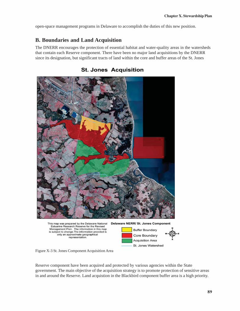
89
Chapter X. Stewardship Plan
open-space management programs in Delaware to accomplish the duties of this new position.
B. Boundaries and Land AcquisitionThe DNERR encourages the protection of essential habitat and water-quality areas in the watershedsthat contain each Reserve component. There have been no major land acquisitions by the DNERRsince its designation, but significant tracts of land within the core and buffer areas of the St. Jones
Reserve component have been acquired and protected by various agencies within the Stategovernment. The main objective of the acquisition strategy is to promote protection of sensitive areasin and around the Reserve. Land acquistion in the Blackbird component buffer area is a high priority.
Figure X-3 St. Jones Component Acquisition Area
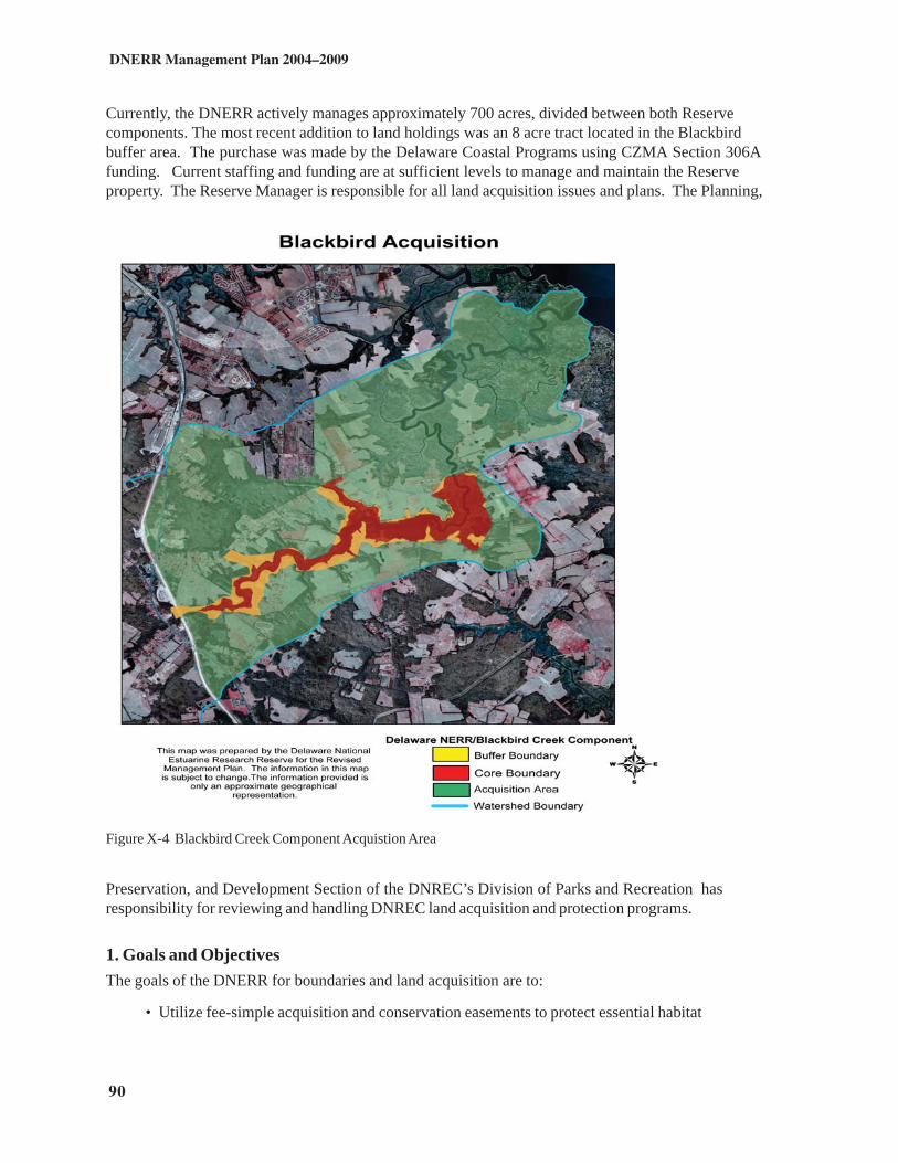
90
DNERR Management Plan 2004–2009
Currently, the DNERR actively manages approximately 700 acres, divided between both Reservecomponents. The most recent addition to land holdings was an 8 acre tract located in the Blackbirdbuffer area. The purchase was made by the Delaware Coastal Programs using CZMA Section 306Afunding. Current staffing and funding are at sufficient levels to manage and maintain the Reserveproperty. The Reserve Manager is responsible for all land acquisition issues and plans. The Planning,
Preservation, and Development Section of the DNREC’s Division of Parks and Recreation hasresponsibility for reviewing and handling DNREC land acquisition and protection programs.
1. Goals and ObjectivesThe goals of the DNERR for boundaries and land acquisition are to:
• Utilize fee-simple acquisition and conservation easements to protect essential habitat
Figure X-4 Blackbird Creek Component Acquistion Area

91
Chapter X. Stewardship Plan
and water-quality areas within each Reserve component’s watershed.• Identify significant unprotected estuarine areas within the State of Delaware.• Purchase land within component buffer areas and then expand the core area
designation to include these lands.
Specific objectives to aid in achieving these goals include:
• Developing a land-acquisition plan that prioritizes properties in each Reservecomponent’s core and buffer areas.
• Increasing local awareness of land preservation options.
2. Acquisition AreasEach Reserve component has a defined acquisition area. Figures X-3 and X-4 reflect the areaswhere land acquisition activities will take place over the next five years. The acquisition maps reflectthe areas that the Reserve is interested in acquiring properties, easements or facilitating protectionby other public and private groups. The boudaries of the maps areas were determined by the limitsof the lower watershed around each component. The maps do reflect distintions betweenproperties that are already protected. Any core and buffer areas that are not held in Stateownership are also included as priority acquisition areas. The identified areas allow the Reserve tofocus on properties that border the current boundaries, but also on properties that will ensure thecontinued environmental quality of the surrounding watersheds. The priority for land acquisition isthe fee-simple purchase or conservation easement purchase of any remaining properties held inprivate ownership that are in the core and buffer boundaries. Secondary priority will be given toany properties that are contiguous to the Reserve boundaries.3. Fee-simple versus Conservation EasementsWhen a property is identified for protection, based on the owner’s willingness to sell and availablefunding sources, the DNERR will choose the appropriate method of protection. Determining factorswill include the properties’ management requirements, location, ecological value, and cost.
Fee-simple acquisition will be used to:• acquire property in the Reserve’s core and buffer areas• expand Reserve boundaries into areas of high value to the research, education, and
stewardship programs• acquire property that protects water quality and biodiversity within the St. Jones and
Blackbird Creek Watersheds
Conservation easements are valuable tools that will be used to leverage funding with acquisition/protection needs. Easements allow property to be protected while reducing costs and managementresponsibility, and ensuring permanent protected status. Conservation easements will be used to:
• purchase development rights• protect water quality and biodiversity within the St. Jones and Blackbird Creek
Watersheds• provide access for research and education programming• protect property that holds significant ecological value

92
DNERR Management Plan 2004–2009
The decision to choose fee-simple acquisition over the purchase of a conservation easement rests onseveral factors. If a property offers adequate public access and will provide additional areas forresearch and education activities, fee-simple acquisition will be favored. If a property contains habitattypical of other Reserve holdings, has limited public access, or has owners that are unwilling toconsider fee-simple acquisition, purchase of a conservation easement will be favored.
4. St. Jones ComponentLand acquisition/protection in the core and buffer areas of the St. Jones Reserve component has beenvery successful with the efforts of the DNREC Division of Fish and Wildlife and the Division ofHistoric and Cultural Affairs. The property acquisitions by these Divisions have established a largecorridor of protected land in which the DNERR is a significant component. Future land acquisitionstrategies by the DNERR will focus on the remaining unprotected core and buffer areas.
Core area acquisition is the primary focus in the St. Jones Reserve component. Within the core area,special emphasis is placed on any land that adjoins the current DNERR boundaries or borders the St.Jones River. Over time, it is hoped that funds and willing sellers will be identified so that the remainingfarmland adjacent to the Reserve will be purchased through fee-simple acquisition.Expanding into these areas will allow for greater research, educational, and stewardship opportunitiesas well as provide space for future building expansions if they become necessary.
Acquiring land within the Reserve buffer areas will be evaluated after all significant core areas areprotected or when a property of significant ecological value becomes available. The Reserve will befocusing on land located on the southern side as well as upstream portions of the St. Jones River. Bothfee-simple and conservation easements will be options exercised to permanently protect these areas.
Acquisition priorities for the St. Jones Component are:• farmland adjoining current core boundaries• properties located within Reserve buffer areas• properties that lie along the St. Jones River• properties that will enhance, preserve, or restore ecological function within the St.
Jones Watershed, e.g., restoration sites, Bald Eagle nesting areas, and marsh
5. Blackbird Creek ComponentThe Blackbird Creek core and buffers areas are mostly comprised of properties that are privatelyowned but protected through easement or state regulation. State ownership of land in this area issignificantly less than that around the St. Jones component. The location of the Reserve in relation tothe growing development pressure in the area demands that land protection activities by the Reservefocus largely on the Blackbird Creek component. Local landowners have had remarkable successwith conservation programs. The local community recognizes the ecological importance of the areaand actively works to reduce development pressure. In particular, large portions of the privately heldsections of core and buffer areas of the Blackbird Creek Reserve component are protected underDelaware’s Farmland Preservation Program. Landowners who place their lands into FarmlandPreservation agree to not develop their lands for at least 10 years, devoting the land only to agricultureand related uses. In return, the owners receive tax benefits, right-to-farm protection, and anopportunity to sell a preservation easement to the state that keeps the land free from developmen. Thefarming community in the Blackbird Watershed was a driving force in establishing this Stateadministered program, and strong support still exists.

93
Chapter X. Stewardship Plan
Fee-simple acquisition will be utilized when a willing seller has been identified and the property is ofsignificant value. Conservation easements will also play a critical role. It is anticipated that a largeportion of land that lies within the core and buffer areas will remain in private ownership. Conservationeasements, purchase of development rights, and promotion of farmland preservation have the potentialto protect large portions of land while remaining cost effective and minimally increasing managementresponsibility for DNERR staff.
The DNERR places a priority on protecting core and buffer areas. Watershed protection, whileextremely important and a component of the overall acquisition strategy, is secondary, unlessproperties of significant ecological importance become available.
Acquisition priorities for the Blackbird Creek Reserve component are:• core and buffer area parcels• property that will grant access to Blackbird Creek• property that will enhance, preserve, or restore ecological function within the
Blackbird Creek Watershed
6. Watershed ProtectionReserve watershed protection is a significant consideration when acquisition priorities are beingestablished. Secondary to that consideration is the protection of fragile estuarine communities aroundthe State. As part of the management plan revision process, it was suggested by the AdvisoryCommittee that the DNERR take a keen interest in its “own backyard” prior to acquiring land in otherareas. This opinion rang true and has been adopted as a guiding principle. There are significant issuesof pollution, encroachment, habitat degradation, and invasive species within DNERR watersheds thatcan be addressed through local land purchases or conservation easements, whether by the DNERR orother conservation groups. All coastal and watershed protection benefits State resources, includingthose of significance to the DNERR. Therefore, partnerships with other land conservationorganizations, both public and private, are important. These partnerships generate mutual benefitswithin and outside DNERR core and buffer areas.
C. Boundary AmendmentIn December of 2004 and February of 2005 the DNERR purchased new property for the first timesince its designation, the Lowe and Manwaring tracts. Both properties are located along BlackbirdCreek and each’s marsh portions were located within the DNERR buffer boundaries prior toacquisition. Both parcels include the following habitats: forested uplands, wetlands, marsh andfarmland. The Reserve purchased the properties for their high ecological value. All marshwetlands, or forested uplands acquired will be managed to preserve environmental quality, minimizedetrimental impacts and control invasive species.
The properties were purchased in response to 312 evaulation recommendations. Each parcelprovides access to Blackbird Creek, increased opportunties for research, education, and restoration.The growing pressure for public access in the area will be addressed through passive recreationexperiences on both parcels. An interpretive trail system will be constructed. The Lowe tractprovides an excellent area to demonstrate restoration practices and will house a visitor center in thefuture. The properties are considerably valuable because they are contiguous and protect a largeportion of river front.

94
DNERR Management Plan 2004–2009
1. Lowe TractThis property located at801 Blackbird LandingRoad, was formerlyknown as the OdessaCampground. It wasoperated as a campgroundfor nearly 40 years. In thelast decade the site fellinto disrepair, but stillretained high qualityhabitat in areas that borderBlackbird Creek. TheDNERR purchased all 62acres in December 2004.The site provides greatopportunties forrestoration and publiceducation activities. Acanoe launch will beinstalled and publicprograms will be offeredbeginning in the spring of2005. All remnants of theproperties former life as acampground will beremoved includingdemolition of all strucutresand removal of electric,water and telephone lines.Once the infrastructurehas been removed theDNERR will reforest themajority of open acreageas well as begincontrolling invasive species.
2. Manwaring TractThis property is located at 803 Blackbird Landing Road and is directly adjacent to the Lowe tract. Itis 85 acres in size and was purchased in February 2005. The property contains approximately 8 acresof farmland with the remaining portion in woodland, marsh and warm season grasses. Unlike theLowe tract, this property will need little to no restoration. It has been enrolled in the ConservationReserve Program, administered by the U.S. Department of Agriculture, for the last 9 years. The siteoffers excellent habitat and will be linked with the Lowe tract by an interpretive trail.
Both properties will be managed in accordance with this management plan. Upon approval of thisupdated management plan the DNERR will expand its boundaries to include the Lowe andManwaring tracts (Figure X-5 ). Sufficient public notice and comment period will be provided as
Figure X-5. Blackbird Component boundary expansion

95
Chapter X. Stewardship Plan
part of the plan approval process.
D. Action Plan for StewardshipThe DNERR will engage in the following activities pertaining to the protection of the Reserve’sresources and watersheds and the possible future expansion of its boundaries. A key tool in this plan isthe Protected Area Geographic Information System (PAGIS), a System-wide effort providing GISresources to assist researchers and decision-makers in gaining land-use information. All Reserveacquisitions will be dependent upon funding and staffing availability.
• Action 1: Protect land within the core and buffer areas of the DNERRthrough fee-simple acquisition and conservation easements
The DNERR will, as funding and willing sellers allow, acquire properties that enhance,preserve, or restore water quality and biodiversity and allow expanded research,education, and stewardship activities. Priority will be in the DNERR core and bufferareas. Properties that lie within the DNERR watersheds but outside core and bufferareas will be evaluated on a per case basis.
• Action 2: Promote conservation practices in agriculture at and beyond theReserve
The DNERR will develop a nutrient management plan for all agricultural lands owned bythe Reserve. The DNERR will also develop and deliver education and outreachprograms to the farming community that focus on the adoption of conservation practicesfor water-quality protection. This will be done by providing demonstration plots, seminars,and field days in cooperative partnerships with State, Federal, and nongovernmentalagencies working with the farming community for the implementation of conservationpractices.
• Action 3: Sponsor resource-protection projects at the St. Jones Reservecomponent
By working closely with the Kent County Soil Conservation District, the DNERR willmaintain and promote the Conservation Demonstration Area and develop signage andliterature for visitors to the site. The DNERR will also continue to support the efforts ofthe Delaware Native Plant Society by providing space and labor to maintain the NativePlant Nursery.
• Action 4: Continue to control access to the Reserve componentsThe DNERR will continue and improve strategies for surveillance and enforcement atboth Reserve components by coordinating with the DNREC DFW Enforcement Sectionand the City of Dover Police. Access to the Blackbird Creek Reserve component willcontinue to be restricted to minimize adverse impacts on its critical natural resources.
• Action 5: Explore the feasibility of funding and filling the position ofStewardship Coordinator (see Chapter V, the Administration Plan)

96
DNERR Management Plan 2004–2009
• Action 6: Manage invasive species in and around the ReserveThe DNERR will create a database of existing terrestrial and aquatic invasive specieswithin the Reserve and surrounding areas. The spread of invasives in the Reserve will becontrolled through chemical and physical eradication. Populations will be monitored bythe Conservationist and Reserve Manager.
• Action 7: Promote land preservation within the Reserve's watershedsCore and buffer area boundaries will be reevaluated and correlated to habitat, water-quality, and critical-area protection within the watersheds of both Reserve components.The DNERR will identify and compile a list of priority land-acquisition areas within thesewatersheds. Education and outreach programs and materials (e.g., workshops, brochures,and signs) will be developed for local landowners in order to identify options for, and topromote the use of, conservation easements, agricultural districts, and other land-preservation options within the Reserve's watersheds. The DNERR will also assist otherland-preservation groups and agencies as needed to protect land within the Reserve’swatersheds.
• Action 8: Expand the Reserve boundaries to include the Lowe andManwarring Tracts
Upon approval of this management plan the new Reserve boundaries will include bothrecently acquired tracts.

A-1
Appendix A. Projected Five-Year Implementation Plan forthe Delaware National Estuarine Research Reserve
(Please note: all tasks depend upon sufficient funding and staff, and are therefore subject to change.)
Ongoing
• Continue interaction with and assistance to DNREC, DCP, and NOAA, providingreports as needed/required
• Improve strategies for coordination among partners• Explore feasibility of State funding for core positions• Explore State match options• Continue overall maintenance, surveillance, and enforcement at both Reserve sites• Keep Reserve records and maps up-to-date• Encourage staff participation in relevant conferences, training programs, and
workshops• Provide on-site and outreach education experiences for school children• Disseminate information regarding current events, research, etc. to the general public
and other audiences• Encourage transfer of information between the research and education sections• Participate in NERRS initiatives such as SWMP and CTP• Participate in the statewide Biodiversity Initiative• Assist Delaware State University and serve as a base of operations and logistics
center for all Delaware-based research for the ECSC• Monitor Reserve sites for changes in biodiversity• Monitor and, when necessary, control invasive species• Continue land acquisition activities• Recruit volunteers
Year 1: 2004–2005
• Plan for Year 2• Fill a temporary Volunteer Coordinator position through Public Allies/Americorps• Explore funding for a full-time CTP Coordinator position• Complete Expansion Phase II• Seek nonprofit status for the Friends of the DNERR• Increase activities for volunteers and the Friends of the DNERR• Develop a brochure to advertise volunteer opportunities at the Reserve• Conduct three Coastal Decision-Maker Workshops• Complete a marketing plan and strategy document for the CTP

A-2
DNERR Management Plan 2004–2009
• Construct a Conservation Demonstration Area at the St. Jones reserve component• Renew the MOU with the Delaware Native Plant Society• Construct an exhibit for the Native Plant Nursery that presents the importance of
biodiversity• Develop self-guided activities for school groups to alleviate staff crunches during busy
times• Conduct a public access/use assessment of the Blackbird Creek Component• Conduct a facilities and educational programming needs assessment for the Blackbird
Creek Component• Monitor the Blackbird Creek watershed for changes in biodiversity and environmental
quality as urban development, especially the Odessa National Development,encroaches on the watershed
Year 2: 2005–2006
• Plan for Year 3• Conduct needs assessments for the CTP• Conduct six workshops or 60 session hours of coastal training• Explore possibility of funding and filling a part-time Volunteer Coordinator position• Explore possibility of funding and filling a Stewardship Coordinator position• Develop nutrient management plans for both Reserve sites• Continue to identify priority land-acquisition areas within each Reserve component
and throughout the State• Continue research on toxic effects of contaminants and bioaccumulation on catfish
and osprey• Continue monitoring biodiversity and environmental quality of the Blackbird Creek
watershed• Coordinate with State agencies in benthic mapping of portions of the Delaware
Estuary• Work with the University of Delaware Center for Remote Sensing to cooperate and
encourage remote sensing of the Reserve and other estuaries• Support development of GIS data coverages by digitizing and ortho-rectifying historic
photographs• Map areas of phragmites, Purple Loosestrife, and Canadian Thistle in both
watersheds and examine innovative control measures as needed• Seek volunteer services for opening the St. Jones reserve component on weekends• Construct one or more outdoor exhibits with topics to include saltmarsh plants and/or
birds of the Reserve

A-3
Appendix A. Five-Year Implementation Plan
Year 3: 2006–2007
• Plan for Year 4• Explore feasibility and funding for a full-time Volunteer Coordinator• Hire or contract out for a full-time CTP Coordinator• Provide 6–10 sessions or 60–120 hours of coastal training opportunities• Explore distance-learning opportunities for coastal training• Formally correlate education field trip and outreach programs to the Delaware
Department of Education’s science modules• Construct an indoor rotating exhibit to highlight current Reserve/coastal research• Develop outreach materials and workshops to support the Conservation
Demonstration Area• Develop programs to monitor and evaluate BMPs throughout the DNERR
watersheds and surrounding regions
Year 4: 2007–2008
• Plan for Year 5• Meet with steering committees to discuss the next revision of the management plan• Evaluate need to move or expand the Coastal Resource Library• Provide 6–10 sessions or 60–120 hours, or more, of coastal training opportunities• Explore possibility of increasing signage along the major highways near both Reserve
sites• Supply monitoring equipment and human resources along with result analysis to
evaluate BMPs
Year 5: 2008–2009
• Plan for the next cycle• Write third edition of the DNERR Management Plan• Provide 6–10 sessions or 60–120 hours, or more, of coastal training opportunities• Evaluate need for an Administrative Assistant• Evaluate need for increased dormitory facilities and implement plans as funding allows• Explore fabrication of low-impact exhibits at the Blackbird Creek reserve component
that will not interfere with the defined uses and restrictions of this site• Supply monitoring equipment and human resources along with result analysis to
evaluate BMPs


B-1
Appendix B. Establishment of the National EstuarineResearch Reserve System by the Coastal ZoneManagement ActU.S. Code Title 16, Chapter 33, §1461, Section 315 – as amended through P.L. 104–150,the Coastal Zone Protection Act of 1996Source: http://www.ocrm.nos.noaa.gov/czm/czm_act.html, accessed August 30, 2002.
(a) Establishment of the System.There is established the National Estuarine Research Reserve System (hereinafter referred to in this section asthe “System”) that consists of—(1) each estuarine sanctuary designated under this section as in effect before the date of the enactment of theCoastal Zone Management Reauthorization Act of 1985 [enacted Apr. 7, 1986]; and(2) each estuarine area designated as a national estuarine reserve under subsection (b).Each estuarine sanctuary referred to in paragraph (1) is hereby designated as a national estuarine reserve.
(b) Designation of national estuarine reserves.After the date of the enactment of the Coastal Zone Management Reauthorization Act of 1985 [enacted Apr. 7,1986], the Secretary may designate an estuarine area as a national estuarine reserve if—(1) the Governor of the coastal state in which the area is located nominates the area for that designation; and(2) the Secretary finds that—(A) the area is a representative estuarine ecosystem that is suitable for long-term research and contributes to thebiogeographical and typological balance of the System;(B) the law of the coastal state provides long-term protection for reserve resources to ensure a stableenvironment for research;(C) designation of the area as a reserve will serve to enhance public awareness and understanding of estuarineareas, and provide suitable opportunities for public education and interpretation; and(D) the coastal state in which the area is located has complied with the requirements of any regulations issued bythe Secretary to implement this section.
(c) Estuarine research guidelines.The Secretary shall develop guidelines for the conduct of research within the System that shall include–(1) a mechanism for identifying, and establishing priorities among, the coastal management issues that should beaddressed through coordinated research within the System;(2) the establishment of common research principles and objectives to guide the development of researchprograms within the System;(3) the identification of uniform research methodologies which will ensure comparability of data, the broadestapplication of research results, and the maximum use of the System for research purposes;(4) the establishment of performance standards upon which the effectiveness of the research efforts and thevalue of reserves within the System in addressing the coastal management issues identified in paragraph (1) maybe measured; and(5) the consideration of additional sources of funds for estuarine research than the funds authorized under thisAct, and strategies for encouraging the use of such funds within the System, with particular emphasis onmechanisms established under subsection (d).In developing the guidelines under this section, the Secretary shall consult with prominent members of theestuarine research community.
(d) Promotion and coordination of estuarine research.The Secretary shall take such action as is necessary to promote and coordinate the use of the System forresearch purposes including—(1) requiring that the National Oceanic and Atmospheric Administration, in conducting or supporting estuarineresearch, give priority consideration to research that uses the System; and

B-2
DNERR Management Plan 2004–2009
(2) consulting with other Federal and State agencies to promote use of one or more reserves within the Systemby such agencies when conducting estuarine research.
(e) Financial assistance.(1) The Secretary may, in accordance with such rules and regulations as the Secretary shall promulgate, makegrants—(A) to a coastal state—(i) for purposes of acquiring such lands and waters, and any property interests therein, as are necessary toensure the appropriate long-term management of an area as a national estuarine reserve,(ii) for purposes of operating or managing a national estuarine reserve and constructing appropriate reservefacilities, or(iii) for purposes of conducting educational or interpretive activities; and(B) to any coastal state or public or private person for purposes of supporting research and monitoring within anational estuarine reserve that are consistent with the research guidelines developed under subsection (c).(2) Financial assistance provided under paragraph (1) shall be subject to such terms and conditions as theSecretary considers necessary or appropriate to protect the interests of the United States, including requiringcoastal states to execute suitable title documents setting forth the property interest or interests of the UnitedStates in any lands and waters acquired in whole or part with such financial assistance.(3)(A) The amount of the financial assistance provided under paragraph (1)(A)(i) with respect to the acquisition oflands and waters, or interests therein, for any one national estuarine reserve may not exceed an amount equal to50 percent of the costs of the lands, waters, and interests therein or $5,000,000, whichever amount is less.(B) The amount of the financial assistance provided under paragraph (1)(A) (ii) and (iii) and paragraph (1)(B) maynot exceed 70 percent of the costs incurred to achieve the purposes described in those paragraphs with respectto a reserve; except that the amount of the financial assistance provided under paragraph (1)(A)(iii) may be up to100 percent of any costs for activities that benefit the entire System.(C) Notwithstanding subparagraphs (A) and (B), financial assistance under this subsection provided fromamounts recovered as a result of damage to natural resources located in the coastal zone may be used to pay 100percent of the costs of activities carried out with the assistance.
(f) Evaluation of system performance.(1) The Secretary shall periodically evaluate the operation and management of each national estuarine reserve,including education and interpretive activities, and the research being conducted within the reserve.(2) If evaluation under paragraph (1) reveals that the operation and management of the reserve is deficient, orthat the research being conducted within the reserve is not consistent with the research guidelines developedunder subsection (c), the Secretary may suspend the eligibility of that reserve for financial assistance undersubsection (e) until the deficiency or inconsistency is remedied.(3) The Secretary may withdraw the designation of an estuarine area as a national estuarine reserve if evaluationunder paragraph (1) reveals that—(A) the basis for any one or more of the findings made under subsection (b)(2) regarding that area no longerexists; or(B) a substantial portion of the research conducted within the area, over a period of years, has not beenconsistent with the research guidelines developed under subsection (c).
(g) Report.The Secretary shall include in the report required under section 316 [16 USC § 1462] information regarding—(1) new designations of national estuarine reserves;(2) any expansion of existing national estuarine reserves;(3) the status of the research program being conducted within the System; and(4) a summary of the evaluations made under subsection (f).

C-1
Appendix C. National Estuarine Research ReserveSystem Regulations
U.S. Code Title 15, Chapter 9, Section 921 - revised as of January 1, 2002
Source: http://www.access.gpo.gov/nara/cfr/waisidx_02/15cfr921_02.html, accessed August 30, 2002.
Subpart A--General
Sec. 921.1 Mission, goals and general provisions.(a) The mission of the National Estuarine Research Reserve Program is the establishment and management, throughFederal-state cooperation, of a national system (National Estuarine Research Reserve System or System) of estuarineresearch reserves (National Estuarine Research Reserves or Reserves) representative of the various regions andestuarine types in the United States. National Estuarine Research Reserves are established to provide opportunities forlong-term research, education, and interpretation.(b) The goals of the Program are to: (1) Ensure a stable environment for research through long-term protection ofNational Estuarine Research Reserve resources; (2) Address coastal management issues identified as significantthrough coordinated estuarine research within the System; (3) Enhance public awareness and understanding ofestuarine areas and provide suitable opportunities for public education and interpretation; (4) Promote Federal, state,public and private use of one or more Reserves within the System when such entities conduct estuarine research; and(5) Conduct and coordinate estuarine research within the System, gathering and making available informationnecessary for improved understanding and management of estuarine areas.(c) National Estuarine Research Reserves shall be open to the public to the extent permitted under state and Federallaw. Multiple uses are allowed to the degree compatible with each Reserve's overall purpose as provided in themanagement plan (see Sec. 921.13) and consistent with paragraphs (a) and (b) of this section. Use levels are set by thestate where the Reserve is located and analyzed in the management plan. The Reserve management plan shall describethe uses and establish priorities among these uses. The plan shall identify uses requiring a state permit, as well as areaswhere uses are encouraged or prohibited. Consistent with resource protection and research objectives, public accessand use may be restricted to certain areas or components within a Reserve.(d) Habitat manipulation for research purposes is allowed consistent with the following limitations. Manipulativeresearch activities must be specified in the management plan, be consistent with the mission and goals of the program(see paragraphs (a) and (b) of this section) and the goals and objectives set forth in the Reserve's management plan,and be limited in nature and extent to the minimum manipulative activity necessary to accomplish the stated researchobjective. Manipulative research activities with a significant or long-term impact on Reserve resources require theprior approval of the state and the National Oceanic and Atmospheric Administration (NOAA). Manipulative researchactivities which can reasonably be expected to have a significant adverse impact on the estuarine resources and habitatof a Reserve, such that the activities themselves or their resulting short- and long-term consequences compromise therepresentative character and integrity of a Reserve, are prohibited. Habitat manipulation for resource managementpurposes is prohibited except as specifically approved by NOAA as: (1) A restoration activity consistent with paragraph(e) of this section; or (2) an activity necessary for the protection of public health or the preservation of other sensitiveresources which have been listed or are eligible for protection under relevant Federal or state authority (e.g.,threatened/endangered species or significant historical or cultural resources) or if the manipulative activity is a long-term pre-existing use (i.e., has occurred prior to designation) occurring in a buffer area. If habitat manipulation isdetermined to be necessary for the protection of public health, the preservation of sensitive resources, or if themanipulation is a long-term pre-existing use in a buffer area, then these activities shall be specified in the Reservemanagement plan in accordance with Sec. 921.13(a)(10) and shall be limited to the reasonable alternative which hasthe least adverse and shortest term impact on the representative and ecological integrity of the Reserve.(e) Under the Act an area may be designated as an estuarine Reserve only if the area is a representative estuarineecosystem that is suitable for long-term research. Many estuarine areas have undergone some ecological change as aresult of human activities (e.g., hydrological changes, intentional/unintentional species composition changes--introduced and exotic species). In those areas proposed or designated as National Estuarine Research Reserves, suchchanges may have diminished the representative character and integrity of the site. Although restoration of degradedareas is not a primary purpose of the System, such activities may be permitted to improve the representative characterand integrity of a Reserve. Restoration activities must be carefully planned and approved by NOAA through the

C-2
DNERR Management Plan 2004–2009
Reserve management plan. Historical research may be necessary to determine the ''natural'' representative state of anestuarine area (i.e., an estuarine ecosystem minimally affected by human activity or influence). Frequently, restorationof a degraded estuarine area will provide an excellent opportunity for management oriented research.(f) NOAA may provide financial assistance to coastal states, not to exceed, per Reserve, 50 percent of all actual costs or$5 million whichever amount is less, to assist in the acquisition of land and waters, or interests therein. NOAA mayprovide financial assistance to coastal states not to exceed 70 percent of all actual costs for the management andoperation of, the development and construction of facilities, and the conduct of educational or interpretive activitiesconcerning Reserves (see subpart I). NOAA may provide financial assistance to any coastal state or public or privateperson, not to exceed 70 percent of all actual costs, to support research and monitoring within a Reserve.Notwithstanding any financial assistance limits established by this Part, when financial assistance is provided fromamounts recovered as a result of damage to natural resources located in the coastal zone, such assistance may be usedto pay 100 percent of all actual costs of activities carrier out with this assistance, as long as such funds are available.Predesignation, acquisition and development, operation and management, special research and monitoring, andspecial education and interpretation awards are available under the National Estuarine Reserve Program.Predesignation awards are for site selection/feasibility, draft management plan preparation and conduct of basiccharacterization studies. Acquisition and development awards are intended primarily for acquisition of interests inland, facility construction and to develop and/or upgrade research, monitoring and education programs. Operationand management awards provide funds to assist in implementing, operating and managing the administrative, andbasic research, monitoring and education programs, outlined in the Reserve management plan. Special research andmonitoring awards provide funds to conduct estuarine research and monitoring projects with the System. Specialeducational and interpretive awards provide funds to conduct estuarine educational and interpretive projects withinthe System.(g) Lands already in protected status managed by other Federal agencies, state or local governments, or privateorganizations may be included within National Estuarine Research Reserves only if the managing entity commits tolong-term management consistent with paragraphs (d) and (e) of this section in the Reserve management plan.Federal lands already in protected status may not comprise a majority of the key land and water areas of a Reserve (seeSec. 921.11(c)(3)). (h) To assist the states in carrying out the Program's goals in an effective manner, NOAA willcoordinate a research and education information exchange throughout the National Estuarine Research ReserveSystem. As part of this role, NOAA will ensure that information and ideas from one Reserve are made available toothers in the System. The network will enable Reserves to exchange information and research data with each other,with universities engaged in estuarine research, and with Federal, state, and local agencies. NOAA's objective is asystem-wide program of research and monitoring capable of addressing the management issues that affect long-termproductivity of our Nation's estuaries.[58 FR 38215, July 15, 1993, as amended at 62 FR 12540, Mar. 17, 1997; 63 FR 26717, May 14, 1998]
Sec. 921.2 Definitions.(a) Act means the Coastal Zone Management Act of 1972, as amended, 16 U.S.C. 1451 et seq.(b) Assistant Administrator means the Assistant Administrator for Ocean Services and Coastal Zone Management ordelegee.(c) Coastal state means a state of the United States, in or bordering on, the Atlantic, Pacific, or Arctic Ocean, the Gulfof Mexico, Long Island Sound, or one or more of the Great Lakes. For the purposes of these regulations the term alsoincludes Puerto Rico, the Virgin Islands, Guam, the Commonwealth of the Northern Marianas Islands, the TrustTerritories of the Pacific Islands, and American Samoa (see 16 U.S.C. 1453(4)).(d) State agency means an instrumentality of a coastal state to whom the coastal state has delegated the authority andresponsibility for the creation and/or management/operation of a National Estuarine Research Reserve. Factorsindicative of this authority may include the power to receive and expend funds on behalf of the Reserve, acquire andsell or convey real and personal property interests, adopt rules for the protection of the Reserve, enforce rulesapplicable to the Reserve, or develop and implement research and education programs for the reserve. For thepurposes of these regulations, the terms ``coastal state'' and ``State agency'' shall be synonymous.(e) Estuary means that part of a river or stream or other body of water having unimpaired connection with the opensea, where the sea water is measurably diluted with fresh water derived from land drainage. The term also includesestuary-type areas with measurable freshwater influence and having unimpaired connections with the open sea, andestuary-type areas of the Great Lakes and their connecting waters (see 16 U.S.C. 1453(7)).(f) National Estuarine Research Reserve means an area that is a representative estuarine ecosystem suitable for long-term research, which may include all of the key land and water portion of an estuary, and adjacent transitional areasand uplands constituting to the extent feasible a natural unit, and which is set aside as a natural field laboratory toprovide long-term opportunities for research, education, and interpretation on the ecological relationships within the

C-3
Appendix C. NERRS Regulations
area (see 16 U.S.C. 1453(8)) and meets the requirements of 16 U.S.C. 1461(b). This includes those areas designated asNational Estuarine Sanctuaries or Reserves under section 315 of the Act prior to enactment of the Coastal Zone ActReauthorization Amendments of 1990 and each area subsequently designated as a National Estuarine ResearchReserve.
Sec. 921.3 National Estuarine Research Reserve System Biogeographic Classification Scheme and Estuarine Typologies.(a) National Estuarine Research Reserves are chosen to reflect regional differences and to include a variety ofecosystem types. A biogeographic classification scheme based on regional variations in the nation's coastal zone hasbeen developed. The biogeographic classification scheme is used to ensure that the National Estuarine ResearchReserve System includes at least one site from each region. The estuarine typology system is utilized to ensure that sitesin the System reflect the wide range of estuarine types within the United States.(b) The biogeographic classification scheme, presented in appendix I, contains 29 regions. Figure 1 graphically depictsthe biogeographic regions of the United States.(c) The typology system is presented in appendix II.
Sec. 921.4 Relationship to other provisions of the Coastal Zone Management Act, and to the Marine Protection,Research and Sanctuaries Act.(a) The National Estuarine Research Reserve System is intended to provide information to state agencies and otherentities involved in addressing coastal management issues. Any coastal state, including those that do not have approvedcoastal management programs under section 306 of the Act, is eligible for an award under the National EstuarineResearch Reserve Program (see Sec. 921.2(c)).(b) For purposes of consistency review by states with a federally approved coastal management program, thedesignation of a National Estuarine Research Reserve is deemed to be a Federal activity, which, if directly affecting thestate's coastal zone, must be undertaken in a manner consistent to the maximum extent practicable with the approvedstate coastal management program as provided by section 1456(c)(1) of the Act, and implementing regulations at 15CFR part 930, subpart C. In accordance with section 1456(c)(1) of the Act and the applicable regulations NOAA willbe responsible for certifying that designation of the Reserve is consistent with the state's approved coastal managementprogram. The state must concur with or object to the certification. It is recommended that the lead state agency forReserve designation consult, at the earliest practicable time, with the appropriate state officials concerning theconsistency of a proposed National Estuarine Research Reserve.(c) The National Estuarine Research Reserve Program will be administered in close coordination with the NationalMarine Sanctuary Program (Title III of the Marine Protection, Research and Sanctuaries Act, as amended, 16 U.S.C.1431-1445), also administered by NOAA. Title III authorizes the Secretary of Commerce to designate discrete areas ofthe marine environment as National Marine Sanctuaries to protect or restore such areas for their conservation,recreational, ecological, historical, research, educational or esthetic values. National Marine Sanctuaries and EstuarineResearch Reserves may not overlap, but may be adjacent.
Subpart B--Site Selection, Post Site Selection and Management Plan Development
Sec. 921.10 General.(a) A coastal state may apply for Federal financial assistance for the purpose of site selection, preparation ofdocuments specified in Sec. 921.13 (draft management plan (DMP) and environmental impact statement (EIS)), andthe conduct of limited basic characterization studies. The total Federal share of this assistance may not exceed$100,000. Federal financial assistance for preacquisition activities under Sec. 921.11 and Sec. 921.12 is subject to thetotal $5 million for which each Reserve is eligible for land acquisition. Notwithstanding the above, when financialassistance is provided from amounts recovered as a result of damage to natural resources located in the coastal zone,such assistance may be used to pay 100 percent of all actual costs of activities carried out with this assistance, as long assuch funds are available. In the case of a biogeographic region (see appendix I) shared by two or more coastal states,each state is eligible for Federal financial assistance to establish a separate National Estuarine Research Reserve withintheir respective portion of the shared biogeographic region. Each separate National Estuarine Research Reserve iseligible for the full complement of funding. Financial assistance application procedures are specified in subpart I.(b) In developing a Reserve program, a state may choose to develop a multiple-site Reserve reflecting a diversity ofhabitats in a single biogeographic region. A multiple-site Reserve allows the state to develop complementary researchand educational programs within the individual components of its multi-site Reserve. Multiple-site Reserves aretreated as one Reserve in terms of financial assistance and development of an overall management framework andplan. Each individual site of a proposed multiple-site Reserve shall be evaluated both separately under Sec. 921.11(c)and collectively as part of the site selection process. A coastal state may propose to establish a multiple-site Reserve at

C-4
DNERR Management Plan 2004–2009
the time of the initial site selection, or at any point in the development or operation of the Reserve. If the state decidesto develop a multiple-site National Estuarine Research Reserve after the initial acquisition and development award ismade for a single site, the proposal is subject to the requirements set forth in Sec. 921.33(b). However, a state may notpropose to add one or more sites to an already designated Reserve if the operation and management of such Reservehas been found deficient and uncorrected or the research conducted is not consistent with the Estuarine ResearchGuidelines referenced in Sec. 921.51. In addition, Federal funds for the acquisition of a multiple-site Reserve remainlimited to $5,000,000 (see Sec. 921.20). The funding for operation of a multiple-site Reserve is limited to themaximum allowed for any one Reserve per year (see Sec. 921.32(c)) and preacquisition funds are limited to $100,000per Reserve. Notwithstanding the above, when financial assistance is provided from amounts recovered as a result ofdamage to natural resources located in the coastal zone, such assistance may be used to pay 100 percent of all actualcosts of activities carrier out with this assistance, as long as such funds are available.[58 FR 38215, July 15, 1993, as amended at 63 FR 26717, May 14, 1998]
Sec. 921.11 Site selection and feasibility.(a) A coastal state may use Federal funds to establish and implement a site selection process which is approved byNOAA.(b) In addition to the requirements set forth in subpart I, a request for Federal funds for site selection must contain thefollowing programmatic information: (1) A description of the proposed site selection process and how it will beimplemented in conformance with the biogeographic classification scheme and typology (Sec. 921.3); (2) Anidentification of the site selection agency and the potential management agency; and (3) A description of how publicparticipation will be incorporated into the process (see Sec. 921.11(d)).(c) As part of the site selection process, the state and NOAA shall evaluate and select the final site(s). NOAA has finalauthority in approving such sites. Site selection shall be guided by the following principles: (1) The site's contributionto the biogeographical and typological balance of the National Estuarine Research Reserve System. NOAA will givepriority consideration to proposals to establish Reserves in biogeographic regions or subregions or incorporating typesthat are not represented in the system (see the biogeographic classification scheme and typology set forth in Sec. 921.3and appendices I and II); (2) The site's ecological characteristics, including its biological productivity, diversity of floraand fauna, and capacity to attract a broad range of research and educational interests. The proposed site must be arepresentative estuarine ecosystem and should, to the maximum extent possible, be an estuarine ecosystem minimallyaffected by human activity or influence (see Sec. 921.1(e)). (3) Assurance that the site's boundaries encompass anadequate portion of the key land and water areas of the natural system to approximate an ecological unit and to ensureeffective conservation. Boundary size will vary greatly depending on the nature of the ecosystem. Reserve boundariesmust encompass the area within which adequate control has or will be established by the managing entity over humanactivities occurring within the Reserve. Generally, Reserve boundaries will encompass two areas: Key land and waterareas (or ''core area'') and a buffer zone. Key land and water areas and a buffer zone will likely require significantlydifferent levels of control (see Sec. 921.13(a)(7)). The term ''key land and water areas'' refers to that core area withinthe Reserve that is so vital to the functioning of the estuarine ecosystem that it must be under a level of controlsufficient to ensure the long-term viability of the Reserve for research on natural processes. Key land and water areas,which comprise the core area, are those ecological units of a natural estuarine system which preserve, for researchpurposes, a full range of significant physical, chemical and biological factors contributing to the diversity of fauna,flora and natural processes occurring within the estuary. The determination of which land and water areas are ''key'' toa particular Reserve must be based on specific scientific knowledge of the area. A basic principle to follow whendeciding upon key land and water areas is that they should encompass resources representative of the total ecosystem,and which if compromised could endanger the research objectives of the Reserve. The term buffer zone refers to anarea adjacent to or surrounding key land and water areas and essential to their integrity. Buffer zones protect the corearea and provide additional protection for estuarine-dependent species, including those that are rare or endangered.When determined appropriate by the state and approved by NOAA, the buffer zone may also include an area necessaryfor facilities required for research and interpretation. Additionally, buffer zones should be established sufficient toaccommodate a shift of the core area as a result of biological, ecological or geomorphological change which reasonablycould be expected to occur. National Estuarine Research Reserves may include existing Federal or state lands already ina protected status where mutual benefit can be enhanced. However, NOAA will not approve a site for potentialNational Estuarine Research Reserve status that is dependent primarily upon the inclusion of currently protectedFederal lands in order to meet the requirements for Reserve status (such as key land and water areas). Such landsgenerally will be included within a Reserve to serve as a buffer or for other ancillary purposes; and may be included,subject to NOAA approval, as a limited portion of the core area; (4) The site's suitability for long-term estuarineresearch, including ecological factors and proximity to existing research facilities and educational institutions; (5) Thesite's compatibility with existing and potential land and water uses in contiguous areas as well as approved coastal and

C-5
Appendix C. NERRS Regulations
estuarine management plans; and (6) The site's importance to education and interpretive efforts, consistent with theneed for continued protection of the natural system.(d) Early in the site selection process the state must seek the views of affected landowners, local governments, otherstate and Federal agencies and other parties who are interested in the area(s) being considered for selection as apotential National Estuarine Research Reserve. After the local government(s) and affected landowner(s) have beencontacted, at least one public meeting shall be held in the vicinity of the proposed site. Notice of such a meeting,including the time, place, and relevant subject matter, shall be announced by the state through the area's principalnewspaper at least 15 days prior to the date of the meeting and by NOAA in the Federal Register.(e) A state request for NOAA approval of a proposed site (or sites in the case of a multi-site Reserve) must contain adescription of the proposed site(s) in relationship to each of the site selection principals (Sec. 921.11(c)) and thefollowing information: (1) An analysis of the proposed site(s) based on the biogeographical scheme/typologydiscussed in Sec. 921.3 and set forth in appendices I and II; (2) A description of the proposed site(s) and its (their)major resources, including location, proposed boundaries, and adjacent land uses. Maps are required; (3) Adescription of the public participation process used by the state to solicit the views of interested parties, a summary ofcomments, and, if interstate issues are involved, documentation that the Governor(s) of the other affected state(s) hasbeen contacted. Copies of all correspondence, including contact letters to all affected landowners must be appended;(4) A list of all sites considered and a brief statement of the reasons why a site was not preferred; and (5) A nominationof the proposed site(s) for designation as a National Estuarine Research Reserve by the Governor of the coastal state inwhich the state is located.(f) A state proposing to reactivate an inactive site, previously approved by NOAA for development as an EstuarineSanctuary or Reserve, may apply for those funds remaining, if any, provided for site selection and feasibility (Sec.921.11a)) to determine the feasibility of reactivation. This feasibility study must comply with the requirements setforth in Sec. 921.11 (c) through (e).
Sec. 921.12 Post site selection.(a) At the time of the coastal state's request for NOAA approval of a proposed site, the state may submit a request forfunds to develop the draft management plan and for preparation of the EIS. At this time, the state may also submit arequest for the remainder of the predesignation funds to perform a limited basic characterization of the physical,chemical and biological characteristics of the site approved by NOAA necessary for providing EIS information toNOAA. The state's request for these post site selection funds must be accompanied by the information specified insubpart I and, for draft management plan development and EIS information collection, the following programmaticinformation: (1) A draft management plan outline (see Sec. 921.13(a) below); and (2) An outline of a draftmemorandum of understanding (MOU) between the state and NOAA detailing the Federal-state role in Reservemanagement during the initial period of Federal funding and expressing the state's long-term commitment to operateand manage the Reserve.(b) The state is eligible to use the funds referenced in Sec. 921.12(a) after the proposed site is approved by NOAAunder the terms of Sec. 921.11.
Sec. 921.13 Management plan and environmental impact statement development.(a) After NOAA approves the state's proposed site and application for funds submitted pursuant to Sec. 921.12, thestate may begin draft management plan development and the collection of information necessary for the preparationby NOAA of an EIS. The state shall develop a draft management plan, including an MOU. The plan shall set out indetail: (1) Reserve goals and objectives, management issues, and strategies or actions for meeting the goals andobjectives; (2) An administrative plan including staff roles in administration, research, education/interpretation, andsurveillance and enforcement; (3) A research plan, including a monitoring design; (4) An education/interpretive plan;(5) A plan for public access to the Reserve; (6) A construction plan, including a proposed construction schedule,general descriptions of proposed developments and general cost estimates. Information should be provided forproposed minor construction projects in sufficient detail to allow these projects to begin in the initial phase ofacquisition and development. A categorical exclusion, environmental assessment, or EIS may be required prior toconstruction; (7)(i) An acquisition plan identifying the ecologically key land and water areas of the Reserve, rankingthese areas according to their relative importance, and including a strategy for establishing adequate long-term statecontrol over these areas sufficient to provide protection for Reserve resources to ensure a stable environment forresearch. This plan must include an identification of ownership within the proposed Reserve boundaries, includingland already in the public domain; the method(s) of acquisition which the state proposes to use--acquisition(including less-than-fee simple options) to establish adequate long-term state control; an estimate of the fair marketvalue of any property interest--which is proposed for acquisition; a schedule estimating the time required to completethe process of establishing adequate state control of the proposed research reserve; and a discussion of any anticipated

C-6
DNERR Management Plan 2004–2009
problems. In selecting a preferred method(s) for establishing adequate state control over areas within the proposedboundaries of the Reserve, the state shall perform the following steps for each parcel determined to be part of the keyland and water areas (control over which is necessary to protect the integrity of the Reserve for research purposes), andfor those parcels required for research and interpretive support facilities or buffer purposes: (A) Determine, withappropriate justification, the minimum level of control(s) required [e.g., management agreement, regulation, less-than- fee simple property interest (e.g., conservation easement), fee simple property acquisition, or a combination ofthese approaches]. This does not preclude the future necessity of increasing the level of state control; (B) Identify thelevel of existing state control(s); (C) Identify the level of additional state control(s), if any, necessary to meet theminimum requirements identified in paragraph (a)(7)(i)(A) of this section; (D) Examine all reasonable alternativesfor attaining the level of control identified in paragraph (a)(7)(i)(C) of this section, and perform a cost analysis ofeach; and (E) Rank, in order of cost, the methods (including acquisition) identified in paragraph (a)(7)(i)(D) of thissection. (ii) An assessment of the relative cost-effectiveness of control alternatives shall include a reasonable estimate ofboth short-term costs (e.g., acquisition of property interests, regulatory program development including associatedenforcement costs, negotiation, adjudication, etc.) and long-term costs (e.g., monitoring, enforcement, adjudication,management and coordination). In selecting a preferred method(s) for establishing adequate state control over eachparcel examined under the process described above, the state shall give priority consideration to the least costlymethod(s) of attaining the minimum level of long-term control required. Generally, with the possible exception ofbuffer areas required for support facilities, the level of control(s) required for buffer areas will be considerably less thanthat required for key land and water areas. This acquisition plan, after receiving the approval of NOAA, shall serve as aguide for negotiations with landowners. A final boundary for the reserve shall be delineated as a part of the finalmanagement plan; (8) A resource protection plan detailing applicable authorities, including allowable uses, usesrequiring a permit and permit requirements, any restrictions on use of the research reserve, and a strategy for researchreserve surveillance and enforcement of such use restrictions, including appropriate government enforcementagencies; (9) If applicable, a restoration plan describing those portions of the site that may require habitatmodification to restore natural conditions; (10) If applicable, a resource manipulation plan, describing those portionsof the Reserve buffer in which long-term pre-existing (prior to designation) manipulation for reasons not related toresearch or restoration is occurring. The plan shall explain in detail the nature of such activities, shall justify why suchmanipulation should be permitted to continue within the reserve buffer; and shall describe possible effects of thismanipulation on key land and water areas and their resources; (11) A proposed memorandum of understanding(MOU) between the state and NOAA regarding the Federal-state relationship during the establishment anddevelopment of the National Estuarine Research Reserve, and expressing a long-term commitment by the state tomaintain and manage the Reserve in accordance with section 315 of the Act, 16 U.S.C. 1461, and applicableregulations. In conjunction with the MOU, and where possible under state law, the state will consider takingappropriate administrative or legislative action to ensure the long-term protection and operation of the NationalEstuarine Research Reserve. If other MOUs are necessary (such as with a Federal agency, another state agency orprivate organization), drafts of such MOUs must be included in the plan. All necessary MOU's shall be signed prior toReserve designation; and (12) If the state has a federally approved coastal management program, a certification thatthe National Estuarine Research Reserve is consistent to the maximum extent practicable with that program. See Secs.921.4(b) and 921.30(b).(b) Regarding the preparation of an EIS under the National Environmental Policy Act on a National EstuarineResearch Reserve proposal, the state and NOAA shall collect all necessary information concerning the socioeconomicand environmental impacts associated with implementing the draft management plan and feasible alternatives to theplan. Based on this information, the state will draft and provide NOAA with a preliminary EIS.(c) Early in the development of the draft management plan and the draft EIS, the state and NOAA shall hold a scopingmeeting (pursuant to NEPA) in the area or areas most affected to solicit public and government comments on thesignificant issues related to the proposed action. NOAA will publish a notice of the meeting in the Federal Register atleast 15 days prior to the meeting. The state shall be responsible for publishing a similar notice in the local media.(d) NOAA will publish a Federal Register notice of intent to prepare a draft EIS. After the draft EIS is prepared andfiled with the Environmental Protection Agency (EPA), a Notice of Availability of the draft EIS will appear in theFederal Register. Not less than 30 days after publication of the notice, NOAA will hold at least one public hearing inthe area or areas most affected by the proposed national estuarine research reserve. The hearing will be held no soonerthan 15 days after appropriate notice of the meeting has been given in the principal news media by the state and in theFederal Register by NOAA. After a 45-day comment period, a final EIS will be prepared by the state and NOAA.
Subpart C--Acquisition, Development and Preparation of the Final Management Plan
Sec. 921.20 General.

C-7
Appendix C. NERRS Regulations
The acquisition and development period is separated into two major phases. After NOAA approval of the site, draftmanagement plan and draft MOU, and completion of the final EIS, a coastal state is eligible for an initial acquisitionand development award(s). In this initial phase, the state should work to meet the criteria required for formal researchreserve designation; e.g., establishing adequate state control over the key land and water areas as specified in the draftmanagement plan and preparing the final management plan. These requirements are specified in Sec. 921.30. Minorconstruction in accordance with the draft management plan may also be conducted during this initial phase. Theinitial acquisition and development phase is expected to last no longer than three years. If necessary, a longer timeperiod may be negotiated between the state and NOAA. After Reserve designation, a state is eligible for a supplementalacquisition and development award(s) in accordance with Sec. 921.31. In this post-designation acquisition anddevelopment phase, funds may be used in accordance with the final management plan to construct research andeducational facilities, complete any remaining land acquisition, for program development, and for restorative activitiesidentified in the final management plan. In any case, the amount of Federal financial assistance provided to a coastalstate with respect to the acquisition of lands and waters, or interests therein, for any one National Estuarine ResearchReserve may not exceed an amount equal to 50 percent of the costs of the lands, waters, and interests therein or$5,000,000, whichever amount is less, except when the financial assistance is provided from amounts recovered as aresult of damage to natural resources located in the coastal zone, in which case the assistance may be used to pay 100percent of all actual costs of activities carrier out with this assistance, as long as such funds are available.[58 FR 38215, July 15, 1993, as amended at 62 FR 12540, Mar. 17, 1997; 63 FR 26717, May 14, 1998]
Sec. 921.21 Initial acquisition and development awards.(a) Assistance is provided to aid the recipient prior to designation in: (1) Acquiring a fee simple or less-than-fee simplereal property interest in land and water areas to be included in the Reserve boundaries (see Sec. 921.13(a)(7); Sec.921.30(d)); (2) Minor construction, as provided in paragraphs (b) and (c) of this section; (3) Preparing the finalmanagement plan; and (4) Initial management costs, e.g., for implementing the NOAA approved draft managementplan, hiring a Reserve manager and other staff as necessary and for other management-related activities. Applicationprocedures are specified in subpart I.(b) The expenditure of Federal and state funds on major construction activities is not allowed during the initialacquisition and development phase. The preparation of architectural and engineering plans, including specifications,for any proposed construction, or for proposed restorative activities, is permitted. In addition, minor constructionactivities, consistent with paragraph (c) of this section also are allowed. The NOAA-approved draft management planmust, however, include a construction plan and a public access plan before any award funds can be spent onconstruction activities.(c) Only minor construction activities that aid in implementing portions of the management plan (such as boat rampsand nature trails) are permitted during the initial acquisition and development phase. No more than five (5) percentof the initial acquisition and development award may be expended on such activities. NOAA must make a specificdetermination, based on the final EIS, that the construction activity will not be detrimental to the environment.(d) Except as specifically provided in paragraphs (a) through (c) of this section, construction projects, to be funded inwhole or in part under an acquisition and development award(s), may not be initiated until the Reserve receivesformal designation (see Sec. 921.30). This requirement has been adopted to ensure that substantial progress inestablishing adequate state control over key land and water areas has been made and that a final management plan iscompleted before major sums are spent on construction. Once substantial progress in establishing adequate statecontrol/acquisition has been made, as defined by the state in the management plan, other activities guided by the finalmanagement plan may begin with NOAA's approval.(e) For any real property acquired in whole or part with Federal funds for the Reserve, the state shall execute suitabletitle documents to include substantially the following provisions, or otherwise append the following provisions in amanner acceptable under applicable state law to the official land record(s): (1) Title to the property conveyed by thisdeed shall vest in the [recipient of the award granted pursuant to section 315 of the Act, 16 U.S.C. 1461 or otherNOAA approved state agency] subject to the condition that the designation of the [name of National EstuarineReserve] is not withdrawn and the property remains part of the federally designated [name of National EstuarineResearch Reserve]; and (2) In the event that the property is no longer included as part of the Reserve, or if thedesignation of the Reserve of which it is part is withdrawn, then NOAA or its successor agency, after full andreasonable consultation with the State, may exercise the following rights regarding the disposition of the property: (i)The recipient may retain title after paying the Federal Government an amount computed by applying the Federalpercentage of participation in the cost of the original project to the current fair market value of the property; (ii) If therecipient does not elect to retain title, the Federal Government may either direct the recipient to sell the property andpay the Federal Government an amount computed by applying the Federal percentage of participation in the cost ofthe original project to the proceeds from the sale (after deducting actual and reasonable selling and repair or

C-8
DNERR Management Plan 2004–2009
renovation expenses, if any, from the sale proceeds), or direct the recipient to transfer title to the Federal Government.If directed to transfer title to the Federal Government, the recipient shall be entitled to compensation computed byapplying the recipient's percentage of participation in the cost of the original project to the current fair market valueof the property; and (iii) Fair market value of the property must be determined by an independent appraiser andcertified by a responsible official of the state, as provided by Department of Commerce regulations at 15 CFR part 24,and Uniform Relocation Assistance and Real Property Acquisition for Federal and Federally assisted programs at 15CFR part 11.(f) Upon instruction by NOAA, provisions analogous to those of Sec. 921.21(e) shall be included in thedocumentation underlying less- then-fee-simple interests acquired in whole or part with Federal funds.(g) Federal funds or non-Federal matching share funds shall not be spent to acquire a real property interest in whichthe state will own the land concurrently with another entity unless the property interest has been identified as a part ofan acquisition strategy pursuant to Sec. 921.13(7) which has been approved by NOAA prior to the effective date ofthese regulations.(h) Prior to submitting the final management plan to NOAA for review and approval, the state shall hold a publicmeeting to receive comment on the plan in the area affected by the estuarine research reserve. NOAA will publish anotice of the meeting in the Federal Register at least 15 days prior to the public meeting. The state shall be responsiblefor having a similar notice published in the local newspaper(s).
Subpart D--Reserve Designation and Subsequent Operation
Sec. 921.30 Designation of National Estuarine Research Reserves.(a) The Under Secretary may designate an area proposed for designation by the Governor of the state in which it islocated, as a National Esturaine Research Reserve if the Under Secretary finds: (1) The area is a representative estuarineecosystem that is suitable for long-term research and contributes to the biogeographical and typological balance of theSystem; (2) Key land and water areas of the proposed Reserve, as identified in the management plan, are underadequate state control sufficient to provide long-term protection for reserve resources to ensure a stable environmentfor research; (3) Designation of the area as a Reserve will serve to enhance public awareness and understanding ofestuarine areas, and provide suitable opportunities for public education and interpretation; (4) A final managementplan has been approved by NOAA; (5) An MOU has been signed between the state and NOAA ensuring a long-termcommitment by the state to the effective operation and implementation of the area as a National Estuarine ResearchReserve; (6) All MOU's necessary for reserve management (i.e., with relevant Federal, state, and local agencies and/orprivate organizations) have been signed; and (7) The coastal state in which the area is located has complied with therequirements of subpart B.(b) NOAA will determine whether the designation of a National Estuarine Research Reserve in a state with a federallyapproved coastal zone management program directly affects the coastal zone. If the designation is found to directlyaffect the coastal zone, NOAA will make a consistency determination pursuant to Sec. 307(c)(1) of the Act, 16 U.S.C.1456, and 15 CFR part 930, subpart C. See Sec. 921.4(b). The results of this consistency determination will bepublished in the Federal Register when the notice of designation is published. See Sec. 921.30(c).(c) NOAA will publish the notice of designation of a National Estuarine Research Reserve in the Federal Register. Thestate shall be responsible for having a similar notice published in the local media.(d) The term state control in Sec. 921.30(a)(3) does not necessarily require that key land and water areas be owned bythe state in fee simple. Acquisition of less-than-fee simple interests (e.g., conservation easements) and utilization ofexisting state regulatory measures are encouraged where the state can demonstrate that these interests and measuresassure adequate long-term state control consistent with the purposes of the research reserve (see also Secs.921.13(a)(7); 921.21(g)). Should the state later elect to purchase an interest in such lands using NOAA funds, adequatejustification as to the need for such acquisition must be provided to NOAA.
Sec. 921.31 Supplemental acquisition and development awards.After National Estuarine Research Reserve designation, and as specified in the approved management plan, a coastalstate may request a supplemental acquisition and/or development award(s) for acquiring additional property interestsidentified in the management plan as necessary to strengthen protection of key land and water areas and to enhancelong-term protection of the area for research and education, for facility and exhibit construction, for restorativeactivities identified in the approved management plan, for administrative purposes related to acquisition and/orfacility construction and to develop and/or upgrade research, monitoring and education/interpretive programs.Federal financial assistance provided to a National Estuarine Research Reserve for supplemental development costsdirectly associated with facility construction (i.e., major construction activities) may not exceed 70 percent of the totalproject cost, except when the financial assistance is provided from amounts recovered as a result of damage to natural

C-9
Appendix C. NERRS Regulations
resources located in the coastal zone, in which case the assistance may be used to pay 100 percent of the costs. NOAAmust make a specific determination that the construction activity will not be detrimental to the environment.Acquisition awards for the acquisition of lands or waters, or interests therein, for any one reserve may not exceed anamount equal to 50 percent of the costs of the lands, waters, and interests therein of $5,000,000, whichever amount isless, except when the financial assistance is provided from amounts recovered as result of damage to natural resourceslocated in the coastal zone, in which case the assistance may be used to pay 100 percent of all actual costs of activitiescarrier out with this assistance, as long as such funds are available. In the case of a biogeographic region (see appendixI) shared by two or more states, each state is eligible independently for Federal financial assistance to establish aseparate National Estuarine Research Reserve within their respective portion of the shared biogeographic region.Application procedures are specified in subpart I. Land acquisition must follow the procedures specified in Secs.921.13(a)(7), 921.21(e) and (f) and 921.81.[58 FR 38215, July 15, 1993, as amended at 62 FR 12540, Mar. 17, 1997; 63 FR 26717, May 14, 1998]
Sec. 921.32 Operation and management: Implementation of the management plan.(a) After the Reserve is formally designated, a coastal state is eligible to receive Federal funds to assist the state in theoperation and management of the Reserve including the management of research, monitoring, education, andinterpretive programs. The purpose of this Federally funded operation and management phase is to implement theapproved final management plan and to take the necessary steps to ensure the continued effective operation of theReserve.(b) State operation and management of the Reserves shall be consistent with the mission, and shall further the goals ofthe National Estuarine Research Reserve program (see Sec. 921.1).(c) Federal funds are available for the operation and management of the Reserve. Federal funds provided pursuant tothis section may not exceed 70 percent of the total cost of operating and managing the Reserve for any one year, exceptwhen the financial assistance is provided from amounts recovered as a result of damage to natural resources located inthe coastal zone, in which case the assistance may be used to pay 100 percent of the costs. In the case of abiogeographic region (see Appendix I) shared by two or more states, each state is eligible for Federal financialassistance to establish a separate Reserve within their respective portion of the shared biogeographic region (see Sec.921.10).(d) Operation and management funds are subject to the following limitations: (1) Eligible coastal state agencies mayapply for up to the maximum share available per Reserve for that fiscal year. Share amounts will be announcedannually by letter from the Sanctuary and Reserves Division to all participating states. This letter will be provided assoon as practicable following approval of the Federal budget for that fiscal year. (2) No more than ten percent of thetotal amount (state and Federal shares) of each operation and management award may be used for construction-typeactivities.[58 FR 38215, July 15, 1993, as amended at 62 FR 12541, Mar. 17, 1997]
Sec. 921.33 Boundary changes, amendments to the management plan, and addition of multiple-site components.(a) Changes in the boundary of a Reserve and major changes to the final management plan, including state laws orregulations promulgated specifically for the Reserve, may be made only after written approval by NOAA. NOAA mayrequire public notice, including notice in the Federal Register and an opportunity for public comment beforeapproving a boundary or management plan change. Changes in the boundary of a Reserve involving the acquisition ofproperties not listed in the management plan or final EIS require public notice and the opportunity for comment; incertain cases, a categorical exclusion, an environmental assessment and possibly an environmental impact statementmay be required. NOAA will place a notice in the Federal Register of any proposed changes in Reserve boundaries orproposed major changes to the final management plan. The state shall be responsible for publishing an equivalentnotice in the local media. See also requirements of Secs. 921.4(b) and 921.13(a)(11).(b) As discussed in Sec. 921.10(b), a state may choose to develop a multiple-site National Estuarine Research Reserveafter the initial acquisition and development award for a single site has been made. NOAA will publish notice of theproposed new site including an invitation for comments from the public in the Federal Register. The state shall beresponsible for publishing an equivalent notice in the local newspaper(s). An EIS, if required, shall be prepared inaccordance with section Sec. 921.13 and shall include an administrative framework for the multiple-site Reserve and adescription of the complementary research and educational programs within the Reserve. If NOAA determines, basedon the scope of the project and the issues associated with the additional site(s), that an environmental assessment issufficient to establish a multiple-site Reserve, then the state shall develop a revised management plan which,concerning the additional component, incorporates each of the elements described in Sec. 921.13(a). The revisedmanagement plan shall address goals and objectives for all components of the multi-site Reserve and the additionalcomponent's relationship to the original site(s).

C-10
DNERR Management Plan 2004–2009
(c) The state shall revise the management plan for a Reserve at least every five years, or more often if necessary.Management plan revisions are subject to (a) above.(d) NOAA will approve boundary changes, amendments to management plans, or the addition of multiple-sitecomponents, by notice in the Federal Register. If necessary NOAA will revise the designation document (findings) forthe site.
Subpart E--Ongoing Oversight, Performance Evaluation and Withdrawal of Designation
Sec. 921.40 Ongoing oversight and evaluations of designated National Estuarine Research Reserves.(a) The Sanctuaries and Reserve Division shall conduct, in accordance with section 312 of the Act and procedures setforth in 15 CFR part 928, ongoing oversight and evaluations of Reserves. Interim sanctions may be imposed inaccordance with regulations promulgated under 15 CFR part 928.(b) The Assistant Administrator may consider the following indicators of non-adherence in determining whether toinvoke interim sanctions: (1) Inadequate implementation of required staff roles in administration, research,education/interpretation, and surveillance and enforcement. Indicators of inadequate implementation could include:No Reserve Manager, or no staff or insufficient staff to carry out the required functions. (2) Inadequateimplementation of the required research plan, including the monitoring design. Indicators of inadequateimplementation could include: Not carrying out research or monitoring that is required by the plan, or carrying outresearch or monitoring that is inconsistent with the plan. (3) Inadequate implementation of the required education/interpretation plan. Indicators of inadequate implementation could include: Not carrying out education orinterpretation that is required by the plan, or carrying out education/interpretation that is inconsistent with the plan.(4) Inadequate implementation of public access to the Reserve. Indicators of inadequate implementation of publicaccess could include: Not providing necessary access, giving full consideration to the need to keep some areas off limitsto the public in order to protect fragile resources. (5) Inadequate implementation of facility development plan.Indicators of inadequate implementation could include: Not taking action to propose and budget for necessaryfacilities, or not undertaking necessary construction in a timely manner when funds are available. (6) Inadequateimplementation of acquisition plan. Indicators of inadequate implementation could include: Not pursuing anaggressive acquisition program with all available funds for that purpose, not requesting promptly additional fundswhen necessary, and evidence that adequate long-term state control has not been established over some core or bufferareas, thus jeopardizing the ability to protect the Reserve site and resources from offsite impacts. (7) Inadequateimplementation of Reserve protection plan. Indicators of inadequate implementation could include: Evidence of non-compliance with Reserve restrictions, insufficient surveillance and enforcement to assure that restrictions on use of theReserve are adhered to, or evidence that Reserve resources are being damaged or destroyed as a result of the above. (8)Failure to carry out the terms of the signed Memorandum of Understanding (MOU) between the state and NOAA,which establishes a long-term state commitment to maintain and manage the Reserve in accordance with section 315of the Act. Indicators of failure could include: State action to allow incompatible uses of state-controlled lands orwaters in the Reserve, failure of the state to bear its fair share of costs associated with long-term operation andmanagement of the Reserve, or failure to initiate timely updates of the MOU when necessary.
Sec. 921.41 Withdrawal of designation.The Assistant Administrator may withdraw designation of an estuarine area as a National Estuarine Research Reservepursuant to and in accordance with the procedures of section 312 and 315 of the Act and regulations promulgatedthereunder.
Subpart F--Special Research Projects
Sec. 921.50 General.(a) To stimulate high quality research within designated National Estuarine Research Reserves, NOAA may providefinancial support for research projects which are consistent with the Estuarine Research Guidelines referenced in Sec.921.51. Research awards may be awarded under this subpart to only those designated Reserves with approved finalmanagement plans. Although research may be conducted within the immediate watershed of the Reserve, the majorityof research activities of any single research project funded under this subpart may be conducted within Reserveboundaries. Funds provided under this subpart are primarily used to support management-related research projectsthat will enhance scientific understanding of the Reserve ecosystem, provide information needed by Reservemanagement and coastal management decision-makers, and improve public awareness and understanding ofestuarine ecosystems and estuarine management issues. Special research projects may be oriented to specific Reserves;however, research projects that would benefit more than one Reserve in the National Estuarine Reserve Research

C-11
Appendix C. NERRS Regulations
System are encouraged.(b) Funds provided under this subpart are available on a competitive basis to any coastal state or qualified public orprivate person. A notice of available funds will be published in the Federal Register. Special research project funds areprovided in addition to any other funds available to a coastal state under the Act. Federal funds provided under thissubpart may not exceed 70 percent of the total cost of the project, consistent with Sec. 921.81(e)(4) (''allowable costs''),except when the financial assistance is provided from amounts recovered as a result of damage to natural resourceslocated in the coastal zone, in which case the assistance may be used to pay 100 percent of the costs.[58 FR 38215, July 15, 1993, as amended at 62 FR 12541, Mar. 17, 1997]
Sec. 921.51 Estuarine research guidelines.(a) Research within the National Estuarine Research Reserve System shall be conducted in a manner consistent withEstuarine Research Guidelines developed by NOAA.(b) A summary of the Estuarine Research Guidelines is published in the Federal Register as a part of the notice ofavailable funds discussed in Sec. 921.50(c).(c) The Estuarine Research Guidelines are reviewed annually by NOAA. This review will include an opportunity forcomment by the estuarine research community.
Sec. 921.52 Promotion and coordination of estuarine research.(a) NOAA will promote and coordinate the use of the National Estuarine Research Reserve System for researchpurposes.(b) NOAA will, in conducting or supporting estuarine research other than that authorized under section 315 of theAct, give priority consideration to research that make use of the National Estuarine Research Reserve System.(c) NOAA will consult with other Federal and state agencies to promote use of one or more research reserves withinthe National Estuarine Research Reserve System when such agencies conduct estuarine research.
Subpart G--Special Monitoring Projects
Sec. 921.60 General.(a) To provide a systematic basis for developing a high quality estuarine resource and ecosystem information base forNational Estuarine Research Reserves and, as a result, for the System, NOAA may provide financial support for basicmonitoring programs as part of operations and management under Sec. 921.32. Monitoring funds are used to supportthree major phases of a monitoring program: (1) Studies necessary to collect data for a comprehensive sitedescription/characterization; (2) Development of a site profile; and (3) Formulation and implementation of amonitoring program.(b) Additional monitoring funds may be available on a competitive basis to the state agency responsible for Reservemanagement or a qualified public or private person or entity. However, if the applicant is other than the managingentity of a Reserve that applicant must submit as a part of the application a letter from the Reserve manager indicatingformal support of the application by the managing entity of the Reserve. Funds provided under this subpart for specialmonitoring projects are provided in addition to any other funds available to a coastal state under the Act. Federalfunds provided under this subpart may not exceed 70 percent of the total cost of the project, consistent with Sec.921.81(e)(4) (''allowable costs''), except when the financial assistance is provided from amounts recovered as a resultof damage to natural resources located in the coastal zone, in which case the assistance may be used to pay 100 percentof the costs.(c) Monitoring projects funded under this subpart must focus on the resources within the boundaries of the Reserveand must be consistent with the applicable sections of the Estuarine Research Guidelines referenced in Sec. 921.51.Portions of the project may occur within the immediate watershed of the Reserve beyond the site boundaries.However, the monitoring proposal must demonstrate why this is necessary for the success of the project.[58 FR 38215, July 15, 1993, as amended at 62 FR 12541, Mar. 17, 1997]
Subpart H--Special Interpretation and Education Projects
Sec. 921.70 General.(a) To stimulate the development of innovative or creative interpretive and educational projects and materials toenhance public awareness and understanding of estuarine areas, NOAA may fund special interpretive and educationalprojects in addition to those activities provided for in operations and management under Sec. 921.32. Specialinterpretive and educational awards may be awarded under this subpart to only those designated Reserves withapproved final management plans.

C-12
DNERR Management Plan 2004–2009
(b) Funds provided under this subpart may be available on a competitive basis to any state agency. However, if theapplicant is other than the managing entity of a Reserve, that applicant must submit as a part of the application a letterfrom the Reserve manager indicating formal support of the application by the managing entity of the Reserve. Thesefunds are provided in addition to any other funds available to a coastal state under the Act. Federal funds providedunder this subpart may not exceed 70 percent of the total cost of the project, consistent with Sec. 921.81(e)(4)("allowable costs''), except when the financial assistance is provided from amounts recovered as a result of damage tonatural resources located in the coastal zone, in which case the assistance may be used to pay 100 percent of the costs.(c) Applicants for education/interpretive projects that NOAA determines benefit the entire National EstuarineResearch Reserve System may receive Federal assistance of up to 100% of project costs.[58 FR 38215, July 15, 1993, as amended at 62 FR 12541, Mar. 17, 1997]
Subpart I--General Financial Assistance Provisions
Sec. 921.80 Application information.(a) Only a coastal state may apply for Federal financial assistance awards for preacquisition, acquisition anddevelopment, operation and management, and special education and interpretation projects under subpart H. Anycoastal state or public or private person may apply for Federal financial assistance awards for special estuarine researchor monitoring projects under subpart G. The announcement of opportunities to conduct research in the Systemappears on an annual basis in the Federal Register. If a state is participating in the national Coastal Zone ManagementProgram, the applicant for an award under section 315 of the Act shall notify the state coastal management agencyregarding the application.(b) An original and two copies of the formal application must be submitted at least 120 working days prior to theproposed beginning of the project to the following address: Sanctuaries and Reserves Division Ocean and CoastalResource Management, National Oceanic and Atmospheric Administration, 1825 Connecticut Avenue, NW, suite 714,Washington, DC 20235. Application for Federal Assistance Standard Form 424 (Non-construction Program)constitutes the formal application for site selection, post-site selection, operation and management, research, andeducation and interpretive awards. The Application for Federal Financial Assistance Standard Form 424 (ConstructionProgram) constitutes the formal application for land acquisition and development awards. The application must beaccompanied by the information required in subpart B (predesignation), subpart C and Sec. 921.31 (acquisition anddevelopment), and Sec. 921.32 (operation and management) as applicable. Applications for development awards forconstruction projects, or restorative activities involving construction, must include a preliminary engineering report, adetailed construction plan, a site plan, a budget and categorical exclusion check list or environmental assessment. Allapplications must contain back up data for budget estimates (Federal and non-Federal shares), and evidence that theapplication complies with the Executive Order 12372, ''Intergovernmental Review of Federal Programs.'' In addition,applications for acquisition and development awards must contain: (1) State Historic Preservation Office comments;(2) Written approval from NOAA of the draft management plan for initial acquisition and development award(s); and(3) A preliminary engineering report for construction activities.
Sec. 921.81 Allowable costs.(a) Allowable costs will be determined in accordance with applicable OMB Circulars and guidance for Federalfinancial assistance, the financial assistant agreement, these regulations, and other Department of Commerce andNOAA directives. The term ''costs'' applies to both the Federal and non-Federal shares.(b) Costs claimed as charges to the award must be reasonable, beneficial and necessary for the proper and efficientadministration of the financial assistance award and must be incurred during the award period.(c) Costs must not be allocable to or included as a cost of any other Federally-financed program in either the currentor a prior award period.(d) General guidelines for the non-Federal share are contained in Department of Commerce Regulations at 15 CFRpart 24 and OMB Circular A- 110. Copies of Circular A-110 can be obtained from the Sanctuaries and ReservesDivision; 1825 Connecticut Avenue, NW, suite 714; Washington, DC 20235. The following may be used in satisfyingthe matching requirement: (1) Site selection and post site selection awards. Cash and in-kind contributions (value ofgoods and services directly benefiting and specifically identifiable to this part of the project) are allowable. Land maynot be used as match. (2) Acquisition and development awards. Cash and in-kind contributions are allowable. Ingeneral, the fair market value of lands to be included within the Reserve boundaries and acquired pursuant to the Act,with other than Federal funds, may be used as match. However, the fair market value of real property allowable asmatch is limited to the fair market value of a real property interest equivalent to, or required to attain, the level ofcontrol over such land(s) identified by the state and approved by the Federal Government as that necessary for theprotection and management of the National Estuarine Research Reserve. Appraisals must be performed according to

C-13
Appendix C. NERRS Regulations
Federal appraisal standards as detailed in Department of Commerce regulations at 15 CFR part 24 and the UniformRelocation Assistance and Real Property Acquisition for Federal land Federally assisted programs in 15 CFR part 11.The fair market value of privately donated land, at the time of donation, as established by an independent appraiserand certified by a responsible official of the state, pursuant to 15 CFR part 11, may also be used as match. Land,including submerged lands already in the state's possession, may be used as match to establish a National EstuarineResearch Reserve. The value of match for these state lands will be calculated by determining the value of the benefitsforegone by the state, in the use of the land, as a result of new restrictions that may be imposed by Reserve designation.The appraisal of the benefits foregone must be made by an independent appraiser in accordance with Federal appraisalstandards pursuant to 15 CFR part 24 and 15 CFR part 11. A state may initially use as match land valued at greaterthan the Federal share of the acquisition and development award. The value in excess of the amount required as matchfor the initial award may be used to match subsequent supplemental acquisition and development awards for theNational Estuarine Research Reserve (see also Sec. 921.20). Costs related to land acquisition, such as appraisals, legalfees and surveys, may also be used as match. (3) Operation and management awards. Generally, cash and in-kindcontributions (directly benefiting and specifically identifiable to operations and management), except land, areallowable. (4) Research, monitoring, education and interpretive awards. Cash and in-kind contributions (directlybenefiting and specifically identifiable to the scope of work), except land, are allowable.
Sec. 921.82 Amendments to financial assistance awards.Actions requiring an amendment to the financial assistance award, such as a request for additional Federal funds,revisions of the approved project budget or original scope of work, or extension of the performance period must besubmitted to NOAA on Standard Form 424 and approved in writing.
Appendix I to Part 921-- Biogeographic Classification Scheme
Acadian 1. Northern of Maine (Eastport to the Sheepscot River.) 2. Southern Gulf of Maine (Sheepscot River to CapeCod.)Virginian 3. Southern New England (Cape Cod to Sandy Hook.) 4. Middle Atlantic (Sandy Hook to Cape Hatteras.) 5.Chesapeake Bay.Carolinian 6. North Carolinas (Cape Hatteras to Santee River.) 7. South Atlantic (Santee River to St. John's River.) 8.East Florida (St. John's River to Cape Canaveral.)West Indian 9. Caribbean (Cape Canaveral to Ft. Jefferson and south.) 10. West Florida (Ft. Jefferson to Cedar Key.)Louisianian 11. Panhandle Coast (Cedar Key to Mobile Bay.) 12. Mississippi Delta (Mobile Bay to Galveston.) 13.Western Gulf (Galveston to Mexican border.)Californian 14. Southern California (Mexican border to Point Conception.) 15. Central California (Point Conceptionto Cape Mendocino.) 16. San Francisco Bay.Columbian 17. Middle Pacific (Cape Mendocino to the Columbia River.) 18. Washington Coast (Columbia River toVancouver Island.) 19. Puget Sound.Great Lakes 20. Lake Superior (including St. Mary's River.) 21. Lakes Michigan and Huron (including Straits ofMackinac, St. Clair River, and Lake St. Clair.) 22. Lake Erie (including Detroit River and Niagara Falls.) 23. LakeOntario (including St. Lawrence River.)Fjord 24. Southern Alaska (Prince of Wales Island to Cook Inlet.) 25. Aleutian Island (Cook Inlet Bristol Bay.)Sub-Arctic 26. Northern Alaska (Bristol Bay to Damarcation Point.)Insular 27. Hawaiian Islands. 28. Western Pacific Island. 29. Eastern Pacific Island.
Appendix II to Part 921-- Typology of National Estuarine Research Reserves
This typology system reflects significant differences in estuarine characteristics that are not necessarily related toregional location. The purpose of this type of classification is to maximize ecosystem variety in the selection ofnational estuarine reserves. Priority will be given to important ecosystem types as yet unrepresented in the reservesystem. It should be noted that any one site may represent several ecosystem types or physical characteristics.
Class I--Ecosystem Types
Group I--ShorelandsA. Maritime Forest-Woodland. That have developed under the influence of salt spray. It can be found on coastaluplands or recent features such as barrier islands and beaches, and may be divided into the following biomes:1. Northern coniferous forest biome: This is an area of predominantly evergreens such as the sitka spruce (Picea),

C-14
DNERR Management Plan 2004–2009
grand fir (Abies), and white cedar (Thuja), with poor development of the shrub and herb leyera, but high annualproductivity and pronounced seasonal periodicity.2. Moist temperate (Mesothermal) coniferous forest biome: Found along the west coast of North America fromCalifornia to Alaska, this area is dominated by conifers, has relatively small seasonal range, high humidity with rainfallranging from 30 to 150 inches, and a well- developed understory of vegetation with an abundance of mosses and othermoisture-tolerant plants.3. Temperate deciduous forest biome: This biome is characterized by abundant, evenly distributed rainfall, moderatetemperatures which exhibit a distinct seasonal pattern, well-developed soil biota and herb and shrub layers, andnumerous plants which produce pulpy fruits and nuts. A distinct subdivision of this biome is the pine edible forest ofthe southeastern coastal plain, in which only a small portion of the area is occupied by climax vegetation, although ithas large areas covered by edaphic climax pines.4. Broad-leaved evergreen subtropical forest biome: The main characteristic of this biome is high moisture with lesspronounced differences between winter and summer. Examples are the hammocks of Florida and the live oak forestsof the Gulf and South Atlantic coasts. Floral dominants include pines, magnolias, bays, hollies, wild tamarine, stranglerfig, gumbo limbo, and palms.B. Coast shrublands. This is a transitional area between the coastal grasslands and woodlands and is characterized bywoody species with multiple stems and a few centimeters to several meters above the ground developing under theinfluence of salt spray and occasional sand burial. This includes thickets, scrub, scrub savanna, heathlands, and coastalchaparral. There is a great variety of shrubland vegetation exhibiting regional specificity:1. Northern areas: Characterized by Hudsonia, various erinaceous species, and thickets of Myricu, Prunus, and Rosa.2. Southeast areas: Floral dominants include Myrica, Baccharis, and Iles.3. Western areas: Adenostoma, arcotyphylos, and eucalyptus are the dominant floral species.C. Coastal grasslands. This area, which possesses sand dunes and coastal flats, has low rainfall (10 to 30 inches peryear) and large amounts of humus in the soil. Ecological succession is slow, resulting in the presence of a number ofseral stages of community development. Dominant vegetation includes mid-grasses (5 to 8 feet tall), such as Spartina,and trees such as willow (Salix sp.), cherry (Prunus sp.), and cottonwood (Pupulus deltoides.) This area is divided intofour regions with the following typical strand vegetation:1. Arctic/Boreal: Elymus;2. Northeast/West: Ammophla;3. Southeast Gulf: Uniola; and4. Mid-Atlantic/Gulf: Spartina patens.D. Coastal tundra. This ecosystem, which is found along the Arctic and Boreal coasts of North America, ischaracterized by low temperatures, a short growing season, and some permafrost, producing a low, treeless matcommunity made up of mosses, lichens, heath, shrubs, grasses, sedges, rushes, and herbaceous and dwarf woodyplants. Common species include arctic/alpine plants such as Empetrum nigrum and Betula nana, the lichens Cetrariaand Cladonia, and herbaceous plants such as Potentilla tridentata and Rubus chamaemorus. Common species on thecoastal beach ridges of the high arctic desert include Bryas intergrifolia and Saxifrage oppositifolia. This area can bedivided into two main subdivisions:1. Low tundra: Characterized by a thick, spongy mat of living and undecayed vegetation, often with water and dottedwith ponds when not frozen; and2. High Tundra: A bare area except for a scanty growth of lichens and grasses, with underlaying ice wedges formingraised polygonal areas.E. Coastal cliffs. This ecosystem is an important nesting site for many sea and shore birds. It consists of communitiesof herbaceous, graminoid, or low woody plants (shrubs, heath, etc.) on the top or along rocky faces exposed to saltspray. There is a diversity of plant species including mosses, lichens, liverworts, and ``higher'' plant representatives.
Group II--Transition AreasA. Coastal marshes. These are wetland areas dominated by grasses (Poacea), sedges (Cyperaceae), rushes (Juncaceae),cattails (Typhaceae), and other graminoid species and is subject to periodic flooding by either salt or freshwater. Thisecosystem may be subdivided into: (a) Tidal, which is periodically flooded by either salt or brackish water; (b) nontidal(freshwater); or (c) tidal freshwater. These are essential habitats for many important estuarine species of fish andinvertebrates as well as shorebirds and waterfowl and serve important roles in shore stabilization, flood control, waterpurification, and nutrient transport and storage.B. Coastal swamps. These are wet lowland areas that support mosses and shrubs together with large trees such ascypress or gum.C. Coastal mangroves. This ecosystem experiences regular flooding on either a daily, monthly, or seasonal basis, haslow wave action, and is dominated by a variety of salt-tolerant trees, such as the red mangrove (Rhizophora mangle),

C-15
Appendix C. NERRS Regulations
black mangrove (Avicennia nitida), and the white mangrove (Laguncularia racemosa.) It is also an important habitatfor large populations of fish, invertebrates, and birds. This type of ecosystem can be found from central Florida toextreme south Texas to the islands of the Western Pacific.D. Intertidal beaches. This ecosystem has a distinct biota of microscopic animals, bacteria, and unicellular algae alongwith macroscopic crustaceans, mollusks, and worms with a detritus-based nutrient cycle. This area also includes thedriftline communities found at high tide levels on the beach. The dominant organisms in this ecosystem includecrustaceans such as the mole crab (Emerita), amphipods (Gammeridae), ghost crabs (Ocypode), and bivalve molluskssuch as the coquina (Donax) and surf clams (Spisula and Mactra.)E. Intertidal mud and sand flats. These areas are composed of unconsolidated, high organic content sediments thatfunction as a short-term storage area for nutrients and organic carbons. Macrophytes are nearly absent in thisecosystem, although it may be heavily colonized by benthic diatoms, dinoflaggellates, filamintous blue-green and greenalgae, and chaemosynthetic purple sulfur bacteria. This system may support a considerable population of gastropods,bivalves, and polychaetes, and may serve as a feeding area for a variety of fish and wading birds. In sand, the dominantfauna include the wedge shell Donax, the scallop Pecten, tellin shells Tellina, the heart urchin Echinocardium, the lugworm Arenicola, sand dollar Dendraster, and the sea pansy Renilla. In mud, faunal dominants adapted to low oxygenlevels include the terebellid Amphitrite, the boring clam Playdon, the deep sea scallop Placopecten, the quahogMercenaria, the echiurid worm Urechis, the mud snail Nassarius, and the sea cucumber Thyone.F. Intertidal algal beds. These are hard substrates along the marine edge that are dominated by macroscopic algae,usually thalloid, but also filamentous or unicellular in growth form. This also includes the rocky coast tidepools thatfall within the intertidal zone. Dominant fauna of these areas are barnacles, mussels, periwinkles, anemones, andchitons. Three regions are apparent:1. Northern latitude rocky shores: It is in this region that the community structure is best developed. The dominantalgal species include Chondrus at the low tide level, Fucus and Ascophylium at the mid-tidal level, and Laminaria andother kelplike algae just beyond the intertidal, although they can be exposed at extremely low tides or found in verydeep tidepools.2. Southern latitudes: The communities in this region are reduced in comparison to those of the northern latitudesand possesses algae consisting mostly of single-celled or filamentour green, blue-green, and red algae, and smallthalloid brown algae.3. Tropical and subtropical latitudes: The intertidal in this region is very reduced and contains numerous calcareousalgae such as Porolithon and Lithothamnion, as well and green algae with calcareous particles such as Halimeda, andnumerous other green, red, and brown algae.
Group III--Submerged BottomsA. Subtidal hardbottoms. This system is characterized by a consolidated layer of solid rock or large pieces of rock(neither of biotic origin) and is found in association with geomorphological features such as submarine canyons andfjords and is usually covered with assemblages of sponges, sea fans, bivalves, hard corals, tunicates, and other attachedorganisms. A significant feature of estuaries in many parts of the world is the oyster reef, a type of subtidalhardbottom. Composed of assemblages of organisms (usually bivalves), it is usually found near an estuary's mouth ina zone of moderate wave action, salt content, and turbidity. If light levels are sufficient, a covering of microscopic andattached macroscopic algae, such as keep, may also be found.B. Subtidal softbottoms. Major characteristics of this ecosystem are an unconsolidated layer of fine particles of silt,sand, clay, and gravel, high hydrogen sulfide levels, and anaerobic conditions often existing below the surface.Macrophytes are either sparse or absent, although a layer of benthic microalgae may be present if light levels aresufficient. The faunal community is dominated by a diverse population of deposit feeders including polychaetes,bivalves, and burrowing crustaceans.C. Subtidal plants. This system is found in relatively shallow water (less than 8 to 10 meters) below mean low tide. It isan area of extremely high primary production that provides food and refuge for a diversity of faunal groups, especiallyjuvenile and adult fish, and in some regions, manatees and sea turtles. Along the North Atlantic and Pacific coasts, theseagrass Zostera marina predominates. In the South Atlantic and Gulf coast areas, Thalassia and Diplantherapredominate. The grasses in both areas support a number of epiphytic organisms.
Class II--Physical Characteristics
Group I--GeologicA. Basin type. Coastal water basins occur in a variety of shapes, sizes, depths, and appearances. The eight basic typesdiscussed below will cover most of the cases:1. Exposed coast: Solid rock formations or heavy sand deposits characterize exposed ocean shore fronts, which are

C-16
DNERR Management Plan 2004–2009
subject to the full force of ocean storms. The sand beaches are very resilient, although the dunes lying just behind thebeaches are fragile and easily damaged. The dunes serve as a sand storage area making them chief stabilizers of theocean shorefront.2. Sheltered coast: Sand or coral barriers, built up by natural forces, provide sheltered areas inside a bar or reef wherethe ecosystem takes on many characteristics of confined waters-abundant marine grasses, shellfish, and juvenile fish.Water movement is reduced, with the consequent effects pollution being more severe in this area than in exposedcoastal areas.3. Bay: Bays are larger confined bodies of water that are open to the sea and receive strong tidal flow. Whenstratification is pronounced the flushing action is augmented by river discharge. Bays vary in size and in type ofshorefront.4. Embayment: A confined coastal water body with narrow, restricted inlets and with a significant freshwater inflowcan be classified as an embayment. These areas have more restricted inlets than bays, are usually smaller and shallower,have low tidal action, and are subject to sedimentation.5. Tidal river: The lower reach of a coastal river is referred to as a tidal river. The coastal water segment extends fromthe sea or estuary into which the river discharges to a point as far upstream as there is significant salt content in thewater, forming a salt front. A combination of tidal action and freshwater outflow makes tidal rivers well-flushed. Thetidal river basin may be a simple channel or a complex of tributaries, small associated embayments, marshfronts, tidalflats, and a variety of others.6. Lagoon: Lagoons are confined coastal bodies of water with restricted inlets to the sea and without significantfreshwater inflow. Water circulation is limited, resulting in a poorly flushed, relatively stagnant body of water.Sedimentation is rapid with a great potential for basin shoaling. Shores are often gently sloping and marshy.7. Perched coastal wetlands: Unique to Pacific islands, this wetland type found above sea level in volcanic craterremnants forms as a result of poor drainage characteristics of the crater rather than from sedimentation. Floralassemblages exhibit distinct zonation while the faunal constituents may include freshwater, brackish, and/or marinespecies. Example: Aunu's Island, American Samoa.8. Anchialine systems: These small coastal exposures of brackish water form in lava depressions or elevated fossil reefshave only a subsurface connection in the ocean, but show tidal fluctuations. Differing from true estuaries in having nosurface continuity with streams or ocean, this system is characterized by a distinct biotic community dominated bybenthis algae such as Rhizoclonium, the mineral encrusting Schiuzothrix, and the vascular plant Ruppia maritima.Characteristic fauna which exhibit a high degree of endemicity, include the mollusks Theosoxus neglectus andTcariosus. Although found throughout the world, the high islands of the Pacific are the only areas within the U.S.where this system can be found.B. Basin structure. Estuary basins may result from the drowning of a river valley (coastal plains estuary), the drowningof a glacial valley (fjord), the occurrence of an offshore barrier (bar-bounded estuary), some tectonic process (tectonicestuary), or volcanic activity (volcanic estuary).1. Coastal plains estuary: Where a drowned valley consists mainly of a single channel, the form of the basin is fairlyregular forming a simple coastal plains estuary. When a channel is flooded with numerous tributaries an irregularestuary results. Many estuaries of the eastern United States are of this type.2. Fjord: Estuaries that form in elongated steep headlands that alternate with deep U-shaped valleys resulting fromglacial scouring are called fjords. They generally possess rocky floors or very thin veneers of sediment, with depositiongenerally being restricted to the head where the main river enters. Compared to total fjord volume river discharge issmall. But many fjords have restricted tidal ranges at their mouths due to sills, or upreaching sections of the bottomwhich limit free movement of water, often making river flow large with respect to the tidal prism. The deepest portionsare in the upstream reaches, where maximum depths can range from 800m to 1200m while sill depths usually rangefrom 40m to 150m.3. Bar-bounded estuary: These result from the development of an offshore barrier such as a beach strand, a line ofbarrier islands, reef formations a line of moraine debris, or the subsiding remnants of a deltaic lobe. The basin is oftenpartially exposed at low tide and is enclosed by a chain of offshore bars of barrier islands broken at intervals by inlets.These bars may be either deposited offshore or may be coastal dunes that have become isolated by recent seal levelrises.4. Tectonic estuary: These are coastal indentures that have formed through tectonic processes such as slippage along afault line (San Francisco Bay), folding or movement of the earth's bedrock often with a large inflow of freshwater.5. Volcanic estuary: These coastal bodies of open water, a result of volcanic processes are depressions or craters thathave direct and/or subsurface connections with the ocean and may or may not have surface continuity with streams.These formations are unique to island areas of volcanic origin.C. Inlet type. Inlets in various forms are an integral part of the estuarine environment as they regulate to a certainextent, the velocity and magnitude of tidal exchange, the degree of mixing, and volume of discharge to the sea.

C-17
Appendix C. NERRS Regulations
1. Unrestricted: An estuary with a wide unrestricted inlet typically has slow currents, no significant turbulence, andreceives the full effect of ocean waves and local disturbances which serve to modify the shoreline. These estuaries arepartially mixed, as the open mouth permits the incursion of marine waters to considerable distances upstream,depending on the tidal amplitude and stream gradient.2. Restricted: Restrictions of estuaries can exist in many forms: Bars, barrier islands, spits, sills, and more. Restrictedinlets result in decreased circulation, more pronounced longitudinal and vertical salinity gradients, and more rapidsedimentation. However, if the estuary mouth is restricted by depositional features or land closures, the incoming tidemay be held back until it suddenly breaks forth into the basin as a tidal wave, or bore. Such currents exert profoundeffects on the nature of the substrate, turbidity, and biota of the estuary.3. Permanent: Permanent inlets are usually opposite the mouths of major rivers and permit river water to flow into thesea.4. Temporary (Intermittent): Temporary inlets are formed by storms and frequently shift position, depending on tidalflow, the depth of the sea, and sound waters, the frequency of storms, and the amount of littoral transport.D. Bottom composition. The bottom composition of estuaries attests to the vigorous, rapid, and complexsedimentation processes characteristic of most coastal regions with low relief. Sediments are derived through thehydrologic processes of erosion, transport, and deposition carried on by the sea and the stream.1. Sand: Near estuary mouths, where the predominating forces of the sea build spits or other depositional features, theshore and substrates of the estuary are sandy. The bottom sediments in this area are usually coarse, with a graduationtoward finer particles in the head region and other zones of reduced flow, fine silty sands are deposited. Sanddeposition occurs only in wider or deeper regions where velocity is reduced.2. Mud: At the base level of a stream near its mouth, the bottom is typically composed of loose muds, silts, and organicdetritus as a result of erosion and transport from the upper stream reaches and organic decomposition. Just inside theestuary entrance, the bottom contains considerable quantities of sand and mud, which support a rich fauna. Mud flats,commonly built up in estuarine basins, are composed of loose, coarse, and fine mud and sand, often dividing theoriginal channel.3. Rock: Rocks usually occur in areas where the stream runs rapidly over a steep gradient with its coarse materialsbeing derived from the higher elevations where the stream slope is greater. The larger fragments are usually found inshallow areas near the stream mouth.4. Oyster shell: Throughout a major portion of the world, the oyster reef is one of the most significant features ofestuaries, usually being found near the mouth of the estuary in a zone of moderate wave action, salt content, andturbidity. It is often a major factor in modifying estuarine current systems and sedimentation, and may occur as anelongated island or peninsula oriented across the main current, or may develop parallel to the direction of the current.
Group II--HydrographicA. Circulation. Circulation patterns are the result of combined influences of freshwater inflow, tidal action, wind andoceanic forces, and serve many functions: Nutrient transport, plankton dispersal, ecosystem flushing, salinity control,water mixing, and more.1. Stratified: This is typical of estuaries with a strong freshwater influx and is commonly found in bays formed from''drowned'' river valleys, fjords, and other deep basins. There is a net movement of freshwater outward at the top layerand saltwater at the bottom layer, resulting in a net outward transport of surface organisms and net inward transportof bottom organisms.2. Non-stratified: Estuaries of this type are found where water movement is sluggish and flushing rate is low, althoughthere may be sufficient circulation to provide the basis for a high carrying capacity. This is common to shallowembayments and bays lacking a good supply of freshwater from land drainage.3. Lagoonal: An estuary of this type is characterized by low rates of water movement resulting from a lack ofsignificant freshwater influx and a lack of strong tidal exchange because of the typically narrow inlet connecting thelagoon to the sea. Circulation whose major driving force is wind, is the major limiting factor in biological productivitywithin lagoons.B. Tides. This is the most important ecological factor in an estuary as it affects water exchange and its vertical rangedetermines the extent of tidal flats which may be exposed and submerged with each tidal cycle. Tidal action against thevolume of river water discharged into an estuary results in a complex system whose properties vary according toestuary structure as well as the magnitude of river flow and tidal range. Tides are usually described in terms of thecycle and their relative heights. In the United States, tide height is reckoned on the basis of average low tide, which isreferred to as datum. The tides, although complex, fall into three main categories:1. Diurnal: This refers to a daily change in water level that can be observed along the shoreline. There is one high tideand one low tide per day.2. Semidiurnal: This refers to a twice daily rise and fall in water that can be observed along the shoreline.

C-18
DNERR Management Plan 2004–2009
3. Wind/Storm tides: This refers to fluctuations in water elevation to wind and storm events, where influence of lunartides is less.C. Freshwater. According to nearly all the definitions advanced, it is inherent that all estuaries need freshwater, which isdrained from the land and measurably dilutes seawater to create a brackish condition. Freshwater enters an estuary asrunoff from the land either from a surface and/or subsurface source.1. Surface water: This is water flowing over the ground in the form of streams. Local variation in runoff is dependentupon the nature of the soil (porosity and solubility), degree of surface slope, vegetational type and development, localclimatic conditions, and volume and intensity of precipitation.2. Subsurface water: This refers to the precipitation that has been absorbed by the soil and stored below the surface.The distribution of subsurface water depends on local climate, topography, and the porosity and permeability of theunderlying soils and rocks. There are two main subtypes of surface water:a. Vadose water: This is water in the soil above the water table. Its volume with respect to the soil is subject toconsiderable fluctuation.b. Groundwater: This is water contained in the rocks below the water table, is usually of more uniform volume thanvadose water, and generally follows the topographic relief of the land being high hills and sloping into valleys.
Group III--ChemicalA. Salinity. This reflects a complex mixture of salts, the most abundant being sodium chloride, and is a very criticalfactor in the distribution and maintenance of many estuarine organisms. Based on salinity, there are two basicestuarine types and eight different salinity zones (expressed in parts per thousand-ppt.) 1. Positive estuary: This is anestuary in which the freshwater influx is sufficient to maintain mixing, resulting in a pattern of increasing salinitytoward the estuary mouth. It is characterized by low oxygen concentration in the deeper waters and considerableorganic content in bottom sediments.2. Negative estuary: This is found in particularly arid regions, where estuary evaporation may exceed freshwater inflow,resulting in increased salinity in the upper part of the basin, especially if the estuary mouth is restricted so that tidalflow is inhibited. These are typically very salty (hyperhaline), moderately oxygenated at depth, and possess bottomsediments that are poor in organic content.3. Salinity zones (expressed in ppt):a. Hyperhaline--greater than 40 ppt.b. Euhaline--40 ppt to 30 ppt.c. Mixhaline--30 ppt to 0.5 ppt.(1) Mixoeuhaline--greater than 30 ppt but less than the adjacent euhaline sea.(2) Polyhaline--30 ppt to 18 ppt.(3) Mesohaline--18 ppt to 5 ppt.(4) Oligohaline--5 ppt to 0.5 ppt.d. Limnetic: Less than 0.5 ppt.B. pH Regime: This is indicative of the mineral richness of estuarine waters and falls into three main categories:1. Acid: Waters with a pH of less than 5.5.2. Circumneutral: A condition where the pH ranges from 5.5 to 7.4.3. Alkaline: Waters with a pH greater than 7.4.

D-1
Appendix D. Biogeographic Classification and Typology ofthe Delaware National Estuarine Research Reserve
Source: Delaware National Estuarine Research Reserve Management Plan, 1993.
Biogeographic ClassificationVirginian Region
4. Middle Atlantic Subregion (Sandy Hook to Cape Hatteras)
TypologyClass I – Ecosystem Types
Group I – ShorelandsA. Maritime Forest-Woodland
3. Temperate Deciduous BiomeGroup II – Transition Areas
A. Coastal Marshes – Tidal, Non-tidal and Tidal FreshwaterB. Coastal SwampsC. Intertidal BeachesD. Intertidal Mud and Sand FlatsF. Intertidal Algal Beds
2. Southern LatitudesGroup III – Submerged Bottoms
B. Subtidal SoftbottomsC. Subtidal Plants
Class II – Physical CharacteristicsGroup I – Geologic
A. Basin Type3. Bay5. Tidal River
B. Basin Structure1. Coastal Plains Estuary
C. Inlet Type1. Unrestricted
D. Bottom Composition1. Sand2. Mud4. Oyster Shell
Group II – HydrographicA. Circulation
1. Stratified2. Non-stratified
B. Tides2. Semidiurnal3. Wind/Storm Tides
C. Freshwater1. Surface Water2. Subsurface Water

D-2
DNERR Management Plan 2004–2009
Group III – ChemicalA. Salinity
1. Positive Estuary3. Salinity Zones
c. Mixohaline(2) Polyhaline(3) Mesohaline(4) Oligohaline
B. pH RegimeCircumneutral

E-1
Appendix E. Memoranda of Understanding
E-1. Memorandum of Understanding between the State of Delaware and theNational Oceanic and Atmospheric Administration

E-2
DNERR Management Plan 2004–2009

E-3
Appendix E. Memoranda of Understanding

E-4
DNERR Management Plan 2004–2009

E-5
Appendix E. Memoranda of Understanding

E-6
DNERR Management Plan 2004–2009
E-7
Appendix E. Memoranda of Understanding
Appendix E. Memoranda of Understanding
E-2. Memorandum of Understanding between the Delaware Native PlantSociety and the Division of Soil and Water Conservation, Delaware CoastalPrograms

E-8
DNERR Management Plan 2004–2009

E-9
Appendix E. Memoranda of Understanding

E-10
DNERR Management Plan 2004–2009

E-11
Appendix E. Memoranda of Understanding


F-1
Appendix F. Certification of Consistency with theDelaware Coastal Management Program

F-2
DNERR Management Plan 2004–2009

F-3
Appendix F. Certification of Consistency with the DCMP


G-1
Appendix G. Past and Present AdvisoryCommittee Members
Original Advisory Committee Members

G-2
DNERR Management Plan 2004–2009
Original Advisory Committee Members (cont’d)

G-3
Appendix G. Advisory Committee Members
Current Advisory Committee Members


H-1
Appendix H. State and County Legal Authorities AffectingResource Protection in the Delaware National EstuarineResearch Reserve
Appendix H-1. Wetlands Act
DE Code Title 7, Part VII, Chapter 66
Source: LexisNexis at http://198.187.128.12/delaware/lpext.dll?f=templates&fn=fs-main.htm&2.0,accessed August 30, 2002.
§ 6601. Short title.This chapter shall be known and may be cited as "The Wetlands Act."
§ 6602. Purpose.It is declared that much of the wetlands of this State have been lost or despoiled by unregulated dredging, dumping,filling and like activities and that the remaining wetlands of this State are in jeopardy of being lost or despoiled by theseand other activities; that such loss or despoliation will adversely affect, if not entirely eliminate, the value of suchwetlands as sources of nutrients to finfish, crustacea and shellfish of significant economic value; that such loss ordespoliation will destroy such wetlands as habitats for plants and animals of significant economic and ecological valueand will eliminate or substantially reduce marine commerce, recreation and aesthetic enjoyment; that such loss ordespoliation will, in most cases, disturb the natural ability of wetlands to reduce flood damage and adversely affect thepublic health and welfare; that such loss or despoliation will substantially reduce the capacity of such wetlands toabsorb silt and will thus result in the increased silting of channels and harbor areas to the detriment of free navigation.It is hereby determined that the coastal areas of Delaware are the most critical areas for the present and future qualityof life in the State and that the preservation of the coastal wetlands is crucial to the protection of the naturalenvironment of these coastal areas. Therefore, it is declared to be the public policy of this State to preserve and protectthe productive public and private wetlands and to prevent their despoliation and destruction consistent with thehistoric right of private ownership of lands.
§ 6603. Definitions.(a) "Activity" means any dredging, draining, filling, bulkheading, construction of any kind, including but not limitedto, construction of a pier, jetty, breakwater, boat ramp, or mining, drilling or excavation.(b) "Authorized activity" includes any activity allowed after receipt of a permit from the Department.(c) "Board" means the Environmental Appeals Board.(d) "Department" means the Department of Natural Resources and Environmental Control.(e) "Person" means any individual, group of individuals, contractor, supplier, installer, user, owner, partnership, firm,company, corporation, association, joint stock company, trust, estate, political subdivision, administrative agency,public or quasi-public corporation or body, or any other legal entity, or its legal representative, agent or assignee.(f) "Preexisting use" means any use of land, or water, or subaqueous lands, or of a structure or any combination ofthese which was lawfully in existence prior to and in active use on July 17, 1973, or any temporary or seasonal use inactive use for 10 consecutive weeks within the last 12 months previous to July 17, 1973.(g) "Secretary" means the Secretary of the Department of Natural Resources and Environmental Control.(h) "Wetlands" shall mean those lands above the mean low water elevation including any bank, marsh, swamp,meadow, flat or other low land subject to tidal action in the State along the Delaware Bay and Delaware River, IndianRiver Bay, Rehoboth Bay, Little and Big Assawoman Bays, the coastal inland waterways, or along any inlet, estuary ortributary waterway or any portion thereof, including those areas which are now or in this century have been connectedto tidal waters, whose surface is at or below an elevation of 2 feet above local mean high water, and upon which maygrow or is capable of growing any but not necessarily all of the following plants:Eelgrass (Zoxtera marina), Wedgeon Grass (Ruppia maritima), Sago Pondweed (Potamogeton pectinatus), SaltmarshCordgrass (Spartina alterniflora), Saltmarsh Grass (Spartina cynosuroides), Saltmarsh Hay (Spartina patens), SpikeGrass (Distichlis spicata), Black Grass (Juncus gerardii), Switch Grass (Panicum virgatum), Three Square Rush (Scirpus

H-2
DNERR Management Plan 2004–2009
americanus), Sea Lavender (Limomium carolinianum), Seaside Goldenrod (Solidago sempervirens), Sea Blite (Suaedamaritima), Sea Blite (Suaeda linearis), Perennial Glasswort (Salicornia virginica), Dwarf Glasswort (Salicorniabigelovii), Samphire (Salicornia europaea), Marsh Aster (Aster tenuifolius), Saltmarsh Fleabane (Pluchea purpurascensvar. succulenta), Mock Bishop's Weed (Ptilimnium capillaceum), Seaside Plantain (Plantage oliganthos), Orach(Atriplex patula var. hastata), March Elder (Iva frutescens var. oraria), Goundsel Bush (Baccharis halmifolia), BladderWrach (Fucus vesiculosis), Swamp Rose Mallow, Seaside Hollyhock or March Mallow (Hibiscus palustris), Torrey Rush(Scirpus torreyi), Narrow-leaved Cattail (Typha angustifolia), and Broad-leaved Cattail (T. latifolia) and those landsnot currently used for agricultural purposes containing 400 acres or more of contiguous nontidal swamp, bog, muck ormarsh exclusive of narrow stream valleys where fresh water stands most, if not all, of the time due to high water table,which contribute significantly to ground water recharge, and which would require intensive artificial drainage usingequipment such as pumping stations, drain fields or ditches for the production of agricultural crops.
§ 6604. Permit required.(a) Any activity in the wetlands requires a permit from the Department except the activity or activities exempted bythis chapter and no permit may be granted unless the county or municipality having jurisdiction has first approved theactivity in question by zoning procedures provided by law.(b) The Secretary shall consider the following factors prior to issuance of any permit:(1) Environmental impact, including but not limited to, likely destruction of wetlands and flora and fauna; impact ofthe site preparation on tidal ebb and flow and the otherwise normal drainage of the area in question, especially as itrelates to flood control; impact of the site preparation and proposed activity on land erosion; effect of site preparationand proposed activity on the quality and quantity of tidal waters, surface, ground and subsurface water resources andother resources;(2) Aesthetic effect, such as the impact on scenic beauty of the surrounding area;(3) The number and type of public and private supporting facilities required and the impact of such facilities on allfactors listed in this subsection;(4) Effect on neighboring land uses, including but not limited to, public access to tidal waters, recreational areas andeffect on adjacent residential and agricultural areas;(5) State, county and municipal comprehensive plans for the development and/or conservation of their areas ofjurisdiction;(6) Economic effect, including the number of jobs created and the income which will be generated by the wages andsalaries of the jobs in relation to the amount of land required, and the amount of tax revenues potentially accruing tothe state, county and local governments.(c) The Secretary may require a bond in an amount and with surety and conditions sufficient to secure compliancewith the conditions and limitations, if any, set forth in the permit. The particular amount and the particular conditionsof the bond required shall be consistent with and in furtherance of the purposes of this chapter. The Secretary shallstate for the record, the basis for the bonding requirements imposed with each permit granted. In the event of a breachof any condition of any such bond, the Attorney General may institute an action in Superior Court upon such bondand prosecute the same to judgment and execution.
§ 6605. Preexisting use.Any expansion or extension of a preexisting use requires a permit and no permit may be granted under this chapterunless the county or municipality having jurisdiction has first approved the use in question by zoning proceduresprovided by law.
§ 6606. Exemptions.Any of the following activities are exempt from permit requirements: Mosquito control activities authorized by theDepartment; construction of directional aids to navigation; duck blinds; foot bridges; the placing of boundary stakes;wildlife nesting structures; grazing of domestic animals; haying; hunting; fishing and trapping.
§ 6607. Procedures; regulations; application fees.(a) The Secretary shall administer this chapter.(b) The Secretary shall inventory, as promptly as he or she is able, all wetlands within the State and prepare suitablemaps. Such maps shall be filed with the Secretary of State and made available for public inspection at the offices of theDepartment. On completion of a wetlands boundary map for an area, the Secretary shall propose that wetlands withinthe area be designated as such in accordance with the map. Wetlands designation on the maps shall be conclusive forthe purpose of this chapter upon adoption by the Secretary, subject to the outcome of any appeals taken under this

H-3
Appendix H. State and County Regulations
section, and subsection (e) of this section. After such designation, the 2-foot elevation above local mean high waterspecified in § 6603 of this title shall not apply to any land outside the designated area.(c) The Secretary shall adopt a wetlands designation or any other regulation only after holding a public hearing inaccordance with § 6609 of this title.(d) The Secretary shall, in furtherance of the purpose of this chapter, adopt regulations:(1) Setting forth procedures, including provision for fees, which shall govern the processing of permit applications andthe conduct of hearings;(2) Elaborating standards consistent with § 6604 of this title by which each permit application will be reviewed andacted upon;(3) Controlling or prohibiting activities on lands designated or proposed for designation as wetlands, which regulationsmay vary from area to area according to the ecological value of the subject wetlands and the threat to the health andwelfare of the people of this State which their alteration would pose.(4) Any fees collected under this chapter are hereby appropriated to the Department to carry out the purposes of thischapter. The Secretary shall report through the annual budget process the receipt, proposed use and disbursement ofthese funds.(e) If an on-site evaluation by the Department establishes that an error exists in a wetlands map that has been adoptedby the Department, the wetlands map containing the error may be corrected by the Department after the Departmentdocuments, in writing, the results of the on-site evaluation, and the Department gives the public notice of anyproposed correction. For purposes of this subsection, the term "public notice" shall consist of having notice of theproposed correction, the name of the property owner, location of the property in issue and a description of the error,published in a daily newspaper of general circulation throughout the State and a newspaper of general circulation inthe county in which the activity is proposed. Such notice shall be published at least 20 days in advance of anycorrection to a map by the Department. If the Department determines that it has received a meritorious objection toany proposed correction set forth in a public notice, the Department shall hold a public hearing in accordance with theprocedures set forth in § 6609 of this title. Any Department correction made to an adopted wetlands map shall be filedwith the Secretary of State and made available for public inspection at the offices of the Department.
§ 6608. Permit applications.(a) Any person desiring to obtain a permit required by § 6604 of this title shall submit an application in such form andaccompanied by such plans, specifications and other information as required by applicable regulations.(b) Upon receipt of an application in proper form, the Secretary shall advertise in a daily newspaper of statewidecirculation and in a newspaper of general circulation in the county in which the activity is proposed (1) the fact thatthe application has been received and (2) a brief description of the nature of the application. The Secretary may hold apublic hearing with respect to any application if it is deemed to be in the best public interest. The Secretary shall hold apublic hearing if he or she receives a written meritorious objection within 20 days of advertisement. A public hearingrequest shall be deemed meritorious if it exhibits a familiarity with the application and a reasoned statement of thepermit's probable impact.
§ 6609. Public hearings.Any public hearing held by the Secretary or the Board concerning a regulation, permit application or alleged violationor appeal shall be conducted as follows:(1) Notification shall be served upon the applicant, alleged violator, or appellant as summonses are served by registeredor certified mail not less than 20 days before the time of said hearing. Not less than 20 days' notice shall also bepublished in a daily newspaper of general circulation throughout the State and a newspaper of general circulation inthe county in which the activity is proposed. Such notice shall also be sent by mail simultaneously to persons who havelisted their names and addresses with the Secretary to be notified. Such notice shall also be sent by mail simultaneouslyto all adjoining property owners. Notice shall outline the area concerned, activity involved, and the location where theapplication for a permit or other pertinent material is available for inspection.(2) The permit applicant, alleged violator, or appellant may appear personally or by counsel at the hearing and produceany competent evidence in his or her behalf. The Secretary or his duly authorized designee or the Board or its dulyauthorized designee may administer oaths, examine witnesses and issue, in the name of the Department or the Board,notices of hearings or subpoenae requiring the testimony of witnesses and the production of books, records or otherdocuments relevant to any matter involved in such a hearing; and subpoenae shall also be issued at the request of theapplicant or alleged violator. In case of contumacy or refusal to obey a notice of hearing or subpoena under thissection, the Superior Court in the county in which the hearing is held shall have jurisdiction, upon application of theSecretary or the Chairperson of the Board, to issue an order requiring such person to appear and testify or produce

H-4
DNERR Management Plan 2004–2009
evidence as the case may require.(3) A verbatim transcript of testimony at the hearing shall be prepared and shall, along with the exhibits and otherdocuments introduced by the Secretary or other party, constitute the record.The Secretary or the Secretary's duly authorized designee or the Board or its duly authorized designee shall makefindings of fact based on the record. The Secretary or the Board shall then enter such order as will best further thepurpose of this chapter, and shall state reasons. The Secretary or the Board shall promptly give written notice to thepersons affected by such order.
§ 6610. Appeal to Board.Any person whose interest is substantially affected by any action of the Secretary may appeal to the EnvironmentalAppeals Board within 20 days after the Secretary has announced the decision.
§ 6611. [Reserved.].
§ 6612. Appeal from Board's decision.(a) Any person or persons, jointly or severally affected by any decision or nondecision of the Board, or any taxpayer, orany officer, department, board or bureau of the State, may appeal to the Superior Court in and for the county in whichthe use in question is wholly or principally located by filing a petition, duly verified, setting forth that such decision isillegal, in whole or in part, specifying the grounds of the illegality. Any such appeal shall be perfected within 30 days ofthe decision of the Board.(b) The Court may affirm, reverse or modify the Board's decision. The Board's findings of fact shall not be set asideunless the Court determines that the record contains no substantial evidence that would reasonably support thefindings. If the Court finds that additional evidence should be taken, the Court may remand the cause to the Board forcompletion of the record.
§ 6613. Taking without just compensation.If the Superior Court finds that the action appealed from constitutes a taking without just compensation, it shallinvalidate the order and grant appropriate relief, unless the Secretary at this stage, consents to the reversal ormodification of his or her decision. However, the Secretary may, through negotiation or condemnation proceedingsunder Chapter 61 of Title 10, acquire the fee simple or any lesser interest, including but not limited to, a perpetualnegative easement or other interest which assures that the affected land shall not thereafter be altered, dredged,dumped upon, filled or otherwise altered subject to any reasonable reservations to the landowner as the Secretary mayhave stipulated to prior to assessment of damages. A decision of the Superior Court that the action appealed fromconstitutes a taking without just compensation shall not become effective for 2 years of the date of decision and shallnot become effective at all if within that period the Secretary has initiated action to acquire fee simple or any lesserinterest in the wetlands in question. A finding of the Superior Court that the denial of a permit or the restrictionsimposed by a granted permit constitutes a taking without just compensation shall not affect any land other than that ofthe petitioning landowner. If the Secretary has not initiated action to acquire fee simple or any lesser interest in thewetlands in question within 2 years from the date of a final court ruling, the permit must be granted as applied.
§ 6614. Cease and desist orders.The Secretary shall have the power to issue an order to any person violating any rule, regulation or order or permitcondition or provision of this chapter to cease and desist from such violation. Any cease and desist order issuedpursuant to this section shall expire (1) after 30 days of its issuance, or (2) upon withdrawal of said order by theSecretary, or (3) when the order is suspended by an injunction, whichever occurs first.
§ 6615. Injunction.Action for injunctive relief may be brought by the Secretary to prevent a violation of this chapter or a permit condition.The Court of Chancery may, at its discretion, require bond in the appropriate amount.
§ 6616. Right of entry.The Secretary or the Secretary's duly authorized designee, in regulating any activity over which he or she hasjurisdiction pursuant to this chapter, may enter, at reasonable times, upon any private or public property for thepurpose of determining whether a violation exists of a statute or regulation enforceable by him or her, upon givingwritten notice, and after presenting official identification to the owner, occupant, custodian or agent of said property.

H-5
Appendix H. State and County Regulations
§ 6617. Penalties.(a) Any person who intentionally or knowingly violates any rule, regulation, order, permit condition or provision ofthis chapter shall be fined not less than $500 or more than $10,000 for each offense. Continuance of any activityprohibited by this chapter during any part of a day shall constitute a separate offense. Any person found guilty ofviolating any cease and desist order of the Secretary shall be fined for each offense, starting from the date of receipt ofthe order. The Superior Court shall have jurisdiction of offenses under this subsection.(b) Any person who violates any rule, regulation, order, permit condition or provision of this chapter shall be fined notless than $50 or more than $500 for each violation. Each day of violation shall be considered as a separate violation.The Justices of the Peace Courts shall have jurisdiction of offenses under this subsection.(c) Any person who violates a provision of this chapter, any condition or limitation in a permit rule, regulation ororder shall be liable for a civil penalty of not less than $1,000 nor more than $10,000 for each completed violation. TheSuperior Court shall have jurisdiction of offenses under this subsection.(d) In addition to any penalties imposed under this section or injunctive relief under § 6615 of this title, a person whoeffects or permits any activity in wetlands in violation of this chapter may be liable to the State for the cost ofrestoration of the affected wetland to its condition prior to such violation insofar as that is technically feasible. TheAttorney General of the State, upon complaint of the Secretary, shall institute a civil action to recover such damages, ormay request such cost of restoration to be imposed in the Chancery Court injunctive action or Superior Court civilaction.
§ 6618. Inconsistent laws superseded; all other laws unimpaired.All laws or ordinances inconsistent with any provision of this chapter are hereby superseded to the extent of theinconsistency; provided, that present and future zoning powers of all counties and municipalities, to the extent thatsaid powers are not inconsistent with this chapter, shall not hereby be impaired; and provided, that a permit grantedunder this chapter shall not authorize an activity in contravention of county or municipal zoning regulations.
§ 6619. Liberal construction.This chapter, being necessary for the welfare of the State and its inhabitants, shall be liberally construed in order topreserve the wetlands of the State.
§ 6620. Federal aid; other funds.The Department may cooperate with and receive moneys from the federal government, state or local government orany industry or other source. Such moneys received are appropriated and made available for the study and preservationof the wetlands.

H-6
DNERR Management Plan 2004–2009
Appendix H-2. Coastal Zone Act
DE Code Title 7, Part VII, Chapter 70
Source: LexisNexis at http://198.187.128.12/delaware/lpext.dll?f=templates&fn=fs-main.htm&2.0,accessed August 30, 2002.
§ 7001. Purpose.It is hereby determined that the coastal areas of Delaware are the most critical areas for the future of the State in termsof the quality of life in the State. It is, therefore, the declared public policy of the State to control the location, extentand type of industrial development in Delaware's coastal areas. In so doing, the State can better protect the naturalenvironment of its bay and coastal areas and safeguard their use primarily for recreation and tourism. Specifically, thischapter seeks to prohibit entirely the construction of new heavy industry in its coastal areas, which industry isdetermined to be incompatible with the protection of that natural environment in those areas. While it is the declaredpublic policy of the State to encourage the introduction of new industry into Delaware, the protection of theenvironment, natural beauty and recreation potential of the State is also of great concern. In order to strike the correctbalance between these 2 policies, careful planning based on a thorough understanding of Delaware's potential and herneeds is required. Therefore, control of industrial development other than that of heavy industry in the coastal zone ofDelaware through a permit system at the state level is called for. It is further determined that offshore bulk producttransfer facilities represent a significant danger of pollution to the coastal zone and generate pressure for theconstruction of industrial plants in the coastal zone, which construction is declared to be against public policy. Forthese reasons, prohibition against bulk product transfer facilities in the coastal zone is deemed imperative.
§ 7002. Definitions.(a) "The coastal zone" is defined as all that area of the State, whether land, water or subaqueous land between theterritorial limits of Delaware in the Delaware River, Delaware Bay and Atlantic Ocean, and a line formed by certainDelaware highways and roads as follows:Beginning at the Delaware-Pennsylvania line at a place where said line intersects U.S. Route 13; thence southward alongthe said U.S. Route 13 until it intersects the right-of-way of U.S. Route I-495; thence along said I-495 right-of-way untilthe said I-495 right-of-way intersects Delaware Route 9 south of Wilmington; thence along said Delaware Route 9 tothe point of its intersection with Delaware Route 273; thence along said Delaware Route 273 to U.S. 13; thence alongU.S. 13 to Maintenance Road 409; thence along Maintenance Road 409 to Delaware Road 71; thence along DelawareRoad 71 to its intersection with Delaware Road 54; thence along Delaware Road 54 to Delaware Road 896; thence alongDelaware Road 896 to Maintenance Road 396; thence along Maintenance Road 396 to Maintenance Road 398; thencealong Maintenance Road 398 to the Maryland state line; thence southward along the Maryland state line toMaintenance Road 433; thence along Maintenance Road 433 to Maintenance Road 63; thence along Maintenance Road63 to Maintenance Road 412; thence along Maintenance Road 412 to U.S. 13; thence along U.S. 13 to Delaware 299 atOdessa; thence along Delaware Route 299 to its intersection with Delaware Route 9; thence along Delaware Route 9 toU.S. 113; thence along U.S. Route 113 to Maintenance Road 8A; thence along Maintenance Road 8A to MaintenanceRoad 7 to the point of its intersection with Delaware Route 14; thence along Delaware Route 14 to Delaware Route 24;thence along Delaware Route 24 to Maintenance Road 331; thence along Maintenance Road 331 to Maintenance Road334; thence along Maintenance Road 334 to Delaware Route 26; thence along Delaware Route 26 to Maintenance Road365; thence along Maintenance Road 365 to Maintenance Road 84; thence along Maintenance Road 84 to MaintenanceRoad 384; thence along Maintenance Road 384 to Maintenance Road 382A; thence along Maintenance Road 382A toMaintenance Road 389; thence along Maintenance Road 389 to Maintenance Road 58; thence along Maintenance Road58 to Maintenance Road 395; thence along Maintenance Road 395 to the Maryland state line.(b) "Nonconforming use" means a use, whether of land or of a structure, which does not comply with the applicableuse provisions in this chapter where such use was lawfully in existence and in active use prior to June 28, 1971.(c) "Environmental impact statement" means a detailed description as prescribed by the Department of NaturalResources and Environmental Control of the effect of the proposed use on the immediate and surroundingenvironment and natural resources such as water quality, fisheries, wildlife and the aesthetics of the region.(d) "Manufacturing" means the mechanical or chemical transformation of organic or inorganic substances into newproducts, characteristically using power-driven machines and materials handling equipment, and includingestablishments engaged in assembling component parts of manufactured products, provided the new product is not astructure or other fixed improvement.(e) "Heavy industry use" means a use characteristically involving more than 20 acres, and characteristically employing

H-7
Appendix H. State and County Regulations
some but not necessarily all of such equipment such as, but not limited to, smokestacks, tanks, distillation or reactioncolumns, chemical processing equipment, scrubbing towers, pickling equipment and waste-treatment lagoons; whichindustry, although conceivably operable without polluting the environment, has the potential to pollute whenequipment malfunctions or human error occurs. Examples of heavy industry are oil refineries, basic steelmanufacturing plants, basic cellulosic pulp-paper mills, and chemical plants such as petrochemical complexes. Anincinerator structure or facility which, including the incinerator, contains 5,000 square feet or more, whether public orprivate, is "heavy industry" for purpose of this chapter. Generic examples of uses not included in the definition of"heavy industry" are such uses as garment factories, automobile assembly plants and jewelry and leather goodsmanufacturing establishments, and on-shore facilities, less than 20 acres in size, consisting of warehouses, equipmentrepair and maintenance structures, open storage areas, office and communications buildings, helipads, parking spaceand other service or supply structures required for the transfer of materials and workers in support of off-shoreresearch, exploration and development operations; provided, however, that on-shore facilities shall not include tankfarms or storage tanks.(f) "Bulk product transfer facility" means any port or dock facility, whether an artificial island or attached to shore byany means, for the transfer of bulk quantities of any substance from vessel to onshore facility or vice versa. Notincluded in this definition is a docking facility or pier for a single industrial or manufacturing facility for which apermit is granted or which is a nonconforming use. Likewise, docking facilities for the Port of Wilmington are notincluded in this definition.(g) "Person" shall include, but not be limited to, any individual, group of individuals, contractor, supplier, installer, user,owner, partnership, firm, company, corporation, association, joint-stock company, trust, estate, political subdivision,administrative agency, public or quasi-public corporation or body, or any other legal entity, or its legal representative,agent or assignee.(h) "Board" shall mean the Coastal Zone Industrial Control Board.
§ 7003. Uses absolutely prohibited in the coastal zone.Heavy industry uses of any kind not in operation on June 28, 1971, are prohibited in the coastal zone and no permitsmay be issued therefor. In addition, offshore gas, liquid or solid bulk product transfer facilities which are not inoperation on June 28, 1971, are prohibited in the coastal zone, and no permit may be issued therefor. Provided, that thissection shall not apply to public sewage treatment or recycling plants. A basic steel manufacturing plant in operationon June 28, 1971, may continue as a heavy industry use in the coastal zone notwithstanding any temporarydiscontinuance of operations after said date, provided that said discontinuance does not exceed 2 years. An incineratoris neither "public sewage treatment" nor a "recycling plant" for the purpose of this chapter.
§ 7004. Uses allowed by permit only; nonconforming uses.(a) Except for heavy industry uses, as defined in § 7002 of this title, manufacturing uses not in existence and in activeuse on June 28, 1971, are allowed in the coastal zone by permit only, as provided for under this section. Anynonconforming use in existence and in active use on June 28, 1971, shall not be prohibited by this chapter and allexpansion or extension of nonconforming uses, as defined herein, and all expansion or extension of uses for which apermit is issued pursuant to this chapter, are likewise allowed only by permit. Provided, that no permit may be grantedunder this chapter unless the county or municipality having jurisdiction has first approved the use in question byzoning procedures provided by law.(b) In passing on permit requests, the Secretary of the Department of Natural Resources and Environmental Controland the State Coastal Zone Industrial Control Board shall consider the following factors:(1) Environmental impact, including but not limited to, probable air and water pollution likely to be generated by theproposed use under normal operating conditions as well as during mechanical malfunction and human error; likelydestruction of wetlands and flora and fauna; impact of site preparation on drainage of the area in question, especiallyas it relates to flood control; impact of site preparation and facility operations on land erosion; effect of site preparationand facility operations on the quality and quantity of surface, ground and subsurface water resources, such as the use ofwater for processing, cooling, effluent removal, and other purposes; in addition, but not limited to, likelihood ofgeneration of glare, heat, noise, vibration, radiation, electromagnetic interference and obnoxious odors.(2) Economic effect, including the number of jobs created and the income which will be generated by the wages andsalaries of these jobs in relation to the amount of land required, and the amount of tax revenues potentially accruing tostate and local government.(3) Aesthetic effect, such as impact on scenic beauty of the surrounding area.(4) Number and type of supporting facilities required and the impact of such facilities on all factors listed in thissubsection.

H-8
DNERR Management Plan 2004–2009
(5) Effect on neighboring land uses including, but not limited to, effect on public access to tidal waters, effect onrecreational areas and effect on adjacent residential and agricultural areas.(6) County and municipal comprehensive plans for the development and/or conservation of their areas of jurisdiction.
§ 7005. Administration of this chapter.(a) The Department of Natural Resources and Environmental Control shall administer this chapter. All requests forpermits for manufacturing land uses and for the expansion or extension of nonconforming uses as herein defined inthe coastal zone shall be directed to the Secretary of the Department of Natural Resources and Environmental Control.Such requests must be in writing and must include (1) evidence of approval by the appropriate county or municipalzoning authorities, (2) a detailed description of the proposed construction and operation of the use and (3) anenvironmental impact statement. The Secretary of the Department of Natural Resources and Environmental Controlshall hold a public hearing and may request further information of the applicant. The Secretary of the Department ofNatural Resources and Environmental Control shall first determine whether the proposed use is, according to thischapter and regulations issued pursuant thereto, (1) a heavy industry use under § 7003 of this title; (2) a use allowableonly by permit under § 7004 of this title; or (3) a use requiring no action under this chapter. The Secretary of theDepartment of Natural Resources and Environmental Control shall then, if he or she determines that § 7004 of thistitle applies, reply to the request for a permit within 90 days of receipt of the said request for permit, either granting therequest, denying same, or granting the request but requiring modifications; the Secretary shall state the reasons for hisor her decision.(b) The Secretary of the Department of Natural Resources and Environmental Control may issue regulationsincluding, but not limited to, regulations governing disposition of permit requests, and setting forth procedures forhearings before himself or herself and the Board. Provided, that all such regulations shall be subject to approval by theBoard.(c) The Secretary of the Department of Natural Resources and Environmental Control shall develop and propose acomprehensive plan and guidelines for the State Coastal Zone Industrial Control Board concerning types ofmanufacturing uses deemed acceptable in the coastal zone and regulations for the further elaboration of the definitionof "heavy industry" in a manner consistent with the purposes and provisions of this chapter. Such plan and guidelinesshall become binding regulations upon adoption by the Board after public hearing. The Board may alter saidregulations at any time after a public hearing. Provided, that any such regulations shall be consistent with §§ 7003 and7004 of this title.(d) The Department of Natural Resources and Environmental Control and all agencies of state government shall assistthe State Coastal Zone Industrial Control Board in developing policies and procedures, and shall provide the Boardwith such information as it shall require.(e) The Secretary shall annually prepare a schedule of fees for permits issued pursuant to this section and submit thesame as part of the Department's annual operating budget proposal.
§ 7006. State Coastal Zone Industrial Control Board created; composition; conflict of interest; quorum.There is hereby created a State Coastal Zone Industrial Control Board, which shall have 9 voting members. Five of theseshall be regular members appointed by the Governor and confirmed by the Senate. No more than 2 of the regularmembers shall be affiliated with the same political party. At least 1 regular member shall be a resident of New CastleCounty, 1 a resident of Kent County and 1 a resident of Sussex County, provided that no more than 2 residents of anycounty shall serve on the Board at the same time. The additional 4 members shall be the Director of the DelawareEconomic Development Office, and the chairpersons of the planning commissions of each county, who shall be exofficio voting members. The term of 1 appointed regular member shall be for 1 year; 1 for 2 years; 1 for 3 years; 1 for 4years; and the chairperson, to be designated as such by the Governor, and serve at the Governor's pleasure. Thereafter,all regular members shall be appointed for 5-year terms. The members shall receive no compensation except forexpenses. Any member of the Board with a conflict of interest in a matter in question shall disqualify himself or herselffrom consideration of that matter. A majority of the total membership of the Board less those disqualifying themselvesshall constitute a quorum. A majority of the total membership of the Board shall be necessary to make a final decisionon a permit request.
§ 7007. Appeals to State Coastal Zone Industrial Control Board.(a) The State Coastal Zone Industrial Control Board shall have the power to hear appeals from decisions of theSecretary of the Department of Natural Resources and Environmental Control made under § 7005 of this title. TheBoard may affirm or reverse the decision of the Secretary of the Department of Natural Resources and EnvironmentalControl with respect to applicability of any provisions of this chapter to a proposed use; it may modify any permit

H-9
Appendix H. State and County Regulations
granted by the Secretary of the Department of Natural Resources and Environmental Control, grant a permit denied bythe Secretary, deny a permit or confirm the Secretary's grant of a permit. Provided, however, that the Board may grantno permit for uses prohibited in § 7003 herein.(b) Any person aggrieved by a final decision of the Secretary of the Department of Natural Resources andEnvironmental Control under subsection (a) of § 7005 of this title may appeal same under this section. Appellantsmust file notice of appeal with the State Coastal Zone Industrial Control Board within 14 days followingannouncement by the Secretary of the Department of Natural Resources and Environmental Control of his or herdecision. The State Coastal Zone Industrial Control Board must hold a hearing and render its decision in the form of afinal order within 60 days following receipt of the appeal notification.(c) Whenever a decision of the Secretary of the Department of Natural Resources and Environmental Controlconcerning a permit request is appealed, the Board shall hold a public hearing at which the appellant may berepresented by counsel. All proceedings in such a hearing shall be made a matter of record and a transcript or recordingof all proceedings kept, and the public may attend and be heard.(d) The Board shall publicly announce by publication in at least 1 newspaper of daily publication in the county inwhich the site designated in the request is wholly or principally located and in at least 1 newspaper of daily publicationand general circulation throughout the State the time, location and subject of all hearings under this section at least 10days prior thereto.
§ 7008. Appeals to Superior Court.Any person aggrieved by a final order of the State Coastal Zone Industrial Control Board under § 7007 of this title mayappeal the Board's decision to Superior Court in and for the county of the location of the land in question. Likewise,the Secretary of the Department of Natural Resources and Environmental Control may appeal from any modificationby the Board of his or her ruling. The appeal shall be commenced by filing notice thereof with Superior Court notmore than 20 days following announcement of the Board's decision. The Court may affirm the Board's order in itsentirety, modify same or reverse said order. In either case, the appeal shall be based on the record of proceedings beforethe Board, the only issue being whether the Board abused its discretion in applying standards set forth by this chapterand regulations issued pursuant thereto to the facts of the particular case. The Superior Court may by rule prescribeprocedure by which it will receive, hear and make disposition of appeals under this chapter. Provided, that no appealunder this chapter shall stay any cease and desist order or injunction issued pursuant to this chapter.
§ 7009. Condemnation.If Superior Court rules that a permit's denial, or restrictions imposed by a granted permit, or the operation of § 7003or § 7004 of this title, is an unconstitutional taking without just compensation, the Secretary of the State Departmentof Natural Resources and Environmental Control may, through negotiation or condemnation proceedings underChapter 61 of Title 10, acquire the fee simple or any lesser interests in the land. If the Secretary does not use thisauthority to acquire the fee simple or any lesser interests in the land within 5 years from the date of the Court's ruling,the permit must be granted as applied for.
§ 7010. Cease and desist orders.The Attorney General shall have the power to issue a cease and desist order to any person violating any provision of thischapter ordering such person to cease and desist from such violation. Provided, that any cease and desist order issuedpursuant to this section shall expire (1) after 30 days of its issuance, or (2) upon withdrawal of said order by theAttorney General, or (3) when the order is superseded by an injunction, whichever occurs first.
§ 7011. Penalties.Any person who violates this chapter shall be fined not more than $50,000 for each offense. The continuance of anactivity prohibited by this chapter during any part of a day shall constitute a separate offense. Superior Court shall haveexclusive original jurisdiction over offenses under this chapter.
§ 7012. Injunctions.The Court of Chancery shall have jurisdiction to enjoin violations of this chapter.
§ 7013. Inconsistent laws superseded; all other laws unimpaired; certain uses not authorized.All laws or ordinances inconsistent with any provision of this chapter are hereby superseded to the extent of theinconsistency. Provided, that present and future zoning powers of all counties and municipalities, to the extent that saidpowers are not inconsistent with this chapter, shall not hereby be impaired; and provided that a permit granted under

H-10
DNERR Management Plan 2004–2009
this chapter shall not authorize a use in contravention of county or municipal zoning regulations.

H-11
Appendix H. State and County Regulations
Appendix H-3. Subaqueous Lands Act
DE Code Title 7, Part VII, Chapter 72
Source: LexisNexis at http://198.187.128.12/delaware/lpext.dll?f=templates&fn=fs-main.htm&2.0,accessed August 30, 2002.
§ 7201. Purposes.Subaqueous lands within the boundaries of Delaware constitute an important resource of the State and requireprotection against uses or changes which may impair the public interest in the use of tidal or nontidal waters. Thepurposes of this chapter are to empower the Secretary to deal with or to dispose of interest in public subaqueous landsand to place reasonable limits on the use and development of private subaqueous lands, in order to protect the publicinterest by employing orderly procedures for granting interests in public subaqueous land and for issuing permits foruses of or changes in private subaqueous lands. To this end, this chapter empowers the Secretary to adopt rules andregulations to effectuate the purposes of the chapter, to apply to the courts for aid in enforcing this statute and the rulesand regulations adopted pursuant hereto, and to convey interests in subaqueous lands belonging to the State.
§ 7202. Definitions.(a) "Department" means the Department of Natural Resources and Environmental Control.(b) "Secretary" means the Secretary of the Department of Natural Resources and Environmental Control.(c) "Subaqueous lands" means submerged lands and tidelands.(d) "Submerged lands" means:(1) Lands lying below the line of mean low tide in the beds of all tidal waters within the boundaries of the State;(2) Lands lying below the plane of the ordinary high water mark of nontidal rivers, streams, lakes, ponds, bays andinlets within the boundaries of the State as established by law; and(3) Specific manmade lakes or ponds as designated by the Secretary.(e) "Ordinary high water mark" means, for nontidal waters, the line at which the presence and action of water are socontinuous in all ordinary years so as to leave a distinct mark on a bank either by erosion or destruction of terrestrial(nonaquatic) vegetation, or that can be determined by other physical or biological means.(f) "Tidelands" means lands lying between the line of mean high water and the line of mean low water.(g) "Maintenance" means the actions required to return a channel, bridge, culvert, stormwater basin or water controlstructure to its full operational condition or to prevent a decline in its utility. These actions shall not change thepurpose, scope or capacity of the channel, bridge, culvert, stormwater basin or water control structure.(h) "Reconstruction" means the rebuilding of a channel, bridge, culvert, stormwater basin or water control structurethat requires significant renovation or repair of their major structural features. This rebuilding shall be characterizedby a replacement or major restorative effort similar to the degree required in the original design and construction ofthe channel, bridge, culvert, stormwater basin or water control structure. This rebuilding shall not change the purpose,scope or capacity of the channel, bridge, culvert, stormwater basin or water control structure.(i) "Retrofitting" means a change in design, construction or materials to an existing bridge, culvert, stormwater basin orwater control structure in order to incorporate later improvements or to reflect new standards, criteria or needs notconsidered in the original design and construction.
§ 7203. Jurisdiction.(a) The Secretary shall have jurisdiction over any project involving ungranted subaqueous lands owned by the State,and shall have jurisdiction and authority to convey a fee simple of lesser interest or to grant an easement with respect toall projects involving these lands. All jurisdiction and authority remaining in the State as to subaqueous lands for whichleases have been made or may be made is invested in the Secretary.(b) Owners of private subaqueous lands must obtain a permit from the Department before making any use of suchlands which may contribute to the pollution of public waters, infringe upon the rights of the public, infringe upon therights of other private owners or make connection with public subaqueous lands.
§ 7204. Ejectment of trespassers.The Department may eject from any subaqueous lands owned by the State any person, firm or corporation trespassingupon any such lands, including the fixed mooring of floating structures, through appropriate action in the courts ofthis State.

H-12
DNERR Management Plan 2004–2009
§ 7205. Permits required.(a) No person shall deposit material upon or remove or extract materials from, or construct, modify, repair orreconstruct, or occupy any structure or facility upon submerged lands or tidelands without first having obtained apermit, lease or letter of approval from the Department. Such permit, lease or letter of approval, if granted, mayinclude reasonable conditions required in the judgment of the Department to protect the interests of the public. TheDepartment may adopt regulations setting fees for such permits. If it is determined that granting the permit, lease orapproval will result in loss to the public of a substantial resource, the permittee may be required to take measures whichwill offset or mitigate the loss. This section shall not apply to any repairs or structural replacements which are abovethe mean low tide and which do not increase any dimensions or change the use of the structure.(b) The Secretary shall annually prepare a schedule of fees for permits issued pursuant to this section and submit thesame as part of the Department's annual operating budget proposal.
§ 7206. Easements and transfers of title.(a) Pursuant to this chapter, the Secretary shall have exclusive jurisdiction and authority over all projects to convey a feesimple or lesser interest or to grant easements with respect to subaqueous lands belonging to the State. All jurisdictionand authority to convey a fee simple or lesser interest or to grant easements over subaqueous lands as to which grantshave been made or may be made is vested in the Secretary. All leases for shellfish grounds shall be made pursuant toChapter 19 of this title.(b) All members of the General Assembly shall be given 2 weeks' notice of intent to convey any interest in subaqueouslands.
§ 7207. Application.(a) Each applicant for a lease, permit or grant, pursuant to this chapter, shall file with the Secretary a request stating indetail the type of lease, permit or grant desired, showing the location of the area and containing specifications for anyproposed construction.(b) The Secretary may require such additional information as will enable him or her to consider the applicationproperly. He or she may require an environmental assessment to be provided if he or she determines that the proposeduse or activity may have a substantial adverse effect upon the environment.(c) The Secretary may request of any state agency a report or recommendation concerning any application before theDepartment.(d) Upon receipt of an application in proper form, the Secretary shall advertise in a daily newspaper of statewidecirculation and in a newspaper of general circulation in the county in which the activity is proposed:(1) The fact that the application has been received;(2) A brief description of the nature of the application; and(3) A statement that a public hearing may be requested by any interested person who offers a meritorious objection tothe application.(e) If the Secretary decides that an objection is not meritorious, he or she shall then provide a written response sostating his or her reasons.
§ 7208. Hearing.(a) A public hearing shall be held:(1) If a grant or lease for a period of time in excess of 20 years is sought; or(2) If the Secretary determines that a public hearing is in the public interest; or(3) If a written meritorious objection to the application is received within 20 days of the advertisement of the publicnotice for the application. A public hearing request shall be deemed meritorious if it exhibits a familiarity with theapplication and provides a reasoned statement of the action's probable impact.(b) Notice of the public hearing shall be sent to the applicant, to immediately adjacent property owners and to anyinterested person who requests it, and such notice shall be published in the same manner as the application.(c) The Secretary shall make a written statement of reasons to be placed with the application if a public hearing is notheld.
§ 7209. Published notice.(a) The published notice shall contain a general description of the location of the property and a statement of thenature of the lease, permit or grant sought to be acquired.(b) If the advertisement is also used to provide notice of a public hearing, it shall also give the time, date and place ofthe hearing, which shall occur not less than 20 days following the publication of the advertisement.

H-13
Appendix H. State and County Regulations
§ 7210. Appeals to Environmental Appeals Board.Any person whose interest is substantially affected by any action of the Secretary or of the Department taken pursuantto this chapter, may appeal to the Environmental Appeals Board as established by § 6007 of this title within 20 daysafter the announcement of the decision. Such appeal shall be governed by §§ 6008 and 6009 of this title. There shall beno appeal of a decision by the Secretary to deny a permit on any matter involving state-owned subaqueous lands.
§ 7211. Costs, deposits and fees.(a) All costs for the proceedings under this chapter shall be assessed against the applicant.(b) The Secretary may require a deposit at the time of the application or at any other time to insure the payment of thecosts.(c) All costs and deposits and all fees collected under this chapter are hereby appropriated to the Department to carryout the purposes of this chapter.
§ 7212. Rules; delegation.The Secretary may after public hearing, adopt, amend, modify or repeal rules or regulations to effectuate the policy andpurposes of this chapter. The Secretary may delegate his or her powers or duties under this chapter, except the power toconvey or to lease or grant easements in subaqueous lands.
§ 7213. Existing rights.This chapter shall not change the law of this State relating to existing property, riparian or other rights of this State orother persons in submerged, tidelands or filled lands.
§ 7214. Violations; enforcement; civil and criminal penalties.(a) The Secretary shall enforce this chapter.(b) Whoever violates this chapter, or any rule, regulation or condition of a lease or permit issued pursuant to authoritygranted in this chapter, or an order of the Secretary, shall be punishable as follows:(1) If the violation has been completed, by a civil penalty of not less than $1,000 nor more than $10,000 for eachcompleted violation. Each day of continued violation shall be considered as a separate violation. The Superior Courtshall have jurisdiction of a violation in which a civil penalty is sought.(2) If the violation is continuing or threatening to begin, the Secretary may, in addition to seeking a monetary penaltyas provided in paragraph (1) of this subsection, seek a temporary restraining order, a temporary injunction orpermanent injunction in the Court of Chancery.(c) Whoever violates this chapter, or any rule or regulation promulgated thereunder, or any rule or regulation in effectat the time of the enactment of this chapter or any lease or permit condition, or any order of the Secretary, shall bepunishable by a criminal penalty of not less than $50 nor more than $500 for each violation. Each day of violation shallbe considered as a separate violation. The Courts of the Justice of the Peace shall have jurisdiction of offenses underthis subsection.(d) Any person who knowingly makes any false statement, representation or certification in any application, record,report, plan or other document filed or required to be maintained under this chapter, or under any lease or permit,rule, regulation or order issued under this chapter, who falsifies, tampers with or knowingly renders inaccurate anymonitoring device or method required to be maintained under this chapter, shall, upon conviction, be punished by afine of not less than $500 nor more than $5,000, or by imprisonment for not more than 6 months, or both. TheSuperior Court shall have jurisdiction of offenses under this subsection.
§ 7215. Cease and desist order.The Secretary shall have the power to issue an order to any person violating any rule or regulation or permit conditionor lease condition or provision of this chapter to cease and desist from such violation. Any cease and desist order issuedpursuant to this section shall expire:(1) After 30 days of its issuance;(2) Upon withdrawal of said order by the Secretary; or(3) When the order is superseded by an injunction, whichever occurs first.
§ 7216. Interference with Department personnel.No person shall obstruct, hinder, delay or interfere with, by force or otherwise, the performance by Departmentpersonnel of any duty under this chapter, or any rule or regulation or order or permit or decision, promulgated or

H-14
DNERR Management Plan 2004–2009
issued thereunder.
§ 7217. Special exemptions.(a) This chapter shall not apply to any work performed by any state, county, municipal government or conservationdistrict, or their designated contractor, when that work occurs in nontidal submerged lands in the Delaware AtlanticCoastal Plain Province with a contributing drainage area of less than 800 acres.(b) This chapter shall not apply to maintenance, reconstruction or retrofitting work performed by or with theassistance of any state, county, municipal government or conservation district when that work occurs in any nontidalsubmerged lands. Such maintenance, reconstruction or retrofitting work shall comply with the standards andspecifications associated with best management practices in the Delaware Erosion and Sediment Control Handbook,1989 or as revised (68 Del. Laws, c. 268, § 2).(c) This chapter shall not apply to any work in agricultural drainage ditches created from nonsubaqueous lands that aredesigned according to reasonable drainage standards, when performed by or with the assistance of any state, county,municipal government or conservation district.(d) This chapter shall not apply to ponds constructed in uplands when those ponds are constructed by or with theassistance of any state, county, municipal government or conservation district.(e) This chapter shall not apply to stormwater ponds that are permitted in accordance with Chapter 40 of this title or tofarm ponds or other ponds whose only source of hydrology is groundwater.(f) The lease provisions of this chapter shall not apply to any wastewater conveyance or treatment works system ownedor operated by the State or any county or municipal government with the State.

H-15
Appendix H. State and County Regulations
Appendix H-4. Antiquities Act
DE Code Title 7, Part VI, Chapter 53 (Archaeological Sites in the State)
Source: LexisNexis at http://198.187.128.12/delaware/lpext.dll?f=templates&fn=fs-main.htm&2.0,accessed August 30, 2002.
§ 5301. Injury or destruction of archaeological resources or artifacts belonging to State.No person shall excavate, collect, deface, injure or destroy any archaeological resource or artifact, or otherwise disturbor alter an archaeological resource or artifact or its surrounding location or context, in or on lands owned or controlledby this State, except with the permission of the Governor of this State or the person duly authorized by the Governor toextend and grant such permission. Archaeological resources and artifacts shall be defined to include any remains ofpast human life or activity that are at least 50 years old.
§ 5302. Requirements for permits for archaeological survey and excavation.The Governor may grant permits for archaeological survey and excavation of archaeological resources or artifacts onlands owned or controlled by this State to any person or institution which in the Governor's judgment is properlyqualified to conduct such an excavation for the gathering of objects of historical or archaeological value or interest. TheGovernor may prescribe reasonable rules and regulations for carrying out such survey and excavations. The Governormay designate a person or persons to extend and grant the permission to survey and excavate as hereby provided for.No archaeological survey or excavation shall be carried out except for the benefit of reputable museums, universities,colleges, or other recognized scientific institutions, with the view to increase knowledge of such archaeologicalresources or artifacts.
§ 5303. Qualified museums.The University of Delaware and the Division of Historical and Cultural Affairs are designated as properly qualifiedmuseums or scientific institutions within the meaning of this chapter.
§ 5304. Place of deposit of objects and records for permanent preservation.All objects of historical or archaeological value or interest found on archaeological sites owned or controlled by thisState and related records resulting from research, surveys and excavation conducted under a permit shall be depositedfor permanent preservation in either the Archaeological Museum of the University of Delaware or the Division ofHistorical and Cultural Affairs, or in a repository approved by the Director of the Division of Historical and CulturalAffairs, except when contrary to § 5302 of this title.
§ 5305. Excavations on privately owned lands; purpose.In order to protect and preserve archaeological and scientific information, matters and objects which are to be foundon privately owned lands in this State, it is a declaration and statement of legislative intent that excavations on privatelyowned lands should be discouraged, except in accordance with and pursuant to the spirit and policy of this chapter;and persons having knowledge of the location of archaeological sites in Delaware, are encouraged to communicate suchinformation to the Chairman of the Department of Anthropology of the University of Delaware or to the Director ofthe Division of Historical and Cultural Affairs
§ 5306. Prohibition against transfer, sale and purchase.No person shall sell, transfer, exchange, transport, purchase, receive or offer to sell, transfer, exchange, transport,purchase or receive any archaeological resource or artifact as defined in § 5301 unless such artifact or resource has beenobtained in compliance with the requirements of this chapter.
§ 5307. Possession of prohibited tools or devices.No person shall possess, use or employ, on lands owned or controlled by the State, tools or devices designed, modifiedor commonly used for the excavation or removal of archaeological resources or artifacts or otherwise designed ormodified for activities prohibited by this chapter, excluding individuals permitted or authorized to possess such toolsand devices in accordance with the requirements of this chapter.

H-16
DNERR Management Plan 2004–2009
§ 5308. Penalties.Whoever violates this chapter shall be fined an amount which shall not exceed $10,000 or imprisoned up to 30 days, orboth. Each day of excavation, alteration, destruction, injury or other violation shall be considered a separate offenseand punishable as such. Unauthorized tools or devices seized from violators of § 5307 may be ordered forfeited to theState without compensation. Further, restitution may be ordered to compensate the State for the cost of remedying orremediating any violation of this chapter.
§ 5309. Exemptions.The provisions of §§ 5301 and 5302 of this chapter shall not apply to activities of State agencies which are (a) alreadysubject to federal laws or regulations relating to archeological resources or artifacts, or (b) which are not intended asarcheological activities, such as, but not limited to, surveying, soil testing, construction or property maintenance.Further, this chapter shall not apply to public use areas on lands along the Atlantic coast from Cape Henlopen south tothe State line, situated between the mean low water line and the base of the primary dune, unless otherwise posted.

H-17
Appendix H. State and County Regulations
Appendix H-5. Natural Areas Preservation System Act
DE Code Title 7, Part VII, Chapter 73
Source: LexisNexis at http://198.187.128.12/delaware/lpext.dll?f=templates&fn=fs-main.htm&2.0,accessed August 30, 2002.
§ 7301. Statement of policy.(a) Because of the continuing growth of the population and the development of the economy of the State, it isnecessary and desirable that areas of unusual natural significance be set aside and preserved for the benefit of presentand future generations before they have been destroyed, for once destroyed they cannot be wholly restored. Such areasare irreplaceable as laboratories for scientific research, as reservoirs of natural materials - not all of the uses of whichare now known, as habitats for plant and animal species and biotic communities whose diversity enriches the meaningand enjoyment of human life, as living museums where people may observe natural biotic and environmental systemsof the earth and the interdependence of all forms of life, and as reminders of the vital dependence of the health of thehuman community upon the health of the natural communities of which it is an inseparable part.(b) It is essential to the people of the State that they retain the opportunities to maintain close contact with such livingcommunities and environmental systems of the earth and to benefit from the scientific, educational, esthetic,recreational and cultural values they possess. It is therefore the public policy of the State that a registry of such areas beestablished and maintained by the Department of Natural Resources and Environmental Control, that such areas beacquired and preserved by the State, and that other agencies, organizations and individuals, both public and private, beencouraged to set aside such areas for the common benefit of the people of present and future generations.
§ 7302. Definitions.The following words, terms and phrases, when used in this chapter, shall have the meanings ascribed to them exceptwhere the context clearly indicates a different meaning:(1) "Articles of dedication" shall mean the writing by which any estate, interest or right in an area is formally dedicatedas permitted by § 7306 of this title.(2) "Council" shall mean the Delaware Natural Areas Advisory Council.(3) "Dedicate" and "dedication" shall mean the transfer to the Department of Natural Resources and EnvironmentalControl, for and on behalf of the State, of an estate, interest or right in an area in any manner permitted by § 7306 ofthis title.(4) "Department" shall mean the Department of Natural Resources and Environmental Control.(5) "Natural area" shall mean an area of land or water, or of both land and water, whether in public or privateownership, which either retains or has reestablished its natural character (although it need not be undisturbed), or hasunusual flora or fauna, or has biotic, geological, scenic or archaeological features of scientific or educational value.(6) "Nature preserve" shall mean a natural area, any estate, interest or right in which has been formally dedicated underthis chapter.(7) "Secretary" shall mean the Secretary of the Department of Natural Resources and Environmental Control.(8) "System" shall mean the nature preserves held under this chapter.
§ 7303. Statement of purpose.In order to secure for the people of the State of present and future generations the benefits of an enduring resource ofareas having 1 or more of the characteristics referred to in subdivision(5) of § 7302 of this title, the State, actingthrough the Department, shall acquire and hold in trust for the benefit of the people an adequate system of naturepreserves for the following uses and purposes:(1) For scientific research in such fields as ecology, taxonomy, genetics, forestry, pharmacology, agriculture, soil science,geology, conservation, archaeology and other subjects;(2) For the teaching of biology, natural history, ecology, geology, conservation and other subjects;(3) As habitats for plant and animal species and communities and other natural objects;(4) As reservoirs of natural materials;(5) As places of natural interest and beauty;(6) As living illustrations of our natural heritage wherein one may observe and experience natural biotic andenvironmental systems of the earth and their processes;(7) To promote understanding and appreciation of the scientific, educational, esthetic, recreational and cultural valuesof such areas by the people of the State;

H-18
DNERR Management Plan 2004–2009
(8) For the preservation and protection of nature preserves against modification or encroachment resulting fromoccupation, development or other use which would destroy their natural or esthetic conditions.In order to give recognition to natural areas, the Department shall establish and maintain a registry of natural areas ofunusual significance, but no area so registered shall be a nature preserve unless and until it shall have been dedicated asprovided for in § 7306 of this title.
§ 7304. Designation of Office of Nature Preserves.There is hereby designated within the Department an Office of Nature Preserves, which shall administer for theDepartment this chapter.
§ 7305. Delaware Natural Areas Advisory Council.(a) There is hereby created a Delaware Natural Areas Advisory Council to advise the Secretary of the Department onthe administration of nature preserves and the preservation of natural areas.(b) The Council shall have 8 members. The Secretary of the Department of Natural Resources and EnvironmentalControl shall be an ex officio member of the Council, with a voice in its deliberations, but without the power to vote.The other members, appointed by the Governor of the State, with the advice and consent of the Senate, shall be personswho have been active or have demonstrated an interest in preserving natural areas, and shall include members of publicand private educational organizations, conservation organizations, industry leaders active in environmental matters,sport hunting organizations, and sport fishing organizations and shall not include more than 4 persons who belong tothe same political party. Council members shall serve for a period of 4 years, except that members initially appointed tothe Council shall serve as follows: Two members shall serve for 1 year; 2 members shall serve for 2 years; 2 membersshall serve for 3 years; and, 2 persons shall serve for 4 years.(c) The Department shall furnish clerical, technical, legal and other services required by the Council in theperformance of its official duties.(d) Members of the Council shall receive no compensation but may be reimbursed for their actual and necessaryexpenses incurred in the performance of their official duties. The Council shall hold at least 1 regular meeting in eachquarter of each calendar year and shall keep a record of its proceedings, which shall be open to the public forinspection.(e) The Council shall:(1) Review and make recommendations on the Department's criteria for acquisition and dedication of naturepreserves;(2) Review and make recommendations regarding inventories and registries of natural areas and nature preserves;(3) Review and make recommendations on departmental plans for the selection of particular natural areas for stateacquisition;(4) Advise the Secretary on policies, rules and regulations governing the management, protection and use of naturepreserves;(5) Recommend the extent and type of visitation and use to be permitted within each nature preserve;(6) Advise and consult with the Secretary and departmental employees on preservation matters;(7) Advise and consult regarding any change from dedicated status of a nature preserve;(8) Within 10 days of receiving plans from the Department for the selection of particular natural areas for stateacquisition, issue written notice to adjacent landowners that such areas are being considered for state acquisition.
§ 7306. Dedication process.(a) The Department is authorized and empowered, for and on behalf of the State, to acquire nature preserves by gift,devise, purchase, exchange or any other method of acquiring real property or any estate, interest or right therein,provided that such acquisition shall not be made through the exercise of the power of eminent domain, and furtherprovided that any interest owned by the State or by any subdivision thereof may be dedicated only by voluntary act ofthe agency having jurisdiction thereof. The Department may acquire the fee simple interest in an area or any 1 or morelesser estates, interests and rights therein, including (without limitation upon the generality of the foregoing by reasonof specification) a leasehold estate, an easement either appurtenant or in gross and either granting the State specifiedrights of use or denying to the grantor specified rights of use or both, a license, a covenant, and other contractualrights. A nature preserve may be acquired voluntarily for such consideration as the Department deems advisable orwithout consideration.(b) The Secretary of the Department, upon the advice and concurrence of the Council, shall accept natural areas byarticles of dedication or gift. A nature preserve is established when articles of dedication have been filed by or at thedirection of the owner of land, or a governmental agency having ownership or control thereof, in the office of the

H-19
Appendix H. State and County Regulations
county recorder of the county in which the land is located.(c) Articles of dedication shall be executed by the owner of the land in the same manner and with the same effect as aconveyance of an interest in land and shall be irrevocable except as provided in this section. The county recorder maynot accept articles of dedication for recording unless they contain terms restricting the use of the land whichadequately provide for its preservation and protection against modification or encroachment resulting fromoccupation, development or other use which would destroy its natural or esthetic conditions for 1 or more of the usesand purposes set forth in this section.(d) Articles of dedication may contain provisions for the management, custody and transfer of land, provisionsdefining the rights of the owner or operating agency and the Department, and such other provisions as may benecessary or advisable to carry out the uses and purposes for which the land is dedicated. They may contain conditionsunder which the owner and the Department may agree to rescind the articles.(e) The Department may make or accept amendments of any articles of dedication upon terms and conditions that willnot destroy the natural or esthetic condition of a preserve. If the fee simple interest in the area is not held by the State,no amendment shall be made without the written consent of the owner. Each amendment shall be recorded in thesame manner as the articles of dedication.
§ 7307. Additional powers and duties of Department.In furtherance of the purposes of this chapter and in implementation of the powers and duties elsewhere provided inthis chapter, the Department shall have the following additional powers and duties:(1) To formulate policies for the selection, acquisition, use, management and protection of nature preserves;(2) To formulate policies for the selection of areas suitable for registration under this chapter;(3) To formulate policies for the dedication of areas as nature preserves;(4) To determine, supervise and control the management of nature preserves and to make, publish and amend fromtime to time rules and regulations necessary or advisable for the use and protection of nature preserves;(5) To encourage and recommend the dedication of areas as nature preserves;(6) To make surveys and maintain registries and records of unique natural areas within the State;(7) To carry on interpretive programs and publish and disseminate information pertaining to nature preserves andother areas within the State; and(8) To promote and assist in the establishment, restoration and protection of, and advise in the management of, naturalareas and other areas of educational or scientific value and otherwise to foster and aid in the establishment, restorationand preservation of natural conditions within the State elsewhere than in the system.
§ 7308. Change in status from that of dedicated nature preserve.Nature preserves dedicated under § 7306 of this title are to be held in trust, for the uses and purposes set forth for thebenefit of the people of the State of present and future generations. They shall be managed and protected in themanner approved by, and subject to, the rules and regulations established by the Department. They shall not be takenfor any other use except another public use after a finding by the Department of the existence of an imperative andunavoidable public necessity for such other public use and with the approval of the Governor after consultation withthe Advisory Council, and by act of the General Assembly not less than 6 months from the date of the Governor'sapproval. Except as may otherwise be provided by the articles of dedication, the Department may grant, upon suchterms and conditions as it may determine, an estate, interest or right in, or dispose of, a nature preserve, but only after afinding by the Department of the existence of an imperative and unavoidable public necessity for such grant ofdisposition, and with the approval of the Governor after consultation with the Advisory Council, and by act of theGeneral Assembly not less than 6 months from the date of the Governor's approval.
§ 7309. Public participation.Before the Department makes any finding of the existence of an imperative and unavoidable public necessity, or grantsany estate, interest or right in a nature preserve or disposes of a nature preserve or of any estate, interest or righttherein, as provided in § 7308 of this title, it shall give notice of such proposed action and an opportunity for anyperson to be heard at a public hearing in the county in which the preserve is located. The public hearing shall bepublished at least once in newspapers with a statewide circulation and general circulation in the county in which thenature preserve is located. The notice shall set forth the substance of the proposed action and describe, with or withoutlegal description, the nature preserve affected, and shall specify a place and time not less than 30 days after suchpublication for a public hearing before the Department on such proposed action. All persons desiring to be heard shallhave a reasonable opportunity to be heard prior to action by the Department on such proposal.

H-20
DNERR Management Plan 2004–2009
§ 7310. Enforcement.Enforcement of this chapter, including enforcement of the articles of dedication, shall be the responsibility of theDepartment.
§ 7311. Transfer of natural areas.All units, departments, agencies and instrumentalities of the State, including (without limitation upon the generality ofthe foregoing by reason of specification) counties, municipalities, schools, colleges and universities, are empowered andurged to dedicate as nature preserves suitable areas or portions of areas within their jurisdiction.
§ 7312. Additional protection unimpaired.Nothing contained in this chapter shall be construed as interfering with the purposes stated in the establishment of orpertaining to any state or local park, preserve, wildlife refuge or other area or the proper management and developmentthereof, except that any agency administering an area dedicated as a nature preserve under this chapter shall beresponsible for preserving the character of the area in accordance with the articles of dedication and the applicablerules and regulations with respect thereto established by the Department from time to time. Neither the dedication ofan area as a nature preserve nor any action taken by the Department under any of the provisions of this chapter shallvoid or replace any protective status under law which the area would have were it not a nature preserve, and theprotective provisions of this chapter shall be supplemental thereto.

H-21
Appendix H. State and County Regulations
Appendix H-6. Conservation Easements
DE Code Title 7, Part VII, Chapter 69
Source: LexisNexis at http://198.187.128.12/delaware/lpext.dll?f=templates&fn=fs-main.htm&2.0,accessed August 30, 2002.
§ 6901. Definitions.As used in this chapter, unless the context otherwise requires:(1) "Conservation easement" means a non-possessory interest of a holder in real property imposing limitations oraffirmative obligations, the purposes of which include retaining or protecting natural, scenic or open-space values ofreal property, assuring its availability for agricultural, forest, recreational or open-space use, protecting naturalresources, fish and wildlife habitat, rare species and natural communities maintaining or enhancing air or water qualityor preserving the historical, architectural, archaeological or cultural aspects of real property.(2) "Holder" means:a. A governmental body empowered to hold an interest in real property under the laws of this State or of the UnitedStates; andb. A charitable corporation, charitable association or charitable trust, the purposes or powers of which includeretaining or protecting the natural, scenic or open-space values of real property, assuring the availability of realproperty for agricultural, forest, recreational or open-space use, protecting natural resources, maintaining or enhancingair or water quality, or preserving the historical, architectural, archaeological or cultural aspects of real property.(3) "Third-party right of enforcement" shall mean a right provided in a conservation easement to enforce any of itsterms and which is granted to a governmental body, charitable corporation, charitable association or charitable trustwhich, although eligible to be a holder, is not a holder.
§ 6902. Creation, conveyance, acceptance and duration.(a) Except as otherwise provided in this chapter, a conservation easement may be created, conveyed, recorded, assigned,released, modified, terminated or otherwise altered or affected in the same manner as other easements.(b) No right or duty in favor of or against a holder and no right in favor of a person having a third-party right ofenforcement arises under a conservation easement before its acceptance by the holder and a recordation of thatacceptance.(c) Except as provided in § 6903(b) of this title, a conservation easement is unlimited in duration unless the instrumentcreating it otherwise provides.(d) An interest in real property in existence at the time a conservation easement is created is not impaired by it, unlessthe owner of the interest is a party to the conservation easement or consents to it.
§ 6903. Judicial actions.(a) An action affecting a conservation easement may be brought by:(1) An owner of an interest in the real property burdened by the easement;(2) A holder of the easement;(3) A person having a third-party right of enforcement; or(4) A person authorized by other law.(b) This chapter does not affect the power of a court to modify or terminate a conservation easement in accordancewith the principles of law and equity.
§ 6904. Validity.A conservation easement is valid even though:(1) It is not appurtenant to an interest in real property;(2) It can be or has been assigned to another holder;(3) It is not of a character that has been recognized traditionally at common law;(4) It imposes a negative burden;(5) It imposes affirmative obligations upon the owner of an interest in the burdened property or upon the holder;(6) The benefit does not touch or concern real property; or(7) There is no privity of estate or of contract.
§ 6905. Applicability.

H-22
DNERR Management Plan 2004–2009
(a) This chapter applies to any interest created after July 18, 1996, which complies with this chapter, whether or notsuch interest is designated as a conservation easement, covenant, equitable servitude, restriction, easement orotherwise.(b) This chapter applies to any interest created before July 18, 1996, if it would have been enforceable had it beencreated after July 18, 1996, unless such retroactive application contravenes the constitution or laws of this State or theUnited States.(c) This chapter does not invalidate any interest, whether designated as a conservation or preservation easement or as acovenant, equitable servitude, restriction, easement or otherwise that is enforceable under other law of this State.

H-23
Appendix H. State and County Regulations
Appendix H-7. Erosion and Sedimentation Control and StormwaterManagement
Erosion and Sedimentation ControlDE Code Title 7, Part IV, Chapter 40
Source: LexisNexis at http://198.187.128.12/delaware/lpext.dll?f=templates&fn=fs-main.htm&2.0,accessed August 30, 2002
§ 4001. Legislative findings and statement of policy.(a) Legislative findings. The General Assembly finds that erosion and sedimentation continue to present seriousproblems throughout the State, and that the removal of a stable ground cover in conjunction with the decrease in theinfiltration capability of soils resulting from the creation of additional impervious areas such as roads and parking lotshas accelerated the process of soil erosion and sediment deposition resulting in pollution of the waters of the State. Thisdamages domestic, agricultural, industrial, recreational, fish and wildlife and other resource uses. The GeneralAssembly further finds that accelerated stormwater runoff increases flood flows and velocities, contributes to erosion,sedimentation, and degradation of water quality, overtaxes the carrying capacity of streams and storm sewers, greatlyincreases the costs of public facilities in carrying and controlling stormwater, undermines flood plain management andflood control efforts in downstream communities, reduces groundwater recharge, and threatens public health, welfare,and safety.(b) Statement of policy. In consideration of these legislative findings, it is declared to be the policy of this chapter tostrengthen and extend the present erosion and sediment control activities and programs of this State for both rural andurban lands and to provide for control and management of stormwater runoff consistent with sound water and landuse practices. These activities will reduce to the extent possible any adverse effects of stormwater runoff on the waterand lands of the State. This policy, to be carried out by establishing and implementing by the Department of NaturalResources and Environmental Control, hereinafter referred to as the "Department," in cooperation with conservationdistricts, counties, municipalities and other local governments and subdivisions of this State, and other public andprivate entities, a statewide comprehensive and coordinated erosion and sediment control and stormwatermanagement program to conserve and protect land, water, air and other resources of the State. This program shall beconsistent with, and coordinated with other environmental programs implemented by the Department such aswetlands protection and groundwater protection.
§ 4002. Definitions.The following words, terms and phrases, when used in this chapter, shall have the meanings ascribed to them in thissection, except where the context clearly indicates a different meaning:(1) "Certified construction reviewer" means an individual who has passed a departmental sponsored or approvedtraining course and who provides on-site construction review for sediment control and stormwater management inaccordance with regulations promulgated under this chapter.(2) "Designated watershed or subwatershed" means a watershed or subwatershed proposed by a conservation district,county, municipality or state agency and approved by the Department. The Department may establish additionalrequirements due to existing water quantity or water quality problems. These requirements shall be implemented on anoverall watershed or subwatershed master plan developed for water quality and/or water quantity protection.(3) "Land disturbing activity" means any land change or construction activity for residential, commercial, industrialand institutional land use which may result in soil erosion from water or wind or movement of sediments or pollutantsinto state waters or onto lands in the State, or which may result in accelerated stormwater runoff, including, but notlimited to, clearing, grading, excavating, transporting and filling of land. This subsection does not apply to commercialforestry practices.(4) "Person" means any state or federal agency, individual, partnership, firm, association, joint venture, public orprivate corporation, trust, estate, commission board, public or private institution, utility, cooperative, municipality orother political subdivision of this State, any interstate body, or any other legal entity.(5) "Responsible personnel" means any foreperson or superintendent who is in charge of on-site clearing and landdisturbing activities for sediment and stormwater control associated with a construction project.(6) "Sediment and stormwater management plan" or "plan" means a plan for the control of soil erosion, sedimentation,stormwater quantity and water quality impacts which may result from any land disturbing activity.(7) "State waters" means any and all waters, public or private, on the surface of the earth which are contained within,

H-24
DNERR Management Plan 2004–2009
flow through or border upon the State or any portion thereof.(8) "Stormwater" means the runoff of water from the surface of the land resulting from any form of precipitation andincluding snow or ice melt.(9) "Stormwater management" means:a. For water quantity control, a system of vegetative, structural, and other measures that controls the volume and rateof stormwater runoff which may be caused by land disturbing activities or activities upon the land; andb. For water quality control, a system of vegetative structural, and other measures that controls adverse effects on waterquality that may be caused by land disturbing activities or activities upon the land.(10) "Stormwater utility" means the establishment of an administrative organization that has been created for thepurposes of funding sediment control, stormwater management or flood control planning, design, construction,maintenance, and overall resource needs by authorized and imposed charges.
§ 4003. Duties of persons engaged in land disturbing activities.(a) After July 1, 1991, unless exempted, no person shall engage in land disturbing activities without submitting asediment and stormwater management plan to the appropriate plan approval authority and obtaining a permit toproceed.(b) Projects which do not alter stormwater runoff characteristics may be required to provide water qualityenhancement even if the predevelopment runoff characteristics are unchanged. Criteria will be detailed in theregulations regarding level of water quality control and variance procedures.(c) Each land developer shall certify, on the sediment and stormwater management plan submitted for approval, thatall land clearing, construction, development, and drainage will be done according to the approved plan.(d) All approved land disturbing activities shall have associated therein at least 1 individual who functions asresponsible personnel.
§ 4004. Applicability.(a) The provisions of this chapter shall not apply to agricultural land management practices unless the conservationdistrict or the Department determines that the land requires a new or updated soil and water conservation plan, andthe owner or operator of the land has refused either to apply to a conservation district for the development of such aplan, or to implement a plan developed by a conservation district.(b) Unless a waiver is granted the construction of agricultural structures such as broiler houses, machine sheds, repairshops, and other major buildings shall require approval of a sediment and stormwater management plan, by theappropriate plan approval agency, prior to the initiation of construction.(c) Utility projects disturbing less than 5,000 square feet of land are not subject to the provisions of this chapter.
§ 4005. Program funding and financial assistance.(a) The Department, conservation districts, counties or municipalities are authorized to receive from federal, state, orother public or private sources financial, technical or other assistance for use in accomplishing the purposes of thischapter. The Department may allocate, as necessary or desirable, any funds received to conservation districts, countiesor municipalities for the purpose of effectuating this chapter.(b) The conservation districts, counties and municipalities shall have authority to adopt a fee system to help fundprogram implementation. That fee system shall be implemented by the designated plan approval agency to fund overallprogram management, plan review, construction review, enforcement needs and maintenance responsibilities. In thosesituations where the Department becomes the designated plan approval agency, the Department may assess a planreview and inspection fee. That fee shall not exceed $80 per disturbed acre per project. There shall be no duplication offees by the various implementing agencies for an individual land disturbing activity and the fee schedule shall be basedupon the costs to the Department, conservation districts, counties or municipalities to implement and administer theprogram. In addition, the Department of Transportation is authorized to act as the designated plan approval agency inthose situations where a public utility engages in land-disturbing activity for which a permit is required because of aproject initiated by the Department of Transportation, subject to the following provisions:(1) If the land-disturbing activity takes place on an existing right-of-way of the Department of Transportation, thatDepartment is permitted to assess and collect a fee for this purpose which shall not exceed $125 per acre, with a $250minimum.(2) If the land-disturbing activity takes place adjacent to but not upon an existing right-of-way of the Department ofTransportation, the fee contemplated by subsection (b)(1) of this section is waived.(c) Authority is also granted to the Department, conservation districts, counties or municipalities to establish astormwater utility as an alternative to total funding under the fee system. The stormwater utility shall be developed for

H-25
Appendix H. State and County Regulations
the designated watersheds and may fund such activities as long range watershed master planning, watershedretrofitting, and facility maintenance. This fee system shall be reasonable and equitable so that each contributor ofrunoff to the system, including state agencies, shall pay to the extent to which runoff is contributed. Criteria for theimplementation of the stormwater utility shall be established in regulations promulgated under this chapter. Theimplementation of a stormwater utility will necessitate the development of a local utility ordinance prior to itsimplementation.
§ 4006. State management program.(a) The Department shall, in cooperation with appropriate state and federal agencies, conservation districts, othergovernmental subdivisions of the State, and the regulated community develop a state stormwater managementprogram. This program shall take into consideration both quantity and quality of water, and shall be integrated with,and made a part of the amended state erosion and sediment control program to create a sediment and stormwaterprogram.(b) In carrying out this chapter, the Department shall have the authority to:(1) Provide technical and other assistance to districts, counties, municipalities and state agencies in implementing thischapter;(2) Develop and publish, as regulation components, minimum standards, guidelines and criteria for delegation ofsediment and stormwater program components, and model sediment and stormwater ordinances for use by districts,counties and municipalities;(3) Review the implementation of all components of the statewide sediment and stormwater program that have beendelegated to either the conservation districts, counties, municipalities or other state agencies in reviews to beaccomplished at least once every 3 years;(4) Require that appropriate sediment and stormwater management provisions be included in all new erosion andsediment control plans developed pursuant to this chapter;(5) Cooperate with appropriate agencies of the United States or other states or any interstate agency with respect tosediment control and stormwater management;(6) Conduct studies and research regarding the causes, effects and hazards of stormwater and methods to controlstormwater runoff;(7) Conduct and supervise educational programs with respect to sediment control and stormwater management;(8) Require the submission to the Department of records and periodic reports by conservation districts, tax ditchorganization, county and municipal agencies as may be necessary to carry out this chapter;(9) Review and approve designated watersheds for the purpose of this chapter;(10) Establish a maximum life of 3 years for the validation of approved plans. The regulations shall specify varianceswhich expand this time limitation in specific situation; and(11) Establish a means of communication, such as a newsletter, so that information regarding program developmentand implementation can be distributed to interested individuals.(c) The Department shall develop such regulations in conjunction with and with substantial concurrence of aregulatory advisory committee, appointed by the Secretary, which shall include representatives of the regulatedcommunity and others affected by this chapter. The recommendations of this committee shall be presented at all publicworkshops and hearings related to the adoption of the regulations implementing this chapter. Prior to finalpromulgation of regulations under this chapter, the Secretary shall explain, in writing, any differences between theadvisory committee recommendations and the final regulations. The regulations may include, but are not limited to,the following items:(1) Criteria for the delegation of program elements;(2) Types of activities that require a sediment and stormwater management permit;(3) Waivers, exemptions and variances;(4) Sediment and stormwater plan approval fees and performance bonds;(5) Criteria for distribution of funds collected by sediment and stormwater plan approval fees;(6) Criteria for implementation of a stormwater runoff utility;(7) Specific design criteria and minimum standards and specifications;(8) Permit application and approval requirements;(9) Criteria for approval of designated watersheds;(10) Criteria regarding attendance and completion of departmental sponsored or approved training courses insediment and stormwater control that will be required of certified construction reviewers and responsible personnel;(11) Construction review; and(12) Maintenance requirements for sediment control during construction and stormwater management structures after

H-26
DNERR Management Plan 2004–2009
construction is completed.(d) The Department may adopt, amend, modify or repeal rules or regulations after public hearing to effectuate thepolicy and purposes of this chapter. The conduct of all hearings conducted pursuant to this chapter and thepromulgation process shall be in accordance with the relevant provisions of Chapter 60 of this title.
§ 4007. Local sediment and stormwater programs.(a) Pursuant to regulations promulgated by the Department, each conservation district, county, municipality or stateagency may adopt, and submit to the Department for approval, 1 or more components of a sediment and stormwaterprogram for the area within its jurisdiction.(b) Requests for delegation of program elements shall be submitted within 6 months of the promulgation of stateregulations, and by January 1 of subsequent years if delegation is desired at a future date. The Secretary shall grant ordeny such a request on or before April 1 of the year for which delegation is sought.(c) Delegation, once applied for, shall become effective on July 1 and shall not exceed 3 years, at which time delegationrenewal is required.(d) A district, county, municipality or state agency may develop the program in cooperation with any othergovernmental subdivisions.(e) Initial consideration regarding delegation of program elements shall be given to the conservation districts, since theconservation districts, having unique capabilities and areawide responsibilities, are in an ideal position to coordinateand implement local sediment and stormwater programs.
§ 4008. Interim program.(a) Prior to July 1, 1991, requirements for sediment control shall be as provided in existing erosion and sedimentcontrol regulations promulgated September 26, 1980. Also, until July 1, 1991, any state or locally developed regulationor criterion for stormwater management shall remain in effect at the discretion of the implementing authority.(b) Projects approved prior to July 1, 1991, but which are under construction after July 1, 1991, shall be subject to thepenalty provisions contained in § 4015 of this title.
§ 4009. Failure of conservation districts, counties, municipalities or state agencies to implement delegated programelements.(a) If, at any time, the Department finds that a conservation district, county, municipality or state agency has failed toimplement program elements that the Department has delegated, the Department shall provide written notice ofviolation to the conservation district, county, municipality or state agency.(b) Within 60 days of receipt of the notice of violation, the conservation district, county, municipality or state agencyshall report to the Department the action which it has taken to comply with the requirements set forth in the violationnotice.(c) If after 120 days of receipt of the notice of violation, the conservation district, county, municipality or state agencyhas failed to comply satisfactorily with requirements set forth in the notice of violation, the Department may suspendor revoke the delegated authority.(d) If at any time, a program element delegation is being considered for suspension or revocation, an opportunity for ahearing before the Secretary or the Secretary's designee shall be provided prior to such suspension or revocation.
§ 4010. State and federal projects.After July 1, 1991, a state or federal agency may not undertake any land clearing, soil movement, or constructionactivity unless the agency has submitted a sediment and stormwater management plan to the Department and receivedits approval. The only variation to this requirement shall be when delegation of the plan approval process has beengranted by the Department to a specific state or federal agency.
§ 4011. Designated watersheds or subwatersheds.(a) Watersheds or subwatersheds approved as designated watersheds or subwatersheds by the Department shall havethe regulatory requirements clearly specified through a watershed approach to nonpoint pollution control or floodcontrol. The watershed approach shall result in a specific plan, developed or approved by the Department, for thedesignated watershed or subwatershed that contains the following information:(1) Stormwater quantity or quality problem identification;(2) The overall needs of the watershed, not just the additional impacts of new development activities;(3) Alternative approaches to address the existing and future problems;(4) A defined approach which includes the overall costs and benefits;

H-27
Appendix H. State and County Regulations
(5) A schedule for implementation;(6) Funding sources and amounts; and(7) A public hearing process prior to departmental approval.(b) Upon approval of the designated watershed or subwatershed plan, all projects undertaken in that watershed orsubwatershed shall have stormwater requirements placed upon them that are consistent with the designated watershedor subwatershed plan.
§ 4012. Construction review and enforcement.(a) With respect to approved sediment and stormwater plans, the agency responsible for construction review duringand after construction completion shall ensure that periodic reviews are undertaken, implementation is accomplishedin accordance with the approved plans, and the required measures are functioning in an effective manner. Notice ofsuch right of construction review shall be included in the sediment and stormwater management plan certification.The agency responsible for construction review may, in addition to local enforcement options, refer a site violation tothe Department for additional action.(b) Referral of a site violation to the Department may initiate a departmental construction review of the site to verifysite conditions. That construction review may result in the following actions:(1) Notification through appropriate means to the person engaged in a land disturbing activity and the contractor tocomply with the approved plan within a specified time frame.(2) Notification of plan inadequacy, with a time frame for the person engaged in a land disturbing activity to submit arevised sediment and stormwater plan to the appropriate plan approval agency and to receive its approval with respectthereto.(c) Failure of the person engaged in the land disturbing activity or the contractor to comply with departmentalrequirements may result in the following actions in addition to other penalties as provided in this chapter.(1) The Department shall have the power to issue a cease and desist order to any person violating any provision of thischapter by ordering such person to cease and desist from any site work activity other than those actions necessary toachieve compliance with any administrative order.(2) The Department may request that the appropriate plan approval agency refrain from issuing any further buildingor grading permits to the person having outstanding violations until those violations have been remedied.
§ 4013. Approval of certified construction reviewers.(a) Based on criteria established by the Department through regulation and any additional criteria established by theagency implementing the plan review and construction elements of the sediment and stormwater program, the personengaged in a land disturbing activity may be required to provide for construction review by a certified constructionreviewer.(b) Individuals functioning as certified construction reviewers must attend and pass a departmental sponsored orapproved construction review training course. The Department will establish, through regulation, the length of timefor which the certification will last and procedure for renewal. The construction reviewers shall also function under thedirection of a registered professional engineer licensed to practice engineering in the State.(c) The responsibility of the certified construction reviewer will be to ensure the adequacy of construction pursuant tothe approved sediment and stormwater management plan.(d) The certified construction reviewer shall be responsible for the following items:(1) Provision of a construction review of active construction sites on at least a weekly basis, as determined on a case-by-case basis by the plan review and construction review agencies, or as required by regulations promulgated pursuantto this chapter;(2) Within 5 calendar days, informing the person engaged in the land disturbing activity, and the contractor, by awritten construction review report of any violations of the approved plan or inadequacies of the plan. The planapproval agency shall be informed, if the approved plan is inadequate, within 5 working days. In addition, theappropriate construction review agency shall receive copies of all construction review reports; and(3) Referral of the project to the Department for appropriate enforcement action if the person engaged in the landdisturbing activity fails to address the items contained in the written construction review report. Verbal notice shall bemade to the Department within 2 working days and written notice shall be provided to the Department within 5working days.(e) If the Secretary or the Secretary's designee determines that a certified construction reviewer is not providingadequate site control or is not referring problem situations to the Department, the Secretary or the Secretary's designeemay suspend or revoke the certification of the construction reviewer.(f) In any situation where a certified construction reviewer's approval is being suspended or revoked, an opportunity

H-28
DNERR Management Plan 2004–2009
for hearing before the Secretary or the Secretary's designee shall be provided. During any suspension or revocation, thecertified construction reviewer shall not be allowed to provide construction reviews pursuant to this chapter.(g) The failure to assign a departmental approved certified construction reviewer to a land disturbing activity, whenrequired by the approved plan, will place that project in violation of this chapter and result in appropriateadministrative and/or enforcement action.
§ 4014. Training of responsible personnel.After July 1, 1991, any applicant seeking sediment and stormwater plan approval shall certify to the appropriateapproval agency that all responsible personnel involved in the construction project will have a certificate of attendanceat a departmentally sponsored or approved training course for the control of sediment and stormwater beforeinitiation of any land disturbing activity. The certificate of attendance shall be valid until the Department notifies theindividual or announces in local newspapers that recertification is required due to a change in course content.
§ 4015. Penalties.(a) Any person who violates any rule, regulation, order, condition imposed in an approved plan or other provision ofthis chapter shall be fined not less than $200 or more than $2,000 for each offense. Each day that the violationcontinues shall constitute a separate offense. The Justice of the Peace Courts shall have jurisdiction of offenses broughtunder this subsection.(b) Any person who intentionally, knowingly, and after written notice to comply, violates or refuses to comply with anynotice issued pursuant to § 4012 of this title shall be fined not less than $500 or more than $10,000 for each offense.Each day the violation continues shall constitute a separate offense. The Superior Court shall have jurisdiction ofoffenses brought under this subsection.
§ 4016. Injunctions.The Court of Chancery shall have jurisdiction to enjoin violations of this chapter. The appropriate program elementauthority, the Department or any aggrieved person who suffers damage or is likely to suffer damage because of aviolation or threatened violation of this chapter may apply to the Chancery Court for injunctive relief. Among anyother appropriate forms of relief, the Chancery Court may direct the violator to restore the affected land or waterimpacted area to its original condition.

H-29
Appendix H. State and County Regulations
Sediment and Stormwater RegulationsSediment and Stormwater Program, Division of Soil and Water Conservation, Department ofNatural Resources and Environmental Control
Source: http://www.dnrec.state.de.us/dnrec2000/Divisions/Soil/Stormwater/Regs/ssregs1.htm, accessedSeptember 2, 2002.
Section 1 - ScopeStormwater runoff may reasonably be expected to be a source of pollution to waters of the State, and may addto existing flooding problems. The implementation of a statewide sediment and stormwater program willprevent existing water quantity and water quality problems from becoming worse, and in some cases, reduceexisting problems.
Sediment and stormwater approvals are required for land changes or construction activities for residential,commercial, silvicultural, industrial, or institutional land use which are not exempted or waived by theseRegulations. Requirements under these Regulations do not apply to agricultural land management practicesunless the Conservation District or the Department determines that the land requires a soil and waterconservation plan, and the owner or operator of the land has refused either to apply to a ConservationDistrict for the development of such a plan, or to implement a plan developed by a Conservation District.
The Department intends that, to the extent possible, the provisions of these Regulations be delegated to eitherthe Conservation Districts, local governments, or other State agencies. Those program provisions which aresubject to delegation include sediment and stormwater management plan approval, inspection duringconstruction, post-construction inspection, and education and training. Initial consideration regardingdelegation of program components shall be given to the Conservation Districts.
The implementation of a stormwater utility represents a comprehensive approach to program funding andimplementation. The activities which may be undertaken by a stormwater utility include not only assessment,collection, and funding activities, but also carrying out provisions of adopted stormwater management plans.These provisions may include contracting for such services as project construction, project maintenance,project inspection, and enforcement of installation and maintenance requirements imposed with respect toapproved land disturbing activities.
Section 2 - DefinitionsAs used in these regulations, the following terms shall have the meanings indicated below:· “Adverse Impact” means a negative impact to land or waters resulting from a construction or
development activity. The negative impact includes increased risk of flooding; degradation of waterquality; increased sedimentation; reduced groundwater recharge; negative impacts on aquatic organisms;negative impacts on wildlife and other resources, and threatened public health.
· “Agricultural Land Management Practices” means those methods and procedures generally accepted bythe Conservation Districts and used in the cultivation of land in order to further crop and livestockproduction and conservation of related soil and water resources.
· “Applicant” means a person, firm, or governmental agency who executes the necessary forms to obtainapproval or a permit for a land disturbing activity.
· “Appropriate Plan Approval Agency” means the Department, Conservation District, county,municipality, or State agency that is responsible in a jurisdiction for review and approval of sedimentand stormwater management plans.
· “As-Built Plans or Record Documents” means a set of engineering or site drawings that delineate thespecific permitted stormwater management facility as actually constructed.
· “Certified Construction Reviewer” means those individuals, having passed a Departmental sponsored orapproved training course, who provide on-site inspection for sediment control and stormwatermanagement in accordance with these regulations.
· “Delegation” means the acceptance of responsibility by a Conservation District, county, municipality, orState agency for the implementation of one or more elements of the statewide sediment and stormwatermanagement program.
· “Department” means the Department of Natural Resources and Environmental Control.

H-30
DNERR Management Plan 2004–2009
· “Designated Watershed or Subwatershed” means a watershed or subwatershed proposed by aConservation District, county, municipality, or State agency and approved by the Department. TheDepartment may establish additional requirements in these watersheds and subwatersheds due toexisting water quantity or water quality problems. These requirements shall be implemented on anoverall watershed or subwatershed master plan that is developed for water quality and/or water quantityprotection.
· “Detention Structure” means a permanent stormwater management structure whose primary purpose isto temporarily store stormwater runoff and release the stored runoff at controlled rates.
· “Develop Land” means to change the runoff characteristics of a parcel of land in conjunction withresidential, commercial, industrial, or institutional construction or alteration.
· “Developer” means a person undertaking, or for whose benefit, activities covered by these regulations arecommenced and/or carried out.
· “Drainage Area” means that area contributing runoff to a single point measured in a horizontal plane,which is enclosed by a ridge line.
· “Easement” means a grant or reservation by the owner of land for the use of such land by others for aspecific purpose or purposes, and which must be included in the conveyance of land affected by sucheasement.
· “Erosion and Sediment Control” means the control of solid material, both mineral and organic, during aland disturbing activity, to prevent its transport out of the disturbed area by means of air, water, gravity,or ice.
· “Exemption” means those land development activities that are not subject to the sediment andstormwater requirements contained in these regulations.
· “Grading” means excavating, filling (including hydraulic fill) or stockpiling of earth materials, or anycombination thereof, including the land in its excavated or filled condition.
· “Infiltration” means the passage or movement of water through the soil profile.· “Land Disturbing Activity” means a land change or construction activity for residential, commercial,
silvicultural, industrial, and institutional land use which may result in soil erosion from water or wind ormovement of sediments or pollutants into State waters or onto lands in the State, or which may result inaccelerated stormwater runoff, including, but not limited to, clearing, grading, excavating, transportingand filling of land.
· “Off-site Stormwater Management” means the design and construction of a stormwater managementfacility that is necessary to control stormwater from more than one land disturbing activity.
· “On-site Stormwater Management” means the design and construction of stormwater managementpractices that are required for a specific land disturbing activity.
· “Person” means any State or federal agency, individual, partnership, firm, association, joint venture,public or private corporation, trust, estate, commission, board, public or private institution, utility,cooperative, municipality or other political subdivision of this State, any interstate body or any otherlegal entity.
· “Redevelopment” means a land disturbance activity that alters the use of land but does not necessarilyalter the pre-development runoff characteristics.
· “Responsible Personnel” means a foreman or superintendent who is in charge of on-site clearing andland disturbing activities for sediment and stormwater control associated with a construction project.
· “Sediment” means soils or other surficial materials transported and/or deposited by the action of wind,water, ice or gravity as a product of erosion.
· “Sediment and Stormwater Management Plan” means a plan for the control of soil erosion,sedimentation, stormwater quantity, and water quality impacts resulting from any land disturbingactivity.
· “Stabilization” means the prevention of soil erosion by surface runoff or wind through the establishmentof a soil cover through the implementation of vegetative or structural measures. Examples include, butare not limited to, straw mulch with temporary or permanent vegetation, wood chips, and stone orgravel ground cover.
· “State Waters” means any and all waters, public or private, on the surface of the earth which arecontained within, flow through or border upon the State or any portion thereof.
· “Stormwater” means the runoff of water from the surface of the land resulting from precipitation orsnow or ice melt.
· “Stormwater Management” means: for water quantity control, a system of vegetative, structural, and

H-31
Appendix H. State and County Regulations
other measures that may control the volume and rate of stormwater runoff which may be caused by landdisturbing activities or activities upon the land; and for water quality control, a system of vegetative,structural, and other measures that control adverse effects on water quality that may be caused by landdisturbing activities or activities upon the land.
· “Stormwater Utility” means an administrative organization that has been established for the purposes offunding sediment control, stormwater management or flood control planning, design, construction,maintenance, and overall resource needs by authorized and imposed charges.
· “Tidewater” means water that alternately rises and falls due to the gravitational attraction of the moonand sun and is under the regulatory authority of Delaware Code, Title 7, Chapter 72. Examples oftidewaters include the Atlantic Ocean, the Delaware Bay, and the Delaware Inland Bays.
· “Variance” means the modification of the minimum sediment and stormwater managementrequirements for specific circumstances where strict adherence of the requirements would result inunnecessary hardship and not fulfill the intent of these regulations.
· “Waiver” means the relinquishment from sediment and stormwater management requirements by theappropriate plan approval authority for a specific development on a case-by-case review basis.
· “Water Quality” means those characteristics of stormwater runoff from a land disturbing activity thatrelate to the chemical, physical, biological, or radiological integrity of water.
· “Water Quantity” means those characteristics of stormwater runoff that relate to the rate and volume ofthe stormwater runoff to downstream areas resulting from land disturbing activities.
· “Watershed” means the total or partial drainage area contributing stormwater runoff to a single point.
Section 3 - Exemptions, Waivers, and VariancesThe following activities are exempt from both sediment control and stormwater management requirementsestablished by these regulations:· Agricultural land management practices, unless the local Conservation District or the Department
determines that the land requires a new or updated soil and water conservation plan, and the owner oroperator of the land has refused either to apply to a Conservation District for the development of such aplan, or to implement a plan developed by a Conservation District;
· Developments or construction that disturb less than 5,000 square feet;· Land development activities which are regulated under specific State or federal laws which provide for
managing sediment control and stormwater runoff. An example of this exemption would be specificpermits required under the National Pollutant Discharge Elimination System when discharges are acombination of stormwater and industrial or domestic wastewater or which must comply with Parts 122,123, and 124 of Title 40 of the Code of Federal Regulations. The Department shall ensure that all landdevelopments which are regulated under specific State or federal laws are coordinated with delegatedplan approval agencies to ensure compatibility of requirements.
· Projects which are emergency in nature that are necessary to protect life or property such as bridge,culvert, or pipe repairs and above ground or underground electric and gas utilities or public utilityrestoration. The emergency nature of a project may preclude prior plan review and approval, butsubsequent inspection may necessitate sediment control or site stabilization in accordance with theprovisions of this Chapter. The appropriate plan approval agency shall be notified orally or in writingwithin 48 hours of the initiation of such emergency activity.
The appropriate plan approval agency shall determine and approve of the emergency nature of a project. Ifthe nature of the emergency will require more than 120 days to accomplish construction, formal approvalshall be obtained for sediment control and stormwater management. These activities must still comply withother State, federal, and local requirements.
Appropriate Plan Approval Agencies may grant waivers from the stormwater management requirements ofthese regulations for individual developments provided that a written request is submitted by the applicantcontaining descriptions, drawings, and any other information that is necessary to evaluate the proposeddevelopment. A separate written waiver request shall be required if there are subsequent additions, extensions,or modifications which would alter the approved stormwater runoff characteristics to a developmentreceiving a waiver.
A project may be eligible for a waiver of stormwater management for both quantitative and qualitative

H-32
DNERR Management Plan 2004–2009
control if the applicant can demonstrate that:· The proposed project will return the disturbed area to a pre-development runoff condition and the pre-
development land use is unchanged at the conclusion of the project; or· The proposed project consists of a linear disturbance of less than six (6) feet in width; or· The project is for an individual residential detached unit or agricultural structure, and the total
disturbed area of the site is less than one acre; or· The proposed project is for agricultural structures in locations included in current soil and water
conservation plans that have been approved by the appropriate Conservation District.
A project may be eligible for a waiver or variance of stormwater management for water quantity control if theapplicant can demonstrate that:· The proposed project will not generate an increase in the 2-year post-development peak discharge rate of
more than ten (10) percent above the 2-year pre-development peak discharge rate and will have noadverse impact on the receiving wetland, watercourse, or waterway; or
· Provisions will be made or exist for a nonerosive conveyance system to tidewater by either a closeddrainage system or by open channel flow that has adequate capacity to contain the runoff events beingconsidered as a requirement of these regulations; or The location of a project within a watershed wouldaggravate downstream flooding by the imposition of peak control requirements.
The plan approval agency may grant a written variance from any requirement of these regulations if there areexceptional circumstances applicable to the site such that strict adherence to the provisions of theseregulations will result in unnecessary hardship and not fulfill the intent of these regulations. A written requestfor variance shall be provided to the plan approval agency and shall state the specific variances sought and thereasons for their granting. The plan approval agency shall not grant a variance unless and until sufficientspecific reasons justifying the variance are provided by the applicant.
Section 4 - Departmental ResponsibilitiesThe Department is responsible for the implementation and supervision of the sediment and stormwaterprogram which is established by Chapter 40, Title 7, Delaware Code. This responsibility shall include, but notbe limited to, the authority to:· Provide technical and other assistance to Conservation Districts, counties, municipalities, federal, and
State agencies in implementing this Chapter;· Develop and publish, as regulation components, minimum standards, guidelines and criteria for
delegation of sediment and stormwater program components, and model sediment and stormwaterordinances for use by Conservation Districts, counties, State agencies, and municipalities;
· Review the implementation of all components of the statewide sediment and stormwater managementprogram that have been delegated to either the Conservation Districts, counties, municipalities, or otherState agencies in reviews to be accomplished at least once every three years;
· Require that appropriate sediment and stormwater management provisions be included in all newerosion and sediment control plans developed pursuant to these regulations;
· Cooperate with appropriate agencies of the United States or other states or any interstate agency withrespect to sediment control and stormwater management;
· Conduct studies and research regarding the causes, effects, and hazards of stormwater and methods tocontrol stormwater runoff;
· Conduct and supervise educational programs with respect to sediment control and stormwatermanagement;
· Require the submission to the Department of records and periodic reports by Conservation Districts, taxditch organizations, county, and municipal agencies as may be necessary to carry out these regulations;
· Review and approve designated watersheds;· Establish a maximum life of three years for the validation of approved plans. These regulations shall
specify variances which expand this time limitation in specific situations; and· Establish a means of communication, such as a newsletter, so that information regarding program
development and implementation can be distributed to interested individuals.
Matters of policy, procedures, standards, criteria, approvals, inspection, or enforcement relating to theSediment and Stormwater Chapter shall be established by the Department subject to the jurisdiction of the

H-33
Appendix H. State and County Regulations
Secretary of the Department. Sediment and stormwater programs or portions of programs which aredelegated to the Conservation Districts, counties, municipalities, or State agencies shall include sediment andstormwater criteria consistent with the standards, procedures, and regulations of the Department.
A variation of requirements by the delegated agency on a specific watershed will not be valid unless approvedby the Department. All State and federal development in the watershed shall be reviewed subject to the samevariations and requirements by the delegated State agency or Department as appropriate.
In situations where public notification and comment are required before an action is taken by theDepartment, the Regulatory Advisory Committee shall have an opportunity to review the proposedDepartmental action and provide input to the Department regarding the action.
Section 5 - Criteria for Delegation of Program ElementsConservation Districts, counties, municipalities, and State agencies may seek delegation of four programelements relating to the implementation of the statewide sediment and stormwater program. Delegation maybe granted by the Secretary for review and approval of sediment and stormwater management plans,inspection during construction, subsequent maintenance inspection, and education and training. Programelements that are delegated shall be implemented according to Chapter 40 and these regulations.
The Secretary, or his designee, shall grant delegation of one or more program elements to any ConservationDistrict, county, municipality, or State agency seeking delegation that is found capable of providingcompliance with Chapter 40 and these regulations. The final decision regarding delegation shall be made onlyafter an opportunity has been provided for public review and comment. Initial consideration regardingdelegation of program elements shall be given to the Conservation Districts. The Conservation Districts,having unique capabilities and area wide responsibilities are in ideal positions to coordinate and implementlocal sediment and stormwater programs.
Requests for delegation of more than one program element may be accomplished by the submission of onerequest for all the elements requested. A concern by the Department over one element will not jeopardizedelegation of other requested program elements.To be considered capable of providing compliance with Chapter 40 and these regulations, applications fordelegation of program elements shall contain the following requisite items.· Requests for delegation of plan approval responsibility shall include the following information:· Ordinance or program information detailing the plan approval process,· Plan review check lists and plan submission requirements,· Sediment and stormwater criteria, including waiver and variance procedures, that meet minimum
standards established by these regulations,· Assurance of adequate personnel allocations and expected time frames for plan review which meet the
requirements of Section 8(9), and· Assurance that plan reviewers will attend Departmental training programs in related fields such as
wetlands identification, subaqueous permits requirements, etc.
Requests for delegation of inspection during construction shall include the following information:· Inspection and referral procedures,· Time frames for inspection of active land disturbing activities,· Inspection forms,· Assurance of adequate personnel allocations or a timetable to obtain adequate personnel,· Criteria for the Certified Construction Reviewer if utilized, and· Procedures and time frames for processing complaints.· Requests for delegation of maintenance inspection responsibility shall include the following information:· Inspection and referral procedures,· Inspection forms,· Time frames, not exceeding one year, for inspection of completed stormwater management structures,
and· Assurance of adequate personnel allocation or a timetable to obtain adequate personnel.· Requests for delegation of education and training responsibility shall include the following information:

H-34
DNERR Management Plan 2004–2009
· Types of educational and training activities to be accomplished,· Frequency of activities,· Names and backgrounds of those individuals conducting the training, and· Procedures and timetables to notify the Department of educational programs.
A Conservation District, county, municipality, or State agency which has been granted delegation of one ormore program elements may establish alternative requirements which are compatible with or are morestringent than Departmental requirements. These alternative requirements may be implemented only whenprior Departmental approval has been granted. These alternative requirements shall apply in lieu of theprovisions of these regulations in the specific program element that has been delegated. Alternativerequirements shall be implemented only after public notice has been provided which would allow for publicreview and comment prior to Departmental approval.
Delegation of authority for one or more program elements may be granted for a maximum time frame ofthree years. After three years a new application to the Department must be made. Over the time frame forwhich delegation has been granted, the Department will evaluate delegation implementation, coordinatereview findings with the delegated authority, and determine if the new delegation should be granted.
A Conservation District, county, municipality, or State agency requesting or renewing delegation shall submita written request to the Secretary on or before January 1 of the year immediately preceding the fiscal year forwhich delegation or renewal of delegation is sought.
The Secretary shall, in writing, grant or deny delegation on or before April 1 of the year during whichdelegation is sought. The Secretary may not deny a requested delegation unless opportunity has been affordedto the appropriate officials to present arguments. Delegation shall be effective July 1 of that year and extendno more than three years, unless renewed. In the event that the Department does not act on the renewalrequest by April 1, the delegated authority submitting the request would be entitled to continue operating fora subsequent three year time period unless action is taken by the Department to suspend the program.
If the Secretary determines that a delegated program falls below acceptable standards established by theseregulations, delegation may be suspended after opportunity is afforded for a hearing. During a period ofsuspension, the program element shall revert to the Department for implementation. Funds set aside by adelegated agency, that were collected through fees established by the plan approval agency, shall be transferredto the Department for use if delegation is suspended.
A delegated authority may sub-delegate program elements, with Departmental concurrence, to a stormwaterutility or other responsible entity or agency.
The Department shall maintain, and make available upon request, a listing of the current status of delegationfor all jurisdictions within the State.
Section 6 - Permit Fees, Maintenance Fees, and Performance BondsThe establishment of permit fees, not involving stormwater utilities, shall be in accordance with the followingitems:· Delegation of program elements will depend, to a large extent, on funding and personnel commitments.
If the delegated jurisdiction has a source of funding that is provided through State General or localrevenues, then the implementation of the delegated component will not necessitate the imposition of apermit fee to cover the cost of the delegated program component.
· In the event that one component of an overall sediment and stormwater management program is notfunded through the use of general or special funds, a non-refundable permit fee will be collected at thetime that the sediment and stormwater management plan or application for waiver or variance issubmitted or approved. The permit fee will provide for the unfunded costs of plan review,administration and management of the permitting office, construction review, maintenance inspection,and education and training. The plan review or permit approval agency, whether delegated or theDepartment, shall be responsible for the collection of the permit fee.
· Unless all program elements in a county or municipality have been delegated to a single agency, the

H-35
Appendix H. State and County Regulations
funds collected not supporting the plan review function shall be distributed to the appropriate agencies.· The number of needed personnel and the direct and indirect expenses associated with those personnel
shall be developed by the agencies requesting delegation in a specific jurisdiction in conjunction withand with the concurrence of the Department. Those expenses will then form the basis for determiningunit plan approval costs.
· Prior to plan approval, a fee may be assessed by the appropriate plan approval agency for those activitiesapproved prior to July 1, 1991 for which construction will initiate after July 1, 1991.
· Where the Department becomes the designated plan approval agency, the Department may assess a planreview and construction review fee. That fee shall not exceed $80.00 per disturbed acre per project.
· The use of Certified Construction Reviewers for sediment control and the submission of “As Built orRecord Document” certification regarding stormwater management construction may reduce theinspection requirements for the delegated agency but may not eliminate that inspection requirement.Periodic overview inspections will still be necessary to ensure construction management.
· The imposition of a financial guarantee, based on existing local authority, may be required by the planapproval agency to ensure that construction of the stormwater management practices was accomplishedaccording to the approved sediment and stormwater management plan. The developer, when required,shall submit to the plan approval agency a surety or cash bond, or irrevocable letter of credit prior to theissuance of any building or grading permit for construction of any land disturbing activity that requiresa stormwater management facility.
· The amount of the security shall not exceed 150% of the total estimated construction cost of thestormwater management facility. The financial guarantee so required shall include provisions relative toforfeiture for failure to complete work specified in the approved stormwater management plan,compliance with all the provisions of these regulations, and other applicable laws and regulations, andany time limitations. The financial guarantee, fully or partially, shall not be released without a finalinspection of the completed work and, when required, after submission of “As Built or RecordDocument” plans, and after written confirmation by the design engineer that construction wasaccomplished according to the approved plans. A partial release of the financial guarantee shall beallowed only to the extent that the work already accomplished would warrant such release.
· A maintenance fee may be required on approvals granted for stormwater management structures thatwill be maintained by a Conservation District, county, or municipality. A fee mechanism shall beestablished prior to the final release of any required financial guarantee or final approval of thecompleted stormwater management structure by the designated construction review agency.
Section 7 - Criteria for Implementation of a Stormwater UtilityThe implementation of a stormwater utility will necessitate the development of a local utility ordinance priorto its implementation. There are essential components that an ordinance must contain to function as afunding mechanism for stormwater management and those components shall include, but not be limited to,the following items:· The financing of a stormwater utility with a user charge system must be reasonable and equitable so that
each user of the stormwater system pays to the extent to which the user contributes to the need for thestormwater system, and that the charges bear a substantial relationship to the cost of the service. The useof county and municipal taxpayer rolls and accounting systems are allowed for the assessment andcollection of fees.
· The intent of the utility must be clearly defined regarding program components that are to be fundedthrough the utility. Those components may include but not be limited to the following activities:· Preparation of long range watershed master plans for stormwater management,· Annual inspections of all stormwater management facilities, both public and private,· Undertaking regular maintenance, through contracting or other means, of stormwater management
structures that have been accepted for maintenance,· Plan review and inspection of sediment control and stormwater management plans and practices,
and· Retrofitting designated watersheds, through contracting or other means, to reduce existing flooding
problems or to improve water quality.· The authority for the creation of the stormwater utility and the imposition of charges to finance
sediment and stormwater activities is conferred in Chapter 40, Title 7, Delaware Code. The application ofa stormwater utility by means of a local ordinance shall not be deemed a limitation or repeal of any other

H-36
DNERR Management Plan 2004–2009
powers granted by State statute.
The creation of a stormwater utility shall include the following components:· The boundaries of the utility, such as watersheds or jurisdictional boundaries as identified by the local
governing body,· The creation of a management entity,· Identification of stormwater problems,· Method for determining utility charges,· Procedures for investment and reinvestment of funds collected, and· An appeals or petition process.
As established by local ordinance, the local governing agency shall have responsibility for implementing allaspects of the utility including long range planning, plan implementation, capital improvements,maintenance of stormwater facilities, determination of charges, billing, and hearing of appeals and petitions.The local agency also will have responsibility for providing staff support for utility implementation.
In the event that an agency or department other than the one in which the utility is located is best equippedto undertake a particular task, the local governing agency shall ensure that appropriate interagency chargesare determined such that all costs of stormwater management are reflected in the utility budget and thatutility charges finance all aspects of stormwater management.
With respect to new stormwater management facilities constructed by private developers, the local governingagency shall develop criteria for use in determining whether these will be maintained by the utility or by thefacility owner. Such criteria may include whether the facility has been designed primarily to serve residentialusers and whether it has been designed primarily for purposes of stormwater management. In situationswhere it is determined that public maintenance is not preferable, standards shall be developed to ensure thatinspection of facilities occurs annually and that facilities are maintained as needed.
The use of charges is limited to those purposes for which the utility has been established, including but notlimited to: planning; acquisition of interests in land including easements; design and construction of facilities;maintenance of the stormwater system; billing and administration; and water quantity and water qualitymanagement, including monitoring, surveillance, private maintenance inspection, construction inspection,and other activities which are reasonably required.
Section 8 - Permit Application and Approval ProcessAfter July 1, 1991, unless a particular activity is exempted by these regulations, a person may not disturb landwithout an approved sediment and stormwater management plan from the appropriate plan approval agency.A grading or building permit may not be issued for a property unless a sediment and stormwatermanagement plan has been approved that is consistent with the following items:· Chapter 40, Title 7, Delaware Code, relating to erosion and sediment control and stormwater
management, and;· These regulations, or duly adopted county or municipal ordinances that are adopted as a part of the
delegation process and relate to the intent of these regulations.
A sediment and stormwater management plan or an application for a waiver shall be submitted to theappropriate plan approval agency by the developer for review and approval for a land disturbing activity,unless otherwise exempted. The sediment and stormwater management plan shall contain supportingcomputations, drawings, and sufficient information describing the manner, location, and type of measures inwhich stormwater runoff will be managed from the entire development. The appropriate plan approvalagency shall review the plan to determine compliance with the requirements of these regulations prior toapproval. The approved sediment and stormwater management plan shall serve as the basis for water quantityand water quality control on all subsequent construction.
The sediment and stormwater management plan shall not be considered approved without the inclusion ofan approval stamp with signature and date, on the plans by the appropriate plan approval agency.

H-37
Appendix H. State and County Regulations
All sediment and stormwater management plans submitted for approval shall contain certification by theowner or developer that clearing, grading, construction, or development will be accomplished pursuant to theplan and that responsible personnel involved in the land disturbance will have a Certification of Training at aDepartmental sponsored or approved training program for the control of erosion and sediment controlbefore initiation of the project. The Certification of Training for responsible personnel requirement may bewaived by the appropriate plan approval agency on any project involving silviculture or fewer than fourresidential homes.
All sediment and stormwater management plans shall contain certification by the owner or developer of theright of the Department or delegated inspection agency to conduct on-site inspections.
A grading or building permit issued by a local jurisdiction may be suspended or revoked after written noticeis given to the permittee by the responsible delegated agency or the Department for any of the followingreasons:· Violations of the conditions of the sediment and stormwater management plan approval;· Changes in site runoff characteristics upon which a waiver was granted;· Construction not in accordance with the approved plans;· Noncompliance with correction notice or stop work order issued for the construction of the sediment
control practices or the stormwater management facilities;· An immediate danger exists in a downstream area in the opinion of the appropriate plan approval or
inspection agency, or the Department; or· Failure to submit stormwater management “As Built or Record Document” plans, when required, at the
completion of the project.
Approved plans remain valid for 3 years from the date of an approval, unless specifically extended orrenewed by the appropriate plan approval agency. The basis for extension or renewal may include,but not limited to, the following items:
· Failure to initiate the approved project for reasons acceptable to the appropriate plan approval agencysuch as funding or other agency permit delays; or
· Time duration for a type of activity that typically exceeds three years.
Projects which have been approved prior to July 1, 1991, and where site clearing has not been initiated on theproject within two years, shall be resubmitted to the appropriate plan approval agency for review andapproval subject to the requirements of these regulations.
Upon receipt of a completed application for sediment and stormwater management, the appropriate planapproval agency shall accomplish its review within 30 calendar days, and have either the approval or reviewcomments transmitted to the applicant. If that 30 day time frame cannot be met, the appropriate planapproval agency shall notify the applicant of the reasons for delay, and an expected time frame not to exceedan additional 30 days, when that review will be accomplished.
Section 9 - Criteria for Designated WatershedsThe concept of designated watersheds is intended, not only to prevent existing water quantity and waterquality problems from getting worse, but also to reduce existing flooding problems and to improve existingwater quality or meet State Water Quality Standards in selected watersheds. Criteria are established fordesignated watersheds and that criteria will depend on whether the specific problems of the watershed arewater quantity or water quality oriented. Water quantity and water quality concerns will be considered in alldesignated watersheds, but the overall emphasis for each designated watershed will depend on its existing andanticipated problems.
To initiate consideration of a watershed for Designated Watershed or Subwatershed status, a watershed shallbe recommended by a Conservation District, county, municipality, or State agency, to the Department. Uponrecommendation to the Department, all involved agencies at the local level will be contacted and their inputreceived prior to any watershed study being initiated.
Included with the recommendation of a watershed for Designated Watershed or Subwatershed status to the

H-38
DNERR Management Plan 2004–2009
Department shall be an identification of the specific problems that exist in the watershed so that the pursuitof a watershed study is warranted. Inclusion in these regulations as a Designated Watershed or Subwatershedrequires approval by the Department that a significant water quantity or water quality problem exists thatwould necessitate this joint State, District, and local government involvement. Also, inclusion of a watershedas a Designated Watershed or Subwatershed will necessitate a public hearing process. The process of problemidentification shall be based on the following information:
To initiate a watershed study based on water quality considerations the following information must besubmitted:· Existing water quality data that has been collected as a result of the overall statewide water quality
inventory process, or· Other water quality data collected through specific sampling that was accomplished in the watershed, or· Submission of a water quality assessment that was accomplished using a qualitative collection method of
benthic macroinvertebrates.
To initiate a watershed study based on flooding or water quantity considerations the following informationmust be submitted:· Estimated annual flood damage to either private, residential, commercial, industrial, or public
properties, or· Number of residences or industries in the floodplain, or· The history of flooding in the watershed, or· Measures already taken to minimize or reduce flooding, or· Dangers to public health and welfare.
Upon modification of these regulations to include a watershed as a Designated Watershed or Subwatershed anadvisory group will be established that will guide the overall watershed study. The advisory group will beappointed by the Secretary and will include State, District, and local representatives in addition torepresentatives of the regulated community and others affected by the results of the study.
The general components contained in the actual watershed studies shall be the following items:· Stormwater quantity or water quality problem identification,· The overall needs of the watershed including the additional impacts of new development activities,· Alternative approaches to address the existing and future problems,· A selected approach that includes the overall costs and benefits,· Schedule for implementation,· Funding sources that are available for the actual implementation of study recommendations, and· A public hearing process prior to final Departmental approval.
The following goals are to be obtained through the implementation of the Designated Watershed orSubwatershed program:· Reduction of existing flooding or water quality impacts,· Prevention of future flooding or water quality impacts, and· Minimization of economic and social losses.
Specific plan components of a water quality watershed study shall include, but not be limited to, the followingitems:· The limits of the watershed,· An inventory of existing water quality data,· An inventory of areas having significant natural resource value as defined in existing State or local
studies as they may be impacted by the construction or location of stormwater control structures,· An inventory of areas of historical and archaeological value identified in existing State or local studies as
they may be impacted by the construction or location of stormwater control structures,· A map or series of maps of the watershed showing the following information:
· watershed topography,· Significant geologic formations,· Soils information,

H-39
Appendix H. State and County Regulations
· Existing land use based on existing zoning,· Proposed land use based on expected zoning or comprehensive plans,· Location of tidal and nontidal wetlands, and· Locations where water quality data were obtained.
· An evaluation of water quantity concerns so that flooding does not become a problem in the watershed.
Specific components of a water quantity based study shall include, but not be limited to, the following items:· The limits of the watershed,· An inventory of historic flood damage sites, including frequency and damage estimates,· An inventory of areas of significant natural resource value as noted in existing State and local studies as
they may be impacted by the construction or location of stormwater control structures,· An inventory of areas of historical and archaeological value identified in existing State and local studies
as they may be impacted by the construction or location of stormwater control structures,· A map or series of maps of the watershed showing the following information:
· watershed topography,· Soils information,· Existing land use based on existing zoning,· Proposed land use based on expected zoning or comprehensive plans,· Locations of tidal and nontidal wetlands,· Locations of existing flooding problems including floor and corner elevations of structures already
impacted, and· 100 year floodplain delineations, water surface profiles, and storm hydrographs at selected
watershed location.· An evaluation of water quality concerns so that water quality degradation does not become a problem in
the watershed.
The initiation of studies for Designated Watersheds or Subwatersheds depends on the availability of fundingfor the study. Once a watershed has been designated, the Department will make every effort to secure fundingthrough federal, State, or local means.
The Department is designated as the agency responsible for administering designated watershed orsubwatershed studies with the advice of the advisory group appointed by the Secretary. Recommendationsbased on the results of the watershed study will only be made with the overall consent of the advisory group.
The formal results of the Designated Watershed or Subwatershed study will require formal acceptance by thelocal Conservation District Board of Supervisors and the local governing body of the appropriate county ormunicipality.
Implementation of the results of the Designated Watershed or Subwatershed study will necessitate thedevelopment and implementation of a dedicated funding source such as a stormwater utility to ensure design,construction, and maintenance of needed structures is accomplished.
Those watersheds or subwatersheds designated due to existing water quantity or water quality problemsinclude the following:· Dover/Silver Lake/St. Jones River and all drainage areas upstream of the Silver Lake dam.
Section 10 - Specific Design Criteria and Minimum Standards and SpecificationsGeneral submission requirements for all projects requiring sediment and stormwater management approvalinclude the following information:· A standard application form,· A vicinity map indicating north arrow, scale, and other information necessary to locate the property or
tax parcel,· A plan at an appropriate scale accompanied by a design report and indicating at least:
· Name and address of:· The owner of the property where the project is proposed;· The land developer; and

H-40
DNERR Management Plan 2004–2009
· The applicant.· The existing and proposed topography, as required on a case by case basis.· The proposed grading and earth disturbance including:
· Surface area involved; and· Limits of grading including limitation of mass clearing and grading whenever possible.
· Stormwater management and stormwater drainage computations, including:· Pre- and post-development velocities, peak rates of discharge, and inflow and outflow hydrographs
of stormwater runoff at all existing and proposed points of discharge from the site,· Site conditions around points of all surface water discharge including vegetation and method of
flow conveyance from the land disturbing activity, and· Design details for structural controls.
· Erosion, sediment control, and stormwater management provisions including:· Provisions to preserve top soil and limit disturbance;· Details of site grading, and;· Design details for structural controls which includes diversions and swales.
· Federal Emergency Management Agency flood maps and federal and State protected wetlands, whereappropriate.
The appropriate plan approval agency shall require that plans and design reports be sealed by a qualifieddesign professional that the plans have been designed in accordance with approved sediment and stormwaterordinances, regulations, standards and criteria. The appropriate plan approval agency may waive thisrequirement on a case by case basis.
Additional information necessary for a complete project review may be required by the appropriate planapproval agency as deemed appropriate. This additional information may include items such as public sewers,water lines, septic fields, wells, etc.
Specific requirements for the erosion and sediment control portion of the sediment and stormwatermanagement plan approval process include, but are not limited to, the following items. The appropriate planapproval agency may modify the following items for a specific project or type of project. Modification for aspecific type of project will require the concurrence of the Department before that modification may beapplied and that modification shall be subject to public review and comment prior to adoption.
All plans shall include details of temporary and permanent stabilization measures including placement of thefollowing statement on all plans submitted for approval. Following soil disturbance or redisturbance,permanent or temporary stabilization shall be completed within 14 calendar days as to the surface of allperimeter sediment controls, topsoil stockpiles, and all other disturbed or graded areas on the project site.
These requirements do not apply to those areas which are shown on the plan and are currently being used formaterial storage, or for those areas on which actual earth moving activities are currently being performed.
All erosion and sediment control plans shall comply with the Delaware Erosion and Sediment ControlHandbook, dated 1989 and approved supplements. The supplements shall be subject to public review andcomment prior to their incorporation in the Erosion and Sediment Control Handbook.
A sequence of construction shall be contained on all plans describing the relationship between theimplementation and maintenance of sediment controls, including permanent and temporary stabilizationand the various stages or phases of earth disturbance and construction. The sequence of construction shall, ata minimum, include the following activities:· Clearing and grubbing for those areas necessary for installation of perimeter controls;· Construction of perimeter controls;· Remaining clearing and grubbing;· Road grading;· Grading for the remainder of the site;· Utility installation and whether stormdrains will be used or blocked until after completion of
construction;

H-41
Appendix H. State and County Regulations
· Final grading, landscaping, or stabilization; and· Removal of sediment controls.
The plans shall contain a description of the predominant soil types on the site, as described by theappropriate soil survey information available through the local Conservation District.
Unless an exception is approved on a case by case basis or an exception is approved for a specific type ofactivity by the appropriate plan approval agency, not more than 20 acres may be cleared at any one time.Once grading is initiated in one 20 acre section, a second 20 acre section may have stumps, roots, brush, andorganic material removed. This will necessitate the phasing of construction on sites in excess of 20 acres tominimize areas exposed of ground cover and reduce erosion rates. Grading of the second 20 acre section maynot proceed until temporary or permanent stabilization of the first 20 acre section is accomplished.
Specific requirements for the permanent stormwater management portion of the sediment and stormwatermanagement plan approval process include, but are not limited to, the following items. The appropriate planapproval agency may modify the following items for a specific project or type of project. Modification for aspecific type of project will require the concurrence of the Department before the modification may beapplied and the modification for a type of project shall be subject to public review and comment.
It is the overall goal of the Department to address stormwater management on a watershed by watershed basisto provide a cost effective water quantity and water quality solution to the specific watershed problems. Theseregulations will provide general design requirements that must be adhered to in the absence of DesignatedWatershed or Subwatershed specific criteria.
All hydrologic computations shall be accomplished using the most recent U.S.D.A. Soil Conservation ServiceTechnical Releases 20 or 55. The storm duration for computational purposes shall be the 24 hour rainfallevent. For projects south of the Chesapeake and Delaware Canal, the Delmarva Unit Hydrograph shall beincorporated into the design procedure.
Stormwater management requirements for a specific project shall be based on the entire area to be developed,or if phased, the initial submittal shall control that area proposed in the initial phase and establish aprocedure and obligation for total site control.
Water quantity control is an integral component of overall stormwater management. Control of peakdischarges will, to some extent, prevent increases in flooding. The following design criteria for peak flowcontrol is established for water quantity control purposes, unless a waiver is granted based on a case-by-casebasis:· Projects in New Castle County that are located north of the Chesapeake and Delaware Canal shall not
exceed the post-development peak discharge for the 2, 10, and 100 year frequency storm events at thepre-development peak discharge rates for the 2, 10, and 100 year frequency storm events.
· Projects in New Castle County that are located south of the Chesapeake and Delaware Canal, KentCounty, and Sussex County shall not exceed the post-development peak discharge for the 2 and 10 yearfrequency storm events at the pre-development peak discharge rates for the 2 and 10 year frequencystorm events.
Watersheds, other than Designated Watersheds or Subwatersheds, that have well documented water quantityproblems may have more stringent, or modified, design criteria that is responsive to the specific needs of thatwatershed. Modified criteria for that watershed must receive Departmental approval, and all projects reviewedand approved by the appropriate plan approval agency shall meet or exceed the modified criteria. Proposedmodification of criteria for a watershed shall be subject to public review and comment prior toimplementation.
Water quality control is also an integral component of stormwater management. Control of water quality on-site will prevent further degradation of downstream water quality. The following design criteria areestablished for water quality protection unless a waiver or variance is granted on a case-by-case basis.· In general, the preferred option for water quality protection shall be ponds. Ponds having a permanent
H-42
DNERR Management Plan 2004–2009
pool of water must be considered before a pond having no permanent pool. Infiltration practices shall beconsidered only after ponds have been eliminated for engineering or hardship reasons as approved by theappropriate plan approval agency.
· Water quality ponds having a permanent pool shall be designed to release the first 1/2 inch of runofffrom the site over a 24 hour period. The storage volume of the normal pool shall be designed toaccommodate, at least, 1/2 inch of runoff from the entire site.
· Water quality ponds, not having a normal pool, shall be designed to release the first inch of runoff fromthe site over a 24 hour period.
· Infiltration practices, when used, shall be designed to accept, at least, the first inch of runoff from allstreets, roadways, and parking lots.
· Other practices may be acceptable to the appropriate plan approval agency if they achieve an equivalentremoval efficiency of 80% for suspended solids.
· All ponds that are constructed for stormwater management shall be designed and constructed inaccordance with the U.S.D.A. Soil Conservation Service Small Pond Code 378, dated September, 1990, asapproved for use in Delaware.
· Any pond utilized for water supply purposes, or for irrigation, must obtain approval from theDepartment for that use pursuant to Chapter 60.
· Where ponds are the proposed method of control, the developer shall submit to the approving agency,when required, an analysis of the impacts of stormwater flows downstream in the watershed for the 100year frequency storm event.
· The analysis shall include hydrologic and hydraulic calculations necessary to determine the impact ofhydrograph timing modifications of the proposed development, with and without the pond, ondownstream dams, highways, structures, or natural points of constricted streamflows past which thetiming effects would be considered negligible. The results of the analysis will determine the need tomodify the pond design or to eliminate the pond requirement. Lacking a clearly defined downstreampoint of constriction, the downstream impacts shall be established, with the concurrence of theapproving agency, downstream of a tributary of the following size:· The first downstream tributary whose drainage area equals or exceeds the contributing area to the
pond; or· The first downstream tributary whose peak discharge exceeds the largest designed release rate of the
pond.· Where existing wetlands are intended as a component of an overall stormwater management system, the
following criteria shall be adhered to:· The only disturbance to the wetland, for the purposes of these regulations, shall be that disturbance
caused by the stormwater management pond embankment placement and construction; or· The applicant can demonstrate that the intended or functional aspects of the stormwater
management facility and wetlands are maintained or enhanced, or the construction in the wetlandfor stormwater management is the only reasonable alternative.
· All other necessary State and federal permits can be obtained.· Designs shall be in accordance with standards developed or approved by the Department, which are
subject to public review and comment.· Ease of maintenance must be considered as a site design component. Access to the stormwater
management structure must be provided for in the design, and land area adjacent to the structure mustbe set aside for disposal of sediments removed from the structure when maintenance is performed. Theland set aside for pond maintenance shall be sized as follows:· The set aside area shall accommodate at least 2% of the stormwater management basin volume to
the elevation of the 2 year storage volume elevation;· The maximum depth of the set aside volume shall be one foot;· The slope of the set aside area shall not exceed 5%; and· The area and slope of the set aside area may be modified if an alternative area or method of disposal
is approved by the appropriate plan approval agency.· A clear statement of defined maintenance responsibility shall be established during the plan review and
approval process.· All ponds shall have a forebay or other design feature to act as a sediment trap. A reverse slope bench
must be provided one foot above the normal pool elevation for safety purposes and all embankmentponds, having a normal pool, shall have a drain installed to facilitate maintenance.

H-43
Appendix H. State and County Regulations
· The use of infiltration practices for the disposal of stormwater runoff is classified by the USEPA as anunderground injection control practice, class V injection well. The appropriate plan approval agencyshall forward a copy of all such approvals and the results of all construction inspections to theDepartment’s Underground Injection Control program manager.
· Infiltration practices have certain limitations on their use on certain sites. These limitations include thefollowing items:· Areas draining to these practices must be stabilized and vegetative filters established prior to runoff
entering the system. Infiltration practices shall not be used if a suspended solids filter system doesnot accompany the practice. If vegetation is the intended filter, there shall be, at least, a 20 footlength of vegetative filter prior to stormwater runoff entering the infiltration practice;
· The bottom of the infiltration practice shall be at least three feet above the seasonal high water table,whether perched or regional, determined by direct piezometer measurements which can bedemonstrated to be representative of the maximum height of the water table on an annual basisduring years of normal precipitation, or by the depth in the soil at which mottling first occurs;
· The infiltration practice shall be designed to completely drain of water within 48 hours.· Soils must have adequate permeability to allow water to infiltrate. Infiltration practices are limited
to soils having an infiltration rate of at least 1.02 inches per hour.· Initial consideration will be based on a review of the appropriate soil survey, and the survey may
serve as a basis for rejection. On-site soil borings and textural classifications must be accomplishedto verify the actual site and seasonal high water table conditions when infiltration is to be utilized.· Infiltration practices greater than three feet deep shall be located at least 20 feet from basement
walls;· Infiltration practices designed to handle runoff from impervious parking areas shall be a
minimum of 150 feet from any public or private water supply well;· The design of an infiltration practice shall provide an overflow system with measures to
provide a non-erosive velocity of flow along its length and at the outfall; and· The slope of the bottom of the infiltration practice shall not exceed five percent. Also, the
practice shall not be installed in fill material as piping along the fill/natural ground interfacemay cause slope failure.
· Unless allowed on a specific project, infiltration practices will be used primarily for water qualityenhancement only.
· An infiltration practice shall not be installed on or atop a slope whose natural angle of inclineexceeds 20%.
· A regional approach to stormwater management is an acceptable alternative to site specific requirements.As a substitute control practice, regional stormwater management structures shall be required to meetthe following items:· They shall have a contributory drainage area not in excess of 400 acres unless, on a case by case
basis, a larger drainage area is approved by the appropriate plan approval agency;· They shall have a permanent pool of water and provide for 24 hour detention of the first inch of
stormwater runoff from the entire upstream watershed; and· All other necessary approvals have been obtained that could be cause for site rejection.· The pre-development peak discharge rate shall be computed assuming that all land uses in the site
to be developed are in good hydrologic condition.
Section 11 - General Permit CriteriaA general permit involves completion and submission of a form by a land owner, developer, or agent to theappropriate plan approval agency for signature. The minimum criteria for the form will be developed by theDepartment, and may be expanded upon by the appropriate plan approval agency. The form will containstandard conditions for erosion and sediment control that must be implemented on sites where a specificcontrol plan is not required. The appropriate plan approval agency shall approve general permit requestswithin 5 calendar days of receipt.
The inclusion of an activity into the general permit classification does not relinquish that activity from therequirements of Chapter 40. Rather, the general permit precludes that activity from the necessity of a specificplan review for each individual project.
H-44
DNERR Management Plan 2004–2009
Approval of a general permit does not relieve the applicant from the conditions that are a part of the generalpermit approval regarding the implementation of control practices as required by the general permit. Failureto implement control practices pursuant to conditions included in the general permit may necessitateappropriate enforcement action as provided in Chapter 40 and these regulations.
Those activities eligible for general permits include the following:· Individual detached residential home or agricultural structure construction where the disturbed area for
construction will be less than one acre in size. Two or more contiguous lots being developed concurrentlyby the same land developer will not be eligible for the general permit.
· Forest harvest operations.· Highway shoulder and side swale maintenance.· The repair, maintenance, and installation of above and underground utilities.· Commercial and industrial projects for erosion and sediment control only when the total disturbed area
of the project is less than 1/2 acre in size.· Modification or reconstruction of a tax ditch by a tax ditch organization when that tax ditch is not
intended to serve new development, and which will not increase water quantity or adversely impactwater quality, or change points of discharge so as to adversely affect the waters of the State.
The appropriate plan approval agency may place more restrictive conditions upon the general permitsapproval including the requirement for site specific plans for any general permits category. The imposition ofmore specific requirements for categories of projects shall be approved by the Department, and shall besubject to public review and comment prior to their imposition.
Section 12 - Certified Construction Reviewer RequirementsProjects reviewed and approved by the Department for sediment control and stormwater management, ingeneral, shall have a certified construction reviewer when the disturbed area of the project is in excess of 50acres. In addition any project, regardless of its size, may be required by the Department, or the appropriateplan approval agency, to have a certified construction reviewer on a case by case basis.
The Department or the appropriate inspection agency may require that any project, already underconstruction, have on site a certified construction reviewer if, on that project, significant sediment control orstormwater management problems necessitate more frequent inspections.
The certified construction reviewer shall function under the direction of a registered professional engineerlicensed to practice engineering in the State of Delaware.
Individuals designated as certified construction reviewers shall attend and pass a Departmental sponsored orapproved construction review training course. The course content will contain, at a minimum, informationregarding the following items:· Basic hydrology and hydraulics;· Soils information including texture, limitations, erodibility, and classifications;· Types of vegetation, growing times, and suitability;· Erosion, sediment control, and stormwater management practices;· Inspection and problem referral procedures;· Aspects of State law, regulations, local ordinances, and approval procedures: and· Sediment and stormwater management plan content.
The time frame for certification shall not exceed five years unless extended by the Department.
The responsibility of the certified construction reviewer will be to ensure the adequacy of constructionpursuant to the approved sediment and stormwater management plan.
The certified construction reviewer shall be responsible for the following items:· Provision of a construction review of active construction sites on at least a weekly basis;· Within five calendar days, informing the person engaged in the land disturbing activity, and the
contractor, by a written construction review report of any violations of the approved plan or

H-45
Appendix H. State and County Regulations
inadequacies of the plan. The plan approval agency shall be informed, if the approved plan is inadequate,within five working days. In addition, the appropriate construction review agency shall receive copies ofall construction review reports; and
· Referral of the project through the delegated inspection agency to the Department for appropriateenforcement action if the person engaged in the land disturbing activity fails to address the itemscontained in the written construction review report. Verbal notice shall be made to the Departmentwithin two working days and written notice shall be provided to the Department within five workingdays.
If the Secretary or his designee determines that a certified construction reviewer is not providing adequatesite control or is not referring problem situations to the Department, the Secretary or his designee maysuspend or revoke the certification of the construction reviewer.
In any situation where a certified construction reviewer’s approval is being suspended or revoked, anopportunity for hearing before the Secretary or his designee shall be provided. During any suspension orrevocation, the certified construction reviewer shall not be allowed to provide construction reviews pursuantto these regulations. The minimum time of suspension or revocation shall be 6 months.
Section 13 - Contractor Certification ProgramThe Department shall require certification of responsible personnel for any foreman or superintendent whois in charge of on-site clearing and land disturbing activities for sediment and stormwater control associatedwith a construction project. Responsible personnel are not required on any project involving silviculture orfewer than four residential homes. Responsible personnel shall obtain certification by completing aDepartment sponsored or approved training program. Enrollment of existing and future responsiblepersonnel is the responsibility of employers. Response to a Department notice of training and certification inaccordance with the provisions of item 3 of this section shall serve as an application for training. TheDepartment shall notify employers of responsible personnel as to the date and location of training programsfor attendance by responsible personnel and other interested persons.
After July 1, 1991, any applicant seeking sediment and stormwater plan approval shall certify to theappropriate plan approval agency that all responsible personnel involved in the construction project will havea certificate of attendance at a Departmental sponsored or approved training course for the control ofsediment and stormwater before initiation of any land disturbing activity. The certificate of attendance shallbe valid until the Department notifies the individual or announces in local newspapers that recertification isrequired due to a change in course content.
After July 1, 1991, employers of responsible personnel may receive interim certification for responsiblepersonnel during the period before attendance at a Departmental sponsored or approved training course bysubmitting an enrollment form to the Department. Interim certification shall be valid until the scheduleddate of attendance for training of responsible personnel. These enrollment forms are available from theDepartment and the Conservation Districts.
Section 14 - Construction Review and Enforcement RequirementsThe land developer shall request, at least 24 hours ahead of time, that the appropriate inspection agencyapprove work completed at the stages of construction outlined in the sequence of construction contained onthe approved plans. Any portion of the work which does not comply will be promptly corrected by thedeveloper after written notice by the appropriate inspection agency. The notice shall set forth the nature ofcorrections required and the time frame within which corrections must be made.
The land developer shall notify the appropriate inspection agency before initiation of construction and uponproject completion when a final inspection will be conducted to ensure compliance with the approvedsediment and stormwater management plan.
The responsible inspection agency shall, for inspection purposes, do all of the following items:· Ensure that the approved sediment and stormwater management plans are on the project site and are
complied with;
H-46
DNERR Management Plan 2004–2009
· Ensure that every active site is inspected for compliance with the approved plan on a regular basis;· Prepare and leave on site, or forward to the contractor, a written report after every inspection that
describes:· The date and location of the site inspection;· Whether the approved plan has been properly implemented and maintained;· Approved plan or practice deficiencies; and· The action taken.
· Notification of on-site personnel or the owner/developer in writing when violations are observed,describing the:· Nature of the violation;· Required corrective action; and· Time period for violation correction.
The Department may investigate complaints or refer any complaint received to the local inspection agency ifthe activity is located in a jurisdiction that has received delegation of sediment and stormwater managementinspection. In conjunction with a referral, the Department may also initiate an on-site investigation afternotification of the local inspection agency in order to properly evaluate the complaint. The Department shalltake enforcement action when appropriate, and notify the local inspection agency in a timely manner of anyenforcement actions taken.
The Department, at its discretion and upon notification to either the owner, developer, or contractor, mayvisit any site to determine the adequacy of sediment and stormwater management practices. In the event thatthe Department conducts site inspections, the appropriate inspection agency shall be notified prior to theinitiation of any enforcement action. The appropriate inspection agency shall establish a time frame to obtainsite compliance. This notification shall, in no way limit the right to the Department to take action subsequentto any provision of these regulations or Chapter. Formal procedures for interaction between the Departmentand the appropriate inspection agency on site inspection and referral will be developed on an individual basis.
The appropriate plan approval agency may require a revision to the approved plans as necessary due todiffering site conditions. The appropriate plan approval agency shall establish guidelines to facilitate theprocessing of revised plans where field conditions necessitate plan modification. Where changes to theapproved plan are necessary those changes shall be in accordance to the following:· Major changes to approved sediment and stormwater management plans, such as the addition or
deletion of a sediment basin, shall be submitted by the owner/developer to the appropriate plan approvalagency for review and approval.
· Minor changes to sediment and stormwater management plans may be made in the field if approved bythe construction reviewer and documented in the field review report. The appropriate inspection agencyshall develop a list of allowable field modifications for use by the construction reviewer.
Stormwater management construction shall have inspections accomplished at the following stages:· Infiltration practices shall be inspected at the commencement, during, and upon completion of
construction;· All ponds shall be inspected at the following stages:
· Upon completion of excavation to sub-foundation and where required, installation of structuralsupports or reinforcement for structures, including, but not limited to;· Core trenches for structural embankments,· Inlet-outlet structures and anti-seep structures, watertight connectors on pipes, and· Trenches for enclosed storm drainage facilities.· During placement of structural fill, concrete, and installation of piping and catch basins;· During backfill of foundations and trenches;· During embankment construction; and· Upon completion of final grading and establishment of permanent vegetation.
· Notification of plan inadequacy, with a time frame for the person engaged in a land disturbing activity tosubmit a revised sediment and stormwater plan to the appropriate plan approval agency and to receiveits approval with respect thereto.

H-47
Appendix H. State and County Regulations
The Department shall notify the local inspection agency in a timely manner of what enforcement action istaken on the site.
The agency responsible for construction review may, in addition to local enforcement options, refer a siteviolation to the Department for additional enforcement action.
Referral of a site violation to the Department may initiate a Departmental construction review of the site toverify site conditions. That construction review may result in the following actions:· Notification through appropriate means to the person engaged in a land disturbing activity and the
contractor to comply with the approved plan within a specified time frame; and· Notification of plan inadequacy, with a time frame for the person engaged in a land disturbing activity to
submit a revised sediment and stormwater plan to the appropriate plan approval agency and to receiveits approval with respect thereto.
The Department shall notify the local inspection agency in a timely manner of what enforcement action istaken on the site.
Failure of the person engaged in the land disturbing activity or the contractor to comply with Departmentalrequirements may result in the following actions in addition to other penalties as provided in Chapter 40.· The Department shall have the power to issue a cease and desist order to any person violating any
provision of Chapter 40 and these regulations by ordering such person to cease and desist from any sitework activity other than those actions necessary to achieve compliance with any administrative order.
· The Department may request that the appropriate plan approval agency refrain from issuing any furtherbuilding or grading permits to the person having outstanding violations until those violations have beenremedied.
Section 15 - Maintenance RequirementsFor erosion and sediment control, all practices shall be maintained in accordance with requirements specifiedin the Delaware Sediment and Erosion Control Handbook dated 1989 or as directed by the constructionreviewer.
Prior to the issuance of any building or grading permit for which stormwater management is required, theresponsible plan approval agency shall require the applicant or owner to execute an inspection andmaintenance agreement binding on all subsequent owners of land served by the private stormwatermanagement facility. Such agreement shall provide for access to the facility at reasonable times for regularinspection by an inspection agency and for an assessment of property owners to ensure that the stormwatermanagement structure is maintained in proper design working condition.
The Department encourages, and will provide technical assistance to, any Conservation District or localjurisdiction who chooses to assume the maintenance responsibility for stormwater management structureson, at least, residential lands. Public maintenance provides a reasonable assurance that maintenance will beaccomplished on a regular basis.
The owner or person responsible shall perform or cause to be performed preventive maintenance of allcompleted stormwater management practices to ensure proper functioning. The responsible inspectionagency shall ensure preventive maintenance through inspection of all stormwater management practices. Theinspections shall occur at least once each year.
Inspection reports shall be maintained by the responsible inspection agency on all detention and retentionstructures and those inspection reports shall include the following items:· The date of inspection;· The name of the inspector;
· The condition of:· Vegetation,· Fences,· Spillways,

H-48
DNERR Management Plan 2004–2009
· Embankments,· Reservoir area,· Outlet channels,· Underground drainage,· Sediment load, or· Other items which could effect the proper function of the structure.
· Description of needed maintenance.
Responsible inspection agencies shall provide procedures to ensure that deficiencies indicated by inspectionsare rectified. The procedures shall include the following:· Notification to the person responsible for maintenance of deficiencies including a time frame for repairs;· Subsequent inspection to ensure completion of repairs; and· Effective enforcement procedures or procedures to refer projects to the Department if repairs are not
undertaken or are not done properly.
Section 16 - PenaltiesAny person who violates any rule, order, condition imposed in an approved plan or other provision of theseregulations shall be fined not less than $200 or more than $2,000 for each offense. Each day that the violationcontinues shall constitute a separate offense. The Justice of the Peace Courts shall have jurisdiction of offensesbrought under this subsection.
Any person who intentionally, knowingly, and after written notice to comply, violates or refuses to complywith any notice issued pursuant to these regulations shall be fined not less than $500 or more than $10,000for each offense. Each day the violation continues shall constitute a separate offense. The Superior Court shallhave jurisdiction of offenses brought under this subsection.
Section 17 - HearingsThe conduct of all hearings conducted pursuant to these regulations shall be in accordance with the relevantprovisions of Delaware Code, Title 7, Chapter 60.
Section 18 - SeverabilityIf any section, subsection, sentence, clause, phrase, or portion of these regulations are for any reason heldinvalid or unconstitutional by any court or competent jurisdiction, such provision and such holding shall notaffect the validity of the remaining portions of these regulations.

H-49
Appendix H. State and County Regulations
Appendix H-8. Endangered Species
Endangered Species ActDE Code Title 7, Part I, Chapter 6
Source: LexisNexis at http://198.187.128.12/delaware/lpext.dll?f=templates&fn=fs-main.htm&2.0,accessed August 30, 2002.
§ 601. Importation of endangered species or hides, parts or articles made therefrom.Notwithstanding any other provision of this title, the importation, transportation, possession or sale of any endangeredspecies of fish or wildlife, or hides or other parts thereof, or the sale or possession with intent to sell any article made inwhole or in part from the skin, hide or other parts of any endangered species of fish or wildlife is prohibited, exceptunder license or permit from the Division of Fish and Wildlife. For the purposes of this section, endangered speciesshall mean those species of fish and wildlife designated by the Division of Fish and Wildlife as seriously threatened withextinction. Such a list shall in any event include, but not be limited to, endangered species as so designated by theSecretary of the Interior.
§ 602. Sale of skins, bodies or animals of certain species prohibited.No part of the skin or body, whether raw or manufactured, of the following species of wild animals or the animal itselfmay be sold or offered for sale by any individual, firm, corporation, association or partnership within the State: Allendangered species as designated by the United States Department of the Interior; leopard (Panthera pardus); snowleopard (Uncia uncia); clouded leopard (Neofelis nebulosa); tiger (Panthera tigris); cheetah (Acinonyx jubatus);alligators, crocodiles or caiman; vicuna (Vicugna vicugna); red wolf (Canis niger); polar bear (Thalarctos maritimus);and harp seals (Phoca groenlandica).
§ 603. Enforcement.Any officer or agent authorized by the Secretary of the Department of Natural Resources and Environmental Controlor any officer or agent authorized by the Director of the Division of Fish and Wildlife, or any police officer of the State,or any police officer of any municipality within the State, has authority to execute any warrant in search for and seizureof any goods, merchandise or wildlife sold or offered for sale in violation of this chapter, or any property or item usedin connection with a violation of this chapter; such goods, merchandise, wildlife or property shall be held pendingproceedings in any court of proper jurisdiction. Upon conviction, such seized goods, merchandise or wildlife shall beforfeited and, upon forfeiture, either offered to a recognized institution for scientific or educational purposes, ordestroyed.
§ 604. Permits for importation of certain fish or wildlife.The Director of the Division of Fish and Wildlife may permit, under such terms and conditions as he or she mayprescribe, the importation of any species or subspecies of fish or wildlife listed in this chapter for zoological,educational, and scientific purposes and for the propagation of such fish or wildlife in captivity for the preservation ofa species, unless such importation is prohibited by any federal law or regulation.
§ 605. Penalty.Whoever violates this chapter shall be guilty of a class A environmental misdemeanor for each offense.

H-50
DNERR Management Plan 2004–2009
List of Endangered Species of DelawareDivision of Fish and Wildlife, Department of Natural Resources and Environmental Control
Source: http://www.dnrec.state.de.us/fw/telist.htm, accessed September 2, 2002.
(Effective June 12, 2000)
AmphibiansEastern Tiger Salamander (Ambystoma tigrinum tigrinum)Barking Treefrog (Hyla gratiosa)
BirdsBrown CreeperBR (Certhia americana)Bald Eagle (Haliaeetus leucocephalus)Pied-billed GrebeBR (Podilymbus podiceps)Northern HarrierBR (Circus cyaneus)Cooper's HawkBR (Accipiter cooperii)Black-Crowned Night-Heron (Nycticorax nycticorax)Yellow-Crowned Night-Heron (Nyctanassa violacea)Northern ParulaBR (Parula americana)Piping Plover (Charadrius melodus)Short-eared OwlBR (Asio flammeus)American Oystercatcher (Haematopus palliatus)Black Rail (Laterallus jamaicensis)Upland Sandpiper (Bartramia longicauda)Loggerhead Shrike (Lanius ludovicianus)Black Skimmer (Rynchops nigerSparrow, Henslow's (Ammodramus henslowii)Common TernBR (Sterna hirundo)Forster's TernBR (Sterna forsteri)Least Tern (Sterna antillarum)Cerulean Warbler (Dendroica cerulea)Hooded WarblerBR (Wilsonia citrina)Swainson's Warbler (Limnothlypis swainsonii)Red-headed Woodpecker (Melanerpes erythrocephalus)Sedge Wren (Cistothorus platensis)
FishAtlantic Sturgeon (Acipenser oxyrhynchus)
InsectsLittle White Tiger Beetle (Cicindela lepida)White Tiger Beetle (Cicindela dorsalis)Seth Forest Scavenger Beetle (Hydrochus spp.)Frosted Elfin (Incisalia irus)Bethany Firefly (Photuris bethaniensis)Hessel's Hairstreak (Mitoura hesseli)King's Hairstreak (Satyrium kingi)Rare Skipper (Problema bulenta)Mulberry Wing (Poanes massasoit chermocki)
MammalsDelmarva Fox Squirrel (Sciurus niger cinereus)

H-51
Appendix H. State and County Regulations
MollusksYellow Lampmussel (Lampsilis cariosa)Eastern Lampmussel (Lampsilis radiata)Dwarf Wedgemussel (Alasmidonta heterodon)Eastern Pondmussel (Ligumia nasuta)Brook Floater (Alasmidonta varicosa)Tidewater Mucket (Leptodea ochracea)
ReptilesLeatherback Sea Turtle (Dermochelys coriacea)Atlantic Ridley Sea Turtle (Lepidochelys kempii)Green Sea Turtle (Chelonia mydas)Loggerhead Sea Turtle (Caretta caretta)Bog Turtle (Clemmys muhlenbergii)Corn Snake (Elaphe guttata guttata)

H-52
DNERR Management Plan 2004–2009
Appendix H-9. Hunting and Fishing Regulations
Wildlife and Non-Tidal Fishing RegulationsDivision of Fish and Wildlife, Department of Natural Resources and Environmental Control
Source: http://www.dnrec.state.de.us/fw/wildregs612.pdf, accessed August 30, 2002.
Effective Date: June 12, 2000
WILDLIFE REGULATIONS
WR-1. DEFINITIONS.For purposes of WR-2 through WR-16 and NT-1 through NT-8, the following words and phrases shall have themeaning ascribed to them, unless the context clearly indicates otherwise: (1) “Administered by the Division” shall meanowned, leased or licensed by the Division.(2) “Antlered deer” shall mean any deer with one or more antlers three inches long or longer, measured from the baseof the antler where it joins the skull to the tip of the antler following any curve of the antler.(3) “Antlerless deer” shall mean any deer that has no antlers or antlers less than three inches in length.(4) “Bait” shall mean any nontoxic food material, compound or mixture of ingredients which wildlife is able toconsume.(5) “Baited field” shall include any farm field, woodland, marsh, water body or other tract of land where minerals,grain, fruit, crop or other nontoxic compounds have been placed to attract wildlife to be hunted.(6) “Designated trout stream” shall mean: a. Christina Creek, from the boundary line between this State and the Stateof Maryland through Rittenhouse Park; b. White Clay Creek, from the boundary line between this State and theCommonwealth of Pennsylvania to the downstream side of Paper Mill Road; c. Pike Creek, from Route 72 toHenderson Road; d. Mill Creek, from Brackenville Road to Route 7; e. Wilson Run, from Route 92 through BrandywineCreek State Park; and f. Beaver Run, from the boundary line between this State and the Commonwealth ofPennsylvania to the Brandywine River.(7) “Director” shall mean the Director or Acting Director of the Division.(8) “Division” shall mean the Division of Fish and Wildlife of the Department.(9) “Established blind” shall mean a structure or pit constructed for the purpose of hunting migratory waterfowl by alandowner on his or her property or by another person with the permission of the landowner or the landowner’s dulyauthorized agent.(10) “Established road” shall mean a road maintained for vehicular use by the Division and designated for such use bythe Division on current wildlife area maps.(11) “Fishing” or “to fish” shall mean to take, catch, kill or reduce to possession or attempt to take, catch, kill or reduceto possession any fish by any means whatsoever.(12) “Game fish” shall include smallmouth bass, largemouth bass, black or white crappie, rock bass, white bass, walleye,northern pike, chain pickerel, muskellunge (or hybrids), salmon, trout, sunfishes and white bass/striped bass hybrids.(13) “Liberated game” shall mean cottontail rabbits and game birds, including bobwhite quail, mallard duck, chukarand pheasant, released pursuant to § 568 of Title 7.(14) “Loaded muzzle-loading rifle” shall mean the powder and ball, bullet or shot is loaded in the bore. A muzzle-loading rifle shall not be considered loaded if the cap, primer, or priming powder (in a flintlock) is removed and: a. Thestriking mechanism used to ignite the cap, primer or priming powder is removed or rendered inoperable; or b. The rifleis enclosed in a case.(15) “Lure” shall mean any mixture of ingredients, element or compound that attract wildlife, but the wildlife isunlikely to consume.(16) “Longbow” shall mean a straight limb, reflex, recurve or compound bow. All crossbows or variations thereof andmechanical holding and releasing devices are expressly excluded from the definition.(17) “Native wildlife” shall mean any species of the animal kingdom indigenous to this State.(18) “Possession” shall mean either actual or constructive possession of or any control over the object referred to.(19) “Refuge” shall mean an area of land, whether in public or private ownership, designated by the Department as arefuge. Land shall only be designated with the permission of the landowner and if such designation is thought to be inthe best interest of the conservation of wildlife. Refuges shall normally be closed at all times to all forms of hunting,except as permitted by the Director in writing for wildlife management purposes.(20) “Restricted trout stream” shall mean the White Clay Creek from a point 25 yards above Thompson Bridge at

H-53
Appendix H. State and County Regulations
Chambers Rock Road to the boundary line between this State and the Commonwealth of Pennsylvania.(21) “Roadway” shall mean any road, lane or street, including associated right-of-ways, maintained by this State or anypolitical subdivision of this State.(22) “Season” shall mean that period of time during which a designated species of wildlife may be lawfully hunted or adesignated species of fish may be lawfully fished.(23) “Wildlife” shall mean any member of the animal kingdom, including without limitation, any amphibian,arthropod, bird, mammal or reptile.(24) “Vehicle” shall include any means in or by which someone travels or something is carried or conveyed or a meansof conveyance or transport, whether or not propelled by its own power.
WR-2. METHOD OF TAKE.
Section 1. General.Unless otherwise provided by law or regulation of the Department, it shall be unlawful to hunt any protected wildlifewith any weapon or firearm other than a longbow or shotgun (10 gauge or smaller), except that: (1) A crossbow may beused in lieu of a shotgun to hunt deer during that part of the November shotgun season that runs from Mondaythrough Saturday of each year and in any shotgun or muzzleloader deer season open in December or January; (2) Amuzzle-loading rifle with a barrel length of at least twenty inches may be used to hunt deer during the primitivefirearms season; (3) A .22 caliber rimfire pistol may be used to hunt raccoons and opossums and to take wildlifelawfully confined in a trap; (4) A hook, spear or gig may be used to take frogs; and (5) A spear, gig, trap or fyke net maybe used to take snapping turtles.
Section 2. Bow and Arrow.(a) General. – No person shall use or have in his or her possession, while hunting, any: poison arrow, arrow withexplosive tip, or any bow drawn, held or released by mechanical means, except the Director may issue permits tohunters who are permanently disabled to use crossbows, provided: (1) The applicant has a physician’s certification thathe or she is unable to use conventional archery equipment; (2) The applicant has a disability that requires the use of awheelchair; (3) The applicant is a single or double amputee above the elbow, or a double amputee below the elbow; (4)The applicant has a permanent physical disorder which cannot be surgically corrected and prevents the use of an armor hand; (5) The applicant has lung disease to the extent that forced (respiratory) expiatory volume for one (1) secondwhen measured by spirometer is less than one (1) liter or arterial oxygen tension (po) is less than 60 mm/Hg on roomair at rest; or (6) The applicant has cardiovascular disease to the extent that functional limitations are classified inseverity as class III or class IV according to standards accepted by the American Heart Association.(b) Crossbows. – Crossbows used for deer hunting must be between 125 and 200 pounds of pull weight, manufacturedafter 1980, and have a mechanical safety.
Section 3. Hunting from Boats.(a) Distance from Blinds. – During the season for the hunting of migratory waterfowl, it shall be unlawful for anyperson to hunt from a boat of any kind that is within 1500 feet of an established blind, except that: (1) Any person mayuse a boat to tend lawfully set traps for fur-bearing wildlife; (2) Any person may retrieve crippled waterfowl by the useof a boat in accordance with federal regulations; (3) Any person may use a boat for transportation to and from anestablished blind lawfully used by such person; (4) Any person may hunt from a boat that is firmly secured andenclosed in an established blind.(b) Notwithstanding the provisions of subsection (a) of this section, any person may hunt migratory waterfowl within1500 feet of an established blind, from a boat, with permission of the blind owner.(c) Gunning Rigs.(1) During the season for hunting migratory waterfowl, it shall be unlawful for any person to hunt within 900 feet ofthe shoreline (high tide line) of the Delaware River and Bay, between the Appoquinimink River and the Smyrna River,without written permission of the closest adjoining landowner(s).(2) During the season for hunting migratory waterfowl, it shall be unlawful for any person to hunt within 1500 feet ofthe shoreline (high tide line) of the Delaware River and Bay, between the Smyrna River and the Murderkill River,without written permission of the closest adjoining landowner(s).(d) Tender Boats. – It shall be unlawful for tender boats servicing gunning (layout) rigs to be further than 1500 feetfrom the rig or to conduct any activity, except to pick up downed birds or service the rig.(e) During the season for hunting migratory waterfowl, it shall be unlawful for any person to hunt from a boat, or afloating or fixed blind in the Little River in areas bounded on both sides by land administered by the Division, except aspermitted in writing by the Director.

H-54
DNERR Management Plan 2004–2009
Section 4. Leghold Traps.(a) It shall be unlawful for any person to set a leghold trap at any time in this State, except from December 1 throughMarch 10 (March 20 on embanked meadows) in New Castle County and December 15 through March 15 in Kent andSussex counties.(b) Notwithstanding subsection (a) of this section, it shall be lawful to trap raccoons with leghold traps in New CastleCounty or Kent County from the southerly boundary of New Castle County Route 380 and east and southeast of thecenter line of U.S. Route No. 13, thence following said center line of U.S. Route No. 13 to the point where U.S. RouteNo. 13 forms a junction with U.S. Route No. 113 and thence along the center line of U.S. Route No. 113 to a linedividing Kent County from Sussex County during any time of the year, except on Sundays.Notwithstanding the foregoing, this subsection shall not apply to lands in Kent County lying east of the center line ofRt. 113, north of the Sussex County line and south of the St. Jones River.(c) It shall be unlawful for any person to set long-spring traps, “Stop-Loss” traps or jump traps larger than No. 1½ orcoil-spring traps larger than No. 1 in any location, except: (1) In any marsh ordinarily subject to the rise and fall of thetide; (2) In a diked marsh that was formerly tidal; (3) Below the mean high tide line in a river ordinarily subject to therise and fall of the tide; (4) On an island surrounded by tidal marsh or diked marsh that was formerly tidal; or (5) Inthe areas described in subsection (b) of this section.The term “diked marsh” shall not include millponds or any stream running into a millpond.(d) In addition to the areas listed in subsection (c) of this section, traps described in said subsection may be set for riverotter and/or beavers in tax ditches, millponds and streams leading into such ponds only by underwater sets.(e) It shall be unlawful for any person to set or make use of long-spring traps, “Stop-Loss” traps or jump traps largerthan No. 1½ or coil-spring traps larger than No. 1 without first permanently attaching a metallic tag on each trap,bearing: (1) The words “Trapping License, Delaware”, the number of the trapping license issued to the owner of thetraps and the year of issuance; or (2) The owner’s name and address.(f) It shall be unlawful for any person to set a long-spring trap, “Stop-Loss” trap, jump trap No. 1½ or smaller or a coil-spring trap No. 1 or smaller in any location in this State, except in the areas described in subsections (c) and (d) of thissection and in the following locations: (1) A ditch; (2) A stream; or (3) On land not subject to cultivation of crops dueto a normally marshy condition.(g) For the purposes of subsection (f) of this section, the term “ditch” shall mean a long, narrow channel dug into theearth as a trough for drainage or irrigation of the soil that normally contains flowing water.(h) For the purposes of subsection (f) of this section, the term “normally marshy condition” shall mean land with oneor more of the following associated plant groupings growing upon it: cordgrass, sedges, rushes, cattails, threesquare orphragmites.(i) When information is furnished to a Fish and Wildlife Agent from the owner, tenant or sharecropper of any land thatany species of wildlife is detrimental to crops, property or other interests on land on which he or she resides orcontrols, upon investigation, that Fish and Wildlife Agent may issue a permit to such person or his or her agent for theuse of leghold traps to control said species of wildlife. Said permit may be issued at any time of the year.(j) The setting of each trap in violation of this section shall be a separate offense.
Section 5. Gray Squirrel.Hunting gray squirrels with a .22 caliber rimfire rifle or muzzle-loading rifle not larger than .36 caliber firing a roundprojectile is permitted south of the Chesapeake and Delaware Canal during that part of the gray squirrel season whichis not concurrent with the rabbit, quail or pheasant seasons as they are described in WR- 4.
Section 6. Muskrats.It shall be unlawful for any person to shoot muskrats at any time, except with written permission of the Director.
Section 7. Otters.Each otter trapped in Delaware must be tagged by an authorized representative of the Division. Each otter sold inDelaware or shipped out of the State must be tagged in accordance with the requirements of the Convention onInternational Trade in Endangered Species.
Section 8. Red Fox.Red foxes may be killed in accordance with § 788 of Title 7 with the following: bow and arrow; shotgun with shot up tosize 2 lead or T steel; rimfire rifle or centerfire rifle up to .25 caliber using hollow point bullets with a maximum bulletweight of 75 grains; or a muzzleloading rifle.

H-55
Appendix H. State and County Regulations
WR-3. FEDERAL LAWS AND REGULATIONS ADOPTED.
Section 1. Federal Laws.It shall be unlawful for any person to hunt, buy, sell or possess any protected wildlife or part thereof, except in suchmanner and numbers as may be prescribed by the following federal laws and regulations promulgated thereunder:Airborne Hunting Act (16 USC § 742j-l et seq.), Eagle Act (16 USC § 668 et seq.), Endangered Species Act (16 USC1531 et seq.), Lacey Act (16 USC § 3371 et seq.), Marine Mammal Protection Act (16 USC § 1361 et seq.), and theMigratory Bird Treaty Act (16 USC § 703 et seq.). Notwithstanding the foregoing, the federal laws and regulations shallbe superseded by more stringent restrictions prescribed by State law or regulation of the Department.
Section 2. Sea Ducks.Scoters, eiders and old squaw ducks may be taken during their special season not less than 800 yards seaward from theDelaware Bay shore beginning at an east/west line between Port Mahon and the Elbow Cross Navigation Light south tothe Atlantic Ocean or in the Atlantic Ocean.
Section 3. Non-toxic Shot.(a) Required Usage. – Non-toxic shot, as defined by federal regulations, shall be required for waterfowl hunting inDelaware. It shall be unlawful for any person to possess shells loaded with lead shot while waterfowl hunting.(b) Maximum Shot Size. – It shall be unlawful for any person to hunt, except for deer, in Delaware with any size non-toxic shot (as defined by federal regulations) pellet(s) larger than size T (.20 inches in diameter).
Section 4. Special Mallard Release Areas.The Division may issue permits to allow the taking of captive-reared mallards during the established waterfowl seasonunder applicable federal regulations. Permits shall only be issued to persons who: control at least 100 acres of land onwhich there is suitable waterfowl habitat; agree to follow a management plan and federal regulations; and maintain alog of guests and birds harvested. Failure to follow the management plan or a violation of State or federal laws mayresult in the revocation of a Special Mallard Release Area Permit. Waterfowl may only be hunted on Special MallardRelease Areas from one-half hour after sunrise to one hour before sunset.
WR-4. SEASONS.
Section 1. Season Dates.Hunting and trapping season dates will be published each year in an annual publication entitled “Delaware Huntingand Trapping Guide.”
Section 2. General.It shall be unlawful for any person to hunt those species of wildlife for which a season is designated at any time otherthan during that season.
Section 3. Protected Wildlife.(a) Unless otherwise provided by law or regulation of the Department, it shall be unlawful for any person to hunt anyspecies of protected wildlife.(b) It shall be unlawful for any person to sell, transport or possess any species of protected wildlife, except when: (1)Otherwise provided by law or regulation of the Department; or (2) The wildlife was lawfully taken outside of this Statein accordance with the laws or regulations of the state or nation where the wildlife was taken.
Section 4. Beaver.(a) Unless otherwise provided by law or regulation of the Department, it shall be unlawful for any person to hunt ortrap beaver during any period of the year, however, from December 1 through March 20, landowners (or their agents)may take up to eight (8) beavers from their property without a permit, provided: (1) Beavers are damaging crops orother property; (2) The property damage is certified by the landowner; and (3) The number of beavers taken isreported to the Division by April 1.(b) Beaver hides and the meat of lawfully taken beaver harvested anywhere within or outside of Delaware may be sold.
Section 5. Bullfrogs.(a) Season. – Bullfrogs may be hunted in accordance with the statutes and regulations of the State of Delawaregoverning the hunting of bullfrogs: from May 1 through September 30.

H-56
DNERR Management Plan 2004–2009
(b) Limit. – It shall be unlawful for any person to take more than twenty-four (24) bullfrogs in any one day.(c) License. – A hunting or fishing license is required to take bullfrogs.
Section 6. Crows.It shall be unlawful for any person to hunt common crows during any period of the year, except Thursdays, Fridays andSaturdays between and including the fourth Thursday of June and the last Saturday of March, unless said person holdsa valid depredation permit. The hunting of common crows is restricted only by the provisions of federal regulationspertaining to the taking of common crows. Crows may be taken without a permit when committing damage or aboutto commit damage.
Section 7. Gray Squirrel.(a) Season. – Gray squirrel may be hunted in accordance with the statutes and regulations of the State of Delawaregoverning the hunting of gray squirrel: from September 15 (September 14, if September 15 is a Sunday) through thefirst Saturday in November; and from the Monday that immediately precedes Thanksgiving through the day thatprecedes the January shotgun deer season. Squirrel hunting shall be unlawful during any period and in any area when itis lawful to hunt deer with a firearm.(b) Limit. – It shall be unlawful for any person to take more than four (4) gray squirrels in any one day.
Section 8. Opossum.The opossum may only be hunted or trapped during the lawful season to hunt or trap raccoons.
Section 9. Pheasant.(a) Season. – Male pheasant may be hunted in accordance with the statutes and regulations of the State of Delawaregoverning the hunting of pheasant: from the Monday that immediately precedes Thanksgiving through the day thatprecedes the January shotgun deer season, except that no pheasant hunting shall be lawful during any period when it islawful to hunt deer with a firearm. Notwithstanding the foregoing, pheasant may be hunted during the Decemberfirearm deer season when hunter orange is displayed in accordance with § 718 of Title 7.(b) Female Pheasant. – It shall be unlawful for any person to hunt or possess any female pheasant at any time, except aspermitted on licensed game preserves, by licensed game breeders or as otherwise permitted by law.(c) Male Pheasant Limit. – It shall be unlawful for any person to hunt or possess more than two (2) male pheasants inany one day during the pheasant season, except as permitted by law.(d) Scientific or Propagating Purposes. – It shall be unlawful for any person to possess pheasants for scientific andpropagating purposes without a valid permit from the Director.(e) Game Preserves. – Nothing in this regulation shall be construed so as to limit the number or sex of pheasants thatmay be harvested by any one person on licensed game preserves.
Section 10. Quail.(a) Season. – Bobwhite quail may be hunted in accordance with the statutes and regulations of the State of Delawaregoverning the hunting of bobwhite quail: from the Monday that immediately precedes Thanksgiving through the firstSaturday of February, except that no quail hunting shall be lawful during any period when it is lawful to hunt deer witha firearm.Notwithstanding the foregoing, quail may be hunted during the December or January firearm deer seasons whenhunter orange is displayed in accordance with § 718 of Title 7.(b) Limit. – It shall be unlawful for any person to take more than six (6) quail in any one day.
Section 11. Rabbit.(a) Season. – Rabbits may be hunted in accordance with the statutes and regulations of the State of Delaware governingthe hunting of rabbits: from the Monday that immediately precedes Thanksgiving through the first Saturday inFebruary, except that no rabbit hunting shall be lawful during any period when it is lawful to hunt deer with a firearm.Notwithstanding the foregoing, rabbit may be hunted during the December or January firearm deer seasons whenhunter orange is displayed in accordance with § 718 of Title 7.(b) Limit. – It shall be unlawful for any person to take more than four (4) rabbits in any one day.
Section 12. Raccoon.(a) Trapping Season. – Raccoon may be trapped in accordance with the statutes and regulations of the State of Delawaregoverning the trapping of raccoon: from December 1 through March 10 (March 20 on embanked meadows) in NewCastle County; and from December 15 through March 15 in Kent and Sussex counties. The season is open throughout

H-57
Appendix H. State and County Regulations
the year on private land, except on Sundays, in eastern New Castle and Kent counties pursuant to § 786 of Title 7 andSection 4(b) of WR-2.(b) Hunting Season. – Raccoon may be hunted in accordance with the statutes and regulations of the State of Delawaregoverning the hunting of raccoon: from September 1 (September 2, if September 1 is a Sunday) through October 31 forchase only whereby it shall be unlawful to kill raccoon and opossum; from November 1 through the last day ofFebruary; and from March 1 through March 31 for chase only whereby it shall be unlawful to kill raccoon andopossum. The season is open throughout the year on private land in eastern New Castle and Kent counties, except onSundays, pursuant to § 786 of Title 7.(c) Notwithstanding subsection (b) of this section, it shall be unlawful for any person to hunt raccoon or opossumduring any period when it is lawful to hunt deer with a firearm, except that it shall be lawful to hunt raccoon from 7:00p.m. until midnight during the December and January firearm deer seasons.
Section 13. Red Fox.Red fox may be hunted in accordance with the statutes and regulations of the State of Delaware governing the huntingof red fox: from October 1 through April 30 for chase only whereby it shall be unlawful to kill red fox, except no red foxhunting shall be lawful during any period when it is lawful to hunt deer with a firearm. Notwithstanding the foregoing,red foxes may be killed in accordance with Section 8 of WR-2 and § 788 of Title 7.
Section 14. Ruffed Grouse.It shall be unlawful for any person to hunt for ruffed grouse during any period of the year.
Section 15. Snapping Turtles.(a) Season. – It shall be unlawful for any person to hunt for snapping turtles during any period of the year, exceptbetween and including June 15 and May 15.(b) Size. – It shall be unlawful for any person to sell, offer for sale or kill any snapping turtle with a carapace length ofless than eight (8) inches, measured on the curvature.
Section 16. Terrapin.(a) Season. – It shall be unlawful for any person to hunt for diamondback terrapin during any period of the year, exceptbetween and including September 1 and November 15.(b) Limit. – It shall be unlawful for any person to take more than four (4) diamondback terrapin in any one day.
WR-5. WILD TURKEYS.
Section 1. Possession of Wild Turkey Prohibited; Exceptions.It shall be unlawful for any person, other than authorized representatives of the Division, to release or possessMeleagris gallopavo (wild turkey) in Delaware without a permit from the Division. The prohibition to possess and/orrelease Meleagris gallopavo shall include both birds taken from the wild and birds bred in captivity.
Section 2. Instruction Requirement.It shall be unlawful for any person to obtain a turkey hunting permit from the Division before a person attends aDivision approved course of instruction in turkey hunting.
Section 3. Method of Take.(a) It shall be unlawful for any person to use any firearm to hunt wild turkeys, except a 10, 12, 16, or 20 gauge shotgunloaded with size 4, 5, or 6 shot or a longbow with a broadhead arrow, 7/8 inches in minimum width.(b) It shall be unlawful for any person to use bait or dogs to hunt wild turkeys.(c) It shall be unlawful for any person to “drive” wild turkeys.(d) It shall be unlawful for any person to shoot any wild turkey that is in a roost tree.(e) It shall be unlawful for any person to hunt wild turkeys unless said person is wearing camouflage clothing.(f) It shall be unlawful for any person to hunt wild turkeys if said person is wearing any garment with the colors white,red, or blue.(g) It shall be unlawful for any person to hunt wild turkeys and use artificial turkey decoys of either sex that are whollyor partially made from any part of a turkey that was formerly alive.
Section 4. Season and Limit.(a) The Division may establish a season for hunting bearded wild turkeys by permit. The Division will determine the

H-58
DNERR Management Plan 2004–2009
terms and conditions of the issuance of permits. It shall be unlawful for any person to hunt wild turkey, except aspermitted by the written authorization of the Division.(b) It shall be unlawful for any person to hunt wild turkeys, except from one-half hour before sunrise to 1:00 p.m.(c) It shall be unlawful for any person to not check a wild turkey at an authorized checking station by 2:30 p.m. on theday of kill.(d) It shall be unlawful for any person to take or attempt to take more than one bearded wild turkey per season.
WR-6. GAME PRESERVES.
It shall be unlawful for any person to hunt liberated game on licensed game preserves from April 1 through October 14.
WR-7. DEER.
Section 1. Limit.(a) Unless otherwise provided by law or regulation of the Department, it shall be unlawful for any person to: (1) Kill ortake or attempt to kill or take more than two deer in any license year; (2) Kill or take two deer in any license yearwithout at least one of the two deer being an antlerless deer; or (3) Possess or transport any deer that was unlawfullykilled.(b) For the purposes of this section, a person “driving deer” and not in possession of any weapon or firearm shall notbe treated as if they are hunting deer, provided they are assisting lawful hunters.(c) It shall be unlawful for any person to purchase, sell, expose for sale, transport or possess with the intent to sell, anydeer or any part of such deer at any time, except that hides from deer lawfully killed and checked may be sold whentagged with a non-transferable tag issued by the Division. Said tag must remain attached to the hide until it leaves theState or is commercially processed into leather. This subsection shall not apply to venison approved for sale by theUnited States Department of Agriculture and imported into Delaware.(d) Notwithstanding subsection (a) of this section, a person may purchase an Antlerless Deer Tag for $10 to kill or takean additional antlerless deer during the open season, provided: (1) The tag is valid for the season in which it is used;and (2) The tag is valid in the deer management zone from which the deer is taken.(e) Notwithstanding subsection (a) of this section, a person may purchase one Quality Buck Tag for $10 to take asecond antlered deer with a minimum outside antler spread of fifteen inches, provided the tag is valid for the season inwhich it is used.
Section 2. Tagging and Designated Checking Stations.(a) Attaching Tags. – Each licensed person who hunts and kills a deer shall, immediately after the killing and beforeremoving the deer from the location of the killing, attach an approved tag to the deer. An approved tag shall mean anAnterless Deer Tag, Quality Buck Tag or a tag detached from a Delaware hunting license. Any unlicensed person notrequired to secure a license shall make and attach a tag to the deer that contains the person’s name, address and reasonfor not having a valid Delaware hunting license.(b) Retention of Tag. – The tag required by subsection (a) of this section shall remain attached to the deer until the deeris presented to an official checking station for examination and tagging, as prescribed by subsection (c) of this section.(c) Checking Stations. – Each person who hunts and kills a deer shall, within 24 hours of killing said deer, present thedeer to a checking station designated by the Division or to an authorized employee of the Division.(d) Dressing. – It shall be unlawful for any person to remove from any deer any part thereof, except those internalorgans known as the viscera, or cut the meat thereof into parts, until such deer has been examined by an authorizedemployee of the Division or a checking station, as prescribed by subsection (c) of this section.(e) Receipt Tag. – The Division shall issue, at a checking station or otherwise, an official receipt tag proving the deer wasexamined by an authorized employee of the Division or a checking station, as prescribed by subsection (c) of thissection. The receipt tag shall remain with the deer until such time as the deer is processed for consumption or preparedfor mounting.(f) Hunting with Tags Detached from License. – It shall be unlawful for any person to hunt deer with any license that hasthe applicable deer tag detached from the license, even though said tag may be in the possession of the hunter. Anyperson with a detached deer tag may, upon application to the Division, have a duplicate license issued in order toobtain a valid deer tag.
Section 3. Method of Take.(a) Shotgun. – It shall be unlawful for any person to hunt deer during the shotgun season using a shotgun of a calibersmaller than 20 gauge, or have in his or her possession any shell loaded with shot smaller than what is commonly
H-59
Appendix H. State and County Regulations
known as “buckshot.” (b) Bow and Arrow. –It shall be unlawful for any person to hunt deer during the longbow seasonand have in his or her possession any weapon or firearm other than a knife, a bow and sharpened broadhead arrowshaving minimum arrowhead width of 7/8 of an inch.(c) Muzzle-loading Pistols. – A single shot muzzle-loading pistol of .42 caliber or larger using a minimum powdercharge of 40 grains may be used to provide the coupe-de-grace on deer during the primitive firearm season.(d) Refuge in Water. – It shall be unlawful for any person to shoot, kill or wound or attempt to shoot, kill or wound anydeer that is taking refuge in or swimming through the waters of any stream, pond, lake or tidal waters.(e) Dogs. – It shall be unlawful for any person to make use of a dog for hunting during the shotgun or muzzleloaderseasons for deer (in each county), except as permitted in the hunting of migratory waterfowl from an established blindor for hunting dove, quail, raccoon or rabbit on properties closed to deer hunting with firearms during December andJanuary.
Section 4. Illegal Hunting Methods; Baiting.It shall be unlawful for any person to set, lay or use any trap, snare, net, or pitfall or make use of any artificial light, orother contrivance or device, for the purpose of hunting deer. This subsection does not preclude the use of bait for thepurpose of attracting deer in order to hunt them on private land.
Section 5. Seasons.(a) Shotgun Seasons. – Deer may be hunted with shotgun in accordance with the statutes and regulations of the State ofDelaware governing the hunting of deer: from the Friday in November that precedes Thanksgiving by thirteen (13)days through the second Saturday succeeding said Friday; and from the Saturday that precedes the third Monday inJanuary through the following Saturday in January.(b) Archery Seasons. – Deer may be hunted with longbow in accordance with statutes and regulations of the State ofDelaware governing the hunting of deer: from September 1 (September 2, if September 1 is a Sunday) through the lastday of January, provided hunter orange is displayed in accordance with § 718 of Title 7 when it also lawful to hunt deerwith a firearm.(c) Muzzleloader Seasons. – Deer may be hunted with muzzle-loading rifles in accordance with the statutes andregulations of the State of Delaware governing the hunting of deer: from the Saturday that precedes the second Mondayin October through the next Saturday; and from the Monday that follows the close of the January shotgun seasonthrough the next Saturday.(d) Special Antlerless Season. – Antlerless deer may be hunted with shotgun in accordance with the statutes andregulations of the State of Delaware governing the hunting of deer: from the second Saturday in December through thethird Saturday in December.(e) Crossbow Seasons. – Crossbows may be used in lieu of shotguns during that part of the November shotgun seasonthat runs from Monday through Saturday of each year and in any shotgun or muzzleloader deer season open inDecember or January.(f) Special Shotgun Season for Young and Disabled Hunters. – Deer may be hunted on the first Saturday of November bydisabled (non-ambulatory) hunters using a wheelchair for mobility, and hunters 12 years of age or older but less than16 years of age (12 to 15 inclusive) who have completed an approved course in hunter training. Young hunters must beaccompanied by a licensed non-hunting adult who is 21 years of age or older. Young hunters must be of sufficient size,physical strength and emotional maturity to safely handle a shotgun.
WR-8. GENERAL RULES AND REGULATIONS GOVERNING LAND AND WATERS ADMINISTERED BY THEDIVISION.
Section 1. Motorized Vehicles.(a) General. – It shall be unlawful for any person to drive or operate a motorized vehicle upon any lands administeredby the Division, except on established roads or as otherwise authorized by the Director.(b) Noise. – It shall be unlawful for any person to drive or operate a motorized vehicle upon any lands administered bythe Division, unless such vehicle is equipped with a muffler in good working order and in constant operation toprevent excessive or unusual noise.(c) Speed Limit. – It shall be unlawful for any person to drive or operate a vehicle in excess of twenty (20) miles perhour when on lands administered by the Division, unless otherwise authorized by the Director.(d) Unlicensed Vehicles. – It shall be unlawful for any person to drive or operate any motorized vehicle upon any landsadministered by the Division, unless said vehicle is licensed for use upon public highways and roadways or the driver oroperator of said vehicle has been issued a permit from the Division.(e) Parking.

H-60
DNERR Management Plan 2004–2009
(1) It shall be unlawful for any person to park any vehicle on lands administered by the Division in such a manner as toobstruct the use of a boat ramp, roadway or trail. Any vehicle parked in such manner shall be subject to removal, andthe owner of said vehicle shall bear all costs involved with such removal.(2) Unless otherwise authorized by the Director, it shall be unlawful for any person to park and leave unattended anyvehicle or trailer in any Division parking lot, unless said lot is lawfully being used for direct access to lands or watersadministered by the Division.(3) Unless otherwise authorized by the Director, it shall be unlawful for any person to leave any vehicle on landsadministered by the Division for a period exceeding 24 hours.
Section 2. Conditions of Use.(a) Trespass. – It shall be unlawful for any person to enter upon lands or waters administered by the Division whenthose lands or waters have been closed by the Division to: protect public safety; protect Department property; ormanage wildlife.(b) Hours of Entry. – It shall be unlawful for any person to be present upon lands or waters administered by theDivision between sunset and sunrise, unless such person is lawfully hunting or fishing or has been authorized bywritten permission of the Director.(c) Camping. – It shall be unlawful for any person to camp on lands administered by the Division, except conservationoriented groups may, with written permission of the Director, camp in areas specified in such permit.(d) Swimming. – It shall be unlawful for any person to swim in waters administered by the Division, except by writtenpermission of the Director.(e) Dumping.(1) It shall be unlawful for any person to place, dump, deposit, throw or leave any garbage, refuse or similar debriswithin or upon any lands or waters administered by the Division, except in receptacles provided for such purpose; (2)It shall be unlawful for any person to bring any trash, refuse or similar material onto lands administered by theDivision for the purpose of disposing such in Division receptacles.(3) Unless otherwise authorized by the Director, it shall be unlawful for any person to deposit any material, structure,debris or other objects on lands or waters administered by the Division.(f) Destruction of State Property.(1) It shall be unlawful for any person to deface, damage, remove or alter any structures, buildings, natural-landfeatures, or other property or equipment belonging to the Division.(2) Unless authorized by the Division for management, research or educational purposes, it shall be unlawful for anyperson to cut, injure or remove trees, shrubs, wildflowers, ferns, mosses or other plants from lands administered by theDivision.(3) It shall be unlawful for any person to erect or use any portable or permanent deer stand that involves the use ofnails or screws placed in a tree.(4) Unless otherwise authorized by the Director, it shall be unlawful for any person to kindle, build, maintain or use afire on lands administered by the Division.
Section 3. Hunting and Firearms.(a) Hunting.(1) It shall be unlawful for any person to hunt on lands administered by the Division, except as permitted by theDirector in writing and specified on current wildlife area maps distributed by the Division.(2) A daily permit must be obtained before hunting waterfowl at Augustine, Cedar Swamp, Little Creek, WoodlandBeach, Ted Harvey, Prime Hook and Assawoman wildlife areas. Permits may be obtained on-site from an authorizedagent of the Division and must be returned upon leaving the area. The Director may specify the hours of a permit’seffectiveness and determine the conditions of its issuance.(b) Waterfowl.(1) It shall be unlawful for any person to hunt waterfowl on areas administered by the Division, except from State builtblinds, or other blinds authorized by the Division, or by written permission of the Director.(2) It shall be unlawful for any person to enter tidal and/or impounded areas administered by the Division during thewaterfowl season, except for access as authorized by paragraph (1) of this subsection.(c) Trapping. – It shall be unlawful for any person to trap or attempt to trap on areas administered by the Division,except for: persons holding a valid contract with the Division to do so; authorized agents of the Division who areconducting authorized wildlife management practices; or scientific purposes as specifically authorized in writing by theDirector.(d) Firearms on Division Areas.(1) It shall be unlawful for any person to possess a firearm on lands or waters administered by the Division from March

H-61
Appendix H. State and County Regulations
1 through August 31, except as authorized by the Director in writing.(2) It shall be unlawful for any person to possess a rifled firearm of any description at any time on those landsbordering the Chesapeake and Delaware Canal and licensed to the Department by the Government of the United Statesfor wildlife management purposes, except muzzleloaders during the primitive firearm season.(3) It shall be unlawful for any person to discharge any firearm on lands or waters administered by the Division onSunday, except in areas designated by the Director or with a permit from the Director.(4) It shall be unlawful for any person to discharge any firearm on lands or waters administered by the Division for anypurpose, including target shooting, other than to hunt during an open season, under conditions approved by theDirector and specified on the current wildlife area map.(e) Dikes. – It shall be unlawful for any person to be in possession of any firearm on any dike administered by theDivision, unless such person is temporarily crossing a dike at a ninety degree angle.(f) Deer Hunting By Driving. – It shall be unlawful for residents to participate in deer drives, except where authorizedon current wildlife area maps between the hours of 9:00 a.m. and 3:00 p.m. No more than six (6) resident hunters mayparticipate in driving deer at any one time.Nonresidents may not participate in deer drives at any time. Nonresidents are restricted to hunting deer fromstationary locations. Nonresidents may not possess a loaded firearm during the deer season, except to hunt from astationary location or to retrieve a deer that they wound.
Section 4. Horses and Bicycles.It shall be unlawful to ride horses or bicycles on, or allow horses to use, any lands or waters administered by theDivision, except on established roads or trails that have been designated by the Division for such purposes on currentwildlife area maps.
Section 5. Concessions, Posters and Solicitations.(a) It shall be unlawful for any person to erect, post or distribute any placard, sign, notice, poster, billboard or handbillon lands or waters administered by the Division without written authorization of the Director.(b) It shall be unlawful for any person to engage in the vending of merchandise, food or services on lands or watersadministered by the Division without written authorization of the Director.(c) It shall be unlawful for any person to do any form of solicitation for money or goods on any lands or watersadministered by the Division without written authorization of the Director.
Section 6. Firewood.It shall be unlawful for any person to remove firewood from lands administered by the Division without a permit fromthe Division, except when special firewood areas are designated by the Director in writing.
Section 7. Dog Training.(a) General. – It shall be unlawful for any person to train a dog on lands or waters administered by the Division, except:(1) During open hunting seasons for the game that the dog is being trained to hunt; (2) Within a dog training areaestablished by the Division; and (3) As permitted by the Director in writing on current wildlife area maps.(b) C&D Canal Summit Area. – It shall be unlawful for any person to enter the dog training area west of the SummitBridge (Rt. 896), designated on the current wildlife area map of the C&D Canal Wildlife Area, for any purpose otherthan to train dogs or hunt for deer during the shotgun deer seasons. It shall be unlawful for any person to fish, operatea model or full size boat, ride horses or bicycles, or conduct any other activity on the area.
WR-9. WILDLIFE THEFT PREVENTION FUND.
Section 1. Schedule of Rewards.(a) The Division shall pay up to $1000 for information leading to the arrest and conviction of any person found guiltyof: (1) Commercialization of wildlife; or (2) Killing an endangered species or a species classified as a threatened speciesin accordance with the Endangered Species Act of 1973, as amended.(b) The Division shall pay up to $500 for information leading to the arrest and conviction of any person found guiltyof: (1) Illegally hunting black ducks, canvasbacks, Canada geese or turkeys; (2) Poisoning wildlife; (3) Gross over-limitsof wildlife; (4) Illegally hunting waterfowl or deer on State game refuges; (5) Hunting or trapping out of season; (6)Illegally hunting at night; (7) Hunting during license revocation; or (8) Possessing, tending or setting killer traps with ajaw spread in excess of 5 inches.(c) The Division shall pay up to $100 for information leading to the arrest and conviction of any person found guilty ofillegally taking or wounding wildlife with a rifle.

H-62
DNERR Management Plan 2004–2009
(d) The confidentiality of informants and their payments shall be maintained by administrative procedures. Peaceofficers, Department employees or members of their immediate families are not eligible for rewards.
WR-10. NUISANCE GAME ANIMALS.
Section 1. Incorporated Cities or Towns.Within the limits of residential or commercial areas of incorporated cities or towns, or within residential orcommercial structures, the following game animals may be controlled (killed) without a permit when they are causingdamage: gray squirrel, raccoon and opossum. Methods used to control said animals must be consistent with the laws ofthis State and the regulations of the Department and only live traps may be used (without a depredation permit)outside of established trapping seasons.
Section 2. Pest Control Operators.The Division may designate licensed pest control operators as cooperators to control nuisance wild animals. Saidcooperators must agree to follow guidelines for control as determined by the Division and notify potential clients oftheir fees.
WR-11. SHORELINE REFUGES OF THE DELAWARE RIVER AND BAY.
Section 1. State Wildlife Area Protection for Intertidal Areas.Any land located between the high tide line and the low tide line, between the Smyrna River and the St. Jones River andadjoining the Delaware River and Bay is hereby designated a State wildlife area and subject to the rules and regulationspertaining thereto, provided the adjoining landowners to said lands agree to their designation and agree to co-signcomplaints concerning violations.
Section 2. Exemptions.Woodland Beach, Pickering Beach, and Kitts Hummock shall be exempt from this regulation. This regulation shall notaffect surf fishing vehicles in areas where such vehicles are permitted or other uses of intertidal areas authorized bypermit from the Division.
WR-12. WATERFOWL REFUGE.
It shall be unlawful for any person to hunt waterfowl in that part of Drawer Creek west of U.S. Route 13 to where thetributaries of the creek meet routes 428 and 429.
WR-13. WILDLIFE REHABILITATION PERMITS.
Section 1. Permit from Division; Exemption.(a) It shall be unlawful for any person to hold wildlife in captivity for the purpose of rehabilitation without a permitfrom the Division and any other permits required by the U.S. Fish and Wildlife Service.(b) Licensed veterinarians are exempt from the permitting requirements of this regulation when rendering temporarytreatment to injured wildlife and provisions are made to return any injured animals to the wild.
Section 2. Training, Housing and Veterinary Care; Inspections.(a) Permit holders must conform to the training, housing and veterinary care standards of the National WildlifeRehabilitators Association. Animals held under rehabilitation permits must be released to the wild or euthanized, ifrelease is not feasible, unless the Division under § 555 of Title 7 authorizes possession for scientific or propagatingpurposes.(b) Rehabilitation facilities must be available for inspection by Division employees during normal business hours.Normal business hours shall mean Monday through Friday, except those days designated as holidays, during the hoursin which the staff of the Division is scheduled to work.
WR-14. FALCONRY.
Section 1. Federal Regulations Adopted.It shall be unlawful for any person to practice the sport of falconry, except in such a manner as prescribed byregulations promulgated under provisions of 50 CFR (Code of Federal Regulations) §§ 21.28, 21.29 and 21.30. Such

H-63
Appendix H. State and County Regulations
regulations are hereby made part of the regulations of the Department as prescribed in § 725 of Title 7.Notwithstanding the foregoing, the federal regulations governing falconry shall be superseded by more stringentrestrictions prescribed by law or regulation of the Department.
Section 2. Permits.(a) Residents wishing to practice falconry shall apply to the Division for a falconry permit.To be issued a falconry permit, the person shall successfully pass a written test and have their facilities and equipmentinspected as prescribed by the federal regulations.(b) Nonresidents wishing to practice falconry shall apply to the Division for a falconry permit. To be issued a falconrypermit, the person must purchase a nonresident hunting license and be properly permitted to practice falconry in thestate in which he or she resides.(c) Falconry permits shall be effective, unless revoked, for a period of up to three years and coincide with the licenseperiod for the hunting license. The Division shall participate in any joint state/federal permit system available.(d) The issuance of Apprentice Class permits shall be limited to persons 15 years of age or older.
Section 3. Taking of Raptors.(a) It shall be unlawful for any person to take any birds of prey from the wild without a permit from the Division. TheDirector shall establish a limit on the number of raptors which may be taken each year and appear before the Councilon Game and Fish to receive input on such limit before its adoption.(b) In 2000, and each year thereafter until changed, the Division may issue up to twelve (12) permits for the taking oftwelve (12) birds of prey from the wild in Delaware, except that no more than three (3) permits shall be issued for thetaking of three (3) nestling red-tailed hawks or three (3) nestling great horned owls, or any combination thereof.Nonresident falconers may apply for available permits to take nestling raptors, provided the state in which thenonresident resides allows Delaware residents the reciprocal opportunity to remove nestling raptors.(c) The taking of nestling (eyas) birds shall be limited to red-tailed hawks and great horned owls on Thursdays, Fridaysand Saturdays from March 18 through June 30.(d) The season for the taking of passage birds shall be from September 1 through January 12.Nonresident falconers may apply to obtain any available permits to take passage raptors in Delaware, provided the statein which the nonresident resides has a reciprocal arrangement that permits Delaware residents to take passage raptors.(e) It shall be unlawful to remove raptors from private property without the express consent of the landowner. It shallalso be unlawful for any person to remove raptors from State parks, State forests, State wildlife areas, State ownedwetland mitigation sites, national wildlife refuges, nature preserves, natural areas, and county or local parks without theadvance approval of the agency administering the property. The permit to remove a raptor from the wild must be inpossession of the falconer when attempting to capture a raptor. Apprentice falconers must be under the directsupervision of their sponsor or a Master or General class falconer when removing raptors from the wild.(f) Raptors taken from the wild in Delaware may not be sold or bartered.
Section 4. Hunting.Falconry shall be a legal method of take for all game birds and game animals in Delaware.The hunting season for resident game shall be from September 1 through February 28. A permit holder whose raptoraccidentally kills wildlife during a closed season for such wildlife shall leave the dead wildlife where it lies, except theraptor may feed upon the wildlife before leaving the site of the kill, provided that the wildlife shall not be reduced topossession by the falconer and the falconer shall cease hunting with the raptor that makes the accidental kill for theremainder of the day.
Section 5. Marking.Any raptor possessed under a Delaware falconry permit must be banded with a permanent, non-reusable numberedband issued by the U.S. Fish and Wildlife Service or the Division.Captive reared raptors may be marked with either a permanent, non-reusable numbered band or, if sold, a numberedseamless band. Markers shall be removed from birds that die or are intentionally released into the wild and must beforwarded to the Division within ten days along with a report that documents the fate of the bird.
Section 6. Release.Raptors, including hybrid raptors, which are not indigenous to Delaware shall not be permanently released into thewild. Raptors released in Delaware must be released within the appropriate season in which that species naturallyoccurs within the State.

H-64
DNERR Management Plan 2004–2009
WR-15. COLLECTION OR SALE OF NATIVE WILDLIFE.
Section 1. Commercial Collection.(a) Unless otherwise provided by law or regulation of the Department, it shall be unlawful for any person to collect,possess, import, cause to be imported, export, cause to be exported, buy, sell or offer for sale any native wildlife speciesor any part thereof for commercial purposes without a permit from the Director. The permit shall limit the terms andconditions for collecting or possessing said wildlife within the State.(b) Notwithstanding subsection (a) of this section, native wildlife species may be possessed, imported, sold or offeredfor sale for commercial purposes without a permit from the Director if there is written documentation to confirm thatsaid wildlife was legally taken in and transported from another state.
Section 2. Collection and Possession of Reptiles and Amphibians.(a) Unless otherwise provided by law or regulation of the Department, it shall be unlawful for any person to removefrom the wild or possess any native reptile or amphibian species, their eggs or parts without a permit from the Director.(b) Notwithstanding subsection (a) of this section, one individual of each of the following species or subspecies ofreptiles and amphibians may be collected and possessed without a permit:
ReptilesLizard, Northern Fence (Sceloporus undulatus hyacinthinus)Racer, Northern Black (Coluber constrictor constrictor)Skink, Five-lined (Eumeces fasciatus)Snake, Black Rat (Elaphe obsoleta obsoleta)Snake, Eastern Garter (Thamnophis sirtalis sirtalis)Snake, Eastern Hognose (Heterodon platirhinos)Snake, Eastern Worm (Carphophis amoenus amoenus)Snake, Northern Water (Nerodia sipedon sipedon)Snake, Ringneck (Diadophis punctatus)Terrapin, Diamondback (Malaclemys terrapin)Turtle, Common Musk (Sternotherus odoratus)Turtle, Eastern Box (Terrapene carolina carolina)Turtle, Eastern Mud (Kinosternon subrubrum subrubrum)Turtle, Painted (Chrysemys picta)Turtle, Redbelly (Pseudemys rubriventris)Turtle, Snapping (Chelydra serpentina)
AmphibiansBullfrog (Rana catesbeiana)Frog, Green (Rana clamitans melanota)Frog, New Jersey Chorus (Pseudacris triseriata kalmi)Frog, Northern Cricket (Acris crepitans crepitans)Frog, Pickerel (Rana palustris)Frog, Southern Leopard (Rana utricularia)Frog, Wood (Rana sylvatica)Newt, Red-spotted (Notophthalmus viridescens viridescens)Peeper, Northern Spring (Pseudacris crucifer crucifer)Salamander, Northern Dusky (Desmognathus fuscus fuscus)Salamander, Northern Two-lined (Eurycea bislineata)Salamander, Redback (Plethodon cinereus)Spadefoot, Eastern (Scaphiopus holbrookii holbrookii)Toad, American (Bufo americanus)Treefrog, Gray (Hyla versicolor and Hyla chrysoscelis)
(c) It shall be unlawful to remove any reptile or amphibian from the wild and later release said reptile or amphibianback to the wild if it has been held in captivity for more than thirty (30) days.(d) Notwithstanding subsection (a) of this section, native reptiles and amphibians taken from the wild and lawfullypossessed prior to August 15, 1999, may continue to be held in captivity, provided that written notification of thenumbers and species being held is given to the Division prior to December 15, 1999.

H-65
Appendix H. State and County Regulations
Section 3. Captive Breeding.(a) It shall be unlawful for any person to breed in captivity any native wildlife species without a permit from theDirector. Said permit shall limit the terms and conditions for captive breeding of said wildlife.(b) It shall be unlawful for any person to release captive-bred species into the wild. A signed bill of sale shall accompanyany captive-bred species that are sold.(c) This section shall not apply to accredited zoos or to raptors regulated by federal and State falconry or raptorpropagation regulations.
Section 4. Sale or Possession of CITES Listed Species.It shall be unlawful for any person to sell or possess bear gall bladder, or other viscera from any species of bear, or anypart of other species listed as prohibited by the Convention on International Trade in Endangered Species (CITES). Thepossession of any part of a bear must be in conformance with CITES.
WR-16. ENDANGERED SPECIES.
Section 1. Importation, Transportation and Possession.Pursuant to § 601 of Title 7, the importation, transportation, possession or sale of any endangered species of fish orwildlife, or hides or other parts thereof, or the sale or possession with intent to sell any article made in whole or in partfrom the skin, hide or other parts of endangered species of fish or wildlife is prohibited, except under license or permitfrom the Division.
Section 2. Designation of Species by Division.(a) Pursuant to § 601 of Title 7, the Division may designate species of fish and wildlife that are seriously threatenedwith extinction as endangered species.(b) For the purposes of this section, the phrase “seriously threatened with extinction” shall mean that the speciessatisfies one or more of the following criteria: (1) Appears on the federal list of endangered species; (2) Ranked as“globally rare” (G1, G2, or G3), which means 100 or fewer populations worldwide; or (3) Is rare within the mid-Atlantic coastal plain.(c) Based upon the criteria prescribed by subsection (b) of this section, the following species are declared endangeredin this State and are afforded the protection provided by § 601 of Title 7:
AmphibiansSalamander, Eastern Tiger (Ambystoma tigrinum tigrinum)Treefrog, Barking (Hyla gratiosa)
BirdsCreeper, BrownBR (Certhia americana)Eagle, Bald (Haliaeetus leucocephalus)Grebe, Pied-billedBR (Podilymbus podiceps)Harrier, NorthernBR (Circus cyaneus)Hawk, Cooper’sBR (Accipiter cooperii)Heron, Black-Crowned Night- (Nycticorax nycticorax)Heron, Yellow-Crowned Night- (Nyctanassa violacea)Parula, NorthernBR (Parula americana)Plover, Piping (Charadrius melodus)Owl, Short-earedBR (Asio flammeus)Oystercatcher, American (Haematopus palliatus)Rail, Black (Laterallus jamaicensis)Sandpiper, Upland (Bartramia longicauda)Shrike, Loggerhead (Lanius ludovicianus)Skimmer, Black (Rynchops niger)Sparrow, Henslow’s (Ammodramus henslowii)Tern, CommonBR (Sterna hirundo)Tern, Forster’sBR (Sterna forsteri)Tern, Least (Sterna antillarum)Warbler, Cerulean (Dendroica cerulea)

H-66
DNERR Management Plan 2004–2009
Warbler, HoodedBR (Wilsonia citrina)Warbler, Swainson’s (Limnothlypis swainsonii)Woodpecker, Red-headed (Melanerpes erythrocephalus)Wren, Sedge (Cistothorus platensis)
FishSturgeon, Atlantic (Acipenser oxyrhynchus)
InsectsBeetle, Little White Tiger (Cicindela lepida)Beetle, White Tiger (Cicindela dorsalis)Beetle, Seth Forest Scavenger (Hydrochus sp.)Elfin, Frosted (Incisalia irus)Firefly, Bethany (Photuris bethaniensis)Hairstreak, Hessel’s (Mitoura hesseli)Hairstreak, King’s (Satyrium kingi)Skipper, Rare (Problema bulenta)Wing, Mulberry (Poanes massasoit chermocki)
MammalsSquirrel, Delmarva Fox (Sciurus niger cinereus) BR Breeding population only.
MollusksLampmussel, Yellow (Lampsilis cariosa)Lampmussel, Eastern (Lampsilis radiata)Wedgemussel, Dwarf (Alasmidonta heterodon)Pondmussel, Eastern (Ligumia nasuta)Floater, Brook (Alasmidonta varicosa)Mucket, Tidewater (Leptodea ochracea)
ReptilesSea Turtle, Leatherback (Dermochelys coriacea)Sea Turtle, Atlantic Ridley (Lepidochelys kempii)Sea Turtle, Green (Chelonia mydas)Sea Turtle, Loggerhead (Caretta caretta)Turtle, Bog (Clemmys muhlenbergii)Snake, Corn (Elaphe guttata guttata)
Section 3. Federally Listed Species.(a) Pursuant to the Endangered Species Act of 1973 (16 USC §§ 1531-1543), as amended, the Secretary of the Interiormust publish in the Federal Register a list of all fish and wildlife species determined by him or her or the Secretary ofCommerce to be endangered species. The federal list of endangered species is hereby adopted and all species listedthereon are hereby declared to be endangered species in the State as prescribed in § 601 of Title 7.(b) It shall be unlawful for any person to collect, possess or sell any species of fish or wildlife listed as endangered orthreatened pursuant to the Endangered Species Act of 1973, as amended, without the appropriate federal permits.
NON-TIDAL FISHING REGULATIONS
NT-1. SPECIAL PERMITS.The Director may issue a permit authorizing the holder thereof to fish by means of nets or other device from any of thenon-tidal waters of this State, provided the fishing serves a research, management or educational purpose.
NT-2. BAG LIMITS AND SEASONS.
Section 1. Closed Seasons.Unless otherwise provided by law or regulation of the Department, there shall be no closed season, size limits orpossession limits on any species of fish taken by hook and line in any nontidal waters of this State.

H-67
Appendix H. State and County Regulations
Section 2. Bass.(a) Statewide limits.(1) It shall be unlawful for any person to have in possession more than six (6) largemouth and/or smallmouth bass ator between the place where said largemouth and/or smallmouth bass were caught and said person’s personal abode ortemporary or transient place of lodging.(2) Unless otherwise authorized in this regulation, it shall be unlawful for any person to possess any largemouth bassthat measure less than twelve (12) inches in total length. Any largemouth bass taken which is less than twelve (12)inches in total length shall be immediately returned to the water with the least possible injury.(3) It shall be unlawful for any person to possess any smallmouth bass measuring from twelve (12) inches to andincluding (17) inches in total length. Any smallmouth bass taken which is greater than twelve (12) inches and less thanseventeen (17) inches shall be immediately returned to the water with the least possible injury.(4) Notwithstanding paragraph (a)(1) of this section, it shall be unlawful for any person to have in possession morethan one (1) smallmouth bass measuring more than seventeen (17) inches in total length at or between the place wheresaid smallmouth bass was caught and said person’s personal abode or temporary or transient place of lodging.(5) It shall be lawful for any person to have in possession while fishing up to six (6) smallmouth bass that are less thantwelve (12) inches in total length.(b) Becks Pond.(1) Notwithstanding paragraph (a)(1) of this section, it shall be unlawful for any person to have in possession whilefishing on Becks Pond more than two (2) largemouth bass.(2) Notwithstanding paragraph (a)(2) of this section, it shall be unlawful for any person to have in possession whilefishing on Becks Pond any largemouth bass less than fifteen (15) inches in total length. Any largemouth bass less thanfifteen (15) inches in total length shall be immediately returned to Becks Pond with the least possible injury.(c) Andrews Lake.(1) Notwithstanding paragraph (a)(1) of this section, it shall be unlawful for any person to have in possession whilefishing on Andrews Lake more than one (1) largemouth bass of the six (6) allowed in possession to be larger thanfifteen (15) inches in total length.Largemouth bass measuring less than twelve (12) inches may be taken and possessed within the six (6) allowed inpossession while fishing on Andrews Lake.(2) Notwithstanding paragraph (a)(2) of this section, it shall be unlawful for any person to have in possession whilefishing on Andrews Lake any largemouth bass measuring from twelve (12) inches to and including fifteen (15) inches intotal length.(d) Derby Pond and Hearns Pond.(1) Notwithstanding subsection (a) of this section, it shall be unlawful for any person to have in possession whilefishing on Derby Pond or Hearns Pond more than one (1) largemouth bass of the six (6) allowed in possession to belarger than eighteen (18) inches.Largemouth bass measuring less than fifteen (15) inches may be taken and retained up to the legal possession limitwhile fishing on Derby Pond or Hearns Pond.(2) Notwithstanding the provisions of paragraph (a)(2) of this section, it shall be unlawful for any person to have inpossession while fishing on Derby Pond or Hearns Pond any largemouth bass measuring from fifteen (15) inches toand including eighteen (18) inches in total length.
Section 3. Trout.(a) Season. – It shall be unlawful for any person to fish for rainbow, brown and/or brook trout in designated troutstreams, except between and including the first Saturday of April and the second Saturday of March of each succeedingyear.(b) Hours of Fishing. – It shall be unlawful for any person to fish for rainbow, brown and/or brook trout in designatedtrout streams on the opening day of the trout season before 7:30 a.m.and thereafter for the remainder of the trout season between one-half hour after sunset and onehalf hour beforesunrise.(c) Possession. – It shall be unlawful for any person to catch and/or have in his or her possession in any one day duringthe prescribed open season more than six (6) rainbow, brown and/or brook trout. On any day after a person takes hisor her legal limit of trout, said person shall be prohibited from fishing in a designated trout stream on the same day,unless otherwise authorized by law or this regulation.(d) Trout Stamp. – It shall be unlawful for any person to fish in a designated trout stream on or before the first Saturdayin April and June 30, of the same year, and on or before the first Saturday in October and November 30, of the sameyear, unless said person has in his or her possession a valid trout stamp, or, unless said person is exempted by law from

H-68
DNERR Management Plan 2004–2009
having a trout stamp.(e) Restricted Trout Stream.(1) It shall be unlawful for any person to fish in a restricted trout stream with more than two (2) flies on a line at anyone time.(2) It shall be unlawful for any person to use any metallic, wooden, plastic or rubber spinners, spoons, lures, plugs and/or natural bait on any restricted trout stream.(3) It shall be unlawful for any person to have in his or her possession more than four (4) trout within 50 feet of anyrestricted trout stream. On the restricted trout stream only, trout may be caught and released as long as the four (4)trout possession limit is not exceeded. All trout released must be returned to the water as quickly as possible with theleast possible injury.(f) Closure of Trout Stream. – It shall be unlawful for any person to fish in a designated trout stream within two weeks(14 days) of a scheduled opening of the trout season.
Section 4. Striped Bass (hybrids).It shall be unlawful for any person to have in his or her possession while fishing in the nontidal waters of this Statemore than two (2) striped bass (Morone saxatilis) and/or striped bass hybrids (Morone saxatilis crysops) or any stripedbass or striped bass hybrid under the length of fifteen (15) inches measured from the tip of the snout to the tip of thetail.
Section 5. Panfish Limits.It shall be unlawful for any person to have in possession while fishing in any State-owned non-tidal water more thanfifty (50) panfish in aggregate to include bluegill, pumpkinseed, redear sunfish, black crappie, white crappie, whiteperch or yellow perch, provided no more than twenty-five (25) of the fifty (50) allowed in possession are of any onespecies.
NT-3. CLOSURE OF DEPARTMENT PONDS DURING DRAWDOWNS.
It shall be unlawful for any person to fish in any pond or lake administered by the Department when the water level insaid pond or lake is lowered for the purpose of aiding in the control of aquatic vegetation, the conservation of fishes orthe repair of water control facilities, provided said pond or lake is duly posted with signs by the Division that state saidpond or lake is closed to fishing.
NT-4. METHOD OF TAKE.
Section 1. Non-tidal Waters.It shall be unlawful for any person to take fish from the non-tidal waters of this State, except by means of hook and linewhile under the immediate observation of the person using same.Carp and shad may be taken as set forth otherwise in this regulation.
Section 2. Carp.It shall be unlawful for any person to take carp, except by the following methods: hook and line; bow and arrow; andspear. Carp may be taken with a seine from freshwater ponds and nontidal streams with permission from the Directorand under the supervision of a representative of the Division.
Section 3. Shad.Except as otherwise provided by law, it shall be unlawful for any person to take shad, except by hook and line, providedsaid line has no more than two (2) lures attached. Each lure may have no more than one (1) single pointed hook.
Section 4. Snagging of Game Fish.It shall be unlawful for any person to fish in the non-tidal waters of this State with hooks (single, double or treble)knowingly used to snag or otherwise catch or attempt to snag or otherwise catch any game fish by hooking said gamefish in any part of the anatomy other than in the mouth.
Section 5. Fish Ladders.It shall be unlawful for any person to fish within ten (10) feet of an entrance or exit of a fish ladder or to remove fishfrom any fish ladder between March 15 and May 30.

H-69
Appendix H. State and County Regulations
NT-5. ICE FISHING.
Section 1. Restrictions.(a) It shall be unlawful for any person to fish more than five (5) hook and lines in non-tidal water through ice.(b) It shall be unlawful for any person to leave any hook and line being fished through the ice unattended.(c) It shall be unlawful for any person to fish in non-tidal water through ice with any line having more than threehooks.
NT-6. SPEED AND WAKE OF MOTORBOATS ON DIVISION PONDS.
It shall be unlawful for any person to operate a motorized vessel, except at a slow-no-wake speed, on any pond or lakeadministered by the Division.
NT-7. FISH STOCKING PRACTICES.
Section 1. Stocking Fish Practices.It shall be unlawful for any person to stock any species of fish into the non-tidal public waters of this State without thewritten permission of the Director. This regulation does not prohibit the stocking of private impoundments.
Section 2. Transportation, Possession and Sale.It shall be unlawful for any person to transport, purchase, possess, or sell walking catfish (Clarius batrachus) or thewhite amur or grass carp (Ctenopharyngodon idella) without the written permission of the Director.
NT-8. LAKE COMO.
It shall be unlawful for any person to use or have in his or her possession any live fish, as bait, while fishing on LakeComo.
SEVERABILITY
If any section, subsection, paragraph, sentence, phrase or word of these regulations is declared unconstitutional by acourt of competent jurisdiction, the remainder of these regulations shall remain unimpaired and shall continue in fullforce and effect, and proceedings thereunder shall not be affected.
CHRONOLOGY
– August 15, 1999: Complete overhaul of the Wildlife and Non-Tidal Fishing Regulations– June 12, 2000: Adopted WR-16 and amended WR-1, WR-4, WR-6, WR-14 and NT-2

H-70
DNERR Management Plan 2004–2009
Hunting, Fishing, and Trapping License ApplicationDivision of Fish and Wildlife, Department of Natural Resources and Environmental Control
Source: http://www.dnrec.state.de.us/fw/licap.htm, accessed September 10, 2002.
DNREC OnlineDelaware Division of Fish & WildlifeMail-in Application for a Hunting, Fishing & Trapping License
Name____________________________________________________________State/Drivers License________________________________________________Street Address_____________________________________________________City____________________________________State___________________________________Zipcode_________________Telephone Number (______)________-___________Date of Birth________/________/________Eye Color_____________Height_______________Weight_______________
All Hunters Born After January 1, 1967, Must Enclose a Copy of Their Delaware Hunter Safety (Education) Card orCertificate Indicating the Completion of a Hunter Safety (Education) Course (Minimum of ten (10) hours). Anequivalent Hunter Safety (Education) Card or Certificate from another State is also acceptable.
Hunting License Fees:
Resident Hunting License.................$12.50Resident Trapping License................$3.50Non Resident Hunting License.........$86.00Non Resident Trapping License........$25.00State Waterfowl Stamp........................$6.00**Non Resident 3 Day License.........$35.00Antlered Deer Tag………………… .$10.00(Required to Harvest an Antlered Deer beginning July 1, 2002 and Includes a Free Quality Buck Tag. The Purchase of aResident or Non-Resident License only Includes 2 Antlerless Tags.)

H-71
Appendix H. State and County Regulations
Appendix H-10. Environmental Protection Act
DE Code Title 7, Part VII, Chapter 60 (Environmental Control)
Source: LexisNexis at http://198.187.128.12/delaware/lpext.dll?f=templates&fn=fs-main.htm&2.0,accessed August 30, 2002.
§ 6001. Findings, policy and purpose.(a) Findings. The General Assembly hereby makes the following findings concerning the development, utilization andcontrol of the land, water, underwater and air resources of the State:(1) The development, utilization and control of the land, water, underwater and air resources of the State are vital tothe people in order to assure adequate supplies for domestic, industrial, power, agricultural, recreational and otherbeneficial uses;(2) The development and utilization of the land, water, underwater and air resources must be regulated to ensure thatthe land, water, underwater and air resources of the State are employed for beneficial uses and not wasted;(3) The regulation of the development and utilization of the land, water, underwater and air resources of the State isessential to protect beneficial uses and to assure adequate resources for the future;(4) The land, water, underwater and air resources of the State must be protected and conserved to assure continuedavailability for public recreational purposes and for the conservation of wildlife and aquatic life;(5) The land, water, underwater and air resources of the State must be protected from pollution in the interest of thehealth and safety of the public;(6) The land, water, underwater and air resources of the State can best be utilized, conserved and protected if utilizationthereof is restricted to beneficial uses and controlled by a state agency responsible for proper development andutilization of the land, water, underwater and air resources of the State;(7) Planning for the development and utilization of the land, water, underwater and air resources is essential in view ofpopulation growth and the expanding economic activity within the State.(b) Policy. In view of the rapid growth of population, agriculture, industry and other economic activities, the land,water and air resources of the State must be protected, conserved and controlled to assure their reasonable andbeneficial use in the interest of the people of the State. Therefore, it is the policy of this State that:(1) The development, utilization and control of all the land, water, underwater and air resources shall be directed tomake the maximum contribution to the public benefit; and(2) The State, in the exercise of its sovereign power, acting through the Department should control the developmentand use of the land, water, underwater and air resources of the State so as to effectuate full utilization, conservation andprotection of the water and air resources of the State.(c) Purpose. It is the purpose of this chapter to effectuate state policy by providing for:(1) A program for the management of the land, water, underwater and air resources of the State so directed as to makethe maximum contribution to the interests of the people of this State;(2) A program for the control of pollution of the land, water, underwater and air resources of the State to protect thepublic health, safety and welfare;(3) A program for the protection and conservation of the land, water, underwater and air resources of the State, forpublic recreational purposes, and for the conservation of wildlife and aquatic life;(4) A program for conducting and fostering research and development in order to encourage maximum utilization ofthe land, water, underwater and air resources of the State;(5) A program for cooperating with federal, interstate, state, local governmental agencies and utilities in thedevelopment and utilization of land, water, underwater and air resources;(6) A program for improved solid waste storage, collection, transportation, processing and disposal by providing thatsuch activities may henceforth be conducted only in an environmentally acceptable manner pursuant to a permitobtained from the Department.
§ 6002. Definitions.The following words and phrases shall have the meaning ascribed to them in this chapter unless the context clearlyindicates otherwise:(1) "Activity" means construction, or operation, or use of any facility, property, or device.(2) "Air contaminant" means particulate matter, dust, fumes, gas, mist, smoke or vapor or any combination thereof,exclusive of uncombined water.

H-72
DNERR Management Plan 2004–2009
(3) "Air pollution" means the presence in the outdoor atmosphere of 1 or more air contaminants in sufficientquantities and of such characteristics and duration as to be injurious to human, plant or animal life or to property, orwhich unreasonably interferes with the enjoyment of life and property within the jurisdiction of this State, excludingall aspects of employer-employee relationships as to health and safety hazards.(4) "Board" means the Environmental Appeals Board.(5) "Borrow pit" means any excavation into the subsurface for the purpose of extraction of earth products with theexception of excavation for utility or road construction, agricultural or highway drainage, or dredging operationsunder the jurisdiction of the U.S. Army Corps of Engineers.(6) "Department" means the Department of Natural Resources and Environmental Control.(7) "Earth products" means any solid material, aggregate or substance of commercial value, whether consolidated orloose, found in natural deposits on or in the earth, including, but not limited to clay, silt, diatomaceous earth, sand,gravel, stone, metallic ores, shale and soil.(8) "Garbage" shall mean any putrescible solid and semisolid animal and/or vegetable wastes resulting from theproduction, handling, preparation, cooking, serving or consumption of food or food materials.(9) "Ground water" means any water naturally found under the surface of the earth.(10) "Incinerator," "incinerator structure or facility," and "waste incinerator" include any structure or facility operatedfor the combustion (oxidation) of solid waste, even if the by-products of the operation include useful products such assteam and electricity. "Incinerator" shall not include:a. Crematoriums;b. The disposal of the bodies of animals through incineration;c. The burning of poultry waste or poultry manure at the same site where the waste or manure was generated, whichshall include the burning of poultry waste or poultry manure generated upon an adjacent farm;d. The disposal of all materials used in the discovery, development, and manufacture of veterinary products, medicinesand vaccines; ore. The disposition of mortalities from poultry operations in facilities approved by the Delaware Department of NaturalResources and Environmental Control which comply with United States Department of Agricultural Natural ResourcesConservation Service Interim Conservation Practice Standard Incinerator 769 or any successor standard.(11) "Industrial waste" means any water-borne liquid, gaseous, solid or other waste substance or a combination thereofresulting from any process of industry, manufacturing, trade or business, or from the development of any agriculturalor natural resource.(12) "Liquid waste" means any industrial waste or sewage or other wastes or any combination thereof which maypotentially alter the chemical, physical or biological integrity of water from its natural state.(13) "Liquid waste hauler" means any person who engages in the removal of liquid wastes from septic tanks, cesspools,seepage pits, holding tanks or other such devices and conveys such liquid waste to a location removed from the point ofacceptance.(14) "Liquid waste treatment plant operator" means any person who has direct responsibility for the operation of aliquid waste treatment plant.(15) "Oil" means oil of any kind and in any form, including but not limited to, petroleum products, sludge, oil refuse,oil mixed with other wastes and all other liquid hydrocarbons regardless of specific gravity.(16) "Other wastes" means garbage, refuse, decayed wood, sawdust, shavings, bark, sand, lime cinders, ashes, offal, oil,tar, dye-stuffs, acids, chemicals and all discarded substances other than sewage or industrial wastes.(17) "Persons" means any individual, trust, firm, joint stock company, federal agency, partnership, corporation(including a government corporation), association, state, municipality, commission, political subdivision of a state orany interstate body.(18) "Pollutant" means dredged spoil, solid waste, incinerator residue, sewage, garbage, sewage sludge, munitions,chemical wastes, biological materials, radioactive materials, heat, wrecked or discarded equipment, rock, sand, cellardirt, hydrocarbons, oil, and product chemicals, and industrial, municipal and agricultural waste discharged into water.(19) "Refuse" means any putrescible or nonputrescible solid waste, except human excreta, but including garbage,rubbish, ashes, street cleanings, dead animals, offal and solid agricultural, commercial, industrial, hazardous andinstitutional wastes and construction wastes resulting from the operation of a contractor.(20) "Rubbish" means any nonputrescible solid waste, excluding ashes, such as cardboard, paper, plastic, metal or glassfood containers, rags, waste metal, yard clippings, small pieces of wood, excelsior, rubber, leather, crockery and otherwaste materials.(21) "Secretary" means the Secretary of the Department of Natural Resources and Environmental Control or theSecretary's duly authorized designee.(22) "Sewage" means water-carried human or animal wastes from septic tanks, water closets, residences, buildings,industrial establishments, or other places, together with such ground water infiltration, subsurface water, admixtures of

H-73
Appendix H. State and County Regulations
industrial wastes or other wastes as may be present.(23) "Solid waste" means any garbage, refuse, refuse-derived fuel, demolition and construction waste wood, sludgefrom a waste treatment plant, water supply treatment plant or air pollution control facility and other discardedmaterial, including solid, liquid, semisolid or contained gaseous material resulting from industrial, commercial, miningand agricultural operations, and from community activities, but does not include solid or dissolved material indomestic sewage, or solid or dissolved material in irrigation return flows or industrial discharges which are pointsources subject to permits under this chapter, as amended, or source, special nuclear or by-product material as definedby the Atomic Energy Act of 1954, as amended. By-products of a uniform and known composition produced as a resultof a production process are not solid wastes when incinerated onsite. All incinerators under state permit as of March 1,2000, and renewal permit applications for these incinerators shall not come under the provisions of this section.(24) "Surface water" means water occurring generally on the surface of the earth.(25) "Variance" means a permitted deviation from an established rule or regulation, or plan, or standard or procedure.(26) "Water facility" means any well, dam, reservoir, surface water intake or waterway obstruction.(27) "Water utility" shall mean any person or entity operating within this State any water service, system, plant orequipment for public use.(28) "Water pollution" means the human-made or human-induced alteration of the chemical, physical, biological orradiological integrity of water.(29) "Water well contractor" means any person engaged in the business of contracting for the construction of waterwells and/or installation of pumping equipment in or for wells.(30) "Categorical pretreatment standard" means a pretreatment standard which applies to industrial users in a specificindustrial subcategory.(31) "Discharge or indirect discharge" means the discharge or the introduction of pollutants from any nondomesticsource into a POTW.(32) "Industrial user" means a source of indirect discharge. The term "industrial user" shall include, but not be limitedto, the original source of the indirect discharge as well as the owners or operators of any intervening connections, otherthan those owned or operated by the receiving POTW, which convey the indirect discharge to the POTW.(33) "POTW pretreatment program" means a program administered by a POTW for the purpose of enforcingpretreatment standards in accordance with the Federal Water Pollution Control Act, as amended, 33 U.S.C. § 1251 etseq. and regulations promulgated thereunder.(34) "Pretreatment standard" means any pollutant discharge limit promulgated by the Administrator of the UnitedStates Environmental Protection Agency in accordance with § 307(b) and (c) of the Federal Water Pollution ControlAct, as amended, 33 U.S.C. § 1317(b) and (c), or by the Secretary, which applies to industrial users.(35) "Publicly owned treatment works" or "POTW" means either:a. A treatment works which is owned by a city, town, county, district or other public body created by or pursuant to thelaws of the State; orb. Any such public body which has jurisdiction over the discharges to such treatment works.(36) "Treatment works" means any device and system used in the storage, treatment, recycling and reclamation ofmunicipal sewage, or industrial wastes of a liquid nature, or necessary to recycle or reuse water at the most economicalcost over the estimated life of the works, including intercepting sewers, outfall sewers, sewage collection systems,pumping, power and other equipment, and their appurtenances, extensions, improvements, remodeling, additions andalterations thereof; elements essential to provide a reliable recycled supply such as standby treatment units and clearwell facilities and improvements to exclude or minimize inflow and infiltration.(37) "Open dump" means any facility or site where solid waste is disposed which is not a sanitary landfill and which isnot a facility for disposal for hazardous waste.(38) "Sanitary landfill" means a facility for the disposal of solid waste which meets the criteria promulgated underparagraph (1) of subsection (g) of § 6010 of this title.(39) "Domestic wastewater" means the liquid and water-borne human and/or household type waste derived fromresidential, industrial, institutional or commercial sources.(40) "At cost" means the expense to the government to conduct tests and analyses. No added service fee, or other feesand charges, may be included in this cost.(41) "Hydrocarbon chemical" means any compound composed of carbon and hydrogen.(42) "Restricted chemical material" means:a. Any halogenated hydrocarbon chemical (aliphatic or aromatic) including but not limited to trichloroethane,tetrachloroethylene, methylene chloride, halogenated benzenes and carbon tetrachloride; orb. Any aromatic hydrocarbon chemical including, but not limited to, benzene, toluene and naphthalene; orc. Any halogenated phenol derivative in which a hydroxide group and 2 or more halogen atoms are substituted ontoaromatic carbons of a benzene ring including, but not limited to, trichlorophenol and pentachlorophenol; or

H-74
DNERR Management Plan 2004–2009
d. Similar materials including but not limited to acrolein, acrylonitrile or benzidene.(43) "Sewage system" means any part of a wastewater disposal system including, but not limited to, all toilets, urinals,piping, drains, sewers, septic tanks, distribution boxes, absorption fields, seepage pits, cesspools and dry wells.(44) "Sewage system cleanser" means: (i) Any solid or liquid material intended or used primarily for the purpose ofcleaning, treating or unclogging any part of a sewage system, or (ii) any solid or liquid material intended or usedprimarily for the purpose of continuously or automatically deodorizing or disinfecting any part of a sewage systemincluding, but not limited to, solid cakes or devices placed in plumbing fixtures. Excluded from this definition areproducts intended or used primarily in the manual surface cleaning, scouring, treating, deodorizing or disinfecting, ofcommon plumbing fixtures.(45) "Well" means any excavation that is drilled, cored, bored, washed, driven, dug, jetted or otherwise constructedwhen the intended use of such excavation is for the location, testing, acquisition or artificial recharge of undergroundwater, and where the depth is greater than the diameter or width.(46) "Boat docking facility" shall mean a place where vessels may be secured to a fixed or floating structure or to theshoreline or shoreline structure.(47) "Direct vessel sewage pumpout connection" shall mean a semipermanent connection made to a vessel for thepurpose of removing vessel sewage from the vessel holding tank or head on a continuous or automatic intermittentbasis to an approved sewage disposal facility.(48) "Vessel discharge" includes, but is not limited to, any spilling, leaking, pumping, pouring, emitting, emptying ordumping.(49) "Graywater" means galley, bath and shower water.(50) "Live-aboard vessel" shall mean:a. A vessel used principally as a residence;b. A vessel used as a place of business, professional or other commercial enterprise and, if used as a means oftransportation, said transportation use is a secondary or subsidiary use; this definition shall not include commercialfishing boats which do not fall under paragraph a. of this subdivision; orc. Any other floating structure used for the purposes stated under paragraph a. or b. of this subdivision.(51) "Marine Sanitation Device (MSD)" includes any equipment on board a vessel which is designed to receive, retain,treat or discharge sewage, and any process to treat such sewage. Marine sanitation devices are classified as:a. "Type I marine sanitation device" means a device that produces an effluent having a fecal coliform bacteria count notgreater than 1,000 per 100 milliliters and no visible floating solids.b. "Type II marine sanitation device" means a device that produces an effluent having a fecal coliform bacteria count ofnot greater than 200 per 100 milliliters and suspended solids not greater than 150 milligrams per liter.c. "Type III marine sanitation device" means a device that is certified to a no-discharge standard. Type III devicesinclude recirculating and incinerating MSDs and holding tanks.(52) "Vessel sewage pumpout station" shall mean a mechanical device which is temporarily connected to a vessel for thepurpose of removing vessel sewage from its holding tank or head to an approved sewage disposal facility.(53) "Vessel" shall mean and include every description of watercraft, boat, houseboat or other form of artificialcontrivance used, or capable of being used, whether or not capable of self-propulsion, for navigation on the waters ofthe State.(54) "Vessel sewage" shall mean human body wastes and wastes from toilets and other receptacles intended to receive orretain human body wastes.(55) "Marinas" are those facilities adjacent to the water which provide for mooring, berthing, or storage of boats, andwhich include any or all of the related ancillary structures and functions of marinas, such as docks, piers, boat storageareas, boat ramps, anchorages, breakwaters, channels, moorings, basins, boat repair services, boat sales, sales of supplieswhich are normally associated with boating such as fuel, bait and tackle, boat rentals and parking areas for users of themarina.(56) "Slip" means a place where a boat may be secured to a fixed or floating structure, including, but not limited to adock, pier, mooring or anchorage. Slips may be wet (in the water) or dry (in a rack or other device on land).(57) "Dump station" means a type of pumpout facility that receives vessel sewage from portable marine sanitationdevices and delivers that sewage to an approved sewage disposal facility.(58) "Dedicated pumpout facility" means a semi-permanent connection made to a vessel for the purpose of removingsewage from the vessel on a continuous basis or automatic intermittent basis to an approved disposal facility.(59) "Pumpout facility" means a mechanical device which is temporarily connected to a vessel for the purpose ofremoving sewage from a vessel to an approved sewage disposal facility.(60) "Water supply system" means all plants, systems, facilities or properties used or useful, or having the presentcapacity for future use, in connection with the supply or distribution of water, and any integral part thereof, includingwater distribution systems, mains, laterals, pumping stations, stand pipes, filtration plants, purification plants,

H-75
Appendix H. State and County Regulations
hydrants, meters, valves and equipment, appurtenances and all properties, rights, easements and franchises relatingthereto and deemed necessary or convenient by the authority for the operation thereof. Except as otherwise provided inthis chapter, the term "water supply system" shall not mean a dam, reservoir, surface water intake, water obstruction orwell.(61) "Debris disposal area" means an excavation, pit or depression into which land clearing debris, along with smallamounts of construction or demolition waste incidental to construction, has been placed and which is not a permittedor approved waste management facility.(62) "Commercial landfill" means a waste disposal facility available for use by the general public and which acceptswaste for disposal for profit.(63) "Delineation" shall mean the process of defining and/or mapping a boundary that approximates the areas thatcontribute water to a particular water source used as a public water supply.(64) "Public drinking water system" shall mean a community, noncommunity or non-transient non-community watersystem which provides piped water to the public for human consumption. The system must have at least 15 serviceconnections or regularly serve at least 25 individuals daily for at least 60 days.(65) "Source water" shall mean any aquifer or surface water body from which water is taken either periodically orcontinuously by a public drinking water system for drinking or food-processing purposes.(66) "Source water assessment area" shall mean the delineated area which contributes water to a public water supplysystem. This is called a wellhead protection area for a well and a watershed or basin for a surface water intake. A sourcewater assessment area shall constitute a critical area as defined under Chapter 92 of Title 29.(67) "Source water assessment plan" shall mean the October 1999 U.S. EPA-approved plan for evaluating the sources ofpublic drinking water in Delaware for their vulnerability and susceptibility to contamination.(68) "Source water assessment" shall mean the identification and evaluation of the sources of water within the Statethat are used by public drinking water systems in an effort to determine the susceptibility of those sources tocontamination.(69) "Wellhead protection area" shall mean the surface and subsurface area surrounding a water well or wellfieldsupplying a public water system through which contaminants are likely to reach such a well or wellfield. A WellheadProtection Area shall constitute a critical area as defined under Chapter 92 of Title 29.(70) "Wellhead protection plan" shall mean the March 1990 U.S. EPA-approved plan for protecting the quality ofdrinking water derived from public water supply wells in Delaware.(71) "Excellent ground-water recharge potential area" shall mean any area where soils and sedimentary deposits of themost coarse grained nature have the best ability to transmit water vertically through the unsaturated zone to the watertable as mapped by the methods described in the Delaware Geological Survey Open File Report No. 34, "MethodologyFor Mapping Ground-Water Recharge Areas in Delaware's Coastal Plain" (August 1991), and as depicted on a series ofmaps prepared by the Delaware Geological Survey. An excellent ground-water recharge potential area shall constitute acritical area as defined under Chapter 92 of Title 29.(72) "Source Water Protection Citizens Technical Advisory Committee" shall mean a group to advise the Secretary ofthe Department of Natural Resources and Environmental Control, including, but not limited to, representatives of thefollowing organizations or municipalities: DNREC, Department of Health and Social Services, Department ofAgriculture, the Delaware Nature Society, the Delaware Public Health Association, the American Association of RetiredPersons, the United States Geological Survey, the Christina River Conservancy, the Water Resources Agency of theUniversity of Delaware, the Council of Farm Organizations, the Delaware Rural Water Association, the League ofWomen Voters, the Friends of Herring Creek, the Civic League of New Castle County, the Delaware Geological Survey,the Committee of 100, the City of Dover, the City of Lewes, the New Castle County Department of Land Use, KentCounty Levy Court, Sussex County Council, the League of Local Governments, the Sussex County Association ofTowns, the Homebuilders Association of Delaware, the Commercial Industrial Realty Council, and the DelawareAssociation of Professional Engineers; and public water suppliers.(73) "Environmental release" means any spillage, leakage, emission, discharge or delivery into the air or waters or on orinto the lands of this State of any sewage of 10,000 gallons or more oil, industrial waste, liquid waste, hydrocarbonchemical, hazardous substance, hazardous waste, restricted chemical material, vessel discharge, air contaminant,pollutant, regulated biological substance or other wastes reportable pursuant to the Comprehensive EnvironmentalResponse, Compensation and Liability Act of 1980, as amended, or regulations enacted pursuant to § 6028 of this title.
§ 6003. Permit - Required.(a) No person shall, without first having obtained a permit from the Secretary, undertake any activity:(1) In a way which may cause or contribute to the discharge of an air contaminant; or(2) In a way which may cause or contribute to discharge of a pollutant into any surface or ground water; or(3) In a way which may cause or contribute to withdrawal of ground water or surface water or both; or

H-76
DNERR Management Plan 2004–2009
(4) In a way which may cause or contribute to the collection, transportation, storage, processing or disposal of solidwastes, regardless of the geographic origin or source of such solid wastes; or(5) To construct, maintain or operate a pipeline system including any appurtenances such as a storage tank or pumpstation; or(6) To construct any water facility; or(7) To plan or construct any highway corridor which may cause or contribute to the discharge of an air contaminant ordischarge of pollutants into any surface or ground water.(b) No person shall, without first having obtained a permit from the Secretary, construct, install, replace, modify or useany equipment or device or other article:(1) Which may cause or contribute to the discharge of an air contaminant; or(2) Which may cause or contribute to the discharge of a pollutant into any surface or ground water; or(3) Which is intended to prevent or control the emission of air contaminants into the atmosphere or pollutants intosurface or ground waters; or(4) Which is intended to withdraw ground water or surface water for treatment and supply; or(5) For disposal of solid waste.(c) The Secretary shall grant or deny a permit required by subsection (a) or (b) of this section in accordance with dulypromulgated regulations and:(1) No permit may be granted unless the county or municipality having jurisdiction has first approved the activity byzoning procedures provided by law; and(2) No permit may be granted to any incinerator unless:a. The property on which the incinerator is or would be located is within an area which is zoned for heavy industrialactivity and shall be subject to such process rules, regulations or ordinances as the county, municipality or othergovernment entity shall require by law, such as a conditional use, so that conditions may be applied regarding thehealth, safety and welfare of the citizens within the jurisdiction; andb. Every point on the property boundary line of the property on which the incinerator is or would be located is:1. At least 3 miles from every point on the property boundary line of any residence;2. At least 3 miles from every point on the property boundary line of any residential community; and3. At least 3 miles from every point on the property boundary line of any church, school, park, or hospital.(d) A county which requests authority to administer a system for granting or denying a septic tank permit, and whichsatisfies the Secretary that it has the capability, including but not limited to regulations and enforcement authority, maybe authorized by the Secretary, for a term stated, to administer such a system for him or her within that county. In theevent of such authorization, an applicant for a septic tank permit in that county shall not be bound by subsections (a)and (b) of this section.(e) The Secretary may, after public hearings, publish a list of activities which do not require a permit.(f) The Secretary may establish fees for permits issued pursuant to this section with the concurrence and approval ofthe General Assembly. The Secretary shall annually prepare a schedule of fees for permits issued pursuant to thissection and submit the same as part of the Department's annual operating budget proposal.(g) No county, municipality or other governmental entity shall issue any building, placement, storage or occupancypermit or license until the property owner has obtained from the Department any necessary permits for undergrounddischarge of wastewater and withdrawal of groundwater.(h) The Secretary may reduce the amount of any fee charged for any permit or license issued pursuant to the provisionsof this title for particular types of permits or classes or categories of permittees.(i) No county, municipality or other governmental entity shall issue any building, placement, storage or occupancypermit or license to any person intending to operate an incinerator unless:(1) The property on which the incinerator is or would be located is within an area which is zoned for heavy industrialactivity and shall be subject to such process rules, regulations or ordinances as the county, municipality or othergovernment entity shall require by law, such as a conditional use, so that conditions may be applied regarding thehealth, safety and welfare of the citizens within the jurisdiction; and(2) Every point on the property boundary line of the property on which the incinerator is or would be located is:a. At least 3 miles from every point on the property boundary line of any residence;b. At least 3 miles from every point on the property boundary line of any residential community; andc. At least 3 miles from every point on the property boundary line of any church, school, park or hospital.
§ 6004. Same - Application; hearing.(a) Any person desiring to obtain a permit required by § 6003 of this title or a variance or an application to establish aredemption center or a certificate of public convenience and necessity required by subchapter V of this chapter shallsubmit an application therefor in such form and accompanied by such plans, specifications and other information as

H-77
Appendix H. State and County Regulations
required by applicable statute or regulation.(b) Except as otherwise provided in subsection (c) of this section, upon receipt of an application in proper form, theSecretary shall advertise in a newspaper of general circulation in the county in which the activity is proposed and in adaily newspaper of general circulation throughout the State (1) the fact that the application has been received, (2) abrief description of the nature of the application, and (3) the place at which a copy of the application may be inspected.The Secretary shall hold a public hearing on an application, if he or she receives a meritorious request for a hearingwithin a reasonable time as stated in the advertisement. A public hearing may be held on any application if theSecretary deems it to be in the best interest of the State to do so. Such notice shall also be sent by mail to any personwho has requested such notification from the Department by providing the name and mailing address. The reasonabletime stated shall be 15 days, unless federal law requires a longer time, in which case the longer time shall be stated. Apublic hearing request shall be deemed meritorious if it exhibits a familiarity with the application and a reasonedstatement of the permit's probable impact. The applicant shall be responsible for the cost of any such advertisementsand notices made by the Department as required by this section, not to exceed $500.(c) The advertisement and notice requirements set forth in subsection (b) of this section may not apply to a permitapplication received by the Department whenever the subject matter of said application relates to the following: (1) Airquality control permit applications for open burning, or for the construction or operation of emission controlequipment on an existing gasoline dispensing facility, a delivery vessel or a dry cleaning facility; (2) water qualitycontrol permit applications for a sewage system for 3 or fewer families, a municipal or publicly owned or operatedsewage collection system that does not have a pump or lift station, or, a commercial septic system that is used to treatand dispose of 500 gallons or less per day of domestic wastewater only; (3) water well construction permit applicationsfor any well from which the Department determines that the withdrawal under normal operations will not exceed50,000 gallons per day. The Secretary may act without public notice on any permit application that is specified in thissubsection.(d) Advertisements required under subsection (b) of this section may be placed by persons desiring to obtain a permitunder § 6003 of this title, provided the advertisement meets the requirements contained in subsection (b) of thissection and any additional requirements as may be specified by the Department.
§ 6005. Enforcement; civil and administrative penalties; expenses.(a) The Secretary shall enforce this chapter.(b) Whoever violates this chapter or any rule or regulation duly promulgated thereunder, or any condition of a permitissued pursuant to § 6003 of this title, or any order of the Secretary, shall be punishable as follows:(1) If the violation has been completed, by a civil penalty imposed by Superior Court of not less than $1,000 nor morethan $10,000 for each completed violation. Each day of continued violation shall be considered as a separate violation.The Superior Court shall have jurisdiction of a violation in which a civil penalty is sought. If the violation has beencompleted and there is a substantial likelihood that it will reoccur, the Secretary may also seek a permanent orpreliminary injunction or temporary restraining order in the Court of Chancery.(2) If the violation is continuing, the Secretary may seek a monetary penalty as provided in paragraph (1) of thissubsection. If the violation is continuing or is threatening to begin, the Secretary may also seek a temporary restrainingorder or permanent injunction in the Court of Chancery. In his or her discretion, the Secretary may endeavor byconciliation to obtain compliance with all requirements of this chapter. Conciliation shall be giving written notice tothe responsible party (i) specifying the complaint, (ii) proposing a reasonable time for its correction, (iii) advising thata hearing on the complaint may be had if requested by a date stated in the notice, and (iv) notifying that a proposedcorrection date will be ordered unless a hearing is requested. If no hearing is requested on or before the date stated inthe notice, the Secretary may order that the correction be fully implemented by the proposed date or may, on his or herown initiative, convene a hearing, in which the Secretary shall publicly hear and consider any relevant submission fromthe responsible party as provided in § 6006 of this title.(3) In his or her discretion, the Secretary may impose an administrative penalty of not more than $10,000 for each dayof violation. Prior to assessment of an administrative penalty, written notice of the Secretary's proposal to impose suchpenalty shall be given to the violator, and the violator shall have 30 days from receipt of said notice to request a publichearing. Any public hearing, if requested, right of appeal and judicial appeal shall be conducted pursuant to §§ 6006-6009 of this title. Assessment of an administrative penalty shall be determined by the nature, circumstances, extent andgravity of the violation, or violations, ability of violator to pay, any prior history of such violations, the degree ofculpability, economic benefit or savings (if any) resulting from the violation and such other matters as justice mayrequire. Simultaneous violations of more than 1 pollutant or air contaminant parameter or of any other limitation orstandard imposed under this chapter shall be treated as a single violation for each day. In the event of nonpayment ofthe administrative penalty after all legal appeals have been exhausted, a civil action may be brought by the Secretary inSuperior Court for collection of the administrative penalty, including interest, attorneys' fees and costs, and the validity,

H-78
DNERR Management Plan 2004–2009
amount and appropriateness of such administrative penalty shall not be subject to review.(c) Any person who is found to have violated this chapter, or a rule, or regulation, or condition of a permit issuedpursuant to § 6003, or an order of the Secretary, shall be liable for all expenses incurred by the Department (1) inabating the violation or (2) controlling a pollution incident related to the violation or (3) cleanup and restoration ofthe environment. Such expenses shall include, but not be limited to, the costs of investigation, legal assistance, publichearings, materials, equipment, human resources, contractual assistance and appropriate salary and overtime pay forall state employees involved in the effort notwithstanding merit system laws, regulations or rules to the contrary. TheSecretary shall submit a detailed billing of expenses to the liable person. In the event the liable person desires tochallenge the detailed billing submitted by the Secretary, such person shall request an administrative hearing before theSecretary. Testimony at the administrative hearing shall be under oath and shall be restricted to issues relating to thebilling of expenses submitted by the Secretary. A verbatim transcript of testimony at the hearing shall be prepared andshall, along with the exhibits and other documents introduced by the Secretary or other party, constitute the record.The Secretary shall make findings of fact based on the record, and enter an order which shall contain reasonssupporting the decision. An appeal of the decision of the Secretary may be perfected to Superior Court within 30 daysof the decision of the Secretary. In the event a liable person fails or refuses to pay any of the expenses listed in thedetailed billing, the Secretary may seek to compel payment through the initiation of a civil action in the SuperiorCourt. This subsection shall not be affected by the appeal provisions of § 6008 of this title.(d) Any expenses or civil or administrative penalties collected by the Department under this section are herebyappropriated to the Department to carry out the purposes of this chapter.
§ 6006. Public hearings.Any public hearing held by the Secretary concerning any regulation or plan, permit application, alleged violation orvariance request shall be conducted as follows:(1) For any hearing on an application for a permit or an alleged violation or variance request, notification shall beserved upon the applicant or alleged violator as summonses are served or by registered or certified mail not less than 20days before the time of said hearing. Not less than 20 days' notice shall also be published in a newspaper of generalcirculation in the county in which the activity is proposed or the alleged violation has occurred and in a dailynewspaper of general circulation throughout the State.(2) For a hearing on a regulation or plan proposed for adoption, notification shall be published in a newspaper ofgeneral circulation in each county and in a newspaper of general circulation in the State. Such notification shallinclude: (i) A brief description of the regulation or plan; (ii) time and place of hearing; and (iii) time and place wherecopies of the proposed regulation may be obtained and a copy of the plan is available for public scrutiny. Such noticeshall also be sent to any persons who have requested such notification from the Department by providing the name andmailing address.(3) The permit applicant or the alleged violator or party requesting a variance may appear personally or by counsel atthe hearing and produce any competent evidence in his/her behalf. The Secretary or his/her duly authorized designeemay administer oaths, examine witnesses and issue, in the name of the department, notices of hearings or subpoenasrequiring the testimony of witnesses and production of books, records or other documents relevant to any matterinvolved in such hearing; and subpoenas shall also be issued at the request of the applicant or alleged violator or partyrequesting a variance. In case of contumacy or refusal to obey a notice of hearing or subpoena under this section, theSuperior Court in the county in which the hearing is held shall have jurisdiction upon application of the Secretary, toissue an order requiring such person to appear and testify or produce evidence as the case may require.(4) A record from which a verbatim transcript can be prepared shall be made of all hearings and shall, also with theexhibits and other documents introduced by the Secretary or other party, constitute the record. The expense ofpreparing any transcript shall be borne by the person requesting it. The Secretary shall make findings of fact based onthe record. The Secretary shall then enter an order that will best further the purpose of this chapter, and the order shallinclude reasons. The Secretary shall promptly give written notice to the persons affected by such order.(5) The Secretary may establish a fee schedule for applications and hearings, and may collect from the applicant orfrom a violator finally adjudged guilty, the necessary expenses of the Department for conducting the hearing, or areasonable fee for processing an application, or both. Any fees collected under this chapter are hereby appropriated tothe Department to carry out the purposes of this chapter. The Secretary shall report through the annual budget processthe receipt, proposed use and disbursement of these funds.
§ 6007. Establishment of Environmental Appeals Board.(a) There is hereby created an Environmental Appeals Board which shall consist of 7 Delaware residents, appointed bythe Governor with the advice and consent of the Senate. The Chairperson shall be appointed by the Governor and serveat the Governor's pleasure. Each county shall be represented by 2 members. Registered members of either major
H-79
Appendix H. State and County Regulations
political party shall not exceed the other major political party by more than 1. The term of each member appointedshall be 3 years. Vacancies in Board membership shall be filled by the Governor for the remainder of the unexpiredterm.(b) The Board is a quasi-judicial review board which is constituted in order to hear appeals of decisions of theSecretary. The Board or its designee may issue subpoenas by certified mail for witnesses or evidence, administer oathsto witnesses and conduct pre-hearing conferences for the simplification of issues by consent, for the disposal ofprocedural requests or disputes and to regulate and expedite the course of the hearing.(c) A simple majority of the Board shall constitute a quorum. A simple majority of those members of the Boardpresent shall be required to override the decision of the Secretary. The Board shall schedule, but not necessarilyconduct, a hearing within 30 days following the receipt of the appeal. In any event, the Board shall conduct, but notnecessarily complete, the hearing within 180 days following the receipt of the appeal unless the parties agree otherwise.The Board may verbally announce the decision at the conclusion of the hearing. A written decision shall be mailed tothe parties by certified mail within 90 days after the completion of the hearing. If the Board fails to conduct the hearingor to issue the written opinion as required, the decision of the Secretary shall be a final decision for the purposes ofappeal.(d) Any member of the Board with a personal or private financial interest in the outcome of an appeal before the Boardshall disqualify himself or herself from any consideration of that matter and shall inform the Chairperson who shallnote such interest on the record of the hearing.(e) Each Board member shall be compensated for such reasonable expenses as travel and meals for each meeting andhearing attended.(f) The Environmental Appeals Board shall adopt such rules and regulations as are necessary to provide procedures toimplement the terms of §§ 6007-6009 of this title, which shall apply to appeals to the Environmental Appeals Board.Prior to adopting any such rules and regulations, the Board shall designate a day, time and place for a public hearing onsuch proposed rules or for any amendments to existing or proposed rules and regulations. The Board shall give 20 days'notice of such hearing by publication in a newspaper of general circulation in the State and shall make copies of suchproposed regulations available to the public upon request. The public hearing on such regulations shall be consistentwith the provisions of Chapter 101 of Title 29.(g) In any appeal to the Board there shall be required a reasonable fee, as established by the General Assembly, to coversuch costs as are incurred during the appeal. The fees charged by the Environmental Appeals Board shall be depositedin a special account in the name of the Environmental Appeals Board and shall be used solely for the costs andexpenses of that Board in holding its hearings and proceedings.
§ 6008. Appeals to Board.(a) Any person whose interest is substantially affected by any action of the Secretary may appeal to the EnvironmentalAppeals Board within 20 days after receipt of the Secretary's decision or publication of the decision. The Board shallconduct a public hearing for all appeals in accordance with Chapter 101 of Title 29. Deliberations of the Board may beconducted in executive session. Each member who votes shall indicate the nature of his or her vote in the writtendecision.(b) Whenever a final decision of the Secretary concerning any case decision, including but not limited to any permit orenforcement action is appealed, the Board shall hold a public hearing in accordance with Chapter 101 of Title 29. Therecord before the Board shall include the entire record before the Secretary. All parties to the appeal may appearpersonally or by counsel at the hearing and may produce any competent evidence in their behalf. The Board mayexclude any evidence which is plainly irrelevant, immaterial, insubstantial, cumulative or unduly repetitive, and maylimit unduly repetitive proof, rebuttal and cross-examination. The burden of proof is upon the appellant to show thatthe Secretary's decision is not supported by the evidence on the record before the Board. The Board may affirm, reverseor remand with instructions any appeal of a case decision of the Secretary.(c) Appeals of regulations shall be on the record before the Secretary. The Board may hear new evidence if it is relevantto or clarifies those issues in the record before the Secretary. The Board may exclude any new evidence which is plainlyirrelevant, immaterial, insubstantial, cumulative or unduly repetitive. Regulations will be presumed valid, and theburden will be upon the appellant to show that the regulations are arbitrary and capricious, or adopted without areasonable basis in the record. The Board shall take due account of the Secretary's experience and specializedcompetence and of the purposes of this chapter in making its determination. The board may affirm, reverse or remandany appeal of regulations promulgated by the Secretary.(d) The decision of the Board shall be signed by all members who were present at the hearing.(e) There shall be no appeal of a decision by the Secretary to deny a permit on any matter involving state-owned landincluding subaqueous lands, except an appeal shall lie on the sole ground that the decision was discriminatory in thatthe applicant, whose circumstances are like and similar to those of other applicants, was not afforded like and similar

H-80
DNERR Management Plan 2004–2009
treatment.(f) No appeal shall operate to stay automatically any action of the Secretary, but upon application, and for good cause,the Secretary or the Court of Chancery may stay the action pending disposition of the appeal.(g) At any time after the appeal to the Board, the parties may, by stipulation, proceed directly to Superior Court, inwhich case the Court may affirm, reverse or remand the Secretary's decision based on the record before the Secretaryand the Board and whatever other evidence the parties may submit by stipulation. The standard of review for such anappeal shall be governed by subsections (b) and (c) of this section.(h) In those circumstances in which the Board concludes that an immediate and expedited review of a decision of theSecretary is appropriate or necessary, the Board may hold a public hearing on the appeal at the earliest possible timeand issue a decision on such appeal. In such a case, the notice requirements of this section and Chapter 101 of Title 29do not apply, and the Board shall give advance notice of the hearing only to the extent reasonably possible.
§ 6009. Appeal from the Board's decision.(a) Any person or persons, jointly or severally, or any taxpayer, or any officer, department, board or bureau of the State,aggrieved by any decision of the Board, may appeal to the Superior Court in and for the county in which the activity inquestion is wholly or principally located by filing a petition, duly verified, setting forth that such decision is illegal, inwhole or in part, specifying the grounds of the illegality. Any such appeal shall be perfected within 30 days of thereceipt of the written opinion of the Board.(b) The Court may affirm, reverse or modify the Board's decision. The Board's findings of fact shall not be set asideunless the Court determines that the records contain no substantial evidence that would reasonably support thefindings. If the Court finds that additional evidence should be taken, the Court may remand the case to the Board forcompletion of the record.(c) No appeal shall operate to stay automatically any action of the Secretary, but upon application, and for good cause,the Board or the Court of Chancery may stay the action pending disposition of the appeal.
§ 6010. Rules and regulations; plans.(a) The Secretary may adopt, amend, modify or repeal rules or regulations, or plans, after public hearing, to effectuatethe policy and purposes of this chapter. No such rule or regulation shall extend, modify or conflict with any law of thisState or the reasonable implications thereof.(b) The Secretary shall formulate, amend, adopt and implement, after a public hearing, a statewide comprehensivewater plan for the immediate and long-range development and use of the water resources of the State.(c) The Secretary may formulate, amend, adopt and implement, after public hearing, a statewide air resourcesmanagement plan to achieve the purpose of this chapter and comply with applicable federal laws and regulations. Anyimplementation plan in effect at the time of enactment of this chapter shall continue to be in effect unless amended orrepealed by the Secretary.(d) The Secretary may formulate, amend, adopt and implement, after public hearing, a statewide water pollutionmanagement plan to achieve the purposes of this chapter and comply with applicable federal laws and regulations. Anyimplementation plan in effect at the time of the enactment of this chapter shall continue to be in effect unless amendedor repealed by the Secretary.(e) The Secretary shall formulate, amend, develop and implement, after public hearing, a State solid waste plan inaccordance with the requirements of subtitle D of the Resource Conservation and Recovery Act of 1976 (P.L. 94-580) asamended [42 U.S.C. § 6941 et seq.], and any regulations thereunder, hereafter referred to as RCRA: Provided, however,that such plan shall be formulated in coordination with the Delaware Solid Waste Authority and shall includeprovisions of the statewide solid waste management plan adopted by the Delaware Solid Waste Authority pursuant tosubsection (j) of § 6403 of this title which reflect the applicable functions and activities of the Delaware Solid WasteAuthority under Chapter 64 of this title.(f) The Secretary:(1) Shall approve the allocation and use of water in the State on the basis of equitable apportionment;(2) Shall approve all new plans and designs of all impounding water facilities by any state, county, municipal, public orprivate water user within the State pursuant to subchapter V of this chapter; and(3) May require reports from all Delaware water users as to a description of their water facilities, and past and presentrecords of water use.(g)(1) The Secretary, after notice and public hearing, shall promulgate regulations containing criteria for determiningwhich facilities shall be classified as sanitary landfills and which shall be classified as open dumps within the meaningof this chapter. At a minimum such criteria shall provide that a facility may be classified as a sanitary landfill and notan open dump only if there is no reasonable probability of adverse effects on health or the environment from disposal

H-81
Appendix H. State and County Regulations
of solid waste at such facility. Such regulations may provide for the classification of the types of sanitary landfills.(2) On the date as determined under paragraph (3) below, the open dumping of solid waste or hazardous waste and theestablishment of new open dumps is prohibited and all solid waste, including solid waste originating in other states butnot including hazardous waste, shall be utilized for resource recovery or disposed of in sanitary landfills, within themeaning of this chapter, or otherwise disposed of in an environmentally sound manner, except in the case of anypractice or disposal of solid waste under a timetable or schedule for compliance established under paragraph (5) below.(3) Except as provided in paragraphs (4) and (5) below, the prohibition contained in paragraph (2) above shall takeeffect on the date of promulgation of regulations containing criteria under paragraph (1) or on the date of approval ofthe state solid waste plan under § 4007 of RCRA [42 U.S.C. § 6947], whichever is later.(4) To assist in the formulation of the state solid waste plan, the Secretary, utilizing the criteria adopted pursuant toparagraph (1) above, shall develop and publish an inventory of all disposal facilities or sites in Delaware which are opendumps within the meaning of this chapter. With respect to any active disposal facilities or sites the Secretary shallcoordinate the development of the inventory with the Delaware Solid Waste Authority. Prior to publication of theinventory the Secretary shall provide written notice of the proposed open dump designation to the owner and operatorof the disposal facility or site which notice shall contain a detailed statement of deficiencies under the criteria adoptedpursuant to paragraph (1) above. Upon receipt of notification the owner or operator shall, within 30 days, be entitledto request a public hearing before the Secretary pursuant to § 6006 of this title to challenge the designation; otherwise,the designation shall become a final decision of the Secretary. With 60 days of publication of the open dump inventory,the owner or operator of a disposal facility or site may apply to the Secretary for a timetable or schedule for complianceor closure under paragraph (5) below. During the pendency of any such application and prior to final action anddisposition thereon the prohibition set forth in paragraph (3) above shall not apply with respect to that site. Uponapplication by the owner or operator, a site or facility may be removed from the open dump inventory after adetermination by the Secretary that the basis upon which the site was designated as an open dump no longer exists.Any such application to remove a site or facility from the inventory shall be advertised in accordance with subsection(b) of § 6004 of this title.(5) All existing disposal facilities or sites for solid waste which are open dumps listed in the inventory under paragraph(4) of this subsection shall comply with such measures as may be required by the Secretary, consistent with therequirements of RCRA [42 U.S.C. § 6901 et seq.], for closure or upgrading. The Secretary shall establish a timetable orschedule for compliance for such practice or disposal of solid waste which specifies a schedule of remedial measures,including an enforceable sequence of actions or operations, leading to compliance with the prohibition on opendumping of solid waste within a reasonable time (not to exceed 5 years) from the date of publication of criteria underparagraph (1) of this subsection.(h)(1) Subject to subsection (f) of this section, the Secretary shall establish procedures for the issuance of water allocationpermits which shall be granted concurrently with any license or permit to construct, extend or operate an irrigationwell or surface water intake on any farm or farmland in the State. A water allocation permit issued pursuant to thissubsection shall reserve the right of the person to whom the permit is issued to utilize up to 20 acre-inches per year, butnot more than 10 acre-inches per month.(2) For the purposes of this subsection:a. An "acre-inch" of water is the amount of water required to cover 1 acre of land to a depth of 1 inch and is equal involume to 27,154 gallons of water.b. An "irrigation well" is an agricultural well which is used exclusively for the watering of lands or crops other thanhousehold lawns and gardens.
§ 6011. Variance.(a) The Secretary may, upon application of a person (except an application concerning (1) a source of water or asewerage facility for 3 or fewer families or (2) open burning, on which the Secretary may act without publicnotification), grant a variance to that person from any rule or regulation promulgated pursuant to this chapter afterfollowing the notice and hearing procedure set forth in § 6004 of this title.(b) The variance may be granted if the Secretary finds that:(1) Good faith efforts have been made to comply with this chapter;(2) The person applying is unable to comply with this chapter because the necessary technology or other alternativemethods of control are not available or have not been available for a sufficient period of time or the financial cost ofcompliance by using available technology is disproportionately high with respect to the benefits which continuedoperation would bestow on the lives, health, safety and welfare of the occupants of this State and the effects of thevariance would not substantially and adversely affect the policy and purposes of this chapter;(3) Any available alternative operating procedure or interim control measures are being or will be used to reduce the

H-82
DNERR Management Plan 2004–2009
impact of such source on the lives, health, safety and/or welfare of the occupants of this State; and(4) The continued operation of such source is necessary to national security or to the lives, health, safety or welfare ofthe occupants of this State.(c) The Secretary shall publish his or her decision, except a decision involving (1) a source of water or a seweragefacility for 3 or fewer families or (2) open burning, and the nature of the variance, if granted, and the conditions underwhich it was granted. The variance may be made effective immediately upon publication.(d) Any party may appeal a decision of the Secretary on a variance request to the Environmental Appeals Board under§ 6008 of this title within 15 days after the Secretary publishes his or her decision.(e) No variance can be in effect longer than 1 year but may be renewed after another hearing pursuant to this section.(f) The granting of a variance shall not in any way limit any right to proceed against the holder for any violation of thevariance. This chapter, or any rule, or regulation, which is not incorporated in the variance provisions, shall remain infull effect.(g) Notwithstanding other provisions of this section, the Secretary is not authorized to approve requests forfundamentally different factor variances from categorical pretreatment standards promulgated by the Administrator ofthe United States Environmental Protection Agency pursuant to § 307(b) or (c) of the Federal Water Pollution ControlAct, as amended, 33 U.S.C. § 1317(b) or (c). The Secretary is authorized to accept and review such variance requests,and, upon review, deny such request or recommend that the Administrator of the United States EnvironmentalProtection Agency approve such a variance request.
§ 6012. Temporary emergency variances.(a) Notwithstanding § 6011 of this title, other than subsection (g) of that section, the Secretary may grant a variance toany rules or regulations promulgated pursuant to this chapter, for a period not to exceed 60 days. The request for atemporary emergency variance shall be submitted in writing, setting forth the reasons for the request.(b) A temporary emergency variance may be granted only after a finding of fact by the Secretary that:(1) Severe hardship would be caused by the time period involved in obtaining variances pursuant to § 6011 of this title;(2) The emergency was of such an unforeseeable nature so as to preclude, because of time limitations, an applicationunder § 6011 of this title;(3) The conditions set forth in subsections (b)(1)-(b)(4) of § 6011 of this title are satisfied.(c) Temporary emergency variances granted pursuant to this section may not be extended more than once.(d) The granting of any temporary emergency variance shall be published within 5 days of the granting of saidvariance.
§ 6013. Criminal penalties.(a) Any person who wilfully or negligently (1) violates § 6003 of this title, or violates any condition or limitationincluded in a permit issued pursuant to § 6003 of this title, or any variance condition or limitation, or any rule orregulation, or any order of the Secretary, or (2) violates any requirements of a statute or regulation respectingmonitoring, recording and reporting of a pollutant or air contaminant discharge; or (3) violates a pretreatmentstandard or toxic effluent standard with respect to introductions of pollutants into publicly owned treatment worksshall be punished by a fine of not less than $2,500 nor more than $25,000 for each day of such violation. The SuperiorCourt shall have jurisdiction of offenses under this subsection.(b) Any person who knowingly makes any false statement, representation or certification in any application, record,report, plan or other document filed or required to be maintained under this chapter, or under any permit, rule,regulation or order issued under this chapter, or who falsifies, tampers with or knowingly renders inaccurate anymonitoring device or method required to be maintained under this chapter, shall upon conviction be punished by afine of not less than $500 nor more than $10,000 or by imprisonment for not more than 6 months, or both. Each dayof violation shall constitute a separate offense. The Superior Court shall have jurisdiction of offenses under thissubsection.(c) Whoever violates this chapter, or any rule or regulation promulgated thereunder or any rule or regulation in effectas of July 26, 1974, or any permit condition, or any order of the Secretary, shall be punished by a fine of not less than$50 nor more than $500 for each violation. Each day of violation shall be considered as a separate violation. The courtsof the justices of the peace shall have jurisdiction of offenses under this subsection.
§ 6014. Regulatory and compliance information, facility performance and public information.(a) The Department shall develop an Environmental Information System that will include general information aboutfacilities and sites under the Department's regulatory jurisdiction as defined by Chapters 40, 60, 62, 63, 66, 70, 72, 74,77, 78, and 91 of this title and Chapter 63 of Title 16. The Environmental Information System shall include informationon all such facilities and sites related to permitting requirements, emissions and discharge monitoring and reporting

H-83
Appendix H. State and County Regulations
data, compliance inspections, violations and enforcement actions. The System shall provide the public withinformation that indicates when a facility has been inspected, what violations are detected, when the facility comes intocompliance, and any enforcement action that results from violations at the facility.(b) The Secretary shall create or contract with a third party to create a central unified notification system to notify thepublic in a timely manner of environmental releases. That system shall be designed in a such a manner as to ensure thenotification, within 12 hours after the Department is informed of an environmental release, of:(1) The State Representative and State Senator in whose district the release occurred;(2) Any community or civic group the majority of whose membership lives within 5 miles of the reporting facility thathas identified itself to the Department as an entity wishing to receive notice pursuant to this subsection; and(3) Any individual who lives within 5 miles of the reporting facility and who has identified himself or herself to theDepartment as a person wishing to receive notice pursuant to this subsection.(c) The facility from which an environmental release has occurred shall pay to the Department the cost of theDepartment's notification under subsection (b) of this section. Such cost shall include a prorated share of the annualfixed costs incurred by the Department for the maintenance of the notification system created pursuant to subsection(b) of this section, and a prorated share of the initial development costs of the notification system to be equallydistributed over the 1st 5 years of the system's existence, both to be determined in the sole discretion of theDepartment. The facility shall make payment under this subsection within 30 days of receiving written notice of theamount of payment due. Failure to make payment pursuant to this subsection in a timely fashion shall constitute aviolation punishable under § 6005 of this title. For purposes of this section facility shall mean any building, structure,installation, equipment, pipe or pipeline (including any pipe into a sewer or publicly owned treatment works),wastewater treatment plant, pit, pond, lagoon, impoundment, landfill, storage container, or any site or area where anenvironmental release has occurred.(d) Any records, reports or information obtained pursuant to this chapter and any permits, permit applications andrelated documentation shall be available to the public for inspection and copying; provided, that upon a showingsatisfactory to the Secretary by any person that such records, reports, permits, permit applications, documentation orinformation, or any part thereof (other than effluent data) would, if made public, divulge methods or processesentitled to protection as trade secrets of such person, the Secretary shall consider, treat and protect such record, reportor information, or part thereof, as confidential; provided further, however:(1) That any such record, report or information accorded confidential treatment may be disclosed or transmitted toother officers, employees or authorized representatives of this State or of the United States concerned with carrying outthis chapter or when relevant in any proceeding to effectuate the purpose of this chapter; and(2) That any report environmental release, air contaminant or water pollutant emissions may be made available to thepublic as reported and as correlated with any applicable emission standards or limitations.
§ 6015. Interference with Department personnel.No person shall obstruct, hinder, delay or interfere with, by force or otherwise, the performance by Departmentpersonnel of any duty under this chapter, or any rule or regulation or order or permit or decision promulgated orissued thereunder.
§ 6016. Departmental investigations; witnesses; oaths; attendance.In furtherance of the policy and purposes of this chapter, the Secretary may make or cause to be made any investigationor study which is, in his or her opinion, necessary for the purpose of enforcing this chapter. For such purposes theinvestigative officer designated by the Secretary may subpoena witnesses and the production of documents and compeltheir testimony. Testimony received at a Departmental investigation shall be under oath and open to the public.Findings of these investigations or studies shall be made public.
§ 6017. Sealing noncomplying equipment.(a) The Department may seal, after consultation with the Attorney General, any source required to have a permit whichis installed, altered, used or operated without such a permit or which is in violation of a cease and desist order.(b) If the equipment is sealed, no person shall tamper with or remove the seal from any equipment so sealed. Violationof this provision shall make the violator upon conviction liable to punishment as provided in § 6005 of this title.(c) A seal may be removed from equipment only upon receipt of written authorization from the Department. TheDepartment shall order removal of the seal after the reason(s) which caused the sealing has been corrected.
§ 6018. Cease and desist order.The Secretary shall have the power to issue an order to any person violating any rule, regulation or order or permitcondition or provision of this chapter to cease and desist from such violation; provided, that any cease and desist order

H-84
DNERR Management Plan 2004–2009
issued pursuant to this section shall expire (1) after 30 days of its issuance, or (2) upon withdrawal of said order by theSecretary, or (3) when the order is suspended by an injunction, whichever occurs first.
§ 6019. Voluntary compliance.Nothing in this chapter shall prevent the Department from making efforts to obtain voluntary compliance by way ofwarning, notice or other educational means; this section does not, however, require that such voluntary methods beused before proceeding by way of compulsory enforcement.
§ 6020. Liberal construction.This chapter, being necessary for the welfare of the State and its inhabitants, shall be liberally construed in order topreserve the land, air and water resources of the State.
§ 6021. Federal aid; other funds.The Department may cooperate with and receive moneys from the federal government, any state or local governmentor any industry or other source. Such moneys received are appropriated and made available for the study andpreservation of land, water and air resources.
§ 6022. Temporary limits and procedures for hazardous operations.Where no rule or regulation has been promulgated which sets specific limits for the use, emission or discharge, oroperating procedure for hazardous operations, the Secretary may set temporary limits or operating procedure;provided, that the temporary limits or orders shall not be effective for more than 6 months unless adopted intopermanent rules and regulations within that period. The affected parties shall be given a hearing before theDepartment within 30 days, if requested, on any action taken under this section.
§ 6023. Licensing of water well contractors, pump installer contractors, drillers, drivers, pump installers, septic tankinstallers, liquid waste treatment plant operators and liquid waste haulers.(a) No person shall:(1) Engage in the drilling, boring, coring, driving, digging, construction, installation, removal or repair of a water wellor water test well; or(2) Install, maintain or repair pumping equipment in or from a well without a license issued by the Department, except(i) as, or under the supervision of, a licensed plumber, or (ii) an agricultural well on land owned or leased by the personinstalling, maintaining or repairing the pumping equipment. For the purpose of this paragraph "agricultural well" shallmean a well used for irrigation of crops, for the watering of livestock or poultry, for aquaculture uses, or for other on-farm purposes where the water is not to be used for human consumption or to service a residential dwelling.(b) No person shall engaged in the construction, repair, installation or replacement of a septic tank system or any partthereof except as or under the supervision of a licensed septic tank installer.(c) No person shall operate any liquid waste treatment system without a duly licensed liquid waste treatment plantoperator.(d) No person shall haul, convey or transport any liquid waste in any container without a license issued by theDepartment.(e) Any person requiring a license for any activity specified in subsections (a)-(d) of this section shall file an applicationwith the Secretary in such form and accompanied by such information as the Secretary may require by regulation.(f) The Secretary shall have the exclusive power to grant or deny any license required under subsections (a), (b), (c) and(d) of this section. The Secretary shall adopt regulations setting forth requirements, including an acceptableperformance or an examination for obtaining and retaining any such license.
§ 6024. Right of entry.The Secretary, or the Secretary's duly authorized designee, in regulating water pollution, air pollution, solid wastedisposal or any other matter over which he or she has jurisdiction pursuant to this chapter, may enter, at reasonabletimes, upon any private or public property for the purpose of determining whether a violation exists of a statute orregulation enforceable by him or her, upon given verbal notice, and after presenting official identification to the owner,occupant, custodian or agent of said property.
§ 6025. Solid waste.(a) The Secretary shall have exclusive authority to effectuate the purposes of this chapter concerning solid waste, setforth in paragraph (6) of subsection (c) of § 6001 of this title notwithstanding any authority heretofore conferred uponor exercised by any other state agency, but any regulations heretofore duly adopted by any other state agency shall

H-85
Appendix H. State and County Regulations
remain in effect and be enforceable by the Secretary unless repealed, amended or modified by the Secretary. Chapter 64of this title shall not be interpreted to be in conflict with either the purposes of this chapter concerning solid waste asset forth in paragraph (6) of subsection (c) of § 6001 of this title, or any regulation promulgated thereunder.(b) No person shall dispose or discharge solid waste anywhere in the State including any surface or ground water,except (1) through municipal or private solid waste collection systems which have received a permit from theDepartment or (2) in solid waste disposal facilities which have received a permit from the Department or (3) incontainers specially provided for solid waste collection by any state or municipal agency or private or public group,organization, agency or company which has received a permit from the Department.(c) Any person charged with violation of subsection (b) of this section, upon conviction, shall be fined not less than$100 nor more than $500 for each violation and there shall be no suspension of the fine. Each day of continuedviolation or part thereof shall be considered as a separate offense. The court shall, in addition to levying the fine, orderthe person convicted to remove or cause to be removed any improperly disposed solid waste. The courts of the justicesof the peace shall have jurisdiction of offenses under this section.
§ 6026. License fees.(a) The Secretary may establish fees for granting any license to any water well contractor, pump installer contractor,well driver, well driller, pump installer, septic tank installer, liquid waste hauler and liquid waste treatment plantoperator.(b) The Secretary may establish fees for conveyance of oil and hazardous substance through pipeline after holdingpublic hearings on such a fee schedule.(c) Any fee collected under this subsection is hereby appropriated to the Department to carry out the purposes of thischapter.
§ 6027. Change of authority.The word "Secretary" shall be substituted wherever the words "Water and Air Resources Commission" or "Commission"appear in the Delaware Code and any authority vested in the "Water and Air Resources Commission" or "Commission"is hereby delegated to the Secretary without qualification.
§ 6028. Report of discharge of pollutant or air contaminant.(a) Any person who causes or contributes to an environmental release or to the discharge of an air contaminant intothe air, or a pollutant, including petroleum substances, into surface water, groundwater or on land, or disposal of solidwaste in excess of any reportable quantity specified under either regulations implementing § 102 of the FederalComprehensive Environmental Response, Compensation and Liability Act of 1980, as amended [42 U.S.C. § 9602], §311 of the Clean Water Act of 1980, as amended [33 U.S.C. § 1321], or Department regulations, whichever restriction ismost stringent, shall report such an incident to the Department as soon as the person has knowledge of saidenvironmental release or discharge and activating their emergency site plan if appropriate unless circumstances existwhich make such notification impossible. Such initial notification shall be made in person or by telephone to a numberspecifically assigned by the Department for this purpose and shall include, to the maximum extent practicable, thefollowing information:(1) The facility name and location of release;(2) The chemical name or identity of any substance involved in the release;(3) An indication of whether the substance is an extremely hazardous substance;(4) An estimate of the quantity of any such substance that was released into the environment;(5) The time and duration of the release;(6) The medium or media into which the release occurred;(7) Any known or anticipated acute or chronic health risks associated with the emergency and, where appropriate,advice regarding medical attention necessary for exposed individuals;(8) Proper precautions to take as a result of the release, including evacuation (unless such information is readilyavailable to the community emergency coordination pursuant to the emergency plan);(9) The names and telephone number of the person or persons to be contacted for further information; and(10) Such other information as the Department may require.This information shall be made available to the public by posting on the Department's internet web site no later than 1business day after the release is reported. Discharges in compliance with a validly issued state permit or in compliancewith other state and federal regulations are exempt from the reporting requirement.(b) The Department shall adopt regulations revising the list, referred to in subsection (a) of this section, of pollutantsenvironmental releases or air contaminants and their reportable quantities which are to be reported to the Department.(c) The reporting requirements under this section are in addition to and not in lieu of, any other discharge reporting

H-86
DNERR Management Plan 2004–2009
requirements found in any other state, federal, county or local government permits, regulations or ordinances.(d) At the Department's discretion, the Department may require said person to file a written report with theDepartment describing in detail the facts and circumstances of the discharge and measures proposed to prevent suchdischarge from occurring in the future.(e) Discharges of an air contaminant or pollutant (including petroleum substances) that are wholly contained within abuilding are exempt from the reporting requirements.(f) Any person who violates this section or any rule or regulation duly promulgated hereunder shall be punishable inaccordance with the enforcement provisions of this chapter.
§ 6029. Limitations on scope of chapter.This chapter shall not apply to or change the existing law in respect to:(1) The landowner's right to place a dam across a gully on his or her property or across a stream that originates on hisproperty where provision is made for continued established average minimum flow occurring for 7 consecutive dayswithin the lowest flow year of record; or(2) The right to build and maintain a dam or construct a pond and divert water from any stream on any stream havinga minimum flow of not more than one-half million gallons of water per day, and utilize up to 360 acre inches of theimpounded water per year so long as such action does not affect the established average minimum flow in the streambelow the dam at any time; or(3) Ponds not larger than 60,000 square feet constructed for purposes of conservation, recreation, propagation andprotection of fish and wildlife, watering of stock or fire protection.
§ 6030. Approval of water use.No increase in the amount of water used shall be made by a user without prior approval of the Department.
§ 6031. Obligation of recipients of water allocations.(a) The Secretary shall, when the use of water pursuant to an allocation granted under subsection (f) of § 6010 of thistitle causes the depletion or exhaustion of an existing use of water, require as a condition of such allocation that therecipient of such allocation take 1 or more of the following actions:(1) To provide free of charge to the affected person a complete water supply connection to a water supply distributionsystem and to provide water to the affected person for a term of 3 years in an amount not to exceed 100,000 gallons peryear. Water used by the affected person which exceeds 100,000 gallons per year shall be paid for by the affected personon a quarterly basis at the rates established by the Public Service Commission as applicable to the supply of publicwater in the area in question; and/or(2) To provide free of charge to the affected person an alternative source of water supply at least equal in quality andquantity to that existing at the time of the granting of the allocation.(b) The Secretary shall, when an allocation granted pursuant to subsection (f) of § 6010 of this title causes thedepletion or exhaustion of an existing use of water, require as a condition of such allocation that the person receivingsuch allocation provide free of charge to the affected person an interim water supply which is adequate to meet suchperson's need. The Secretary shall determine the level of interim water supply sufficient to meet the needs of theaffected person and shall further determine the dates on which the interim water supply will commence and terminate.(c) The Secretary shall, upon receipt of a verified petition setting forth factual allegations that an allocation grantedpursuant to subsection (f) of § 6010 of this title caused the depletion or exhaustion of petitioner's existing use of water,schedule and conduct a hearing to consider the petition. Prior to a hearing under this subsection the Secretary shallgive at least 20 days' notification of the date of the hearing to the petitioner and the person granted the allocation. Thepetitioner or the person granted the allocation may appear personally or by counsel at the hearing and produce anycompetent evidence. The Secretary or the Secretary's designee may administer oaths, examine witnesses and issue inthe name of the Department subpoenae when requested by a petitioner or a person granted an allocation. A verbatimtranscript of testimony at the hearing shall be prepared and shall, along with the exhibits and other documentsintroduced into evidence, constitute the record. The Secretary or the Secretary's designee shall make findings of factbased on the record and issue an order to effectuate such findings and further the purposes of this subsection. Anyperson whose interest is substantially affected by any order of the Secretary may appeal to the Environmental AppealsBoard as provided in § 6008 of this title.
§ 6032. Licensing of site evaluators, percolation testers and on-site system designers and contractors.(a) No person shall conduct percolation tests or soil evaluations or design or install on-site wastewater treatment anddisposal systems without first having obtained a license from the Secretary. As a prerequisite of licensing, the Secretarymay require the person to demonstrate familiarity with test procedures and applicable regulations, and to sign a

H-87
Appendix H. State and County Regulations
statement under penalty of perjury that he or she will abide by all statutes and regulations governing the design andinstallation of on-site wastewater treatment and disposal systems. In addition, the Secretary may require each licenseeor class of licensees to show proof of surety to cover liability for such risks and in such amounts as the Secretary mayestablish by regulation after public notice in accordance with § 6006 of this title.(b) Any license by the Secretary shall be for a fixed term not to exceed 3 years and shall be renewable upon application.(c) The Secretary shall adopt such other regulations after public notice and hearing in accordance with § 6006 of thistitle as necessary to accomplish the purposes of this title.(d) The license requirements shall not apply in a county which has been delegated authority to issue septic tankpermits pursuant to subsection (d) of § 6003 of this title.
§ 6033. Pretreatment program.(a) The Secretary shall develop, implement and enforce, and may amend, modify and repeal, a state pretreatmentprogram in compliance with the Federal Water Pollution Control Act, as amended, 33 U.S.C. § 1251 et seq. andregulations promulgated thereunder. In addition to any other authority which the Secretary may exercise for thispurpose under this chapter or other chapters of this Code, the Secretary may:(1) Require any POTW to develop, submit for approval to the Secretary, administer and enforce a POTW pretreatmentprogram;(2) Review, approve and deny requests for approval of POTW pretreatment programs submitted by a POTW to theSecretary;(3) Require any POTW, whether or not such POTW is required to develop and enforce a POTW pretreatmentprogram, to develop, submit for approval to the Secretary and enforce specific limits on or prohibitions againstdischarges of pollutants by industrial users of such POTW to prevent interference with such POTW;(4) Incorporate conditions into new or existing permits issued to POTWs, such as, but not limited to, complianceschedules, modification clauses, the elements of an approved pretreatment program and specific limits on orprohibitions against discharges by industrial users into such POTW;(5) Review, approve and deny requests from POTWs required to develop POTW programs to modify categoricalpretreatment standards to reflect removals achieved by such POTW;(6) Require any POTW or industrial user to submit reports, monitor activities and maintain records to assurecompliance with this section and regulations hereunder;(7) Require compliance by industrial users with pretreatment standards, and discharge limits and prohibitions;(8) Adopt, amend, modify or repeal rules or regulations to effectuate this section and comply with federal laws andregulations respecting pretreatment. Such rules and regulations shall be adopted, after public hearing, in accordancewith § 6010 of this title; provided, however, that the Secretary may incorporate into state regulations without a publichearing a categorical pretreatment standard which has previously been promulgated by regulation by theAdministrator of the United States Environmental Protection Agency. Prior to incorporating any such categoricalpretreatment standard without a public hearing, the Secretary shall comply with §§ 6415, 6416 and 6418 of Title 29.(b) The Secretary may seek any relief authorized by this chapter against any industrial user even if a POTW has actedor will act to seek such relief.
§ 6034. Sewage system cleansers and additives.(a) No person shall distribute, sell, offer or expose for sale in this State any sewage system cleanser or additivecontaining any restricted chemical materials in excess of 1 part per hundred by weight. The penalty for an initialviolation of this subsection shall be a formal written warning by the Secretary for the first offense; and for anysubsequent violation a fine of $500 shall be imposed.(b) No person shall use, introduce or apply, or cause any other person to use, introduce or apply in any sewage system,surface waters or groundwaters in this State any sewage system cleanser or additive containing any restricted chemicalmaterial or any combination thereof, in excess of 1 part per hundred. The penalty for violating this subsection shall bea fine of $100 for the first offense and $1,000 for each subsequent offense.(c) No person shall serve water, or a product containing water, to the public from a well ordered closed due to thepresence of restricted chemical materials. The penalty for each such violation shall be a fine of not less than $1,000 normore than $10,000. Any subsequent violation of this subsection by a violator shall result in the closing of the facilityuntil a new and safe source of water is found and is operative in the facility.(d) The Courts of the Justices of the Peace shall have jurisdiction over offenses under this section.(e) The Secretary, with assistance from the Division of Public Health, shall:(1) Conduct a public education program by utilizing mass-media instruments within 90 days of July 17, 1984;(2) Thereafter, conduct random spot checks in appropriate business concerns to insure that no restricted chemicalmaterials are on sale; and

H-88
DNERR Management Plan 2004–2009
(3) Take appropriate enforcement action for violations of the sale or use of restricted chemical materials as provided insubsections (a) and (b) of this section.
§ 6035. Vessel sewage discharge.(a) Marina owners/operators for marinas that are located in whole or in part on tidal waters of the State, and thatprovide dockage for vessels with a portable toilet(s) or Type III marine sanitation device(s) (MSD), shall provideconvenient access, as determined by the Department, to an approved, fully operable and well maintained pumpoutfacility(ies) and/or dump station(s) for the removal of sewage from said vessels to a Department approved sewagedisposal system.(b)(1) Owners/operators may agree to pool resources for a single pumpout dump station with Departmental approvalbased on criteria of number and class of vessels, marina locations, cost per pumpout use, and ultimate method ofsewage treatment and disposal (i.e. septic system or waste water treatment facility).(2) The owner/operator of any boat docking facility that is located in whole or in part on tidal waters of the State, andthat provides dockage for a live-aboard vessel(s) with a Type III marine sanitation device(s), shall install and maintainat all times, in a fully operable condition, an approved dedicated pumpout facility at each live-aboard vessel slip for thepurpose of removing sewage from the live-abroad vessel on a continuous or automatic, intermittent basis to aDepartment approved sewage disposal system.(3) Any discharge, by any means, of untreated or inadequately treated vessel sewage into or upon the waters of anymarina, boat docking facility or tidal water of the State is prohibited.(4) All vessels while on waters of the State shall comply with 33 U.S.C. § 1322, as amended February 4, 1987.(5) The Secretary shall have authority to adopt reasonable rules and regulations to implement this section.
§ 6036. Projects of state significance.The Department shall adopt objective standards and criteria to identify "projects of state significance" which standardsand criteria shall be used by the Department in evaluating projects in the State requiring the review or approval of theDepartment. The process to be followed by the Department in the adoption of said objective standards and criteriashall include the following:(1) In making the determination of whether any proposed project is a project of state significance, the Departmentshall consider, without limitation, the following factors:a. Environmental impact, including, without limitation, probable air, land and water pollution likely to be generated bythe proposed use under normal operating conditions and as the result of mechanical malfunction and human error;likely destruction of wetlands and flora and fauna; impact and effect of site preparation and facility operations on landerosion, drainage of the area in question, especially as it relates to flood control, and the quality and quantity of surfaceand ground water resources, such as the use of water for processing, cooling, effluent removal and other purposes; andthe likelihood of generation of glare, heat, noise, vibration, radiation, electromagnetic interference and obnoxiousodors.b. Economic effect, including, without limitation, the number of jobs created and the income which will be generatedby the wages and salaries of these jobs in relation to the amount of land required, and the amount of tax revenuespotentially accruing to state and local government.c. Effect on neighboring land uses including, without limitation, effect on public access to all state surface waters, effecton recreational areas and effect on adjacent residential and agricultural areas.(2) The Secretary shall further elaborate on the definition of "heavy industry" in accordance with § 7005(c) of this title.The Secretary shall delineate "heavy industry of state significance" as part of this process, which shall be a subcategoryof projects of state significance. Heavy industry uses of any kind, including heavy industry of state significance, not inoperation on June 28, 1971, shall be prohibited in the coastal zone and no permits may be issued therefor.(3) All agencies of state government shall assist the Department in developing objective standards and criteria toidentify projects of state significance and shall provide such information as the Department requests. The Departmentshall develop regulations specifying the objective standards and criteria which are to be used to identify projects of statesignificance and shall make such regulations available for public review no later than 9 months after the effective dateof this legislation. The Department shall hold a public hearing on said regulations and shall announce such hearing bypublication in a newspaper of general circulation in each county of the State. The Department shall adopt regulationsspecifying the objective standards and criteria for identifying projects of state significance, with exception of heavyindustry of state significance, no later than 13 months after the effective date of this legislation. The Department shallsubmit to the State Coastal Zone Industrial Control Board standards and criteria for identifying heavy industry of statesignificance for adoption no later than 11 months after the effective date of this legislation. The State Coastal ZoneIndustrial Control Board shall adopt said standards and criteria no later than 13 months after the effective date of this

H-89
Appendix H. State and County Regulations
legislation.
§ 6037. Obligation of persons who contaminate drinking water supplies.(a)(1) The Secretary shall develop and publish the necessary forms to be used by any person who believes his or herdrinking water supply has been contaminated to petition for an alternative water supply, said petition will include, at aminimum, the following:a. Well information including a valid DNREC well permit number, or other certified documentation as to how andwhen the well or other water intake was constructed; andb. The contaminant and its concentration in the form of a signed analytical report from a certified drinking waterlaboratory which identifies the sample, the contaminant, its concentration and the analytical method detection limit;andc. The date the sample was collected, the name of the person collecting the sample, a description of the samplecontainer, and the preservation techniques used, if any.(2) The form shall be notarized and certified as being true and factual by the petitioner. Failure to provide all relevantinformation, or providing false information, will be grounds to reject a petition.(b) Upon the Secretary's receipt of a certified petition that sets forth allegations that a discharge of a substance into adrinking water supply has affected a petitioner's use of an existing drinking supply well or other drinking water intakethrough any activity, the Secretary shall notify all potentially responsible parties who shall be given 30 days in which toeither respond to the petition, propose remedial action or request a hearing on the merits of the petition.(c) After evaluating all available information in his or her possession, the Secretary will issue an order either verifyingor rejecting the contentions contained in the petition. The Secretary's decision to verify the petition and grant reliefmust be based on findings of fact contained in the certified petition and other scientifically conclusive evidence in hisor her possession, which at a minimum establishes that:(1) A state or federal drinking water standard has been exceeded; and(2) A source, due to its nature, proximity, and hydrogeologic connection to the affected water supply is the likely causeof the contamination provided that the activity does not contain a valid state or federal permit with which thepermittee has fully complied and provided that the permit did not anticipate the contamination of the drinking watersupply.(d) Upon verification of a petition as set forth in subsection (c) of this section, the Secretary shall require that if anyactivity results in the contamination of an existing drinking water supply by contaminants other than bacteria, viruses,nitrate or pesticides, which have been applied according to the manufacturer's instructions, then the person(s) who isresponsible for the contamination shall complete one of the following activities which is deemed to be the most costeffective:(1) Provide at no cost to each person who has had his or her existing drinking water supply contaminated, theinstallation of an alternative water supply of at least equal quantity and quality to said person's water supply thatexisted on the date the water supply was contaminated; or(2) Provide at no cost to each person who has had his or her existing drinking water supply contaminated, a completewater supply connection to a water supply distribution system, and provide water to said person for a term of up to 3years in an amount not to exceed 100,000 gallons per year. Said 3-year term shall commence on the 1st day water issupplied to said person by the person who contaminated the drinking water supply. Water used by said person thatexceeds 100,000 gallons per year shall be paid by said person at a rate that is established by the appropriate rate settingbody taking into consideration the rate charged for the supply of public water in the water supply area before it wascontaminated, or the rate charged in a similar area; or(3) Provide at no cost the treatment system necessary to maintain the water supply as an adequate drinking watersupply and provide the costs of operation and maintenance of the system for a period of 3 years.(e) In addition to the provisions of subsection (d) of this section, the Secretary may require that the person who hascaused the contamination of a person's drinking water supply by contaminates other than bacteria, viruses, nitrate orpesticides, shall provide at no cost to each person who has had his or her drinking water supply contaminated aninterim water supply that is of a quality and quantity to meet said person's needs as shall be determined by theSecretary on a case-by-case basis. In addition, the Secretary shall determine the dates on which the interim watersupply shall commence and be terminated.(f) Any affected party may appeal a decision by the Secretary concerning a replacement water supply petition to theEnvironmental Appeals Board in accordance with § 6008 of this title.(g) Any hearing that may be conducted pursuant to the provisions of this section shall be done according to proceduresas set forth in § 6006 of this title.(h) For the purposes of this section, "contamination" means the human alteration of the chemical, physical, biological
H-90
DNERR Management Plan 2004–2009
or radiological integrity of water which violates federal or state drinking water standards.
§ 6037B. Recreational water.(a) The Secretary shall provide for the sanitary control of natural swimming and bathing places.(b) The Secretary shall consult with the Director of the Division of Public Health prior to making anyrecommendations on swimming or bathing conditions that pose a significant risk to the public health.
§ 6038. Borrow pits.(a) The Secretary shall develop, implement and enforce, and may amend, modify and repeal, after notice and publichearing, a program to protect the waters of the State from adverse environmental impacts relating to the operation ofborrow pits. In addition to any other authority which the Secretary may exercise for the purpose under this chapter orother chapters of the Delaware Code, the Secretary may:(1) Require borrow pit owners/operators to obtain operating permits from the Department of Natural Resources andEnvironmental Control;(2) Require reclamation of abandoned pits by owners/operators;(3) Require borrow pit owners/operators to secure the borrow pit premises from illegal dumping, disposal of wastes orvandalism; and(4) Adopt, amend, modify or repeal rules or regulations to effectuate this section.(b) Fees may be collected or charged for permits to be issued under this section in an amount determined by theissuing authority, which fee shall not exceed the sum of $80 per disturbed acre, per year, per project.(c) The Secretary may delegate all or part of the program to any county having rules or regulations governing borrowpits which, upon a finding by the Secretary, are at least equivalent to state requirements.
§ 6039. Debris disposal area remediation.(a) The Secretary may develop, implement and administer a program for the identification, investigation, assessment,mitigation and remediation of debris disposal areas created as part of the construction of residential or subdivisiondevelopments.Any person who caused or contributed to the creation or use of a debris disposal area on or afterDecember 8, 1988, shall be subject to enforcement for illegal disposal and may be required by order from theDepartment to remove and properly dispose of such material. The Department is authorized to develop policies,procedures and guidelines and may establish, amend, modify and repeal, after notice and public hearing, suchregulations as may be necessary to effectuate the purposes of this section.(b) Except as provided in subsection (d) of this section, any such appropriations available to the Department by theGeneral Assembly to effectuate the purposes of this section shall be used to identify, investigate, assess, mitigate orremediate debris disposal areas created or used before December 8, 1988. Up to $50,000 of any such funds available infiscal year 1999 may also be used to conduct a study to better determine the scope and extent of the debris disposalproblem and the estimated cost and timeframe for addressing this problem. In addition to this study, the Departmentshall further evaluate feasible and appropriate options for providing long-term funding to support this program. TheDepartment shall solicit participation and input from representatives of interested and affected parties in performingthis evaluation. The Department shall report the findings from the study and the evaluation and makerecommendations to the Governor and the General Assembly no later than March 15, 1999.(c) There shall be established within the Department an account to be known as the "Debris Disposal AreaRemediation Account". All funds made available to the Department in accordance with the provisions of subsection (b)of this section shall be placed in the Debris Disposal Area Remediation Account to be used by the Department or itsagents to carry out the purposes of this section. The Department may establish presumptive remedies to address theremediation of debris disposal areas. These funds shall be used for the purpose of identifying, investigating, assessing,mitigating or remediating debris disposal areas and associated effects as determined by the Department.Notwithstanding any other provision to the contrary, up to $7,500 per site may also be used to cover any secondarydamage that may occur to existing structures or property as the result of the remediation, which, if applicable, shall bein addition to the maximum reimbursement amount established in subsection (a) of this section.(d) The Department may use funds from the Debris Disposal Area Remediation Account to identify, investigate, assess,mitigate or remediate any debris disposal area constructed, used or filled subsequent to December 8, 1988, if the partyresponsible for the area does not respond as required to any order issued by the Secretary, and if such site presents animminent threat to human health, safety or the environment as determined by the Department. In addition to theassessment of any penalty as provided in § 6005 (a) and (b) of this title, any person who fails to comply with any orderissued by the Secretary to identify, investigate, assess, mitigate or remediate any debris disposal area may be liable for allcosts incurred by the Department to do so as provided in § 6005 (c) of this title.(e) Except to the extent provided herein, no provision contained in this section shall relieve any party from compliance

H-91
Appendix H. State and County Regulations
with or liability under any other environmental statute, including, but not limited to, Chapters 60, 62, 63, 66, 74 and 77of Title 7.
§ 6040. Requirement for scrap tire piles; enforcement.(a) The following definitions shall apply to this section:(1) "Aisle" means an easily accessible, unobstructed space between scrap tire piles, to allow housekeeping operations,visual inspection and fire-fighting operations, and to contain the spread of any fire.(2) "Tire" means a covering fitting around the rim of a vehicular wheel to absorb shocks, usually of reinforced rubberor a rubberized compound, and pressurized with air or by a pneumatic inner tube, and typically weighingapproximately 25 pounds. Included in this meaning is any substantial portion of such covering, and any weight tiresincluding truck tires.(3) "Scrap tire" means:a. A tire that is no longer prudent or practical for vehicular use; orb. A tire that has not been used on a vehicle for more than 6 months after the last date it was used on a vehicle.(4) "Scrap tire pile" means an accumulation of 100 or more scrap tires, whether or not they are lying one upon another,that:a. Has been accumulated or located in the same general vicinity, or accumulated or located on a parcel of real property;b. Is not enclosed by a building; andc. Was in existence on or before July 1, 1997.(5) "Yard" means the general area encompassing a scrap tire pile.(6) "Owner" means any person or entity who has or had legal or equitable ownership interest in a scrap tire pile, or inany real property on which a scrap tire pile is located, at any time after July 1, 1997.(7) "Operator" means any person or entity who has or had a contractual or other responsibility for security,maintenance, sales or operations of a scrap tire pile or of any real property on which a scrap tire pile is located, at anytime after July 1, 1997; provided that this definition does not include a person or entity whose only ownership interestis as a mortgagee.(b) By September 30, 2002, all scrap tire piles shall be in compliance with the following provisions:(1) The scrap tires shall be stacked in orderly and stable stacks and rows on solid, level ground.(2) The yard shall be completely surrounded by a secure fence at least 6 feet in height. The fence shall be designed andconstructed so as to reasonably exclude all unauthorized persons and animals, and to prevent the possibility of arson.(3) The distance between the fence and the outer edge of the closest scrap tire shall be at least 25 feet.(4) The yard shall be maintained free of weeds, debris and any combustible materials other than the scrap tires.(5) The height of the rows shall not exceed 14 feet.(6) The width and length of the rows shall not exceed 25 feet by 100 feet.(7) Rows shall be separated by aisles that are at least 24 feet wide.(8) The minimum distance between the fence and any residence or any other structure designed for full-time humanoccupancy shall be 200 feet. The minimum distance between the fence and any other building or structure shall be 25feet.(9) Scrap tires shall be either securely covered with waterproof covers, or treated with a pesticide or larvicide, at leasttwice in any calendar year, at times and in a manner designed to prevent breeding of mosquitoes.(c) Owners and operators of scrap tire piles shall be responsible and liable for compliance with all the requirements ofthis section beginning on September 30, 2002. An approval for recycling solid wastes into specific market applicationsor a solid waste resource recovery permit shall be deemed compliant with the provisions of this subchapter. Ownersand operators of any scrap tire pile in violation of this section shall be subject to daily penalties in accordance with theapplicable provisions of this chapter, including § 6005. This section shall not be construed to limit or preclude anyaction against or involving any scrap tire piles as a public nuisance or as illegal disposal of solid waste. This section shallnot be construed to supersede or affect the permitting and other requirements for any solid waste facility or for solidwaste handling and disposal.
§ 6051. Findings; intent.The General Assembly hereby finds that beverage containers are a major source of nondegradable litter in this State andthat the collection and disposal of this litter and solid waste constitutes a great financial burden for the citizens of thisState; and, that, in addition to this unnecessary expenditure of tax moneys, such litter unreasonably interferes with theenjoyment of life and property by our citizens; and that the practice of littering is not compatible with previouslyadopted policies of the State in regard to proper use and protection of our natural resources.It is the intent of the General Assembly to create incentives for the manufacturers, distributors, dealers and consumersof beverage containers to reuse or recycle beverage containers thereby removing the blight on the landscape caused by

H-92
DNERR Management Plan 2004–2009
the disposal of these containers on the highways and lands of the State and reducing the increasing costs of littercollection and disposal.
§ 6052. Definitions.(a) "Beverage" shall mean any mineral waters (but not including naturally sparkling mineral waters), soda waters orany other carbonated beverage not containing alcohol that is commonly known as a "soft drink" and any beer, ale orother malt beverage containing alcohol.(b) "Beverage container" means any airtight nonaluminous container containing less than 2 gallons of a beverage underpressure of carbonation.(c) "Biodegradable or photodegradable material" means material which is capable of being broken down by bacteria orlight.(d) "Consumer" means any person who purchases a beverage in a beverage container for final use or consumption.(e) "Dealer" means any person who engages in the sale of beverages in beverage containers to a consumer and shallinclude groups of retailers or retail chains.(f) "Department" shall mean the Department of Natural Resources and Environmental Control or its successor agency.(g) "Deposit" means the sum paid to the distributor by the dealer or to the dealer by the consumer when beverages arepurchased in returnable beverage containers, and which is refunded when the beverage container is returned.(h) "Distributor" means any person who engages in the sale of beverages in beverage containers to a dealer includingany manufacturer who engages in such sale.(i) "Manufacturer" means any person who bottles, cans, packs or otherwise fills beverage containers for sale todistributors or dealers.(j) "On-premise sales" means sales transactions in which beverages are purchased by a consumer for immediateconsumption within the area under control of the dealer.(k) "Recyclable" means substances or products that can be recovered from the waste stream and reused in total or inpart for the same or other uses.(l) "Recycling" means the process of sorting, cleansing, treating and reconstituting discarded materials for the purposeof reusing the materials in the same or altered form.(m) "Redemption center" means a store or other location where any person may, during normal business hours,redeem the amount of the deposit for any empty beverage container for which a deposit was required pursuant to thissubchapter.(n) "Refund" means the sum, equal to the deposit, that is given to the consumer or the dealer or both in exchange forempty returnable beverage containers.(o) "Returnable beverage container" means a beverage container for which a refund or equal value is payable uponreturn, whether such container is refillable or not. This definition and this subchapter shall not apply to any beveragecontainer which is capable of containing 64 or more ounces of beverage.
§ 6053. Use of returnable beverage containers.(a) Any beverage in a beverage container sold or offered for sale in this State shall be in a returnable beverage container.(b) A dealer shall not procure beverages in beverage containers from distributors who refuse to accept from the dealerany returnable beverage containers of the kind, size and brand sold by the distributor and pay to the dealer the refundvalue of the beverage container.(c) Dealers shall inform consumers that beverages are sold in returnable beverage containers by placing a sign, or ashelf label, or both, in close proximity to any sales display of beverages in returnable containers. Such a sign or labelshall indicate the amount of deposit required for each container and that all containers are returnable. If the dealerparticipates in a redemption center, the location of that center shall be posted.(d) No person under 20 years of age shall return any beverage container, the use of which has been to contain beer, aleor other malt beverage containing alcohol, to any redemption center, which also, as part of its business, is engaged inthe selling of alcoholic beverages.
§ 6054. Deposits.(a) The manufacturer or the distributor shall set the amount of the deposit required and may develop a schedule ofdeposits varying according to the size of the container involved. A deposit of not less than 5 cents shall be paid by theconsumer on each beverage container sold at the retail level and refunded to the consumer upon return of the emptybeverage container to a dealer or a redemption center.(b) A deposit shall not be required for on-premise sales if the empty beverage containers are returned to thedistributor.

H-93
Appendix H. State and County Regulations
§ 6055. Labeling.(a) Every beverage container sold or offered for sale in this State shall clearly indicate by embossing or imprinting onthe normal product label, or in the case of a metal beverage container on the top of the container, the word "Delaware"and the refund value of the container in not less than one-quarter inch type size.(b) This section shall not apply to beverage containers which are certified as refillable by the distributor and which havedeposit notations permanently printed or embossed on the container.
§ 6056. Redemption centers.(a) Any dealer or distributor or manufacturer or person or any combination thereof may establish a redemption centersubject to approval of the Department.(b) Application for approval of a redemption center shall be filed with the Department. The application shall state thename and address of the person responsible for the establishment and operation of the center, the kinds, sizes andbrand names of beverage containers which will be accepted and the addresses of dealers to be served.(c) The Department shall approve a redemption center if it finds that the center will provide a convenient service topersons for the return of empty beverage containers. The order approving a redemption center shall state the dealers tobe served and the kinds, sizes and brand names of empty beverage containers which the center shall accept. The ordermay contain such other provisions to insure the redemption center will provide convenient service to the public as theDepartment may determine.(d) The Department may review at any time approval of a redemption center. After written notice to the personresponsible for the establishment and operation of the redemption center and to the dealers served by the center, theDepartment may, after hearing, withdraw approval of the center if it finds there has not been compliance with theapproval order or if the redemption center no longer provides a convenient service to the public.(e) A redemption center may also accept for reuse or recycling materials other than beverage containers.
§ 6057. Refund procedures.(a) A dealer shall accept from a consumer any empty beverage container of the kind, size and brand sold by the dealer,and pay the consumer the refund on the appropriately labeled returnable beverage container.(b) A dealer may refuse to refund deposits on beverage containers if a redemption center or centers are established inthe vicinity which serve the public need.(c) A dealer or redemption center may refuse to refund deposits on beverage containers which are broken, or unclean,or not empty. Such dealer or center may refuse to accept beverage containers from any person who attempts to return120 or more containers at the same time, or within a 1-week period.(d) A dealer or a redemption center upon redeeming beverage containers shall be reimbursed by the manufacturer ordistributor of such beverage containers in an amount which is at least 20 percent of the deposit returned to theconsumer in addition to the refund.
§ 6058. Educational program.(a) State informational material such as travel pamphlets, road maps and similar publications submitted for printingon or after January 1, 1978, shall bear information relating to this subchapter. This information shall take the form of astandard public statement relating to the deposit law, urging travelers to avoid littering.(b) The Department of Education shall incorporate information on this subchapter in educational material which itnormally distributes to primary and secondary educational institutions within the State, urging an end to littering.
§ 6059. Prohibitions.No beverage shall be sold or offered for sale at retail in this State:(1) In a metal container designed and constructed so that part of the container is detachable in opening the container.(2) In containers connected to each other with plastic rings or similar devices which are not classified by theDepartment as biodegradable, photodegradable or recyclable.(3) In a glass beverage container which is not recyclable or refillable.
§ 6060. Penalty; enforcement.(a) Whoever violates this subchapter or any rule or regulation duly promulgated thereunder, or any order of theSecretary of the Department of Natural Resources and Environmental Control issued pursuant to this subchapter, shallbe punishable as follows:(1) If the violation has been completed, by a civil penalty imposed by the Superior Court of not less than $250 normore than $1,000 for each completed violation; if the violation has been completed and there is a substantial likelihoodthat it will reoccur, the Secretary may also seek a permanent or preliminary injunction or temporary restraining order

H-94
DNERR Management Plan 2004–2009
in the Court of Chancery.(2) If the violation is continuing, the Secretary may seek a monetary penalty as provided in paragraph (1) of thissubsection. If the violation is continuing or is threatening to begin, the Secretary may also seek a temporary restrainingorder or permanent injunction in the Court of Chancery. In his or her discretion, the Secretary may endeavor byconciliation to obtain compliance with all requirements of this subchapter. Conciliation shall be giving written noticeto the responsible party: (i) Specifying the complaint; (ii) proposing a reasonable time for its correction; (iii) advisingthat a hearing on the complaint may be had if requested by a date stated in the notice; and (iv) notifying that aproposed correction date will be ordered unless a hearing is requested. If no hearing is requested on or before the datestated in the notice, the Secretary may order that the correction be fully implemented by the proposed date or may, onhis or her own initiative, convene a hearing, in which the Secretary shall publicly hear and consider any relevantsubmission from the responsible party as provided in § 6006 of this title.(b) The Secretary of the Department of Natural Resources and Environmental Control shall have the authority toenforce this subchapter.
§ 6061. Fines payable by mail.(a) Applicability. Any duly constituted environmental protection officer or peace officer in this State, who charges anyperson with any of the offenses which are violations of laws or regulations established or promulgated under theauthority of this chapter, may, in addition to issuing a summons for any such offenses, provide the violator with avoluntary assessment form which, when properly executed by the officer, allows the offender to dispose of the chargeswithout the necessity of personally appearing in the court to which the summons is returnable.(b) Definitions.(1) "Payment," as used in this section, shall mean the total amount of the fine and the costs as herein provided and thepenalty assessment added to the fine, pursuant to the Delaware Victim Compensation Law, Chapter 90 of Title 11.(2) "Voluntary assessment form," as used in this section, shall mean the written agreement or document signed by theviolator, wherein he/she agrees to pay by mail the fine for the offense described therein, together with costs and penaltyassessment.(c) Places and time of payment. Payments made pursuant to this section shall be remitted to the court to which thesummons is returnable and shall be disbursed in accordance with § 6062 of this title. The payment must be received bythe court within 10 days from the date of arrest (excluding Saturday and Sunday) and shall be paid only by check ormoney order.(d) Offenses designated as "offenses subject to voluntary assessment"; exceptions. All offenses, as now or hereafter setforth in this chapter, or regulations promulgated under the authority of this chapter, are hereby designated as offensessubject to voluntary assessment except offenses under the jurisdiction of Superior Court.(e) Offer and acceptance of voluntary assessment; effect; withdrawal of acceptance; request for hearing.(1) At the time of making an arrest for any offense subject to this section, the arresting officer may offer the allegedviolator the option of accepting a voluntary assessment. The alleged violator's signature on the voluntary assessmentform constitutes an acknowledgment of guilt of the offense stated in the form, and an agreement to pay the fine asherein provided, together with costs and penalty assessment, within 10 days from the date of arrest (excluding Saturdayand Sunday) during which time payment must be received by the court.(2) The alleged violator, after signing and receiving the voluntary assessment form, may withdraw his/her acceptance ofthe voluntary assessment and request a hearing on the charge stated in such form, provided that the alleged violator,within 10 days from the date of arrest (excluding Saturday and Sunday), personally or in writing, notifies the court towhich payment of the penalty assessment is to be made that he/she wishes to withdraw his/her acceptance of thevoluntary assessment and requests a hearing on the charge stated in the voluntary assessment form. If the allegedviolator notifies the court of such withdrawal and request for hearing as aforesaid, he/she shall be prosecuted for thecharge stated in the voluntary assessment form as if such form had not been issued.(f) Penalty. If an alleged violator elects the option of accepting a voluntary assessment in accordance with subsection(e) of this section, the penalty for offenses designated as offenses subject to voluntary assessment shall be the minimumfine for each specific offense charged, and fines shall be cumulative if more than 1 offense is charged.(g) Court costs and applicability of Delaware Victim Compensation Law. In lieu of any other court costs, and providedthe offense is not subject to other proceedings under this section, each fine for an offense under this section shall besubject to court costs of $8.50. Each fine for an offense under this section shall be subject also to the penalty assessmentwhich is or may be provided for in the Delaware Victim Compensation Law, Chapter 90 of Title 11.(h) Agreement to accept voluntary assessment; procedure. Whenever a person is arrested for commission of an offensesubject to voluntary assessment and has elected to make payment as herein provided, the arresting officer, using aDepartment complaint and summons citation, shall complete the information section and prepare the voluntaryassessment form, indicating the amount of the fine, have the arrested person sign the voluntary assessment form, give a

H-95
Appendix H. State and County Regulations
copy of the citation and form to the arrested person and release him/her from custody. The arresting officer shall alsoinform the arrested person of the court to which payment shall be submitted. No officer shall receive or accept custodyof a payment. If the person declines to accept the voluntary assessment, the arresting officer shall follow the procedurefor arrest as set forth in Chapter 19 of Title 11.(i) Payment of fine as complete satisfaction; repeat offenders.(1) Payment of the prescribed fine, costs and penalty assessment is a complete satisfaction of the violation, except asprovided in paragraph (2) of this subsection, but does not waive any administrative penalty in the nature of licenserevocations which may be lawfully revoked by the Department of Natural Resources and Environmental Control.(2) In the event that following compliance with the payment provisions of this section, it is determined that within the2-year period immediately preceding the violation, the violator was convicted of or made a payment pursuant to thissection in satisfaction of a violation of the same section of this chapter, personal appearance before the court to whichthe summons is returnable shall be required. Notice of the time and place for the required court appearance shall begiven to the violator by the court to which the summons for the offense would be returnable.(j) Removal from applicability of section.(1) If a payment due pursuant to this section is not received by the court to which the summons is returnable within 10days from the date of arrest (excluding Saturday and Sunday), the violator shall be prosecuted for the offense chargedon the voluntary assessment form in a manner as if a voluntary assessment form had not been issued. Upon convictionin such prosecution, the court shall impose penalties as provided for by this chapter or other law relating to theparticular violation charged, and this section, as to payment of fines under voluntary assessments, shall not apply.(2) In addition to the penalties provided for in paragraph (1) of this subsection, it is a Class B misdemeanor,punishable as provided by Title 11, for any person who has elected to make payment pursuant to this section to fail todo so within 10 days (excluding Saturday and Sunday) from the date of arrest.(k) Nonexclusive procedure. The procedure prescribed is not exclusive of any other method prescribed by law for thearrest and prosecution of persons violating this chapter.
§ 6062. Report to the Department.Any court or officer of any court, before whom any prosecution, under this part, is commenced or shall go on appeal,and within 20 days after trial or dismissal thereof, shall report, in writing, the result thereof and the amount of fine orforfeiture collected, if any, and the disposition thereof, to the Department, remitting at the same time all moneycollected from fines and forfeitures.
§ 6070. Title.This subchapter shall be known as the "Solid Waste Dumping Elimination Act."
§ 6071. Purpose.The General Assembly finds that historically millions of tons of solid wastes have been disposed of in the ocean andwaters of the State, that these wastes are not land disposed in recognition of the threat posed by the presence ofcontaminants, by the lack of knowledge or appreciation of the harm such wastes can cause to the marine environment,or that it is cheaper to dispose of such wastes in the ocean or other waters of the State. Therefore, it is the intent of theGeneral Assembly to prohibit the disposal of solid wastes in the ocean and other waters of the State.
§ 6072. Definitions.The following words and phrases shall have the meanings ascribed to them in this subchapter unless the context clearlyindicates otherwise:(1) "Inland bays" shall mean the Rehoboth Bay, Indian River Bay, Indian River and Little Assawoman Bay.(2) "Waters of exceptional recreational or ecological significance" shall mean waters designated by the State which areimportant, unique or sensitive from a recreational and/or ecological perspective, but which may or may not haveexcellent water quality. Such waters shall normally have regional significance with respect to recreational use (fishing,swimming and boating), or have significant or widespread riverine, riparian or wetland natural areas.
§ 6073. Prevention.The provisions of any other law, rule or regulation to the contrary notwithstanding, all disposal of solid wastes into theocean waters of the State, the Delaware Bay, the inland bays and waters of exceptional recreational or ecologicalsignificance is hereby prohibited.
§ 6074. Penalties.(a) Whoever negligently violates § 6073 of this title shall be fined not less than $2,500 nor more than $25,000 per day

H-96
DNERR Management Plan 2004–2009
of violation, or be imprisoned for not more than 1 year, or both. If a conviction of a person is for a violationcommitted after a prior conviction of such person under this section, punishment shall be by a fine of not less than$5,000 nor more than $50,000 per day of violation, or by imprisonment of not more than 2 years, or both.(b) Whoever knowingly violates § 6073 of this title shall be fined not less than $5,000 nor more than $50,000 per day ofviolation, or be imprisoned for no more than 3 years, or both. If a conviction of a person is for a violation committedafter a prior conviction of such person under this section, punishment shall be by a fine of not less than $10,000 normore than $100,000 per day of violation, or by imprisonment of not more than 6 years, or both.(c) The Superior Court shall have jurisdiction over violations of § 6073 of this title.(d) There shall be no suspension of any fines required under the provisions of this section.
§ 6075. Nonutility wells and permits for nonutility wells within a service territory served by a water utility under acertificate of public convenience and necessity.(a) The Department may not withhold a permit for a potable water well within the service territory served by a waterutility under a certificate of public convenience and necessity, or require an applicant for a potable water well permit inan area served by a water utility to utilize the services of the utility, unless:(1) The Delaware Geological Survey or the Department of Health and Social Services certifies that the ground watersupply is inadequate or unsuitable for the intended use for which the permit is being sought;(2) The water utility demonstrates to the satisfaction of the Department that it can provide service of equal or betterquality at lower cost; or(3) The permit applicant is a resident of a municipality, a county water district authority, or a recorded developmentwhere public water is available.(b) Notwithstanding paragraphs (a)(2) and (3) of this section, following the issuance of a certificate of publicconvenience and necessity to a water utility, the Department shall not withhold a potable water well permit from anyperson seeking to construct or extend a well on a farm, farmland or the lands of any existing mobile home community,or an addition, modification or extension of that mobile home community, which as of April 11, 2000, self-suppliedpotable water under existing permits in an area served by a water utility, nor shall it require that the person utilize theservices of the utility. However, this subsection shall not authorize or require the issuance of a potable well permit thatwould enable a person or entity to act as a water utility without a duly issued certificate of public convenience andnecessity.(c) Notwithstanding any other provision of this section, following the issuance of a certificate of public convenienceand necessity to a water utility, the Department shall not withhold a nonpotable water well permit from any personseeking to construct or extend a nonpotable water well in an area serviced by a water utility, subject to the provisions ofsubsection (d) of this section.(d) Following the issuance of a nonpotable water well permit in an area for which a certificate of public convenienceand necessity has been issued, the Secretary shall send a copy of the permit, with conditions, to the water utilityproviding water to that area. This notification requirement shall not apply to permits issued for monitor, observation,recovery and dewatering wells. All nonpotable water well permits issued in such an area shall include the followingconditions:(1) Water taken from the well is not to be used for human consumption;(2) The well shall not, at anytime, be interconnected with any portion of any building's plumbing and/or any waterutility's service connection;(3) Representatives of the Secretary and the water utility that services the certificated area may inspect the well at anyreasonable time to insure that there are not interconnections; and(4) That the permit is subject to revocation upon any violation of its permit conditions, and upon revocation, theSecretary shall order that the well will be abandoned.(e) The Secretary may enforce this section under § 6005 of this title. Violations of this section may be sanctioned underthe provisions of §§ 6005 and 6013 of this title.
§ 6076. Transfer of jurisdiction for certificates of public convenience and necessity for water utilities to the PublicService Commission.On and after July 1, 2001, the Department and Secretary shall no longer have jurisdiction to issue certificates of publicconvenience and necessity to water utilities. On such date, the jurisdiction to issue certificates of public convenienceand necessity shall be vested in the Public Service Commission. On such date, the Public Service Commission shall alsobe vested with the jurisdiction, to the extent described in Chapter 1 of Title 26, to issue, suspend and revoke certificatesissued to water utilities. The process of reviewing requests for certificates, however, shall include coordination andcooperation by the Commission with the Department of Natural Resources and Environmental Control and theDivision of Public Health.

H-97
Appendix H. State and County Regulations
§ 6077-6080. Issuance of certificate; limitations; powers of the Public Service Commission with respect to waterutilities; public hearings; rules for conduct; application fee.Repealed by 72 Del. Laws, c. 402, § 1, eff. July 1, 2001.
§ 6081. Reporting on source water protection.(a) The Secretary shall prepare, periodically, a report to the Governor and General Assembly, beginning in 2003, of thepotential threats, including contaminants currently not regulated, to public drinking water systems. The report shallidentify actions that the Secretary proposes to control these threats.(b) The Secretary shall periodically prepare a report to the respective counties and municipalities, beginning in 2003,that denotes the availability of source water assessments completed by the Department. The Secretary shall also reporton the status of the Ground-Water Recharge Potential Mapping Project.
§ 6082. Adoption of source water assessment, wellhead protection, and excellent ground-water recharge potential areasby counties and municipalities.(a) By December 31, 2004, the Department shall develop a guidance manual, in conjunction with and with thesubstantial concurrence of the Source Water Protection Citizens Technical Advisory Committee, for desirable land useswithin source water assessment areas that promote the long-term protection of public drinking water supplies,consistent with "Shaping Delaware's Future: Managing Growth in 21st Century Delaware, Strategies for State Policiesand Spending" (December 1999).(b) The counties and municipalities with populations of 2,000 persons or more, with the assistance of the Department,shall adopt as part of the update and implementation of the 2007 Comprehensive Land Use Plans, the overlay mapsdelineating, as critical areas, source water assessment, wellhead protection and excellent ground-water rechargepotential areas. Furthermore, the counties and municipalities shall adopt, by December 31, 2007, regulations governingthe use of land within those critical areas designed to protect those critical areas from activities and substances thatmay harm water quality and subtract from overall water quantity.(c) Municipalities with populations of less than 2,000 persons, with the assistance of the Department, may adopt byordinance the overlay maps delineating, as critical areas, source water assessment, wellhead protection, and excellentground-water recharge potential areas. Furthermore, the ordinance shall include regulations governing the use of landwithin those critical areas designed to protect those critical areas from activities and substances that may harm waterquality and subtract from overall water quantity. Counties and municipalities of more than 2,000 persons that havepreviously adopted ordinances that include the Department's overlay maps and regulations that protect public watersupplies and are consistent with minimum standards identified in the guidance manual shall be exempt from theprovisions of this subsection.(d) The Department shall make source water assessment areas available to the public as they are completed, with allsystems to be completed by 2003.(e) The Department may, when based on sound science and factual information, revise and update the overlay maps ofsource water assessment areas.(f) Counties and municipalities with populations of 2,000 persons or more shall update their overlay maps inaccordance with changes made by the Department with respect to source water assessment, wellhead protection andexcellent ground-water recharge potential areas.(g) Municipalities with populations of less than 2,000 persons may update their overlay maps in accordance withchanges made by the Department with respect to source water assessment, wellhead protection, and excellent ground-water recharge potential areas.
§ 6083. Adoption of source water assessment, wellhead protection and excellent ground-water recharge potential areasby the Governor's Cabinet Committee on State Planning Issues.The Department shall make source water assessment, wellhead protection and excellent ground-water rechargepotential area delineations available for maps developed as part of "Shaping Delaware's Future: Managing Growth in21st Century Delaware, Strategies for State Policies and Spending" (December 1999)
§ 6084. Source Water Protection Citizen and Technical Advisory Committee.The Secretary shall consult a citizen and technical advisory committee, as established by the Delaware Source WaterAssessment Plan, on matters related to the implementation of the Source Water Assessment Plan and the requirementsof this statute.
§ 6090. Findings; intent.

H-98
DNERR Management Plan 2004–2009
(a) The General Assembly finds that:(1) Recycling of waste materials is preferable to incinerating or landfilling those materials because recycling conservesvaluable resources, saves energy in the manufacturing process and extends the life of disposal facilities;(2) Increased recycling is necessary in Delaware to meet the EPA's national goal of a 25% reduction of the solid wastestream;(3) Plastics have been shown to be recyclable;(4) One of the barriers to increased recycling of plastics is the necessity of keeping the various types of plastic separate,based on the resin from which they are made; and(5) The Society of the Plastics Industry, Inc., has devised a coding system that can be used to label plastic containers soas to identify the type of resin from which they are made.(b) It is the intent of the General Assembly to facilitate the recycling of plastic containers by requiring that thesecontainers be labeled according to resin type.
§ 6091. Definitions.As used in this subchapter, unless otherwise indicated:(1) "Container" means a "rigid plastic container" or a "plastic bottle" as those terms are defined in this section.(2) "Department" means the Department of Natural Resources and Environmental Control.(3) "Label" means a molded, imprinted or raised symbol on or near the bottom of a rigid plastic container or plasticbottle.(4) "Person" means any individual, trust, firm, joint stock company, federal agency, partnership, corporation (includinga government corporation), association, state, municipality, commission, political subdivision of a state or anyinterstate body.(5) "Plastic" means any material made of polymeric organic compounds and additives that can be shaped by flow.(6) "Plastic bottle" means a plastic container intended for single use that has a neck that is smaller than the body of thecontainer; accepts a screw-type cap, snap cap or other closure; and has a capacity of 16 fluid ounces or more, but lessthan 5 gallons.(7) "Rigid plastic container" means any formed or molded container, other than a bottle, intended for single use,composed predominantly of plastic resin and having a relatively inflexible finite shape or form with a capacity of 8ounces or more but less than 5 gallons.(8) "Secretary" means the Secretary of the Department of Natural Resources and Environmental Control.
§ 6092. Labeling.(a) On or after July 1, 1992, no person shall distribute, sell or offer for sale in this State any plastic bottle or rigid plasticcontainer unless such container is labeled with a code identifying the appropriate resin type used to produce thestructure of the container. The code shall consist of a number placed within 3 triangulated arrows and a letter placedbelow the triangle of arrows. The triangulated arrows shall be equilateral, formed by 3 arrows with the apex of eachpoint of the triangle at the midpoint of each arrow, rounded with a short radius. The pointer (arrowhead) of eacharrow shall be at the midpoint of each side of the triangle with a short gap separating the pointer from the base of theadjacent arrow. The triangle, formed by the 3 arrows curved at their midpoints, shall depict a clockwise path aroundthe code number. The numbers and letters used shall be as follows:1 = PETE (polyethylene threphthalate)2 = HDPE (high density polyethylene)3 = V (vinyl)4 = LDPE (low density polyethylene)5 = PP (polypropylene)6 = PS (polystyrene)7 = Other(b) The Department shall maintain a list of the label codes provided in subsection (a) of this section and shall providea copy of the list to any person upon request.(c) The provisions of this section and any rules or regulations adopted hereunder shall be interpreted to conform withnationwide plastics industry standards.
§ 6093. Penalty; enforcement.(a) Any person who violates this subchapter or any rule or regulation duly promulgated thereunder or any order of theSecretary issued pursuant to this subchapter shall be punishable as follows:(1) If a violation has been completed, by a civil penalty imposed by the Justice of the Peace Court of not less than $250nor more than $1,000 for each completed violation. The Secretary may also seek a permanent or preliminary

H-99
Appendix H. State and County Regulations
injunction or temporary restraining order in the Court of Chancery.(2) If a violation is continuing, the Secretary may seek a monetary penalty as provided in paragraph (1) of thissubsection. If a violation is continuing or is threatened, the Secretary may also seek a temporary restraining order orpermanent injunction in the Court of Chancery.(b) The Secretary shall have the authority to enforce this subchapter.
§ 6095. Applicability.This subchapter shall apply to all sources required to obtain a Title V Operating Permit pursuant to the federal CleanAir Act Amendments of 1990. Such sources shall include, but not be limited to, the following:(1) Sulfuric acid plants; municipal incinerators; fossil-fuel burners; petroleum storage and transfer units with a totalstorage capacity exceeding 300,000 barrels; petroleum refineries; sulfur recovery plants; chemical process plants;(2) For pollutants other than radionuclides, any stationary source or group of stationary sources located within acontiguous area and under common control or common ownership consistent with the requirements of 40 C.F.R. Part70, that emits or has the potential to emit, in the aggregate, 10 tons per year (tpy) or more of any hazardous airpollutant which has been listed pursuant to Title I, § 112(b) of the Clean Air Act Amendments of 1990, Public Law 101- 549, 25 tpy or more of any combination of such hazardous air pollutants, or such lesser quantity as the Departmentmay establish by regulation;(3) A source that directly emits or has the potential to emit, 100 tpy or more of any air pollutant, including any majorsource of fugitive emissions of any such pollutant, as the Department may establish by regulation;(4) For ozone nonattainment areas, sources with the potential to emit 100 tpy or more of volatile organic compoundsor oxides of nitrogen in areas classified as "marginal" or "moderate," 50 tpy or more in areas classified as "serious," 25tpy or more in areas classified as "severe," and sources subject to the requirements for preconstruction review; exceptthat the references in this paragraph to 100, 50, and 25 tpy of nitrogen oxides shall not apply with respect to any sourcefor which the Department has made a finding, pursuant to regulations, that requirements under this section do notapply;(5) For areas within the northeast transport region, sources with the potential to emit 50 tpy or more of volatileorganic compounds; or(6) Any other sources designated by the Department or mandated for designation by the United States EnvironmentalProtection Agency.
§ 6096. Title V account.The Secretary shall establish a separate account entitled the "Clean Air Act Title V Operating Permit Program Account,"hereinafter the "Account." All fees collected under this subchapter shall be deposited into this account and utilizedsolely to cover all direct and indirect costs required to support the Title V Operating Permit Program, hereinafter"Program." Any civil or administrative penalties or costs recovered as a result of a violation of a Title V permit shall beused to further the goals and purposes of the Department to promote clean air for the citizens of Delaware.
§ 6097. Fees.(a) The Department shall collect an annual fee from sources that are required to obtain a Title V Operating Permitpursuant to the Title V Program and from sources who voluntarily limit their potential to emit to below Title Vapplicability thresholds as set forth in § 6095 of this title (i.e., a synthetic minor facility). The annual fees shall beutilized solely to pay for all direct and indirect costs required to develop, administer and implement the Program.(b) The fee schedule must result in the collection and retention of revenues sufficient to cover the permit programcosts. These costs include, but are not limited to, the costs of the following activities, as they relate to the operatingpermit program for stationary sources: preparing generally applicable regulations or guidance documents regardingthe permit program or its implementation or enforcement; reviewing and acting on any application for a permit,permit revision or permit renewal, including the development of an applicable requirement as part of the processing ofa permit or permit revision or renewal; general administrative costs of implementing the permit program, includingthe supporting and tracking of data; implementing and enforcing the terms of any Title V Operating Permit (notincluding any court costs or other costs associated with an enforcement action), including adequate resources todetermine which sources are subject to the program; emissions and ambient monitoring; modeling; preparinginventories and tracking emissions; and supporting the ombudsman established pursuant to the Small BusinessStationary Source Technical and Environmental Compliance Program ("SBTCP") to assist sources covered by theSBTCP in determining and meeting their obligations under the Title V Operating Permit Program.(c) The Department shall collect annual fees, payable annually or in quarterly installments, during calendar years 2000,2001 and 2002, from each source that is required to pay the annual fee as set forth in subsection (a) of this section. Theannual fee for each subject source will be determined by the sum of 2 component fees: a base fee and a user fee. For

H-100
DNERR Management Plan 2004–2009
sources that are identified in the 1996 Delaware Point Source Emission Inventory of Estimated Actual Aircontaminants, the base fee and the user fee shall be calculated as set forth in subsections (d) and (e) of this section. Forall other sources the base fee and user fee shall be calculated as set forth in subsection (f) of this section. TheDepartment shall publish each source name, base fee information and user fee information in the Delaware Register ofRegulations.(d) The base fee relates to services that are common to all sources subject to the Program. These services includeactivities such as permit issuance and renewals; stationary source regulation development; ambient monitoring;emission inventory; control strategy development; and development, administration and implementation of 2additional programs: the SBTCP and a portion of the accidental release prevention program. The Department willplace each subject source into 1 of the following 4 categories, either as a voluntarily requested synthetic minor or asdetermined from estimated hours spent performing services:(1) Synthetic minor: $3,000;(2) Routine, up to 400 hours spent: $7,500;(3) Complex, from 401 to 625 hours spent: $18,000; and(4) Very complex, over 625 hours spent; $39,500.Beginning January 1, 2000, the Department will track the actual hours spent processing Title V permits and performingother related services under the Title V Program. This information may be used in the evaluation of the Title VProgram associated with the expiration of this statute on December 31, 2002.(e) The user fee relates to activities not identified in subsection (d) of this section for the Program, such as:development, administration and implementation of a compliance and enforcement program; implementation andenforcement of the terms of any Title V Operating Permit or synthetic minor permit; permit revisions or amendments,including the development of an applicable requirement as part of the processing of the permit issuance, revision oramendment; the supporting and tracking of data; modeling; and adequate resources to determine which sources aresubject to the Program. Such fees shall be based on the emissions of each air contaminant, in whole tons and in theaggregate, excluding carbon monoxide, as listed in the 1996 Delaware Point Source Emission Inventory of EstimatedActual Air Contaminants. The user fees are as follows:(1) Emissions between 0 - 25 tons: $1,000;(2) Emissions between 26 - 100 tons: $2,000;(3) Emissions between 101 - 300 tons: $5,000;(4) Emissions between 301 - 1000 tons: $10,000;(5) Emissions between 1001 - 2500 tons: $40,000;(6) Emissions between 2501 - 10,000 tons: $100,000;(7) Emissions greater than 10,000 tons: $225,000.(f) Sources not included in the 1996 Delaware Point Source Emission Inventory of Estimated Actual Regulated AirContaminants shall be assessed a base fee that is consistent with the categories and amounts specified in subsection (d)of this section. The estimated hours on which the base fee assessment is calculated shall include an evaluation ofspecific regulatory applicability to the source. This shall include, but is not limited to, the following: New source review;new source performance standards; toxic requirements, to include maximum achievable control technology andNational Emission Standards for Hazardous Air Pollutants; and continuous emission monitoring requirements. Suchsources shall also be assessed a user fee based upon allowable emissions specified in its permit application that isconsistent with the categories and amounts specified in subsection (e) of this section.(g) These fees may be increased on an annual basis by no more than the Federal Consumer Price Index for the previouscalendar year. Any increases in fees are subject to review and approval by the committee established pursuant to § 6098of this title. After December 31, 2002, no fees shall be collected pursuant to this section unless authorized by a furtheract of the General Assembly.(h) In determining the amount of tons of actual emissions, the Department shall not be required to include anyamount of air contaminant emitted by any source in excess of 4,000 tons per year of that air contaminant. Thedetermination of common control or common ownership shall be consistent with the requirements of 40 C.F.R. Part70.(i) Any funds collected under this section shall be deposited in the account as described in § 6096 of this title and shallbe used solely to develop, administer and implement the Program.(j) The Air Quality Management Section will publish, by April 15 and October 15 of each year, the overall programcosts, the fees collected, current staffing levels and program accomplishments for the preceding 6 months. The Divisionof Air and Waste Management shall publish a notice announcing the availability of the report in a paper of generalcirculation throughout the State. Additionally, the Division shall mail a copy of said notice to the personnel on the AirQuality Management Section's mailing lists.

H-101
Appendix H. State and County Regulations
§ 6098. Permit shield.Except for sources required to have a permit before construction or modification under the applicable requirements ofthis subchapter, if an applicant has submitted a timely and complete application for a permit required by this title(including renewals), but final action has not been taken on such application, the source's failure to have a permit shallnot be a violation of this subchapter, unless the delay in final action was due to the failure of the applicant to timelysubmit information required or requested to process the application.
§ 6099. Title V Operating Permit Program Advisory Committee.There shall be established a "Title V Operating Permit Program Advisory Committee," hereinafter referred to as"Committee." The Committee members shall be appointed by the Governor and shall include, but not be limited to,the Secretary of the Department of Natural Resources and Environmental Control, or the Secretary's duly appointeddesignee; the Director of Air and Waste Management, or the Director's duly appointed designee; 2 members who willrepresent stationary sources; 1 to be a member of the Chemical Industry Council; a member of the Delaware StateChamber of Commerce; a member representing a public utility; 2 members of a nationally affiliated or stateenvironmental advocacy group; and the chairpersons of the House and the Senate Natural Resource Committees. TheSecretary of the Department of Natural Resources and Environmental Control shall serve as the Chair of thisCommittee. The Committee shall provide the Governor and the General Assembly with a report on or before February1 of each year, for the previous calendar year, identifying the amounts and sources of fees collected pursuant to § 6097of this title, the expenditures made by the Department to implement the Program, information regarding theperformance of the Program, whether the fees collected by § 6097 of this title are adequate to ensure the effectiveimplementation of the Program, and recommendations to remedy or improve any deficiencies or elements of theProgram. The Committee shall submit its final report on or before February 1, 2003, and shall cease to exist on thatdate absent a further act of the General Assembly.

H-102
DNERR Management Plan 2004–2009
Appendix H-11. Land Use and Zoning Restrictions - New Castle County,Kent County, Public Lands, and State Parks
Source: LexisNexis at http://198.187.128.12/delaware/lpext.dll?f=templates&fn=fs-main.htm&2.0,accessed August 30, 2002.
New Castle CountyDE Code Title 9, Part II, Chapter 26 (Zoning)
§ 2601. Power of County Council; area subject to regulation.The County Council may, in accordance with the conditions and procedure specified in this subchapter, regulate thelocation, height, bulk and size of buildings and other structures, the percentage of lot which may be occupied, the sizeof yards, courts and other open spaces, the density and distribution of population, the location and uses of buildingsand structures for trade, industry, residence, recreation, public activities or other purposes and the uses of land fortrade, industry, residence, recreation, public activities, water supply conservation, soil conservation or other similarpurposes, in any portion or portions of New Castle County which lie outside of incorporated municipalities; providedhowever, that no such regulation or regulations promulgated pursuant to Chapter 30 of this title shall apply to anylands, buildings or other structures proposed to be used by or for any nonprofit corporation organized under the lawsof this State and engaged at the time of such proposal in the operation in this State of 1 or more acute general hospitalfacilities for the purpose of such or similar operations, or to any lands, buildings or other structures of suchcorporation devoted to such operations. The territory lying within incorporated municipalities shall be included uponrequest made by the governing body or authority thereof.
§ 2602. Zoning plan and regulations.(a) For any or all of the purposes specified in § 2601 of this title the County Council may divide the territory of NewCastle County into districts or zones of such number, shape, or area as it may determine, and within such districts, orany of them, may regulate the erection, construction, reconstruction, alteration, and uses of buildings and structuresand the uses of land.(b) All such regulations shall be uniform for each class or kind of buildings throughout any district, but the regulationsin one district may differ from those in other districts.
§ 2603. Purposes of regulations.(a) Regulations adopted by the County Council, pursuant to the provisions of this subchapter, shall be in accordancewith a comprehensive development plan adopted pursuant to this title, and shall be designated and adopted for thepurpose of promoting the health, safety, morals, convenience, order, prosperity or welfare of the present and futureinhabitants of this State, including, among other things, the lessening of congestion in the streets or roads or reducingthe waste of excessive amounts of roads, securing safety from fire and other dangers, providing adequate light and air,preventing on the one hand excessive concentration of population and on the other hand excessive and wastefulscattering of population or settlement, promoting such distribution of population and such classification of land usesand distribution of land development and utilization as will tend to facilitate and provide adequate provisions forpublic requirements, transportation, water flowage, water supply, drainage, sanitation, educational opportunities,recreation, soil fertility, food supply, protection of the tax base, securing economy in governmental expenditures,fostering the State's agricultural and other industries, and the protection of both urban and nonurban development.(b) The regulations shall be made with reasonable consideration, among other things, of the character of the particulardistrict involved, its peculiar suitability for particular uses, the conservation of property values and natural resourcesand the general and appropriate trend and character of land, building and population development.
§ 2604. Assistance from and cooperation with other agencies.The Department of Land Use shall make use of the expert advice and information which may be furnished byappropriate state, federal, or other officials, departments and agencies. All officials, departments, and agencies withinthe State having information, maps, and data pertinent to county zoning shall make the same available for the use ofthe Department of Land Use, as well as furnish such other technical assistance and advice as they may have available forsuch purpose.

H-103
Appendix H. State and County Regulations
§ 2605. Department's powers in conduct of public hearing.At any public hearing held pursuant to this subchapter, the Department of Land Use may summon witnesses,administer oaths and compel the giving of testimony.
§ 2607. Changes in zoning district, plan or regulations; procedure.(a) The County Council may, from time to time, make amendments, supplements, changes, modifications (hereincalled "changes"), in accordance with a comprehensive development plan adopted pursuant to Chapter 13 of this title,with respect to the number, shape, boundary or area of any district or districts, or any regulation of, or within, suchdistrict or districts, or any other provision of any zoning regulation or regulations, but no such changes shall be madeor become effective until the same shall have been proposed by or be first submitted to the Department of Land Use.(b) With respect to any proposed changes, the Department of Land Use shall hold at least 1 public hearing, notice ofwhich hearing shall be published at least 7 days before the date of the hearing in a newspaper of general circulation inthe County. The notice shall contain the time and place of hearing, and shall specify the nature of the proposed changein a general way and shall specify the place and times at which the text and map relating to the proposed change may beexamined.(c) Unless such Department of Land Use shall have transmitted its report upon the proposed changes within 45 daysafter the submission thereof to it, the County Council shall be free to proceed to the adoption of the changes withoutfurther awaiting the receipt of the report of the Department of Land Use. In any event, the County Council shall not bebound by the report of the Department of Land Use. Before finally adopting any such changes, the County Councilshall hold a public hearing thereon, at least 15 days notice of the time and place of which shall be given by at least 1publication in a newspaper of general circulation in the County.
§ 2608. Zoning coordination and integration; committees and rules of Department of Land Use.(a) The New Castle County Department of Land Use may cooperate with other planning and zoning commissionswithin New Castle County and within other counties and states, and with the planning, zoning, legislative andadministrative authorities of incorporated or unincorporated municipalities, either within or without such County,with a view to coordinating and integrating the zoning of the County with the planning and zoning of other countiesor of municipalities.(b) The Department of Land Use may appoint committees and adopt such rules for the conduct of its business as itdeems proper to effect such cooperation or to more expeditiously and effectively perform its functions.
§ 2609. Violations of regulations or subchapter; enforcement, remedies and penalties.(a) No person shall erect, construct, reconstruct, alter, maintain or use any building or structure or use any land inviolation of any regulation in or of any provision of, any zoning regulation, or any change thereof, enacted or adoptedby the County Council under the authority of this subchapter.(b) Whoever violates any such regulation, provision or change of this subchapter, shall be fined not more than $100, orimprisoned not more than 10 days, or both.(c) Each and every day during which such illegal erection, construction, reconstruction, alteration, maintenance or usecontinues shall be deemed a separate offense.(d) In case any building or structure is or is proposed to be erected, constructed, reconstructed, altered, maintained orused, or any land is or is proposed to be used, in violation of this subchapter or of any regulation or provision of anyregulation, or change thereof, enacted or adopted by the County Council under the authority granted by thissubchapter, the County Council, the attorney thereof, or any owner or occupier of real estate within the district orwithin an adjoining district in which such building, structure or land is situated, may, in addition to other remediesprovided by law, institute injunction, mandamus, abatement or any other appropriate action or actions, proceeding orproceedings to prevent, enjoin, abate or remove such unlawful erection, construction, reconstruction, alteration,maintenance or use.
§ 2610. Nonconforming uses of land or buildings.(a) The lawful use of a building or structure, or the lawful use of any land, as existing and lawful at the time of theenactment of a zoning regulation, or in the case of a change of regulations, then at the time of such change, may, exceptas hereinafter provided, be continued although such use does not conform with the provisions of such regulations orchange, and such use may be extended throughout the same building, provided no structural alteration of suchbuilding is proposed or made for the purpose of such extension. County Council in any zoning regulations may permitthe restoration, reconstruction, extension or substitution of nonconforming uses upon such terms and conditions asmay be set forth in the zoning regulations.(b) If the County acquires title to any property by reason of tax delinquency and such properties are not redeemed as

H-104
DNERR Management Plan 2004–2009
provided by law, the future use of such property shall be in conformity with the then existing provisions of the zoningregulations of the County, or with any change of such regulations, equally applicable to other like properties within thedistrict in which the property acquired by the County is located.
§ 2611. Conflict between zoning regulations and other laws.Whenever any regulation made under authority of this subchapter requires a greater width or size of yards, courts orother open spaces, or requires a lower height of buildings or smaller number of stories, or requires a greater percentageof lot to be left unoccupied, or imposes other higher standards than are required in or under any other statute or localregulation, the regulations made under authority of this subchapter shall govern. Whenever any other statute or localregulation requires a greater width or size of yards, courts or other open spaces, or requires a lower height of buildingsor a lesser number of stories, or requires a greater percentage of lot to be left unoccupied, or imposes other higherstandards than are required by any regulations made under authority of this subchapter, such statute shall govern.
§ 2612. Residential facilities for developmentally disabled persons.(a) For purposes of all county zoning ordinances a residential facility licensed or approved by a state agency serving 10or fewer developmentally disabled persons on a 24-hour-per-day basis shall be construed to be a permitted singlefamily residential use of such property.(b) For purposes of this section a developmentally disabled person is a person with a disability resulting in substantialfunctional limitations in a person's major life activities attributable to mental retardation, cerebral palsy, epilepsy orautism, attributable to any other condition found to be closely related to mental retardation because such conditionresults in similar impairment of general intellectual functioning or adaptive behavior to that of mentally retardedpersons or requires treatment and services similar to those required for such persons, or attributable to a physicalimpairment.(c) No residential facility serving 10 or fewer developmentally disabled persons shall be established within a 5,000 footradius of an existing, similar community residential facility in a residential area.
§ 2613. Notice to local school districts of residential zoning changes.With respect to any proposed residential zoning change the County Council shall notify the local school district for thearea at least 7 days prior to the initial hearing upon such residential zoning change.
§ 2614. Changes in zoning.(a) Unless the Department of Land Use recommends approval of a rezoning, the County Council shall not change thezoning for any parcel of land without the County Council approving such change in zoning by a concurrence of twothirds of all members elected to the County Council.(b) Any rezoning which is approved subject to restrictions shall require a two-thirds vote of all members elected to theCounty Council to release, remove or change such restrictions, unless the Department of Land Use recommendsapproval of the release, removal or change of said restrictions, in which case a simple majority of all members electedto the County Council shall be required.
§ 2615. Notice to property owners of zoning changes.With respect to any proposed zoning change, unless the owner applies for the change or consents to the change, thecounty government shall notify the owner of the property and all adjacent property owners to the extent and in themanner the county by ordinance so provides as of June 28, 2000, mailed at least 7 days prior to the initial hearing uponsuch zoning change.This Act shall become effective for zoning changes initiated after enactment of this act.
§ 2651. Short title; intent and purpose.(a) This subchapter shall be known and may be cited as the "Quality of Life Act of 1988." It is the purpose of thissubchapter to utilize and strengthen the existing role, processes and powers of County Councils in the establishmentand implementation of comprehensive planning programs to guide and control future development. It is the intent ofthis subchapter to encourage the most appropriate use of land, water and resources consistent with the public interestand to deal effectively with future problems that may result from the use and development of land within theirjurisdictions. Through the process of comprehensive planning, it is intended that units of County Council can preserve,promote and improve the public health, safety, comfort, good order, appearance, convenience, law enforcement and fireprevention and general welfare; facilitate the adequate and efficient provision of transportation, water, sewage, schools,parks, recreational facilities, housing and other requirements and services; and conserve, develop, utilize and protectnatural resources within their jurisdictions.

H-105
Appendix H. State and County Regulations
(b) It is also the intent of this subchapter to encourage and assure cooperation between and among municipalities,counties and the State and to encourage and assure coordination of planning and development activities of units ofCounty Council, municipalities, regional agencies and state government in accord with applicable provisions of law. Agrowth management plan or policy plan that meets the standards and requirements of this subchapter shall be anacceptable comprehensive plan. The land use map or map series forming part of the comprehensive plan as required bythis subchapter shall have the force of law, and no development, as defined in this subchapter, shall be permitted exceptin conformity with the land use map or map series and with county land development regulations enacted toimplement the other elements of the adopted comprehensive plan.
§ 2652. Definitions.For the purposes of this subchapter:(1) "Area" or "area of jurisdiction" means the total area qualifying under the provisions of this subchapter, being allunincorporated lands within a county.(2) "Coordination" as used in this chapter means, in general terms, to act jointly, concurrently, and/or harmoniouslytoward a common end or purpose.(3) "Comprehensive plan" or "comprehensive development plan" shall mean, from and after the respective dates bywhich the counties must be in compliance with this subchapter, a plan that meets the requirements of this subchapter.Wherever in this subchapter land use regulations are required to be in accordance with the comprehensive plan, suchrequirements shall mean only that such regulations must be in conformity with the applicable maps or map series ofthe comprehensive plan. Whenever in this subchapter land use orders, permits or zoning district changes are requiredto be in accordance with the comprehensive plan, such requirements shall mean only that such orders, permits andchanges must be in conformity with the map or map series of the comprehensive plan and county land use regulationsenacted to implement the other elements of the adopted comprehensive plan.(4) "County" means New Castle.(5) "Developer" means any person, including a governmental agency, undertaking any development as defined in thissubchapter.(6) "Development" means any construction or reconstruction of any new or existing commercial or residentialbuilding(s) or structure(s) upon lands which are not owned by the State or its agencies or its political subdivisions, orare not within the jurisdictional control of the State or its agencies or its political subdivisions.(7) "Development order" means any order granting, denying or granting with conditions an application for adevelopment permit.(8) "Development permit" includes any building permit, zoning permit, subdivision approval, rezoning, certificate ofoccupancy, special exception, variance or any other official action of local government having the effect of permittingthe development of land.(9) "Governing body" means the chief governing body of County Council, however designated, or the combination ofsuch bodies where joint utilization of the provision of this subchapter is accomplished as provided herein.(10) "Governmental agency" means:a. The United States or any department, commission, agency or other instrumentality thereof.b. This State or any department, commission, agency or other instrumentality thereof.c. Any local government, as defined in this section, or any department, commission, agency or other instrumentalitythereof.d. Any school board or other special district, authority or governmental entity.(11) "Land" means the earth, water and air, above, below or on the surface, and includes any improvements orstructures customarily regarded as land.(12) "Land use" means the development that has occurred on the land, the development that is proposed by adeveloper on the land or the use that is permitted or permissible on the land under an adopted comprehensive plan.(13) "Local government" means any municipality.(14) "Local planning agency" means the agency designated to prepare the comprehensive plan required by thissubchapter.(15) A "newspaper of general circulation" means a newspaper published at least on a weekly basis and printed in thelanguage most commonly spoken in the area within which it circulates, but does not include a newspaper intendedprimarily for members of a particular professional or occupational group, a newspaper whose primary function is tocarry legal notices or a newspaper that is given away primarily to distribute advertising.(16) "Parcel of land" means any quantity of land capable of being described with such definiteness that its locations andboundaries may be established, which is designated by its owner or developer as land to be used or developed as a unitor which has been used or developed as a unit.(17) "Person" means an individual, corporation, governmental agency, business trust, estate/trust, partnership,

H-106
DNERR Management Plan 2004–2009
association, 2 or more persons having a joint or common interest or any other legal entity.(18) "Public notice" or "due public notice" as used in connection with the phrase "public hearing," "hearing to be heldafter due public notice" or "public meeting" means publication of notice of the time, place and purpose of such hearingat least twice in a newspaper of general circulation in the area.(19) "Land development regulation commission" means a commission designated by a County Council to develop andrecommend, to the local governing body, land development regulations which implement the adopted comprehensiveplan and to review land development regulations, or amendments thereto, for consistency with the adopted plan and toreport to the governing body regarding its findings. The responsibilities of the land development regulationcommission may be performed by the local planning agency.(20) "Land development regulations" means ordinances enacted by governing bodies for the regulation of any aspect ofdevelopment and includes any County Council zoning, rezoning, subdivision, building construction or sign regulationsor any other regulations controlling the development of land.(21) "Public facilities" means major capital improvements over which the County has jurisdiction.
§ 2653. Scope of subchapter.(a) The County shall have power and responsibility:(1) To plan for their future development and growth.(2) To adopt and amend comprehensive plans, or elements or portions thereof, to guide their future development andgrowth.(3) To implement adopted or amended comprehensive plans by the adoption of appropriate land developmentregulations or elements thereof. In furtherance of the authority to adopt, amend and implement comprehensive plansor elements or portions thereof to guide and control future growth, counties are expressly granted the authority todevelop and adopt regulations governing the transfer of development rights from identified residential andnonresidential districts, zones or parcels of land to residential and nonresidential districts, zones, parcels or areasdesignated to receive such development rights; provided that such receiving districts, zones or areas are within the sameplanning district as defined by the county. Such regulations may provide for the establishment of development rightbanking. Whenever a county exercises its authority to provide for the transfer of development rights it shall:a. Comply with all requirements of this subchapter pertaining to the amendment of a comprehensive plan;b. Provide for the transfer of development rights as an option to the use and development of the subject propertyaccording to the otherwise applicable zoning ordinance;c. Limit designation of receiving areas to locations where the county has determined that growth should be encouragedand where a transfer of development rights would not result in the inability of either the existing or planned publicfacilities which serve the area to accommodate such growth; andd. Demonstrate that the creation and regulation of both sending and receiving districts are otherwise consistent withpromotion of the policies expressed by the comprehensive plan and statewide planning goals and objectives establishedpursuant to Chapter 91 of Title 29.e. Consider appropriate incentives for the transfer of development rights, including bonuses for the use of transferreddevelopment rights and intergovernmental agreements with other counties or municipalities which would permit thetransfer and use of development rights between counties and municipalities.(4) To establish, support and maintain administrative instruments and procedures to carry out the provisions andpurposes of this subchapter.(b) Each County Council shall prepare a comprehensive plan of the type and in the manner set out in this subchapteror amend its existing comprehensive plan to conform to the requirements of this subchapter.
§ 2654. Areas under this subchapter.A county shall exercise authority under this subchapter for the total unincorporated area under its jurisdiction.
§ 2655. Local planning agency.(a) The governing body of each County Council shall designate and by ordinance establish a "local planning agency."The governing body may designate itself as the local planning agency pursuant to this subsection. The local planningagency shall prepare the comprehensive plan after meetings to be held after due public notice and shall makerecommendations regarding the adoption of such plan or element or portion thereof. The agency may be a localplanning commission, the Department of Land Use of the County Council or other instrumentality, including acountywide planning entity established by special act or council of local government officials, provided thecomposition of the council is fairly representative of all the governing bodies in the county.(b) The governing body or bodies shall appropriate funds for salaries, fees and expenses necessary in the conduct of thework of the local planning agency and shall also establish a schedule of fees to be charged by the agency. To accomplish

H-107
Appendix H. State and County Regulations
the purpose and activities authorized by this subchapter, the local planning agency, with the approval of the governingbody or bodies and in accord with the fiscal practices thereof, may expend all sums so appropriated and other sumsmade available for use from fees, gifts, state or federal grants, state or federal loans and other sources; however,acceptance of loans must be approved by the governing bodies involved.(c) The local planning agency shall have the general responsibility for the conduct of the comprehensive planningprogram. Specifically, the local planning agency shall:(1) Be the agency responsible for the preparation of the comprehensive plan and shall make recommendationsregarding the adoption of such plan or element or portion thereof consistent with existing county laws or regulations.During the preparation of the plan, and prior to any recommendation for adoption, the local planning agency shallhold at least 1 public hearing or public meeting on the proposed plan or element or portion thereof. The local planningagency may designate any agency, committee, department or person to prepare, revise, monitor and oversee theeffectiveness and status of the comprehensive plan or any element thereof. Prior to adoption of the proposedcomprehensive plan, the governing body shall hold at least 1 public hearing, with due public notice, on the proposedplan or element thereof. Final recommendation of the adoption of such plan to the governing body shall be inaccordance with existing county procedures, or absent such procedures, shall be the responsibility of the local planningagency.(2) Review proposed land development regulations, land development codes or amendments thereto, and makerecommendations to the governing body as to the consistency of the proposal with the adopted comprehensive plan.(3) Perform any other functions, duties and responsibilities assigned to it by the governing body or special law.
§ 2656. Required and optional elements of comprehensive plan; studies and surveys.(a) The comprehensive plan shall consist of materials in such descriptive form, either written or graphic, as may beappropriate to the prescription of principles, guidelines and standards for the orderly and balanced future economic,social, physical, environmental and fiscal development of the area.(b) Coordination of the several elements of the local comprehensive plan shall be a major objective of the planningprocess.(c) A capital improvements plan covering at least a 5-year period shall be developed in accordance with the adoptionof, and be consistent with, the comprehensive plan. The capital improvements plan shall be designed to consider theneed for and the location of public facilities in order to encourage the efficient utilization of such facilities and setforth:(1) Principles for construction, extension or increase in capacity of public facilities, as well as principles for correctingexisting public facility deficiencies, which are necessary to implement the comprehensive plan.(2) Estimated public facility costs, including a delineation of when facilities will be needed, the general location of thefacilities and projected revenue sources to fund the facilities.(3) Standards to ensure the availability of public facilities and the adequacy of those facilities.(4) To the extent provisions of the capital improvements plan anticipate State financial assistance, involvement orcooperation, such provisions shall be developed in conjunction with the state capital improvement plan and annualcapital budget.(d) The capital improvements plan shall be reviewed on an annual basis and modified as necessary. Corrections,updates and modifications concerning costs, revenue sources, acceptance of facilities pursuant to dedications which areconsistent with the plan, or the date of construction of any facility enumerated in the capital improvements plan maybe accomplished by ordinance and shall not be deemed to be amendments to the local comprehensive plan. Allproposed improvements to public facilities shall be consistent with the capital improvements plan.(e) Coordination of the comprehensive plan with the comprehensive plans of municipalities within the County,adjacent counties and applicable state regulations and policy shall be an objective of the comprehensive planningprocess. To that end, in the preparation of a comprehensive plan or element thereof, and in the comprehensive plan orelement as adopted, the planning agency shall include a specific policy statement or coordinated mapping elementindicating the relationship of the proposed development of the area to the comprehensive plans of municipalitieswithin the County, adjacent counties and applicable state regulations and policy as the case may require. Such policystatement or coordinated mapping element shall specifically identify the coordination process undertaken and theofficial action taken by affected municipalities regarding the county comprehensive plan. Such statement or elementshall also set forth the procedures to be followed to ensure continuing coordination with municipalities, regionalagencies and the State. In addition, the comprehensive plan shall provide for coordination with state agencies regardingland use and development policies and shall provide for review and consideration by the Cabinet Committee on StatePlanning Issues at such times as required by this subchapter.(f) The comprehensive plan and its elements shall contain policy recommendations for the implementation of the planand its elements.

H-108
DNERR Management Plan 2004–2009
(g) The comprehensive plan shall include:(1) A future land use plan element designating proposed future general distribution, location and extent of the uses ofland for such activities as residential uses, commercial uses, industry, agriculture, recreation, conservation, education,public buildings and grounds, other public facilities and other categories of the public and private uses of land. Theplan shall include standards to be followed in the control and distribution of population densities and building andstructure intensities. The proposed distribution, location and extent of the various categories of land use shall beshown on a land use map or map series which shall be supplemented by goals, policies and measurable objectives. Eachland use category shall be defined in terms of the types of uses included and standards for the density or intensity ofuse. The future land use plan shall be based upon surveys, studies and data regarding the area, including the amount ofland required to accommodate anticipated growth, the projected population of the area, the character of undevelopedland and the availability of public services. The future land use plan may designate areas for future planneddevelopment use involving combinations of types of uses for which special regulations may be necessary to ensuredevelopment in accord with the principles and standards of the comprehensive plan and this subchapter. The land usemaps or map series shall generally identify and depict historic district boundaries and shall designate historicallysignificant properties meriting protection. Population, demographic, environmental and economic data andprojections used to determine present conditions, future land use and public facility requirements shall be developed inconjunction with the State and municipalities, and shall, as a minimum, consistent with projections officially adoptedby the Delaware Population Consortium. The sources and assumptions used to develop such projections shall beclearly identified.(2) A mobility element which is consistent with the approved Area-wide Transportation Plan and has been developedin conjunction with the Department of Transportation. The mobility element shall provide a balanced transportationsystem addressing the movement of people and goods while showing existing and proposed rights-of-way, sidewalks,bikeways, rail facilities, terminals and related facilities. The mobility element shall include recommendations for landuse regulations that promote a range of sustainable transportation choices for future transportation needs. Themobility element shall be consistent with the State Implementation Plan (SIP) for air quality attainment.(3) A water and sewer element correlated to principles and guidelines for future land use, indicating ways to provide forfuture potable water, and wastewater disposal for the area. County Council, in conjunction with the State, shall assesstheir current, as well as projected, water needs and sources. The element shall describe the problems and needs and thegeneral facilities that will be required for solution of the problems and needs. The water and sewer element shall bedeveloped in consultation with and reviewed by the Department of Natural Resources and Environmental Control. Thewater and sewer element shall include an assessment of fiscal considerations and shall be consistent with approvedarea-wide wastewater treatment Plans.(4) A conservation element for the conservation, use and protection of natural resources in the area and which resultsin the identification of these resources. At a minimum, the element shall consist of such natural area classifications aswetlands, wood uplands, habitat areas, geological areas, hydrological areas, floodplains, aquifer recharge areas, oceanbeaches, soils and slopes. The land use map or map series contained in the future land use element shall generallyidentify and depict natural areas classifications, such as those enumerated in this section. The land uses identified onsaid maps shall be consistent with applicable state laws and regulations. Identification and depiction of the above shallbe based on the best topographic maps and other information available from state and federal agencies or other sourcesthat the County deems appropriate. The conservation element shall also consider areas most suited for agriculturaluses, silvacultural uses and watershed protection. The conservation element shall be developed in consultation withand reviewed by the Department of Agriculture and the Department of Natural Resources and Environmental Control.(5) A recreation and open space element indicating a comprehensive system of public and private sites for recreationincluding, but not limited to, nature preserves, parks and playgrounds, parkways, water bodies including beaches andpublic access to beaches, open spaces and other recreational facilities. A county recreation and open space plan isacceptable in lieu of a recreation and open space element. The recreation and open space element shall be consistentwith the comprehensive land use plan. The element shall be developed in consultation with and reviewed by theDepartment of Natural Resources and Environmental Control and shall reflect the State's open space preservation andoutdoor recreation planning activities.(6) A housing element that is consistent with county housing plans, standards and principles. Such housing plans shallbe in accordance with state and federal rules and regulations and the housing plan or housing element of thecomprehensive plan shall include the following:a. The provision of housing for existing residents and the anticipated growth of the area.b. The elimination of substandard dwelling conditions.c. The structural and aesthetic improvement of existing housing.d. The provision of adequate sites for future housing, including housing for low-income and moderate-incomefamilies, group home facilities and foster care facilities, with supporting infrastructure and public facilities.

H-109
Appendix H. State and County Regulations
e. Provision for relocation housing and identification of historically significant and other housing for purposes ofconservation, rehabilitation or replacement.f. The formulation of housing implementation programs.g. Demonstrated coordination with the State Housing Authority including, but not limited to, guidelines to insure thatsites for publicly assisted housing are located where adequate transportation opportunities, health and social servicesand other community services are available.(7) An intergovernmental coordination element of the comprehensive plan shall demonstrate consideration of theparticular effects of the plan, when adopted, upon the development of municipalities within the County, adjacentcounties or on the applicable state regulations.(8) A recommended community design element to assist in the achievement of the objectives of the comprehensiveplan which may consist of design recommendations for land subdivision, neighborhood development, neighborhoodredevelopment, design of open space locations and similar matters. To that end, such recommendations may be madeavailable as aids and guides to developers in the future planning and development of land in the area.(9) An historical preservation element which sets out plans and programs for those structures or lands in the areahaving historical, archaeological, architectural or similar significance. The historical preservation element shall bedeveloped in consultation with and reviewed by the Division of Historical and Cultural Affairs of the Department ofState.(10) An economic development element setting forth principles and guidelines for the commercial and industrialdevelopment, if any, and the employment and personnel utilization within the area. The element may detail the type ofcommercial and industrial development sought while correlating the present and projected employment needs of thearea to other elements of the plan and may set forth methods by which a balanced and stable economic base will bepursued. The economic development element shall include a general area redevelopment component consisting ofplans, criteria and programs for community redevelopment, including reuse of housing sites, business sites, industrialsites, central business districts, public building sites, recreational facilities and other locations. The economicdevelopment element shall be developed in consultation with and reviewed by the Economic Development Office.(h) The comprehensive plan may include such other elements as may be peculiar to and/or necessary for the areaconcerned and as are added by the governing body upon the recommendation of the local planning agency.
§ 2657. State responsibilities to local planning agencies.(a) All elements of the comprehensive plan shall be based upon data appropriate to the element involved. State agenciesshall provide to each county upon request existing data or information necessary to expedite the development andpreparation of the comprehensive plan and elements of this section. Surveys and studies utilized in the preparation ofthe comprehensive plan shall not be deemed a part of the comprehensive plan unless adopted as a part of it. Copies ofsuch studies, surveys and supporting documents shall be made available to public inspection, and shall be madeavailable to the public upon payment of reasonable charges for reproduction. The County shall be relieved of anyrequirement to comply with the data and information requirements of this subchapter when the State is unable tosupply the necessary data and information to implement that requirement, except when such data or information iscurrently available or readily accessible to the County within budgetary limitations.(b) The State through the Cabinet Committee on State Planning Issues shall provide to the County for use in thecomprehensive planning process State land use and development goals and policies, state regulatory requirements,estimates of future state financial capabilities, the State Capital Improvements Budget and Plan, State facility locationplans, estimates of existing quantity of natural resources, economic development strategies and any other informationwhich might reasonably influence the county's future land use decisions. The State shall provide the County with long-range plans, performance standards, land development polices, facility citing criteria and infrastructure impactassessment standards (necessary to ensure the availability of public facilities and the adequacy of those facilities), so asto enable the county to prepare the plan elements required by § 2656 of this title and to clearly set forth the criteria theState will use to review such elements. The Cabinet Committee on State Planning Issues' review of countycomprehensive plans as provided herein shall be limited to the plans, policies, criteria and other information providedto the county. During preparation of the county comprehensive plan, the county and the State shall jointly establishguidelines for the location and arrangement of public facilities, such as public schools, health care facilities, publicsafety and correctional institutions, libraries and other public buildings. Such guidelines shall be used to coordinatebetween the various levels of government so as to ensure that public buildings and facilities are located in a mannerwhich consistent with State and county development goals.
§ 2658. Evaluation and appraisal of comprehensive plan.(a) The comprehensive plan or amendments or revisions thereto shall be submitted to the Governor or designee atsuch time as the plan is made available for public review. The County shall provide sufficient copies for review by the

H-110
DNERR Management Plan 2004–2009
Governor's Advisory Council on Planning Coordination. The Advisory Council, within 30 days of plan submission,shall conduct a public meeting at which time the County shall make a presentation of the plan and its underlying goalsand development policies. Following the public meeting the plan shall be subject to the state review and certificationprocess set forth in § 9103 of Title 29.(b) The State shall not be obligated to provide state financial assistance or infrastructure improvements to support landuse or development actions by the county where the county's adopted comprehensive plan or portions thereof aredetermined to be substantially inconsistent with State development policies.(c) The planning programs shall be a continuous and ongoing process. The local planning agency shall prepare a reporton the comprehensive plan, which shall be sent to the Cabinet Committee on State Planning Issues each year afteradoption of the comprehensive plan. The Cabinet Committee and its Advisory Panel shall meet no later than 6 monthsafter receipt of such reports to consider land use trends and changing conditions as they impact upon existingpertinent county and state policies. It is the intent of this subchapter that periodic updates on amendments to and theimplementation of adopted comprehensive plans be communicated through the evaluation and appraisal reports toascertain trends, monitor implementation and foster on-going coordination.(d) The report shall present an assessment and evaluation of the success or failure of the comprehensive plan orelement or portion thereof, and shall contain appropriate statements (using words, maps, illustrations or other forms)related to:(1) The major problems of development, physical deterioration and the location of land uses and the social andeconomic effects of such uses in the area.(2) The condition of each element in the comprehensive plan at the time of adoption and at date of report.(3) The comprehensive plan objectives as compared with actual results at date of report.(4) The extent to which unanticipated and unforeseen problems and opportunities occurred between date of adoptionand date of report.(e) The report shall include reformulated objectives, policies and standards in the comprehensive plan or elements orportions thereof.(f) The Cabinet Committee on State Planning Issues shall prepare an annual assessment report of statewide trends,issues and opportunities to be submitted to county and local governments, the General Assembly, and the public. The1st report shall be prepared by December 31, 1995.
§ 2659. Legal status of comprehensive plan.(a) After a comprehensive plan or element or portion thereof has been adopted by County Council in conformity withthis subchapter, the land use map or map series forming part of the comprehensive plan as required by this subchaptershall have the force of law, and no development, as defined in this subchapter, shall be permitted except in conformitywith the land use map or map series and with land development regulations enacted to implement the other elementsof the adopted comprehensive plan.(b) Nothing in this subchapter shall serve to invalidate any comprehensive plan, land development regulation, land use,development, development order or development permit which presently exists or which hereafter validly comes intoexistence prior to the date when full compliance with this subchapter is required.(c) Any application for a development permit filed or submitted prior to adoption or amendment under thissubchapter of a comprehensive plan or element thereof shall be processed under the comprehensive plan, ordinances,standards and procedures existing at the time of such application. All subdivision or land development applicationsheretofore or hereafter filed or submitted to New Castle County that do not receive final approval from New CastleCounty government within 5 years from the date of application shall be subject to the environmental standardscontained in Chapter 40, Articles 5 and 10, of the New Castle County Code, as may be amended, and the traffic impactstandards contained in Chapter 40, Articles 5 and 11, of the New Castle County Code, as may be amended. This sectionshall not be construed to extend any time limitations pertaining to the expiration of subdivision or land developmentapplications contained in the New Castle County Code.(d) All development permits and development orders heretofore or hereafter validly issued or approved by CountyCouncil and not thereafter limited, rescinded or restricted shall automatically be incorporated into and become part ofthe present and all future comprehensive plans.(e) In the event that any comprehensive plan or element required to comply with this subchapter shall be determinedas failing to comply herewith, such failure shall not invalidate those elements of the plan which do comply with thissubchapter, nor invalidate any previously issued development permit or order that was not specifically and timelychallenged in the legal action in which such noncompliance was determined.(f) The County Council may by ordinance provide for the sunsetting of any subdivision or land development planapprovals heretofore or hereafter approved by County Council. However, no such plans shall be subject to sunsettingwithin the first 5 years of approval of such plans by County Council or the first 5 years after adoption of the County

H-111
Appendix H. State and County Regulations
sunsetting ordinance, whichever is later.
§ 2660. County comprehensive plan.(a) The county shall prepare a final comprehensive plan for submission to the Cabinet Committee on State PlanningIssues no later than December 31, 1996; provided, however, the county may request an extension of such date byforwarding an official request to the Cabinet Committee on State Planning Issues at least 90 days prior to December 31,1996. The basis for the request shall be clearly indicated. In no case shall the deadline for submission of a final plan beextended beyond March 31, 1997. Upon completion of the comment period set forth in this subchapter, the Countyshall solicit public comment and adopt a comprehensive plan for zoning, subdivision and other land use decisions.Such plan shall be updated every 5 years thereafter.(b) Once the County Council shall have in place said comprehensive plan, the County shall not be permitted to amendsuch plan without a simple majority of the entire membership thereof voting to do so.(c) Within 1 year of the date of adoption of the county plan, the County shall initiate an implementation programregarding subdivision and development controls. The County shall report the status of the implementation program inthe monitoring report as required by this subchapter. This report should include progress to date, problems, issues andopportunities.(d) Subsequent amendments to the county comprehensive plan required by this chapter shall be submitted to theCabinet Committee on State Planning Issues for review pursuant to § 9211 of Title 29.(e) Within 18 months of the date of adoption of the county comprehensive plan or revisions thereof, New CastleCounty shall amend its official zoning map(s) to rezone all lands in accordance with the uses and intensities of usesprovided for in the future land use element for the County. In the event that the comprehensive plan includesprovisions governing the rate of growth of particular planning districts or sub-areas of the County, the County'szoning district regulations shall be amended to reflect the timing elements of the comprehensive plan.
§ 2661. Information from state and local agencies and school districts.(a) All subdivision plans approved by the County Council shall be filed with the Office of the Recorder of Deeds, andwith such other state and local agencies as the County may by ordinance require.(b) As part of its review of a rezoning or subdivision application, the County Council through its designated localplanning agency shall request and review information from all state and local agencies and local school districtsidentified on a list prepared by the County and shall file as part of the record any written information provided by suchstate and local agencies or local school districts with respect to the rezoning or subdivision application. If the planningagency makes recommendations that are in conflict with the information supplied by state and local agencies or localschool districts, it must explain its reasons for doing so in writing.(c) (1) This section shall apply only to residential development. Prior to recording a major record subdivision plan, asdefined by New Castle County, the applicant shall provide certification to the Department of Land Use from theSecretary of the Department of Education after consultation with the superintendent of the appropriate individualschool district that the school district has adequate capacity for the proposed development. The Secretary shall respondto any request for certification or Voluntary School Assessments within 60 days receipt of a completed request for suchcertification. That certification shall include the following information:a. Existing classrooms and service levels based upon the Delaware Department of Education Delaware SchoolConstruction Manual, September 19, 1996, as may be amended or supplemented from time to time, or based uponother standards accepted as accurate by the Secretary of the Department of Education; andb. Capacity calculations, which shall include the current student population, increased demand resulting from priorcertifications from the Department of Education, and the increased demand that will result from the proposeddevelopment. The Department of Land Use shall within 20 days provide the Department of Education with allnecessary information regarding the number and type of dwelling units proposed and other information which theSecretary may request.This subsection shall apply to all new residential major subdivision plans submitted pursuant to the New CastleCounty Unified Development Code adopted December 31, 1997, as may be amended.(2) Notwithstanding the foregoing provisions of this subsection, no certificate of adequate school capacity shall berequired where either (1) the residential development is restricted by recorded covenants to provide housing or shelterpredominantly for individuals 55 years of age or older pursuant to the Federal Fair Housing Act; (2) the residentialdevelopment is for low income housing, which, for purposes of this section, shall be defined to mean any housingfinanced by a loan or mortgage that is insured or held by the Secretary of HUD or the Delaware State HousingAuthority or which is developed by a nonprofit corporation certified under § 501(c)(3) of the United States InternalRevenue Code; or (3) the applicant has pledged, in a writing recorded and running with the subject property, to pay aVoluntary School Assessment in an amount determined pursuant to § 103(c) of Title 14, for each lot for which the

H-112
DNERR Management Plan 2004–2009
applicant would otherwise be required to obtain a certificate.(3) Voluntary School Assessments will be calculated on a per unit basis as of the time of the issuance of the firstbuilding permit, and the assessment shall remain constant throughout the development of the subdivision (and shallnot be increased for any reason, including but not limited to any resubdivision); provided, however, that after 5 yearsthe Voluntary School Assessment amount may be recalculated. Any Voluntary School Assessments paid under thissubsection shall be paid to the Revolving Fund created by § 1714 of Title 14 at the time that a certificate of occupancy isobtained for each unit. With the approval of the Secretary, after consultation with the superintendent of the affectedschool district, an applicant may receive a credit against voluntary assessments to be paid in an amount equal to the fairmarket value of any lands or properties set aside by the applicant and deeded to the school district for school uses. Anysuch lands shall not be used for nonschool purposes, other than as parkland or open space. All voluntary assessmentspaid shall be held in the Revolving Fund by the State for the school district in which the applicant's project is locateduntil such time as the school district engages in construction activities that increase school capacity, at which time suchassessments shall be released to the school district by the State in the amount of the Voluntary School Assessments paidinto the Revolving Fund for such district.(4) To the extent New Castle County has adopted (or in the future attempts to adopt) any regulations or ordinanceslinking or tying residential development to school capacity, or otherwise restricting residential development in theabsence of school capacity, such regulations and ordinances are hereby preempted and of no force and effect.
§ 2662. Highway capacity.The County Council shall not approve any proposed change in the zoning classification for land (i.e., any "rezoningrequest") without first complying with the following procedures:(1) As soon as possible, but in any event no later than June 30, 1988, the County Council, through its designatedplanning agency, shall establish an agreement with the Delaware Department of Transportation (DelDOT) to provide aprocedure for analysis by DelDOT of the effects on traffic of each rezoning application.(2) Each such agreement shall be approved by a resolution or ordinance, consistent with County procedures, and shallestablish traffic level of service suitable to the County and DelDOT.(3) The purpose of the agreement shall be to ensure that traffic analyses are conducted as part of the zoningreclassification process within the County.(4) The agreement shall provide for the review of traffic impacts according to nationally recognized traffic criteria andshall, at a minimum, consider the effects of existing traffic, projected traffic growth in areas surrounding a proposedzoning reclassification and the projected traffic generated by the proposed site development for which the zoningreclassification is sought.
§ 2699. Court review of land use actions; limitations on liability of individuals and associations.Any individual or association of individuals that challenges or opposes a zoning, subdivision or other land useapplication, and seeks judicial review of a decision concerning the application in a manner prescribed by statute, shallnot be liable to any other party to the judicial review for seeking such a review, except for such costs as are expresslyprovided for by the rules of court.

H-113
Appendix H. State and County Regulations
New Castle CountyDE Code Title 9, Part II, Chapter 30 (Subdivision and Land Development)
§ 3001. Definitions.As used in this chapter, unless otherwise expressly stated:(1) "Commission" means Regional Planning Commission of New Castle County in § 3003 of this title but shall meanthe Department of Land Use in all other sections.(2) "County" means New Castle County.(3) "District" means Regional Planning District of New Castle County, which comprises all that portion of the Countynot included within the corporate limits of any city or town, unless any territory within such corporate limits isincluded upon request made by the governing body or authority of any such city or town.(4) "Plan" means the map, plat, or other document verbally or graphically illustrating or describing a plan ofsubdivision or land development.(5) "Recorder of Deeds" means Recorder of Deeds in and for New Castle County.(6) "Regulations" means land subdivision regulations.(7) "Structure" means any man-made object having an ascertainable stationary location on land or in water, whether ornot affixed to the land.(8) "Subdivide" means the subdivision of land as defined in subdivision (10) of this section, or any act directed towardthe present or future subdivision of land.(9) "Subdivider" means any person, or agent thereof, who undertakes the subdivision of land; or any successor to therights of said person in said land.(10) "Subdivision" means:a. The division or redivision of a lot, tract, or parcel of land, by any means, including by means of a plan or plat or adescription by metes and bounds, into 2 or more lots, tracts, parcels or other divisions of land, for the purpose,whether immediate or future, of lease, of the transfer of ownership or of building development, exempting, however,the division of land for agricultural purposes into parcels of more than 10 acres not involving any new streets oreasements of access, divisions of property by testamentary or intestate provisions, or divisions of property upon courtorder;b. The division or allocation of land for the opening, widening or extension of any street or streets, or the division orallocation of land as open spaces for common use by owners, occupants or leaseholders, or as easements for theextension and maintenance of public sewer, water supply, storm drainage or other public facilities.
§ 3002. Power to regulate.In order to provide for the orderly growth and development of the County, to promote the health, safety, prosperity,and the general welfare of the present and future inhabitants of the County, to insure the conservation of propertyvalues and natural resources, including the protection of the County's agricultural lands, water resources, andindustrial potential, and to afford adequate provisions for public utilities, water supply, drainage, sanitation, vehicularaccess, educational and recreational facilities, parkland and open space, among other and related activities, theCommission may regulate the subdivision of all land in the County not within the corporate limits of any city or town.
§ 3003. Land subdivision regulations.In order to carry out the provisions of this chapter, the Commission shall adopt and administer regulations inaccordance with the following procedures:(1) Within 1 year from May 4, 1965, the Commission shall propose regulations pursuant to the purposes specified inthis chapter, and shall hold at least 1 public meeting, notice of which shall have been given by publication at least 15days before said meeting in a newspaper of general circulation in the County. Copies of the proposed regulations shallbe available to the public without charge at a place or places stated in said notice. Within 120 days after said meeting,the Commission may adopt the regulations as proposed or may make any amendment, change or addition thereto,except that prior to the adoption thereof the same procedures shall be followed;(2) Prior to the adoption by the Commission of any subsequent amendment, change or addition to said regulations,the same procedures shall be followed;(3) No regulation adopted by the Commission shall become effective unless and until approved by the County Council.
§ 3004. Content of land subdivision regulations.Any regulations adopted and approved under this chapter shall include, but not be limited to, the following provisions:(1) Varying procedures for insuring the processing of land subdivision plans, within a reasonable period of time,relative to the number of lots or parcels and the extent of improvements required;

H-114
DNERR Management Plan 2004–2009
(2) Procedures for insuring that the arrangement of the lots or parcels of land or improvements thereon shall conformto the existing zoning at the time of recordation and that streets, or rights-of-way, bordering or within subdivided landshall be of such widths and grades and in such locations as may be deemed necessary to accommodate prospectivetraffic, that adequate easements or rights-of-way shall be provided for drainage and utilities, that reservations of areasdesigned for their use as public grounds shall be of suitable size and location for their designated uses, that sufficientand suitable monuments shall be required, that land which might constitute a menace to safety, health or generalwelfare shall be made safe for the purpose for which it is subdivided, and that adequate provision for water supply ismade;(3) Procedures for encouraging and promoting flexibility and ingenuity in the layout and design of subdivisions andland development, and for encouraging practices which are in accordance with contemporary and evolving principlesof site planning and development.
§ 3005. Issuance of building and occupancy permits.(a) No building permit shall be issued for the erection of any building or for the construction of any improvement orstructure on any part of any land which has been subdivided after the adoption of regulations under this chapter, andno street, right-of-way, sanitary sewer, storm sewer, water main, or other improvements in connection therewith shallbe constructed, opened or dedicated for public use or travel, or for the common use of occupants of buildings abuttingthereon, except pursuant to an approval received for the land subdivision in accordance with the regulations adoptedunder this chapter.(b) No occupancy permit shall be issued for such building, improvement or structure, or land thereunder, except upona determination of full compliance with the land subdivision approval. It shall be the responsibility of the County toenforce satisfactory completion of the subdivision.(c) Except in instances in which the State Department of Transportation or its successor has indicated authorization fortemporary use of land set aside for future right-of-way needs, as provided in § 145 of Title 17, no building permit shallbe issued for the erection of any building, or for the construction of any improvement, or structure on any part of anyland which lies or is located within the lines of any land designated and set aside for future highway right-of-way needsas appears on the Department's Future Right-of-Way Map - Final except as hereinafter provided in subsection (d).(d) A building permit, otherwise issuable except for subsection (c) of this section, shall be issued notwithstanding theprovisions of subsection (c) unless the State Department of Transportation after being given written notice thereof bythe Commission shall (1) within 60 days of receipt of such notice, file with the Commission a declaration (i) that theissuance of said permit will be detrimental to future highway planning and construction; and (ii) that the landdescribed in said permit application is needed for future highway purposes; and (2) within 180 days of the giving ofsuch notice, institute condemnation proceedings under Chapter 61 of Title 10, to acquire all of the land described inthe building permit application as may be located within the future highway right-of-way.(e) A building permit shall be required for the construction, erection, placement or alteration of any smokestack, tree,silo, flagpole, elevated tank, power line, radio or television tower, antenna, building, structure or other improvement toreal property which meets any of the following conditions:(1) Is greater than 200 feet in height above ground level;(2) Is greater in height than an imaginary trapezoidal shape, beginning at the end of a runway of a public use airport, atan initial width of 50 feet, and extending outward and upward at a slope of 100:1 for a distance of 20,000 feet, to awidth of 3000 feet at its ending point;(3) Is located within the runway approach area of each public use airport in the State; or(4) Otherwise acts as an obstruction to the operation of aircraft as those terms are defined in Chapter 6 of Title 2 or byFederal Aviation Regulations (FAR) Part 77.(f) Such building permit for each such object or structure will not be issued until such time as the Department throughthe Office of Aeronautics, has approved the application. The Department of Transportation, through the Office ofAeronautics, shall respond to the county or municipality having land use jurisdiction regarding any objections to theissuance of a building permit, within thirty 30 days of receipt of such permit for review.
§ 3006. Selling before approval; penalty; civil suits.(a) No street, sanitary sewer, storm sewer, water main, or other improvements shall be constructed, opened, ordedicated for public use or for the common use of occupants of buildings abutting thereon, and no part of any landwhich has been subdivided after the adoption of regulations under this chapter, shall be sold, transferred or conveyed,except pursuant to an approval received for the land subdivision in accordance with the regulations adopted under thischapter.(b) Whoever violates subsection (a) of this section shall upon conviction thereof be fined not more than $200 orimprisoned not more than 30 days, or both. Each lot or parcel so transferred or sold and each improvement so

H-115
Appendix H. State and County Regulations
constructed, opened or dedicated shall be deemed a separate violation, and each and every day during which suchviolation continues shall be deemed a separate violation. The Superior Court shall have exclusive jurisdiction ofoffenses under this section.(c) The County Council, or any owner of real estate affected by such violation, may, in addition to utilizing otherremedies provided by law, institute injunction, mandamus, abatement or other appropriate proceedings to prevent,enjoin, abate or otherwise correct such violation.
§ 3007. Recording unapproved plans; penalty.(a) The Recorder of Deeds within the County shall not receive for filing any plan of land showing an arrangement oflots or parcels of lands, streets, easements or rights-of-way unless and until said plan shall have been submitted to, andapproved by, the Commission and the County Council pursuant to the regulations adopted under this chapter, anduntil each such approval shall have been endorsed in writing on said plan by the Chairperson or the Executive Directorof the Commission and the County Council by the President.(b) Any plan received by the Recorder of Deeds for filing or recording without the approval of the Commission and theCounty Council endorsed thereon, shall be null and void and without legal effect and shall upon application of theCommission or the County Council, to the Superior Court, be expunged from the records of the Recorder of Deeds.(c) Whoever causes any plan to be filed or recorded contrary to the provisions of this chapter shall be fined not lessthan $100 and not more than $500. The Superior Court shall have exclusive original jurisdiction of offenses under thissection.
§ 3008. Improvements private until dedicated.The approval of a plan by the Commission and by the County Council shall, when recorded, be deemed and taken asacceptance of the intended dedication of the streets, grounds or other improvements appearing thereon to the publicuse by appropriate governmental body or agency. The approval of a plan shall not impose any duty or obligation uponthe County Council or any other public agency to improve, repair, or maintain the streets, grounds or otherimprovements appearing on the plan. The Commission may adopt and the County Council may approve suchregulations as are deemed advisable for the removal of snow from the streets appearing on the plan from the time theplan is recorded until the obligation to maintain such improvements is assumed either by a maintenance corporationor by an appropriate public agency.
§ 3009. Approved plan to be recorded.The subdivider shall, within 120 days after the approval of a plan, record such plan in the office of the Recorder ofDeeds. If such plan is not recorded within said time, the approval shall expire.
§ 3010. Schedule of fees.The Commission shall establish a uniform schedule of fees to be paid by the subdivider and to be proportioned to thecost of processing a subdivision submitted for review and approval of the Commission. No schedule established by theCommission shall become effective unless and until approved by the County Council.
§ 3011. Effect of approved plan on official map.After a plan has been approved and recorded as provided under this chapter, all public streets and public grounds onsuch plan shall be, and become, a part of the official map of the County without public hearing.
§ 3012. Notice to local school districts of residential subdivision plans or changes in residential subdivision plans thatincrease density.With respect to the initial approval of a residential subdivision plan or any change in a residential subdivision plan thatincreases residential density, the County Council shall notify the local school district for the area at least 7 days prior toany such approval process.
§ 3013. Effect of open space acquisition.Notwithstanding any other provisions of this chapter to the contrary, upon the acquisition by the county governmentof areas of land, whether by sheriff 's sale or otherwise, previously shown as open space on the recorded plats of thecounty, such lands shall be deemed as dedicated and available for public use. Such acquisition shall not impose anyduty or obligation upon the county government or other public agency to improve, repair or maintain the open space.

H-116
DNERR Management Plan 2004–2009
Kent CountyDE Code Title 9, Part III, Chapter 48 (Regional Planning)
§ 4801. Definitions.As used in this chapter, unless the same shall be inconsistent with the context:(1) "Commission" means "Regional Planning Commission of Kent County" created by this chapter.(2) "Council" means "the Council of the Mayor and Council of Dover."(3) "County Engineer" means "County Engineer of Kent County."(4) "County government" means the county governing body of Kent County.(5) "District" means "Regional Planning District of Kent County" created by this chapter.(6) "Highway Department" means "State Department of Transportation of the State of Delaware."(7) "Land development" means "any tract or parcel of land upon which is proposed the construction or erection of 1 ormore commercial, industrial, multi-family, or mobile home park use."(8) "Recorder's office" means "Recorder of Deeds in and for Kent County."(9) "Road" includes any "road," "street," "highway," "freeway," "parkway" or other public thoroughfare.(10) "Subdivision" means division of any part, parcel or area of land by the owner or the owner's agent, into lots orparcels 2 or more in number for the purpose of conveyance, transfer, improvement or sale with or without appurtenantroads, streets, lanes, driveways and ways dedicated or intended to be dedicated to public use, or the use of purchasers orowners of lots fronting thereon. A subdivision includes:a. Any division of a parcel of land having frontage on an existing improved street into 2 or more lots, 1 or more ofwhich have frontage on the existing street;b. Any development of a parcel of land which involves installation of streets and driveways whether or not dedicatedand whether or not the parcel is divided for the purpose of immediate conveyance, transfer or sale;c. Any re-subdivision and, as appropriate, shall refer to the process of subdividing land or the land so subdivided.(11) "Minor subdivision" means any subdivision of land that creates 5 or less, or no, parcels of land and if a parcel ofland is created, either said created parcel is not on a new road, or said created parcel(s) is on a private road approvedpursuant to regulations adopted by the county government; and shall apply only to the creation of up to a 5 parcelminor subdivision and shall not apply to the creation of parcels in excess of a total of 5 off of the tract of land fromwhich minor subdivision is sought. Original tract shall be deemed to be all tracts separately in existence upon effectivedate of this definition.
§ 4802. Regional Planning Commission and Regional Planning District; statement of purposes.For the purpose of promoting health, safety, prosperity and general welfare, as well as for the purpose of securingcoordinated plans for roads, airways, railways, public buildings, parks, playgrounds, civic centers, airports, commercial,industrial and residential developments, water supplies, sewers and sewage disposal, drainage and other improvementsand utilities (excepting, however, privately owned public utilities engaged in furnishing light, heat, power,transportation or communication by telephone or by telegraph or otherwise, as to which the provisions of this chaptershall not apply) in that portion of Kent County which is not included within the corporate limits of any city or town,unless any territory within such corporate limits is included upon request made by the governing body of authority ofany such city or town, and as well as for the purpose of preventing the unnecessary duplication of such improvementsor utilities, a department known as the Regional Planning Commission of Kent County is created for the area to beknown as the Regional Planning District of Kent County.
§ 4803. Regional Planning Commission.The county government shall, by ordinance, establish a Regional Planning Commission and determine themembership, terms, qualifications and compensation of said Commission.
§ 4804. Office space and equipment.The Kent County government shall provide suitable and convenient office space for the use and occupancy of theCommission, and the county government shall furnish and supply all necessary equipment for the office.
§ 4805. Secretary of Commission and other personnel.(a) The Commission shall appoint a secretary who shall serve for such time, and perform such duties and receive suchcompensation as the Commission may prescribe. He shall give bond if required by the Commission in such amount asthe Commission may require.(b) The Commission may appoint, discharge at pleasure and fix the compensation of such employees and staff or maycontract for the services of such persons, firms, or corporations as from time to time, in its judgment may be necessary

H-117
Appendix H. State and County Regulations
to the exercise of its powers under this chapter; provided, however, that all actions of the Commission are subject tocounty government approval, and the county government may require any employee to give bond with surety approvedby it in a sum to be fixed by the Commission.
§ 4806. Assistance to Commission by County and City of Dover.The county government or council may, from time to time, upon request of the Commission and for the purpose ofspecial surveys, assign or detail to the Commission any members of the administrative staffs or agencies of the countyor city, or may direct any such staff or agency to make for the Commission special surveys or studies requested by theCommission.
§ 4807. Master plan of District.(a) The Commission shall prepare a master plan of the District showing existing and proposed roads included in orlikely to be incorporated in the road system, together with the indication of their existing and proposed widths; existingand proposed county parks, playgrounds, parkways, and other recreation places; existing and proposed county airways,aviation fields and other county open places; existing and proposed sites for county buildings; and such other featuresas may come wholly or partially within county jurisdiction; and in addition, similar elements of the plan existing andproposed within city or town as have or are likely to bear an important relation to the above county features. Suchmaster plan shall be a public record, but its purpose and effect shall be solely as an aid to the Commission in theperformance of its duties.(b) The Commission may, from time to time, amend, extend or add to the master plan.(c) The master plan may cover areas within the corporate limits of any city or town in Kent County, to the extent thatsuch areas shall be deemed, in the judgment of the Commission, to be related to the planning of the District. Themaster plan shall have no legal effect in such areas except as in pursuance of a request for the inclusion of such areawithin the District as provided in § 4802 of this title.(d) The Commission shall encourage the cooperation of the cities and towns within Kent County in any matterconcerning the master plan and, if requested, shall advise the governing body or authority of any city or town in KentCounty with respect thereto.
§ 4808. Road surveys.The Commission may, in pursuance of the development and carrying out of its master plan, make from time to timesurveys for the exact location of the lines of future roads, road relocations, road extensions, road widenings ornarrowings in the District or any portion thereof, and make plats of the areas thus surveyed, showing theCommission's recommendations for the exact locations of such future road lines.
§ 4809. Official map of the District.(a) There is established an official map of the District. The Commission shall be the maker and custodian of such map.The map shall show the location and lines of the roads within the District existing and established by law as publicroads at the time of the preparation and setting up of the map by the Commission; and shall show the location of thelines of the roads on plats which shall have been approved by the Commission at or previous to that time.(b) Whenever the Commission shall have adopted an official map or any amendment, extension or addition thereto, itshall submit the official map or such amendment, extension or addition thereto, to the county government for itsapproval and if the official map or amendment, extension or addition thereto shall pertain to the road system of or anyroad in Kent County, the official map or any amendment, extension or addition thereto shall also be submitted to theDepartment of Transportation for its approval and upon approval of the official map or such amendment, extension oraddition thereto, the Commission shall cause the official map or such amendment, extension or addition thereto to berecorded in the Recorder's office within 15 days after such approval.(c) The Commission may, from time to time, amend, extend, add to or remove from the official map all roadsestablished or vacated by law.(d) If the State Department of Transportation changes or amends existing roads or adds new roads which vary fromthe master plan as established pursuant to § 4807 of this title, the Commission shall have the right, after due notice inwriting to the Department, to appeal such change or addition, to the State Highway Commissioners in an officialmeeting of which the public shall be given notice and which the public may attend. After receiving notice in writing ofthe appeal of the Regional Planning Commission, the State Highway Commissioners and their employees will refrainfrom execution of plans changing or adding roads in variance from the aforesaid master plan until the appeal has beenheard and a written decision rendered by the said State Highway Commissioners. That decision may be summarilyappealed to the Superior Court which shall have the power to enjoin further action by all parties until a determinationis reached by that Court as to whether the promotion of the health, safety, prosperity and general welfare of the citizens

H-118
DNERR Management Plan 2004–2009
of this State and of Kent County are better served by compliance with the aforesaid master plan or by granting thechange or addition desired by the State Department of Transportation.
§ 4810. Subdivision plans; land development plans; road plats; submission to Commission; recording; fees; regulations.(a) Plans depicting the location, proposed grades and drainage of all roads intended to be dedicated by the ownerthereof to the public use or for the use of owners of property abutting thereon or adjacent thereto and plans of allsubdivisions and land developments within the limits of the District shall be submitted to the Commission for itsadoption and the approval of the county government. No person shall record any plan, map or other documentshowing the location of any new or proposed road, subdivision or land development in any public office in KentCounty unless such plan, map or other document shall show thereon by endorsement its adoption by the Commissionand its approval by the county government; expressly provided, however, said endorsement of approval for minorsubdivision shall be Administrative Commission staff pursuant to minor subdivision regulations which theCommission is hereby authorized and directed to adopt. The adoption of any road plan or map by the Commissionand the approval thereof by the county government endorsed upon such road plan or map shall, when recorded, bedeemed and taken as an acceptance of the intended dedication of the road appearing thereon, but shall not impose anyduty upon the county government or upon the Department of Transportation respecting the maintenance orimprovement thereof. Such road plan or map shall, when recorded, become a part of the official map. The Commissionmay adopt and the county government may approve such regulations as are deemed advisable for the removal of snowfrom the streets appearing on the plan from the time the plan is recorded until the obligation to maintain suchimprovements is assumed either by a maintenance corporation or by an appropriate public agency.(b) No plat of land within the District shall be received or recorded by the Recorder of Deeds in and for Kent Countyor filed for recording in the Recorder's office until the plat shall have been submitted to and approved by theCommission and the county government, and such approvals be endorsed in writing on the plat by the chairman orsecretary of the Commission and the president of the county government. The filing or recording of a plat without theapproval of the Commission and the county government shall, upon application of the Commission or the countygovernment, to the Superior Court in and for Kent County, be expunged from the records.(c) On the basis of the estimated cost of the services to be rendered by it in connection with the consideration of suchplats and the work incident thereto, the Commission may fix the scale of fees to be paid to it and may from time totime amend such scale. In the case of each plat submitted to the Commission, the fee thus fixed shall be paid before theplat is approved or disapproved, but such fees shall not exceed the actual cost to the Commission of the services andshall be paid by the person requesting the Commission's approval.(d) Every such plat shall be prepared upon cloth of such size and character, with such notations, information andmarkings, and accompanied by such data and information as the Commission may, by regulation prescribe, and shallhave such permanent markers, boundary stones or stations as the Commission shall prescribe, which shall be shownand designated on the plat thereof. The Commission shall prescribe the procedure for the submission of such plats andaction in respect thereto, which shall include certification by a registered engineer or land surveyor as to the properlocation on the plat of the aforesaid boundary markers, boundary stones or stations.
§ 4811. Approval or disapproval of plat by Commission; hearing.The Commission shall approve, approve with conditions, disapprove or table a plat within 45 days after acceptance bythe Commission of the plat and all necessary supporting documentation; otherwise such plat shall be deemed to havebeen approved and a certificate to that effect shall be issued by the Commission upon demand. Such period may beextended by mutual agreement between the Commission and the applicant for the Commission's approval. Thegrounds of disapproval of any plat shall be stated upon the records of the Commission and a copy of such statementshall be furnished to the applicant. No plat shall be acted upon by the Commission without affording a hearingthereon, notice of the time and place of which shall be sent by registered mail to such applicant not less than 5 daysbefore the date fixed therefor. However, in the application the applicant may waive the requirement of such hearing andnotice. Any approval or disapproval, after its recordation by the Commission, may be appealed to the countygovernment within 30 days.
§ 4812. Recording unapproved plan; penalty for.Any Recorder who receives for filing or recording any plan or map contrary to the provisions of this chapter shall befined not less than $100 nor more than $500.
§ 4813. Cooperation with other agencies.(a) Upon the request of the county government or the Council or the Department of Transportation or theDepartment of Health and Social Services or any other state, county or municipal agency, board, department,
H-119
Appendix H. State and County Regulations
commission or authority, the Commission shall, upon such terms as may mutually be agreed upon, prepare plans andsupply information relating to any of the matters set forth in this chapter.(b) In exercising the powers conferred by this chapter the Commission is empowered to act in conjunction andcooperation with representatives, agencies, or officers of the United States government, this State, any other state, orany county, city or town within or without this State.
§ 4814. Entry upon land; access to records.(a) In the performance of the functions and duties of the Commission any member thereof or any employee or agentthereof shall have the right to enter and go upon, at reasonable times (Sundays and holidays excluded) between thehours of 8:00 a.m. and 5:00 p.m. any lands in the District, either public or private, and to make surveys and to placeand maintain necessary monuments and markers thereon, but such entry shall be made with due care and regard forthe protection and preservation of property.(b) In the performance of the functions and duties of the Commission, any member, employee or agent of theCommission shall have free access, without expense, to all state, county, municipal and other public records.
§ 4815. Appropriation; authority to make.The county government may annually appropriate a sum not exceeding $200,000 for the purpose of carrying out thischapter, to be paid as other county expenses out of moneys collected for taxes for county purposes.
§ 4816. Issuance of building and occupancy permits.(a) No building permit shall be issued by the County for the erection of any building or for the construction of anyimprovement, utility or structure on any part of any land which is required to be submitted to the Commission asprovided in § 4810 of this title after the adoption of regulations, and no street, right-of-way, sanitary sewer, stormsewer, water main, or other improvements in connection therewith shall be constructed, opened or dedicated for publicuse or travel, or for the common use of occupants of buildings abutting thereon, except pursuant to an approvalreceived for the road, subdivision or land development plan in accordance with the provisions contained in thischapter.(b) No occupancy permit shall be issued for such building, improvement, utility or structure, or land thereunder,except upon a determination of full compliance with the road, subdivision or land development plan approval.(c) Except in instances in which the Department of Transportation has indicated authorization for temporary use ofland set aside for future right-of-way needs, as provided in § 145 of Title 17, no building permit shall be issued by theCounty for the erection of any building or for the construction of any improvement, or structure on any part of anyland which lies, or is located, within the lines of any land designated and set aside for future highway right-of-wayneeds as appears on the Department's Future Right-of-Way Map - Final, except as hereinafter provided in subsection(d).(d) A building permit, otherwise issuable except for subsection (c) of this section, shall be issued notwithstanding theprovisions of subsection (c) unless the Department, after being given written notice thereof by the Commission shall:(1) Within 60 days of receipt of such notice, file with the Commission a declaration that:a. The issuance of the permit will be detrimental to future highway planning and construction; andb. That the land described in the permit application is needed for future highway purposes; and(2) Within 180 days of the giving of such notice, institute condemnation proceedings under Chapter 61 of Title 10, toacquire all of the land described in said building permit application as may be located within said future highway right-of-way.
§ 4817. Powers and duties of municipal corporations not affected.Nothing contained in this chapter shall change, alter, affect, or modify the rights, powers and duties heretoforeconferred upon any municipal corporation over, in or upon any lands lying outside of the corporate limits ofmunicipal corporations.
§ 4818. Appeals from county government decisions.All decisions of the county government pursuant to applications made under this chapter are appealable to theSuperior Court of Kent County; and when such appeal has been filed with the Prothonotary of Kent County, theProthonotary shall give notice to the clerk of the peace of Kent County who shall transmit to the Prothonotary within10 days the written decision of the county government, which decision shall set forth the legal and factual basis for therefusal of the county government to permit the recording of the plat in the manner requested.
§ 4819. Notice to local school districts of residential subdivision plans or changes in residential subdivision plans that

H-120
DNERR Management Plan 2004–2009
increase density.With respect to the initial approval of a residential subdivision plan or any change in a residential subdivision plan thatincreases residential density, the county government shall notify the local school district for the area at least 7 daysprior to any such approval process.

H-121
Appendix H. State and County Regulations
Kent CountyDE Code Title 9, Part III, Chapter 49 (Zoning)
§ 4901. Power of county government; area subject to regulation.The county government may, in accordance with the conditions and procedure specified in this subchapter, regulate thelocation, height, bulk and size of buildings and other structures, the percentage of lot which may be occupied, the sizeof yards, courts, and other open spaces, the density and distribution of population, the location and uses of buildingsand structures for trade, industry, residence, recreation, public activities or other purposes, and the uses of land fortrade, industry, residence, recreation, public activities, water supply conservation, soil conservation, or other similarpurposes, in any portion or portions of Kent County which lie outside of incorporated municipalities, or incorporatedmunicipalities without zoning provisions, notwithstanding any provisions of other titles or chapters of this Code to thecontrary.
§ 4902. Zoning plan and regulations.(a) For any or all of the purposes specified in § 4901 of this title the county government may divide the territory ofKent County into districts or zones of such number, shape, or area as it may determine, and within such districts, orany of them, may regulate the erection, construction, reconstruction, alterations, and uses of buildings and structuresand the uses of land.(b) All such regulations shall be uniform for each class or kind of buildings throughout any district, but the regulationsin 1 district may differ from those in other districts.(c) The county government shall provide for the manner in which regulations shall be enforced and shall designate theadministrator of the regulations. The administrator so designated shall have authority to act as such throughout theCounty.
§ 4903. Purposes of regulations.(a) Regulations adopted by the county government, pursuant to the provisions of this subchapter, shall be designatedand adopted for the purpose of promoting the health, safety, morale, convenience, order, prosperity or welfare of thepresent and future inhabitants of this State, including, amongst other things, the lessening of congestion in the streetsor roads or reducing the waste of excessive amounts of roads, securing safety from fire and other dangers, providingadequate light and air, preventing on the one hand excessive concentration of population and on the other handexcessive and wasteful scattering of population or settlement, promoting such distribution of population and suchclassification of land uses and distribution of land development and utilization as will tend to facilitate and provideadequate provisions for public requirements, transportation, water flowage, water supply, drainage, sanitation,educational opportunities, recreation, soil fertility, food supply, protection of the tax base, securing economy ingovernmental expenditures, fostering the State's agricultural and other industries, and the protection of both urbanand nonurban development.(b) The regulations shall be made with reasonable consideration, among other things, of the character of the particulardistrict involved, its peculiar suitability for particular uses, the conservation of property values and natural resourcesand the general and appropriate trend and character of land, building and population development.
§ 4904. Kent County Zoning Commission; consolidation with Regional Planning Commission.(a) In order to avail itself of the powers conferred by this subchapter, the county government shall appoint acommission of 5 members which shall be known as the Kent County Zoning Commission. Each member shall beappointed for a term of 6 years except that a member appointed to fill a vacancy occurring for any reason other thanexpiration of term, shall be appointed for the unexpired term.(b) Each member shall be a freeholder and resident of Kent County, 4 of whom shall live outside any incorporated cityor town. No more than 3 of the members of the Commission shall be of the same political party. Originally 3 membersshall be appointed for 3 years, and the remaining 2 for 6 years so that at any biennial election, no more than 3 membersshall be up for appointment. Members of the Regional Planning Commission otherwise qualified, shall be eligible forappointment to the Kent County Zoning Commission.(c) Upon adoption of permanent zoning regulations by the county government, the Zoning Commission shall cease toexist and the members of the Zoning Commission shall become voting members of and shall serve out their terms onthe Kent County Regional Planning Commission. Upon expiration of the said original terms, reappointment orappointment of new members shall be in accordance with the terms established for members of the Regional PlanningCommission. Following consolidation with the Zoning Commission, the Kent County Regional Planning Commissionshall henceforth exercise all of the powers and duties herein set forth for the Zoning Commission.

H-122
DNERR Management Plan 2004–2009
§ 4905. Assistance from and cooperation with other agencies.The Zoning Commission shall make use of the expert advice and information which may be furnished by appropriatestate, federal, or other officials, departments and agencies. All officials, departments, and agencies within the Statehaving information, maps and data pertinent to county zoning shall make the same available for the use of the ZoningCommission, as well as furnish such other technical assistance and advice as they may have available for such purpose.
§ 4906. Personnel and office facilities of Zoning Commission.The Zoning Commission may employ such experts, trained personnel, and staff as the funds provided therefor maypermit. The county government shall furnish the Zoning Commission with appropriate office space and other facilities.The county government may pay to the Regional Planning Commission of Kent County for salaries and other expensesof the Zoning Commission an amount based upon a proportionate use of personnel and facilities of the RegionalPlanning Commission by the Zoning Commission.
§ 4907. Tentative zoning plan; preparation of by Commission.The Zoning Commission shall make, as promptly as possible, for certification to the county government, a zoning planor plans, including both the full text of the zoning regulation or regulations and the maps, and representing therecommendations of the Zoning Commission for the regulation by districts or zones of the location, height, bulk, andsize of buildings and other structures, percentage of lot which may be occupied, the size of lots, courts, and other openspaces, the density and distribution of population, for the location and use of buildings and structures for trade,industry, residence, recreation, public activities or other purposes, and for the uses of land for trade, industry,recreation, public activities, soil conservation, water supply conservation or other similar purposes.
§ 4908. Public hearing and notice.When the efforts of the Commission shall have reached the stage of a tentative plan, the Commission shall hold at least1 public hearing on each tentative plan to be separately submitted, notice of which hearing shall be published at least15 days before the date of the hearing in a newspaper of general circulation in the County. The notice shall contain thetime and place of hearing, and shall specify the place and times at which the tentative text and maps of the zoningregulations may be examined.
§ 4909. Commission's powers in conduct of public hearing.For the purpose of any public hearing under this subchapter, the Commission shall have the power to summonwitnesses, administer oaths, and compel the giving of testimony.
§ 4910. Adoption by county government of zoning plan and regulations; public hearing and notice; consultativehearings; resubmission to Commission.(a) After receiving the certification of a zoning plan from the Zoning Commission and before the adoption of anyzoning regulations, the county government shall hold a public hearing thereon, the time and place of which at least 30days notice shall be given by 1 publication in a newspaper of general circulation in the County. Such notice shall statethe place at which the text and maps as certified by the Zoning Commission may be examined.(b) The county government may conduct consultative hearings to aid it in determining the desirability of contemplatedor recommended regulations.(c) No change in or departure from text or maps, as certified by the Zoning Commission, shall be made unless suchchange or departure shall first be submitted to the Zoning Commission for its approval or disapproval or suggestions.The Zoning Commission shall have 45 days from and after such submission within which to send its report to thecounty government, but the county government shall not be bound by the report.
§ 4911. Changes in zoning district; plan or regulations; procedure.(a) The county government may, from time to time, make amendments, supplements, changes or modifications (hereincalled "changes") with respect to the number, shape, boundary or area of any district or districts, or any regulation of,or within, such district or districts, or any other provision of any zoning regulation or regulations, but no such changesshall be made or become effective until the same shall have been proposed by or be first submitted to the ZoningCommission.(b) With respect to any proposed changes, the Zoning Commission shall hold at least 1 public hearing, notice of whichhearing shall be published at least 15 days before the date of the hearing in a newspaper of general circulation in theCounty. The notice shall contain the time and place of hearing, and shall specify the nature of the proposed change in ageneral way and shall specify the place and times at which the text and map relating to the proposed change may beexamined.

H-123
Appendix H. State and County Regulations
(c) Unless the Zoning Commission shall have transmitted its report upon the proposed changes within 45 days afteracceptance of a completed application including all supporting documentation, by the Commission, the countygovernment shall be free to proceed to the adoption of the changes without further awaiting the receipt of the report ofthe Zoning Commission. In any event, the county government shall not be bound by the report of the ZoningCommission. Before finally adopting any such changes, the county government shall hold a public hearing thereon, atleast 15 days notice of the time and place of which shall be given at least 1 publication in a newspaper of generalcirculation in the County.
§ 4912. Zoning coordination and integration.The Zoning Commission may cooperate with other planning and zoning commissions within Kent County, and withinother counties and states, and with the planning, zoning, legislative and administrative authorities of incorporated orunincorporated municipalities, either within or without such County, with a view to coordinating and integrating thezoning of the County with the planning and zoning of other counties or of municipalities. The Zoning Commissionshall also have power to appoint such committee or committees, and adopt such rules for the conduct of its business, asit may deem proper to effect such cooperation or to more expeditiously and effectively perform its functions.
§ 4913. Board of Adjustment.The county government shall, by ordinance, establish a Board of Adjustment and determine the membership, terms,qualifications and compensation of said Board.
§ 4914. Same - Office and personnel.The county government shall furnish the Board of Adjustment with necessary office space and other facilities. Subjectto the approval of the county government, the Board may employ such secretarial and technical assistants as may berequired to perform its functions properly.
§ 4915. Same - Rules governing organization, procedure and jurisdiction.The county government shall provide and specify in its zoning or other regulations, general rules to govern theorganization, procedure and jurisdiction of the Board of Adjustment, which rules shall not be inconsistent with thissubchapter, and the Board of Adjustment may adopt supplemental rules of procedure not inconsistent with thissubchapter or such general rules.
§ 4916. Appeals to the Board of Adjustment - Procedure.(a) Appeals to the Board of Adjustment may be taken by any person refused a building permit, or from the decision ofany administrative officer or agency based upon or made in the course of the administration or enforcement of theprovisions of the zoning regulations. Appeals to the Board of Adjustment may be taken by any officer, department,board or bureau of the County affected by the grant or refusal of a building permit or by other decision of anadministrative officer or agency based on or made in the course of the administration or enforcement of the provisionsof the zoning regulations.(b) The time within which such appeal must be made, and the effect, form, or other procedure relating thereto, shall bespecified in the general rules provided by the county government to govern the procedure of the Board of Adjustmentor in the supplemental rules of procedure adopted by the Board.
§ 4917. Same - Powers of Board of Adjustment upon appeals.Upon appeals the Board of Adjustment shall have the following powers:(1) To hear and decide appeals where it is alleged by the appellant that there is error in any order, requirement, decisionor refusal made by an administrative official or agency based on or made in the enforcement of the zoning regulations;(2) To hear and decide, in accordance with the provisions of any zoning regulations, requests for special exceptions orfor interpretation of the map or for decisions upon other special questions upon which the Board is authorized by anyzoning regulation to pass;(3) Where by reason of exceptional narrowness, shallowness or shape of a specific piece of property at the time of theenactment of the regulations, or by reason of exceptional topographic conditions or other extraordinary andexceptional situation or condition of such piece of property, the strict application of any regulation adopted under thissubchapter would result in peculiar and exceptional practical difficulties to, or exceptional and undue hardship upon,the owner of such property, to authorize, upon an appeal relating to such property, a variance from such strictapplication so as to relieve such difficulties or hardship; provided such relief may be granted without substantialdetriment to the public good and without substantially impairing the intent and purpose of the zoning plan andzoning regulations.

H-124
DNERR Management Plan 2004–2009
§ 4918. Court review of decision of Board of Adjustment; proceedings.(a) Any persons jointly or severally aggrieved by any decision of the Board of Adjustment or any taxpayer or any officer,department, board or bureau of the County may present to the Superior Court in and for Kent County, a petition dulyverified, setting forth that such decision is illegal in whole or in part, specifying the grounds of the illegality. Thepetition shall be presented to the Court within 30 days after the filing of the decision in the office of the Board.(b) Upon the presentation of the petition, the Court may allow a writ of certiorari, directed to the Board ofAdjustment, to review the decision of the Board of Adjustment, and shall prescribe therein the time within which areturn thereto must be made and served upon the petitioner's attorney, which shall not be less than 10 days and may beextended by the Court.(c) The allowance of the writ shall not stay proceeding upon the decision appealed from, but the Court may, onapplication, on notice to the Board and on due cause shown, grant a restraining order.(d) The Board of Adjustment shall not be required to return the original papers acted upon by it, but it shall besufficient to return certified or sworn copies thereof, or of such portions thereof as may be called for by the writ. Thereturn shall concisely set forth such other facts as may be pertinent and material to show the grounds of the decisionappealed from and shall be verified.(e) If, upon the hearing, it shall appear to the Court that testimony is necessary for the proper disposition of the matter,it may take evidence, or appoint a referee to take such evidence as it may direct and report the same to the Court withhis findings of fact and conclusions of law, which shall constitute a part of the proceedings upon which thedetermination of the Court shall be made.(f) The Court may reverse or affirm, wholly or partly, or may modify the decision brought up for review.(g) Costs shall not be allowed against the Board, unless it shall appear to the Court that it acted with gross negligenceor in bad faith or with malice in making the decision appealed from.
§ 4919. Enforcement; remedies.(a) The enforcement of any code or regulation adopted by the county government under the authority of thissubchapter shall be as prescribed by the county government by ordinance.(b) In case any building or structure is or is proposed to be erected, constructed, reconstructed, altered, maintained orused, or any land is or is proposed to be used, in violation of this subchapter or of any regulation or provision of anyregulation or change thereof, enacted or adopted by the county government, the attorney thereof, or any owner of realestate within the district in which such building, structure or land is situated, may, in addition to other remediesprovided by law, institute injunction, mandamus, abatement or any other appropriate action or actions, proceeding orproceedings to prevent, enjoin, abate or remove such unlawful erection, construction, reconstruction, alteration,maintenance or use.(9 Del. C. 1953, § 4919; 56 Del. Laws, c. 103, § 16; 65 Del. Laws, c. 304, § 2; 66 Del. Laws, c. 207, § 1.)
§ 4920. Nonconforming uses of land or buildings.(a) The lawful use of a building or structure, or the lawful use of any land, as existing and lawful at the time of theenactment of a zoning regulation, or in the case of a change of regulations, then at the time of such change, may, exceptas hereinafter provided, be continued although such use does not conform with the provisions of such regulations orchange, and such use may be extended throughout the same building, provided no structural alteration of suchbuilding is proposed or made for the purpose of such extension. The county government in any zoning regulations maypermit the restoration, reconstruction, extension or substitution of nonconforming uses upon such terms andconditions as may be set forth in the zoning regulations.(b) If the County acquires title to any property by reason of tax delinquency and such properties are not redeemed asprovided by law, the future use of such property shall be in conformity with the then existing provisions of the zoningregulations of the County, or with any change of such regulations, equally applicable to other like properties within thedistrict in which the property acquired by the County is located.
§ 4921. Appropriations.The county government may appropriate out of the general county fund such moneys, otherwise unappropriated, as itmay deem fit to finance the work of the Zoning Commission and of the Board of Adjustment, and may enforce thezoning regulations and restrictions which are adopted, and may accept grants of money and service for these purposes,and other purposes, in accordance with this chapter, from either private or public sources, state or federal.
§ 4922. Conflict between zoning regulations and other laws.(a) Whenever any regulations made under authority of this subchapter require a greater width or size of yards, courts

H-125
Appendix H. State and County Regulations
or other open spaces, or require a lower height of buildings or smaller number of stories, or require a greaterpercentage of lot to be left unoccupied, or impose other higher standards than are required in or under any otherstatute or local regulations, the provisions of the regulations made under authority of this subchapter shall govern.Whenever the provisions of any other statute or local regulation require a greater width or size of yards, courts or otheropen spaces, or require a lower height of buildings or a lesser number of stories, or require a greater percentage of lot tobe left unoccupied, or impose other higher standards than are required by any regulations made under authority of thissubchapter, the provisions of such statute shall govern.(b) Whenever any other statute shall derogate from this subchapter, unless it be a statute granting powers to the StatePlanning Office, this subchapter shall govern.
§ 4923. Residential facilities for developmentally disabled persons.(a) For purposes of all county zoning ordinances a residential facility licensed or approved by a state agency serving 10or fewer developmentally disabled persons on a 24-hour-per-day basis shall be construed to be a permitted singlefamily residential use of such property.(b) For purposes of this section a developmentally disabled person is a person with a disability resulting in substantialfunctional limitations in a person's major life activities attributable to mental retardation, cerebral palsy, epilepsy orautism, attributable to any other condition found to be closely related to mental retardation because such conditionresults in similar impairment of general intellectual functioning or adaptive behavior to that of mentally retardedpersons or requires treatment and services similar to those required for such persons, or attributable to a physicalimpairment.(c) No residential facility serving 10 or fewer developmentally disabled persons shall be established within a 5,000 footradius of an existing, similar community residential facility in a residential area.
§ 4924. Notice to local school districts of residential zoning changes.With respect to any proposed residential zoning change, the county government shall notify the local school district forthe area at least 7 days prior to the initial hearing upon such residential zoning change.
§ 4925. Changes in zoning.In the case of a rezoning application the county government shall determine its voting requirement necessary to takeaction thereon, which shall not be less than a majority of all members elected to Levy Court.
§ 4926. Notice to property owners of zoning changes.With respect to any proposed zoning change, unless the owner applies for the change or consents to the change, thecounty government shall notify the owner of the property and all adjacent property owners to the extent and in themanner the county by ordinance so provides as of June 28, 2000, mailed at least 7 days prior to the initial hearing uponsuch zoning change.This Act shall become effective for zoning changes initiated after enactment of this act.
§ 4951. Short title; intent and purpose.(a) This subchapter shall be known and may be cited as the "Quality of Life Act of 1988." It is the purpose of thissubchapter to utilize and strengthen the existing role, processes and powers of county governments in theestablishment and implementation of comprehensive planning programs to guide and control future development. It isthe intent of this subchapter to encourage the most appropriate use of land, water and resources consistent with thepublic interest and to deal effectively with future problems that may result from the use and development of landwithin their jurisdictions. Through the process of comprehensive planning, it is intended that units of countygovernment can preserve, promote and improve the public health, safety, comfort, good order, appearance,convenience, law enforcement and fire prevention and general welfare; facilitate the adequate and efficient provision oftransportation, water, sewage, schools, parks, recreational facilities, housing and other requirements and services; andconserve, develop, utilize and protect natural resources within their jurisdictions.(b) It is also the intent of this subchapter to encourage and assure cooperation between and among municipalities,counties and the State and to encourage and assure coordination of planning and development activities of units ofcounty government, municipalities, regional agencies and state government in accord with applicable provisions of law.A growth management plan or policy plan that meets the standards and requirements of this subchapter shall be anacceptable comprehensive plan. The land use map or map series forming part of the comprehensive plan as required bythis subchapter shall have the force of law, and no development, as defined in this subchapter, shall be permitted exceptin conformity with the land use map or map series and with county land development regulations enacted toimplement the other elements of the adopted comprehensive plan.

H-126
DNERR Management Plan 2004–2009
§ 4952. Definitions.For the purposes of this subchapter:(1) "Area" or "area of jurisdiction" means the total area qualifying under the provisions of this subchapter, being allunincorporated lands within a county.(2) "Coordination" as used in the this chapter means, in general terms, to act jointly, concurrently, and/orharmoniously toward a common end or purpose.(3) "Comprehensive plan" or "comprehensive development plan" shall mean, from and after the respective dates bywhich the counties must be in compliance with this subchapter, a plan that meets the requirements of this subchapter.Whenever in this subchapter land use regulations are required to be in accordance with the comprehensive plan, suchrequirements shall mean only that such regulations must be in conformity with the applicable maps or map series ofthe comprehensive plan. Whenever in this subchapter land use orders, permits or zoning district changes are requiredto be in accordance with the comprehensive plan, such requirements shall mean only that such orders, permits andchanges must be in conformity with the map or map series of the comprehensive plan and county land use regulationsenacted to implement the other elements of the adopted comprehensive plan.(4) "County" means Kent.(5) "Developer" means any person, including a governmental agency, undertaking any development as defined in thissubchapter.(6) "Development" means any construction or reconstruction of any new or existing commercial or residentialbuilding(s) or structure(s) upon lands which are not owned by the State or its agencies or its political subdivisions, orare not within the jurisdictional control of the State or its agencies or its political subdivisions.(7) "Development order" means any order granting, denying or granting with conditions an application for adevelopment permit.(8) "Development permit" includes any building permit, zoning permit, subdivision approval, rezoning, certificate ofoccupancy, special exception, variance or any other official action of local government having the effect of permittingthe development of land.(9) "Governing body" means the chief governing body of county government, however designated, or the combinationof such bodies where joint utilization of the provision of this subchapter is accomplished as provided herein.(10) "Governmental agency" means:a. The United States or any department, commission, agency or other instrumentality thereof.b. This State or any department, commission, agency or other instrumentality thereof.c. Any local government, as defined in this section, or any department, commission, agency or other instrumentalitythereof.d. Any school board or other special district, authority or governmental entity.(11) "Land" means the earth, water and air, above, below or on the surface, and includes any improvements orstructures customarily regarded as land.(12) "Land use" means the development that has occurred on the land, the development that is proposed by adeveloper on the land or the use that is permitted or permissible on the land under an adopted comprehensive plan.(13) "Local government" means any municipality.(14) "Local planning agency" means the agency designated to prepare the comprehensive plan required by thissubchapter.(15) A "newspaper of general circulation" means a newspaper published at least on a weekly basis and printed in thelanguage most commonly spoken in the area within which it circulates, but does not include a newspaper intendedprimarily for members of a particular professional or occupational group, a newspaper whose primary function is tocarry legal notices or a newspaper that is given away primarily to distribute advertising.(16) "Parcel of land" means any quantity of land capable of being described with such definiteness that its locations andboundaries may be established, which is designated by its owner or developer as land to be used or developed as a unitor which has been used or developed as a unit.(17) "Person" means an individual, corporation, governmental agency, business trust, estate/trust, partnership,association, 2 or more persons having a joint or common interest or any other legal entity.(18) "Public notice" or "due public notice" as used in connection with the phrase "public hearing," "hearing to be heldafter due public notice" or "public meeting" means publication of notice of the time, place and purpose of such hearingat least twice in a newspaper of general circulation in the area.(19) "Land development regulation commission" means a commission designated by a county government to developand recommend, to the local governing body, land development regulations which implement the adoptedcomprehensive plan and to review land development regulations, or amendments thereto, for consistency with theadopted plan and to report to the governing body regarding its findings. The responsibilities of the land development

H-127
Appendix H. State and County Regulations
regulation commission may be performed by the local planning agency.(20) "Land development regulations" means ordinances enacted by governing bodies for the regulation of any aspect ofdevelopment and includes any county government zoning, rezoning, subdivision, building construction or signregulations or any other regulations controlling the development of land.(21) "Public facilities" means major capital improvements over which the County has jurisdiction.
§ 4953. Scope of subchapter.(a) The County shall have power and responsibility:(1) To plan for their future development and growth.(2) To adopt and amend comprehensive plans, or elements or portions thereof, to guide their future development andgrowth.(3) To implement adopted or amended comprehensive plans by the adoption of appropriate land developmentregulations or elements thereof. In furtherance of the authority to adopt, amend and implement comprehensive plansor elements or portions thereof to guide and control future growth, counties are expressly granted the authority todevelop and adopt regulations governing the transfer of development rights from identified districts, zones or parcelsof land to districts, zones or areas designated to receive such development rights. Such regulations may provide for theestablishment of development right banking. Whenever a county exercises its authority to provide for the transfer ofdevelopment rights it shall:a. Comply with all requirements of this subchapter pertaining to the amendment of a comprehensive plan;b. Provide for the transfer of development rights as an option to the use and development of the subject propertyaccording to the otherwise applicable zoning ordinance;c. Limit designation of receiving areas to locations where the county has determined that growth should be encouragedand where a transfer of development rights would not result in the inability of either the existing or planned publicfacilities which serve the area to accommodate such growth;d. Demonstrate that the creation and regulation of both sending and receiving districts are otherwise consistent withpromotion of the policies expressed by the comprehensive plan and statewide planning goals and objectives establishedpursuant to Chapter 91 of Title 29; ande. Consider appropriate incentives for the transfer of development rights, including bonuses for the use of transferreddevelopment rights and intergovernmental agreements with other counties or municipalities which would permit thetransfer and use of development rights between counties and municipalities.(4) To establish, support and maintain administrative instruments and procedures to carry out the provisions andpurposes of this subchapter.(b) Each county government shall prepare a comprehensive plan of the type and in the manner set out in thissubchapter or amend its existing comprehensive plan to conform to the requirements of this subchapter.
§ 4954. Areas under this subchapter.A county shall exercise authority under this subchapter for the total unincorporated area under its jurisdiction.
§ 4955. Local planning agency.(a) The governing body of each county government shall designate and by ordinance establish a "local planningagency." The governing body may designate itself as the local planning agency pursuant to this subsection. The localplanning agency shall prepare the comprehensive plan after meetings to be held after due public notice and shall makerecommendations regarding the adoption of such plan or element or portion thereof. The agency may be a localplanning commission, the planning department of the county government or other instrumentality, including acountywide planning entity established by special act or council of local government officials, provided thecomposition of the council is fairly representative of all the governing bodies in the county.(b) The governing body or bodies shall appropriate funds for salaries, fees and expenses necessary in the conduct of thework of the local planning agency and shall also establish a schedule of fees to be charged by the agency. To accomplishthe purpose and activities authorized by this subchapter, the local planning agency, with the approval of the governingbody or bodies and in accord with the fiscal practices thereof, may expend all sums so appropriated and other sumsmade available for use from fees, gifts, state or federal grants, state or federal loans and other sources; however,acceptance of loans must be approved by the governing bodies involved.(c) The local planning agency shall have the general responsibility for the conduct of the comprehensive planningprogram. Specifically, the local planning agency shall:(1) Be the agency responsible for the preparation of the comprehensive plan and shall make recommendationsregarding the adoption of such plan or element or portion thereof consistent with existing county laws or regulations.During the preparation of the plan, and prior to any recommendation for adoption, the local planning agency shall

H-128
DNERR Management Plan 2004–2009
hold at least 1 public hearing or public meeting on the proposed plan or element or portion thereof. The local planningagency may designate any agency, committee, department or person to prepare, revise, monitor and oversee theeffectiveness and status of the comprehensive plan or any element thereof. Prior to adoption of the proposedcomprehensive plan, the governing body shall hold at least 1 public hearing, with due public notice, on the proposedplan or element thereof. Final recommendation of the adoption of such plan to the governing body shall be inaccordance with existing county procedures, or absent such procedures, shall be the responsibility of the local planningagency.(2) Review proposed land development regulations, land development codes or amendments thereto, and makerecommendations to the governing body as to the consistency of the proposal with the adopted comprehensive plan.(3) Perform any other functions, duties and responsibilities assigned to it by the governing body or special law.
§ 4956. Required and optional elements of comprehensive plan; studies and surveys.(a) The comprehensive plan shall consist of materials in such descriptive form, either written or graphic, as may beappropriate to the prescription of principles, guidelines and standards for the orderly and balanced future economic,social, physical, environmental and fiscal development of the area.(b) Coordination of the several elements of the local comprehensive plan shall be a major objective of the planningprocess.(c) A capital improvements plan covering at least a 5-year period shall be developed in accordance with the adoptionof, and be consistent with, the comprehensive plan. The capital improvements plan shall be designed to consider theneed for and the location of public facilities in order to encourage the efficient utilization of such facilities and setforth:(1) Principles for construction, extension or increase in capacity of public facilities, as well as principles for correctingexisting public facility deficiencies, which are necessary to implement the comprehensive plan.(2) Estimated public facility costs, including a delineation of when facilities will be needed, the general location of thefacilities and projected revenue sources to fund the facilities.(3) Standards to ensure the availability of public facilities and the adequacy of those facilities.(4) To the extent provisions of the capital improvements plan anticipate State financial assistance, involvement orcooperation, such provisions shall be developed in conjunction with the state capital improvement plan and annualcapital budget.(d) The capital improvements plan shall be reviewed on an annual basis and modified as necessary. Corrections,updates and modifications concerning costs, revenue sources, acceptance of facilities pursuant to dedications which areconsistent with the plan, or the date of construction of any facility enumerated in the capital improvements plan maybe accomplished by ordinance and shall not be deemed to be amendments to the local comprehensive plan. Allproposed improvements to public facilities shall be consistent with the capital improvements plan.(e) Coordination of the comprehensive plan with the comprehensive plans of municipalities within the County,adjacent counties and applicable state regulations and policy shall be an objective of the comprehensive planningprocess. To that end, in the preparation of a comprehensive plan or element thereof, and in the comprehensive plan orelement as adopted, the planning agency shall include a specific policy statement or coordinated mapping elementindicating the relationship of the proposed development of the area to the comprehensive plans of municipalitieswithin the County, adjacent counties and applicable state regulations and policy as the case may require. Such policystatement or coordinated mapping element shall specifically identify the coordination process undertaken and theofficial action taken by affected municipalities regarding the county comprehensive plan. Such statement or elementshall also set forth the procedures to be followed to ensure continuing coordination with municipalities, regionalagencies and the State. In addition, the comprehensive plan shall provide for coordination with state agencies regardingland use and development policies and shall provide for review and consideration by the Cabinet Committee on StatePlanning Issues at such times as required this subchapter.(f) The comprehensive plan and its elements shall contain policy recommendations for the implementation of the planand its elements.(g) The comprehensive plan shall include:(1) A future land use plan element designating proposed future general distribution, location and extent of the uses ofland for such activities as residential uses, commercial uses, industry, agriculture, recreation, conservation, education,public buildings and grounds, other public facilities and other categories of the public and private uses of land. Theplan shall include standards to be followed in the control and distribution of population densities and building andstructure intensities. The proposed distribution, location and extent of the various categories of land use shall beshown on a land use map or map series which shall be supplemented by goals, policies and measurable objectives. Eachland use category shall be defined in terms of the types of uses included and standards for the density or intensity ofuse. The future land use plan shall be based upon surveys, studies and data regarding the area, including the amount of

H-129
Appendix H. State and County Regulations
land required to accommodate anticipated growth, the projected population of the area, the character of undevelopedland, and the availability of public services. The future land use plan may designate areas for future planneddevelopment use involving combinations of types of uses for which special regulations may be necessary to ensuredevelopment in accord with the principles and standards of the comprehensive plan and this subchapter. The land usemaps or map series shall generally identify and depict historic district boundaries and shall designate historicallysignificant properties meriting protection. Population, demographic, environment, oil economic data and projectionsused to determine present conditions, future land use, and public facility requirements shall be developed inconjunction with the State and municipalities, and shall, as a minimum, be consistent with projections officiallyadopted by the Delaware Population Consortium. The sources and assumptions used to develop such projections shallbe clearly identified.(2) A mobility element which is consistent with the approved area-wide transportation plan and has been developed inconjunction with the Department of Transportation. The mobility element shall provide a balanced transportationsystem addressing the movement of people and goods while showing existing and proposed rights-of-way, sidewalks,bikeways, rail facilities, terminals and related facilities. The mobility element shall include recommendations for landuse regulations that promote a range of sustainable transportation choices for future transportation needs. Themobility element shall be consistent with the State Implementation Plan (SIP) for air quality attainment.(3) A water and sewer element correlated to principles and guidelines for future land use, indicating ways to provide forfuture potable water, and wastewater disposal for the area. County government, in conjunction with the State, shallassess their current, as well as projected, water needs and sources. The element shall describe the problems and needsand the general facilities that will be required for solution of the problems and needs. The water and sewer elementshall be developed in consultation with and reviewed by the Department of Natural Resources and EnvironmentalControl. The water and sewer element shall include an assessment of fiscal considerations and shall be consistent withapproved area-wide wastewater treatment plans.(4) A conservation element for the conservation, use and protection of natural resources in the area and which resultsin the identification of these resources. At a minimum, the element shall consist of such natural area classifications aswetlands, wood uplands, habitat areas, geological areas, hydrological areas, floodplains, aquifer recharge areas, oceanbeaches, soils and slopes. The land use map or map series contained in the future land use element shall generallyidentify and depict natural areas classifications, such as those enumerated in this section. The land uses identified onsaid maps shall be consistent with applicable state laws and regulations. Identification and depiction of the above shallbe based on the best topographic maps and other information available from state and federal agencies or other sourcesthat the County deems appropriate. The conservation element shall also consider areas most suited for agriculturaluses, silvicultural uses and watershed protection. The conservation element shall be developed in consultation with andreviewed by the Department of Agriculture and the Department of Natural Resources and Environmental Control.(5) A recreation and open space element indicating a comprehensive system of public and private sites for recreationincluding, but not limited to, nature preserves, parks and playgrounds, parkways, water bodies including beaches andpublic access to beaches, open spaces and other recreational facilities. A county recreation and open space plan isacceptable in lieu of a recreation and open space element. The recreation and open space element shall be consistentwith the Comprehensive Land Use Plan. The element shall be developed in consultation with and reviewed by theDepartment of Natural Resources and Environmental Control and shall reflect the State's open space preservation andoutdoor recreation planning activities.(6) A housing element that is consistent with county housing plans, standards and principles. Such housing plans shallbe in accordance with state and federal rules and regulations and the housing plan or housing element of thecomprehensive plan shall include the following:a. The provision of housing for existing residents and the anticipated growth of the area.b. The elimination of substandard dwelling conditions.c. The structural and aesthetic improvement of existing housing.d. The provision of adequate sites for future housing, including housing for low-income and moderate-incomefamilies, group home facilities and foster care facilities, with supporting infrastructure and public facilities.e. Provision for relocation housing and identification of historically significant and other housing for purposes ofconservation, rehabilitation or replacement.f. The formulation of housing implementation programs.g. Demonstrated coordination with the State Housing Authority including but not limited to guidelines to insure thatsites for publicly assisted housing are located where adequate transportation opportunities, health and social servicesand other community services are available.(7) An intergovernmental coordination element of the comprehensive plan shall demonstrate consideration of theparticular effects of the plan, when adopted, upon the development of municipalities within the County, adjacentcounties or on the applicable state regulations.

H-130
DNERR Management Plan 2004–2009
(8) A recommended community design element to assist in the achievement of the objectives of the comprehensiveplan which may consist of design recommendations for land subdivision, neighborhood development, neighborhoodredevelopment, design of open space locations and similar matters. To that end, such recommendations may be madeavailable as aids and guides to developers in the future planning and development of land in the area.(9) An historical preservation element which sets out plans and programs for those structures or lands in the areahaving historical, archaeological, architectural or similar significance. The historical preservation element shall bedeveloped in consultation with and reviewed by the Division of Historical and Cultural Affairs of the Department ofState.(10) An economic development element setting forth principles and guidelines for the commercial and industrialdevelopment, if any, and the employment and personnel utilization within the area. The element may detail the type ofcommercial and industrial development sought while correlating the present and projected employment needs of thearea to other elements of the plan and may set forth methods by which a balanced and stable economic base will bepursued. The economic development element shall include a general area redevelopment component consisting ofplans, criteria and programs for community redevelopment, including reuse of housing sites, business sites, industrialsites, central business districts, public building sites, recreational facilities and other locations. The economicdevelopment element shall be developed in consultation with and reviewed by the Economic Development Office.(h) The comprehensive plan may include such other elements as may be peculiar to and/or necessary for the areaconcerned and as are added by the governing body upon the recommendation of the local planning agency.(i) Transferred.
§ 4957. State responsibilities to local planning agencies.(a) All elements of the comprehensive plan shall be based upon data appropriate to the element involved. State agenciesshall provide to each county upon request existing data or information necessary to expedite the development andpreparation of the comprehensive plan and elements of this section. Surveys and studies utilized in the preparation ofthe comprehensive plan shall not be deemed a part of the comprehensive plan unless adopted as a part of it. Copies ofsuch studies, surveys and supporting documents shall be made available to public inspection, and shall be madeavailable to the public upon payment of reasonable charges for reproduction. The County shall be relieved of anyrequirement to comply with the data and information requirements of this subchapter when the State is unable tosupply the necessary data and information to implement that requirement, except when such data and information iscurrently available or readily accessible to the County within budgetary limitations.(b) The State through the Cabinet Committee on State Planning Issues shall provide to the County for use in thecomprehensive planning process: State land use and development goals and policies, state regulatory requirements,estimates of future state financial capabilities, the State Capital Improvements Budget and Plan, State facility locationplans, estimation of existing quantity of natural resources, economic development strategies, and any otherinformation which might reasonably influence the County's future land use decisions. The State shall provide theCounty with long-range plans, performance standards, land development polices, facility citing criteria andinfrastructure impact assessment standards (necessary to ensure the availability of public facilities and the adequacy ofthose facilities), so as to enable the County to prepare the plan elements required by § 4956 of this title and to clearlyset forth the criteria the State will use to review such elements. The Cabinet Committee on State Planning Issues reviewof county comprehensive plans as provided herein shall be limited to the plans, policies, criteria, and other informationprovided to the County. During preparation of the county comprehensive plan, the county and the State shall jointlyestablish guidelines for the location and arrangement of public facilities, such as public schools, health care facilities,public safety and correctional institutions, libraries and other public buildings. Such guidelines shall be used tocoordinate between the various levels of government so as to ensure that public buildings and facilities are located in amanner which consistent with State and County development goals.
§ 4958. Evaluation and appraisal of comprehensive plan.(a) The comprehensive plan or amendments or revisions thereto shall be submitted to the Governor or designee atsuch time as the plan is made available for public review. The County shall provide sufficient copies for review by theGovernor's Advisory Council on Planning Coordination. The Advisory Council, within 30 days of plan submission,shall conduct a public meeting, at which time the County shall make a presentation of the plan and its underlying goalsand development policies. Following the public meeting the plan shall be subject to the state review and certificationprocess set forth in § 9103 of Title 29.(b) The State shall not be obligated to provide state financial assistance or infrastructure improvements to support landuse or development actions by the county where the County's adopted comprehensive plan or portions thereof aredetermined to be substantially inconsistent with State development policies.(c) The planning programs shall be a continuous and ongoing process. The local planning agency shall prepare a report

H-131
Appendix H. State and County Regulations
on the comprehensive plan, which shall be sent to the Cabinet Committee on State Planning Issues each year afteradoption of the comprehensive plan. The Cabinet Committee and its Advisory Panel shall meet no later than 6 monthsafter receipt of such reports to consider land use trends and changing conditions as they impact upon existingpertinent county and state policies. It is the intent of this subchapter that periodic updates on amendments to and theimplementation of adopted comprehensive plans be communicated through the evaluation and appraisal reports toascertain trends, monitor implementation and foster on-going coordination.(d) The report shall present an assessment and evaluation of the success or failure of the comprehensive plan orelement or portion thereof, and shall contain appropriate statements (using words, maps, illustrations or other forms)related to:(1) The major problems of development, physical deterioration and the location of land uses and the social andeconomic effects of such uses in the area.(2) The condition of each element in the comprehensive plan at the time of adoption and at date of report.(3) The comprehensive plan objectives as compared with actual results at date of report.(4) The extent to which unanticipated and unforeseen problems and opportunities occurred between date of adoptionand date of report.(e) The report shall include reformulated objectives, policies and standards in the comprehensive plan or elements orportions thereof.(f) The Cabinet Committee on State Planning Issues shall prepare an annual assessment report of statewide trends,issues and opportunities to be submitted to county and local governments, the General Assembly and the public. The1st report shall be prepared by December 31, 1995.
§ 4959. Legal status of comprehensive plan.(a) After a comprehensive plan or element or portion thereof has been adopted by County Council or Levy Court inconformity with this subchapter, the land use map or map series forming part of the comprehensive plan as required bythis subchapter shall have the force of law, and no development, as defined in this subchapter, shall be permitted exceptin conformity with the land use map or map series and with land development regulations enacted to implement theother elements of the adopted comprehensive plan.(b) Nothing in this subchapter shall serve to invalidate any comprehensive plan, land development regulation, land use,development, development order or development permit which presently exists or which hereafter validly comes intoexistence prior to the date when full compliance with this subchapter is required.(c) Any application for a development permit filed or submitted prior to adoption or amendment under thissubchapter of a comprehensive plan or element thereof shall be processed under the comprehensive plan, ordinances,standards and procedures existing at the time of such application.(d) All development permits and development orders heretofore or hereafter validly issued or approved by countygovernment and not thereafter limited, rescinded or restricted shall automatically be incorporated into and becomepart of the present and all future comprehensive plans, subject to whatever time limitations may otherwise apply tosuch permits and orders at the time of issuance or approval.(e) In the event that any comprehensive plan or element required to comply with this subchapter shall be determinedas failing to comply herewith, such failure shall not invalidate those elements of the plan which do comply with thissubchapter, nor invalidate any previously issued development permit or order that was not specifically and timelychallenged in the legal action in which such noncompliance was determined.
§ 4960. County comprehensive plan.(a) The County shall prepare a final comprehensive plan for submission to the Cabinet Committee on State PlanningIssues no later than December 31, 1996; provided, however, the County may request an extension of such date byforwarding an official request to the Cabinet Committee on State Planning Issues at least 90 days prior to December 31,1996. The basis for the request shall be clearly indicated. In no case shall the deadline for submission of a final plan beextended beyond March 31, 1997. Upon completion of the comment period set forth in this subchapter, the countygovernment shall solicit public comment and adopt a comprehensive plan for zoning, subdivision and other land usedecisions. Such plan shall be updated every 5 years thereafter.(b) Once the county government shall have in place said comprehensive plan, the County shall not be permitted toamend such plan without a simple majority of the entire membership thereof voting to do so.(c) Within 1 year of the date of adoption of the county plan, the County shall initiate an implementation programregarding subdivision and development controls. The County shall report the status of the implementation program inthe monitoring report as required by this subchapter. This report should include progress to date, problems, issues andopportunities.(d) Subsequent amendments to the county comprehensive plan required by this chapter shall be submitted to the
H-132
DNERR Management Plan 2004–2009
Cabinet Committee on State Planning Issues for review pursuant to § 9211 of Title 29.(e) Within 18 months of the date of adoption of the county comprehensive plan or revision thereof, Kent County shallamend its official zoning map(s) to rezone all lands in accordance with the uses and intensities of uses provided for inthe future land use element for the County. In the event that the comprehensive plan includes provisions governing therate of growth of particular planning districts or sub-areas of the County, the County's zoning district regulations shallbe amended to reflect the timing elements of the comprehensive plan.
§ 4961. Information from state and local agencies and school districts.(a) All subdivision plans approved by the county government shall be filed with the Office of the Recorder of Deeds,and with such other state and local agencies as the County may by ordinance require.(b) As part of its review of a rezoning or subdivision application, the county government through its designated localplanning agency shall request and review information from all state and local agencies and local school districtsidentified on a list prepared by the County and shall file as part of the record any written information provided by suchstate and local agencies or local school districts with respect to the rezoning or subdivision application. If the planningagency makes recommendations that are in conflict with the information supplied by state and local agencies or localschool districts, it must explain its reasons for doing so in writing.(c) Any state or local agency or local school district which delivers to the head of county government a written requestthat it be notified of rezoning and subdivision applications shall be included on the County's list of agencies and schooldistricts from which information shall be requested and reviewed in accordance with subsection (b) of this section.
§ 4962. Highway capacity.The county government shall not approve any proposed change in the zoning classification for land (i.e., any "rezoningrequest") without first complying with the following procedures:(1) As soon as possible, but in any event no later than June 30, 1988, the county government, through its designatedplanning agency, shall establish an agreement with the Delaware Department of Transportation (DelDOT) to provide aprocedure for analysis by DelDOT of the effects on traffic of each rezoning application.(2) Each such agreement shall be approved by a resolution or ordinance, consistent with county procedures, and shallestablish traffic level of service suitable to the County and DelDOT.(3) The purpose of the agreement shall be to ensure that traffic analyses are conducted as part of the zoningreclassification process within the County.(4) The agreement shall provide for the review of traffic impacts according to nationally recognized traffic criteria andshall, at a minimum, consider the effects of existing traffic, projected traffic growth in areas surrounding a proposedzoning reclassification and the projected traffic generated by the proposed site development for which the zoningreclassification is sought.
§ 4999. Court review of land use actions; limitations on liability of individuals and associations.Any individual or association of individuals that challenges or opposes a zoning, subdivision or other land useapplication, and seeks judicial review of a decision concerning the application in a manner prescribed by statute, shallnot be liable to any other party to the judicial review for seeking such a review, except for such costs as are expresslyprovided for by the rules of court.

H-133
Appendix H. State and County Regulations
DE Code Title 7, Part V, Chapter 45 (Public Lands), § 4521
§ 4521. Zoning and use.Notwithstanding any provision of this chapter to the contrary, no state park, or any part thereof, open space as definedin § 7504 of this title, or other area acquired primarily for recreational use, shall be rezoned, neither shall there be achange in the use of any such lands requiring a variance or subdivision approval, except upon 45 days prior notice to allelected members of the General Assembly in whose district such lands, or any part thereof, lie.

H-134
DNERR Management Plan 2004–2009
DE Code Title 7, Part V, Chapter 47 (State Parks), § 4706
§ 4706. Zoning and use.Notwithstanding any provision of this chapter to the contrary, no state park, or any part thereof, or other area acquiredprimarily for recreational use, shall be rezoned, neither shall there be a change in the use of any such lands requiring avariance or subdivision approval, except upon 45 days prior notice to all elected members of the General Assembly inwhose district such lands, or any part thereof, lie.

I-1
Appendix I. Environmental Research and MonitoringProjects of the Delaware National Estuarine ResearchReserve, 1999–2004
St. Jones River and Blackbird Creek Watersheds
Atmospheric Deposition – NutrientsLocation: St. Jones WatershedStatus: 3rd year, ongoingPartners: DCMPThis project measures the nutrients in rainfall and weather patterns to determine if localizedland-use and regional influences affect deposition rates.
Development Pressures on the Blackbird CreekLocation: Blackbird WatershedStatus: Began 1/02Partners: DCMP, tentative upon funding – University of Delaware Departments of Geology, CivilEngineering, and Bioresource EngineeringMonitoring of Blackbird Creek to assess the impacts of development in the area and its effects onthe Reserve.
St. Jones TMDL DevelopmentLocation: St. Jones WatershedStatus: Began 2/02Partners: DNREC Division of Water ResourcesAssist with monitoring of St. Jones River for data to be used in developing TMDLs for the river.
Stormwater Nutrient RunoffLocation: St. Jones WatershedStatus: CompletedPartners: DCMPThis project monitored nutrient runoff concentrations from different land uses to determinesources and transport methods. The results are to be used to assist in land-use planning andplanning sediments and stormwater control structures.
Stormwater Forebay MonitoringLocation: St. Jones WatershedStatus: Began 2/02Partners: DCMP, Delaware State University, DelDOT, City of Dover, Kent County, KCD, DNRECDivision of Soil and Water ConservationThe forebay project will manage stormwater runoff from approximately 150 acres of commercialand institutional lands, which currently discharge into Silver Lake. Monitoring will be conductedto measure the effectiveness of this innovative practice.

I-2
DNERR Management Plan 2004–2009
NERRS System-Wide Monitoring ProgramLocation: St. Jones and Blackbird WatershedsStatus: OngoingPartners: DCMPImplementation of SWMP.
NERRS Graduate Research FellowshipsLocation: St. Jones Watershed and Delaware BayStatus: OngoingPartners: University of Delaware College of Marine Studies and Department of GeologyStable isotope tagging to assess the importance of the microbial loop in the Delaware Estuary.Late Holocene evolution of the St. Jones Estuary in the Delaware Reserve: Implications forsustaining resources in respect to anthropogenic impacts.
Inland Bays
Aerial Photography of Rehoboth BayLocation: Inland BaysStatus: CompletedPartner: DCMPThis project conducted visual interpretation of macroalgae locations from low-level aerialphotography for Rehoboth Bay.
Development Calibration and Analysis of a Hydrological and Water Quality Model of theDelaware Inland Bays WatershedLocation: Inland Bays WatershedStatus: 1st year, ongoingPartner: DNREC Division of Water ResourcesPart of team evaluating and testing models to be used to determine implementation of loadreductions for the Inland Bays.
Evaluation of Aeration as a Method for Improving the Ecological Condition of Dead-EndCanalsLocation: Inland BaysStatus: 2nd year, ongoingPartners: DCMP, Center for the Inland Bays, Town of South BethanyEvaluation of mechanical aerator devices to improve the DO concentrations in dead-end canalsas a feasible means of improving the condition of the canals over the summer months when waterquality in the canals can become lethal to marine life.

I-3
Appendix I. DNERR Research and Monitoring Projects, 1999–2004
Evaluation of Torquay Canal to Determine Causes of Fish Kills in the AreaLocation: Inland BaysStatus: CompletedPartners: DCMP, University of Delaware College of Marine StudiesAn in-depth evaluation and monitoring of Torquay Canal and Bald Eagle Creek to determine thecauses of fish kills and overall poor water quality conditions. Develop hydrodynamicexplanation of water conditions that lead to fish kills.Indian River Inlet Marina Benthic Habitat CharacterizationLocation: Inland BaysStatus: Beginning 6/02Partners: DCMP, DNREC Division of Soil and Water Conservation, DNREC Division of Parksand RecreationThis project will conduct detailed benthic surveys of the Marina Basin as well as the Bottom HillsDrain.
Quantification of the Spatial Extent of Submerged Aquatic Vegetation in Delaware’s InlandBaysLocation: Inland BaysStatus: Beginning 3/02Partners: DCMP, Center for the Inland BaysThis project will conduct detailed benthic surveys of Delaware’s Inland Bays with the RoxAnnSeabed Classification System.
RoxAnn Seabed Classification System SurveyLocation: Inland BaysStatus: CompletedPartner: DCMPThis project classified the benthic habitat (algae, sand, mud, etc.) as well as bathymetry forRehoboth Bay.
Delaware Bay and Atlantic Ocean Coast
Application of Underwater Acoustics to Determine the Effect of Beach Restoration onNearshore Habitat, Distribution, and Movement of Spawning Horseshoe CrabsLocation: Delaware Bay NearshoreStatus: Beginning 3/02Partners: DCMP, USGS, USFWS, Cornell Cooperative ExtensionThis project will address two questions: (a) Are underwater acoustic systems effective tools in thestudy of horseshoe crab habitat, distribution, and movement in intertidal and subtidalenvironments? (b) Are horseshoe crab habitat, distribution, and movement in nearshorehabitats affected by beach restoration and renourishment?

I-4
DNERR Management Plan 2004–2009
Atlantic Coast Borrow Site Benthic Habitat CharacterizationLocation: Delaware Ocean Coast NearshoreStatus: Beginning 6/02Partners: DCMP, DNREC Division of Soil and Water ConservationThis project will conduct detailed benthic habitat surveys of potential borrow sites on theAtlantic Coast.
Beach Replenishment for Horseshoe Crab SpawningLocation: Bowers BeachStatus: Beginning 3/02Partners: DCMP, Delaware Nature ConservancyThe purpose of this study is to determine whether spawning horseshoe crabs exhibit a preferencefor certain beach conditions such as sediment type. Horseshoe crab spawning activity and eggdensity will be monitored on both the newly created coarse-grained areas and the existing finer-grained areas and at reference beaches nearby. Results of this study may help coastal managersdetermine beach replenishment design criteria that will both protect beaches and homes fromerosion and enhance habitat for spawning horseshoe crabs.
Horseshoe Crab Spawning ResearchLocation: Delaware Bay ShoreStatus: 3rd year, ongoingPartners: DCMP, USGSDevelop a statistically sound methodology for sampling, extracting, and enumerating horseshoecrab eggs from beach sediments.Develop an understanding of the role beach-nourishment activities have on horseshoe crab eggdensities.Develop an understanding of between-beach differences in egg densities.Evaluate the amount of horseshoe crab eggs available as food to migratory shorebirds.Make recommendations regarding beach management for optimal horseshoe crab spawninghabitat.
Migratory ShorebirdsLocation: Delaware Bay ShoreStatus: 3rd year, ongoingPartners: DCMP, USFWS, British Trust for Ornithology, Wash Wader Ringing GroupThe primary objective is to undertake population monitoring of key shorebird species, primarilyRed Knot, Ruddy Turnstone, and Sanderling, using cannon netting, color marking, and re-sighting techniques.The research has five main goals:1. To monitor the arrival and departure times of Knot, Turnstone, and Sanderling in DelawareBay.2. To monitor whether the key species can accumulate sufficient reserves to migrate to thebreeding grounds and breed successfully.3. To color-mark samples of each of the key species to enable survival and movement studies to beundertaken.4. To obtain samples of the proportion of color-marked birds.5. To continue to train a team of Delaware volunteers and professionals to undertake the long-term monitoring of the shorebirds passing through Delaware Bay.

I-5
Appendix I. DNERR Research and Monitoring Projects, 1999–2004
Other Delaware Locations
Development of Environmental Indicators for the Coastal ZoneLocation: Delaware Coastal ZoneStatus: 3rd year, ongoingPartner: DCMPDevelopment and implementation of environmental indicators to comply with coastal zoneregulations regarding industrial activities in the coastal zone.
Murderkill River TMDL ImplementationLocation: Murderkill River WatershedStatus: 3rd year, ongoingPartner: DNREC Division of Water ResourcesPart of team evaluating and testing models to be used to determine implementation of loadreductions for Murderkill River and evaluating site reduction values.
Regional Research
Atmospheric Deposition – PesticidesLocation: Delmarva PeninsulaStatus: Beginning 3/02Partners: USDA, University of Delaware College of Marine Studies, CICEETThis project is to study the wet deposition rates of pesticides and the potential impact on naturalareas.
Regional Demonstration of the Impacts of BMPs on NPS Pollution of Coastal WatersLocation: Southeast Coastal StatesStatus: Completed, report pendingPartners: DCMP, other coastal statesProject evaluated BMP sites in three states to determine their effectiveness and to developmethods for coastal managers to evaluate other sites.


J-1
Appendix J. Outline of Environmental Issues Affecting theDelaware National Estuarine Research ReserveSource: Site Profile of the Delaware National Estuarine Research Reserve, 1999.
I. Watershed Land-Use CoverA. Blackbird Creek
1. Agriculture – 39%2. Forests – 22%3. Impervious surface – 10%4. Undeveloped (not agriculture, not urban) – 51%
B. St. Jones River1. Agriculture – 48%2. Urban / impervious surface – almost 25%3. Undeveloped (not agriculture, not urban) – 27%
II. Land-Use Change and Impacts (pgs 141–145)A. Land development to agriculture and population centers
1. [Per Reserve Manager… new development planned near Blackbird Creek Reserve]B. Highway construction (pgs 141–142)
1. Affect Blackbird Creeka. Reduce wildlife habitatb. Create runoff/contaminantsc. Spur increased development – residential mostly, golf courses, shopping centers, etc.d. Increased septic system problemse. Danger to wildlife – traffic
C. Exurbia development / subdivisions (pg 142)1. Increased sewer and septic problems2. Woodland Beach – bacterial contaminations of shellfish3. Lower St. Jones River has communities with failing septic systems
D. Sand and gravel mining (pg 142)1. Associated problems include:
a. Lowering of groundwater tablesb. Contamination of ground and surface waters from fuel and other industry impactsc. Threaten fish, wildlife, humansd. Abandoned mines:
i. Frequently converted to illegal dumping sitesE. Installation of septic systems in environmentally sensitive areas (pg 143)
1. Mouth of St. Jones River closed to oyster harvest due to septic system problemsF. Mosquito control – ditching
1. Extensive historical alteration to the Lower St. Jones River2. Effects:
a. Alteration of marsh vegetation3. Now use insecticides
a. Alternatives?G. Air Force base operation (pg 143)
1. Noise impacts from flight paths2. Impacts small upland area within the Reserve

J-2
DNERR Management Plan 2004–2009
a. >70–80 decibels (greater than 75 db equals “High Noise Zone”)b. “…the extent of aircraft noise to the Reserve’s wildlife is unknown – aircraft passingoverhead have been observed to put resting waterfowl or feeding shorebirds intotemporary alarm flights … At one time DNERR sought funds from the U.S. Air Force tostudy such noise effects on wildlife, but to date no support has materialized.” (pg 145)
III. PCB Contamination (pg 138)A. Lower St. Jones River affected more than BlackbirdB. Caused by urbanization of upper watershedC. High concentrations found in:
1. Surface waters2. Groundwater3. Sediment4. Fish and other marine life (crab, eel)
a. Health advisory given in 1993D. “It is not well understood where the PCBs in the St. Jones River watershed originated, but theymight well have been from now discontinued point-source discharges. There is not much effortunderway to remediate what has accumulated throughout the watershed, but the situation doesnot seem to be getting worse.” (pg 138)E. Issue common throughout Delaware Estuary
IV. Point-Source Pollution (pgs 138–140)A. Lower St. Jones
1. Periodic sewage spills2. Under auspices of NPDES
B. Metals and volatile compoundsC. “Overall, … problems associated with point-source discharges … now relatively wellunderstood, identified, and for the most part under control.” (pg 140)
V. Nonpoint Source Pollution (pgs 140–141)A. Affecting St. Jones River and Blackbird Creek watershedsB. St. Jones watershed
1. NPS pollution affecting surface and groundwater, high level of concern2. NPS contributors:
a. Agricultureb. Silviculturec. Urban runoff
i. Increasing development in future in lower St. Jones River, increasing NPS pollutionii. Impervious surface and residential landscapes
C. Blackbird Creek watershed1. High level of concern regarding:
a. Silvicultureb. Agriculture runoffc. Land disposal
D. Most common in Delaware Estuary:1. Urban runoff2. Agricultural runoff3. Atmospheric deposition

J-3
Appendix J. Environmental Issues Affecting the DNERR
E. Nutrient loading1. Both Reserve watersheds
a. Dissolved and particulate nutrients – primarily nitrogen and phosphorusb. Suspended sediments from agriculture runoff due to:
i. Cornii. Soybeansiii. Animal feedlots
2. Nitrogen – St. Jones’s urban runoffa. “Agriculture and single family residential lots of less than 0.2 ha have the highest loadingrates … of nitrogen based on a DCPS study” (pg 141)
3. Phosphorusa. Delaware Estuary has one of the highest levels of phosphorus loading in the U.S.
VI. Shoreline Erosion Problems and Relative Sea-Level Rise (pg 145)A. Erosion – major problem for Delaware River and Bay
1. Primarily caused by waves generated in the bay2. Responses – shoreline hardening3. Offshore breakwater structures near the Lower St. Jones River
B. Sea-level rise1. Will threaten communities (human and wildlife) along Delaware shoreline2. Reserve-specific potential threats
a. Landward shift in tidal wetland vegetationb. Loss of tidal marsh in areas of steep upland slopes or hardened shorelines
i. GRF study on thisc. Landward transgression of emergent wetlands into current uplandsd. Seaward loss of tidal marsh caused by inundatione. Land-use policies will affect how the Reserve areas will respond to these changes
VII. Landfill/Industrial Waste Sites (pgs 147–148)A. Contamination can occur – point and nonpointB. St. Jones River watershed
1. 3 Superfund sitesa. Wildcat Landfill
i. Contaminated groundwater, surface water, and soil sediments along St. Jones Rivercorridor w/PCBs and other toxinsii. Remedial actions/restoration/mitigation completediii. Now used by wildlife
b. Dover Gas Light Companyi. Coal tar contamination in surrounding soils and groundwater, PCB contaminationii. Soil being excavated in 1998iii. Groundwater treatment in design (at time of writing)iv. Not as much of a problem for Reserve
c. Dover Air Force Basei. Groundwater contamination w/volatile organic compounds (solvents and gasoline)ii. Impacts to Reserve appear to be negligible (at time of writing)
2. Other sitesa. 33 other state-level “superfund” sites (HSCA-sites) in St. Jones River watershed,none in Blackbird Creek watershed

J-4
DNERR Management Plan 2004–2009
VIII. Invasive Species: Expansion of Phragmites (pgs 85–88)A. “Expansion of [Phragmites australis] over the past 50 years in Delaware and other areas of themid-Atlantic and southern New England has become a serious problem.”
1. Thick, monotypic stands in 10–15% of tidal wetlands in Delaware2. Phragmites present in up to 1/3 of Delaware’s coastal wetlands3. Still not well understood why it has expanded so aggressively but several hypotheses
B. St. Jones component – salinity seems to limit its distribution in St. Jones RiverC. Blackbird Creek – it could expand throughout Blackbird Creek tidal wetlandsD. Some eradication programs through DNREC, Fish and Wildlife
IX. Living ResourcesA. Horseshoe crabs
1. Spawning site at bay-front shoreline in Ted Harvey Conservation Area2. Horseshoe crab eggs an important diet for migratory shorebirds3. Concern about over-harvest – 1998 Atlantic States Marine Fisheries Commission approvedcoastwide Fishery Management Plan to deal with this
B. Wading birds, shorebirds, waterfowl, gulls & terns1. Waterfowl hunting important in or near DNERR tidal wetlands and throughout Delaware
a. Concerns about population levels of Black Duck, Northern Pintail, Canvasbackb. Concerns about decreasing population levels of migratory Canada Geese and increasesin resident Canada Geese and migratory Snow Geese
C. Finfish1. Found in Blackbird Creeka. Bullhead, Silvery Minnow, Gizzard Shad, Yellow Perch, Black Crappie, Bluegill,Pumpkinseed Sunfish2. Found in Lower St. Jones River
a. Spotted Hake, Atlantic Herring, Atlantic Croaker, Striped Mullet, Striped Killifish, BlackSea Bass, Bluefish, Northern Searobin, Oyster Toadfish, Summer Flounder, AtlanticMenhaden
3. Both sitesa. Spot, White Perch, Mummichog, Atlantic Silverside, Bay Anchovyb. Lesser numbers: Hogchocker, Weakfish, Striped Bass, American Eel, Black Drum,Channel Catfish
4. Found in Lower St. Jones River and adjacent inshore waters of Delaware Baya. 25 speciesb. Most abundant: Atlantic Silverside, Mummichog, Sheepshead Minnow, Bay Anchovyc. Primary recreation species: Weakfish, Striped Bass, White Perch, Summer Flounder,Bluefish
5. Fisheriesa. In Delaware Bay: White Perch, Weakfish, American Shad, Striped Bassb. Atlantic Menhaden over-harvested: fishing ban 1992c. American Eel – concern for over-harvesting of immature eelsd. Principal recreational fishery: Weakfish, Bluefish, Summer Flounder, Striped Bass.Other important: Black Sea Bass, Tautog, Scup, Black Drum, shark fishing
D. Reptiles and amphibiansE. Raptors and passerine birdsF. Mammals
1. Muskrats trapped for fur and meat in or near DNERR tidal wetlands2. Hunting for White-tailed Deer

K-1
Appendix K. Description of Public Process for Management Plan Revision
Appendix K. Description of Public Process forManagement Plan Revision
The public process for developing this updated management plan had two distinct areas. Themanagement plan committee was formed before the revision process was begun and the publiccomment period was conducted as the plan was being finished. Both processes attempted to pull in asmany participants as possible.
Management Plan CommitteeThe management plan committee was formed at the beginning of the revision process. Thecommittee was broken into three speciality areas, management, research and education. Therespective core Reserve positions managed their area of expertise. This division was made tofacilitate recruiting and retaining valuable members that were experts in their fields. Each sub-committee’s size averaged six to eight members. They met several times to review the originalmanagement plan and provide input on the direction of Reserve activities for the next five years. TheReserve Manager, Research Coordinator and Education Coordinator then used this guidance todevelop the relevant sections of the revised mangement plan. The draft sections were then circulatedamong members of the respected sub-committees for comments. The draft document as a whole wasthen made available to the entire committee. Based on reviews and comments changes were made tothe plan and submitted for DNREC and NOAA review.
Public Review and CommentsAt the end of the management plan development process, any interested parties were invited tocomment. This was accomplished by making a copy of the draft plan available at the St. Jones Centerand at the Delaware Coastal Program Office. In March of 2005, advertisements were run in theWilmington News Journal and the Delaware State news. The ads instructed anyone that wasinterested in reveiwing the proposed update to contact the Reserve and a copy of the plan would bemade available for their review on-site. All comments were to be submitted to the Reserve Manager.The advertisements were run for two consecutive Sundays. Also in March 2005, an evening publicmeeting was held for interested groups to make comments in person. The Reserve Managerpresented an overview of the new plan and the floor was opened to the audience. All comments weretaken under advisement, and if relevant, applied to the plan.