dealing with spatial heterogeneity in...
TRANSCRIPT
57ième CONGRÈS CANADIEN DE GÉOTECHNIQUE 57TH CANADIAN GEOTECHNICAL CONFERENCE5ième CONGRÈS CONJOINT SCG/AIH-CNN 5TH JOINT CGS/IAH-CNC CONFERENCE
DEALING WITH SPATIAL HETEROGENEITY IN AQUIFER STUDIES Ghislain de Marsily, Université Pierre et Marie Curie, Paris, France
ABSTRACT We present a historical review of how heterogeneity of rock formations has been treated in the past, from early time to the present, mostly when studying groundwater flow and permeability. The principles of major approaches used today are summarized but without all their intricacies. We then ask : when does heterogeneity need to be dealt with? We provide a couple of examples where the need is major or minor and discuss the grey areas in-between. We proceed with a list of questions and suggestions concerning the need for further research in the field of heterogeneity, and conclude on a suggested approach that, we think, is of major interest, combining a genetic approach and a geostatistical one. We also discuss the data requirements.
RÉSUMÉOn présente un examen historique de la façon dont l’hétérogénéité des formations aquifères a été prise en compte dans le passé, jusqu’à aujourd’hui, principalement en ce qui concerne la perméabilité. Les principes des approches les plus utilisées aujourd’hui sont résumées, sans en donner tous les développements mathématiques. On se pose alors la question : pour quels problèmes est-ce que l’hétérogénéité est importante et doit être prise en compte, et comment ? On examine quelques exemples concrets, où l’importance de l’hétérogénéité est majeure ou mineure, et les façons les plus appropriées de la prendre en compte. Les « zones grises » entre les cas extrêmes sont abordées. On essaye ensuite de donner une liste de questions et de suggestions sur les recherches futures dans le domaine de l’hétérogénéité. On conclut en suggérant une approche nouvelle, qui combine des méthodes génétique et géostatistiques, et en réfléchissant sur les données nécessaires pour la mettre en œuvre.
1. INTRODUCTION
The word “Hydrogeology” can be understood as a combination of “hydraulics” and “geology”. Hydraulics is a relatively simple science, we know, at least in principle, the governing hydraulic equations and can solve them, analytically or numerically, given the geometry of the system, boundary conditions, etc. Geology is more complex : it refers not only to the description of the system, what it looks like today, its properties in space, etc., but also to the history of its formation, because, as geologists, we have been trained to accept that one needs to understand the succession of complex processes that were active in the creation and modification through time of the objects one is trying to describe. Geology also refers to an ensemble of disciplines that need to be called upon to study or describe the system: sedimentology, tectonics, geophysics, geochemistry, age dating, etc. “Hydrogeology” is thus the science where the two are combined : finding the solution of the flow (and transport) equations in a complex, only partly identified, geologic system.
If the world were homogeneous, i.e. if the rock properties were constant in space, and/or easy to determine, our job would be somewhat boring : solving well-known equations in a perfectly identified medium. Fortunately, the world is heterogeneous, with highly non-constant properties in space, and “dealing with heterogeneity” is what makes the work fascinating. We have all heard of in situ experiments conducted in the field by experimentalists trained to work in the lab. : the first thing they do is to “homogenize” the
site, by mechanically mixing the superficial horizons. “Otherwise it is too complex and we cannot understand what is going on”, they say. Our first thought is that they miss part of the fun by ignoring spatial heterogeneity, the second one is that their results are mostly useless, because the world is heterogeneous, and to understand “hydrogeology”, one has to acknowledge it and deal with it.
In this article, we will first provide a brief history of how hydrogeologists have dealt with heterogeneity so far, and then we will try to give our own views of how hydrogeologists may be dealing with it in the future. Making predictions is quite difficult, and a French saying adds “especially into the future” ! We are most likely to be wrong in these predictions, but we hope that our suggestions may trigger additional work, foster discussions, generate controversy, and that, in the long term, better methods to deal with heterogeneity will develop.
We will not discuss in any detail four important issues : (i) the transition from Navier-Stokes’ equations to Darcy’s law; (ii) the multiplicity of scales of heterogeneity; and (iii) the multiple processes involved in flow and transport in natural media (flow, transport, diffusion, biogeochemical reactions, etc.). We will rather focus on the methods used to account for heterogeneity in any of these processes, represent the heterogeneity and model it. Finally (iv), we will not insist either on the reasons that make the Earth heterogeneous : sedimentation processes, crystalline rock formation, tectonics, diagenesis, etc, as we assume that all geologists are familiar with that.
Invités/InvitedPage 13
2. METHODS TO ADDRESS HETEROGENEITY
The following methods will be presented :
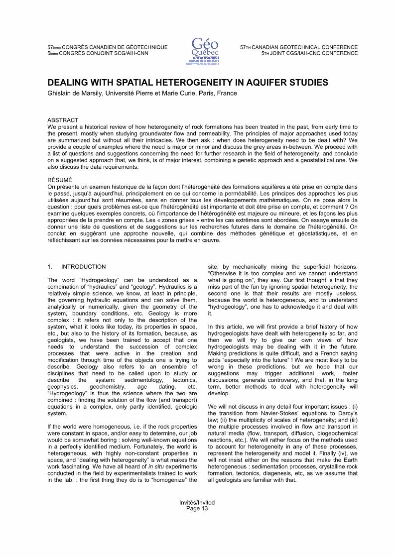
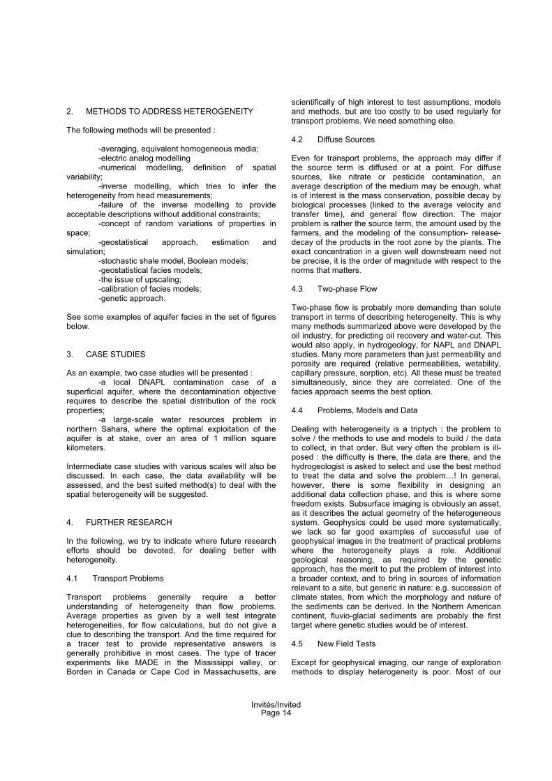
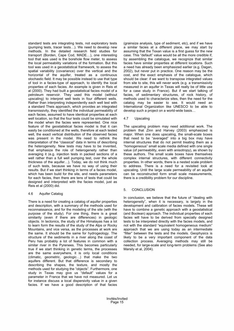
-averaging, equivalent homogeneous media; -electric analog modelling -numerical modelling, definition of spatial variability; -inverse modelling, which tries to infer the heterogeneity from head measurements; -failure of the inverse modelling to provide acceptable descriptions without additional constraints; -concept of random variations of properties in space; -geostatistical approach, estimation and simulation; -stochastic shale model, Boolean models; -geostatistical facies models; -the issue of upscaling; -calibration of facies models; -genetic approach.
See some examples of aquifer facies in the set of figures below.
3. CASE STUDIES
As an example, two case studies will be presented : -a local DNAPL contamination case of a superficial aquifer, where the decontamination objective requires to describe the spatial distribution of the rock properties; -a large-scale water resources problem in northern Sahara, where the optimal exploitation of the aquifer is at stake, over an area of 1 million square kilometers.
Intermediate case studies with various scales will also be discussed. In each case, the data availability will be assessed, and the best suited method(s) to deal with the spatial heterogeneity will be suggested.
4. FURTHER RESEARCH
In the following, we try to indicate where future research efforts should be devoted, for dealing better with heterogeneity.
4.1 Transport Problems
Transport problems generally require a better understanding of heterogeneity than flow problems. Average properties as given by a well test integrate heterogeneities, for flow calculations, but do not give a clue to describing the transport. And the time required for a tracer test to provide representative answers is generally prohibitive in most cases. The type of tracer experiments like MADE in the Mississippi valley, or Borden in Canada or Cape Cod in Massachusetts, are
scientifically of high interest to test assumptions, models and methods, but are too costly to be used regularly for transport problems. We need something else.
4.2 Diffuse Sources
Even for transport problems, the approach may differ if the source term is diffused or at a point. For diffuse sources, like nitrate or pesticide contamination, an average description of the medium may be enough, what is of interest is the mass conservation, possible decay by biological processes (linked to the average velocity and transfer time), and general flow direction. The major problem is rather the source term, the amount used by the farmers, and the modeling of the consumption- release-decay of the products in the root zone by the plants. The exact concentration in a given well downstream need not be precise, it is the order of magnitude with respect to the norms that matters.
4.3 Two-phase Flow
Two-phase flow is probably more demanding than solute transport in terms of describing heterogeneity. This is why many methods summarized above were developed by the oil industry, for predicting oil recovery and water-cut. This would also apply, in hydrogeology, for NAPL and DNAPL studies. Many more parameters than just permeability and porosity are required (relative permeabilities, wetability, capillary pressure, sorption, etc). All these must be treated simultaneously, since they are correlated. One of the facies approach seems the best option.
4.4 Problems, Models and Data
Dealing with heterogeneity is a triptych : the problem to solve / the methods to use and models to build / the data to collect, in that order. But very often the problem is ill-posed : the difficulty is there, the data are there, and the hydrogeologist is asked to select and use the best method to treat the data and solve the problem…! In general, however, there is some flexibility in designing an additional data collection phase, and this is where some freedom exists. Subsurface imaging is obviously an asset, as it describes the actual geometry of the heterogeneous system. Geophysics could be used more systematically; we lack so far good examples of successful use of geophysical images in the treatment of practical problems where the heterogeneity plays a role. Additional geological reasoning, as required by the genetic approach, has the merit to put the problem of interest into a broader context, and to bring in sources of information relevant to a site, but generic in nature: e.g. succession of climate states, from which the morphology and nature of the sediments can be derived. In the Northern American continent, fluvio-glacial sediments are probably the first target where genetic studies would be of interest.
4.5 New Field Tests
Except for geophysical imaging, our range of exploration methods to display heterogeneity is poor. Most of our
Invités/InvitedPage 14
standard tests are integrating tests, not exploratory tests (pumping tests, tracer tests…). We need to develop new methods. In the detailed research field studies for transport (Borden, Cape Cod, MADE…), one interesting tool that was used is the borehole flow meter, to assess the local permeability variations of the formation. But this tool was used in a geostatistical framework, to assess the spatial variability (covariance) over the vertical and the horizontal of the aquifer, treated as a continuous stochastic field. It may be possible instead to use that type of tool in a facies-type of approach, to identify the local properties of each facies. An example is given in Reis et al (2000). They had built a geostatistical facies model of a petroleum reservoir. They used this model (without upscaling) to interpret well tests in four different wells. Rather than interpreting independently each well test with a standard Theis approach, which provides an integrated transmissivity, they identified the individual permeability of each facies, assumed to have identical properties at each well location, so that the four tests could be simulated with the model when the facies were represented. One nice feature of the geostatistical facies model is that it can easily be conditioned at the wells, therefore at each tested well, the exact vertical distribution of the observed facies was present in the model. We need to rethink the interpretation of the “classical” data in terms of describing the heterogeneity. New tests may have to be invented, that emphasize the role of heterogeneity rather than averaging it (e.g. injection tests in packed sections of a well rather than a full well pumping test, over the whole thickness of the aquifer…). Today, we do not think much of such tests, because we have no way of using their results. But if we start thinking in terms of a facies model, which has been build for the site, and needs parameters for each facies, then there are tens of tests that could be designed and interpreted with the facies model, just as Reis et al (2000) did.
4.6 Aquifer Catalog
There is a need for creating a catalog of aquifer properties and description, with a summary of the methods used for reconnaissance, and for the modeling of the site (with the purpose of the study). For one thing, there is a great similarity (even if there are differences) in geologic objects. In tectonics, the study of the Himalayas has a lot to learn form the results of the study of the Alps or Rocky Mountains, and vice versa, as the processes at work are the same. It should be the same for hydrogeology. The structure of the sediments in a river along the coast of Peru has probably a lot of features in common with a similar river in the Pyrenees. This becomes particularly true if we start thinking in genetic terms, the processes are the same everywhere, it is only local conditions (climatic, geometric, geologic…) that make the two aquifers different. But that difference is secondary to describing the shapes, the texture, and mostly the methods used for studying the “objects”. Furthermore, one study in Texas may give us “default” values for a parameter in France that we have not measured. Let us for instance discuss a local dispersivity value in a given facies. If we have a good description of that facies
(grainsize analysis, type of sediment, etc), and if we have a similar facies at a different place, we may start by assuming that the Texan value is a first guess for the new case. This “default” value would be all the more credible if, by assembling the catalogue, we recognize that similar facies have similar properties at different locations. Such a need has already been emphasized earlier (e.g. Dagan, 2002), but never put in practice. One reason may be the cost, and the exact emphasis of the catalogue, which should be clear: if we want to transpose integrated values from site to site, this will never work (e.g. a transmissivity measured in an aquifer in Texas will really be of little use for a case study in France). But if we start talking of facies, of sedimentary structures, of rock history, of methods used to characterize sites, then the need for the catalog may be easier to see. It would need an International Organization like UNESCO to be able to develop such a project on a world-wide basis…
4.7 Upscaling
The upscaling problem may need additional work. The problem that Zinn and Harvey (2003) emphasized is major. When one does upscaling, the small-scale boxes that need to be “averaged” into a big box may have internal structures that do not permit treating them as a “homogeneous” small scale media defined with one single value (of permeability, even with anisotropy), as shown by these authors. The small scale boxes have themselves complex internal structures, with different connectivity properties. In other words, there is a nested scale problem to address. There is a need for a revisited look at upscaling. Until the large scale permeability of an aquifer can be reconstructed form small scale measurements, there is a credibility problem for our discipline.
5. CONCLUSION
In conclusion, we believe that the future of “dealing with heterogeneity”, when it is necessary, is largely in the development and calibration of facies models. These will have to combine a genetic approach with a geostatistical (and Boolean) approach. The individual properties of each facies will have to be derived from specially designed tests to be interpreted directly with the facies models, and not with the standard “equivalent homogeneous medium” approach that we are using today as an intermediate “filter” between the tests and the models. Geophysics is likely to be a very important component of the data collection process. Averaging methods may still be needed, for large-scale and long-term problems (See also Marsily et al, 2004).
Invités/InvitedPage 15
6. REFERENCES
Andersson, J.A. 1984. Stochastic model of a fracturedrock conditioned by measured information : WaterResources Research , v. 20, pp. 79-88.
Chiles, J.P, Delfiner, P. 1999. Geostatistics : ModelingSpatial Uncertainty. Wiley, New-York, 695 p.
Dagan, G. 2002. An overview of stochastic modeling ofgroundwater flow and transport : from theory toapplications. EOS, Trans. Amer.Geophys. Union, 83(53), 31.12.2002
Goncalves, J., Violette, S., Guillaucheau, F., Pagel, M., Bruel, D., Robin, C., Marsily, G. de, Ledoux, E. 2003.Using a 3-D basin model as an interactive tool withdiagenesis analysis, example of the Paris basin,France. Basin Research, in print.
Haldorsen, H.H., and Chang, D.M. 1986. Notes onstochastic shales from outcrop to simulation models. In: Reservoir Characterization, L.W. Lake and H.B. Carol,Jr. (eds), Academic Press, New York, pp. 152-167.
Haldorsen, H.H., and Damsleth, E. 1990. Stochasticmodeling : Journal of Petroleum Technology, v. 42, pp.404-412, discussion by, pp. 929-930.
Kolterman, C.E., and Gorelick, S.M. 1992. Paleoclimatic
signature in terrestrial flood deposits : Science, v. 256,pp. 1775-1782.
Lavenue, A.M., Ramarao, B.S., Marsily, G. de, Marietta,M.G. 1995. Pilot point methodology for automatedcalibration of an ensemble of conditionally simulatedtransmissivity fields : Part 2 - Application. WaterResour. Res. 31, 3, pp. 495-516.
Marsily, Gh. de, Delay, F., Gonçalvès, J., Renard, Ph.,Teles, V., Violette, S.. 2004. Dealing with SpatialHeterogeneity. Special Issue of Hydrogeology Journal :“The Future of Hydrogeology”. To appear.
Reis, L.C., Hu, L.Y., Marsily, G. de, Eschard, R. 2000.Production data integration using a gradual deformationapproach : Application to an oil field (offshore Brazil).Soc. of Petrol. Eng., Paper SPE 63064.
Teles, V., Bravard, J.P., Marsily, G. de, Perrier, E. 2001.Modelling of the construction of the Rhône alluvial plainsince 15000 years BP. Sedimentology, 48, pp.1209-1224.
Zinn, B., Harvey, C.F. 2003. When good statistical modelsof aquifer heterogeneity go bad: A comparison of flow,dispersion, and mass transfer in connected andmultivariate Gaussian hydraulic conductivity fields.Water Resour. Res. 39, 3, pp. 1051-1070.
7. FIGURES
Boolean Model « stochastic shales »
From Haldorsen and Chang, 1986
Cross-section, Boolean
Alluvial system, from
Haldorsen & Chang, 1986
Stochastic Delta, Boolean Model, from Haldorsen & Damsleth, 1990 Stochastic Boolean Fracture System, from Anderson, 1984
Invités/InvitedPage 16
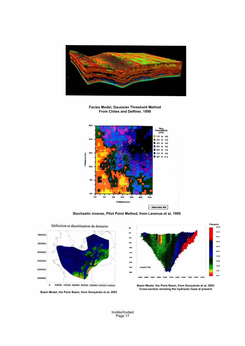
Facies Model, Gaussian Threshold Method
From Chiles and Delfiner, 1999
Stochastic inverse, Pilot Point Method, from Lavenue et al, 1995
Basin Model, the Paris Basin, from Gonçalvès et al, 2003
Basin Model, the Paris Basin, from Gonçalvès et al, 2003
Cross-section showing the hydraulic head at present
Invités/InvitedPage 17
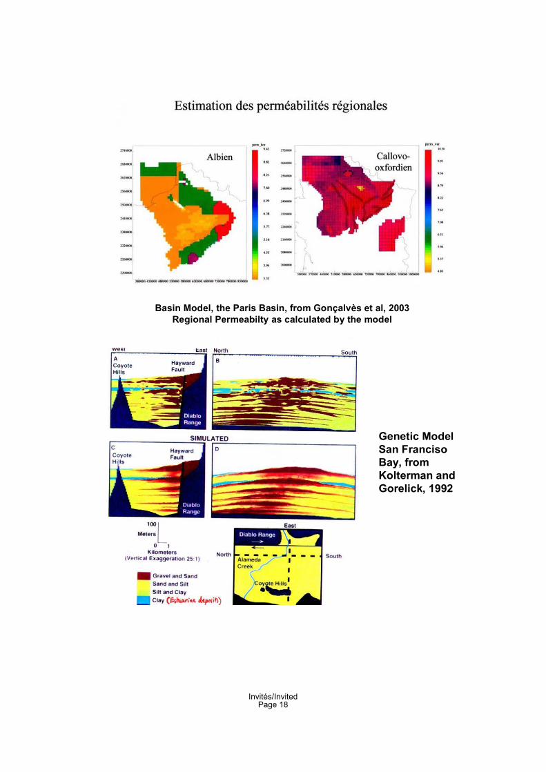
Basin Model, the Paris Basin, from Gonçalvès et al, 2003
Regional Permeabilty as calculated by the model
Genetic Model
San Franciso
Bay, from
Kolterman and
Gorelick, 1992
Invités/InvitedPage 18
Independent objects:
the alluvial plain
The plain is a 3-D assembly of sediment entities
Genetic Model, Alluvial Plain, Teles et al, 2001
Modeled alluvial plain for the Present:
a patchwork of sediments
AllerodYounger Dryas
Old AtlanticYounger AtlanticSubboréal
First Iron AgeSmall Glacial AgeHuman infilling
Saône Alluvial
deposits
Initial infilling of
the Rhone
Invités/InvitedPage 19
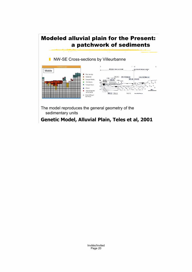
Modeled alluvial plain for the Present:
a patchwork of sediments
The model reproduces the general geometry of thesedimentary units
Genetic Model, Alluvial Plain, Teles et al, 2001
NW-SE Cross-sections by Villeurbanne
Middle
Invités/InvitedPage 20