datums - map coordinate reference frames: part 1 - basicsdatums - map coordinate reference frames:...
TRANSCRIPT

1
Datums - Map Coordinate Reference Frames:Part 1 - Basics
James R. Clynch, February2006
Part 1I. What are Datums - in Geodesy and MappingII. Origin of DatumsIII. Datums and EllipsoidsIV. Modern Datums and Reference FramesV. Realizations
A. How Datums Really WorkB. Pre-satellite Era RealizationsC. Satellite Era RealizationsD. Datums as Rubber Sheets
VI. What Datum Am I OnA. Map Datums - Paper and ElectronicB. Navigation and Survey Equipment Datums 1. Standalone GPS Users 2. Differential GPS Users 3. Other Electronic Navigation Systems 4. Surveying
Part 2VII. Datum Transformations
A. Basic MethodsB. Vector Method - The 7 Parameter TransformC. Molodensky Transform - The Historically Common Method 1. Vector Viewpoint of Molodensky Transformation 2. The Usual Statement of Molodensky Transformation 3. Modern Uses of Molodensky TransformationD. Local Fit Equations - Multiple Regression Method

2
I. What Are Datums – in Geodesy and Mapping?The basic fact is: the coordinates of all locations on the earth are on datums. At
high accuracy the coordinates of a point, the latitude, longitude and height or Cartesiancoordinates, may exist in several self-consistent sets. These will be in different datums.
A datum is the answer to the practical problem of making an accurate map. If youwish to determine the relative location of a pair of points a few meters apart, the solutionis obvious. Just measure the difference with a tape measure. The issue of orientation stillexists though, but this can be solved using two "known" points to measure a third. Orobservations of the stars can be used to define north.
In effect this defines a local datum. The known point, together with some methodfor determining the direction of north, defines the location of points measured from it. Ifthe reference point is in error by 100 m north, so will all the points using it. They movetogether. This of course assumes these errors are small, at least as compared to the radiusof the earth.
If you look at the legend of a topographic map, you will find that it lists the"datum" that is used. In fact there may be several datums, one for horizontal, one forvertical etc. These are important because they define the reference system that is used forthe coordinates.
If you use a GPS navigation system not set to the map datum, you can be off by100 m (usually) to a kilometer (sometimes). Navigation systems produce coordinates ondatums. If this is not the same datum as the map being used, an error occurs. Severalship accidents have happened because the GPS navigation system and the navigationchart were on different datums.
The practical way to define a datum is with a whole set of reference markers andtheir associated coordinates. They should be carefully surveyed together. This gives anetwork that serves as a "realization of the datum". This provides a practical set of pointsspread out over the region covered. Surveyors use the closest survey marker that meetsthe accuracy needs. In practice almost all surveying is relative, from one point to thenext.
This means that datums are the reference frames used in the construction of maps.Realization, the disks in the ground and the catalogue of their coordinates, are thepractical way datums are used.
Things are complicated in practice as the same area may have two datums giving eachpoint two different coordinates. In addition datums were often generated by individualcountries, and did not match at the boundaries. The 1900 era German maps of Franceand the English maps of Germany did not match, even in the areas of overlap.
In general if a datum covers areas not directly connected by a survey, such as overa body of water, there are really different versions of the datum. This is not an academic

3
point. At least one recent ship grounding in the Caribbean was caused by using the wrong"NAD 83" in a GPS receiver. They used a version of "NAD 83" that did not match the"NAD 83" on the chart.
II. Origin of Datums
When we see a map or a globe today we have a fairly good idea of the meaning ofthe latitude and longitude lines on it. The longitude lines have a zero in GreenwichEngland and the zero of latitude is the equator. Even today there are subtle difference inthe meaning of these statements. In the past there were major differences depending onthe country you were from. The coordinates were said to be on different datums.
In the past each major country had its own system of coordinates. The latitudewas meant to be the same, basically defined by the spin axis of the earth. But the origin oflongitude is completely arbitrary and each country chose a convenient location on its soil.Thus two maps that were of the same area would not have the same coordinates for a city.
In fact both the latitude and longitude would often be different, although thelatitude difference would be small. These reference systems were set up by establishing a"good primary reference site" and then doing relative surveying outward from it. Thiswas usually an astronomical observatory so the coordinates of this primary point wouldbe well known from celestial observations. The outward surveying had to stop at oceansand other major obstacles. So islands frequently had their own primary reference pointthat was not as well determined as the ones in major European capital cities.
Because these systems were not quite consistent from country to country, evenwhere there were no survey problems, maps differed based on which country made them.Each map set was on a different Datum.
In reality there are many kinds of datums. Here we will only consider two,horizontal datums and vertical datums. Mapmakers distinguish between horizontal andvertical position because different techniques are used to measure heights and horizontalpositions.
And things are even more complicated because the world is not quite a sphere.
III. Datums and Ellipsoids
The world is slightly bigger at the equator than at the poles. The distance fromthe center of the earth to the equator is larger than the distance from the center to thepoles by about 23 km. This is a factor of about 1/300 or 0.3 percent. While this is small,it is important for maps of the world or even much smaller regions.

4
The non-spherical earth is modeled by an ellipse of revolution. This shape iscalled and ellipsoid. (In some books it is called a spheroid.) In order to make anellipsoid model of the earth, take an ellipse and align the shorter axis with the spin axis ofthe earth. The longer axis will point out the equator. Rotate the ellipse about the shorter,polar, axis to form a solid. This is the ellipsoid.
The shape and size of the ellipsoid representing the earth is very difficult tomeasure. A good measurement needs celestial observations at many points all over theworld. These were unavailable before satellite based surveying began in the 1960's. Socountries made due with what they had, usually over a "small region" like Europe.
Each country decided for itself what was the best estimate of the size and shape ofthe earth. They each had their own ellipsoid. And they also had their own primaryreference point. Defining the latitude and longitude of a particular point on the earthdefines the origin of the ellipsoid. That is choosing an ellipsoid and primary referencepoint coordinates gives both the shape and location of the ellipsoid. This model of theearth is needed for the surveying that defines the location of other points on maps.

5
Ellipsoids made from a "local" area's data, like Europe or North America could besignificantly different. This did not bother the mapmakers because they just wantedsomething to use in making maps that worked well for their area. For example theellipsoids chosen for Europe and North America are quite different, with the originsbeing offset about 250 m.
The ellipsoids are usually defined by two quantities. These could be the length ofthe two axes. However a more common set used in geodesy and surveying is the semi-major axis (equatorial axis length) and the flattening. The polar axis is also called thesemi-minor axis. If the equatorial axis is called a, and the polar axis b, then theflattening is defined as
ab
1a
baf −=−= .
A list of the most common ellipsoids in use is given in the following table.
Name Semi-Major Axis -a(Km)
Semi-Minor Axis - b(km)
1/Flattening
Airy 6377.563 6356.257 299.32Modified Airy 6377.340 6356.034 299.32Australian National 6378.160 6356.775 298.25Bessel 1841 6377.397 6356.079 299.15Clarke 1866 6378.206 6356.584 294.98Clarke 1880 6378.249 6356.516 293.46Everest 6377.276 6356.075 300.80Fischer 1960 6378.155 6356.773 298.30Helmert 1906 6378.200 6356.818 298.30Indonesian 1974 6378.160 6356.774 298.25International 6378.388 6356.912 297.00Krassovsky 6378.245 6356.863 298.30South American 1969 6378.160 6356.774 298.25WGS 72 6378.135 6356.751 298.26GRS 80 6378.137 6356.752 298.257WGS 84 6378.137 6356.752 298.257
A datum in the modern sense is defined by choosing an ellipsoid and then aprimary reference point. Therefore giving the ellipsoid used is not enough. The NorthAmerican Datum of 1927, NAD27, uses the Clarke 1866 ellipsoid and a point in centralKansas (called Meade's Ranch) as its primary reference point. Note that some maps ofsome Caribbean islands are also listed as being on NAD27. But this is really a differentdatum because a different primary reference point was used.

6
There was a major update of the North American Datum in the early 1980. Thisresulted in the North American Datum of 1983 or NAD83. NAD83 uses Meade'sRanch but a new ellipsoid. The ellipsoid is GRS80, which is the same as the WGS84ellipsoid. (The World Geodetic System of 1984, WGS84, was established at about thesame time by the US Defense Department.) In essence new data was used to establishbetter coordinates for the existing major benchmark network in North America.
Thus the brass disks in the ground are the same, only a new database ofcoordinates for each marker is different. The update was done with many newmeasurements and computations. But the main result was a new catalogue of thecoordinates of the survey marks already in the ground.
A few of the common datums in use today are:
North American Datum of 1927 NAD27 Clarke 1866North American Datum of 1983 NAD83 GRS80 = WGS84North American Vertical Datum of 1929 NAVD29 Clarke 1866North American Vertical Datum of 1988 NAVD88 GRS80 = WGS84World Geodetic System of 1984 WGS84 WGS84 = GRS80South American Datum of 1969 SA1969 South AmericanEuropean Datum of 1950 EU50 International
IV. Modern Datums and Reference Frames
Today maps almost always use Greenwich England for the longitude origin andtry to have the best values for the ellipsoid and primary reference points. However weare still left with older surveys and maps that are on different datums. There arehundreds of them, but only about 50 that have common use.
With the advent of satellite surveying systems, worldwide coordinate systemswere needed. This led to the establishment of worldwide systems. The US DefenseDepartment made the first of these in 1966. A later one, called World Geodetic System1972, WGS72, was quite successful. It was used for the Navy Navigation System, whichwas opened to public use. Later a better system, called WGS84 was generated when theGlobal Positioning System (GPS) required better coordinates.

7
The above diagram shows the approximate shift in horizontal location betweenWGS84 and datums used commonly for maps. While the US is now officially on theNorth American Datum of 1983 (NAD83), which is essentially identical to WGS84, thereare still many maps on the older NAD27. This is true even of government printedtopographic maps from the US Geological Survey. In other areas of the world the shiftare even larger. Kilometer size shifts exist for the Tokyo datum for example.
The science community has been working on a series of world reference systemsthat are called International Terrestrial Reference Systems or ITRF's. The earliestones were ITRF92 and ITRF94, which was quite good. Modest improvements followedwith ITRF97 and ITRF2000. The later two models were so accurate that models of themotion of the crustal plates of the earth had to be included.
The WGS's and ITRF's were basically defined as Cartesian XYZ systems. Theseare a perpendicular axis with the origin at the center of the earth. The Z-axis goes out thenorth pole. The X-Y plane is the equatorial plane. The positive X-axis defines the originof longitude. This is called an Earth Centered, Earth Fixed, ECEF coordinatesystem. An ellipsoid was associated with each. This was needed to convert the xyzcoordinates to latitude, longitude and height. Of course height had it's own complicationwhich are discussed elsewhere.

8
V. Realizations
A. How Datums Really are Used
There is a second whole side to datums, the practical side. The primary referencepoint for the US is in central Kansas at a place called Meade's Ranch. It is impractical tobegin all surveys in Kansas. The mapping organization of each nation do high qualitysurveys and establish a network of high accuracy points. These are usually a bronze diskset in concrete or rock.
This disk, along with the coordinates of the small punch mark in the disk center,generates a "realization" of the datum.
9
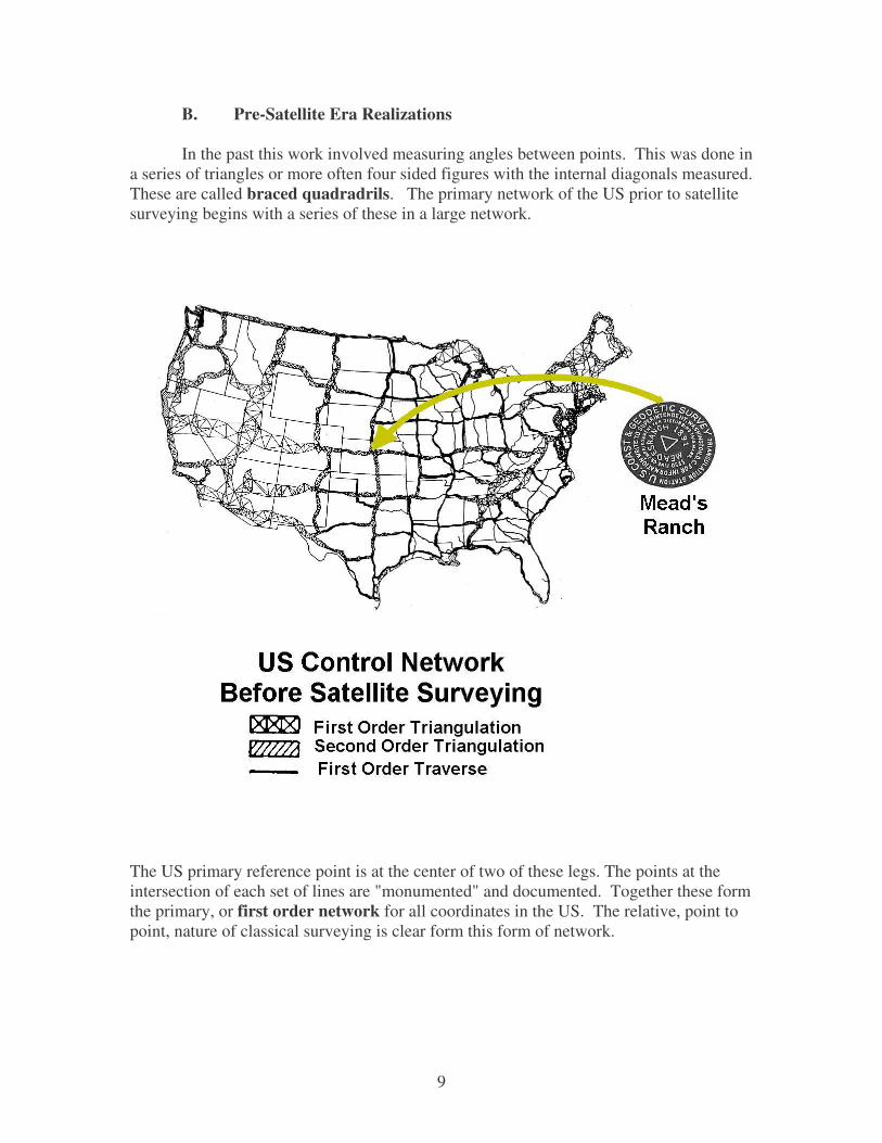
B. Pre-Satellite Era Realizations
In the past this work involved measuring angles between points. This was done ina series of triangles or more often four sided figures with the internal diagonals measured.These are called braced quadradrils. The primary network of the US prior to satellitesurveying begins with a series of these in a large network.
The US primary reference point is at the center of two of these legs. The points at theintersection of each set of lines are "monumented" and documented. Together these formthe primary, or first order network for all coordinates in the US. The relative, point topoint, nature of classical surveying is clear form this form of network.

10
C. Satellite Era Realizations
With the coming of satellite surveying, reference points could be far apart andessentially disjoint. They were still measured by relative surveying, on much higheraccuracies could be obtained over much longer distances. This is clear from the currentUS primary realization. It looks like a set of points. The density is a function of theamount of work beyond the minimum that each state decided to perform.
D. Datums As Rubber Sheets
Datums are established by taking a large number of high precision surveymeasurements at many points over the region of interest and solving for a best set ofcoordinates. In doing this there must be many more measurements than 2 times thenumber of points. The factor of 2 comes in because of the two horizontal coordinates ateach location.
Even with a ratio of 10 to 1 of the number of measurements to unknown, thesolutions can have significant errors. The random errors will be minimized, butsystematic errors will remain. The surveys measurements were almost all relativemeasurements from point to point. Errors could accumulate. In addition only a smallnumber of distances (called baselines) were commonly done due to the extreme expense.

11
Any error in a base length would cause a scale error in all measurements dependent on it.This is an example of a systematic error.
As a result there were often smoothly varying distortions that built up overdistances. The resulting distortions often looked like a suspended sheet of rubber withweights at different points. This was very common in large area datums such as theNorth American Datum of 1927. Of course, the precise location and extent of the hillsand valleys in this sheet were unknowable until a more accurate survey was done. ForNAD27 this occurred with WGS72, the first extensive satellite based datum.
The North American Datum of 1983, NAD83, was the first large area civiliansystem based mainly on satellite surveying. This datum was significantly better theNAD27. The distortions in the old system show up in the contour plots of thedifferences between the latitude and longitude in the two datums. It is clear that the shiftsare not constant, but vary systematically from place to place. The latitude shifts have asignificant north-south gradient with bends in the west over the Rocky Mountains.Differences vary from -20 to +50 m.
The differences in the longitude have a predominate east-west gradient. The values varyfrom -40 m on the east coast to +100 m on the west coast. It is clear that over a smallarea map such as a 7.5' quad, the shift will be almost constant. But for the entire USthere as significant, systematic variations.

12
VI. What Datum Am I On
Because coordinates in different datums can differ by 100's of meters (or even akilometer in the far east), it is important to know what datum you are on. There areusually two questions:
What datum is my map or database on?What datum is my navigation system or survey on?
Clearly if the answer is the same, the map/data base and the position sensor can worktogether. Ships have gone aground when this was not so.
A. Map Datums - Paper and Electronic
The database of a map is usually listed in the legend of the map. In fact there areis usually both a horizontal and vertical datum listed. Today it is not uncommon to seetwo horizontal datums listed, one for the original map and one for some overprinting.This is how USGS has updated a lot of topographical maps from NAD27 to NAD83. Butyou have to read the legend carefully to notice this. In fact there are quite a few militarymaps issued by NIMA that use the same technique. The maps of the Balkans distributedin the mid 1990's were on the European Datum of 1950 with annotations in the legendson how to shift the positions to WGS 84.

13
For computer data files the issue is much more difficult. The data from thelegends of the maps is usually preserved, but often not displayed. If the map is simplyscanned as an image the legend is there, but the data is not usually "registered" or set upfor computer reading of accurate coordinates. If the map has been entered into aGeographical Information System (GIS) it may well be registered, but in this case thelegend data is present only in an auxiliary file. This type of legend data is called"metadata".
B. Navigation and Survey Equipment Datums
What datum is GPS on? The answer depends on how the GPS receiver generatedthe solution. Stand alone GPS and Differential GPS (DGPS) have different answers.And there are both a general answer, and a more precise answer.
1. Standalone GPS Users
For the stand alone user the simple answer is WGS 84. GPS operates bymeasuring ranges from the satellites to the user. In order to convert these ranges intopositions, the locations of the satellites are needed. Having a range and not knowingwhere it is from is not useful. The time history of the satellite positions is called theephemeris of the satellites. So a stand-alone user is on the datum of the ephemeris heuses.
In the most common case the navigator or surveyor uses the ephemeris that ispresent on the signal broadcast by the satellites. This is called the Broadcast Ephemeris(BCE). This information is "on WGS84". The quotes denote that this answer is notprecisely correct, or is complicated by history.
There have been Precise Ephemeris (PE's) available for over 20 years. Theseare post-fit ephemeris based on a large set of ground stations. These are available fromseveral civilian sources. There is even a consortium that produces a blended set ofseveral PE's. In the past these were used for post fit work because it was a week or moreafter the fact that the PE's became available. After 2000, they have become available atvery short delays. There even is a rapid prediction service that generates projected PE'sthat are much better than BCE out to a day or so. PE's are usually on the latestInternational Terrestrial Reference System - ITRF2000 in 2002. If you use these, you areon the ITRF 2000 datum.
The more complex answer for the BCE's puts these also on an ITRF. Anephemeris is computed from GPS observations made at known, fixed locations. Thedatum of an ephemeris is determined by the coordinates used for the antennas of theseobservations. These antenna locations for the Operational Control System (OCS)stations have been adjusted several times. This has effectively changed the datum ofWGS84 as realized by the GSP BCE's.

14
In order to avoid confusion, the name of the datum was not changed when theadjustments were made. A suffix was added, but not widely used or know outside thegeodesy community. The BCE datums were/are:
BCE Datum Name Implemented Matches
WGS 84 1980 Original WGS84WGS 84 (G730) 1-2-1994 ITRF94WGS 84 (G873) 9-27-1996 ITRF96WGS 84 (G1150) 1- 2002 ITRF2000
GPS time is counted in weeks after January 1980. The number in the Gnnn is the GPSweek number of the change. The first change moved coordinates about a meter. The lastthree changes have been much smaller. For the general navigator these changes may notbe significant. There are some precision applications where these differences areimportant.
2. Differential GPS Users
With DGPS a reference station at a known location measures the errors in rangesto individual satellites and sends these to remote users over some communication link. Inorder to compute the errors, the reference station needs to know its position. The datumof the coordinates used for this position becomes the datum of all DGPS solutions thatuse those corrections. If you use DGPS you are on the datum used by the referencestation.
3. Other Electronic Navigation Systems
Other electronic navigation systems are much like DGPS. The coordinates usedfor the stations that transmit the signals or transpond signals define the datum. Oftenthese are not accurate enough for meter level distinctions to be important. However inAsia, the difference between WGS 84 and other local datums can be large. The user musttake care to know which datum his navigation system and maps are on.
4. Surveying
Surveying is much like DGPS. Both classical surveying and satellite surveyingis usually done point to point. In a surveyed network there must be at least one knownpoint. In large surveys there will be more. These know points are "held constant" in theanalysis of the data. The datum used for the point(s) held constant defines the datum ofthe other surveyed points.
This is true of almost all GPS surveying as well as classical survey techniques.Data is taken at the same time with GPS receivers at different locations. The relativelocations are then computed.

15
There is one exception, Absolute GPS Surveying. Large government agencieshave to establish the primary points in remote areas. In this case a more complex postanalysis is done on GPS data taken at a fixed location over several days. The analysisneeds Precise Ephemeris to achieve survey quality positions. The answer is on the datumof the PE's used.