curriculum of remote sensing & …hec.gov.pk/english/services/universities/revised...2...
TRANSCRIPT
CURRICULUM OF
REMOTE SENSING &
GEOGRAPHICAL INFORMATION
SYSTEM
BS/MS
(Revised 2016/2017)
HIGHER EDUCATION COMMISSION
ISLAMABAD
2
CURRICULUM DIVISION, HEC
Prof. Dr. Mukhtar Ahmed Chairman Prof. Dr. Arshad Ali Executive Director Mr. Muhammad Raza Chohan Director General (Academics) Dr. Muhammad Idrees Director (Curriculum) Syeda Sanober Rizvi Deputy Director (Curriculum) Mr. Riaz-ul-Haque Assistant Director (Curriculum)
3
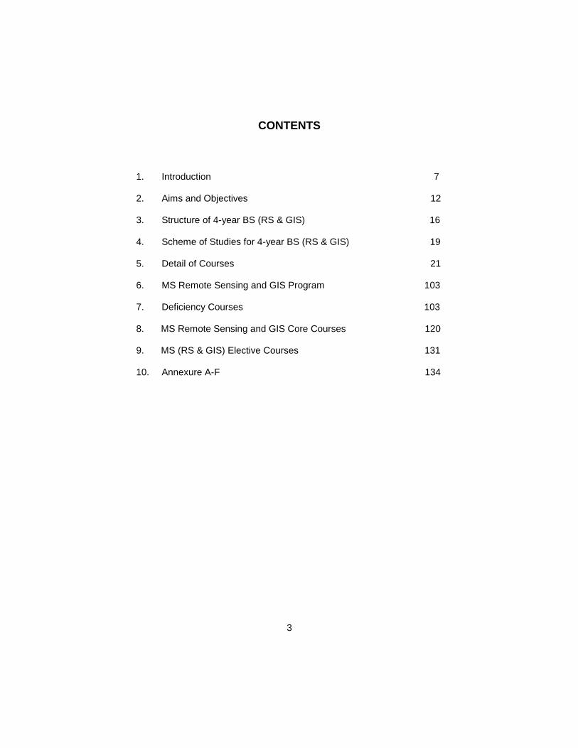
CONTENTS
1. Introduction 7
2. Aims and Objectives 12
3. Structure of 4-year BS (RS & GIS) 16
4. Scheme of Studies for 4-year BS (RS & GIS) 19
5. Detail of Courses 21
6. MS Remote Sensing and GIS Program 103
7. Deficiency Courses 103
8. MS Remote Sensing and GIS Core Courses 120
9. MS (RS & GIS) Elective Courses 131
10. Annexure A-F 134

4
PREFACE
The curriculum, with varying definitions, is said to be a plan of the teaching-learning process that students of an academic programme are required to undergo to achieve some specific objectives. It includes scheme of studies, objectives & learning outcomes, course contents, teaching methodologies and assessment/ evaluation. Since knowledge in all disciplines and fields is expanding at a fast pace and new disciplines are also emerging; it is imperative that curricula be developed and revised accordingly. University Grants Commission (UGC) was designated as the competent authority to develop, review and revise curricula beyond Class-XII vide Section 3, Sub-Section 2 (ii), Act of Parliament No. X of 1976 titled “Supervision of Curricula and Textbooks and Maintenance of Standard of Education”. With the repeal of UGC Act, the same function was assigned to the Higher Education Commission (HEC) under its Ordinance of 2002, Section 10, Sub-Section 1 (v). In compliance with the above provisions, the Curriculum Division of HEC undertakes the revision of curricula regularly through respective National Curriculum Revision Committees (NCRCs) which consist of eminent professors and researchers of relevant fields from public and private sector universities, R&D organizations, councils, industry and civil society by seeking nominations from their organizations. In order to impart quality education which is at par with indigenous needs and international standards, HEC NCRCs have developed unified framework/ templates as guidelines for the development and revision of curricula in the disciplines of Basic Sciences, Applied Sciences, Social Sciences, Agriculture and Engineering. It is hoped that this curriculum document, prepared by the respective NCRC’s, would serve the purpose of meeting our national, social and economic needs, and it would also provide the level of competency specified in Pakistan Qualification Framework to make it compatible with international educational standards. The curriculum is also placed on the website of HEC http://hec.gov.pk/english/services/universities/RevisedCurricula/Pages/default.aspx
(Muhammad Raza Chohan) Director General (Academics)
5
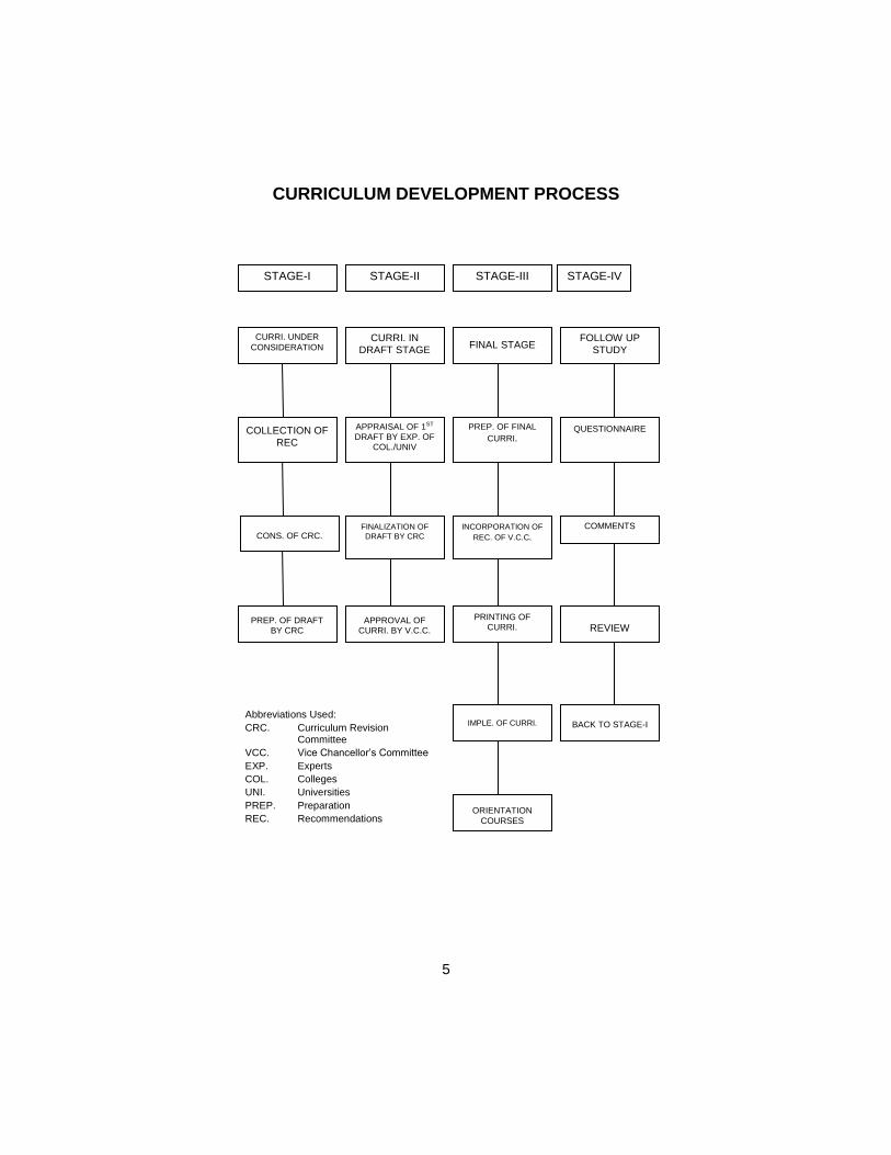
CURRICULUM DEVELOPMENT PROCESS
STAGE-I STAGE-II STAGE-III STAGE-IV
CURRI. UNDER
CONSIDERATION CURRI. IN
DRAFT STAGE
FINAL STAGE FOLLOW UP
STUDY
COLLECTION OF
REC
APPRAISAL OF 1ST DRAFT BY EXP. OF
COL./UNIV
PREP. OF FINAL
CURRI.
QUESTIONNAIRE
CONS. OF CRC.
FINALIZATION OF
DRAFT BY CRC
INCORPORATION OF
REC. OF V.C.C.
COMMENTS
PREP. OF DRAFT BY CRC
APPROVAL OF CURRI. BY V.C.C.
PRINTING OF CURRI.
REVIEW
IMPLE. OF CURRI.
BACK TO STAGE-I
ORIENTATION
COURSES
Abbreviations Used:
CRC. Curriculum Revision Committee
VCC. Vice Chancellor’s Committee
EXP. Experts
COL. Colleges
UNI. Universities
PREP. Preparation
REC. Recommendations
6
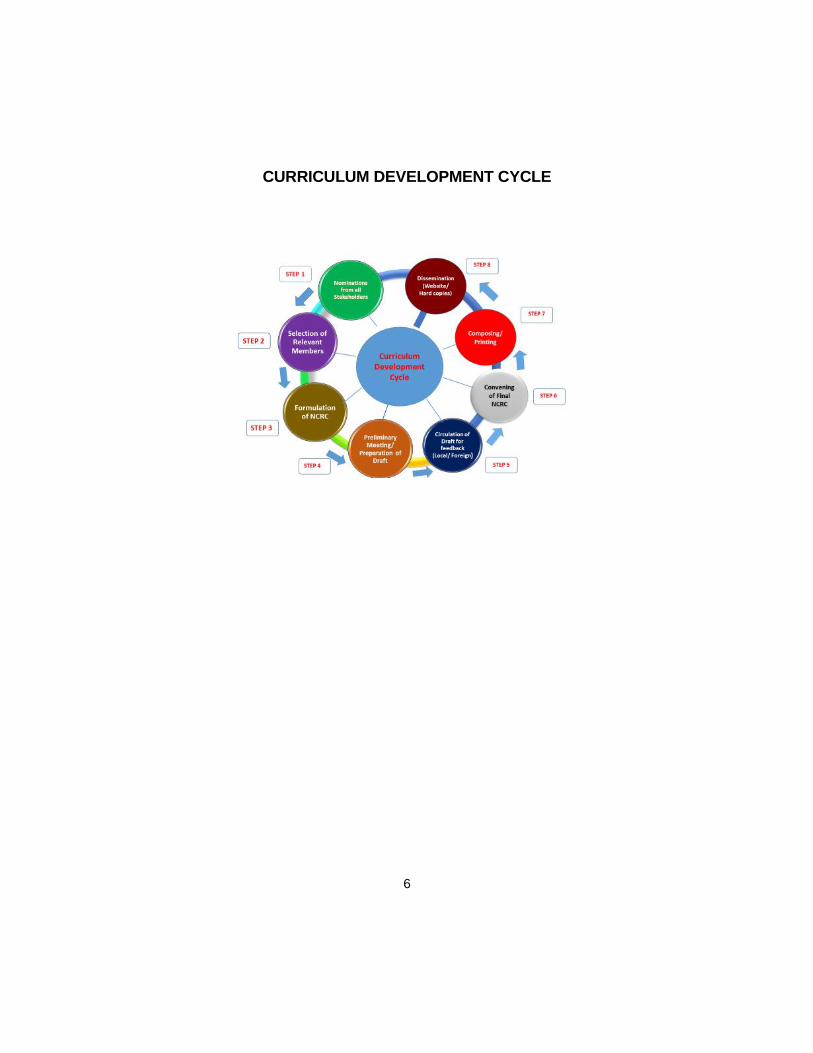
CURRICULUM DEVELOPMENT CYCLE
7
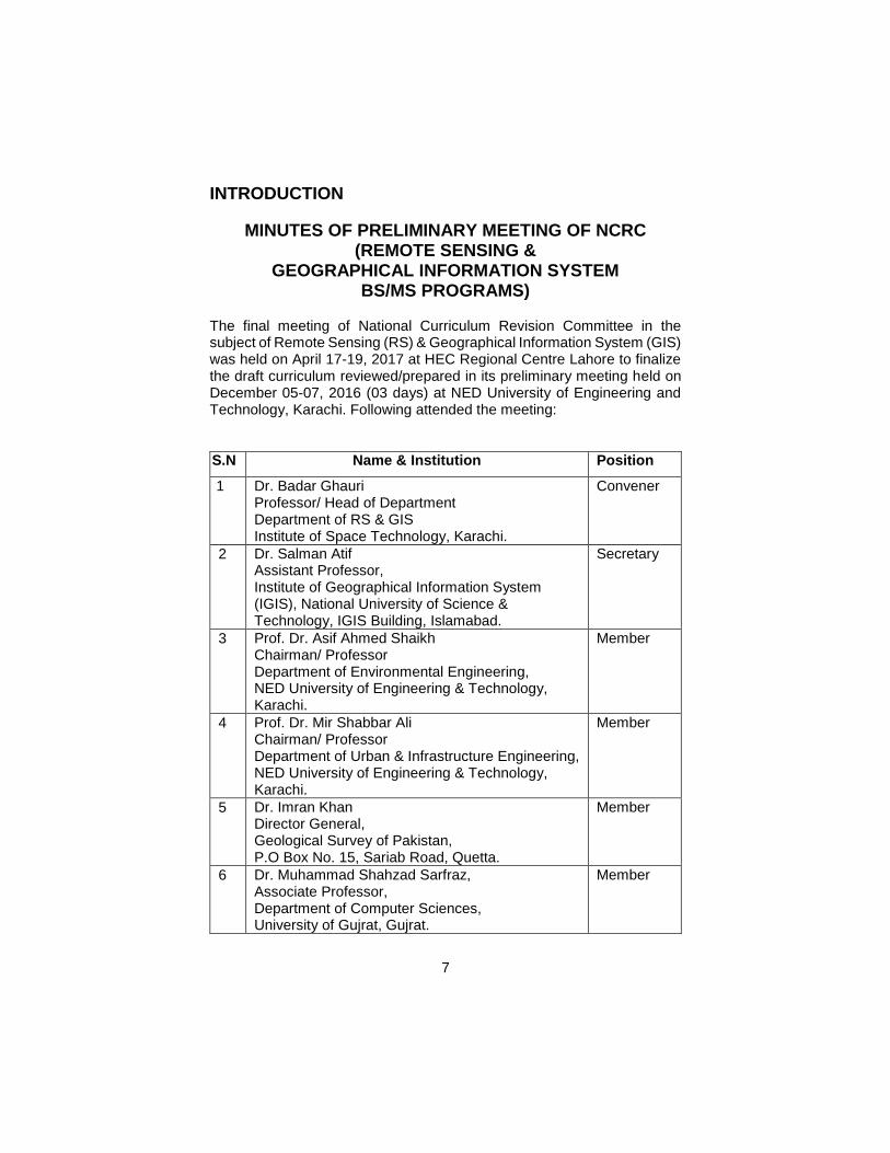
INTRODUCTION
MINUTES OF PRELIMINARY MEETING OF NCRC (REMOTE SENSING &
GEOGRAPHICAL INFORMATION SYSTEM BS/MS PROGRAMS)
The final meeting of National Curriculum Revision Committee in the subject of Remote Sensing (RS) & Geographical Information System (GIS) was held on April 17-19, 2017 at HEC Regional Centre Lahore to finalize the draft curriculum reviewed/prepared in its preliminary meeting held on December 05-07, 2016 (03 days) at NED University of Engineering and Technology, Karachi. Following attended the meeting:
S.N Name & Institution Position
1 Dr. Badar Ghauri Professor/ Head of Department Department of RS & GIS Institute of Space Technology, Karachi.
Convener
2 Dr. Salman Atif Assistant Professor, Institute of Geographical Information System (IGIS), National University of Science & Technology, IGIS Building, Islamabad.
Secretary
3 Prof. Dr. Asif Ahmed Shaikh Chairman/ Professor Department of Environmental Engineering, NED University of Engineering & Technology, Karachi.
Member
4 Prof. Dr. Mir Shabbar Ali Chairman/ Professor Department of Urban & Infrastructure Engineering, NED University of Engineering & Technology, Karachi.
Member
5 Dr. Imran Khan Director General, Geological Survey of Pakistan, P.O Box No. 15, Sariab Road, Quetta.
Member
6 Dr. Muhammad Shahzad Sarfraz, Associate Professor, Department of Computer Sciences, University of Gujrat, Gujrat.
Member
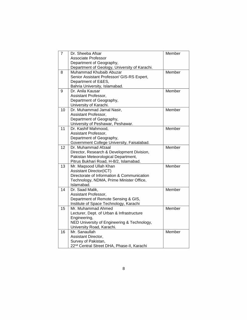
8
7 Dr. Sheeba Afsar Associate Professor Department of Geography, Department of Geology, University of Karachi.
Member
8 Muhammad Khubaib Abuzar Senior Assistant Professor/ GIS-RS Expert, Department of E&ES, Bahria University, Islamabad.
Member
9 Dr. Anila Kausar Assistant Professor, Department of Geography, University of Karachi.
Member
10 Dr. Muhammad Jamal Nasir, Assistant Professor, Department of Geography, University of Peshawar, Peshawar.
Member
11 Dr. Kashif Mahmood, Assistant Professor, Department of Geography, Government College University, Faisalabad.
Member
12 Dr. Muhammad Afzaal Director, Research & Development Division, Pakistan Meteorological Department, Pitrus Bukhari Road, H-8/2, Islamabad.
Member
13 Mr. Maqsood Ullah Khan Assistant Director(ICT) Directorate of Information & Communication Technology, NDMA, Prime Minister Office, Islamabad.
Member
14 Dr. Saad Malik, Assistant Professor, Department of Remote Sensing & GIS, Institute of Space Technology, Karachi
Member
15 Mr. Muhammad Ahmed Lecturer, Dept. of Urban & Infrastructure Engineering, NED University of Engineering & Technology, University Road, Karachi.
Member
16 Mr. Sanaullah Assistant Director, Survey of Pakistan, 22nd Central Street DHA, Phase-II, Karachi
Member
9
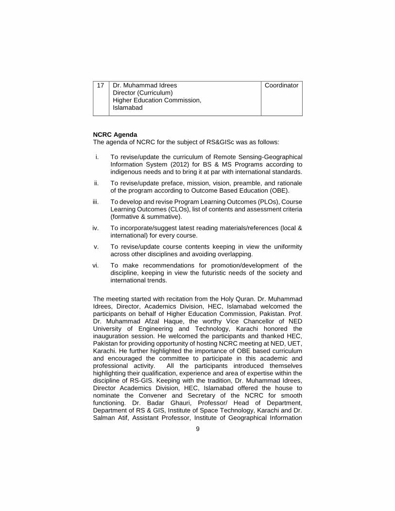
17 Dr. Muhammad Idrees Director (Curriculum) Higher Education Commission, Islamabad
Coordinator
NCRC Agenda The agenda of NCRC for the subject of RS&GISc was as follows: i. To revise/update the curriculum of Remote Sensing-Geographical
Information System (2012) for BS & MS Programs according to indigenous needs and to bring it at par with international standards.
ii. To revise/update preface, mission, vision, preamble, and rationale of the program according to Outcome Based Education (OBE).
iii. To develop and revise Program Learning Outcomes (PLOs), Course Learning Outcomes (CLOs), list of contents and assessment criteria (formative & summative).
iv. To incorporate/suggest latest reading materials/references (local & international) for every course.
v. To revise/update course contents keeping in view the uniformity across other disciplines and avoiding overlapping.
vi. To make recommendations for promotion/development of the discipline, keeping in view the futuristic needs of the society and international trends.
The meeting started with recitation from the Holy Quran. Dr. Muhammad Idrees, Director, Academics Division, HEC, Islamabad welcomed the participants on behalf of Higher Education Commission, Pakistan. Prof. Dr. Muhammad Afzal Haque, the worthy Vice Chancellor of NED University of Engineering and Technology, Karachi honored the inauguration session. He welcomed the participants and thanked HEC, Pakistan for providing opportunity of hosting NCRC meeting at NED, UET, Karachi. He further highlighted the importance of OBE based curriculum and encouraged the committee to participate in this academic and professional activity. All the participants introduced themselves highlighting their qualification, experience and area of expertise within the discipline of RS-GIS. Keeping with the tradition, Dr. Muhammad Idrees, Director Academics Division, HEC, Islamabad offered the house to nominate the Convener and Secretary of the NCRC for smooth functioning. Dr. Badar Ghauri, Professor/ Head of Department, Department of RS & GIS, Institute of Space Technology, Karachi and Dr. Salman Atif, Assistant Professor, Institute of Geographical Information
10
System (IGIS), National University of Science & Technology, IGIS Building, Islamabad were selected unanimously as Convener and Secretary, respectively.
Dr. Muhammad Idrees presented the agenda and objectives of the NCRC. He highlighted the importance of this meeting and emphasized for adaptation of general rules of curriculum development and revision like scope of the subject/program, horizontal & vertical alignment, rule of flexibility and adaptability keeping in view the futuristic approach, market value/job market and societal needs. He also shared a template for revising/updating the curricula. The template was unanimously accepted to be followed. It was also agreed to add vision, mission, program learning outcomes (PLOs) and course learning outcomes (CLOs), teaching methodology and assessment segments in the curricula.
In next session the house openly discussed the nomenclature of the discipline, preface, vision, mission, objectives of the programs, Program Learning Outcomes (PLOs), methods of instruction and learning environment, assessment and operational framework keeping in mind new trends of Outcome Based Education (OBE) being adopted by various institutions. Sample Course Learning Outcomes (CLOs) were also proposed for few subjects. After long deliberation, the committee finalized the above said segments of the curriculum. Similarly, framework/scheme of studies of undergraduate 4-years program for RS-GIS was discussed keeping in view the duration of the program, number of semesters, number of weeks per semester, total number of credit hours, number of credit hours per semester, weightage of theory and practical. Furthermore, list of courses (core & elective) and semester wise breakup of courses were also discussed thoroughly and the same was unanimously finalized. In the afternoon session, admission criteria/intake criteria was discussed and finalized. After that the list of courses was distributed among the committee members keeping in view the experience and expertise in the field for reviewing course objectives, adding learning outcomes, updating list of contents, adding teaching-learning methods and assessment, and updating bibliography/ references/ suggested books. On second day, task assigned to the groups was displayed and discussed the addition/deletion and revising the courses. After thorough deliberations, draft curriculum of the BS (4-years) for RS-GIS was finalized. On third day, the courses of MS program of RS-GIS was reviewed and after thorough discussion, courses were finalized. It was decided that the draft curriculum of RS-GIS would be circulated among the experts of the field (local & foreign) and the feedback of the experts will be incorporated in final meeting.
11
In the end, Dr. Idrees thanked the Convener, Secretary and all members of the Committee for sparing their time and for their contribution to prepare the revised draft of the curriculum. He also thanked Vice Chancellor of NED, UET for hosting this NCRC meeting and department of Urban and Infrastructure (NED, UET) for facilitation and other logistic arrangements for smooth functioning of NCRC. He further stated that their efforts will go a long way in developing workable, useful and market oriented comprehensive degree programs in RS-GIS. The Convener of the NCRC also thanked the Secretary and members for their inputs in revising/updating the curriculum to make it more practical, competitive, efficient and realistic. The committee appreciated the efforts made by the officials of HEC Regional Centre, Karachi for making arrangements to facilitate the committee and their accommodation. The meeting ended with the vote of thanks to Dr. Muhammad Idrees and his team from HEC for providing this academic and professional opportunity for national cause.
RECOMMENDATIONS BY NCRC Recommendations for Undergraduate Program 1. The courses should include newer approaches on data sciences,
analytics, big geo-spatial data and Internet of Things; 2. It was stressed that electives on enterprise GIS design,
management and implementation should be included; 3. Web GIS as an important technology should be made part of the
curriculum; 4. RS-GIS labs should be fully equipped with latest hardware and
software. 5. The student final year projects should be in line with the needs of
the industry. Universities are suggested to develop linkages with RS-GIS industries through ORIC;
6. Students must gain practical experience through internship. Recommendations for Postgraduate Program 1. Students should take the deficiency courses in RS & GIS where,
required; 2. Deficiency courses should be designed such that the basic
principles and approaches in RS & GIS are implicitly introduced; 3. Students should be encouraged and supported to publish their
research in reputed scientific journals. General Recommendations for the Discipline 1. The program should be in line with the guidelines of NCRC; 2. The core RS &GIS courses should be identical to maximum extent.
In this regard, the Universities are advised to take appropriate steps
12
to harmonize their programs with these guidelines. However, the electives component may vary depending on the level of expertise and resources available in individual academic institution and allied industry.
3. Faculty development should be facilitated through trainings, seminars, meetings and conferences in their subject areas.
4. In order to harness the real potential of RS-GIS at user end, proposals/guidelines be issued/circulated through Cabinet Division to all Ministries/Divisions, Attached Departments, Autonomous bodies, Corporations and Industry to provide technical support in preparation of their recruitment rules/ToRs for RS-GIS specific projects/portfolios.
Aims and Objectives: National Curriculum Revision Committee members held intensive deliberations in two (preliminary and final) meetings on multidimensional aspects of the required curriculum. The main tasks of this group were: 1. To develop international standard Remote Sensing and GIS
curriculum for undergraduate and postgraduate degree programs that could uniformly be adopted by the public and private sector institutions.
2. To impart cutting edge knowledge and practical based skills among our graduates through rigorous theory, practical work and field exercises focused on key and applied aspects of these space age technologies.
3. To develop entrepreneurial skills for launching professional career in the geospatial field.
4. To devise components for the smooth implementation of teaching and research program at HEIs of Pakistan.
As a starting point, BS (RS&GIS) four years degree program was taken up for the discussion on its nomenclature, duration, eligibility criteria, course streams and contents to be offered. This followed deliberations to revise MS RS&GIS program in terms of duration of the degree, core courses, elective courses and thesis. After prolonged discussions BS and MS in RS&GIS degree programs were finalized. Vision Produce innovation oriented RS-GIS graduates who can contribute to the betterment of environment and society.
13
Mission To impart the best quality RS & GIS education through advanced teaching tools providing impetus for sustainable socio-economic development of Pakistan.
PREAMBLE With the advent of new technologies, the world has turned into a global village. In view of tremendous research taking place world over new ideas and information pours in like a stream, making it imperative to update the curricula after regular intervals, for introducing latest development and innovation in the relevant field of knowledge. In exercise of the powers conferred under Section 3 Sub-Section 2 (ii) of Act of Parliament No. X of 1976 titled “Supervision of Curricula and Textbooks and Maintenance of Standard of Education” the erstwhile University Grants Commission was designated as competent authority to develop review and revise curricula beyond Class-XII. With the repeal of UGC Act, the same function was assigned to the Higher Education Commission under its Ordinance of 2002 Section 10 Sub-Section 1 (v). In compliance with the above provisions, the HEC undertakes revamping and refurbishing of curricula after regular intervals in a democratic manner involving universities/DAIs, research and development institutions and local Chamber of Commerce and Industry. The intellectual inputs by expatriate Pakistanis working in universities and R&D institutions of technically advanced countries are also invited to contribute and their views are incorporated where considered appropriate by the National Curriculum Revision Committee (NCRC). RATIONALE Considering the recent advancements in the science and technology and their impacts in the field of RS & GIS, coupled with contemporary requirements of Outcome Based Education (OBE), there is a dire need to update the curriculum of RS & GIS program. SCOPE The scope of the document is to provide minimum standards in the form of guidelines for the development, delivery and assessment of the RS & GIS program. The guideline areas include; Program Educational Objectives (PEOs), Program Learning Outcomes (PLOs) and Course Learning Outcomes (CLOs), scheme of studies, course outlines, credit hours distribution, assessment criterion, and recommendations. Program Educational Objectives (PEOs) Following are the sample program educational objectives that are expected to be exhibited by the RS & GIS graduates. 1. Demonstrate sound knowledge and skills.
14
2. Work, manage and illustrate effective teamwork, interpersonal skills and professional growth.
3. Undertake professional practice considering ethical, societal and environmental implications.
Note: Institutions are expected to customize their own PEOs for their program requirements. PROGRAM LEARNING OUTCOMES (PLOs)
RS & GIS program provides the necessary technical as well as professional skills consistent with Higher Education Commission (HEC) accreditation standards and national development needs.
A RS & GIS graduate would be able to undertake planning, designing, operations and maintenance of urban and rural infrastructure by applying his/her knowledge in all stages of RS & GIS and inter-disciplinary projects.
METHODS OF INSTRUCTIONS AND LEARNING ENVIRONMENT This shall comprise the following:-
Classroom lectures, duly supported by audio-visual aids, demonstrations and relevant handouts.
Assignments and tutorials requiring use of latest of reference materials and internet facility.
Homework load for the students should be rationalized considering the credit hours of the course.
Semester projects and class presentations.
Laboratory experiments and design exercises.
Final year project
Field works such as survey camp, community services and internship
Instructional visits to appropriate establishments, installations, construction sites, field stations, industries etc.
Extension lectures and class room discussions by renowned professionals.
Enhanced use of modern computing facilities in the institutions.
The notebooks/field books/graphs and drawing sheets pertaining to the field work and practical should be completed within the allocated time and submitted to the teacher. In case of field visit, the students shall be required to write a visit report.
ASSESSMENT 1. Classroom attendance, class assignments, class tests, homework
assignments, quizzes, viva voce, presentations etc., should be considered for the award of sessional marks.
15
2. Structured rubrics are encouraged to be used for the assessment of Laboratory work, class performance, Complex RS & GIS Problems, field survey, semester projects and Final Year Project (FYP).
3. The academic pursuit and achievements of a student in a semester/academic year are to be evaluated by holding semester examinations.
4. Examination of final year courses may be evaluated by external/neutral examiners, in addition to internal examiner.
5. Final year projects shall be evaluated by both external and internal examiners.
OPERATIONAL FRAMEWORK 1. Following the HEC guidelines, an operational framework is
developed which includes both Geo-spatial and non-geospatial courses as detailed in summary table titled “BS REMOTE SENSING AND GEOGRAPHIC INFORMATION SYSTEM”.
2. Every University in Pakistan covers different areas in respect of professional applications. However, objectives of Bachelor of RS & GIS courses are same. Considering this aspect that the courses suggested one and in such way that graduates from all universities are at par and at the same time be prepared to meet the national and international requirements. The curriculum designed has the room for individual universities to adjust courses as per their local requirements.
3. Number of contact hours: The contact hours for study of courses are kept for university to university, considering the variation in local requirements. The following scheme is recommended: 1 credit hour of theory class = 1 contact hour 1 credit hour of lab / design class / practical = 2 contact hours
4. The evaluation of the students will be made on the basis of grading system as per guidelines of the HEC.
5. Course Contents: Course contents of each course are being provided as guidelines to
meet the requirement of uniformity. 6. Practical/Design Classes/Field Work:
The Laboratory Experiments/Practical/Design Classes/Field Works shall be in conformance with the contents of the respective course.
16
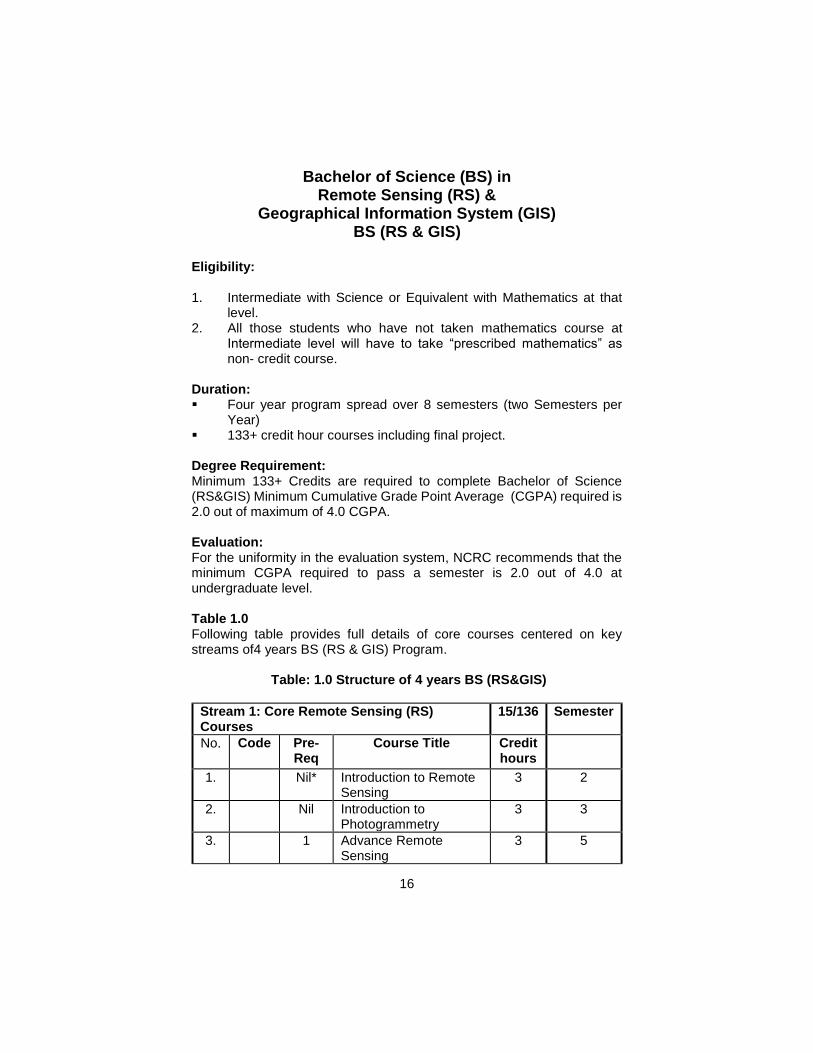
Bachelor of Science (BS) in Remote Sensing (RS) &
Geographical Information System (GIS) BS (RS & GIS)
Eligibility: 1. Intermediate with Science or Equivalent with Mathematics at that
level. 2. All those students who have not taken mathematics course at
Intermediate level will have to take “prescribed mathematics” as non- credit course.
Duration: Four year program spread over 8 semesters (two Semesters per
Year) 133+ credit hour courses including final project. Degree Requirement: Minimum 133+ Credits are required to complete Bachelor of Science (RS&GIS) Minimum Cumulative Grade Point Average (CGPA) required is 2.0 out of maximum of 4.0 CGPA. Evaluation: For the uniformity in the evaluation system, NCRC recommends that the minimum CGPA required to pass a semester is 2.0 out of 4.0 at undergraduate level.
Table 1.0 Following table provides full details of core courses centered on key streams of4 years BS (RS & GIS) Program.
Table: 1.0 Structure of 4 years BS (RS&GIS)
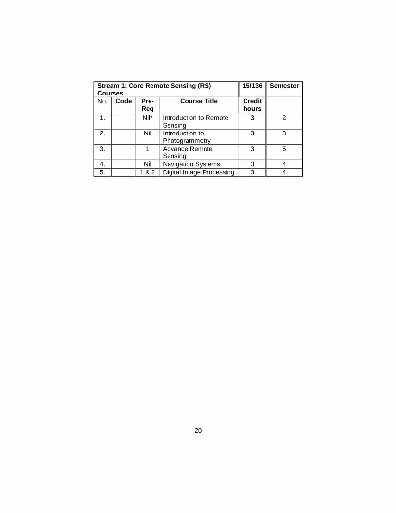
Stream 1: Core Remote Sensing (RS) Courses
15/136 Semester
No. Code Pre-Req
Course Title Credit hours
1.
Nil* Introduction to Remote Sensing
3 2
2.
Nil Introduction to Photogrammetry
3 3
3.
1 Advance Remote Sensing
3 5
17
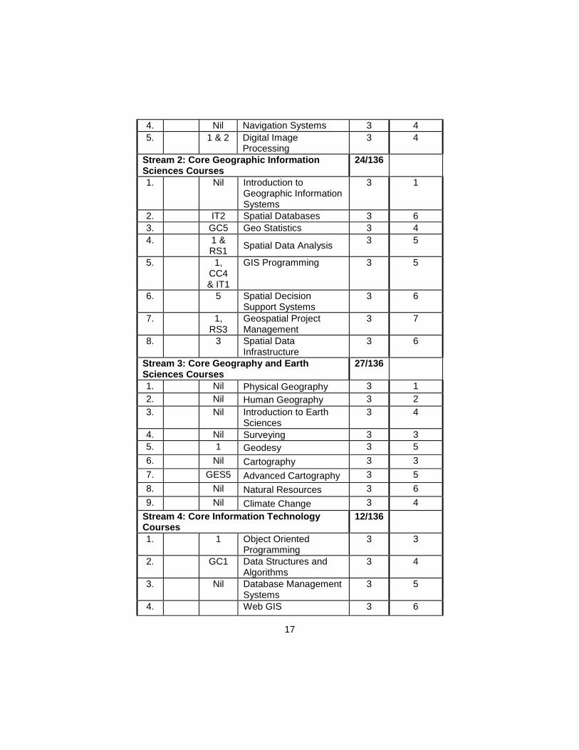
4.
Nil Navigation Systems 3 4
5.
1 & 2 Digital Image Processing
3 4
Stream 2: Core Geographic Information Sciences Courses
24/136
1.
Nil Introduction to Geographic Information Systems
3 1
2.
IT2 Spatial Databases 3 6
3.
GC5 Geo Statistics 3 4
4.
1 & RS1
Spatial Data Analysis 3 5
5.
1, CC4 & IT1
GIS Programming 3 5
6.
5 Spatial Decision Support Systems
3 6
7.
1, RS3
Geospatial Project Management
3 7
8.
3 Spatial Data Infrastructure
3 6
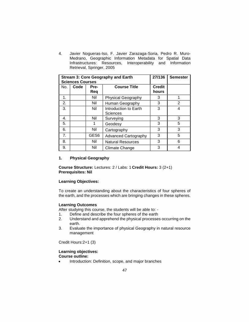
Stream 3: Core Geography and Earth Sciences Courses
27/136
1.
Nil Physical Geography 3 1
2.
Nil Human Geography 3 2
3.
Nil Introduction to Earth Sciences
3 4
4.
Nil Surveying 3 3
5.
1 Geodesy 3 5
6.
Nil Cartography 3 3
7.
GES5 Advanced Cartography 3 5
8.
Nil Natural Resources 3 6
9. Nil Climate Change 3 4
Stream 4: Core Information Technology Courses
12/136
1.
1 Object Oriented Programming
3 3
2. GC1 Data Structures and Algorithms
3 4
3.
Nil Database Management Systems
3 5
4.
Web GIS 3 6
18
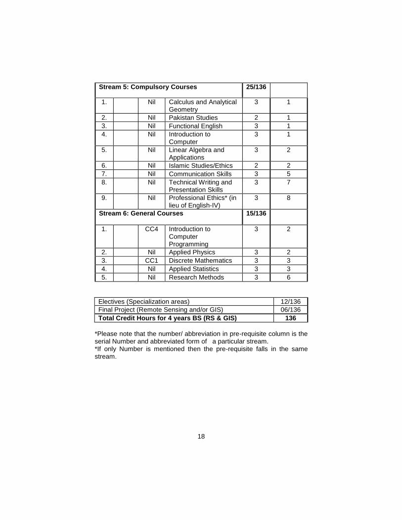
Stream 5: Compulsory Courses 25/136
1.
Nil Calculus and Analytical Geometry
3 1
2.
Nil Pakistan Studies 2 1
3.
Nil Functional English 3 1
4.
Nil Introduction to Computer
3 1
5.
Nil Linear Algebra and Applications
3 2
6.
Nil Islamic Studies/Ethics 2 2
7.
Nil Communication Skills 3 5
8.
Nil Technical Writing and Presentation Skills
3 7
9.
Nil Professional Ethics* (in lieu of English-IV)
3 8
Stream 6: General Courses 15/136
1.
CC4 Introduction to Computer Programming
3 2
2.
Nil Applied Physics 3 2
3.
CC1 Discrete Mathematics 3 3
4.
Nil Applied Statistics 3 3
5.
Nil Research Methods 3 6
Electives (Specialization areas) 12/136
Final Project (Remote Sensing and/or GIS) 06/136
Total Credit Hours for 4 years BS (RS & GIS) 136
*Please note that the number/ abbreviation in pre-requisite column is the serial Number and abbreviated form of a particular stream. *If only Number is mentioned then the pre-requisite falls in the same stream.
19
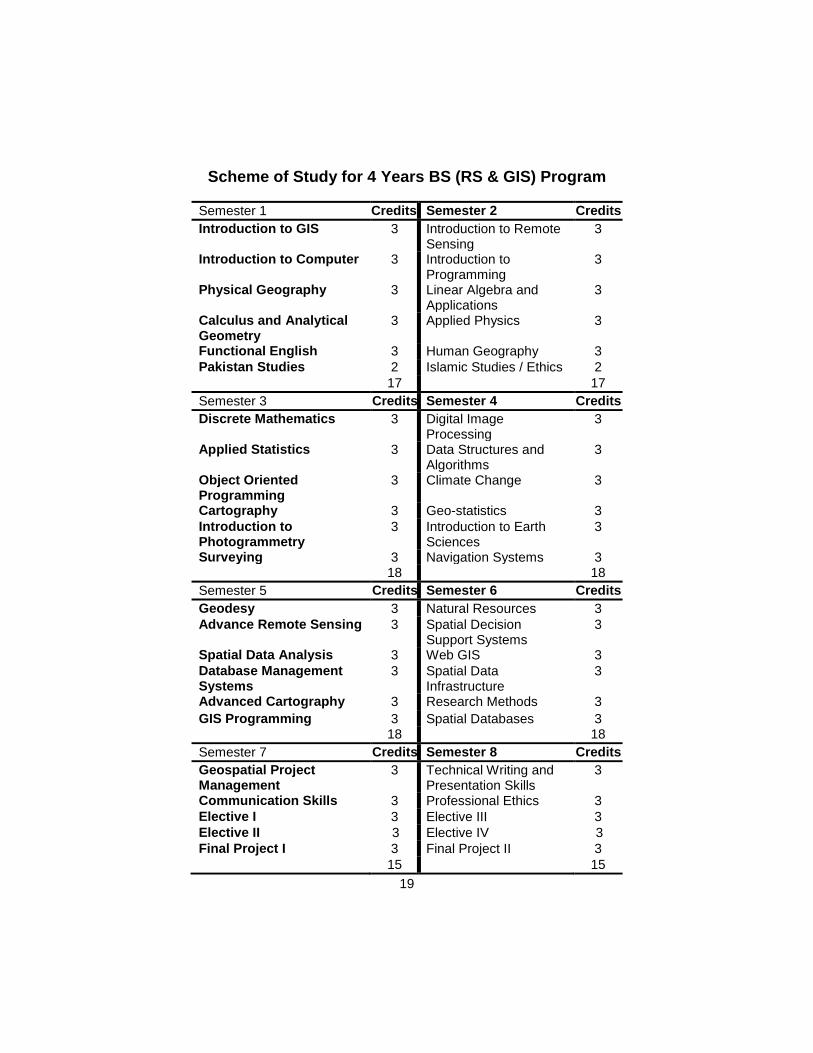
Scheme of Study for 4 Years BS (RS & GIS) Program
Semester 1 Credits Semester 2 Credits
Introduction to GIS 3 Introduction to Remote Sensing
3
Introduction to Computer 3 Introduction to Programming
3
Physical Geography 3 Linear Algebra and Applications
3
Calculus and Analytical Geometry
3 Applied Physics 3
Functional English 3 Human Geography 3
Pakistan Studies 2 Islamic Studies / Ethics 2
17 17
Semester 3 Credits Semester 4 Credits
Discrete Mathematics 3 Digital Image Processing
3
Applied Statistics 3 Data Structures and Algorithms
3
Object Oriented Programming
3 Climate Change 3
Cartography 3 Geo-statistics 3
Introduction to Photogrammetry
3 Introduction to Earth Sciences
3
Surveying 3 Navigation Systems 3 18 18
Semester 5 Credits Semester 6 Credits
Geodesy 3 Natural Resources 3
Advance Remote Sensing 3 Spatial Decision Support Systems
3
Spatial Data Analysis 3 Web GIS 3
Database Management Systems
3 Spatial Data Infrastructure
3
Advanced Cartography 3 Research Methods 3
GIS Programming 3 Spatial Databases 3 18 18
Semester 7 Credits Semester 8 Credits
Geospatial Project Management
3 Technical Writing and Presentation Skills
3
Communication Skills 3 Professional Ethics 3
Elective I 3 Elective III 3
Elective II 3 Elective IV 3
Final Project I 3 Final Project II 3
15 15
20
Stream 1: Core Remote Sensing (RS) Courses
15/136 Semester
No. Code Pre-Req
Course Title Credit hours
1.
Nil* Introduction to Remote Sensing
3 2
2.
Nil Introduction to Photogrammetry
3 3
3.
1 Advance Remote Sensing
3 5
4.
Nil Navigation Systems 3 4
5.
1 & 2 Digital Image Processing 3 4
21
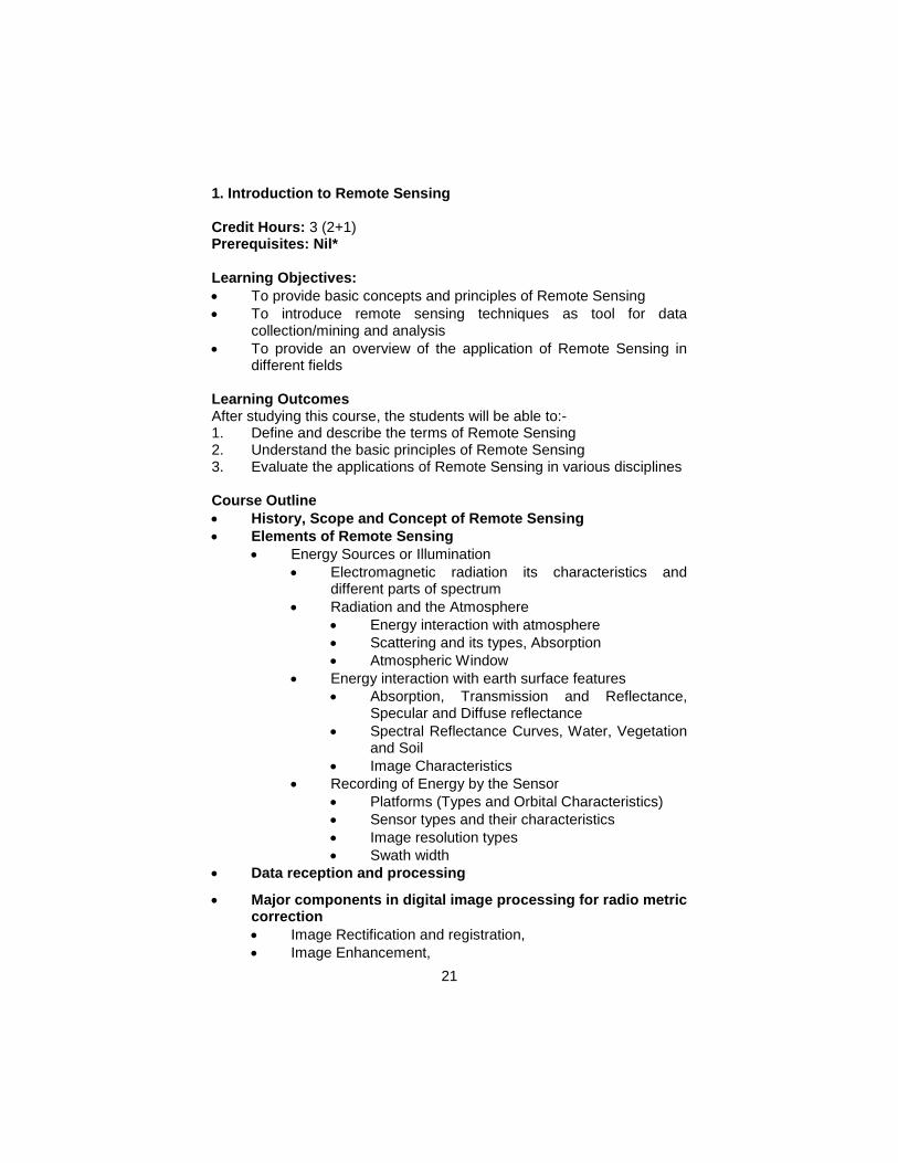
1. Introduction to Remote Sensing Credit Hours: 3 (2+1) Prerequisites: Nil* Learning Objectives:
To provide basic concepts and principles of Remote Sensing
To introduce remote sensing techniques as tool for data collection/mining and analysis
To provide an overview of the application of Remote Sensing in different fields
Learning Outcomes After studying this course, the students will be able to:- 1. Define and describe the terms of Remote Sensing 2. Understand the basic principles of Remote Sensing 3. Evaluate the applications of Remote Sensing in various disciplines Course Outline
History, Scope and Concept of Remote Sensing
Elements of Remote Sensing
Energy Sources or Illumination
Electromagnetic radiation its characteristics and different parts of spectrum
Radiation and the Atmosphere
Energy interaction with atmosphere
Scattering and its types, Absorption
Atmospheric Window
Energy interaction with earth surface features
Absorption, Transmission and Reflectance, Specular and Diffuse reflectance
Spectral Reflectance Curves, Water, Vegetation and Soil
Image Characteristics
Recording of Energy by the Sensor
Platforms (Types and Orbital Characteristics)
Sensor types and their characteristics
Image resolution types
Swath width
Data reception and processing
Major components in digital image processing for radio metric correction
Image Rectification and registration,
Image Enhancement,
22
Mosaicking and sub-setting
Interpretation and Analysis
Visual Image Interpretation
Digital Image processing overview
Applications Overview
Lab Outline: 1. Introduction to labs, 2. Overview of Image Processing Software (e.g. ERDAS Imagine,
ENVI, Orfeo Toolbox), 3. Image Georeferencing 4. Layer stacking, 5. Image Mosaicing, 6. Extraction of AOI (Subsetting), 7. Color composites, 8. Various sensors data comparison, 9. Feature recognition, 10. Image classification
a. Unsupervised b. Supervised
Teaching Methodology
Lectures
Written Assignments
Lab work Assessment Mid Term (40%)
Written (Long Questions, Short Questions, MCQs) 50%
Presentation 20%
Assignments 20%
Report Writing 10% Final Term (60%)
Written (Long Questions, Short Questions, MCQs) 50%
Presentation 20%
Report Writing 10%
Lab work 20% Recommended Books 1. Campbell, James B. (2011). Introduction to Remote Sensing, 5th Ed.
The Guilford Press.
23
2. Foody, G.M. & Curran, P.J. (1994). Environmental Remote Sensing from Regional to Global scales. John, Wiley & Sons. Inc. 250 p.
3. Gibson, P. J (2000). Introductory Remote Sensing: Principles and Concepts Rutledge.
4. Lillesand, T. M. & Kiefer, R. W. (2010). Remote Sensing and Image Interpretation, 6th edition. John Wiley and Sons Inc.
5. Lulla, K.& Dessinov, L.V. (2000). Dynamic Earth Environmental: Remote Sensing Observations from shuttle Mir Mission John, Wiley & Sons. Inc.288 p.
6. Rancez, A.N. (1999). Remote Sensing for the Earth Sciences. John Wiley & Sons. Inc. 728 p.
Qihao Weng. (2012). An Introduction to Contemporary Remote Sensing, 1st Ed, McGraw-Hill, U. K. 2. Introduction to Photogrammetry Course Structure: Lectures: 2 / Labs: 1 Credit Hours: 3 (2+1) Prerequisites: Nil Learning Objective
To provide basic knowledge about the key elements of photogrammetry and its procedures/techniques.
To understand stereo photogrammetry and its applications Learning Outcomes After studying this course, the students will be able to:- 1. Define and describe the terms photogrammetry and aerial
photograph 2. Understand the basic principles of photogrammetry 3. Apply the knowledge to visually interpret the aerial photograph. 4. Compare photogrammetry and remote Sensing. 5. Evaluate the application of aerial photographs and its importance in
natural Resource management Course Outline:
Introduction: History, overview and importance of photogrammetry
Analog, and digital photogrammetry
Sensor, films and filters, data acquisition methods
Types of aerial photographs: vertical, oblique, terrestrial, convergent and trimetrogon photographs
Flight configuration of aerial photography: forward & side lap and forward gain
Aerial photograph’s marginal information
24
Methods for calculation of scale and area: descriptive, graphical and representative friction method
Interpretation of aerial photographs: shape, shadow, size, pattern, tone, texture and association
Stereovision, Ray’s Diagram, Porro-Koppe’s principle, Stereoscopic analysis
Introduction to Digital Photogrammetric Work Stations (DPWS)
Concepts of UAVs, LIDAR and their applications
DEM, DSM and DTM generation and their comparison,
Ortho-photography/Ortho-image, applications: visual interpretation, identification and extraction of natural and man-made features, flood damage assessment and various types of mass-movement
Teaching Methodology
Lecturing
Written Assignments
Lab work Assessment Mid Term (40%)
Written (Long Questions, Short Questions, MCQs) 50%
Presentation 20%
Assignments/Lab work 20% Final Term (60%)
Written (Long Questions, Short Questions, MCQs) 50%
Presentation 20%
Assignments/Lab work 20%
Term Project 10% Lab Outline:
Visual interpretation, Identification and Extraction of various land features
DEM generation, Height measurement, scale & area calculations, and contouring by using Stereoscope and Photogrammetric Work Station
Reference Material: 1. David, P. P., & James D. K. (2012). Aerial Photography and Image
Interpretation 2nd Edition. John Wiley & Sons, Inc. New Jersey.ISBN-13: 978-0470879382
25
2. Edward, M., Mikhail, J. S., Bethel, J., & Chris McGlone. (2001). Introduction to modern photogrammetry 1st Ed. Wiley, ISBN: 9780471309246
3. Golwell, R.N. (1960). Manual of photographic Interpretation, New York.
4. Judge, A.W. (1950). Streeoscopic photography: It application to science, industry and education. London.
5. Karl, K. (2004). Photogrammetry – Geometry from Images and Laser Scans 2nd Ed. Walter de Gruyter, Berlin.ISBN: 9783110190076
6. Paul, W., DeWitt,B., & Wikinson, B. (2014). Element of Photogrammetry with Application in GIS. McGraw Hill. ISBN-13:978-0071761123
7. Wilfried, L. (2009). Digital Photogrammetry – A Practical Course 3rd Ed. Springer. ISBN:9783540927259
3. Advanced Remote Sensing Credit hours: 3 (1+2) Prerequisites: Introduction to Remote Sensing Course Objectives: To equip students on the advanced development in Remote Sensing and analytical techniques.
Learning Outcomes After studying this course, the students will be able to:- 1. Understand practical skills required in advanced remote sensing 2. Learn techniques to handle analytically the remote sensing data. 3. Become proficient in the use of advanced remote sensing
techniques. 4. Become effective in analyzing optical, thermal and microwave
remotely sensed data sets. Content List
Introduction to new generation satellites (GPM, SMAP, SWOT, ICESat, Aqua/Terra, ALOS, Sentinel-2, etc)
Major components in digital image processing
Spatial Filtering,
Principle component Analysis,
Image Fusion,
Image Classification techniques (object based, knowledge based, support vector machine, neural network)
Generating DEM, DTM & DSM
Integrated Remote sensing and GIS Modeling
26
Synthetic aperture radar(SAR)
Interferometry,
image spectrometry,
Feature Extraction from hyper-spectral data,
Image Residuals,
Spectral Fingerprints,
Absorption-band Parameters,
Spectral Derivative Ratio,
Classification Algorithms for hyper-spectral Data,
radar remote sensing,
speckle noise and suppression,
texture analysis,
data Fusion,
Basic concepts of satellite altimetry and gravimetry
Applications of new generation satellite sensors (SAR, InSAR, Altimetry, Gravimetry)
Lab:
Image Enhancement and Image Fusion
Image Classification: object based, knowledge based, support vector machine, neural network
Indices Development: NDVI, NDWI, NDSI, Leaf Area Index in ERDAS Imagine, ENVI, MATLAB, etc.
Application in natural resource management Teaching Methodology
Lectures
Lab sessions
Term Projects Assessment
Mid Term (40%)
Written (Long Questions, Short Questions, MCQs) 60%
Term Project Completion 20%
Term Project Presentation 20% Final Term (60%)
Written (Long Questions, Short Questions, MCQs) 100% Reference Material:
Campbell, B. J. (2006). Introduction to Remote Sensing, 4th Ed., The Guilford Press, New York, ISBN # 0-7484-0663-8.
Henderson, F.M. and Lewis, A. J. (1998). Principles & Application Imaging radar / Manual of Remote Sensing / Third Edition, Volume
27
2, Published by American Society for Photogrammetry and Remote Sensing, John Wiley & Sons, New York.
McCoy, R. (2004). Field Methods in Remote Sensing, The Guilford Press: New York, ISBN: 1593850794
Mather, P. (2004) Computer processing of remotely sensed images. Third Edition, J Wiley. ISBN 0-470-849193.
Egan, W. G. and Egan, W. (2003) Optical Remote Sensing: Science and Technology (Optical Engineering) Marcel Dekker ISBN: 0824741315
Landgrebe, D. A. (2003). Signal
Theory Methods in Multispectral Remote Sensing. (Wiley Series in Remote Sensing and Image Processing) Wiley-Interscience; Bk&CD-Rom edition: New York, ISBN: 047142028X.
Peebles, P.Z (1998) Radar Principles, Wiley Inter science, New York.
Elachi, C. (1988). Space borne Radar Remote Sensing: Applications and Techniques, IEEE Press, New York.
Ulaby, F. T. (1986). Microwave Remote Sensing: Active and Passive, Volume II: Radar Remote Sensing and Surface Scattering and Emission Theory Artech House Publishers ISBN: 0890061912
4. Navigation systems Credit hours: 3 (2+1) Prerequisites: Introduction to GIS Course Objectives: Introduces students to the basic of global satellite navigation systems in a manner where they will be able to add significant components of the said in their practical applications of GIS. These practical applications may include surveying, mobile applications with real-time navigation and integration in web mapping applications etc. Learning Outcomes
Upon successful completion of this course, the student will demonstrate the ability to:
1. Identify various global satellite navigation systems and their operational principles;
2. Understand the functioning and operational details of GNSS and similar systems;
3. Analyze the shortcomings of such systems in real-life scenarios;
28
4. Adapt to variations in various navigation systems based devices and their operational mechanisms.
Content List
Introduction to Navigation science,
Available and Future Navigation Systems,
Basic Mathematical Concept for Navigation Systems,
Space Segment,
Control Segment,
User Segment,
Point to point transmission,
Point to area transmission,
Differential GPS and Kinematics,
Diffusion and interference,
Application of Navigation system,
GPS Error sources and Accuracy Assessment,
Data transfer from and to a GPS receiver.
Practical:
GPS value reading,
Easting Northing (latitude/ longitude) and elevation,
Map Projections and Datum Settings,
GPS based surveys,
Tracking and data processing including GPS data display,
Planimetric & vertical errors calculations,
GPS Project
Teaching Methodology
Lectures
Written Assignments
Field Assignments
Report Writing Assessment Mid Term (40%)
Written (Long Questions, Short Questions, MCQs) 50%
Presentation 20%
Assignments 10%
Report Writing 10%
Lab work 10% Final Term (60%)
Written (Long Questions, Short Questions, MCQs) 50%
Presentation 20%
29
Assignments 20%
Term Project 10%
Lab work 10% Recommended Books 1. Van Sickle, J. (2008). GPS for land surveyors. CRC Press. 2. Toth, P., & Vigo, D. (Eds.). (2014). Vehicle routing: problems,
methods, and applications (Vol. 18). Siam. 3. Bray, H. (2014). You are here: From the Compass to GPS, the
History and Future of how We Find Ourselves. Basic Books. 4. Denny, M. (2012). The science of navigation: from dead reckoning
to GPS. JHU Press. 5. DIGITAL IMAGE PROCESSING Credit hours: 3 (2+1) Prerequisites: (Advance Remote Sensing) Course Objectives:
To provide basic understanding of digital image processing of remotely sensed data.
To apply the image processing techniques of feature detection for generating useful knowledge.
Learning Outcomes After studying this course, the students will be able to:- 1. Understand different modalities and current techniques in image
acquisition 2. Describe how digital images are represented and stored efficiently
depending on the desired quality, color depth, dynamics (time-varying data).
3. Use the mathematical principles of digital image enhancement (contrast, gradients, noise).
4. Analyze the constraints in image processing when dealing with larger data sets (efficient storage and compression schemes).
5. Apply the knowledge primarily obtained by studying examples and cases in the field of biomedical imaging to other engineering disciplines.
Content List
Data Sources and acquisition
Characteristics of grey-level digital images
Types of Image data Formats
Pre-processing (Image stacking, Sub-setting & Geomatric and Atmospheric Corrections)
Image Rectification and Registration
30
Re-sampling
Image transformation (Geometric and Affine)
Batch Processing
Image Mosaicking and Color Balancing
Image Enhancement (Grey level transformations, Histogram equalization,)
Image Filtering (Pan-sharpening, Fourier descriptors, Linear and non-linear filtering operations, Image and Separable convolutions, Sub-sampling and interpolation as convolution operations)
Image Indices (NDVI, NDWI, NDSI, Leaf Area Index, etc)
Image Classification (Types, Algorithms and Spatial modeler techniques)
Signatures selection, feature space and evaluation
Principal component analysis
Morphological operations
Accuracy Assessment and Field Verification Practical:
Intro to lab and software
Hands on training on Spatial modeler in ERDAS Imagine
Atmospheric correction of multi-spectral and hyper-spectral data sets
Image Management (Import/Export & Display)
Image Enhancement Techniques (Histogram equalization, filtering)
Spectral and spatial digitizing
Mosaicking and color balancing
Rectification, Registration and Re-sampling
Image processing techniques
Signature selection
Accuracy Assessment and Field Verification
Individual/Group project with field work Teaching Methodology
Lecturing
Written assignments
Lab based assignments
Final project Assessment Mid Term (40%)
Written (Long Questions, Short Questions, MCQs) 50%
Written assignment 25%
Lab based assignments 25%
31
Term project 10%
Final Term (60%)
Written (Long Questions, Short Questions, MCQs) 50%
Written assignment 20%
Lab based assignments 20%
Final project 10%
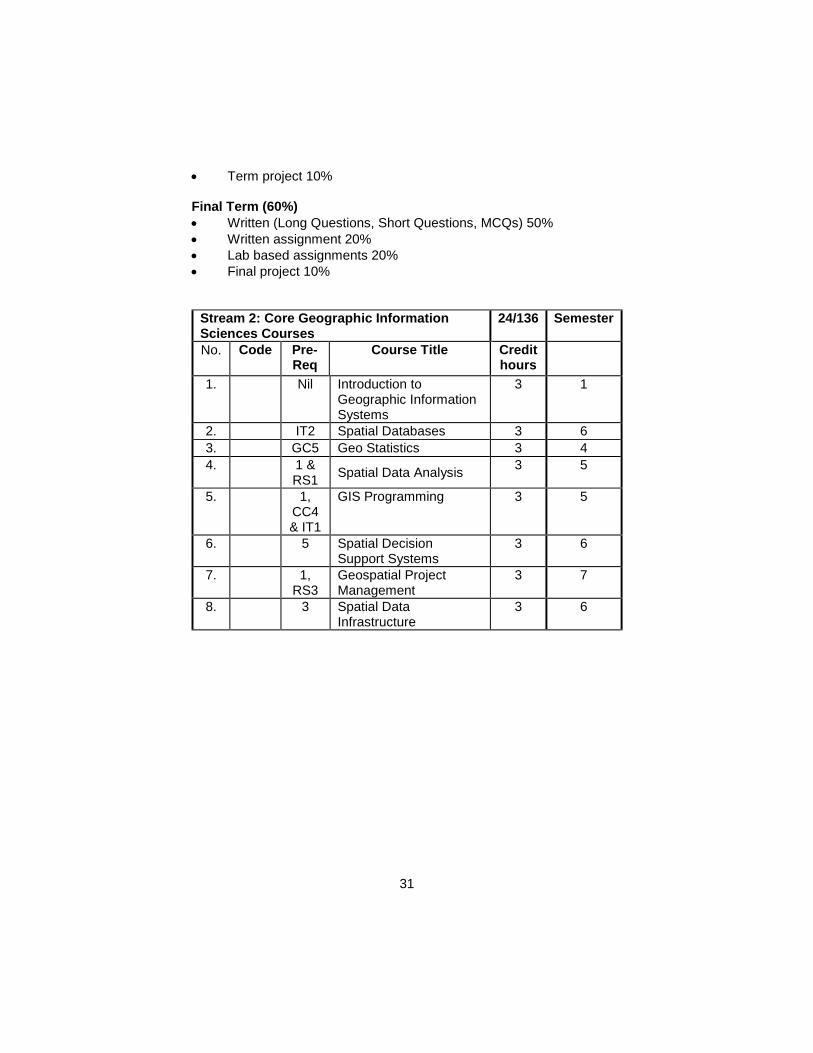
Stream 2: Core Geographic Information Sciences Courses
24/136 Semester
No. Code Pre-Req
Course Title Credit hours
1.
Nil Introduction to Geographic Information Systems
3 1
2.
IT2 Spatial Databases 3 6
3.
GC5 Geo Statistics 3 4
4.
1 & RS1
Spatial Data Analysis 3 5
5.
1, CC4 & IT1
GIS Programming 3 5
6.
5 Spatial Decision Support Systems
3 6
7.
1, RS3
Geospatial Project Management
3 7
8.
3 Spatial Data Infrastructure
3 6
32
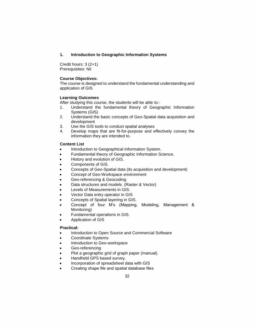
1. Introduction to Geographic Information Systems Credit hours: 3 (2+1) Prerequisites: Nil Course Objectives: The course is designed to understand the fundamental understanding and application of GIS Learning Outcomes After studying this course, the students will be able to:- 1. Understand the fundamental theory of Geographic Information
Systems (GIS) 2. Understand the basic concepts of Geo-Spatial data acquisition and
development 3. Use the GIS tools to conduct spatial analyses 4. Develop maps that are fit-for-purpose and effectively convey the
information they are intended to.
Content List
Introduction to Geographical Information System.
Fundamental theory of Geographic Information Science.
History and evolution of GIS.
Components of GIS.
Concepts of Geo-Spatial data (its acquisition and development)
Concept of Geo-Workspace environment
Geo-referencing & Geocoding
Data structures and models. (Raster & Vector)
Levels of Measurements in GIS.
Vector Data entry operator in GIS
Concepts of Spatial layering in GIS.
Concept of four M’s (Mapping, Modeling, Management & Monitoring)
Fundamental operations in GIS.
Application of GIS
Practical:
Introduction to Open Source and Commercial Software
Coordinate Systems
Introduction to Geo-workspace
Geo-referencing
Plot a geographic grid of graph paper (manual).
Handheld GPS based survey.
Incorporation of spreadsheet data with GIS
Creating shape file and spatial database files
33
Digitization [preparation of Land-use Map]
Generating Maps in form of PDF/Jpeg etc. Teaching Methodology
Lecturing –Basic Concepts
Filed Survey –Data Collections
Computer lab sessions – Demonstration of GIS software
Term Projects – Application Assessment
Mid Term (40%)
Written (Long Questions, Short Questions, MCQs) 40%
Term Project Completion 20%
Term Project Presentation 20%
Lab Exercises 20% Final Term (60%)
Written (Long Questions, Short Questions, MCQs) 80%
Practical Examination 20% Recommended Books 1. Chang, K. T. (2010), “Introduction to Geographical Information
Systems” Higher Education, McGraw-Hill 2. Clarke, K. (2010), “Getting started with Geographic Information
System”, 5th Edition, Prentice Hall, New York. ISBN –10: 0131494988
3. Huisman, O. and de By, R. A.(2009), “Principles of Geographic Information Systems: An Introductory Textbook”, ITC Educational Textbook Series; 1, ISBN 978-90-6164-269-5
4. Gopi, S., Sathikumar, R., & Madhu, N. (2007). Advance Surveying Total Station, GIS and Remote Sensing. New Delhi, India: Dorling Kindersley.
5. Bolstad, P. (2007), “GIS Fundamentals”, 3rd Edition, Atlas Books. ISBN: 978-0-9717647-2-9
6. Heywood, I., Cornelius, S. and Carver, S. (2006), “An introduction to Geographic Information System”, 3rd Edition, Prentice Hall. ISBN-10: 0131293176
7. Longley, P. A., Goodchild, M. F., Maguire, D. J., and David, W. R. (2011), “Geographic Information Systems and Sciences”, 3rd Edition, John Wiley & Sons.
8. Ormsby, T., Napoleon, E., Burke, R., Groessl, C., and Bowden, L. (2010), “Getting to Know ArcGIS Desktop: Basics of ArcView, ArcEditor, and ArcInfo”, 2nd Edition, ESRI Press. ISBN: 9781589482609.
34
2. Spatial Database Systems
Credit Hours: 3 ( 2 + 1 ) Prerequisites: Introduction to GIS
Course Objectives: To introduce a thorough understanding and capabilities of Spatial
Databases Learning Outcomes: After this course’s completion, the students should be able to:
1. Understand basic spatial database concepts, 2. Distinguish Spatial data models and geodatabases 3. Implement Spatial data retrieval techniques and SQL in the GIS
environment 4. Compare various spatial data management and Open GIS
Standards
Contents List:
Introduction to Spatial Database
Basic Open GIS Standards for Spatial Database
Relational Database in Spatial domain
Object Relational Database
Spatial Query and Spatial Operators
Basics of Geodatabase
Basic spatial and geometry tests
Table operations
Topology in Spatial Database
Spatial Indexing
Practical: Introduction to lab and software Linking with GIS software Development of geo-databases and spatial databases Topological testing Spatial Queries and Spatial Operators Assignments on application of spatial queries
Teaching Methodology
Lectures
Written Assignments
Guest Speaker
Field Visits
Report Writing
35
Assessment
Mid Term (40%)
Written (Long Questions, Short Questions, MCQs) 50%
Lab Exam 50%
Final Term (60%)
Written (Long Questions, Short Questions, MCQs) 50%
Lab Exam 50%
Recommended Books: 1. Elmasri, R. and Navathe, S.B. (2004) “Fundamentals of Database
Systems” Addison-Wesley Pub. Co ISBN – 0-201760355 2. Konstantin Krivoruchko (2011), “Spatial Statistical Data Analysis for
GIS Users” ISBN: 1589481615 3. Manfred M. F. and Jinfeng, W. (2011), “Spatial Data Analysis:
Models, Methods and Techniques”. 1stEdition, ISBN-10: 3642217192
4. Oracle press release 2010, Oracle Spatial 11g user guide and reference
5. OGC release 2011, Open GIS Implementation Specification for Geographic information – Simple feature access Part 2: SQL option
6. Rigaux, P. Scholl, M. and Voisard, A.(2001) “Spatial Databases: With Application to GIS” Morgan Kaufmann; 2nd Edition
3. Geo-statistics Credit hours: 3 (3+0) Prerequisites: (None) Course Objectives: To help students understand the use and application of geo-statistics in GIS and remote sensing Learning Outcomes After studying this course, the students will be able to: 1. Understand the concepts underlying geo-statistical analysis; 2. Differentiate different geo-statistical analysis techniques; 3. Understand and analyze the outcomes of geo-statistical analysis; 4. Use of the suitable geo-statistical models; 5. Employ geo-statistical analysis for planning and decision making. Content List
Statistic
Data analysis and transformation
36
Sets and Probability
Concept of Random Variables
Possibilities
Probabilities and expectations
Directional semi-variograms
Sampling Theory
Estimation Theory
Testing Hypothesis: One sample Tests, Two Sample Tests
Regression and Correlation
Analysis of Variance
The Chi-Square Distribution
Quantile-quantile plot
Spatial autocorrelation and directional influences
Cross validation
Practical: Exercise related to:
Statistics, data analysis and transformation.
Directional semi-variograms.
Quantile-quantile plot Teaching Methodology
Lecturing
Written assignments
Lab based assignments
Final project Assessment
Mid Term (40%)
Written (Long Questions, Short Questions, MCQs) 50%
Written assignment 20%
Lab based assignments 20%
Final project 10%
Final Term (60%)
Written (Long Questions, Short Questions, MCQs) 50%
Written assignment 20%
Lab based assignments 20%
Final project 10% Recommended Books 1. Peter J., Diggle, Paulo J., Ribeiro, Jr. (2007). Model-based
geostatistics, Springer.
37
2. Remy, N., Boucher, A. and Wu, J. (2009). Applied Geostatistics with SGeMS: A User’s Guide.
3. Roger S., Bivand, Edzer J., Pebesma and Gómez-Rubio, V. (2009). Applied Spatial Data Analysis with R (Use R).
4. Sarma, D.D. (2009). Geostatistics with Applications in Earth Sciences,
5. Webster, R. and Margaret A. Oliver (2007). Geostatistics for Environmental Scientists (Statistics in Practice).
4. Spatial Data Analysis
Credit Hours: 3 (2 + 1) Prerequisites: Spatial Data Systems Course Objectives: To develop spatial analytical skills in practical scenarios within the geographic information systems. Learning Outcomes: After studying this course, the students will be able to:- 1. Identify the main functional components of GIS 2. Understand the various types of Spatial analyses 3. Implement standardized data input and management 4. Simulate real world using various analytical techniques.
Contents List:
Introduction to spatial data types
Potentials of spatial data
Modeling and storing field data
Cluster analysis
Boundary Analysis
Spatial Analyses
Point pattern analysis
Spatial Autocorrelation
Buffering, proximity and neighborhood functions
Spatial interpolation, type, Methods / algorithms, Derived measures on surfaces
Polylines and network Analyses
Area objects and types of area objects
Geometric properties of areas
Map overlay
38
Vector and raster overlay operations
Ordinary Least Squares & Geographically Weighted Regression Techniques
Problems in simple Boolean polygon overlay
Multivariate data and multidimensional space
New approaches to spatial analysis
Surface modeling, DTM/DEM/DSM
Multi-criteria and Multi-attribute Decision Making
Uncertainties in spatial modeling. Practical: Assignment on Spatial Analysis for various applications Geo-coding Point analysis exercise Interpolation of point data and surface modeling Network analysis exercise Arial analysis exercise Buffer analysis exercise Multivariate analysis Assignment on advanced spatial analysis Suitability analysis Risk Modeling, Assignment on uncertainties in spatial modeling Teaching Methodology: Lectures Lab work Assignments Term Project Assessment: Mid Term (40%)
Written (Long Questions, Short Questions, MCQs) 40%
Quizes 30%
Lab Exam 30% Final Term (60%)
Written (Long Questions, Short Questions, MCQs) 40%
Lab Exam 20%
Term Project Completion 20%
Term Project Presentation 20%
39
Recommended Books: 1. Albert, D. P., Gesler, W. M. and Levergood, B. (2000), “Spatial
Analysis, GIS and Remote Sensing Application in Health Sciences” CRC Press.ISBN: 1575041014
2. Atkinson, P. M., and Tate, N. (1999) “Advances in Remote Sensing and GIS Analysis”, 1st Edition, John Wiley & Sons. UK. ISBN:0471985775
3. Chang, K. T. (2010), “Introduction to Geographic Information Systems”, McGraw Hill. ISBN: 007352283X
4. Chrisman, N. (2001) “Exploring Geographic Information System”, 2nd Edition, John Wiley & Sons, UK. ISBN: 0471314250
5. Heywood, I., Cornelius, S. and Carver, S. (2006), “An introduction to Geographic Information System”, 3rd Edition, Prentice Hall. ISBN-10: 0131293176
6. Laurini, R., and Thompson, D. (1992), “Fundamentals of Spatial Information Systems”, 1stEdition,Academic Press. ISBN:0124383807
7. Longely, P., Goodchild, M., Maquire, D., and Rhind, D. W. (2005), “Geographic Information Systems: Principles, Techniques, Management and Applications”, 2nd Edition, John Wiley & Sons. ISBN: 0471735450
8. Stillwell, J. and Clarke, G. (2004), “Applied GIS and Spatial Analysis”, John Wiley & Sons, UK.
9. Sullivan, D. and Unwin, D. (2010), “Geographic Information Analysis”, John Wiley &SonsInc. ISBN: ISBN10: 0470288574
10. Verbyla, D. (2007), “Practical GIS Analysis”, 1st Edition, Taylor & Francis. ISBN: 0415286093
5. GIS Programming
Credit Hours: 3 ( 2 + 1)
Prerequisites: Data Structures and Algorithms
Course Objectives: To provide a foundation for customized geospatial applications using various programming platforms. Learning Outcomes: Students completing this course should be able to: 1. Understand the basic working environments of Python 2. Apply geoprocessing techniques using Arcpy code. 3. Implement automated tasks using Arcpy code. 4. Understand and implement the use of cursors. 5. Create usable ArcObjects code for typical GIS programming tasks
in .NET.
40
Contents List:
Intro to course
Fundamentals of geo-processing
Fundamentals of Python
Usage of variables and special data types
Naming conventions and reserved words
testing and printing variable values
Looping and control structures
Debugging
optional and required parameters
Objects, properties and methods
the OO paradigm
Object Model Diagrams
The geo-processor object introduction
Functions and parameters, passing and returning values
Multiple inputs and complex parameter passing
Selections and sets
SQL basics
Writing results to disk, various formats and switches
Advanced topics and further directions
Num.py for numerical modeling
Architecture of ArcObjects
Main Arc Objects classes, classes and interfaces (IFeatureLayer, IFeatureClass, IFeature, IFeatureCursor, etc.) other useful modules
Practical:
Introduction to Lab
Looping statements
Getting and setting object parameters
Creating features and feature classes
Editing layer’s display properties
Changing/editing and summarizing attribute data
Exploring the geo-processor object,
Projects
Teaching Methodology: Lectures Lab work Assignments Assessment Mid Term (40%)
41
Written (Long Questions, Short Questions, MCQs) 50%
Lab exam 50%
Final Term (60%)
Written (Long Questions, Short Questions, MCQs) 50%
Lab Exam 50%
Recommended Books: 1. Eric Pimpler (2013), “Programming ArcGIS 10.1 with Python
Cookbook”. 2. Bugg, K.E. (2003), “GIS Programming: Prepare for the Gathering
Storm”, GEO World. 3. Kropla, B. (2005), “Beginning Map Server: Open Source GIS
Development”, 1st Edition, Apress, Co. ISBN: 1590594908 4. Ralston, B. A. (2001), “Developing GIS Solutions with Map Objects
and Visual Basic”, Onward Press, New York. ISBN: 0766854388 5. Rigaux, P., Scholl, M. and Voisard, A. (2001), “Spatial Databases:
With Application to GIS” 1st Edition, Morgan Kaufmann. ISBN: 1558605886.
6. Spatial Decision Support Systems Credit hours: 3 (2+1) Prerequisites: Geo-Spatial Database Systems Course Objectives: To provide the students with an understanding, use and development of decision support systems to address complex spatial problems. Learning Outcomes After studying this course, the students will be able to:- 1. Define and differentiate conventional and spatial decision support
systems. 2. Understand the components of SDSS. 3. Compare various technologies that are important in developing new
SDSS, including programming languages, development environments, and spatial libraries.
4. Apply the methods for tailoring SDSS into work environment.
Content List
Introduction to Spatial Decision Making (Need, Process, Evolution and Trends)
Components of Traditional DSS
Components of SDSS
Methods and Techniques to Support Spatial Decisions
42
Modeling Techniques (Generic Models and Application-Specific Models)
GIS Software Used in SDSS
SDSS Software Components
Design and Development of SDSS from Scratch
Enabling Technologies for the Development of Desktop
Web-Based SDSS Development and Architecture
SDSS Application Domains
SDSS Challenges (Technical, Technological, Social, Policy, and Organizational and Educational)
Future Trends and Directions
Practical:
Collaborative Decision -Making Software Packages, INDEX®
Populating a data warehouse using different loading facilities
Running different queries for extraction of results
ArcGIS Server-based SDSS and Map Server-based SDSS
Heuristic modeling using Marxan
Populating and using an OLAP tool Teaching Methodology
Lecturing
Written Assignments
Guest Speaker
Report Writing Assessment
Mid Term (40%)
Written (Long Questions, Short Questions, MCQs) 50%
Presentation 20%
Assignments 20%
Lab Assignments 10%
Final Term (60%)
Written (Long Questions, Short Questions, MCQs) 50%
Presentation 20%
Assignments 20%
Term Projects 10% Recommended Books 1. De Montis, A. (2010). Spatial Decision Support for Urban and
Environmental Planning. A collection of case studies, D. Geneletti, A. Abdullah (Eds.). ArahPendidikan Publishers (2009).
43
2. E. Turban, J. Aronson and T. Liang (2004); Decision Support Systems and Intelligent Systems, 7th Edition, Prentice Hall. ISBN: 0130461067
3. Jankowski, P., &Nyerges, T. (2001). GIS for group decision making. CRC Press.
4. Power, D. J., Sharda, R., & Burstein, F. (2015). Decision support systems. John Wiley & Sons, Ltd.
5. S. Ramanathan and DeGroote, John (2011); Spatial Decision Support Systems; CRC Press, 487 pages
6. Shi, W. (2009). Principles of modeling uncertainties in spatial data and spatial analyses. CRC Press.
7. Geospatial Project Management Credit Hours: 3 Course Structure: Lectures: 3 / Labs: 0
Prerequisites: Introduction to RS & GIS Objectives: i. Familiarize with important aspects of managing projects
Learning Outcomes:
After completion of this course the students will be able to: 1. Identify and analyze the issues involved in organizing, planning,
monitoring and controlling a geospatial project. 2. Initiate a small‐scale geospatial technology project by developing
project plans and financial budgets, assembling project costs and benefits, developing investment appraisal methods and using authorization, monitoring and control processes.
3. Discuss the role, significance and impact of people in a project management setting, and evaluate and implement strategies for managing people in geospatial technology projects.
4. Review current geospatial technology project management methodologies and appraise their effectiveness and efficacy for managing different types of geospatial projects.
Course Outline: Introduction and overview of Geospatial project management. Geospatial Program Development: Role of planning and management in developing a successful geospatial technology based projects. Geospatial Program Organizational Structure: Governance and Coordination: Role of planning and development, organizational structures, leadership and governance, and communications in successful geospatial projects.
44
Human Resources: Role of project leadership, team building, capacity
building (including opportunities for geospatial certification) and multi‐organizational agreements (i.e. collaborations) in contributing to successful geospatial programs. Funding, Financial Management, and Collaboration: The financial aspects, such as funding, financial management, monitoring, and reporting, and risk management that contribute to successful geospatial programs and the completion of projects on time and on budget. Geospatial Program Legal Issues: The ways in which legal and ethical issues influence the geospatial sector Management of Geospatial Program Technical Elements: Role of technical design (system configuration, data, applications) and the development and maintenance of these technical components in contributing to successful geospatial programs. Geospatial Office Operations, Service Delivery and User Support: Role of the operational environment in helping to shape and sustain successful geospatial programs. Geospatial Projects and Project Management: The ways in which all of the aforementioned components can be combined to successfully manage geospatial projects. Also current and emerging trends, including the consequences of choosing proprietary vs. open source software solutions, geospatial
standards, spatial data infrastructures, web‐based geoprocessing service architectures, and volunteered geographic information, and how they are likely to influence future geospatial projects.
Teaching Methodology
Lectures
Written Assignments
Presentation
Brainstorming for creativity
Assessment
Mid Term (40%)
Written (Long Questions, Short Questions, MCQs) 50%
Presentation 20%
Assignments 20%
Report writing 10%
Final Term (60%)
Written (Long Questions, Short Questions, MCQs) 50%
Presentation 20%
Assignments 20%
Report writing 10%
45
Reference Material: 1. Croswell, Peter L. 2011. The GIS Management Handbook. Des
Plaines, IL, Kessey Dewitt Publications in association with URISA. 2. Obermeyer, Nancy J. and Pinto, Jeffrey K. 2008. Managing
Geographic Information Systems (Second Edition). New York, The Gilford Press
3. Tomlinson, Roger 2013. Thinking about GIS: Geographic Information System Planning for Managers (Fifth Edition). Redlands, CA, Esri Press
4. Hanebuth, Austin Smith 2015. Applications in Geospatial Project Management Student Manual. Digital Quest Incorporated
5. Harder, Ormsby, and Balstrøm 2013. Understanding GIS: An ArcGIS Project Workbook. Esri Press
8. Spatial data infrastructure Credit hours: 3 (3+0) Prerequisites: Course Objectives: Spatial data infrastructures are meant for data holding and dissemination amongst a wider range of audience. In light of this the course objectives are to introduce students to the basic need and necessity of SDIs, their data holding nature, metadata standards and protocols, system architecture and deployment for public. Learning Outcomes After studying this course, the learners will be able to:- 1. Understand the basic working principles of SDI 2. Create and deploy working prototypes of SDI 3. Describe the working principles of an SDI and its component
elements
Content List
Introduction, Need for SDI
Components of SDI
Clearinghouse
Clearing house architecture National Geospatial Clearinghouse
Metadata
Metadata concepts and functionality
Structure of Metadata
Functionality of Metadata
System Architecture
Attribute Data Standardization
System Architecture for SDI Interoperability
46
Interoperability and standards
Client Server Architecture
Spatial Data Quality
Data Quality Information (DQI)
Accuracy, Precision, Bias and Error Modeling
Data Modeling for SDI
Data Modeling, Abstraction of Real World
Types of abstraction, Problems of information sharing (Heterogeneities),
Distributed database concept
GIS Internet Services and SDI Technologies
System Architecture
Available Services
Technologies that support internet GIS services
Commercial tools for internet GIS
Standardization by ISO and OGC
Teaching Methodology
Lecturing
Written Assignments
Guest Speaker
Field Visits
Report Writing Assessment
Mid Term (40%)
Written (Long Questions, Short Questions, MCQs) 50%
Presentation 20%
Assignments 20%
Report Writing 10%
Final Term (60%)
Written (Long Questions, Short Questions, MCQs) 50%
Presentation 20%
Assignments 20%
Report Writing 10% Recommended Books 1. P. Williamson, Abbas Rajabifard, Developing Spatial Data
Infrastructures: From Concept to Reality, Taylor & Francis, 2003 2. Yukio Sadahiro, Spatial Data Infrastructure for Urban Regeneration,
Springer, 2008 3. Harlan Joseph Onsrud, Research and Theory in Advancing Spatial
Data Infrastructure Concepts, ESRI, 2007
47
4. Javier Nogueras-Iso, F. Javier Zarazaga-Soria, Pedro R. Muro-Medrano, Geographic Information Metadata for Spatial Data Infrastructures: Resources, Interoperability and Information Retrieval, Springer, 2005
Stream 3: Core Geography and Earth Sciences Courses
27/136 Semester
No. Code Pre-Req
Course Title Credit hours
1.
Nil Physical Geography 3 1
2.
Nil Human Geography 3 2
3.
Nil Introduction to Earth Sciences
3 4
4.
Nil Surveying 3 3
5.
1 Geodesy 3 5
6.
Nil Cartography 3 3
7.
GES6 Advanced Cartography 3 5
8.
Nil Natural Resources 3 6
9. Nil Climate Change 3 4
1. Physical Geography Course Structure: Lectures: 2 / Labs: 1 Credit Hours: 3 (2+1) Prerequisites: Nil Learning Objectives: To create an understanding about the characteristics of four spheres of the earth, and the processes which are bringing changes in these spheres. Learning Outcomes After studying this course, the students will be able to: - 1. Define and describe the four spheres of the earth 2. Understand and apprehend the physical processes occurring on the
earth. 3. Evaluate the importance of physical Geography in natural resource
management Credit Hours:2+1 (3) Learning objectives: Course outline:
Introduction: Definition, scope, and major branches
48
Lithosphere
Plate tectonics, mountain building forces
Internal structure of earth
Rocks–origin, formation and types: Igneous, Sedimentary and Metamorphic Rocks
Geomorphic processes: Terrestrial and extra-terrestrial processes
An overview of the Geomorphic agents and there Landforms
Atmosphere
Composition and structure of Atmosphere
Atmospheric temperature and pressure,
Global circulation and wind systems
Cyclones and other Atmospheric disturbances
Atmospheric moisture and precipitation
Air masses and fronts
Hydrosphere
Hydrological cycle
Ocean composition, morphology
Temperature, salinity and other characteristics of ocean water
Movements of the ocean water; waves, currents and tides
Biosphere
Eco-systems
Formation and types of soils Lab. Work:
Study and identification of landforms using Satellite imageries and Topographic Sheets.
Observation and recording of weather data from a weather station.
Isotherms, isobars, climographs, meteorological instruments, study of weather maps.
Construction of maps and diagrams, identification of rocks and minerals, methods of showing relief: contours (pattern, cross section).
Field visits:
Visit to national park/biosphere reserves, Soil Survey of Pakistan, Geological Survey of Pakistan, (any one of them)
Teaching Methodology
Lecturing
Written Assignments
Field Visits
49
Assessment
Mid Term (40%)
Written (Long Questions, Short Questions, MCQs) 50%
Presentation 20%
Assignments 20%
Report Writing 10%
Final Term (60%)
Written (Long Questions, Short Questions, MCQs) 50%
Presentation 20%
Assignments 20%
Report Writing 10% Books Recommended: 1. King, C. A. M. (1980). Physical Geography, Basil Blackwell, Oxford. 2. Mcliveen, J. F. R. (1992). Fundamentals of Weather and climate,
Prentice Hall, New Jersey. 3. Monkhouse, F. J. (1996). Principles of Physical Geography, Hodder
& Stoughton, London. 4. Peterson, J. F., Sack, D. & Gabler, R. E. (2011). Physical
Geography, Brooks Cole. 5. Scott, R. C. (1996). Introduction to Physical Geography, West
Publishing Co, New York. 6. Small, R. J. (1989). Geomorphology and Hydrology, Longman,
London. 7. Strahler, A. (2013). Introduction to Physical Geography, John Wiley
& Sons, New Jersey. 8. Strahlar, A. N., Strahlar, A. H. (2004). Physical Environment, John
Wiley, New York. 9. Stringer, E. T. (2004). Modern Physical Geography, John Wiley,
New York. 10. Thornbury, W. D. (2004). Principles of Geomorphology, John Willy
& Sons, New York. 11. Thurman, H. V. & Trujillo, A. P. (2013). Essentials of Oceanography,
Prentice-Hall, Inc, New York. 12. Tarbuck, J.E and Lutgens, K.F. 2000. Earth Science, 9 Editions,
Prentice Hall: New Jersey. 13. Christopherson, W.R. 1997. Geosystems: An Introduction to the
physical Geography, 3 Edition, Prentice Hall: New Jersey. 14. De Blij, H.J. 1995. The Earth: An Introduction to its Physical and
Human Geography, 4 Edition, John Wiley: New York. 15. Lutgens, K.F and Tarbuck, J.E. 1995. The Atmosphere, 6 Editions,
Prentice Hall: New Jersey. 16. Scott, C.R. 1989. Physical Geography, West Publication Company:
St. Paul.
50
17. Strahler, N. Arthur and Strahler, H. Alan, 1987. Modern Physical Geography, 3 Edition John Wiley: New York.
18. McKnight, L.T. 1987. Physical Geography: Landscape Appreciation, 2 th rd th th rd nd Edition, Prentice-Hall: New Jersey.
19. Hamblin, K. W. 1985. The Earth’s Dynamic Systems, 5 edition, Macmillan Publishing Company & Collier Macmillan Publishers: New York.
2. Human Geography
Credit hours: 3 (3-0) 2+1 (3) Prerequisites: Nil Course Objectives: 1. To introduce the basic concepts in Human Geography 2. To familiarize with the recent trends in the field of Human Geography
Learning Outcomes: After studying this course, the students will be able to:- 1. Define human geography concepts of realms and regions, culture
integration, population distribution etc. 2. Recognize and interpret the relationships among patterns and
processes at different scales of analysis. . 3. Interpret man- environmental relationship and its consequences. 4. Characterize and analyze changing interconnections among places. 5. Evaluate the working of themes of human geography to understand
the real world phenomenon.
This course covers the following topics:
Course Details Introduction: Definition, Domains, Scope and Applications of Human Geography
Man Environment Relationship: Determinism, Possibilism and Perception, Environmental Problems
Population Growth/Change: Components, Causes of Rapid Population Growth, Malthus Theory of Population, Demographic Transition Theory, Overview of World Population Growth and future trends, Fertility and Mortality: Measures and Patterns.
Population Distribution: Types, Measurements, Factors and World Pattern of Population Distribution
51
Urbanization: Causes, Overview of urbanization along with future prospects, Mobility determinants, Push and Pull factors, Types of Migration, Push and Pull Factor, Consequence Language and religion: Classification of languages, world pattern of languages, classification of principle religion, race: major racial groups and their distribution,
Settlements: Classification of settlements (central place theory), urban and rural settlements (forms, functions and classification),
Political systems: national political systems (nations, states and nation-states), geographic characterization of states (size, shape, location, cores and capitals), classification of boundaries, international political system: the United Nations and its agencies, regional alliances, laws of the sea and maritime boundaries.
Economic Activities: Primary economic activities, Secondary economic activities Tertiary economic activities Quaternary & Quinary economic activities International trade, Major trade partners and organization, world trade pattern, Energy resources: Renewable and non- renewable resources (thermal power, hide power, solar power, wind power, nuclear power), Economic development: world pattern of economic development, measures of economic development, poverty problem. Lab. Construction of maps and diagrams to show world distribution of population, religions, languages and races, age sex pyramids of different countries, calculation of rates and ratios related to population. Construction of maps and diagrams to show economic activities, world distribution of major crops, fishing grounds, major minerals, major industrial goods, trade pattern. Teaching Methodology
Lecturing
52
Written Assignments
Field Visits Assessment Mid Term (40%)
Written (Long Questions, Short Questions, MCQs) 50%
Presentation 20%
Assignments 20%
Report Writing 10%
Final Term (60%)
Written (Long Questions, Short Questions, MCQs) 50%
Presentation 20%
Assignments 20%
Report Writing 10% Recommended Books: 1. Abbasi B,A (2008),A Regional Studies of South Asia Sang-e-Meel
Publications ,Lahore 2. Clarke, J. I. (1965). Population geography. Oxford; New York:
Pergamon Press. 3. Fouberg, E. H., Murphy, A. B., & De Blij, H. J. (2009). Human
geography: people, place, and culture. John Wiley & Sons. 4. Khan, F.K.An introduction to Economic Geography.Karachi, Saleem
publishing house 5. Khan,F.K. (2002) Pakistan, Geography, Economy and People
Karachi ,Saleem publishing house 6. Massey, D. B., Allen, J., & Sarre, P. (Eds.). (1999). Human
geography today (pp. 279-294). Cambridge: Polity Press. 7. Pitzl, G. R. (2004). Encyclopedia of human geography. Greenwood
Publishing Group. 8. Sethi, H. N. (2005). Environment of Pakistan Peak publication & Co
Karachi 9. Rubenstein, M. James. 2004. The Cultural Landscape: An
Introduction to Human Geography, Prentice Hall, Englewood Cliffs: New Jersey.
10. De Blij, H. J. 2003. Human Geography: Culture and Society, John Wiley and Sons Incorporated: New York.
11. Fellmann, J. D., Getis, A. and Getis, J. 2005. Human Geography: Landscapes of Human Activities, 8th Edition, McGraw Hill: New York.
12. Ahmad, Q. S. 2001. Fundamentals of Human Geography, Royal Book Company: Karachi.
13. Scott, Foresman and De Blij, J. Harm. 1989. World Geography, Scott, Foresman and Company: Illinois. Raw,
53
14. Michael. 1986. Understanding Human Geography: A Practical Approach. Bell and Hymann: London.
3. Introduction to Earth Sciences Course Structure: Lectures: 2 / Labs: 1 Credit Hours: 3 (2 + 1) Prerequisite: NIL Objectives: To introduce the concepts of Geosciences, the earth’s properties and its dynamic processes. Learning Outcomes: After studying this course, the students will be able to:- 1. Apprehend with the physical properties and the origin of the
landforms of the Earth’s surface. 2. Familiarize with earth resources, managing the environment and
natural hazards. 3. Understand the economic potential of different metallogenic zones
of Pakistan.
Course Outline:
Formation of the Earth and Solar System
Structure and Composition of Earth;
Geomorphology and Mountain Building Processes,
Geological Hazards, Volcanoes, Earthquakes, Tsunamis, Floods, Landslides, Mass-movements,
Geological Time Scale;
Sequence stratigraphy
Evolution of Life and the Atmosphere,
Glaciation and glacial landforms
Global Change in the Earth System,
Clastic sedimentology,
Mineralogy and geochemistry,
Geological and geophysical surveys
Exploration and Exploitation of Natural Resources,
Aquifer types and groundwater systems
Petroleum Basins of Pakistan. Lab/Field Outline: Identification of rocks and minerals in hand specimens, Identification of different rock units and geological structures in field, preparation of geological maps, and field visit to different geological sections and land for and hazard prone areas
54
Teaching Methodology
Lectures
Filed Survey
Labs/Field
Field Report
Assessment Mid Term (40%)
Written (Long Questions, Short Questions, MCQs) 50%
Field Report 20%
Presentation 20%
Labwork 10%
Final Term (60%)
Written (Long Questions, Short Questions, MCQs) 50%
Field Report 20%
Presentation 20%
Labwork 10% Reference Material: 1. Shah, S.M.I., and Khan, Imran, A., (2016). Lexicon of the
Stratigraphy of Pakistan, Memoir Vol. 23, Geological Survey of Pakistan, 412 p.
2. Edward J. Tarbuck, Frederick Lutgens, Dennis Tasa. Earth: An Introduction to Physical Geology, Publication Date: February 18, 2007 ISBN-10: 0131566849 ISBN-13: 978-0131566842 Edition: 9
3. AGI - American Geological Institute, M. National Association of Geoscience Teachers, Richard M. Busch, Laboratory Manual in Physical Geology, Publication Date: February 7, 2011 | ISBN-10: 0321689577 ISBN-13: 978-0321689573 Edition: 9
4. Frederick K. Lutgens, Edward J. Tarbuck, Dennis Tasa, Essentials of Geology (10th Edition), Publication Date: January 9, 2008 | ISBN-10: 0136003761 ISBN-13: 978-0136003762 Edition: 10
5. Charles C. Plummer, Diane Carlson, McGeary David 2009, Physical Geology, (13th Edition), Cengage Publishers USA.
6. Richard J. Lisle, Peter Brabham, John W. Barnes (2011). Basic Geological Mapping. John Wiley
7. Tom W Argles, David A Rothery, Angela L. Coe (2011) Geological Field Techniques (4th Edition), Hodder and ...
8. McGeary, D., Plummer, C. C. & Carlson, D. H., (2004) Physical Geology: Earth revealed. McGraw-Hill, Boston.
9. Murphy, B and Nance D (1999). Earth Science Today. ITP, Brooks Cole Publishing, NYC. ISBN 0-534-52182-7.
10. Dutch, S. I; Monroe, J. S. and Moran, J. M. (1998). Earth Science, Wadsworth, ISBN: 0 314 20111 4.
55
11. Allen, P. A. 1997. Earth Surface Processes, Blackwell Science Ltd. 12. Timothy Kusky, (2005). Encyclopedia of Earth Science, Facts On
File, Inc. New York. ISBN 0-8160-4973-4
4. SURVEYING
Credit hours: 3 (1+2)
Prerequisites: NIL
Course Objectives:
To introduce the basic concepts of surveying
To implement different field techniques of surveying
Learning Outcomes: After studying this course, the students will be able to:- 1. Define surveying , its components, types and classification 2. Understand the procedure of surveying and functioning of different
instruments used in surveying 3. Solve technical problems through practical applications 4. Contribute to the analysis, planning, and provision of site planning
documents
Course Contents Introduction to Basic Concepts: Definition, Scope, future prospects, surveying classification, Operations in Surveying: Triangulation, Trilateration, Traverse, establishment of ground control, mosaic, diagonal scale, surveying safety, units of measurement in surveying, zero-dimension in relation to different map scales, Theory of errors in observations, precision & accuracy, least square adjustments
Functions of Surveying Instruments: Tripod, Level vial, Circular level, Leveling heads, Plumb bob, Optical plumbing assembly, Telescopes, Total station, GPS , Distance measurement: Horizontal and vertical, Chain, Taping and its errors : Horizontal taping , Slope taping, Taping
corrections ,Taping procedure
Practical: 1. Plane Table(PT) Surveying
General description, instruments, procedure, methods of plane tabling, advantages and disadvantages of Plane-Table (PT) surveying, errors in plane table surveying two point & three point problems. PT traversing, point location, plotting detail using PT, contouring & compilation
56
2. Compass Survey General description, bearing, compass traverses (open and close). Calculation of angles, bearing from the true north, adjustment of errors, compass sketch surveys, finding the direction of Qibla using compass, problems on whole circle bearing and quadrantal bearing.
3. Leveling General description, kinds of levels and adjustments in levels. Contours by Clinometers-Tangent scale clinometers used with plane table laying out of contours-leveling, procedure of leveling, methods of calculating reduced levels, profiles, longitudinal leveling, cross sectional leveling-accuracy required in leveling operation. High Precise (HP) Leveling.
4. Application of Theodolite /Total Station Transit theodolite, Vernier theodolites, modern theodolites, micrometer theodolites, direct measurement of horizontal angles, measurement of vertical angles, deflection angle measurement, measuring horizontal distance by Stadia Method. Topographic data capturing through Total Station and its processing for mapping in Micro-Survey-Cad, AutoCad & ArcGIS.
Teaching Methodology
Lecturing
Written Assignments
Field Survey
Survey sheets making Assessment Mid Term (40%)
Written (Long Questions, Short Questions, MCQs) 40%
Presentation 15%
Assignments 20%
Field work 25%
Final Term (60%)
Written (Long Questions, Short Questions, MCQs) 40%
Presentation 15%
Assignments 20%
Field work 25%
Suggested Books 1. Ghilani, C.D and & Wolf, P.R.(2012) Elementary Surveying, an
Introduction to Geomatics”, 13th Edition 2. Bhavikatti, S. S. (2010). Surveying and Levelling: I.K. International
Publishing House Pvt. Limited. 3. Clancy, J. (2013). Site Surveying and Levelling: Taylor & Francis.
57
4. Rangwala, S. C. R. P. S. (2005). Surveying and Levelling: Charotar Publishing House Pvt. Limited.
5. GEODESY
Credit hours: 3 (2+1) Prerequisites: Surveying & Physical Geography
Course Objectives:
To provide basic understanding of geodetic science as it pertains to the practice of Geomatics.
To develop skills and concepts related to the geodetic parameters behind any GIS project.
To understand the shape of earth.
Learning Outcomes After studying this course, the students will be able to:- 1. Explain theoretical concepts of GPS survey methods and data
processing 2. Convert point coordinates between different geodetic reference
systems 3. Evaluate the discrepancies between different horizontal and vertical
datums as it pertains to the practice of land surveying. 4. Apply trigonometric computations on spherical and spheroidal earth
models 5. Apply best practices for GPS surveys. Content List
Introduction: Definitions, scope, evolution, current trends and future prospects of geodesy
Earth’s shape & size, ellipsoid, its gravitational field and geoid
Units of measurement
Elementary geometry of the ellipsoid and spheroid
Types of geodesy, geometric, gravimetric, satellite and space geodesy
Traditional survey positional techniques
Triangulation, traverse and trilateration
Various types of heights, ellipsoidal heights, orthometric heights, geoidal separation
Types of latitude, horizontal and vertical datum, datum and map projection, transformation parameters, WGS 84 and Everest ellipsoids
Deflection of the vertical. radius of curvature, radius of curvature along prime vertical and meridional plane
Geodetic to Geocentric Coordinate Conversions and vice versa
58
Planning a GPS survey, data collection and data formats Practical: Exercise related to:
Datum and coordinate systems
Use of GPS in the field
Manipulating GPS data
Change of projections and datums Teaching Methodology
Lecturing
Written assignments
Lab based assignments
Final project
Assessment Mid Term (40%)
Written (Long Questions, Short Questions, MCQs) 50%
Written assignment 25%
Lab based assignments 25%
Term project 10%
Final Term (60%)
Written (Long Questions, Short Questions, MCQs) 50%
Written assignment 20%
Lab based assignments 20%
Final project 10% Recommended Books 1. Elithorp, J.A. and Findorff, D.D. (2009). Geodesy for Geomatics and
GIS Professionals (2nd ed.). Acton, MA: XanEdu Custom Publishing.
2. GuochangXU. (2012). Sciences of Geodesy-II: Innovations and Future Developments, Springer Publishers.
3. Sickle, J.V. (2015) GPS for Land Surveyors. 4. Lu, Zhiping, Qu, Yunying, Qiao, Shubo, (2014) Introduction to
Geodetic Datum and Geodetic Systems. 5. Van, S.J. (2008). GPS for Land Surveyors (3rd Ed.): CRC Press. 6. Wolfgang Torge, (2012). Geodesy, 4thEd. Walter de GruyterInc. 7. P. Vanícek, E.J. Krakiwsky (1986 ). Geodesy: The Consepts. 2nd Ed.
Elsevier Science Publishers B.V. 8. William M. Kaula (2000). Theory of Satellite Geodecy:Applications
of Satellites to Geodesy. Dover Publications, Inc. Mineola, New York.
59
6. Cartography Course Structure: Lectures: 2 / Labs: 1 Credit Hours: 3
Objectives:
Providing basic knowledge of portraying spatial features from reality by using cartographic techniques.
Providing training in coordinates and projection systems and map classification techniques.
Course Outline: Introduction to Cartography and its history, Nature of Cartography, Map Types (Choropleth, Proportional Symbol, Dot, Isarithmic, Cartograms Flow, and Graduate Color Maps), Symbols, Lettering, Scale and direction, Map Projections, Datum and Coordinate Systems, Generalization, Land Use/Land Cover Schemas: standards for land cover/land use classification schemes Survey of Pakistan, Food and Agriculture Organization (FAO), United States Geological Survey (USGS), Coordination of Information on the Environment (CORINE). Thematic Maps, Descriptive Statistics, Class Intervals, Map Compilation, Map Design, Cartography and Ethics, Map Production, Project. Lab Outline: Map reading, Assignment on Types of Maps, Understanding of Survey of Pakistan (SOP) symbology and Development of Symbol Charts, Development of Graphical Map Projections, Development of at least two map projections each from conical, cylindrical, and plane projection, Large to small scale map conversion, Data classification and Thematic Mapping, Map composite development, Assignment on misleading cartography, Visit to SOP, seminar Reference Material: 1. Cromley, R. G. (1991) “Digital Cartography”. Prentice Hall Inc. 2. Jones, C. (1997), “Geographical Information Systems and
Computer Cartography”, 1st Edition, Prentice Hall. ISBN-10: 0582044391
3. Kraak, M.J. and Ormeling, F.J. (1996), “Cartography- Visualization of Spatial Data”, Longman Publishing Group. ISBN-10: 0582259533.
4. Lliffe, J.C., and Lott, R. (2008), “Datum and Map Projections: For Remote Sensing, GIS and Surveying”, 2nd Edition, Whittles Publishing, Scotland UK. ISBN: 142007041X
5. Robinson, A.H., Morrison,J.L., Muehrcke, P. C., Kimerling, A.J., and Guptil,S.C. (1995), “Elements of Cartography”, 6th edition, John Wiley & Sons, New York, ISBN-10: 0471555797
6. Slocum, T. A.,, McMaster, R. B., Kessler, F. C. and Howard. H. H. (2009), “Thematic Cartography and Geographic Visualization”, 3rd
60
Edition, Upper Saddle River, NJ: Pearson Prentice Hall. ISBN:0-13-229834-1
7. Advanced Cartography Course Structure: Lectures: 1 / Labs: 2 Prerequisites: Cartography Fundamentals of GIS and Cartography Credit Hours: 3(1+2) Objectives:
Provides digital training in coordinates and projection systems and map classification techniques.
Provides advance knowledge of portraying spatial features from reality by using cartographic techniques.
Learning Outcomes After studying this course, the students will be able to:- 1. Define and describe the terms digital Cartography and its concepts 2. Understand the basic principles of digital Cartography 3. Apply the Knowledge to create digital maps in formats reflecting the
purpose, content and function of input data 4. Evaluate the digital cartographic methods for exploring, critiquing,
confirming and presenting geographical relationships Course Outline:
Introduction to digital cartography,
Overview of Elements of cartographic design
Typography and Lettering the Map
Maplex Label Engine
Symbolization and visualization (Color use guidelines)
Arcscan and 3D Analyst:
Viewing DEM (SRTM) Data in 3D
Classic Cartography Techniques
Data for Digital Cartography
Georefrencing, digitization and data base
Advance of Thematic Mapping 1. Choropleth Mapping
2. Proportional Symbol Mapping
3. Dot Density Map
4. sarithmic Maps (Spatial Analyst)
5. Pie Diagram
6. Raster Data and Supervised Classification
61
Proximity Analysis: Buffering
Mapping Flow Data: Airline Traffic
Digital Cartography and Satellite Data
Satellite Data Downloading
Tracking Analyst
Analyzing hurricanes using Tracking Analyst
Cartographic Design: Special Topics
Distributed GIS, internet mapping for education,
Commercial web mapping programs
Internet mapping, Lab. Exercise related to:
1 Maplex Label Engine
2 Arcscan and 3D Analyst:
3 Viewing DEM (SRTM) Data in 3D
4 Data for Digital Cartography
5 Georefrencing, Digitization and Database Development
6 Advances in Thematic Mapping
1. Choropleth Mapping
2. Proportional Symbol Mapping
3. Dot Density Map
4. Isarithmic Maps (Spatial Analyst)
5. Pie Diagram
6.Graduated Symbols
7.Raster Data and Supervised Classification
7 Proximity Analysis: Buffering
8 Mapping Flow Data: Airline Traffic
9 Digital Cartography and Satellite Data
10 Tracking Analyst
11 Web mapping
Teaching Methodology
Lecturing
Labs
Assignments
Quiz
62
Assessment
Mid Term (40%)
Written (Long Questions, Short Questions, MCQs) 50%
Presentation 20%
Assignments 20%
Quiz10%
Final Term (60%)
Written (Long Questions, Short Questions, MCQs) 50%
Presentation 20%
Research Project 20%
Quiz10% Suggested Readings: 1. Baker, Thomas. (2005). Internet-Based GIS Mapping in Support of
K-12 Education: The Professional Geographer 57 (1): 44-50. 2. Tang, Winnie, Jan and Selwood. (2003). Connecting Our World.
Redlands, CA: ESRI Press: Redlands. 3. Peng, Zhong-Ren, Ming-Hsiang and Tsou. (2003). Internet GIS:
Distributed Geographic Information Services for the Internet and Wireless Networks. Hoboken, NJ: John Wiley & Sons: New York
4. Nelson, S, Elisabeth. (2000). The Impact of Bivariate Symbol Design on Task Performance in a Map Setting, Cartographica. 37(4): 61-77.
5. Van, Den, Hoonaard, Will. (2000). Getting There without Aiming at It: Women’s Experiences in Becoming Cartographers, Cartographica. 37(3): 47-60.
6. H. Wood, C. Peter and Keller, Cartographic Design: Theoretical and Practical Perspectives, John Wiley & Sons: New York.
7. Robinson, A. H. (1995.) Elements of Cartography, 6th edition, John Wiley: New York
8. Natural Resources Credit hours: 3(2+1) Prerequisites: Introduction to Remote Sensing Introduction to Geographic Information Science
Objectives: 1. Provide concepts of different types of natural resources, 2. Introduce different analytical and modeling techniques for natural
resource assessment 3. Apply remote sensing and GIS techniques for natural resource
management
63
Learning Outcomes:
After completion of this course, the students will be able to:
Understand the basics of natural resources, their importance with management perspective.
Comprehend different techniques of remote sensing and GIS for management of natural resources.
Course Outline:
Introduction to natural resources (Land, water and biodiversity)
Historical/current issues, practices, natural resource inventory, monitoring and analysis,
Basic ecological principles,
Watershed Hydrology, hydrological cycle and processes
Different types of soils and properties (soil-water movement and Infiltration)
Surface and groundwater characteristics and interaction
Forest Inventorying and Carbon Budget,
Energy Resources,
Spatial analysis tools for natural resources management,
Soil and water erosion (processes and assessment),
Land and water resource management (Surface and Ground Water)
Surface and groundwater quality assessment,
Mountain, coastal ecology,
Energy resources management using geo-spatial techniques,
Wildlife ecology and Habitat Assessment,
Remote Sensing for mineral exploration, land cover monitoring (snow and glacier, natural vegetation, rangeland, etc)
Geo-spatial modeling techniques in natural resource management (watershed, land, surface and groundwater)
Lab/Field: Exercise related to:
Prepare inventory of natural resources (Forestry, ramgeland, wetlands, and water resources),
Image classification techniques,
Features extraction using different indices,
Watershed delineation and modeling,
Statistical data analysis
Teaching Methodology
Lecturing
Written assignments
Lab based assignments
Final project
64
Assessment
Mid Term (40%)
Written (Long Questions, Short Questions, MCQs) 50%
Written assignment 20%
Assignments 20%
Final project 10% Final Term (60%)
Written (Long Questions, Short Questions, MCQs) 50%
Written assignment 20%
Assignments 20%
Final project 10%
Reference Material: 1. Bipal K. Jana, MrinmoyMajumder, Impact of Climate Change on
Natural Resource Management, Springer (2010) 2. B.K. Jana (editor), M. Majumder (editor). 2010. Impact of Climate
Change on Natural Resource Management: e-book. Springer. ISBN. 978-90-481-3581-3. Dordrecht.
3. Chapin, F.S., Kofinas, G.P., Folke, C. 2009. Principles of Ecosystem Stewardship: Resilience-Based Natural Resource Management in a Changing World. Springer; 1st Edition. ISBN-10: 038773032X. ISBN-13: 978-0387730325
4. Pettit C. (editor), et al., 2008.Landscape analysis and visualization: spatial models for natural resource management and planning. Springer.ISBN. 978-3-540-69168-6. Berlin.
5. Shunlin Liang. 2008. Advances in land remote sensing: system, modelling, inversion and application. ISBN 978-1- 4020-6449-4
6. BirAbhimanyu Kumar, Remote sensing and GIS for natural resource management, Academic Excellence (2007)
7. BekeleShiferaw, H. Ade Freeman, Scott M. Swinton, Natural Resources Management in Agriculture: Methods for Assessing Economic, Cabi Publishing (2005)
8. Susan L. Ustin, Remote sensing for natural resource management and environmental monitoring, John Wiley & Sons (2004)
9. Aerial Photography and Image Interpretation, Paine & Kiser (2003) 10. Michael A. Wulder, Steven E. Franklin. 2003. Remote sensing of
forest environments: concepts and case studies. Springer, 2003
65
9. Climate Change Credit hours: 3 (2+1) Prerequisites: Basic programming skill, Gridded data analysis and display skills Course Objectives: After studying this course, the student will be able to:- 1. Understand the basic concepts related to Climate system 2. Explain the various factors that shape climate 3. Describe the risks and uncertainties in Climate Change 4. Use of Remote Sensing/GIS techniques in Climate Change
assessment
Learning Outcomes After studying this course, the student will learn:- 1. How climate system works 2. What factors cause climate to change at different time-scales 3. How much climate has changed in past 4. How scientists use models, observations and theory to generate
future climate scenarios 5. How satellite and RS/GIS technologies are revealing the global
signals of climate change 6. What are the possible impacts of climate change on water and
agriculture on national and regional level?
Content List
Review of general climatology
Climatic elements
World climate classification, Climate of Asia, Climate of the sub-continent
The Earth's atmosphere and surface radioactive transfers (energy balance) and Green House Effect
Ocean Circulations (Energy transport from equator to poles)
Hydrological Cycle
Global Warming
Climate Change and climate variability
Natural & Anthropogenic causes of Climate Change
Climatological statistics Mean, mode, median, anomalies and trends
Introduction to time series analysis
Climate change assessment
Basic concepts of climate modeling
Impact of climate change on water, agriculture & weather pattern
Practical: To be decided by the instructor/Institute
66
Teaching Methodology
Lecturing –Basic Concepts
Filed Survey – Data Collections
Computer lab sessions – Demonstration for use of RS/GIS
Term Projects – Application
Assessment Mid Term (40%)
Written (Long Questions, Short Questions, MCQs) 60%
Term Project Completion 20%
Term Project Presentation 20% Final Term (60%)
Written (Long Questions, Short Questions, MCQs) 100% Recommended Books 1. Joseph Romm (2015): Climate Change: What everybody needs to
know, Oxford University Press. 2. Mark Maslin (2014): Climate Change: A very short introduction,
Oxford University Press. 3. Murry L. Salby (2012): Physics of the Atmosphere and Climate,
Cambridge University Press 4. J. David Neelin (2010): Climate Change and Climate Modeling.
Cambridge Press, UK 5. A. Barrie Pittok (2009): Climate Change: The Science, Impacts and
Solutions, CSIRO Publishing 6. V. Conrad and L.W. Pollak (2008): Methods in Climatology, Harvard
University Press. 7. John Michael Wallace, Peter Victor Hobbs (2006): Atmospheric
Science: An Introductory Survey, Academic Press 8. C. N. Hewitt, Andrea V. Jackson (2003): Handbook of Atmospheric
Science: Principles and Applications. Blackwell Pub
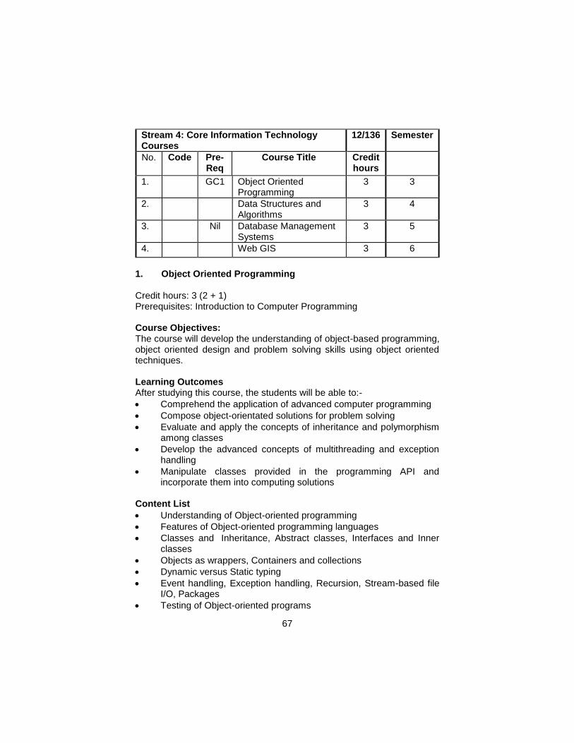
67
Stream 4: Core Information Technology Courses
12/136 Semester
No. Code Pre-Req
Course Title Credit hours
1.
GC1 Object Oriented Programming
3 3
2. Data Structures and Algorithms
3 4
3.
Nil Database Management Systems
3 5
4.
Web GIS 3 6
1. Object Oriented Programming Credit hours: 3 (2 + 1) Prerequisites: Introduction to Computer Programming Course Objectives: The course will develop the understanding of object-based programming, object oriented design and problem solving skills using object oriented techniques. Learning Outcomes After studying this course, the students will be able to:-
Comprehend the application of advanced computer programming
Compose object-orientated solutions for problem solving
Evaluate and apply the concepts of inheritance and polymorphism among classes
Develop the advanced concepts of multithreading and exception handling
Manipulate classes provided in the programming API and incorporate them into computing solutions
Content List
Understanding of Object-oriented programming
Features of Object-oriented programming languages
Classes and Inheritance, Abstract classes, Interfaces and Inner classes
Objects as wrappers, Containers and collections
Dynamic versus Static typing
Event handling, Exception handling, Recursion, Stream-based file I/O, Packages
Testing of Object-oriented programs
68
Packaging & Deployment
Case studies (ranging from simple to real-world complexity) Practical:
Define Classes, and Inheritance using C++
Develop module based programs like calculator and games etc. Teaching Methodology
Lecturing
Labs
Assignments
Quizzes Assessment Mid Term (40%)
Written (Long Questions, Short Questions, MCQs) 50%
Presentation 20%
Assignments 20%
Quiz 10%
Final Term (60%)
Written (Long Questions, Short Questions, MCQs) 50%
Presentation 20%
Assignments 20%
Quiz 10% Recommended Books 1. Problem Solving with C++", 9e Global Edition, Walter Savitch, ISBN-
13:9781292018249, Addison-Wesley, 2015. 2. Object Oriented Programming in C++, Latest Edition By Rober
Lafore. 3. C++ How to Program by Deitel& Deitel, Latest Edition 4. Let us C++ byYashavant Kanetkar, 8th Edition
2. Data Structures & Algorithms Credit Hours: 3 (2 + 1) Prerequisites: Introduction to Programming, Object Oriented Programming Course Objectives: To teach the students how to select and design data structures and algorithms that are appropriate for problems that they might encounter. This course is also about showing the correctness of algorithms and
69
studying their computational complexities. This course offers the students a mixture of theoretical knowledge and practical experience.
Course Outcomes: The students should be able to:
Analyze the asymptotic performance of algorithms.
Write rigorous correctness proofs for algorithms.
Demonstrate a familiarity with major algorithms and data structures.
Apply important algorithmic design paradigms and methods of analysis.
Synthesize efficient algorithms in common engineering design situations
Contents List
Properties of Data
Asymptotic Analysis
Algorithm Analysis
Arrays.
Dynamic memory allocation.
Implementation of stacks.
Implementation of Queues & priority Queues.
Linked lists (single, double, circular) and Arrays.
Binary Trees.
N-Trees.
Implementation of Searching Algorithms.
Calculating the complexity of algorithms.
Improving the efficiency of algorithms.
Sorting Algorithms.
Searching Algorithms.
Vectors.
Roles and Implementation of trees in databases.
Indexing.
Algorithm Design Practical
Introduce Dev-C++ IDE
Concepts of stacks and queues
Understanding to Recursion
Data Structure
To study and implement a singly linked list
C++ Program Basic Structure
A Circular Doubly Linked List (with a dummy header node)
An Application of Singly and Doubly Linked Lists
Read and Write Records To and From File
70
Teaching Methodology:
Lectures Lab work Assignments Assessment
Mid Term (40%)
Written (Long Questions, Short Questions, MCQs) 50%
Lab exam 50%
Final Term (60%)
Written (Long Questions, Short Questions, MCQs) 50%
Lab Exam 50%
Text Book a. Introduction to Algorithms (3rdEdition) by Cormen, Thomas H.;
Leiserson, Charles E.; Rivest, Ronald L.; Stein, Clifford, 2009. ISBN: 0262033844
b. Data Structures and Algorithm Analysis in C++ by Addison Wesley, (4thEdition), 2012.
Recommended Books 1. Data Structures and Algorithm Analysis in C (3rdEdition) by Dr.
Clifford A. Shaffer, 2011. ISBN: 048648582X 2. Data Structures and Algorithms in Java (2ndEdition) by Robert
Lafore, 2002. ISBN: 0672324539 3. Head First Java, (2ndEdition) by Kathy Sierra, Bert Bates, Sierra,
Kathy;Bates, Bert, 2005. ISBN: 0596009208 4. Data Structures and Algorithms in Java (5thEdition) by Michael T.
Goodrich, Roberto Tamassia, 2010. ISBN: 0470383267 5. Algorithm Design by Tardos, Kleinberg (1stEdition) by Jon
Kleinberg, ÉvaTardos, 2005. ISBN: 0321295358. 3. Database Management Systems Credit hours: 3 (2+1) Prerequisites: (Intro to Computers and Programming)
Course Objectives: The course aims to introduce basic database concepts, different data models, data storage and retrieval and design techniques. The course primarily focuses on relational data model and DBMS concepts.
71
Learning Outcomes After studying this course, the students will be able to:- 1. Define the modern database systems and their working 2. Understand the relational databases and its advantages over
traditional systems 3. Apply the data storage and retrieval techniques 4. Demonstrate the knowledge of database administration
Content List
Basic Database Concepts
Data Model and Relational Algebra
Entity Relationship Modeling
Structured Query Language
Rational Database Management Systems
Database Design
Functional Dependencies
Normal Forms
Transaction Processing and Optimization
Concurrency Control and Recovery Techniques
Database Recovery Techniques
Database Security and Authorization
Practical:
Exploring DBMS Environment
Creating Databases and Tables
Executing Selection Queries
Executing Updation Queries
Table Joins
Views and Populating Data using Views
Creating and Executing Stored Procedures
Roles and Permissions
User Defined Functions
Importing and Exporting Data
Creating and Restoring Backup
Teaching Methodology
Lecturing
Written Assignments
Guest Speaker
Report Writing
Assessment Mid Term (40%)
Written (Long Questions, Short Questions, MCQs) 50%
Presentation 20%
72
Assignments 20%
Lab Tests 10%
Final Term (60%)
Written (Long Questions, Short Questions, MCQs) 50%
Presentation 20%
Assignments 20%
Term Project 10% Recommended Books 1. Connolly R. and P. Begg(2015) Database Systems: A Practical
Approach to Design, Implementation and Management, Addison-Wesley Pub. Co ISBN – 9780132943307
2. Date, C. J. (2006). An introduction to database systems. Pearson Education India.
3. Elmasri, R. and Navathe, S. B. (2015) “Fundamentals of Database Systems” Addison-Wesley Pub. Co ISBN – 978-0133970777 Rigaux, P. Scholl, M. and Voisard, A. (2002) “Spatial Databases: With Application to GIS” Morgan Kaufmann; ISBN - 1-55860-588-6
4. Web GIS Credit hours: 3 (2+1) Prerequisites: Introduction to Computer Programming, Introduction to GIS, Spatial Database Systems Course Objectives:
The course introduces students to Web GIS technologies. Students will acquire skills in Web architecture and Web application structure required for the delivery of online GIS mapping solutions. They will develop hands-on web pages/websites in conjunction with standard website creation languages.
Learning Outcomes After studying this course, the students will be able to:- 1. Acquire skills how to make different types of Web Maps. 2. Integrate Spatial Databases with Web Applications 3. Publish maps online using Open Source Software (Carto DB, fusion
Tables, Geoserver, etc). 4. Read data from various data sources 5. Process Spatial data with FOSS (Free and Open Source Software) 6. Draw and query maps on the server using Web Map Service 7. Put layers together with a web mapping API 8. Learn how to Explore open data, VGI, and crowd sourcing
73
Content List
Components of Web GIS
GIS Server, Web Server and Database Server
GIS / Web Server Architecture
Cloud Computing process in relation to Web GIS
Databases and SQL
Web GIS Servers
Web Editors used by Industry professionals for Webpage design
HTML, PHP, CSS and JavaScript code
HTML with GUI
CSS and JavaScript into web pages for GIS
Templates as an alternative solution to creating a foundation for web-based GIS maps
APIs for web mapping
Map servers and their applications
Analytics on web maps Practical:
Introduction to key concepts in Web mapping
System architecture for web mapping
Understanding Free and Open Source Software and its use in web mapping
WMS Services
System architecture for web mapping
Elements of a web map
Collaborative web maps
Spatial data processing with FOSS libraries
Drawing and querying maps on the server using Web Map Service
Map APIs
Web based data editing
Drawing vector layers on the client side
Working with vector KML
Working with GeoJSON
Symbolizing vector layers in OpenLayers
Adding interactive GeoJSON layers in OpenLayers
GIS analysis on the web
Teaching Methodology
Lecturing
Written Assignments
Guest Speaker
Field Visits
Report Writing
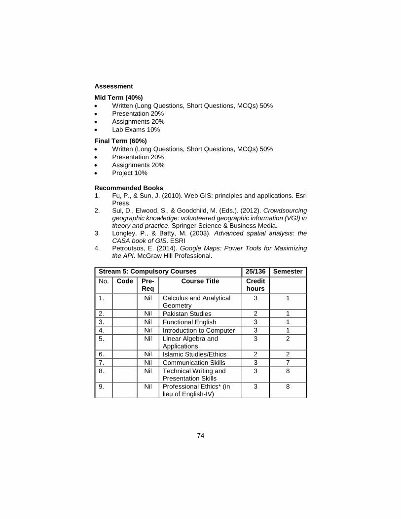
74
Assessment
Mid Term (40%)
Written (Long Questions, Short Questions, MCQs) 50%
Presentation 20%
Assignments 20%
Lab Exams 10%
Final Term (60%)
Written (Long Questions, Short Questions, MCQs) 50%
Presentation 20%
Assignments 20%
Project 10% Recommended Books 1. Fu, P., & Sun, J. (2010). Web GIS: principles and applications. Esri
Press. 2. Sui, D., Elwood, S., & Goodchild, M. (Eds.). (2012). Crowdsourcing
geographic knowledge: volunteered geographic information (VGI) in theory and practice. Springer Science & Business Media.
3. Longley, P., & Batty, M. (2003). Advanced spatial analysis: the CASA book of GIS. ESRI
4. Petroutsos, E. (2014). Google Maps: Power Tools for Maximizing the API. McGraw Hill Professional.
Stream 5: Compulsory Courses 25/136 Semester
No. Code Pre-Req
Course Title Credit hours
1.
Nil Calculus and Analytical Geometry
3 1
2.
Nil Pakistan Studies 2 1
3.
Nil Functional English 3 1
4.
Nil Introduction to Computer 3 1
5.
Nil Linear Algebra and Applications
3 2
6.
Nil Islamic Studies/Ethics 2 2
7.
Nil Communication Skills 3 7
8.
Nil Technical Writing and Presentation Skills
3 8
9.
Nil Professional Ethics* (in lieu of English-IV)
3 8
75
1. Calculus & Analytic Geometry
Course Structure: Lectures: 3 / Labs: 0 Credit Hours: 3
Prerequisites: None Course Outline: Complex Numbers, DeMoivre’s Theorem and its Applications, Simple Cartesian Curves, Functions and Graphs, Symmetrical Properties, Curve Tracing, Limit and Continuity, Differentiation of Functions. Derivative as Slope of Tangent to a Curve and as Rate of Change, Application to Tangent and Normal, Linearization, Maxima/Minima and Point of Inflexion, Taylor and Maclaurin Expansions and their convergence. Definite Integral as Limit of a Sum, Application to Area, Arc Length, Volume and Surface of Revolution. Reference Frames, Coordinate systems Reference Material: 1. Ron Larson (202) Calculus with Analytic Geometry, Seventh Edition. 2. Ron Larson, Robert P. Hostetler, Bruce H. Edwards, Houghton
Mifflin, 2004Calculus with Analytic Geometry, Seventh Edition. 3. George B., Jr Thomas, Ross L. Finney; (2004). Calculus and
Analytic Geometry (9thEdition), Amazon. 4. George Brinton Thomas, et al; Amazon,(2004),Thomas' Calculus
(10thEdition). 5. Swokowski, Olinick and Pence (2004)Calculus and Analytical
Geometry. 6. Sherman K Stein, Anthony, Amazon, (2002). Calculus and Analytic
Geometry
2. Pakistan Studies
Course Structure: Lectures: 2 / Labs: 0 Credit Hours: 2
Prerequisites: None Objectives: To take an analytical view in the history and development of Muslim society and culture in the sub-continent, emergence of Pakistan and its constitutional development. To develop an appreciation of the issues and challenges currently being faced in Pakistan. The strengths of its people and strategies to deal with the impediments to progress. International relations of Pakistan. Course Outline: Historical background of Pakistan: Muslim society in Indo-Pakistan, the movement led by the societies, The downfall of Islamic society, The establishment of British Raj- Causes and consequences. Political
76
evolution of Muslims in the twentieth century: Sir Syed Ahmad Khan; Muslim League; Nehru; AllamaIqbal: Independence Movement; Lahore Resolution; Creation of Pakistan and transfer of power. Pakistan culture and society, Constitutional and Administrative issues, Pakistan and its geo-political dimension, Pakistan and International Affairs, Pakistan and the challenges ahead. Reference Material: The Emergence of Pakistan, by Chaudary M. Ali The Making of Pakistan, by K.K. Aziz 3. Functional English Course Structure: Lectures: 3 / Labs: 0 Credit Hours: 3 Objectives: Basic understanding of language skills including grammar and comprehension Course Outline: Introduction, Need for English Skills, Listening Skills, Reading Skills, Language and Communication, Using Words Effectively, Parts of Speech, Non-Verbal Communication, Anonyms, Antonyms and Homonyms, Frequently Misused Words, Fundamental Writing Principles, Techniques and Style, Phrases, Sentences, Punctuation and Effective Use, Organizing the Thought Process, Brainstorming, Grouping, Sequencing, Outlining, Paragraphs, Compositions, Assignments and Short Paper, Improve Writing Techniques, Summary Development, Precise Development, Critical Review, The Research Paper, Letters, Vocabulary Development, Etymology, Abbreviations, Acronyms, Business Terminology, Increasing Word Power (Grammatical Rules) English Grammar, Punctuation Rules, Capitalization Rules, The Rules Of Grammar, Correct English Usage, Principles of Grammar
Reference Material: English for Modern Business By Ketteley and Thompson Write Better,Speak Better, By Readers Digest
4. Introduction to Computer: Introduction to Computer hardware and Software organization.Operating System concepts, DOS, LINUX/UNIX Operating Systems, Introduction to Windows, Environment, Local Area Networks and Internet, Computer Security. Fundamentals of Programming: High Level Languages, Problem Analysis and Algorithm Development, Flow charting, Sequential Flow, Conditional Flow, Repetitive Flow, Algorithm Logic.
77
Introduction to C-language: Program structures, Pre-processor declaration, Looping and Flow Control in C, Functions and Structured Programming, standard data types, Branching and Nested Flow of Control, Arrays and Strings, Pointers, Structure data types and Union , Input / Output, Filling System in C, Graphics programming, Objects Oriented Programming, Introduction to JAVA.
RECOMMENDED BOOKS: 1. Tucker Noonan, Programming Languages: Principles and
Paradigms, 2002, McGraw-Hill 2. C++ Program Design, 3rd Edition, 2002, McGraw-Hill 3. Cormen et.al., Introduction to Algorithms, 2nd Edition, 2002,
McGraw- Hill 4. Wu, An Introduction to Object Oriented Approach with C++,1998,
McGraw-Hill 5. Francis Scheid, Schaum's Outline Series, Computers and
Programming, 1983. 6. C Programming using Turbo C, Robert Lafore Howard & W. Sams
Co., 1990. 7. L. H. Miller and A. E. Quilici, Joy of C, John Wiley, New York, 1993 8. Microsoft Disk Operating Systems Manual 9. Anthony Rudd, C++ Complete, John Wiley, New York, 1994 10. Jones, Understanding UNIX, Que. Books, 1990. 11. W. Stallings, Computer Organization and Architecture, Maxwell-
Macmillan, New York, 1990.
5. Linear Algebra and Applications
Course Structure: Lectures: 3 / Labs: 0
Credit Hours: 3
Prerequisites: None
Course Outline: Vectors, Vector Spaces, Matrices & Determinants, Linear Transformations, Operations on matrices, Inner products, Eigenvalues & Eigenvectors. Applications to Systems of Equations and to Geometry.
Reference Material: 1. Linear Algebra by David C Lay, 3rd Ed., Amazon, 2002 2. Linear Algebra: A Modern Introduction -- by David Poole, Amazon,
2003 3. Introduction to Linear Algebra, 3rdEdition, by Gilbert Strang, 2003,
Amazon 4. Schaum's Easy Outline of Linear AlgebrabySeymourLipschutz,
Marc Lipson, 2002 5. Linear Algebra, Fifth Edition, by Gareth Williams, 2004, Amazon
78
6. Islamic Studies/Ethics
Course Structure: Lectures: 2 / Labs: 0
Credit Hours: 2
Objectives: To impart an understanding of the fundamental principles and teachings of Islam through study of selected verses of the Quran and Prophetic Sayings. Important facets of the Prophet’s life and salient, features of Islamic Civilization. To provide appreciation of other prominent religions, systems of ethics and cultures to prepare students to survive in international and multicultural work place. Course Outline: Fundamentals of Islam. (Aqaid, Ibadat, Islamic Dawah etc.); Ethical values of Islam; Seerah of the Holy Prophet (PBUH); Islamic Civilization and its effects on humanity. Study of other prominent world religions and ethical systems in comparison with Islamic viewpoint. Multicultural societies.
Reference Material: 1. Islam in the Light of a First Testament and Traditions by Shaukat
Umari 2. What Everyone Knows About Islam by ZunaireHanif 3. Introduction to Islam by Hamidullah 7. Communication Skills
Course Structure: Lectures: 3 / Labs: 0
Credit Hours: 3
Prerequisites: Functional English Objectives:
Course Outline: Introduction to Oral Communication and its Application: Communicating at Work, Communication in Process, Communication in Organization, Oral Presentation and Oral Reports, Presentation: Face to Face Information Gathering, Communicating non verbally, Types of Non-Verbal Communication, Developing good listening habits, Listening Barriers, Active listening Techniques, Oral Communication/Planning Business Communications, Short Talks and Presentation Types of Short Presentation/Modes of Delivering the Speech, Guidelines for presenting the speech, Oral Communication / Delivering Business Presentations, The Long Presentation & the Purpose of Presentations: Analyzing your audience, Parts of presentations, Verbal Visual supporting Materials, Conducting successful interviews, meetings and conferences, Types of Interviews, Leading Group and holding Successful conferences,
79
Techniques for participation in a meeting, Small group communication and Decision making, Use and values of small groups in effective organization, Basic problem solving procedure, Employment communication, Responsibilities of the interviewee, Responsibilities of the interviewer, Participation and leadership in small groups, Effective group participation, Effective group leadership, Old communication/methods of dictating techniques, Communication and telephone, Communicating effectively in international business, Non-Verbal communication in international business, Training needs in international business, Criteria for communicating effectively
Reference Material:
Business communication principles and applications by C.Glen Pearce, rossfi Steven P. Golden Communication for result by Cheryl Hamilton, Cordell Parker, Doyle D. Smith.
8. Technical Writing and Presentation Skills
Course Structure: Lectures: 3 / Labs: 0 Credit Hours: 3
Objectives: To develop good Technical writing, language usage and reading skills. To appreciate the importance of communication and to develop understanding of communication concepts, principles, theories and problems. To develop good oral communication and presentation skills.
Course Outline: Principles of writing good English, understanding the composition process: writing clearly; words, sentence and paragraphs. Comprehension and expression. Use of grammar and punctuation. Process of writing, observing, audience analyzing, collecting, composing, drafting and revising, persuasive writing, reading skills, listening skills and comprehension, skills for taking notes in class, skills for exams. Business communications; planning messages, writing concise but with impact. Letter formats, mechanics of business, letter writing, letters, memo and applications, summaries, proposals, writing resumes, styles and formats, oral communications, verbal and non-verbal communication, conducting meetings, small group communication, taking minutes. Presentation skills; presentation strategies, defining the objective, scope and audience of the presentation, material gathering material organization strategies, time management, opening and concluding, use of audio-visual aids, delivery and presentation.
.
80
Reference Material:
Business English by Vawdrey, Stoddard and Bell
9. Professional Ethics
Course Structure: Lectures: 3 / Labs: 0 Credit Hours: 3
Objectives: This course intends to give insight about data standards used in GIS and RS, common security issues of geographic data, and professional ethics involved in exchange of data and interoperation. The course emphasizes the importance of standardization as a real challenge and comparable to the most important development project in the spatial industry. The course will try to deal with the numerous economic, legal, and regulatory factors of importance to both the public and private sectors.
Course Outline: Ethical Issues in GIS / RS / Electronic Information, ISO Standards Accuracy, Precision, Error and Uncertainty, Managing Spatial Data Errors Ethics in GIS Development, Interoperability of GIS Data, Ethics of GIS Data Security, National Spatial Data Infrastructure.
Reference Material: 1. Aitken, S. and Michel, S.M. 1995. Who Contrives the "Real" in GIS? 2. Geographic Information, Planning and Critical Theory. Cartography
and Geographic Information Systems 22 (1): 17-29. 3. Armstrong, M. and Ruggles, A. 2005. Geographic Information
Technologies and Personal Privacy. Cartographica 40 (4): 63-73. 4. Barndt, M. 1998. Public participation GIS-Barriers to
Implementation. 5. Cartography and Geographic Information Systems 25 (2): 105-112. 6. Bell, S. and Reed, M. 2004. Adapting to the Machine: Integrating
GIS into Qualitative Research. Cartographica, 39 (1): 55-65. 7. Campbell, H. 1996. A Social Interactionist Perspective on Computer 8. Implementation. Journal of American Planning Association, 62(1):
99-107. 9. Chrisman, N. 2005. Full Circle: More than Just Social Implications
of GIS. Cartographica, 40 (4):23-35. 10. Clark, M. J. 1998. GIS- Democracy or Delusion? Environment and
Planning A 30(2): 303-316. 11. Crampton, J. 1995. The Ethics of GIS. Cartography and Geographic
Information Systems 22 (1): 84-89. 12. Crampton, J. 2003. Cartographic Rationality and the Politics of 13. Geosurveillance and Security. Cartography and Geographic
Information Science 30 (2): 135-148.
81
14. Crampton, J. 2007. The Biopolitical Justification for Geosurveillance.
15. Geographical Review 97 (3):389-403. 16. Curry, M.R. 1996. Data Protection and Intellectual Property:
Information, Systems and the Americanization of the New Europe. Environment and Planning A 28: 891- 908
17. Elwood, S. 2006. Beyond Cooptation or Resistance: Urban Spatial Politics, Community Organizations, and GIS-Based Spatial Narratives. Annals of the Association of American Geographers, 96 (2): 323-341.
18. Elwood, S. and Ghose, R. 2004. PPGIS in Community Development Planning: Framing the Organizational Context. Cartographica 38 (3&4): 19-33.
19. Elwood, S. and Leitner, H. 1998. GIS and Community-based Planning: Exploring the Diversity of Neighborhood Perspectives and Needs. Cartography and Geographic Information Systems 25(2): 77-88.
20. Exler, R.D., 1990. "Geographic Information Systems Standards: An Industry Perspective", GIS World Vol 3(2):44-47.
21. FICCDC, 1988. "The proposed standard for digital cartographic data", The American Cartographer, Vol 15(1).
22. Ghose, R. 2001. "Use of Information Technology for Community Empowerment: Transforming Geographic Information System into Community Information Systems", Transactions in GIS, 5(2), 141-163.
23. Ghose, R. 2003. Investigating Community Participation, Spatial Knowledge Production and GIS Use in Inner City Revitalization. Journal of Urban Technology, vol. 10, no. 1, 39-60.
24. Ghose, R. 2007. Politics of Scale and Networks of Association in PPGIS, Environment and Planning A 39, 1961-1980.
25. GIS World, 1989. "Spatial data exchange formats", The GIS Sourcebook, GIS World, Fort Collins, CO, pp. 122-23.
26. Harvey and Tulloch. 2006. Local government data sharing: Evaluating the Foundations of Spatial Data Infrastructures. International Journal of Geographic Information Science, 20 (7):743-768.
27. Lake, R.W. 1993. Planning and Applied Geography: Positivism, Ethics, and Geographic Information Systems. Progress in Human Geography 17 (3): 401-13.
28. Pickles, J. 1995. Representations in an Electronic age: Geography, GIS and Democracy. In: J. Pickles (ed.), Ground truth: The social implications of geographic information systems. New York: Guilford Press. pp. 1-30.
29. Robbins, P. and Maddock T. 2000. Interrogating Land Cover Categories: Metaphor and Method in Remote Sensing. Cartography and Geographic Information Science, 27 (4): 295-309.
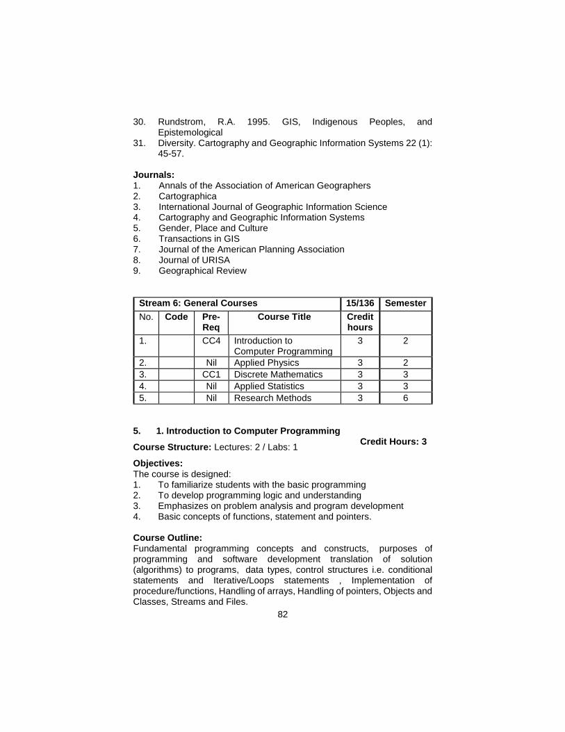
82
30. Rundstrom, R.A. 1995. GIS, Indigenous Peoples, and Epistemological
31. Diversity. Cartography and Geographic Information Systems 22 (1): 45-57.
Journals: 1. Annals of the Association of American Geographers 2. Cartographica 3. International Journal of Geographic Information Science 4. Cartography and Geographic Information Systems 5. Gender, Place and Culture 6. Transactions in GIS 7. Journal of the American Planning Association 8. Journal of URISA 9. Geographical Review
Stream 6: General Courses 15/136 Semester
No. Code Pre-Req
Course Title Credit hours
1.
CC4 Introduction to Computer Programming
3 2
2.
Nil Applied Physics 3 2
3.
CC1 Discrete Mathematics 3 3
4.
Nil Applied Statistics 3 3
5.
Nil Research Methods 3 6
5. 1. Introduction to Computer Programming
Course Structure: Lectures: 2 / Labs: 1 Credit Hours: 3
Objectives: The course is designed: 1. To familiarize students with the basic programming 2. To develop programming logic and understanding 3. Emphasizes on problem analysis and program development 4. Basic concepts of functions, statement and pointers.
Course Outline: Fundamental programming concepts and constructs, purposes of programming and software development translation of solution (algorithms) to programs, data types, control structures i.e. conditional statements and Iterative/Loops statements , Implementation of procedure/functions, Handling of arrays, Handling of pointers, Objects and Classes, Streams and Files.
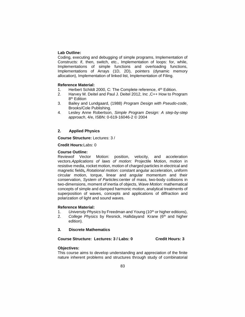
83
Lab Outline: Coding, executing and debugging of simple programs, Implementation of Constructs: if, then, switch, etc., Implementation of loops: for, while, Implementations of simple functions and overloading functions, Implementations of Arrays (1D, 2D), pointers (dynamic memory allocation), Implementation of linked list, Implementation of Filing.
Reference Material: 1. Herbert Schildt 2000, C: The Complete reference, 4th Edition. 2. Harvey M. Deitel and Paul J. Deitel 2012, Inc ,C++ How to Program
8th Edition 3. Bailey and Lundgaard, (1988) Program Design with Pseudo-code,
Brooks/Cole Publishing. 4. Lesley Anne Robertson, Simple Program Design: A step-by-step
approach, 4/e, ISBN: 0-619-16046-2 © 2004 2. Applied Physics
Course Structure: Lectures: 3 /
Credit Hours:Labs: 0
Course Outline: Reviewof Vector Motion: position, velocity, and acceleration vectors.Applications of laws of motion: Projectile Motion, motion in resistive media, rocket motion, motion of charged particles in electrical and magnetic fields, Rotational motion: constant angular acceleration, uniform circular motion, torque, linear and angular momentum and their conservation, System of Particles:center of mass, two-body collisions in two-dimensions, moment of inertia of objects, Wave Motion: mathematical concepts of simple and damped harmonic motion, analytical treatments of superposition of waves, concepts and applications of diffraction and polarization of light and sound waves. Reference Material: 1. University Physics by Freedman and Young (10th or higher editions), 2. College Physics by Resnick, Hallidayand Krane (6th and higher
edition).
3. Discrete Mathematics Course Structure: Lectures: 3 / Labs: 0 Credit Hours: 3
Objectives: This course aims to develop understanding and appreciation of the finite nature inherent problems and structures through study of combinatorial
84
reasoning, abstract algebra, iterative procedures, predicate calculus, tree and graph structures. Course Outline: Sets, Combinatorics, Sequences, Formal logic, Prepositional and predicate calculus, Methods of Proof, Mathematical Induction and Recursion, loop invariants, Relations and functions, Pigeon whole principle, Trees and Graphs, Optimization and matching. Reference Material: 1. Discrete Mathematics and Its Applications, by Kenneth H Rosen,
2003, Amazon 2. Discrete Mathematical Structuresby Rosen, 2004 3. Discrete Mathematics by Richard Johnson Baugh, 5ed, 2004,
Amazon 4. Discrete Mathematics and Its Applications -- by Kenneth H Rosen;
2004, Amazon 5. Discrete Mathematics with Applications -- by Susanna S. Epp, 2004,
Amazon
4. Applied Statistics
Course Structure: Lectures: 3 / Labs:0 Credit Hours: 3 Course Outline: Introduction to Statistics, Descriptive Statistics, Statistics in decision making, Graphical representation of Data Stem-and Lead plot, Box-Cox plots, Histograms and Ogive, measures of central tendencies, dispersion for grouped and ungrouped Data, Moments of frequency distribution; examples with real life, use of Elementary statistical packages for explanatory Data analysis. Counting techniques, definition of probability with classical and relative frequency and subjective approaches, sample space, events, laws of probability. Conditional probability and Bayesian theorem with application to Random variable (Discrete and continuous) Binomial, Poisson, Geometric, Negative Binomial Distributions; Exponential Gamma and Normal distributions. Reference Material: 1. Probability and Statistics (3rdEdition) -- by Morris H. DeGroot, Mark
J. Schervish, 2004, Amazon 2. Schaum's Outline of Probability and Statistics -- by Murray R
Spiegel, et al, 2004, Amazon 3. Probability and Statistics for Engineers and Scientists (7th Edition)
by Ronald E. Walpole, et al; 2004, Amazon 4. Probability and Statistics (3rdEdition),by Morris H. DeGroot, Mark J.
Schervish, 2001, Amazon 5. Introduction to Statistics by Walpole, 2000
85
6. Probability for Statistics for Engineers by Walpole, 7thEdition, 2002 7. Advanced Engineering Mathematics by Kreyszig, E., 8thEdition,
2003
5. Research Methods
Course Structure: Lectures: 3 / Labs: 0
Credit Hours: 3
Prerequisites: None
Course Contents: Introduction to Research: Definition & Nature, The Scientific Method, The Research Process, and Errors in Research. Research Design and Data Sources: Types of research and research designs, Primary data and its sources, Secondary data and its sources. Data Collection Procedures: The Measurement Process, Concepts of validity and reliability, The casual design procedures, Data Collection Methods, Observation, Documentary-Historical Method, The Survey Method, Data Collection Instruments: Questionnaire, Interview and Scheduling, Problems in Data Collection. Sampling: Sampling Concepts, The Sampling Procedures (Types of Sampling), Determining a sample size & Selection of sample
Data Processing And Analysis: Basic concepts of data processing: Computer representation, Data Matrix, Data Storage Data Processing flow: Editing, Coding, Handling Blank Responses, Coding, Categorization, Converting, Weighting, Storing etc., Alternative processing flows, University data analysis, Measurement of central tendency, Measurement of dispersion, Hypothesis Testing, Bavaria data analysis, Linear Correlation, Simple Regression, The Chi-Square Test, The Cross-Tabular Tables, Elaboration of relationships, Multivariate data analysis: Interdependence Methods, Factor analysis, Cluster analysis, multidimensional analysis, Multivariate data analysis: Dependence methods, Multiple Regressions, Analysis of Variance & Covariance, Discriminate analysis.
Research Project Proposal: Rationale for the study defining the problem, Research Objectives, Information needs, Research design, Data collection procedure, Data processing & analysis, Research Team and its profile, Budget, Time Table.
Reference Material: 1. Ranjit Kumar, Research Methodology, Sage Publications. 2. IngemanArbonor&BjoranBerke, Methodology for Creating Business
Knowledge, Sage Publications.

86
3. Dam Remenyl, Doing Research in Business and Management, Sage Publications.
4. David H. Folz, Survey Research for Public Administration, Sage Publications.
5. C. William Emory, Business Research Methods, IRWIN.
87
Elective Courses On the recommendation of the BS (RS &GIS) program coordinator, students can choose electives either from the following list or any other undergraduate courses offerings of their respective institution. The following section provides brief details of some of the key elective of the 4 years BS (RS &GIS) program that may be chosen by the undergraduate students. 1: Spatial Data Modeling Course Structure: Lectures: 2 / Labs: 1 Credit Hours: 3 Prerequisites: Spatial data visualization Objectives: This course attempts to provide an introduction to GIS data models and data structures. The subject continues with a systematic overview of spatial data models (e.g. raster and vector) and the structures used to implement these, together with methods of spatial feature addressing, geometry of objects, topology, object hierarchies and aggregations, the modeling of fuzzy objects and the uncertainty aspects of spatial data. Course Outline: Introduction to Fields, Objects, Geometry, Objects represented in raster, Vector Structure, Vector data representing the geometry of geographical objects, Networks and graphs, Properties of Graphs, graph areas and error checking procedures,Terrain object classed and generalization hierarchies aggregation hierarchies, object association, Fuzzy set theory, fuzzy boundaries, Uncertainties of Spatial Objects. Lab Outline: Preparation of Symbolic Charts for representation of Earth Features, Assignment on Geometry of spatial objects, Utility Network Analysis, Spatial data generalization and aggregation,
Reference Material: 1. Michael, N. D.(2003) “ Fundamentals of Geographic Information
Systems” Third Edition, John Wiley & sons. 2. Heywood, I., Cornelius, S. and Carver, S. (1999) “ An introduction
to Geographic Information System”, Addison Wesley Longman, New York, second edition.
3. DeMers, M. (1996) “Fundamentals of Geographic Information 4. Systems”, John Wiley & Sons, New York. 5. Burrough, P., (1986) “Principles of Geographic Information Systems
for Land Resources Management”, Oxford University Press, Oxford.
88
2: Spatial Data Infrastructure
Course Structure: Lectures: 2 / Labs: 1 Credit Hours: 3
Objectives: This course attempts to provide an understanding to the data structures, processes and its standards which are involved in data sharing. Subject includes the applications and architecture of Spatial Data Infrastructure.
Course Outline: Need and main components of SDI, Clearing house architecture National Geospatial Clearinghouse, Metadata concepts, its structures and functionality,System Architecture for SDI Interoperability, Client Server Architecture, Data Quality Information (DQI) Accuracy, Precision, Bias Error Modelling, Data Modelling. Abstraction of real world, Types of abstraction, Problems of information sharing (Heterogeneities), Distributed database concept, GIS Internet Services and SDI Technologies, Available Services, Technologies that support internet GIS services. Commercial tools for Internet GIS, legal aspects of SDI.
Lab Outline: Comparison of working SDI’s, Development of Metadata according to Standards, Development of Architecture of SDI, Data Standardization, Data transformations and translations, Web Publishing & development.
Reference Material: 1. Robert, C. H. ( 2005) “ SDI : A View from Europe” Oxford University
Press, Oxford, ISBN: 089875982X. 2. Groot, R. (2001). Geospatial Data Infrastructure: Concepts, Cases,
and Good Practice (Spatial Information Systems (Cloth), Oxford University Press.
3. Beth E. Lachman (2001). Lessons for the Global Spatial Data Infrastructure: International Case Study Analysis, RAND Corporation.
4. Mapping Science Committee (1993), “Toward a Coordinated Spatial Data Infrastructure for the Nation,” National Academy Press.
3: Land Information System
Course Structure: Lectures: 2 / Labs: 1
Credit Hours: 3
Objectives: This course attempts to give students a broad understanding of land tenure and the cadastre concept, how it has evolved historically and its role in documenting land rights. The course covers cadastral systems in
89
the world as a means of understanding fundamental principles and design criteria underlying these systems. The final part of the course deals with the design of cadastre-based LIS. Course Outline: Introduction to Land characteristics, Land information system, Cadastre, Land information management, LIS Taxonomy, classification of land information , Land Registration, Comparison of land registration and cadastre, Benefits of land registration for individuals and role of land registration for Government, Land Tenure Systems, Concept and definition, Forms of land tenure operational forms of land tenure, English, Anglo-American, Continental, Western European Concept and rights, Customary land tenure Islamic land tenure, Land Registration concept, process, Public registration, Principles of \registration, Deeds Registration, Title Registration, Features of Land Registration system, Private conveyancing, Positive and Negative Systems, Boundaries, Fiscal cadastre Multipurpose Cadastre, Institutional arrangement and technical matters, Procedures for introducing a land administration system. Lab Outline:Studying and understanding the existing LIS examples, Development of work flow diagrams for the procedures, Comparison of existing land information systems, Cadastral mapping through existing analogue maps/satellite imageries, Cadastral map editing, and updating, Development of database for land registration, Process verification and development of Registries, Titles, Integration of Revenue mapping and statistical analysis, Integration of cadastral system with other utility information system, LIS Project Development. Reference Material: 1. Flower, C. (1998) “Geographic information systems, mapping, and
spatial data for the coastal and ocean resource management community.NOAA's Coastal Services Canter.
2. Dale, P.F. and J. McLaughlin (1988). Land Information Management, OxfordUniversity Press, New York.
3. United Nations (1996), “ Land Administration Guidelines: with special reference to countries in transition”. New York&Geneva.
4: Introduction to Computer Systems (ICS)
Course Structure: Lectures: 2 / Labs: 1
Credit Hours: 3
Objectives: This course focuses on a breadth-first coverage of Information Technology discipline, introducing computing environments, general application software, basic computing hardware, operating systems, office working
90
tools, Internet and computer usage concepts; Software engineering process, Social and ethical issues of computing. Course Outline: Number Systems, Binary numbers, Boolean logic, History computer system, basic machine organization, Von Neumann Architecture, Algorithm definition and data structure design, and implementation, Programming paradigms and languages, Graphical programming, Overview of Software Engineering, Operating system, Compiler, Computer networks and Internet, Computer graphics, AI, Social and legal issues. Lab Outline: Computation of Number Systems; Binary, Octal, Hexa, Decimal number Systems, Implementation of Boolean functions, and basic machine organization e.g. motherboard, memory, I/O Cards, Input/Output Devices, Networking Devices, Concepts of Flow Charts, Environment of different Operating Systems; Linux, Unix, DOS, MS Windows, Introduction to Office Tools (MS Word, MS Excel, MS Access etc), Internet browsers and exposure to web based programming.
Reference Material:
1. Bailey and Lundgaard, Program Design with Pseudo-code,
Brooks/Cole Publishing, 2. Lesley Anne Robertson, Simple Program Design: A step-by-step
approach, Course Technology, 2000 3. Larry Long and Nancy Long, Computers: Information Technology in
Perspective, 9th edition, Prentice Hall, 2002 / ISBN: 0130929891 4. Schneider and Gersting, An Invitation to Computer Science,
Brooks/Cole Thomson Learning, 2000 5. Sherer, Computer Science: An overview of Computer Science,
5: Technical and Business Writing (Elective)
Course Structure: Lectures: 3 / Labs: 0
Credit Hours: 3
Objectives: To develop efficient literature survey, analysis, report writing and document designing skills. Course Outline: Overview of technical reporting, use of library and information gathering, administering questionnaires, reviewing the gathered information.
91
Technical exposition; topical arrangement, exemplification, definition, classification and division, casual analysis, effective exposition, technical narration, description and argumentation, persuasive strategy. Organizing information and generation solution: brainstorming, organizing material, construction of the formal outline, outlining conventions, electronic communication, generation solutions. Polishing style: paragraphs, listening sentence structure, clarity, length and order, pomposity, empty words, pompous vocabulary, document design: document structure, preamble, summaries, abstracts, table of contents, footnotes, glossaries, cross-referencing, plagiarism, citation and bibliography, glossaries, index, appendices, typesetting systems, creating the professional report; elements, mechanical elements and graphical elements. Reports: Proposals, progress reports, Leaflets, brochures, handbooks, magazines articles, research papers, feasibility reports, project reports, technical research reports, manuals and documentation, thesis. Electronic documents, Linear verses hierarchical structure documents.
Reference Material: Research Method: Guidance for Postgraduates, Greenfield, T. Arnold 6: Multivariable Calculus
Course Structure: Lectures: 3 / Labs: 0
Credit Hours: 3
Prerequisites: Calculus Course Outline: Functions of Several Variables and Partial Differentiation. Multiple Integrals, Line and Surface Integrals. Green’s and Stoke’s Theorem. Fourier Series: periodic functions, Functions of any period P-2L, Even & odd functions, HalfRange expansions, Fourier Transform. Laplace Transform, Z-Transform. Reference Material: Calculus and Analytical Geometry by Swokowski, Olinick and Pence. 7: Introduction to Economics
Course Structure: Lectures: 3 / Labs:0
Credit Hours: 3
Course Outline:
Introduction: Basic Economics Concepts, problems of Economic Organizations, Markets and Elements of supply and demand.
Supply, demand and product markets: demand, utility and consumer behavior and business organizations. Theory of production and
92
marginal products, analysis of costs, competitive markets, monopoly and imperfect competition
Production Function and Distribution: Factors of Production, Pricing of factors of production.
Markets and Economic Efficiency, role of Government, Economic Systems, Economic Growth and International Trade
National Economy facts: National income Accounting, Measurement. Income and Spending, Money, Monetary and Fiscal Policy, International Linkages
Aggregate Demand, Supply and Growth, Consumption and Saving, Inflation, Unemployment, Budget Deficit and International Adjustment.
Economics Applications in Agriculture, Industry, Demography, Business and Trade.
Reference Material:
Saeed, AmjadKhawaja (latest edition) Economy of Pakistan
Malik, Sohail (latest edition) Economy of Pakistan
Waseer, Habibullah (latest edition)
Hussain Ch. M. (latest edition) Economic Theory
Pakistan Economic Survey (various issues)
Robert S.Pindyck&Danial L. Rubinfeld: Microeconomics, 4th Edition, Prentice Hall
RudigerDornbusch& Stanley Fischer: Microeconomics, 6th Edition, McGraw-Hill
C.E.Ferguson&J.P.: Microeconomics Theory, 5th Edition.
Samuleson&Nordhausan: Economics,6th Edition, Tata McGraw-Hill.
8. Introduction to Geology
Course Structure: Lectures: 2 / Labs: 1
Credit Hours: 3
Prerequisites: Physical and Human Geography
Objectives: This course attempts to familiarize students with Science of Geology, to discuss in detail the theory of Plate Tectonics and mountain building. To discuss in brief the economic potential of different rock units with special reference to Geology of Pakistan.
Course Outline: Overview of Earth, Geological Framework of Earth, Structure and Composition of Earth; Deformation and Mountain Building Processes, Rock Cycle Volcanoes, Geological Hazards; Earthquakes, Tsunamis, Floods,
93
Landslides, Mass-movements, Geological Time Scale; Cenozoic, Mesozoic, Paleozoic, Fossils and Evolution, Global Change in the Earth System, Economic Geology; Exploration and Exploitation of Natural Resources, Petroleum Basins of Pakistan.
Lab Outline: Identification of rocks and minerals in hand specimen, Identification of different rock units and geological structures in field, Preparation of Geological maps, Petrographic studies of rocks and minerals and Field visit to different Mining areas
Reference Material: 1. Charles C. Plummer, Diane Carlson, McGeary David 2009, Physical
Geology, (13th edition), Cengage Publishers USA. 2. Richard J. Lisle,PeterBrabham, John W. Barnes (2011). Basic
Geological Mapping. John Wiley 3. Tom W Argles, David A Rothery, Angela L. Coe (2011) Geological
Field Techniques (4thEdition ), Hodder and ... 4. McGeary, D., Plummer, C.C. & Carlson, D.H., (2004) Physical
Geology: Earth revealed. McGraw-Hill, Boston. 5. Murphy, B and Nance D (1999). Earth Science Today. ITP, Brooks
Cole Publishing, NYC. ISBN 0-534-52182-7. 6. Dutch, S.I; Monroe, J.S and Moran, J.M (1998). Earth Science,
Wadsworth, ISBN: 0 314 20111 4. 7. Allen, P.A. 1997. Earth Surface Processes, Blackwell Science Ltd. 8. Skinner, B.J and Porter, S.C. (1992). The dynamic Earth: an
introduction to physical geology, John Wiley & Sons New York, ISBN:0471 55224 0.
9. Duff, P.M.D (1993). Holmes Principles of Physical Geology, Chapman and Hall, ISBN 0 412 40320 x.
9. Introduction to Ecology
Course Structure: Lectures: 2 / Labs: 1
Credit Hours: 3
Objectives:
An introduction to ecology at the population, community and ecosystems levels. This course is designed to present an introduction to current theories and practices in ecology. It covers fundamental ecological principles with special reference to levels of organization, population and community properties, structural adaptation, functional adjustments, and other factors affecting the distribution of organisms.
94
Course Outline: Introduction , Natural history, Temperature relations, Water relations, Energy and nutrient relations; Population genetics and natural selection, Population distribution and abundance, Population dynamics, Population growth, Life histories; factors governing species distribution and interactions, community description and classification; community stability, factors determining community structure and diversity, emergent properties of communities; Competition, Interactions – Exploitation, Mutualism, Species Abundance and Diversity, Food Webs, Biogeography; Community Metrics, Diversity and Stability, Succession and Biogeography, ecosystem energetics; island biogeographic theory; Trophic Structure; Primary Production and Energy Flow, Nutrient Cycling, Succession and Stability, Landscape Ecology, Global Ecology, Global Change
Lab Outline: Lab Introduction, Spreadsheets, Demography, Population Size Estimation, Forest Ecosystem, Spatial Patterns, Predation and Functional Response
Reference Material: 1. Ecology: Theories and Applications, 4thEdition, Stilling, P. D. 2001;
Prentice-Hall 2. Smith, Robert Leo and Thomas M. Smith. 2001, Ecology and Field
Biology, 6th Edition. Benjamin Cummings Publ. Co., Inc. San Francisco.
3. Molles, MC. Ecology. Concepts and Applications. 5thEdition. WCB-McGraw-Hill 2004
4. C. Philip Wheater, James R. Bell, Penny A. Cook 2011, Practical Field Ecology: A Project Guide
5. Smith Robert 2006, Elements of Ecology. Pearsons Publishers
10. Introduction to Atmospheric Sciences
Course Structure: Lectures: 2 / Lab: 1
Credit Hours: 3
Objectives:
Purpose of the course is to:
Familiarize the students with the basic concepts related to Atmospheric Sciences. Train the students regarding use and understanding of atmospheric sciences in Remote Sensing and GIS. Course Outline: Composition and structure of the atmosphere. Evolution and present state of earth's climate. Emphasis on physical processes determining the
95
climate of the earth's atmosphere and surface radiative transfer, energy balance, hydrologic cycle, atmospheric and oceanic energy transport. Clouds and weather phenomena. Air motions. Basic equations governing atmospheric motions and their elementary applications; circulation and vorticity; basic dynamics of mid-latitude disturbances. Basic forecasting techniques. Daily weather forecasts. Overview of the science of global warming. Evidence, future projections, societal and environmental impacts, and potential solutions. Lab Outline: To be decided by the instructor/institute
Reference Material: 1. C. N. Hewitt, Andrea V. Jackson 2003.Handbook of Atmospheric
Science: Principles and Applications. Blackwell Pub. 2. John Michael Wallace, Peter Victor Hobbs. 2006. Atmospheric
Science: An Introductory Survey, Academic Press 3. Hephaestus 2011. Atmospheric Sciences, Hephaestus Books,
ISBN124323508X, 9781243235084 4. General Books 2010.Atmospheric ScientistsPublisherGeneral
Books LLC, ISBN115639841X, 9781156398418 5. J. David Neelin 2010. Climate Change and Climate Modeling.
Cambridge Press, UK 11. Environmental Management
Course Structure: Lectures: 2 / Lab: 1
Credit Hours: 3
Prerequisites: Nil Objectives: To introduce advanced tools, techniques and applications of GIS for environmental management. Strengthen the capacity of students for decision support for developing environmental information management system (EIMS) and its applications.
Course Outline: GIS and related applications with particular focus on advance spatial analysis and their use in solving environmental problems. Review of existing GIS applications in environmental planning, such as monitoring and implementation of environmental issues, housing and socioeconomic analysis, utilities, facilities and infrastructure planning and transportation management etc. Role of GIS in Environmental Management Information System (EMIS) for efficient urban management; mapping policies, sensitively mapping and its applications. Case studies for environmental management covering different aspects.
96
Lab Outline: To be decided by the instructor/Institute
Reference Material: 1. A . E. Turban and J. Aronson (1998), Decision Support Systems and
Intelligent Systems, 5th Edition, Prentice Hall. ISBN: 0-13-781674-8 2. B.Sauter, V. (1997) “Decision Support Systems ”, John Wiley
&Sons, Inc. ISBN: 0-471-31134-0 3. Lo, C. P. and Yeung, A. K. W. 2002. Concepts and Techniques of
Geographic Information Systems. Upper Saddle 4. River, NJ: Prentice Hall. 5. Stan Arnoff, 1995, Geographic Information Systems: A
Management Perspective. Ottawa, WDL Publications. 6. P. A. Burrough, 1986, Principles of Geographical Information
Systems for Land Resources Assessment, Oxford University Press, New York.
7. Remote Sensing for Human Settlements, Nairobi, 1989 8. Sullivan & Unwin, Geographic Information Analysis. 2003 9. John Stillwell & Graham Clarke, Applied GIS and Spatial Analysis,
2004, John Wiley & Sons, UK, P-406 10. Peter M. Atkinson and Nicholas J. Tate, Advances in Remote
Sensing and GIS Analysis, 1999, John Wiley & Sons, UK, P-273 11. Paul, L., Michael, G., David, M. & David, R. “Geographic Information
Systems: Principles, Techniques, Applications and Management”. John Wiley &Sons, 1999.
12. Managing Our Urban Future, A Lecture by Prof. Ian Masser, Division of Urban Planning and Management, ITC, Netherlands, 1999 (Printed booklet)
13. Colten, Craig E. 2005. An Unnatural Metropolis: Wresting New Orleans from Nature. LSU Press.
14. Michael Worboys, Matt Duckham (2004) GIS: A Computing Perspective, 2ndEdition CRC Press; 2nd Edition ISBN: 0415283752
12. Coastal Zone Management
Course Structure: Lectures: 2 / Lab: 1
Credit Hours: 3
Objectives: The course is mainly focused on applications of remote sensing for coastal
zone management, especially about the importance of coastal resources, conservation principles and management.
97
Course Outline: Coastal Processes: Oceanic circulation, upwelling and sinking, Current measurement, Surface waves, Water motion in waves, reflection, diffraction and refraction, wave generated currents: Tides, Tidal forces and sediment drift, Bathymetry, Coastal waters: Estuaries, Wetlands and Lagoons, Living and non-living resources, Coastal aquifers. Brackish water aquaculture. Coastal habitats (coral reefs, mangroves, change detection). Coastal hazards (Cyclones, storm surges, Coastal erosion, Sea level rise and possible effects, Non-point and point pollution, Oil pollution, and Phytoplankton blooms). Morphology of Sea, morphological divisions of Sea and biological environment, biological productivity of ocean environment, food chain of the Sea. Remote Sensing applications for coastal erosion and accretion, salinity intrusion, navigation, estuarine studies and coastal zone management. Use of Optical, Hyperspectral and Microwave satellites [e.g: ERS (European Remote Satellite), MOS (Marine Observation Satellite), OCM (Ocean Colour Monitor), CZCS (Coastal Zone Color Scanner), SeaWiFS (Sea-viewing Wide-Field-of View Sensor) etc.) for coastal and ocean resource monitoring and management. Chlorophyll production index: various sensors used for coastal application, physical oceanographic parameter estimation, sea surface temperature significant wave height, wind speed and direction, coastal Bathymetry, sea level rise. Wetland mapping, site location for marine culture, sea surface temperature (SST) studies to forecast fish population, Mangroves, coral reefs and other pollution assessment - case studies.
Lab Outline: To be decided by the instructor
Reference Material: 1. Yeqiao Wang, Taylor & Francis, 2009, Remote Sensing of Coastal
Environments, ISBN-13: 978-1-42-009441. 2. Parimal Sharma, 2009, Coastal Zone Management, Global India
Publications 3. Xiaojun Yang, 2009, Remote Sensing and Geospatial Technologies
for Coastal Ecosystem Assessment, Springer 4. Richard L. Miller, Carlos E. DelCastillo and Brent A. McKee, Remote
Sensing of Coastal Aquatic Environments: Technologies, Techniques and Applications, Springer, 2005, ISBN-13: 978-1-4020-3099-4
5. Michel Claude Girard, Colette Marie Girard, 2003, Processing of Remote Sensing Data, Dunod Paris
6. Timothy Beatley, David J. Brower, Anna K. Schwab, 2002, An Introduction to Coastal Zone Management, Island Press.
98
13. Geospatial System Analysis & Design Credit Hours: 3
Course Structure: Lectures: 2 / Labs : 1
Objective:
Understanding of basics concept of Object Oriented Approach
Modeling System using Object Oriented Approach
Develop skills to analysis System
Develop skills to design a System
Course Outline: Introduction of Object Oriented Analysis and Design, Benefits of Object Oriented Approach, Object communication association and aggregation, Principal of Object Oriented, Abstraction, Encapsulation, Inheritance, Polymorphism, Modeling System, Analysis System: Use case diagram, Class diagram, Design phase: Sequence diagram, Collaboration diagram and Activity diagram.
Reference Material: 1. Grady Booch, Robert A. Makismchuk, Michael W. Engel, Bobbi J.
Young, Jim Conallen Kelli A. Houston 2007,Object-Oriented Analysis and Design with Applications 3rd Edition, ISBN-13: 978-0201895513
2. CarigLarman 2004, Applying UML and Patterns: An Introduction to Object-Oriented Analysis and Design and Iterative Development 3rdEdition, ISBN-13: 978-0131489066
3. Bertrand Meyer 2000, Object-Oriented Software Construction (Book/CD-ROM) 2ndEdition , ISBN-13: 978-0136291558
14. Geospatial Applications in Urban Planning Course Structure: Lectures: 2 / Lab: 1 Credit Hours: 3
Objectives: Focusing on information requirements across urban sectors, some analytical requirements and explores how GIS and RS tools can be applied in problem solving with deepen understanding of the application of GIS and RS in urban management Course Outline: Principles of GIS applied to problems in urban design and planning, landscape architecture, and environmental and resource studies. Practical problem-solving approaches using contemporary desktop mapping packages and vector and raster GIS systems. Siting, environmental evaluation and inventories, and modeling Using aerial photographs and satellite image data in urban planning. Urban change analysis, land-use
99
and land cover classification, and environmental planning applications. Scale and resolution considerations. Development of proficiency through laboratory exercises and use of image-processing software.
Lab Outline: To build confidence for independent work in their future research work, real world problem solving assignments / project will be conducted by the students. Excursion to local urban management authorities will be arranged to understand their requirements and expected solutions.
Reference Material: 1. Shen, Zhenjiang; Geospatial Techniques in Urban Planning; ISBN
978-3-642-13558-3; Springer Heidelberg Dordrecht London, Library of Congress Control Number: 2011940817
2. Easa, Said and Chan, Yupo (Eds); Urban Planning and Development Applications of GIS; 2000 / 304 pp.
3. Herold, M., Schiefer, S., Hostert, P., and Roberts, D. A. 2006. Applying imaging spectrometry in urban areas. In Urban Remote Sensing, edited by Q. Weng and D. Quattrochi, pp. 137–161. Boca Raton, FL: CRC/Taylor & Francis.
4. Auch, R., Taylor, J., and Acevedo, W. 2004. Urban Growth in American Cities: Glimpses of U.S. Urbanization. USGS Circular 1252. Washington: U.S. Geological Survey
5. Anderson, J. R., Hardy, E. E., Roach, J. T., and Witmer, R. E. 1976. A land use and land cover classification systems for use with remote sensing data. USGS Professional Paper 964. Washington: U.S. Geological Survey.
6. Forman, R. T. T. 1995. Land Mosaics: The Ecology of Landscapes and Regions. Cambridge, England: Cambridge University Press.
15. Land Information System
Course Structure: Lectures: 2 / Lab: 1 Credit Hours: 3
Objectives: This course attempts to give students a broad understanding of land tenure and the Cadastre concept, how it has evolved historically and its role in documenting land rights. The course covers cadastral systems in the world as a means of understanding fundamental principles and design criteria underlying these systems. The final part of the course deals with the design of Cadastre-based LIS. Course Outline: Introduction to Land characteristics, LIS, Cadastre, Land information management, LIS Taxonomy, classification of land information , Land
100
Registration, Comparison of land registration and Cadastre, Benefits of land registration for individuals and role of land registration for Government, Land Tenure Systems, Concept and definition, Forms of land tenure operational forms of land tenure, English, Anglo-American, Continental, Western European Concept and rights, Customary land tenure Islamic land tenure, Land Registration concept, process, Public registration, Principles of \registration, Deeds Registration, Title Registration, Features of Land Registration system, Positive and Negative Systems, Boundaries, Fiscal Cadastre Multipurpose Cadastre, Institutional arrangement and technical matters, Procedures for introducing a land administration system. Lab Outline: Studying and understanding the existing LIS examples, Development of work flow diagrams for the procedures, Comparison of existing land information systems, Cadastral mapping through existing analogue maps/satellite imageries, Cadastral map editing, and updating, Development of database for land registration, Process verification and development of Registries, Titles, Integration of Revenue mapping and statistical analysis, Integration of cadastral system with other utility information system, LIS Project Development Reference Material: 1. Flower, C. (1998) “Geographic information systems, mapping, and
spatial data for the coastal and ocean resource management community.NOAA's Coastal Services Canter.
2. Dale, P.F. and J. McLaughlin (1988). Land Information Management, Oxford University Press, New York.
3. United Nations (1996), “Land Administration Guidelines: with special referenceto countries in transition”. New York & Geneva.
16. GIS for Disaster Management
Course Structure: Lectures: 2 / Lab: 1
Credit Hours: 3
Objectives: Disaster risk information is spatial in nature and Geographic Information Systems (GIS) play an important role in disaster risk assessment and management. For this, there is a significant need to create awareness among the disaster management professionals regarding the importance of GIS usage. The course reveals how spatial data is used during pre- and post-disaster management such as during early warning, hazard, vulnerability and risk assessment, damage assessment, as well as in the design of risk reduction measures.
101
Course Outline: Basic concepts and terminologies of disaster management, Handling spatial information Post-Disaster Impact and Damage Analysis, The use of satellite imagery for disaster relief and recovery, Impact analysis and preliminary damage assessment, Building damage assessment, Pre-Disaster Risk Assessment, Hazard Assessment, Elements at risk and vulnerability assessment, Types and methods of risk assessment, risk evaluation, cost-benefit analysis, Risk Information for Risk Reduction Planning, Risk evaluation, Visualization of risk information, Risk information and spatial planning, Disaster risk zoning, Flood Mapping, Disease mapping and prediction, Land degradation and Monitoring, Food security and environmental monitoring, Monitoring urban sprawl, GIS and disaster management cycle, GIS and Emergency Shelters, GIS and distribution of Relief, Challenges of using GIS in disaster management, GPS and its applications in Disaster management, risk assessment maps, GIS models in disaster management; assembling spatial information for disaster management and analysis, GIS and fire monitoring.
Lab Outline: To be decided by the instructor/Institute.
Reference Material: 1. Course Manual: Introduction to Disaster Management by Virtual
University of Small States of the Common Wealth (VUSSC) Disaster Management Version 1.0
2. Jonathan Li, SisiZlatanova, Andrea Fabbri (eds), Geomatics Solutions for Disaster Management (Lecture Notes in Geoinformation and Cartography), 2007, 1st Edition, Publisher: Springer, ISBN: 3540721061
3. Hideki Kaji, Yujiro Ogawa, Hitoshi Taniguchi, Yoko Mushiake, (eds), GIS for Disaster Management, Proceedings of the 9thInternational Research and Training seminar on Regional Development Planning for Disaster Prevention, 12 December 1996
4. Nagoya, Japan, United Nation Centre for Regional Development (UNCRD) Proceeding Series No. 18
5. Burrough, P. A. (latest edition), Principles of Geographical Information Systems for land Resources Assessment. Clarendon Press, Oxford
6. Burrough, P. A. (1986), Principles of Geographical Information System for Land resources Assessment, Oxford University Press, Clarendon
7. Carrara and Guzitti (eds) (20001), Geographical Information System in Assessing Natural hazards (Advances in Natural and Technological Hazards Research), Kluwer Academic Publishers.
102
17. Land Use Surveying
Course Structure: Lectures: 2 / Lab: 1
Credit Hours: 3
Objectives: It will focus on the acquisition of theory and practical field skills reinforcement designed by civil engineers as well as those in civil technology. Course Outline: Overview of surveying, objects and classifications of surveying, scales, survey tasks, survey principles and methods, accuracy and precision, measurement and errors, coordinate systems and computation, direct distance measurements, errors in measurement of distance and corrections, height measures, leveling and its types, bench marks, leveling staff, sources of errors in leveling and accuracies, angular measurements, reading systems of optical theodolites, measuring angles and adjustments, indirect distance measurements, contouring plans by level and staff, section and cross-sections, precise and reciprocal leveling, traverse survey, triangulation and trilateration, GPS survey. Lab Outline: Instrumental surveys will be included for measuring the distance, angles and heights. Major emphasis will be towards theodolite and leveling surveys. Reference Material: 1. Subhrajit Guhathakurta;2003; Integrated Land Use and
Environmental Models: A Survey of Current; Herberger Center for Design Excellence (Arizona State University), USA
2. Wolf P. R., Ghilani C, 2005, Elementary Surveying : An Introduction to Geomatics ,11thEdition, Prentice Hall, USA, ISBN 0131481894
3. Anderson, J. M., Mikhail E. M., (1998), Surveying Theory and Practice, 7th Ed., MCB/McGraw-Hill, US, ISBN 0-07-015914-9
4. Wirshing R., Wirshing R. J., (1985), Schaum's Outline of Introductory Surveying, McGraw-Hill, UK, ISBN 0070711240
5. McCormac J. C., McCourmac J. C., Anderson W., (1999), Surveying, 4th Edition, Wiley, UK, ISBN 0471366579
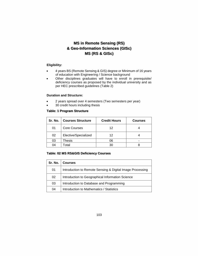
103
MS in Remote Sensing (RS)
& Geo-Information Sciences (GISc)
MS (RS & GISc)
Eligibility:
4 years BS (Remote Sensing & GIS) degree or Minimum of 16 years of education with Engineering / Science background
Other disciplines graduates will have to enroll in prerequisite/ deficiency courses as proposed by the individual university and as per HEC prescribed guidelines (Table 2)
Duration and Structure:
2 years spread over 4 semesters (Two semesters per year)
30 credit hours including thesis
Table: 1 Program Structure
Sr. No. Courses Structure Credit Hours Courses
01 Core Courses 12 4
02 Elective/Specialized 12 4
03 Thesis 06 -
04 Total 30 8
Table: 02 MS RS&GIS Deficiency Courses
Sr. No. Courses
01 Introduction to Remote Sensing & Digital Image Processing
02 Introduction to Geographical Information Science
03 Introduction to Database and Programming
04 Introduction to Mathematics / Statistics
104
‘Introduction to Remote Sensing & Digital Image
Processing’ Course structure 2-1 credit hour 3
Pre-requisites: None
Corse outline: This course will cover basic principles of satellite remote sensing, EM radiations and their interaction with atmosphere. It will describe various optical and microwave satellite systems and their onboard sensors. The characteristics and behavior of different earth features/objects with respect to different EM radiations will be highlighted and their role in data interpretation would be discussed. Application of different satellite images of varying spatial and spectral resolution would discussed. The 2nd segment of the course will deal with Image processing. It will cover different image processing functions and tools for extraction of desired information in a useable form. While providing a conceptual understanding of all the image processing functions and tools to transform raw images to value added products, an ample opportunity of hands on sessions on popular off –the- shelf software packages will be provided to perform all these functions. Objectives: The objectives of the course are:
1. To provide basic concepts and principles of satellite remote sensing and its applications
2. To give understanding on various on-board sensor data and their applications
3. To give conceptual understanding of different image processing functions and tools and tasks
Learning outcomes: 1. An understanding on remote sensing principles, satellites and their
orbits, data acquisition, onboard sensors and their characteristics. 2. Knowledge of various data processing techniques for different
applications.
3. An understanding of analysis and interpretation of remote sensing data.
Skills outcomes: By taking this course the students will be:
105
1. Able to process satellite data and apply different Digital Image Processing (DIP) algorithms for different tasks using off the shelf software packages.
2. Able to conceive and conduct a remote sensing based study/project. 3. Able to select and use appropriate remote sensing datasets for
different applications
Course Assessment #: 1. Home Assignments 2. Class Interaction
3. Final Term Exam
# To be dependent upon the course and instructor’s choice
Course Syllabus
1. Fundamentals of Remote Sensing a. History of remote sensing b. Electromagnetic radiation c. Interaction of EM with the atmosphere d. Spectral response at various targets e. Radiometric and geometric Errors f. Basic principles of Photogrammetry
2. Sensors a. Types of Sensors b. Characteristics of optical sensors c. Resolution
3. Remote Sensing Satellite Systems a. Earth imaging by satellite b. Data parameters c. Low Resolution Satellite - NOAA, Aqua, Terra, Meteosat d. Medium Resolution satellites - Landsat, SPOT, ASTER e. High Resolution Satellites - IKONOS, QuickBird, etc.
4. Image Rectification and Restoration a. Datum, Projection and Coordinate System b. Geometric Correction c. Data Mosaicing
5. Image Interpretation a. Introduction b. Interpretation elements
6. Image Enhancements a. Introduction to digital image processing (DIP) b. Perception of colors c. Visualization of image data d. Colour composites
106
e. Filter operations (noise removal, edge enhancement) f. Contrast Manipulation g. Spatial Feature Manipulation (Spatial filtering, convolution,
edge enhancement, Fourier analysis) h. Multi-Image Manipulation (Spectral ratioing and differencing,
Density slicing, NDVI, HSI) i. Data Merging
7. Image Classification a. Principles of image classification b. Unsupervised Classification c. Supervised Classification
8. The Output Stage a. Maps and their cartographic representation
9. Remote Sensing data applications a. Landuse/landcover b. Urban planning c. Geology/geomorphology d. Coastal zone e. Hydrology/water resources f. Thermal infrared data applications
10. Microwave Remote Sensing a. Principles of microwave remote sensing b. Microwave sensors and platforms
Lab Outline
1. Introduction to labs and exploring Image processing software 2. Demonstrations on various sensor data products 3. Image Management (Import/Export & Display including Single band
image interpretation, False color predictions, False color composite Images Interpretation)
4. Rectification, Registration 5. Image Interpretation/analysis 6. Image Enhancement Techniques
i. Contrast Manipulation (level slicing, contrast stretching) ii. Spatial Feature Manipulation (Spatial filtering, edge
enhancement) iii. Multi-image manipulations (band ratioing and differencing,
NDVI, HIS color space transformations) 7. Image Mosaicing, Color balancing, Data merging 8. Signature selection, Supervised, unsupervised and hybrid
classification, ISODATA, MDM, MLC 9. Map Composition 10. Thermal Infrared Image interpretation
107
References
1. W. G. Rees (2001) Physical Principles of Remote Sensing
Cambridge University Press, United Kingdom. ISBN: 0521669480 2. Robert A. Schowengerdt (January 15, 1997) Remote Sensing 2nd
edition, Academic Press ISBN: 0126289816 3. Thomas M. Lillesand & Ralph W. Kiefer (Year 2000) Remote
Sensing and Image Interpretation John Wiley & Sons, Inc. 4. James B. Campbell (1996) Introduction to Remote Sensing, The
Guilford Press, New York, USA 5. Lillesand, T. M. and Kiefer, R. W. (2004). Remote Sensing and
Image Interpretation, 5th edition. (John Wiley and Sons), ISBN 0-471-15227-7
6. Mather, P M (2004). Computer Processing of Remotely Sensed Images, 3rd Ed. (John Wiley and Sons), ISBN 0-470-84919-3
7. Campbell, James B. (2002. Introduction to Remote Sensing, 3rd Ed., (The Guilford Press) ISBN # 0-7484-0663-8 (pbk)
8. Gibson, P.J (2000). Introductory Remote Sensing: Principles and Concepts (Routledge), ISBN 0-415-19646-9
9. Jensen, J. (2000) Remote Sensing of the Environment: An Earth Resources Perspective, Amazon Publishers
10. Sabins, F.F (1996). Remote Sensing: Principles and Interpretation, 3rd ed, (W H Freeman & Co), ISBN # 0-7167-2442-1
11. Schowengerdt, R A (1997) Remote Sensing, Models and Methods for Image Processing (Academic Press) ISBN 0-12-628981-6
12. Jensen, J. R. (2002) , Digital Image Processing: A Remote Sensing Perspective, Prentice Hall, New York
2. ‘Introduction to Geographical Information Science and spatial
analysis’
Course structure 2-1 credit hour 3
Pre-requisites: None
Course outline: Geographic Information Systems or GIS is a collection of computer hardware, software, and geographic data for capturing, managing, analyzing, and displaying all forms of geographically referenced information. Geographic Information Systems (GIS) are becoming important tools in any discipline that deals with spatial information. This course introduces the diverse ways in which the concepts and theories that form the basis of modern GIS are implemented and applied. It explores the origins of GIS, its conceptual and theoretical foundations as well as important issues related to applications of GIS. This Masters level Introduction to GIS course will serve as a basic for those who want
108
to use GIS to support various applications and intend to concentrate their studies in the GIS specialization. Course objectives are implemented through readings, lectures and laboratory sessions that will give students "hands-on" exposure to different GIS Software packages. It will also give an overview of the history of GIS, cartography, data sources and their management techniques, vector and raster data models, database development and spatial analysis and queries etc.
Objectives:
The objectives of this course will be to:
1. introduce the concepts and theories that form the foundations of modern geographical information systems (GIS)
2. provide the students with a thorough grounding in the generic underpinnings of geographic information system concepts, design, and a working knowledge
3. provide students with a generic process of solving geographic problems using GIS and to develop skills in conceptualizing geographic problems and in developing strategies to solve the problems
Learning outcomes: 1. An understanding of concepts and theories that underpin modern
GIS 2. An understanding of the analytical capabilities of GIS 3. An understanding of the issues relating to the real world spatial
problems
Skills outcomes:
By taking this course the students will be: 1. Able to demonstrate a detailed knowledge of the concepts and
theories of modern GIS and corresponding GIS platforms in terms of feature, functionalities and available tools and will be able to analyze and solve geospatial problems.
2. Familiar with data sources and techniques for applying GIS in different monitoring and management activities.
Course Assessment #: 1. Home Assignments 2. Class Interaction 3. Final Term Exam
# to be dependent upon instructor’s choice
109
Course Syllabus
1. Introduction a. GIS - Components and characteristics b. Historical Background
i. Origin ii. Evolution iii. Stages
c. GIS Approaches i. Earlier Approach ii. Current Trends iii. Future Innovations and advancements
d. GIS Operations 2. Coordinate Systems
a. Shape of the Earth b. Geodesy, Datum & Spheroids c. Geographic Coordinate System d. Projected Coordinate System
i. Map Projections ii. Projection Transformations iii. Working with Coordinate Systems in GIS
3. Geometric Transformation a. Geometric Transformation b. Root Mean Square (RMS) Error c. Resampling of Pixel Values
4. Data Acquisition & Capturing Techniques a. Data Sources
i. Primary ii. Secondary
b. Manipulation and customization of existing historical/statistical data
c. Metadata d. Conversion of Existing Data
5. Data Visualization and Cartography a. Cartography Concepts b. Symbolization c. Types of Maps d. Map Elements e. Map Designing & Compilation f. Map Designing Issues
6. GIS Application Platforms a. Software Technologies
i. Characteristics & Applications ii. Comparison
b. Hardware Technologies 7. Spatial Data Development and Manipulation
a. Techniques
110
b. Manipulation & Editing c. Precision d. Location errors e. Error Rectification Techniques f. Spatial data accuracy standards g. Topological errors h. Topological editing i. Non-topological editing j. Spatial adjustments k. Other editing operations
8. Attribute Data Input and Management a. Attribute Data in GIS b. The Relational Model c. Attribute Data Entry d. Manipulation of Fields and Attribute Data
9. Geo-relational Vector Data Model a. Geo-relational data model b. Representation of Simple Features c. Topology d. Non-topological Vector Data e. Data Formats f. Data Models for Composite Features
10. Object–based Vector Data Model a. Object-based Data Model b. The Geodatabase Data Model c. Relationships d. Interface e. Topology Rules f. Advantages of the Geodatabase Data Model g. Data Formats
11. Raster Data Model a. Elements of the Raster Data Model b. Types of Raster Data c. Raster Data Structure d. Image Compression e. Data Conversion f. Integration of Raster and Vector Data g. Data Formats
12. Querying Spatial Data a. Data Exploration b. Attribute Data Query c. Spatial Data Query d. Raster Data Query e. SQL Queries, Mathematical Expressions & operators f. Geographic Visualization
111
13. Satellite based Navigation a. GPS b. GPS Components & Segments c. DGPS d. Accuracies comparison e. Integration with GIS
Lab Outline
1. Exploring GIS Softwares 2. Spatial Data Visualization 3. Cartographic Operations 4. Layout Designing 5. Spatial data Management 6. Geodatabase Development 7. Digitization Techniques 8. Editing Techniques 9. Geo-processing Operations 10. Topology Development 11. Topological Editing 12. Data Transformation / Conversion 13. Spatial Data Queries 14. Georeferencing 15. Projection Transformation
References
1. Aronoff, S. (2004) "Geographic Information Systems: A Management Perspective" WDL Publications, Ottawa, Fifth Edition. ISBN – 0912804008
2. Clarke, K. (2004) “Getting started with Geographic Information System”, Prentice Hall, New York, Second Edition. ISBN – 1879102897
3. Heywood, I., Cornelius, S. and Carver, S. (2003) “An introduction to Geographic Information System”, Addison Wesley Longman, New York, Second Edition. ISBN – 0130611980
4. Matt Duckham, Michael F. Goodchild, Michael F. Worboys, (2003) Foundations of Geographic Information Science, Tylor & Francis, NewYork, USA
5. Michael N. Demers (2002) Fundamentals of Geographic Information System, John Wiley & Sons, Inc., Singapore
6. Kang-tsung Chang (2002) Introduction to Geographic Information Systems, McGraw- Hill Company, New York, U.S.A
7. Burrough, P. (2002) “Principles of Geographic Information Systems for Land Resources Management”, Oxford University Press, Oxford, Second Edition. ISBN - 0198233655
112
8. McDonald, R. and Burrough, P. (2001) “Principles of Geographic Information Systems”, Oxford University Press, Oxford, Second Edition ISBN–198233855
9. Foresman, T. (1997) “The history of Geographic Information System”, Prentice Hall, New York. ISBN – 0138621454
3. ‘Introduction to GIS Database and Programming’
Course structure 2-1 credit hour 03
Pre-requisites: None
Course Outline: Databases form the most basic and valuable part of today’s Management Information Systems (MIS), Decision Support Systems (DSS) and Transaction Processing Systems (TPS). This course explores the concepts of database systems and their working. Approach of traditional and modern database systems, their pros/cons over each other and the way they interact to the outside world. Concepts of DBMS and RDBMS and requirement of their integration in today’s user friendly as well as real time applications for accurate mapping and reporting are discussed. Conceptual and Practical knowledge concerning present database systems such as data manipulation, data definition, entity relationship, normalization, database management, security enforcement etc. are explored. This course also introduces the basic concepts of computer programming and extracting data from databases through user defined computer programs. Objectives:
The objectives of this course are
1. To introduce the concepts of modern database systems and their applications in different disciplines and spheres of life
2. To introduce the basic concepts of computer programming
Learning outcomes: 1. An understanding of the modern database systems and their
working 2. An understanding of the relational databases and its advantages
over traditional systems 3. Knowledge of database administration 4. An understanding of basic concepts of computer programming 5. Knowledge of the database applications and the role of computer
programming to develop them.
113
Skills outcomes: On successful completion of the course students will be able to 1. Demonstrate practical knowledge of the RDBMS 2. Be able to work on databases and can query and program them. 3. Be able to develop basic computer programs
Course Assessment #: 1. Home Assignments 2. Class Interaction 3. Final Term Exam
# to be dependent upon instructor’s choice
Course Syllabus
Part I - Database Systems
1. Introduction to databases a. Traditional file based system
i. File based approach
ii. Limitations of file based approach
b. Database approach
i. The database management system
ii. Components of the DBMS environment
c. History of DBMS
d. Advantages and disadvantages of DBMS 2. Database Environment
a. The three level architecture i. External level ii. Conceptual level iii. Internal level
b. Database languages i. The data definition language (DDL) ii. The data manipulation language (DML) iii. Fourth-generation languages (4GL)
c. Data models and conceptual modeling i. Object based data models ii. Record based data models iii. Physical data models iv. Conceptual modeling
3. The Relational Model a. Brief history of the relational model b. Terminology
i. Relational data structure
114
ii. Mathematical relations iii. Database relations iv. Properties of relations v. Relational keys
c. Relational Integrity i. Nulls ii. Entity integrity iii. Referential integrity
d. Views i. Terminology ii. Purpose of views iii. Updating views
4. Data Manipulation a. Introduction to SQL
i. Objectives of SQL ii. History of SQL iii. Importance of SQL
b. Writing SQL Commands i. Simple queries ii. Sorting results iii. Using the SQL Aggregate functions iv. Grouping results v. Combining result tables vi. Database updates
5. Data Definition a. Data definition
i. Creating a database ii. Creating a table iii. Changing a table iv. Removing a table v. Creating an index vi. Removing an index
b. Views i. Creating a view ii. Removing a view iii. Restrictions on views iv. Advantages and disadvantages of views
6. Entity-Relationship Modeling a. Entity Types b. Relationship Types c. Attributes d. Strong and Weak entity types e. Attributes on Relationships
i. One to One Relationships ii. One to Many Relationships iii. Many to Many Relationships
115
7. Normalization a. The purpose of Normalization b. Data Redundancy c. Functional Dependencies d. The process of Normalization e. First Normal Form (1NF) f. Second Normal Form (2NF) g. Third Normal Form (3NF) h. Boyce-Codd Normal Form (BCNF) i. Fourth Normal Form (4NF)
Part II - Computer Programming and Problem Solving
1. Computer Programming/Languages
a. Why Programming? b. History c. Programming languages
i. Low level languages ii. High level languages iii. Visual languages
2. Application Types a. Console based applications b. Forms based applications
3. Programming Paradigms a. Sequential programming b. Procedural programming c. Object Oriented programming
4. Programming Environment a. Integrated development environment (IDE) b. Writing code c. Compilation d. Project Building e. Output Execution f. Output Deployment
5. Variables and Expressions a. Syntax b. Variables c. Expressions
6. Data Types a. Integer data type b. Float data type c. Double data type d. Byte data type e. Character data type f. String data type g. Boolean data type
116
7. Control Structures a. If statement b. If-else statement c. Switch case statement d. For statement e. While statement f. Do while statement g. Break statement h. Continue statement i. Return statement j. Goto statement
8. Connecting to Databases a. Programming for databases b. Fetching data c. Modifying data
Lab Outline
1. Exploring DBMS Environment 2. Creating Databases and tables 3. Executing Selection Queries 4. Executing Updation Queries 5. Creating and running views 6. Creating and Executing Stored procedures 7. Roles and permissions 8. User defined functions 9. Importing and exporting data 10. Creating and restoring backup 11. Exploring Programming Environment 12. Writing programs and syntax 13. Controlling program execution 14. Connecting Data sources 15. Fetching and modifying data 16. Project assignment
References
1. Mark L. Gillenson (2005) Fundamentals of Database Management Systems John Wiley & Sons
2. Kropla, B. (2005) “MapServer: Open Source GIS Development” Apress, Co. ISBN: 1590594908
3. Michael Worboys, Matt Duckham (2004) GIS: A Computing Perspective, 2nd Edition CRC Press; 2nd edition ISBN: 0415283752
4. C.J. Date, Database Systems, Addison Wesley Pub. Co. (2004) ISBN – 0201385902
117
5. R.Connolly and P.Begg Database Systems: A Practical Approach to Design, Implementation and Management, Addison-Wesley Pub. Co (2003) ISBN – 0321210255.
6. Elmasri, R. and Navathe, S.B (2004) “Fundamentals of Database Systems” Addison-Wesley Pub. Co ISBN – 0-HEC- RS&GIS Curricula 2005 61 201760355
7. Les Kirkup (2002) Data Analysis with Excel®: An Introduction for Physical Scientists Cambridge University Press
8. Terry Halpin (2001)Information Modeling and Relational Databases: From Conceptual Analysis to Logical Design (Morgan Kaufmann Series in Data Management Systems) Morgan Kaufmann; 1st edition ISBN: 1558606726
9. Rigaux, P. Scholl, M. and Voisard, A.(2001) “Spatial Databases: With Application to GIS” Morgan Kaufmann; 2nd edition ISBN –01017386802
10. Ralston, B. A. (2002), Developing GIS Solutions with Map Objects and Visual Basic, Onward Press, New York. ISBN: 0766854388
11. Rigaux, P. Scholl, M. and Voisard, A.(2001) “Spatial Databases: With Application to GIS” Morgan Kaufmann; 2nd edition.ISBN: 1558605886
12. Bugg, K.E (2003)“GIS programming: prepare for the gathering storm” GEO
4. ‘Introduction to Mathematics/Statistics’
Course structure 03 credit hour 3
Pre-requisites: None
Course outline: This Course includes some of the basics of Mathematics and Statistics which are required for pursuing studies in the fields related to Image processing and GIS as well as data acquisition through orbiting satellite. It would cover simple as well as trigonometric differentiation and integration as well as the concept of spherical geometry. This course also covers topics relating to distribution of data and probability theory. Objectives:
The objectives of this course are: 1. To refresh the mathematics related to space science and technology 2. To give an understanding on essential mathematics and statistical
concepts which may be helpful in understanding image processing as well as various techniques employed in remote sensing and GIS.
118
Learning outcomes: 1. It would refresh the mathematics and statistics specially those topics
which would be useful in understanding the mathematics involved in image processing.
2. An understanding of various mathematical computation involved in data processing.
3. The mathematical and statistical data theories and concepts will lead to understanding of image data, its interpretation and analysis.
Skills outcomes: On completion of this course, students will be able to: 1. Efficiently process the image data 2. Acquire a better analytic ability to support any hypothesis developed
in data interpretation and analysis process.
Course Syllabus
1. Measures of Central Tendency a. The Arithmetic Mean b. The Median c. The Mode d. Standard Deviation
2. Probability a. Mutually exclusive events b. Non Mutually exclusive events c. Independent events d. Dependent events e. Binomial distribution f. Poison distribution g. Normal distribution
3. Fourier Series 4. Partial Differential function 5. Trigonometric Differential Equations 6. Differential series
a. Power series function b. Gamma function c. Beta function d. Bassel’s equation e. Generating function f. Legender’s equation g. Rodrigue’s formula h. Laplace Transformation
7. Integration a. Chain Rule b. Euler’s formulas c. Even odd function
119
8. Error theory and Statistics 9. Data distribution
a. Data sampling and chi square b. Data sampling
10. Spherical Trigonometry a. Spherical Triangle b. Terrestrial Latitude and Longitude
11. Celestial Sphere a. Attitude and Azimuth b. Declination and hour angle c. Right Ascension and declination
12. Vector Analysis 1. Divergence of a vector 2. Guass Divergence theorem 3. Curl of a vector 4. Stokes’ theorem 5. Green’s theorem
References
1. Linear Algebra by David C Lay, 3ed, Amazon, 2002 2. Linear Algebra: A Modern Introduction -- by David Poole, Amazon,
2003 3. Introduction to Linear Algebra, Third Edition, by Gilbert Strang,
2003, Amazon 4. Schaum's Easy Outline of Linear Algebra by Seymour Lipschutz,
Marc Lipson, 2002 5. Linear Algebra, Fifth Edition, by Gareth Williams, 2004, Amazon
120
Table: 03 MS RS &GIS Core Courses
Sr. No. Courses
01 Advanced Remote Sensing and Digital Image Processing
02 Advanced Geographic Information Systems
03 Advanced Programming and Customizing GIS
04 Advanced Research Methods
01: Advanced Remote Sensing and Digital Image Processing
Credit Hours: 3 (2+1)
Pre-requisites:
Course Objective:
The course is designed to enhance the professional skills aligned with the latest advancements in Remote Sensing and Digital Image Processing.
Learning Outcomes
After studying this course, the students will be able to:-
1. Understand the advances in Remote Sensing technology 2. Analyze optical, thermal and microwave remotely sensed data sets. 3. Apply advance remote sensing techniques in earth resource
management.
Course Outline:
Overview of advances in satellite technology
Data acquisition, image formats and conversion
Geometric and Radiometric correction
Data Fusion techniques
Digital Image interpretation and analysis
Spatial filtering
Principle component Analysis
Raster calculations and model building
Indices development and change detection
Pattern recognition and artificial Intelligence
Image classification techniques (supervised, unsupervised, object based, knowledge based)
121
Overview of support vector machine and neural network classifications
Fundamentals of DEM generation and quality assessment
Principles of Microwave Remote Sensing and analysis techniques
Hyper-spectral remote sensing and interpretation
Integration of Remote Sensing with Hydrological/environmental Modeling
Remote Sensing application in agriculture, natural resources and disaster risk management
Lab:
1. Introduction to labs 2. Advance image Pre-processing (radiometric corrections,
geometric rectification, image enhancement), 3. Advanced information extraction techniques, 4. Thematic accuracy assessment, 5. Spectrometer handling, 6. Digital change detection, 7. Ortho-rectification, 8. Image transformations, 9. Advance data Fusion techniques, 10. DEM extraction from various data sources, 11. Processing of Thermal, Hyper spectral, LIDAR data etc.
Reference Material: 1. Aronoff, S. (2005) Remote Sensing for GIS Mangers. Redlands.
California: ESRI Press ISBN: 9781589480810 2. Campbell, James B. (2011)Introduction to Remote Sensing, 5th Ed.,
(The Guilford Press) ISBN: 9781609181765. 3. Mather, P M (2011). Computer Processing of Remotely Sensed
Images, 4th Ed. (John Wiley and Sons), ISBN: 9780470742389 4. Jensen, J. (2009) Remote Sensing of the Environment: An Earth
Resources Perspective, 2nd Ed. Pearson Publishers, ISBN: 9788131716809
5. D. A. Landgrebe (2003) Signal theory methods in multispectral remote sensing, John Wiley and Sons ISBN: 0-471-42028-X
6. Pramod K. Varshney, Manoj K. Arora (2004) Advanced Image Processing Techniques for Remotely Sensed Hyperspectral Data, Springer, ISBN: 3540216685
7. Henderson, F. M and Lewis, A. J (1998). Principles and Applications of Imaging Radar. Manual of Remote Sensing, 3rd Edition Volume 5. John Wiley and Sons. ISBN 0-471029406-3.

122
8. Jie Shan, Charles K. Toth (2008) Topographic Laser Ranging and Scanning: Principles and Processing, CRC Press ISBN: 978-1420051421
9. George Vosselman (2010) Airborne and terrestrial laser scanning, Hans-Gerd Maas ISBN: 9781439827987
02: Advanced Geographic Information Systems Course Structure: Lectures: 2 / Labs : 1 Credit Hours: 3 Objectives The course is designed to enhance the professional skills aligned with the latest advancements in GIS Learning Outcomes After studying this course, the students will be able to:-
Acquire skills and knowledge on the selection, integration, spatial analysis/modeling and visualization/communication of spatial information using GIS
Learn to identify and translate a spatial research question into a GIS modeling problem / solution
Apply advanced GIS tools to recognize and critically evaluate specific spatial issues
Develop and carry out a scientifically sound GIS project
Course Outline: 1. Review of geographical data, 2. Coordinate systems and Map projections, 3. Raster/Vector conversions, 4. Error estimations and rectification due to projection systems and
cartographic procedures, advanced editing of spatial data, 5. Symbolization and Map layouts development, 6. Describing and analyzing fields, 7. Area Objects and Spatial autocorrelation, 8. 3D Visualization of Spatial Data, 9. Geocoding and survey data integration in GIS, 10. Point Pattern analysis, 11. Lines and Networks, 12. Performing Network analysis, 13. Geo-statistical analysis, 14. Map Overlay analysis, 15. Multivariate data analysis, 16. Multidimensional Space, 17. GIS Modeling and Simulation.
123
Reference Material: 1. Aronoff, S. (2004) "Geographic Information Systems: A
Management Perspective", WDL Publications, Ottawa, 5thEdition. ISBN – 0912804008
2. Burrough, P. and McDonald, R. (1998) “Principles of Geographic Information Systems”, Oxford University Press, Oxford, Second Edition ISBN - 0198233855
3. Clarke, K. (2010) “Getting started with Geographic Information System”, Prentice Hall, New York, 5thEdition. ISBN – 10: 0131494988
4. Fotheringham, S., Brunsdon, C., Charlton, M. E. (2000) “Quantitative Geography: Perspectives on Spatial Data Analysis”, SAGE Publications ISBN: 0761959483.
5. Heywood, I., Cornelius, S. and Carver, S. (2006) “An introduction to Geographic Information System”, Prentice Hall, 3rdEdition. ISBN-10: 0131293176
6. Malczewski, J. (1999) “GIS and Multicriteria Decision Analysis”, John Wiley & Sons, Inc. ISBN: 0471329444.
7. Molenaar, M. (1998) “An Introduction to the Theory of Spatial Object Modelling for GIS”, Taylor & Francis, Inc. ISBN: 074840774X.
8. Stillwell, J. (2005) “Applied GIS and Spatial Analysis”, John Wiley & Sons, Ltd. England.
03. Advanced Programming and Customizing GIS Credits: 3 (2-1) Credits Hours
2 Lectures + 1 Lab
Taught: Semester I Pre-requisites: Introduction to Databases and Computer Programming
Course Summary: This Course looks at the advance programming concepts and their applications in developing Customized GIS software. Concepts of design architectures, constructs and features of the modern programming languages are explored. Investigation of mapping capabilities in user defined programs, querying and plotting user data on the map. Topics include Functions, Arrays, Object oriented programming, Files, Mapping in Computer programs, Analysis, Querying maps and Spatial Databases. Objectives: The objectives of this course are
124
1. To build upon the existing knowledge of computer programming and explore some advance topics
2. To introduce the concepts of GIS customization and its advantages in decision making
Learning outcomes: 1. An understanding of computer programming concepts and its role in
application software development 2. Knowledge of GIS software, its customization and building
standalone customized GIS programs 3. An understanding of the map querying and serving reports with them 4. Knowledge of spatial databases and their working
Skills outcomes: On successful completion of the course students will be able to 1. Develop software applications using the computer programming
knowledge 2. Build customized GIS applications incorporating user data, reports
and analysis
Course Assessment #: 1. Mid Term Exam 2. Home Assignments 3. Class Interaction 4. Final Term Exam
# To be dependent upon instructors’ choice
Part I - Computer Programming and Problem Solving
1. Defining Functions a. Defining and using functions b. Main function c. Variable scope d. Arguments e. Return value from functions
2. Arrays a. Declaring arrays b. Accessing array elements c. Array types
3. Working with Strings a. String creation and variables b. String concatenation c. String comparison d. Searching and extracting substring
125
4. Object Oriented Programming a. What is object oriented programming? b. Defining classes c. Creating objects d. Static members e. Constructors f. Overloading methods and constructors g. Data encapsulation
5. Inheritance and polymorphism a. Inheritance b. Polymorphism c. Abstract classes
6. Working with files a. Reading and writing files b. File Streams
Part II - Programming for GIS
1. GIS Applications a. How to program? b. Modules and Components of a basic GIS Application
2. GIS Customization a. What is GIS Customization? b. Why Customize?
3. Geo Databases a. Spatial database concepts b. Saving and retrieving vector data c. Spatial query processing d. Spatial indexing
4. Analysis and Design a. Requirement analysis b. System design c. Data flow
5. Planning a. Selection of Hardware / Software b. Communication infrastructure
6. Creating environment for customization a. Add Mapping support
i. Add Layers to map ii. Classifying / symbolizing layers iii. Layering controls iv. Navigational controls v. Querying
7. Analysis and Reporting b. Thematic Visualizations c. Paper based reports
126
8. Packaging and deployment a. Customized GIS packaging b. Deployment of customized package c. Feedback incorporation d. Customized Applications - Case Studies
Lab Outline 1) Writing programs using Functions/procedures 2) Using Arrays and Strings 3) Object Oriented Programming
a) Defining classes and objects b) Overloading c) Using Derived classes d) Using Polymorphism and Overriding e) Using Abstract Classes f) Defining Interfaces g) Reading and Writing Files h) Programming GIS i) Programming a GIS Application j) Working with Geo Databases k) Custom Controls for mapping l) Programming for basic map features m) Programming for map analysis and reports
4) Project assignment
References 1. Bruce Ralston (2002) Developing GIS Solutions with Map Objects
and Visual Basic Onward Press, Thomson Learning, New York. ISBN: 0766854388
2. Kang-Stung Chang Programming (2005) ArcObjects with VBA: A Task-Oriented Approach, CRC Press LLC. ISBN: 0849327814
3. Philippe Rigaux, et al (2002) Spatial Databases: With Application to GIS (Morgan Kaufmann Series in Data Management Systems) Academic Press, U.S
4. Menno-Jan Kraak (2001) Web Cartography, Taylor & Francis ISBN: 074840869X
5. Simon W. Houlding (2000) Practical Geostatistics: Modeling and Spatial Analysis (with CD-ROM) Springer; Bk&CD Rom edition ISBN: 3540668209
127
04. Advanced Research Methods
Credits: 3 (3-0) Credits Hours
Taught: Semester II
Pre-requisites: None
Course Summary: This course deals with skills and knowledge required to pursue any research/scientific study/investigation. It however focuses on the research undertakings in the field of remote sensing and GIS. The course covers the standards methods and steps followed in any research activity right from the evolution of idea, statement of the problem, acquisition of information, qualitative and quantitative measurement techniques, surveys and sampling procedures, data interpretation and analysis, validation of results and accuracy assessment.
Objectives:
The objectives of the course will be: 1. To analyze a problem and formulate research questions 2. To make a critical selection from secondary sources (literature,
electronic information sources, including the internet, etc.) that provide the information required to deal with the research questions.
3. To critically analyze, review and summarize intellectual material with an emphasis on problem-solving.
4. To review existing scientific papers on the subject and provide feedback to the authors.
Learning outcomes: 1. An understanding of the concepts and theories of scientific
research. 2. An understanding of how to formulate research problem as well as
to review literature through different sources 3. An understanding of designing and basic elements of a research
study 4. An understanding of major types of research methods such as
qualitative, quantitative and surveying methods and their relative functions, as well as reliability and validity of results produced.
5. An understanding of sampling technique and its types. 6. An understanding of data collection methods and concerning issues. 7. An understanding of analysis and interpretation 8. An understanding of formulating research proposal and writing the
research report.
128
Skills outcomes: On completion of this module students will be able to: 1. Design or formulate a research study. 2. Familiar with authentic literature review techniques as well as data
collection methods. 3. To formulate the research proposal and report it in a written form 4. To write the research report/papers 5. to develop presentation skills
Course Assessment #: 1. Mid Term Exam 2. Home Assignments
3. Class Interaction
4. Final Term Exam # To be dependent upon instructors choice
129
Course Syllabus
1. Introduction a. Defining research through different perspectives b. Scope of Research c. Research and theory d. The scientific approach e. Stages of research process f. Ethics of Research
i. Principals of Right to Know and Right to Protect ii. Ethical dilemmas and conflicts
2. Information Acquisition a. Sources of research topics and questions b. Literature review and the exploratory study c. Introduction to Library Resources d. Primary and secondary sources e. Specification of objectives f. Hypotheses Uni-variate, Bi-variate, Multivariate and
Characteristics of a Testable Hypothesis-e Null Hypothesis and Alternate Hypothesis
g. Concepts and variables 3. Assessment Of Short Comings and Reliabilities Of
Measurement a. Levels of measurement: nominal, ordinal, interval and ratio b. Reliability and validity c. Construction of composite scores: typology, index and scaling d. Problems of making causal inference
4. Study Designs and Measurement a. Basic elements of study design b. Major types of design and their relative functions c. Qualitative Research Methods
i. Field research ii. Focus groups iii. Participatory research appraisal iv. Elite interviews
d. Quantitative Research Methods i. Experimental research ii. Aggregate data (Analyzing existing statistics) iii. Content analysis (Analyzing recorded human
communications) e. Social Survey Methods
i. The Interview Method ii. The Questionnaire Method iii. Formulating Questions for a Survey iv. Survey Implementation
130
v. Editing, Coding and Data Entry vi. Analysis of Survey Data vii. Writing a Survey Report
f. Evaluation Research Methods i. Social survey ii. Case study: its exploratory nature
g. Reliability and validity of measurement h. Level of Measurement i. Cross-sectional, Longitudinal, and Sequential Designs
5. Sampling a. Population and the source list a. Sampling errors and sample size b. Probability sampling c. Non-probability sampling
6. Data Collection Methods a. Interview and questionnaire
1. Structured 2. Semi-structured 3. Unstructured
b. Observation c. Documents and content analysis d. Unobtrusive measures e. Data collection issues
7. Data Analysis And Interpretation a. Editing, coding, and tabulation b. Statistical analysis: Description and inference c. The meanings and implications of results: why so and so
what? 8. Anticipated Out Puts
a. Formulating the research proposal b. Writing the research report c. Research Publications
9. Presentation Skills
References
1. Ranjit Kumar, Research Methodology, Sage Publications 2. Ingeman Arbonor And Bjoran Berke, Methodology for Creating
Business Knowledge, Sage Publications 3. Dam Remenyl, Doing Research in Business and Management,
Sage Publications 4. David H. Folz, Survey Research for Public Administration, Sage
Publications 5. C. William Emory, Business Research Methods, IRWIN
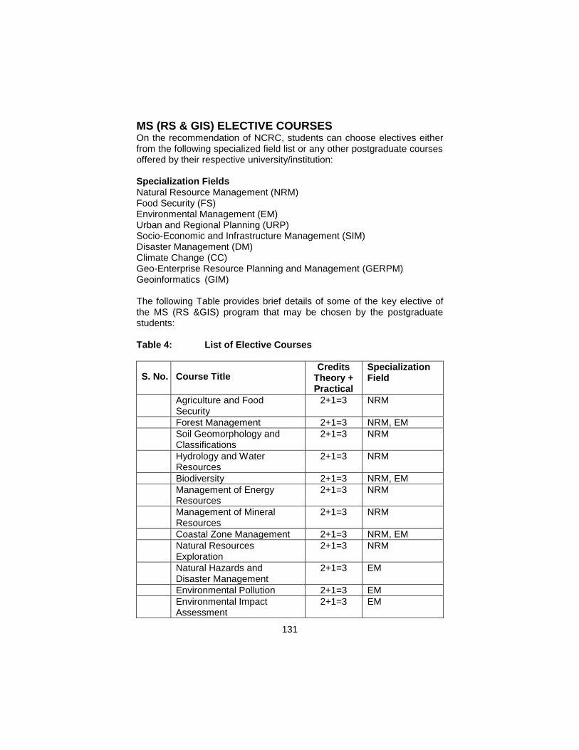
131
MS (RS & GIS) ELECTIVE COURSES On the recommendation of NCRC, students can choose electives either from the following specialized field list or any other postgraduate courses offered by their respective university/institution: Specialization Fields Natural Resource Management (NRM) Food Security (FS) Environmental Management (EM) Urban and Regional Planning (URP) Socio-Economic and Infrastructure Management (SIM) Disaster Management (DM) Climate Change (CC) Geo-Enterprise Resource Planning and Management (GERPM) Geoinformatics (GIM) The following Table provides brief details of some of the key elective of the MS (RS &GIS) program that may be chosen by the postgraduate students: Table 4: List of Elective Courses
S. No. Course Title Credits
Theory + Practical
Specialization Field
1. Agriculture and Food Security
2+1=3 NRM
2. Forest Management 2+1=3 NRM, EM
3. Soil Geomorphology and Classifications
2+1=3 NRM
4. Hydrology and Water Resources
2+1=3 NRM
5. Biodiversity 2+1=3 NRM, EM
6. Management of Energy Resources
2+1=3 NRM
7. Management of Mineral Resources
2+1=3 NRM
8. Coastal Zone Management 2+1=3 NRM, EM
9. Natural Resources Exploration
2+1=3 NRM
10. Natural Hazards and Disaster Management
2+1=3 EM
11. Environmental Pollution 2+1=3 EM
12. Environmental Impact Assessment
2+1=3 EM
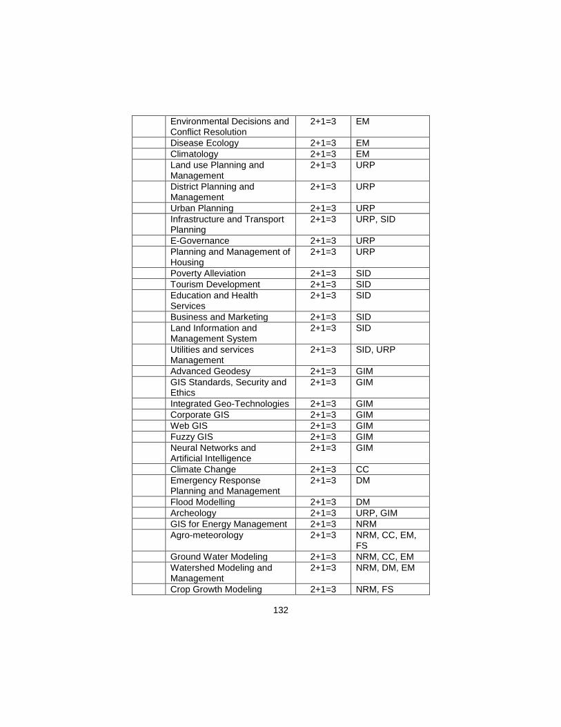
132
13. Environmental Decisions and Conflict Resolution
2+1=3 EM
14. Disease Ecology 2+1=3 EM
15. Climatology 2+1=3 EM
16. Land use Planning and Management
2+1=3 URP
17. District Planning and Management
2+1=3 URP
18. Urban Planning 2+1=3 URP
19. Infrastructure and Transport Planning
2+1=3 URP, SID
20. E-Governance 2+1=3 URP
21. Planning and Management of Housing
2+1=3 URP
22. Poverty Alleviation 2+1=3 SID
23. Tourism Development 2+1=3 SID
24. Education and Health Services
2+1=3 SID
25. Business and Marketing 2+1=3 SID
26. Land Information and Management System
2+1=3 SID
27. Utilities and services Management
2+1=3 SID, URP
28. Advanced Geodesy 2+1=3 GIM
29. GIS Standards, Security and Ethics
2+1=3 GIM
30. Integrated Geo-Technologies 2+1=3 GIM
31. Corporate GIS 2+1=3 GIM
32. Web GIS 2+1=3 GIM
33. Fuzzy GIS 2+1=3 GIM
34. Neural Networks and Artificial Intelligence
2+1=3 GIM
35. Climate Change 2+1=3 CC
36. Emergency Response Planning and Management
2+1=3 DM
37. Flood Modelling 2+1=3 DM
38. Archeology 2+1=3 URP, GIM
39. GIS for Energy Management 2+1=3 NRM
40. Agro-meteorology 2+1=3 NRM, CC, EM, FS
41. Ground Water Modeling 2+1=3 NRM, CC, EM
42. Watershed Modeling and Management
2+1=3 NRM, DM, EM
43. Crop Growth Modeling 2+1=3 NRM, FS
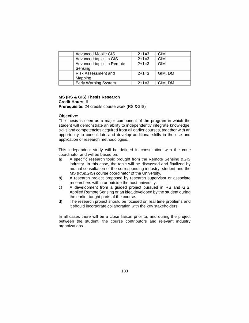
133
44. Advanced Mobile GIS 2+1=3 GIM
45. Advanced topics in GIS 2+1=3 GIM
46. Advanced topics in Remote Sensing
2+1=3 GIM
47. Risk Assessment and Mapping
2+1=3 GIM, DM
48. Early Warning System 2+1=3 GIM, DM
MS (RS & GIS) Thesis Research Credit Hours: 6 Prerequisite: 24 credits course work (RS &GIS)
Objective: The thesis is seen as a major component of the program in which the student will demonstrate an ability to independently integrate knowledge, skills and competencies acquired from all earlier courses, together with an opportunity to consolidate and develop additional skills in the use and application of research methodologies.
This independent study will be defined in consultation with the course coordinator and will be based on: a) A specific research topic brought from the Remote Sensing &GIS
industry. In this case, the topic will be discussed and finalized by mutual consultation of the corresponding industry, student and the MS (RS&GIS) course coordinator of the University.
b) A research project proposed by research supervisor or associate researchers within or outside the host university.
c) A development from a guided project pursued in RS and GIS, Applied Remote Sensing or an idea developed by the student during the earlier taught parts of the course.
d) The research project should be focused on real time problems and it should incorporate collaboration with the key stakeholders.
In all cases there will be a close liaison prior to, and during the project between the student, the course contributors and relevant industry organizations.
134
ANNEXURE - A
English I (Functional English)
Objectives: Enhance language skills and develop critical thinking.
Course Contents Basics of Grammar Parts of speech and use of articles Sentence structure, active and passive voice Practice in unified sentence Analysis of phrase, clause and sentence structure Transitive and intransitive verbs Punctuation and spelling Comprehension
Answers to questions on a given text
Discussion General topics and every-day conversation (topics for discussion to be at the discretion of the teacher keeping in view the level of students) Listening
To be improved by showing documentaries/films carefully selected by
subject teachers
Translation skills
Urdu to English
Paragraph writing
Topics to be chosen at the discretion of the teacher
Presentation skills
Introduction
Note: Extensive reading is required for vocabulary building
Recommended Books
1. Functional English
a) Grammar
1. Practical English Grammar by A. J. Thomson and A. V.
Martinet. Exercises 1. Third edition. Oxford University Press.
1997. ISBN 0194313492
2. Practical English Grammar by A. J. Thomson and A. V.
Martinet. Exercises 2. Third edition. Oxford University Press.
1997. ISBN 0194313506
b) Writing
1. Writing. Intermediate by Marie-Christine Boutin, Suzanne
Brinand and Francoise Grellet. Oxford Supplementary Skills.
135
Fourth Impression 1993. ISBN 0 19 435405 7 Pages 20-27
and 35-41.
c) Reading/Comprehension
1. Reading. Upper Intermediate. Brain Tomlinson and Rod Ellis.
Oxford Supplementary Skills. Third Impression 1992. ISBN 0
19 453402 2.
d) Speaking
English II (Communication Skills)
Objectives: Enable the students to meet their real life communication
needs.
Course Contents:
Paragraph writing
Practice in writing a good, unified and coherent paragraph
Essay writing Introduction
CV and job application
Translation skills
Urdu to English
Study skills
Skimming and scanning, intensive and extensive, and speed reading,
summary and précis writing and comprehension
Academic skills
Letter/memo writing, minutes of meetings, use of library and internet
Presentation skills
Personality development (emphasis on content, style and pronunciation)
Note: documentaries to be shown for discussion and review
Recommended Books
Communication Skills
a) Grammar
1. Practical English Grammar by A. J. Thomson and A. V.
Martinet. Exercises 2. Third edition. Oxford University Press
1986. ISBN 0 19 431350 6.
b) Writing
1. Writing. Intermediate by Marie-Christine Boutin, Suzanne
Brinand and Francoise Grellet. Oxford Supplementary Skills.
Fourth Impression 1993. ISBN 019 435405 7 Pages 45-53
(note taking).
2. Writing. Upper-Intermediate by Rob Nolasco. Oxford
Supplementary Skills. Fourth Impression 1992. ISBN 0 19
136
435406 5 (particularly good for writing memos, introduction to
presentations, descriptive and argumentative writing).
c) Reading
1. Reading. Advanced. Brian Tomlinson and Rod Ellis. Oxford
Supplementary Skills. Third Impression 1991. ISBN 0 19
453403 0.
2. Reading and Study Skills by John Langan
3. Study Skills by Richard York.
English III (Technical Writing and
Presentation Skills)
Objectives: Enhance language skills and develop critical thinking
Course Contents
Presentation skills
Essay writing
Descriptive, narrative, discursive, argumentative
Academic writing
How to write a proposal for research paper/term paper
How to write a research paper/term paper (emphasis on style, content,
language, form, clarity, consistency)
Technical Report writing
Progress report writing
Note: Extensive reading is required for vocabulary building
Recommended Books
Technical Writing and Presentation Skills
a) Essay Writing and Academic Writing
1. Writing. Advanced by Ron White. Oxford Supplementary Skills. Third Impression 1992. ISBN 0 19 435407 3 (particularly suitable for discursive, descriptive, argumentative and report writing).
2. College Writing Skills by John Langan. McGraw-Hill Higher Education. 2004.
3. Patterns of College Writing (4th edition) by Laurie G. Kirszner and Stephen R. Mandell. St. Martin’s Press.
b) Presentation Skills c) Reading
The Mercury Reader. A Custom Publication. Compiled by Northern Illinois University. General Editors: Janice Neulib; Kathleen Shine Cain; Stephen Ruffus and Maurice Scharton. (A reader which will give students exposure to the best of twentieth century literature, without taxing the taste of engineering students).
137
ANNEXURE - B
Pakistan Studies (Compulsory)
Introduction/Objectives
Develop vision of historical perspective, government, politics, contemporary Pakistan, ideological background of Pakistan.
Study the process of governance, national development, issues arising in the modern age and posing challenges to Pakistan.
Course Outline
1. Historical Perspective
a. Ideological rationale with special reference to Sir Syed Ahmed Khan, Allama Muhammad Iqbal and Quaid-e-Azam Muhammad Ali Jinnah.
b. Factors leading to Muslim separatism
c. People and Land i. Indus Civilization ii. Muslim advent iii. Location and geo-physical features.
2. Government and Politics in Pakistan
Political and constitutional phases: a. 1947-58 b. 1958-71 c. 1971-77 d. 1977-88 e. 1988-99 f. 1999 onward
3. Contemporary Pakistan a. Economic institutions and issues b. Society and social structure c. Ethnicity d. Foreign policy of Pakistan and challenges e. Futuristic outlook of Pakistan
Recommended Books 1. Burki, Shahid Javed. State & Society in Pakistan, The MacMillan
Press Ltd 1980. 2. Akbar, S. Zaidi. Issue in Pakistan’s Economy. Karachi: Oxford
University Press, 2000.
138
3. S. M. Burke and Lawrence Ziring. Pakistan’s Foreign policy: An Historical analysis. Karachi: Oxford University Press, 1993.
4. Mehmood, Safdar. Pakistan Political Roots & Development. Lahore, 1994.
5. Wilcox, Wayne. The Emergence of Bangladesh, Washington: American Enterprise, Institute of Public Policy Research, 1972.
6. Mehmood, Safdar. Pakistan Kayyun Toota, Lahore: Idara-e-Saqafat-e-Islamia, Club Road, nd.
7. Amin, Tahir. Ethno - National Movement in Pakistan, Islamabad: Institute of Policy Studies, Islamabad.
8. Ziring, Lawrence. Enigma of Political Development. Kent England: Wm Dawson & sons Ltd, 1980.
9. Zahid, Ansar. History & Culture of Sindh. Karachi: Royal Book Company, 1980.
10. Afzal, M. Rafique. Political Parties in Pakistan, Vol. I, II & III. Islamabad: National Institute of Historical and cultural Research, 1998.
11. Sayeed, Khalid Bin. The Political System of Pakistan. Boston: Houghton Mifflin, 1967.
12. Aziz, K. K. Party, Politics in Pakistan, Islamabad: National Commission on Historical and Cultural Research, 1976.
13. Muhammad Waseem, Pakistan Under Martial Law, Lahore: Vanguard, 1987.
14. Haq, Noor ul. Making of Pakistan: The Military Perspective. Islamabad: National Commission on Historical and Cultural Research, 1993.
139
ANNEXURE - C
ISLAMIC STUDIES
(Compulsory)
Objectives
This course is aimed at: 1 To provide Basic information about Islamic Studies 2 To enhance understanding of the students regarding Islamic
Civilization 3 To improve Students skill to perform prayers and other worships 4 To enhance the skill of the students for understanding of issues
related to faith and religious life.
Detail of Courses
Introduction to Quranic Studies
1. Basic Concepts of Quran 2. History of Quran 3. Uloom-ul-Quran
Study of Selected Text of Holly Quran 1. Verses of Surah Al-Baqara Related to Faith(Verse No-284-286) 2. Verses of Surah Al-Hujrat Related to Adab Al-Nabi (Verse No-1-18) 3. Verses of Surah Al-Mumanoon Related to Characteristics of faithful
(Verse No-1-11) 4. Verses of Surah al-Furqan Related to Social Ethics (Verse No.63-
77) 5. Verses of Surah Al-Inam Related to Ihkam (Verse No-152-154)
Study of Selected Text of Holly Quran 1. Verses of Surah Al-Ihzab Related to Adab al-Nabi (Verse No.6, 21,
40, 56, 57, 58.) 2. Verses of Surah Al-Hashar (18,19,20) Related to thinking, Day of
Judgment 3. Verses of Surah Al-Saf Related to Tafakar, Tadabar (Verse No-
1,14)
Seerat of Holy Prophet (S.A.W) I 1. Life of Muhammad Bin Abdullah ( Before Prophet Hood) 2. Life of Holy Prophet (S.A.W) in Makkah 3. Important Lessons Derived from the life of Holy Prophet in Makkah
Seerat of Holy Prophet (S.A.W) II 1. Life of Holy Prophet (S.A.W) in Madina 2. Important Events of Life Holy Prophet in Madina 3. Important Lessons Derived from the life of Holy Prophet in Madina
Introduction to Sunnah
1. Basic Concepts of Hadith
140
2. History of Hadith 3. Kinds of Hadith 4. Uloom –ul-Hadith 5. Sunnah & Hadith 6. Legal Position of Sunnah
Selected Study from Text of Hadith
Introduction to Islamic Law & Jurisprudence 1. Basic Concepts of Islamic Law & Jurisprudence 2. History & Importance of Islamic Law & Jurisprudence 3. Sources of Islamic Law & Jurisprudence 4. Nature of Differences in Islamic Law 5. Islam and Sectarianism
Islamic Culture & Civilization 1. Basic Concepts of Islamic Culture & Civilization 2. Historical Development of Islamic Culture & Civilization 3. Characteristics of Islamic Culture & Civilization 4. Islamic Culture & Civilization and Contemporary Issues
Islam & Science 1. Basic Concepts of Islam & Science 2. Contributions of Muslims in the Development of Science 3. Quran & Science
Islamic Economic System 1. Basic Concepts of Islamic Economic System 2. Means of Distribution of wealth in Islamic Economics 3. Islamic Concept of Riba 4. Islamic Ways of Trade & Commerce
Political System of Islam 1. Basic Concepts of Islamic Political System 2. Islamic Concept of Sovereignty 3. Basic Institutions of Govt. in Islam
Islamic History 1. Period of Khlaft-E-Rashida 2. Period of Ummayyads 3. Period of Abbasids
Social System of Islam 1. Basic Concepts of Social System of Islam 2. Elements of Family 3. Ethical Values of Islam
Reference Books 1. Hameed ullah Muhammad, “Emergence of Islam” , IRI, Islamabad 2 Hameed ullah Muhammad, “Muslim Conduct of State”
141
3 Hameed ullah Muhammad, ‘Introduction to Islam 4. Mulana Muhammad Yousaf Islahi,” 5 Hussain Hamid Hassan, “An Introduction to the Study of Islamic
Law” leaf Publication Islamabad, Pakistan. 6 Ahmad Hasan, “Principles of Islamic Jurisprudence” Islamic
Research Institute, International Islamic University, Islamabad (1993) 7 Mir Waliullah, “Muslim Jurisprudence and the Quranic Law of
Crimes” Islamic Book Service (1982) 8 H. S. Bhatia, “Studies in Islamic Law, Religion and Society” Deep &
Deep Publications New Delhi (1989) 9 Dr. Muhammad Zia-ul-Haq, “Introduction to Al Sharia Al Islamia”
Allama Iqbal Open University, Islamabad (2001)
142
ANNEXURE - D
Note: One course will be selected from the following six courses of
Mathematics.
COMPULSORY MATHEMATICS
COURSES FOR BS (4 YEAR)
(FOR STUDENTS NOT MAJORING IN
MATHEMATICS)
1. MATHEMATICS I (ALGEBRA)
Prerequisite(s): Mathematics at secondary level
Credit Hours: 3 + 0
Specific Objectives of the Course: To prepare the students, not majoring in mathematics, with the essential tools of algebra to apply the concepts and the techniques in their respective disciplines. Course Outline: Preliminaries: Real-number system, complex numbers, introduction to sets, set operations, functions, types of functions. Matrices: Introduction to matrices, types, matrix inverse, determinants, system of linear equations, Cramer’s rule. Quadratic Equations: Solution of quadratic equations, qualitative analysis of roots of a quadratic equations, equations reducible to quadratic equations, cube roots of unity, relation between roots and coefficients of quadratic equations. Sequences and Series: Arithmetic progression, geometric progression, harmonic progression. Binomial Theorem: Introduction to mathematical induction, binomial theorem with rational and irrational indices. Trigonometry: Fundamentals of trigonometry, trigonometric identities.
Recommended Books 1. Dolciani MP, Wooton W, Beckenback EF, Sharron S, Algebra 2 and
Trigonometry, 1978, Houghton & Mifflin, Boston (suggested text)
2. Kaufmann JE, College Algebra and Trigonometry, 1987, PWS-Kent Company, Boston
3. Swokowski EW, Fundamentals of Algebra and Trigonometry (6th edition), 1986, PWS-Kent Company, Boston
2. MATHEMATICS II (CALCULUS)
Prerequisite(s): Mathematics I (Algebra) Credit Hours: 3 + 0
143
Specific Objectives of the Course: To prepare the students, not majoring in mathematics, with the essential tools of calculus to apply the concepts and the techniques in their respective disciplines. Course Outline Preliminaries: Real-number line, functions and their graphs, solution of
equations involving absolute values, inequalities. Limits and Continuity: Limit of a function, left-hand and right-hand limits, continuity, continuous functions.
Derivatives and their Applications: Differentiable functions, differentiation of polynomial, rational and transcendental functions, derivatives. Integration and Definite Integrals: Techniques of evaluating indefinite integrals, integration by substitution, integration by parts, change of variables in indefinite integrals.
Recommended Books 1. Anton H, Bevens I, Davis S, Calculus: A New Horizon (8th edition),
2005, John Wiley, New York
2. Stewart J, Calculus (3rd edition), 1995, Brooks/Cole (suggested text)
3. Swokowski EW, Calculus and Analytic Geometry, 1983, PWS-Kent Company, Boston
4. Thomas GB, Finney AR, Calculus (11th edition), 2005, Addison-Wesley, Reading, Ma, USA
3. MATHEMATICS III (GEOMETRY)
Prerequisite(s): Mathematics II (Calculus)
Credit Hours: 3 + 0
Specific Objectives of the Course: To prepare the students, not majoring in mathematics, with the essential tools of geometry to apply the concepts and the techniques in their respective disciplines. Course Outline Geometry in Two Dimensions: Cartesian-coördinate mesh, slope of a line, equation of a line, parallel and perpendicular lines, various forms of equation of a line, intersection of two lines, angle between two lines, distance between two points, distance between a point and a line. Circle: Equation of a circle, circles determined by various conditions,
intersection of lines and circles, locus of a point in various conditions. Conic Sections: Parabola, ellipse, hyperbola, the general-second-degree equation
Recommended Books 1. Abraham S, Analytic Geometry, Scott, Freshman and Company,
1969 2. Kaufmann JE, College Algebra and Trigonometry, 1987, PWS-Kent
Company, Boston 3. Swokowski EW, Fundamentals of Algebra and Trigonometry (6th
edition), 1986, PWS-Kent Company, Boston
144
4. COURSE FOR NON-MATHEMATICS MAJORS IN SOCIAL
SCIENCES
Title of subject: MATHEMATICS
Discipline : BS (Social Sciences).
Pre-requisites : SSC (Metric) level Mathematics
Credit Hours : 03 + 00
Minimum Contact Hours: 40
Assessment : written examination;
Effective : 2008 and onward
Aims : To give the basic knowledge of Mathematics and prepare the students not majoring in mathematics.
Objectives : After completion of this course the student should be able to:
Understand the use of the essential tools of basic mathematics;
Apply the concepts and the techniques in their respective disciplines;
Model the effects non-isothermal problems through different domains;
Contents :
1. Algebra
Preliminaries: Real and complex numbers, Introduction to sets, set operations, functions, types of functions. Matrices: Introduction to matrices, types of matrices, inverse of matrices, determinants, system of linear equations, Cramer’s rule. Quadratic equations: Solution of quadratic equations, nature of roots of quadratic equations, equations reducible to quadratic equations. Sequence and Series: Arithmetic, geometric and harmonic progressions. Permutation and combinations: Introduction to permutation and combinations, Binomial Theorem: Introduction to binomial theorem. Trigonometry: Fundamentals of trigonometry, trigonometric identities. Graphs: Graph of straight line, circle and trigonometric functions.
2. Statistics Introduction: Meaning and definition of statistics, relationship of statistics with social science, characteristics of statistics, limitations of statistics and main division of statistics. Frequency distribution: Organisation of data, array, ungrouped and grouped data, types of frequency series, individual, discrete and continuous series, tally sheet method, graphic presentation of the frequency distribution, bar frequency diagram histogram, frequency polygon, cumulative frequency curve. Measures of central tendency: Mean medium and modes, quartiles, deciles and percentiles. Measures of dispersion:
145
Range, inter quartile deviation mean deviation, standard deviation, variance, moments, skewness and kurtosis.
Recommended Books
1. Swokowski. E. W., ‘Fundamentals of Algebra and Trigonometry’, Latest Edition.
2. Kaufmann. J. E., ‘College Algebra and Trigonometry’, PWS-Kent Company, Boston, Latest Edition.
3. Walpole, R. E., ‘Introduction of Statistics’, Prentice Hall, Latest Edition.
4. Wilcox, R. R., ‘Statistics for The Social Sciences’,
5. MATHEMATICS FOR CHEMISTRY
Credit Hours: 3
Prerequisites: Mathematics at Secondary level
Specific Objectives of Course:
To prepare the students not majoring in mathematics with the essential tools of Calculus to apply the concepts and the techniques in their respective disciplines. Course Outline Preliminaries: Real Numbers and the Real Line, Functions and their graphs: Polynomial Functions, Rational Functions, Trigonometric Functions, and Transcendental Functions. Slope of a Line, Equation of a Line, Solution of equations involving absolute values, Inequalities. Limits and Continuity: Limit of a Function, Left Hand and Right Hand Limits, Continuity, Continuous Functions. Derivatives and its Applications: Differentiation of Polynomial, Rational and Transcendental Functions, Extreme Values of Functions. Integration and Indefinite Integrals: Integration by Substitution, Integration by Parts, Change of Variables in Indefinite Integrals. Least-Squares Line.
Recommended Books
1. Thomas, Calculus, 11th Edition. Addison Wesley publishing company, 2005.
2. H. Anton, I. Bevens, S. Davis, Calculus, 8th edition, John Willey & Sons, Inc. 2005.
3. Hughes-Hallett, Gleason, McCallum, et al, Calculus Single and Multivariable, 3rd Edition. John Wiley & Sons, Inc. 2002.
4. Frank A. Jr, Elliott Mendelsohn, Calculus, Schaum’s Outline Series, 4th edition, 1999.
5. E. W. Swokowski, Calculus and Analytic Geometry PWS Publishers, Boston, 1983.
146
6. John H. Mathews, Numerical Methods for Mathematics Science and Engineering, Prentice-Hall, Second Edition 1992.
6. MATHEMATICS FOR PHYSICS
Contents
1. Preliminary calculus.
Differentiation Differentiation from first principles; products; the chain rule; quotients; implicit differentiation; logarithmic differentiation; Leibnitz’ theorem; special points of a function; theorems of differentiation.
Integration Integration from first principles; the inverse of differentiation; integration by inspection; sinusoidal function; logarithmic integration; integration using partial fractions; substitution method; integration by parts; reduction formulae; infinite and improper integrals; plane polar coordinates; integral inequalities; applications of integration.
2. Complex numbers and hyperbolic functions
The need for complex numbers
Manipulation of complex numbers Additions and subtraction; modulus and argument; multiplication; complex conjugate; division
Polar representation of complex numbers Multiplication and division in polar form
de Moivre’s theorem Trigonometrical identities; finding the nth roots of unity; solving polynomial equations
Complex logarithms and complex powers
Applications to differentiation and integration
Hyperbolic functions Definitions; hyperbolic-trigonometric analogies; identities of hyperbolic functions; solving hyperbolic equations; inverses of hyperbolic functions; calculus of hyperbolic functions
3. Series and limits
Series
Summation of series Arithmetic series; geometric series; arithmetico-geometric series; the difference method; series involving natural numbers; transformation of series
Convergence of infinite series Absolute and conditional convergence; convergence of a series containing only real positive terms; alternating series test
Operations with series
147
Power series Convergence of power series; operations with power series
Taylor series Taylor’s theorem; approximation errors in Taylor series; standard McLaurin series
Evaluation of limits
4. Partial differentiation
Definition of the partial derivative
The total differential and total derivative
Exact and inexact differentials
Useful theorems of partial differentiation
The chain rule
Change of variables
Taylor’s theorem for many-variable functions
Stationary values of many-variable functions
Stationary values under constraints
5. Multiple integrals
Double integrals
Triple integrals
Applications of multiple integrals Areas and volumes; masses, centers of mass and centroids; Pappus’ theorems; moments of inertia; mean values of functions
Change of variables in multiple integrals Change of variables in double integrals;
6. Vector algebra
Scalars and vectors
Addition and subtraction of vectors
Multiplication by a scalar
Basis vectors and components
Magnitude of a vectors
Multiplication of vectors Scalar product; vector product; scalar triple product; vector triple product
Equations of lines and planes Equation of a line; equation of a plane
Using vectors to find distances Point to line; point to plane; line to line; line to plane
Reciprocal vectors
7. Matrices and vector spaces
Vectors spaces Basic vectors; the inner product; some useful inequalities
Matrices
148
The complex and Hermitian conjugates of a matrix
The determinant of a matrix Properties of determinants
The inverse of a matrix
The rank of a matrix
Simultaneous linear equations N simultaneous linear equations in N unknowns
Special square matrices Diagonal; symmetric and antisymmetric; orthogonal; Hermitian; unitary normal
Eigen vectors and eigen values Of a normal matrix; of Hermitian and anti-Hermitian matrices; of a unitary matrix; of a general square matrix
Determination of eigen values and eigen vectors Degenerate eigen values
8. Vector calculus
Differentiation of vectors Composite vector expressions; differential of a vector
Integration of vectors
Space curves
Vector functions of several arguments
Surfaces
Scalar and vector fields
Vector operators
Gradient of a scalar field; divergence of a vector field; curl of a vector field
Vector operator formulae
Vector operators acting on sums and products; combinations of grad, div and curl
Cylindrical and spherical polar coordinates
Cylindrical polar coordinates; spherical polar coordinates.
149
ANNEXURE - E
Statistics-I Credit 3 (2-1)
Definition and importance of Statistics in Agriculture, Data Different types of data and variables
Classification and Tabulation of data, Frequency distribution, stem-and-Leaf diagram, Graphical representation of data Histogram, frequency polygon, frequency curve.
Measure of Central tendency, Definition and calculation of Arithmetic mean, Geometric mean, Harmonic mean, Median quantiles and Mode in grouped and un-grouped data.
Measure of Dispersion, Definition and Calculation of Range, quartile deviation, Mean deviation, Standard deviation and variance, coefficient of variation.
Practical
a. Frequency Distribution b. Stem-and-Leaf diagram c. Various types of Graphs d. Mean, Geometric mean Harmonic Mean, e. Median, Quartiles Deviation, mean Deviation. f. Standard Deviation, Variance, Coefficient of variation, g. Skewness and kenosis
Recommended Books
1. Introduction to Statistical Theory Part- I by Sher Muhammad and Dr. Shahid Kamal (Latest Edition)
2. Statistical Methods and Data Analysis by Dr. Faquir Muhammad 3. A. Concise Course in A. Level Statistic with world examples by J.
Crashaw and J. Chambers (1994) 4. Basic Statistics an Inferential Approach 2nd Ed. (1986) Fran II.
Dietrich-II and Thomas J. Keans
Statistics-II Credit 3 (2-1)
Sampling Probability and non-Probability Sampling, Simple random sampling stratified random sampling Systematic sampling error, Sampling distribution of mean and difference between two means. Interference Theory: Estimation and testing of hypothesis, Type—I and type-II error, Testing of hypothesis about mean and difference between two means using Z-test and t-test, Paired t-test, Test of association of attributes using X2 (chi-square) Testing hypothesis about variance.
150
Practical a. Sampling random sampling b. Stratified random sampling. c. Sampling distribution of mean d. Testing of hypotheses regarding population mean e. Testing of hypotheses about the difference between population
means f. Chi-square test g. Testing of Correlation Coefficient h. Fitting of simple linear regression i. One-way ANOVA j. Two-way ANOVA
Recommended Books 1. Introduction to Statistical Theory Part-II by Sher Muhammad and Dr.
Shahid Kamal (Latest Edition) 2. Statistical Methods and Data Analysis by Dr. Faquir Muhammad 3. Principles and Procedures of Statistics A Bio-material approach, 2nd
Edition, 1980 by R. G. D Steal and James H. Tarric 4. Statistical Procedures for Agricultural Research 2nd Edition (1980)
by K. A. Gomez and A. A. Gomez
151
ANNEXURE - F
Introduction to Information and Communication Technologies
Course Structure: Lectures: 2 Labs: 1 Credit Hours: 3
Pre-requisite: None Semester: 1
Course Description
This is an introductory course on Information and Communication Technologies. Topics include ICT terminologies, hardware and software components, the internet and World Wide Web, and ICT based applications. After completing this course, a student will be able to:
Understand different terms associated with ICT
Identify various components of a computer system
Identify the various categories of software and their usage
Define the basic terms associated with communications and networking
Understand different terms associated with the Internet and World Wide Web.
Use various web tools including Web Browsers, E-mail clients and search utilities.
Use text processing, spreadsheets and presentation tools
Understand the enabling/pervasive features of ICT
Course Contents Basic Definitions & Concepts Hardware: Computer Systems & Components Storage Devices, Number Systems Software: Operating Systems, Programming and Application Software Introduction to Programming, Databases and Information Systems Networks Data Communication The Internet, Browsers and Search Engines The Internet: Email, Collaborative Computing and Social Networking The Internet: E-Commerce IT Security and other issues Project Week Review Week Text Books/Reference Books 1. Introduction to Computers by Peter Norton, 6th International
Edition, McGraw-Hill 2. Using Information Technology: A Practical Introduction to Computer
& Communications by Williams Sawyer, 6th Edition, McGraw-Hill

152
3. Computers, Communications & information: A user's introduction by Sarah E. Hutchinson, Stacey C. Swayer
4. Fundamentals of Information Technology by Alexis Leon, Mathews Leon, Leon Press.