cumberland state forest cumberland · cumberland county cumberland ... act, enacted to help...
TRANSCRIPT
www.dof.virginia.govVirginia Department of Forestry
~ 16,222 Acres ~Cumberland County
Cumberland
V I R G I N I A
State Forest
Forest HistoryThe land that comprises Cumberland State Forest has a long history of farming. Evidence of the land’s former inhabitants can be seen in the cemeteries and old homesteads scattered throughout the forest. By the mid-1930s, much of this land had become unproductive and was highly eroded. At that time, the federal government began purchasing marginal farmland under the Bankhead-Jones Farm Tenant Act, enacted to help conserve and restore the health of the land. Much of this purchased land was soon leased to the state. In 1954, the federal government deeded land to the Commonwealth of Virginia, and the Cumberland State Forest was born. Under the Virginia Department of Forestry’s management, the forest grew to its present 16,222 acres in central Virginia’s Cumberland County.
Cumberland State Forest is rich in history. The Charles Irving Thornton tombstone, with an inscription written by Charles Dickens, is on the National Register of Historical Places and the Virginia Landmarks Register. The forest is also the site of Col. Jesse Thomas’ homestead. Colonel Thomas rode his famous horse “Fearnaught” through the night to warn Baron Von Steuben that Cornwallis was coming, thus saving Von Steuben’s regiment and the Continental Army’s sole remaining supplies in Virginia.
Forest ManagementOne management goal on the Cumberland State Forest is sustainable timber production. Management activities on the State Forest demonstrate good forestry and conservation practices and provide sites for applied research in forestry. Wildlife habitat, recreation, and watershed protection are all compatible with sound timber management strategies.
In the 1930s, much of today’s forest was open farmland. When farming ceased, native pines colonized the abandoned fields. Today, the Cumberland State Forest contains a diversity of timber types, including loblolly pine stands and mature oak-hickory forest.
Cumberland State Forest
To learn more about what your state forests have to offer and to get directions to any state forest, visit www.dof.virginia.gov.
About Your State ForestsThe Virginia Department of Forestry (VDOF) manages 19 State Forests and other state lands, totaling 57,685 acres. Virginia’s State Forests are managed for multiple uses: water quality, recreation, forest products, wildlife and scenic beauty. The primary management goals of individual State Forests may vary, usually depending on the wishes of the donor of the land.
The State Forests of Virginia are self-supporting and receive no taxpayer funds for operation. Operating funds are generated from the sale of forest products. In addition, up to 25 percent of the revenue received from the sale of forest products is returned to the counties in which the forests are located. You can support educational programs on your State Forests by donating a portion of your state tax refund to Virginia’s State Forests Fund.
29
6060
95
95
295
646
20
53
45
45
56
24
6
360
15
460
36015 460
Farmville
Cumberland
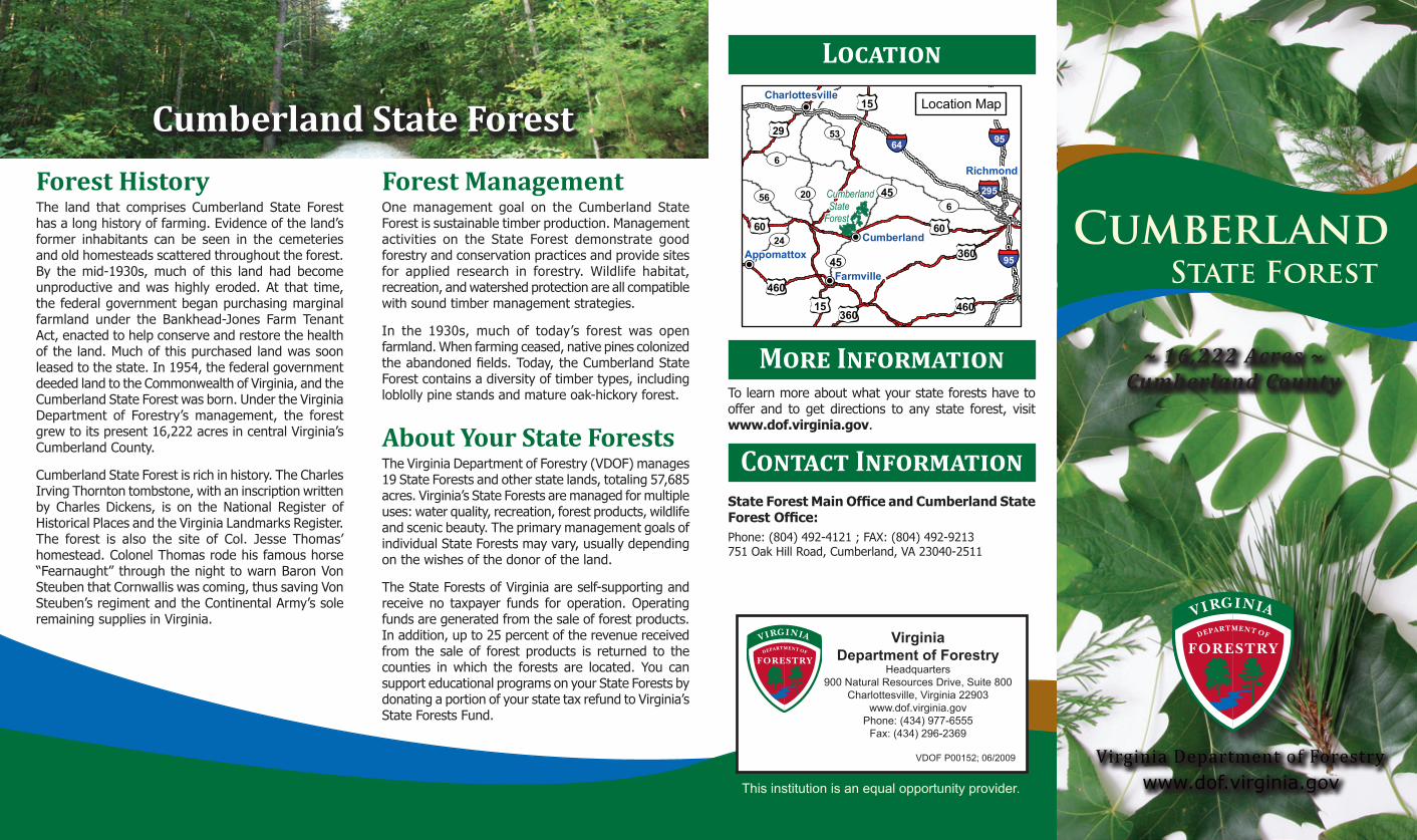
Charlottesville
Richmond
Appomattox
Cumberland StateForest
Location Map
V I R G I N I A VirginiaDepartment of Forestry
Headquarters900 Natural Resources Drive, Suite 800
Charlottesville, Virginia 22903www.dof.virginia.gov
Phone: (434) 977-6555Fax: (434) 296-2369
VDOF P00152; 06/2009
State Forest Main Office and Cumberland State Forest Office:Phone: (804) 492-4121 ; FAX: (804) 492-9213751 Oak Hill Road, Cumberland, VA 23040-2511
Contact Information
This institution is an equal opportunity provider.
Location
More Information
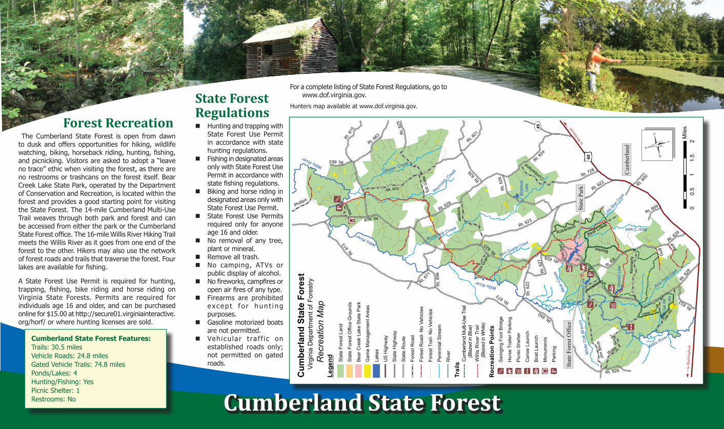
Forest RecreationThe Cumberland State Forest is open from dawn
to dusk and offers opportunities for hiking, wildlife watching, biking, horseback riding, hunting, fishing, and picnicking. Visitors are asked to adopt a “leave no trace” ethic when visiting the forest, as there are no restrooms or trashcans on the forest itself. Bear Creek Lake State Park, operated by the Department of Conservation and Recreation, is located within the forest and provides a good starting point for visiting the State Forest. The 14-mile Cumberland Multi-Use Trail weaves through both park and forest and can be accessed from either the park or the Cumberland State Forest office. The 16-mile Willis River Hiking Trail meets the Willis River as it goes from one end of the forest to the other. Hikers may also use the network of forest roads and trails that traverse the forest. Four lakes are available for fishing.
A State Forest Use Permit is required for hunting, trapping, fishing, bike riding and horse riding on Virginia State Forests. Permits are required for individuals age 16 and older, and can be purchased online for $15.00 at http://secure01.virginiainteractive.org/horf/ or where hunting licenses are sold.
Cumberland State Forest
Cumberland State Forest Features:Trails: 30.5 milesVehicle Roads: 24.8 milesGated Vehicle Trails: 74.8 milesPonds/Lakes: 4Hunting/Fishing: YesPicnic Shelter: 1Restrooms: No
State Forest Regulations Hunting and trapping with
State Forest Use Permit in accordance with state hunting regulations.
Fishing in designated areas only with State Forest Use Permit in accordance with state fishing regulations.
Biking and horse riding in designated areas only with State Forest Use Permit.
State Forest Use Permits required only for anyone age 16 and older.
No removal of any tree, plant or mineral.
Remove all trash.No camping, ATVs or
public display of alcohol.No fireworks, campfires or
open air fires of any type.Firearms are prohibited
e xcep t f o r hun t i ng purposes.
Gasoline motorized boats are not permitted.
Veh icu la r t ra f f i c on established roads only; not permitted on gated roads.
Hunters map available at www.dof.virginia.gov.
For a complete listing of State Forest Regulations, go to www.dof.virginia.gov.
Cum
berla
nd S
tate
For
est
Virg
inia
Dep
artm
ent o
f For
estry
00.
51
1.5
2M
iles
Rec
reat
ion
Map
to Rich
mond
to B
ucki
ngha
m
Rec
reat
ion
Poin
tsS
win
ging
Foo
t Brid
ge
Hor
se T
raile
r Par
king
Pic
nic
She
lter
Can
oe L
aunc
h
Boa
t Lau
nch
Mon
umen
ts
Par
king
Lege
nd Stat
e Fo
rest
Lan
d
Stat
e Fo
rest
Offi
ce G
roun
ds
Bear
Cre
ek L
ake
Sta
te P
ark
Gam
e M
anag
emen
t Are
as
Lake
s
US
Hig
hway
Stat
e H
ighw
ay
Stat
e R
oute
Fore
st R
oad
Fore
st R
oad-
No
Vehi
cles
Fore
st T
rail-
No
Vehi
cles
Pere
nnia
l Stre
am
Riv
er
60
45
Rt. 672
Rt. 629
Rt. 624
Rt. 608
Rt. 650
Rt. 61
5
Mt. Airy Rt. 622
Rt. 628
Rt. 623
Rt. 626
Toll
Gat
e
Rt. 663
Jim
Birc
h
Rt.
696
Phillips
Rt. 613
Rt. 728
Oak Hill
Robertson
Kenn
erly
Rt. 601
Booker
Bear Creek
Asal
Rt.
625
Rt. 633
Rt.
627
Cumberland
Rt. 671
Rt. 669
Rt. 600
Gof
f
Arrowhead
War
ner
Rock
Qua
rry Park
Road
Rt.
622
Rt. 663
Rt.
626
Rt. 623
Rt. 626
Jenk
ins
Lower Oak Hill
Willis
R
iv
er
Rt. 629
Rt. 628
Rt. 624
Willis River
Bigger Creek
Reyno
lds C
reek
Horn Quarter Creek
Bear
Cre
ek
Whi
te O
ak B
ranc
h
Little B
ear Cree
k
Rock Point Creek
Bonbrook Creek Bear Creek
Willis River
Willis River
Willis River
Oak H
ill
Lake
Wins
ton L
ake
Bonb
rook
Lake
Arro
whea
d Lak
eSt
ate
Park
Stat
e Fo
rest
Offi
ce
Cum
berla
nd
Trai
ls
Will
is R
iver
Tra
il
Cum
berla
nd M
ulti-
Use
Tra
il(B
laze
d in
Blu
e)
(Bla
zed
in W
hite
)