cristal mining hatfield gravel pit project - balranald shire · cristal mining hatfield gravel pit...
TRANSCRIPT
Cristal Mining Hatfield
Gravel Pit Project
Environmental Impact Statement
(EIS)
Report Date: Tuesday, 22nd August 2017
Final


Proponent's name:
Cristal Mining Australia Limited (Cristal)
375 Benetook Avenue, Mildura 3500
P.O. Box 4032, Mildura, Vic 3502
ABN: 60 009 247 858
Contact name:
Ray Roberts, Resource Development Manager
Telephone: (03) 5025 4600 Mob: 0429 375 476
Person preparing the EIS
Andrew Minns, Principal, Envirocom
99 Sir Donald Bradman Drive, Hilton SA 5033
Phone: 0417 826 355
Email: [email protected]
ABN: 30 624 983 216

Cristal Mining Gravel Pit Project Environmental Impact Statement
Document Information
Project Cristal Mining Gravel Pit Project
Client Cristal Mining
Report title Program for Environmental Impact Statement
Project Number
Author Richard Mills
Environment & Community, Envirocom
Andrew Minns
Principal, Envirocom
99 Sir Donald Bradman Drive,
Hilton, SA 5033
Mobile 0417 826 355
Email [email protected]
Website www.envirocom.net.au
Reviewed by Andrew Schweitzer
Environment Manager, Cristal Mining Australia
Revision Table
Report revision Date Comments
CRISTAL_GravelPit_EIS_20170421 21-04-2017 First Draft prepared by R Mills
CRISTAL_GravelPit_EIS_20170605 26-06-2017 Document reviewed, updated and further sections prepared by A Minns
CRISTAL_GravelPit_EIS_20170626 29-06-2017 Reviewed by A Schweitzer
CRISTAL_GravelPit_EIS_20170713 12-07-2017 Edits update R Mills
CRISTAL_GravelPit_EIS_20170715 15-07-2017 Final Draft
CRISTAL_GravelPit_EIS_20170822 22-08-2017 R. Mills Final

Cristal Mining Gravel Pit Project Environmental Impact Statement
Abbreviations
ACP Atlas-Campaspe Project
AHD Australian Height Datum
DA Development Application
DoPI Department of Planning and Infrastructure
DP Deposited Plan
EA Environmental Assessment
EAR Environmental Assessment Report
EMP Environmental Management Plan
EMRP Environmental Management & Rehabilitation Plan
EPA Environment Protection Authority
EPA Act Environmental Planning and Assessment Act 1979
EPA Reg Environmental Planning and Assessment Regulation 2000
EPBC Act Environmental Protection and Biodiversity Conservation Act 1999
LEP Local Environmental Plan 1996
LGA Local Government Area
NIA Noise Impact Assessment
OEH Office of Environment and Heritage
PHA Preliminary Hazard Analysis
RAP Registered Aboriginal Parties
REP Regional Environmental Plan
RFS New South Wales Rural Fire Service
RL Relative Level
RMS Roads and Maritime Services
SEPP State Environmental Planning Policy

Cristal Mining Gravel Pit Project Environmental Impact Statement
Page | i
Table of Contents Executive Summary ...................................................................................................................................... 1
Objectives ............................................................................................................................................. 1
Statement of Commitments ................................................................................................................... 2
1 Introduction .......................................................................................................................................... 4
1.1 Project Overview ...................................................................................................................... 5
1.2 About the Proponent ................................................................................................................ 5
1.3 The Atlas Campaspe Mineral Sands Project ............................................................................ 5
1.4 Need for Hatfield Gravel Pit Development................................................................................ 9
1.5 Objectives of the Proposal ....................................................................................................... 9
1.6 Alternatives to Proposed Development .................................................................................... 9
1.7 Tenure .................................................................................................................................... 10
1.8 Land Use ................................................................................................................................ 10
2 Planning context ................................................................................................................................ 11
2.1 Introduction ............................................................................................................................ 11
2.2 Legislation and approvals required ........................................................................................ 11
2.3 Relevant policies .................................................................................................................... 14
2.4 Local environmental plans ...................................................................................................... 14
2.5 Zoning .................................................................................................................................... 15
2.6 Determining authority ............................................................................................................. 15
2.7 Stakeholder consultation ........................................................................................................ 15
3 Project Description ............................................................................................................................. 16
3.1 Gravel Resources .................................................................................................................. 16
3.2 Project General Arrangements ............................................................................................... 20
3.3 Gravel Pit Site Development .................................................................................................. 23
3.4 Gravel Pit Operations ............................................................................................................. 29
4 Consultation & Community................................................................................................................. 31
4.1 Agency Consultation .............................................................................................................. 31
4.2 Leaseholder Consultation....................................................................................................... 32
4.3 Aboriginal Community Consultation ....................................................................................... 32
4.4 Balranald Shire Council .......................................................................................................... 33
5 Environmental Assessment................................................................................................................ 34
5.1 Environmental Assessment .................................................................................................... 34
5.2 Climate ................................................................................................................................... 37
5.3 Land Resources - Soils and Agriculture ................................................................................. 39
5.4 Groundwater .......................................................................................................................... 40
5.5 Surface Water ........................................................................................................................ 41
5.6 Flora ....................................................................................................................................... 42
5.7 Biodiversity Offset Strategy .................................................................................................... 56

Cristal Mining Gravel Pit Project Environmental Impact Statement
Page | ii
5.8 Fauna ..................................................................................................................................... 63
5.9 Aboriginal Heritage ................................................................................................................. 65
5.10 European Heritage ................................................................................................................. 66
5.11 Air Quality ............................................................................................................................... 68
5.12 Noise ...................................................................................................................................... 69
5.13 Visual Amenity ....................................................................................................................... 70
5.14 Public safety ........................................................................................................................... 71
5.15 Socio and Economic .............................................................................................................. 72
6 Rehabilitation Strategy ....................................................................................................................... 73
6.1 Cristal Rehabilitation Experience ........................................................................................... 73
6.2 Rehabilitation Management Plan ........................................................................................... 73
6.3 Rehabilitation Objectives ........................................................................................................ 73
6.4 Management of Rehabilitation Materials ................................................................................ 74
6.5 Rehabilitation Methodology .................................................................................................... 75
7 References......................................................................................................................................... 78
List of Figures Figure 1: Map - Regional overview. ........................................................................................................... 6 Figure 2: Gravel pit locations along mine haulage route. ........................................................................... 7 Figure 3: Gravel pit locations in relation to residences. ............................................................................. 8 Figure 4: Regional stratigraphy. ............................................................................................................... 17 Figure 5: Pit A North and South calcrete thickness based on 2016 auger program (Goldman 2016). ..... 18 Figure 6: Pit C calcrete thickness based on 2016 auger program (Goldman 2016). ............................... 19 Figure 7: Pit A - Indicative site plan. ........................................................................................................ 24 Figure 8: Pit B - Indicative site plan. ........................................................................................................ 25 Figure 9: Pit C - Indicative site plan. ........................................................................................................ 26 Figure 10: Vegetation clearance using a track mounted dozer and chains. ............................................. 28 Figure 11: A 4WD tractor towing a laser scoop bucket with differential GPS mounted on-board
undertaking topsoil stripping and mapping at Cristal’s Ginkgo Mine (Sluiter 2017). ................................ 28 Figure 12: All in one hopper, rock crusher and conveyor. ........................................................................ 30 Figure 13: Hopper and loading conveyor. ................................................................................................ 30 Figure 14: Sensitive receptors in closest proximity to gravel pit operations. ............................................ 36 Figure 15: Wind data from Balranald and Ivanhoe (Resource Strategies 2012). ..................................... 38 Figure 16: Pit A north & south satellite image native vegetation. ............................................................. 45 Figure 17: Map Pit A north & south – Sluiter & Allen (2017) native vegetation mapping. ........................ 46 Figure 18: Image Gravel Pit A - representative soil and vegetation types. .............................................. 47 Figure 19: Image Pit A –Chenopod Sandplain Mallee community. .......................................................... 48 Figure 20: Image Pit A - Mossgiel daisy outliers. ..................................................................................... 49 Figure 21:Pit B satellite image native vegetation. .................................................................................... 50 Figure 22: Map Pit B – Sluiter & Allen(2017) native vegetation mapping................................................. 51 Figure 23: Image Gravel Pit B - representative soil and vegetation types. .............................................. 52 Figure 24: Pit C satellite image native vegetation. ................................................................................... 53 Figure 25: Map Pit C – Sluiter & Allen (2017) native vegetation mapping. .............................................. 54 Figure 26: Image Gravel Pit C - representative soil and vegetation types (Pearl bluebush). ................... 55 Figure 27: Gravel pit development Vegetation Offset options 250K map. ............................................... 60 Figure 28: Gravel pit development Vegetation Offset options showing hectares 100K map. ................... 61 Figure 29: Gravel pit development Vegetation Offset options showing species 100K map. .................... 62 Figure 30: Aboriginal object 40-5-0180 at Pit C. ...................................................................................... 67
Cristal Mining Gravel Pit Project Environmental Impact Statement
Page | iii
List of Tables Table 0-1: Statement of commitments. ...................................................................................................... 2 Table 1-1: Gravel pit location details and native vegetation summary. ...................................................... 4 Table 1-2: Proposed gravel land tenure details. ...................................................................................... 10 Table 2-1: EO Act clauses & criteria. ....................................................................................................... 12 Table 3-1: In situ gravel resource estimation. .......................................................................................... 16 Table 3-2: Estimated gravel requirements over Atlas Campaspe mine life. ............................................. 16 Table 3-3: Gravel pit plant and equipment. .............................................................................................. 21 Table 3-4: Waste product streams and management controls. ............................................................... 22 Table 5-1: Impact probability matrix. ........................................................................................................ 34 Table 5-2: Impact consequence matrix. ................................................................................................... 34 Table 5-3: Risk ranking matrix. ................................................................................................................ 35 Table 5-4: Environmental Risk Assessment Summary. ........................................................................... 35 Table 5-5: Temperature and Rainfall data from regional met stations. .................................................... 37 Table 5-6: Summary of Native Vegetation and Cleared Areas. ............................................................... 39 Table 5-7: Agriculture risk assessment. ................................................................................................... 40 Table 5-8: Groundwater risk assessment summary................................................................................. 41 Table 5-9: Surface water risk assessment summary. .............................................................................. 42 Table 5-10: Assessment of threatened flora at risk of impact (Adapted from Sluiter & Allen 2017). ........ 44 Table 5-11: Flora risk assessment summary. .......................................................................................... 44 Table 5-12: OEH Biodiversity Offset Principles and Cristal offset strategies (Sluiter, Allen & Holmes
2017). ...................................................................................................................................................... 57 Table 5-13: Biodiversity Offset Calculations (Sluiter, Allen and Holmes 2017). ....................................... 59 Table 5-14: Fauna risk assessment summary. ........................................................................................ 65 Table 5-15: Aboriginal cultural heritage risk assessment summary. ........................................................ 66 Table 5-16: Air quality risk assessment summary. .................................................................................. 69 Table 5-17: Noise risk assessment summary. ......................................................................................... 70 Table 5-18: Visual amenity risk assessment. ........................................................................................... 71 Table 5-19: Public safety risk assessment. .............................................................................................. 72 Table 6-1: Proposed vegetation clearance at each gravel pit site. .......................................................... 76 Table 6-2: Revegetation species and target areas (After Sluiter 2017). .................................................. 76
List of Appendices Appendix A. Agency Correspondence & Regulatory Documents. ........................................................ 79
Appendix B. Extractives Licence Application – maps and coordinates (Latitude & Longitude decimal
degrees) 80
Appendix C. Landholder Letter of Consent ........................................................................................... 81
Appendix D. Hatfield Flora Report ........................................................................................................ 82
Appendix E. Hatfield Fauna Report ...................................................................................................... 83
Appendix F. Hatfield Aboriginal Heritage Report .................................................................................. 84
Appendix G. Gravel Pit Offset Report ................................................................................................... 85

Cristal Mining Gravel Pit Project Environmental Impact Statement
Page | 1
Executive Summary
This Environmental Impact Statement (EIS) has been prepared for the development, operation and
rehabilitation of three gravel pits at Hatfield, 70 kilometres north of Balranald. The proposed gravel pits are
located along the mineral haulage route between the Atlas-Campaspe mine site and the Ivanhoe Balranald
Road and cover an area of ~113 hectares. The gravel pits are located on Western Lands lease held by
Minto Glen Pastoral Company Pty Ltd.
The proponent is Cristal Mining Australia (Cristal), a significant global mineral sands and titanium dioxide
producer. Cristal has existing mining and mineral separation operations in the Murray Basin region in New
South Wales.
Cristal engaged consultants to undertake a series of environmental and heritage assessments at each of
the proposed gravel pit sites. These assessment reports are attached as Appendices.
This EIS has been prepared as a designated local development under Part 4 of the Environmental
Planning and Assessment Act 1979 (EP&A Act).
The project integrates with the approved Cristal Atlas Campaspe Minerals Sands development. Gravel
extracted from the pits is required for the haulage road upgrade, internal mine site roads and ongoing road
maintenance associated with the Atlas Campaspe Mineral Sands development. The gravel pit
development was not included within the scope of the Resource Strategies (2012) Atlas Campaspe
Mineral Sands Environmental Impact Statement (Development Application SSD- 5012, determination date
6th June 2014).
This EIS and related Development Application is also related to a further Development Application to
Balranald Shire Council to enable road subdivision along the mineral concentrate transport route. The
road subdivision is required for road realignment works to enable safe and efficient mineral concentrate
haulage along the route.
This EIS describes existing environmental conditions, examines potential impacts and proposes strategies
for avoiding and mitigating impacts to the environment.
Objectives
Cristal requested the issuing of Secretary’s Environmental Assessment Requirements for the purpose of
preparing an EIS for the development of three gravel pits adjacent to the Atlas Campaspe mine access
road to enable road upgrade and maintenance works (see Appendix A Environmental Assessment
Requirements). This EIS will attach to a Development Application to Balranald Shire Council for approval.
The Development Application will enable Cristal to:
acquire a license for gravel pits in the vicinity of its mineral concentrate haulage route to enable the upgrade of Council roads from the mine site to the Balranald - Ivanhoe Road intersection;
maintain the mineral concentrate haulage route for the life of mine;
apply for a Crown Land Extractive Industry License and ensure all license conditions are met,
including sound land and natural resource management practices and rehabilitation works;
select a suitable gravel pit operator for the initial road upgrade phase and then to enable the
selection of the most suitable operator for the road maintenance phase during mine operations;
Cristal Mining Gravel Pit Project Environmental Impact Statement
Page | 2
ensure the mineral concentrate haulage route is constructed and maintained to ensure public
safety and security for haulage of mineral concentrate product from the mine site to the mineral
separation plant at Broken Hill.
This EIS assesses the impact of the development, operation and rehabilitation of the three proposed
gravel pits on the environment and specifies mitigation and management measures that will be
implemented to minimise impact and manage risk. Refer to Table 0-1: Statement of commitments., for a
summary of all measures identified in the environmental assessment (Section 5) of this report.
Statement of Commitments
Table 0-1: Statement of commitments.
Aspect Commitments
Agricultural Production Progressively rehabilitate landscape following gravel extraction.
Agreement reached with lessee for gravel pit development.
Groundwater
Manage hydrocarbons in accordance with AS 1940.
Transport waste oil off site and dispose in an appropriately registered facility.
Store all fuels and chemicals in bunded areas.
Containment systems are to comply with AS 1940-2004 The storage and handling of flammable and combustible liquids.
Establish spill kit stations at operational sites.
Include procedures for hydrocarbon spillage and reporting in the operator induction.
Establish a procedure for operators to transfer fuel from trailer tanks or drums to vehicles and machinery.
Flora Minimise ground disturbance by accurate pit boundary surveys.
Implement a Vegetation Clearance Permit process.
Establish a biodiversity offset area.
Stockpiles soil to preserve seed bank.
Stockpile vegetation for rehabilitation, seed collection and banking of targeted species.
Establish complementary colonizing species where appropriate.
Nine Mossgiel daisy plants will be transplanted to suitable locations: i.e. offset area or rehabilitation area.
Management of flora for gravel pit operations incorporated into the AC Biodiversity Management Plan.
Induct and train gravel pit operators in flora & fauna protection.
Fauna Minimise ground disturbance by accurate pit boundary surveys.
Establish a biodiversity offset area.
Stockpile vegetation and logs for rehabilitation.
Management of fauna for gravel pit operations incorporated into the AC
Biodiversity Management Plan.
Induct and train gravel pit operators in flora & fauna protection.
Cristal Mining Gravel Pit Project Environmental Impact Statement
Page | 3
Aspect Commitments
Aboriginal Heritage
Establish a 20 metre radius buffer zone around the Aboriginal object.
Fence the exclusion zone during the active operational phase.
Instruct employees, contractors and visitors not to enter the area except for approved land management activities such as weed spraying, fence maintenance, etc.
If further artefacts are discovered during gravel pit operations, activities that could affect cultural objects shall cease immediately and the Office of Environment and Heritage is to be consulted (tel: 131 555) about an appropriate course of action prior to recommencing of work.
Air Quality
Implement controls to suppress dust as required.
Monitor dust emissions at the nearest residence as per the AC Mine Development Consent conditions.
Manage dust for gravel pit operations as per the AC Air Quality Management Plan.
Noise
Implement controls to suppress noise as required.
Monitor noise at the nearest residence as per AC Mine Development Consent conditions.
Visual Amenity
Transport waste off site and dispose in appropriately registered facilities.
Monitor and record waste types and quantities and report via the Atlas-Campaspe Mine environmental and rehabilitation compliance report.
Store dangerous goods in accordance with Australian Standard AS1940
Manage waste in accordance with the Atlas Campaspe mine waste management procedures.
Public safety
Prepare and implement the Traffic Management Plan
Prepare and implement the Emergency Response Plan
Prepare and implement the Safety Management Plan
Store dangerous goods in accordance with Australian Standard AS1940
Local employment & business development
Give preference to local contractors where commercially competitive and capable.
Rehabilitation
Pre-clearance survey to describe flora, fauna and soil profiles.
Soils to be placed in low profile stockpiles. Topsoils and subsoils will be stockpiled separately.
Progressively rehabilitate and minimise cleared areas to mitigate wind or water erosion.
Rehabilitation materials will be managed by: avoid soil stripping on windy days; use mulch on stockpiles; suppress dust using water trucks; use trees removed during clearing as wind breaks/barriers.
Fence gravel pit license boundary to keep livestock and pest animals out of gravel pit areas during operations and rehabilitation periods.
Provide refuge for fauna in the early stages of rehabilitation by replacing logs and branches.
Revegetate using targeted species.
A feral animal control plan will be produced to ensure that rehabilitated areas are not subject to grazing by rabbits and kangaroos.
Cristal Mining Gravel Pit Project Environmental Impact Statement
Page | 4
1 Introduction
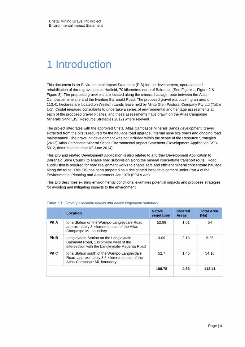
This document is an Environmental Impact Statement (EIS) for the development, operation and
rehabilitation of three gravel pits at Hatfield, 70 kilometres north of Balranald (See Figure 1, Figure 2 &
Figure 3). The proposed gravel pits are located along the mineral haulage route between the Atlas-
Campaspe mine site and the Ivanhoe Balranald Road. The proposed gravel pits covering an area of
113.41 hectares are located on Western Lands lease held by Minto Glen Pastoral Company Pty Ltd (Table
1-1). Cristal engaged consultants to undertake a series of environmental and heritage assessments at
each of the proposed gravel pit sites, and these assessments have drawn on the Atlas Campaspe
Minerals Sand EIS (Resource Strategies 2012) where relevant.
The project integrates with the approved Cristal Atlas Campaspe Minerals Sands development; gravel
extracted from the pits is required for the haulage road upgrade, internal mine site roads and ongoing road
maintenance. The gravel pit development was not included within the scope of the Resource Strategies
(2012) Atlas Campaspe Mineral Sands Environmental Impact Statement (Development Application SSD-
5012, determination date 6th June 2014).
This EIS and related Development Application is also related to a further Development Application to
Balranald Shire Council to enable road subdivision along the mineral concentrate transport route. Road
subdivision is required for road realignment works to enable safe and efficient mineral concentrate haulage
along the route. This EIS has been prepared as a designated local development under Part 4 of the
Environmental Planning and Assessment Act 1979 (EP&A Act).
This EIS describes existing environmental conditions, examines potential impacts and proposes strategies
for avoiding and mitigating impacts to the environment.
Table 1-1: Gravel pit location details and native vegetation summary.
Location Native vegetation
Cleared Areas
Total Area (Ha)
Pit A Iona Station on the Wampo-Langleydale Road, approximately 3 kilometres east of the Atlas-Campaspe ML boundary
52.99 1.01 54
Pit B Langleydale Station on the Langleydale-Balranald Road, 1 kilometre west of the intersection with the Langleydale-Magenta Road
3.09 2.16 5.25
Pit C Iona Station south of the Wampo-Langleydale Road, approximately 3.5 kilometres east of the Atlas-Campaspe ML boundary
52.7 1.46 54.16
108.78 4.63 113.41

Cristal Mining Gravel Pit Project Environmental Impact Statement
Page | 5
1.1 Project Overview
Purpose
The approval of the Development Application to the Balranald Shire Council, for which this EIS has been
prepared, will enable the development of gravel pits along the mineral concentrate haulage route for the
Atlas Campaspe Mineral Sands Mine. The gravel from these pits will be used to upgrade the haulage
route from the mine site to the intersection with the Balranald – Ivanhoe road. Gravel will also be used for
road maintenance purposes during mine operations.
Project Summary
The Project involves the development, operation and rehabilitation of three gravel pits. Mobile equipment
and crushing and screening plant will remove vegetation, strip topsoils, extract and transport gravel.
Cleared vegetation and stripped soil will be progressively replaced over mined areas to rehabilitate the
disturbed areas to native vegetation utilising local species and selected threatened species where
practical.
This proposed gravel pit development related to the road upgrades proposed in Section 2.4 Project
Construction and Other Development Activities 2012 Atlas Campaspe Mineral Sands EIS. A higher gravel
extraction rate will be required in the first year of operation to enable the upgrade of the mineral
concentrate haulage route upgrade. Thereafter, gravel will be extracted on an as needs basis for road
maintenance purposes during the life of the Atlas Campaspe mine operations.
The proposed life of the Project is approximately 20 years from commencement of the Atlas Campaspe
mine development.
1.2 About the Proponent
Cristal is the world’s second largest producer of titanium dioxide and is ranked in the top 10 of global
mineral sands-producing companies. Cristal has existing mining and mineral separation operations in the
Murray Basin region in New South Wales.
Cristal operates the Ginkgo and Snapper mineral sand mines, located approximately 85 kilometres north of
Mildura and 40 kilometres west of the township of Pooncarie in western New South Wales. Both mines
utilise conventional tractor scoops for topsoil handling, truck and shovel operation for overburden and wet
dredge mining and floating concentrator plants to recover and separate the heavy minerals in the ore
deposit.
The Heavy Mineral Concentrate (HMC) obtained by the wet-dredging process is pumped to mineral
concentrate stockpiles and transported by road to Broken Hill for further refinement to produce ilmenite,
leucoxene, zircon and rutile end products.
1.3 The Atlas Campaspe Mineral Sands Project
Cristal plan to establish the Atlas-Campaspe (AC) mineral sand mine site, 80 kilometres north of Balranald
and 270 kilometres south-east from Broken Hill. The Atlas-Campaspe deposit contains approximately 6
million tonnes of heavy mineral. The systems, processes and methods proposed for extracting and
transporting HMC at Snapper and Gingko will be transferred and applied to the Atlas-Campaspe operation.
The Atlas Campaspe Mineral Sands Project Development Consent 6th June 2014 is referred to throughout
this document and presented in Appendix A.

Cristal Mining Gravel Pit Project Environmental Impact Statement
Page | 6
Figure 1: Map - Regional overview.

Cristal Mining Gravel Pit Project Environmental Impact Statement
Page | 7
Figure 2: Gravel pit locations along mine haulage route.

Cristal Mining Gravel Pit Project Environmental Impact Statement
Page | 8
Figure 3: Gravel pit locations in relation to residences.
Cristal Mining Gravel Pit Project Environmental Impact Statement
Page | 9
1.4 Need for Hatfield Gravel Pit Development
The series of unsealed roads linking the Atlas-Campaspe Mine site to the Balranald-Ivanhoe (Link Road,
Boree Plains-Gol Gol Road, Magenta Road and Hatfield-The Vale Road) require upgrading to
accommodate up to 48 heavy mineral road train movements per day during peak times and an average of
38 road train movement per day over the life of the project. The Atlas Campaspe Mineral Sands Project
Development Consent (6th June 2014) included:
the upgrade of unsealed roads from the AC mine site to the Balranald Ivanhoe Road intersection;
the maintenance of roads during the operating life of the mine.
Access to suitable local gravel for road works and maintenance is fundamental to haul road safety,
efficiency and longevity.
1.5 Objectives of the Proposal
Cristal requested the issuing of Secretary’s Environmental Assessment Requirements for the purpose of
preparing an EIS for the development of three gravel pits adjacent to the Atlas Campaspe mine access
road to enable road upgrade and maintenance works. This EIS will attach to a Development Application to
Balranald Shire Council for approval.
The Development Application will enable Cristal to:
acquire a license for gravel pits in the vicinity of its mineral concentrate haulage route to enable the upgrade of Council roads from the mine site to the Balranald - Ivanhoe Road intersection;
maintain the mineral concentrate haulage route for the life of mine;
apply for a Crown Land Extractive Industry License and ensure all license conditions are met,
including sound land and natural resource management practices and rehabilitation works;
select a suitable gravel pit operator for the initial road upgrade phase and then to enable the
selection of the most suitable operator for the road maintenance phase during mine operations;
ensure the mineral concentrate haulage route is constructed and maintained to ensure public
safety and security for haulage of mineral concentrate product from the mine site to the mineral
separation plant at Broken Hill.
1.6 Alternatives to Proposed Development
The alternative to seeking an extractive industries license is to source gravel from more distant locations
within Balranald Shire Council or Central Darling Shire Council. However good quality gravel sources are
scarce within these Council districts and long haulage distances greatly increase costs, create wear on
existing roads and increase the risk to public safety associated with driving.
Upgrading roads using gravel is preferred to constructing roads without gravel. A road constructed with
unsuitable materials will deteriorate quickly with sustained heavy vehicle usage and during wet weather.
Highly degraded roads may lead to road closures which would be unacceptable to the Atlas Campaspe
mine operations and the general public (local landholders).
Note that use of other local roads in the region is not permitted as per Atlas-Campaspe Development
Consent Condition 6.

Cristal Mining Gravel Pit Project Environmental Impact Statement
Page | 10
1.7 Tenure
The proposed gravel pits are situated on Crown Land in the Balranald Shire Western Lands region, south-
central New South Wales 1: 250,000 Pooncarie Map Sheet. The land is leased to Minto Glen Pastoral
Company Pty Ltd. Cristal identified two gravel pits in 2015 and a third gravel source in 2016 (Table 1-2).
The three proposed gravel pits (Pit A north and south, B & C) are located along the Atlas Campaspe mine
site mineral concentrate haulage route (Figure 1, Figure 2 & Figure 3).
Table 1-2: Proposed gravel land tenure details.
Pit
Lot Number Type Lessee Area (Ha)
Pit A Local Government Area (LGA) of Balranald, Parish of Willilbah, County of Kilfera
Lot No. 1, DP 1198331
Western Lands Lease (WLL) 2611 issued under Western Lands Act 1901 for “Pastoral Purposes” for a term in perpetuity.
Minto Glen Pastoral Company Pty Ltd.
53.24
Pit B Local Government Area (LGA) of Balranald, Parish of Willilbah East, County of Kilfera
Lot No. 1944, DP 763848
Western Lands Lease (WLL) 4103 issued under Western Lands Act 1901 for the purpose of “Grazing” in perpetuity.
Minto Glen Pastoral Company Pty Ltd.
5.25
Pit C Local Government Area (LGA) of Balranald, Parish of Willilbah, County of Kilfera
Lot No. 2, DP 1198331
Western Lands Lease (WLL) 2611 issued under Western Lands Act 1901 for “Pastoral Purposes” for a term in perpetuity.
Minto Glen Pastoral Company Pty Ltd.
54.16
1.8 Land Use
The gravel pit sites are Western Lands leases, leased to Minto Glen Pastoral Company, for saltbush /
bluebush grazing. Pit A and Pit C consist mostly of native vegetation. The Pit B site is highly modified and
was formerly a gravel extraction area for historical road construction in the area.

Cristal Mining Gravel Pit Project Environmental Impact Statement
Page | 11
2 Planning context
2.1 Introduction
This proposal is deemed designated development, requiring the preparation of an Environmental Impact
Statement (EIS), due to the following triggers:
Section 77A EP&A Act 1979 (disturbance of > 2 ha land) &
Clause 18A SEPP for Mining, Petroleum, Production and Extractive Industries, 2007 (Extractive
Industry located in Western Division)
Cristal Mining requested Environmental Assessment Requirements (EAR’s) for the purpose of preparing
this EIS for the development of gravel pits adjacent to the Atlas Campaspe mine access road to enable
road upgrade and maintenance works. This EIS will attach to a Development Application to Balranald
Shire Council, the consent authority, for approval.
The Development Application will enable Cristal Mining to acquire a license for gravel pits in the vicinity of
its mineral concentrate haulage route to enable the upgrade of Council roads from the mine site to the
Balranald - Ivanhoe Road intersection.
EAR’s were issued to Cristal Mining on 23 November 2015.
The Environmental Impact Statement (EIS) for the development must comply with the requirements in
Clauses 6 and 7 of Schedule 2 of the Environmental Planning and Assessment Regulation 2000.
The purpose of this EIS is to describe the proposal, to document the likely impacts of the proposal on the
environment, and to detail protective measures to be implemented.
2.2 Legislation and approvals required
Environmental Planning and Assessment Act 1979
The overarching state legislation in relation to this activity is the Environmental Planning and Assessment
Act 1979 (EP&A Act) and Environmental Planning and Assessment Regulation 2000.
Crown Land Act 1989
Prior to the extraction of any gravel, Cristal is required to apply for and have granted a Crown Lands
License for “Gravel Extraction” under the provisions of Section 34 of the Crown Lands Act 1989.
A licence application is to be submitted to Department of Industry - Lands & Forestry concurrently with the
development application for the gravel pits. An application for landowner consent will also submitted to
Department of Industry - Lands & Forestry.
Cristal prepared a direct negotiation proposal to the Department of Industry - Lands & Forestry using the
Schedule of Information Requirements submitted dated 14th October 2015. DPI approved the Cristal
request to directly negotiate the extraction of material for road upgrades and maintenance on the 15 th
Cristal Mining Gravel Pit Project Environmental Impact Statement
Page | 12
December 2015. Thus, Cristal plan to proceed with the application for an Extractive Industries License
without the need for Crown Lands to seek competitive tenders for the License.
Environment Operations Act 1997
An EPA licence is required as the quarrying activity is a scheduled activity, as per causes 16 and 19 of the
Protection of the Environment Operations Act 1997 – Schedule 1. The relevant clauses are provided in
italics:
Clause 16 Crushing, grinding or separating
(1) This clause applies to "crushing, grinding or separating", meaning the processing of materials
(including sand, gravel, rock or minerals, but not including waste of any description) by crushing, grinding
or separating them into different sizes.
(2) The activity to which this clause applies is declared to be a scheduled activity if it has a capacity to
process more than 150 tonnes of materials per day or 30,000 tonnes of materials per year.
Clause 19 Extractive activities
(1) This clause applies to the following activities: "land-based extractive activity", meaning the
extraction, processing or storage of extractive materials, either for sale or re-use, by means of excavation,
blasting, tunnelling, quarrying or other such land-based methods.
(2) In this clause "extractive materials" means clay, sand, soil, stone, gravel, rock, sandstone or similar
substances that are not minerals within the meaning of the Mining Act 1992.
(3) Each activity referred to in Column 1 of the Table to this clause is declared to be a scheduled activity if
it meets the criteria set out in Column 2 of that Table (Table 2-1).
Table 2-1: EO Act clauses & criteria.
Column 1 Column 2
Activity Criteria
land-based extractive activity involves the extraction, processing or storage of more than 30,000 tonnes per year of extractive materials
Threatened Species Conservation Act 1995
The Threatened Species Conservation Act 1995 (TSC Act) lists a number of factors to consider when
deciding whether there will be a significant impact on threatened species, populations or ecological
communities and their habitats.
A Species Impact Statement (SIS) is required when the level of determined significance is ‘likely’. As
stated in Section 4, the proposal is not likely to significantly impact on a threatened species, population or
ecological community. Therefore, the proposal does not require approval under the TSC Act, or the
completion of a SIS.

Cristal Mining Gravel Pit Project Environmental Impact Statement
Page | 13
National Parks and Wildlife Act 1974
The National Parks and Wildlife Act 1974 (NPW Act), administered by the Office of Environment and
Heritage (OEH), is the primary legislation for the protection of some aspects of Aboriginal cultural heritage
in New South Wales.
Part 6 of the NPW Act provides specific protection for Aboriginal objects and declared Aboriginal places by
establishing offences of harm. There are a number of defences and exemptions to the offence of harming
an Aboriginal object or Aboriginal place. One of the defences is that the harm was carried out under an
Aboriginal Heritage Impact Permit (AHIP).
This project has assessed that an AHIP is not required (see section 5.9).
NSW Native Vegetation Act 2003 (NV Act)
The Native Vegetation Act 2003 (NV Act) regulates the clearing of native vegetation in NSW.
The Native Vegetation Act 2003 (the Act) does not override any requirement to obtain consent from a local
council where an approval for the clearing of native vegetation is required under an environmental
planning instrument under the Environmental Planning & Assessment Act 1979 (EP&A Act).
Section 25 of the Act lists a number of clearing activities that are excluded from the operation of the Act
because they are authorised by other legislation.
Section 25 exclusions include any clearing that is, or that is part of, designated development within the
meaning of the EP&A Act and for which development consent has been granted under that Act (now taken
to include development approved under the major project provisions of the EP&A Act).
Therefore, approval is not required from Local Land Services for vegetation clearing because the project is
designated development.
Environmental Protection and Biodiversity Conservation Act 1999 (EPBC Act)
Under the Federally administered Environmental Protection and Biodiversity Conservation Act 1999,
actions which are likely to have a significant impact on matters of National Environmental Significance
(NES) require approval from the Commonwealth Minister for Environment and Heritage. Matters of NES
include:
world heritage properties
national heritage places
wetlands of international importance (listed under the Ramsar Convention)
listed threatened species and ecological communities
migratory species protected under international agreements
Commonwealth marine areas
the Great Barrier Reef Marine Park
nuclear actions (including uranium mines)
a water resource, in relation to coal seam gas development and large coal mining development.
This report assesses Matters of National Environmental Significance listed under EPBC Act Protected
Matters. Listed threatened species will be impacted, however the impact is not deemed significant. A
referral has been prepared and has been submitted to the Department of Environment for assessment.

Cristal Mining Gravel Pit Project Environmental Impact Statement
Page | 14
Water Management Act (2000)
The objectives of the Water Management Act (2000) are to provide for the sustainable and integrated
management of the water sources of the state for the benefit of both present and future generations. One
key aim is to integrate the management of water sources with the management of other aspects of the
environment, including the land, its soil, its native vegetation and its native fauna.
Water will be required for road works and dust suppression during the mineral concentrate transport route
road upgrade and future maintenance. This water will be sourced from the Atlas Campaspe mine site, or if
new bores are developed along the transport route, these bores will be developed in consultation with local
landholders and licensed in accordance with the requirements of the Water Management Act (2000).
2.3 Relevant policies
State Environmental Planning Policy (Infrastructure) 2007 (Infrastructure SEPP) aims to assist in the
effective delivery of public infrastructure across the State by improving certainty and regulatory efficiency
through consistent planning assessment and approvals regime for public infrastructure and services and
through the clear definition of environmental assessment and approval process for public infrastructure
and services facilities.
The Infrastructure SEPP 2007 is applicable as the quarry is for public road infrastructure.
2.4 Local environmental plans
Balranald Local Environmental Plan (LEP) 2010
The site is located within the Balranald local government area and as such the Balranald LEP 2010
applies. Under the LEP, BSC is the determining authority for extractive industries. Applicable sections of
the LEP include:
Cultural Heritage Conservation
Clause 5.10 of the LEP specifies the requirements of the consent authority in relation to impacts on areas
of cultural and heritage significance. The proposed works will not impact upon any known cultural heritage
sites (refer to section 5.9).
Biodiversity Conservation
Clause 6.1 of the LEP specifies the consent authority must consider any adverse impacts from the
proposal on the following:
a) native flora and fauna, their habitat, and their interrelationship with the environment, and
b) the movement and dispersal of native flora and fauna, and
c) the physical and biological functions of the ecosystem.
An assessment of the likely impacts of the proposal is located in Section 5.
Cristal Mining Gravel Pit Project Environmental Impact Statement
Page | 15
2.5 Zoning
Under the Balranald LEP, the proposed quarrying site is zoned ‘primary production zone (RU1).’ Under this
zone, extractive industries are permitted with consent.
The proposed quarrying area is leased under the Western Lands Act 1901 for the purpose of grazing. This
Act provides for the administration and management of Crown Lands in the state of New South Wales. The
land is held under Western Lands Lease by Minto Glen Pastoral Co. Pty Ltd. The land is predominately
used for grazing by domestic livestock.
2.6 Determining authority
The determining authority is the Balranald Shire Council.
This proposal will be subject to a Western Joint Regional Planning Panel referral.
2.7 Stakeholder consultation
The following relevant stakeholders have been consulted on the proposal and their recommendations and
requirements have contributed to the development of the EIS:
NSW Department of Planning and Environment
NSW Department of Industry, Lands and Forestry
NSW Transport - Roads and Maritime Services
NSW Office of Environment and Heritage
Department of Environment and Energy (Australian Government)
Balranald Shire Council
Lessee
Property Managers
Consultation with these stakeholders is detailed in section 4.

Cristal Mining Gravel Pit Project Environmental Impact Statement
Page | 16
3 Project Description
Cristal proposes to develop three gravel pits located along the mineral concentrate transport route that
connects the Atlas-Campaspe mine site to the Ivanhoe to Balranald road. The gravel resource extends
over three sites (114 hectares) and provides the base materials for the mineral concentrate transport
route upgrade and road construction at the mine site.
3.1 Gravel Resources
Resource Assessment
Gravel used for road construction in the Murray-Mallee Region of south-eastern Australia is typically
the B-horizon carbonate layer existing below the reddish-brown surface topsoil known as the Woorinen
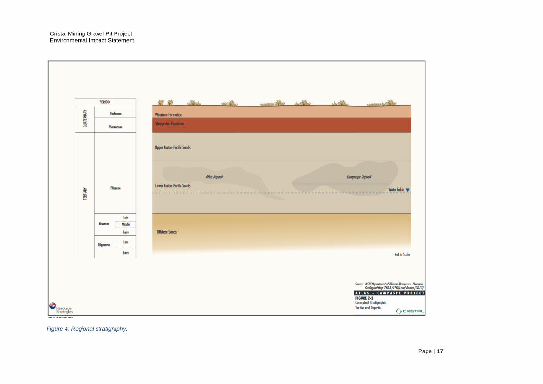
Formation (Sluiter 2017) (Figure 4). Cristal conducted test work to identify 780,000 tonnes of gravel
resource (Goldman 2016) at Pit A, Pit B and Pit C that will support the mineral concentrate transport
route upgrade, mine road construction and road maintenance. Table 3-1, Figure 5 and Figure 6 detail
the extent and depth of the gravel resources.
Table 3-1: In situ gravel resource estimation.
Pit Area (Ha)
Average Depth (m)
Average thickness
Volume (m3)
* Tonne (Kt)
Pit A 37 0.410 0.488 187,500 309
Pit B 5 9,000 15
Pit C 67.5 0.320 0.395 266,625 457
463,125 781
* Estimates for Pit A and Pit C are derived from an auger program conducted in 2016. Pit B volume and tonnage is
based on a visual estimate (Goldman 2016).
Resource Requirements
Tonkin Consulting estimate that 150,000m3 (260Kt) of gravel (calcrete) is needed for the haul road
construction (Table 3-2). This does not include gravel requirements for ongoing maintenance or gravel
for internal roads within the Atlas-Campaspe ML. Tonkin estimate that up to 300 Kt of gravel is
required for road upgrades and maintenance over twenty years (Goldman 2016). The bulk of gravel
materials is required for the haulage road upgrade and internal roads in the first year of mine site
development.
Table 3-2: Estimated gravel requirements over Atlas Campaspe mine life.
Pit Haul Road Construction (Kt)
Internal Mine Road Construction (Kt)
Road Maintenance During Mine Life (Kt)
Total
Pit A 100 20 20 140
Pit B 20 10 0 30
Pit C 140 20 20 180
Total 260 50 40 350
Cristal Mining Gravel Pit Project Environmental Impact Statement
Page | 17
Figure 4: Regional stratigraphy.

Cristal Mining Gravel Pit Project Environmental Impact Statement
Page | 18
Figure 5: Pit A North and South calcrete thickness based on 2016 auger program (Goldman 2016).

Cristal Mining Gravel Pit Project Environmental Impact Statement
Page | 19
Figure 6: Pit C calcrete thickness based on 2016 auger program (Goldman 2016).

Cristal Mining Gravel Pit Project Environmental Impact Statement
Page | 20
3.2 Project General Arrangements
The general project arrangements and logistics are discussed in this section.
Key Activities
The key activities planned at the gravel pit sites are:
site planning, pre-clearance surveys and installation of surveyed markers;
vegetation and topsoil stripping and stockpiling;
extraction, crushing and screening, stockpiling, loading and transporting of gravel using earth
moving equipment;
progressive rehabilitation;
decommissioning and rehabilitation.
Pit Operator & Local Employment
Gravel pit will be operated by a local contractor. During the operational phase of the mine, the gravel pits
will be operated on an intermittent basis.
Hours of Operation
Gravel pit operations will be restricted to daylight hours.
Power Supply
If power supply is required at the gravel pit operations, Cristal (or the contracted gravel pit operator) will
provide a portable diesel electricity generator on a bunded platform or bunded trailer conforming with
Australian Standards (AS) 1940:2004 The Storage and Handling of Flammable and Combustible Liquids
and the Operational Health and Safety Act, 2000.
Accommodation
Personnel will be accommodated at the Atlas-Campaspe mine site accommodation facility if required. The
mine site facility will accommodate up to 300 personnel during construction and approximately 200 people
during operations (See Section 2.4.2. Atlas Campaspe Mineral Sands Project EIS (Resource Strategies
2012).
If gravel pit operations commence prior to the construction of the Atlas Campaspe accommodation facility,
operators will commute from Balranald or Ivanhoe, or utilise accommodation on local properties with the
permission of the landholder.
Amenities
Mobile portable chemical toilet units will be made available at the work sites. The commercial units are
sealed and vermin proof. The units are transported and emptied at a registered facility.
Plant and Equipment
Plant and equipment required for the operation of the gravel pits is listed in Table 3-3.

Cristal Mining Gravel Pit Project Environmental Impact Statement
Page | 21
Table 3-3: Gravel pit plant and equipment.
Infrastructure
& Machinery
Purpose Specifications*
Shipping container Storage 4 units up to 30 m2
First aid / lunch room Personnel room 1 unit up to 40 m2
Bunded platform Hazardous materials
Diesel generator Conveyor or other equipment as required
300 to 550 kVA
Front end loader / ripper Road building, gravel excavation
D9 Diesel
Grader Road building, top soil removal 140 HP Diesel
Trucks with trailers Transport gravel 15-20t B Double tandem + trailer
Crusher Screener Rock crushing 1Kt, 120 H.P. Diesel 200 t/h throughput depending on material
Hopper / feeder Rock loading
Conveyor Gravel loading
* Specifications may vary.
Water requirements
Ground water
A non-potable source of water is required for supressing dust in the gravel pit area. Water for gravel pit
operations will be supplied from local groundwater resources under the appropriate licences.
Potable water
Potable water will be provided from either the Ivanhoe town water supply or the Atlas-Campaspe Mine
water supply and delivered by truck for use at gravel pit sites.
Management of Hazardous Goods
The proponent or contractor may store small quantities of hazardous materials and hydrocarbons at gravel
pit sites. Dangerous good and chemicals are managed in accordance with relevant codes.
Standards and procedures developed for the storage, management and disposal of hydrocarbons at the
Atlas Campaspe mine site will apply to gravel pit operations. Refer to Atlas Campaspe Mineral Sands
Project EIS Section 2.11 (Resource Strategies 2012). Hydrocarbon Storage. Diesel fuel and lubricants in
minor quantities will be stored and managed in accordance with Australian Standard (AS) 1940:2004 The
Storage and Handling of Flammable and Combustible Liquids and the Operational Health and Safety Act,
2000 (Condition 30). This approach is consistent with the Atlas Campaspe Mine Site Development
Consent Schedule 3 Environment Performance Conditions - Condition 30 Dangerous Goods.
No other hazardous materials are planned to be stored at the gravel pit sites.
Cristal Mining Gravel Pit Project Environmental Impact Statement
Page | 22
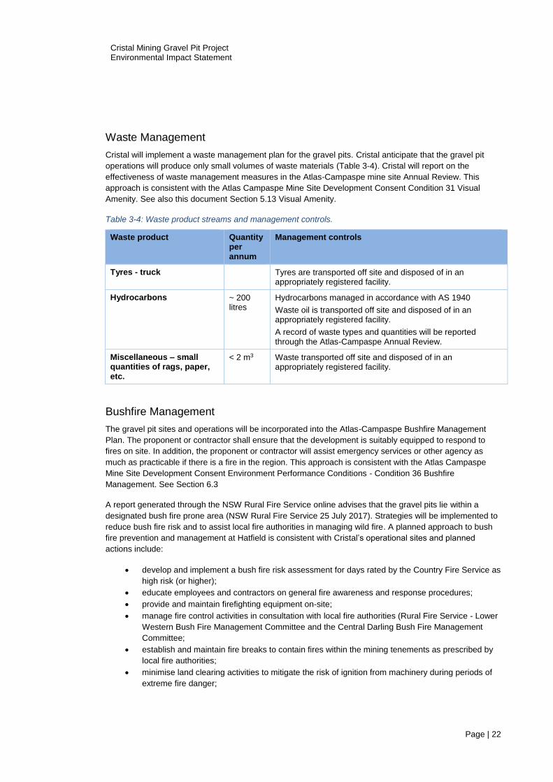
Waste Management
Cristal will implement a waste management plan for the gravel pits. Cristal anticipate that the gravel pit
operations will produce only small volumes of waste materials (Table 3-4). Cristal will report on the
effectiveness of waste management measures in the Atlas-Campaspe mine site Annual Review. This
approach is consistent with the Atlas Campaspe Mine Site Development Consent Condition 31 Visual
Amenity. See also this document Section 5.13 Visual Amenity.
Table 3-4: Waste product streams and management controls.
Waste product Quantity per annum
Management controls
Tyres - truck Tyres are transported off site and disposed of in an appropriately registered facility.
Hydrocarbons ~ 200 litres
Hydrocarbons managed in accordance with AS 1940
Waste oil is transported off site and disposed of in an appropriately registered facility.
A record of waste types and quantities will be reported through the Atlas-Campaspe Annual Review.
Miscellaneous – small quantities of rags, paper, etc.
< 2 m3 Waste transported off site and disposed of in an appropriately registered facility.
Bushfire Management
The gravel pit sites and operations will be incorporated into the Atlas-Campaspe Bushfire Management
Plan. The proponent or contractor shall ensure that the development is suitably equipped to respond to
fires on site. In addition, the proponent or contractor will assist emergency services or other agency as
much as practicable if there is a fire in the region. This approach is consistent with the Atlas Campaspe
Mine Site Development Consent Environment Performance Conditions - Condition 36 Bushfire
Management. See Section 6.3
A report generated through the NSW Rural Fire Service online advises that the gravel pits lie within a
designated bush fire prone area (NSW Rural Fire Service 25 July 2017). Strategies will be implemented to
reduce bush fire risk and to assist local fire authorities in managing wild fire. A planned approach to bush
fire prevention and management at Hatfield is consistent with Cristal’s operational sites and planned
actions include:
develop and implement a bush fire risk assessment for days rated by the Country Fire Service as
high risk (or higher);
educate employees and contractors on general fire awareness and response procedures;
provide and maintain firefighting equipment on-site;
manage fire control activities in consultation with local fire authorities (Rural Fire Service - Lower
Western Bush Fire Management Committee and the Central Darling Bush Fire Management
Committee;
establish and maintain fire breaks to contain fires within the mining tenements as prescribed by
local fire authorities;
minimise land clearing activities to mitigate the risk of ignition from machinery during periods of
extreme fire danger;

Cristal Mining Gravel Pit Project Environmental Impact Statement
Page | 23
assess and report fuel loads requiring management;
implement fuel reduction burns, only in consultation with local authorities and in a manner that
maintains and enhances biodiversity;
restrict smoking in fire prone areas; and
manage risks associated with hydrocarbons and other flammable materials.
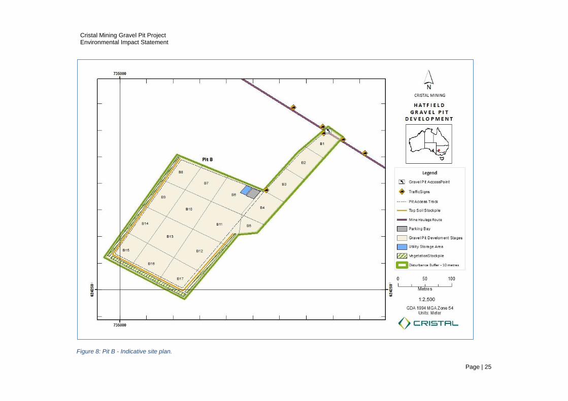
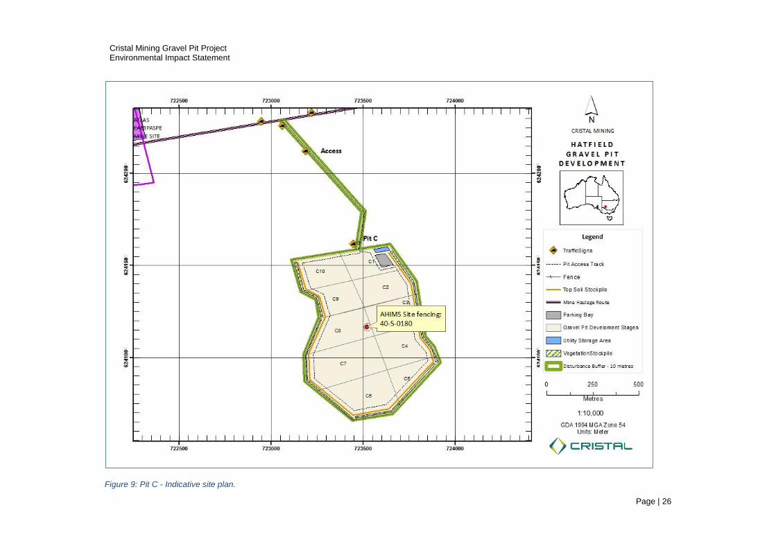
3.3 Gravel Pit Site Development
Preliminary works to establish the gravel pit operations includes:
Pit boundary surveys to ensure operations are contained within the licence boundary
pre-clearance surveys prior to any land disturbance;
fencing on perimeter where required;
establish roads, entry and exit points and signage;
establish mobile equipment parking area;
establish storage area for fuel, container storage, etc.
Prior to the commencement of gravel extraction, the initial gravel pit extraction area will be cleared of
vegetation, followed by topsoil stripping. Vegetation and topsoil will initially be placed in windrows along
the edge of the gravel extraction area. These materials will be used for future revegetation of mined areas.
Cristal propose to install fencing to secure a 20 metre exclusion zone around Aboriginal object AHIMS
number 40-5-0180. An indicative site layout for each gravel pit is shown in Figure 7, Figure 8 and Figure 9.

Cristal Mining Gravel Pit Project Environmental Impact Statement
Page | 24
Figure 7: Pit A - Indicative site plan.
Cristal Mining Gravel Pit Project Environmental Impact Statement
Page | 25
Figure 8: Pit B - Indicative site plan.
Cristal Mining Gravel Pit Project Environmental Impact Statement
Page | 26
Figure 9: Pit C - Indicative site plan.

Cristal Mining Gravel Pit Project Environmental Impact Statement
Page | 27
Preclearance Survey and Monitoring
Preclearance surveys will be undertaken prior to any site disturbance in accordance with procedures
applied at Cristal’s existing mining operations and required at the Atlas Campaspe mine development.
Cristal will establish photo monitoring points at each gravel pit site. Photographs taken at these photo
monitoring points will enable a baseline visual record, with the aim of re-establishing a similar cover of
vegetation following gravel extraction and site rehabilitation.
The gravel pit monitoring commitments will be incorporated into the Atlas-Campaspe Biodiversity
Management Plan.
Plans and Surveying
Surveyors will install gravel pit boundary and depth markers and exclusion zones (i.e. heritage artefact Pit
C). An indicative layout of the access, mobile plant parking area, vehicle and equipment storage areas is
shown in Figure 7, Figure 8 and Figure 9.
Infrastructure
Cristal do not propose to install fixed infrastructure at the proposed pits. All buildings, storage, equipment
and machinery will be mobile. Contractors operating the gravel pits may install:
two or three shipping containers at the gravel pits for the storage of equipment and safety
supplies;
one meeting / lunch room measuring up to 35 square metres.
Vegetation and Soil Clearance
Vegetation and soils will be cleared using earthmoving equipment as discussed in Section 6 Rehabilitation
Strategy. The vegetation clearance and soil stripping methods are adapted from Resource Strategies
(2012) Rehabilitation Strategy for the Atlas Campaspe Mineral Sands Mine Development and the GHD
(2015) Flora and Fauna Environmental Management Plan.
Vegetation will be raked into windrows for future use in land rehabilitation. Topsoil will be stripped
progressively ahead of gravel extraction using earth moving equipment and stockpiled for future
rehabilitation purposes or directly placed on previously mined areas.
Figure 10 and Figure 11 illustrate typical vegetation clearance and topsoil stripping methods.
Cristal will implement soil stripping, stockpiling and re-application consistent with procedures applied at the
Ginkgo, Snapper and Atlas Campaspe mine sites.

Cristal Mining Gravel Pit Project Environmental Impact Statement
Page | 28
Figure 10: Vegetation clearance using a track mounted dozer and chains.
Figure 11: A 4WD tractor towing a laser scoop bucket with differential GPS mounted on-board undertaking topsoil stripping and mapping at Cristal’s Ginkgo Mine (Sluiter 2017).

Cristal Mining Gravel Pit Project Environmental Impact Statement
Page | 29
Access Creation
Access to the gravel pits will be via short roads that will intersect with the mineral concentrate transport
route. In some cases, exiting tracks will be utilised to minimise additional disturbance.
Gravel pit access roads and intersections will be constructed in accordance with the Road Design Guide
(NSW Roads and Traffic Authority [RTA], 1996) and in consultation with the Balranald Shire Council
(BSC).
The development of access to the gravel pits coincides with the road upgrades proposed in Section 2.4
Project Construction and Other Development Activities Atlas Campaspe Mineral Sands Mine EIS
(Resource Strategies 2012). Access and tracks will be constructed progressively, as required at the three
gravel sites.
3.4 Gravel Pit Operations
Gravel pit operations include the processes for extracting, crushing, screening, stockpiling, loading and
transporting gravel. Figure 12 and Figure 13 show a typical gravel pit equipment in operation.
Gravel Extraction
Calcrete layer will be ripped using a dozer with ripper attachment. A front-end loader will pick up and load
gravel directly onto a crusher/screening belt, or directly onto stockpiles, trucks and trailers.
Crushing and Screening
Oversize calcrete material will need to be processed via crushing and screening prior to use as road
construction material. Oversize material will be loaded into a hopper and transported via conveyor belt to a
crusher or screening unit. Mobile crushing and screening equipment will be positioned in close proximity to
the mine face. Figure 12 and Figure 13 illustrate gravel pit hopper, screening and loading operations.
Loading and transporting
Gravel is loaded onto haulage trucks using front end loaders. Loading and transporting standards and
procedures developed for Gingko and Snapper operations will apply to gravel pit operations. Refer Atlas
Campaspe Mineral Sands Mine EIS (Resource Strategies 2012) Section 2.6.5 Mineral Concentrate
Stockpile & Loading and Section 2.6.6. Mineral Concentrate and MSP Process Waste Transport.
Traffic Management
Gravel pit related traffic will be managed in accordance with the Traffic Management Plan required by the
Atlas Campaspe Mineral Sand Mine Development Consent (see Condition 9 requiring a Traffic
Management Plan). The Traffic Management Plan will address access signage, loading zones, traffic flow,
routes and dust and noise management.

Cristal Mining Gravel Pit Project Environmental Impact Statement
Page | 30
Figure 12: All in one hopper, rock crusher and conveyor.
Figure 13: Hopper and loading conveyor.
3.
Cristal Mining Gravel Pit Project Environmental Impact Statement
Page | 31
4 Consultation & Community
4.1 Agency Consultation
Cristal held discussions and sought advice from the following NSW Government agencies to determine the
approval route to acquire the gravel pit licence.
NSW Department of Planning and Environment (DPE)
The NSW Department of Planning and Environment administers the Environmental Planning and
Assessment Act 1979. DPE coordinated the preparation of, and issued the SEAR’s for this EIS.
DPE has been consulted throughout the preparation of this EIS, relating to SEPP’s that apply to this
project, the approach to the preparation of the EIS and in relation to changes to the original area proposed
for the gravel pits. Subsequent resource exploration and assessment work has changed pit license
boundaries and added a third pit extraction area, close to original pit locations. Based on discussions (see
correspondence in Appendix A), it is deemed that these boundary changes did not require a review and re-
issue of SEAR’s.
NSW Department of Industry, Lands and Forestry
The NSW Department of Industry - Lands and Forestry is the landowner. An Application for Landowner’s
Consent will be submitted to Lands and Forestry as part of the Extractives Licence application (See
Appendix C Letters of Consent).
There has been regular consultation with the Lands Office in Dubbo throughout the preparation of this EIS.
The Department of Industry were involved in the preparation of the SEAR’s for this EIS.
The Local Land Services (LSS) Western Region advises that the Native Vegetation Act does not apply to
the gravel pit proposal as the development is carried out in accordance with Part 5 of the EP&A Act.
Consequently, there is no requirement to seek approval from the LLS (Appendix A).
NSW Office of Environment and Heritage (OEH)
The NSW Office of Environment and Heritage has been consulted throughout the preparation of this EIS.
OEH was originally involved in the preparation of SEAR’s for this EIS.
Advice was sought from the OEH Albury office regarding impact to native vegetation and offsetting. OEH
has also been consulted on Aboriginal heritage.
Australian Government Department of Environment and Energy
An EPBC Act referral has been prepared and submitted to the Department of Environment and Energy,
due to the presence of some Federally listed endangered species that were surveyed in the area of the
proposed gravel pits.
NSW Office of Water
The NSW Office of Water was consulted and involved in preparation of the SEAR’s for this EIS.

Cristal Mining Gravel Pit Project Environmental Impact Statement
Page | 32
No impacts to surface water or groundwater have been identified. It is planned to use water for dust
suppression from existing bores or new bores to be developed as part of the Atlas Campaspe Mineral
Sand project. The NSW Office of Water has been consulted in relation to requirements for licensing of
bores to enable water to be used for road construction and dust suppression activities, if new bores are
required.
NSW Transport - Roads and Maritime Services (RMS)
RMS were consulted and involved in the preparation of SEAR’s for this project.
4.2 Leaseholder Consultation
The leaseholder and the property managers of Minto Glen Pastoral Co. Pty Ltd have been consulted
throughout 2016 and 2017 regarding the development of the gravel pits.
Lessee consent has been received and the consent documentation will be attached to the Development
Application to Balranald Shire Council (Appendix C).
4.3 Aboriginal Community Consultation
The cultural heritage study associated with this EIS involved representatives of the local Aboriginal
community and considered their cultural values and concerns.
The following consultation details are an extract from the Aboriginal Cultural Heritage Due Diligence
Assessment Report (Cupper, 2017).
Methodology for the Aboriginal Community Involvement
Aboriginal community participation in the Aboriginal cultural heritage due diligence assessment comprised
involvement: before the field assessment to assess preliminary community views and organize a field
survey team; during the field survey with the Aboriginal team members; and after the field survey to
discuss the findings and recommendations for Aboriginal cultural heritage management.
Aboriginal Community Involvement Prior to the Field Assessment
Cristal Mining’s Resource Development Manager Dr Ray Roberts, Human Resources Business Partner
David Arthur, Envirocom’s Principal Andrew Minns and project archaeologist Dr Matt Cupper met with
representatives of the registered Aboriginal parties for the Atlas Campaspe Mineral Sands Project in
Balranald on 24 June 2015 to update them on the project.
The representatives of the registered Aboriginal parties present were Danny Kelly, Tara Bruton, Cameron
Murray (Muthi Muthi Nations Aboriginal Corporation), Gary Pappin (Wakool Indigenous Corporation) and
Faye Johnson (Ivanhoe Community Working Party).
The proposed developments associated with the Atlas Campaspe Mineral Sands Project were discussed
with the representatives of the registered Aboriginal parties.
Opinions of the representatives of the registered Aboriginal parties about the development and its potential
impacts on cultural heritage were sought and any concerns or queries were addressed.

Cristal Mining Gravel Pit Project Environmental Impact Statement
Page | 33
Aboriginal Community Involvement During the Field Assessment
On the recommendation of the registered Aboriginal parties Ryan Kelly and Tara Bruton, both
representative of the local Aboriginal community, were involved in the field survey undertaken on 12
November 2016.
Aboriginal Community Involvement Following the Field Assessment
At the completion of the field assessment, the project archaeologist Dr Matt Cupper updated Danny Kelly
(Muthi Muthi Nations Aboriginal Corporation) on the results of the assessment and recommendations for
managing Aboriginal cultural heritage. Dr Cupper also met with Mr Kelly in Balranald on 21 December
2016 to address any queries.
A draft copy of this cultural heritage due diligence assessment was provided to the Muthi Muthi Nations
Aboriginal Corporation on 9 December 2016. Any further comments will be passed on to Cristal Mining and
the Office of Environment and Heritage.
4.4 Balranald Shire Council
Balranald Shire Council is the determining authority for the Development Application for the gravel pit
development and has been consulted throughout the preparation of this EIS.
Cristal Mining Gravel Pit Project Environmental Impact Statement
Page | 34
5 Environmental Assessment
5.1 Environmental Assessment
Impacts to social, environmental and heritage aspects are evaluated via studies and detailed assessments. Cristal engaged consultants to undertake a series of environmental and heritage assessments at each of the proposed gravel pit sites. Some of the information contained here is extracted from the Atlas Campaspe Minerals Sand EIS (Resource Strategies 2012); for example: climate, land use, planning, management and operational methods. Risks are ranked on a matrix rating probability and consequence (Table 5-1, Table 5-2 & Table 5-3).
A summary of the results of risk assessments appears in Table 5-4. The assessments examine sensitive
receptors at risk of disturbance by gravel extraction operations. The sensitive receptors in closest proximity
to the development (Native vegetation, nearby homesteads and Aboriginal object 40-5-0180) are shown in
Figure 14.
This assessment includes:
a description of existing environments;
an assessment of potential impacts (risk ranking) on environmental and social components;
strategies for avoiding, mitigating or offsetting impacts;
a description of the management of mitigating strategies and monitoring of performance
measures.
Table 5-1: Impact probability matrix.
Rating Probability Criteria
A Almost certain Happens often
B Likely Could happen easily
C Possible Could happen and has occurred elsewhere
D Unlikely Hasn’t happened yet but possible
E Rare Conceivable in extreme circumstances
Table 5-2: Impact consequence matrix.
Rating Consequence Criteria
1 Extreme Widespread catastrophic impact on values
2 Major Widespread substantial impact
3 Serious Widespread and considerable impact
4 Material Localised and considerable impact
5 Minimal Minor impact of environmental values
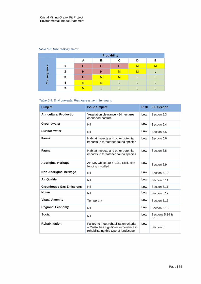
Cristal Mining Gravel Pit Project Environmental Impact Statement
Page | 35
Table 5-3: Risk ranking matrix.
Probability
Co
ns
eq
uen
ce
A B C D E
1 H H H M M
2 H H M M L
3 H M M L L
4 M M L L L
5 M L L L L
Table 5-4: Environmental Risk Assessment Summary.
Subject Issue / impact Risk EIS Section
Agricultural Production Vegetation clearance ~54 hectares chenopod pasture
Low Section 5.3
Groundwater Nil Low Section 5.4
Surface water Nil Low Section 5.5
Fauna Habitat impacts and other potential impacts to threatened fauna species
Low Section 5.6
Fauna Habitat impacts and other potential impacts to threatened fauna species
Low Section 5.8
Aboriginal Heritage AHIMS Object 40-5-0180 Exclusion fencing installed
Low Section 5.9
Non-Aboriginal heritage Nil Low Section 5.10
Air Quality Nil Low Section 5.11
Greenhouse Gas Emissions Nil Low Section 5.11
Noise Nil Low Section 5.12
Visual Amenity Temporary Low Section 5.13
Regional Economy Nil Low Section 5.15
Social Nil
Low Sections 5.14 & 5.15
Rehabilitation Failure to meet rehabilitation criteria – Cristal has significant experience in rehabilitating this type of landscape
Low Section 6
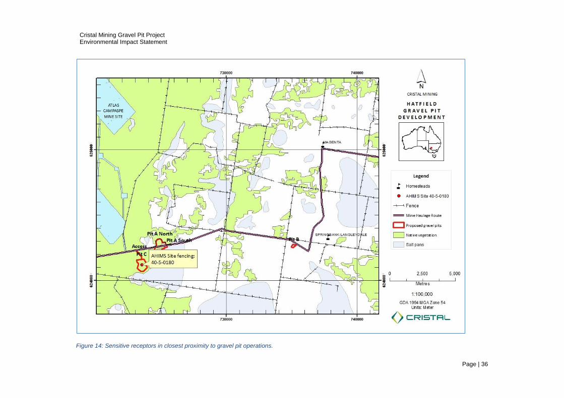
Cristal Mining Gravel Pit Project Environmental Impact Statement
Page | 36
Figure 14: Sensitive receptors in closest proximity to gravel pit operations.

Cristal Mining Gravel Pit Project Environmental Impact Statement
Page | 37
5.2 Climate
Climate information is summarised from Section 2.4 Climate 2014 Atlas Campaspe EIS (Resource
Strategies 2012).
Temperature
The closest BOM meteorological stations are located in Pooncarie, Balranald and Ivanhoe. Seasonally
warmest months are from November to March and coolest from June to August. The monthly-average
daily maximum and minimum temperatures occur in January and June, respectively (Table 5-5).
Rainfall
The long-term average annual rainfall recorded at regional met stations demonstrate a north to south
gradient with drier, warmer climate averages recorded northwest of the project area and wetter, cooler
averages to the south (Table 5-5).
Table 5-5: Temperature and Rainfall data from regional met stations.
Location Temp (min daily June) Temp (max daily Jan) Annual rainfall
Balranald 12.4 38.1
Ivanhoe kilfera 306
Ivanhoe Post Office 13.7 39.5 284
Oxley 323
Pooncarie 14.8 38.5 268
Local datasets (Mildura and Menindee) demonstrate that measured monthly-average evaporation exceeds
the measured monthly-average rainfall for all months. Water runoff collected in topographic depressions
will evaporate quickly. Vegetation (trees) access moisture in deeper profiles (Resource Strategies 2012).
Wind
Resource Strategies (2012) assessed wind data from Balranald and Ivanhoe meteorological stations for
the Atlas-Campaspe development proposal. The annual wind roses for the region indicate southerly winds
generally occur during the morning, trending to west south-westerly winds in the afternoon (Figure 15).
Wind speeds are typically less than 10 kilometres per hour.
Geology
Regional geology is fully described in the Atlas Campaspe Mineral Sand Mine EIS, Section 2.2 and
Appendix F: Hydrogeological and Water Supply Assessment (Resource Strategies 2012).
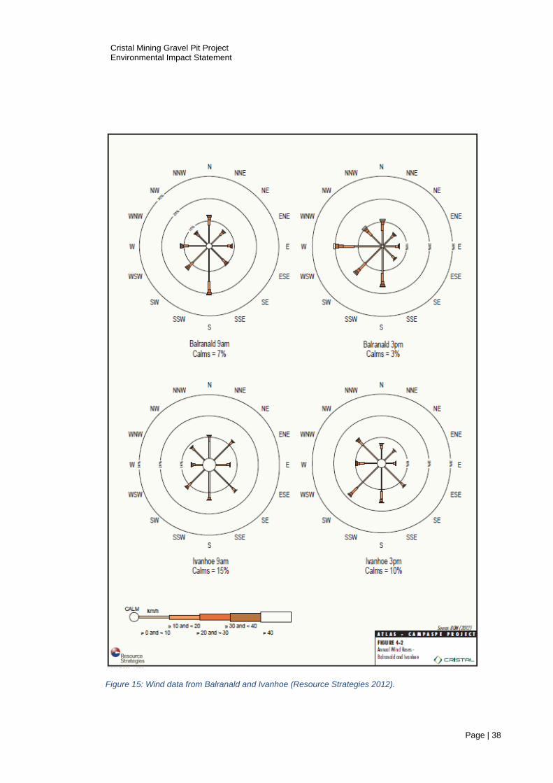
Cristal Mining Gravel Pit Project Environmental Impact Statement
Page | 38
Figure 15: Wind data from Balranald and Ivanhoe (Resource Strategies 2012).

Cristal Mining Gravel Pit Project Environmental Impact Statement
Page | 39
General Site Description
The three gravel pit sites consist mostly of native vegetation (95%) modified through agriculture (grazing),
and farm tracks. The extent of native vegetation and modified areas for the three sites is summarised in
Table 5-6.
Table 5-6: Summary of Native Vegetation and Cleared Areas.
Pit A Pit B Pit C
Native Vegetation (ha) 52.99 3.09 52.7 108.78
Cleared areas (ha) 1.01 2.16 1.46 4.63
Total Area 54 5.25 54.16 113.41
Sluiter (2017) summarises the geological setting of the gravel pit areas and identifies two soil types -
Woorinen soils and Callabonna clays. The Shepparton Formation underlies the Woorinen soils and
confines the regional Loxton-Parilla Sands aquifer. Regional geology and local soil types are fully
described in Section 4.3.1 Regional Geology 2014 Atlas Campaspe EIS (Resource Strategies, 2012).
Several landform features are represented:
east-west aligned sandy dune-fields (with dunes and interdune corridors or swales)
sandplains of predominantly sandy loam
clayey to loamy plains of undulating to almost flat relief
run-on depressions
relict playa lakes
small areas of gypseous plains and rises
5.3 Land Resources - Soils and Agriculture
Existing Environment
The combination of a semi-arid climate and shallow soils over the proposed sites constrain agriculture to
saltbush / bluebush cattle grazing (Sluiter 2017). Two private dwellings occur within a ten-kilometre radius
of the gravel pit sites.
Potential Impacts and Controls
Gravel extraction to approximately one metre depth alters the topography and soil structure at the three
sites, however the excavation is unlikely to impact on the functioning of regional systems (hydrology, soils
and agriculture). Top soil and subsoil progressively removed over 113 ha will be stockpiled and replaced
as gravel extraction proceeds. Stockpiled soils are susceptible to wind erosion and Cristal will sew native
seed to stabilise stockpiles.
Table 5-7 summarises the potential impacts to landform, soils and agriculture, risk rankings and proposed
control strategies. Gravel pit development and operation result in minor impacts to landform and
agriculture. Progressive rehabilitation, landowner compensation and biodiversity offsets mitigate impacts
to soils and agriculture.
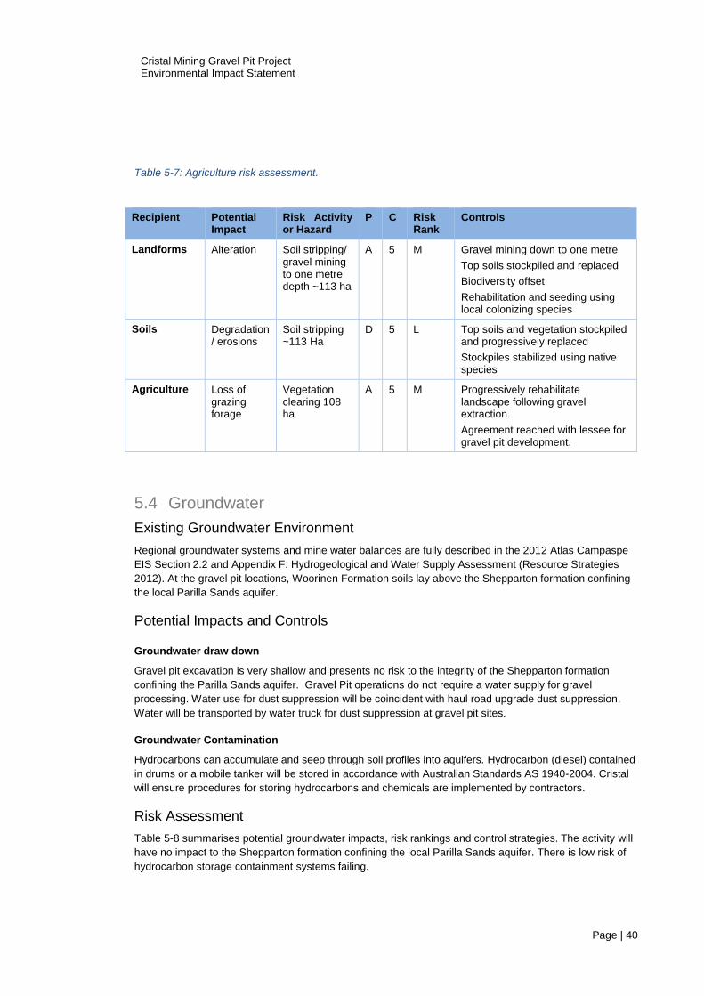
Cristal Mining Gravel Pit Project Environmental Impact Statement
Page | 40
Table 5-7: Agriculture risk assessment.
5.4 Groundwater
Existing Groundwater Environment
Regional groundwater systems and mine water balances are fully described in the 2012 Atlas Campaspe
EIS Section 2.2 and Appendix F: Hydrogeological and Water Supply Assessment (Resource Strategies
2012). At the gravel pit locations, Woorinen Formation soils lay above the Shepparton formation confining
the local Parilla Sands aquifer.
Potential Impacts and Controls
Groundwater draw down
Gravel pit excavation is very shallow and presents no risk to the integrity of the Shepparton formation
confining the Parilla Sands aquifer. Gravel Pit operations do not require a water supply for gravel
processing. Water use for dust suppression will be coincident with haul road upgrade dust suppression.
Water will be transported by water truck for dust suppression at gravel pit sites.
Groundwater Contamination
Hydrocarbons can accumulate and seep through soil profiles into aquifers. Hydrocarbon (diesel) contained
in drums or a mobile tanker will be stored in accordance with Australian Standards AS 1940-2004. Cristal
will ensure procedures for storing hydrocarbons and chemicals are implemented by contractors.
Risk Assessment
Table 5-8 summarises potential groundwater impacts, risk rankings and control strategies. The activity will
have no impact to the Shepparton formation confining the local Parilla Sands aquifer. There is low risk of
hydrocarbon storage containment systems failing.
Recipient Potential Impact
Risk Activity or Hazard
P C Risk Rank
Controls
Landforms Alteration Soil stripping/ gravel mining to one metre depth ~113 ha
A 5 M Gravel mining down to one metre
Top soils stockpiled and replaced
Biodiversity offset
Rehabilitation and seeding using local colonizing species
Soils Degradation / erosions
Soil stripping ~113 Ha
D 5 L Top soils and vegetation stockpiled and progressively replaced
Stockpiles stabilized using native species
Agriculture Loss of grazing forage
Vegetation clearing 108 ha
A 5 M Progressively rehabilitate landscape following gravel extraction.
Agreement reached with lessee for gravel pit development.
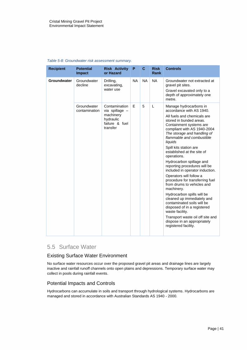
Cristal Mining Gravel Pit Project Environmental Impact Statement
Page | 41
Table 5-8: Groundwater risk assessment summary.
5.5 Surface Water
Existing Surface Water Environment
No surface water resources occur over the proposed gravel pit areas and drainage lines are largely
inactive and rainfall runoff channels onto open plains and depressions. Temporary surface water may
collect in pools during rainfall events.
Potential Impacts and Controls
Hydrocarbons can accumulate in soils and transport through hydrological systems. Hydrocarbons are
managed and stored in accordance with Australian Standards AS 1940 - 2000.
Recipient Potential Impact
Risk Activity or Hazard
P C Risk Rank
Controls
Groundwater Groundwater decline
Drilling, excavating, water use
NA NA NA Groundwater not extracted at gravel pit sites.
Gravel excavated only to a depth of approximately one metre.
Groundwater contamination
Contamination via spillage – machinery hydraulic failure & fuel transfer
E 5 L Manage hydrocarbons in accordance with AS 1940.
All fuels and chemicals are stored in bunded areas. Containment systems are compliant with AS 1940-2004 The storage and handling of flammable and combustible liquids
Spill kits station are established at the site of operations.
Hydrocarbon spillage and reporting procedures will be included in operator induction.
Operators will follow a procedure for transferring fuel from drums to vehicles and machinery.
Hydrocarbon spills will be cleaned up immediately and contaminated soils will be disposed of in a registered waste facility.
Transport waste oil off site and dispose in an appropriately registered facility.

Cristal Mining Gravel Pit Project Environmental Impact Statement
Page | 42
Surface Water Risk Assessment
Table 5-9 summarises surface water impacts, risk rankings and control strategies. Risk to local surface
water resources is low.
Table 5-9: Surface water risk assessment summary.
5.6 Flora
The Hatfield gravel pit flora report (Appendix D) fulfils the statutory requirements of the National Parks and
Wildlife Act 1974 and the Threatened Species Conservation Act 1995 for assessing biodiversity. Dr Ian
Sluiter & Allen (2017) and qualified field personnel conducted detailed flora assessments at the three
proposed gravel pit sites pursuant to OEH National Parks and Wildlife Scientific Licence Number
SL101035. Sluiter & Allen (2017) conclude that the gravel pit development and activities are unlikely to
have a significant effect on the TSC or EPBC Act rated species occurring or likely to occur over the project
area.
The Hatfield gravel pit flora assessment (Sluiter & Allen 2017) describes site flora and assesses the risk of
gravel pit operations on flora communities and species. The report contains several recommendations for
avoiding or mitigating impacts, and calculates a biodiversity offset for vegetation clearance. This section
summarises the flora survey findings, potential impacts and control strategies and provides a risk ranking
for select flora species. Figure 16 through to Figure 26 present satellite images, maps and images of
vegetation over the three proposed gravel pit sites.
Existing Flora Environment
The proposed gravel extraction will affect approximately 113 hectares of land. Remnant native vegetation
occurs over approximately 108.78 hectares of this area. Two at risk species (Mossgiel daisy Brachyscome
papillosa and Rusty greenhood Pterostylis cobarensis) occur or are likely to occur in the region. However,
Recipient Potential Impact
Risk Activity or Hazard
P C Risk Rank
Controls
Surface water
Hydrocarbon spillage
Contamination via spillage
E 5 L All fuels and chemicals are stored in bunded areas compliant with AS 1940-2004 The storage and handling of flammable and combustible liquids
Spill kits station are established at the site of operations.
Training regarding hydrocarbon spillage and reporting.
Operators follow a procedure transferring fuel from drums to vehicles and machinery.
Personnel report on hydrocarbon spills.
Hydrocarbon spills are cleaned up immediately and contaminated soils are disposed of in a registered waste facility.

Cristal Mining Gravel Pit Project Environmental Impact Statement
Page | 43
important populations of these species do not occur over the proposed gravel pits sites. Mossgiel daisy
(Vulnerable) is represented by a small number of individuals. Suitable habitat for Rusty greenhood
(Vulnerable) does not occur at the gravel pit sites (Table 5-10). Two endangered communities occur at
gravel pit sites: Sandhill Pine Woodland and Yarran Shrubland. The broader landscape offers extensive
areas of native vegetation which provide similar communities unaffected by the Project including large
tracts of vegetation that are contiguous with the disturbance footprint.
Potential Impacts and Controls
The clearing of 108 hectares of native vegetation constitutes the main impact (Sluiter 2017), with proposed
clearances affecting two endangered communities; Sandhill Pine Woodland (4.89 ha) and Yarran
Shrubland (0.53 ha). Belah-Rosewood Woodland (53.93 ha) and Bluebush-Grassland (45.71 ha)
communities comprise 90% of the gravel pit clearances. Chenopod Sandplain Mallee (1.02 ha) and Pearl
Bluebush Shrubland (2.7 ha) communities are minor components of the total clearance (3%).
Control strategies for managing flora that are consistent with controls proposed for the Atlas Campaspe
mine site flora. The management of gravel pit vegetation areas will be incorporated into the Atlas-
Campaspe Biodiversity Management Plan. Cristal propose to manage vegetation in a manner consistent
with conditions prescribed in the Atlas Campaspe Mineral Sand Mine Development Consent Schedule 3
Environment Performance Condition 13 & 14. These conditions require procedures to be developed for:
exclusion of livestock grazing;
control of vehicle access;
controls for weeds and pests;
controls for erosion.
Flora Risk Assessment
Table 5-11 summarises the flora impacts, risk rankings and control strategies adapted from Sluiter (2017).
Vegetation clearance results in localised impact on 4.89 hectares of vulnerable Sandhill Pine Woodland,
0.53 hectares of vulnerable Yarran Shrubland and 53.93 hectares of Belah-Rosewood Woodland.
OEH seven part tests conducted for threatened species at risk of impact by Sluiter & Allen (2017), conclude
that gravel pit development and operation is unlikely to significantly impact upon threatened species
populations or lifecycles. Important populations that are necessary for species long-term survival and
recovery were not recorded in the project area for Mossgiel daisy Brachyscome papillosa or Rusty
greenhood Pterostylis cobarensis. Habitat for both species is sub optimal. Sluiter & Allen (2017) concludes
that control measures, rehabilitation and the biodiversity offset, will maintain or improve flora assets over
the medium to long term (Table 5-10).
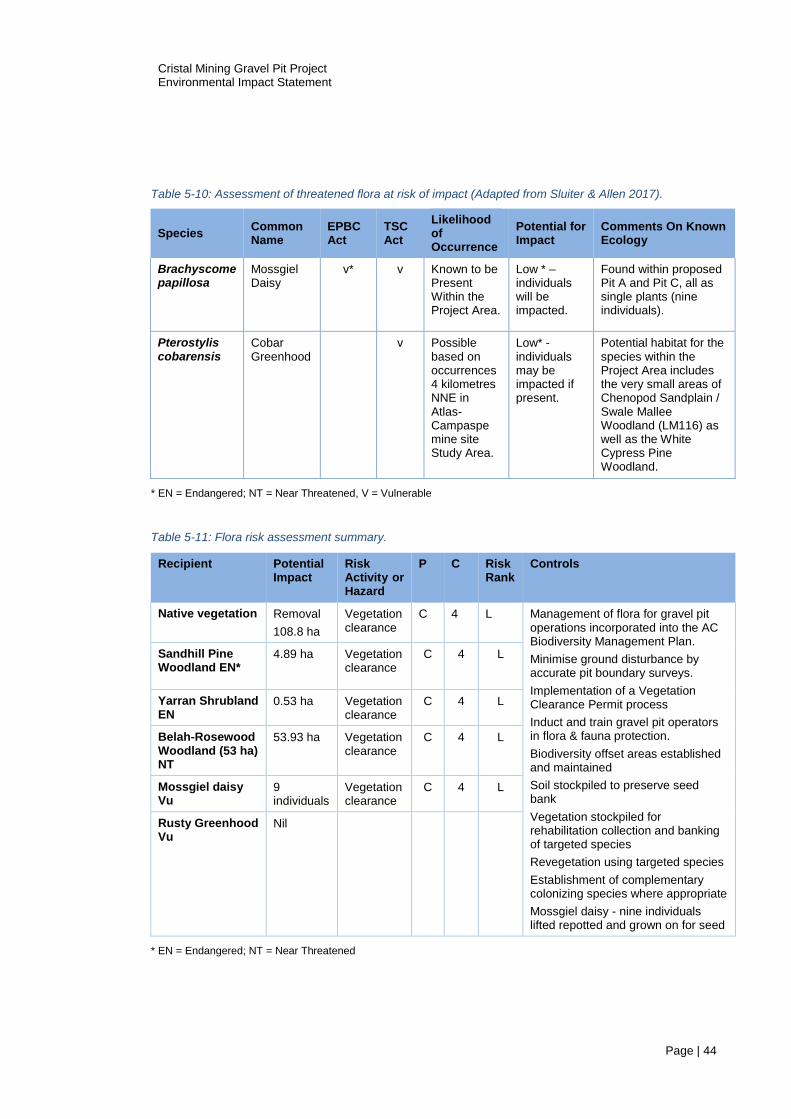
Cristal Mining Gravel Pit Project Environmental Impact Statement
Page | 44
Table 5-10: Assessment of threatened flora at risk of impact (Adapted from Sluiter & Allen 2017).
Species Common Name
EPBC Act
TSC Act
Likelihood of Occurrence
Potential for Impact
Comments On Known Ecology
Brachyscome papillosa
Mossgiel Daisy
v* v Known to be Present Within the Project Area.
Low * – individuals will be impacted.
Found within proposed Pit A and Pit C, all as single plants (nine individuals).
Pterostylis cobarensis
Cobar Greenhood
v Possible based on occurrences 4 kilometres NNE in Atlas-Campaspe mine site Study Area.
Low* - individuals may be impacted if present.
Potential habitat for the species within the Project Area includes the very small areas of Chenopod Sandplain / Swale Mallee Woodland (LM116) as well as the White Cypress Pine Woodland.
* EN = Endangered; NT = Near Threatened, V = Vulnerable
Table 5-11: Flora risk assessment summary.
* EN = Endangered; NT = Near Threatened
Recipient Potential Impact
Risk Activity or Hazard
P C Risk Rank
Controls
Native vegetation Removal
108.8 ha
Vegetation clearance
C 4 L Management of flora for gravel pit operations incorporated into the AC Biodiversity Management Plan.
Minimise ground disturbance by accurate pit boundary surveys.
Implementation of a Vegetation Clearance Permit process
Induct and train gravel pit operators in flora & fauna protection.
Biodiversity offset areas established and maintained
Soil stockpiled to preserve seed bank
Vegetation stockpiled for rehabilitation collection and banking of targeted species
Revegetation using targeted species
Establishment of complementary colonizing species where appropriate
Mossgiel daisy - nine individuals lifted repotted and grown on for seed
Sandhill Pine Woodland EN*
4.89 ha Vegetation clearance
C 4 L
Yarran Shrubland EN
0.53 ha Vegetation clearance
C 4 L
Belah-Rosewood Woodland (53 ha) NT
53.93 ha Vegetation clearance
C 4 L
Mossgiel daisy Vu
9 individuals
Vegetation clearance
C 4 L
Rusty Greenhood Vu
Nil

Cristal Mining Gravel Pit Project Environmental Impact Statement
Page | 45
Figure 16: Pit A north & south satellite image native vegetation.
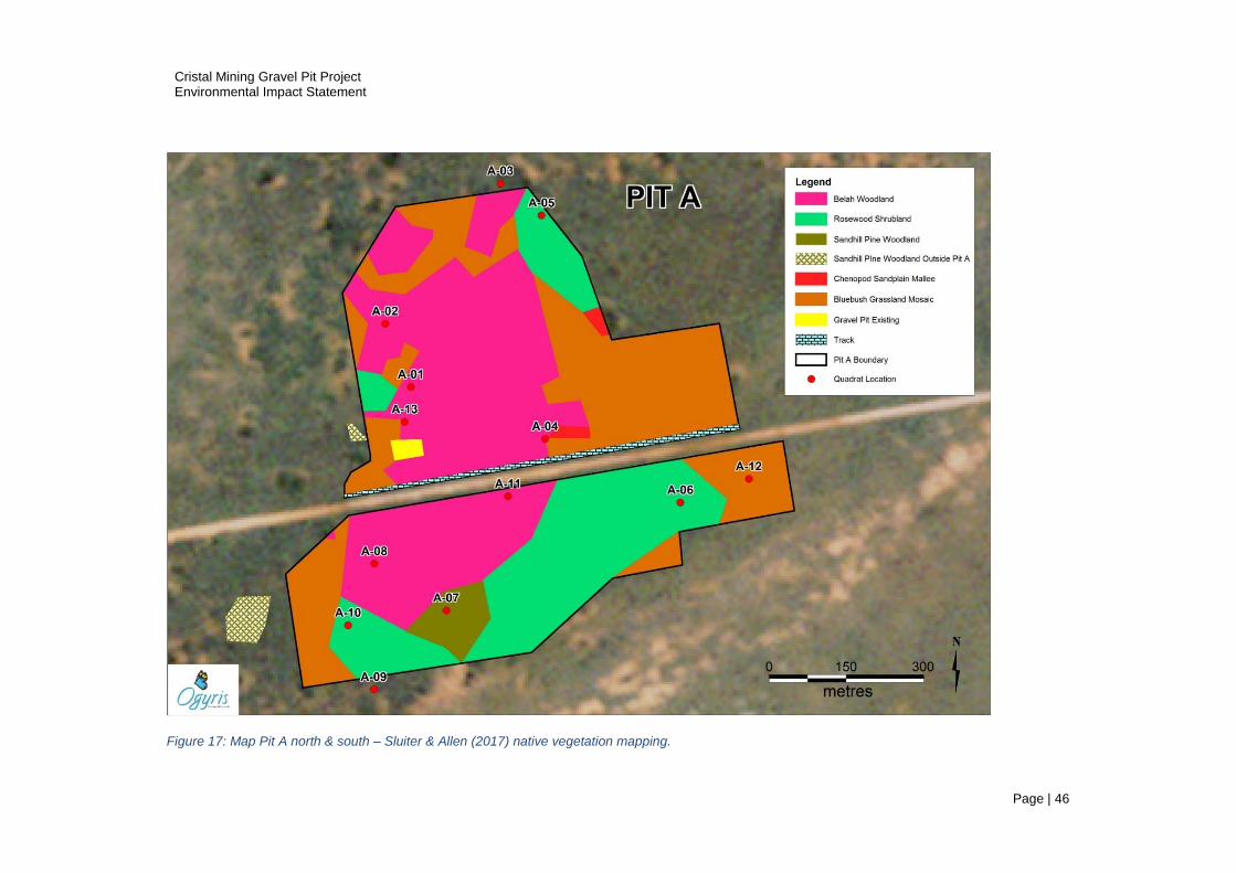
Cristal Mining Gravel Pit Project Environmental Impact Statement
Page | 46
Figure 17: Map Pit A north & south – Sluiter & Allen (2017) native vegetation mapping.

Cristal Mining Gravel Pit Project Environmental Impact Statement
Page | 47
Figure 18: Image Gravel Pit A - representative soil and vegetation types.
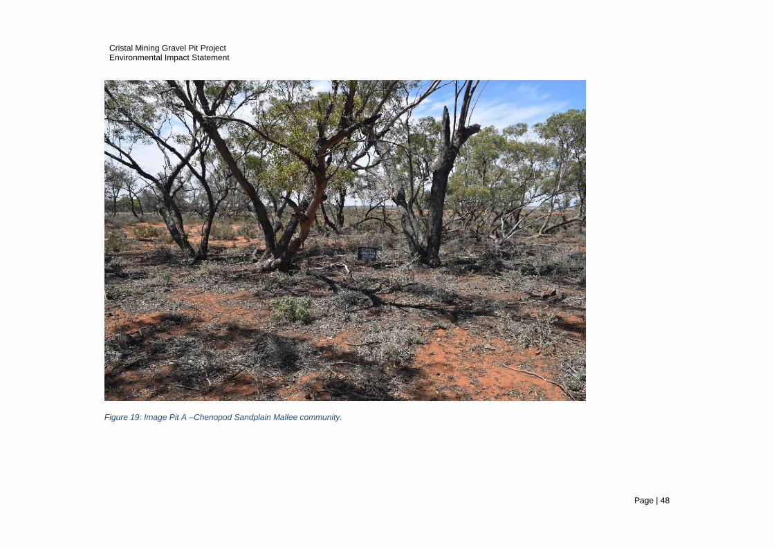
Cristal Mining Gravel Pit Project Environmental Impact Statement
Page | 48
Figure 19: Image Pit A –Chenopod Sandplain Mallee community.
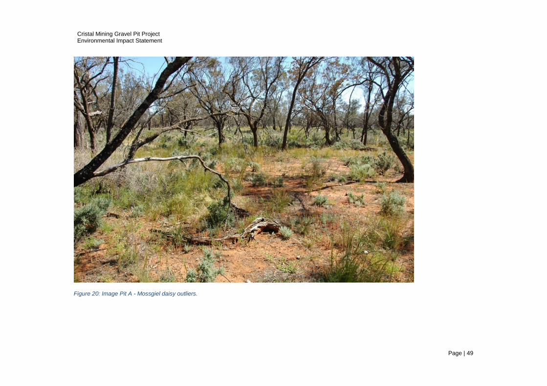
Cristal Mining Gravel Pit Project Environmental Impact Statement
Page | 49
Figure 20: Image Pit A - Mossgiel daisy outliers.

Cristal Mining Gravel Pit Project Environmental Impact Statement
Page | 50
Figure 21:Pit B satellite image native vegetation.
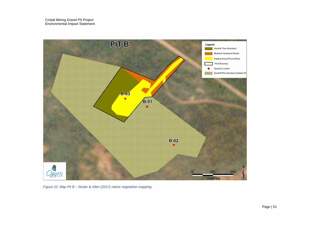
Cristal Mining Gravel Pit Project Environmental Impact Statement
Page | 51
Figure 22: Map Pit B – Sluiter & Allen (2017) native vegetation mapping.
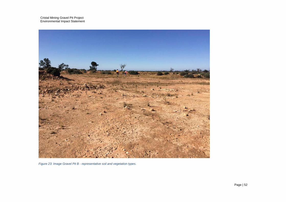
Cristal Mining Gravel Pit Project Environmental Impact Statement
Page | 52
Figure 23: Image Gravel Pit B - representative soil and vegetation types.

Cristal Mining Gravel Pit Project Environmental Impact Statement
Page | 53
Figure 24: Pit C satellite image native vegetation.

Cristal Mining Gravel Pit Project Environmental Impact Statement
Page | 54
Figure 25: Map Pit C – Sluiter & Allen (2017) native vegetation mapping.

Cristal Mining Gravel Pit Project Environmental Impact Statement
Page | 55
Figure 26: Image Gravel Pit C - representative soil and vegetation types (Pearl bluebush).
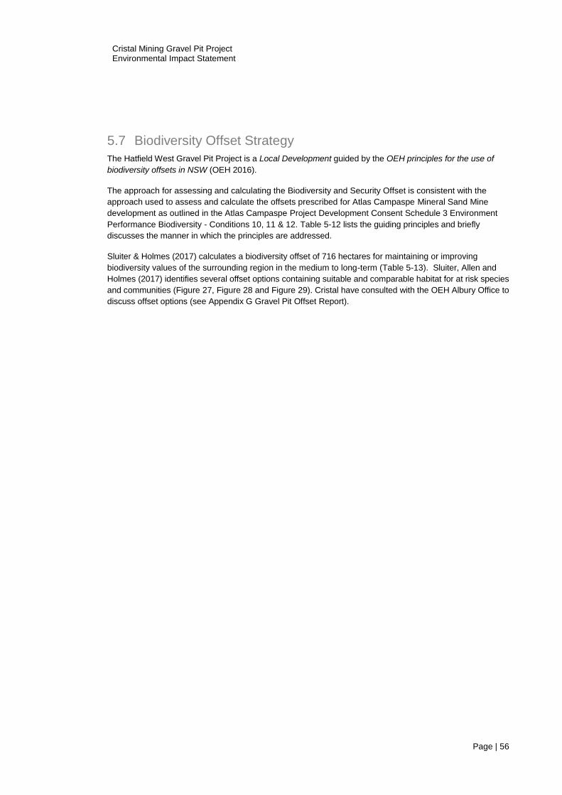
Cristal Mining Gravel Pit Project Environmental Impact Statement
Page | 56
5.7 Biodiversity Offset Strategy
The Hatfield West Gravel Pit Project is a Local Development guided by the OEH principles for the use of
biodiversity offsets in NSW (OEH 2016).
The approach for assessing and calculating the Biodiversity and Security Offset is consistent with the
approach used to assess and calculate the offsets prescribed for Atlas Campaspe Mineral Sand Mine
development as outlined in the Atlas Campaspe Project Development Consent Schedule 3 Environment
Performance Biodiversity - Conditions 10, 11 & 12. Table 5-12 lists the guiding principles and briefly
discusses the manner in which the principles are addressed.
Sluiter & Holmes (2017) calculates a biodiversity offset of 716 hectares for maintaining or improving
biodiversity values of the surrounding region in the medium to long-term (Table 5-13). Sluiter, Allen and
Holmes (2017) identifies several offset options containing suitable and comparable habitat for at risk species
and communities (Figure 27, Figure 28 and Figure 29). Cristal have consulted with the OEH Albury Office to
discuss offset options (see Appendix G Gravel Pit Offset Report).
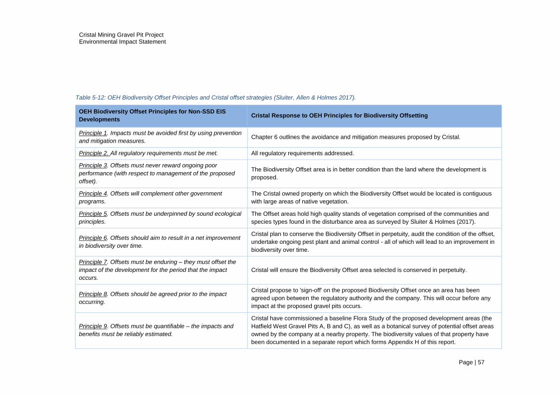
Cristal Mining Gravel Pit Project Environmental Impact Statement
Page | 57
Table 5-12: OEH Biodiversity Offset Principles and Cristal offset strategies (Sluiter, Allen & Holmes 2017).
OEH Biodiversity Offset Principles for Non-SSD EIS
Developments Cristal Response to OEH Principles for Biodiversity Offsetting
Principle 1. Impacts must be avoided first by using prevention
and mitigation measures. Chapter 6 outlines the avoidance and mitigation measures proposed by Cristal.
Principle 2. All regulatory requirements must be met. All regulatory requirements addressed.
Principle 3. Offsets must never reward ongoing poor
performance (with respect to management of the proposed
offset).
The Biodiversity Offset area is in better condition than the land where the development is
proposed.
Principle 4. Offsets will complement other government
programs.
The Cristal owned property on which the Biodiversity Offset would be located is contiguous
with large areas of native vegetation.
Principle 5. Offsets must be underpinned by sound ecological
principles.
The Offset areas hold high quality stands of vegetation comprised of the communities and
species types found in the disturbance area as surveyed by Sluiter & Holmes (2017).
Principle 6. Offsets should aim to result in a net improvement
in biodiversity over time.
Cristal plan to conserve the Biodiversity Offset in perpetuity, audit the condition of the offset,
undertake ongoing pest plant and animal control - all of which will lead to an improvement in
biodiversity over time.
Principle 7. Offsets must be enduring – they must offset the
impact of the development for the period that the impact
occurs.
Cristal will ensure the Biodiversity Offset area selected is conserved in perpetuity.
Principle 8. Offsets should be agreed prior to the impact
occurring.
Cristal propose to 'sign-off' on the proposed Biodiversity Offset once an area has been
agreed upon between the regulatory authority and the company. This will occur before any
impact at the proposed gravel pits occurs.
Principle 9. Offsets must be quantifiable – the impacts and
benefits must be reliably estimated.
Cristal have commissioned a baseline Flora Study of the proposed development areas (the
Hatfield West Gravel Pits A, B and C), as well as a botanical survey of potential offset areas
owned by the company at a nearby property. The biodiversity values of that property have
been documented in a separate report which forms Appendix H of this report.

Cristal Mining Gravel Pit Project Environmental Impact Statement
Page | 58
OEH Biodiversity Offset Principles for Non-SSD EIS
Developments Cristal Response to OEH Principles for Biodiversity Offsetting
Principle 10. Offsets must be targeted. The Biodiversity Offset provides for like-for-like where possible, but in most circumstances
vastly exceeds the conservation value of the land lost as part of the proposed development.
Principle 11. Offsets must be located appropriately. The proposed Biodiversity Offset is located ~20kilometres to the north on landscapes
contiguous with Mungo National Park.
Principle 12. Offsets must be supplementary - that is not on
land already conserved or having received an incentive to
conserve.
The Cristal owned land is not part of an existing reserve.
Principle 13. Offsets and their actions must be enforceable
through development consent conditions, license conditions,
conservation agreements or contracts.
See response to Principle 7. Cristal also undertake to conduct independent audits of the
vegetation condition of the selected Biodiversity Offset.

Cristal Mining Gravel Pit Project Environmental Impact Statement
Page | 59
Table 5-13: Biodiversity Offset Calculations (Sluiter, Allen and Holmes 2017).
Vegetation
Formation
(Keith 2004)
Vegetation
Class (Keith
2004)
Biometric Vegetation Type (OEH
2011)
Benson
et. al.
(2006) ID
No.
Vegetation
Community
(abbreviated name
in this study)
Disturbance
Area (Ha)
Indicative
Offset
Ratio
Target Area
of Offset
Proposed
(Ha)
Semi-arid
Woodlands
(shrubby sub-
formation)
Semi-arid Sand
Plain Woodlands
LM108 Black Oak - Western
Rosewood open woodland on deep
sandy loams of the Murray-Darling
Depression and Riverina Bioregions.
58
Belah-Rosewood
Woodland (Belah-
Rosewood sub-
community)
53.93 8:1 431.4
Riverine Sandhill
Woodlands
LM159 White Cypress Pine open
woodland of sandplains, prior
streams and dunes of the semi-arid
(warm) climate zone.
28 Sandhill Pine
Woodland 4.89 15:1 73.4
Semi-arid
Woodlands
(shrubby sub-
formation)
Sandplain Mallee
Woodlands
LM116 Chenopod sandplain mallee
woodland/shrubland of the arid and
semi-arid (warm) zones.
170 Chenopod
Sandplain Mallee 1.02 7:1 7.1
Arid
Shrublands
Not specifically
recognized by
Keith (2004)
Yarran shrubland of the semi-arid
(warm) and arid zones. 23 Yarran Shrubland 0.53 15:1 8.0
Arid
Shrublands
(Chenopod
sub-formation)
Aeolian
Chenopod
Shrublands
LM138 Pearl Bluebush low Open
Shrubland of the arid and semi-arid
plains.
154 Pearl Bluebush
Shrubland 2.70 5:1 13.5
Arid
Shrublands
(Chenopod
sub-formation)
Aeolian
Chenopod
Shrublands
Derived corkscrew grass
grassland/forb land on sandplains
and plains in the semi-arid (warm)
climatic zone.
165 Bluebush-
Grassland Mosaic 45.71 4:1 182.8
TOTAL 108.78 716.2
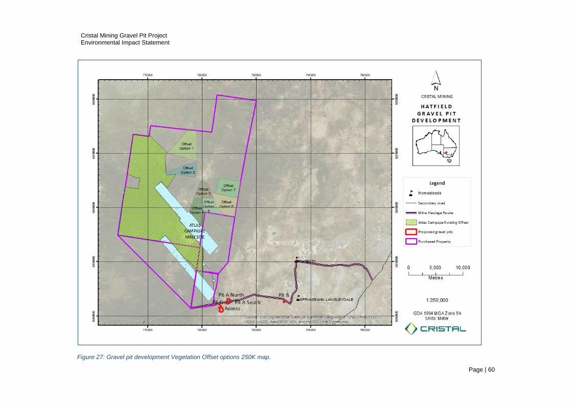
Cristal Mining Gravel Pit Project Environmental Impact Statement
Page | 60
Figure 27: Gravel pit development Vegetation Offset options 250K map.

Cristal Mining Gravel Pit Project Environmental Impact Statement
Page | 61
Figure 28: Gravel pit development Vegetation Offset options showing hectares 100K map.
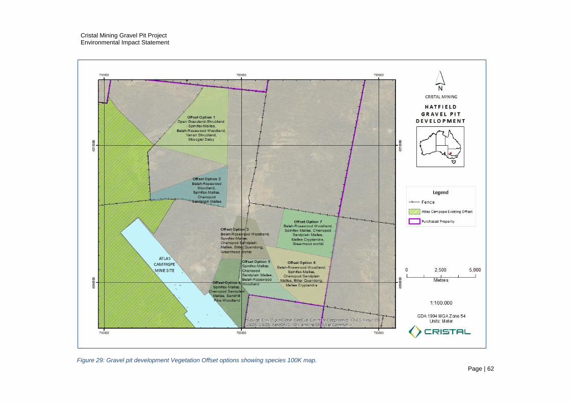
Cristal Mining Gravel Pit Project Environmental Impact Statement
Page | 62
Figure 29: Gravel pit development Vegetation Offset options showing species 100K map.

Cristal Mining Gravel Pit Project Environmental Impact Statement
Page | 63
5.8 Fauna
The GHD Hatfield gravel pit fauna assessment (GHD 2017 See Appendix E) fulfils the statutory
requirements of the Environmental Assessment (EAR 996) set out by the NSW Office of Environment and
Heritage (OEH). GHD Pty Ltd conducted the surveys under Scientific License number SL100146. This
section summarises the GHD survey findings, potential impacts and control strategies and provides a risk
ranking for select fauna species (Table 5-13). GHD conclude that the gravel pit development and activities
are unlikely to have a significant effect on the TSC or EPBC Act rated species occurring or likely to occur
over the project area (GHD 2017). GHD employed Anabat acoustics, microbat harp traps and visual
search methods to detect mammals, birds and reptiles. The GHD report assesses the potential impacts of
the proposal on fauna species or their communities listed as threatened under the NSW Threatened
Species Conservation (TSC) Act 1995 and the Commonwealth Environment Protection and Biodiversity
Conservation (EPBC) Act 1999.
Existing Environment
GHD recorded twenty-six birds, five reptiles and seven bat species over a three-day survey in January
2017, at the proposed gravel pits sites. GHD trapped three bats species rated as vulnerable under the
TSC Act during the survey: Corben's Long-eared Bat (Nyctophilus corbeni) Vu, Inland Forest Bat
(Vespadelus baverstocki) Vu and Little Pied Bat (Chalinobolus picatus) Vu. Corben's Long-eared Bat is
also listed as vulnerable under the EPBC Act. In addition, GHD advise that the Yellow-bellied Sheathtail-
bat (Vu) may occur at sites where suitable habitat occurs. The survey did not detect bird species rated at
risk under the TSC Act or the EPBC Act. Three terrestrial mammal species listed under the EPBC Act and
known to occur regionally or possibly occurring regionally were not recorded during the January survey.
Reptiles listed as threatened under the TSC Act and occurring in the broader landscape are unlikely to
occur in the project area because suitable habitats for those species are absent.
Potential Impacts and Controls
GHD advise that the key threatening processes are vegetation clearance, removal of dead trees and weed
invasion, and discuss several potential impacts on fauna including:
clearing of breeding and/foraging habitat (includes harming or killing of animals directly);
dust generated by traffic, construction, extraction and processing activities;
noise generated by construction, extraction and processing activities;
wildfire that may result unintentionally from construction, extraction and processing;
introduction and/or spread of exotic plants and animals;
injury and death of fauna from collisions with vehicles.
Cristal plan to incorporate the gravel pit site works into the Atlas Campaspe Biodiversity Plan to manage
the key threatening processes and adopt the vegetation clearance and threatened species management
protocols, consistent with conditions prescribed in the Atlas Campaspe Development Consent, Schedule 3,
Environment Performance Condition 14. Plans for managing vegetation, fauna, weeds and rehabilitation
are incorporated into the Biodiversity Plan and will include procedures for:
top soil and vegetation stripping (also see Section 6);
excluding livestock grazing;
controlling vehicle access;
controlling weeds and pests;
controlling erosion;
rehabilitation.

Cristal Mining Gravel Pit Project Environmental Impact Statement
Page | 64
Risk Assessment
GHD (2017) assessed the likelihood of project impacts on threatened species based on habitat suitability,
previous records from extensive Atlas-Campaspe EIS surveys and the potential for existing vegetation to
provide breeding/roosting/foraging habitat for established and resident population of rated species. GHD
conducted a Threaten Species Assessment of Significance (7part test) for species known to be present or
considered as possibly present within the study sites.
Major Mitchells (TSC Act Vu) occurs regionally but was not detected during the GHD survey. GHD advise
that the proposed project will not have an adverse impact on local populations such that the species is
placed at risk of extinction and the impact of the Project is not considered significant for this species.
White-fronted Chat (EPBC En & TSC Vu); Hooded Robin, Varied Sittella and Gilbert’s Whistler, Little Eagle
(All TSC Status Vu) may occur in the project area. GHD advise that the proposed project is unlikely to
significantly impact local populations of these bird species such that the species are placed at risk of
extinction. These species are widespread regionally and the removal of vegetation represents a very small
proportion of regionally available habitat. The risk to these rated species is low (Table 5-14).
For South-eastern Long-eared Bat* (EPBC Status Vu), Corben’s Long-eared Bat*, Little Pied Bat, Inland
Forest Bat and Yellow-bellied Sheathtail Bat (All TSC Status Vu), GHD advise that all of these species are
likely to have some capacity to establish new roosting sites within the locality given the abundance of tree
hollows present regionally. The areas of hollow-bearing trees proposed to be removed is small within the
broader landscape of many thousands of hectares of intact and suitable habitat. Local populations are not
placed at risk of extinction due to the large expanses of unaffected adjacent habitat occupied by these
species. These bat species are highly transient and while the project may impact on individuals, the
development is highly unlikely to impact on regional populations. The risk to these species is low (Table
5-14).
GHD advise that Bolam's Mouse (Vu) and the Western Pygmy possum (En) are unlikely to occur despite
the presence of potentially suitable habitat at the gravel pit sites, as these species are not recorded within
a ten-kilometre radius of the fauna study area. GHD advise that the Southern Ningaui (Vu) is highly
unlikely to occur because suitable habitat (spinifex) does not occur over the study site. GHD suggest that
the Stripe-faced Dunnart (Vu) possibly occurs at the gravel pit site in areas where habitat is present.
* Experts regard the South Eastern long-eared Bat and Corben's Long-eared bat as the same species.
Smith, J., (personal communication, August 2, 2017).
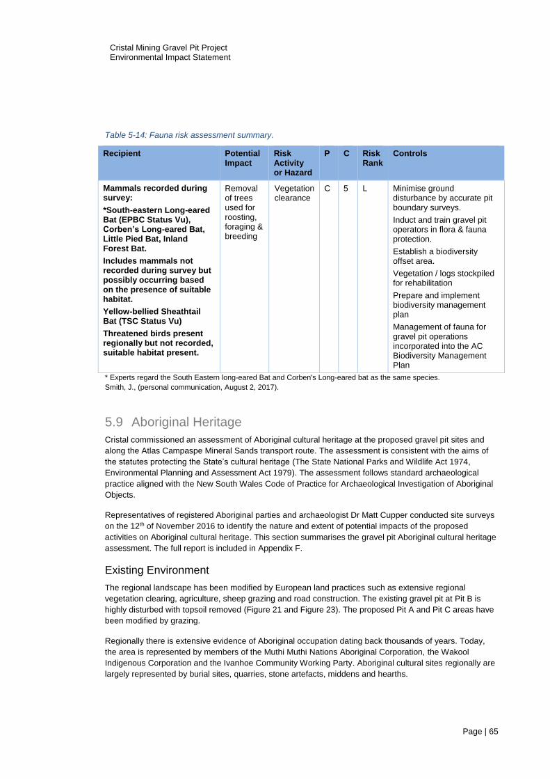
Cristal Mining Gravel Pit Project Environmental Impact Statement
Page | 65
Table 5-14: Fauna risk assessment summary.
* Experts regard the South Eastern long-eared Bat and Corben's Long-eared bat as the same species.
Smith, J., (personal communication, August 2, 2017).
5.9 Aboriginal Heritage
Cristal commissioned an assessment of Aboriginal cultural heritage at the proposed gravel pit sites and
along the Atlas Campaspe Mineral Sands transport route. The assessment is consistent with the aims of
the statutes protecting the State’s cultural heritage (The State National Parks and Wildlife Act 1974,
Environmental Planning and Assessment Act 1979). The assessment follows standard archaeological
practice aligned with the New South Wales Code of Practice for Archaeological Investigation of Aboriginal
Objects.
Representatives of registered Aboriginal parties and archaeologist Dr Matt Cupper conducted site surveys
on the 12th of November 2016 to identify the nature and extent of potential impacts of the proposed
activities on Aboriginal cultural heritage. This section summarises the gravel pit Aboriginal cultural heritage
assessment. The full report is included in Appendix F.
Existing Environment
The regional landscape has been modified by European land practices such as extensive regional
vegetation clearing, agriculture, sheep grazing and road construction. The existing gravel pit at Pit B is
highly disturbed with topsoil removed (Figure 21 and Figure 23). The proposed Pit A and Pit C areas have
been modified by grazing.
Regionally there is extensive evidence of Aboriginal occupation dating back thousands of years. Today,
the area is represented by members of the Muthi Muthi Nations Aboriginal Corporation, the Wakool
Indigenous Corporation and the Ivanhoe Community Working Party. Aboriginal cultural sites regionally are
largely represented by burial sites, quarries, stone artefacts, middens and hearths.
Recipient Potential Impact
Risk Activity or Hazard
P C Risk Rank
Controls
Mammals recorded during survey:
*South-eastern Long-eared Bat (EPBC Status Vu), Corben’s Long-eared Bat, Little Pied Bat, Inland Forest Bat.
Includes mammals not recorded during survey but possibly occurring based on the presence of suitable habitat.
Yellow-bellied Sheathtail Bat (TSC Status Vu)
Threatened birds present regionally but not recorded, suitable habitat present.
Removal of trees used for roosting, foraging & breeding
Vegetation clearance
C 5 L Minimise ground disturbance by accurate pit boundary surveys.
Induct and train gravel pit operators in flora & fauna protection.
Establish a biodiversity offset area.
Vegetation / logs stockpiled for rehabilitation
Prepare and implement biodiversity management plan
Management of fauna for gravel pit operations incorporated into the AC Biodiversity Management Plan

Cristal Mining Gravel Pit Project Environmental Impact Statement
Page | 66
The survey team discovered an isolated stone artefact (AHIMS site number 40-5-0180) at Pit C (Figure
30). The description and location of the artefact appears in Table 4 of the Aboriginal Cultural Assessment
report (Cupper 2016).
Potential Impacts and Controls
Cristal plan to implement the ACH report recommendations. The object will be protected by installing a
barrier to exclude people and earthmoving equipment from the area during active operation of the gravel
pit (Figure 30).
the exclusion zone will be appropriately fenced with a permanent 20 metre exclusion barrier;
Cristal will instruct employees, contractors and visitors not to enter the area except for approved
land management activities such as weed spraying, fence maintenance, etc.
Risk Assessment
Table 5-15 summarises the heritage impacts, risk rankings and control strategies. The artefact is at high
risk of damage where activities are uncontrolled. The risk of damage to the artefact is low where a physical
barrier is installed and personnel excluded from entry.
5.10 European Heritage
Existing Environment
Europeans have occupied and used the region for agriculture since the mid 1800’s. No European heritage
sites occur at the gravel pit locations (Niche 2012).
Potential Impacts and Controls
Not required.
Table 5-15: Aboriginal cultural heritage risk assessment summary.
Recipient Potential Impact
Risk Activity or Hazard
P C Risk Rank
Controls
Aboriginal cultural heritage
Damage to artefact AHIMS site number 40-5-0180
Damage to undiscovered artefacts
Vegetation clearance and operations
E 4 L A 20 metre radius buffer to be established around the Aboriginal object 40-5-0180
Fence the exclusion zone during the active operational phase.
Training - Cristal will instruct employees, contractors and visitors not to enter the area except for approved land management activities such as weed spraying, fence maintenance, etc.
Following the finding of new material, gravel pit activities affecting cultural objects shall cease immediately and the Office of Environment and Heritage’s Environmental Line (tel: 131 555) consulted about an appropriate course of action prior to recommencing of work.

Cristal Mining Gravel Pit Project Environmental Impact Statement
Page | 67
Figure 30: Aboriginal object 40-5-0180 at Pit C.
Cristal Mining Gravel Pit Project Environmental Impact Statement
Page | 68
5.11 Air Quality
The Atlas-Campaspe Mineral Sand Mine air quality report fully assesses emission for mine site construction,
HMC transport (Chapter8) and operations (Katestone 2013). The gravel pit development (topsoil stripping)
and operations is a minor component of the Atlas-Campaspe development. Gravel pit operations will operate
at their peak for one year during haulage route upgrades. The Atlas-Campaspe Development Consent sets
the particulate emission limits affecting private residences (Environmental Performance Condition 19).
Existing Environment
Langleydale and Magenta homesteads are the only two sensitive receptors in proximity to the proposed
gravel pits. Langleydale is 2.5 kilometres east of Pit B and 10 kilometres east of Pit A and C. Magenta is 8
kilometres from Pit B and 15 kilometres northeast of Pit A and C. The closest gravel pit (Pit B) to a residence
(Langleydale), has a very short operating life. Prevailing winds trend southeast toward Magenta and to a
lesser extent east toward Langleydale.
Potential Impacts and Controls
Particulates
Dust generated from mechanical disturbance of soil and rock by excavators and vehicles on dirt roads is the
primary air pollutant emitted by open-cut excavation. Dust impacts to residences are minimised due to the
distance to the residences, the operating life of the gravel pits and the scale of operations. Monitoring
devices measuring particulate emissions will be located at Langleydale and Magenta residences (Atlas
Campaspe Mineral sand Project Development Condition 22). Cristal propose to implement the same dust
suppression controls for the gravel pit activities as those proposed for road upgrades. No additional air
quality assessments are proposed for assessing gravel pit emissions. The gravel pit operations will be
incorporated into the Atlas-Campaspe Air Quality Management Plan (Atlas Campaspe Development Consent
Condition 21). The Plan will implement strategies for minimising impacts (Atlas Campaspe Development
In addition, due to the close proximity of the pits to the Langleydale-Wampo road, dust generated at the
gravel sites could change conditions of the road surface or impair the visibility of road users.
Greenhouse Gas
The Katestone air quality report (Resource Strategies 2012) advises that trace emissions of NOX and CO
occurring due to combustion of vehicle fuels are expected to be negligible and therefore vehicle fuel
emissions will not to be assessed for gravel pit operations.
Risk Assessment
Table 5-16 summarises potential air quality impacts, risk ranking and control strategies. The risk that dust
emissions will impact on the air quality of local residences is low. The primary gravel pit emission sources
(Pit A and Pit C) are located 8 kilometres west of the nearest residence Langleydale.
The hazard to road users is low where operations are altered to ensure that dust does not impair road user
visibility on windy days. This can be achieved by changing the location of gravel extraction on windy days
and by suppressing dust with water trucks at the gravel pits and along gravel haulage routes.

Cristal Mining Gravel Pit Project Environmental Impact Statement
Page | 69
Table 5-16: Air quality risk assessment summary.
5.12 Noise
The Atlas-Campaspe Mineral Sand Mine EIS noise report assesses the impact of transport and mining
operation noise on sensitive receptors (Resource Strategies 2013). The gravel pit development (topsoil
stripping) and operations is a minor component of the Atlas-Campaspe development. Gravel pit operations
will operate at their peak for one year during haulage route upgrades. The Atlas-Campaspe Development
Consent sets the particulate noise limits affecting private residences. (Atlas Campaspe Mineral Sand Mine
Development Consent Condition 16).
Existing Environment
Langleydale and Magenta homesteads are the only two residences proximate to the proposed gravel pits.
Langleydale is 2.5 kilometres east of Pit B and 10 kilometres east of Pt A and Pit C. Magenta is 8 kilometres
from Pit B and 15 kilometres northeast of Pit A and Pit C. Pit B is the closest gravel pit to a residence
(Langleydale) and has a very short operating life. Prevailing winds trend southeast to northwest toward
Magenta and to a lesser extent Langleydale. Cristal (Resource Strategies 2013) anticipate that traffic noise
limits for HMC haulage will be met despite a measurable increase in traffic noise. The predicted traffic noise
levels at the Magenta residence are well within day and night-time road traffic noise criteria (Atlas
Campaspe Mineral Sand Mine Development Consent Condition 16).
Recipient Potential Impact
Risk Activity or Hazard
P C Risk Rank
Controls
Private residences, Langley dale and Magenta
Dust emissions on residences
Topsoil stripping, gravel excavation, loading and transport
E 5 L Gravel pit operations peak during road upgrade
The closest residence to Pit B is 2.5 kilometers away
Pit B has a short operating life >3 months
Dust suppression controls implemented as required
Monitor dust emissions at the nearest residence as per the AC Mine Development Consent conditions
Preparation and implementation of an air quality management plan as per the AC air quality management plan
Road surface
Dust emissions alter road surface conditions
Topsoil stripping, gravel excavation, loading and transport
E 5 L Dust will be suppressed using water trucks at the gravel pits and along the haulage route.
Road users Dust emissions impair road user visibility
Topsoil stripping, gravel excavation, loading and transport
E 5 L Change the location of gravel extraction on windy days.
Dust will be suppressed using water trucks at the gravel pits and along the haulage route.
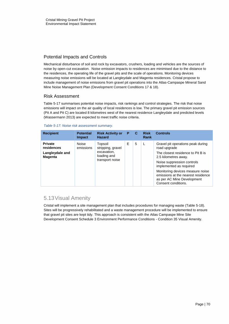
Cristal Mining Gravel Pit Project Environmental Impact Statement
Page | 70
Potential Impacts and Controls
Mechanical disturbance of soil and rock by excavators, crushers, loading and vehicles are the sources of
noise by open-cut excavation. Noise emission impacts to residences are minimised due to the distance to
the residences, the operating life of the gravel pits and the scale of operations. Monitoring devices
measuring noise emissions will be located at Langleydale and Magenta residences. Cristal propose to
include management of noise emissions from gravel pit operations into the Atlas-Campaspe Mineral Sand
Mine Noise Management Plan (Development Consent Conditions 17 & 18).
Risk Assessment
Table 5-17 summarises potential noise impacts, risk rankings and control strategies. The risk that noise
emissions will impact on the air quality of local residences is low. The primary gravel pit emission sources
(Pit A and Pit C) are located 8 kilometres west of the nearest residence Langleydale and predicted levels
(Wassermann 2013) are expected to meet traffic noise criteria.
Table 5-17: Noise risk assessment summary.
5.13 Visual Amenity
Cristal will implement a site management plan that includes procedures for managing waste (Table 5-18).
Sites will be progressively rehabilitated and a waste management procedure will be implemented to ensure
that gravel pit sites are kept tidy. This approach is consistent with the Atlas Campaspe Mine Site
Development Consent Schedule 3 Environment Performance Conditions - Condition 35 Visual Amenity.
Recipient Potential Impact
Risk Activity or Hazard
P C Risk Rank
Controls
Private residences
Langleydale and Magenta
Noise emissions
Topsoil stripping, gravel excavation, loading and transport noise
E 5 L Gravel pit operations peak during road upgrade
The closest residence to Pit B is 2.5 kilometres away.
Noise suppression controls implemented as required
Monitoring devices measure noise emissions at the nearest residence as per AC Mine Development Consent conditions.
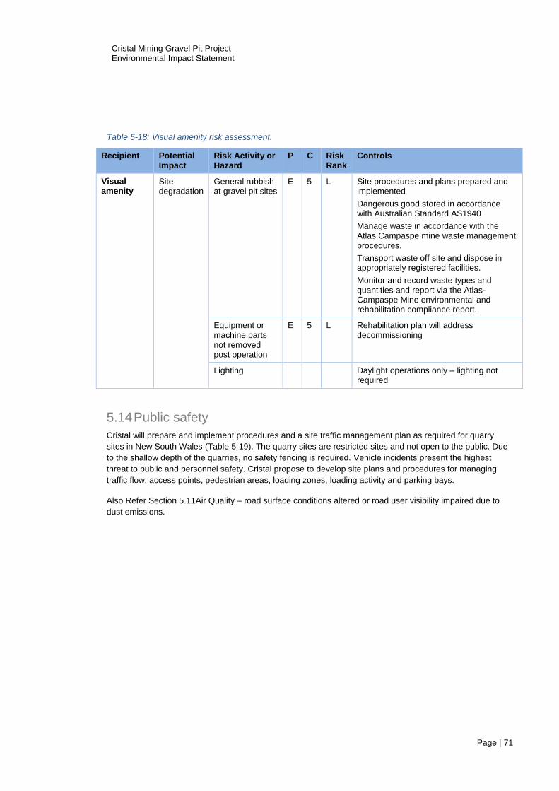
Cristal Mining Gravel Pit Project Environmental Impact Statement
Page | 71
Table 5-18: Visual amenity risk assessment.
5.14 Public safety
Cristal will prepare and implement procedures and a site traffic management plan as required for quarry
sites in New South Wales (Table 5-19). The quarry sites are restricted sites and not open to the public. Due
to the shallow depth of the quarries, no safety fencing is required. Vehicle incidents present the highest
threat to public and personnel safety. Cristal propose to develop site plans and procedures for managing
traffic flow, access points, pedestrian areas, loading zones, loading activity and parking bays.
Also Refer Section 5.11Air Quality – road surface conditions altered or road user visibility impaired due to
dust emissions.
Recipient Potential Impact
Risk Activity or Hazard
P C Risk Rank
Controls
Visual amenity
Site degradation
General rubbish at gravel pit sites
E 5 L Site procedures and plans prepared and implemented
Dangerous good stored in accordance with Australian Standard AS1940
Manage waste in accordance with the Atlas Campaspe mine waste management procedures.
Transport waste off site and dispose in appropriately registered facilities.
Monitor and record waste types and quantities and report via the Atlas-Campaspe Mine environmental and rehabilitation compliance report.
Equipment or machine parts not removed post operation
E 5 L Rehabilitation plan will address decommissioning
Lighting Daylight operations only – lighting not required
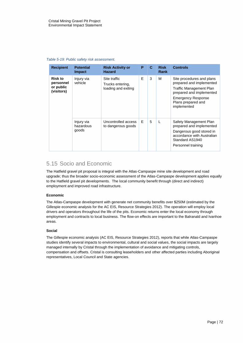
Cristal Mining Gravel Pit Project Environmental Impact Statement
Page | 72
Table 5-19: Public safety risk assessment.
5.15 Socio and Economic
The Hatfield gravel pit proposal is integral with the Atlas-Campaspe mine site development and road
upgrade; thus the broader socio-economic assessment of the Atlas-Campaspe development applies equally
to the Hatfield gravel pit developments. The local community benefit through (direct and indirect)
employment and improved road infrastructure.
Economic
The Atlas-Campaspe development with generate net community benefits over $250M (estimated by the
Gillespie economic analysis for the AC EIS, Resource Strategies 2012). The operation will employ local
drivers and operators throughout the life of the pits. Economic returns enter the local economy through
employment and contracts to local business. The flow-on effects are important to the Balranald and Ivanhoe
areas.
Social
The Gillespie economic analysis (AC EIS, Resource Strategies 2012), reports that while Atlas-Campaspe
studies identify several impacts to environmental, cultural and social values, the social impacts are largely
managed internally by Cristal through the implementation of avoidance and mitigating controls,
compensation and offsets. Cristal is consulting leaseholders and other affected parties including Aboriginal
representatives, Local Council and State agencies.
Recipient Potential Impact
Risk Activity or Hazard
P C Risk Rank
Controls
Risk to personnel or public (visitors)
Injury via vehicle
Site traffic
Trucks entering, loading and exiting
E 3 M Site procedures and plans prepared and implemented
Traffic Management Plan prepared and implemented
Emergency Response Plans prepared and implemented
Injury via hazardous goods
Uncontrolled access to dangerous goods
E 5 L Safety Management Plan prepared and implemented
Dangerous good stored in accordance with Australian Standard AS1940
Personnel training

Cristal Mining Gravel Pit Project Environmental Impact Statement
Page | 73
6 Rehabilitation Strategy
This section outlines a rehabilitation strategy for the three proposed Hatfield gravel pits. This strategy
follows the Atlas Campaspe EIS Rehabilitation Strategy (Resource Strategies 2012) and draws on
Cristal’s Murray Basin Mines Flora and Fauna Environmental Management Plan (GHD 2015). The
strategy applies the principles and relevant concepts provided in the Leading Practice Sustainable
Development Program for the Mining Industry Mine Rehabilitation Handbook (Commonwealth
Department of Industry, Tourism and Resources [DITR], 2006a).
6.1 Cristal Rehabilitation Experience
Cristal draws on considerable experience gained through rehabilitation activities at sites Australia wide;
low-impact techniques are used where possible to minimise disturbance to the natural environment. This
strategy provides the framework for gravel pit rehabilitation where the final rehabilitation outcomes and
closure requirements are developed in consultation with government agencies.
The Atlas Campaspe EIS Section 5.1 Rehabilitation Strategy (Resource Strategies 2012) outlines
Cristal’s rehabilitation experience and success at nearby Wemen, Gingko and Snapper mine sites. The
Hatfield gravel pit sites are similar in many respects including climate, land use, flora and fauna. Cristal
propose to adapt the series of environmental management plans developed for Murray Basin mines (See
GHD 2015). Cristal anticipate that rehabilitation outcomes at the Hatfield sites will be equally successful
with the implementation of a compatible strategy and proven methods.
6.2 Rehabilitation Management Plan
This rehabilitation strategy section of the EIS forms the basis of a Rehabilitation Management Plan that
details and guides the gravel pit rehabilitation. This Rehabilitation Management Plan provides:
a description of the nature and timing of rehabilitation works;
the rehabilitation planning context;
rehabilitation performance objectives, performance standards and completion criteria;
a monitoring program for evaluating environmental performance;
reporting obligations;
the closure strategy;
a description of how the Rehabilitation Management Plan performs to meet the objectives of
related plans (e.g. Biodiversity Management Plan, MOP and Mine Closure Plan).
6.3 Rehabilitation Objectives
Rehabilitation objectives are consistent with the Atlas Campaspe Development Consent Schedule 3
Environment Performance Conditions for Rehabilitation and the AC EIS Rehabilitation Strategy
(Resource Strategies 2012). The processes for restoring the landform for the gravel pit site are less
complex than those required for rehabilitating the Atlas Campaspe mine site given that:

Cristal Mining Gravel Pit Project Environmental Impact Statement
Page | 74
average excavation depth is less than 0.5m;
activities and methods are the same for the three sites;
risk is low in relation to contaminants, surface water hydrology, erosion, and groundwater;
there are no process by-products requiring management
the most significant impact occurs in the first year of operation and thereafter a small operation
will be maintained on a campaign basis for road maintenance materials.
Rehabilitation objectives for the Hatfield Gravel Pits sites are to:
create safe, stable and non-polluting landforms;
decommission all infrastructure;
restore self-sustaining ecosystems consistent with the surrounding land-use;
minimise impacts and preserve existing vegetation and topography where possible;
rehabilitate progressively;
establish self-propagating vegetation cover using native species characteristic of the cleared
vegetation communities:
exclude livestock from rehabilitation areas during operations and periods of vegetation
establishment;
manage topsoils to preserve soil integrity;
monitor to assess rehabilitation performance on an annual basis against performance
standards and completion criteria;
Final landform
The Hatfield West Gravel Pit Project general topography is undulating flat plains interspersed with few
dunes. For rehabilitation purposes Pit A, Pit B and Pit C are regarded as separate domains. The final
rehabilitated landform will complement the surrounding landscape by ensuring:
the final restored landscape profile closely matches the surrounding topography;
creation of closed depressions consistent with pre-mining topography;
a safe, stable and non-polluting landscape;
re-establishment of native vegetation species characteristic of vegetation communities cleared
and
self-sustaining ecosystems suitable for a final use of light intensity grazing.
6.4 Management of Rehabilitation Materials
Vegetation and soils are to be removed and stockpiled adjacent to the mine path for use in mined land
rehabilitation. Vegetation will be pushed into a windrow, including logs, trunks and branches. Following
vegetation clearance, top soil and subsoil, along with residual vegetation (leaf litter, branches), will be
scraped up and placed in low profile stockpiles.
The average overburden thickness (topsoil, sub-soil, waste rock) is 320mm (Goldman 2016). Minor
variations in overburden depth and soil type vary with changes in landform. After the stripping of topsoil,
any further overburden (subsoil) that needs to be removed will be placed in separate stockpiles.
When soils are replaced over the mined surface, the materials will be replaced in original sequence:
waste rock, sub-soil and topsoil respectively. The light fine sandy clays are susceptible to erosion,
particularly when disturbed. Sluiter (2017) recommends special consideration be given to soil stripping
and stockpiling. The following management approaches will be applied:

Cristal Mining Gravel Pit Project Environmental Impact Statement
Page | 75
avoid soil stripping on windy days;
use mulch on stockpiles;
suppress dust using water trucks;
use mulch slurries over newly bare surfaces where required;
use trees removed during clearing as wind breaks/barriers.
6.5 Rehabilitation Methodology
The seven step approach used for rehabilitation programs at the Gingko, Snapper and Wemen mine
sites (Resources Strategies 2013), will be adapted for rehabilitation of the gravel pits. This methodology
is defined as:
1. pre-clearance survey to describe flora, fauna and soil profiles;
2. strip and store topsoil, subsoil and vegetation; collect seeds for future use;
3. progressively backfill mined out gravel pit areas with overburden as mining advances. The
overburden is typically calcrete or other rocky materials set aside as unsuitable for road
construction material;
4. return stockpiled soils to the location from where the soil was removed;
5. prepare topsoil (levelling, ripping);
6. seed and/or hand-plant native species as prescribed in the revegetation plan for each site;
7. maintain and enhance revegetation where necessary.
Site preparation – preclearance surveys
Preclearance surveys are required to ensure:
topography, vegetation and soils are quantified, characterised & mapped;
clearance boundaries are surveyed accurately;
a stripping plan is prepared; and
contractors are trained and inducted in procedures.
Vegetation clearing and soil stripping
It is proposed that sufficient vegetation will be cleared at Pit A to provide gravel supplies for haul road
upgrades for a six-month period (i.e. the initial road upgrade period). Pit C will be developed as required,
following a review of gravel requirements after Pit A is depleted. Table 6-1 summarises the coverage of
native vegetation and cleared areas existing at the gravel pit sites. Vegetation will be cleared using
bulldozers and a linked chain to pull trees down to ground level. This is the same method used at
Cristal’s Pooncarie West mining precinct. The tree stumps and branches will be stockpiled for later use in
the rehabilitation program.
The sequence of clearing and stripping is:
prior to clearing all hollows and other potential harbour for native species will be checked and
fauna located/removed and released as soon as possible;
feral animals will be controlled to protect newly rehabilitated areas by incorporating the gravel
pits areas into the Atlas Campaspe Biodiversity Management Plan;
chain dragging;
stockpile trunks, logs & branches;
collect seed from selected trees/shrubs and propagate for rehabilitation use;
strip soils and stockpile as per development plan.
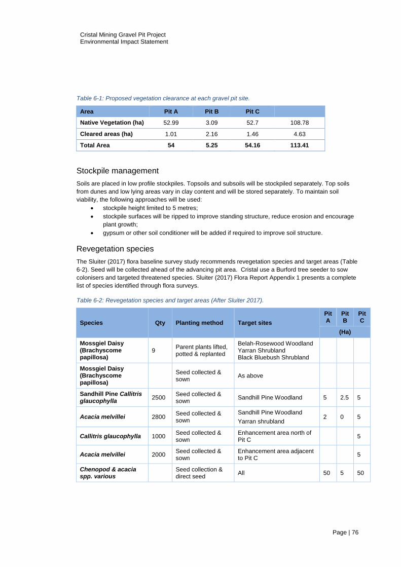
Cristal Mining Gravel Pit Project Environmental Impact Statement
Page | 76
Table 6-1: Proposed vegetation clearance at each gravel pit site.
Area Pit A Pit B Pit C
Native Vegetation (ha) 52.99 3.09 52.7 108.78
Cleared areas (ha) 1.01 2.16 1.46 4.63
Total Area 54 5.25 54.16 113.41
Stockpile management
Soils are placed in low profile stockpiles. Topsoils and subsoils will be stockpiled separately. Top soils
from dunes and low lying areas vary in clay content and will be stored separately. To maintain soil
viability, the following approaches will be used:
stockpile height limited to 5 metres;
stockpile surfaces will be ripped to improve standing structure, reduce erosion and encourage
plant growth;
gypsum or other soil conditioner will be added if required to improve soil structure.
Revegetation species
The Sluiter (2017) flora baseline survey study recommends revegetation species and target areas (Table
6-2). Seed will be collected ahead of the advancing pit area. Cristal use a Burford tree seeder to sow
colonisers and targeted threatened species. Sluiter (2017) Flora Report Appendix 1 presents a complete
list of species identified through flora surveys.
Table 6-2: Revegetation species and target areas (After Sluiter 2017).
Species Qty Planting method Target sites
Pit A
Pit B
Pit C
(Ha)
Mossgiel Daisy (Brachyscome papillosa)
9 Parent plants lifted, potted & replanted
Belah-Rosewood Woodland Yarran Shrubland Black Bluebush Shrubland
Mossgiel Daisy (Brachyscome papillosa)
Seed collected & sown
As above
Sandhill Pine Callitris glaucophylla
2500 Seed collected & sown
Sandhill Pine Woodland 5 2.5 5
Acacia melvillei 2800 Seed collected & sown
Sandhill Pine Woodland
Yarran shrubland 2 0 5
Callitris glaucophylla 1000 Seed collected & sown
Enhancement area north of Pit C
5
Acacia melvillei 2000 Seed collected & sown
Enhancement area adjacent to Pit C
5
Chenopod & acacia spp. various
Seed collection & direct seed
All 50 5 50

Cristal Mining Gravel Pit Project Environmental Impact Statement
Page | 77
Erosion control
Landscape erosion is low risk because of the shallow relief and low annual rainfall. The key
management approach to mitigate wind or water erosion is to keep stockpiles low profile, minimise
cleared areas and progressively rehabilitate mined areas.
Weed Control
Sluiter (2017) identified thirty-seven exotic plant species, including the weeds of national significance
(WONS), African Boxthorn. The introduction and spread of new weeds into disturbed areas will be
managed by:
scheduled inspections of the mining tenement, internal roads, mine path and utility areas;
mechanical removal and/or the application of approved herbicides in areas affected by weeds;
specific control for noxious weeds; and
control of boxthorn.
Pest Animal Control
GHD did not record animal pests during the 2017 fauna survey. However, goats, cats and foxes are
known to be common in the region. These pest animals will be managed by:
passive monitoring (recording of pest animal occurrences by contractors);
fencing, to keep livestock and pest animals out of gravel pit areas during operations and
rehabilitation periods, and
approved baiting / trapping if necessary.
Fauna refuge
Cristal propose to implement two strategies that provide refuge for fauna in the early stages of
rehabilitation:
install nest boxes (on poles if required);
replace logs and branches;
passive surveying and annual reporting of nest box habitation, as part of the Atlas Campaspe
Mineral Sand Mine environmental monitoring program.

Cristal Mining Gravel Pit Project Environmental Impact Statement
Page | 78
7 References
Cupper, M. 2016, `Atlas Campaspe Mineral Sands Project HMC Transport Route Gravel Pits. Aboriginal
Cultural Heritage Due Diligence Assessment’. Unpublished report to Cristal Mining, 2016.
GHD Pty Ltd, 2015, `Cristal Mining Australia Ltd Murray Basin Mines Flora and Fauna Environmental
Management Plan’. Unpublished plan for Cristal Mining, 2015.
GHD Pty Ltd, 2017, `Cristal Mining Australia Ltd Gravel Pits Fauna Survey’. Unpublished Report to
Cristal Mining, 2017.
Goldman, M., [email protected]. Extraction boundary coordinates and maps for Andrew
Minns. 9th September 2016.
NSW Rural Fire Service 25 July 2017 Online http://www.rfs.nsw.gov.au/plan-and-prepare/building-in-a-
bush-fire-area/planning-for-bush-fire-protection/bush-fire-prone-land/check-bfpl
Reeves, J., 2012, `Atlas-Campaspe Mineral Sands Project Aboriginal and Non-Aboriginal Cultural
Heritage Assessment.’, Niche Environment and Heritage Pty Ltd.
Resource Strategies Pty Ltd, 2012. Atlas Campaspe Mineral Sands Project Environmental Impact
Statement. Unpublished Report to Cristal Mining.
Sluiter, I.R.K. and Allen, G.G., 2017, ‘Flora Report on Cristal Mining Australia’s Hatfield West Gravel Pit
EIS Project.’ Ecological Report No. 2016/05, Ogyris.
Sluiter, I.R.K., Allen G.G,. and Holmes, A., 2017, ‘Offset Report on Cristal Mining Australia’s Boree
Plains Property’ Ecological Report No. 2016/06, Ogyris

Cristal Mining Gravel Pit Project Environmental Impact Statement
Page | 79
Appendix A. Agency Correspondence & Regulatory
Documents.

Cristal Mining Gravel Pit Project Environmental Impact Statement
Page | 80
Appendix B. Extractives Licence Application – maps and
coordinates

Cristal Mining Gravel Pit Project Environmental Impact Statement
Page | 81
Appendix C. Landholder Letter of Consent

Cristal Mining Gravel Pit Project Environmental Impact Statement
Page | 82
Appendix D. Hatfield Flora Report Sluiter, I.R.K. and Allen, G.G., 2016, ‘Flora Report on Cristal Mining Australia’s Hatfield West Gravel Pit EIS
Project.’ Ecological Report No. 2016/05, Ogyris.

Cristal Mining Gravel Pit Project Environmental Impact Statement
Page | 83
Appendix E. Hatfield Fauna Report GHD Pty Ltd (2017), `Cristal Mining Australia Ltd Gravel Pits Fauna Survey’. Unpublished Report to Cristal
Mining, 2017.
Cristal Mining Gravel Pit Project Environmental Impact Statement
Page | 84
Appendix F. Hatfield Aboriginal Heritage Report Cupper, M. 2016. `Atlas Campaspe Mineral Sands Project HMC Transport Route Gravel Pits. Aboriginal Cultural
Heritage Due Diligence Assessment’. Unpublished report to Cristal Mining, 2016.

Cristal Mining Gravel Pit Project Environmental Impact Statement
Page | 85
Appendix G. Gravel Pit Offset Report