creek road, greenwich, london borough of greenwich · creek road, greenwich, london borough of...
TRANSCRIPT
Creek Road, Greenwich, London Borough of Greenwich
An Archaeological Desk-Based Assessment
for Rock Investments PLC
by Steve Ford
Thames Valley Archaeological Services Ltd
Site Code CRG05/01
March 2005
1
Creek Road, Greenwich, London Borough of Greenwich An Archaeological Desk-Based Assessment
Report 05/01
by Steve Ford
Introduction
This desk-based study is an assessment of the archaeological potential of a parcel of land on the south side of
Creek Road, Greenwich, London Borough of Greenwich (TQ 3815 7768) (Fig. 1). The project was
commissioned by Mr James Holmes of Planning and Regeneration, 1 Avebury Court, Mark Road, Hemel
Hempstead, HP2 7TA on behalf of Rock Investments Plc, 315 Regents Park Road, London N3 1DP. It
comprises the first stage of a process to determine the presence/absence, extent, character, quality and date of
any archaeological remains which may be affected by redevelopment of the area.
Site Description, Location and Geology
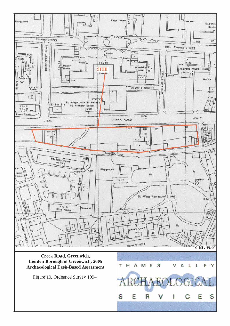
The site comprises an elongated parcel of land c. 0.45 hectares in area, between Creek Road to the north and
Bardsley Lane to the south (Fig. 10). The site lies at a height of approximately 5.5m above Ordnance Datum.
According to the British Geological Survey, the western part of the site lies on alluvium which is a part of the
drainage network of Deptford Creek located to the west and its confluence with the Thames to the north. The
eastern side of the site is on river gravel (BGS 1981).
A visit on 12th March 2005 revealed a variety of uses of the site with the majority of the boundaries and
structures shown on Figure 10 still extant. Much of the site is a grassy area clear of structures with an informal
footpath crossing from Bardsley Lane to Creek Road. On Creek Road, the western end of the site (numbers 258
and 260) is occupied by semi-derilict and unstable structures supported by scaffolding. They are of 19th-century
date and possibly the same as those depicted on the 1838 Tithe map. One of these was a public house. To the
east, both the Lord Hood public house (no. 300) and adjacent comedy club (302) are extant. The public house
appears to have been constructed after 1916, whereas the comedy club was formerly St Peter’s School and was
built prior to 1869 but after 1838, and possibly rebuilt or modified subsequently as a hall. It is a locally listed
building. To the north-east is a three-storey block of apartments built since 1968, and probably within the 1980s.
Structures fronting Bardsley Lane mainly comprise sheds and yards but with a subsiding brick-built structure to
the rear of the Lord Hood constructed since 1916 and possibly rebuilt much later in the 20th century. It is not
known if any of the structures contained basements.
2
Planning Background and Development Proposals
Planning permission is to be sought for the redevelopment of the site for residential and commercial/retail use.
Five blocks are proposed with variable heights up to five storeys with commercial/retail accommodation on the
ground floor. A basement carpark is proposed for most of the western part of the development with a club in the
basement at the eastern end of the development. The locally listed building (302 Creek Road) currently occupied
by the Comedy Club is to be retained within the development. The height of the development block at the
eastern end of the site which is to lie within the proposed World Heritage Site buffer zone is lower than the
proposed block to the west and is of similar height to the adjacent listed building. This is summarized in Figure
11.
Archaeology and Planning (PPG 16 1990) provides guidance relating to archaeology within the planning
process. It points out that, where a desk-based assessment has shown that there is a strong possibility of
significant archaeological deposits in a development area, it is reasonable to provide more detailed information
from a field evaluation so that an appropriate strategy to mitigate the effects of development on archaeology can
be devised:
Paragraph 21 states:
‘Where early discussions with local planning authorities or the developer’s own research indicate that important archaeological remains may exist, it is reasonable for the planning authority to request the prospective developer to arrange for an archaeological field evaluation to be carried out...’
Should the presence of archaeological deposits be confirmed further guidance is provided. Archaeology and
Planning stresses preservation in situ of archaeological deposits as a first consideration as in paragraphs 8 and
18.
Paragraph 8 states:
‘...Where nationally important archaeological remains, whether scheduled or not, and their settings, are affected by proposed development there should be a presumption in favour of their physical preservation...’
Paragraph 18 states:
‘The desirability of preserving an ancient monument and its’ setting is a material consideration in determining planning applications whether that monument is scheduled or unscheduled...’
However, for archaeological deposits that are not of such significance it is appropriate for them to be ‘preserved
by record’ (i.e. fully excavated and recorded by a competent archaeological contractor) prior to their destruction
or damage.
Paragraph 25 states:
3
‘Where planning authorities decide that the physical preservation in situ of archaeological remains is not justified in the circumstances of the development and that development resulting in the destruction of the archaeological remains should proceed, it would be entirely reasonable for the planning authority to satisfy itself ... that the developer has made appropriate and satisfactory provision for the excavation and recording of remains.’
Further guidance is provided by the London Borough of Greenwich Unitary Development Plan (LBGUDP 1994)
LB Greenwich Policy D27A: ‘At identified sites of known archaeological remains of national importance, including scheduled monuments, there will be a presumption in favour of the physical preservation of the remains in situ and to allow for public access and display. For sites of lesser importance the council will seek to preserve the remains in situ, but where this is not feasible the remains should be either excavated and removed from the site, or excavated and recorded before destruction. Appropriate conditions/legal agreements may be used to ensure this is satisfied.’
Policy D27B: ‘The Council will expect applicants to properly assess and plan for the impact of proposed developments on archaeological remains where they fall within ‘Areas of Archaeological Potential’ as defined on the constraints map 10. In certain instances preliminary archaeological site investigations may be required before proposals are considered. The Council will seek to secure the co-operation of developers in the excavation, recording and publication of archaeological finds before development takes place by use of planning conditions/legal agreements as appropriate.’
The site falls within the Borough’s ‘Area of Archaeological Potential’ (LBGUDP 1994, map 10).
Both the wording of the policies and the Area of Archaeological Potential map in the second deposit draft
of the forthcoming Unitary Development Plan (April 2004) are unaltered though the policy numbers would now
become D29A and D29B respectively.
World Heritage Site
The eastern margins of the site (east of 302 Creek Road, Fig. 10) lies within the buffer zone for the World
Heritage Site. The Greenwich World Heritage Site was designated in 1997 and the zone and buffer zone are
defined on the constraints map for the second deposit draft of the forthcoming Unitary Development Plan.
Proposed policy TC7 states:
‘The Council will protect and enhance the site and setting of the Maritime Greenwich World Heritage Site, as defined on the Proposals Map. Development within it should preserve and enhance its essential and unique character and appearance. Views and vista to and from the World Heritage Site will also be protected by ensuring that developments in the buffer zone of the site or directly visible from it are visually sympathetic’.
The site is not visible in the vista from the Wolfe Monument within the Heritage Site but is visible in the vista
from Eltham Park towards Central London as presented in the second deposit draft Unitary Development Plan.
Methodology
4
The assessment of the site was carried out by the examination of pre-existing information from a number of
sources recommended by the Institute of Field Archaeologists paper ‘Standards in British Archaeology’
covering desk-based studies. These sources include historic and modern maps, the Greater London Sites and
Monuments Record, geological maps and any relevant publications or reports.
Archaeological Background
General background
The lower stretch of the Thames Valley is rich in finds of many periods (Williams and Brown 1999). Many
archaeological deposits, covering extensive tracts of the gravel terraces north of the estuary, have been
discovered by aerial photography but the nature and extent of occupation and use of lower-lying areas has only
come to light in more recent times. River margins, creeks and inlets, including those of the Thames, were
preferred areas of settlement in earlier periods, but study of this use is hampered by subsequent inundation due
to a rise in sea level and the deposition of deep alluvium. Fieldwork has, nevertheless, located areas of
occupation with good preservation of organic remains typified by the examples of wooden trackways laid down
to cross low-lying ground in the Bronze Age and earlier (Meddens 1996). The areas of higher ground (e.g.
gravel terrace margins) overlooking lower-lying, seasonally-flooded land are a preferred topographic location
for occupation. In this context, it should be noted that the site lies partly on the alluvial and tidal floodplain of
the Ravensbourne River (Deptford Creek), close to its confluence with the Thames. The eastern part of the site
lies on a gravel terrace forming higher ground.
The later history of the area is that of the development of Saxon and medieval Deptford on the west side of
Deptford Creek, especially the development of the shipbuilding industry. This became of particular prominence
with the establishment of Henry VIII’s naval dockyard in 1513, Deptford becoming the most important dock on
the Thames. In the medieval period as for the north bank of the Thames, a rising sea level caused extensive
flooding and much energy was devoted to land reclamation and flood defence works (Steele 1999).
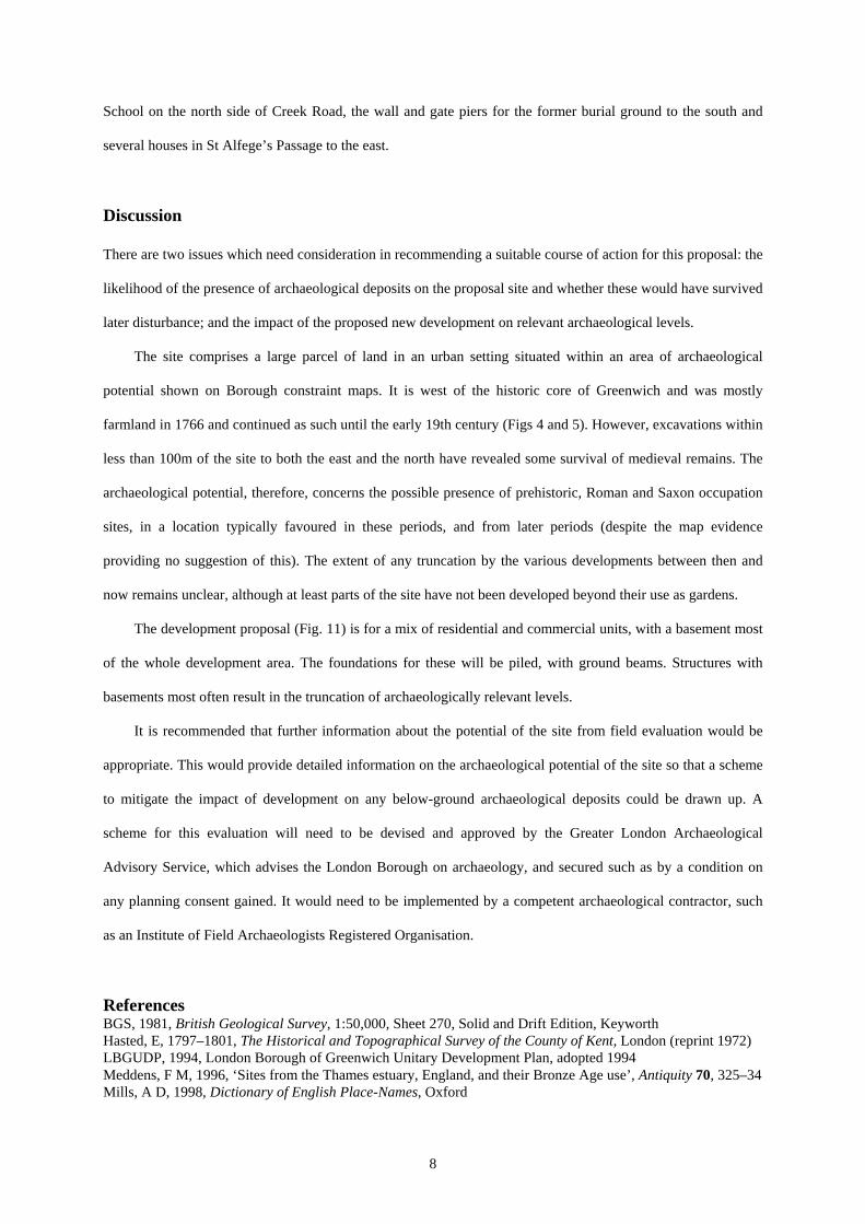
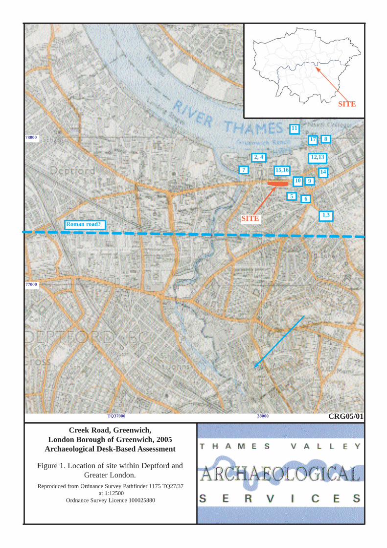
Greater London Sites and Monuments Record
A search of the Greater London Sites and Monuments Records (GLSMR) was made on 6th January 2005. This
report details those entries within a 500m radius of the site with a summary in Appendix 1. The locations of the
5
entries are shown on Figure 1. The detailed search revealed 17 entries, mostly of medieval and post-medieval
date. There were no entries for the site itself.
The earliest entry is that for the findspot of a Neolithic polished stone axe [Fig. 1: 4]. This is the only
prehistoric entry for the study area.
Roman entries are also few. The findspot of a bronze box is recorded to the north [2] and occupation
deposits comprising a pit, posthole and stake hole were recorded during a watching brief to the west [12]. The
line of the Roman road from Canterbury to London (Watling Street), which roughly follows the line of the A2 is
reasonably well known to the east but is lost through the Deptford area, although it might be expected that the
bridging point across the creek is close to the historic location of Deptford Bridge just to the south of the study
area.
Similarly there are only two entries for the Saxon period. Greenwich is first documented in AD964 but was
later part of the large manor of Lewisham and is not mentioned separately in Domesday Book (1086). It is
assumed therefore that a manor house for Greenwich was present in or near the historic core of the settlement
though its location is as yet unknown [9]. The church of St Alfege was first built in 1012 to commemorate the
martyrdom of Archbishop Alfege (sometimes Ælphege)who was taken when the Danes sacked Canterbury and
murdered by them in 1011. The church has been rebuilt on several occasions subsequently [6], most notbaly by
Nicholas Hawksmoor (1711–14).
Several entries are for the medieval period. A large excavation in advance of the development of the Cutty
Sark station mostly revealed a complex of buildings dating from the 16th century and later. However, the
earliest activity on that site was dumping in the 12th century with one pit of later, 13th century date [15].
Similarly a pit of 12/13th century date was also found during excavation of later deposits [10]. St Alfege’s
Churchyard lies to the south of the site and presumably was in use as a burial ground in medieval and post-
medieval times as the church [6]continued in use.
Post-medieval entries are more plentiful. Early post-medieval structural remains have been extensively
excavated [15] at the site of the Cutty Sark Station and various foundations and other structural remains of
17th/18th century date have been recorded at the Naval College and elsewhere [1, 12, 13, 14]. 16th century
pottery has been recorded on the Thames foreshore [8]. Later post-medieval entries include a well, [3],
Greenwich Pier, built in 1836 [17], The foot tunnel under the Thames to Milwall [11] and various revetments
and dumping [7].
6
There are no scheduled monuments on or immediately adjacent to the site. The World Heritage Site
boundary lies c. 100m to the east but the eastern part of the site lies within the Heritage Site buffer zone.
Historic Background
Greenwich was first documented in AD964 as Grenwic (green port or harbour) and is mentioned in Domesday
Book (Grenviz) (Mills 1998). It gave its name to the hundred until Edward I’s time when the hundred name
became Blackheath. At the time of Domesday it was held by the Bishop of Lisieux from the Bishop of Bayeux.
‘It is assessed at 2 sulungs. There is land in demesne for 2 ploughs; 24 villans have 4 ploughs and there are 4 bordars, 1 cottar and 5 slaves. There are 4 mills rendering 70s, 22 acres of meadow, 40 acres of pasture and woodland for 10 pigs. These 2 sulungs at the time of King Edward were two manors one held by Earl Harold and one by Beohtsige but are now one. They were worth £8 and are no worth £12’ (Williams and Martin 2002, 16).
The settlement was also know as East Greenwich to distinguish it from Deptford west of Deptford Creek.
Greenwich was no more than a settlement based on fishing in medieval times and not until post-medieval times
did its prosperity rise with the creation of Greenwich Park, the Observatory and the Naval School (Hasted 1797–
1801, 372).
Cartographic and Documentary Sources
A range of Ordnance Survey and other historical maps of the area were consulted at Greenwich Heritage Centre
in order to ascertain what activity had been taking place throughout the site’s later history and whether this may
have affected any possible archaeological deposits within the proposal area (Appendix 2).
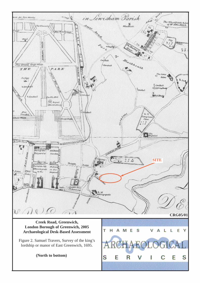
The earliest detailed map consulted was a survey of the King’s lordship of the manor of East Greenwich
made by Samuel Travers in 1695 (Fig. 2). This indicates that the site area is undefined and presumably farmland
but with a distinctive bend in Lamb Lane (an earlier name for Bardsley Lane) indicating the easternmost limit of
the proposal site.
Hawksmoor’s map of 1728 does not show the site though the line of Creek Road and even the bridge of
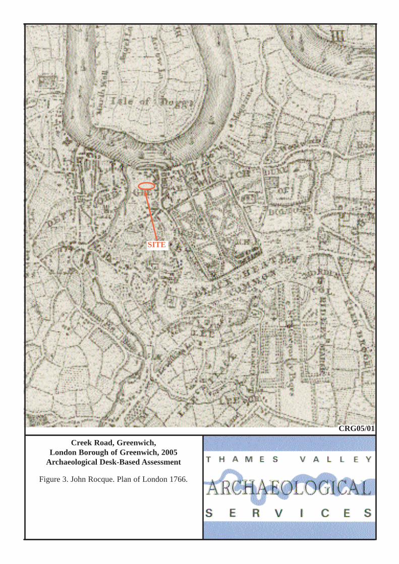
Deptford Creek are indicated, a later addition to this copy of the map. John Rocque’s map of London dated 1762
(Fig. 3) shows Deptford and Greenwich at a small scale. The area of the site can be located relative to the road
pattern, the church of St Alfege and from the Creek. The site appears to lie in an undefined area beyond the rear
of properties on the west side of Church Street in what is presumed to be farmland. Creek Road has not yet been
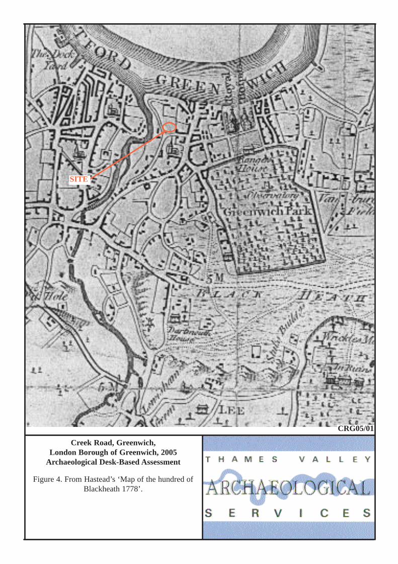
constructed. Hasted’s ‘Map of the Hundred of Blackheath’ dated 1778 shows Greenwich and Deptford at a
larger scale (Fig. 4) (Hasted 1797–1801, 339ff). The environs of the site can be identified and unlike Rocque’s
7
map of some 20 years earlier, an east-west road north of the church might be Bardsley Lane (which forms the
southern boundary of the site). The proportions of the map are out, in comparison to modern maps which makes
a detailed examination difficult though it seems likely that no structures are present for the site.
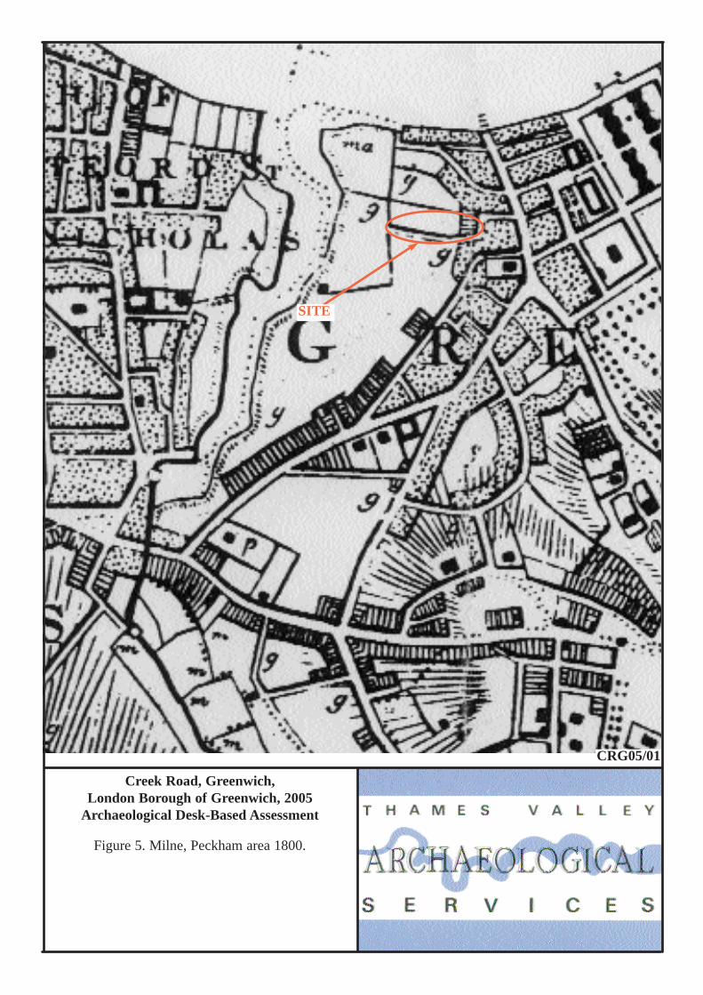
Milne’s map from 1800 shows a road which can be reliably interpreted as Bardsley Lane (Fig. 5). The site
area is mostly unoccupied grassland but the easternmost part is occupied by five house plots though it is unclear
if this is a realistic or merely schematic depiction. Neither Creek Road nor the bridge over the Creek has been
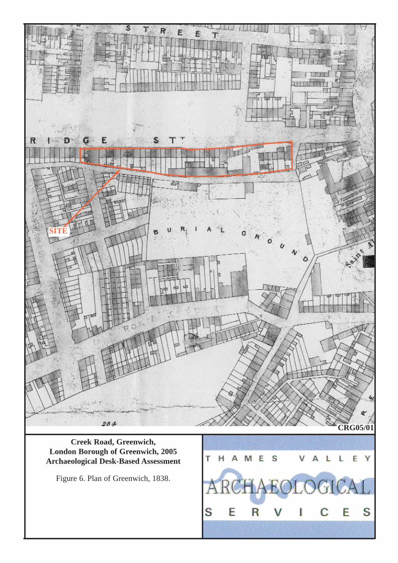
built. The next map consulted was a plan of Greenwich in 1838 which showed that the bridge and Creek Road
(Bridge Street) were built (Fig. 6). This showed the site in detail and indicated that the whole of the Creek Road
frontage for the site was occupied by terraced houses with several larger buildings, particularly so on Bardsley
Lane (not named on this map but known as Lamb Lane at this time). The environs of the site in general had seen
marked change with much terraced housing present and St Alfege's Cemetery to the south. The house plots
shown on Milne’s map are not now indicated. A map of the suburbs of London of 1866 by Edward Weller only
depicts the site schematically but does name some of the institutions present on the site.
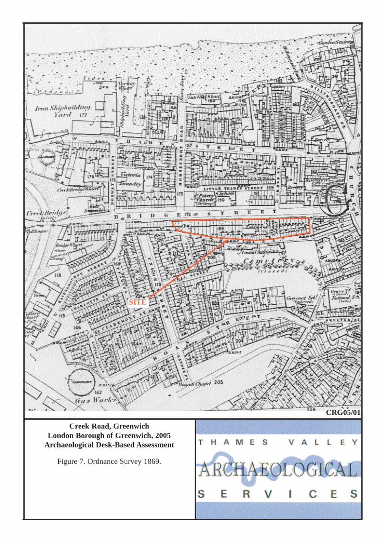
The First Edition of the Ordnance Survey dated 1869 (Fig. 7). shows a similar pattern to that in 1838.
Bardsley Lane is shown as Lamb Lane. The site is densely occupied by terraced houses fronting both Creek
Road and Bardsley Lane with a school and two public houses building present.
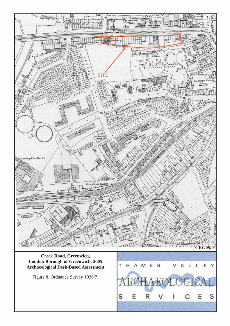
On the Second and Third Edition Ordnance Survey maps (1894–6 and 1916) there is relatively little change
indicated. Rather more change is indicated by 1937 with the terraced houses fronting Bardsley (Lamb) Lane no
longer present and more open space (Fig. 8).
The site escaped bomb damage during The Blitz in 1940 and subsequently, but several houses on Bardsley
were cleared at this time and St Alfege’s sustained some damage.
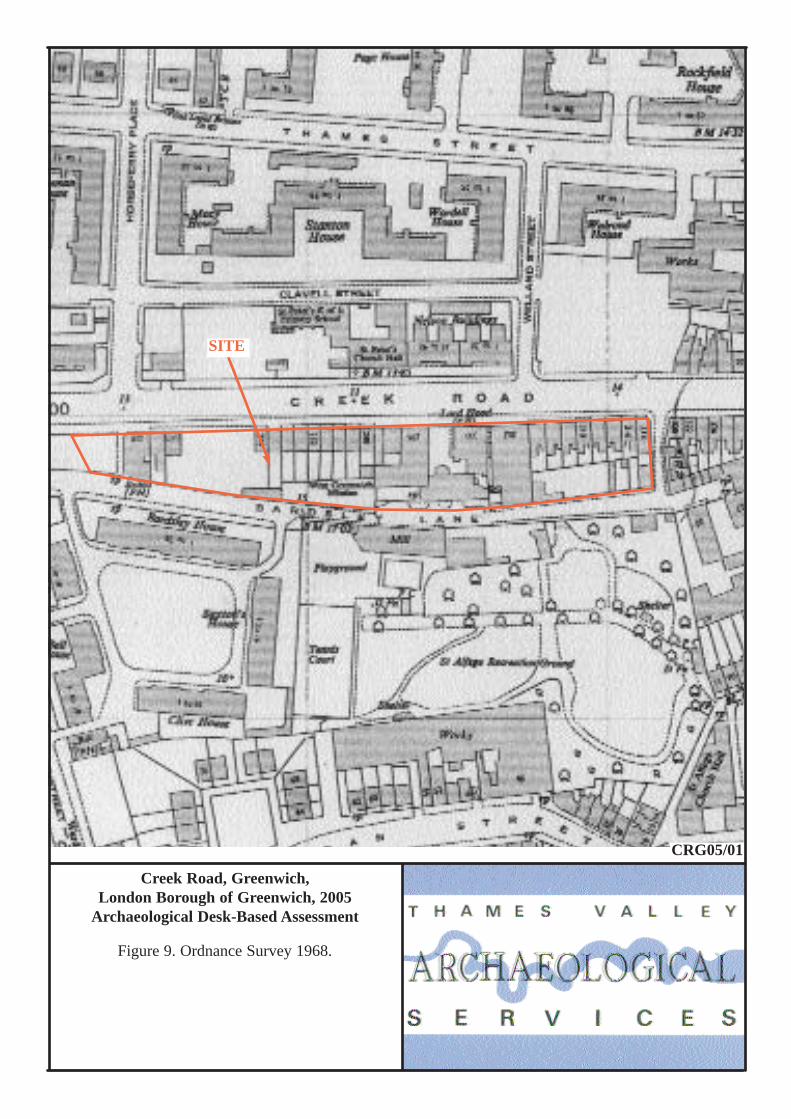
Relatively few changes are noted on the Ordnance Survey map of 1952 but with progressive clearance of
plots on the 1968 edition (Fig. 9) and 1994 edition (Fig. 10) and with some new apartments built at the eastern
end of the site in the 1970s or 1980s.
Listed Buildings
There are no statutory listed buildings on the site noted in the Greater London Sites and Monuments Record but
there are eight listed structures within 200m of the site (Appendix 1). However 302 Creek Road on the site is
locally listed and is to be retained within the development proposal. The nearest listed buildings are the Church
8
School on the north side of Creek Road, the wall and gate piers for the former burial ground to the south and
several houses in St Alfege’s Passage to the east.
Discussion
There are two issues which need consideration in recommending a suitable course of action for this proposal: the
likelihood of the presence of archaeological deposits on the proposal site and whether these would have survived
later disturbance; and the impact of the proposed new development on relevant archaeological levels.
The site comprises a large parcel of land in an urban setting situated within an area of archaeological
potential shown on Borough constraint maps. It is west of the historic core of Greenwich and was mostly
farmland in 1766 and continued as such until the early 19th century (Figs 4 and 5). However, excavations within
less than 100m of the site to both the east and the north have revealed some survival of medieval remains. The
archaeological potential, therefore, concerns the possible presence of prehistoric, Roman and Saxon occupation
sites, in a location typically favoured in these periods, and from later periods (despite the map evidence
providing no suggestion of this). The extent of any truncation by the various developments between then and
now remains unclear, although at least parts of the site have not been developed beyond their use as gardens.
The development proposal (Fig. 11) is for a mix of residential and commercial units, with a basement most
of the whole development area. The foundations for these will be piled, with ground beams. Structures with
basements most often result in the truncation of archaeologically relevant levels.
It is recommended that further information about the potential of the site from field evaluation would be
appropriate. This would provide detailed information on the archaeological potential of the site so that a scheme
to mitigate the impact of development on any below-ground archaeological deposits could be drawn up. A
scheme for this evaluation will need to be devised and approved by the Greater London Archaeological
Advisory Service, which advises the London Borough on archaeology, and secured such as by a condition on
any planning consent gained. It would need to be implemented by a competent archaeological contractor, such
as an Institute of Field Archaeologists Registered Organisation.
References BGS, 1981, British Geological Survey, 1:50,000, Sheet 270, Solid and Drift Edition, Keyworth Hasted, E, 1797–1801, The Historical and Topographical Survey of the County of Kent, London (reprint 1972) LBGUDP, 1994, London Borough of Greenwich Unitary Development Plan, adopted 1994 Meddens, F M, 1996, ‘Sites from the Thames estuary, England, and their Bronze Age use’, Antiquity 70, 325–34 Mills, A D, 1998, Dictionary of English Place-Names, Oxford
9
PPG16, 1990, Department of the Environment Planning Policy Guidance note 16, Archaeology and Planning, HMSO
Steele, J, 1999, Deptford Creek, surviving regeneration, Deptford Forum Publishing, London Williams, J and Brown, N (eds), 2000, An Archaeological Research Framework for the Greater Thames
Estuary, Essex County Council, Chelmsford Williams, A and Martin, G H, 2002, Domesday Book, A complete Translation, London
10
APPENDIX 1: Sites and Monuments Record entries
No SMR Ref Grid Ref (TQ) Type Period Comment 1 070242/00/
00 38407750 Occupation Post-Medieval (17th-8th century) Brick footings, cess pit, well, metalled
road 2 070385 37957790 Findspot Roman Bronze Box 3 071070 38407750 Structure Post Medieval Well 4 110011 37957790 Findspot Neolithic Polished stone axe head 5 070323/01 38187765 Churchyard Medieval/post-medieval
St Alfege’s
6 070323 38307760 Church Late Saxon- post-medieval Built to commemorate martyrdom of St Alfege in 1012. Rebuilt subsequently
7 071534-5 37887777 Revetment and dumping
Post-medieval (19th century) Watching brief NWS97
8 071551 38427797 Pottery Post-medieval (16th century) Thames foreshore survey FGW04 9 071583 383777 Documentary late Saxon/ Medieval Greenwich Manor house documented in
AD 964 10 071846-8 38237774 Pit
Occupation Medieval (12-13th century) Post-medieval (17th/18th century)
Excavation DXL97
11 222457 38267791-38317828
Foot tunnel Post-medieval (19th century) Foot tunnel under the Thames
12 LO75706 LO75711 LO76791
38387785 Occupation, Structural remains, Dump layers
Roman Post-medieval (18th century)
Watching brief RNP99
13 LO75707 38397790 Dumps Post-medieval (18th century) Watching brief RNF00 14 LO75714
LO76783 LO76784
38427775 Structural remains and drain
Post-medieval (17-19th century) Watching brief DSH98
15 LO75926 38227775 Dump deposits Pit Buildings
Medieval 12th (century) Medieval 13th (century) Post-medieval 16th-18th century
Excavation CYA99
16 LO75953 382775 Negative - Evaluation RAS02 17 LO76840 38257790 Pier Post-medieval (19th century) Greenwich Pier, built in 1836 LO32789 38257761 Terraced house Post-medieval (19th century) 8 St Alfege passage, listed grade II
LO32790 38247761 Terraced house Post-medieval (19th century) 9 St Alfege passage, listed grade II LO32791 38247761 Terraced house Post-medieval (19th century) 10 St Alfege passage, listed grade II LO32792 38237761 Terraced house Post-medieval (19th century) 11 St Alfege passage, listed grade II LO56263 38197758-
38237760 Wall Gate piers
Post-medieval (17th century) Post-medieval (19th century)
St Alfege passage, (former burial ground) listed grade II
LO56264 38117766-38227766
wall Post-medieval (19th century) Bardsley Lane (former burial ground) listed grade II
LO61455 38127773 Church School Post-medieval (19th century) Creek Road listed grade II LO6693 38237761-
38257762 Terraced houses Post-medieval (19th century) 6-11 St Alfege passage listed grade II
11
APPENDIX 2: Historic and modern maps consulted 1695 Samuel Travers, Survey of the Kings Lordship of the manor of East Greenwich (Fig. 2) 1728 Hawksmoor, Plan of the manor of Grenwich, XVII 1.2 1762 John Rocque (Fig. 3) 1778 E Hasted, Map of the Hundred of Blackheath (Fig. 4) 1800 Milne (Fig. 5) 1838 Plan of Greenwich (Fig. 6) 1866 Weekly Dispatch (Edward Weller?) Suburbs of London sheet 2, Greenwich 1869 First Edition Ordnance Survey, London sheet LVIII 25” (Fig. 7) 1894–6 Second Edition Ordnance Survey, London sheet XCII 25” 1916 Third Edition Ordnance Survey, London sheet XI 25” 1937 Ordnance Survey, London sheet XII.2I 25” (Fig. 8) 1952 Ordnance Survey, TQ 3877 1:2500 1968 Ordnance Survey, TQ 3877 1:2500 (Fig. 9) 1994 Ordnance Survey, TQ 3877NW 1:1250 Fig. 10)
Creek Road, Greenwich,London Borough of Greenwich, 2005
Archaeological Desk-Based Assessment
Figure 1. Location of site within Deptford andGreater London.
Reproduced from Ordnance Survey Pathfinder 1175 TQ27/37at 1:12500
Ordnance Survey Licence 100025880
78000
77000
TQ37000 38000
SITE
CRG05/01
SITE
1,3
2, 4
5 6
7
8
910
11
17
1415,16
12,13
Roman road?
Creek Road, Greenwich,London Borough of Greenwich, 2005
Archaeological Desk-Based Assessment
Figure 2. Samuel Travers, Survey of the king’s lordship or manor of East Greenwich, 1695.
SITE
CRG05/01
(North to bottom)
Creek Road, Greenwich,London Borough of Greenwich, 2005
Archaeological Desk-Based Assessment
Figure 3. John Rocque. Plan of London 1766.
SITE
CRG05/01
Creek Road, Greenwich,London Borough of Greenwich, 2005
Archaeological Desk-Based Assessment
Figure 4. From Hastead’s ‘Map of the hundred ofBlackheath 1778’.
SITE
CRG05/01
Creek Road, Greenwich,London Borough of Greenwich, 2005
Archaeological Desk-Based Assessment
Figure 5. Milne, Peckham area 1800.
SITE
CRG05/01
Creek Road, Greenwich,London Borough of Greenwich, 2005
Archaeological Desk-Based Assessment
Figure 6. Plan of Greenwich, 1838.
SITE
CRG05/01
Creek Road, GreenwichLondon Borough of Greenwich, 2005
Archaeological Desk-Based Assessment
Figure 7. Ordnance Survey 1869.
SITE
CRG05/01
Creek Road, Greenwich,London Borough of Greenwich, 2005
Archaeological Desk-Based Assessment
Figure 8. Ordnance Survey 1936/7.
SITE
CRG05/01
Creek Road, Greenwich,London Borough of Greenwich, 2005
Archaeological Desk-Based Assessment
Figure 9. Ordnance Survey 1968.
SITE
CRG05/01
Creek Road, Greenwich,London Borough of Greenwich, 2005
Archaeological Desk-Based Assessment
Figure 10. Ordnance Survey 1994.
SITE
CRG05/01