contextual conservation: antillean manatees (trichechus ... · contextual conservation: antillean...
TRANSCRIPT

Contextual conservation: Antillean manatees (Trichechus manatus manatus)
of Turneffe Atoll, Belize
A thesis submitted to the faculty of San Francisco State University
In partial fulfillment of The requirements for
The degree
Master of Arts In
Geography: Resource Management and Environmental Planning
by
Suzanne Bremner Poloner Holguin
San Francisco, California
December, 2004

Copyright by Suzanne Bremner Poloner Holguin
2004
Certification of Approval
I certify that I have read Contextual conservation:
Antillean manatees of Turneffe Atoll, Belize by Suzanne
Bremner Poloner Holguin, and that in my opinion this
work meets the criteria for approving a thesis submitted
in partial fulfillment of the requirements for the degree:
Master of Arts in Geography: Resource Management
and Environmental Planning at San Francisco State
University.
_______________________________________
Ellen Hines Assistant Professor of Geography
_______________________________________
Barbara Holzman Professor of Geography
_______________________________________
Jeffrey Bury Assistant Professor of Geography

Contextual conservation: Antillean manatees (Trichechus manatus manatus) of Turneffe Atoll, Belize
Suzanne Bremner Poloner Holguin
San Francisco State University 2004
The Antillean manatee (Trichechus manatus manatus) is an endangered marine
mammal found in the Caribbean Sea. Turneffe Atoll, located 50 km off the coast of
Belize has a small population of manatees that has not been the focus of systematic
surveys before this research. I have developed an approach called contextual
conservation, upon which to base recommendations for the protection of manatees at
Turneffe Atoll. A contextual conservation approach examines the abundance and
distribution of a population in relation to the biogeography of their habitat and the
political and economic agendas of the country. By applying the contextual
conservation approach to the manatees of Turneffe Atoll the importance of
maintaining local coral, mangrove and seagrass communities as linked habitats has
become clear. Studying the politics and economics of Belize has identified how
tourism, while a major source of revenue for the country, also contributes to
environmental degradation through the commodification of nature and the associated
increase in development. From surveys investigating the abundance and distribution
of manatees at Turneffe Atoll, I have recorded the sightings of 16 manatees,
predominantly in Douglas Caye/Lagoon, Jones Hole and Long Bogue. Using the
contextual conservation approach, I have shown that manatees and their linked
habitats must be protected from the anticipated increase in tourism and the associated
negative environmental impacts. Specific recommendations include the establishment
of legally protected areas, reduced-speed zones and limited development at Turneffe
Atoll.
I certify that the Abstract is a correct representation of the content of this thesis.
_________________________________________________ ____________ Chair, Thesis Committee Date

Acknowledgements
This thesis would not be possible had Dr. Ellen Hines not offered me the
amazing opportunity to study manatees in Belize. Some people have the ability to
alter your life, and Ellen, thank you for having such a wonderful affect on mine.
A huge thank you goes to Birgit Winning, director of the Oceanic Society, who
also provided me with the incredible opportunity to conduct research at the Oceanic
Society Field Station on Blackbird Caye, Turneffe Atoll, Belize. Thank you Birgit, for
the unique learning experiences I gained as a field researcher. The Oceanic Society
provided funding and a secure field station throughout this research.
A special thank you to the researchers and staff at the Oceanic Society Field
Station on Blackbird Caye, whose friendships I value and shared experiences I will
never forget. The knowledgeable boat captains taught me so much and my research
significantly benefited from our conversations. I am grateful to those participants who
wanted to spend their vacations learning about manatees at Turneffe Atoll. The
Oceanic Society Field Station will always hold a special place in my heart.
Thanks to Dr. Jeff Bury for teaching me about political ecology, and for the
valuable and encouraging advice on my thesis. Thanks to Dr. Barbara Holzman for
your efforts to improve this thesis.
Stefanie Egan made all of the beautiful maps depicting the results of this
research, for which I am so thankful. You have so consistently helped me through this
process and I truly appreciate it.
Without my husband Thom, I could not have taken advantage of this
opportunity. Thom has been my ultimate support, encouraging me to set and attain
my goals and accomplish what is important to me. You taught me what school was
really about. I could never thank you enough for being exactly who you are.
Partial funding came from San Francisco State University’s College of
Behavioral and Social Sciences. This project was also supported, in part, by funds
from the Project AWARE Foundation.
v

Table of Contents
List of Figures. . . . . . . . . . . . . . . . . . . . . . . . . . . . . . . . . . . . . . . . . . . . . . . . . . . . . . . . ix
List of Tables . .. . . . . . . . . . . . . . . . . . . . . . . . . . . . . . . . . . . . . . . . . . . . . . . . . . . . . . .xi
1. Introduction . . . . . . . . . . . . . . . . . . . . . . . . . . . . . . . . . . . . . . . . . . . . . . . . . . . . . . .1
2. Contextual Conservation . . . . . . . . . . . . . . . . . . . . . . . . . . . . . . . . . . . . . . . . . . . . .6
2.1 Approach and Justification . . . . . . . . . . . . . . . . . . . . . . . . . . . . . . . . . . . . .7
3. Manatees of Belize . . . . . . . . . . . . . . . . . . . . . . . . . . . . . . . . . . . . . . . . . . . . . . . . 14
3.1 Sirenians . . . . . . . . . . . . . . . . . . . . . . . . . . . . . . . . . . . . . . . . . . . . . . . . . 14
3.2 The Antillean Manatee . . . . . . . . . . . . . . . . . . . . . . . . . . . . . . . . . . . . . . 18
3.3 Previous Research on the Manatees of Belize . . . . . . . . . . . . . . . . . . . . .20
3.3.1 Aerial surveys . . . . . . . . . . . . . . . . . . . . . . . . . . . . . . . . . . . . . .23
4. Biogeography of Turneffe Atoll, Belize. . . . . . . . . . . . . . . . . . . . . . . . . . . . . . . . .27
4.1 Evolution and Formation of Turneffe Atoll. . . . . . . . . . . . . . . . . . . . . . . 28
4.2 Linked Habitats . . . . . . . . . . . . . . . . . . . . . . . . . . . . . . . . . . . . . . . . . . . . 32
4.3 Coral . . . . . . . . . . . . . . . . . . . . . . . . . . . . . . . . . . . . . . . . . . . . . . . . . . . . .35
4.4 Mangroves . . . . . . . . . . . . . . . . . . . . . . . . . . . . . . . . . . . . . . . . . . . . . . . . 38
4.5 Seagrass . . . . . . . . . . . . . . . . . . . . . . . . . . . . . . . . . . . . . . . . . . . . . . . . . . 43
4.6 Human Population . . . . . . . . . . . . . . . . . . . . . . . . . . . . . . . . . . . . . . . . . . 47
4.7 Summary . . . . . . . . . . . . . . . . . . . . . . . . . . . . . . . . . . . . . . . . . . . . . . . . . 48
vi

5. Politics and Economics of Belize . . . . . . . . . . . . . . . . . . . . . . . . . . . . . . . . . . . . . . 50
5.1 Brief History of Belize . . . . . . . . . . . . . . . . . . . . . . . . . . . . . . . . . . . . . . . 51
5.2 Current Economics of Belize . . . . . . . . . . . . . . . . . . . . . . . . . . . . . . . . . . 56
5.3 Tourism . . . . . . . . . . . . . . . . . . . . . . . . . . . . . . . . . . . . . . . . . . . . . . . . . . .59
5.4 Environmental Impacts of Tourism in Belize. . . . . . . . . . . . . . . . . . . . . . 64
5.5 Commodification . . . . . . . . . . . . . . . . . . . . . . . . . . . . . . . . . . . . . . . . . . . 66
5.6 Summary . . . . . . . . . . . . . . . . . . . . . . . . . . . . . . . . . . . . . . . . . . . . . . . . . .69
6. Abundance and Distribution of the Antillean manatees of Turneffe Atoll, Belize .71
6.1 Study Area. . . . . . . . . . . . . . . . . . . . . . . . . . . . . . . . . . . . . . . . . . . . . . . . . 71
6.2 Methods . . . . . . . . . . . . . . . . . . . . . . . . . . . . . . . . . . . . . . . . . . . . . . . . . . .73
6.3 Results . . . . . . . . . . . . . . . . . . . . . . . . . . . . . . . . . . . . . . . . . . . . . . . . . . . .77
6.3.1 Boat survey results . . . . . . . . . . . . . . . . . . . . . . . . . . . . . . . . . . .81
6.3.2 Aerial survey results . . . . . . . . . . . . . . . . . . . . . . . . . . . . . . . . . 82
6.3.3 Fresh water results . . . . . . . . . . . . . . . . . . . . . . . . . . . . . . . . . . .82
6.4 Discussion . . . . . . . . . . . . . . . . . . . . . . . . . . . . . . . . . . . . . . . . . . . . . . . . .85
7. Conclusions and Recommendations . . . . . . . . . . . . . . . . . . . . . . . . . . . . . . . . . . . .89
8. References . . . . . . . . . . . . . . . . . . . . . . . . . . . . . . . . . . . . . . . . . . . . . . . . . . . . . . . 88
vii

List of Figures
Figure Page
1. Belize, the Barrier Reef and three atolls . . . . . . . . . . . . . . . . . . . . . . . . . . . . . . . . . .2
2. Sirenians . . . . . . . . . . . . . . . . . . . . . . . . . . . . . . . . . . . . . . . . . . . . . . . . . . . . . . . . . 15
3. Sirenian distribution . . . . . . . . . . . . . . . . . . . . . . . . . . . . . . . . . . . . . . . . . . . . . . . . 16
4. Map of Belize including the aerial survey regions investigated in 1989 . . . . . . . . 25
5. Aerial survey regions investigated by BCZMAI in 1997 . . . . . . . . . . . . . . . . . . . .26
6. Satellite image of Barrier Reef, the Barrier Reef and three atolls . . . . . . . . . . . . . 29
7. Turneffe Atoll . . . . . . . . . . . . . . . . . . . . . . . . . . . . . . . . . . . . . . . . . . . . . . . . . . . . .33
8. Brain coral . . . . . . . . . . . . . . . . . . . . . . . . . . . . . . . . . . . . . . . . . . . . . . . . . . . . . . . 36
9. Fan coral . . . . . . . . . . . . . . . . . . . . . . . . . . . . . . . . . . . . . . . . . . . . . . . . . . . . . . . . .37
10. Aerial roots of the red mangrove (Rhizophora mangle) . . . . . . . . . . . . . . . . . . . .40
11. Propagules of the red mangrove (Rhizophora mangle) . . . . . . . . . . . . . . . . . . . . 40
12. Close-up of the red mangrove (Rhizophora mangle) propagule . . . . . . . . . . . . . .41
13. Young red mangroves (Rhizophora mangle) in shallow seagrass . . . . . . . . . . . . 41
14. Red (Rhizophora mangle) and black (Avicennia germinans) mangroves . . . . . . .43
15. Turtle grass (Thalassia testudinum) . . . . . . . . . . . . . . . . . . . . . . . . . . . . . . . . . . . 45
16. Manatee grass (Syringodium filiforme) . . . . . . . . . . . . . . . . . . . . . . . . . . . . . . . . .46
17. Shoal grass (Halodule wrightii) . . . . . . . . . . . . . . . . . . . . . . . . . . . . . . . . . . . . . . 46
18. The contribution of Belize’s principal economic sectors to the GDP . . . . . . . . . 57
viii

19. Turneffe Atoll . . . . . . . . . . . . . . . . . . . . . . . . . . . . . . . . . . . . . . . . . . . . . . . . . . . .72
20. Oceanic Society Field Station at Blackbird Caye . . . . . . . . . . . . . . . . . . . . . . . . .73
21. Map of manatee sighting locations and regions surveyed, 2002-2004 . . . . . . . . .79
22. Map of fresher water locations at Turneffe Atoll . . . . . . . . . . . . . . . . . . . . . . . . . 84
23. Recommended regions to be included in protected areas . . . . . . . . . . . . . . . . . . .92
ix

List of Tables
Table Page 1. Belize tourism statistics . . . . . . . . . . . . . . . . . . . . . . . . . . . . . . . . . . . . . . . . . . . . . 63 2. Manatee boat sighting details for 16 manatees, n=11 sightings . . . . . . . . . . . . . . 80
x

11
1. Introduction
My research investigates the abundance, distribution and conservation of the
Antillean manatee (Trichechus manatus manatus), in relation to the biogeography of
Turneffe Atoll and the political and economic agenda of Belize. I am questioning both,
1) what are the biogeographic, political and economic factors involved and influencing
manatee protection, and 2) how to effectively protect the manatees of Turneffe Atoll?
Belize is located in Central America, south of the eastern tip of Mexico and east
of Guatemala. Off the coast of Belize, in the Caribbean Sea, extends the Belize Barrier
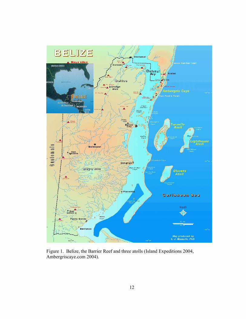
Reef and three atolls, Turneffe, Lighthouse Reef and Glover’s Reef (Figure 1).
Turneffe Atoll has a population of manatees that has not been the focus of any
investigation before this research expedition. Though rich with biodiversity, the atoll
lacks legal protection and is threatened with development (Oceanic Society 2004,
BCZMAI 2001).
Turneffe Atoll is the largest of the three Belizean atolls and is located
approximately 50 km east of Belize City. Manatees have been opportunistically spotted
around the atoll yet, information about them is lacking. Tourism and real estate
developments are potential pressures for the atoll, and while 42% of Belize is legally
protected (PACT 2004), Turneffe Atoll is not. With the anticipated pressures of
development, commercialism and larger scale tourism activities on Turneffe Atoll
(Oceanic Society 2004, BCZMAI 2001), conservation is critical for their protection.
12
Figure 1. Belize, the Barrier Reef and three atolls (Island Expeditions 2004, Ambergriscaye.com 2004).

13
The goal of this thesis is to contribute specific recommendations to protect the
manatees and the habitat they depend on at Turneffe Atoll, Belize. To determine these
recommendations I argue for a new approach towards conservation, called contextual
conservation. A contextual conservation approach combines not only the abundance
and distribution of a population but the biogeography, political and economic realities
of the region that contribute to the current status of the population. A contextual
conservation approach will help elucidate the region’s socio-political environmental
pressures from a layered perspective, determining what regional issues affect local
conservation. As a specific example of the contextual conservation approach, I am
investigating the abundance, distribution and conservation of Antillean manatees at
Turneffe Atoll, Belize, to create effective conservation policy.
I propose this framework by first defining, in chapter 2, contextual conservation
and why the apparent gap left in conservation biology requires a shift in thinking to
include greater political and economic context in conservation recommendations.
Pertinent research and theoretical analysis developed in the field of political ecology
enhances this discussion by acknowledging the obvious role of politics in
environmental issues. Combining aspects of both disciplines informs and enhances the
contextual conservation approach. Just as contextual conservation involves the biology
of the species, the biogeography of the region and the political and economic reality of
the country, this thesis follows a similar flow.

14
Chapter 3 describes manatees and their history in Belize. This includes a
description of the evolutionary history and current biology of the species, as well as
previous research on the abundance and distribution of manatees in Belize.
Investigating the natural history of manatees in the Caribbean Sea uncovers how they
have adapted to, and evolved with, their environment.
Studying the biogeography of the region is a key component of contextual
conservation. Chapter 4 addresses the biogeography and geomorphology of Turneffe
Atoll, Belize. Three significant biological features of the manatees’ habitat at Turneffe
Atoll are the linked environments of the coral, mangrove and seagrass communities.
Each of these important biogeographic components of the manatees’ habitat are
described, acknowledging their individuality as well as how they contribute to the
functioning habitat. By habitat I am referring to the area that contributes to the
sustenance of the population, both specific food sources and the environment that is
necessary for that food source to grow (Garshelis 2000).
A contextual conservation approach should also investigate the political and
economic agendas of the region to determine the root causes of developmental pressures
that may contribute to the species’ reduced numbers, towards recommending
appropriate and realistic protective policies. Chapter 5 addresses the current political
and economic agenda of Belize, in relation to the country’s history and future goals.
Understanding a brief history of Belize will place the country’s current goals in

15
perspective. Rather than put forth conservation recommendations that are
counterproductive from an economic standpoint, my recommendations are in the
context of Belize’s current economic and political goals.
I return in Chapter 6 to the manatees and my investigation of their abundance
and distribution at Turneffe Atoll, Belize. Little data exists about the population at
Turneffe Atoll, and my research contributes to baseline data. Combining both boat and
aerial surveys of manatees in the waters of the atoll, a table and map are presented
indicating the location and environmental variables of each sighting. Chapter 7 unites
this thesis and includes the final discussion and recommendations for both policy
makers and researchers based on information elucidated through the contextual
conservation approach.

16
2. Contextual Conservation
Effective conservation must address the needs of the species in the greater
context of its habitat to protect both the animal and the environment it thrives in
(Reynolds 1999). Reynolds (1999) stresses that, 1) manatee conservation focused
solely on manatees is doomed to fail if the habitat required by the animal is lost, and 2)
identification and conservation of critical habitat is an essential element to manatee
conservation programs. This requires an evaluation of not only the population, but also
its entire habitat to better understand how it functions. For this reason, it is
reductionistic to simply study the abundance and distribution of manatees, as if the
presence or absence of an animal can address the future needs of the animal. My
investigation is rooted in a contextual conservation approach, a form of conservation
that considers the species in a physical and biogeographical context, understanding how
the habitat functions and evolves. Beyond the species-specific approach, contextual
conservation also incorporates the socio-political conditions in the region that have
contributed to the current situation. Conservation strategies and effective
recommendations must explore the social context behind the actions that deplete
wildlife and degrade natural systems (Hines 2002).
In this chapter, I present my argument for investigating the manatees of Turneffe
Atoll in relation to their environment, as an example of contextual conservation. How
can we protect a species in its habitat amidst developmental pressures? Applied here,
17
how can the manatee population survive while its habitat is legally unprotected and
threatened with increased tourism and development? A contextual conservation
approach combines aspects of both conservation biology and political ecology to
address conservation.
2.1 Approach and Justification
Contextual conservation is rooted in geography. Geography encompasses both
the physical and the cultural worlds, and so does contextual conservation. Geography is
also concerned with flow. Physical flow can be understood, for example, as the
movement of the earth’s crust through plate tectonics or the surface of the earth through
land flows, movement of water through ocean currents and the flow of organisms from
one location to another through migration or dispersal. Similarly, cultural flow can be
recognized as the movement of ideas, concepts, cosmologies and philosophies around
the world; the flow of money, power and influence, or generally, the flow of everything
human related. Geography also involves scales, addressing issues from perhaps global,
regional and/or local scales to understand the causes and effects apparent at each level
and between levels. As developed in this specific example of the contextual
conservation of the Antillean manatees of Turneffe Atoll, Belize, my approach
examines both the physical and the cultural dimensions of conservation as it relates to
the focus animal, and involves the global, regional and local scales.

18
The contextual conservation approach is enhanced by aspects and components
of political ecology and conservation biology. Political ecology, also stemming from
geography, is a powerful field of inquiry that demands recognizing the political, and
therefore cultural aspects of the environment. The contextual conservation approach
has been informed in part by research in political ecology because of the connection
between the politics of the region and how they may impact the environment.
Additionally, conservation biology’s longstanding dedication to the study and
preservation of species and habitats has contributed to the development of the
contextual conservation approach, which aims to protect animals within their habitats.
Yet, rather than add to the many forms of conservation biology, contextual conservation
marks a conscious shift towards investigating politics and economics as they relate to
the species or population. The following overview of conservation biology and political
ecology will demonstrate the need for a contextual conservation approach. While a
complete analysis of the field of conservation biology is beyond the scope of this thesis,
I have drawn upon both peer reviewed sources as well as conservation biology
textbooks to understand the general trend of how conservation biology is described and
taught.
Conservation biology and its integrated, interdisciplinary approach is critical,
but not holistic enough to address the sources of environmental pressures. Soulé (1985)
defined conservation biology as addressing the biology of the species, communities and

19
ecosystems that are perturbed, while providing the principles and tools for preserving
biological diversity. At that time, Soulé (1985) recognized the dependence of the
biological sciences on the social sciences, but still applied the social sciences to
determine the impact of park reserves on the local economy, rather than asking the
reverse: how the local economy might facilitate or be counter-productive to the
establishment of the parks?
Meffe and Viederman (1995) revisit science and policy in conservation biology
ten years after Soulé’s 1985 article, and suggested that conservation biology was
maturing to encompass economic, legal and political issues, recognizing that the science
of conservation biology was not sufficient to stem species extinction and ecosystem
degradation. They effectively stated that as scientists, our research is worthless if it is
not translated into effective policy, yet we can no longer simply hope that someone else
will create the policy based on our research. Instead, scientists must anticipate the
needs of policy makers by having relevant information available before the policy
makers know it is needed (Meffe and Vierderman 1995). Though I agree with
anticipating the needs of policy makers, I question how effectively this can, or has, been
done if scientists do not know how to study the political and economic pressures that
contribute to the problem at hand? The social sciences are recognized, but still not
incorporated into a workable paradigm of conservation.

20
More recently, conservation biology has included economics within the
principles of conservation, but only to determine the economic value of biological
diversity (Primack 2000), rather than addressing the political and economic pressures
that are contributing to the loss of organisms in their environments. The economic
value of nature is based on its usefulness to humans and is measured economically by
placing a monetary value on a component or function of nature (Trombulak et al. 2004).
Nature is therefore regarded as an economic source, conforming to an economic model
(Ricklefs 1993), rather than questioning how the economic model confronts nature.
Economics are still largely being promoted in conservation biology as a means to
quantify value- an after effect of economics- rather than learning from economics why
the pressure is being placed on the environment in the first place. The valuation of
nature does not alter or alleviate the pressures on nature, it simply tries to demonstrate
how much more valuable nature is than whatever the current development scheme may
be. I am not quantifying animals as economic sources, but rather I am exploring the
economic pressures on the population in their habitat. Economics does not have to be
an afterthought in conservation science; it can be a tool that explores the monetary
values of those in power in the region to address why and how the environment is
exploited for money.
While conservation biology indeed takes in a cross-section of disciplines, it is
still rooted in the scientific method (Caughley and Gunn 1996, Meffe and Viederman

21
1995). Caughley and Gunn (1996) note that detection of a species in trouble,
diagnosing the problems and following with treatment should conform to the scientific
method, but I question where researchers can begin when little data exists? The most
intriguing approach to management decision-making without ideal data is Johannes
(1998) call for data-less management carried out specifically in the absence of data
required for predictive models and statistical confidence limits. Johannes (1998) argues
that we do not have the resources available to collect and process management data for
tropical seagrasses, mangroves and coral reefs, among other organisms. We must
instead make the best management decisions possible when such ideal and perfect data
are unattainable. Combining both local knowledge from key informants with the
research available, data-less management can contribute to informed decisions
(Johannes 1998). When pressured with small endangered and threatened populations in
legally unprotected areas, recommendations should be made from a contextual
conservation approach because it addresses scarcity of data by maximizing the use of
information from data that are available.
A contextual conservation approach is informed by significant research in the
field of political ecology because it acknowledges the very existence of a politicized
environment, especially in developing countries (Bryant and Bailey 1997). Political
ecology has been defined as combining the concerns of ecology and a broadly defined
political economy (Blaikie and Brookfield 1987) recognizing that environmental

22
problems are the interactions between biophysical processes, human needs and the
wider, overarching political systems (Forsyth 2003). Political ecology seeks to
contribute to the understanding of the causes and implications of environmental change
(Bryant and Bailey 1997); applied here to the investigation of the causes and
implication of Belize’s politics and economics on manatees.
While conservation biology represents a synthesis of disciplines from
anthropology and ecology, to genetics and sociology, it only includes the social sciences
insofar as they provide insight on how people can be encouraged and educated to
protect natural resources (Primack 2000). Instead, political ecology calls for rethinking
explanations of environmental problems in ways that do acknowledge the linkages
between social factors and the pursuit of conservation (Forsyth 2003). Of course
conservation biology is a necessary and highly productive field with the goal of
providing principles and tools for preserving biological diversity (Soulé 1985), but the
connection between the political and economic pressures on habitat loss or the direct
take of a species must be included in conservation, complimented with the biology and
biogeography of the species.
The key component of political ecology that contributes to the contextual
conservation approach is the recognition that environmental problems cannot be
understood in isolation from the political and economic contexts with which they are
created (Bryant and Bailey 1997). I cannot describe the threatened manatees without

23
simultaneously considering the political and economic processes that have generated,
contributed to and exacerbated their vulnerability (Bryant and Bailey 1997). These
perceptive views are here incorporated into a real conservation approach, with the goal
of creating effective and informed policy. While the theoretical dimensions of political
ecology have contributed to my investigation on how we perceive the environment and
environmental problems (Peet and Watts 1996, Escobar 1996), conservation requires
swift, effective and cautious action because organisms are losing their habitats and are
threatened with extinction. Contextual conservation melds the science of conservation
biology with political ecology’s fundamental acknowledgment of a politicized
environment.
As a crisis science (Soulé 1985), conservation biology may expect too much
time and information to develop testable hypotheses when baseline data on abundance
and distribution are needed. If combined with political ecology’s goal to include both
the ecological and the political dimensions of environmental issues (Zimmerer and
Bassett 2003), the resulting contextual conservation approach maximizes the scarcity of
data available on the biology, biogeography, abundance and distribution of a population
in the context of the region’s agenda to facilitate habitat protection. Through the
contextual conservation approach, I will inform policy makers and future researchers as
to the most appropriate protection and research strategies regarding the manatees of
Turneffe Atoll.

24
3. Manatees of Belize
A contextual conservation approach should be informed by detailed information
about the species in question. Before recommending effective conservation policy
about the manatees of Turneffe Atoll we must understand what a manatee is, how they
evolved and their basic biology, to advise the decision making process. This chapter
explores these issues, as well as the previous research conducted on the abundance and
distribution of manatees in Belize.
3.1 Sirenians
Manatees are marine mammals belonging to the scientific order Sirenia, of
which there are four species still living today (Figure 2): the dugong (Dugong dugon)
found in the coastal and island waters of the western Pacific and Indian oceans; the
West African manatee (Manatus senegalensis) found in the coastal and riverine waters
from Senegal to Angola in western Central Africa; the Amazonian manatee (Manatus
inunguis) occupies the freshwater habitats throughout the Amazon River and its
tributaries; and the West Indian manatee (Trichechus manatus) found in the mid-
Atlantic region of the United States, the Gulf of Mexico, the Caribbean and parts of
South America. The West Indian manatee is further divided into two sub-species: the
Florida manatee (Trichechus manatus latirostris) primarily occupying the coastal
waters of Florida and Georgia, and the Antillean manatee (Trichechus manatus

25
manatus) found from southwestern Texas down to the east coast of Central and South
America, as far south as Brazil (Reynolds and Powell 2002) (Figure 3). All four extant
species are listed as vulnerable (IUCN 2004).
Figure 2. Scientific order Sirenia (Folkens 1989).

26
Figure 3. Sirenian distribution (Printed with permission from Sirenian International
2000).
The fifth species in the order Sirenia is the extinct Steller’s sea cow
(Hydrodamalis gigas), named for Georg Wilhelm Steller who recorded much of the
information available on sea cows in the winter of 1741 (Reynolds and Odell 1991).
Unique among sirenians, the 26-foot long Steller’s sea cow inhabited cold, sub-arctic
waters where the population was decimated and driven to extinction 27 years after it
had been initially recorded (Reynolds and Odell 1991). It was the European-managed

27
whaling and sealing expeditions that slaughtered the small population of perhaps less
than 2,000 (Bertram and Bertram 1973).
Sirenians may seem evolutionarily related to other marine mammals, yet they
have evolved separately (Domning 2001). As recently as the 19th century, scientists still
believed that manatees were a tropical version of the walrus, as seen in early lithographs
and drawings (Reynolds and Odell 1991). In fact, sirenians are evolutionarily most
closely related to elephants, hyraxes (furry rodent-like mammals) and aardvarks
(Reynolds and Odell 1991). According to Domning (2001), sirenians are thought to
have arisen in the Old World (Eurasia and/or Africa), with ancestral forms dating from
the Early Eocene Epoch, about 55 million years ago. Sirenians appear to have spread
quickly to the New World where their actual fossil record begins in the late Early
Eocene of Jamaica. For 50 million years, all four families in the order Sirenia
(Prorastomidae, Protosirenidae, Dugongidae and Trichechidae) inhabited the Caribbean
western-Atlantic region, but it was not until the Miocene Epoch, about 15 million years
ago, that a truly manatee-like animal appears. By the early Pliocene Epoch, about five
million years ago, the Amazonian manatee’s ancestors were isolated in the Amazon
Basin, while other manatee successfully inhabited the Caribbean. The West African
manatee is said to have occurred by a chance colonization of Africa from animals
dispersing from the Caribbean (Domning 2001).

28
3.2 The Antillean Manatee
The Antillean manatee was proposed for sub-species status in 1934, but at the
time, there was little anatomical evidence to support this idea (Reynolds and Odell
1991). It was not until the 1980s that sufficient anatomical evidence based on skull
measurements confirmed the sub-species status (Domning and Hayek 1986.).
According to the thorough descriptions of sirenian traits (Reynolds 1999, Reynolds and
Odell 1991), adult Antillean manatees average 3 m and weigh 544 kg. Their thick,
tough skin is sparsely scattered with hair and covers a layer of blubber less than an inch
thick (Ripple 1999). Their bodies are streamlined, gray to brown in color with small
eyes and prominent vibrissae on their large flexible upper lip. Manatee bodies are
spindle shaped with short paddle-like front limbs and a large paddle-like tail for
locomotion. Manatees travel at speeds of 3-10 km/h, and up to 24 km/h in short bursts
(Ripple 1999).
Internally, manatees have very thick, heavy bones, with the ribs, longbones and
forelimbs lacking marrow. The lack of marrow makes this heavy bone similar to ivory-
a prized quality for bone carvers. The weight of their bones can help offset the
buoyancy of their long, unlobed lungs, which occupy virtually their entire dorsal region
(Reynolds and Powell 2002). Manatees are herbivores and consume angiosperms
almost exclusively, ingesting the small invertebrates that may feed incidentally on the
seagrasses as well (Reynolds and Powell 2002). Relying primarily on seagrass to

29
subsist, healthy seagrass communities are essential for manatees. To effectively
consume seagrass and the gritty sediments associated with them, manatees have six to
eight molars in each of their four rows of teeth that are continuously replaced
throughout their lifetime (Reynolds and Odell 1991). In order to digest this high fiber,
low protein diet, manatees have a hindgut similar to horses and elephants, and a huge
large intestine (more than 20 m) (Reynolds and Powell 2002).
With a maximum life expectancy of 60 years, manatees become sexually mature
at between 2.5 and 10 years of age (Bonde et al. 2004, Reynolds and Powell 2002, Boyd
et al. 1999). They have an 11-20 month gestation period and calve every 2-5 years
(Bonde et al. 2004, Reynolds and Powell 2002). Typically, a calf remains with its
mother for approximately 2 years (Ripple 1999). A late sexual maturation combined
with a long gestation to produce typically one calf creates a low reproductive potential.
In turn, this low reproductive potential makes manatee populations easy to overexploit
and slow to recover. Changes in the morbidity or fecundity will have significant effects
on the long-term survival of a population (Marmontel et at. 1997). When one manatee
is killed, it may take several years, if possible, to replace that reproductive potential
(Reynolds 1999). Adult survivorship is particularly important and must be high for
populations to be maintained (Boyd et al. 1999).
The manatee is primarily endangered as a result of contact with humans
(Reynolds and Powell 2002, Lefebvre et al. 2001, O’Shea and Salisbury 1991, Bertram

30
and Bertram 1973, 1968). The coastal habitats occupied by manatees are the same
coastal environments humans enjoy, exploit and increasingly develop. Not only have
manatees been a source of food, but manatee tears, oil, hides, bones and incisors, among
other parts, have been intertwined into traditional medicinal practices (Ripple 1999,
Bertram and Bertram 1973). Their tough hides are used as whips, shields and machine
belts (Reynolds and Powell 2002). Legal restriction of hunting has probably prevented
the extinction of manatees in Belize, but other modern anthropogenic threats have taken
the forefront including drowning in fish nets, boat propeller accidents and overall
degradation and loss of habitat (Auil 2004, 1998, Reynolds and Powell 2002).
3.3 Previous Research on the Manatees of Belize
Not only were manatee populations historically more abundant as indicated by
fossil findings (Domning 2001), but manatees contributed substantially to the diet of
early settlers in the Maya regions and coastal sites in Belize (McKillop 1985). Sauer
(1966, 58) recounts the importance of regional manatee meat to the local diet, stating
how these “. . . large seacows pastured freely on plants of the estuaries and were an
important food source until they were decimated by the Christians, who were permitted
to eat them on fast days.” Research on the historic exploitation of the manatee in the
Maya and circum-Caribbean areas has identified manatee remains from a Middle
Classic Period (400-700 Current Era- C.E.) site at Moho Caye, Belize, and carvings

31
from manatee bones have been found at both coastal and inland sites, demonstrating the
widespread use of manatees (McKillop 1985).
Currently, throughout the Antillean manatee’s range, aerial surveys have shown
that the majority live in Belizean waters (Auil 2004, BCZMAI 2003, O’Shea and
Salisbury 1991), though their numbers are not increasing (Auil 2004). The relatively
large manatee population in Belize is often referred to as the last stronghold for
manatees in the Caribbean (O’Shea and Salisbury 1991), yet the population consists of
less than 900 individuals, with estimates varying between 300-900 (BCZMAI 2003).
Within Belize, manatees are unevenly distributed in the Northern and Southern Lagoons
of the mainland and throughout the coastal waters, ranging from Corozal Bay in the
north, to Port Honduras in the south and extending east to include the off shore cayes,
the Belize Barrier Reef and at least one of the three Belizean atolls in the Caribbean
Sea, specifically Turneffe Atoll (Auil 2004, 1998, Self-Sullivan et al. 2003, Morales-
Vela et al. 2000, Smith 2000, O’Shea and Salisbury 1991, Bengston and Magor 1979).
Most manatee populations are found in the Northern and Southern Lagoons on the
mainland of Belize, south of Belize City, as well as the coastal cayes west of the Belize
Barrier Reef (Auil 2004, 1998, Morales-Vela et al. 2000, O’Shea and Salisbury 1991,
Bengston and Magor 1979). Accurate data including population size, location, feeding
habits and migration information are essential if we are to prevent the further extinction

32
of marine mammals. However, not all manatee populations have been thoroughly
accounted for in Belize, potentially resulting in the loss of undocumented populations.
Currently, West Indian manatees are listed in Appendix 1 of the Convention on
International Trade in Endangered Species as Threatened with extinction (CITES 2003),
as Vulnerable by the World Conservation Union (IUCN 2003) and Endangered under
the United States Endangered Species Act (TESS 2003, USFWS 2003). Antillean
manatees have been protected in Belize since 1935 under the Manatee Protection
Ordinances (McCarthy 1986). The Antillean manatee is further protected in Belize
under the Wildlife Protection Act of 1981 and in Mexico by the Ecological Act of 1994.
The United Nations Environment Programme (UNEP) has published a Regional
Manatee Recovery Plan (UNEP 1995), and Auil, while with the Belize Coastal Zone
Management Authority and Institute’s (BCZMAI) Manatee Research Programme, has
written the Belize Manatee Recovery Plan (1998) produced through the Belize National
Manatee Working Group and the BCZMAI, which follows UNEP’s recommended
outline (BCZMAI 2004a, Sirenian International 2004a). In this comprehensive
document, a four-year schedule of conservation activities was drafted with the goal of:
1) Preventing extinction or irreversible decline of the species in the near future, and 2)
Preventing decline of the quality of their habitat (BCZMAI 2004a). The management
plan includes manatees found in the four coastal districts of Belize where manatees are

33
typically found, but this does not include all areas of Belize where manatees have been
seen. Specifically, the off shore atolls are not included.
3.3.1 Aerial surveys
The first countrywide aerial survey of manatees in Belize was conducted in
September of 1977, and resulted in a maximum count of 101 manatees, nine of which
were calves (Bengston & Magor 1979). A second aerial survey was conducted in May
of 1989, and 102 manatees including 11 calves were sighted (O'Shea & Salisbury
1991). Both of these surveys investigated the same five regions thought to have the
largest populations of Antillean manatees. Specifically, the Four Mile Lagoon and the
New River in northern Belize; the lower Belize River from Burrell Boom to Belize
City; off shore cayes near Belize City west of the Belize Barrier Reef; the Northern and
Southern Lagoons near the central coast and; the Placentia Lagoon area on the south-
central coast (Figure 4) (O'Shea and Salisbury 1991, Bengston and Magor 1979).
The BCZMAI flew fifteen additional aerial surveys between 1994 and 2002 that
included six sites: Corozal Bay to the North, Belize City Cayes and River; the Southern
Lagoon; the Placentia Lagoon; Indian Hill Lagoon and Port Honduras (Figure 5)
(BCZMAI 2003). The highest count of manatees was in the wet season of 2002, with
338 manatees spotted (BCZMAI 2003). Most importantly, Turneffe Atoll was dropped
from their aerial surveys as of 1999, and no individual data on Turneffe are given,

34
which suggests no manatees were seen. Furthermore, Turneffe Atoll is not included in
the recommendations for future aerial surveys (Auil 2004). Morales-Vela et al. (2000)
found a total of 11 manatees at Turneffe Atoll during their three aerial surveys during
1994-1996, but they too recommend against including Turneffe Atoll in each survey
because manatees did not appear to use the atoll often. While abundance estimates of a
small population in such a large area are difficult, further research and continued
monitoring of their distribution and movement patterns is needed for their protection
(Hines et al. in press).

35
Figure 4. Map of Belize including the aerial survey regions investigated by O’Shea and Salisbury in May of 1989. 1). Four Mile Lagoon and lower New River, 2). Lower Belize River, 3). Waters and cayes off Belize City, 4). Southern Lagoon, and 5) Placentia Lagoon (O’Shea and Salisbury 1991).

36
Figure 5. Aerial survey regions investigated by the Belize Coastal Zone Management Authority and Institute in 1997 (BCZMAI 2003).
Port Honduras
Indian Hill Lagoon
Placentia Lagoon
Southern Lagoon
Belize City Cayes and Rivers
Chetumal Bay and Corozal Bay

37
4. Biogeography of Turneffe Atoll, Belize
As Quammen (1996, 17) states so concisely, “Biogeography is the study of the
facts and the patterns of species distribution.” The study of the geographic distribution
of organisms includes studying where plants and animals are found, but also where they
are not found. Biogeographic studies seek to understand why certain plants and animals
are found in some environments and not in others. Biogeography attempts to study the
distribution of life within the context of history, place, evolution, scale and movement,
and can be as narrow as researching one species and its presence and absence, or as
holistic as studying the spatial patterns of biodiversity within a region. What is unique
about this field is the recognition of organisms in context, and their distribution in
relation to the environment.
Beyond information from a natural history perspective, investigating the
biogeography of a region naturally recognizes species in the context of their
environments. The contextualized study of species in their environments generates
questions regarding how species create, manipulate and use their environments. As my
research has taken me to Turneffe Atoll, Belize to study the Antillean manatee
population, I cannot separate the manatees from their environment, and have therefore
used aspects of biogeography to learn more about manatee conservation in situ.
This chapter describes the biogeography of Turneffe Atoll as it relates to the
manatees because recognizing the unique environment manatees have evolved within

38
will inform policy makers of the need to protect the entire habitat. The location and
formation of the atoll has facilitated the growth of coral reefs, mangroves and seagrass
communities, all of which constitute manatee habitat. Understanding how the
biological components of the atoll are linked reinforces the need to protect manatees
and their unique habitats.
4.1 Evolution and Formation of Turneffe Atoll
Off the coast of Belize in the Caribbean Sea lies the second longest Barrier Reef
in the world (220 km) and three of the four atolls found in the Western Hemisphere,
Turneffe, Glover’s Reef and Lighthouse Reef atolls (Murray et al. 2003, Spalding et al.
2001) (Figure 6). Located approximately 50 km from the mainland of Belize, Turneffe
Atoll is the largest of the three Belizean atolls in the Caribbean Sea, with a maximum
width of 16.1 km, a maximum length of 48.2 km (Gischler and Hudson 1998). The
atoll has an overall area of 525 km² (Gischler and Hudson 1998) and a land area of 22%
of the atoll (Spalding et al. 2001). Although relatively close to the mainland of Belize,
the islands of Turneffe Atoll are oceanic islands, having never been connected to the
mainland. Just 9.6 to 16 km to the east of the Barrier Reef, Turneffe Atoll rests on an
isolated carbonate platform (Gischler and Hudson 1998). Instead of forming on a
volcanic hotspot typical of some atolls in the Pacific, the structural floor of the isolated

39
carbonate platforms and the Barrier Reef are situated on NNE-striking ridges at the
passive continental margin (Gischler 2003, Dillon and Vedder 1973).
Figure 6. Satellite image of mainland Belize, the Barrier Reef and the three atolls: Turneffe at the top, Lighthouse in the middle and Glover’s at the bottom of the image (Redtail Canyon 2004).

40
Turneffe Atoll is also referred to as Turneffe Islands, which begs the question,
what is an atoll? Darwin presented the earliest scientific classification of ocean reefs
and atolls based on shape and origin (Fagerstrom 1987). Darwin distinguished three
main types of reefs: atolls, barrier reefs and fringing reefs, linked together in an age-
related sequence (Stoddart 1978). Though the name ‘atoll’ significantly pre-dates
Darwin’s usage, it refers to a sub-circular or ring-like arrangement of narrow reefs,
partially enclosing a shallow-water central lagoon, lacking a volcanic island in the
middle (Fagerstrom 1987).
An atoll is therefore a type of circular coral reef. Additionally, Gischler and
Hudson (1998) believe that plate tectonics produced the morphology of ridges and
valleys that control the distribution of modern reefs in Southern Belize. Winds and
storms control most of the sediments that develop on these platforms and subsequent
reefs often develop due to the build up, especially on windward margins where we
might expect atolls to be most similar (Wood 1999). Most sediments stem from a wide
variety of calcareous shells and skeletons of protists, plants and animals (Hallock 1997),
while Gischler and Hudson (1998) note the sediments on the Belize shelf are pure
carbonate in the north, and mixed siliciclastic in the south. Thus, if the rate of
carbonate production at the margins is high, combined with a steady rate of subsidence
then, according to Wood (1999), a shallow reef will grow around the platform forming a
deep central lagoon with patch reefs. The platform is now covered by the cayes that

41
make up Turneffe Atoll, with a central lagoon on the inside, encircled by fringing and
patch reefs on the outside.
During the late Pleistocene (2 million years ago), the cayes of Turneffe Atoll
were simply dish-shaped limestone islands that were likely fringed by coral reefs
(Gischler 2003). The following description is from Gischler’s (2003) explanatory
Holocene flooding scenario, which began 8,000 years before present (BP) when
Turneffe Atoll was simply a collection of emergent cayes. Between 7,000 and 2,700
years BP, the Holocene sea levels began to rise and the elevated levels of groundwater
enhanced soil development. Eventually the marine waters breached the outer edges of
the cayes and entered the center of the atoll, which was significantly lower, allowing
mangroves to colonize the interior areas of the atoll. At around 4,800 years BP, as a
result of the rising sea levels, mangrove-rimmed lagoons formed, yet at the highest sea
levels, mangroves diminished and coral reefs colonized the rim. By about 4,000 years
BP the sea level was close to 3.5 m below the present level, and Turneffe’s central
lagoon was largely developed. Simply stated, above the Pleistocene limestone bedrock
rests basal soils, followed by mangrove peats and marine lagoonal carbonate sediments
(Gischler 2003).

42
4.2 Linked Habitats
Presently, Turneffe Atoll is comprised of approximately 200 cayes, with about
23 gaps or channels less than 50 m wide consisting mostly of mangrove forests, with a
handful of sandy cayes capable of supporting humans. The cayes of Turneffe enclose
three main shallow lagoons less than 8 m deep: Northern or Vincent, Central, and
Southern Lagoons, and several small lagoons (Figure 7). Manatees share the atoll with
other threatened and endangered species including the American salt-water crocodile
(Crocodylus acutus), hawksbill turtle (Eretmochelys imbricata), bottlenose dolphin
(Tursiops truncatus), Nassau grouper (Epinephelus striatus), roseate tern (Sterna
dougallii) and the white-crowned pigeon (Columba leucocephala). There are also
several breeding seabird colonies including the brown booby (Sula leucogaster), sooty
tern (Sterna fuscata oahuensis) and the magnificent frigate bird (Fregata magnificens).

43
Figure 7. Turneffe Atoll (Belize Now Network 2001).

44
The most prominent features of Turneffe Atoll supporting significant
biodiversity are the coral reef, mangroves and seagrass beds. For a variety of fishes and
invertebrates, the seagrass beds and mangroves function as nurseries or daily foraging
habitats before migrating to the coral reef (Creed et al. 2003, Ogden 1997). In many
ways, they depend on each other and have formed because of each other, and therefore
coral reefs, mangroves and seagrass beds are often referred to as linked habitats
(Mumby et al. 2004, AMNH 2004, Green and Short 2003, Creed et al. 2003, Hogarth
1999, Ogden 1997, 1980). All three communities thrive together because the
mangroves filter pollutants and trap sediments that would otherwise smother seagrass
and coral and prevent the sunlight required for photosynthesis from reaching them.
Seagrass communities also clean the water, benefiting coral reef inhabitants by blocking
the flow of silt and mud. In turn, coral reefs protect mangroves and seagrass from the
wave force by slowing the surging waves (AMNH 2004, Green and Short 2003, Ogden
1997, 1980). Because the wave action hitting Turneffe Atoll comes from the north-
northeast direction, the fringing reef helps to absorb much of the wave force and
therefore, the more gentle water laps against the mangrove lined cayes (Murray et al.
2003). The less wave force, the less sediment agitation takes place, which keep the
water clear enough for sunlight to penetrate the water and reach the seagrasses and
coral.

45
Not only are the coral, mangroves and seagrass beds linked biologically, they
also share similar threats to their existence (Jacobs 1998). Anthropogenic impacts of
coastal development and pollution threaten seagrass beds (Creed et al. 2003),
mangroves (Hogarth 1999, Klee 1999) and coral (Gibson and Carter 2003, Birkeland
1997). Both nutrient over-enrichment of the environment and the turbid water caused
by land development lead to reduced light availability and therefore reduced
photosynthesis (Green and Short 2003, Klee 1999). The development and pollution that
adversely affects seagrass beds will also have an impact on manatee populations (Bonde
et al. 2004). Therefore, conservation efforts should protect the connected corridors of
mangroves, seagrass beds and coral reefs (Mumby et al. 2004).
4.3 Coral
Coral reefs are among the most biologically productive and diverse ecosystems
in the world (Birkeland 1997, Campbell 1993). Corals are actually tiny animals, also
called polyps, which secrete and then reside in a limestone/calcium carbonate skeleton.
As the skeleton grows in varying shapes, other coral and algae begin to inhabit it
(Campbell 1993). Hard coral, which helps to build the reef, grow on top of each other
and leave behind the dead skeletons of previous coral polyps, gradually forming the
coral reef (WCMC 2004, Belize Net 2004). Typical hard corals are brain corals, finger
coral, elk-horn coral, stag-horn corals and plate corals (Belize Net 2004) (Figure 8).

46
Soft corals have a skeleton as well, but as their name suggests, it is not hard, such as fan
coral (Figure 9). Within hard corals and some soft corals live tiny algae called
zooxanthellae. In their symbiotic relationship, the zooxanthellae live inside the coral
and in turn produce oxygen and nutrients through photosynthesis while processing the
corals’ waste materials (Belize Net 2004, Campbell 1993).
Within Belizean waters, 74 species of hard corals and 36 species of soft coral
have been identified (Belize Net 2004). The reef is not only home to hard and soft
corals, but associated organisms such as hundreds of fish species, as well as manatees,
dolphins, octopus, lobster, conch, shrimp, anemones, seaweeds and countless others.
Figure 8. Brain coral (Holguin 2003).

47
Figure 9. Purple fan coral (Holguin 2003).
In order to survive corals need:
1. Sunlight to grow in shallow water where the sunlight can reach them. Because
the zooxanthellae are algae, they need sunlight to survive through
photosynthesis,
2. Clear water, because the sediment and plankton can cloud the water and
decrease the amount of sunlight for photosynthesis that reaches the
zooxanthellae,
3. Warm water ranging from 20-32° C /68-90° F,
4. Clean water, not only due to the sediments that may settle on the coral
preventing photosynthesis, but pollution from sewage and fertilizers increase the
amount of nutrients in the water, negatively altering the coral reef environment,

48
5. Saltwater to maintain the balance of salt to fresh water, typically between 34-37
ppt (Coral Reef Alliance 2004, Gibson and Carter 2003, Hubbard 1997, Ogden
1997, 1980, Campbell 1993).
Fortunately, and evolutionarily, both mangroves and seagrasses have helped to maintain
this ideal coral reef environment and have similar physiological and ecological roles
(Hogarth 1999, Ogden 1997).
4.4 Mangroves
Mangroves are vascular plants that live in shallow seawater with the ability to
adapt to the saline wetland environment by excluding and secreting salt from their
tissues (Hogarth 1999, Klee 1999, Rutzler and Feller 1996). They are woody shrubs
and trees that live along the edges and shores of rivers, estuaries and lagoons in areas
sheltered from strong wave action (Chapman 1984, 1975). Mangroves can live in water
up to 100 times saltier than most other plants can tolerate with the most tolerate species
living along the shores and less tolerate species further away from the edge (AMNH
2004).
Mangroves have three essential adaptations that allow them to live in such
extreme environments (AMNH 2004). First, mangroves are extremely salt tolerant and
can filter out and exclude as much as 90% of the salt found in the seawater. Typically,
this salt is then secreted out through the leaves of some species. Second, mangroves

49
also store freshwater in their thick succulent leaves, which have a waxy coating that
helps to minimize evaporation (Hogarth 1999). Third, mangroves have aerating roots,
which extend from the trunk and lower branches of the mangrove and help to stabilize
the mangrove in its soft floating bed of unconsolidated sediments, or mud (AMNH
2004) (Figure 10). These sprouting aerial roots respire aerobically, which enables them
to survive the oxygen deprived inter-tidal soils (Rutzler and Feller 1996). Mangrove
aerating roots either emerge from the soil or extend from existing above water roots, as
in the red mangroves (Chapman 1984). The root system retains sediments, consolidates
the soil and provides physical stability to shorelines by creating dense, stable sediments,
retarding coastal erosion (Hogarth 1999, Klee 1999).
To reproduce, mangrove species produce a large seedling called a propagule.
After pollination the growing embryo remains on the parent tree and grows for many
months growing into a true seedling, not a seed or a fruit (Hogarth 1999). The
propagules germinate while still on the mangrove and are ready to take root when they
fall from the branch (Figure 11 and 12). The floating propagule will follow the currents
until it becomes lodged in another mass of mangroves or shallow seagrass bed, where it
quickly begins to grow (AMNH 2004) (Figure 13).

50
Figure 10. Stabilizing aerial roots of the red mangrove (Rhizophora mangle) (Holguin 2003).
Figure 11. Propagules of the red mangrove (Rhizophora mangle) (Holguin 2004).

51
Figure 12. Close-up of red mangrove (Rhizophora mangle) propagule (Holguin 2004).
Figure 13. Red mangrove (Rhizophora mangle) seedlings with aerial roots growing in a shallow seagrass (Thalassia testudinum) bed (Holguin 2004).

52
The fringing reef of Turneffe Atoll has contributed to the growth of mangroves
on the atoll by absorbing a majority of in-coming wave energy, which shelters the shore
and provides sufficient conditions for mangrove seedlings to develop (Murray et al.
2003). Turneffe Atoll has become extensively covered with mangroves, covering two
thirds of the atoll’s land area, which constitutes 9.4% of all of Belize’s mangroves
(Murray et al. 2003). Turneffe Atoll includes three mangrove species zoned according
to flood depth and salinity. Red mangroves (Rhizophora mangle) are the most prevalent
mangroves on Turneffe, covering 22% of the atoll and found along the island edges
(Gischler and Hudson 1998). Beyond contributing to the biogeography of the atoll,
mangroves are associated with many other land species including vines, palms, orchids
and climbing ferns and lichens (Hogarth 1999) and are home to several species of wood
boring moths, beetles, ants, termites, spiders, roaches, scorpions, mosquitoes as well as
several species of amphibians, reptiles, birds and mammals (Hogarth 1999, Rutzler and
Feller 1996). Below the water, mangroves support populations of algae, crustacea,
mollusks, sponges, tunicates, worms (Hogarth 1999) and of course several populations
of fish for which the mangroves provide an intermediate nursery stage between seagrass
beds and the patch reefs (Mumby et al. 2004).
Black mangroves (Avicennia germinans) dominate sites further inland with
reduced salinity. Black mangroves are taller than the red mangroves and have a
distinctively darker bark with long cabled roots that protrude out of the soil (Figure 14)

53
(Tomlinson 1986). Most rare are the white mangroves (Languncularia racemosa) with
their distinctive feature being a grayish bark with oval shaped leaves that are dented at
the tip growing very small propagules (Murray et al. 2003). White mangroves
propagules cannot survive the salinity and periodic flooding that is common in lower
areas, and are restricted to higher ground on Turneffe Atoll (Rutzler and Feller 1996).
Figure 14. Red mangroves (Rhizophora mangle) along the lagoon edge, with the taller, less salt tolerant black mangroves (Avicennia germinans) further inland (Holguin 2004).
4.5 Seagrass
The third significant biogeographic feature of Turneffe Atoll’s linked habitats
are the ample seagrass beds that form a highly productive system in the protected
shallow waters of the atoll. Seagrasses are the only group of angiosperms known to
have successfully adapted to sea life (Brasier 1975), and the current Caribbean seagrass

54
communities are similar to those found in the Eocene Epoch (Domning 2001). Seagrass
communities filter coastal waters, dissipate wave energy and anchor sediments because
their root-like stems, or rhizomes, extend horizontally under the sea bottom, and act as
sediment stabilizers (Green Reef 2003, Garcia and Holtermann 1998, Brasier 1975).
These rhizomes store carbohydrates and are therefore, important to the manatees’ diet
(Domning 2001).
Sediments that would otherwise settle on coral and prevent photosynthesis, tend
to accumulate and become stabilized by the seagrass (Creed et al. 2003, Ogden 1997).
When seagrass communities are near shore, they act to slow water movement and their
long leaves act as filters, removing particles from the water and depositing them as fine
sediment, held in place by their extensive root and rhizome system creating an organic
and nutrient rich environment (Ogden 1997, 1980). Seagrass communities provide
habitat and food for an enormous diversity of fauna including fish, conch, sponges,
mollusks, lobster, waterfowl, turtles, bottlenose dolphins and manatees for feeding,
breeding and protection (Creed et al. 2003, Ogden 1980).
The seagrasses of Turneffe Atoll are dominated by turtle grass (Thalassia
testudinum) which thrives in areas that are protected from wind-driven current and surf
(Green Reef 2003) (Figure 15). Also present in the atoll are manatee grass
(Syringodium filiforme) (Figure 16), shoal grass (Halodule wrightii) (Figure 17), and
the algae Halimeda (Ogden 1980). According to Lefebvre et al. (2000) Halodule

55
wrightii and Syringodium filiforme are fast growing seagrasses, but are more vulnerable
than Thalassia testudinum to physio-chemical disturbances. They are shallow rooted
and have fewer energy reserves than Thalassia testudinum and are therefore more
susceptible to physical degradation and deterioration in water quality (Lefebvre et al.
2000). Future efforts to protect important manatee habitat should incorporate
management issues regarding water quality and damaging physical impacts to the
seagrass community. As the staple for the herbivorous manatee diet, seagrass
conservation must be associated with manatee protection and survival (Lefebvre et al.
2000).
Figure 15. Turtle grass (Thalassia testudinum) (Hines 2003).

56
Figure 16. Manatee grass (Syringodium filiforme) (Florida Oceanographic Coastal Center 2003a).
Figure 17. Shoal grass (Halodule wrightii) (Florida Oceanographic Coastal Center 2003b).

57
4.6 Human Population
Studying the biogeography of Turneffe Atoll would not be complete without
addressing the human population as well. The country of Belize has a human
population of approximately 270,000, as of July 2004 (CIA 2004). Specific industries,
including fisheries and tourism are located in the coastal zone, which is home to 45% of
the population (BCZMAI 2004b). Though Turneffe Atoll is an hour and fifteen-minute
boat ride east of Belize City, the size of atoll’s population is both influenced and
supported by the fishing and tourism industries.
From my field research, there are three smaller-scale resorts on the atoll, two
field stations and approximately twenty fishing camps. The resorts cater predominately
to divers, sports fisherpeople, snorklers and beachcombers. Most of the fishing camps
are seasonally used, especially in lobster season. The Oceanic Society, a non-profit
conservation organization, has a field station on Blackbird Caye, which supports the
organization’s primary mission to protect marine wildlife through integrated programs
of scientific research, environmental education and volunteerism. Their environmental
approach is to collaborate with local communities in conservation initiatives while
involving volunteer participants in research projects. The University of Belize’s
Institute of Marine Science runs their field station on a neighboring caye. A realistic
total of approximately 100 people, both local residents and tourists included, occupy the
atoll.

58
Human habitation of Turneffe Atoll is part of the region’s biogeography. Each
resort, field station and fishing camp affects the environment in varying degrees through
activities such as altering the landscape and coastal environment to ‘beautify’ the area,
generating garbage and sewage, driving diesel boats, potentially over-fishing for natural
resources and the general removal of coral and shells by tourists. A contextual
conservation approach includes human contributions to the biogeography of the region
because humans are a significant part of the region and directly impact manatee
habitats.
4.7 Summary
This investigation of the biogeography of Turneffe Atoll has related most
specifically to the manatees and their habitat. A complete biogeographical description
of this area would also include extensive details regarding Turneffe Atoll’s relationship
to the Belize Barrier Reef and the mainland of Belize, as well as the entire Caribbean
Sea region. However, it is beyond the scope of this study to extensively investigate
Turneffe Atoll’s relationship to the surrounding area because the contextual
conservation approach should maintain its focus on the animal in question. There are
numerous fascinating aspects of Turneffe Atoll’s biogeography that may be studied in
the future, but there are specific features of the atoll that relate most directly to the
manatees, from a contextual conservation approach.

59
As significant components of the biogeography of Turneffe Atoll, the corals,
mangroves and seagrass beds are rich and diverse enough to be studied independently.
An understanding of how Turneffe Atoll has formed and its unique linked biogeography
enhances the conservation measures aimed at protecting the manatees within their
habitat. This overview is by no means exhaustive, but rather, describes how the
biogeography of Turneffe Atoll is interconnected. Seagrass communities in the waters
of an isolated atoll like Turneffe depend on the shelter and reduced wave action
provided by the mangroves and corals. Therefore, effective conservation strategies for
manatees must consider the health of these linked habitats.

60
5. Politics and Economics of Belize
A contextual approach to conservation should investigate the politics and
economics of the region to determine how they may be influencing and impacting the
protection of the species. The short-term economic goals of a country or region are not
always conducive to long-term environmental protection. Informed conservation
decision-making should assess the current economic goals of the country to place
conservation in the context of the country’s agenda. Realistic conservation
recommendations must understand the economic pressures of the country affecting the
focus population to be seriously considered and enforced.
In Florida, the economic impact of the boating industry significant affects
manatee conservation. While Reynolds (1999) described the economic impact of
Florida’s boating industry on manatee conservation in Florida after he asserted his
recommendations, I am bringing economics to the forefront to inform my
recommendations. Tourism in Florida continues to be a threat to manatees, and the
increase in what is popularly termed ecotourism has actually increased the amount of
boat traffic threatening the manatees (Bonde et al. 2004). With more than 30% of
documented manatee mortalities attributed to vessel collision in Florida (Nowacek et al.
2004) there is a tension between protecting manatees and the economically influential
boating industry. The implementation of boating regulations can have a negative
economic impact on state revenues because of the reduction in commercial, recreational
61
and tourists interests (Reynolds 1999). Whereas Florida has a large established boating
industry, Turneffe Atoll, for example, has not developed these intensive boating
patterns and therefore has the opportunity to implement protection policies now, before
boating intensifies. Just as manatee conservation in Florida is affected by regional
politics and economics, so too are the manatees in Belize.
Specifically, this chapter examines how the current political and economic
agenda of Belize has developed over time to rely heavily on the importation of goods,
the exportation of raw agricultural products and the tourism industry. In turn, these
collective goals of the country affect manatees and their habitat. A brief overview of
the history of Belize will place the current economic and political status in perspective.
5.1 Brief History of Belize
Some of the earliest settlers in the Caribbean and Central America were the
Arawaks and Caribs, followed by the Maya who developed complex civilizations
between 1,200 Before the Current Era (B.C.E) and 1,000 Current Era (C.E.) in what is
now Belize (Leslie 2002). Most pertinent to this thesis is the British colonization of
Belize. The first British in Belize were the buccaneers who plundered Spanish vessels
carrying logwood to Europe (Waddell 1981). In the middle of the seventeenth century,
these buccaneers, pirates and adventurers became known as Baymen and began cutting
the local logwood (Haematoxylon campechianum) for exportation (Leslie 2002). After

62
several battles between the Spanish and the British, the Battle of St. George’s Caye on
September 10, 1798 officially marked British control in Belize, and is celebrated as one
of their Independence Days. It was not until 1862 that the settlement of Belize was
declared a colony and named British Honduras (Leslie 2002, Sutherland 1998).
Logwood harvesting was the economic basis for the British settlement in Belize
for over 100 years (Leslie 2002). The logwoods had a valuable dye that was extracted
when boiled, and was used to color woolen cloth. Logwood trade remained the most
important Belizean industry until it peaked in the late nineteenth century. When
logwood dye was replaced by new synthetic dyes, loggers turned their attention to
mahogany and chicle (Setzekorn 1981).
Mahogany dominated the economic, social and political life of Belize until the
middle of the 20th century (Leslie 2002). The exploitation of forests in general, has
been termed the raison d’être of British Honduras (Waddell 1981). Though logwood
was the first product exported from Belize, by 1779 the British had found mahogany a
much more profitable export (Leslie 2002). Taking advantage of Belize’s mountainous
landscape and several tributaries, forest exploitation did not require much machinery,
capital or roads, as loggers were able to chop down trees, tie them together and float
them down river (Barry and Vernon 1995).
During a decline in mahogany trade in the 1800s, many landowners went
bankrupt and partnerships were formed, resulting in an elite few controlling huge

63
portions of land. For example, the James Hyde & Company, which became the British
Honduras Company in 1860, and the Belize Estate and Produce Company (BEC) in
1875, owned over one million acres in Belize, or about one fifth of the entire country
(Leslie 2002). The BEC owned about half of the privately held land in the colony, and
was the main political and economic power in Belize for over a century (Bolland 1986).
This “forestocracy” controlled the legislature and finances of the colony, along with a
small number of merchants who controlled other major imports and exports (Peedle
1999, 29).
One of the many results of the BEC’s huge ownership was poor forestry
practices, which affected the country’s economic stability. Proper forest management
was not employed, resulting in trees simply being cut and shipped, without being
replanted. With no new trees ever planted, the loggers had to move deeper inland to
find trees (Leslie 2002). The lack of a road network limited their reach, as did the
rugged terrain of the Maya Mountains in the western part of the country. Fortunately,
they did not clear-cut timber, but selectively harvested the logwoods and hardwoods,
leaving much of the forest canopy intact (Barry and Vernon 1995). Due to the fact that
logging companies virtually controlled the economy, the colony became dependent on
the mahogany trade to the extent that when the price began to fall, the entire economic
and social life of Belize was affected (Leslie 2002). The Baymen left behind a dual
environmental legacy: while the logging industry leveled most of the hardwood growth

64
and violated all but the most inaccessible primary forests, the loggers also relied on the
waterways to float felled timber to the coast, rather than creating an extensive and road
system, leaving much of the country relatively untouched by modern development
(Barry and Vernon 1995).
The campaign against colonialism began in 1950, but it was not until 1964 that
Belizeans gained self-government. Finally, on September 21, 1981 Belize became an
independent nation- the second of their celebrated Independence Days (Leslie 2002).
There are currently two main political parties in Belize: the People’s United Party
(PUP) and the United Democratic Party (UDP). The PUP was the first elected party in
Belize and promoted trade with the U.S. as the natural trading partner of Belize, rather
than Britain (Peedle 1999). Initially, the PUP frowned upon the tourism industry and
discouraged its development (Barry and Vernon 1995). In contrast, when the UDP
gained control of the country in the 1984 elections, they were committed to
deregulation, uncontrolled foreign investment and neoliberal economic policies
including the privatization of public corporations and agencies. The UDP, a right-of-
centre and pro-U.S. free market economics party, was the first Belizean administration
to focus on tourism (Mowforth and Munt 1998). When the PUP returned to office in
1989, they promoted the industry while placing an increased emphasis on ecotourism
(Barry and Vernon 1995). After losing to the UDP in 1993, the PUP has retained
control since the winning the 1998 and 2003 elections, with Said Musa becoming

65
Belize’s third Prime Minister. According to the Belize State of the Nation Address for
2003, by re-electing the PUP the country gave a strong mandate for continuity and
sustained growth and development (Musa 2003).
Colonialism in Belize created a pattern of underdevelopment and dependence on
forestry exports and the importation of goods instead of developing the land (Leslie
2002). After gaining self-government there was a change in land use and an economic
shift away from forestry practices towards agriculture and crop production. New laws
regarding land distribution made it possible to distribute over 200,000 acres to Belizean
farmers between 1971 and 1975, and another 325,000 acres redistributed between 1975-
1985. The land distribution has contributed to an increase in agricultural development
for both export and small farming. Under colonialism, Belize was only allowed to trade
with Britain, though now the United States has become their major trading partner.
Presently, the majority of exported products from Belize are raw products, while most
of the imported products are manufactured, and are more costly than the raw materials
Belize is exporting (Leslie 2002). The costs of importing foodstuffs from Britain and
the United States keeps the cost of living high and the price of everyday commodities
out of reach of the average Belizean (Setzekorn 1981).

66
5.2 Current Economics of Belize
In Belize, the principal economic sectors and major foreign exchange earners are
currently, 1) agriculture, 2) manufacturing, which primarily includes agro-products such
as sugar and citrus products, and 3) services, which includes primarily tourism (Figure
18) (Belize Government 2004a). The agricultural sector also includes forestry,
livestock products and mining; the manufacturing sector also includes food products,
beverages, textiles, clothing, footwear, electricity and water; the services sector also
includes wholesale and retail trade, general government services, transportation,
communications, telecommunications, real estate, hotel, restaurant, community, social
and personal services (BELTRAIDE 2004). Because the services sector has several
categories, I cannot tease out the exact numbers to account for tourism’s fiscal impact.
While the Government of Belize recognizes tourism as driving the growth of the
services sector, and of the country (Belize Government 2004a, Musa 2004a), I cannot
isolate tourism’s exact contribution and have relied on the Government of Belize’s
statistics regarding tourism.

67
Belize Economy: Pe rce ntage of Gross Domestic Product (GDP) 2002
15%
17%
59%
9%Agriculture, fishing and miningSecondary activitiesServicesOther
Figure 18. The contribution of Belize’s principal economic sectors (agriculture, secondary activities including manufacturing and services, which includes tourism) to the Gross Domestic Product (GDP) (IMF 2004).
Belize’s relies heavily on the exportation of its products. Currently, sugar, citrus
and bananas account for at least 60% of the earnings accruing from merchandise
exports, with marine products and small manufacturing contributing as well (Belize
Government 2004b). Agriculture provides some 71% of the country's total foreign
exchange earnings, and employs approximately 29% of the total labor force. Although
about 1,998,230 acres of land or 38% of the total land area is considered potentially
suitable for agricultural use, only 10% to 15% is in use in any one year. About half of
this is under pasture, with the remainder in a variety of permanent and annual crops.
Coastal extractive industries, including Belize’s fishing industry, exported U.S. $12.15
million of marine products in 1996 (Belize Government 2004b).
The threat of future, increasingly global, free trade agreements may significantly
alter the country’s economic agenda because of their dependency on external support
68
(Peedle 1999). U.S. free trade agreements have the potential to undermine Belize’s
niche in the U.S. market, especially for sugar and citrus. Currently, significant
proportions of the exported products are sold under preferential arrangements, which
ensure that Belize receives a significantly higher price for its exported goods than world
market prices (Belize Government 2004a). With the move toward free trade, these
arrangements can be deemed illegal, and the Government of Belize would then have to
phase out these special export arrangements with the U.S., Canada and Europe. Neither
the government nor the private producers in Belize can compete in the open world
markets against larger exporters such as Mexico and Brazil, as they undermine Belize’s
place in the market for sugar and citrus predominately (Peedle 1999, Barry and Vernon
1995).
Indeed, during the 2004 Belize State of the Nation Address, Prime Minister Said
Musa bluntly pointed out the serious financial constraints of the country (Musa 2004a).
Trying to counter the “continuing shock of the dismantling of the preferential access to
industrial countries for . . . traditional agricultural commodities like sugar and bananas .
. .”, Belize is developing a macro-economic and budgetary strategy (Musa 2004a).
Even with the positive growth trends and increased export volume of the transitional
agricultural sector, the prices received for these commodities are reduced in the global
marketplace (Musa 2004a). The government of Belize recognizes it is compelled to

69
diversify the range of goods and services they export, now including tilapia, papaya, hot
pepper and red kidney beans (Musa 2004a).
The erosion of the preferential market access upon which the Belizean sugar
industry is dependent, may result in potentially devastating consequences for Belize’s
sugar industry as well (Musa 2004a). The anticipated reduction of price paid for the
exportation of sugar has forced Belize to examine alternative options, including
growing high fiber cane to produce electricity with sugar and ethanol and by-products,
with the potential to transform the Belizean economy in sugar producing regions. Even
citrus processing plants are diversifying into the processing of pineapple concentrate in
an effort to earn more money (Musa 2004a). Therefore, with the free trade agreements
lowering the price received for exported goods, I suggest that the Belizean government
will likely expand the tourism sector because it has been so profitable.
5.3 Tourism
Tourism is one of the twin pillars of the Belizean economy, along with
agriculture (Belize Government 2004c). In the Government of Belize’s economic
overview, from 1997 through 2001 tourism averaged 20.2% of the Gross Domestic
Product (GDP) (Belize Government 2004b). In 2003, the country’s economic growth in
the services sector was driven by a phenomenal increase in cruise passenger arrivals
(Musa 2003). Both cruise ship passenger arrivals and overnight visitor arrivals had

70
shown dramatic increases over the first half of 2002 (100.2% and 12.1% increase
respectively) (Musa 2003). Within the investment and trade sector of the economy,
most of the new companies that have obtained the status of approved enterprises during
2003 have been related to tourism, aquaculture and non-traditional agriculture (Musa
2003).
According to Prime Minister Said Musa’s State of the Nation Address for 2004,
Belize’s growth in tourism is explosive and leads the region (Musa 2004a). During the
first eight months of 2004 there was an a 14% increase in the number of hotels, a 5%
increase in the number of hotel rooms, an 8% increase in overnight tourist arrivals, a
79% increase in cruise ship passenger arrivals and a 57% increase in cruise ship calls to
Belize’s ports. Combined with an 11% increase in the number of persons employed in
the hotel industry and a US$28.5 million in new hotel investment, tourism is growing in
Belize. The private sector has been increasingly investing in tourism, as evident by the
substantial investments made in new destinations, new shopping areas, tour operators,
land and water taxis, gift shops and entertainment facilities. The government’s tourism
program has stated it will continue to focus on marketing Belize aggressively,
indicating that increasing the revenues earned through tourism is an economic goal for
Belize (Musa 2004a).
Responsible tourism is the key guiding principle for Belize’s tourism
development, which refers to an ethic and a set of practices ranging from what the

71
government calls deep eco-tourism at one end of the scale to more conventional mass
tourism at the other. Responsible tourism has been defined as a way of carrying out
tourism planning, policy and development to ensure that benefits are optimally
distributed among stakeholders and that tourism resources are managed to achieve
optimum benefits for all Belizeans (Belize Tourism Board 2004a). The target markets
include those interested in marine activities (diving, snorkeling, fishing), soft adventure
(archaeology, hiking, birding, caving, natural history), as well as families, retirees,
honeymooners/weddings, cruise ship passengers, gaming and conventions (Belize
Tourism Board 2004a). These categories include every form of tourism, and though the
Belize Government promotes a catchy name like responsible tourism and highlights soft
adventure, Belize is still promoting mass tourism, targeted at everyone.
The Belize Tourism Board (2004a) sees the challenges facing Belize's tourism
industry as the need to strategically “. . . develop and upgrade its product . . . maintain
the pristine quality of its environment . . . market effectively to high-potential, high-
yield, niche markets, and . . . to forge stronger linkages between the public and private
sectors, non-governmental organizations and communities around the country.”
Referred to as a catalyst for economic growth, tourism is considered a national priority
with public and private sectors working together towards a sustainable tourism that
provides economic growth while preserving the environment (Belize Tourism Board
2004a, Belize Government 2004c). Such loaded terminology referring to the

72
environment as a product and a catalyst for economic growth puts tourism (Belize
Tourism Board 2004a), and thus the environment, at the heart of the economic stability
of Belize.
The Government of Belize’s commitment to tourism is further demonstrated by
their recent US$50 million dollar investment contract with the Carnival Cruise
Corporation to build a new cruise port facility in Port Loyola in the Southside of Belize
City (Musa 2004a, Ramos 2004a). Carnival claimed 56.8% of the cruise ship market in
Belize in 2003, and overall tourist arrivals from cruises are projected to reach a record
of 1 million people in 2004 (Ramos 2004a). The Belizean Government anticipates a
direct and indirect increase in tourism related jobs (Musa 2004a). While we would
expect Belize to make significant earning from the cruise tourists, according to Ramos,
there is no hard data on how much revenue cruise tourism has contributed to Belize’s
economy, and industry interests and observers claim that what cruise tourists do spend
leaves the country and accrues in foreign bank accounts (Ramos 2004b).
The tourism industry is currently the single largest employer and contributor to
economic growth in Belize (Belize Tourism Board 2004c). Currently, 1 in 4 jobs in
Belize is directly involved with tourism, as stated on the radio commercials promoting
tourism, heard during field research (Belize Tourism Board 2004c). The impact of
tourism and its contribution to the economic stability of Belize cannot be overlooked.
Tourism is even mentioned during an Independence Day speech made by Prime

73
Minister Musa, commenting on the new Marine Parade Boulevard that will soon open
and facilitate the thousands of cruise tourists who visit the region every week (Musa
2004b).
The country’s dependence on tourism is growing, as seen in Belize’s tourism
statistics (Table 1). Of special importance is the increasing number of tourists arriving
by cruise ship, coupled with the increase in tourist expenditures, linking the tourism
industry with Belize’s economic stability. As the tourism industry grows in Belize, the
task for environmental decision-makers is to prevent environmental damage caused by
tourism, while trying to maintain or increase its economic advantages.
Table 1. Belize tourism statistics 1998-2003 (Belize Tourism Board 2004b).
Belize Tourism Statistics Year 1998 1999 2000 2001 2002 2003 Hotel Revenues (US$ millions) 22 24.8 28.7 33.4 30.6 N/A Tourist Expenditure (US$ millions) 108.3 111.5 120.2 120.5 132.8 156.2 Total tourists arriving by cruise ship 14,183 34,130 58,131 48,116 319,690 575,196 Total tourist arrivals (not including cruise ships) 176,054 180,795 195,766 195,955 199,521 220,574

74
5.4 Environmental Impacts of Tourism in Belize
While the tourism industry is thriving in Belize, the increased numbers of
tourists alter the natural environment. The greater the number of tourists, the greater the
pressure on the physical environment and the greater the demand on limited resources
(Pattullo 1996). As the increasing majority of tourists visit the coastal zone of Belize,
increased development, including infrastructure development, is unavoidable (Auil
1998). The cayes are sought after by an array of people ranging from local fisherpeople
wanting to set up fishing camps, to investors and developers eyeing the land for
personal development and/or tourism (Barry and Vernon 1995). While 42% of Belize’s
land is legally protected, the remaining open spaces are still threatened with
development (PACT 2004), and 67% of the cayes have been claimed by locals and
foreigners (Auil 1998 citing CZMP 1995). Coastal and caye development often means
removal of littoral forests, seagrass destruction by dredging of canals and mangrove
destruction that leads to the need for artificial barriers such as seawalls (Auil 1998).
Development pressures include problems from liquid and solid waste disposal,
increased risk of contaminating water supplies, increased dredging, loss of habitat and
increased boat activity and pollution (Auil 1998, Barry and Vernon 1995).
At a workshop in September of 2004, hosted by the Belize Coastal Zone
Management Authority and Institute, stakeholders met to discuss, assess and map the
direct threats to the diversity and productivity of Turneffe Atoll. The workshop

75
participants concluded there were four principle threats to the diversity and productivity
of Turneffe Atoll including, 1) unsustainable fishing, 2) mangrove clearing,
3) overdevelopment, and 4) dredging (BCZMAI 2004c). While these are all direct
threats to Turneffe Atoll, I argue that these are indirect impacts of tourism, rather than
population growth or other forms of development. The high estimated population of
Belize for 2004 is 272,945, indicating an estimated increase of 2.4% (CIA 2004).
Compared to the estimated doubling of cruise ship passengers visiting Belize projected
at 1,000,000 people for 2004 (Ramos 2004a), and the expected increase in non-cruise
ship tourists above the 220,000 visitors in 2003. Tourism growth has exceeded
population growth and the environmental impacts are compounded by the lack of
regulation, monitoring, enforcement, land use and tourism planning and zoning for the
atoll (BCZMAI 2004c).
In Belize, the responsibility for undertaking functions related to the economic
development, resource and environmental management of the coastal zone is divided
among numerous agencies. Multiple agencies may lead to fragmentation of
management responsibility and ad-hoc decision making on development (BCZMAI
2004b). With the trend of increasing tourism, environmental protection policies for
Turneffe Atoll must anticipate increased pressure and begin to create effective policy
immediately.
76
5.5 Commodification
More tourists are now entering Belize with the expectations to spend money on
vacation experiences. This form of globalization has an impact on people’s daily lives
through commodification, by which everything is reduced to a product to be bought and
sold (Went 2000). This “omnipresent commercialization” (Went 2000, 43) means that
money can be made by turning more and more things (experiences, resources, etc.) into
commodities, particularly the commodification of the environment through tourism.
Tourism turns places, landscapes and people into commodities, and tourists consume
these elements as products. Additionally, promoting tourism globally recognizes
Belizeans as owners of their country, but owners only to the extent that they accept
seeing and treating their land and themselves as reservoirs of capital (Escobar 1996).
Nature-based tourism taps into the experience of being in nature or witnessing a natural
event, and earning money from it. If we rationalize defending and protecting nature in
economic terms, then we contribute to the growing economization of lives and
experiences (Escobar 1996).
I make no distinction between tourism and ecotourism because they are both
industries that make money by opening up remote areas of land to tourists, thereby
bringing and perhaps initiating capitalism and the commodification of natural resources,
which I do not promote as a means of conservation. Tourism is a multidisciplinary
subject that can be regarded as an activity, which depicts how humans interact with the

77
planet and each other (Mowforth and Munt 1998). Choosing to avoid academic and
discipline specific definitions, tourism can be simply defined as both traveling for
pleasure, as well as the business of providing tours and services to tourists
(Dictionary.com 2004). However, it is not a specific definition that matters here as
much as people’s individual concept of what tourism and travel means to them and how
they choose to enjoy their vacations. Generally, all forms of tourism can be calculated
in terms of economic success, because in order to work all forms of tourism must be
profitable (Sutherland 1998).
In Florida, the environmental costs of tourism on manatees may outweigh the
benefits. Swimming with manatees has become the commodified experience, even
though little is known about the potential impacts about this form of wildlife
observation on the population (Bonde et al. 2004, Sorice 2003). As boat traffic
increases in part due to tourism, there is the potential increase in pollution and
destruction of seagrass beds (Bonde et al. 2004). In addition, large numbers of humans
entering the water with manatees present in Florida for their personal experiences may
negatively impact manatees as well. Just as the resting behaviors of bottlenose dolphins
(Tursiops truncatus) decreases with an increasing number of boats (Constantine et al.
2004), manatees are affected by an increasing number of boats as well as humans
entering the water (King and Heinen 2004). Commodified experiences may benefit

78
some humans because of their power to buy adventures and experiences, but the
environment does not necessarily benefit.
As a new form of commodity exchange, the Belizean tourism industry has been
called the new colonialism because the economy is still influenced and constructed to
meet the desires of wealthy international tourists who want new experiences (Belsky
2000, Mowforth and Munt 1998). Tourism “. . . creates an economy dependent on the
hyperrealist perceptions of the tourist and the fashions of the industry (ecotourism being
the latest fashion), and . . . can overwhelm the local culture, driving it in directions that
make it accessible only to the most wealthy” (Sutherland 1998, 104). Increasingly,
local communities and their cultural and physical environments are packaged and
promoted as international destinations for affluent tourists from developed, capitalist
economies (Belsky 2000).
Tourism extends the consumer based lifestyle to new locales and corresponds
with the frequently destructive penetration of Western capitalism into the most
peripheral and remote regions of the earth (Dilly 1999). This is exemplified through the
USAID-initiated Belize Tourism Industry Association (BTIA), which has been called
an umbrella group that simply represents private interests (Mowforth and Munt 1998).
The BTIA’s website promoting the recent Belize Tourism Expo uses the slogan, “Sell
the adventure!” (BETEX 2004). This reduces the environment, and the Belizean
experience itself, to simply a commodified product to be sold to anyone. The tourism
79
industry has become an essential part of Belize’s economy. One of the resulting
challenges is that as it expands it will need to develop more resorts, a stronger
infrastructure, including air, road and sea transportation. At the same time, tourism and
the resulting development must avoid significant damage to the environmental
resources that attract tourists in the first place (Peedle 1999).
5.6 Summary
Colonialism and the resulting dependency on the importation of goods have
affected Belize’s current economic goals. Investigating the current political and
economic status of Belize reveals an increasing dependency on tourism, which in turn
affects the manatees. Understanding the economic pressures on conservation will
strengthen the protection recommendations because they will consider and anticipate
the economics demands on the environment and therefore act in advance to protect the
species’ habitat.
The tourism industry, while contributing to the economic stability of the
country, has associated negative environmental impacts that threaten the already
vulnerable manatee populations. While tourism generates money for the country, it also
contributes to the commodification of nature and the notion that a dollar value can be
placed on what tourists consider nature or a natural experience. Belize’s economic
agenda to expand tourism affects manatee conservation because of the threat of

80
increased development and the associated negative environmental impacts. Tourism’s
significant economic impact cannot be overlooked in protection recommendations.
Rather, acknowledging the importance of tourism to Belize and creating policy that
considers the economic goals of the country and how this affects the protection of the
manatees will be most effective. These issues must be realistically addressed in
protection recommendations because of their significant impact.

81
6. Abundance and Distribution of the Antillean manatees
(Trichechus manatus manatus) of Turneffe Atoll, Belize
The objective of my field research was to survey the waters of Turneffe Atoll,
Belize, to record baseline data on the abundance and distribution of the Antillean
manatee (Trichechus manatus manatus). Determining the abundance and distribution
of manatees can identify areas currently most in need of legal protection (Hines 2002).
6.1 Study Area
Turneffe Atoll is located approximately 50 km from the mainland of Belize, on
the east side of the Belize Barrier Reef. With a maximum width of 16.1 km, a
maximum length of 48.2 km, and covering an overall area of 525 km² (Gischler and
Hudson 1998), Turneffe Atoll is comprised of over 200 islands surrounding three main
lagoons with several small lagoons and creeks (Figure 19). The habitat is comprised of
both hard and soft corals, mangroves (Rhizophora mangle, Avicennia germinans and
Languncularia racemosa) and seagrass beds (Thalassia testudinum, Syringodium
filiforme and Halodule wrightii).

82
Figure 19. Turneffe Atoll.
Tarpon Creek
Blue Creek
Long Bogue

83
6.2 Methods
Research was based from the Oceanic Society Field Station located on
Blackbird Caye, Turneffe Atoll, Belize (Figure 20). Boat surveys were conducted
throughout the waterways, driven by local Belizean boat captains. Survey destinations
were determined based on, 1) previous aerial survey sightings, 2) previous
opportunistic or incidental sightings recorded by other field researchers not conducting
manatee research, and 3) key informants, including boat captains and fishermen,
describing where manatees had been historically and recently seen. Boat surveys took
place during July 12-26, 2003, April 3-10, 2004 and July 10-31, 2004 from a 26-foot
skiff equipped with outboard engines.
Figure 20. Oceanic Society Field Station located on Blackbird Caye, Turneffe Atoll, Belize (Printed with permission- Hines 2004).

84
Boat scanning techniques differed between large and small locations due to the
area of water visible at one time. In smaller locations (small lagoons, holes and creeks)
we were able to see the entire area at one time. This allowed us to performed 20-30
minute scans with the motor off, confident that if a manatee had broken the surface to
breathe we would have detected it. In larger locations (Central Lagoon and areas within
the reef but just outside of the mangroves), the area is so great in size that we could not
see the entire location at once. We investigated larger areas traveling very slowly,
scanning in all directions. Boat speed was below 8 km/h when scanning, and we often
took advantage of the wind patterns by shutting off the engine on one side of a lagoon
to drift to the other side so as not disturb the animals, as well as to reduce noise and
diesel fuel pollution. During the second week of surveys in July of 2003, the poling
technique was applied, using a 20-foot pole to push our way through shallow areas.
Visually scanning for manatees took place in the boat at all times, as we did not
enter the water in the presence of a manatee. Scanning for manatees involved looking
for a manatee through the clear water, seeing a nose break the surface to breathe and
seeing their back or tail above the water during a rolling dive. Additionally, we scanned
for a manatee footprint on the surface of the water indicating a manatee was just below
the surface, altering the pattern of the water above it. When manatees were identified
from the boat, data were collected including exact GPS location, time of sighting, boat
activity (motoring, anchored, poling or drifting), behavior (feeding, resting, breathing,

85
traveling towards or away from the boat), the number of animals and length of sighting-
ranging from an initial sighting to two-hour long feedings. Boat surveys included 32
half-day expeditions each lasting approximately three and a half hours and 6 full-day
expeditions lasting approximately 7 hours.
Environmental data were collected randomly during the boat surveys, as well as
immediately after a manatee had been spotted. These data include water temperature,
water salinity, water depth and Beaufort readings (ranging from calm, glassy water to
small, white-capped waves). As a field researcher for the Oceanic Society, I had
volunteer participants assist me in searching for manatees, after training them in the
proper procedures. Volunteers helped scan the water for manatees, allowing us to
survey in all directions, and assisted with environmental data collections including
water salinity, temperature and depth.
The aerial survey took place on April 2, 2004 from a Cessna aircraft provided by
the Lighthawk Foundation and piloted by an affiliated volunteer pilot. Joining me for
the aerial survey were Nicole Auil and Angeline Valentine both of the Belize Coastal
Zone Management Authority and Institute’s Manatee Programme, and Dr. Ellen Hines
of San Francisco State University and the Oceanic Society. We began at the northwest
side of the atoll and flew in zigzag strip-transect lines from the surrounding coral reef to
the lagoons inside, down to the southern tip and up the eastern side to Blackbird Caye.

86
The side door was removed for better viewing, and when manatees were seen our
location and the number of animals were immediately recorded.
Several factors limited and biased this investigation: 1) The inherent bias in this
investigation is my goal to protect the manatees and their habitat. The mere fact that I
see a need to investigate and protect manatees has not been addressed, but rather it is
assumed that we should protect and increase the populations of vulnerable species. 2)
Boat research was often limited by availability of fuel. Fuel was purchased once a week
from Belize City and rationed during the week. The high cost of fuel (over US$4)
always demanded fuel economy. 3) The health and comfort of my advisors and
volunteer participants was a priority, and on four occasions, boat surveys were ended
early due to sickness. 4) Volunteer participants significantly funded this research
through the Oceanic Society, and therefore volunteer participants expectations were
also a priority. Investigation locations were occasionally altered in favor of areas with a
higher probability of seeing a manatee, if their expectations had not been met by the end
of their stay. 5) Because volunteer expectations were a priority, some locations were
surveyed more often than others because of their higher probability of a manatee
sighting. Therefore, each sighting does not necessarily indicate a different manatee.
The same manatee may have been recorded more than once at different locations or at
different times. 6) My own unfamiliarity regarding travel routes around atoll and boat
driving forced me to rely heavily on the experience of the boat captains. Locations for

87
investigation were decided upon in conjunction with boat captains there may have been
areas of the atoll that were unintentionally overlooked due to their natural biases as
well. While these limitations are important to express, the integrity of the research has
been upheld.
6.3 Results
Combined boat and aerial surveys as a result of this research recorded a total
number of 23 manatees. Figure 21 depicts the sightings recorded during this research
investigation as well as previous aerial surveys conducted by Dr. Ellen Hines and Julie
Robinson in 2002 and by Dr. Ellen Hines, Julie Robinson and Angeline Valentine in
2003, as well as opportunistic sightings reported to the researcher.
Water temperatures for all collections ranged from 27.8°C/ 82°F – 32.9°C /91°F
and typical salinity readings ranged from 34.2 ppt – 37.6 ppt. The depth ranged from
1.6 m – 5.7 m, and Beaufort readings ranged from 1– 2, though typically the water
surface was smooth. Though the tidal range in Belize is small, 0.5 m – 0.8 m (Eden and
Holtermann 1998), I included tidal information because it may be an important factor
for locating manatees. For instance, during low tide, some areas may be too shallow for
manatees. In addition, it is not well understood if there is fresh water lens on the
surface of the water drawn from perhaps the mangroves or unidentified point sources,

88
detectable during an outgoing tide. Table 2 details the environmental variables
recorded at each boat sighting location.

89
Figure 21. Manatee sighting locations and regions surveyed at Turneffe Atoll, 2002-2004.
Regions Surveyed

90
91
6.3.1 Boat survey results
Boat research recorded a total number of 16 manatee sightings. Between July
12-26, 2003, there were twelve days of boat surveys for a total of 43 hours and 39
minutes of field effort. A total of nine manatees were identified during five separate
sightings at three different locations. A manatee was spotted three times at the same
location of Blue Creek, located on the southwest side of the atoll, but it could not be
determined if it was the same manatee each time. Our longest sighting lasted over 2
hours and consisted of two feeding manatees; however, a maximum of four manatees
were seen together in Douglas Lagoon. The last sighting is incomplete and lacks GPS
data because the GPS was stolen before the information could be retrieved.
During April 3-10, there were five days of boat surveys for a total of 14 hours
and 35 minutes of field research. A total of four manatees were identified including a
calf during two separate sightings at two separate locations. Three manatees, including
the calf, were found feeding in Jone’s Hole on the southwest side of the atoll. With the
motor off, we spent a total of 50 minutes in their vicinity. We were in the presence of a
manatee in Douglas Lagoon, where we saw the turbid water patch indicative of a
manatee feeding, but the manatee fled.
During the July 10-31, 2004, boat surveys there were a total of 6 manatees, each
recorded individually at three different locations. Manatees were twice seen near Bird
Caye feeding on manatee grass (Syringodium filiforme), on the west side of the atoll.

92
Three manatees were individually seen in Douglas Lagoon, and one near Tarpon Creek.
Due to fuel shortages, we did not survey the Northern Lagoon.
6.3.2 Aerial survey results
The aerial survey took place during the morning of April 2, 2004, departing
from the Municipal Airport in Belize City. Our survey lasted just over two hours on a
clear day and we flew an average altitude of 168 m and traveled between 128-160 km/h.
We spotted 7 manatees, including a cow-calf pair near Douglas Lagoon, and two
manatees occupying different locations in Crickozeen Creek.
6.3.3 Fresh water
During the April 2004 boat survey we encountered very clear, red brickish
colored water during the lowest tide of the day. We were informed by our boat captain
that this was fresh water. Salinity readings were as low as 16.4 ppt within one inch of
the water surface, yet still 37.8 ppt further below the surface. During the July, 2004,
field season I surveyed the atoll for fresh water locations over one and a half days.
Most freshwater locations appeared to be on the northeast side, though fresh water was
locally reported to me by key informants to be found all around the atoll as a fresh
water lens especially detectable during low tide. During the fresh water surveys,

93
salinity reading ranged from 12.5-35.2 ppt, tested at seven different locations (Figure
22).

94
Figure 22. Fresher water locations at Turneffe Atoll

95
6.4 Discussion
This research marks the beginning of baseline data collection of manatees at
Turneffe Atoll. Surveying over 500 km² is a daunting task, and without prior
experience on Turneffe Atoll my investigations were influenced by the experiences of
others (advisor, boat captains and participant needs).
The number of manatees seen at Turneffe Atoll is low, though the reasons why
are not clearly understood. Perhaps it is a migratory population, a resident female
population visited by migratory males, a small male and female population or a larger
population than these data suggest, among other undetermined reasons. The ample
seagrass beds do not suggest food sources are a limiting factor, however ample seagrass
beds exist on the west side of the Belize Barrier Reef and are closer to known
freshwater sources, which may affect manatee location choice.
The distribution of manatees at Turneffe Atoll is scattered and unevenly
distributed, though certain areas have had repeated manatee sightings. Several manatee
sighting on the west side of the atoll suggest that the manatees may be traveling to
Turneffe from another location, perhaps from the mainland lagoons, coastal cayes or
even Chetumal Bay in Mexico. The distribution of manatees in the Central Lagoon of
the atoll may have been larger, but the area is so great in size that boat surveys are
inefficient. Similarly, boat surveys to the Northern Lagoon require greater fuel
expenditures due to the few entrances, which make circumscribing the entire Northern

96
Lagoon necessary. Though the distribution is scattered there is a trend towards high use
in the Douglas Lagoon region that requires protection from increased boat traffic and
development. Because boat traffic typically enters the atoll from the west side heading
east, the entrances on the west side require manatee protection measures, such as
limited boat speeds to prevent collisions and signage to display restrictions and promote
awareness.
The discovery of fresher water locations at Turneffe Atoll adds another dynamic
to this diverse habitat that requires further investigation. Though the literature states
that manatees prefer drinking fresh water, the exact reasons why remain unclear
(Olivera-Gomez and Mellink 2005, Ripple 1999, Reynolds and Odell 1991). We have
preliminarily determined where the manatees of Turneffe Atoll may be accessing fresh
water and recommend continuing this research.
Manatees have been shown to be affected by many human activities including
habitat degradation, entanglement in fishing nets, poaching and watercraft (Auil 1998).
With the increasing threat of anthropogenic pressures, these data suggest that the
manatees of Turneffe Atoll require protection and further investigation to determine
changes in their abundance and distribution, as well as their use of the atoll. The
population could be resident, or perhaps some are crossing the Belize Barrier Reef and
traveling to and from the mainland lagoons and/or coastal cayes, or perhaps north to and

97
from Chetumal Bay where they may be taking advantage of other freshwater
opportunities (Olivera-Gomez and Mellink 2005).
If the manatees are indeed traveling to and from Turneffe Atoll, then the atoll
becomes an important stopover location. Tagged Florida manatees have traveled 845
km, including Chessie who swam as far north as Rhode Island and Gina who was
originally tagged in Florida and now resides in the waters of the Bahamas (Sirenian
International 2004b). Knowing that Antillean manatees are found as far south as Brazil,
the location of Turneffe Atoll outside of the Belize Barrier Reef provides a stopover for
traveling manatees. Visiting manatees may not have to cross the barrier reef while
perhaps going north towards the southeastern Caribbean Coast on the Yucatan
Peninsula in the state of Quintana Roo, Mexico.
Indeed, just as this thesis nears completion, a radio-tagged manatee has crossed
the Belize Barrier Reef and traveled to Douglas Lagoon in Turneffe Atoll. This is the
first manatee for which there is evidence of its travel across the Barrier Reef and into
the waters of Turneffe Atoll. Having this evidence signifies the need to protect the
travel corridors to and from the atoll. Having proof that a manatee has traveled to the
atoll suggests that others can do the same. Knowing the manatee entered the atoll from
the west side headed east, it is important to extend protected areas to include travel
corridors from at least the off shore cayes, though ideally from the Northern and
Southern Lagoons of the mainland.

98
I recommend continued long-term research of the manatees of Turneffe Atoll to
determine their future abundance, distribution and use of the atoll. Aerial surveys
should be conducted at least once a year, and boat surveys should take place as often as
is feasible. To build upon this research I recommend both returning to locations where
manatees have been identified to follow up on their use of the area, as well as
investigating new areas, specifically the Northern Lagoon. I highly recommend that
future boat and aerial surveys include the Northern Lagoon because of the fresher water
salinity readings taken near the lagoon. Investigating the atoll for fresh water sources is
critical because of the important role it may play for the manatees, as well as other
organisms, of the atoll. With the pressures of development threatening the atoll, the
loss of fresh water sources might never be known if this research is not continued.

99
7. Conclusions and Recommendations
Applying the contextual conservation approach to the manatees of Turneffe
Atoll has illustrated, 1) the linked habitats of the coral, mangrove and seagrass
communities as they affect manatees, and 2) how the country’s economic agenda to
increase tourism impacts manatees. Understanding the entire system in perspective can
yield the most effective conservation efforts because it realistically addresses the
political and economic agenda in relation to habitat conservation. I have demonstrated
the need to protect manatees in their habitats now, anticipating the pressure of
development as a result of increased tourism. While manatees have been
opportunistically seen at Turneffe Atoll and occasionally included in aerial surveys, this
investigation initiated a systematic study devoted to recording the manatees at Turneffe
Atoll. A contextual conservation approach has been necessary to comprehend the
pressures on the entire system involving this population of manatees in order to
appropriately recommend protected areas and guidelines.
Utilizing the contextual conservation approach has brought politics and
economics to the forefront of conservation by identifying a significant pressure on the
manatees’ habitat: tourism. This is not to suggest that tourism has only negative
impacts; rather, this research was significantly funded by small scale, research-based
tourism. What contextual conservation has identified is how Belize’s political and
economic history as a colony has contributed to its current economic dependence on

100
preferential trade agreements and tourism. As free trade agreements increasingly alter
previous trade relations with the U.S. and Europe by reducing the amount of money
earned by agricultural exports, Belize will likely increase its dependency on tourism.
Indeed, the Government of Belize intends to continue to market tourism in Belize
aggressively as a catalyst for economic growth because the tourism industry has
continued to grow in Belize (Belize Tourism Board 2004a, Musa 2004a). Tourism is a
powerful force in Belize, and decision-making for manatee conservation should
consider tourism’s impact on conservation. Protection recommendations that are
counter-productive to tourism policies may not be accepted by those in power if they
reduce potential revenues. With the developmental pressures of tourism on the
undeveloped and unprotected areas of Belize, Turneffe Atoll in particular, policy
makers must create effective protection areas that allow entire habitats to thrive,
including those depended on by manatees. Before the tourism industry grows any
larger on Turneffe Atoll, the manatees and their habitats must be protected.
My recommendations are intended for both policy makers and researchers,
acknowledging that both fields are affected by one another. In order for policy changes
to take place, data from researchers must exist to support the recommendations.
Similarly, the inclination to investigate and collect data regarding a specific threatened
area or organism is often to change, create or facilitate policy. Recognizing the
importance of tourism to the economic stability of Belize, manatee protection measures

101
should work with limiting the existing impacts of tourism on the atoll, rather than
against it. The following recommendations are intended for those researchers, policy
makers and concerned individuals who recognize the need to protect manatees and their
habitat at Turneffe Atoll, Belize.
• Establish protected areas that include Douglas Caye/Lagoon, Tarpon Creek,
Jone’s Hole and Long Bogue as well as fresher water locations (Figure 23).
These protected areas should include the linked coral, mangrove and seagrass
communities that constitute manatee habitat. Protected areas should prevent all
forms of further development including resorts and fishing camps, while
allowing research to continue. Protected areas should be indicated with signs to
both limit boat speed to 15km/h and increase awareness (GBRMPA 2004).
• Protected areas should extend west of the atoll to include travel corridors for
manatees crossing the Belize Barrier Reef. With the evidence of a manatee
traveling to the atoll from the off shores cayes near Belize City, it is imperative
that safe, protected travel routes are established so animals can continue to enter
the atoll from outer areas.

102
Figure 23. Recommended regions to be included in protected areas.
Recommended regions for inclusion into protected areas
Long Bogue

103
• If a manatee is observed, humans and boats should not advance closer than 50 m
or if already closer, avoid where possible engaging the boat propeller and move
away slowly. Individuals should not swim, dive or enter the water near a
manatee, nor should they attempt to feed, touch or interfere with a manatee
(GBRMPA 2004).
• To protect the health of manatee habitats, the growth of existing facilities should
be limited and new developments on the atoll should be restricted because
development will compromise the linked habitats of the coral, mangroves and
seagrass, negatively affecting the food source and habitat of the manatees.
• Continue small-scale research on the manatees of Turneffe Atoll from both boat
and aerial surveys. Systematic surveys of areas including Douglas
Caye/Lagoon, Tarpon Creek, Jone’s Hole and Long Bogue involving specific
previous sighting locations should be used to provide statistically relevant data.
• Research should continue to involve key informants from the local community
to, 1) increase manatee awareness, 2) inquire about where manatees have been
seen, as well as, 3) assess how the protected areas might affect local livelihoods.
Key informants may include those who work and/or reside on the atoll, as well
as those individuals who earn money from activities involving the atoll.
• Continue to record and disseminate manatee GPS locations and environmental
variables towards creating a spatially explicit Geographic Information Systems

104
(GIS) database and mapping system to be the data repository for future
monitoring and modeling efforts.
• Additional research should be conducted to locate potential point sources of
fresh water at Turneffe Atoll. Preliminary research has identified areas of
fresher water near Douglas Lagoon as well as on the northeast side of the atoll,
which need to be investigated further.
• Initiate and unify seagrass research to record the abundance, distribution, health
and locations of the communities to be added to a GIS database and mapping
system to monitor the seagrass communities over time.
• Initiate and unify coral reef research to record the abundance, distribution,
health and locations of the communities to be added to a GIS database and
mapping system to monitor the coral reefs over time.
• Initiate and unify mangrove research to record the abundance, distribution,
health and locations of the communities to be added to a GIS database and
mapping system to monitor the mangroves over time.
Each component investigated through the contextual conservation approach has
contributed to my final recommendations. Specifically, studying the general biology of
the manatee has elucidated the importance of adult survivorship at it reflects population
growth, due to their low reproductive potential (Boyd et al. 1999, Reynolds 1999,

105
Marmontel et al. 1997). In addition, previous research on manatees in Belize has
indicated that the population does not appear to be increasing (Auil 2004). My field
research regarding the abundance and distribution of manatees at Turneffe Atoll
suggests that the while the number of manatees using the atoll may be low, the
distribution has shown a trend towards high use in the Douglas Lagoon region.
Combining this information demonstrates a need to protect the manatee population from
decreasing, and I recommend enacting legal protected areas for the manatees of
Turneffe Atoll.
My investigation of the biogeography of Turneffe Atoll as a component of
contextual conservation has also contributed to my recommendations. This approach
has illustrated the linked habitats of the coral, mangroves and seagrass communities as
dependent upon one other as well as susceptible to similar threats including
development and the resulting pollution. These habitats consist of both specific food
sources for the manatee and the environment necessary for that food source to grow
(Garshelis 2000). The contextual conservation approach has identified the linked
manatee habitat and therefore, protected areas for manatees at Turneffe Atoll should
include coral, mangrove and seagrass communities.
The contextual conservation approach has examined the politics and economics
of Belize as they affect manatees. Indeed, through this approach I have identified that
tourism is a significant pressure on the manatees’ habitat. As the country continues to

106
promote tourism as a potential catalyst for economic growth, I recommend that policy-
makers anticipate the expected growth for tourism and create protected areas for
manatees immediately.
The contextual conservation approach has elucidated the need to address
conservation from different disciplines and different scales. Each component of
contextual conservation, from the biology, the biogeography and the politics and
economics, has addressed both what factors are involved and influencing manatee
protection, while concurrently implying effective protection strategies. Having not
developed this approach I might only offer recommendations reflecting where manatees
have been seen without addressing what constitutes manatee habitat and why it is
threatened with degradation. Instead, I have a more complete understanding of the
manatees of Turneffe Atoll in relation to their environment and how they are impacted
by the political and economic agenda of Belize. Through the contextual conservation
approach I have developed a holistic method of inquiry that maximizes the scarcity of
data available to create sound recommendations on which to base protection policies.

107
8. References
Ambergriscaye.com. 2004. Dr. Sal’s map of Belize. [Online]. Available:
http://www.ambergriscaye.com/pages/town/mapbelizesal.html. October 3,
2004.
AMNH. American Museum of Natural History. 2004. Mangroves: The roots of the
sea. [Online]. Available: http://biobulletin.amnh.org/D/1/1/index.html.
September 14, 2004.
Auil, N. E. 2004. Abundance and distribution trends of the West Indian Manatee in the
coastal zone of Belize: Implications for conservation. Master’s thesis, Texas
A&M University.
___. 1998. Belize manatee recovery plan. UNDP/GEF Coastal Zone Management
Project. UNEP Caribbean Environment Programme, Kingston, Jamaica.
Barry, T., and D. Vernon. 1995. Inside Belize: The essential guide to its politics,
economy, society and environment. New Mexico: Resource Center Press.
BCZMAI. Belize Coastal Zone Management Authority and Institute. 2004a. Manatee
Research Program. [Online]. Available:
http://www.coastalzonebelize.org/prog02.html. October 28, 2004.
___. 2004b. About CZMAI. [Online]. Available:
http://www.coastalzonebelize.org/about.html. October 31, 2004.
___. 2004c. Belize threats assessment and mapping highlights. Workshop.

108
___. 2003. Manatee Research Program. [Online]. Available:
http://www.coastalzonebelize.org/prog02.html. October 1, 2003.
___. 2001. Turneffe islands development guidelines.
Belize Government. 2004a. The Economy. [Online]. Available:
http://www.belize.gov.bz/belize/economy.html. October 31, 2004
___. 2004b. Agriculture. [Online]. Available:
http://www.belize.gov.bz/belize/agriculture.html. October 31, 2004
___. 2004c. Tourism. [Online]. Available:
http://www.belize.gov.bz/belize/tourism.html. October 31, 2004.
Belize Net. 2004. Coastal ecosystems. [Online]. Available:
http://www.belizenet.com/coastal/3.html. October 3, 2004.
Belize Now Network. 2001. Turneffe Atoll. [Online]. Available:
http://www.belizenownetwork.com/Maps/Cayes/Turneffe/index.htm. October
4, 2003.
Belize Tourism Board. BTB. 2004a. Tourism Policy. [Online]. Available:
http://www.belizetourism.org/policy.html. October 31, 2004.
___. 2004b. Tourism Statistics. [Online]. Available:
http://www.belizetourism.org/statistics.html. October 31, 2004.
___. 2004c. Invest in Tourism. [Online]. Available:
http://www.belizetourism.org/invest.html. November 1, 2004.

109
Belsky, J. M. 2000. The meaning of the manatee: An examination of Community-based
ecotourism discourse and practice in Gales Point, Belize. In People, plants and
justice: The politics of nature conservation, ed., C. Zerner, 285-308. New York:
Columbia University Press.
BELTRAIDE. Belize Trade and Investment Development Service. 2004. Belize
statistical information. [Online]. Available:
http://www.belizeinvest.org.bz/index.php?option=displaypage&Itemid=61&op=
page&SubMenu= . December 1, 2004.
Bengston, J. L., and D. Magor. 1979. A survey of manatees in Belize. Journal of
Mammalogy 60: 230-232.
Bertram G. C. L., and C. K. R. Bertram. 1973. The modern Sirenia: Their distribution
and status. Biological Journal of the Linnaean Society 5: 297-338.
___. 1968. Bionomics of dugongs and manatees. Nature 218: 423-426.
BETEX. Belize Tourism Expo. 2004. Home page. [Online]. Available:
http://www.betex.bz/home_page.php. October 30, 2004.
Birkeland, C., ed. 1997. Life and death of coral reefs. New York: Chapman & Hall.
Blaikie , P., and H. C. Brookfield. 1987. eds. Land degradation and society. London:
Methuen.
Bolland, O. N. 1986. Belize: A new nation in Central America. Colorado: Westview
Press.

110
Bonde, R. K., A. A. Aguirre, and J. Powell. 2004. Manatees as sentinels of marine
ecosystem health: Are they the 2000-pound canaries? EcoHealth 1: 255-262.
Boyd I. L., C. Lockyer and H. D. Marsh. Reproduction in marine mammals. In Biology
of marine mammals, eds., J. E. Reynolds and S. A. Rommel, 218-286.
Washington: Smithsonian Institution Press.
Brasier, M. D. 1975. An outline history of seagrass communities. Palaeontology
18(4): 681-702.
Bryant, R. L., and S. Bailey. 1997. Third World political ecology. London: Routledge.
Campbell, N. A. 1993. Biology. California: The Benjamin/Cummings Publishing
Company.
Caughley, G., and A. Gunn. 1996. Conservation biology in theory and practice.
Massachusetts: Blackwell Science, Inc.
Chapman, V. J. 1984. Botanical surveys in mangrove communities. In The mangrove
ecosystem: Research methods, eds., S. C. Snedaker and J. G. Snedaker, 53-80.
UNESCO.
___. 1975. Mangrove vegetation. Germany: A. R. Gantner Verlag
Kommanditgesellschaft.
CIA. 2004. The world fact book: Belize. [Online]. Available:
http://www.odci.gov/cia/publications/factbook/geos/bh.html. November 28,
2004.

111
CITES. Convention on the International Trade of Endangered Species. 2003. CITES
Appendices. [Online]. Available:
http://www.cites.org/eng/append/index.shtml. October 1, 2003.
Constantine, R., D. H. Brunton and T. Dennis. 2004. Dolphin-watching tour boats
change bottlenose dolphin (Tursiops truncates) behaviour. Biological
Conservation 117: 299-307.
Coral Reef Alliance. 2004. An overview of coral reefs. [Online]. Available:
http://www.coralreefalliance.org/aboutcoralreefs/overview.html. August 20,
2004.
Creed, J. C., R. C. Phillips and B. I. Van Tussenbroek. 2003. The seagrasses of the
Caribbean. In World atlas of seagrasses, eds. E. P. Green and F. T. Short, 234-
242. Prepared by the UNEP World Conservation Monitoring Centre. Berkeley:
University of California Press.
Dictionary.com. 2004. Tourism. [Online]. Available:
http://dictionary.reference.com/search?q=tourism. November 28, 2004.
Dillon, W. P., and J. G. Vedder. 1973. Structure and development of the continental
margin of British Honduras. Geological Society of America Bulletin 84(7):
2713-2732.

112
Dilly, B. J. 1999. Ecotourism and cultural preservation in the Guyanese rain forest. In
Globalization and the rural poor in Latin America, ed. W. M. Loker, 155-172.
Colorado: Lynne Rienner Publishers.
Domning, D. P. 2001. Sirenian, seagrasses, and Cenozoic ecological change in the
Caribbean. Palaeogeography, palaeoclimatology, palaeoecology 166: 27-50.
Domning, D. P., and L. C. Hayek. 1986. Interspecific and intraspecific morphological
variation in manatees (Sirenia: Trichechus). Marine Mammal Science 2: 87-
144.
Escobar, A. 1996. Constructing nature. In Liberation ecologies: Environment,
development, social movements, eds. R. Peet and M. Watts, 46-68. London:
Routlegde.
Fagerstrom, J. A. 1987. The evolution of reef communities. New York: John Wiley
and Sons.
Florida Oceanographic Coastal Center. 2003a. Manatee seagrass. [Online].
Available: http://www.floridaoceanographic.org/environ/seagrass2.htm.
December 13, 2004.
___. 1995b. Shoal seagrass. [Online]. Available:
http://www.floridaoceanographic.org/environ/seagrass7.htm. December 13,
2004.

113
Folkens, P. A. 1989. Sirenia poster. Originally created for The National Marine
Educators Association. [Online]. Available:
http://www.sirenian.org/giftshop.html#POSTER. December 5, 2003.
Forsyth, T. 2003. Critical political ecology. New York: Routledge.
Garcia, E., and K. Holtermann. 1998. Calabash Caye, Turneffe Islands Atoll, Belize.
UNESCO. Paris: CARICOMP 3 (67-77).
Garshelis, D. L. 2000. Delusions in habitat evaluation: Measuring use, selection, and
importance. In Research techniques in animal ecology controversies and
consequences, eds. L. Boitani and T. K. Fuller, 111-164. New York: Columbia
University Press.
Gibson, J., and J. Carter. 2003. The reefs of Belize. In Latin American coral reefs, ed.
J. Cortes, 171-202. Amsterdam: Elsevier.
Gischler, E. 2003. Holocene lagoonal development in the isolated carbonate platforms
off Belize. Sedimentary Geology 159: 113-132.
Gischler, E., and J. H. Hudson. 1998. Holocene development of three isolated
carbonate platforms, Belize, Central America. Marine Geology 144: 333-347.
GBRMPA. Great Barrier Reef Marine Protected Areas. 2004. Dugong watching.
[Online]. Available:
http://www.gbrmpa.gov.au/corp_site/key_issues/tourism/dugong_watching.html
November 27, 2004.

114
Green, E. P., and F. T. Short. 2003. World atlas of seagrasses. Prepared by the UNEP
World Conservation Monitoring Centre. Berkeley: University of California
Press.
Green Reef. 2003. Seagrass beds. [Online]. Available:
http://www.greenreefbelize.com/reefbriefs/briefs4.html. December 3, 2003.
Hallock, P. 1997. Reefs and reef limestones in Earth history. In Life and death of
coral reefs, ed. C. Birkeland, 43-67. New York: Chapman and Hall.
Hines, E. M. 2002. Conservation of the Dugong (Dugong dugon) along the Andaman
Coast of Thailand: An example of the integration of conservation and biology in
endangered species research. Ph.D. dissertation, University of Victoria, Canada.
Hines, E., K. Adulyanukosol, and D. A. Duffus. Dugong abundance along
the Andaman Coast of Thailand. Marine Mammal Science in press.
Hogarth, P. J. 1999. The biology of mangroves. Oxford: Oxford University Press.
Hubbard, D. K. 1997. Reefs as dynamic systems. In Life and death of coral reefs, ed.
Charles Birkeland, 43-67. New York: Chapman and Hall.
IMF. International Monetary Fund. 2004. Belize: Selected issues and statistical
appendix. [Online]. Available:
http://www.imf.org/external/pubs/ft/scr/2004/cr04101.pdf. December 8, 2004.
Island Expeditions. 2004. Belize map. [Online]. Available:
http://www.islandexpeditions.com/ie-tripdesc.html. October 3, 2004

115
IUCN. World Conservation Union. 2003. 2003 IUCN Red List of Threatened Species.
[Online]. Available: http://www.iucnredlist.org/. October 24, 2004.
Jacobs, N. D. 1998. Belize assessment and analysis of the fisheries sector and marine
and coastal areas. National Biodiversity Strategy and Action Plan prepared by
UNDP and GEF Project no. BZE/97/G31.
Johannes, R. E. 1998. The case for data-less marine resource management: Examples
from tropical nearshore finfisheries. Trends in Ecology and Evolution 13: 243-
246.
King, J. M., and J. T. Heinen. 2004. An assessment of the behaviors of overwintering
manatees as influenced by interactions with tourists at two sites in central
Florida. Biological Conservation 117: 227-234.
Klee, G. A. 1999. The coastal environment: Toward an integrated coastal and marine
sanctuary management. New jersey: Prentice Hall.
Lefebvre, L. W., M. Marmontel, J. P. Reid, G. B. Rathbun and D. P. Domning. 2001.
Status and biogeography of the West Indian manatee. In Biogeography of the
West Indies, eds. C. A. Woods and F. E. Sergile, 425-484. Boca Raton: CRC
Press
Lefebvre, L. W., J. P. Reid, J. Kenworthy and J. A. Powell. 2000. Characteristics of
manatee habitat use and seagrass grazing in Florida and Puerto Rico:

116
Implications for conservation and management. Pacific Conservation Biology
5: 289-298.
Leslie, R., ed. 2002. A History of Belize Nation in the Making. Belize: Cubola
Productions.
Marmontel, M., S. R. Humphrey and T. J. O’ Shea. 1997. Population viability analysis
of the Florida manatee (Trichechus manatus latirostris), 1976-1991.
Conservation Biology 11: 467-481.
McCarthy, T. J. 1986. The gentile giants of Belize. Part II: Distribution of manatees.
Belize Audubon Society Bullentin. 18:1-4. Cited in O’Shea, T. and C. A.
Salisbury. 1991. Belize- a last stronghold in the Caribbean. Oryx 25(3): 156-
164.
McKillop, H. I. 1985. Prehistoric exploitation of the manatee in the Maya and circum-
Caribbean areas. World Archaeology 16(3): 337-353.
Meffe, G. K., and S. Viederman. 1995. Combining science and policy in conservation
biology. Wildlife Society Bulletin 23(3): 327-332.
Mowforth, M., and I. Munt. 1998. Tourism and sustainability: New tourism in the
Third World. London: Routledge.
Morales-Vela, B., D. Olivera-Gomez, J. E. Reynolds and G. B. Rathbun. 2000.
Distribution and habitat use by manatees (Trichechus manatus manatus) in
Belize and Chetumal Bay, Mexico. Biological Conservation 95(1): 67-75.

117
Mumby, P. J., A. J. Edwards, J. E. Arias-Gonzalez, K. C. Lindeman, P. G. Blackwell,
A. Gall, M. I. Gorczynska, A. R. Harborne, C. L. Pescod, H. Renken, C. C. C.
Wabnitz and G. Llewellyn. 2004. Mangroves enhance the biomass of coral reef
fish communities in the Caribbean. Nature 427(6974): 533-536.
Murray, M. R., S. A. Zisman, P. A. Furley, D. M. Munro, J. Gibson, J. Ratter, S.
Bridgewater, C. D. Minty and C. J. Place. 2003. The mangroves of Belize part
1. Distribution, composition and classification. Forest Ecology and
Management 174: 256-279.
Musa, Said. 2004a. Belize state of the nation address, September 17, 2004. [Online].
Available: http://www.belize.gov.bz/pressoffice/press_releases/17-09-2004-
3416.shtml. December 7, 2004.
___. 2004b. Statement of Prime Minister Honorable Said Musa on the 23rd anniversary
of the Independence of Belize. [Online]. Available:
http://www.belize.gov.bz/pm/23rd_anni_address.html. December 10, 2004.
___. 2003. Belize state of the nation address, September 19, 2003. [Online].
Available: http://www.belize.gov.bz/pm/speeches/state_of_nation_2003.html.
December 10, 2004.
Nowacek, S. M., R. S. Well, E. C. G. Owen, T. R. Speakman, R. O. Flamm and D. P.
Nowacek. 2004. Florida manatees, Trichechus manatus latirostris, respond to
approaching vessels. Biological Conservation 119: 517-523.

118
O’Shea, T., and C. A. Salisbury. 1991. Belize- a last stronghold in the Caribbean. Oryx
25(3): 156-164.
Oceanic Society. 2004. Adopt and Atoll. [Online]. Available: http://oceanic-
society.org/pages/conf.html. October 23, 2004.
Ogden, J. C. 1997. Ecosystem interactions in the tropical coastal seascape. In Life and
death of coral reefs, ed. C. Birkeland 288-297. New York: Chapman & Hall.
___. 1980. Faunal relationships in Caribbean seagrass beds. In Handbook of seagrass
biology: an ecosystem perspective, ed. R. C. Phillips and C. P. McRoy, 175-198.
New York: Garland STPM Press.
Olivera-Gomez, L. D., and E. Mellink. 2004. Distribution of the Antillean manatee
(Trichechus manatus manatus) as a function of habitat characteristics, in Bahia
de Chetumal, Mexico. Biological Conservation 121: 127-133.
PACT. Protected Areas Conservation Trust. 2004. About us. [Online]. Available:
http://www.pactbelize.org/index.php?option=displaypage&Itemid=50&op=page
&SubMenu=. October 23, 2004.
Pattullo, P. 1996. Last resorts. London: Cassell.
Peedle, I. 1999. Belize: A guide to the people, politics and culture. New York:
Interlink Books.
Peet, R., and M. Watts, eds. 1996. Liberation ecologies: Environment, development,
social movements. London: Routledge.

119
Primack, R. B. 2000. A primer of conservation biology. Massachusetts: Sinauer
Associates.
Quammen, D. 1996. The song of the dodo. New York: Simon & Schuster.
Ramos, A. 2004a. GOB “compensates” Royal Caribbean with millions. Amandala,
20, October.
___. 2004b. No resolve on Carnival contract, Tourism Minister “hopeful”. Amandala,
28, October.
Redtail Canyon. 2004. Belize. [Online]. Available:
http://www.redtailcanyon.com/items/3344.aspx?imageld=33348. January 19,
2004.
Reynolds, J. 1999. Efforts to conserve the manatees. In Conservation and
management of marine mammals, eds. J. R. Twiss Jr. and R. R. Reeves, 267-
295. Washington, DC: Smithsonian Institute Press.
Reynolds, J., and D. K. Odell. 1991. Manatees and dugongs. New York: Facts on File.
Reynolds, J., and J. A. Powell. 2002. Manatees. In The Encyclopedia of Marine
Mammals, eds. W. F. Perrin, B. Wursig and J. G. M. Thewissen, 709-720. New
York: Academic Press.
Ricklefs, R. E. 1993. The economy of nature. New York: W. H. Freeman.
Ripple, J. 1999. Manatees and dugongs of the world. Minnesota: Voyager Press, Inc.

120
Rutzler, K., and I. C. Feller. 1996. Caribbean mangrove swamps. Scientific American
March: 94-99.
Sauer, C. O. 1966. The early Spanish main. Berkeley: University of California Press.
Self-Sullivan, C., G. W. Smith, J. M. Packard and K. S. LaCommare. 2003. Seasonal
occurrence of male Antillean manatees (Trichechus manatus manatus) on the
Belize Barrier Reef. Aquatic Mammals 29(3): 342-354.
Setzekorn, W. D. 1981. Formerly British Honduras: A profile of the new nation of
Belize. Chicago: Ohio University Pres.
Sirenian International. 2004. Marine policy and wildlife law resource. [Online].
Available: http://www.sirenian.org/MPresources.html. December 5, 2003.
___. 2004a. West Indian manatees. [Online]. Available:
http://www.sirenian.org/westindian.html. November 16, 2004.
___. 2000. Sirenian distribution. [Online]. Available:
http://www.sirenian.org/distribution.html. December 13, 2004.
Smith, G. W. 2000. Identification of individual manatee in the Basil Jones area of the
Bacalar Chico Marine Reserve and the Drowned Cays area if Belize. Annual
Report to the National Manatee Working Group. Coastal Zone Management
Institute and Authority, Belize City.
121
Sorice, M. G., C. S. Shafer and D. Scott. Managing endangered species within the
use/preservation paradox: Understanding and defining harassment of the West
Indian Manatee (Trichechus manatus). Coastal Management 31: 319-338.
Soulé, M. E. 1985. What is conservation biology? Bioscience 35(11): 727-734.
Spalding, M., C. Ravilious and E. P. Green. World atlas of coral reefs. London: A
Banson Production.
Stoddart, D. R. 1978. Descriptive reef terminology. In Coral reefs: Research methods,
ed. D. R. Stoddart, 5-17. United Kingdom: United Nations.
___. 1962. Three Caribbean atolls: Turneffe Islands, Lighthouse Reef, and Glover’s
Reef, British Honduras. Atoll Research Bulletin 87: 1-147.
Sutherland, A. 1998. The making of Belize: Globalization in the margins.
Connecticut: Bergin & Garvey.
TESS. Threatened and Endangered Species System. 2003. Threatened and
Endangered Species System. [Online]. Available:
https://ecos.fws.gov/tess_public/TESSWebpage. October 1, 2003.
Tomlinson, P. B. 1986. The botany of mangroves. Cambridge: Cambridge University
Press.
Trombulak, S. C., K. S. Omland, J. A. Robinson, J. J. Lusk, T. L. Fleischner, G. Brown

122
and M. Domroese. 2004. Principles of conservation biology: Recommended
guidelines for conservation literacy from the Education Committee of the
Society for Conservation Biology. Conservation Biology 18(5): 1180-1190.
USFWS. United States Fish and Wildlife Service. 2003. The Endangered Species Act
and What We Do. [Online]. Available:
http://endangered.fws.gov/whatwedo.html. October 1, 2003.
Waddell, D. A. G. 1981. British Honduras. Connecticut: Greenwood Press.
Went, R. 2000. Globalization: Neoliberal challenge, radical responses. London:
Pluto Press.
The World Bank Group. 2004. Belize data profile. [Online]. Available:
http://devdata.worldbank.org/external/CPProfile.asp?SelectedCountry=BLZ&C
CODE=BLZ&CNAME=Belize&PTYPE=CP. December 4, 2004.
WCMC. World Conservation Monitoring Centre. 2004. Corals in danger. [Online].
Available:
http://www.wcmc.org.uk/marine/data/coral_mangrove/coral.main.html. August
15, 2004.
Wood, Rachel. 1999. Reef evolution. Oxford: Oxford University Press.
Zimmerer, K. S., and T. J. Bassett, eds. 2003. Political ecology: An integrative
approach to geography and environment-development studies. New York: The
Guilford Press.