conserving opulation linkages for the mojave desert ... · pairs of conservation areas between...
TRANSCRIPT
Herpetological Conservation and Biology 8(1)1 ndash 15 Submitted 7 August 2012 Accepted 4 March 2013 Published 30 April 2013
CONSERVING POPULATION LINKAGES FOR THE MOJAVE DESERT
TORTOISE (GOPHERUS AGASSIZII)
ROY C AVERILL-MURRAY1 CATHERINE R DARST
2 NATHAN STROUT3 AND MARTIN WONG
3
1Desert Tortoise Recovery Office US Fish and Wildlife Service Reno Nevada USA email roy_averill-murrayfwsgov 2Desert Tortoise Recovery Office US Fish and Wildlife Service Ventura California USA
3Redlands Institute University of Redlands Redlands California USA
AbstractmdashConservation of Mojave Desert Tortoises is founded on a set of tortoise conservation areas (TCAs) established across the range of the species Limitations of the existing reserve design and increasing development pressures on the intervening habitat matrix underscore the need to conserve linkages between existing TCAs We modeled linkages between TCAs using least-cost corridors based on an underlying model of suitable tortoise habitat Results indicate that TCAs contain 55 of total historic habitat (45340 km2) A minimum linkage network would contain 16282 km2 of habitat (20 historic) This combined area of 61622 km2 represents an initial framework to develop a conservation network for the species taking into account large areas of existing high-intensity human uses such as military operations and off-highway-vehicle recreation Models that assume more permeable habitat to tortoise connectivity reveal much broader linkages but approximately 700 km2 of habitat within the minimum linkages are already at risk of permanent habitat loss through solar energy development Additional conservation of occupied habitat adjacent to the minimum linkages and existing TCAs would provide security against edge effects and population declines within conservation areas especially given limitations in existing reserve architecture Application of these linkage models will require refinement at the local level and questions remain about the ultimate ability of a conservation network based on these models to support viable tortoise populations and accommodate climate change Nevertheless conservation decisions cannot be delayed while awaiting final answers to all relevant questions In areas proposed for permanent habitat conversion critical linkages may be severed before they are protected
Key Wordsmdashconnectivity conservation habitat fragmentation least-cost corridor
INTRODUCTION
Habitat loss and fragmentation are prevalent threats to biodiversity (Yiming and Wilcove 2005 Venter et al 2006) Fragmented isolated populations are subject to demographic environmental and genetic forces that can act independently or together to create a ldquovortexrdquo of extinction (Wilcox and Murphy 1985 Gilpin and Souleacute 1986 Fagan and Holmes 2006) Connecting protected areas with linkages is a way to increase the effective area of reserves and the population size of at-risk species (Crooks and Sanjayan 2006) In addition to the benefits of buffering small or low-density populations in protected areas preservation of natural levels of connectivity between these areas may be critical to facilitate gene flow and to prevent habitat specialization and genetic divergence between otherwise isolated populations (Frankham 2006) Preserving connectivity also may allow species to adapt to or allow for natural range shifts in response to changing environmental conditions (Meffe and Carroll 1994 Krosby et al 2010) Therefore protected areas by themselves may not provide adequate long-term protection to biodiversity without considering the context of the reserve its shape and the ldquomatrixrdquo of the surroundings which may contain a variety of habitats of different quality (Ricketts 2001 Prugh et al 2008 Prevedello and Vieira 2010) A well-connected network of reserves increases chances of
maintaining viable populations of a particular species over a single reserve or isolated reserves (eg Carroll et al 2003)
The Mojave Desert Tortoise (Gopherus agassizii) was listed as threatened under the US Endangered Species Act in 1990 due to reports of population declines across the speciesrsquo distribution (see Berry and Medica [1995] for evidence of declines within local populations but see also Bury and Corn [1995] for alternative interpretations of widespread declines) and numerous perceived threats across its range (US Fish and Wildlife Service 1990) The historic distribution of the Mojave Desert Tortoise was relatively continuous across its range broken only by major topographic barriers such as Death Valley California and the Spring Mountains Nevada (Germano et al 1994 Nussear et al 2009) The foundation of desert tortoise conservation and recovery across this landscape consists of 12 designated critical habitat units which range in area from 221 to 4130 km2 Critical habitat in addition to National Park Service lands and other conservation areas or easements managed for desert tortoises constitutes the primary component of tortoise conservation areas (TCAs US Fish and Wildlife Service 2011) The minimum reserve size recommended to preserve viable populations was estimated as 2590 km2 (US Fish and Wildlife Service 1994) and only four critical habitat units meet this threshold Given that the quality of conserved habitat
Copyright copy 2013 Roy C Averill-Murray All Rights Reserved 1
Averill-Murray et almdashDesert Tortoise Population Connectivity
can be affected by factors present outside a preserversquos boundary (Harrison and Bruna 1999) optimal reserve shape would be circular to minimize the perimeter and potential edge effects relative to the area However management practicalities resulted in all critical habitat units having complex perimeters often with narrow extensions or projections into relatively unprotected habitat
Population viability analyses indicate that while focused management to improve adult tortoise survival could be effective in reversing population declines the loss of large blocks of habitat in adjacent areas would be a major setback for population recovery (Doak et al 1994 see also Reed et al 2009) Similar analyses led to the recommendation that reserves should contain at least 10000 adult tortoises to allow persistence gt 350 y (US Fish and Wildlife Service 1994) During the three most recent years of monitoring for which data are available estimated abundances in only three (in 2009 and 2010) to five (in 2008) of the critical habitat units met this target (McLuckie et al 2010 US Fish and Wildlife Service unpubl data) However some units share boundaries and form contiguous blocks (Fig 1) and three such blocks in California include combined abundances of over 10000 adult tortoises (Fremont-KramerSuperior-Cronese FennerChemehuevi and Pinto Mountains Joshua Tree National ParkChuckwalla)
Concentrated management of protected areas especially those that fail to meet minimum area or abundance guidelines has been recommended to increase desert tortoise populations but managing the habitat matrix between protected areas is also important (US Fish and Wildlife Service 1994 2011) Habitat loss within the matrix has been increasing recently from anthropogenic pressures such as utility-scale renewable
energy development (Lovich and Ennen 2011) and proposals exist for other habitat-destructive activities such as expansion of military training lands high-speed rail lines and new airport construction Low-mobility species like the Mojave Desert Tortoise require corridors that contain habitat attributes within the matrix for sustaining individuals for extended periods or even multi-generational populations (ldquocorridor dwellersrdquo) in contrast to species that may pass through corridors between protected areas in days or weeks especially at large spatial scales (Beier and Loe 1992) As a result even though individual desert tortoises can make long-distance movements (Berry 1986 Edwards et al 2004) we rarely expect desert tortoises in one protected area to traverse a long narrow ldquogreen striprdquo (eg more narrow than that necessary to support an individualrsquos annual activity) of ldquopreservedrdquo Mojave Desert habitat with potentially habitat-degrading edge effects to another protected area several kilometers distant (as opposed to tortoises moving several meters through a narrow barrier such as through a culvert below a highway Boarman et al 1998) In this study we integrated assessments of habitat potential and anthropogenic effects to model existing suitable habitat for the Mojave Desert Tortoise We used this suitable habitat layer to model linkages between TCAs using least-cost corridor analysis
MATERIALS AND METHODS
DatamdashAll data used in our analyses came from previously published sources 1) TCAs (US Fish and Wildlife Service 2011 compiled from multiple sources including the US Fish and Wildlife Service Bureau of Land Management and Clark County Nevada) 2) US
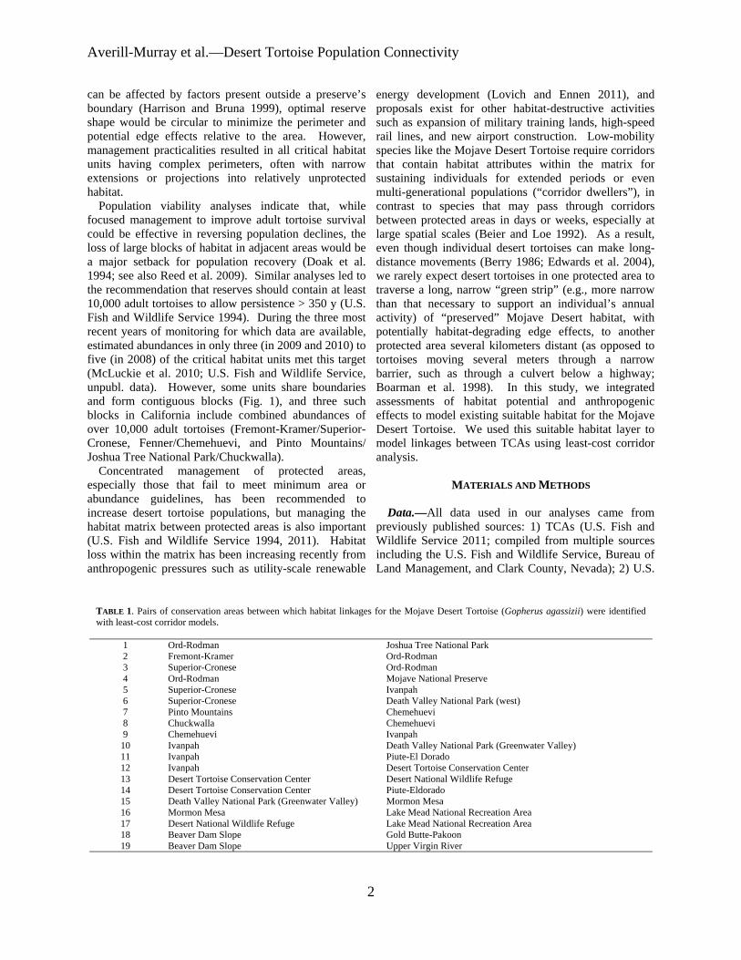
TABLE 1 Pairs of conservation areas between which habitat linkages for the Mojave Desert Tortoise (Gopherus agassizii) were identified with least-cost corridor models
1 Ord-Rodman Joshua Tree National Park 2 Fremont-Kramer Ord-Rodman 3 Superior-Cronese Ord-Rodman 4 Ord-Rodman Mojave National Preserve 5 Superior-Cronese Ivanpah 6 Superior-Cronese Death Valley National Park (west) 7 Pinto Mountains Chemehuevi 8 Chuckwalla Chemehuevi 9 Chemehuevi Ivanpah 10 Ivanpah Death Valley National Park (Greenwater Valley) 11 Ivanpah Piute-El Dorado 12 Ivanpah Desert Tortoise Conservation Center 13 Desert Tortoise Conservation Center Desert National Wildlife Refuge 14 Desert Tortoise Conservation Center Piute-Eldorado 15 Death Valley National Park (Greenwater Valley) Mormon Mesa 16 Mormon Mesa Lake Mead National Recreation Area 17 Desert National Wildlife Refuge Lake Mead National Recreation Area 18 Beaver Dam Slope Gold Butte-Pakoon 19 Beaver Dam Slope Upper Virgin River
2
Herpetological Conservation and Biology
Geological Surveyrsquos (USGS) desert tortoise habitat potential model (Nussear et al 2009) 3) The Nature Conservancyrsquos Mojave Ecoregional Assessment (Randall et al 2010 Mojave Desert Ecoregional Assessment Available from httpconserveonlineorg workspacesmojavedocumentsmojave-desertecoregiona al-2010viewhtml [Accessed 10 January 2012]) 4) The Nature Conservancyrsquos Sonoran Desert Ecoregional Assessment (Conservation Biology Institute 2009 A framework for effective conservation management of the Sonoran Desert in California Available from httpstaticconsbioorgmediareportsfilesSonoran Framework_ January_20091pdf [Accessed 10 January 2012]) and 5) the Multi-Resolution Land Characteristics Consortiumrsquos National Landcover Dataset 2006 (NLCD Fry et al 2011)
Modeling suitable habitatmdashThe USGS model of historical habitat probability for the Mojave Desert Tortoise used presence data and a set of environmental variables to predict potential areas of desert tortoise habitat on a scale of 0ndash1 throughout its geographic range at 1 km2 resolution The model did not account for anthropogenic changes that have altered relatively high-potential habitat into areas with lower potential We therefore used the NLCD developed-areas layer and The Nature Conservancys Highly Converted Areas for the Mojave ecoregion (Randall et al op cit) and ldquoConservation Category Drdquo areas for the Sonoran ecoregion (Conservation Biology Institute op cit) to reclassify developed areas where tortoises cannot or are less likely to occur to a lower habitat potential as described below The ldquohighly convertedrdquo and ldquocategory Drdquo layers depict urban suburban and agricultural lands that have been heavily altered The Nature Conservancyrsquos ecoregional assessments were done as hexagon rasters of approximately 26 km2 which are appropriate at scales greater than 1250000 (Randall et al op cit Conservation Biology Institute op cit)
To make the three primary datasets analytically comparable we resampled all datasets to the same 100 m grid-cell resolution as is commonly done with GIS datasets We resampled the USGS habitat potential model from its 1 km grid-cell size to a 100 m grid cell with a nearest-neighbor approach using the Resample tool in ArcGIS (ESRI Redlands California USA) The Nature Conservancyrsquos Ecoregional Assessment dataset was available as hexagonal units approximately 25 km2
in area as vector (polygon) files To be compatible with our analysis we rasterized the output to a 100 m grid cell We downsampled the NLCD from 30 m using ArcGISs Aggregate tool setting the aggregation technique to Maximum This setting took the maximum cell value from the source when determining the new value for the output cell
We reclassified habitat potential values based on anthropogenic features from the datasets described above We assigned areas within the NLCD as 0 habitat potential using a series of ArcGIS conditional (ifelse ldquoConrdquo) statements if they were classified as high-intensity developed or medium-intensity developed The high-intensity developed category includes highly developed areas where impervious surfaces account for 80ndash100 of the total cover The medium-intensity developed category includes areas where impervious surfaces account for 50ndash79 of the total cover these areas most commonly include single-family housing units We assumed that the low-intensity developed category which includes areas where impervious surfaces account for 20ndash49 percent of total cover reduces tortoise occupancy potential below the baseline threshold for natural habitat without necessarily eliminating all use so we assigned scores of 03 to these areas if the USGS habitat potential value was greater than or equal to 03 We reclassified areas categorized by The Nature Conservancy as highly converted and ldquocategory Drdquo to 0 habitat potential the highly converted layer depicts urban suburban and agricultural lands that have been heavily altered Areas not affected by these anthropogenic features retained their underlying score from the USGS habitat model
We also identified areas of contiguous non-zero cells less than a cumulative area of 1 km2 We classified these areas as 0 habitat potential because they are isolated patches that are disconnected from contiguous habitat and are capable of supporting few tortoises (eg fewer than 14 adult tortoises on average US Fish and Wildlife Service unpubl data) Figure 1 depicts the resulting ldquoSuitable Habitatrdquo model For discrete estimations of habitat area (ie to convert the probability model to presenceabsence) we clipped the model to the 05 habitat-probability threshold based on 05 prevalence in the model dataset (Liu et al 2005 Ken Nussear pers comm 2009)
Least-cost corridor model simulationmdashLeast-cost path analysis uses a raster-based algorithm that weighs the minimal cost distance between source and target cells We used five basic steps to finding least-cost corridor networks in our study landscape (cf Sawyer et al 2011) (1) Select the specific source and destination points (2) create a spatially-explicit resistance surface that is weighted according to facilitating or hindering effects on the movement process (3) calculate a minimum accumulated cost surface over the resistance surface from all cells in the study area for both the source and destination features (treating each feature as a source) creating two raster maps where every cell is assigned a value that represents the lowest possible accumulative cost from the feature to each cell (4) use these two accumulative cost outputs to find the sum of
3
Averill-Murray et almdashDesert Tortoise Population Connectivity
FIGURE 1 Current predicted Mojave Desert Tortoise (Gopherus agassizii) habitat adapted from Nussear et al (2009)
the two surfaces at each cell The sum of the two raster costs identifies for each cell location the least-cost path from one source to another source that passes through the cell location (ESRI 2011 Creating a least cost corridor ArcGIS Desktop Help 100 Available from httphelparcgiscomenarcgisdesktop100helpindex html009z00000024000000htm [Accessed 9 April 2012]) and (5) apply a maximum accumulated distance threshold to define a corridor (as opposed to a single line resulting from a least-cost path analysis)
Nineteen pairs of TCAs served as sourcedestination polygons for our least-cost corridor analysis (Table 1) We modeled connectivity between TCA pairs through cells of habitat capable of supporting tortoise occupancy under the premise that the Mojave Desert Tortoise is a corridor dweller High-probability habitat corresponds to ldquolow costrdquo for tortoise occupancy so we inverted the habitat suitability surface using ESRIrsquos Spatial Analyst arithmetic functions for use as a cost surface Using the source polygons and the cost surface we created a cost-
distance surface for each of the source polygons defined in a pair (two surfaces per pair) These surfaces represent the accumulative cost of ldquotravelingrdquo over the cost surface from each cell back to the edge of the source polygon We created these surfaces with ESRIrsquos Spatial Analyst CostDistance function We used ESRIrsquos Spatial Analyst Corridor function to sum the two accumulative costs for the two input accumulative-cost rasters thereby identifying for each cell location the least-cost path from the source to the destination that passes through that cell location Because of the varying cost between each TCA pair (one pair might be geographically adjacent to one another while another pair might be separated by gt 100 km) we applied a standard threshold percentage to normalize the outputs Through an iterative process of reviewing threshold outputs we chose a standard distance threshold of 1 for each corridor output The associated range of cost-distance values were calculated from the total range of corridor values and applied using ESRIrsquos Spatial Analyst Con
4
Herpetological Conservation and Biology
FIGURE 2 Least-cost corridors between tortoise conservation areas (Base model) Each corridor includes the lowest 1 cost-distance paths between tortoise conservation areas (TCAs) where the relative cost to tortoises increases from black to white White patterns within TCAs are private inholdings within federal lands
function The output of this series of operations was a corridors from 0ndash1 using a custom script written in raster of the corridor fromto each TCA polygon which Python We also inverted these rescaled corridor values includes the lowest 1 cost paths from one TCA to to represent importance for connectivity rather than cost another We refer to the output from this process using the
While overall movement resistance may be higher Suitable Habitat model as the ldquoBaserdquo model The between two TCAs than between another pair corridors movement cost surface in the Base model assumes a 11 between each TCA pair are important to population relationship between probability of tortoise occurrence in connectivity range-wide Therefore we normalized all each pixel and resistance to connectivity However a
TABLE 2 Overlap (km2 ) of Mojave Desert Tortoise (Gopherus agassizii) habitat in four least-cost corridor models with Department of Defense (DOD) lands designated open off-highway-vehicle (OHV) recreation areas and designated wilderness areas or Bureau of Land Management National Conservation Areas (NCAs)
Base Base2 Binned Binned2
DOD2375 (13) 0 -shy7165 (16) 0 -shy
OHV875 (5) 0 -shy1200 (3) 0 -shy
WildernessNCA 2952 (17) 4260 (26) 6985 (16) 7145 (20)
5
Averill-Murray et almdashDesert Tortoise Population Connectivity
FIGURE 3 Least-cost corridors between tortoise conservation areas (TCAs Base model) overlaid with Department of Defense (DoD) lands and open off-highway vehicle (OHV) areas and showing designated wilderness areas and National Conservation Areas (NCAs) clipped to the linkages Each corridor includes the lowest 1 cost-distance paths between TCAs where the relative cost to tortoises increases from black to white White patterns within TCAs are private inholdings within federal lands
pixel of moderate probability (eg 07) may contribute equally to connectivity as a pixel of high probability (09) if both pixels allow some degree of population presence or individual movement especially at a temporal scale of a tortoise generation (about 25 y) For example 95 of cells with known presence in the USGS habitat model had scores greater than 07 (Nussear et al 2009) Therefore we compared the Base model to a ldquoBinnedrdquo model in order to evaluate uncertainty in our choice of resistance values as recommended by Beier et al (2009) and Sawyer et al (2011) We developed the cost surface for the Binned model by re-scoring all pixels ge 07 in the Base model to 10 values 050ndash069 to 06 values 010ndash049 to 03 and values lt 01 to 0 Other land uses also may affect desert tortoise connectivity but are not captured by NLCDrsquos developed areas of The Nature Conservancyrsquos highly converted areas Military training maneuvers and open-access off- highway-
vehicle (OHV) recreation are high-impact activities that limit tortoise abundance especially in the long term with increasing use (Bury and Luckenbach 2002 Berry et al 2006) Therefore we assessed effects on linkages of converting all Department of Defense (DOD) lands and open OHV areas to 0 habitat probability (models ldquoBase2rdquo and ldquoBinned2rdquo)
RESULTS
Suitable Habitat (ie current estimated habitat) for the Mojave Desert Tortoise totals 67000 km2 81 of the historic (ie unmanipulated USGS habitat model) estimated total of 83138 km2 The area of Suitable Habitat within TCAs including areas of overlap with DOD lands is 45340 km2 (68 of total current 55 of total historic) Suitable Habitat within linkages connecting the TCAs in the Base model totals17831 km2
6
Herpetological Conservation and Biology
TABLE 3 Percentage overlap of least-cost corridors based on four connectivity models between Mojave Desert Tortoise (Gopherus agassizii) conservation areas Total habitat area within each linkage is given along the diagonal
Base Base2 Binned Binned2 Base 17831 km2 81 38 35 Base2 74 16282 km2 34 41 Binned 92 90 43597 km2 97 Binned2 70 90 79 35629 km2
(27 current 21 historic Fig 2) Several linkages are already severely constrained or impacted by DOD and open OHV area designations (Fig 3 Table 2) Military training operations or high-intensity OHV recreation affect up to 18 of Suitable Habitat within linkages in the Base model On the other hand portions of some linkages (17) are protected by wilderness or US Bureau of Land Management (BLM) National
Conservation Area (NCA) designations (Fig 3 Table 2) The Binned model had the effect of greatly lowering
the resistance to tortoise occupancy thereby increasing the amount of area included in the lowest 1 cost paths between TCAs (Fig 4) Linkages in the Base model included only 38 of Suitable Habitat in the Binned model while the Binned linkages included 92 of Base linkage habitat (Table 3) The total area of habitat within
FIGURE 4 Binned model least-cost corridors between tortoise conservation areas (TCAs) overlaid with Department of Defense (DoD) lands and open off-highway vehicle (OHV) areas and showing designated wilderness areas and National Conservation Areas (NCAs) clipped to the linkages Each corridor includes the lowest 1 cost-distance paths between TCAs where the relative cost to tortoises increases from black to white White patterns within TCAs are private inholdings within federal lands
7
Averill-Murray et almdashDesert Tortoise Population Connectivity
FIGURE 5 Base2 model least-cost corridors between tortoise conservation areas (TCAs) overlaid with Department of Defense (DoD) lands and open off-highway vehicle (OHV) areas and showing designated wilderness areas and National Conservation Areas (NCAs) clipped to the linkages Each corridor includes the lowest 1 cost-distance paths between TCAs where the relative cost to tortoises increases from black to white White patterns within TCAs are private inholdings within federal lands
linkages in the Binned model totals 43597 km2 (65 current 52 historic) Military training operations or high-intensity OHV recreation affect 19 of habitat within the linkages in the Binned model (Table 2) Current wilderness or NCA designations protect 16 of linkages in the Binned model (Table 2)
Excluding DOD and OHV designations from the cost surface reduced total habitat areas by 87 and 183 in the Base2 and Binned2 models respectively (Table 3) although a greater proportion of the linkages is protected by existing wilderness or NCA designations (Table 2) Excluding these areas resulted in expansion of remaining linkages between TCAs especially in California in the Base2 model (Figs 56) Overall linkages in the Base model overlapped 81 of Suitable Habitat in the Base2 model while the Binned model included 97 of Suitable Habitat in the Binned2 model (Table 3) Differences
from 100 in proportion of habitat in the Base and Binned models that overlap the smaller Base2 and Binned2 models reflect shifts in the 1 cost surfaces For example in the Base2 model more of the area east of the Ord-Rodman and Superior-Cronese critical habitat units was important for connectivity and new linkage strands were identified between the Chemehuevi and Chuckwalla critical habitat units (Fig 5)
DISCUSSION
Successfully conserving the Mojave Desert Tortoise will entail managing not just conservation areas alone but also the connections between these areas (ie managing the matrix between reserves Fahrig 2001 Prevedello and Vieira 2010) Some TCAs are contiguous with others and together may contain viable
8
Herpetological Conservation and Biology
FIGURE 6 Binned2 model least-cost corridors between tortoise conservation areas (TCAs) overlaid with Department of Defense (DoD) lands and open off-highway vehicle (OHV) areas and showing designated wilderness areas and National Conservation Areas (NCAs) clipped to the linkages Each corridor includes the lowest 1 cost-distance paths between TCAs where the relative cost to tortoises increases from black to white White patterns within TCAs are private inholdings within federal lands
numbers of desert tortoises but even these contiguous blocks are adjacent to smaller more isolated TCAs Therefore the function of the collective TCA network could be solidified by ensuring that all remain connected In cases where much of the matrix between reserves remains undeveloped managing the matrix to increase permeability and occupancy will be easier than restoring corridors after development has occurred (Prugh et al 2008 Prededello and Vieira 2010)
In addition most wildlife including the Mojave Desert Tortoise does not occur at uniform densities across landscapes (Krzysik 2002) The extent to which populations may fluctuate asynchronously such as localized declines attributed to drought or predation events (Peterson 1994 Longshore et al 2003 see also the model of recruitment in chaotic environments in Morafka 1994) even within designated conservation
areas increases risks to population viability and places increased emphasis on preserving population connectivity through the surrounding habitat matrix Even under an assumption that TCAs are source habitats surrounded by sinks maintaining or improving conditions within sinkslinkages can be as important to regional viability as protecting source TCAs because of their effect on neighboring source habitat (Carroll et al 2003) Consequently the effectiveness of TCAs will be improved if they are connected with functional habitat to ensure desert tortoise population persistence (US Fish and Wildlife Service 1994 2011) Ideally linkages between TCAs would also be wide enough to buffer against detrimental edge effects (Beier et al 2008) a recommendation applicable also to the TCAs themselves (US Fish and Wildlife Service 1994)
9
Averill-Murray et almdashDesert Tortoise Population Connectivity
While specific management is needed within TCAs these areas provide only an initial framework upon which to focus recovery efforts especially given uncertainties related to the effects of climate change on Mojave Desert Tortoise populations and distribution (Barrows et al 2011 US Fish and Wildlife Service 2011) Temperatures are projected to change relatively quickly within desert ecosystems To keep pace with changes from current temperature regimes within the current century desert wildlife populations or species would need to shift their distributions at approximately 07 kmyear (Loarie et al 2009) At this rate the current climate would cross each critical habitat unit (ranging in latitudinal extent of approximately 33ndash267 km) within 23ndash187 years Notwithstanding potential elevational shifts by tortoise populations in response to climate change which may be constrained in many areas as a result of geologic limitations on burrow construction preserving connectivity between TCAs may allow shifts in the speciesrsquo distribution and allow for future flexibility in refocusing management to ensure long-term recovery (Crooks and Sanjayan 2006 Krosby et al 2010)
Connectivity conservation also is integral to maintaining genetic variability and ecological heterogeneity within and among populations of widely distributed species Genetic analyses suggest that historically levels of gene flow among subpopulations of the Mojave Desert Tortoise were high corresponding to high levels of habitat connectivity (Murphy et al 2007 Hagerty 2008) All recent genetic studies of the Mojave Desert Tortoise have suggested that its population structure is characterized by isolation-byshydistance populations at the farthest extremes of the distribution are most differentiated but a gradient of genetic differentiation occurs between those populations across the range (Britten et al 1997 Murphy et al 2007 Hagerty and Tracy 2010) This isolation-by-distance genetic structure across the relatively continuous historic distribution of the Mojave Desert Tortoise (Germano et al 1994 Nussear et al 2009) indicates that gene flow generally occurs (or historically occurred) according to a continuous-distribution model (Allendorf and Luikart 2007) as opposed to a metapopulation or stepping-stone model where individual tortoises move from one patch of suitable habitat across less suitable or non-habitat to another patch of suitable habitat
Our modeling approach was similar to that of Hagerty et al (2011) who modeled historic gene flow between populations across the range of the species across a cost surface based on the original (historic) USGS habitat model Gene flow historically occurred in a diffuse pattern across the landscape unless otherwise constrained to more narrow concentrated pathways created by topographic barriers (eg around the Spring Mountains in southern Nevada Hagerty et al 2011) Linkages
between conservation areas are needed to conserve historic genetic gradation thereby preventing habitat specialization and genetic divergence between populations (Frankham 2006) Where gene flow is constrained by topographic barriers conservation of such concentrated pathways or linkages is especially important
For gene flow to reliably occur across the range and for populations within existing conservation areas to be buffered against detrimental effects of low numbers or density populations need to be connected by areas of habitat occupied by tortoises Low levels of genetic differentiation in Mojave Desert Tortoises have been detected across even relatively recent and narrow anthropogenic impacts on the landscape (Latch et al 2011) Pairs of tortoises from opposite sides of a road exhibited significantly greater genetic differentiation than pairs from the same side of a road (Latch et al 2011) raising even greater concerns for population fragmentation from larger scale habitat loss
Assumptions and limitationsmdashOur assessment of important areas within which to preserve connectivity of Mojave Desert Tortoise populations is limited by shortcomings in our knowledge We assumed that potential tortoise occupancy was accurately reflected by the USGS habitat model as modified by our interpretation of the altered-habitat datasets and that linkages of high-probability habitat between existing TCAs will help sustain viable populations across the range of the species Implicit in this assumption is that various land uses or impacts occurring on the landscape (eg unpaved roads exotic plant invasions) that were not explicitly included in the geospatial data we used do not impede connectivity of tortoise populations We evaluated the effect of this assumption relative to large-scale potential impacts of high-intensity land uses (military training maneuvers and open OHV recreation) and additional areas emerged that may be important to connectivity
Least-cost path analyses provide only a snapshot of current habitat conditions and are uninformative about demographic processes or how individuals actually move through a landscape (Noss and Daly 2006 Taylor et al 2006) We assumed that a 1 cost surface would identify linkages wide enough to provide functional connectivity between TCAs However application of different resistance values from the underlying habitat model greatly influenced the total area and configuration of the 1 cost surface
Indeed limiting the cost surface to the lowest 1 is an arbitrary choice (Sawyer et al 2011) The mean model score for all cells with known tortoise presence in the USGS habitat model was 084 and 95 of cells with known presence had scores greater than 07 (Nussear et al 2009) Therefore connectivity between tortoise
10
Herpetological Conservation and Biology
populations (TCAs) may occur more broadly than estimated in the Base model The more permeable Binned model identified linkages 245 larger in area than those in the Base model while the linkages in the Binned2 model were 219 larger than those in the Base2 model
Limited guidance is available for determining precise linkage widths but minimum widths for corridor dwellers such as the Mojave Desert Tortoise should be substantially larger than a home range diameter (Beier et al 2008) Inevitably however questions will be asked about what is the minimum width for a particular desert tortoise linkage what is the relevant home range size from which to estimate that minimum width and what are the minimum sampling considerations in estimating home ranges (cf Harless et al 2010) We agree with Beier et al (2008) that this is analogous to asking an engineer ldquowhat are the fewest number of rivets that might keep this wing on the airplanerdquo A more appropriate question for conservation is ldquowhat is the narrowest width that is not likely to be regretted after the adjacent area is converted to human userdquo Managers and policy-makers must realize that conservation is not primarily a set-aside issue that can be dealt with by reserving a minimal percentage or amount of the landscape rather it is a pervasive issue that must be considered across the entire landscape (Franklin and Lindenmayer 2009)
Management implications and recommendationsmdash In general land and wildlife managers should think about corridors between conservation areas that are large enough for resident tortoises to persist and to continue to interact with their neighbors within and outside broad habitat linkages rather than expect that a more narrow band of habitat will allow an individual tortoise to move through it to the other side breed with a tortoise on that side and produce viable offspring that contribute to the next generation Linkage integrity with sufficient habitat to support sustainable populations is important for Mojave Desert Tortoises and other corridor dwellers to support connectivity between core reserves (cf Barrows et al 2011) Given the underlying geospatial data linkages in the Base2 model illustrate a minimum connection of habitat for Mojave Desert Tortoises between TCA pairs and therefore represent priority areas for conservation of population connectivity However large areas within these linkages are at risk of permanent habitat loss as a result of solar energy development
Utility-scale solar development will require 831 km2
of land by 2030 to meet the reasonably foreseeable development scenario within the entire states of California and Nevada (US Bureau of Land Management and US Department of Energy 2012) To meet this need BLM has identified 39830 km2 of
potentially developable public lands throughout these states (not all within Mojave Desert Tortoise habitat) including 866 km2 of proposed solar energy zones (SEZs) within which solar energy production would be prioritized and facilitated Meanwhile projects totaling 190 km2 and 1470 km2 had already been approved or were pending respectively across BLM land within the range of the Mojave Desert Tortoise (US Bureau of Land Management and US Department of Energy 2012) Relatively little linkage area would be consumed by the proposed SEZs (40 km2) but 37 km2 of approved and 703 km2 of pending projects overlap linkages in the Base2 model with some linkages at particular risk (Fig 7) Even though substantial uncertainty surrounds the ultimate development footprint of pending solar development projects (or other proposed projects including wind energy development) a separate analysis found that between 2000 km2 and 7400 km2 of lower conservation value land could meet Californiarsquos renewable energy goal by up to seven times over (Cameron et al 2012) This suggests that renewable energy goals can be met without compromising the conservation of important Mojave Desert Tortoise habitat
The Binned2 model includes blocks of contiguous habitat outside the Base2 linkage network and many such areas likely contain substantial numbers of Mojave Desert Tortoises Managers should consider additional conservation of occupied habitat adjacent to the Base2 linkages and existing TCAs to provide security against edge effects and population declines especially given limitations previously identified in the existing reserve architecture For example even though use of DOD lands may be subject to change depending on national security needs the value of military lands to conservation has long been recognized (Stein et al 2008) and DOD-managed habitat that is unaffected by military training operations adds to the conservation base Of additional note are blocks of habitat at the northern extent of the Mojave Desert Tortoisersquos range which may be of particular relevance for additional evaluation to determine more precisely how the modeled linkages will accommodate climate change (Beier et al 2008)
Application of models from this study will require refinement at the local level and at a higher-resolution scale than the available geospatial data (ie finer resolution than 1 km2) to account for on-the-ground limitations to tortoise occupancy and movement either not reflected in the geospatial data used here or as a result of errors in the land cover data we used to identify Suitable Habitat (Beier et al 2009) For example habitat connections through the northern end and across the boundary of the Chuckwalla critical habitat unit may be more limited by rugged topography than suggested by Figure 1 (Jody Fraser and Pete Sorensen pers comm)
11
Averill-Murray et almdashDesert Tortoise Population Connectivity
FIGURE 7 Least-cost corridors (Base2 model) between tortoise conservation areas (TCAs) relative to approved solar development projects pending solar development projects and solar energy zones Each corridor includes the lowest 1 cost-distance paths between TCAs where the relative cost to tortoises increases from black to white White patterns within TCAs are private inholdings within federal lands
thereby placing greater potential importance on the linkage identified on the north end of the critical habitat unit in the Binned2 model In addition more detailed or spatially explicit population viability analyses based on regional population and distribution patterns are needed to evaluate the ability of a conservation network such as that modeled here to ensure long-term persistence of Mojave Desert Tortoise populations (US Fish and Wildlife Service 2011 eg Carroll et al 2003)
While there is much still to be learned about the science and application of connectivity land managers cannot wait for research to resolve all relevant questions before focusing effort on enhancing connectivity Instead science and management must proceed in parallel with the flexibility to modify future management in the light of new knowledge (Lovejoy 2006) In areas proposed for essentially permanent habitat conversion such as by large-scale development there is the risk that
critical linkages will be severed before they are protected (Morrison and Reynolds 2006) For species with long generation times like the Mojave Desert Tortoise this risk is compounded by the fact that we are not likely to detect a problem with a population until well after we have reduced the habitat below its extinction threshold (Fahrig 2001)
AcknowledgmentsmdashDiscussion with Linda Allison Ashleigh Blackford Brian Croft Diane Elam Kimberleigh Field and the Desert Tortoise Science Advisory Committee (Peter Hudson Earl McCoy Katherine Ralls Michael Reed and Robert Steidl) contributed to the development of this manuscript Additional review and comments by Todd Esque Kimberleigh Field Michael Reed and Andrew Walde improved the manuscript We thank Lisa Benvenuti at the Redlands Institute for her excellent map-making
12
Herpetological Conservation and Biology
skills The findings and conclusions in this article are those of the authors and do not necessarily represent the views of the US Fish and Wildlife Service
LITERATURE CITED
Allendorf FW and G Luikart 2007 Conservation and the Genetics of Populations Blackwell Malden Massachusetts USA
Barrows CW KD Fleming and MF Allen 2011 Identifying habitat linkages to maintain connectivity for corridor dwellers in a fragmented landscape Journal of Wildlife Management 75682ndash691
Beier P and S Loe 1992 A checklist for evaluating impacts to wildlife movement corridors Wildlife Society Bulletin 20434ndash440
Beier P DR Majka and SL Newell 2009 Uncertainty analysis of least-cost modeling for designing wildlife linkages Ecological Applications 192067ndash2077
Beier P DR Majka and WD Spencer 2008 Forks in the road choices in procedures for designing wildland linkages Conservation Biology 22836ndash851
Berry KH TY Bailey and KM Anderson 2006 Attributes of Desert Tortoise populations at the National Training Center Central Mojave Desert California USA Journal of Arid Environments 67165ndash191
Berry KH and PA Medica 1995 Desert Tortoises in the Mojave and Colorado deserts Pages 135ndash137 In Our Living Resources A Report to the Nation on the Distribution Abundance and Health of US Plants Animals and Ecosystems LaRoe ET GS Farris CE Puckett PD Doran and MJ Mac (Eds) US Department of the Interior National Biological Service Washington DC USA
Boarman WI ML Beigel GC Goodlett and M Sazaki 1998 A passive integrated transponder system for tracking animal movements Wildlife Society Bulletin 26886ndash891
Britten HB BR Riddle PF Brussard R Marlow and TE Lee 1997 Genetic delineation of management units for the Desert Tortoise Gopherus agassizii in northeastern Mojave Desert Copeia 1997523ndash530
Bury RB and PS Corn 1995 Have desert tortoises undergone a long-term decline in abundance Wildlife Society Bulletin 2341ndash47
Bury RB and RA Luckenbach 2002 Comparison of Desert Tortoise (Gopherus agassizii) populations in an unused and off-road vehicle area in the Mojave Desert Chelonian Conservation and Biology 4457ndash463
Cameron DR BS Cohen and SA Morrison 2012 An approach to enhance the conservation-compatibility of solar energy development PloS ONE 7(6)e38347 Doi101371journalpone0038437
Carroll C RF Noss PC Paquet and NH Schumaker 2003 Use of population viability analysis and reserve selection algorithms in regional conservation plans Ecological Applications 131773ndash 1789
Crooks KR and M Sanjayan 2006 Connectivity conservation maintaining connections for nature Pp 1ndash19 In Connectivity Conservation Crooks KR and M Sanjayan (Eds) Cambridge University Press Cambridge UK
Doak D P Kareiva and B Klepetka 1994 Modeling population viability for the Desert Tortoise in the western Mojave Desert Ecological Applications 4446ndash460
Edwards T EW Stitt CR Schwalbe and DE Swann 2004 Gopherus agassizii (Desert Tortoise) Movement Herpetological Review 35381ndash382
Fagan WF and EE Holmes 2006 Quantifying the extinction vortex Ecology Letters 951ndash60
Fahrig L 2001 How much habitat is enough Biological Conservation 10065ndash74
Frankham R 2006 Genetics and landscape connectivity Pp 72ndash96 In Connectivity Conservation Crooks KR and M Sanjayan (Eds) Cambridge University Press Cambridge UK
Franklin JF and DB Lindenmayer 2009 Importance of matrix habitats in maintaining biological diversity Proceedings of the National Academy of Sciences 106349ndash350
Fry J G Xian S Jin J Dewitz C Homer L Yang C Barnes N Herold and J Wickham 2011 Completion of the 2006 National Land Cover Database for the conterminous United States Photogrammetric Engineering and Remote Sensing 77858ndash864
Germano DJ RB Bury TC Esque TH Fritts and PA Medica 1994 Range and habitat of the Desert Tortoise Pp 57ndash72 In Biology of the North American Tortoises Bury RB and DJ Germano (Eds) National Biological Survey Fish and Wildlife Research 13 Washington DC USA
Gilpin ME and ME Souleacute 1986 Minimum viable populations processes of species extinction Pp 19ndash34 In Conservation Biology The Science of Scarcity and Diversity Souleacute ME (Ed) Sinauer Associates Sunderland Massachusetts USA
Hagerty BE 2008 Ecological genetics of the Mojave Desert Tortoise PhD Dissertation University of Nevada Reno Nevada USA 226 p
Hagerty BE KE Nussear TC Esque and CR Tracy 2011 Making molehills out of mountains landscape genetics of the Mojave Desert Tortoise Landscape Ecology 26267ndash280
Hagerty BE and CR Tracy 2010 Defining population structure for the Mojave Desert Tortoise Conservation Genetics 111795ndash1807
13
Averill-Murray et almdashDesert Tortoise Population Connectivity
Harless ML AD Walde DK Delaney LL Pater and WK Hayes 2010 Sampling considerations for improving home range estimates of Desert Tortoises effects of estimator sampling regime and sex Herpetological Conservation and Biology 5374ndash387
Harrison S and E Bruna 1999 Habitat fragmentation and large-scale conservation what do we know for sure Ecography 22225ndash232
Krosby M J Tewksbury NM Haddad and J Hoekstra 2010 Ecological connectivity for a changing climate Conservation Biology 241686ndash1689
Krzysik AJ 2002 A landscape sampling protocol for estimating distribution and density patterns of Desert Tortoises at multiple spatial scales Chelonian Conservation and Biology 4366ndash379
Latch EK WI Boarman A Walde and RC Fleischer 2011 Fine-scale analysis reveals cryptic landscape genetic structure in Desert Tortoises PLoS ONE 6e27794 Doi101371journalpone0027794
Liu C PM Berry TP Dawson and RG Pearson 2005 Selecting thresholds of occurrence in the prediction of species distributions Ecography 28385ndash 393
Loarie SR PB Duffy H Hamilton GP Asner CB Field and DD Ackerly 2009 The velocity of climate change Nature 4621052ndash1055
Longshore KM JR Jaeger and JM Sappington 2003 Desert Tortoise (Gopherus agassizii) survival at two eastern Mojave Desert sites death by short-term drought Journal of Herpetology 37169ndash177
Lovejoy T 2006 Introduction donrsquot fence me in Pp 447ndash449 In Connectivity Conservation Crooks KR and M Sanjayan (Eds) Cambridge University Press Cambridge UK
Lovich JE and JR Ennen 2011 Wildlife conservation and solar energy development in the Desert Southwest United States BioScience 61982ndash 992
McLuckie AM PG Emblidge and RA Fridell 2010 Regional Desert Tortoise monitoring in the Red Cliffs Desert Reserve 2009 Utah Division of Wildlife Resource Publication 10-13
Meffe GK and CR Carroll 1994 The design of conservation reserves Pp 265ndash304 In Principles of Conservation Biology Meffe GK and CR Carroll (Eds) Sinauer Associates Sunderland Massachusetts USA
Morafka DJ 1994 Neonates missing links in the life histories of North American tortoises Pp 161ndash173 In Biology of North American Tortoises Bury RB and DJ Germano (Eds) National Biological Survey Fish and Wildlife Research 13 Washington DC USA
Morrison SA and MD Reynolds 2006 Where to draw the line integrating feasibility into connectivity planning Pp 536ndash554 In Connectivity Conservation
Crooks KR and M Sanjayan (Eds) Cambridge University Press Cambridge UK
Murphy RW KH Berry T Edwards and AM McLuckie 2007 A genetic assessment of the recovery units for the Mojave population of the Desert Tortoise Gopherus agassizii Chelonian Conservation and Biology 6229ndash251
Noss RF and KM Daly 2006 Incorporating connectivity into broad-scale conservation planning Pp 587ndash619 In Connectivity Conservation Crooks KR and M Sanjayan (Eds) Cambridge University Press Cambridge UK
Nussear KE TC Esque RD Inman L Gass KA Thomas CSA Wallace JB Blainey DM Miller and RH Webb 2009 Modeling habitat of the Desert Tortoise (Gopherus agassizii) in the Mojave and parts of the Sonoran deserts of California Nevada Utah and Arizona US Geological Survey Open-file Report 2009-1102 18 p
Peterson CC 1994 Different rates and causes of high mortality in two populations of the threatened Desert Tortoise Gopherus agassizii Biological Conservation 70101ndash108
Prevedello JA and MV Vieira 2010 Does the type of matrix matter A quantitative review of the evidence Biodiversity and Conservation 191205ndash 1223
Prugh LR KE Hodges ARE Sinclair and JS Brashares 2008 Effect of habitat area and isolation of fragmented animal populations Proceedings of the National Academy of Sciences 10520770ndash20775
Reed JM N Fefferman and RC Averill-Murray 2009 Vital rate sensitivity analysis as a tool for assessing management actions for the Desert Tortoise Biological Conservation 1422710ndash2717
Ricketts TH 2001 The matrix matters effective isolation in fragmented landscapes American Naturalist 15887ndash99
Sawyer SC CW Epps and JS Brashares 2011 Placing linkages among fragmented habitats do least-cost models reflect how animals use landscapes Journal of Applied Ecology 48668ndash678
Stein BA C Scott and N Benton 2008 Federal lands and endangered species the role of military and other federal lands in sustaining biodiversity BioScience 58339ndash347
Taylor PD L Fahrig and KA With 2006 Landscape connectivity a return to basics Pp 29ndash43 In Connectivity Conservation Crooks KR and M Sanjayan (Eds) Cambridge University Press Cambridge UK
US Bureau of Land Management and US Department of Energy 2012 Final programmatic environmental impact statement (PEIS) for solar energy development in six southwestern states FES 12-24 DOEEIS-0403
14
Herpetological Conservation and Biology
US Fish and Wildlife Service 1990 Endangered and threatened wildlife and plants determination of threatened status for the Mojave population of the Desert Tortoise Federal Register 5512178ndash12191
US Fish and Wildlife Service 1994 Desert Tortoise (Mojave population) Recovery Plan US Fish and Wildlife Service Portland Oregon USA
US Fish and Wildlife Service 2011 Revised Recovery Plan for the Mojave Population of the Desert Tortoise (Gopherus agassizii) US Fish and Wildlife Service California and Nevada Region Sacramento California USA
Venter O NN Brodeur L Nemiroff B Belland IJ Dolinsek and JWA Grant Threats to endangered species in Canada BioScience 56903ndash910
Wiens JA 2006 Introduction connectivity research ndash What are the issues Pp 23ndash27 In Connectivity Conservation Crooks KR and M Sanjayan (Eds) Cambridge University Press Cambridge UK
Wilcox BA and DD Murphy 1985 Conservation strategy the effects of fragmentation on extinction American Naturalist 125879ndash887
Yiming L and DS Wilcove 2005 Threats to vertebrate species in China and the United States BioScience 55147ndash153
ROY C AVERILL-MURRAY is the Desert Tortoise Recovery Coordinator for the Desert Tortoise Recovery Office of the US Fish and Wildlife Service in Reno Nevada USA He oversees the recovery office in coordinating research monitoring and recovery plan implementation for the threatened Mojave Desert Tortoise He has published articles and book chapters on various aspects of the ecology and management of both the Mojave Desert Tortoise and the Sonoran Desert Tortoise Roy has degrees in Wildlife and Fisheries Sciences from Texas AampM University (BS) and the University of Arizona (MS) (Photographed by Kimberleigh J Field)
CATHERINE R DARST is the Recovery Biologist for the US Fish and Wildlife Services Desert Tortoise Recovery Office in Ventura California USA Cats work focuses on recovery plan implementation and research coordination including developing collaborative planning processes and spatial decision support for the Mojave Desert Tortoise Cat received her undergraduate degrees from the University of California at Davis and her PhD in Ecology Evolution and Behavior from the University of Texas at Austin (Photographed by Ashleigh Blackford)
NATHAN STROUT is the Technology Manager for the Redlands Institute University of Redlands in Redlands California USA He is responsible for managing the technical design and development of projects at the Redlands Institute and a team of technical staff including programmers analysts and IT support staff His work includes GIS research and analysis web and desktop application development and project management Nathan also serves as adjunct faculty in the Master of Science in Geographic Information Systems (MS GIS) at the University of Redlands Nathan received his undergraduate degree in Environmental Science and a MS in GIS from the University of Redlands (Photographed by Stephen Daugherty)
MARTIN L WONG is a GIS Analyst for the Redlands Institute University of Redlands in Redlands California He is responsible for supporting students faculty and staff at the Redlands Institute and the Environmental Studies and MSGIS departments in their geospatial data needs His work includes researching acquiring and geoprocessing data writing scripts and tools using Python and C and producing maps and reports Martin received his undergraduate degree in Geography from the University of California at Santa Barbara (Photographed by Susie Kim)
15
Averill-Murray et almdashDesert Tortoise Population Connectivity
can be affected by factors present outside a preserversquos boundary (Harrison and Bruna 1999) optimal reserve shape would be circular to minimize the perimeter and potential edge effects relative to the area However management practicalities resulted in all critical habitat units having complex perimeters often with narrow extensions or projections into relatively unprotected habitat
Population viability analyses indicate that while focused management to improve adult tortoise survival could be effective in reversing population declines the loss of large blocks of habitat in adjacent areas would be a major setback for population recovery (Doak et al 1994 see also Reed et al 2009) Similar analyses led to the recommendation that reserves should contain at least 10000 adult tortoises to allow persistence gt 350 y (US Fish and Wildlife Service 1994) During the three most recent years of monitoring for which data are available estimated abundances in only three (in 2009 and 2010) to five (in 2008) of the critical habitat units met this target (McLuckie et al 2010 US Fish and Wildlife Service unpubl data) However some units share boundaries and form contiguous blocks (Fig 1) and three such blocks in California include combined abundances of over 10000 adult tortoises (Fremont-KramerSuperior-Cronese FennerChemehuevi and Pinto Mountains Joshua Tree National ParkChuckwalla)
Concentrated management of protected areas especially those that fail to meet minimum area or abundance guidelines has been recommended to increase desert tortoise populations but managing the habitat matrix between protected areas is also important (US Fish and Wildlife Service 1994 2011) Habitat loss within the matrix has been increasing recently from anthropogenic pressures such as utility-scale renewable
energy development (Lovich and Ennen 2011) and proposals exist for other habitat-destructive activities such as expansion of military training lands high-speed rail lines and new airport construction Low-mobility species like the Mojave Desert Tortoise require corridors that contain habitat attributes within the matrix for sustaining individuals for extended periods or even multi-generational populations (ldquocorridor dwellersrdquo) in contrast to species that may pass through corridors between protected areas in days or weeks especially at large spatial scales (Beier and Loe 1992) As a result even though individual desert tortoises can make long-distance movements (Berry 1986 Edwards et al 2004) we rarely expect desert tortoises in one protected area to traverse a long narrow ldquogreen striprdquo (eg more narrow than that necessary to support an individualrsquos annual activity) of ldquopreservedrdquo Mojave Desert habitat with potentially habitat-degrading edge effects to another protected area several kilometers distant (as opposed to tortoises moving several meters through a narrow barrier such as through a culvert below a highway Boarman et al 1998) In this study we integrated assessments of habitat potential and anthropogenic effects to model existing suitable habitat for the Mojave Desert Tortoise We used this suitable habitat layer to model linkages between TCAs using least-cost corridor analysis
MATERIALS AND METHODS
DatamdashAll data used in our analyses came from previously published sources 1) TCAs (US Fish and Wildlife Service 2011 compiled from multiple sources including the US Fish and Wildlife Service Bureau of Land Management and Clark County Nevada) 2) US
TABLE 1 Pairs of conservation areas between which habitat linkages for the Mojave Desert Tortoise (Gopherus agassizii) were identified with least-cost corridor models
1 Ord-Rodman Joshua Tree National Park 2 Fremont-Kramer Ord-Rodman 3 Superior-Cronese Ord-Rodman 4 Ord-Rodman Mojave National Preserve 5 Superior-Cronese Ivanpah 6 Superior-Cronese Death Valley National Park (west) 7 Pinto Mountains Chemehuevi 8 Chuckwalla Chemehuevi 9 Chemehuevi Ivanpah 10 Ivanpah Death Valley National Park (Greenwater Valley) 11 Ivanpah Piute-El Dorado 12 Ivanpah Desert Tortoise Conservation Center 13 Desert Tortoise Conservation Center Desert National Wildlife Refuge 14 Desert Tortoise Conservation Center Piute-Eldorado 15 Death Valley National Park (Greenwater Valley) Mormon Mesa 16 Mormon Mesa Lake Mead National Recreation Area 17 Desert National Wildlife Refuge Lake Mead National Recreation Area 18 Beaver Dam Slope Gold Butte-Pakoon 19 Beaver Dam Slope Upper Virgin River
2
Herpetological Conservation and Biology
Geological Surveyrsquos (USGS) desert tortoise habitat potential model (Nussear et al 2009) 3) The Nature Conservancyrsquos Mojave Ecoregional Assessment (Randall et al 2010 Mojave Desert Ecoregional Assessment Available from httpconserveonlineorg workspacesmojavedocumentsmojave-desertecoregiona al-2010viewhtml [Accessed 10 January 2012]) 4) The Nature Conservancyrsquos Sonoran Desert Ecoregional Assessment (Conservation Biology Institute 2009 A framework for effective conservation management of the Sonoran Desert in California Available from httpstaticconsbioorgmediareportsfilesSonoran Framework_ January_20091pdf [Accessed 10 January 2012]) and 5) the Multi-Resolution Land Characteristics Consortiumrsquos National Landcover Dataset 2006 (NLCD Fry et al 2011)
Modeling suitable habitatmdashThe USGS model of historical habitat probability for the Mojave Desert Tortoise used presence data and a set of environmental variables to predict potential areas of desert tortoise habitat on a scale of 0ndash1 throughout its geographic range at 1 km2 resolution The model did not account for anthropogenic changes that have altered relatively high-potential habitat into areas with lower potential We therefore used the NLCD developed-areas layer and The Nature Conservancys Highly Converted Areas for the Mojave ecoregion (Randall et al op cit) and ldquoConservation Category Drdquo areas for the Sonoran ecoregion (Conservation Biology Institute op cit) to reclassify developed areas where tortoises cannot or are less likely to occur to a lower habitat potential as described below The ldquohighly convertedrdquo and ldquocategory Drdquo layers depict urban suburban and agricultural lands that have been heavily altered The Nature Conservancyrsquos ecoregional assessments were done as hexagon rasters of approximately 26 km2 which are appropriate at scales greater than 1250000 (Randall et al op cit Conservation Biology Institute op cit)
To make the three primary datasets analytically comparable we resampled all datasets to the same 100 m grid-cell resolution as is commonly done with GIS datasets We resampled the USGS habitat potential model from its 1 km grid-cell size to a 100 m grid cell with a nearest-neighbor approach using the Resample tool in ArcGIS (ESRI Redlands California USA) The Nature Conservancyrsquos Ecoregional Assessment dataset was available as hexagonal units approximately 25 km2
in area as vector (polygon) files To be compatible with our analysis we rasterized the output to a 100 m grid cell We downsampled the NLCD from 30 m using ArcGISs Aggregate tool setting the aggregation technique to Maximum This setting took the maximum cell value from the source when determining the new value for the output cell
We reclassified habitat potential values based on anthropogenic features from the datasets described above We assigned areas within the NLCD as 0 habitat potential using a series of ArcGIS conditional (ifelse ldquoConrdquo) statements if they were classified as high-intensity developed or medium-intensity developed The high-intensity developed category includes highly developed areas where impervious surfaces account for 80ndash100 of the total cover The medium-intensity developed category includes areas where impervious surfaces account for 50ndash79 of the total cover these areas most commonly include single-family housing units We assumed that the low-intensity developed category which includes areas where impervious surfaces account for 20ndash49 percent of total cover reduces tortoise occupancy potential below the baseline threshold for natural habitat without necessarily eliminating all use so we assigned scores of 03 to these areas if the USGS habitat potential value was greater than or equal to 03 We reclassified areas categorized by The Nature Conservancy as highly converted and ldquocategory Drdquo to 0 habitat potential the highly converted layer depicts urban suburban and agricultural lands that have been heavily altered Areas not affected by these anthropogenic features retained their underlying score from the USGS habitat model
We also identified areas of contiguous non-zero cells less than a cumulative area of 1 km2 We classified these areas as 0 habitat potential because they are isolated patches that are disconnected from contiguous habitat and are capable of supporting few tortoises (eg fewer than 14 adult tortoises on average US Fish and Wildlife Service unpubl data) Figure 1 depicts the resulting ldquoSuitable Habitatrdquo model For discrete estimations of habitat area (ie to convert the probability model to presenceabsence) we clipped the model to the 05 habitat-probability threshold based on 05 prevalence in the model dataset (Liu et al 2005 Ken Nussear pers comm 2009)
Least-cost corridor model simulationmdashLeast-cost path analysis uses a raster-based algorithm that weighs the minimal cost distance between source and target cells We used five basic steps to finding least-cost corridor networks in our study landscape (cf Sawyer et al 2011) (1) Select the specific source and destination points (2) create a spatially-explicit resistance surface that is weighted according to facilitating or hindering effects on the movement process (3) calculate a minimum accumulated cost surface over the resistance surface from all cells in the study area for both the source and destination features (treating each feature as a source) creating two raster maps where every cell is assigned a value that represents the lowest possible accumulative cost from the feature to each cell (4) use these two accumulative cost outputs to find the sum of
3
Averill-Murray et almdashDesert Tortoise Population Connectivity
FIGURE 1 Current predicted Mojave Desert Tortoise (Gopherus agassizii) habitat adapted from Nussear et al (2009)
the two surfaces at each cell The sum of the two raster costs identifies for each cell location the least-cost path from one source to another source that passes through the cell location (ESRI 2011 Creating a least cost corridor ArcGIS Desktop Help 100 Available from httphelparcgiscomenarcgisdesktop100helpindex html009z00000024000000htm [Accessed 9 April 2012]) and (5) apply a maximum accumulated distance threshold to define a corridor (as opposed to a single line resulting from a least-cost path analysis)
Nineteen pairs of TCAs served as sourcedestination polygons for our least-cost corridor analysis (Table 1) We modeled connectivity between TCA pairs through cells of habitat capable of supporting tortoise occupancy under the premise that the Mojave Desert Tortoise is a corridor dweller High-probability habitat corresponds to ldquolow costrdquo for tortoise occupancy so we inverted the habitat suitability surface using ESRIrsquos Spatial Analyst arithmetic functions for use as a cost surface Using the source polygons and the cost surface we created a cost-
distance surface for each of the source polygons defined in a pair (two surfaces per pair) These surfaces represent the accumulative cost of ldquotravelingrdquo over the cost surface from each cell back to the edge of the source polygon We created these surfaces with ESRIrsquos Spatial Analyst CostDistance function We used ESRIrsquos Spatial Analyst Corridor function to sum the two accumulative costs for the two input accumulative-cost rasters thereby identifying for each cell location the least-cost path from the source to the destination that passes through that cell location Because of the varying cost between each TCA pair (one pair might be geographically adjacent to one another while another pair might be separated by gt 100 km) we applied a standard threshold percentage to normalize the outputs Through an iterative process of reviewing threshold outputs we chose a standard distance threshold of 1 for each corridor output The associated range of cost-distance values were calculated from the total range of corridor values and applied using ESRIrsquos Spatial Analyst Con
4
Herpetological Conservation and Biology
FIGURE 2 Least-cost corridors between tortoise conservation areas (Base model) Each corridor includes the lowest 1 cost-distance paths between tortoise conservation areas (TCAs) where the relative cost to tortoises increases from black to white White patterns within TCAs are private inholdings within federal lands
function The output of this series of operations was a corridors from 0ndash1 using a custom script written in raster of the corridor fromto each TCA polygon which Python We also inverted these rescaled corridor values includes the lowest 1 cost paths from one TCA to to represent importance for connectivity rather than cost another We refer to the output from this process using the
While overall movement resistance may be higher Suitable Habitat model as the ldquoBaserdquo model The between two TCAs than between another pair corridors movement cost surface in the Base model assumes a 11 between each TCA pair are important to population relationship between probability of tortoise occurrence in connectivity range-wide Therefore we normalized all each pixel and resistance to connectivity However a
TABLE 2 Overlap (km2 ) of Mojave Desert Tortoise (Gopherus agassizii) habitat in four least-cost corridor models with Department of Defense (DOD) lands designated open off-highway-vehicle (OHV) recreation areas and designated wilderness areas or Bureau of Land Management National Conservation Areas (NCAs)
Base Base2 Binned Binned2
DOD2375 (13) 0 -shy7165 (16) 0 -shy
OHV875 (5) 0 -shy1200 (3) 0 -shy
WildernessNCA 2952 (17) 4260 (26) 6985 (16) 7145 (20)
5
Averill-Murray et almdashDesert Tortoise Population Connectivity
FIGURE 3 Least-cost corridors between tortoise conservation areas (TCAs Base model) overlaid with Department of Defense (DoD) lands and open off-highway vehicle (OHV) areas and showing designated wilderness areas and National Conservation Areas (NCAs) clipped to the linkages Each corridor includes the lowest 1 cost-distance paths between TCAs where the relative cost to tortoises increases from black to white White patterns within TCAs are private inholdings within federal lands
pixel of moderate probability (eg 07) may contribute equally to connectivity as a pixel of high probability (09) if both pixels allow some degree of population presence or individual movement especially at a temporal scale of a tortoise generation (about 25 y) For example 95 of cells with known presence in the USGS habitat model had scores greater than 07 (Nussear et al 2009) Therefore we compared the Base model to a ldquoBinnedrdquo model in order to evaluate uncertainty in our choice of resistance values as recommended by Beier et al (2009) and Sawyer et al (2011) We developed the cost surface for the Binned model by re-scoring all pixels ge 07 in the Base model to 10 values 050ndash069 to 06 values 010ndash049 to 03 and values lt 01 to 0 Other land uses also may affect desert tortoise connectivity but are not captured by NLCDrsquos developed areas of The Nature Conservancyrsquos highly converted areas Military training maneuvers and open-access off- highway-
vehicle (OHV) recreation are high-impact activities that limit tortoise abundance especially in the long term with increasing use (Bury and Luckenbach 2002 Berry et al 2006) Therefore we assessed effects on linkages of converting all Department of Defense (DOD) lands and open OHV areas to 0 habitat probability (models ldquoBase2rdquo and ldquoBinned2rdquo)
RESULTS
Suitable Habitat (ie current estimated habitat) for the Mojave Desert Tortoise totals 67000 km2 81 of the historic (ie unmanipulated USGS habitat model) estimated total of 83138 km2 The area of Suitable Habitat within TCAs including areas of overlap with DOD lands is 45340 km2 (68 of total current 55 of total historic) Suitable Habitat within linkages connecting the TCAs in the Base model totals17831 km2
6
Herpetological Conservation and Biology
TABLE 3 Percentage overlap of least-cost corridors based on four connectivity models between Mojave Desert Tortoise (Gopherus agassizii) conservation areas Total habitat area within each linkage is given along the diagonal
Base Base2 Binned Binned2 Base 17831 km2 81 38 35 Base2 74 16282 km2 34 41 Binned 92 90 43597 km2 97 Binned2 70 90 79 35629 km2
(27 current 21 historic Fig 2) Several linkages are already severely constrained or impacted by DOD and open OHV area designations (Fig 3 Table 2) Military training operations or high-intensity OHV recreation affect up to 18 of Suitable Habitat within linkages in the Base model On the other hand portions of some linkages (17) are protected by wilderness or US Bureau of Land Management (BLM) National
Conservation Area (NCA) designations (Fig 3 Table 2) The Binned model had the effect of greatly lowering
the resistance to tortoise occupancy thereby increasing the amount of area included in the lowest 1 cost paths between TCAs (Fig 4) Linkages in the Base model included only 38 of Suitable Habitat in the Binned model while the Binned linkages included 92 of Base linkage habitat (Table 3) The total area of habitat within
FIGURE 4 Binned model least-cost corridors between tortoise conservation areas (TCAs) overlaid with Department of Defense (DoD) lands and open off-highway vehicle (OHV) areas and showing designated wilderness areas and National Conservation Areas (NCAs) clipped to the linkages Each corridor includes the lowest 1 cost-distance paths between TCAs where the relative cost to tortoises increases from black to white White patterns within TCAs are private inholdings within federal lands
7
Averill-Murray et almdashDesert Tortoise Population Connectivity
FIGURE 5 Base2 model least-cost corridors between tortoise conservation areas (TCAs) overlaid with Department of Defense (DoD) lands and open off-highway vehicle (OHV) areas and showing designated wilderness areas and National Conservation Areas (NCAs) clipped to the linkages Each corridor includes the lowest 1 cost-distance paths between TCAs where the relative cost to tortoises increases from black to white White patterns within TCAs are private inholdings within federal lands
linkages in the Binned model totals 43597 km2 (65 current 52 historic) Military training operations or high-intensity OHV recreation affect 19 of habitat within the linkages in the Binned model (Table 2) Current wilderness or NCA designations protect 16 of linkages in the Binned model (Table 2)
Excluding DOD and OHV designations from the cost surface reduced total habitat areas by 87 and 183 in the Base2 and Binned2 models respectively (Table 3) although a greater proportion of the linkages is protected by existing wilderness or NCA designations (Table 2) Excluding these areas resulted in expansion of remaining linkages between TCAs especially in California in the Base2 model (Figs 56) Overall linkages in the Base model overlapped 81 of Suitable Habitat in the Base2 model while the Binned model included 97 of Suitable Habitat in the Binned2 model (Table 3) Differences
from 100 in proportion of habitat in the Base and Binned models that overlap the smaller Base2 and Binned2 models reflect shifts in the 1 cost surfaces For example in the Base2 model more of the area east of the Ord-Rodman and Superior-Cronese critical habitat units was important for connectivity and new linkage strands were identified between the Chemehuevi and Chuckwalla critical habitat units (Fig 5)
DISCUSSION
Successfully conserving the Mojave Desert Tortoise will entail managing not just conservation areas alone but also the connections between these areas (ie managing the matrix between reserves Fahrig 2001 Prevedello and Vieira 2010) Some TCAs are contiguous with others and together may contain viable
8
Herpetological Conservation and Biology
FIGURE 6 Binned2 model least-cost corridors between tortoise conservation areas (TCAs) overlaid with Department of Defense (DoD) lands and open off-highway vehicle (OHV) areas and showing designated wilderness areas and National Conservation Areas (NCAs) clipped to the linkages Each corridor includes the lowest 1 cost-distance paths between TCAs where the relative cost to tortoises increases from black to white White patterns within TCAs are private inholdings within federal lands
numbers of desert tortoises but even these contiguous blocks are adjacent to smaller more isolated TCAs Therefore the function of the collective TCA network could be solidified by ensuring that all remain connected In cases where much of the matrix between reserves remains undeveloped managing the matrix to increase permeability and occupancy will be easier than restoring corridors after development has occurred (Prugh et al 2008 Prededello and Vieira 2010)
In addition most wildlife including the Mojave Desert Tortoise does not occur at uniform densities across landscapes (Krzysik 2002) The extent to which populations may fluctuate asynchronously such as localized declines attributed to drought or predation events (Peterson 1994 Longshore et al 2003 see also the model of recruitment in chaotic environments in Morafka 1994) even within designated conservation
areas increases risks to population viability and places increased emphasis on preserving population connectivity through the surrounding habitat matrix Even under an assumption that TCAs are source habitats surrounded by sinks maintaining or improving conditions within sinkslinkages can be as important to regional viability as protecting source TCAs because of their effect on neighboring source habitat (Carroll et al 2003) Consequently the effectiveness of TCAs will be improved if they are connected with functional habitat to ensure desert tortoise population persistence (US Fish and Wildlife Service 1994 2011) Ideally linkages between TCAs would also be wide enough to buffer against detrimental edge effects (Beier et al 2008) a recommendation applicable also to the TCAs themselves (US Fish and Wildlife Service 1994)
9
Averill-Murray et almdashDesert Tortoise Population Connectivity
While specific management is needed within TCAs these areas provide only an initial framework upon which to focus recovery efforts especially given uncertainties related to the effects of climate change on Mojave Desert Tortoise populations and distribution (Barrows et al 2011 US Fish and Wildlife Service 2011) Temperatures are projected to change relatively quickly within desert ecosystems To keep pace with changes from current temperature regimes within the current century desert wildlife populations or species would need to shift their distributions at approximately 07 kmyear (Loarie et al 2009) At this rate the current climate would cross each critical habitat unit (ranging in latitudinal extent of approximately 33ndash267 km) within 23ndash187 years Notwithstanding potential elevational shifts by tortoise populations in response to climate change which may be constrained in many areas as a result of geologic limitations on burrow construction preserving connectivity between TCAs may allow shifts in the speciesrsquo distribution and allow for future flexibility in refocusing management to ensure long-term recovery (Crooks and Sanjayan 2006 Krosby et al 2010)
Connectivity conservation also is integral to maintaining genetic variability and ecological heterogeneity within and among populations of widely distributed species Genetic analyses suggest that historically levels of gene flow among subpopulations of the Mojave Desert Tortoise were high corresponding to high levels of habitat connectivity (Murphy et al 2007 Hagerty 2008) All recent genetic studies of the Mojave Desert Tortoise have suggested that its population structure is characterized by isolation-byshydistance populations at the farthest extremes of the distribution are most differentiated but a gradient of genetic differentiation occurs between those populations across the range (Britten et al 1997 Murphy et al 2007 Hagerty and Tracy 2010) This isolation-by-distance genetic structure across the relatively continuous historic distribution of the Mojave Desert Tortoise (Germano et al 1994 Nussear et al 2009) indicates that gene flow generally occurs (or historically occurred) according to a continuous-distribution model (Allendorf and Luikart 2007) as opposed to a metapopulation or stepping-stone model where individual tortoises move from one patch of suitable habitat across less suitable or non-habitat to another patch of suitable habitat
Our modeling approach was similar to that of Hagerty et al (2011) who modeled historic gene flow between populations across the range of the species across a cost surface based on the original (historic) USGS habitat model Gene flow historically occurred in a diffuse pattern across the landscape unless otherwise constrained to more narrow concentrated pathways created by topographic barriers (eg around the Spring Mountains in southern Nevada Hagerty et al 2011) Linkages
between conservation areas are needed to conserve historic genetic gradation thereby preventing habitat specialization and genetic divergence between populations (Frankham 2006) Where gene flow is constrained by topographic barriers conservation of such concentrated pathways or linkages is especially important
For gene flow to reliably occur across the range and for populations within existing conservation areas to be buffered against detrimental effects of low numbers or density populations need to be connected by areas of habitat occupied by tortoises Low levels of genetic differentiation in Mojave Desert Tortoises have been detected across even relatively recent and narrow anthropogenic impacts on the landscape (Latch et al 2011) Pairs of tortoises from opposite sides of a road exhibited significantly greater genetic differentiation than pairs from the same side of a road (Latch et al 2011) raising even greater concerns for population fragmentation from larger scale habitat loss
Assumptions and limitationsmdashOur assessment of important areas within which to preserve connectivity of Mojave Desert Tortoise populations is limited by shortcomings in our knowledge We assumed that potential tortoise occupancy was accurately reflected by the USGS habitat model as modified by our interpretation of the altered-habitat datasets and that linkages of high-probability habitat between existing TCAs will help sustain viable populations across the range of the species Implicit in this assumption is that various land uses or impacts occurring on the landscape (eg unpaved roads exotic plant invasions) that were not explicitly included in the geospatial data we used do not impede connectivity of tortoise populations We evaluated the effect of this assumption relative to large-scale potential impacts of high-intensity land uses (military training maneuvers and open OHV recreation) and additional areas emerged that may be important to connectivity
Least-cost path analyses provide only a snapshot of current habitat conditions and are uninformative about demographic processes or how individuals actually move through a landscape (Noss and Daly 2006 Taylor et al 2006) We assumed that a 1 cost surface would identify linkages wide enough to provide functional connectivity between TCAs However application of different resistance values from the underlying habitat model greatly influenced the total area and configuration of the 1 cost surface
Indeed limiting the cost surface to the lowest 1 is an arbitrary choice (Sawyer et al 2011) The mean model score for all cells with known tortoise presence in the USGS habitat model was 084 and 95 of cells with known presence had scores greater than 07 (Nussear et al 2009) Therefore connectivity between tortoise
10
Herpetological Conservation and Biology
populations (TCAs) may occur more broadly than estimated in the Base model The more permeable Binned model identified linkages 245 larger in area than those in the Base model while the linkages in the Binned2 model were 219 larger than those in the Base2 model
Limited guidance is available for determining precise linkage widths but minimum widths for corridor dwellers such as the Mojave Desert Tortoise should be substantially larger than a home range diameter (Beier et al 2008) Inevitably however questions will be asked about what is the minimum width for a particular desert tortoise linkage what is the relevant home range size from which to estimate that minimum width and what are the minimum sampling considerations in estimating home ranges (cf Harless et al 2010) We agree with Beier et al (2008) that this is analogous to asking an engineer ldquowhat are the fewest number of rivets that might keep this wing on the airplanerdquo A more appropriate question for conservation is ldquowhat is the narrowest width that is not likely to be regretted after the adjacent area is converted to human userdquo Managers and policy-makers must realize that conservation is not primarily a set-aside issue that can be dealt with by reserving a minimal percentage or amount of the landscape rather it is a pervasive issue that must be considered across the entire landscape (Franklin and Lindenmayer 2009)
Management implications and recommendationsmdash In general land and wildlife managers should think about corridors between conservation areas that are large enough for resident tortoises to persist and to continue to interact with their neighbors within and outside broad habitat linkages rather than expect that a more narrow band of habitat will allow an individual tortoise to move through it to the other side breed with a tortoise on that side and produce viable offspring that contribute to the next generation Linkage integrity with sufficient habitat to support sustainable populations is important for Mojave Desert Tortoises and other corridor dwellers to support connectivity between core reserves (cf Barrows et al 2011) Given the underlying geospatial data linkages in the Base2 model illustrate a minimum connection of habitat for Mojave Desert Tortoises between TCA pairs and therefore represent priority areas for conservation of population connectivity However large areas within these linkages are at risk of permanent habitat loss as a result of solar energy development
Utility-scale solar development will require 831 km2
of land by 2030 to meet the reasonably foreseeable development scenario within the entire states of California and Nevada (US Bureau of Land Management and US Department of Energy 2012) To meet this need BLM has identified 39830 km2 of
potentially developable public lands throughout these states (not all within Mojave Desert Tortoise habitat) including 866 km2 of proposed solar energy zones (SEZs) within which solar energy production would be prioritized and facilitated Meanwhile projects totaling 190 km2 and 1470 km2 had already been approved or were pending respectively across BLM land within the range of the Mojave Desert Tortoise (US Bureau of Land Management and US Department of Energy 2012) Relatively little linkage area would be consumed by the proposed SEZs (40 km2) but 37 km2 of approved and 703 km2 of pending projects overlap linkages in the Base2 model with some linkages at particular risk (Fig 7) Even though substantial uncertainty surrounds the ultimate development footprint of pending solar development projects (or other proposed projects including wind energy development) a separate analysis found that between 2000 km2 and 7400 km2 of lower conservation value land could meet Californiarsquos renewable energy goal by up to seven times over (Cameron et al 2012) This suggests that renewable energy goals can be met without compromising the conservation of important Mojave Desert Tortoise habitat
The Binned2 model includes blocks of contiguous habitat outside the Base2 linkage network and many such areas likely contain substantial numbers of Mojave Desert Tortoises Managers should consider additional conservation of occupied habitat adjacent to the Base2 linkages and existing TCAs to provide security against edge effects and population declines especially given limitations previously identified in the existing reserve architecture For example even though use of DOD lands may be subject to change depending on national security needs the value of military lands to conservation has long been recognized (Stein et al 2008) and DOD-managed habitat that is unaffected by military training operations adds to the conservation base Of additional note are blocks of habitat at the northern extent of the Mojave Desert Tortoisersquos range which may be of particular relevance for additional evaluation to determine more precisely how the modeled linkages will accommodate climate change (Beier et al 2008)
Application of models from this study will require refinement at the local level and at a higher-resolution scale than the available geospatial data (ie finer resolution than 1 km2) to account for on-the-ground limitations to tortoise occupancy and movement either not reflected in the geospatial data used here or as a result of errors in the land cover data we used to identify Suitable Habitat (Beier et al 2009) For example habitat connections through the northern end and across the boundary of the Chuckwalla critical habitat unit may be more limited by rugged topography than suggested by Figure 1 (Jody Fraser and Pete Sorensen pers comm)
11
Averill-Murray et almdashDesert Tortoise Population Connectivity
FIGURE 7 Least-cost corridors (Base2 model) between tortoise conservation areas (TCAs) relative to approved solar development projects pending solar development projects and solar energy zones Each corridor includes the lowest 1 cost-distance paths between TCAs where the relative cost to tortoises increases from black to white White patterns within TCAs are private inholdings within federal lands
thereby placing greater potential importance on the linkage identified on the north end of the critical habitat unit in the Binned2 model In addition more detailed or spatially explicit population viability analyses based on regional population and distribution patterns are needed to evaluate the ability of a conservation network such as that modeled here to ensure long-term persistence of Mojave Desert Tortoise populations (US Fish and Wildlife Service 2011 eg Carroll et al 2003)
While there is much still to be learned about the science and application of connectivity land managers cannot wait for research to resolve all relevant questions before focusing effort on enhancing connectivity Instead science and management must proceed in parallel with the flexibility to modify future management in the light of new knowledge (Lovejoy 2006) In areas proposed for essentially permanent habitat conversion such as by large-scale development there is the risk that
critical linkages will be severed before they are protected (Morrison and Reynolds 2006) For species with long generation times like the Mojave Desert Tortoise this risk is compounded by the fact that we are not likely to detect a problem with a population until well after we have reduced the habitat below its extinction threshold (Fahrig 2001)
AcknowledgmentsmdashDiscussion with Linda Allison Ashleigh Blackford Brian Croft Diane Elam Kimberleigh Field and the Desert Tortoise Science Advisory Committee (Peter Hudson Earl McCoy Katherine Ralls Michael Reed and Robert Steidl) contributed to the development of this manuscript Additional review and comments by Todd Esque Kimberleigh Field Michael Reed and Andrew Walde improved the manuscript We thank Lisa Benvenuti at the Redlands Institute for her excellent map-making
12
Herpetological Conservation and Biology
skills The findings and conclusions in this article are those of the authors and do not necessarily represent the views of the US Fish and Wildlife Service
LITERATURE CITED
Allendorf FW and G Luikart 2007 Conservation and the Genetics of Populations Blackwell Malden Massachusetts USA
Barrows CW KD Fleming and MF Allen 2011 Identifying habitat linkages to maintain connectivity for corridor dwellers in a fragmented landscape Journal of Wildlife Management 75682ndash691
Beier P and S Loe 1992 A checklist for evaluating impacts to wildlife movement corridors Wildlife Society Bulletin 20434ndash440
Beier P DR Majka and SL Newell 2009 Uncertainty analysis of least-cost modeling for designing wildlife linkages Ecological Applications 192067ndash2077
Beier P DR Majka and WD Spencer 2008 Forks in the road choices in procedures for designing wildland linkages Conservation Biology 22836ndash851
Berry KH TY Bailey and KM Anderson 2006 Attributes of Desert Tortoise populations at the National Training Center Central Mojave Desert California USA Journal of Arid Environments 67165ndash191
Berry KH and PA Medica 1995 Desert Tortoises in the Mojave and Colorado deserts Pages 135ndash137 In Our Living Resources A Report to the Nation on the Distribution Abundance and Health of US Plants Animals and Ecosystems LaRoe ET GS Farris CE Puckett PD Doran and MJ Mac (Eds) US Department of the Interior National Biological Service Washington DC USA
Boarman WI ML Beigel GC Goodlett and M Sazaki 1998 A passive integrated transponder system for tracking animal movements Wildlife Society Bulletin 26886ndash891
Britten HB BR Riddle PF Brussard R Marlow and TE Lee 1997 Genetic delineation of management units for the Desert Tortoise Gopherus agassizii in northeastern Mojave Desert Copeia 1997523ndash530
Bury RB and PS Corn 1995 Have desert tortoises undergone a long-term decline in abundance Wildlife Society Bulletin 2341ndash47
Bury RB and RA Luckenbach 2002 Comparison of Desert Tortoise (Gopherus agassizii) populations in an unused and off-road vehicle area in the Mojave Desert Chelonian Conservation and Biology 4457ndash463
Cameron DR BS Cohen and SA Morrison 2012 An approach to enhance the conservation-compatibility of solar energy development PloS ONE 7(6)e38347 Doi101371journalpone0038437
Carroll C RF Noss PC Paquet and NH Schumaker 2003 Use of population viability analysis and reserve selection algorithms in regional conservation plans Ecological Applications 131773ndash 1789
Crooks KR and M Sanjayan 2006 Connectivity conservation maintaining connections for nature Pp 1ndash19 In Connectivity Conservation Crooks KR and M Sanjayan (Eds) Cambridge University Press Cambridge UK
Doak D P Kareiva and B Klepetka 1994 Modeling population viability for the Desert Tortoise in the western Mojave Desert Ecological Applications 4446ndash460
Edwards T EW Stitt CR Schwalbe and DE Swann 2004 Gopherus agassizii (Desert Tortoise) Movement Herpetological Review 35381ndash382
Fagan WF and EE Holmes 2006 Quantifying the extinction vortex Ecology Letters 951ndash60
Fahrig L 2001 How much habitat is enough Biological Conservation 10065ndash74
Frankham R 2006 Genetics and landscape connectivity Pp 72ndash96 In Connectivity Conservation Crooks KR and M Sanjayan (Eds) Cambridge University Press Cambridge UK
Franklin JF and DB Lindenmayer 2009 Importance of matrix habitats in maintaining biological diversity Proceedings of the National Academy of Sciences 106349ndash350
Fry J G Xian S Jin J Dewitz C Homer L Yang C Barnes N Herold and J Wickham 2011 Completion of the 2006 National Land Cover Database for the conterminous United States Photogrammetric Engineering and Remote Sensing 77858ndash864
Germano DJ RB Bury TC Esque TH Fritts and PA Medica 1994 Range and habitat of the Desert Tortoise Pp 57ndash72 In Biology of the North American Tortoises Bury RB and DJ Germano (Eds) National Biological Survey Fish and Wildlife Research 13 Washington DC USA
Gilpin ME and ME Souleacute 1986 Minimum viable populations processes of species extinction Pp 19ndash34 In Conservation Biology The Science of Scarcity and Diversity Souleacute ME (Ed) Sinauer Associates Sunderland Massachusetts USA
Hagerty BE 2008 Ecological genetics of the Mojave Desert Tortoise PhD Dissertation University of Nevada Reno Nevada USA 226 p
Hagerty BE KE Nussear TC Esque and CR Tracy 2011 Making molehills out of mountains landscape genetics of the Mojave Desert Tortoise Landscape Ecology 26267ndash280
Hagerty BE and CR Tracy 2010 Defining population structure for the Mojave Desert Tortoise Conservation Genetics 111795ndash1807
13
Averill-Murray et almdashDesert Tortoise Population Connectivity
Harless ML AD Walde DK Delaney LL Pater and WK Hayes 2010 Sampling considerations for improving home range estimates of Desert Tortoises effects of estimator sampling regime and sex Herpetological Conservation and Biology 5374ndash387
Harrison S and E Bruna 1999 Habitat fragmentation and large-scale conservation what do we know for sure Ecography 22225ndash232
Krosby M J Tewksbury NM Haddad and J Hoekstra 2010 Ecological connectivity for a changing climate Conservation Biology 241686ndash1689
Krzysik AJ 2002 A landscape sampling protocol for estimating distribution and density patterns of Desert Tortoises at multiple spatial scales Chelonian Conservation and Biology 4366ndash379
Latch EK WI Boarman A Walde and RC Fleischer 2011 Fine-scale analysis reveals cryptic landscape genetic structure in Desert Tortoises PLoS ONE 6e27794 Doi101371journalpone0027794
Liu C PM Berry TP Dawson and RG Pearson 2005 Selecting thresholds of occurrence in the prediction of species distributions Ecography 28385ndash 393
Loarie SR PB Duffy H Hamilton GP Asner CB Field and DD Ackerly 2009 The velocity of climate change Nature 4621052ndash1055
Longshore KM JR Jaeger and JM Sappington 2003 Desert Tortoise (Gopherus agassizii) survival at two eastern Mojave Desert sites death by short-term drought Journal of Herpetology 37169ndash177
Lovejoy T 2006 Introduction donrsquot fence me in Pp 447ndash449 In Connectivity Conservation Crooks KR and M Sanjayan (Eds) Cambridge University Press Cambridge UK
Lovich JE and JR Ennen 2011 Wildlife conservation and solar energy development in the Desert Southwest United States BioScience 61982ndash 992
McLuckie AM PG Emblidge and RA Fridell 2010 Regional Desert Tortoise monitoring in the Red Cliffs Desert Reserve 2009 Utah Division of Wildlife Resource Publication 10-13
Meffe GK and CR Carroll 1994 The design of conservation reserves Pp 265ndash304 In Principles of Conservation Biology Meffe GK and CR Carroll (Eds) Sinauer Associates Sunderland Massachusetts USA
Morafka DJ 1994 Neonates missing links in the life histories of North American tortoises Pp 161ndash173 In Biology of North American Tortoises Bury RB and DJ Germano (Eds) National Biological Survey Fish and Wildlife Research 13 Washington DC USA
Morrison SA and MD Reynolds 2006 Where to draw the line integrating feasibility into connectivity planning Pp 536ndash554 In Connectivity Conservation
Crooks KR and M Sanjayan (Eds) Cambridge University Press Cambridge UK
Murphy RW KH Berry T Edwards and AM McLuckie 2007 A genetic assessment of the recovery units for the Mojave population of the Desert Tortoise Gopherus agassizii Chelonian Conservation and Biology 6229ndash251
Noss RF and KM Daly 2006 Incorporating connectivity into broad-scale conservation planning Pp 587ndash619 In Connectivity Conservation Crooks KR and M Sanjayan (Eds) Cambridge University Press Cambridge UK
Nussear KE TC Esque RD Inman L Gass KA Thomas CSA Wallace JB Blainey DM Miller and RH Webb 2009 Modeling habitat of the Desert Tortoise (Gopherus agassizii) in the Mojave and parts of the Sonoran deserts of California Nevada Utah and Arizona US Geological Survey Open-file Report 2009-1102 18 p
Peterson CC 1994 Different rates and causes of high mortality in two populations of the threatened Desert Tortoise Gopherus agassizii Biological Conservation 70101ndash108
Prevedello JA and MV Vieira 2010 Does the type of matrix matter A quantitative review of the evidence Biodiversity and Conservation 191205ndash 1223
Prugh LR KE Hodges ARE Sinclair and JS Brashares 2008 Effect of habitat area and isolation of fragmented animal populations Proceedings of the National Academy of Sciences 10520770ndash20775
Reed JM N Fefferman and RC Averill-Murray 2009 Vital rate sensitivity analysis as a tool for assessing management actions for the Desert Tortoise Biological Conservation 1422710ndash2717
Ricketts TH 2001 The matrix matters effective isolation in fragmented landscapes American Naturalist 15887ndash99
Sawyer SC CW Epps and JS Brashares 2011 Placing linkages among fragmented habitats do least-cost models reflect how animals use landscapes Journal of Applied Ecology 48668ndash678
Stein BA C Scott and N Benton 2008 Federal lands and endangered species the role of military and other federal lands in sustaining biodiversity BioScience 58339ndash347
Taylor PD L Fahrig and KA With 2006 Landscape connectivity a return to basics Pp 29ndash43 In Connectivity Conservation Crooks KR and M Sanjayan (Eds) Cambridge University Press Cambridge UK
US Bureau of Land Management and US Department of Energy 2012 Final programmatic environmental impact statement (PEIS) for solar energy development in six southwestern states FES 12-24 DOEEIS-0403
14
Herpetological Conservation and Biology
US Fish and Wildlife Service 1990 Endangered and threatened wildlife and plants determination of threatened status for the Mojave population of the Desert Tortoise Federal Register 5512178ndash12191
US Fish and Wildlife Service 1994 Desert Tortoise (Mojave population) Recovery Plan US Fish and Wildlife Service Portland Oregon USA
US Fish and Wildlife Service 2011 Revised Recovery Plan for the Mojave Population of the Desert Tortoise (Gopherus agassizii) US Fish and Wildlife Service California and Nevada Region Sacramento California USA
Venter O NN Brodeur L Nemiroff B Belland IJ Dolinsek and JWA Grant Threats to endangered species in Canada BioScience 56903ndash910
Wiens JA 2006 Introduction connectivity research ndash What are the issues Pp 23ndash27 In Connectivity Conservation Crooks KR and M Sanjayan (Eds) Cambridge University Press Cambridge UK
Wilcox BA and DD Murphy 1985 Conservation strategy the effects of fragmentation on extinction American Naturalist 125879ndash887
Yiming L and DS Wilcove 2005 Threats to vertebrate species in China and the United States BioScience 55147ndash153
ROY C AVERILL-MURRAY is the Desert Tortoise Recovery Coordinator for the Desert Tortoise Recovery Office of the US Fish and Wildlife Service in Reno Nevada USA He oversees the recovery office in coordinating research monitoring and recovery plan implementation for the threatened Mojave Desert Tortoise He has published articles and book chapters on various aspects of the ecology and management of both the Mojave Desert Tortoise and the Sonoran Desert Tortoise Roy has degrees in Wildlife and Fisheries Sciences from Texas AampM University (BS) and the University of Arizona (MS) (Photographed by Kimberleigh J Field)
CATHERINE R DARST is the Recovery Biologist for the US Fish and Wildlife Services Desert Tortoise Recovery Office in Ventura California USA Cats work focuses on recovery plan implementation and research coordination including developing collaborative planning processes and spatial decision support for the Mojave Desert Tortoise Cat received her undergraduate degrees from the University of California at Davis and her PhD in Ecology Evolution and Behavior from the University of Texas at Austin (Photographed by Ashleigh Blackford)
NATHAN STROUT is the Technology Manager for the Redlands Institute University of Redlands in Redlands California USA He is responsible for managing the technical design and development of projects at the Redlands Institute and a team of technical staff including programmers analysts and IT support staff His work includes GIS research and analysis web and desktop application development and project management Nathan also serves as adjunct faculty in the Master of Science in Geographic Information Systems (MS GIS) at the University of Redlands Nathan received his undergraduate degree in Environmental Science and a MS in GIS from the University of Redlands (Photographed by Stephen Daugherty)
MARTIN L WONG is a GIS Analyst for the Redlands Institute University of Redlands in Redlands California He is responsible for supporting students faculty and staff at the Redlands Institute and the Environmental Studies and MSGIS departments in their geospatial data needs His work includes researching acquiring and geoprocessing data writing scripts and tools using Python and C and producing maps and reports Martin received his undergraduate degree in Geography from the University of California at Santa Barbara (Photographed by Susie Kim)
15
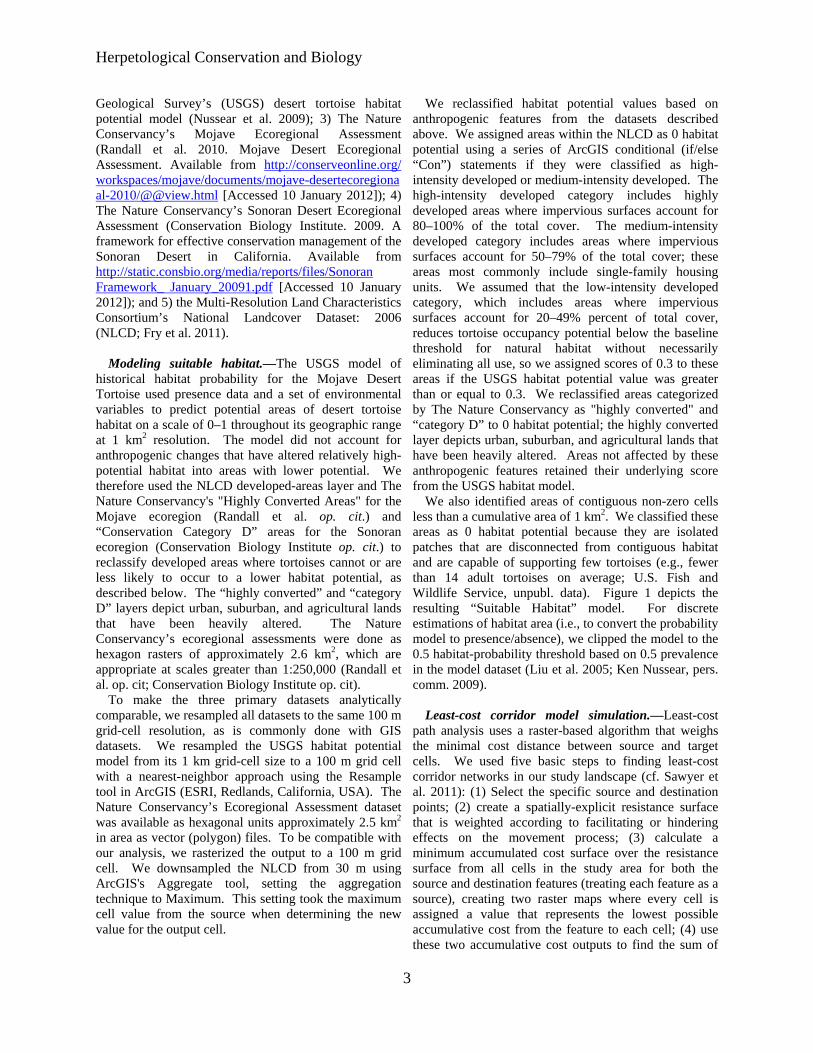
Herpetological Conservation and Biology
Geological Surveyrsquos (USGS) desert tortoise habitat potential model (Nussear et al 2009) 3) The Nature Conservancyrsquos Mojave Ecoregional Assessment (Randall et al 2010 Mojave Desert Ecoregional Assessment Available from httpconserveonlineorg workspacesmojavedocumentsmojave-desertecoregiona al-2010viewhtml [Accessed 10 January 2012]) 4) The Nature Conservancyrsquos Sonoran Desert Ecoregional Assessment (Conservation Biology Institute 2009 A framework for effective conservation management of the Sonoran Desert in California Available from httpstaticconsbioorgmediareportsfilesSonoran Framework_ January_20091pdf [Accessed 10 January 2012]) and 5) the Multi-Resolution Land Characteristics Consortiumrsquos National Landcover Dataset 2006 (NLCD Fry et al 2011)
Modeling suitable habitatmdashThe USGS model of historical habitat probability for the Mojave Desert Tortoise used presence data and a set of environmental variables to predict potential areas of desert tortoise habitat on a scale of 0ndash1 throughout its geographic range at 1 km2 resolution The model did not account for anthropogenic changes that have altered relatively high-potential habitat into areas with lower potential We therefore used the NLCD developed-areas layer and The Nature Conservancys Highly Converted Areas for the Mojave ecoregion (Randall et al op cit) and ldquoConservation Category Drdquo areas for the Sonoran ecoregion (Conservation Biology Institute op cit) to reclassify developed areas where tortoises cannot or are less likely to occur to a lower habitat potential as described below The ldquohighly convertedrdquo and ldquocategory Drdquo layers depict urban suburban and agricultural lands that have been heavily altered The Nature Conservancyrsquos ecoregional assessments were done as hexagon rasters of approximately 26 km2 which are appropriate at scales greater than 1250000 (Randall et al op cit Conservation Biology Institute op cit)
To make the three primary datasets analytically comparable we resampled all datasets to the same 100 m grid-cell resolution as is commonly done with GIS datasets We resampled the USGS habitat potential model from its 1 km grid-cell size to a 100 m grid cell with a nearest-neighbor approach using the Resample tool in ArcGIS (ESRI Redlands California USA) The Nature Conservancyrsquos Ecoregional Assessment dataset was available as hexagonal units approximately 25 km2
in area as vector (polygon) files To be compatible with our analysis we rasterized the output to a 100 m grid cell We downsampled the NLCD from 30 m using ArcGISs Aggregate tool setting the aggregation technique to Maximum This setting took the maximum cell value from the source when determining the new value for the output cell
We reclassified habitat potential values based on anthropogenic features from the datasets described above We assigned areas within the NLCD as 0 habitat potential using a series of ArcGIS conditional (ifelse ldquoConrdquo) statements if they were classified as high-intensity developed or medium-intensity developed The high-intensity developed category includes highly developed areas where impervious surfaces account for 80ndash100 of the total cover The medium-intensity developed category includes areas where impervious surfaces account for 50ndash79 of the total cover these areas most commonly include single-family housing units We assumed that the low-intensity developed category which includes areas where impervious surfaces account for 20ndash49 percent of total cover reduces tortoise occupancy potential below the baseline threshold for natural habitat without necessarily eliminating all use so we assigned scores of 03 to these areas if the USGS habitat potential value was greater than or equal to 03 We reclassified areas categorized by The Nature Conservancy as highly converted and ldquocategory Drdquo to 0 habitat potential the highly converted layer depicts urban suburban and agricultural lands that have been heavily altered Areas not affected by these anthropogenic features retained their underlying score from the USGS habitat model
We also identified areas of contiguous non-zero cells less than a cumulative area of 1 km2 We classified these areas as 0 habitat potential because they are isolated patches that are disconnected from contiguous habitat and are capable of supporting few tortoises (eg fewer than 14 adult tortoises on average US Fish and Wildlife Service unpubl data) Figure 1 depicts the resulting ldquoSuitable Habitatrdquo model For discrete estimations of habitat area (ie to convert the probability model to presenceabsence) we clipped the model to the 05 habitat-probability threshold based on 05 prevalence in the model dataset (Liu et al 2005 Ken Nussear pers comm 2009)
Least-cost corridor model simulationmdashLeast-cost path analysis uses a raster-based algorithm that weighs the minimal cost distance between source and target cells We used five basic steps to finding least-cost corridor networks in our study landscape (cf Sawyer et al 2011) (1) Select the specific source and destination points (2) create a spatially-explicit resistance surface that is weighted according to facilitating or hindering effects on the movement process (3) calculate a minimum accumulated cost surface over the resistance surface from all cells in the study area for both the source and destination features (treating each feature as a source) creating two raster maps where every cell is assigned a value that represents the lowest possible accumulative cost from the feature to each cell (4) use these two accumulative cost outputs to find the sum of
3
Averill-Murray et almdashDesert Tortoise Population Connectivity
FIGURE 1 Current predicted Mojave Desert Tortoise (Gopherus agassizii) habitat adapted from Nussear et al (2009)
the two surfaces at each cell The sum of the two raster costs identifies for each cell location the least-cost path from one source to another source that passes through the cell location (ESRI 2011 Creating a least cost corridor ArcGIS Desktop Help 100 Available from httphelparcgiscomenarcgisdesktop100helpindex html009z00000024000000htm [Accessed 9 April 2012]) and (5) apply a maximum accumulated distance threshold to define a corridor (as opposed to a single line resulting from a least-cost path analysis)
Nineteen pairs of TCAs served as sourcedestination polygons for our least-cost corridor analysis (Table 1) We modeled connectivity between TCA pairs through cells of habitat capable of supporting tortoise occupancy under the premise that the Mojave Desert Tortoise is a corridor dweller High-probability habitat corresponds to ldquolow costrdquo for tortoise occupancy so we inverted the habitat suitability surface using ESRIrsquos Spatial Analyst arithmetic functions for use as a cost surface Using the source polygons and the cost surface we created a cost-
distance surface for each of the source polygons defined in a pair (two surfaces per pair) These surfaces represent the accumulative cost of ldquotravelingrdquo over the cost surface from each cell back to the edge of the source polygon We created these surfaces with ESRIrsquos Spatial Analyst CostDistance function We used ESRIrsquos Spatial Analyst Corridor function to sum the two accumulative costs for the two input accumulative-cost rasters thereby identifying for each cell location the least-cost path from the source to the destination that passes through that cell location Because of the varying cost between each TCA pair (one pair might be geographically adjacent to one another while another pair might be separated by gt 100 km) we applied a standard threshold percentage to normalize the outputs Through an iterative process of reviewing threshold outputs we chose a standard distance threshold of 1 for each corridor output The associated range of cost-distance values were calculated from the total range of corridor values and applied using ESRIrsquos Spatial Analyst Con
4
Herpetological Conservation and Biology
FIGURE 2 Least-cost corridors between tortoise conservation areas (Base model) Each corridor includes the lowest 1 cost-distance paths between tortoise conservation areas (TCAs) where the relative cost to tortoises increases from black to white White patterns within TCAs are private inholdings within federal lands
function The output of this series of operations was a corridors from 0ndash1 using a custom script written in raster of the corridor fromto each TCA polygon which Python We also inverted these rescaled corridor values includes the lowest 1 cost paths from one TCA to to represent importance for connectivity rather than cost another We refer to the output from this process using the
While overall movement resistance may be higher Suitable Habitat model as the ldquoBaserdquo model The between two TCAs than between another pair corridors movement cost surface in the Base model assumes a 11 between each TCA pair are important to population relationship between probability of tortoise occurrence in connectivity range-wide Therefore we normalized all each pixel and resistance to connectivity However a
TABLE 2 Overlap (km2 ) of Mojave Desert Tortoise (Gopherus agassizii) habitat in four least-cost corridor models with Department of Defense (DOD) lands designated open off-highway-vehicle (OHV) recreation areas and designated wilderness areas or Bureau of Land Management National Conservation Areas (NCAs)
Base Base2 Binned Binned2
DOD2375 (13) 0 -shy7165 (16) 0 -shy
OHV875 (5) 0 -shy1200 (3) 0 -shy
WildernessNCA 2952 (17) 4260 (26) 6985 (16) 7145 (20)
5
Averill-Murray et almdashDesert Tortoise Population Connectivity
FIGURE 3 Least-cost corridors between tortoise conservation areas (TCAs Base model) overlaid with Department of Defense (DoD) lands and open off-highway vehicle (OHV) areas and showing designated wilderness areas and National Conservation Areas (NCAs) clipped to the linkages Each corridor includes the lowest 1 cost-distance paths between TCAs where the relative cost to tortoises increases from black to white White patterns within TCAs are private inholdings within federal lands
pixel of moderate probability (eg 07) may contribute equally to connectivity as a pixel of high probability (09) if both pixels allow some degree of population presence or individual movement especially at a temporal scale of a tortoise generation (about 25 y) For example 95 of cells with known presence in the USGS habitat model had scores greater than 07 (Nussear et al 2009) Therefore we compared the Base model to a ldquoBinnedrdquo model in order to evaluate uncertainty in our choice of resistance values as recommended by Beier et al (2009) and Sawyer et al (2011) We developed the cost surface for the Binned model by re-scoring all pixels ge 07 in the Base model to 10 values 050ndash069 to 06 values 010ndash049 to 03 and values lt 01 to 0 Other land uses also may affect desert tortoise connectivity but are not captured by NLCDrsquos developed areas of The Nature Conservancyrsquos highly converted areas Military training maneuvers and open-access off- highway-
vehicle (OHV) recreation are high-impact activities that limit tortoise abundance especially in the long term with increasing use (Bury and Luckenbach 2002 Berry et al 2006) Therefore we assessed effects on linkages of converting all Department of Defense (DOD) lands and open OHV areas to 0 habitat probability (models ldquoBase2rdquo and ldquoBinned2rdquo)
RESULTS
Suitable Habitat (ie current estimated habitat) for the Mojave Desert Tortoise totals 67000 km2 81 of the historic (ie unmanipulated USGS habitat model) estimated total of 83138 km2 The area of Suitable Habitat within TCAs including areas of overlap with DOD lands is 45340 km2 (68 of total current 55 of total historic) Suitable Habitat within linkages connecting the TCAs in the Base model totals17831 km2
6
Herpetological Conservation and Biology
TABLE 3 Percentage overlap of least-cost corridors based on four connectivity models between Mojave Desert Tortoise (Gopherus agassizii) conservation areas Total habitat area within each linkage is given along the diagonal
Base Base2 Binned Binned2 Base 17831 km2 81 38 35 Base2 74 16282 km2 34 41 Binned 92 90 43597 km2 97 Binned2 70 90 79 35629 km2
(27 current 21 historic Fig 2) Several linkages are already severely constrained or impacted by DOD and open OHV area designations (Fig 3 Table 2) Military training operations or high-intensity OHV recreation affect up to 18 of Suitable Habitat within linkages in the Base model On the other hand portions of some linkages (17) are protected by wilderness or US Bureau of Land Management (BLM) National
Conservation Area (NCA) designations (Fig 3 Table 2) The Binned model had the effect of greatly lowering
the resistance to tortoise occupancy thereby increasing the amount of area included in the lowest 1 cost paths between TCAs (Fig 4) Linkages in the Base model included only 38 of Suitable Habitat in the Binned model while the Binned linkages included 92 of Base linkage habitat (Table 3) The total area of habitat within
FIGURE 4 Binned model least-cost corridors between tortoise conservation areas (TCAs) overlaid with Department of Defense (DoD) lands and open off-highway vehicle (OHV) areas and showing designated wilderness areas and National Conservation Areas (NCAs) clipped to the linkages Each corridor includes the lowest 1 cost-distance paths between TCAs where the relative cost to tortoises increases from black to white White patterns within TCAs are private inholdings within federal lands
7
Averill-Murray et almdashDesert Tortoise Population Connectivity
FIGURE 5 Base2 model least-cost corridors between tortoise conservation areas (TCAs) overlaid with Department of Defense (DoD) lands and open off-highway vehicle (OHV) areas and showing designated wilderness areas and National Conservation Areas (NCAs) clipped to the linkages Each corridor includes the lowest 1 cost-distance paths between TCAs where the relative cost to tortoises increases from black to white White patterns within TCAs are private inholdings within federal lands
linkages in the Binned model totals 43597 km2 (65 current 52 historic) Military training operations or high-intensity OHV recreation affect 19 of habitat within the linkages in the Binned model (Table 2) Current wilderness or NCA designations protect 16 of linkages in the Binned model (Table 2)
Excluding DOD and OHV designations from the cost surface reduced total habitat areas by 87 and 183 in the Base2 and Binned2 models respectively (Table 3) although a greater proportion of the linkages is protected by existing wilderness or NCA designations (Table 2) Excluding these areas resulted in expansion of remaining linkages between TCAs especially in California in the Base2 model (Figs 56) Overall linkages in the Base model overlapped 81 of Suitable Habitat in the Base2 model while the Binned model included 97 of Suitable Habitat in the Binned2 model (Table 3) Differences
from 100 in proportion of habitat in the Base and Binned models that overlap the smaller Base2 and Binned2 models reflect shifts in the 1 cost surfaces For example in the Base2 model more of the area east of the Ord-Rodman and Superior-Cronese critical habitat units was important for connectivity and new linkage strands were identified between the Chemehuevi and Chuckwalla critical habitat units (Fig 5)
DISCUSSION
Successfully conserving the Mojave Desert Tortoise will entail managing not just conservation areas alone but also the connections between these areas (ie managing the matrix between reserves Fahrig 2001 Prevedello and Vieira 2010) Some TCAs are contiguous with others and together may contain viable
8
Herpetological Conservation and Biology
FIGURE 6 Binned2 model least-cost corridors between tortoise conservation areas (TCAs) overlaid with Department of Defense (DoD) lands and open off-highway vehicle (OHV) areas and showing designated wilderness areas and National Conservation Areas (NCAs) clipped to the linkages Each corridor includes the lowest 1 cost-distance paths between TCAs where the relative cost to tortoises increases from black to white White patterns within TCAs are private inholdings within federal lands
numbers of desert tortoises but even these contiguous blocks are adjacent to smaller more isolated TCAs Therefore the function of the collective TCA network could be solidified by ensuring that all remain connected In cases where much of the matrix between reserves remains undeveloped managing the matrix to increase permeability and occupancy will be easier than restoring corridors after development has occurred (Prugh et al 2008 Prededello and Vieira 2010)
In addition most wildlife including the Mojave Desert Tortoise does not occur at uniform densities across landscapes (Krzysik 2002) The extent to which populations may fluctuate asynchronously such as localized declines attributed to drought or predation events (Peterson 1994 Longshore et al 2003 see also the model of recruitment in chaotic environments in Morafka 1994) even within designated conservation
areas increases risks to population viability and places increased emphasis on preserving population connectivity through the surrounding habitat matrix Even under an assumption that TCAs are source habitats surrounded by sinks maintaining or improving conditions within sinkslinkages can be as important to regional viability as protecting source TCAs because of their effect on neighboring source habitat (Carroll et al 2003) Consequently the effectiveness of TCAs will be improved if they are connected with functional habitat to ensure desert tortoise population persistence (US Fish and Wildlife Service 1994 2011) Ideally linkages between TCAs would also be wide enough to buffer against detrimental edge effects (Beier et al 2008) a recommendation applicable also to the TCAs themselves (US Fish and Wildlife Service 1994)
9
Averill-Murray et almdashDesert Tortoise Population Connectivity
While specific management is needed within TCAs these areas provide only an initial framework upon which to focus recovery efforts especially given uncertainties related to the effects of climate change on Mojave Desert Tortoise populations and distribution (Barrows et al 2011 US Fish and Wildlife Service 2011) Temperatures are projected to change relatively quickly within desert ecosystems To keep pace with changes from current temperature regimes within the current century desert wildlife populations or species would need to shift their distributions at approximately 07 kmyear (Loarie et al 2009) At this rate the current climate would cross each critical habitat unit (ranging in latitudinal extent of approximately 33ndash267 km) within 23ndash187 years Notwithstanding potential elevational shifts by tortoise populations in response to climate change which may be constrained in many areas as a result of geologic limitations on burrow construction preserving connectivity between TCAs may allow shifts in the speciesrsquo distribution and allow for future flexibility in refocusing management to ensure long-term recovery (Crooks and Sanjayan 2006 Krosby et al 2010)
Connectivity conservation also is integral to maintaining genetic variability and ecological heterogeneity within and among populations of widely distributed species Genetic analyses suggest that historically levels of gene flow among subpopulations of the Mojave Desert Tortoise were high corresponding to high levels of habitat connectivity (Murphy et al 2007 Hagerty 2008) All recent genetic studies of the Mojave Desert Tortoise have suggested that its population structure is characterized by isolation-byshydistance populations at the farthest extremes of the distribution are most differentiated but a gradient of genetic differentiation occurs between those populations across the range (Britten et al 1997 Murphy et al 2007 Hagerty and Tracy 2010) This isolation-by-distance genetic structure across the relatively continuous historic distribution of the Mojave Desert Tortoise (Germano et al 1994 Nussear et al 2009) indicates that gene flow generally occurs (or historically occurred) according to a continuous-distribution model (Allendorf and Luikart 2007) as opposed to a metapopulation or stepping-stone model where individual tortoises move from one patch of suitable habitat across less suitable or non-habitat to another patch of suitable habitat
Our modeling approach was similar to that of Hagerty et al (2011) who modeled historic gene flow between populations across the range of the species across a cost surface based on the original (historic) USGS habitat model Gene flow historically occurred in a diffuse pattern across the landscape unless otherwise constrained to more narrow concentrated pathways created by topographic barriers (eg around the Spring Mountains in southern Nevada Hagerty et al 2011) Linkages
between conservation areas are needed to conserve historic genetic gradation thereby preventing habitat specialization and genetic divergence between populations (Frankham 2006) Where gene flow is constrained by topographic barriers conservation of such concentrated pathways or linkages is especially important
For gene flow to reliably occur across the range and for populations within existing conservation areas to be buffered against detrimental effects of low numbers or density populations need to be connected by areas of habitat occupied by tortoises Low levels of genetic differentiation in Mojave Desert Tortoises have been detected across even relatively recent and narrow anthropogenic impacts on the landscape (Latch et al 2011) Pairs of tortoises from opposite sides of a road exhibited significantly greater genetic differentiation than pairs from the same side of a road (Latch et al 2011) raising even greater concerns for population fragmentation from larger scale habitat loss
Assumptions and limitationsmdashOur assessment of important areas within which to preserve connectivity of Mojave Desert Tortoise populations is limited by shortcomings in our knowledge We assumed that potential tortoise occupancy was accurately reflected by the USGS habitat model as modified by our interpretation of the altered-habitat datasets and that linkages of high-probability habitat between existing TCAs will help sustain viable populations across the range of the species Implicit in this assumption is that various land uses or impacts occurring on the landscape (eg unpaved roads exotic plant invasions) that were not explicitly included in the geospatial data we used do not impede connectivity of tortoise populations We evaluated the effect of this assumption relative to large-scale potential impacts of high-intensity land uses (military training maneuvers and open OHV recreation) and additional areas emerged that may be important to connectivity
Least-cost path analyses provide only a snapshot of current habitat conditions and are uninformative about demographic processes or how individuals actually move through a landscape (Noss and Daly 2006 Taylor et al 2006) We assumed that a 1 cost surface would identify linkages wide enough to provide functional connectivity between TCAs However application of different resistance values from the underlying habitat model greatly influenced the total area and configuration of the 1 cost surface
Indeed limiting the cost surface to the lowest 1 is an arbitrary choice (Sawyer et al 2011) The mean model score for all cells with known tortoise presence in the USGS habitat model was 084 and 95 of cells with known presence had scores greater than 07 (Nussear et al 2009) Therefore connectivity between tortoise
10
Herpetological Conservation and Biology
populations (TCAs) may occur more broadly than estimated in the Base model The more permeable Binned model identified linkages 245 larger in area than those in the Base model while the linkages in the Binned2 model were 219 larger than those in the Base2 model
Limited guidance is available for determining precise linkage widths but minimum widths for corridor dwellers such as the Mojave Desert Tortoise should be substantially larger than a home range diameter (Beier et al 2008) Inevitably however questions will be asked about what is the minimum width for a particular desert tortoise linkage what is the relevant home range size from which to estimate that minimum width and what are the minimum sampling considerations in estimating home ranges (cf Harless et al 2010) We agree with Beier et al (2008) that this is analogous to asking an engineer ldquowhat are the fewest number of rivets that might keep this wing on the airplanerdquo A more appropriate question for conservation is ldquowhat is the narrowest width that is not likely to be regretted after the adjacent area is converted to human userdquo Managers and policy-makers must realize that conservation is not primarily a set-aside issue that can be dealt with by reserving a minimal percentage or amount of the landscape rather it is a pervasive issue that must be considered across the entire landscape (Franklin and Lindenmayer 2009)
Management implications and recommendationsmdash In general land and wildlife managers should think about corridors between conservation areas that are large enough for resident tortoises to persist and to continue to interact with their neighbors within and outside broad habitat linkages rather than expect that a more narrow band of habitat will allow an individual tortoise to move through it to the other side breed with a tortoise on that side and produce viable offspring that contribute to the next generation Linkage integrity with sufficient habitat to support sustainable populations is important for Mojave Desert Tortoises and other corridor dwellers to support connectivity between core reserves (cf Barrows et al 2011) Given the underlying geospatial data linkages in the Base2 model illustrate a minimum connection of habitat for Mojave Desert Tortoises between TCA pairs and therefore represent priority areas for conservation of population connectivity However large areas within these linkages are at risk of permanent habitat loss as a result of solar energy development
Utility-scale solar development will require 831 km2
of land by 2030 to meet the reasonably foreseeable development scenario within the entire states of California and Nevada (US Bureau of Land Management and US Department of Energy 2012) To meet this need BLM has identified 39830 km2 of
potentially developable public lands throughout these states (not all within Mojave Desert Tortoise habitat) including 866 km2 of proposed solar energy zones (SEZs) within which solar energy production would be prioritized and facilitated Meanwhile projects totaling 190 km2 and 1470 km2 had already been approved or were pending respectively across BLM land within the range of the Mojave Desert Tortoise (US Bureau of Land Management and US Department of Energy 2012) Relatively little linkage area would be consumed by the proposed SEZs (40 km2) but 37 km2 of approved and 703 km2 of pending projects overlap linkages in the Base2 model with some linkages at particular risk (Fig 7) Even though substantial uncertainty surrounds the ultimate development footprint of pending solar development projects (or other proposed projects including wind energy development) a separate analysis found that between 2000 km2 and 7400 km2 of lower conservation value land could meet Californiarsquos renewable energy goal by up to seven times over (Cameron et al 2012) This suggests that renewable energy goals can be met without compromising the conservation of important Mojave Desert Tortoise habitat
The Binned2 model includes blocks of contiguous habitat outside the Base2 linkage network and many such areas likely contain substantial numbers of Mojave Desert Tortoises Managers should consider additional conservation of occupied habitat adjacent to the Base2 linkages and existing TCAs to provide security against edge effects and population declines especially given limitations previously identified in the existing reserve architecture For example even though use of DOD lands may be subject to change depending on national security needs the value of military lands to conservation has long been recognized (Stein et al 2008) and DOD-managed habitat that is unaffected by military training operations adds to the conservation base Of additional note are blocks of habitat at the northern extent of the Mojave Desert Tortoisersquos range which may be of particular relevance for additional evaluation to determine more precisely how the modeled linkages will accommodate climate change (Beier et al 2008)
Application of models from this study will require refinement at the local level and at a higher-resolution scale than the available geospatial data (ie finer resolution than 1 km2) to account for on-the-ground limitations to tortoise occupancy and movement either not reflected in the geospatial data used here or as a result of errors in the land cover data we used to identify Suitable Habitat (Beier et al 2009) For example habitat connections through the northern end and across the boundary of the Chuckwalla critical habitat unit may be more limited by rugged topography than suggested by Figure 1 (Jody Fraser and Pete Sorensen pers comm)
11
Averill-Murray et almdashDesert Tortoise Population Connectivity
FIGURE 7 Least-cost corridors (Base2 model) between tortoise conservation areas (TCAs) relative to approved solar development projects pending solar development projects and solar energy zones Each corridor includes the lowest 1 cost-distance paths between TCAs where the relative cost to tortoises increases from black to white White patterns within TCAs are private inholdings within federal lands
thereby placing greater potential importance on the linkage identified on the north end of the critical habitat unit in the Binned2 model In addition more detailed or spatially explicit population viability analyses based on regional population and distribution patterns are needed to evaluate the ability of a conservation network such as that modeled here to ensure long-term persistence of Mojave Desert Tortoise populations (US Fish and Wildlife Service 2011 eg Carroll et al 2003)
While there is much still to be learned about the science and application of connectivity land managers cannot wait for research to resolve all relevant questions before focusing effort on enhancing connectivity Instead science and management must proceed in parallel with the flexibility to modify future management in the light of new knowledge (Lovejoy 2006) In areas proposed for essentially permanent habitat conversion such as by large-scale development there is the risk that
critical linkages will be severed before they are protected (Morrison and Reynolds 2006) For species with long generation times like the Mojave Desert Tortoise this risk is compounded by the fact that we are not likely to detect a problem with a population until well after we have reduced the habitat below its extinction threshold (Fahrig 2001)
AcknowledgmentsmdashDiscussion with Linda Allison Ashleigh Blackford Brian Croft Diane Elam Kimberleigh Field and the Desert Tortoise Science Advisory Committee (Peter Hudson Earl McCoy Katherine Ralls Michael Reed and Robert Steidl) contributed to the development of this manuscript Additional review and comments by Todd Esque Kimberleigh Field Michael Reed and Andrew Walde improved the manuscript We thank Lisa Benvenuti at the Redlands Institute for her excellent map-making
12
Herpetological Conservation and Biology
skills The findings and conclusions in this article are those of the authors and do not necessarily represent the views of the US Fish and Wildlife Service
LITERATURE CITED
Allendorf FW and G Luikart 2007 Conservation and the Genetics of Populations Blackwell Malden Massachusetts USA
Barrows CW KD Fleming and MF Allen 2011 Identifying habitat linkages to maintain connectivity for corridor dwellers in a fragmented landscape Journal of Wildlife Management 75682ndash691
Beier P and S Loe 1992 A checklist for evaluating impacts to wildlife movement corridors Wildlife Society Bulletin 20434ndash440
Beier P DR Majka and SL Newell 2009 Uncertainty analysis of least-cost modeling for designing wildlife linkages Ecological Applications 192067ndash2077
Beier P DR Majka and WD Spencer 2008 Forks in the road choices in procedures for designing wildland linkages Conservation Biology 22836ndash851
Berry KH TY Bailey and KM Anderson 2006 Attributes of Desert Tortoise populations at the National Training Center Central Mojave Desert California USA Journal of Arid Environments 67165ndash191
Berry KH and PA Medica 1995 Desert Tortoises in the Mojave and Colorado deserts Pages 135ndash137 In Our Living Resources A Report to the Nation on the Distribution Abundance and Health of US Plants Animals and Ecosystems LaRoe ET GS Farris CE Puckett PD Doran and MJ Mac (Eds) US Department of the Interior National Biological Service Washington DC USA
Boarman WI ML Beigel GC Goodlett and M Sazaki 1998 A passive integrated transponder system for tracking animal movements Wildlife Society Bulletin 26886ndash891
Britten HB BR Riddle PF Brussard R Marlow and TE Lee 1997 Genetic delineation of management units for the Desert Tortoise Gopherus agassizii in northeastern Mojave Desert Copeia 1997523ndash530
Bury RB and PS Corn 1995 Have desert tortoises undergone a long-term decline in abundance Wildlife Society Bulletin 2341ndash47
Bury RB and RA Luckenbach 2002 Comparison of Desert Tortoise (Gopherus agassizii) populations in an unused and off-road vehicle area in the Mojave Desert Chelonian Conservation and Biology 4457ndash463
Cameron DR BS Cohen and SA Morrison 2012 An approach to enhance the conservation-compatibility of solar energy development PloS ONE 7(6)e38347 Doi101371journalpone0038437
Carroll C RF Noss PC Paquet and NH Schumaker 2003 Use of population viability analysis and reserve selection algorithms in regional conservation plans Ecological Applications 131773ndash 1789
Crooks KR and M Sanjayan 2006 Connectivity conservation maintaining connections for nature Pp 1ndash19 In Connectivity Conservation Crooks KR and M Sanjayan (Eds) Cambridge University Press Cambridge UK
Doak D P Kareiva and B Klepetka 1994 Modeling population viability for the Desert Tortoise in the western Mojave Desert Ecological Applications 4446ndash460
Edwards T EW Stitt CR Schwalbe and DE Swann 2004 Gopherus agassizii (Desert Tortoise) Movement Herpetological Review 35381ndash382
Fagan WF and EE Holmes 2006 Quantifying the extinction vortex Ecology Letters 951ndash60
Fahrig L 2001 How much habitat is enough Biological Conservation 10065ndash74
Frankham R 2006 Genetics and landscape connectivity Pp 72ndash96 In Connectivity Conservation Crooks KR and M Sanjayan (Eds) Cambridge University Press Cambridge UK
Franklin JF and DB Lindenmayer 2009 Importance of matrix habitats in maintaining biological diversity Proceedings of the National Academy of Sciences 106349ndash350
Fry J G Xian S Jin J Dewitz C Homer L Yang C Barnes N Herold and J Wickham 2011 Completion of the 2006 National Land Cover Database for the conterminous United States Photogrammetric Engineering and Remote Sensing 77858ndash864
Germano DJ RB Bury TC Esque TH Fritts and PA Medica 1994 Range and habitat of the Desert Tortoise Pp 57ndash72 In Biology of the North American Tortoises Bury RB and DJ Germano (Eds) National Biological Survey Fish and Wildlife Research 13 Washington DC USA
Gilpin ME and ME Souleacute 1986 Minimum viable populations processes of species extinction Pp 19ndash34 In Conservation Biology The Science of Scarcity and Diversity Souleacute ME (Ed) Sinauer Associates Sunderland Massachusetts USA
Hagerty BE 2008 Ecological genetics of the Mojave Desert Tortoise PhD Dissertation University of Nevada Reno Nevada USA 226 p
Hagerty BE KE Nussear TC Esque and CR Tracy 2011 Making molehills out of mountains landscape genetics of the Mojave Desert Tortoise Landscape Ecology 26267ndash280
Hagerty BE and CR Tracy 2010 Defining population structure for the Mojave Desert Tortoise Conservation Genetics 111795ndash1807
13
Averill-Murray et almdashDesert Tortoise Population Connectivity
Harless ML AD Walde DK Delaney LL Pater and WK Hayes 2010 Sampling considerations for improving home range estimates of Desert Tortoises effects of estimator sampling regime and sex Herpetological Conservation and Biology 5374ndash387
Harrison S and E Bruna 1999 Habitat fragmentation and large-scale conservation what do we know for sure Ecography 22225ndash232
Krosby M J Tewksbury NM Haddad and J Hoekstra 2010 Ecological connectivity for a changing climate Conservation Biology 241686ndash1689
Krzysik AJ 2002 A landscape sampling protocol for estimating distribution and density patterns of Desert Tortoises at multiple spatial scales Chelonian Conservation and Biology 4366ndash379
Latch EK WI Boarman A Walde and RC Fleischer 2011 Fine-scale analysis reveals cryptic landscape genetic structure in Desert Tortoises PLoS ONE 6e27794 Doi101371journalpone0027794
Liu C PM Berry TP Dawson and RG Pearson 2005 Selecting thresholds of occurrence in the prediction of species distributions Ecography 28385ndash 393
Loarie SR PB Duffy H Hamilton GP Asner CB Field and DD Ackerly 2009 The velocity of climate change Nature 4621052ndash1055
Longshore KM JR Jaeger and JM Sappington 2003 Desert Tortoise (Gopherus agassizii) survival at two eastern Mojave Desert sites death by short-term drought Journal of Herpetology 37169ndash177
Lovejoy T 2006 Introduction donrsquot fence me in Pp 447ndash449 In Connectivity Conservation Crooks KR and M Sanjayan (Eds) Cambridge University Press Cambridge UK
Lovich JE and JR Ennen 2011 Wildlife conservation and solar energy development in the Desert Southwest United States BioScience 61982ndash 992
McLuckie AM PG Emblidge and RA Fridell 2010 Regional Desert Tortoise monitoring in the Red Cliffs Desert Reserve 2009 Utah Division of Wildlife Resource Publication 10-13
Meffe GK and CR Carroll 1994 The design of conservation reserves Pp 265ndash304 In Principles of Conservation Biology Meffe GK and CR Carroll (Eds) Sinauer Associates Sunderland Massachusetts USA
Morafka DJ 1994 Neonates missing links in the life histories of North American tortoises Pp 161ndash173 In Biology of North American Tortoises Bury RB and DJ Germano (Eds) National Biological Survey Fish and Wildlife Research 13 Washington DC USA
Morrison SA and MD Reynolds 2006 Where to draw the line integrating feasibility into connectivity planning Pp 536ndash554 In Connectivity Conservation
Crooks KR and M Sanjayan (Eds) Cambridge University Press Cambridge UK
Murphy RW KH Berry T Edwards and AM McLuckie 2007 A genetic assessment of the recovery units for the Mojave population of the Desert Tortoise Gopherus agassizii Chelonian Conservation and Biology 6229ndash251
Noss RF and KM Daly 2006 Incorporating connectivity into broad-scale conservation planning Pp 587ndash619 In Connectivity Conservation Crooks KR and M Sanjayan (Eds) Cambridge University Press Cambridge UK
Nussear KE TC Esque RD Inman L Gass KA Thomas CSA Wallace JB Blainey DM Miller and RH Webb 2009 Modeling habitat of the Desert Tortoise (Gopherus agassizii) in the Mojave and parts of the Sonoran deserts of California Nevada Utah and Arizona US Geological Survey Open-file Report 2009-1102 18 p
Peterson CC 1994 Different rates and causes of high mortality in two populations of the threatened Desert Tortoise Gopherus agassizii Biological Conservation 70101ndash108
Prevedello JA and MV Vieira 2010 Does the type of matrix matter A quantitative review of the evidence Biodiversity and Conservation 191205ndash 1223
Prugh LR KE Hodges ARE Sinclair and JS Brashares 2008 Effect of habitat area and isolation of fragmented animal populations Proceedings of the National Academy of Sciences 10520770ndash20775
Reed JM N Fefferman and RC Averill-Murray 2009 Vital rate sensitivity analysis as a tool for assessing management actions for the Desert Tortoise Biological Conservation 1422710ndash2717
Ricketts TH 2001 The matrix matters effective isolation in fragmented landscapes American Naturalist 15887ndash99
Sawyer SC CW Epps and JS Brashares 2011 Placing linkages among fragmented habitats do least-cost models reflect how animals use landscapes Journal of Applied Ecology 48668ndash678
Stein BA C Scott and N Benton 2008 Federal lands and endangered species the role of military and other federal lands in sustaining biodiversity BioScience 58339ndash347
Taylor PD L Fahrig and KA With 2006 Landscape connectivity a return to basics Pp 29ndash43 In Connectivity Conservation Crooks KR and M Sanjayan (Eds) Cambridge University Press Cambridge UK
US Bureau of Land Management and US Department of Energy 2012 Final programmatic environmental impact statement (PEIS) for solar energy development in six southwestern states FES 12-24 DOEEIS-0403
14
Herpetological Conservation and Biology
US Fish and Wildlife Service 1990 Endangered and threatened wildlife and plants determination of threatened status for the Mojave population of the Desert Tortoise Federal Register 5512178ndash12191
US Fish and Wildlife Service 1994 Desert Tortoise (Mojave population) Recovery Plan US Fish and Wildlife Service Portland Oregon USA
US Fish and Wildlife Service 2011 Revised Recovery Plan for the Mojave Population of the Desert Tortoise (Gopherus agassizii) US Fish and Wildlife Service California and Nevada Region Sacramento California USA
Venter O NN Brodeur L Nemiroff B Belland IJ Dolinsek and JWA Grant Threats to endangered species in Canada BioScience 56903ndash910
Wiens JA 2006 Introduction connectivity research ndash What are the issues Pp 23ndash27 In Connectivity Conservation Crooks KR and M Sanjayan (Eds) Cambridge University Press Cambridge UK
Wilcox BA and DD Murphy 1985 Conservation strategy the effects of fragmentation on extinction American Naturalist 125879ndash887
Yiming L and DS Wilcove 2005 Threats to vertebrate species in China and the United States BioScience 55147ndash153
ROY C AVERILL-MURRAY is the Desert Tortoise Recovery Coordinator for the Desert Tortoise Recovery Office of the US Fish and Wildlife Service in Reno Nevada USA He oversees the recovery office in coordinating research monitoring and recovery plan implementation for the threatened Mojave Desert Tortoise He has published articles and book chapters on various aspects of the ecology and management of both the Mojave Desert Tortoise and the Sonoran Desert Tortoise Roy has degrees in Wildlife and Fisheries Sciences from Texas AampM University (BS) and the University of Arizona (MS) (Photographed by Kimberleigh J Field)
CATHERINE R DARST is the Recovery Biologist for the US Fish and Wildlife Services Desert Tortoise Recovery Office in Ventura California USA Cats work focuses on recovery plan implementation and research coordination including developing collaborative planning processes and spatial decision support for the Mojave Desert Tortoise Cat received her undergraduate degrees from the University of California at Davis and her PhD in Ecology Evolution and Behavior from the University of Texas at Austin (Photographed by Ashleigh Blackford)
NATHAN STROUT is the Technology Manager for the Redlands Institute University of Redlands in Redlands California USA He is responsible for managing the technical design and development of projects at the Redlands Institute and a team of technical staff including programmers analysts and IT support staff His work includes GIS research and analysis web and desktop application development and project management Nathan also serves as adjunct faculty in the Master of Science in Geographic Information Systems (MS GIS) at the University of Redlands Nathan received his undergraduate degree in Environmental Science and a MS in GIS from the University of Redlands (Photographed by Stephen Daugherty)
MARTIN L WONG is a GIS Analyst for the Redlands Institute University of Redlands in Redlands California He is responsible for supporting students faculty and staff at the Redlands Institute and the Environmental Studies and MSGIS departments in their geospatial data needs His work includes researching acquiring and geoprocessing data writing scripts and tools using Python and C and producing maps and reports Martin received his undergraduate degree in Geography from the University of California at Santa Barbara (Photographed by Susie Kim)
15
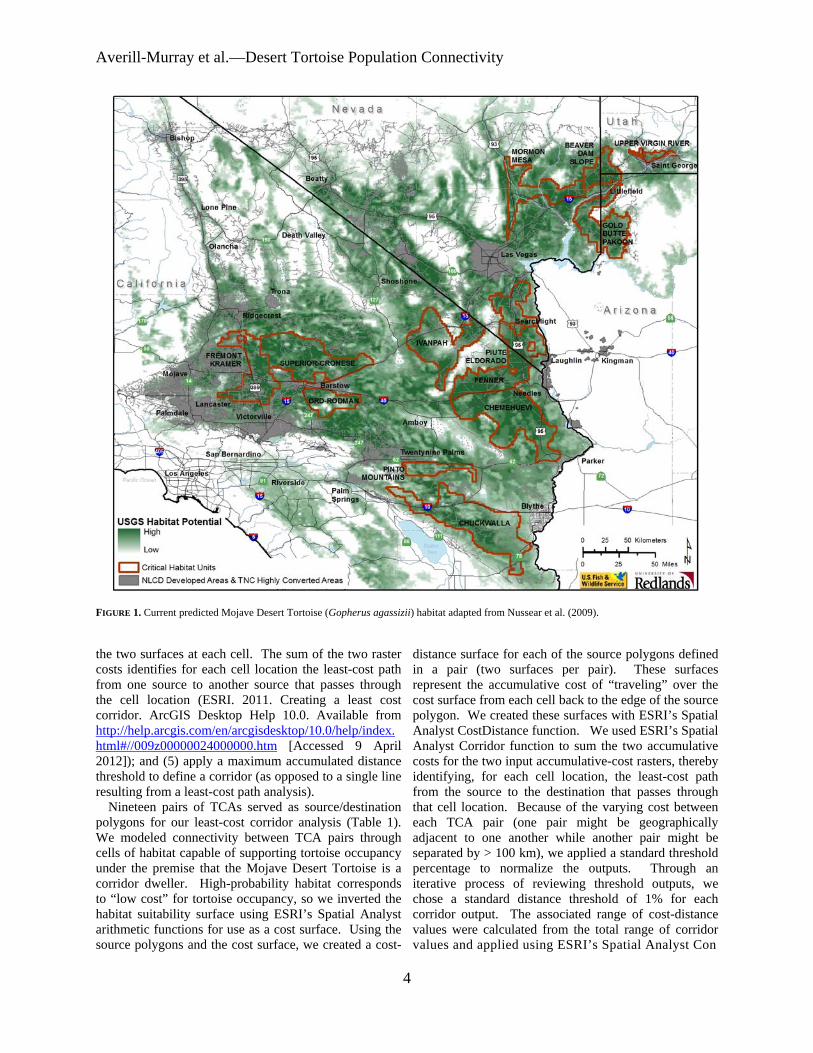
Averill-Murray et almdashDesert Tortoise Population Connectivity
FIGURE 1 Current predicted Mojave Desert Tortoise (Gopherus agassizii) habitat adapted from Nussear et al (2009)
the two surfaces at each cell The sum of the two raster costs identifies for each cell location the least-cost path from one source to another source that passes through the cell location (ESRI 2011 Creating a least cost corridor ArcGIS Desktop Help 100 Available from httphelparcgiscomenarcgisdesktop100helpindex html009z00000024000000htm [Accessed 9 April 2012]) and (5) apply a maximum accumulated distance threshold to define a corridor (as opposed to a single line resulting from a least-cost path analysis)
Nineteen pairs of TCAs served as sourcedestination polygons for our least-cost corridor analysis (Table 1) We modeled connectivity between TCA pairs through cells of habitat capable of supporting tortoise occupancy under the premise that the Mojave Desert Tortoise is a corridor dweller High-probability habitat corresponds to ldquolow costrdquo for tortoise occupancy so we inverted the habitat suitability surface using ESRIrsquos Spatial Analyst arithmetic functions for use as a cost surface Using the source polygons and the cost surface we created a cost-
distance surface for each of the source polygons defined in a pair (two surfaces per pair) These surfaces represent the accumulative cost of ldquotravelingrdquo over the cost surface from each cell back to the edge of the source polygon We created these surfaces with ESRIrsquos Spatial Analyst CostDistance function We used ESRIrsquos Spatial Analyst Corridor function to sum the two accumulative costs for the two input accumulative-cost rasters thereby identifying for each cell location the least-cost path from the source to the destination that passes through that cell location Because of the varying cost between each TCA pair (one pair might be geographically adjacent to one another while another pair might be separated by gt 100 km) we applied a standard threshold percentage to normalize the outputs Through an iterative process of reviewing threshold outputs we chose a standard distance threshold of 1 for each corridor output The associated range of cost-distance values were calculated from the total range of corridor values and applied using ESRIrsquos Spatial Analyst Con
4
Herpetological Conservation and Biology
FIGURE 2 Least-cost corridors between tortoise conservation areas (Base model) Each corridor includes the lowest 1 cost-distance paths between tortoise conservation areas (TCAs) where the relative cost to tortoises increases from black to white White patterns within TCAs are private inholdings within federal lands
function The output of this series of operations was a corridors from 0ndash1 using a custom script written in raster of the corridor fromto each TCA polygon which Python We also inverted these rescaled corridor values includes the lowest 1 cost paths from one TCA to to represent importance for connectivity rather than cost another We refer to the output from this process using the
While overall movement resistance may be higher Suitable Habitat model as the ldquoBaserdquo model The between two TCAs than between another pair corridors movement cost surface in the Base model assumes a 11 between each TCA pair are important to population relationship between probability of tortoise occurrence in connectivity range-wide Therefore we normalized all each pixel and resistance to connectivity However a
TABLE 2 Overlap (km2 ) of Mojave Desert Tortoise (Gopherus agassizii) habitat in four least-cost corridor models with Department of Defense (DOD) lands designated open off-highway-vehicle (OHV) recreation areas and designated wilderness areas or Bureau of Land Management National Conservation Areas (NCAs)
Base Base2 Binned Binned2
DOD2375 (13) 0 -shy7165 (16) 0 -shy
OHV875 (5) 0 -shy1200 (3) 0 -shy
WildernessNCA 2952 (17) 4260 (26) 6985 (16) 7145 (20)
5
Averill-Murray et almdashDesert Tortoise Population Connectivity
FIGURE 3 Least-cost corridors between tortoise conservation areas (TCAs Base model) overlaid with Department of Defense (DoD) lands and open off-highway vehicle (OHV) areas and showing designated wilderness areas and National Conservation Areas (NCAs) clipped to the linkages Each corridor includes the lowest 1 cost-distance paths between TCAs where the relative cost to tortoises increases from black to white White patterns within TCAs are private inholdings within federal lands
pixel of moderate probability (eg 07) may contribute equally to connectivity as a pixel of high probability (09) if both pixels allow some degree of population presence or individual movement especially at a temporal scale of a tortoise generation (about 25 y) For example 95 of cells with known presence in the USGS habitat model had scores greater than 07 (Nussear et al 2009) Therefore we compared the Base model to a ldquoBinnedrdquo model in order to evaluate uncertainty in our choice of resistance values as recommended by Beier et al (2009) and Sawyer et al (2011) We developed the cost surface for the Binned model by re-scoring all pixels ge 07 in the Base model to 10 values 050ndash069 to 06 values 010ndash049 to 03 and values lt 01 to 0 Other land uses also may affect desert tortoise connectivity but are not captured by NLCDrsquos developed areas of The Nature Conservancyrsquos highly converted areas Military training maneuvers and open-access off- highway-
vehicle (OHV) recreation are high-impact activities that limit tortoise abundance especially in the long term with increasing use (Bury and Luckenbach 2002 Berry et al 2006) Therefore we assessed effects on linkages of converting all Department of Defense (DOD) lands and open OHV areas to 0 habitat probability (models ldquoBase2rdquo and ldquoBinned2rdquo)
RESULTS
Suitable Habitat (ie current estimated habitat) for the Mojave Desert Tortoise totals 67000 km2 81 of the historic (ie unmanipulated USGS habitat model) estimated total of 83138 km2 The area of Suitable Habitat within TCAs including areas of overlap with DOD lands is 45340 km2 (68 of total current 55 of total historic) Suitable Habitat within linkages connecting the TCAs in the Base model totals17831 km2
6
Herpetological Conservation and Biology
TABLE 3 Percentage overlap of least-cost corridors based on four connectivity models between Mojave Desert Tortoise (Gopherus agassizii) conservation areas Total habitat area within each linkage is given along the diagonal
Base Base2 Binned Binned2 Base 17831 km2 81 38 35 Base2 74 16282 km2 34 41 Binned 92 90 43597 km2 97 Binned2 70 90 79 35629 km2
(27 current 21 historic Fig 2) Several linkages are already severely constrained or impacted by DOD and open OHV area designations (Fig 3 Table 2) Military training operations or high-intensity OHV recreation affect up to 18 of Suitable Habitat within linkages in the Base model On the other hand portions of some linkages (17) are protected by wilderness or US Bureau of Land Management (BLM) National
Conservation Area (NCA) designations (Fig 3 Table 2) The Binned model had the effect of greatly lowering
the resistance to tortoise occupancy thereby increasing the amount of area included in the lowest 1 cost paths between TCAs (Fig 4) Linkages in the Base model included only 38 of Suitable Habitat in the Binned model while the Binned linkages included 92 of Base linkage habitat (Table 3) The total area of habitat within
FIGURE 4 Binned model least-cost corridors between tortoise conservation areas (TCAs) overlaid with Department of Defense (DoD) lands and open off-highway vehicle (OHV) areas and showing designated wilderness areas and National Conservation Areas (NCAs) clipped to the linkages Each corridor includes the lowest 1 cost-distance paths between TCAs where the relative cost to tortoises increases from black to white White patterns within TCAs are private inholdings within federal lands
7
Averill-Murray et almdashDesert Tortoise Population Connectivity
FIGURE 5 Base2 model least-cost corridors between tortoise conservation areas (TCAs) overlaid with Department of Defense (DoD) lands and open off-highway vehicle (OHV) areas and showing designated wilderness areas and National Conservation Areas (NCAs) clipped to the linkages Each corridor includes the lowest 1 cost-distance paths between TCAs where the relative cost to tortoises increases from black to white White patterns within TCAs are private inholdings within federal lands
linkages in the Binned model totals 43597 km2 (65 current 52 historic) Military training operations or high-intensity OHV recreation affect 19 of habitat within the linkages in the Binned model (Table 2) Current wilderness or NCA designations protect 16 of linkages in the Binned model (Table 2)
Excluding DOD and OHV designations from the cost surface reduced total habitat areas by 87 and 183 in the Base2 and Binned2 models respectively (Table 3) although a greater proportion of the linkages is protected by existing wilderness or NCA designations (Table 2) Excluding these areas resulted in expansion of remaining linkages between TCAs especially in California in the Base2 model (Figs 56) Overall linkages in the Base model overlapped 81 of Suitable Habitat in the Base2 model while the Binned model included 97 of Suitable Habitat in the Binned2 model (Table 3) Differences
from 100 in proportion of habitat in the Base and Binned models that overlap the smaller Base2 and Binned2 models reflect shifts in the 1 cost surfaces For example in the Base2 model more of the area east of the Ord-Rodman and Superior-Cronese critical habitat units was important for connectivity and new linkage strands were identified between the Chemehuevi and Chuckwalla critical habitat units (Fig 5)
DISCUSSION
Successfully conserving the Mojave Desert Tortoise will entail managing not just conservation areas alone but also the connections between these areas (ie managing the matrix between reserves Fahrig 2001 Prevedello and Vieira 2010) Some TCAs are contiguous with others and together may contain viable
8
Herpetological Conservation and Biology
FIGURE 6 Binned2 model least-cost corridors between tortoise conservation areas (TCAs) overlaid with Department of Defense (DoD) lands and open off-highway vehicle (OHV) areas and showing designated wilderness areas and National Conservation Areas (NCAs) clipped to the linkages Each corridor includes the lowest 1 cost-distance paths between TCAs where the relative cost to tortoises increases from black to white White patterns within TCAs are private inholdings within federal lands
numbers of desert tortoises but even these contiguous blocks are adjacent to smaller more isolated TCAs Therefore the function of the collective TCA network could be solidified by ensuring that all remain connected In cases where much of the matrix between reserves remains undeveloped managing the matrix to increase permeability and occupancy will be easier than restoring corridors after development has occurred (Prugh et al 2008 Prededello and Vieira 2010)
In addition most wildlife including the Mojave Desert Tortoise does not occur at uniform densities across landscapes (Krzysik 2002) The extent to which populations may fluctuate asynchronously such as localized declines attributed to drought or predation events (Peterson 1994 Longshore et al 2003 see also the model of recruitment in chaotic environments in Morafka 1994) even within designated conservation
areas increases risks to population viability and places increased emphasis on preserving population connectivity through the surrounding habitat matrix Even under an assumption that TCAs are source habitats surrounded by sinks maintaining or improving conditions within sinkslinkages can be as important to regional viability as protecting source TCAs because of their effect on neighboring source habitat (Carroll et al 2003) Consequently the effectiveness of TCAs will be improved if they are connected with functional habitat to ensure desert tortoise population persistence (US Fish and Wildlife Service 1994 2011) Ideally linkages between TCAs would also be wide enough to buffer against detrimental edge effects (Beier et al 2008) a recommendation applicable also to the TCAs themselves (US Fish and Wildlife Service 1994)
9
Averill-Murray et almdashDesert Tortoise Population Connectivity
While specific management is needed within TCAs these areas provide only an initial framework upon which to focus recovery efforts especially given uncertainties related to the effects of climate change on Mojave Desert Tortoise populations and distribution (Barrows et al 2011 US Fish and Wildlife Service 2011) Temperatures are projected to change relatively quickly within desert ecosystems To keep pace with changes from current temperature regimes within the current century desert wildlife populations or species would need to shift their distributions at approximately 07 kmyear (Loarie et al 2009) At this rate the current climate would cross each critical habitat unit (ranging in latitudinal extent of approximately 33ndash267 km) within 23ndash187 years Notwithstanding potential elevational shifts by tortoise populations in response to climate change which may be constrained in many areas as a result of geologic limitations on burrow construction preserving connectivity between TCAs may allow shifts in the speciesrsquo distribution and allow for future flexibility in refocusing management to ensure long-term recovery (Crooks and Sanjayan 2006 Krosby et al 2010)
Connectivity conservation also is integral to maintaining genetic variability and ecological heterogeneity within and among populations of widely distributed species Genetic analyses suggest that historically levels of gene flow among subpopulations of the Mojave Desert Tortoise were high corresponding to high levels of habitat connectivity (Murphy et al 2007 Hagerty 2008) All recent genetic studies of the Mojave Desert Tortoise have suggested that its population structure is characterized by isolation-byshydistance populations at the farthest extremes of the distribution are most differentiated but a gradient of genetic differentiation occurs between those populations across the range (Britten et al 1997 Murphy et al 2007 Hagerty and Tracy 2010) This isolation-by-distance genetic structure across the relatively continuous historic distribution of the Mojave Desert Tortoise (Germano et al 1994 Nussear et al 2009) indicates that gene flow generally occurs (or historically occurred) according to a continuous-distribution model (Allendorf and Luikart 2007) as opposed to a metapopulation or stepping-stone model where individual tortoises move from one patch of suitable habitat across less suitable or non-habitat to another patch of suitable habitat
Our modeling approach was similar to that of Hagerty et al (2011) who modeled historic gene flow between populations across the range of the species across a cost surface based on the original (historic) USGS habitat model Gene flow historically occurred in a diffuse pattern across the landscape unless otherwise constrained to more narrow concentrated pathways created by topographic barriers (eg around the Spring Mountains in southern Nevada Hagerty et al 2011) Linkages
between conservation areas are needed to conserve historic genetic gradation thereby preventing habitat specialization and genetic divergence between populations (Frankham 2006) Where gene flow is constrained by topographic barriers conservation of such concentrated pathways or linkages is especially important
For gene flow to reliably occur across the range and for populations within existing conservation areas to be buffered against detrimental effects of low numbers or density populations need to be connected by areas of habitat occupied by tortoises Low levels of genetic differentiation in Mojave Desert Tortoises have been detected across even relatively recent and narrow anthropogenic impacts on the landscape (Latch et al 2011) Pairs of tortoises from opposite sides of a road exhibited significantly greater genetic differentiation than pairs from the same side of a road (Latch et al 2011) raising even greater concerns for population fragmentation from larger scale habitat loss
Assumptions and limitationsmdashOur assessment of important areas within which to preserve connectivity of Mojave Desert Tortoise populations is limited by shortcomings in our knowledge We assumed that potential tortoise occupancy was accurately reflected by the USGS habitat model as modified by our interpretation of the altered-habitat datasets and that linkages of high-probability habitat between existing TCAs will help sustain viable populations across the range of the species Implicit in this assumption is that various land uses or impacts occurring on the landscape (eg unpaved roads exotic plant invasions) that were not explicitly included in the geospatial data we used do not impede connectivity of tortoise populations We evaluated the effect of this assumption relative to large-scale potential impacts of high-intensity land uses (military training maneuvers and open OHV recreation) and additional areas emerged that may be important to connectivity
Least-cost path analyses provide only a snapshot of current habitat conditions and are uninformative about demographic processes or how individuals actually move through a landscape (Noss and Daly 2006 Taylor et al 2006) We assumed that a 1 cost surface would identify linkages wide enough to provide functional connectivity between TCAs However application of different resistance values from the underlying habitat model greatly influenced the total area and configuration of the 1 cost surface
Indeed limiting the cost surface to the lowest 1 is an arbitrary choice (Sawyer et al 2011) The mean model score for all cells with known tortoise presence in the USGS habitat model was 084 and 95 of cells with known presence had scores greater than 07 (Nussear et al 2009) Therefore connectivity between tortoise
10
Herpetological Conservation and Biology
populations (TCAs) may occur more broadly than estimated in the Base model The more permeable Binned model identified linkages 245 larger in area than those in the Base model while the linkages in the Binned2 model were 219 larger than those in the Base2 model
Limited guidance is available for determining precise linkage widths but minimum widths for corridor dwellers such as the Mojave Desert Tortoise should be substantially larger than a home range diameter (Beier et al 2008) Inevitably however questions will be asked about what is the minimum width for a particular desert tortoise linkage what is the relevant home range size from which to estimate that minimum width and what are the minimum sampling considerations in estimating home ranges (cf Harless et al 2010) We agree with Beier et al (2008) that this is analogous to asking an engineer ldquowhat are the fewest number of rivets that might keep this wing on the airplanerdquo A more appropriate question for conservation is ldquowhat is the narrowest width that is not likely to be regretted after the adjacent area is converted to human userdquo Managers and policy-makers must realize that conservation is not primarily a set-aside issue that can be dealt with by reserving a minimal percentage or amount of the landscape rather it is a pervasive issue that must be considered across the entire landscape (Franklin and Lindenmayer 2009)
Management implications and recommendationsmdash In general land and wildlife managers should think about corridors between conservation areas that are large enough for resident tortoises to persist and to continue to interact with their neighbors within and outside broad habitat linkages rather than expect that a more narrow band of habitat will allow an individual tortoise to move through it to the other side breed with a tortoise on that side and produce viable offspring that contribute to the next generation Linkage integrity with sufficient habitat to support sustainable populations is important for Mojave Desert Tortoises and other corridor dwellers to support connectivity between core reserves (cf Barrows et al 2011) Given the underlying geospatial data linkages in the Base2 model illustrate a minimum connection of habitat for Mojave Desert Tortoises between TCA pairs and therefore represent priority areas for conservation of population connectivity However large areas within these linkages are at risk of permanent habitat loss as a result of solar energy development
Utility-scale solar development will require 831 km2
of land by 2030 to meet the reasonably foreseeable development scenario within the entire states of California and Nevada (US Bureau of Land Management and US Department of Energy 2012) To meet this need BLM has identified 39830 km2 of
potentially developable public lands throughout these states (not all within Mojave Desert Tortoise habitat) including 866 km2 of proposed solar energy zones (SEZs) within which solar energy production would be prioritized and facilitated Meanwhile projects totaling 190 km2 and 1470 km2 had already been approved or were pending respectively across BLM land within the range of the Mojave Desert Tortoise (US Bureau of Land Management and US Department of Energy 2012) Relatively little linkage area would be consumed by the proposed SEZs (40 km2) but 37 km2 of approved and 703 km2 of pending projects overlap linkages in the Base2 model with some linkages at particular risk (Fig 7) Even though substantial uncertainty surrounds the ultimate development footprint of pending solar development projects (or other proposed projects including wind energy development) a separate analysis found that between 2000 km2 and 7400 km2 of lower conservation value land could meet Californiarsquos renewable energy goal by up to seven times over (Cameron et al 2012) This suggests that renewable energy goals can be met without compromising the conservation of important Mojave Desert Tortoise habitat
The Binned2 model includes blocks of contiguous habitat outside the Base2 linkage network and many such areas likely contain substantial numbers of Mojave Desert Tortoises Managers should consider additional conservation of occupied habitat adjacent to the Base2 linkages and existing TCAs to provide security against edge effects and population declines especially given limitations previously identified in the existing reserve architecture For example even though use of DOD lands may be subject to change depending on national security needs the value of military lands to conservation has long been recognized (Stein et al 2008) and DOD-managed habitat that is unaffected by military training operations adds to the conservation base Of additional note are blocks of habitat at the northern extent of the Mojave Desert Tortoisersquos range which may be of particular relevance for additional evaluation to determine more precisely how the modeled linkages will accommodate climate change (Beier et al 2008)
Application of models from this study will require refinement at the local level and at a higher-resolution scale than the available geospatial data (ie finer resolution than 1 km2) to account for on-the-ground limitations to tortoise occupancy and movement either not reflected in the geospatial data used here or as a result of errors in the land cover data we used to identify Suitable Habitat (Beier et al 2009) For example habitat connections through the northern end and across the boundary of the Chuckwalla critical habitat unit may be more limited by rugged topography than suggested by Figure 1 (Jody Fraser and Pete Sorensen pers comm)
11
Averill-Murray et almdashDesert Tortoise Population Connectivity
FIGURE 7 Least-cost corridors (Base2 model) between tortoise conservation areas (TCAs) relative to approved solar development projects pending solar development projects and solar energy zones Each corridor includes the lowest 1 cost-distance paths between TCAs where the relative cost to tortoises increases from black to white White patterns within TCAs are private inholdings within federal lands
thereby placing greater potential importance on the linkage identified on the north end of the critical habitat unit in the Binned2 model In addition more detailed or spatially explicit population viability analyses based on regional population and distribution patterns are needed to evaluate the ability of a conservation network such as that modeled here to ensure long-term persistence of Mojave Desert Tortoise populations (US Fish and Wildlife Service 2011 eg Carroll et al 2003)
While there is much still to be learned about the science and application of connectivity land managers cannot wait for research to resolve all relevant questions before focusing effort on enhancing connectivity Instead science and management must proceed in parallel with the flexibility to modify future management in the light of new knowledge (Lovejoy 2006) In areas proposed for essentially permanent habitat conversion such as by large-scale development there is the risk that
critical linkages will be severed before they are protected (Morrison and Reynolds 2006) For species with long generation times like the Mojave Desert Tortoise this risk is compounded by the fact that we are not likely to detect a problem with a population until well after we have reduced the habitat below its extinction threshold (Fahrig 2001)
AcknowledgmentsmdashDiscussion with Linda Allison Ashleigh Blackford Brian Croft Diane Elam Kimberleigh Field and the Desert Tortoise Science Advisory Committee (Peter Hudson Earl McCoy Katherine Ralls Michael Reed and Robert Steidl) contributed to the development of this manuscript Additional review and comments by Todd Esque Kimberleigh Field Michael Reed and Andrew Walde improved the manuscript We thank Lisa Benvenuti at the Redlands Institute for her excellent map-making
12
Herpetological Conservation and Biology
skills The findings and conclusions in this article are those of the authors and do not necessarily represent the views of the US Fish and Wildlife Service
LITERATURE CITED
Allendorf FW and G Luikart 2007 Conservation and the Genetics of Populations Blackwell Malden Massachusetts USA
Barrows CW KD Fleming and MF Allen 2011 Identifying habitat linkages to maintain connectivity for corridor dwellers in a fragmented landscape Journal of Wildlife Management 75682ndash691
Beier P and S Loe 1992 A checklist for evaluating impacts to wildlife movement corridors Wildlife Society Bulletin 20434ndash440
Beier P DR Majka and SL Newell 2009 Uncertainty analysis of least-cost modeling for designing wildlife linkages Ecological Applications 192067ndash2077
Beier P DR Majka and WD Spencer 2008 Forks in the road choices in procedures for designing wildland linkages Conservation Biology 22836ndash851
Berry KH TY Bailey and KM Anderson 2006 Attributes of Desert Tortoise populations at the National Training Center Central Mojave Desert California USA Journal of Arid Environments 67165ndash191
Berry KH and PA Medica 1995 Desert Tortoises in the Mojave and Colorado deserts Pages 135ndash137 In Our Living Resources A Report to the Nation on the Distribution Abundance and Health of US Plants Animals and Ecosystems LaRoe ET GS Farris CE Puckett PD Doran and MJ Mac (Eds) US Department of the Interior National Biological Service Washington DC USA
Boarman WI ML Beigel GC Goodlett and M Sazaki 1998 A passive integrated transponder system for tracking animal movements Wildlife Society Bulletin 26886ndash891
Britten HB BR Riddle PF Brussard R Marlow and TE Lee 1997 Genetic delineation of management units for the Desert Tortoise Gopherus agassizii in northeastern Mojave Desert Copeia 1997523ndash530
Bury RB and PS Corn 1995 Have desert tortoises undergone a long-term decline in abundance Wildlife Society Bulletin 2341ndash47
Bury RB and RA Luckenbach 2002 Comparison of Desert Tortoise (Gopherus agassizii) populations in an unused and off-road vehicle area in the Mojave Desert Chelonian Conservation and Biology 4457ndash463
Cameron DR BS Cohen and SA Morrison 2012 An approach to enhance the conservation-compatibility of solar energy development PloS ONE 7(6)e38347 Doi101371journalpone0038437
Carroll C RF Noss PC Paquet and NH Schumaker 2003 Use of population viability analysis and reserve selection algorithms in regional conservation plans Ecological Applications 131773ndash 1789
Crooks KR and M Sanjayan 2006 Connectivity conservation maintaining connections for nature Pp 1ndash19 In Connectivity Conservation Crooks KR and M Sanjayan (Eds) Cambridge University Press Cambridge UK
Doak D P Kareiva and B Klepetka 1994 Modeling population viability for the Desert Tortoise in the western Mojave Desert Ecological Applications 4446ndash460
Edwards T EW Stitt CR Schwalbe and DE Swann 2004 Gopherus agassizii (Desert Tortoise) Movement Herpetological Review 35381ndash382
Fagan WF and EE Holmes 2006 Quantifying the extinction vortex Ecology Letters 951ndash60
Fahrig L 2001 How much habitat is enough Biological Conservation 10065ndash74
Frankham R 2006 Genetics and landscape connectivity Pp 72ndash96 In Connectivity Conservation Crooks KR and M Sanjayan (Eds) Cambridge University Press Cambridge UK
Franklin JF and DB Lindenmayer 2009 Importance of matrix habitats in maintaining biological diversity Proceedings of the National Academy of Sciences 106349ndash350
Fry J G Xian S Jin J Dewitz C Homer L Yang C Barnes N Herold and J Wickham 2011 Completion of the 2006 National Land Cover Database for the conterminous United States Photogrammetric Engineering and Remote Sensing 77858ndash864
Germano DJ RB Bury TC Esque TH Fritts and PA Medica 1994 Range and habitat of the Desert Tortoise Pp 57ndash72 In Biology of the North American Tortoises Bury RB and DJ Germano (Eds) National Biological Survey Fish and Wildlife Research 13 Washington DC USA
Gilpin ME and ME Souleacute 1986 Minimum viable populations processes of species extinction Pp 19ndash34 In Conservation Biology The Science of Scarcity and Diversity Souleacute ME (Ed) Sinauer Associates Sunderland Massachusetts USA
Hagerty BE 2008 Ecological genetics of the Mojave Desert Tortoise PhD Dissertation University of Nevada Reno Nevada USA 226 p
Hagerty BE KE Nussear TC Esque and CR Tracy 2011 Making molehills out of mountains landscape genetics of the Mojave Desert Tortoise Landscape Ecology 26267ndash280
Hagerty BE and CR Tracy 2010 Defining population structure for the Mojave Desert Tortoise Conservation Genetics 111795ndash1807
13
Averill-Murray et almdashDesert Tortoise Population Connectivity
Harless ML AD Walde DK Delaney LL Pater and WK Hayes 2010 Sampling considerations for improving home range estimates of Desert Tortoises effects of estimator sampling regime and sex Herpetological Conservation and Biology 5374ndash387
Harrison S and E Bruna 1999 Habitat fragmentation and large-scale conservation what do we know for sure Ecography 22225ndash232
Krosby M J Tewksbury NM Haddad and J Hoekstra 2010 Ecological connectivity for a changing climate Conservation Biology 241686ndash1689
Krzysik AJ 2002 A landscape sampling protocol for estimating distribution and density patterns of Desert Tortoises at multiple spatial scales Chelonian Conservation and Biology 4366ndash379
Latch EK WI Boarman A Walde and RC Fleischer 2011 Fine-scale analysis reveals cryptic landscape genetic structure in Desert Tortoises PLoS ONE 6e27794 Doi101371journalpone0027794
Liu C PM Berry TP Dawson and RG Pearson 2005 Selecting thresholds of occurrence in the prediction of species distributions Ecography 28385ndash 393
Loarie SR PB Duffy H Hamilton GP Asner CB Field and DD Ackerly 2009 The velocity of climate change Nature 4621052ndash1055
Longshore KM JR Jaeger and JM Sappington 2003 Desert Tortoise (Gopherus agassizii) survival at two eastern Mojave Desert sites death by short-term drought Journal of Herpetology 37169ndash177
Lovejoy T 2006 Introduction donrsquot fence me in Pp 447ndash449 In Connectivity Conservation Crooks KR and M Sanjayan (Eds) Cambridge University Press Cambridge UK
Lovich JE and JR Ennen 2011 Wildlife conservation and solar energy development in the Desert Southwest United States BioScience 61982ndash 992
McLuckie AM PG Emblidge and RA Fridell 2010 Regional Desert Tortoise monitoring in the Red Cliffs Desert Reserve 2009 Utah Division of Wildlife Resource Publication 10-13
Meffe GK and CR Carroll 1994 The design of conservation reserves Pp 265ndash304 In Principles of Conservation Biology Meffe GK and CR Carroll (Eds) Sinauer Associates Sunderland Massachusetts USA
Morafka DJ 1994 Neonates missing links in the life histories of North American tortoises Pp 161ndash173 In Biology of North American Tortoises Bury RB and DJ Germano (Eds) National Biological Survey Fish and Wildlife Research 13 Washington DC USA
Morrison SA and MD Reynolds 2006 Where to draw the line integrating feasibility into connectivity planning Pp 536ndash554 In Connectivity Conservation
Crooks KR and M Sanjayan (Eds) Cambridge University Press Cambridge UK
Murphy RW KH Berry T Edwards and AM McLuckie 2007 A genetic assessment of the recovery units for the Mojave population of the Desert Tortoise Gopherus agassizii Chelonian Conservation and Biology 6229ndash251
Noss RF and KM Daly 2006 Incorporating connectivity into broad-scale conservation planning Pp 587ndash619 In Connectivity Conservation Crooks KR and M Sanjayan (Eds) Cambridge University Press Cambridge UK
Nussear KE TC Esque RD Inman L Gass KA Thomas CSA Wallace JB Blainey DM Miller and RH Webb 2009 Modeling habitat of the Desert Tortoise (Gopherus agassizii) in the Mojave and parts of the Sonoran deserts of California Nevada Utah and Arizona US Geological Survey Open-file Report 2009-1102 18 p
Peterson CC 1994 Different rates and causes of high mortality in two populations of the threatened Desert Tortoise Gopherus agassizii Biological Conservation 70101ndash108
Prevedello JA and MV Vieira 2010 Does the type of matrix matter A quantitative review of the evidence Biodiversity and Conservation 191205ndash 1223
Prugh LR KE Hodges ARE Sinclair and JS Brashares 2008 Effect of habitat area and isolation of fragmented animal populations Proceedings of the National Academy of Sciences 10520770ndash20775
Reed JM N Fefferman and RC Averill-Murray 2009 Vital rate sensitivity analysis as a tool for assessing management actions for the Desert Tortoise Biological Conservation 1422710ndash2717
Ricketts TH 2001 The matrix matters effective isolation in fragmented landscapes American Naturalist 15887ndash99
Sawyer SC CW Epps and JS Brashares 2011 Placing linkages among fragmented habitats do least-cost models reflect how animals use landscapes Journal of Applied Ecology 48668ndash678
Stein BA C Scott and N Benton 2008 Federal lands and endangered species the role of military and other federal lands in sustaining biodiversity BioScience 58339ndash347
Taylor PD L Fahrig and KA With 2006 Landscape connectivity a return to basics Pp 29ndash43 In Connectivity Conservation Crooks KR and M Sanjayan (Eds) Cambridge University Press Cambridge UK
US Bureau of Land Management and US Department of Energy 2012 Final programmatic environmental impact statement (PEIS) for solar energy development in six southwestern states FES 12-24 DOEEIS-0403
14
Herpetological Conservation and Biology
US Fish and Wildlife Service 1990 Endangered and threatened wildlife and plants determination of threatened status for the Mojave population of the Desert Tortoise Federal Register 5512178ndash12191
US Fish and Wildlife Service 1994 Desert Tortoise (Mojave population) Recovery Plan US Fish and Wildlife Service Portland Oregon USA
US Fish and Wildlife Service 2011 Revised Recovery Plan for the Mojave Population of the Desert Tortoise (Gopherus agassizii) US Fish and Wildlife Service California and Nevada Region Sacramento California USA
Venter O NN Brodeur L Nemiroff B Belland IJ Dolinsek and JWA Grant Threats to endangered species in Canada BioScience 56903ndash910
Wiens JA 2006 Introduction connectivity research ndash What are the issues Pp 23ndash27 In Connectivity Conservation Crooks KR and M Sanjayan (Eds) Cambridge University Press Cambridge UK
Wilcox BA and DD Murphy 1985 Conservation strategy the effects of fragmentation on extinction American Naturalist 125879ndash887
Yiming L and DS Wilcove 2005 Threats to vertebrate species in China and the United States BioScience 55147ndash153
ROY C AVERILL-MURRAY is the Desert Tortoise Recovery Coordinator for the Desert Tortoise Recovery Office of the US Fish and Wildlife Service in Reno Nevada USA He oversees the recovery office in coordinating research monitoring and recovery plan implementation for the threatened Mojave Desert Tortoise He has published articles and book chapters on various aspects of the ecology and management of both the Mojave Desert Tortoise and the Sonoran Desert Tortoise Roy has degrees in Wildlife and Fisheries Sciences from Texas AampM University (BS) and the University of Arizona (MS) (Photographed by Kimberleigh J Field)
CATHERINE R DARST is the Recovery Biologist for the US Fish and Wildlife Services Desert Tortoise Recovery Office in Ventura California USA Cats work focuses on recovery plan implementation and research coordination including developing collaborative planning processes and spatial decision support for the Mojave Desert Tortoise Cat received her undergraduate degrees from the University of California at Davis and her PhD in Ecology Evolution and Behavior from the University of Texas at Austin (Photographed by Ashleigh Blackford)
NATHAN STROUT is the Technology Manager for the Redlands Institute University of Redlands in Redlands California USA He is responsible for managing the technical design and development of projects at the Redlands Institute and a team of technical staff including programmers analysts and IT support staff His work includes GIS research and analysis web and desktop application development and project management Nathan also serves as adjunct faculty in the Master of Science in Geographic Information Systems (MS GIS) at the University of Redlands Nathan received his undergraduate degree in Environmental Science and a MS in GIS from the University of Redlands (Photographed by Stephen Daugherty)
MARTIN L WONG is a GIS Analyst for the Redlands Institute University of Redlands in Redlands California He is responsible for supporting students faculty and staff at the Redlands Institute and the Environmental Studies and MSGIS departments in their geospatial data needs His work includes researching acquiring and geoprocessing data writing scripts and tools using Python and C and producing maps and reports Martin received his undergraduate degree in Geography from the University of California at Santa Barbara (Photographed by Susie Kim)
15
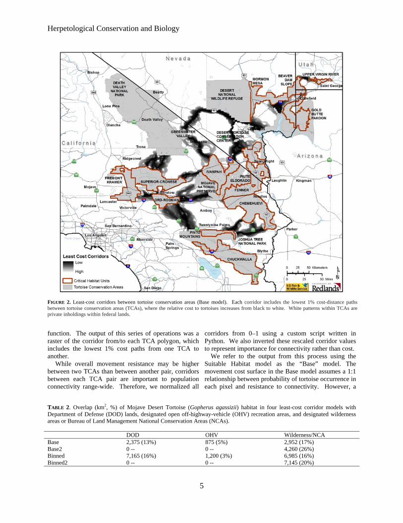
Herpetological Conservation and Biology
FIGURE 2 Least-cost corridors between tortoise conservation areas (Base model) Each corridor includes the lowest 1 cost-distance paths between tortoise conservation areas (TCAs) where the relative cost to tortoises increases from black to white White patterns within TCAs are private inholdings within federal lands
function The output of this series of operations was a corridors from 0ndash1 using a custom script written in raster of the corridor fromto each TCA polygon which Python We also inverted these rescaled corridor values includes the lowest 1 cost paths from one TCA to to represent importance for connectivity rather than cost another We refer to the output from this process using the
While overall movement resistance may be higher Suitable Habitat model as the ldquoBaserdquo model The between two TCAs than between another pair corridors movement cost surface in the Base model assumes a 11 between each TCA pair are important to population relationship between probability of tortoise occurrence in connectivity range-wide Therefore we normalized all each pixel and resistance to connectivity However a
TABLE 2 Overlap (km2 ) of Mojave Desert Tortoise (Gopherus agassizii) habitat in four least-cost corridor models with Department of Defense (DOD) lands designated open off-highway-vehicle (OHV) recreation areas and designated wilderness areas or Bureau of Land Management National Conservation Areas (NCAs)
Base Base2 Binned Binned2
DOD2375 (13) 0 -shy7165 (16) 0 -shy
OHV875 (5) 0 -shy1200 (3) 0 -shy
WildernessNCA 2952 (17) 4260 (26) 6985 (16) 7145 (20)
5
Averill-Murray et almdashDesert Tortoise Population Connectivity
FIGURE 3 Least-cost corridors between tortoise conservation areas (TCAs Base model) overlaid with Department of Defense (DoD) lands and open off-highway vehicle (OHV) areas and showing designated wilderness areas and National Conservation Areas (NCAs) clipped to the linkages Each corridor includes the lowest 1 cost-distance paths between TCAs where the relative cost to tortoises increases from black to white White patterns within TCAs are private inholdings within federal lands
pixel of moderate probability (eg 07) may contribute equally to connectivity as a pixel of high probability (09) if both pixels allow some degree of population presence or individual movement especially at a temporal scale of a tortoise generation (about 25 y) For example 95 of cells with known presence in the USGS habitat model had scores greater than 07 (Nussear et al 2009) Therefore we compared the Base model to a ldquoBinnedrdquo model in order to evaluate uncertainty in our choice of resistance values as recommended by Beier et al (2009) and Sawyer et al (2011) We developed the cost surface for the Binned model by re-scoring all pixels ge 07 in the Base model to 10 values 050ndash069 to 06 values 010ndash049 to 03 and values lt 01 to 0 Other land uses also may affect desert tortoise connectivity but are not captured by NLCDrsquos developed areas of The Nature Conservancyrsquos highly converted areas Military training maneuvers and open-access off- highway-
vehicle (OHV) recreation are high-impact activities that limit tortoise abundance especially in the long term with increasing use (Bury and Luckenbach 2002 Berry et al 2006) Therefore we assessed effects on linkages of converting all Department of Defense (DOD) lands and open OHV areas to 0 habitat probability (models ldquoBase2rdquo and ldquoBinned2rdquo)
RESULTS
Suitable Habitat (ie current estimated habitat) for the Mojave Desert Tortoise totals 67000 km2 81 of the historic (ie unmanipulated USGS habitat model) estimated total of 83138 km2 The area of Suitable Habitat within TCAs including areas of overlap with DOD lands is 45340 km2 (68 of total current 55 of total historic) Suitable Habitat within linkages connecting the TCAs in the Base model totals17831 km2
6
Herpetological Conservation and Biology
TABLE 3 Percentage overlap of least-cost corridors based on four connectivity models between Mojave Desert Tortoise (Gopherus agassizii) conservation areas Total habitat area within each linkage is given along the diagonal
Base Base2 Binned Binned2 Base 17831 km2 81 38 35 Base2 74 16282 km2 34 41 Binned 92 90 43597 km2 97 Binned2 70 90 79 35629 km2
(27 current 21 historic Fig 2) Several linkages are already severely constrained or impacted by DOD and open OHV area designations (Fig 3 Table 2) Military training operations or high-intensity OHV recreation affect up to 18 of Suitable Habitat within linkages in the Base model On the other hand portions of some linkages (17) are protected by wilderness or US Bureau of Land Management (BLM) National
Conservation Area (NCA) designations (Fig 3 Table 2) The Binned model had the effect of greatly lowering
the resistance to tortoise occupancy thereby increasing the amount of area included in the lowest 1 cost paths between TCAs (Fig 4) Linkages in the Base model included only 38 of Suitable Habitat in the Binned model while the Binned linkages included 92 of Base linkage habitat (Table 3) The total area of habitat within
FIGURE 4 Binned model least-cost corridors between tortoise conservation areas (TCAs) overlaid with Department of Defense (DoD) lands and open off-highway vehicle (OHV) areas and showing designated wilderness areas and National Conservation Areas (NCAs) clipped to the linkages Each corridor includes the lowest 1 cost-distance paths between TCAs where the relative cost to tortoises increases from black to white White patterns within TCAs are private inholdings within federal lands
7
Averill-Murray et almdashDesert Tortoise Population Connectivity
FIGURE 5 Base2 model least-cost corridors between tortoise conservation areas (TCAs) overlaid with Department of Defense (DoD) lands and open off-highway vehicle (OHV) areas and showing designated wilderness areas and National Conservation Areas (NCAs) clipped to the linkages Each corridor includes the lowest 1 cost-distance paths between TCAs where the relative cost to tortoises increases from black to white White patterns within TCAs are private inholdings within federal lands
linkages in the Binned model totals 43597 km2 (65 current 52 historic) Military training operations or high-intensity OHV recreation affect 19 of habitat within the linkages in the Binned model (Table 2) Current wilderness or NCA designations protect 16 of linkages in the Binned model (Table 2)
Excluding DOD and OHV designations from the cost surface reduced total habitat areas by 87 and 183 in the Base2 and Binned2 models respectively (Table 3) although a greater proportion of the linkages is protected by existing wilderness or NCA designations (Table 2) Excluding these areas resulted in expansion of remaining linkages between TCAs especially in California in the Base2 model (Figs 56) Overall linkages in the Base model overlapped 81 of Suitable Habitat in the Base2 model while the Binned model included 97 of Suitable Habitat in the Binned2 model (Table 3) Differences
from 100 in proportion of habitat in the Base and Binned models that overlap the smaller Base2 and Binned2 models reflect shifts in the 1 cost surfaces For example in the Base2 model more of the area east of the Ord-Rodman and Superior-Cronese critical habitat units was important for connectivity and new linkage strands were identified between the Chemehuevi and Chuckwalla critical habitat units (Fig 5)
DISCUSSION
Successfully conserving the Mojave Desert Tortoise will entail managing not just conservation areas alone but also the connections between these areas (ie managing the matrix between reserves Fahrig 2001 Prevedello and Vieira 2010) Some TCAs are contiguous with others and together may contain viable
8
Herpetological Conservation and Biology
FIGURE 6 Binned2 model least-cost corridors between tortoise conservation areas (TCAs) overlaid with Department of Defense (DoD) lands and open off-highway vehicle (OHV) areas and showing designated wilderness areas and National Conservation Areas (NCAs) clipped to the linkages Each corridor includes the lowest 1 cost-distance paths between TCAs where the relative cost to tortoises increases from black to white White patterns within TCAs are private inholdings within federal lands
numbers of desert tortoises but even these contiguous blocks are adjacent to smaller more isolated TCAs Therefore the function of the collective TCA network could be solidified by ensuring that all remain connected In cases where much of the matrix between reserves remains undeveloped managing the matrix to increase permeability and occupancy will be easier than restoring corridors after development has occurred (Prugh et al 2008 Prededello and Vieira 2010)
In addition most wildlife including the Mojave Desert Tortoise does not occur at uniform densities across landscapes (Krzysik 2002) The extent to which populations may fluctuate asynchronously such as localized declines attributed to drought or predation events (Peterson 1994 Longshore et al 2003 see also the model of recruitment in chaotic environments in Morafka 1994) even within designated conservation
areas increases risks to population viability and places increased emphasis on preserving population connectivity through the surrounding habitat matrix Even under an assumption that TCAs are source habitats surrounded by sinks maintaining or improving conditions within sinkslinkages can be as important to regional viability as protecting source TCAs because of their effect on neighboring source habitat (Carroll et al 2003) Consequently the effectiveness of TCAs will be improved if they are connected with functional habitat to ensure desert tortoise population persistence (US Fish and Wildlife Service 1994 2011) Ideally linkages between TCAs would also be wide enough to buffer against detrimental edge effects (Beier et al 2008) a recommendation applicable also to the TCAs themselves (US Fish and Wildlife Service 1994)
9
Averill-Murray et almdashDesert Tortoise Population Connectivity
While specific management is needed within TCAs these areas provide only an initial framework upon which to focus recovery efforts especially given uncertainties related to the effects of climate change on Mojave Desert Tortoise populations and distribution (Barrows et al 2011 US Fish and Wildlife Service 2011) Temperatures are projected to change relatively quickly within desert ecosystems To keep pace with changes from current temperature regimes within the current century desert wildlife populations or species would need to shift their distributions at approximately 07 kmyear (Loarie et al 2009) At this rate the current climate would cross each critical habitat unit (ranging in latitudinal extent of approximately 33ndash267 km) within 23ndash187 years Notwithstanding potential elevational shifts by tortoise populations in response to climate change which may be constrained in many areas as a result of geologic limitations on burrow construction preserving connectivity between TCAs may allow shifts in the speciesrsquo distribution and allow for future flexibility in refocusing management to ensure long-term recovery (Crooks and Sanjayan 2006 Krosby et al 2010)
Connectivity conservation also is integral to maintaining genetic variability and ecological heterogeneity within and among populations of widely distributed species Genetic analyses suggest that historically levels of gene flow among subpopulations of the Mojave Desert Tortoise were high corresponding to high levels of habitat connectivity (Murphy et al 2007 Hagerty 2008) All recent genetic studies of the Mojave Desert Tortoise have suggested that its population structure is characterized by isolation-byshydistance populations at the farthest extremes of the distribution are most differentiated but a gradient of genetic differentiation occurs between those populations across the range (Britten et al 1997 Murphy et al 2007 Hagerty and Tracy 2010) This isolation-by-distance genetic structure across the relatively continuous historic distribution of the Mojave Desert Tortoise (Germano et al 1994 Nussear et al 2009) indicates that gene flow generally occurs (or historically occurred) according to a continuous-distribution model (Allendorf and Luikart 2007) as opposed to a metapopulation or stepping-stone model where individual tortoises move from one patch of suitable habitat across less suitable or non-habitat to another patch of suitable habitat
Our modeling approach was similar to that of Hagerty et al (2011) who modeled historic gene flow between populations across the range of the species across a cost surface based on the original (historic) USGS habitat model Gene flow historically occurred in a diffuse pattern across the landscape unless otherwise constrained to more narrow concentrated pathways created by topographic barriers (eg around the Spring Mountains in southern Nevada Hagerty et al 2011) Linkages
between conservation areas are needed to conserve historic genetic gradation thereby preventing habitat specialization and genetic divergence between populations (Frankham 2006) Where gene flow is constrained by topographic barriers conservation of such concentrated pathways or linkages is especially important
For gene flow to reliably occur across the range and for populations within existing conservation areas to be buffered against detrimental effects of low numbers or density populations need to be connected by areas of habitat occupied by tortoises Low levels of genetic differentiation in Mojave Desert Tortoises have been detected across even relatively recent and narrow anthropogenic impacts on the landscape (Latch et al 2011) Pairs of tortoises from opposite sides of a road exhibited significantly greater genetic differentiation than pairs from the same side of a road (Latch et al 2011) raising even greater concerns for population fragmentation from larger scale habitat loss
Assumptions and limitationsmdashOur assessment of important areas within which to preserve connectivity of Mojave Desert Tortoise populations is limited by shortcomings in our knowledge We assumed that potential tortoise occupancy was accurately reflected by the USGS habitat model as modified by our interpretation of the altered-habitat datasets and that linkages of high-probability habitat between existing TCAs will help sustain viable populations across the range of the species Implicit in this assumption is that various land uses or impacts occurring on the landscape (eg unpaved roads exotic plant invasions) that were not explicitly included in the geospatial data we used do not impede connectivity of tortoise populations We evaluated the effect of this assumption relative to large-scale potential impacts of high-intensity land uses (military training maneuvers and open OHV recreation) and additional areas emerged that may be important to connectivity
Least-cost path analyses provide only a snapshot of current habitat conditions and are uninformative about demographic processes or how individuals actually move through a landscape (Noss and Daly 2006 Taylor et al 2006) We assumed that a 1 cost surface would identify linkages wide enough to provide functional connectivity between TCAs However application of different resistance values from the underlying habitat model greatly influenced the total area and configuration of the 1 cost surface
Indeed limiting the cost surface to the lowest 1 is an arbitrary choice (Sawyer et al 2011) The mean model score for all cells with known tortoise presence in the USGS habitat model was 084 and 95 of cells with known presence had scores greater than 07 (Nussear et al 2009) Therefore connectivity between tortoise
10
Herpetological Conservation and Biology
populations (TCAs) may occur more broadly than estimated in the Base model The more permeable Binned model identified linkages 245 larger in area than those in the Base model while the linkages in the Binned2 model were 219 larger than those in the Base2 model
Limited guidance is available for determining precise linkage widths but minimum widths for corridor dwellers such as the Mojave Desert Tortoise should be substantially larger than a home range diameter (Beier et al 2008) Inevitably however questions will be asked about what is the minimum width for a particular desert tortoise linkage what is the relevant home range size from which to estimate that minimum width and what are the minimum sampling considerations in estimating home ranges (cf Harless et al 2010) We agree with Beier et al (2008) that this is analogous to asking an engineer ldquowhat are the fewest number of rivets that might keep this wing on the airplanerdquo A more appropriate question for conservation is ldquowhat is the narrowest width that is not likely to be regretted after the adjacent area is converted to human userdquo Managers and policy-makers must realize that conservation is not primarily a set-aside issue that can be dealt with by reserving a minimal percentage or amount of the landscape rather it is a pervasive issue that must be considered across the entire landscape (Franklin and Lindenmayer 2009)
Management implications and recommendationsmdash In general land and wildlife managers should think about corridors between conservation areas that are large enough for resident tortoises to persist and to continue to interact with their neighbors within and outside broad habitat linkages rather than expect that a more narrow band of habitat will allow an individual tortoise to move through it to the other side breed with a tortoise on that side and produce viable offspring that contribute to the next generation Linkage integrity with sufficient habitat to support sustainable populations is important for Mojave Desert Tortoises and other corridor dwellers to support connectivity between core reserves (cf Barrows et al 2011) Given the underlying geospatial data linkages in the Base2 model illustrate a minimum connection of habitat for Mojave Desert Tortoises between TCA pairs and therefore represent priority areas for conservation of population connectivity However large areas within these linkages are at risk of permanent habitat loss as a result of solar energy development
Utility-scale solar development will require 831 km2
of land by 2030 to meet the reasonably foreseeable development scenario within the entire states of California and Nevada (US Bureau of Land Management and US Department of Energy 2012) To meet this need BLM has identified 39830 km2 of
potentially developable public lands throughout these states (not all within Mojave Desert Tortoise habitat) including 866 km2 of proposed solar energy zones (SEZs) within which solar energy production would be prioritized and facilitated Meanwhile projects totaling 190 km2 and 1470 km2 had already been approved or were pending respectively across BLM land within the range of the Mojave Desert Tortoise (US Bureau of Land Management and US Department of Energy 2012) Relatively little linkage area would be consumed by the proposed SEZs (40 km2) but 37 km2 of approved and 703 km2 of pending projects overlap linkages in the Base2 model with some linkages at particular risk (Fig 7) Even though substantial uncertainty surrounds the ultimate development footprint of pending solar development projects (or other proposed projects including wind energy development) a separate analysis found that between 2000 km2 and 7400 km2 of lower conservation value land could meet Californiarsquos renewable energy goal by up to seven times over (Cameron et al 2012) This suggests that renewable energy goals can be met without compromising the conservation of important Mojave Desert Tortoise habitat
The Binned2 model includes blocks of contiguous habitat outside the Base2 linkage network and many such areas likely contain substantial numbers of Mojave Desert Tortoises Managers should consider additional conservation of occupied habitat adjacent to the Base2 linkages and existing TCAs to provide security against edge effects and population declines especially given limitations previously identified in the existing reserve architecture For example even though use of DOD lands may be subject to change depending on national security needs the value of military lands to conservation has long been recognized (Stein et al 2008) and DOD-managed habitat that is unaffected by military training operations adds to the conservation base Of additional note are blocks of habitat at the northern extent of the Mojave Desert Tortoisersquos range which may be of particular relevance for additional evaluation to determine more precisely how the modeled linkages will accommodate climate change (Beier et al 2008)
Application of models from this study will require refinement at the local level and at a higher-resolution scale than the available geospatial data (ie finer resolution than 1 km2) to account for on-the-ground limitations to tortoise occupancy and movement either not reflected in the geospatial data used here or as a result of errors in the land cover data we used to identify Suitable Habitat (Beier et al 2009) For example habitat connections through the northern end and across the boundary of the Chuckwalla critical habitat unit may be more limited by rugged topography than suggested by Figure 1 (Jody Fraser and Pete Sorensen pers comm)
11
Averill-Murray et almdashDesert Tortoise Population Connectivity
FIGURE 7 Least-cost corridors (Base2 model) between tortoise conservation areas (TCAs) relative to approved solar development projects pending solar development projects and solar energy zones Each corridor includes the lowest 1 cost-distance paths between TCAs where the relative cost to tortoises increases from black to white White patterns within TCAs are private inholdings within federal lands
thereby placing greater potential importance on the linkage identified on the north end of the critical habitat unit in the Binned2 model In addition more detailed or spatially explicit population viability analyses based on regional population and distribution patterns are needed to evaluate the ability of a conservation network such as that modeled here to ensure long-term persistence of Mojave Desert Tortoise populations (US Fish and Wildlife Service 2011 eg Carroll et al 2003)
While there is much still to be learned about the science and application of connectivity land managers cannot wait for research to resolve all relevant questions before focusing effort on enhancing connectivity Instead science and management must proceed in parallel with the flexibility to modify future management in the light of new knowledge (Lovejoy 2006) In areas proposed for essentially permanent habitat conversion such as by large-scale development there is the risk that
critical linkages will be severed before they are protected (Morrison and Reynolds 2006) For species with long generation times like the Mojave Desert Tortoise this risk is compounded by the fact that we are not likely to detect a problem with a population until well after we have reduced the habitat below its extinction threshold (Fahrig 2001)
AcknowledgmentsmdashDiscussion with Linda Allison Ashleigh Blackford Brian Croft Diane Elam Kimberleigh Field and the Desert Tortoise Science Advisory Committee (Peter Hudson Earl McCoy Katherine Ralls Michael Reed and Robert Steidl) contributed to the development of this manuscript Additional review and comments by Todd Esque Kimberleigh Field Michael Reed and Andrew Walde improved the manuscript We thank Lisa Benvenuti at the Redlands Institute for her excellent map-making
12
Herpetological Conservation and Biology
skills The findings and conclusions in this article are those of the authors and do not necessarily represent the views of the US Fish and Wildlife Service
LITERATURE CITED
Allendorf FW and G Luikart 2007 Conservation and the Genetics of Populations Blackwell Malden Massachusetts USA
Barrows CW KD Fleming and MF Allen 2011 Identifying habitat linkages to maintain connectivity for corridor dwellers in a fragmented landscape Journal of Wildlife Management 75682ndash691
Beier P and S Loe 1992 A checklist for evaluating impacts to wildlife movement corridors Wildlife Society Bulletin 20434ndash440
Beier P DR Majka and SL Newell 2009 Uncertainty analysis of least-cost modeling for designing wildlife linkages Ecological Applications 192067ndash2077
Beier P DR Majka and WD Spencer 2008 Forks in the road choices in procedures for designing wildland linkages Conservation Biology 22836ndash851
Berry KH TY Bailey and KM Anderson 2006 Attributes of Desert Tortoise populations at the National Training Center Central Mojave Desert California USA Journal of Arid Environments 67165ndash191
Berry KH and PA Medica 1995 Desert Tortoises in the Mojave and Colorado deserts Pages 135ndash137 In Our Living Resources A Report to the Nation on the Distribution Abundance and Health of US Plants Animals and Ecosystems LaRoe ET GS Farris CE Puckett PD Doran and MJ Mac (Eds) US Department of the Interior National Biological Service Washington DC USA
Boarman WI ML Beigel GC Goodlett and M Sazaki 1998 A passive integrated transponder system for tracking animal movements Wildlife Society Bulletin 26886ndash891
Britten HB BR Riddle PF Brussard R Marlow and TE Lee 1997 Genetic delineation of management units for the Desert Tortoise Gopherus agassizii in northeastern Mojave Desert Copeia 1997523ndash530
Bury RB and PS Corn 1995 Have desert tortoises undergone a long-term decline in abundance Wildlife Society Bulletin 2341ndash47
Bury RB and RA Luckenbach 2002 Comparison of Desert Tortoise (Gopherus agassizii) populations in an unused and off-road vehicle area in the Mojave Desert Chelonian Conservation and Biology 4457ndash463
Cameron DR BS Cohen and SA Morrison 2012 An approach to enhance the conservation-compatibility of solar energy development PloS ONE 7(6)e38347 Doi101371journalpone0038437
Carroll C RF Noss PC Paquet and NH Schumaker 2003 Use of population viability analysis and reserve selection algorithms in regional conservation plans Ecological Applications 131773ndash 1789
Crooks KR and M Sanjayan 2006 Connectivity conservation maintaining connections for nature Pp 1ndash19 In Connectivity Conservation Crooks KR and M Sanjayan (Eds) Cambridge University Press Cambridge UK
Doak D P Kareiva and B Klepetka 1994 Modeling population viability for the Desert Tortoise in the western Mojave Desert Ecological Applications 4446ndash460
Edwards T EW Stitt CR Schwalbe and DE Swann 2004 Gopherus agassizii (Desert Tortoise) Movement Herpetological Review 35381ndash382
Fagan WF and EE Holmes 2006 Quantifying the extinction vortex Ecology Letters 951ndash60
Fahrig L 2001 How much habitat is enough Biological Conservation 10065ndash74
Frankham R 2006 Genetics and landscape connectivity Pp 72ndash96 In Connectivity Conservation Crooks KR and M Sanjayan (Eds) Cambridge University Press Cambridge UK
Franklin JF and DB Lindenmayer 2009 Importance of matrix habitats in maintaining biological diversity Proceedings of the National Academy of Sciences 106349ndash350
Fry J G Xian S Jin J Dewitz C Homer L Yang C Barnes N Herold and J Wickham 2011 Completion of the 2006 National Land Cover Database for the conterminous United States Photogrammetric Engineering and Remote Sensing 77858ndash864
Germano DJ RB Bury TC Esque TH Fritts and PA Medica 1994 Range and habitat of the Desert Tortoise Pp 57ndash72 In Biology of the North American Tortoises Bury RB and DJ Germano (Eds) National Biological Survey Fish and Wildlife Research 13 Washington DC USA
Gilpin ME and ME Souleacute 1986 Minimum viable populations processes of species extinction Pp 19ndash34 In Conservation Biology The Science of Scarcity and Diversity Souleacute ME (Ed) Sinauer Associates Sunderland Massachusetts USA
Hagerty BE 2008 Ecological genetics of the Mojave Desert Tortoise PhD Dissertation University of Nevada Reno Nevada USA 226 p
Hagerty BE KE Nussear TC Esque and CR Tracy 2011 Making molehills out of mountains landscape genetics of the Mojave Desert Tortoise Landscape Ecology 26267ndash280
Hagerty BE and CR Tracy 2010 Defining population structure for the Mojave Desert Tortoise Conservation Genetics 111795ndash1807
13
Averill-Murray et almdashDesert Tortoise Population Connectivity
Harless ML AD Walde DK Delaney LL Pater and WK Hayes 2010 Sampling considerations for improving home range estimates of Desert Tortoises effects of estimator sampling regime and sex Herpetological Conservation and Biology 5374ndash387
Harrison S and E Bruna 1999 Habitat fragmentation and large-scale conservation what do we know for sure Ecography 22225ndash232
Krosby M J Tewksbury NM Haddad and J Hoekstra 2010 Ecological connectivity for a changing climate Conservation Biology 241686ndash1689
Krzysik AJ 2002 A landscape sampling protocol for estimating distribution and density patterns of Desert Tortoises at multiple spatial scales Chelonian Conservation and Biology 4366ndash379
Latch EK WI Boarman A Walde and RC Fleischer 2011 Fine-scale analysis reveals cryptic landscape genetic structure in Desert Tortoises PLoS ONE 6e27794 Doi101371journalpone0027794
Liu C PM Berry TP Dawson and RG Pearson 2005 Selecting thresholds of occurrence in the prediction of species distributions Ecography 28385ndash 393
Loarie SR PB Duffy H Hamilton GP Asner CB Field and DD Ackerly 2009 The velocity of climate change Nature 4621052ndash1055
Longshore KM JR Jaeger and JM Sappington 2003 Desert Tortoise (Gopherus agassizii) survival at two eastern Mojave Desert sites death by short-term drought Journal of Herpetology 37169ndash177
Lovejoy T 2006 Introduction donrsquot fence me in Pp 447ndash449 In Connectivity Conservation Crooks KR and M Sanjayan (Eds) Cambridge University Press Cambridge UK
Lovich JE and JR Ennen 2011 Wildlife conservation and solar energy development in the Desert Southwest United States BioScience 61982ndash 992
McLuckie AM PG Emblidge and RA Fridell 2010 Regional Desert Tortoise monitoring in the Red Cliffs Desert Reserve 2009 Utah Division of Wildlife Resource Publication 10-13
Meffe GK and CR Carroll 1994 The design of conservation reserves Pp 265ndash304 In Principles of Conservation Biology Meffe GK and CR Carroll (Eds) Sinauer Associates Sunderland Massachusetts USA
Morafka DJ 1994 Neonates missing links in the life histories of North American tortoises Pp 161ndash173 In Biology of North American Tortoises Bury RB and DJ Germano (Eds) National Biological Survey Fish and Wildlife Research 13 Washington DC USA
Morrison SA and MD Reynolds 2006 Where to draw the line integrating feasibility into connectivity planning Pp 536ndash554 In Connectivity Conservation
Crooks KR and M Sanjayan (Eds) Cambridge University Press Cambridge UK
Murphy RW KH Berry T Edwards and AM McLuckie 2007 A genetic assessment of the recovery units for the Mojave population of the Desert Tortoise Gopherus agassizii Chelonian Conservation and Biology 6229ndash251
Noss RF and KM Daly 2006 Incorporating connectivity into broad-scale conservation planning Pp 587ndash619 In Connectivity Conservation Crooks KR and M Sanjayan (Eds) Cambridge University Press Cambridge UK
Nussear KE TC Esque RD Inman L Gass KA Thomas CSA Wallace JB Blainey DM Miller and RH Webb 2009 Modeling habitat of the Desert Tortoise (Gopherus agassizii) in the Mojave and parts of the Sonoran deserts of California Nevada Utah and Arizona US Geological Survey Open-file Report 2009-1102 18 p
Peterson CC 1994 Different rates and causes of high mortality in two populations of the threatened Desert Tortoise Gopherus agassizii Biological Conservation 70101ndash108
Prevedello JA and MV Vieira 2010 Does the type of matrix matter A quantitative review of the evidence Biodiversity and Conservation 191205ndash 1223
Prugh LR KE Hodges ARE Sinclair and JS Brashares 2008 Effect of habitat area and isolation of fragmented animal populations Proceedings of the National Academy of Sciences 10520770ndash20775
Reed JM N Fefferman and RC Averill-Murray 2009 Vital rate sensitivity analysis as a tool for assessing management actions for the Desert Tortoise Biological Conservation 1422710ndash2717
Ricketts TH 2001 The matrix matters effective isolation in fragmented landscapes American Naturalist 15887ndash99
Sawyer SC CW Epps and JS Brashares 2011 Placing linkages among fragmented habitats do least-cost models reflect how animals use landscapes Journal of Applied Ecology 48668ndash678
Stein BA C Scott and N Benton 2008 Federal lands and endangered species the role of military and other federal lands in sustaining biodiversity BioScience 58339ndash347
Taylor PD L Fahrig and KA With 2006 Landscape connectivity a return to basics Pp 29ndash43 In Connectivity Conservation Crooks KR and M Sanjayan (Eds) Cambridge University Press Cambridge UK
US Bureau of Land Management and US Department of Energy 2012 Final programmatic environmental impact statement (PEIS) for solar energy development in six southwestern states FES 12-24 DOEEIS-0403
14
Herpetological Conservation and Biology
US Fish and Wildlife Service 1990 Endangered and threatened wildlife and plants determination of threatened status for the Mojave population of the Desert Tortoise Federal Register 5512178ndash12191
US Fish and Wildlife Service 1994 Desert Tortoise (Mojave population) Recovery Plan US Fish and Wildlife Service Portland Oregon USA
US Fish and Wildlife Service 2011 Revised Recovery Plan for the Mojave Population of the Desert Tortoise (Gopherus agassizii) US Fish and Wildlife Service California and Nevada Region Sacramento California USA
Venter O NN Brodeur L Nemiroff B Belland IJ Dolinsek and JWA Grant Threats to endangered species in Canada BioScience 56903ndash910
Wiens JA 2006 Introduction connectivity research ndash What are the issues Pp 23ndash27 In Connectivity Conservation Crooks KR and M Sanjayan (Eds) Cambridge University Press Cambridge UK
Wilcox BA and DD Murphy 1985 Conservation strategy the effects of fragmentation on extinction American Naturalist 125879ndash887
Yiming L and DS Wilcove 2005 Threats to vertebrate species in China and the United States BioScience 55147ndash153
ROY C AVERILL-MURRAY is the Desert Tortoise Recovery Coordinator for the Desert Tortoise Recovery Office of the US Fish and Wildlife Service in Reno Nevada USA He oversees the recovery office in coordinating research monitoring and recovery plan implementation for the threatened Mojave Desert Tortoise He has published articles and book chapters on various aspects of the ecology and management of both the Mojave Desert Tortoise and the Sonoran Desert Tortoise Roy has degrees in Wildlife and Fisheries Sciences from Texas AampM University (BS) and the University of Arizona (MS) (Photographed by Kimberleigh J Field)
CATHERINE R DARST is the Recovery Biologist for the US Fish and Wildlife Services Desert Tortoise Recovery Office in Ventura California USA Cats work focuses on recovery plan implementation and research coordination including developing collaborative planning processes and spatial decision support for the Mojave Desert Tortoise Cat received her undergraduate degrees from the University of California at Davis and her PhD in Ecology Evolution and Behavior from the University of Texas at Austin (Photographed by Ashleigh Blackford)
NATHAN STROUT is the Technology Manager for the Redlands Institute University of Redlands in Redlands California USA He is responsible for managing the technical design and development of projects at the Redlands Institute and a team of technical staff including programmers analysts and IT support staff His work includes GIS research and analysis web and desktop application development and project management Nathan also serves as adjunct faculty in the Master of Science in Geographic Information Systems (MS GIS) at the University of Redlands Nathan received his undergraduate degree in Environmental Science and a MS in GIS from the University of Redlands (Photographed by Stephen Daugherty)
MARTIN L WONG is a GIS Analyst for the Redlands Institute University of Redlands in Redlands California He is responsible for supporting students faculty and staff at the Redlands Institute and the Environmental Studies and MSGIS departments in their geospatial data needs His work includes researching acquiring and geoprocessing data writing scripts and tools using Python and C and producing maps and reports Martin received his undergraduate degree in Geography from the University of California at Santa Barbara (Photographed by Susie Kim)
15
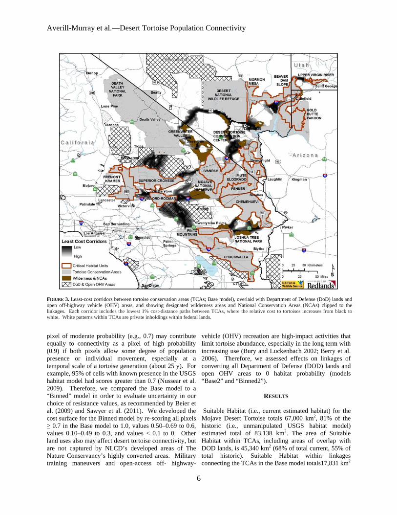
Averill-Murray et almdashDesert Tortoise Population Connectivity
FIGURE 3 Least-cost corridors between tortoise conservation areas (TCAs Base model) overlaid with Department of Defense (DoD) lands and open off-highway vehicle (OHV) areas and showing designated wilderness areas and National Conservation Areas (NCAs) clipped to the linkages Each corridor includes the lowest 1 cost-distance paths between TCAs where the relative cost to tortoises increases from black to white White patterns within TCAs are private inholdings within federal lands
pixel of moderate probability (eg 07) may contribute equally to connectivity as a pixel of high probability (09) if both pixels allow some degree of population presence or individual movement especially at a temporal scale of a tortoise generation (about 25 y) For example 95 of cells with known presence in the USGS habitat model had scores greater than 07 (Nussear et al 2009) Therefore we compared the Base model to a ldquoBinnedrdquo model in order to evaluate uncertainty in our choice of resistance values as recommended by Beier et al (2009) and Sawyer et al (2011) We developed the cost surface for the Binned model by re-scoring all pixels ge 07 in the Base model to 10 values 050ndash069 to 06 values 010ndash049 to 03 and values lt 01 to 0 Other land uses also may affect desert tortoise connectivity but are not captured by NLCDrsquos developed areas of The Nature Conservancyrsquos highly converted areas Military training maneuvers and open-access off- highway-
vehicle (OHV) recreation are high-impact activities that limit tortoise abundance especially in the long term with increasing use (Bury and Luckenbach 2002 Berry et al 2006) Therefore we assessed effects on linkages of converting all Department of Defense (DOD) lands and open OHV areas to 0 habitat probability (models ldquoBase2rdquo and ldquoBinned2rdquo)
RESULTS
Suitable Habitat (ie current estimated habitat) for the Mojave Desert Tortoise totals 67000 km2 81 of the historic (ie unmanipulated USGS habitat model) estimated total of 83138 km2 The area of Suitable Habitat within TCAs including areas of overlap with DOD lands is 45340 km2 (68 of total current 55 of total historic) Suitable Habitat within linkages connecting the TCAs in the Base model totals17831 km2
6
Herpetological Conservation and Biology
TABLE 3 Percentage overlap of least-cost corridors based on four connectivity models between Mojave Desert Tortoise (Gopherus agassizii) conservation areas Total habitat area within each linkage is given along the diagonal
Base Base2 Binned Binned2 Base 17831 km2 81 38 35 Base2 74 16282 km2 34 41 Binned 92 90 43597 km2 97 Binned2 70 90 79 35629 km2
(27 current 21 historic Fig 2) Several linkages are already severely constrained or impacted by DOD and open OHV area designations (Fig 3 Table 2) Military training operations or high-intensity OHV recreation affect up to 18 of Suitable Habitat within linkages in the Base model On the other hand portions of some linkages (17) are protected by wilderness or US Bureau of Land Management (BLM) National
Conservation Area (NCA) designations (Fig 3 Table 2) The Binned model had the effect of greatly lowering
the resistance to tortoise occupancy thereby increasing the amount of area included in the lowest 1 cost paths between TCAs (Fig 4) Linkages in the Base model included only 38 of Suitable Habitat in the Binned model while the Binned linkages included 92 of Base linkage habitat (Table 3) The total area of habitat within
FIGURE 4 Binned model least-cost corridors between tortoise conservation areas (TCAs) overlaid with Department of Defense (DoD) lands and open off-highway vehicle (OHV) areas and showing designated wilderness areas and National Conservation Areas (NCAs) clipped to the linkages Each corridor includes the lowest 1 cost-distance paths between TCAs where the relative cost to tortoises increases from black to white White patterns within TCAs are private inholdings within federal lands
7
Averill-Murray et almdashDesert Tortoise Population Connectivity
FIGURE 5 Base2 model least-cost corridors between tortoise conservation areas (TCAs) overlaid with Department of Defense (DoD) lands and open off-highway vehicle (OHV) areas and showing designated wilderness areas and National Conservation Areas (NCAs) clipped to the linkages Each corridor includes the lowest 1 cost-distance paths between TCAs where the relative cost to tortoises increases from black to white White patterns within TCAs are private inholdings within federal lands
linkages in the Binned model totals 43597 km2 (65 current 52 historic) Military training operations or high-intensity OHV recreation affect 19 of habitat within the linkages in the Binned model (Table 2) Current wilderness or NCA designations protect 16 of linkages in the Binned model (Table 2)
Excluding DOD and OHV designations from the cost surface reduced total habitat areas by 87 and 183 in the Base2 and Binned2 models respectively (Table 3) although a greater proportion of the linkages is protected by existing wilderness or NCA designations (Table 2) Excluding these areas resulted in expansion of remaining linkages between TCAs especially in California in the Base2 model (Figs 56) Overall linkages in the Base model overlapped 81 of Suitable Habitat in the Base2 model while the Binned model included 97 of Suitable Habitat in the Binned2 model (Table 3) Differences
from 100 in proportion of habitat in the Base and Binned models that overlap the smaller Base2 and Binned2 models reflect shifts in the 1 cost surfaces For example in the Base2 model more of the area east of the Ord-Rodman and Superior-Cronese critical habitat units was important for connectivity and new linkage strands were identified between the Chemehuevi and Chuckwalla critical habitat units (Fig 5)
DISCUSSION
Successfully conserving the Mojave Desert Tortoise will entail managing not just conservation areas alone but also the connections between these areas (ie managing the matrix between reserves Fahrig 2001 Prevedello and Vieira 2010) Some TCAs are contiguous with others and together may contain viable
8
Herpetological Conservation and Biology
FIGURE 6 Binned2 model least-cost corridors between tortoise conservation areas (TCAs) overlaid with Department of Defense (DoD) lands and open off-highway vehicle (OHV) areas and showing designated wilderness areas and National Conservation Areas (NCAs) clipped to the linkages Each corridor includes the lowest 1 cost-distance paths between TCAs where the relative cost to tortoises increases from black to white White patterns within TCAs are private inholdings within federal lands
numbers of desert tortoises but even these contiguous blocks are adjacent to smaller more isolated TCAs Therefore the function of the collective TCA network could be solidified by ensuring that all remain connected In cases where much of the matrix between reserves remains undeveloped managing the matrix to increase permeability and occupancy will be easier than restoring corridors after development has occurred (Prugh et al 2008 Prededello and Vieira 2010)
In addition most wildlife including the Mojave Desert Tortoise does not occur at uniform densities across landscapes (Krzysik 2002) The extent to which populations may fluctuate asynchronously such as localized declines attributed to drought or predation events (Peterson 1994 Longshore et al 2003 see also the model of recruitment in chaotic environments in Morafka 1994) even within designated conservation
areas increases risks to population viability and places increased emphasis on preserving population connectivity through the surrounding habitat matrix Even under an assumption that TCAs are source habitats surrounded by sinks maintaining or improving conditions within sinkslinkages can be as important to regional viability as protecting source TCAs because of their effect on neighboring source habitat (Carroll et al 2003) Consequently the effectiveness of TCAs will be improved if they are connected with functional habitat to ensure desert tortoise population persistence (US Fish and Wildlife Service 1994 2011) Ideally linkages between TCAs would also be wide enough to buffer against detrimental edge effects (Beier et al 2008) a recommendation applicable also to the TCAs themselves (US Fish and Wildlife Service 1994)
9
Averill-Murray et almdashDesert Tortoise Population Connectivity
While specific management is needed within TCAs these areas provide only an initial framework upon which to focus recovery efforts especially given uncertainties related to the effects of climate change on Mojave Desert Tortoise populations and distribution (Barrows et al 2011 US Fish and Wildlife Service 2011) Temperatures are projected to change relatively quickly within desert ecosystems To keep pace with changes from current temperature regimes within the current century desert wildlife populations or species would need to shift their distributions at approximately 07 kmyear (Loarie et al 2009) At this rate the current climate would cross each critical habitat unit (ranging in latitudinal extent of approximately 33ndash267 km) within 23ndash187 years Notwithstanding potential elevational shifts by tortoise populations in response to climate change which may be constrained in many areas as a result of geologic limitations on burrow construction preserving connectivity between TCAs may allow shifts in the speciesrsquo distribution and allow for future flexibility in refocusing management to ensure long-term recovery (Crooks and Sanjayan 2006 Krosby et al 2010)
Connectivity conservation also is integral to maintaining genetic variability and ecological heterogeneity within and among populations of widely distributed species Genetic analyses suggest that historically levels of gene flow among subpopulations of the Mojave Desert Tortoise were high corresponding to high levels of habitat connectivity (Murphy et al 2007 Hagerty 2008) All recent genetic studies of the Mojave Desert Tortoise have suggested that its population structure is characterized by isolation-byshydistance populations at the farthest extremes of the distribution are most differentiated but a gradient of genetic differentiation occurs between those populations across the range (Britten et al 1997 Murphy et al 2007 Hagerty and Tracy 2010) This isolation-by-distance genetic structure across the relatively continuous historic distribution of the Mojave Desert Tortoise (Germano et al 1994 Nussear et al 2009) indicates that gene flow generally occurs (or historically occurred) according to a continuous-distribution model (Allendorf and Luikart 2007) as opposed to a metapopulation or stepping-stone model where individual tortoises move from one patch of suitable habitat across less suitable or non-habitat to another patch of suitable habitat
Our modeling approach was similar to that of Hagerty et al (2011) who modeled historic gene flow between populations across the range of the species across a cost surface based on the original (historic) USGS habitat model Gene flow historically occurred in a diffuse pattern across the landscape unless otherwise constrained to more narrow concentrated pathways created by topographic barriers (eg around the Spring Mountains in southern Nevada Hagerty et al 2011) Linkages
between conservation areas are needed to conserve historic genetic gradation thereby preventing habitat specialization and genetic divergence between populations (Frankham 2006) Where gene flow is constrained by topographic barriers conservation of such concentrated pathways or linkages is especially important
For gene flow to reliably occur across the range and for populations within existing conservation areas to be buffered against detrimental effects of low numbers or density populations need to be connected by areas of habitat occupied by tortoises Low levels of genetic differentiation in Mojave Desert Tortoises have been detected across even relatively recent and narrow anthropogenic impacts on the landscape (Latch et al 2011) Pairs of tortoises from opposite sides of a road exhibited significantly greater genetic differentiation than pairs from the same side of a road (Latch et al 2011) raising even greater concerns for population fragmentation from larger scale habitat loss
Assumptions and limitationsmdashOur assessment of important areas within which to preserve connectivity of Mojave Desert Tortoise populations is limited by shortcomings in our knowledge We assumed that potential tortoise occupancy was accurately reflected by the USGS habitat model as modified by our interpretation of the altered-habitat datasets and that linkages of high-probability habitat between existing TCAs will help sustain viable populations across the range of the species Implicit in this assumption is that various land uses or impacts occurring on the landscape (eg unpaved roads exotic plant invasions) that were not explicitly included in the geospatial data we used do not impede connectivity of tortoise populations We evaluated the effect of this assumption relative to large-scale potential impacts of high-intensity land uses (military training maneuvers and open OHV recreation) and additional areas emerged that may be important to connectivity
Least-cost path analyses provide only a snapshot of current habitat conditions and are uninformative about demographic processes or how individuals actually move through a landscape (Noss and Daly 2006 Taylor et al 2006) We assumed that a 1 cost surface would identify linkages wide enough to provide functional connectivity between TCAs However application of different resistance values from the underlying habitat model greatly influenced the total area and configuration of the 1 cost surface
Indeed limiting the cost surface to the lowest 1 is an arbitrary choice (Sawyer et al 2011) The mean model score for all cells with known tortoise presence in the USGS habitat model was 084 and 95 of cells with known presence had scores greater than 07 (Nussear et al 2009) Therefore connectivity between tortoise
10
Herpetological Conservation and Biology
populations (TCAs) may occur more broadly than estimated in the Base model The more permeable Binned model identified linkages 245 larger in area than those in the Base model while the linkages in the Binned2 model were 219 larger than those in the Base2 model
Limited guidance is available for determining precise linkage widths but minimum widths for corridor dwellers such as the Mojave Desert Tortoise should be substantially larger than a home range diameter (Beier et al 2008) Inevitably however questions will be asked about what is the minimum width for a particular desert tortoise linkage what is the relevant home range size from which to estimate that minimum width and what are the minimum sampling considerations in estimating home ranges (cf Harless et al 2010) We agree with Beier et al (2008) that this is analogous to asking an engineer ldquowhat are the fewest number of rivets that might keep this wing on the airplanerdquo A more appropriate question for conservation is ldquowhat is the narrowest width that is not likely to be regretted after the adjacent area is converted to human userdquo Managers and policy-makers must realize that conservation is not primarily a set-aside issue that can be dealt with by reserving a minimal percentage or amount of the landscape rather it is a pervasive issue that must be considered across the entire landscape (Franklin and Lindenmayer 2009)
Management implications and recommendationsmdash In general land and wildlife managers should think about corridors between conservation areas that are large enough for resident tortoises to persist and to continue to interact with their neighbors within and outside broad habitat linkages rather than expect that a more narrow band of habitat will allow an individual tortoise to move through it to the other side breed with a tortoise on that side and produce viable offspring that contribute to the next generation Linkage integrity with sufficient habitat to support sustainable populations is important for Mojave Desert Tortoises and other corridor dwellers to support connectivity between core reserves (cf Barrows et al 2011) Given the underlying geospatial data linkages in the Base2 model illustrate a minimum connection of habitat for Mojave Desert Tortoises between TCA pairs and therefore represent priority areas for conservation of population connectivity However large areas within these linkages are at risk of permanent habitat loss as a result of solar energy development
Utility-scale solar development will require 831 km2
of land by 2030 to meet the reasonably foreseeable development scenario within the entire states of California and Nevada (US Bureau of Land Management and US Department of Energy 2012) To meet this need BLM has identified 39830 km2 of
potentially developable public lands throughout these states (not all within Mojave Desert Tortoise habitat) including 866 km2 of proposed solar energy zones (SEZs) within which solar energy production would be prioritized and facilitated Meanwhile projects totaling 190 km2 and 1470 km2 had already been approved or were pending respectively across BLM land within the range of the Mojave Desert Tortoise (US Bureau of Land Management and US Department of Energy 2012) Relatively little linkage area would be consumed by the proposed SEZs (40 km2) but 37 km2 of approved and 703 km2 of pending projects overlap linkages in the Base2 model with some linkages at particular risk (Fig 7) Even though substantial uncertainty surrounds the ultimate development footprint of pending solar development projects (or other proposed projects including wind energy development) a separate analysis found that between 2000 km2 and 7400 km2 of lower conservation value land could meet Californiarsquos renewable energy goal by up to seven times over (Cameron et al 2012) This suggests that renewable energy goals can be met without compromising the conservation of important Mojave Desert Tortoise habitat
The Binned2 model includes blocks of contiguous habitat outside the Base2 linkage network and many such areas likely contain substantial numbers of Mojave Desert Tortoises Managers should consider additional conservation of occupied habitat adjacent to the Base2 linkages and existing TCAs to provide security against edge effects and population declines especially given limitations previously identified in the existing reserve architecture For example even though use of DOD lands may be subject to change depending on national security needs the value of military lands to conservation has long been recognized (Stein et al 2008) and DOD-managed habitat that is unaffected by military training operations adds to the conservation base Of additional note are blocks of habitat at the northern extent of the Mojave Desert Tortoisersquos range which may be of particular relevance for additional evaluation to determine more precisely how the modeled linkages will accommodate climate change (Beier et al 2008)
Application of models from this study will require refinement at the local level and at a higher-resolution scale than the available geospatial data (ie finer resolution than 1 km2) to account for on-the-ground limitations to tortoise occupancy and movement either not reflected in the geospatial data used here or as a result of errors in the land cover data we used to identify Suitable Habitat (Beier et al 2009) For example habitat connections through the northern end and across the boundary of the Chuckwalla critical habitat unit may be more limited by rugged topography than suggested by Figure 1 (Jody Fraser and Pete Sorensen pers comm)
11
Averill-Murray et almdashDesert Tortoise Population Connectivity
FIGURE 7 Least-cost corridors (Base2 model) between tortoise conservation areas (TCAs) relative to approved solar development projects pending solar development projects and solar energy zones Each corridor includes the lowest 1 cost-distance paths between TCAs where the relative cost to tortoises increases from black to white White patterns within TCAs are private inholdings within federal lands
thereby placing greater potential importance on the linkage identified on the north end of the critical habitat unit in the Binned2 model In addition more detailed or spatially explicit population viability analyses based on regional population and distribution patterns are needed to evaluate the ability of a conservation network such as that modeled here to ensure long-term persistence of Mojave Desert Tortoise populations (US Fish and Wildlife Service 2011 eg Carroll et al 2003)
While there is much still to be learned about the science and application of connectivity land managers cannot wait for research to resolve all relevant questions before focusing effort on enhancing connectivity Instead science and management must proceed in parallel with the flexibility to modify future management in the light of new knowledge (Lovejoy 2006) In areas proposed for essentially permanent habitat conversion such as by large-scale development there is the risk that
critical linkages will be severed before they are protected (Morrison and Reynolds 2006) For species with long generation times like the Mojave Desert Tortoise this risk is compounded by the fact that we are not likely to detect a problem with a population until well after we have reduced the habitat below its extinction threshold (Fahrig 2001)
AcknowledgmentsmdashDiscussion with Linda Allison Ashleigh Blackford Brian Croft Diane Elam Kimberleigh Field and the Desert Tortoise Science Advisory Committee (Peter Hudson Earl McCoy Katherine Ralls Michael Reed and Robert Steidl) contributed to the development of this manuscript Additional review and comments by Todd Esque Kimberleigh Field Michael Reed and Andrew Walde improved the manuscript We thank Lisa Benvenuti at the Redlands Institute for her excellent map-making
12
Herpetological Conservation and Biology
skills The findings and conclusions in this article are those of the authors and do not necessarily represent the views of the US Fish and Wildlife Service
LITERATURE CITED
Allendorf FW and G Luikart 2007 Conservation and the Genetics of Populations Blackwell Malden Massachusetts USA
Barrows CW KD Fleming and MF Allen 2011 Identifying habitat linkages to maintain connectivity for corridor dwellers in a fragmented landscape Journal of Wildlife Management 75682ndash691
Beier P and S Loe 1992 A checklist for evaluating impacts to wildlife movement corridors Wildlife Society Bulletin 20434ndash440
Beier P DR Majka and SL Newell 2009 Uncertainty analysis of least-cost modeling for designing wildlife linkages Ecological Applications 192067ndash2077
Beier P DR Majka and WD Spencer 2008 Forks in the road choices in procedures for designing wildland linkages Conservation Biology 22836ndash851
Berry KH TY Bailey and KM Anderson 2006 Attributes of Desert Tortoise populations at the National Training Center Central Mojave Desert California USA Journal of Arid Environments 67165ndash191
Berry KH and PA Medica 1995 Desert Tortoises in the Mojave and Colorado deserts Pages 135ndash137 In Our Living Resources A Report to the Nation on the Distribution Abundance and Health of US Plants Animals and Ecosystems LaRoe ET GS Farris CE Puckett PD Doran and MJ Mac (Eds) US Department of the Interior National Biological Service Washington DC USA
Boarman WI ML Beigel GC Goodlett and M Sazaki 1998 A passive integrated transponder system for tracking animal movements Wildlife Society Bulletin 26886ndash891
Britten HB BR Riddle PF Brussard R Marlow and TE Lee 1997 Genetic delineation of management units for the Desert Tortoise Gopherus agassizii in northeastern Mojave Desert Copeia 1997523ndash530
Bury RB and PS Corn 1995 Have desert tortoises undergone a long-term decline in abundance Wildlife Society Bulletin 2341ndash47
Bury RB and RA Luckenbach 2002 Comparison of Desert Tortoise (Gopherus agassizii) populations in an unused and off-road vehicle area in the Mojave Desert Chelonian Conservation and Biology 4457ndash463
Cameron DR BS Cohen and SA Morrison 2012 An approach to enhance the conservation-compatibility of solar energy development PloS ONE 7(6)e38347 Doi101371journalpone0038437
Carroll C RF Noss PC Paquet and NH Schumaker 2003 Use of population viability analysis and reserve selection algorithms in regional conservation plans Ecological Applications 131773ndash 1789
Crooks KR and M Sanjayan 2006 Connectivity conservation maintaining connections for nature Pp 1ndash19 In Connectivity Conservation Crooks KR and M Sanjayan (Eds) Cambridge University Press Cambridge UK
Doak D P Kareiva and B Klepetka 1994 Modeling population viability for the Desert Tortoise in the western Mojave Desert Ecological Applications 4446ndash460
Edwards T EW Stitt CR Schwalbe and DE Swann 2004 Gopherus agassizii (Desert Tortoise) Movement Herpetological Review 35381ndash382
Fagan WF and EE Holmes 2006 Quantifying the extinction vortex Ecology Letters 951ndash60
Fahrig L 2001 How much habitat is enough Biological Conservation 10065ndash74
Frankham R 2006 Genetics and landscape connectivity Pp 72ndash96 In Connectivity Conservation Crooks KR and M Sanjayan (Eds) Cambridge University Press Cambridge UK
Franklin JF and DB Lindenmayer 2009 Importance of matrix habitats in maintaining biological diversity Proceedings of the National Academy of Sciences 106349ndash350
Fry J G Xian S Jin J Dewitz C Homer L Yang C Barnes N Herold and J Wickham 2011 Completion of the 2006 National Land Cover Database for the conterminous United States Photogrammetric Engineering and Remote Sensing 77858ndash864
Germano DJ RB Bury TC Esque TH Fritts and PA Medica 1994 Range and habitat of the Desert Tortoise Pp 57ndash72 In Biology of the North American Tortoises Bury RB and DJ Germano (Eds) National Biological Survey Fish and Wildlife Research 13 Washington DC USA
Gilpin ME and ME Souleacute 1986 Minimum viable populations processes of species extinction Pp 19ndash34 In Conservation Biology The Science of Scarcity and Diversity Souleacute ME (Ed) Sinauer Associates Sunderland Massachusetts USA
Hagerty BE 2008 Ecological genetics of the Mojave Desert Tortoise PhD Dissertation University of Nevada Reno Nevada USA 226 p
Hagerty BE KE Nussear TC Esque and CR Tracy 2011 Making molehills out of mountains landscape genetics of the Mojave Desert Tortoise Landscape Ecology 26267ndash280
Hagerty BE and CR Tracy 2010 Defining population structure for the Mojave Desert Tortoise Conservation Genetics 111795ndash1807
13
Averill-Murray et almdashDesert Tortoise Population Connectivity
Harless ML AD Walde DK Delaney LL Pater and WK Hayes 2010 Sampling considerations for improving home range estimates of Desert Tortoises effects of estimator sampling regime and sex Herpetological Conservation and Biology 5374ndash387
Harrison S and E Bruna 1999 Habitat fragmentation and large-scale conservation what do we know for sure Ecography 22225ndash232
Krosby M J Tewksbury NM Haddad and J Hoekstra 2010 Ecological connectivity for a changing climate Conservation Biology 241686ndash1689
Krzysik AJ 2002 A landscape sampling protocol for estimating distribution and density patterns of Desert Tortoises at multiple spatial scales Chelonian Conservation and Biology 4366ndash379
Latch EK WI Boarman A Walde and RC Fleischer 2011 Fine-scale analysis reveals cryptic landscape genetic structure in Desert Tortoises PLoS ONE 6e27794 Doi101371journalpone0027794
Liu C PM Berry TP Dawson and RG Pearson 2005 Selecting thresholds of occurrence in the prediction of species distributions Ecography 28385ndash 393
Loarie SR PB Duffy H Hamilton GP Asner CB Field and DD Ackerly 2009 The velocity of climate change Nature 4621052ndash1055
Longshore KM JR Jaeger and JM Sappington 2003 Desert Tortoise (Gopherus agassizii) survival at two eastern Mojave Desert sites death by short-term drought Journal of Herpetology 37169ndash177
Lovejoy T 2006 Introduction donrsquot fence me in Pp 447ndash449 In Connectivity Conservation Crooks KR and M Sanjayan (Eds) Cambridge University Press Cambridge UK
Lovich JE and JR Ennen 2011 Wildlife conservation and solar energy development in the Desert Southwest United States BioScience 61982ndash 992
McLuckie AM PG Emblidge and RA Fridell 2010 Regional Desert Tortoise monitoring in the Red Cliffs Desert Reserve 2009 Utah Division of Wildlife Resource Publication 10-13
Meffe GK and CR Carroll 1994 The design of conservation reserves Pp 265ndash304 In Principles of Conservation Biology Meffe GK and CR Carroll (Eds) Sinauer Associates Sunderland Massachusetts USA
Morafka DJ 1994 Neonates missing links in the life histories of North American tortoises Pp 161ndash173 In Biology of North American Tortoises Bury RB and DJ Germano (Eds) National Biological Survey Fish and Wildlife Research 13 Washington DC USA
Morrison SA and MD Reynolds 2006 Where to draw the line integrating feasibility into connectivity planning Pp 536ndash554 In Connectivity Conservation
Crooks KR and M Sanjayan (Eds) Cambridge University Press Cambridge UK
Murphy RW KH Berry T Edwards and AM McLuckie 2007 A genetic assessment of the recovery units for the Mojave population of the Desert Tortoise Gopherus agassizii Chelonian Conservation and Biology 6229ndash251
Noss RF and KM Daly 2006 Incorporating connectivity into broad-scale conservation planning Pp 587ndash619 In Connectivity Conservation Crooks KR and M Sanjayan (Eds) Cambridge University Press Cambridge UK
Nussear KE TC Esque RD Inman L Gass KA Thomas CSA Wallace JB Blainey DM Miller and RH Webb 2009 Modeling habitat of the Desert Tortoise (Gopherus agassizii) in the Mojave and parts of the Sonoran deserts of California Nevada Utah and Arizona US Geological Survey Open-file Report 2009-1102 18 p
Peterson CC 1994 Different rates and causes of high mortality in two populations of the threatened Desert Tortoise Gopherus agassizii Biological Conservation 70101ndash108
Prevedello JA and MV Vieira 2010 Does the type of matrix matter A quantitative review of the evidence Biodiversity and Conservation 191205ndash 1223
Prugh LR KE Hodges ARE Sinclair and JS Brashares 2008 Effect of habitat area and isolation of fragmented animal populations Proceedings of the National Academy of Sciences 10520770ndash20775
Reed JM N Fefferman and RC Averill-Murray 2009 Vital rate sensitivity analysis as a tool for assessing management actions for the Desert Tortoise Biological Conservation 1422710ndash2717
Ricketts TH 2001 The matrix matters effective isolation in fragmented landscapes American Naturalist 15887ndash99
Sawyer SC CW Epps and JS Brashares 2011 Placing linkages among fragmented habitats do least-cost models reflect how animals use landscapes Journal of Applied Ecology 48668ndash678
Stein BA C Scott and N Benton 2008 Federal lands and endangered species the role of military and other federal lands in sustaining biodiversity BioScience 58339ndash347
Taylor PD L Fahrig and KA With 2006 Landscape connectivity a return to basics Pp 29ndash43 In Connectivity Conservation Crooks KR and M Sanjayan (Eds) Cambridge University Press Cambridge UK
US Bureau of Land Management and US Department of Energy 2012 Final programmatic environmental impact statement (PEIS) for solar energy development in six southwestern states FES 12-24 DOEEIS-0403
14
Herpetological Conservation and Biology
US Fish and Wildlife Service 1990 Endangered and threatened wildlife and plants determination of threatened status for the Mojave population of the Desert Tortoise Federal Register 5512178ndash12191
US Fish and Wildlife Service 1994 Desert Tortoise (Mojave population) Recovery Plan US Fish and Wildlife Service Portland Oregon USA
US Fish and Wildlife Service 2011 Revised Recovery Plan for the Mojave Population of the Desert Tortoise (Gopherus agassizii) US Fish and Wildlife Service California and Nevada Region Sacramento California USA
Venter O NN Brodeur L Nemiroff B Belland IJ Dolinsek and JWA Grant Threats to endangered species in Canada BioScience 56903ndash910
Wiens JA 2006 Introduction connectivity research ndash What are the issues Pp 23ndash27 In Connectivity Conservation Crooks KR and M Sanjayan (Eds) Cambridge University Press Cambridge UK
Wilcox BA and DD Murphy 1985 Conservation strategy the effects of fragmentation on extinction American Naturalist 125879ndash887
Yiming L and DS Wilcove 2005 Threats to vertebrate species in China and the United States BioScience 55147ndash153
ROY C AVERILL-MURRAY is the Desert Tortoise Recovery Coordinator for the Desert Tortoise Recovery Office of the US Fish and Wildlife Service in Reno Nevada USA He oversees the recovery office in coordinating research monitoring and recovery plan implementation for the threatened Mojave Desert Tortoise He has published articles and book chapters on various aspects of the ecology and management of both the Mojave Desert Tortoise and the Sonoran Desert Tortoise Roy has degrees in Wildlife and Fisheries Sciences from Texas AampM University (BS) and the University of Arizona (MS) (Photographed by Kimberleigh J Field)
CATHERINE R DARST is the Recovery Biologist for the US Fish and Wildlife Services Desert Tortoise Recovery Office in Ventura California USA Cats work focuses on recovery plan implementation and research coordination including developing collaborative planning processes and spatial decision support for the Mojave Desert Tortoise Cat received her undergraduate degrees from the University of California at Davis and her PhD in Ecology Evolution and Behavior from the University of Texas at Austin (Photographed by Ashleigh Blackford)
NATHAN STROUT is the Technology Manager for the Redlands Institute University of Redlands in Redlands California USA He is responsible for managing the technical design and development of projects at the Redlands Institute and a team of technical staff including programmers analysts and IT support staff His work includes GIS research and analysis web and desktop application development and project management Nathan also serves as adjunct faculty in the Master of Science in Geographic Information Systems (MS GIS) at the University of Redlands Nathan received his undergraduate degree in Environmental Science and a MS in GIS from the University of Redlands (Photographed by Stephen Daugherty)
MARTIN L WONG is a GIS Analyst for the Redlands Institute University of Redlands in Redlands California He is responsible for supporting students faculty and staff at the Redlands Institute and the Environmental Studies and MSGIS departments in their geospatial data needs His work includes researching acquiring and geoprocessing data writing scripts and tools using Python and C and producing maps and reports Martin received his undergraduate degree in Geography from the University of California at Santa Barbara (Photographed by Susie Kim)
15

Herpetological Conservation and Biology
TABLE 3 Percentage overlap of least-cost corridors based on four connectivity models between Mojave Desert Tortoise (Gopherus agassizii) conservation areas Total habitat area within each linkage is given along the diagonal
Base Base2 Binned Binned2 Base 17831 km2 81 38 35 Base2 74 16282 km2 34 41 Binned 92 90 43597 km2 97 Binned2 70 90 79 35629 km2
(27 current 21 historic Fig 2) Several linkages are already severely constrained or impacted by DOD and open OHV area designations (Fig 3 Table 2) Military training operations or high-intensity OHV recreation affect up to 18 of Suitable Habitat within linkages in the Base model On the other hand portions of some linkages (17) are protected by wilderness or US Bureau of Land Management (BLM) National
Conservation Area (NCA) designations (Fig 3 Table 2) The Binned model had the effect of greatly lowering
the resistance to tortoise occupancy thereby increasing the amount of area included in the lowest 1 cost paths between TCAs (Fig 4) Linkages in the Base model included only 38 of Suitable Habitat in the Binned model while the Binned linkages included 92 of Base linkage habitat (Table 3) The total area of habitat within
FIGURE 4 Binned model least-cost corridors between tortoise conservation areas (TCAs) overlaid with Department of Defense (DoD) lands and open off-highway vehicle (OHV) areas and showing designated wilderness areas and National Conservation Areas (NCAs) clipped to the linkages Each corridor includes the lowest 1 cost-distance paths between TCAs where the relative cost to tortoises increases from black to white White patterns within TCAs are private inholdings within federal lands
7
Averill-Murray et almdashDesert Tortoise Population Connectivity
FIGURE 5 Base2 model least-cost corridors between tortoise conservation areas (TCAs) overlaid with Department of Defense (DoD) lands and open off-highway vehicle (OHV) areas and showing designated wilderness areas and National Conservation Areas (NCAs) clipped to the linkages Each corridor includes the lowest 1 cost-distance paths between TCAs where the relative cost to tortoises increases from black to white White patterns within TCAs are private inholdings within federal lands
linkages in the Binned model totals 43597 km2 (65 current 52 historic) Military training operations or high-intensity OHV recreation affect 19 of habitat within the linkages in the Binned model (Table 2) Current wilderness or NCA designations protect 16 of linkages in the Binned model (Table 2)
Excluding DOD and OHV designations from the cost surface reduced total habitat areas by 87 and 183 in the Base2 and Binned2 models respectively (Table 3) although a greater proportion of the linkages is protected by existing wilderness or NCA designations (Table 2) Excluding these areas resulted in expansion of remaining linkages between TCAs especially in California in the Base2 model (Figs 56) Overall linkages in the Base model overlapped 81 of Suitable Habitat in the Base2 model while the Binned model included 97 of Suitable Habitat in the Binned2 model (Table 3) Differences
from 100 in proportion of habitat in the Base and Binned models that overlap the smaller Base2 and Binned2 models reflect shifts in the 1 cost surfaces For example in the Base2 model more of the area east of the Ord-Rodman and Superior-Cronese critical habitat units was important for connectivity and new linkage strands were identified between the Chemehuevi and Chuckwalla critical habitat units (Fig 5)
DISCUSSION
Successfully conserving the Mojave Desert Tortoise will entail managing not just conservation areas alone but also the connections between these areas (ie managing the matrix between reserves Fahrig 2001 Prevedello and Vieira 2010) Some TCAs are contiguous with others and together may contain viable
8
Herpetological Conservation and Biology
FIGURE 6 Binned2 model least-cost corridors between tortoise conservation areas (TCAs) overlaid with Department of Defense (DoD) lands and open off-highway vehicle (OHV) areas and showing designated wilderness areas and National Conservation Areas (NCAs) clipped to the linkages Each corridor includes the lowest 1 cost-distance paths between TCAs where the relative cost to tortoises increases from black to white White patterns within TCAs are private inholdings within federal lands
numbers of desert tortoises but even these contiguous blocks are adjacent to smaller more isolated TCAs Therefore the function of the collective TCA network could be solidified by ensuring that all remain connected In cases where much of the matrix between reserves remains undeveloped managing the matrix to increase permeability and occupancy will be easier than restoring corridors after development has occurred (Prugh et al 2008 Prededello and Vieira 2010)
In addition most wildlife including the Mojave Desert Tortoise does not occur at uniform densities across landscapes (Krzysik 2002) The extent to which populations may fluctuate asynchronously such as localized declines attributed to drought or predation events (Peterson 1994 Longshore et al 2003 see also the model of recruitment in chaotic environments in Morafka 1994) even within designated conservation
areas increases risks to population viability and places increased emphasis on preserving population connectivity through the surrounding habitat matrix Even under an assumption that TCAs are source habitats surrounded by sinks maintaining or improving conditions within sinkslinkages can be as important to regional viability as protecting source TCAs because of their effect on neighboring source habitat (Carroll et al 2003) Consequently the effectiveness of TCAs will be improved if they are connected with functional habitat to ensure desert tortoise population persistence (US Fish and Wildlife Service 1994 2011) Ideally linkages between TCAs would also be wide enough to buffer against detrimental edge effects (Beier et al 2008) a recommendation applicable also to the TCAs themselves (US Fish and Wildlife Service 1994)
9
Averill-Murray et almdashDesert Tortoise Population Connectivity
While specific management is needed within TCAs these areas provide only an initial framework upon which to focus recovery efforts especially given uncertainties related to the effects of climate change on Mojave Desert Tortoise populations and distribution (Barrows et al 2011 US Fish and Wildlife Service 2011) Temperatures are projected to change relatively quickly within desert ecosystems To keep pace with changes from current temperature regimes within the current century desert wildlife populations or species would need to shift their distributions at approximately 07 kmyear (Loarie et al 2009) At this rate the current climate would cross each critical habitat unit (ranging in latitudinal extent of approximately 33ndash267 km) within 23ndash187 years Notwithstanding potential elevational shifts by tortoise populations in response to climate change which may be constrained in many areas as a result of geologic limitations on burrow construction preserving connectivity between TCAs may allow shifts in the speciesrsquo distribution and allow for future flexibility in refocusing management to ensure long-term recovery (Crooks and Sanjayan 2006 Krosby et al 2010)
Connectivity conservation also is integral to maintaining genetic variability and ecological heterogeneity within and among populations of widely distributed species Genetic analyses suggest that historically levels of gene flow among subpopulations of the Mojave Desert Tortoise were high corresponding to high levels of habitat connectivity (Murphy et al 2007 Hagerty 2008) All recent genetic studies of the Mojave Desert Tortoise have suggested that its population structure is characterized by isolation-byshydistance populations at the farthest extremes of the distribution are most differentiated but a gradient of genetic differentiation occurs between those populations across the range (Britten et al 1997 Murphy et al 2007 Hagerty and Tracy 2010) This isolation-by-distance genetic structure across the relatively continuous historic distribution of the Mojave Desert Tortoise (Germano et al 1994 Nussear et al 2009) indicates that gene flow generally occurs (or historically occurred) according to a continuous-distribution model (Allendorf and Luikart 2007) as opposed to a metapopulation or stepping-stone model where individual tortoises move from one patch of suitable habitat across less suitable or non-habitat to another patch of suitable habitat
Our modeling approach was similar to that of Hagerty et al (2011) who modeled historic gene flow between populations across the range of the species across a cost surface based on the original (historic) USGS habitat model Gene flow historically occurred in a diffuse pattern across the landscape unless otherwise constrained to more narrow concentrated pathways created by topographic barriers (eg around the Spring Mountains in southern Nevada Hagerty et al 2011) Linkages
between conservation areas are needed to conserve historic genetic gradation thereby preventing habitat specialization and genetic divergence between populations (Frankham 2006) Where gene flow is constrained by topographic barriers conservation of such concentrated pathways or linkages is especially important
For gene flow to reliably occur across the range and for populations within existing conservation areas to be buffered against detrimental effects of low numbers or density populations need to be connected by areas of habitat occupied by tortoises Low levels of genetic differentiation in Mojave Desert Tortoises have been detected across even relatively recent and narrow anthropogenic impacts on the landscape (Latch et al 2011) Pairs of tortoises from opposite sides of a road exhibited significantly greater genetic differentiation than pairs from the same side of a road (Latch et al 2011) raising even greater concerns for population fragmentation from larger scale habitat loss
Assumptions and limitationsmdashOur assessment of important areas within which to preserve connectivity of Mojave Desert Tortoise populations is limited by shortcomings in our knowledge We assumed that potential tortoise occupancy was accurately reflected by the USGS habitat model as modified by our interpretation of the altered-habitat datasets and that linkages of high-probability habitat between existing TCAs will help sustain viable populations across the range of the species Implicit in this assumption is that various land uses or impacts occurring on the landscape (eg unpaved roads exotic plant invasions) that were not explicitly included in the geospatial data we used do not impede connectivity of tortoise populations We evaluated the effect of this assumption relative to large-scale potential impacts of high-intensity land uses (military training maneuvers and open OHV recreation) and additional areas emerged that may be important to connectivity
Least-cost path analyses provide only a snapshot of current habitat conditions and are uninformative about demographic processes or how individuals actually move through a landscape (Noss and Daly 2006 Taylor et al 2006) We assumed that a 1 cost surface would identify linkages wide enough to provide functional connectivity between TCAs However application of different resistance values from the underlying habitat model greatly influenced the total area and configuration of the 1 cost surface
Indeed limiting the cost surface to the lowest 1 is an arbitrary choice (Sawyer et al 2011) The mean model score for all cells with known tortoise presence in the USGS habitat model was 084 and 95 of cells with known presence had scores greater than 07 (Nussear et al 2009) Therefore connectivity between tortoise
10
Herpetological Conservation and Biology
populations (TCAs) may occur more broadly than estimated in the Base model The more permeable Binned model identified linkages 245 larger in area than those in the Base model while the linkages in the Binned2 model were 219 larger than those in the Base2 model
Limited guidance is available for determining precise linkage widths but minimum widths for corridor dwellers such as the Mojave Desert Tortoise should be substantially larger than a home range diameter (Beier et al 2008) Inevitably however questions will be asked about what is the minimum width for a particular desert tortoise linkage what is the relevant home range size from which to estimate that minimum width and what are the minimum sampling considerations in estimating home ranges (cf Harless et al 2010) We agree with Beier et al (2008) that this is analogous to asking an engineer ldquowhat are the fewest number of rivets that might keep this wing on the airplanerdquo A more appropriate question for conservation is ldquowhat is the narrowest width that is not likely to be regretted after the adjacent area is converted to human userdquo Managers and policy-makers must realize that conservation is not primarily a set-aside issue that can be dealt with by reserving a minimal percentage or amount of the landscape rather it is a pervasive issue that must be considered across the entire landscape (Franklin and Lindenmayer 2009)
Management implications and recommendationsmdash In general land and wildlife managers should think about corridors between conservation areas that are large enough for resident tortoises to persist and to continue to interact with their neighbors within and outside broad habitat linkages rather than expect that a more narrow band of habitat will allow an individual tortoise to move through it to the other side breed with a tortoise on that side and produce viable offspring that contribute to the next generation Linkage integrity with sufficient habitat to support sustainable populations is important for Mojave Desert Tortoises and other corridor dwellers to support connectivity between core reserves (cf Barrows et al 2011) Given the underlying geospatial data linkages in the Base2 model illustrate a minimum connection of habitat for Mojave Desert Tortoises between TCA pairs and therefore represent priority areas for conservation of population connectivity However large areas within these linkages are at risk of permanent habitat loss as a result of solar energy development
Utility-scale solar development will require 831 km2
of land by 2030 to meet the reasonably foreseeable development scenario within the entire states of California and Nevada (US Bureau of Land Management and US Department of Energy 2012) To meet this need BLM has identified 39830 km2 of
potentially developable public lands throughout these states (not all within Mojave Desert Tortoise habitat) including 866 km2 of proposed solar energy zones (SEZs) within which solar energy production would be prioritized and facilitated Meanwhile projects totaling 190 km2 and 1470 km2 had already been approved or were pending respectively across BLM land within the range of the Mojave Desert Tortoise (US Bureau of Land Management and US Department of Energy 2012) Relatively little linkage area would be consumed by the proposed SEZs (40 km2) but 37 km2 of approved and 703 km2 of pending projects overlap linkages in the Base2 model with some linkages at particular risk (Fig 7) Even though substantial uncertainty surrounds the ultimate development footprint of pending solar development projects (or other proposed projects including wind energy development) a separate analysis found that between 2000 km2 and 7400 km2 of lower conservation value land could meet Californiarsquos renewable energy goal by up to seven times over (Cameron et al 2012) This suggests that renewable energy goals can be met without compromising the conservation of important Mojave Desert Tortoise habitat
The Binned2 model includes blocks of contiguous habitat outside the Base2 linkage network and many such areas likely contain substantial numbers of Mojave Desert Tortoises Managers should consider additional conservation of occupied habitat adjacent to the Base2 linkages and existing TCAs to provide security against edge effects and population declines especially given limitations previously identified in the existing reserve architecture For example even though use of DOD lands may be subject to change depending on national security needs the value of military lands to conservation has long been recognized (Stein et al 2008) and DOD-managed habitat that is unaffected by military training operations adds to the conservation base Of additional note are blocks of habitat at the northern extent of the Mojave Desert Tortoisersquos range which may be of particular relevance for additional evaluation to determine more precisely how the modeled linkages will accommodate climate change (Beier et al 2008)
Application of models from this study will require refinement at the local level and at a higher-resolution scale than the available geospatial data (ie finer resolution than 1 km2) to account for on-the-ground limitations to tortoise occupancy and movement either not reflected in the geospatial data used here or as a result of errors in the land cover data we used to identify Suitable Habitat (Beier et al 2009) For example habitat connections through the northern end and across the boundary of the Chuckwalla critical habitat unit may be more limited by rugged topography than suggested by Figure 1 (Jody Fraser and Pete Sorensen pers comm)
11
Averill-Murray et almdashDesert Tortoise Population Connectivity
FIGURE 7 Least-cost corridors (Base2 model) between tortoise conservation areas (TCAs) relative to approved solar development projects pending solar development projects and solar energy zones Each corridor includes the lowest 1 cost-distance paths between TCAs where the relative cost to tortoises increases from black to white White patterns within TCAs are private inholdings within federal lands
thereby placing greater potential importance on the linkage identified on the north end of the critical habitat unit in the Binned2 model In addition more detailed or spatially explicit population viability analyses based on regional population and distribution patterns are needed to evaluate the ability of a conservation network such as that modeled here to ensure long-term persistence of Mojave Desert Tortoise populations (US Fish and Wildlife Service 2011 eg Carroll et al 2003)
While there is much still to be learned about the science and application of connectivity land managers cannot wait for research to resolve all relevant questions before focusing effort on enhancing connectivity Instead science and management must proceed in parallel with the flexibility to modify future management in the light of new knowledge (Lovejoy 2006) In areas proposed for essentially permanent habitat conversion such as by large-scale development there is the risk that
critical linkages will be severed before they are protected (Morrison and Reynolds 2006) For species with long generation times like the Mojave Desert Tortoise this risk is compounded by the fact that we are not likely to detect a problem with a population until well after we have reduced the habitat below its extinction threshold (Fahrig 2001)
AcknowledgmentsmdashDiscussion with Linda Allison Ashleigh Blackford Brian Croft Diane Elam Kimberleigh Field and the Desert Tortoise Science Advisory Committee (Peter Hudson Earl McCoy Katherine Ralls Michael Reed and Robert Steidl) contributed to the development of this manuscript Additional review and comments by Todd Esque Kimberleigh Field Michael Reed and Andrew Walde improved the manuscript We thank Lisa Benvenuti at the Redlands Institute for her excellent map-making
12
Herpetological Conservation and Biology
skills The findings and conclusions in this article are those of the authors and do not necessarily represent the views of the US Fish and Wildlife Service
LITERATURE CITED
Allendorf FW and G Luikart 2007 Conservation and the Genetics of Populations Blackwell Malden Massachusetts USA
Barrows CW KD Fleming and MF Allen 2011 Identifying habitat linkages to maintain connectivity for corridor dwellers in a fragmented landscape Journal of Wildlife Management 75682ndash691
Beier P and S Loe 1992 A checklist for evaluating impacts to wildlife movement corridors Wildlife Society Bulletin 20434ndash440
Beier P DR Majka and SL Newell 2009 Uncertainty analysis of least-cost modeling for designing wildlife linkages Ecological Applications 192067ndash2077
Beier P DR Majka and WD Spencer 2008 Forks in the road choices in procedures for designing wildland linkages Conservation Biology 22836ndash851
Berry KH TY Bailey and KM Anderson 2006 Attributes of Desert Tortoise populations at the National Training Center Central Mojave Desert California USA Journal of Arid Environments 67165ndash191
Berry KH and PA Medica 1995 Desert Tortoises in the Mojave and Colorado deserts Pages 135ndash137 In Our Living Resources A Report to the Nation on the Distribution Abundance and Health of US Plants Animals and Ecosystems LaRoe ET GS Farris CE Puckett PD Doran and MJ Mac (Eds) US Department of the Interior National Biological Service Washington DC USA
Boarman WI ML Beigel GC Goodlett and M Sazaki 1998 A passive integrated transponder system for tracking animal movements Wildlife Society Bulletin 26886ndash891
Britten HB BR Riddle PF Brussard R Marlow and TE Lee 1997 Genetic delineation of management units for the Desert Tortoise Gopherus agassizii in northeastern Mojave Desert Copeia 1997523ndash530
Bury RB and PS Corn 1995 Have desert tortoises undergone a long-term decline in abundance Wildlife Society Bulletin 2341ndash47
Bury RB and RA Luckenbach 2002 Comparison of Desert Tortoise (Gopherus agassizii) populations in an unused and off-road vehicle area in the Mojave Desert Chelonian Conservation and Biology 4457ndash463
Cameron DR BS Cohen and SA Morrison 2012 An approach to enhance the conservation-compatibility of solar energy development PloS ONE 7(6)e38347 Doi101371journalpone0038437
Carroll C RF Noss PC Paquet and NH Schumaker 2003 Use of population viability analysis and reserve selection algorithms in regional conservation plans Ecological Applications 131773ndash 1789
Crooks KR and M Sanjayan 2006 Connectivity conservation maintaining connections for nature Pp 1ndash19 In Connectivity Conservation Crooks KR and M Sanjayan (Eds) Cambridge University Press Cambridge UK
Doak D P Kareiva and B Klepetka 1994 Modeling population viability for the Desert Tortoise in the western Mojave Desert Ecological Applications 4446ndash460
Edwards T EW Stitt CR Schwalbe and DE Swann 2004 Gopherus agassizii (Desert Tortoise) Movement Herpetological Review 35381ndash382
Fagan WF and EE Holmes 2006 Quantifying the extinction vortex Ecology Letters 951ndash60
Fahrig L 2001 How much habitat is enough Biological Conservation 10065ndash74
Frankham R 2006 Genetics and landscape connectivity Pp 72ndash96 In Connectivity Conservation Crooks KR and M Sanjayan (Eds) Cambridge University Press Cambridge UK
Franklin JF and DB Lindenmayer 2009 Importance of matrix habitats in maintaining biological diversity Proceedings of the National Academy of Sciences 106349ndash350
Fry J G Xian S Jin J Dewitz C Homer L Yang C Barnes N Herold and J Wickham 2011 Completion of the 2006 National Land Cover Database for the conterminous United States Photogrammetric Engineering and Remote Sensing 77858ndash864
Germano DJ RB Bury TC Esque TH Fritts and PA Medica 1994 Range and habitat of the Desert Tortoise Pp 57ndash72 In Biology of the North American Tortoises Bury RB and DJ Germano (Eds) National Biological Survey Fish and Wildlife Research 13 Washington DC USA
Gilpin ME and ME Souleacute 1986 Minimum viable populations processes of species extinction Pp 19ndash34 In Conservation Biology The Science of Scarcity and Diversity Souleacute ME (Ed) Sinauer Associates Sunderland Massachusetts USA
Hagerty BE 2008 Ecological genetics of the Mojave Desert Tortoise PhD Dissertation University of Nevada Reno Nevada USA 226 p
Hagerty BE KE Nussear TC Esque and CR Tracy 2011 Making molehills out of mountains landscape genetics of the Mojave Desert Tortoise Landscape Ecology 26267ndash280
Hagerty BE and CR Tracy 2010 Defining population structure for the Mojave Desert Tortoise Conservation Genetics 111795ndash1807
13
Averill-Murray et almdashDesert Tortoise Population Connectivity
Harless ML AD Walde DK Delaney LL Pater and WK Hayes 2010 Sampling considerations for improving home range estimates of Desert Tortoises effects of estimator sampling regime and sex Herpetological Conservation and Biology 5374ndash387
Harrison S and E Bruna 1999 Habitat fragmentation and large-scale conservation what do we know for sure Ecography 22225ndash232
Krosby M J Tewksbury NM Haddad and J Hoekstra 2010 Ecological connectivity for a changing climate Conservation Biology 241686ndash1689
Krzysik AJ 2002 A landscape sampling protocol for estimating distribution and density patterns of Desert Tortoises at multiple spatial scales Chelonian Conservation and Biology 4366ndash379
Latch EK WI Boarman A Walde and RC Fleischer 2011 Fine-scale analysis reveals cryptic landscape genetic structure in Desert Tortoises PLoS ONE 6e27794 Doi101371journalpone0027794
Liu C PM Berry TP Dawson and RG Pearson 2005 Selecting thresholds of occurrence in the prediction of species distributions Ecography 28385ndash 393
Loarie SR PB Duffy H Hamilton GP Asner CB Field and DD Ackerly 2009 The velocity of climate change Nature 4621052ndash1055
Longshore KM JR Jaeger and JM Sappington 2003 Desert Tortoise (Gopherus agassizii) survival at two eastern Mojave Desert sites death by short-term drought Journal of Herpetology 37169ndash177
Lovejoy T 2006 Introduction donrsquot fence me in Pp 447ndash449 In Connectivity Conservation Crooks KR and M Sanjayan (Eds) Cambridge University Press Cambridge UK
Lovich JE and JR Ennen 2011 Wildlife conservation and solar energy development in the Desert Southwest United States BioScience 61982ndash 992
McLuckie AM PG Emblidge and RA Fridell 2010 Regional Desert Tortoise monitoring in the Red Cliffs Desert Reserve 2009 Utah Division of Wildlife Resource Publication 10-13
Meffe GK and CR Carroll 1994 The design of conservation reserves Pp 265ndash304 In Principles of Conservation Biology Meffe GK and CR Carroll (Eds) Sinauer Associates Sunderland Massachusetts USA
Morafka DJ 1994 Neonates missing links in the life histories of North American tortoises Pp 161ndash173 In Biology of North American Tortoises Bury RB and DJ Germano (Eds) National Biological Survey Fish and Wildlife Research 13 Washington DC USA
Morrison SA and MD Reynolds 2006 Where to draw the line integrating feasibility into connectivity planning Pp 536ndash554 In Connectivity Conservation
Crooks KR and M Sanjayan (Eds) Cambridge University Press Cambridge UK
Murphy RW KH Berry T Edwards and AM McLuckie 2007 A genetic assessment of the recovery units for the Mojave population of the Desert Tortoise Gopherus agassizii Chelonian Conservation and Biology 6229ndash251
Noss RF and KM Daly 2006 Incorporating connectivity into broad-scale conservation planning Pp 587ndash619 In Connectivity Conservation Crooks KR and M Sanjayan (Eds) Cambridge University Press Cambridge UK
Nussear KE TC Esque RD Inman L Gass KA Thomas CSA Wallace JB Blainey DM Miller and RH Webb 2009 Modeling habitat of the Desert Tortoise (Gopherus agassizii) in the Mojave and parts of the Sonoran deserts of California Nevada Utah and Arizona US Geological Survey Open-file Report 2009-1102 18 p
Peterson CC 1994 Different rates and causes of high mortality in two populations of the threatened Desert Tortoise Gopherus agassizii Biological Conservation 70101ndash108
Prevedello JA and MV Vieira 2010 Does the type of matrix matter A quantitative review of the evidence Biodiversity and Conservation 191205ndash 1223
Prugh LR KE Hodges ARE Sinclair and JS Brashares 2008 Effect of habitat area and isolation of fragmented animal populations Proceedings of the National Academy of Sciences 10520770ndash20775
Reed JM N Fefferman and RC Averill-Murray 2009 Vital rate sensitivity analysis as a tool for assessing management actions for the Desert Tortoise Biological Conservation 1422710ndash2717
Ricketts TH 2001 The matrix matters effective isolation in fragmented landscapes American Naturalist 15887ndash99
Sawyer SC CW Epps and JS Brashares 2011 Placing linkages among fragmented habitats do least-cost models reflect how animals use landscapes Journal of Applied Ecology 48668ndash678
Stein BA C Scott and N Benton 2008 Federal lands and endangered species the role of military and other federal lands in sustaining biodiversity BioScience 58339ndash347
Taylor PD L Fahrig and KA With 2006 Landscape connectivity a return to basics Pp 29ndash43 In Connectivity Conservation Crooks KR and M Sanjayan (Eds) Cambridge University Press Cambridge UK
US Bureau of Land Management and US Department of Energy 2012 Final programmatic environmental impact statement (PEIS) for solar energy development in six southwestern states FES 12-24 DOEEIS-0403
14
Herpetological Conservation and Biology
US Fish and Wildlife Service 1990 Endangered and threatened wildlife and plants determination of threatened status for the Mojave population of the Desert Tortoise Federal Register 5512178ndash12191
US Fish and Wildlife Service 1994 Desert Tortoise (Mojave population) Recovery Plan US Fish and Wildlife Service Portland Oregon USA
US Fish and Wildlife Service 2011 Revised Recovery Plan for the Mojave Population of the Desert Tortoise (Gopherus agassizii) US Fish and Wildlife Service California and Nevada Region Sacramento California USA
Venter O NN Brodeur L Nemiroff B Belland IJ Dolinsek and JWA Grant Threats to endangered species in Canada BioScience 56903ndash910
Wiens JA 2006 Introduction connectivity research ndash What are the issues Pp 23ndash27 In Connectivity Conservation Crooks KR and M Sanjayan (Eds) Cambridge University Press Cambridge UK
Wilcox BA and DD Murphy 1985 Conservation strategy the effects of fragmentation on extinction American Naturalist 125879ndash887
Yiming L and DS Wilcove 2005 Threats to vertebrate species in China and the United States BioScience 55147ndash153
ROY C AVERILL-MURRAY is the Desert Tortoise Recovery Coordinator for the Desert Tortoise Recovery Office of the US Fish and Wildlife Service in Reno Nevada USA He oversees the recovery office in coordinating research monitoring and recovery plan implementation for the threatened Mojave Desert Tortoise He has published articles and book chapters on various aspects of the ecology and management of both the Mojave Desert Tortoise and the Sonoran Desert Tortoise Roy has degrees in Wildlife and Fisheries Sciences from Texas AampM University (BS) and the University of Arizona (MS) (Photographed by Kimberleigh J Field)
CATHERINE R DARST is the Recovery Biologist for the US Fish and Wildlife Services Desert Tortoise Recovery Office in Ventura California USA Cats work focuses on recovery plan implementation and research coordination including developing collaborative planning processes and spatial decision support for the Mojave Desert Tortoise Cat received her undergraduate degrees from the University of California at Davis and her PhD in Ecology Evolution and Behavior from the University of Texas at Austin (Photographed by Ashleigh Blackford)
NATHAN STROUT is the Technology Manager for the Redlands Institute University of Redlands in Redlands California USA He is responsible for managing the technical design and development of projects at the Redlands Institute and a team of technical staff including programmers analysts and IT support staff His work includes GIS research and analysis web and desktop application development and project management Nathan also serves as adjunct faculty in the Master of Science in Geographic Information Systems (MS GIS) at the University of Redlands Nathan received his undergraduate degree in Environmental Science and a MS in GIS from the University of Redlands (Photographed by Stephen Daugherty)
MARTIN L WONG is a GIS Analyst for the Redlands Institute University of Redlands in Redlands California He is responsible for supporting students faculty and staff at the Redlands Institute and the Environmental Studies and MSGIS departments in their geospatial data needs His work includes researching acquiring and geoprocessing data writing scripts and tools using Python and C and producing maps and reports Martin received his undergraduate degree in Geography from the University of California at Santa Barbara (Photographed by Susie Kim)
15
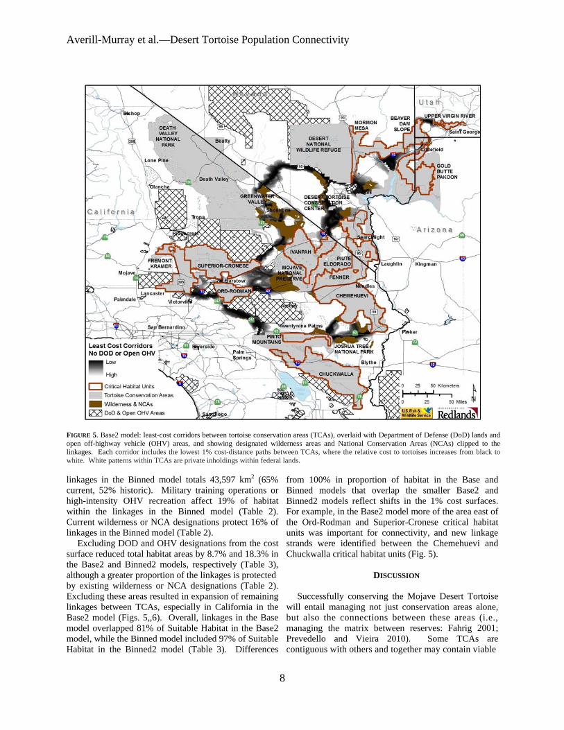
Averill-Murray et almdashDesert Tortoise Population Connectivity
FIGURE 5 Base2 model least-cost corridors between tortoise conservation areas (TCAs) overlaid with Department of Defense (DoD) lands and open off-highway vehicle (OHV) areas and showing designated wilderness areas and National Conservation Areas (NCAs) clipped to the linkages Each corridor includes the lowest 1 cost-distance paths between TCAs where the relative cost to tortoises increases from black to white White patterns within TCAs are private inholdings within federal lands
linkages in the Binned model totals 43597 km2 (65 current 52 historic) Military training operations or high-intensity OHV recreation affect 19 of habitat within the linkages in the Binned model (Table 2) Current wilderness or NCA designations protect 16 of linkages in the Binned model (Table 2)
Excluding DOD and OHV designations from the cost surface reduced total habitat areas by 87 and 183 in the Base2 and Binned2 models respectively (Table 3) although a greater proportion of the linkages is protected by existing wilderness or NCA designations (Table 2) Excluding these areas resulted in expansion of remaining linkages between TCAs especially in California in the Base2 model (Figs 56) Overall linkages in the Base model overlapped 81 of Suitable Habitat in the Base2 model while the Binned model included 97 of Suitable Habitat in the Binned2 model (Table 3) Differences
from 100 in proportion of habitat in the Base and Binned models that overlap the smaller Base2 and Binned2 models reflect shifts in the 1 cost surfaces For example in the Base2 model more of the area east of the Ord-Rodman and Superior-Cronese critical habitat units was important for connectivity and new linkage strands were identified between the Chemehuevi and Chuckwalla critical habitat units (Fig 5)
DISCUSSION
Successfully conserving the Mojave Desert Tortoise will entail managing not just conservation areas alone but also the connections between these areas (ie managing the matrix between reserves Fahrig 2001 Prevedello and Vieira 2010) Some TCAs are contiguous with others and together may contain viable
8
Herpetological Conservation and Biology
FIGURE 6 Binned2 model least-cost corridors between tortoise conservation areas (TCAs) overlaid with Department of Defense (DoD) lands and open off-highway vehicle (OHV) areas and showing designated wilderness areas and National Conservation Areas (NCAs) clipped to the linkages Each corridor includes the lowest 1 cost-distance paths between TCAs where the relative cost to tortoises increases from black to white White patterns within TCAs are private inholdings within federal lands
numbers of desert tortoises but even these contiguous blocks are adjacent to smaller more isolated TCAs Therefore the function of the collective TCA network could be solidified by ensuring that all remain connected In cases where much of the matrix between reserves remains undeveloped managing the matrix to increase permeability and occupancy will be easier than restoring corridors after development has occurred (Prugh et al 2008 Prededello and Vieira 2010)
In addition most wildlife including the Mojave Desert Tortoise does not occur at uniform densities across landscapes (Krzysik 2002) The extent to which populations may fluctuate asynchronously such as localized declines attributed to drought or predation events (Peterson 1994 Longshore et al 2003 see also the model of recruitment in chaotic environments in Morafka 1994) even within designated conservation
areas increases risks to population viability and places increased emphasis on preserving population connectivity through the surrounding habitat matrix Even under an assumption that TCAs are source habitats surrounded by sinks maintaining or improving conditions within sinkslinkages can be as important to regional viability as protecting source TCAs because of their effect on neighboring source habitat (Carroll et al 2003) Consequently the effectiveness of TCAs will be improved if they are connected with functional habitat to ensure desert tortoise population persistence (US Fish and Wildlife Service 1994 2011) Ideally linkages between TCAs would also be wide enough to buffer against detrimental edge effects (Beier et al 2008) a recommendation applicable also to the TCAs themselves (US Fish and Wildlife Service 1994)
9
Averill-Murray et almdashDesert Tortoise Population Connectivity
While specific management is needed within TCAs these areas provide only an initial framework upon which to focus recovery efforts especially given uncertainties related to the effects of climate change on Mojave Desert Tortoise populations and distribution (Barrows et al 2011 US Fish and Wildlife Service 2011) Temperatures are projected to change relatively quickly within desert ecosystems To keep pace with changes from current temperature regimes within the current century desert wildlife populations or species would need to shift their distributions at approximately 07 kmyear (Loarie et al 2009) At this rate the current climate would cross each critical habitat unit (ranging in latitudinal extent of approximately 33ndash267 km) within 23ndash187 years Notwithstanding potential elevational shifts by tortoise populations in response to climate change which may be constrained in many areas as a result of geologic limitations on burrow construction preserving connectivity between TCAs may allow shifts in the speciesrsquo distribution and allow for future flexibility in refocusing management to ensure long-term recovery (Crooks and Sanjayan 2006 Krosby et al 2010)
Connectivity conservation also is integral to maintaining genetic variability and ecological heterogeneity within and among populations of widely distributed species Genetic analyses suggest that historically levels of gene flow among subpopulations of the Mojave Desert Tortoise were high corresponding to high levels of habitat connectivity (Murphy et al 2007 Hagerty 2008) All recent genetic studies of the Mojave Desert Tortoise have suggested that its population structure is characterized by isolation-byshydistance populations at the farthest extremes of the distribution are most differentiated but a gradient of genetic differentiation occurs between those populations across the range (Britten et al 1997 Murphy et al 2007 Hagerty and Tracy 2010) This isolation-by-distance genetic structure across the relatively continuous historic distribution of the Mojave Desert Tortoise (Germano et al 1994 Nussear et al 2009) indicates that gene flow generally occurs (or historically occurred) according to a continuous-distribution model (Allendorf and Luikart 2007) as opposed to a metapopulation or stepping-stone model where individual tortoises move from one patch of suitable habitat across less suitable or non-habitat to another patch of suitable habitat
Our modeling approach was similar to that of Hagerty et al (2011) who modeled historic gene flow between populations across the range of the species across a cost surface based on the original (historic) USGS habitat model Gene flow historically occurred in a diffuse pattern across the landscape unless otherwise constrained to more narrow concentrated pathways created by topographic barriers (eg around the Spring Mountains in southern Nevada Hagerty et al 2011) Linkages
between conservation areas are needed to conserve historic genetic gradation thereby preventing habitat specialization and genetic divergence between populations (Frankham 2006) Where gene flow is constrained by topographic barriers conservation of such concentrated pathways or linkages is especially important
For gene flow to reliably occur across the range and for populations within existing conservation areas to be buffered against detrimental effects of low numbers or density populations need to be connected by areas of habitat occupied by tortoises Low levels of genetic differentiation in Mojave Desert Tortoises have been detected across even relatively recent and narrow anthropogenic impacts on the landscape (Latch et al 2011) Pairs of tortoises from opposite sides of a road exhibited significantly greater genetic differentiation than pairs from the same side of a road (Latch et al 2011) raising even greater concerns for population fragmentation from larger scale habitat loss
Assumptions and limitationsmdashOur assessment of important areas within which to preserve connectivity of Mojave Desert Tortoise populations is limited by shortcomings in our knowledge We assumed that potential tortoise occupancy was accurately reflected by the USGS habitat model as modified by our interpretation of the altered-habitat datasets and that linkages of high-probability habitat between existing TCAs will help sustain viable populations across the range of the species Implicit in this assumption is that various land uses or impacts occurring on the landscape (eg unpaved roads exotic plant invasions) that were not explicitly included in the geospatial data we used do not impede connectivity of tortoise populations We evaluated the effect of this assumption relative to large-scale potential impacts of high-intensity land uses (military training maneuvers and open OHV recreation) and additional areas emerged that may be important to connectivity
Least-cost path analyses provide only a snapshot of current habitat conditions and are uninformative about demographic processes or how individuals actually move through a landscape (Noss and Daly 2006 Taylor et al 2006) We assumed that a 1 cost surface would identify linkages wide enough to provide functional connectivity between TCAs However application of different resistance values from the underlying habitat model greatly influenced the total area and configuration of the 1 cost surface
Indeed limiting the cost surface to the lowest 1 is an arbitrary choice (Sawyer et al 2011) The mean model score for all cells with known tortoise presence in the USGS habitat model was 084 and 95 of cells with known presence had scores greater than 07 (Nussear et al 2009) Therefore connectivity between tortoise
10
Herpetological Conservation and Biology
populations (TCAs) may occur more broadly than estimated in the Base model The more permeable Binned model identified linkages 245 larger in area than those in the Base model while the linkages in the Binned2 model were 219 larger than those in the Base2 model
Limited guidance is available for determining precise linkage widths but minimum widths for corridor dwellers such as the Mojave Desert Tortoise should be substantially larger than a home range diameter (Beier et al 2008) Inevitably however questions will be asked about what is the minimum width for a particular desert tortoise linkage what is the relevant home range size from which to estimate that minimum width and what are the minimum sampling considerations in estimating home ranges (cf Harless et al 2010) We agree with Beier et al (2008) that this is analogous to asking an engineer ldquowhat are the fewest number of rivets that might keep this wing on the airplanerdquo A more appropriate question for conservation is ldquowhat is the narrowest width that is not likely to be regretted after the adjacent area is converted to human userdquo Managers and policy-makers must realize that conservation is not primarily a set-aside issue that can be dealt with by reserving a minimal percentage or amount of the landscape rather it is a pervasive issue that must be considered across the entire landscape (Franklin and Lindenmayer 2009)
Management implications and recommendationsmdash In general land and wildlife managers should think about corridors between conservation areas that are large enough for resident tortoises to persist and to continue to interact with their neighbors within and outside broad habitat linkages rather than expect that a more narrow band of habitat will allow an individual tortoise to move through it to the other side breed with a tortoise on that side and produce viable offspring that contribute to the next generation Linkage integrity with sufficient habitat to support sustainable populations is important for Mojave Desert Tortoises and other corridor dwellers to support connectivity between core reserves (cf Barrows et al 2011) Given the underlying geospatial data linkages in the Base2 model illustrate a minimum connection of habitat for Mojave Desert Tortoises between TCA pairs and therefore represent priority areas for conservation of population connectivity However large areas within these linkages are at risk of permanent habitat loss as a result of solar energy development
Utility-scale solar development will require 831 km2
of land by 2030 to meet the reasonably foreseeable development scenario within the entire states of California and Nevada (US Bureau of Land Management and US Department of Energy 2012) To meet this need BLM has identified 39830 km2 of
potentially developable public lands throughout these states (not all within Mojave Desert Tortoise habitat) including 866 km2 of proposed solar energy zones (SEZs) within which solar energy production would be prioritized and facilitated Meanwhile projects totaling 190 km2 and 1470 km2 had already been approved or were pending respectively across BLM land within the range of the Mojave Desert Tortoise (US Bureau of Land Management and US Department of Energy 2012) Relatively little linkage area would be consumed by the proposed SEZs (40 km2) but 37 km2 of approved and 703 km2 of pending projects overlap linkages in the Base2 model with some linkages at particular risk (Fig 7) Even though substantial uncertainty surrounds the ultimate development footprint of pending solar development projects (or other proposed projects including wind energy development) a separate analysis found that between 2000 km2 and 7400 km2 of lower conservation value land could meet Californiarsquos renewable energy goal by up to seven times over (Cameron et al 2012) This suggests that renewable energy goals can be met without compromising the conservation of important Mojave Desert Tortoise habitat
The Binned2 model includes blocks of contiguous habitat outside the Base2 linkage network and many such areas likely contain substantial numbers of Mojave Desert Tortoises Managers should consider additional conservation of occupied habitat adjacent to the Base2 linkages and existing TCAs to provide security against edge effects and population declines especially given limitations previously identified in the existing reserve architecture For example even though use of DOD lands may be subject to change depending on national security needs the value of military lands to conservation has long been recognized (Stein et al 2008) and DOD-managed habitat that is unaffected by military training operations adds to the conservation base Of additional note are blocks of habitat at the northern extent of the Mojave Desert Tortoisersquos range which may be of particular relevance for additional evaluation to determine more precisely how the modeled linkages will accommodate climate change (Beier et al 2008)
Application of models from this study will require refinement at the local level and at a higher-resolution scale than the available geospatial data (ie finer resolution than 1 km2) to account for on-the-ground limitations to tortoise occupancy and movement either not reflected in the geospatial data used here or as a result of errors in the land cover data we used to identify Suitable Habitat (Beier et al 2009) For example habitat connections through the northern end and across the boundary of the Chuckwalla critical habitat unit may be more limited by rugged topography than suggested by Figure 1 (Jody Fraser and Pete Sorensen pers comm)
11
Averill-Murray et almdashDesert Tortoise Population Connectivity
FIGURE 7 Least-cost corridors (Base2 model) between tortoise conservation areas (TCAs) relative to approved solar development projects pending solar development projects and solar energy zones Each corridor includes the lowest 1 cost-distance paths between TCAs where the relative cost to tortoises increases from black to white White patterns within TCAs are private inholdings within federal lands
thereby placing greater potential importance on the linkage identified on the north end of the critical habitat unit in the Binned2 model In addition more detailed or spatially explicit population viability analyses based on regional population and distribution patterns are needed to evaluate the ability of a conservation network such as that modeled here to ensure long-term persistence of Mojave Desert Tortoise populations (US Fish and Wildlife Service 2011 eg Carroll et al 2003)
While there is much still to be learned about the science and application of connectivity land managers cannot wait for research to resolve all relevant questions before focusing effort on enhancing connectivity Instead science and management must proceed in parallel with the flexibility to modify future management in the light of new knowledge (Lovejoy 2006) In areas proposed for essentially permanent habitat conversion such as by large-scale development there is the risk that
critical linkages will be severed before they are protected (Morrison and Reynolds 2006) For species with long generation times like the Mojave Desert Tortoise this risk is compounded by the fact that we are not likely to detect a problem with a population until well after we have reduced the habitat below its extinction threshold (Fahrig 2001)
AcknowledgmentsmdashDiscussion with Linda Allison Ashleigh Blackford Brian Croft Diane Elam Kimberleigh Field and the Desert Tortoise Science Advisory Committee (Peter Hudson Earl McCoy Katherine Ralls Michael Reed and Robert Steidl) contributed to the development of this manuscript Additional review and comments by Todd Esque Kimberleigh Field Michael Reed and Andrew Walde improved the manuscript We thank Lisa Benvenuti at the Redlands Institute for her excellent map-making
12
Herpetological Conservation and Biology
skills The findings and conclusions in this article are those of the authors and do not necessarily represent the views of the US Fish and Wildlife Service
LITERATURE CITED
Allendorf FW and G Luikart 2007 Conservation and the Genetics of Populations Blackwell Malden Massachusetts USA
Barrows CW KD Fleming and MF Allen 2011 Identifying habitat linkages to maintain connectivity for corridor dwellers in a fragmented landscape Journal of Wildlife Management 75682ndash691
Beier P and S Loe 1992 A checklist for evaluating impacts to wildlife movement corridors Wildlife Society Bulletin 20434ndash440
Beier P DR Majka and SL Newell 2009 Uncertainty analysis of least-cost modeling for designing wildlife linkages Ecological Applications 192067ndash2077
Beier P DR Majka and WD Spencer 2008 Forks in the road choices in procedures for designing wildland linkages Conservation Biology 22836ndash851
Berry KH TY Bailey and KM Anderson 2006 Attributes of Desert Tortoise populations at the National Training Center Central Mojave Desert California USA Journal of Arid Environments 67165ndash191
Berry KH and PA Medica 1995 Desert Tortoises in the Mojave and Colorado deserts Pages 135ndash137 In Our Living Resources A Report to the Nation on the Distribution Abundance and Health of US Plants Animals and Ecosystems LaRoe ET GS Farris CE Puckett PD Doran and MJ Mac (Eds) US Department of the Interior National Biological Service Washington DC USA
Boarman WI ML Beigel GC Goodlett and M Sazaki 1998 A passive integrated transponder system for tracking animal movements Wildlife Society Bulletin 26886ndash891
Britten HB BR Riddle PF Brussard R Marlow and TE Lee 1997 Genetic delineation of management units for the Desert Tortoise Gopherus agassizii in northeastern Mojave Desert Copeia 1997523ndash530
Bury RB and PS Corn 1995 Have desert tortoises undergone a long-term decline in abundance Wildlife Society Bulletin 2341ndash47
Bury RB and RA Luckenbach 2002 Comparison of Desert Tortoise (Gopherus agassizii) populations in an unused and off-road vehicle area in the Mojave Desert Chelonian Conservation and Biology 4457ndash463
Cameron DR BS Cohen and SA Morrison 2012 An approach to enhance the conservation-compatibility of solar energy development PloS ONE 7(6)e38347 Doi101371journalpone0038437
Carroll C RF Noss PC Paquet and NH Schumaker 2003 Use of population viability analysis and reserve selection algorithms in regional conservation plans Ecological Applications 131773ndash 1789
Crooks KR and M Sanjayan 2006 Connectivity conservation maintaining connections for nature Pp 1ndash19 In Connectivity Conservation Crooks KR and M Sanjayan (Eds) Cambridge University Press Cambridge UK
Doak D P Kareiva and B Klepetka 1994 Modeling population viability for the Desert Tortoise in the western Mojave Desert Ecological Applications 4446ndash460
Edwards T EW Stitt CR Schwalbe and DE Swann 2004 Gopherus agassizii (Desert Tortoise) Movement Herpetological Review 35381ndash382
Fagan WF and EE Holmes 2006 Quantifying the extinction vortex Ecology Letters 951ndash60
Fahrig L 2001 How much habitat is enough Biological Conservation 10065ndash74
Frankham R 2006 Genetics and landscape connectivity Pp 72ndash96 In Connectivity Conservation Crooks KR and M Sanjayan (Eds) Cambridge University Press Cambridge UK
Franklin JF and DB Lindenmayer 2009 Importance of matrix habitats in maintaining biological diversity Proceedings of the National Academy of Sciences 106349ndash350
Fry J G Xian S Jin J Dewitz C Homer L Yang C Barnes N Herold and J Wickham 2011 Completion of the 2006 National Land Cover Database for the conterminous United States Photogrammetric Engineering and Remote Sensing 77858ndash864
Germano DJ RB Bury TC Esque TH Fritts and PA Medica 1994 Range and habitat of the Desert Tortoise Pp 57ndash72 In Biology of the North American Tortoises Bury RB and DJ Germano (Eds) National Biological Survey Fish and Wildlife Research 13 Washington DC USA
Gilpin ME and ME Souleacute 1986 Minimum viable populations processes of species extinction Pp 19ndash34 In Conservation Biology The Science of Scarcity and Diversity Souleacute ME (Ed) Sinauer Associates Sunderland Massachusetts USA
Hagerty BE 2008 Ecological genetics of the Mojave Desert Tortoise PhD Dissertation University of Nevada Reno Nevada USA 226 p
Hagerty BE KE Nussear TC Esque and CR Tracy 2011 Making molehills out of mountains landscape genetics of the Mojave Desert Tortoise Landscape Ecology 26267ndash280
Hagerty BE and CR Tracy 2010 Defining population structure for the Mojave Desert Tortoise Conservation Genetics 111795ndash1807
13
Averill-Murray et almdashDesert Tortoise Population Connectivity
Harless ML AD Walde DK Delaney LL Pater and WK Hayes 2010 Sampling considerations for improving home range estimates of Desert Tortoises effects of estimator sampling regime and sex Herpetological Conservation and Biology 5374ndash387
Harrison S and E Bruna 1999 Habitat fragmentation and large-scale conservation what do we know for sure Ecography 22225ndash232
Krosby M J Tewksbury NM Haddad and J Hoekstra 2010 Ecological connectivity for a changing climate Conservation Biology 241686ndash1689
Krzysik AJ 2002 A landscape sampling protocol for estimating distribution and density patterns of Desert Tortoises at multiple spatial scales Chelonian Conservation and Biology 4366ndash379
Latch EK WI Boarman A Walde and RC Fleischer 2011 Fine-scale analysis reveals cryptic landscape genetic structure in Desert Tortoises PLoS ONE 6e27794 Doi101371journalpone0027794
Liu C PM Berry TP Dawson and RG Pearson 2005 Selecting thresholds of occurrence in the prediction of species distributions Ecography 28385ndash 393
Loarie SR PB Duffy H Hamilton GP Asner CB Field and DD Ackerly 2009 The velocity of climate change Nature 4621052ndash1055
Longshore KM JR Jaeger and JM Sappington 2003 Desert Tortoise (Gopherus agassizii) survival at two eastern Mojave Desert sites death by short-term drought Journal of Herpetology 37169ndash177
Lovejoy T 2006 Introduction donrsquot fence me in Pp 447ndash449 In Connectivity Conservation Crooks KR and M Sanjayan (Eds) Cambridge University Press Cambridge UK
Lovich JE and JR Ennen 2011 Wildlife conservation and solar energy development in the Desert Southwest United States BioScience 61982ndash 992
McLuckie AM PG Emblidge and RA Fridell 2010 Regional Desert Tortoise monitoring in the Red Cliffs Desert Reserve 2009 Utah Division of Wildlife Resource Publication 10-13
Meffe GK and CR Carroll 1994 The design of conservation reserves Pp 265ndash304 In Principles of Conservation Biology Meffe GK and CR Carroll (Eds) Sinauer Associates Sunderland Massachusetts USA
Morafka DJ 1994 Neonates missing links in the life histories of North American tortoises Pp 161ndash173 In Biology of North American Tortoises Bury RB and DJ Germano (Eds) National Biological Survey Fish and Wildlife Research 13 Washington DC USA
Morrison SA and MD Reynolds 2006 Where to draw the line integrating feasibility into connectivity planning Pp 536ndash554 In Connectivity Conservation
Crooks KR and M Sanjayan (Eds) Cambridge University Press Cambridge UK
Murphy RW KH Berry T Edwards and AM McLuckie 2007 A genetic assessment of the recovery units for the Mojave population of the Desert Tortoise Gopherus agassizii Chelonian Conservation and Biology 6229ndash251
Noss RF and KM Daly 2006 Incorporating connectivity into broad-scale conservation planning Pp 587ndash619 In Connectivity Conservation Crooks KR and M Sanjayan (Eds) Cambridge University Press Cambridge UK
Nussear KE TC Esque RD Inman L Gass KA Thomas CSA Wallace JB Blainey DM Miller and RH Webb 2009 Modeling habitat of the Desert Tortoise (Gopherus agassizii) in the Mojave and parts of the Sonoran deserts of California Nevada Utah and Arizona US Geological Survey Open-file Report 2009-1102 18 p
Peterson CC 1994 Different rates and causes of high mortality in two populations of the threatened Desert Tortoise Gopherus agassizii Biological Conservation 70101ndash108
Prevedello JA and MV Vieira 2010 Does the type of matrix matter A quantitative review of the evidence Biodiversity and Conservation 191205ndash 1223
Prugh LR KE Hodges ARE Sinclair and JS Brashares 2008 Effect of habitat area and isolation of fragmented animal populations Proceedings of the National Academy of Sciences 10520770ndash20775
Reed JM N Fefferman and RC Averill-Murray 2009 Vital rate sensitivity analysis as a tool for assessing management actions for the Desert Tortoise Biological Conservation 1422710ndash2717
Ricketts TH 2001 The matrix matters effective isolation in fragmented landscapes American Naturalist 15887ndash99
Sawyer SC CW Epps and JS Brashares 2011 Placing linkages among fragmented habitats do least-cost models reflect how animals use landscapes Journal of Applied Ecology 48668ndash678
Stein BA C Scott and N Benton 2008 Federal lands and endangered species the role of military and other federal lands in sustaining biodiversity BioScience 58339ndash347
Taylor PD L Fahrig and KA With 2006 Landscape connectivity a return to basics Pp 29ndash43 In Connectivity Conservation Crooks KR and M Sanjayan (Eds) Cambridge University Press Cambridge UK
US Bureau of Land Management and US Department of Energy 2012 Final programmatic environmental impact statement (PEIS) for solar energy development in six southwestern states FES 12-24 DOEEIS-0403
14
Herpetological Conservation and Biology
US Fish and Wildlife Service 1990 Endangered and threatened wildlife and plants determination of threatened status for the Mojave population of the Desert Tortoise Federal Register 5512178ndash12191
US Fish and Wildlife Service 1994 Desert Tortoise (Mojave population) Recovery Plan US Fish and Wildlife Service Portland Oregon USA
US Fish and Wildlife Service 2011 Revised Recovery Plan for the Mojave Population of the Desert Tortoise (Gopherus agassizii) US Fish and Wildlife Service California and Nevada Region Sacramento California USA
Venter O NN Brodeur L Nemiroff B Belland IJ Dolinsek and JWA Grant Threats to endangered species in Canada BioScience 56903ndash910
Wiens JA 2006 Introduction connectivity research ndash What are the issues Pp 23ndash27 In Connectivity Conservation Crooks KR and M Sanjayan (Eds) Cambridge University Press Cambridge UK
Wilcox BA and DD Murphy 1985 Conservation strategy the effects of fragmentation on extinction American Naturalist 125879ndash887
Yiming L and DS Wilcove 2005 Threats to vertebrate species in China and the United States BioScience 55147ndash153
ROY C AVERILL-MURRAY is the Desert Tortoise Recovery Coordinator for the Desert Tortoise Recovery Office of the US Fish and Wildlife Service in Reno Nevada USA He oversees the recovery office in coordinating research monitoring and recovery plan implementation for the threatened Mojave Desert Tortoise He has published articles and book chapters on various aspects of the ecology and management of both the Mojave Desert Tortoise and the Sonoran Desert Tortoise Roy has degrees in Wildlife and Fisheries Sciences from Texas AampM University (BS) and the University of Arizona (MS) (Photographed by Kimberleigh J Field)
CATHERINE R DARST is the Recovery Biologist for the US Fish and Wildlife Services Desert Tortoise Recovery Office in Ventura California USA Cats work focuses on recovery plan implementation and research coordination including developing collaborative planning processes and spatial decision support for the Mojave Desert Tortoise Cat received her undergraduate degrees from the University of California at Davis and her PhD in Ecology Evolution and Behavior from the University of Texas at Austin (Photographed by Ashleigh Blackford)
NATHAN STROUT is the Technology Manager for the Redlands Institute University of Redlands in Redlands California USA He is responsible for managing the technical design and development of projects at the Redlands Institute and a team of technical staff including programmers analysts and IT support staff His work includes GIS research and analysis web and desktop application development and project management Nathan also serves as adjunct faculty in the Master of Science in Geographic Information Systems (MS GIS) at the University of Redlands Nathan received his undergraduate degree in Environmental Science and a MS in GIS from the University of Redlands (Photographed by Stephen Daugherty)
MARTIN L WONG is a GIS Analyst for the Redlands Institute University of Redlands in Redlands California He is responsible for supporting students faculty and staff at the Redlands Institute and the Environmental Studies and MSGIS departments in their geospatial data needs His work includes researching acquiring and geoprocessing data writing scripts and tools using Python and C and producing maps and reports Martin received his undergraduate degree in Geography from the University of California at Santa Barbara (Photographed by Susie Kim)
15
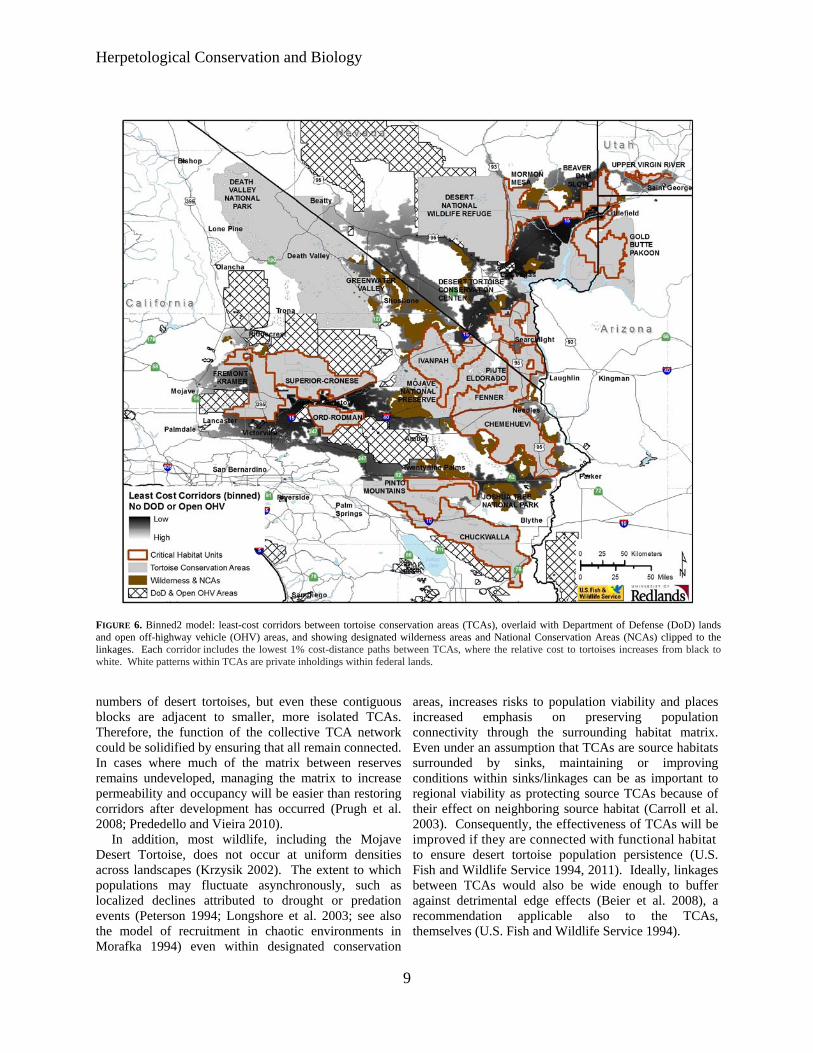
Herpetological Conservation and Biology
FIGURE 6 Binned2 model least-cost corridors between tortoise conservation areas (TCAs) overlaid with Department of Defense (DoD) lands and open off-highway vehicle (OHV) areas and showing designated wilderness areas and National Conservation Areas (NCAs) clipped to the linkages Each corridor includes the lowest 1 cost-distance paths between TCAs where the relative cost to tortoises increases from black to white White patterns within TCAs are private inholdings within federal lands
numbers of desert tortoises but even these contiguous blocks are adjacent to smaller more isolated TCAs Therefore the function of the collective TCA network could be solidified by ensuring that all remain connected In cases where much of the matrix between reserves remains undeveloped managing the matrix to increase permeability and occupancy will be easier than restoring corridors after development has occurred (Prugh et al 2008 Prededello and Vieira 2010)
In addition most wildlife including the Mojave Desert Tortoise does not occur at uniform densities across landscapes (Krzysik 2002) The extent to which populations may fluctuate asynchronously such as localized declines attributed to drought or predation events (Peterson 1994 Longshore et al 2003 see also the model of recruitment in chaotic environments in Morafka 1994) even within designated conservation
areas increases risks to population viability and places increased emphasis on preserving population connectivity through the surrounding habitat matrix Even under an assumption that TCAs are source habitats surrounded by sinks maintaining or improving conditions within sinkslinkages can be as important to regional viability as protecting source TCAs because of their effect on neighboring source habitat (Carroll et al 2003) Consequently the effectiveness of TCAs will be improved if they are connected with functional habitat to ensure desert tortoise population persistence (US Fish and Wildlife Service 1994 2011) Ideally linkages between TCAs would also be wide enough to buffer against detrimental edge effects (Beier et al 2008) a recommendation applicable also to the TCAs themselves (US Fish and Wildlife Service 1994)
9
Averill-Murray et almdashDesert Tortoise Population Connectivity
While specific management is needed within TCAs these areas provide only an initial framework upon which to focus recovery efforts especially given uncertainties related to the effects of climate change on Mojave Desert Tortoise populations and distribution (Barrows et al 2011 US Fish and Wildlife Service 2011) Temperatures are projected to change relatively quickly within desert ecosystems To keep pace with changes from current temperature regimes within the current century desert wildlife populations or species would need to shift their distributions at approximately 07 kmyear (Loarie et al 2009) At this rate the current climate would cross each critical habitat unit (ranging in latitudinal extent of approximately 33ndash267 km) within 23ndash187 years Notwithstanding potential elevational shifts by tortoise populations in response to climate change which may be constrained in many areas as a result of geologic limitations on burrow construction preserving connectivity between TCAs may allow shifts in the speciesrsquo distribution and allow for future flexibility in refocusing management to ensure long-term recovery (Crooks and Sanjayan 2006 Krosby et al 2010)
Connectivity conservation also is integral to maintaining genetic variability and ecological heterogeneity within and among populations of widely distributed species Genetic analyses suggest that historically levels of gene flow among subpopulations of the Mojave Desert Tortoise were high corresponding to high levels of habitat connectivity (Murphy et al 2007 Hagerty 2008) All recent genetic studies of the Mojave Desert Tortoise have suggested that its population structure is characterized by isolation-byshydistance populations at the farthest extremes of the distribution are most differentiated but a gradient of genetic differentiation occurs between those populations across the range (Britten et al 1997 Murphy et al 2007 Hagerty and Tracy 2010) This isolation-by-distance genetic structure across the relatively continuous historic distribution of the Mojave Desert Tortoise (Germano et al 1994 Nussear et al 2009) indicates that gene flow generally occurs (or historically occurred) according to a continuous-distribution model (Allendorf and Luikart 2007) as opposed to a metapopulation or stepping-stone model where individual tortoises move from one patch of suitable habitat across less suitable or non-habitat to another patch of suitable habitat
Our modeling approach was similar to that of Hagerty et al (2011) who modeled historic gene flow between populations across the range of the species across a cost surface based on the original (historic) USGS habitat model Gene flow historically occurred in a diffuse pattern across the landscape unless otherwise constrained to more narrow concentrated pathways created by topographic barriers (eg around the Spring Mountains in southern Nevada Hagerty et al 2011) Linkages
between conservation areas are needed to conserve historic genetic gradation thereby preventing habitat specialization and genetic divergence between populations (Frankham 2006) Where gene flow is constrained by topographic barriers conservation of such concentrated pathways or linkages is especially important
For gene flow to reliably occur across the range and for populations within existing conservation areas to be buffered against detrimental effects of low numbers or density populations need to be connected by areas of habitat occupied by tortoises Low levels of genetic differentiation in Mojave Desert Tortoises have been detected across even relatively recent and narrow anthropogenic impacts on the landscape (Latch et al 2011) Pairs of tortoises from opposite sides of a road exhibited significantly greater genetic differentiation than pairs from the same side of a road (Latch et al 2011) raising even greater concerns for population fragmentation from larger scale habitat loss
Assumptions and limitationsmdashOur assessment of important areas within which to preserve connectivity of Mojave Desert Tortoise populations is limited by shortcomings in our knowledge We assumed that potential tortoise occupancy was accurately reflected by the USGS habitat model as modified by our interpretation of the altered-habitat datasets and that linkages of high-probability habitat between existing TCAs will help sustain viable populations across the range of the species Implicit in this assumption is that various land uses or impacts occurring on the landscape (eg unpaved roads exotic plant invasions) that were not explicitly included in the geospatial data we used do not impede connectivity of tortoise populations We evaluated the effect of this assumption relative to large-scale potential impacts of high-intensity land uses (military training maneuvers and open OHV recreation) and additional areas emerged that may be important to connectivity
Least-cost path analyses provide only a snapshot of current habitat conditions and are uninformative about demographic processes or how individuals actually move through a landscape (Noss and Daly 2006 Taylor et al 2006) We assumed that a 1 cost surface would identify linkages wide enough to provide functional connectivity between TCAs However application of different resistance values from the underlying habitat model greatly influenced the total area and configuration of the 1 cost surface
Indeed limiting the cost surface to the lowest 1 is an arbitrary choice (Sawyer et al 2011) The mean model score for all cells with known tortoise presence in the USGS habitat model was 084 and 95 of cells with known presence had scores greater than 07 (Nussear et al 2009) Therefore connectivity between tortoise
10
Herpetological Conservation and Biology
populations (TCAs) may occur more broadly than estimated in the Base model The more permeable Binned model identified linkages 245 larger in area than those in the Base model while the linkages in the Binned2 model were 219 larger than those in the Base2 model
Limited guidance is available for determining precise linkage widths but minimum widths for corridor dwellers such as the Mojave Desert Tortoise should be substantially larger than a home range diameter (Beier et al 2008) Inevitably however questions will be asked about what is the minimum width for a particular desert tortoise linkage what is the relevant home range size from which to estimate that minimum width and what are the minimum sampling considerations in estimating home ranges (cf Harless et al 2010) We agree with Beier et al (2008) that this is analogous to asking an engineer ldquowhat are the fewest number of rivets that might keep this wing on the airplanerdquo A more appropriate question for conservation is ldquowhat is the narrowest width that is not likely to be regretted after the adjacent area is converted to human userdquo Managers and policy-makers must realize that conservation is not primarily a set-aside issue that can be dealt with by reserving a minimal percentage or amount of the landscape rather it is a pervasive issue that must be considered across the entire landscape (Franklin and Lindenmayer 2009)
Management implications and recommendationsmdash In general land and wildlife managers should think about corridors between conservation areas that are large enough for resident tortoises to persist and to continue to interact with their neighbors within and outside broad habitat linkages rather than expect that a more narrow band of habitat will allow an individual tortoise to move through it to the other side breed with a tortoise on that side and produce viable offspring that contribute to the next generation Linkage integrity with sufficient habitat to support sustainable populations is important for Mojave Desert Tortoises and other corridor dwellers to support connectivity between core reserves (cf Barrows et al 2011) Given the underlying geospatial data linkages in the Base2 model illustrate a minimum connection of habitat for Mojave Desert Tortoises between TCA pairs and therefore represent priority areas for conservation of population connectivity However large areas within these linkages are at risk of permanent habitat loss as a result of solar energy development
Utility-scale solar development will require 831 km2
of land by 2030 to meet the reasonably foreseeable development scenario within the entire states of California and Nevada (US Bureau of Land Management and US Department of Energy 2012) To meet this need BLM has identified 39830 km2 of
potentially developable public lands throughout these states (not all within Mojave Desert Tortoise habitat) including 866 km2 of proposed solar energy zones (SEZs) within which solar energy production would be prioritized and facilitated Meanwhile projects totaling 190 km2 and 1470 km2 had already been approved or were pending respectively across BLM land within the range of the Mojave Desert Tortoise (US Bureau of Land Management and US Department of Energy 2012) Relatively little linkage area would be consumed by the proposed SEZs (40 km2) but 37 km2 of approved and 703 km2 of pending projects overlap linkages in the Base2 model with some linkages at particular risk (Fig 7) Even though substantial uncertainty surrounds the ultimate development footprint of pending solar development projects (or other proposed projects including wind energy development) a separate analysis found that between 2000 km2 and 7400 km2 of lower conservation value land could meet Californiarsquos renewable energy goal by up to seven times over (Cameron et al 2012) This suggests that renewable energy goals can be met without compromising the conservation of important Mojave Desert Tortoise habitat
The Binned2 model includes blocks of contiguous habitat outside the Base2 linkage network and many such areas likely contain substantial numbers of Mojave Desert Tortoises Managers should consider additional conservation of occupied habitat adjacent to the Base2 linkages and existing TCAs to provide security against edge effects and population declines especially given limitations previously identified in the existing reserve architecture For example even though use of DOD lands may be subject to change depending on national security needs the value of military lands to conservation has long been recognized (Stein et al 2008) and DOD-managed habitat that is unaffected by military training operations adds to the conservation base Of additional note are blocks of habitat at the northern extent of the Mojave Desert Tortoisersquos range which may be of particular relevance for additional evaluation to determine more precisely how the modeled linkages will accommodate climate change (Beier et al 2008)
Application of models from this study will require refinement at the local level and at a higher-resolution scale than the available geospatial data (ie finer resolution than 1 km2) to account for on-the-ground limitations to tortoise occupancy and movement either not reflected in the geospatial data used here or as a result of errors in the land cover data we used to identify Suitable Habitat (Beier et al 2009) For example habitat connections through the northern end and across the boundary of the Chuckwalla critical habitat unit may be more limited by rugged topography than suggested by Figure 1 (Jody Fraser and Pete Sorensen pers comm)
11
Averill-Murray et almdashDesert Tortoise Population Connectivity
FIGURE 7 Least-cost corridors (Base2 model) between tortoise conservation areas (TCAs) relative to approved solar development projects pending solar development projects and solar energy zones Each corridor includes the lowest 1 cost-distance paths between TCAs where the relative cost to tortoises increases from black to white White patterns within TCAs are private inholdings within federal lands
thereby placing greater potential importance on the linkage identified on the north end of the critical habitat unit in the Binned2 model In addition more detailed or spatially explicit population viability analyses based on regional population and distribution patterns are needed to evaluate the ability of a conservation network such as that modeled here to ensure long-term persistence of Mojave Desert Tortoise populations (US Fish and Wildlife Service 2011 eg Carroll et al 2003)
While there is much still to be learned about the science and application of connectivity land managers cannot wait for research to resolve all relevant questions before focusing effort on enhancing connectivity Instead science and management must proceed in parallel with the flexibility to modify future management in the light of new knowledge (Lovejoy 2006) In areas proposed for essentially permanent habitat conversion such as by large-scale development there is the risk that
critical linkages will be severed before they are protected (Morrison and Reynolds 2006) For species with long generation times like the Mojave Desert Tortoise this risk is compounded by the fact that we are not likely to detect a problem with a population until well after we have reduced the habitat below its extinction threshold (Fahrig 2001)
AcknowledgmentsmdashDiscussion with Linda Allison Ashleigh Blackford Brian Croft Diane Elam Kimberleigh Field and the Desert Tortoise Science Advisory Committee (Peter Hudson Earl McCoy Katherine Ralls Michael Reed and Robert Steidl) contributed to the development of this manuscript Additional review and comments by Todd Esque Kimberleigh Field Michael Reed and Andrew Walde improved the manuscript We thank Lisa Benvenuti at the Redlands Institute for her excellent map-making
12
Herpetological Conservation and Biology
skills The findings and conclusions in this article are those of the authors and do not necessarily represent the views of the US Fish and Wildlife Service
LITERATURE CITED
Allendorf FW and G Luikart 2007 Conservation and the Genetics of Populations Blackwell Malden Massachusetts USA
Barrows CW KD Fleming and MF Allen 2011 Identifying habitat linkages to maintain connectivity for corridor dwellers in a fragmented landscape Journal of Wildlife Management 75682ndash691
Beier P and S Loe 1992 A checklist for evaluating impacts to wildlife movement corridors Wildlife Society Bulletin 20434ndash440
Beier P DR Majka and SL Newell 2009 Uncertainty analysis of least-cost modeling for designing wildlife linkages Ecological Applications 192067ndash2077
Beier P DR Majka and WD Spencer 2008 Forks in the road choices in procedures for designing wildland linkages Conservation Biology 22836ndash851
Berry KH TY Bailey and KM Anderson 2006 Attributes of Desert Tortoise populations at the National Training Center Central Mojave Desert California USA Journal of Arid Environments 67165ndash191
Berry KH and PA Medica 1995 Desert Tortoises in the Mojave and Colorado deserts Pages 135ndash137 In Our Living Resources A Report to the Nation on the Distribution Abundance and Health of US Plants Animals and Ecosystems LaRoe ET GS Farris CE Puckett PD Doran and MJ Mac (Eds) US Department of the Interior National Biological Service Washington DC USA
Boarman WI ML Beigel GC Goodlett and M Sazaki 1998 A passive integrated transponder system for tracking animal movements Wildlife Society Bulletin 26886ndash891
Britten HB BR Riddle PF Brussard R Marlow and TE Lee 1997 Genetic delineation of management units for the Desert Tortoise Gopherus agassizii in northeastern Mojave Desert Copeia 1997523ndash530
Bury RB and PS Corn 1995 Have desert tortoises undergone a long-term decline in abundance Wildlife Society Bulletin 2341ndash47
Bury RB and RA Luckenbach 2002 Comparison of Desert Tortoise (Gopherus agassizii) populations in an unused and off-road vehicle area in the Mojave Desert Chelonian Conservation and Biology 4457ndash463
Cameron DR BS Cohen and SA Morrison 2012 An approach to enhance the conservation-compatibility of solar energy development PloS ONE 7(6)e38347 Doi101371journalpone0038437
Carroll C RF Noss PC Paquet and NH Schumaker 2003 Use of population viability analysis and reserve selection algorithms in regional conservation plans Ecological Applications 131773ndash 1789
Crooks KR and M Sanjayan 2006 Connectivity conservation maintaining connections for nature Pp 1ndash19 In Connectivity Conservation Crooks KR and M Sanjayan (Eds) Cambridge University Press Cambridge UK
Doak D P Kareiva and B Klepetka 1994 Modeling population viability for the Desert Tortoise in the western Mojave Desert Ecological Applications 4446ndash460
Edwards T EW Stitt CR Schwalbe and DE Swann 2004 Gopherus agassizii (Desert Tortoise) Movement Herpetological Review 35381ndash382
Fagan WF and EE Holmes 2006 Quantifying the extinction vortex Ecology Letters 951ndash60
Fahrig L 2001 How much habitat is enough Biological Conservation 10065ndash74
Frankham R 2006 Genetics and landscape connectivity Pp 72ndash96 In Connectivity Conservation Crooks KR and M Sanjayan (Eds) Cambridge University Press Cambridge UK
Franklin JF and DB Lindenmayer 2009 Importance of matrix habitats in maintaining biological diversity Proceedings of the National Academy of Sciences 106349ndash350
Fry J G Xian S Jin J Dewitz C Homer L Yang C Barnes N Herold and J Wickham 2011 Completion of the 2006 National Land Cover Database for the conterminous United States Photogrammetric Engineering and Remote Sensing 77858ndash864
Germano DJ RB Bury TC Esque TH Fritts and PA Medica 1994 Range and habitat of the Desert Tortoise Pp 57ndash72 In Biology of the North American Tortoises Bury RB and DJ Germano (Eds) National Biological Survey Fish and Wildlife Research 13 Washington DC USA
Gilpin ME and ME Souleacute 1986 Minimum viable populations processes of species extinction Pp 19ndash34 In Conservation Biology The Science of Scarcity and Diversity Souleacute ME (Ed) Sinauer Associates Sunderland Massachusetts USA
Hagerty BE 2008 Ecological genetics of the Mojave Desert Tortoise PhD Dissertation University of Nevada Reno Nevada USA 226 p
Hagerty BE KE Nussear TC Esque and CR Tracy 2011 Making molehills out of mountains landscape genetics of the Mojave Desert Tortoise Landscape Ecology 26267ndash280
Hagerty BE and CR Tracy 2010 Defining population structure for the Mojave Desert Tortoise Conservation Genetics 111795ndash1807
13
Averill-Murray et almdashDesert Tortoise Population Connectivity
Harless ML AD Walde DK Delaney LL Pater and WK Hayes 2010 Sampling considerations for improving home range estimates of Desert Tortoises effects of estimator sampling regime and sex Herpetological Conservation and Biology 5374ndash387
Harrison S and E Bruna 1999 Habitat fragmentation and large-scale conservation what do we know for sure Ecography 22225ndash232
Krosby M J Tewksbury NM Haddad and J Hoekstra 2010 Ecological connectivity for a changing climate Conservation Biology 241686ndash1689
Krzysik AJ 2002 A landscape sampling protocol for estimating distribution and density patterns of Desert Tortoises at multiple spatial scales Chelonian Conservation and Biology 4366ndash379
Latch EK WI Boarman A Walde and RC Fleischer 2011 Fine-scale analysis reveals cryptic landscape genetic structure in Desert Tortoises PLoS ONE 6e27794 Doi101371journalpone0027794
Liu C PM Berry TP Dawson and RG Pearson 2005 Selecting thresholds of occurrence in the prediction of species distributions Ecography 28385ndash 393
Loarie SR PB Duffy H Hamilton GP Asner CB Field and DD Ackerly 2009 The velocity of climate change Nature 4621052ndash1055
Longshore KM JR Jaeger and JM Sappington 2003 Desert Tortoise (Gopherus agassizii) survival at two eastern Mojave Desert sites death by short-term drought Journal of Herpetology 37169ndash177
Lovejoy T 2006 Introduction donrsquot fence me in Pp 447ndash449 In Connectivity Conservation Crooks KR and M Sanjayan (Eds) Cambridge University Press Cambridge UK
Lovich JE and JR Ennen 2011 Wildlife conservation and solar energy development in the Desert Southwest United States BioScience 61982ndash 992
McLuckie AM PG Emblidge and RA Fridell 2010 Regional Desert Tortoise monitoring in the Red Cliffs Desert Reserve 2009 Utah Division of Wildlife Resource Publication 10-13
Meffe GK and CR Carroll 1994 The design of conservation reserves Pp 265ndash304 In Principles of Conservation Biology Meffe GK and CR Carroll (Eds) Sinauer Associates Sunderland Massachusetts USA
Morafka DJ 1994 Neonates missing links in the life histories of North American tortoises Pp 161ndash173 In Biology of North American Tortoises Bury RB and DJ Germano (Eds) National Biological Survey Fish and Wildlife Research 13 Washington DC USA
Morrison SA and MD Reynolds 2006 Where to draw the line integrating feasibility into connectivity planning Pp 536ndash554 In Connectivity Conservation
Crooks KR and M Sanjayan (Eds) Cambridge University Press Cambridge UK
Murphy RW KH Berry T Edwards and AM McLuckie 2007 A genetic assessment of the recovery units for the Mojave population of the Desert Tortoise Gopherus agassizii Chelonian Conservation and Biology 6229ndash251
Noss RF and KM Daly 2006 Incorporating connectivity into broad-scale conservation planning Pp 587ndash619 In Connectivity Conservation Crooks KR and M Sanjayan (Eds) Cambridge University Press Cambridge UK
Nussear KE TC Esque RD Inman L Gass KA Thomas CSA Wallace JB Blainey DM Miller and RH Webb 2009 Modeling habitat of the Desert Tortoise (Gopherus agassizii) in the Mojave and parts of the Sonoran deserts of California Nevada Utah and Arizona US Geological Survey Open-file Report 2009-1102 18 p
Peterson CC 1994 Different rates and causes of high mortality in two populations of the threatened Desert Tortoise Gopherus agassizii Biological Conservation 70101ndash108
Prevedello JA and MV Vieira 2010 Does the type of matrix matter A quantitative review of the evidence Biodiversity and Conservation 191205ndash 1223
Prugh LR KE Hodges ARE Sinclair and JS Brashares 2008 Effect of habitat area and isolation of fragmented animal populations Proceedings of the National Academy of Sciences 10520770ndash20775
Reed JM N Fefferman and RC Averill-Murray 2009 Vital rate sensitivity analysis as a tool for assessing management actions for the Desert Tortoise Biological Conservation 1422710ndash2717
Ricketts TH 2001 The matrix matters effective isolation in fragmented landscapes American Naturalist 15887ndash99
Sawyer SC CW Epps and JS Brashares 2011 Placing linkages among fragmented habitats do least-cost models reflect how animals use landscapes Journal of Applied Ecology 48668ndash678
Stein BA C Scott and N Benton 2008 Federal lands and endangered species the role of military and other federal lands in sustaining biodiversity BioScience 58339ndash347
Taylor PD L Fahrig and KA With 2006 Landscape connectivity a return to basics Pp 29ndash43 In Connectivity Conservation Crooks KR and M Sanjayan (Eds) Cambridge University Press Cambridge UK
US Bureau of Land Management and US Department of Energy 2012 Final programmatic environmental impact statement (PEIS) for solar energy development in six southwestern states FES 12-24 DOEEIS-0403
14
Herpetological Conservation and Biology
US Fish and Wildlife Service 1990 Endangered and threatened wildlife and plants determination of threatened status for the Mojave population of the Desert Tortoise Federal Register 5512178ndash12191
US Fish and Wildlife Service 1994 Desert Tortoise (Mojave population) Recovery Plan US Fish and Wildlife Service Portland Oregon USA
US Fish and Wildlife Service 2011 Revised Recovery Plan for the Mojave Population of the Desert Tortoise (Gopherus agassizii) US Fish and Wildlife Service California and Nevada Region Sacramento California USA
Venter O NN Brodeur L Nemiroff B Belland IJ Dolinsek and JWA Grant Threats to endangered species in Canada BioScience 56903ndash910
Wiens JA 2006 Introduction connectivity research ndash What are the issues Pp 23ndash27 In Connectivity Conservation Crooks KR and M Sanjayan (Eds) Cambridge University Press Cambridge UK
Wilcox BA and DD Murphy 1985 Conservation strategy the effects of fragmentation on extinction American Naturalist 125879ndash887
Yiming L and DS Wilcove 2005 Threats to vertebrate species in China and the United States BioScience 55147ndash153
ROY C AVERILL-MURRAY is the Desert Tortoise Recovery Coordinator for the Desert Tortoise Recovery Office of the US Fish and Wildlife Service in Reno Nevada USA He oversees the recovery office in coordinating research monitoring and recovery plan implementation for the threatened Mojave Desert Tortoise He has published articles and book chapters on various aspects of the ecology and management of both the Mojave Desert Tortoise and the Sonoran Desert Tortoise Roy has degrees in Wildlife and Fisheries Sciences from Texas AampM University (BS) and the University of Arizona (MS) (Photographed by Kimberleigh J Field)
CATHERINE R DARST is the Recovery Biologist for the US Fish and Wildlife Services Desert Tortoise Recovery Office in Ventura California USA Cats work focuses on recovery plan implementation and research coordination including developing collaborative planning processes and spatial decision support for the Mojave Desert Tortoise Cat received her undergraduate degrees from the University of California at Davis and her PhD in Ecology Evolution and Behavior from the University of Texas at Austin (Photographed by Ashleigh Blackford)
NATHAN STROUT is the Technology Manager for the Redlands Institute University of Redlands in Redlands California USA He is responsible for managing the technical design and development of projects at the Redlands Institute and a team of technical staff including programmers analysts and IT support staff His work includes GIS research and analysis web and desktop application development and project management Nathan also serves as adjunct faculty in the Master of Science in Geographic Information Systems (MS GIS) at the University of Redlands Nathan received his undergraduate degree in Environmental Science and a MS in GIS from the University of Redlands (Photographed by Stephen Daugherty)
MARTIN L WONG is a GIS Analyst for the Redlands Institute University of Redlands in Redlands California He is responsible for supporting students faculty and staff at the Redlands Institute and the Environmental Studies and MSGIS departments in their geospatial data needs His work includes researching acquiring and geoprocessing data writing scripts and tools using Python and C and producing maps and reports Martin received his undergraduate degree in Geography from the University of California at Santa Barbara (Photographed by Susie Kim)
15
Averill-Murray et almdashDesert Tortoise Population Connectivity
While specific management is needed within TCAs these areas provide only an initial framework upon which to focus recovery efforts especially given uncertainties related to the effects of climate change on Mojave Desert Tortoise populations and distribution (Barrows et al 2011 US Fish and Wildlife Service 2011) Temperatures are projected to change relatively quickly within desert ecosystems To keep pace with changes from current temperature regimes within the current century desert wildlife populations or species would need to shift their distributions at approximately 07 kmyear (Loarie et al 2009) At this rate the current climate would cross each critical habitat unit (ranging in latitudinal extent of approximately 33ndash267 km) within 23ndash187 years Notwithstanding potential elevational shifts by tortoise populations in response to climate change which may be constrained in many areas as a result of geologic limitations on burrow construction preserving connectivity between TCAs may allow shifts in the speciesrsquo distribution and allow for future flexibility in refocusing management to ensure long-term recovery (Crooks and Sanjayan 2006 Krosby et al 2010)
Connectivity conservation also is integral to maintaining genetic variability and ecological heterogeneity within and among populations of widely distributed species Genetic analyses suggest that historically levels of gene flow among subpopulations of the Mojave Desert Tortoise were high corresponding to high levels of habitat connectivity (Murphy et al 2007 Hagerty 2008) All recent genetic studies of the Mojave Desert Tortoise have suggested that its population structure is characterized by isolation-byshydistance populations at the farthest extremes of the distribution are most differentiated but a gradient of genetic differentiation occurs between those populations across the range (Britten et al 1997 Murphy et al 2007 Hagerty and Tracy 2010) This isolation-by-distance genetic structure across the relatively continuous historic distribution of the Mojave Desert Tortoise (Germano et al 1994 Nussear et al 2009) indicates that gene flow generally occurs (or historically occurred) according to a continuous-distribution model (Allendorf and Luikart 2007) as opposed to a metapopulation or stepping-stone model where individual tortoises move from one patch of suitable habitat across less suitable or non-habitat to another patch of suitable habitat
Our modeling approach was similar to that of Hagerty et al (2011) who modeled historic gene flow between populations across the range of the species across a cost surface based on the original (historic) USGS habitat model Gene flow historically occurred in a diffuse pattern across the landscape unless otherwise constrained to more narrow concentrated pathways created by topographic barriers (eg around the Spring Mountains in southern Nevada Hagerty et al 2011) Linkages
between conservation areas are needed to conserve historic genetic gradation thereby preventing habitat specialization and genetic divergence between populations (Frankham 2006) Where gene flow is constrained by topographic barriers conservation of such concentrated pathways or linkages is especially important
For gene flow to reliably occur across the range and for populations within existing conservation areas to be buffered against detrimental effects of low numbers or density populations need to be connected by areas of habitat occupied by tortoises Low levels of genetic differentiation in Mojave Desert Tortoises have been detected across even relatively recent and narrow anthropogenic impacts on the landscape (Latch et al 2011) Pairs of tortoises from opposite sides of a road exhibited significantly greater genetic differentiation than pairs from the same side of a road (Latch et al 2011) raising even greater concerns for population fragmentation from larger scale habitat loss
Assumptions and limitationsmdashOur assessment of important areas within which to preserve connectivity of Mojave Desert Tortoise populations is limited by shortcomings in our knowledge We assumed that potential tortoise occupancy was accurately reflected by the USGS habitat model as modified by our interpretation of the altered-habitat datasets and that linkages of high-probability habitat between existing TCAs will help sustain viable populations across the range of the species Implicit in this assumption is that various land uses or impacts occurring on the landscape (eg unpaved roads exotic plant invasions) that were not explicitly included in the geospatial data we used do not impede connectivity of tortoise populations We evaluated the effect of this assumption relative to large-scale potential impacts of high-intensity land uses (military training maneuvers and open OHV recreation) and additional areas emerged that may be important to connectivity
Least-cost path analyses provide only a snapshot of current habitat conditions and are uninformative about demographic processes or how individuals actually move through a landscape (Noss and Daly 2006 Taylor et al 2006) We assumed that a 1 cost surface would identify linkages wide enough to provide functional connectivity between TCAs However application of different resistance values from the underlying habitat model greatly influenced the total area and configuration of the 1 cost surface
Indeed limiting the cost surface to the lowest 1 is an arbitrary choice (Sawyer et al 2011) The mean model score for all cells with known tortoise presence in the USGS habitat model was 084 and 95 of cells with known presence had scores greater than 07 (Nussear et al 2009) Therefore connectivity between tortoise
10
Herpetological Conservation and Biology
populations (TCAs) may occur more broadly than estimated in the Base model The more permeable Binned model identified linkages 245 larger in area than those in the Base model while the linkages in the Binned2 model were 219 larger than those in the Base2 model
Limited guidance is available for determining precise linkage widths but minimum widths for corridor dwellers such as the Mojave Desert Tortoise should be substantially larger than a home range diameter (Beier et al 2008) Inevitably however questions will be asked about what is the minimum width for a particular desert tortoise linkage what is the relevant home range size from which to estimate that minimum width and what are the minimum sampling considerations in estimating home ranges (cf Harless et al 2010) We agree with Beier et al (2008) that this is analogous to asking an engineer ldquowhat are the fewest number of rivets that might keep this wing on the airplanerdquo A more appropriate question for conservation is ldquowhat is the narrowest width that is not likely to be regretted after the adjacent area is converted to human userdquo Managers and policy-makers must realize that conservation is not primarily a set-aside issue that can be dealt with by reserving a minimal percentage or amount of the landscape rather it is a pervasive issue that must be considered across the entire landscape (Franklin and Lindenmayer 2009)
Management implications and recommendationsmdash In general land and wildlife managers should think about corridors between conservation areas that are large enough for resident tortoises to persist and to continue to interact with their neighbors within and outside broad habitat linkages rather than expect that a more narrow band of habitat will allow an individual tortoise to move through it to the other side breed with a tortoise on that side and produce viable offspring that contribute to the next generation Linkage integrity with sufficient habitat to support sustainable populations is important for Mojave Desert Tortoises and other corridor dwellers to support connectivity between core reserves (cf Barrows et al 2011) Given the underlying geospatial data linkages in the Base2 model illustrate a minimum connection of habitat for Mojave Desert Tortoises between TCA pairs and therefore represent priority areas for conservation of population connectivity However large areas within these linkages are at risk of permanent habitat loss as a result of solar energy development
Utility-scale solar development will require 831 km2
of land by 2030 to meet the reasonably foreseeable development scenario within the entire states of California and Nevada (US Bureau of Land Management and US Department of Energy 2012) To meet this need BLM has identified 39830 km2 of
potentially developable public lands throughout these states (not all within Mojave Desert Tortoise habitat) including 866 km2 of proposed solar energy zones (SEZs) within which solar energy production would be prioritized and facilitated Meanwhile projects totaling 190 km2 and 1470 km2 had already been approved or were pending respectively across BLM land within the range of the Mojave Desert Tortoise (US Bureau of Land Management and US Department of Energy 2012) Relatively little linkage area would be consumed by the proposed SEZs (40 km2) but 37 km2 of approved and 703 km2 of pending projects overlap linkages in the Base2 model with some linkages at particular risk (Fig 7) Even though substantial uncertainty surrounds the ultimate development footprint of pending solar development projects (or other proposed projects including wind energy development) a separate analysis found that between 2000 km2 and 7400 km2 of lower conservation value land could meet Californiarsquos renewable energy goal by up to seven times over (Cameron et al 2012) This suggests that renewable energy goals can be met without compromising the conservation of important Mojave Desert Tortoise habitat
The Binned2 model includes blocks of contiguous habitat outside the Base2 linkage network and many such areas likely contain substantial numbers of Mojave Desert Tortoises Managers should consider additional conservation of occupied habitat adjacent to the Base2 linkages and existing TCAs to provide security against edge effects and population declines especially given limitations previously identified in the existing reserve architecture For example even though use of DOD lands may be subject to change depending on national security needs the value of military lands to conservation has long been recognized (Stein et al 2008) and DOD-managed habitat that is unaffected by military training operations adds to the conservation base Of additional note are blocks of habitat at the northern extent of the Mojave Desert Tortoisersquos range which may be of particular relevance for additional evaluation to determine more precisely how the modeled linkages will accommodate climate change (Beier et al 2008)
Application of models from this study will require refinement at the local level and at a higher-resolution scale than the available geospatial data (ie finer resolution than 1 km2) to account for on-the-ground limitations to tortoise occupancy and movement either not reflected in the geospatial data used here or as a result of errors in the land cover data we used to identify Suitable Habitat (Beier et al 2009) For example habitat connections through the northern end and across the boundary of the Chuckwalla critical habitat unit may be more limited by rugged topography than suggested by Figure 1 (Jody Fraser and Pete Sorensen pers comm)
11
Averill-Murray et almdashDesert Tortoise Population Connectivity
FIGURE 7 Least-cost corridors (Base2 model) between tortoise conservation areas (TCAs) relative to approved solar development projects pending solar development projects and solar energy zones Each corridor includes the lowest 1 cost-distance paths between TCAs where the relative cost to tortoises increases from black to white White patterns within TCAs are private inholdings within federal lands
thereby placing greater potential importance on the linkage identified on the north end of the critical habitat unit in the Binned2 model In addition more detailed or spatially explicit population viability analyses based on regional population and distribution patterns are needed to evaluate the ability of a conservation network such as that modeled here to ensure long-term persistence of Mojave Desert Tortoise populations (US Fish and Wildlife Service 2011 eg Carroll et al 2003)
While there is much still to be learned about the science and application of connectivity land managers cannot wait for research to resolve all relevant questions before focusing effort on enhancing connectivity Instead science and management must proceed in parallel with the flexibility to modify future management in the light of new knowledge (Lovejoy 2006) In areas proposed for essentially permanent habitat conversion such as by large-scale development there is the risk that
critical linkages will be severed before they are protected (Morrison and Reynolds 2006) For species with long generation times like the Mojave Desert Tortoise this risk is compounded by the fact that we are not likely to detect a problem with a population until well after we have reduced the habitat below its extinction threshold (Fahrig 2001)
AcknowledgmentsmdashDiscussion with Linda Allison Ashleigh Blackford Brian Croft Diane Elam Kimberleigh Field and the Desert Tortoise Science Advisory Committee (Peter Hudson Earl McCoy Katherine Ralls Michael Reed and Robert Steidl) contributed to the development of this manuscript Additional review and comments by Todd Esque Kimberleigh Field Michael Reed and Andrew Walde improved the manuscript We thank Lisa Benvenuti at the Redlands Institute for her excellent map-making
12
Herpetological Conservation and Biology
skills The findings and conclusions in this article are those of the authors and do not necessarily represent the views of the US Fish and Wildlife Service
LITERATURE CITED
Allendorf FW and G Luikart 2007 Conservation and the Genetics of Populations Blackwell Malden Massachusetts USA
Barrows CW KD Fleming and MF Allen 2011 Identifying habitat linkages to maintain connectivity for corridor dwellers in a fragmented landscape Journal of Wildlife Management 75682ndash691
Beier P and S Loe 1992 A checklist for evaluating impacts to wildlife movement corridors Wildlife Society Bulletin 20434ndash440
Beier P DR Majka and SL Newell 2009 Uncertainty analysis of least-cost modeling for designing wildlife linkages Ecological Applications 192067ndash2077
Beier P DR Majka and WD Spencer 2008 Forks in the road choices in procedures for designing wildland linkages Conservation Biology 22836ndash851
Berry KH TY Bailey and KM Anderson 2006 Attributes of Desert Tortoise populations at the National Training Center Central Mojave Desert California USA Journal of Arid Environments 67165ndash191
Berry KH and PA Medica 1995 Desert Tortoises in the Mojave and Colorado deserts Pages 135ndash137 In Our Living Resources A Report to the Nation on the Distribution Abundance and Health of US Plants Animals and Ecosystems LaRoe ET GS Farris CE Puckett PD Doran and MJ Mac (Eds) US Department of the Interior National Biological Service Washington DC USA
Boarman WI ML Beigel GC Goodlett and M Sazaki 1998 A passive integrated transponder system for tracking animal movements Wildlife Society Bulletin 26886ndash891
Britten HB BR Riddle PF Brussard R Marlow and TE Lee 1997 Genetic delineation of management units for the Desert Tortoise Gopherus agassizii in northeastern Mojave Desert Copeia 1997523ndash530
Bury RB and PS Corn 1995 Have desert tortoises undergone a long-term decline in abundance Wildlife Society Bulletin 2341ndash47
Bury RB and RA Luckenbach 2002 Comparison of Desert Tortoise (Gopherus agassizii) populations in an unused and off-road vehicle area in the Mojave Desert Chelonian Conservation and Biology 4457ndash463
Cameron DR BS Cohen and SA Morrison 2012 An approach to enhance the conservation-compatibility of solar energy development PloS ONE 7(6)e38347 Doi101371journalpone0038437
Carroll C RF Noss PC Paquet and NH Schumaker 2003 Use of population viability analysis and reserve selection algorithms in regional conservation plans Ecological Applications 131773ndash 1789
Crooks KR and M Sanjayan 2006 Connectivity conservation maintaining connections for nature Pp 1ndash19 In Connectivity Conservation Crooks KR and M Sanjayan (Eds) Cambridge University Press Cambridge UK
Doak D P Kareiva and B Klepetka 1994 Modeling population viability for the Desert Tortoise in the western Mojave Desert Ecological Applications 4446ndash460
Edwards T EW Stitt CR Schwalbe and DE Swann 2004 Gopherus agassizii (Desert Tortoise) Movement Herpetological Review 35381ndash382
Fagan WF and EE Holmes 2006 Quantifying the extinction vortex Ecology Letters 951ndash60
Fahrig L 2001 How much habitat is enough Biological Conservation 10065ndash74
Frankham R 2006 Genetics and landscape connectivity Pp 72ndash96 In Connectivity Conservation Crooks KR and M Sanjayan (Eds) Cambridge University Press Cambridge UK
Franklin JF and DB Lindenmayer 2009 Importance of matrix habitats in maintaining biological diversity Proceedings of the National Academy of Sciences 106349ndash350
Fry J G Xian S Jin J Dewitz C Homer L Yang C Barnes N Herold and J Wickham 2011 Completion of the 2006 National Land Cover Database for the conterminous United States Photogrammetric Engineering and Remote Sensing 77858ndash864
Germano DJ RB Bury TC Esque TH Fritts and PA Medica 1994 Range and habitat of the Desert Tortoise Pp 57ndash72 In Biology of the North American Tortoises Bury RB and DJ Germano (Eds) National Biological Survey Fish and Wildlife Research 13 Washington DC USA
Gilpin ME and ME Souleacute 1986 Minimum viable populations processes of species extinction Pp 19ndash34 In Conservation Biology The Science of Scarcity and Diversity Souleacute ME (Ed) Sinauer Associates Sunderland Massachusetts USA
Hagerty BE 2008 Ecological genetics of the Mojave Desert Tortoise PhD Dissertation University of Nevada Reno Nevada USA 226 p
Hagerty BE KE Nussear TC Esque and CR Tracy 2011 Making molehills out of mountains landscape genetics of the Mojave Desert Tortoise Landscape Ecology 26267ndash280
Hagerty BE and CR Tracy 2010 Defining population structure for the Mojave Desert Tortoise Conservation Genetics 111795ndash1807
13
Averill-Murray et almdashDesert Tortoise Population Connectivity
Harless ML AD Walde DK Delaney LL Pater and WK Hayes 2010 Sampling considerations for improving home range estimates of Desert Tortoises effects of estimator sampling regime and sex Herpetological Conservation and Biology 5374ndash387
Harrison S and E Bruna 1999 Habitat fragmentation and large-scale conservation what do we know for sure Ecography 22225ndash232
Krosby M J Tewksbury NM Haddad and J Hoekstra 2010 Ecological connectivity for a changing climate Conservation Biology 241686ndash1689
Krzysik AJ 2002 A landscape sampling protocol for estimating distribution and density patterns of Desert Tortoises at multiple spatial scales Chelonian Conservation and Biology 4366ndash379
Latch EK WI Boarman A Walde and RC Fleischer 2011 Fine-scale analysis reveals cryptic landscape genetic structure in Desert Tortoises PLoS ONE 6e27794 Doi101371journalpone0027794
Liu C PM Berry TP Dawson and RG Pearson 2005 Selecting thresholds of occurrence in the prediction of species distributions Ecography 28385ndash 393
Loarie SR PB Duffy H Hamilton GP Asner CB Field and DD Ackerly 2009 The velocity of climate change Nature 4621052ndash1055
Longshore KM JR Jaeger and JM Sappington 2003 Desert Tortoise (Gopherus agassizii) survival at two eastern Mojave Desert sites death by short-term drought Journal of Herpetology 37169ndash177
Lovejoy T 2006 Introduction donrsquot fence me in Pp 447ndash449 In Connectivity Conservation Crooks KR and M Sanjayan (Eds) Cambridge University Press Cambridge UK
Lovich JE and JR Ennen 2011 Wildlife conservation and solar energy development in the Desert Southwest United States BioScience 61982ndash 992
McLuckie AM PG Emblidge and RA Fridell 2010 Regional Desert Tortoise monitoring in the Red Cliffs Desert Reserve 2009 Utah Division of Wildlife Resource Publication 10-13
Meffe GK and CR Carroll 1994 The design of conservation reserves Pp 265ndash304 In Principles of Conservation Biology Meffe GK and CR Carroll (Eds) Sinauer Associates Sunderland Massachusetts USA
Morafka DJ 1994 Neonates missing links in the life histories of North American tortoises Pp 161ndash173 In Biology of North American Tortoises Bury RB and DJ Germano (Eds) National Biological Survey Fish and Wildlife Research 13 Washington DC USA
Morrison SA and MD Reynolds 2006 Where to draw the line integrating feasibility into connectivity planning Pp 536ndash554 In Connectivity Conservation
Crooks KR and M Sanjayan (Eds) Cambridge University Press Cambridge UK
Murphy RW KH Berry T Edwards and AM McLuckie 2007 A genetic assessment of the recovery units for the Mojave population of the Desert Tortoise Gopherus agassizii Chelonian Conservation and Biology 6229ndash251
Noss RF and KM Daly 2006 Incorporating connectivity into broad-scale conservation planning Pp 587ndash619 In Connectivity Conservation Crooks KR and M Sanjayan (Eds) Cambridge University Press Cambridge UK
Nussear KE TC Esque RD Inman L Gass KA Thomas CSA Wallace JB Blainey DM Miller and RH Webb 2009 Modeling habitat of the Desert Tortoise (Gopherus agassizii) in the Mojave and parts of the Sonoran deserts of California Nevada Utah and Arizona US Geological Survey Open-file Report 2009-1102 18 p
Peterson CC 1994 Different rates and causes of high mortality in two populations of the threatened Desert Tortoise Gopherus agassizii Biological Conservation 70101ndash108
Prevedello JA and MV Vieira 2010 Does the type of matrix matter A quantitative review of the evidence Biodiversity and Conservation 191205ndash 1223
Prugh LR KE Hodges ARE Sinclair and JS Brashares 2008 Effect of habitat area and isolation of fragmented animal populations Proceedings of the National Academy of Sciences 10520770ndash20775
Reed JM N Fefferman and RC Averill-Murray 2009 Vital rate sensitivity analysis as a tool for assessing management actions for the Desert Tortoise Biological Conservation 1422710ndash2717
Ricketts TH 2001 The matrix matters effective isolation in fragmented landscapes American Naturalist 15887ndash99
Sawyer SC CW Epps and JS Brashares 2011 Placing linkages among fragmented habitats do least-cost models reflect how animals use landscapes Journal of Applied Ecology 48668ndash678
Stein BA C Scott and N Benton 2008 Federal lands and endangered species the role of military and other federal lands in sustaining biodiversity BioScience 58339ndash347
Taylor PD L Fahrig and KA With 2006 Landscape connectivity a return to basics Pp 29ndash43 In Connectivity Conservation Crooks KR and M Sanjayan (Eds) Cambridge University Press Cambridge UK
US Bureau of Land Management and US Department of Energy 2012 Final programmatic environmental impact statement (PEIS) for solar energy development in six southwestern states FES 12-24 DOEEIS-0403
14
Herpetological Conservation and Biology
US Fish and Wildlife Service 1990 Endangered and threatened wildlife and plants determination of threatened status for the Mojave population of the Desert Tortoise Federal Register 5512178ndash12191
US Fish and Wildlife Service 1994 Desert Tortoise (Mojave population) Recovery Plan US Fish and Wildlife Service Portland Oregon USA
US Fish and Wildlife Service 2011 Revised Recovery Plan for the Mojave Population of the Desert Tortoise (Gopherus agassizii) US Fish and Wildlife Service California and Nevada Region Sacramento California USA
Venter O NN Brodeur L Nemiroff B Belland IJ Dolinsek and JWA Grant Threats to endangered species in Canada BioScience 56903ndash910
Wiens JA 2006 Introduction connectivity research ndash What are the issues Pp 23ndash27 In Connectivity Conservation Crooks KR and M Sanjayan (Eds) Cambridge University Press Cambridge UK
Wilcox BA and DD Murphy 1985 Conservation strategy the effects of fragmentation on extinction American Naturalist 125879ndash887
Yiming L and DS Wilcove 2005 Threats to vertebrate species in China and the United States BioScience 55147ndash153
ROY C AVERILL-MURRAY is the Desert Tortoise Recovery Coordinator for the Desert Tortoise Recovery Office of the US Fish and Wildlife Service in Reno Nevada USA He oversees the recovery office in coordinating research monitoring and recovery plan implementation for the threatened Mojave Desert Tortoise He has published articles and book chapters on various aspects of the ecology and management of both the Mojave Desert Tortoise and the Sonoran Desert Tortoise Roy has degrees in Wildlife and Fisheries Sciences from Texas AampM University (BS) and the University of Arizona (MS) (Photographed by Kimberleigh J Field)
CATHERINE R DARST is the Recovery Biologist for the US Fish and Wildlife Services Desert Tortoise Recovery Office in Ventura California USA Cats work focuses on recovery plan implementation and research coordination including developing collaborative planning processes and spatial decision support for the Mojave Desert Tortoise Cat received her undergraduate degrees from the University of California at Davis and her PhD in Ecology Evolution and Behavior from the University of Texas at Austin (Photographed by Ashleigh Blackford)
NATHAN STROUT is the Technology Manager for the Redlands Institute University of Redlands in Redlands California USA He is responsible for managing the technical design and development of projects at the Redlands Institute and a team of technical staff including programmers analysts and IT support staff His work includes GIS research and analysis web and desktop application development and project management Nathan also serves as adjunct faculty in the Master of Science in Geographic Information Systems (MS GIS) at the University of Redlands Nathan received his undergraduate degree in Environmental Science and a MS in GIS from the University of Redlands (Photographed by Stephen Daugherty)
MARTIN L WONG is a GIS Analyst for the Redlands Institute University of Redlands in Redlands California He is responsible for supporting students faculty and staff at the Redlands Institute and the Environmental Studies and MSGIS departments in their geospatial data needs His work includes researching acquiring and geoprocessing data writing scripts and tools using Python and C and producing maps and reports Martin received his undergraduate degree in Geography from the University of California at Santa Barbara (Photographed by Susie Kim)
15

Herpetological Conservation and Biology
populations (TCAs) may occur more broadly than estimated in the Base model The more permeable Binned model identified linkages 245 larger in area than those in the Base model while the linkages in the Binned2 model were 219 larger than those in the Base2 model
Limited guidance is available for determining precise linkage widths but minimum widths for corridor dwellers such as the Mojave Desert Tortoise should be substantially larger than a home range diameter (Beier et al 2008) Inevitably however questions will be asked about what is the minimum width for a particular desert tortoise linkage what is the relevant home range size from which to estimate that minimum width and what are the minimum sampling considerations in estimating home ranges (cf Harless et al 2010) We agree with Beier et al (2008) that this is analogous to asking an engineer ldquowhat are the fewest number of rivets that might keep this wing on the airplanerdquo A more appropriate question for conservation is ldquowhat is the narrowest width that is not likely to be regretted after the adjacent area is converted to human userdquo Managers and policy-makers must realize that conservation is not primarily a set-aside issue that can be dealt with by reserving a minimal percentage or amount of the landscape rather it is a pervasive issue that must be considered across the entire landscape (Franklin and Lindenmayer 2009)
Management implications and recommendationsmdash In general land and wildlife managers should think about corridors between conservation areas that are large enough for resident tortoises to persist and to continue to interact with their neighbors within and outside broad habitat linkages rather than expect that a more narrow band of habitat will allow an individual tortoise to move through it to the other side breed with a tortoise on that side and produce viable offspring that contribute to the next generation Linkage integrity with sufficient habitat to support sustainable populations is important for Mojave Desert Tortoises and other corridor dwellers to support connectivity between core reserves (cf Barrows et al 2011) Given the underlying geospatial data linkages in the Base2 model illustrate a minimum connection of habitat for Mojave Desert Tortoises between TCA pairs and therefore represent priority areas for conservation of population connectivity However large areas within these linkages are at risk of permanent habitat loss as a result of solar energy development
Utility-scale solar development will require 831 km2
of land by 2030 to meet the reasonably foreseeable development scenario within the entire states of California and Nevada (US Bureau of Land Management and US Department of Energy 2012) To meet this need BLM has identified 39830 km2 of
potentially developable public lands throughout these states (not all within Mojave Desert Tortoise habitat) including 866 km2 of proposed solar energy zones (SEZs) within which solar energy production would be prioritized and facilitated Meanwhile projects totaling 190 km2 and 1470 km2 had already been approved or were pending respectively across BLM land within the range of the Mojave Desert Tortoise (US Bureau of Land Management and US Department of Energy 2012) Relatively little linkage area would be consumed by the proposed SEZs (40 km2) but 37 km2 of approved and 703 km2 of pending projects overlap linkages in the Base2 model with some linkages at particular risk (Fig 7) Even though substantial uncertainty surrounds the ultimate development footprint of pending solar development projects (or other proposed projects including wind energy development) a separate analysis found that between 2000 km2 and 7400 km2 of lower conservation value land could meet Californiarsquos renewable energy goal by up to seven times over (Cameron et al 2012) This suggests that renewable energy goals can be met without compromising the conservation of important Mojave Desert Tortoise habitat
The Binned2 model includes blocks of contiguous habitat outside the Base2 linkage network and many such areas likely contain substantial numbers of Mojave Desert Tortoises Managers should consider additional conservation of occupied habitat adjacent to the Base2 linkages and existing TCAs to provide security against edge effects and population declines especially given limitations previously identified in the existing reserve architecture For example even though use of DOD lands may be subject to change depending on national security needs the value of military lands to conservation has long been recognized (Stein et al 2008) and DOD-managed habitat that is unaffected by military training operations adds to the conservation base Of additional note are blocks of habitat at the northern extent of the Mojave Desert Tortoisersquos range which may be of particular relevance for additional evaluation to determine more precisely how the modeled linkages will accommodate climate change (Beier et al 2008)
Application of models from this study will require refinement at the local level and at a higher-resolution scale than the available geospatial data (ie finer resolution than 1 km2) to account for on-the-ground limitations to tortoise occupancy and movement either not reflected in the geospatial data used here or as a result of errors in the land cover data we used to identify Suitable Habitat (Beier et al 2009) For example habitat connections through the northern end and across the boundary of the Chuckwalla critical habitat unit may be more limited by rugged topography than suggested by Figure 1 (Jody Fraser and Pete Sorensen pers comm)
11
Averill-Murray et almdashDesert Tortoise Population Connectivity
FIGURE 7 Least-cost corridors (Base2 model) between tortoise conservation areas (TCAs) relative to approved solar development projects pending solar development projects and solar energy zones Each corridor includes the lowest 1 cost-distance paths between TCAs where the relative cost to tortoises increases from black to white White patterns within TCAs are private inholdings within federal lands
thereby placing greater potential importance on the linkage identified on the north end of the critical habitat unit in the Binned2 model In addition more detailed or spatially explicit population viability analyses based on regional population and distribution patterns are needed to evaluate the ability of a conservation network such as that modeled here to ensure long-term persistence of Mojave Desert Tortoise populations (US Fish and Wildlife Service 2011 eg Carroll et al 2003)
While there is much still to be learned about the science and application of connectivity land managers cannot wait for research to resolve all relevant questions before focusing effort on enhancing connectivity Instead science and management must proceed in parallel with the flexibility to modify future management in the light of new knowledge (Lovejoy 2006) In areas proposed for essentially permanent habitat conversion such as by large-scale development there is the risk that
critical linkages will be severed before they are protected (Morrison and Reynolds 2006) For species with long generation times like the Mojave Desert Tortoise this risk is compounded by the fact that we are not likely to detect a problem with a population until well after we have reduced the habitat below its extinction threshold (Fahrig 2001)
AcknowledgmentsmdashDiscussion with Linda Allison Ashleigh Blackford Brian Croft Diane Elam Kimberleigh Field and the Desert Tortoise Science Advisory Committee (Peter Hudson Earl McCoy Katherine Ralls Michael Reed and Robert Steidl) contributed to the development of this manuscript Additional review and comments by Todd Esque Kimberleigh Field Michael Reed and Andrew Walde improved the manuscript We thank Lisa Benvenuti at the Redlands Institute for her excellent map-making
12
Herpetological Conservation and Biology
skills The findings and conclusions in this article are those of the authors and do not necessarily represent the views of the US Fish and Wildlife Service
LITERATURE CITED
Allendorf FW and G Luikart 2007 Conservation and the Genetics of Populations Blackwell Malden Massachusetts USA
Barrows CW KD Fleming and MF Allen 2011 Identifying habitat linkages to maintain connectivity for corridor dwellers in a fragmented landscape Journal of Wildlife Management 75682ndash691
Beier P and S Loe 1992 A checklist for evaluating impacts to wildlife movement corridors Wildlife Society Bulletin 20434ndash440
Beier P DR Majka and SL Newell 2009 Uncertainty analysis of least-cost modeling for designing wildlife linkages Ecological Applications 192067ndash2077
Beier P DR Majka and WD Spencer 2008 Forks in the road choices in procedures for designing wildland linkages Conservation Biology 22836ndash851
Berry KH TY Bailey and KM Anderson 2006 Attributes of Desert Tortoise populations at the National Training Center Central Mojave Desert California USA Journal of Arid Environments 67165ndash191
Berry KH and PA Medica 1995 Desert Tortoises in the Mojave and Colorado deserts Pages 135ndash137 In Our Living Resources A Report to the Nation on the Distribution Abundance and Health of US Plants Animals and Ecosystems LaRoe ET GS Farris CE Puckett PD Doran and MJ Mac (Eds) US Department of the Interior National Biological Service Washington DC USA
Boarman WI ML Beigel GC Goodlett and M Sazaki 1998 A passive integrated transponder system for tracking animal movements Wildlife Society Bulletin 26886ndash891
Britten HB BR Riddle PF Brussard R Marlow and TE Lee 1997 Genetic delineation of management units for the Desert Tortoise Gopherus agassizii in northeastern Mojave Desert Copeia 1997523ndash530
Bury RB and PS Corn 1995 Have desert tortoises undergone a long-term decline in abundance Wildlife Society Bulletin 2341ndash47
Bury RB and RA Luckenbach 2002 Comparison of Desert Tortoise (Gopherus agassizii) populations in an unused and off-road vehicle area in the Mojave Desert Chelonian Conservation and Biology 4457ndash463
Cameron DR BS Cohen and SA Morrison 2012 An approach to enhance the conservation-compatibility of solar energy development PloS ONE 7(6)e38347 Doi101371journalpone0038437
Carroll C RF Noss PC Paquet and NH Schumaker 2003 Use of population viability analysis and reserve selection algorithms in regional conservation plans Ecological Applications 131773ndash 1789
Crooks KR and M Sanjayan 2006 Connectivity conservation maintaining connections for nature Pp 1ndash19 In Connectivity Conservation Crooks KR and M Sanjayan (Eds) Cambridge University Press Cambridge UK
Doak D P Kareiva and B Klepetka 1994 Modeling population viability for the Desert Tortoise in the western Mojave Desert Ecological Applications 4446ndash460
Edwards T EW Stitt CR Schwalbe and DE Swann 2004 Gopherus agassizii (Desert Tortoise) Movement Herpetological Review 35381ndash382
Fagan WF and EE Holmes 2006 Quantifying the extinction vortex Ecology Letters 951ndash60
Fahrig L 2001 How much habitat is enough Biological Conservation 10065ndash74
Frankham R 2006 Genetics and landscape connectivity Pp 72ndash96 In Connectivity Conservation Crooks KR and M Sanjayan (Eds) Cambridge University Press Cambridge UK
Franklin JF and DB Lindenmayer 2009 Importance of matrix habitats in maintaining biological diversity Proceedings of the National Academy of Sciences 106349ndash350
Fry J G Xian S Jin J Dewitz C Homer L Yang C Barnes N Herold and J Wickham 2011 Completion of the 2006 National Land Cover Database for the conterminous United States Photogrammetric Engineering and Remote Sensing 77858ndash864
Germano DJ RB Bury TC Esque TH Fritts and PA Medica 1994 Range and habitat of the Desert Tortoise Pp 57ndash72 In Biology of the North American Tortoises Bury RB and DJ Germano (Eds) National Biological Survey Fish and Wildlife Research 13 Washington DC USA
Gilpin ME and ME Souleacute 1986 Minimum viable populations processes of species extinction Pp 19ndash34 In Conservation Biology The Science of Scarcity and Diversity Souleacute ME (Ed) Sinauer Associates Sunderland Massachusetts USA
Hagerty BE 2008 Ecological genetics of the Mojave Desert Tortoise PhD Dissertation University of Nevada Reno Nevada USA 226 p
Hagerty BE KE Nussear TC Esque and CR Tracy 2011 Making molehills out of mountains landscape genetics of the Mojave Desert Tortoise Landscape Ecology 26267ndash280
Hagerty BE and CR Tracy 2010 Defining population structure for the Mojave Desert Tortoise Conservation Genetics 111795ndash1807
13
Averill-Murray et almdashDesert Tortoise Population Connectivity
Harless ML AD Walde DK Delaney LL Pater and WK Hayes 2010 Sampling considerations for improving home range estimates of Desert Tortoises effects of estimator sampling regime and sex Herpetological Conservation and Biology 5374ndash387
Harrison S and E Bruna 1999 Habitat fragmentation and large-scale conservation what do we know for sure Ecography 22225ndash232
Krosby M J Tewksbury NM Haddad and J Hoekstra 2010 Ecological connectivity for a changing climate Conservation Biology 241686ndash1689
Krzysik AJ 2002 A landscape sampling protocol for estimating distribution and density patterns of Desert Tortoises at multiple spatial scales Chelonian Conservation and Biology 4366ndash379
Latch EK WI Boarman A Walde and RC Fleischer 2011 Fine-scale analysis reveals cryptic landscape genetic structure in Desert Tortoises PLoS ONE 6e27794 Doi101371journalpone0027794
Liu C PM Berry TP Dawson and RG Pearson 2005 Selecting thresholds of occurrence in the prediction of species distributions Ecography 28385ndash 393
Loarie SR PB Duffy H Hamilton GP Asner CB Field and DD Ackerly 2009 The velocity of climate change Nature 4621052ndash1055
Longshore KM JR Jaeger and JM Sappington 2003 Desert Tortoise (Gopherus agassizii) survival at two eastern Mojave Desert sites death by short-term drought Journal of Herpetology 37169ndash177
Lovejoy T 2006 Introduction donrsquot fence me in Pp 447ndash449 In Connectivity Conservation Crooks KR and M Sanjayan (Eds) Cambridge University Press Cambridge UK
Lovich JE and JR Ennen 2011 Wildlife conservation and solar energy development in the Desert Southwest United States BioScience 61982ndash 992
McLuckie AM PG Emblidge and RA Fridell 2010 Regional Desert Tortoise monitoring in the Red Cliffs Desert Reserve 2009 Utah Division of Wildlife Resource Publication 10-13
Meffe GK and CR Carroll 1994 The design of conservation reserves Pp 265ndash304 In Principles of Conservation Biology Meffe GK and CR Carroll (Eds) Sinauer Associates Sunderland Massachusetts USA
Morafka DJ 1994 Neonates missing links in the life histories of North American tortoises Pp 161ndash173 In Biology of North American Tortoises Bury RB and DJ Germano (Eds) National Biological Survey Fish and Wildlife Research 13 Washington DC USA
Morrison SA and MD Reynolds 2006 Where to draw the line integrating feasibility into connectivity planning Pp 536ndash554 In Connectivity Conservation
Crooks KR and M Sanjayan (Eds) Cambridge University Press Cambridge UK
Murphy RW KH Berry T Edwards and AM McLuckie 2007 A genetic assessment of the recovery units for the Mojave population of the Desert Tortoise Gopherus agassizii Chelonian Conservation and Biology 6229ndash251
Noss RF and KM Daly 2006 Incorporating connectivity into broad-scale conservation planning Pp 587ndash619 In Connectivity Conservation Crooks KR and M Sanjayan (Eds) Cambridge University Press Cambridge UK
Nussear KE TC Esque RD Inman L Gass KA Thomas CSA Wallace JB Blainey DM Miller and RH Webb 2009 Modeling habitat of the Desert Tortoise (Gopherus agassizii) in the Mojave and parts of the Sonoran deserts of California Nevada Utah and Arizona US Geological Survey Open-file Report 2009-1102 18 p
Peterson CC 1994 Different rates and causes of high mortality in two populations of the threatened Desert Tortoise Gopherus agassizii Biological Conservation 70101ndash108
Prevedello JA and MV Vieira 2010 Does the type of matrix matter A quantitative review of the evidence Biodiversity and Conservation 191205ndash 1223
Prugh LR KE Hodges ARE Sinclair and JS Brashares 2008 Effect of habitat area and isolation of fragmented animal populations Proceedings of the National Academy of Sciences 10520770ndash20775
Reed JM N Fefferman and RC Averill-Murray 2009 Vital rate sensitivity analysis as a tool for assessing management actions for the Desert Tortoise Biological Conservation 1422710ndash2717
Ricketts TH 2001 The matrix matters effective isolation in fragmented landscapes American Naturalist 15887ndash99
Sawyer SC CW Epps and JS Brashares 2011 Placing linkages among fragmented habitats do least-cost models reflect how animals use landscapes Journal of Applied Ecology 48668ndash678
Stein BA C Scott and N Benton 2008 Federal lands and endangered species the role of military and other federal lands in sustaining biodiversity BioScience 58339ndash347
Taylor PD L Fahrig and KA With 2006 Landscape connectivity a return to basics Pp 29ndash43 In Connectivity Conservation Crooks KR and M Sanjayan (Eds) Cambridge University Press Cambridge UK
US Bureau of Land Management and US Department of Energy 2012 Final programmatic environmental impact statement (PEIS) for solar energy development in six southwestern states FES 12-24 DOEEIS-0403
14
Herpetological Conservation and Biology
US Fish and Wildlife Service 1990 Endangered and threatened wildlife and plants determination of threatened status for the Mojave population of the Desert Tortoise Federal Register 5512178ndash12191
US Fish and Wildlife Service 1994 Desert Tortoise (Mojave population) Recovery Plan US Fish and Wildlife Service Portland Oregon USA
US Fish and Wildlife Service 2011 Revised Recovery Plan for the Mojave Population of the Desert Tortoise (Gopherus agassizii) US Fish and Wildlife Service California and Nevada Region Sacramento California USA
Venter O NN Brodeur L Nemiroff B Belland IJ Dolinsek and JWA Grant Threats to endangered species in Canada BioScience 56903ndash910
Wiens JA 2006 Introduction connectivity research ndash What are the issues Pp 23ndash27 In Connectivity Conservation Crooks KR and M Sanjayan (Eds) Cambridge University Press Cambridge UK
Wilcox BA and DD Murphy 1985 Conservation strategy the effects of fragmentation on extinction American Naturalist 125879ndash887
Yiming L and DS Wilcove 2005 Threats to vertebrate species in China and the United States BioScience 55147ndash153
ROY C AVERILL-MURRAY is the Desert Tortoise Recovery Coordinator for the Desert Tortoise Recovery Office of the US Fish and Wildlife Service in Reno Nevada USA He oversees the recovery office in coordinating research monitoring and recovery plan implementation for the threatened Mojave Desert Tortoise He has published articles and book chapters on various aspects of the ecology and management of both the Mojave Desert Tortoise and the Sonoran Desert Tortoise Roy has degrees in Wildlife and Fisheries Sciences from Texas AampM University (BS) and the University of Arizona (MS) (Photographed by Kimberleigh J Field)
CATHERINE R DARST is the Recovery Biologist for the US Fish and Wildlife Services Desert Tortoise Recovery Office in Ventura California USA Cats work focuses on recovery plan implementation and research coordination including developing collaborative planning processes and spatial decision support for the Mojave Desert Tortoise Cat received her undergraduate degrees from the University of California at Davis and her PhD in Ecology Evolution and Behavior from the University of Texas at Austin (Photographed by Ashleigh Blackford)
NATHAN STROUT is the Technology Manager for the Redlands Institute University of Redlands in Redlands California USA He is responsible for managing the technical design and development of projects at the Redlands Institute and a team of technical staff including programmers analysts and IT support staff His work includes GIS research and analysis web and desktop application development and project management Nathan also serves as adjunct faculty in the Master of Science in Geographic Information Systems (MS GIS) at the University of Redlands Nathan received his undergraduate degree in Environmental Science and a MS in GIS from the University of Redlands (Photographed by Stephen Daugherty)
MARTIN L WONG is a GIS Analyst for the Redlands Institute University of Redlands in Redlands California He is responsible for supporting students faculty and staff at the Redlands Institute and the Environmental Studies and MSGIS departments in their geospatial data needs His work includes researching acquiring and geoprocessing data writing scripts and tools using Python and C and producing maps and reports Martin received his undergraduate degree in Geography from the University of California at Santa Barbara (Photographed by Susie Kim)
15
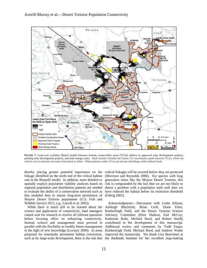
Averill-Murray et almdashDesert Tortoise Population Connectivity
FIGURE 7 Least-cost corridors (Base2 model) between tortoise conservation areas (TCAs) relative to approved solar development projects pending solar development projects and solar energy zones Each corridor includes the lowest 1 cost-distance paths between TCAs where the relative cost to tortoises increases from black to white White patterns within TCAs are private inholdings within federal lands
thereby placing greater potential importance on the linkage identified on the north end of the critical habitat unit in the Binned2 model In addition more detailed or spatially explicit population viability analyses based on regional population and distribution patterns are needed to evaluate the ability of a conservation network such as that modeled here to ensure long-term persistence of Mojave Desert Tortoise populations (US Fish and Wildlife Service 2011 eg Carroll et al 2003)
While there is much still to be learned about the science and application of connectivity land managers cannot wait for research to resolve all relevant questions before focusing effort on enhancing connectivity Instead science and management must proceed in parallel with the flexibility to modify future management in the light of new knowledge (Lovejoy 2006) In areas proposed for essentially permanent habitat conversion such as by large-scale development there is the risk that
critical linkages will be severed before they are protected (Morrison and Reynolds 2006) For species with long generation times like the Mojave Desert Tortoise this risk is compounded by the fact that we are not likely to detect a problem with a population until well after we have reduced the habitat below its extinction threshold (Fahrig 2001)
AcknowledgmentsmdashDiscussion with Linda Allison Ashleigh Blackford Brian Croft Diane Elam Kimberleigh Field and the Desert Tortoise Science Advisory Committee (Peter Hudson Earl McCoy Katherine Ralls Michael Reed and Robert Steidl) contributed to the development of this manuscript Additional review and comments by Todd Esque Kimberleigh Field Michael Reed and Andrew Walde improved the manuscript We thank Lisa Benvenuti at the Redlands Institute for her excellent map-making
12
Herpetological Conservation and Biology
skills The findings and conclusions in this article are those of the authors and do not necessarily represent the views of the US Fish and Wildlife Service
LITERATURE CITED
Allendorf FW and G Luikart 2007 Conservation and the Genetics of Populations Blackwell Malden Massachusetts USA
Barrows CW KD Fleming and MF Allen 2011 Identifying habitat linkages to maintain connectivity for corridor dwellers in a fragmented landscape Journal of Wildlife Management 75682ndash691
Beier P and S Loe 1992 A checklist for evaluating impacts to wildlife movement corridors Wildlife Society Bulletin 20434ndash440
Beier P DR Majka and SL Newell 2009 Uncertainty analysis of least-cost modeling for designing wildlife linkages Ecological Applications 192067ndash2077
Beier P DR Majka and WD Spencer 2008 Forks in the road choices in procedures for designing wildland linkages Conservation Biology 22836ndash851
Berry KH TY Bailey and KM Anderson 2006 Attributes of Desert Tortoise populations at the National Training Center Central Mojave Desert California USA Journal of Arid Environments 67165ndash191
Berry KH and PA Medica 1995 Desert Tortoises in the Mojave and Colorado deserts Pages 135ndash137 In Our Living Resources A Report to the Nation on the Distribution Abundance and Health of US Plants Animals and Ecosystems LaRoe ET GS Farris CE Puckett PD Doran and MJ Mac (Eds) US Department of the Interior National Biological Service Washington DC USA
Boarman WI ML Beigel GC Goodlett and M Sazaki 1998 A passive integrated transponder system for tracking animal movements Wildlife Society Bulletin 26886ndash891
Britten HB BR Riddle PF Brussard R Marlow and TE Lee 1997 Genetic delineation of management units for the Desert Tortoise Gopherus agassizii in northeastern Mojave Desert Copeia 1997523ndash530
Bury RB and PS Corn 1995 Have desert tortoises undergone a long-term decline in abundance Wildlife Society Bulletin 2341ndash47
Bury RB and RA Luckenbach 2002 Comparison of Desert Tortoise (Gopherus agassizii) populations in an unused and off-road vehicle area in the Mojave Desert Chelonian Conservation and Biology 4457ndash463
Cameron DR BS Cohen and SA Morrison 2012 An approach to enhance the conservation-compatibility of solar energy development PloS ONE 7(6)e38347 Doi101371journalpone0038437
Carroll C RF Noss PC Paquet and NH Schumaker 2003 Use of population viability analysis and reserve selection algorithms in regional conservation plans Ecological Applications 131773ndash 1789
Crooks KR and M Sanjayan 2006 Connectivity conservation maintaining connections for nature Pp 1ndash19 In Connectivity Conservation Crooks KR and M Sanjayan (Eds) Cambridge University Press Cambridge UK
Doak D P Kareiva and B Klepetka 1994 Modeling population viability for the Desert Tortoise in the western Mojave Desert Ecological Applications 4446ndash460
Edwards T EW Stitt CR Schwalbe and DE Swann 2004 Gopherus agassizii (Desert Tortoise) Movement Herpetological Review 35381ndash382
Fagan WF and EE Holmes 2006 Quantifying the extinction vortex Ecology Letters 951ndash60
Fahrig L 2001 How much habitat is enough Biological Conservation 10065ndash74
Frankham R 2006 Genetics and landscape connectivity Pp 72ndash96 In Connectivity Conservation Crooks KR and M Sanjayan (Eds) Cambridge University Press Cambridge UK
Franklin JF and DB Lindenmayer 2009 Importance of matrix habitats in maintaining biological diversity Proceedings of the National Academy of Sciences 106349ndash350
Fry J G Xian S Jin J Dewitz C Homer L Yang C Barnes N Herold and J Wickham 2011 Completion of the 2006 National Land Cover Database for the conterminous United States Photogrammetric Engineering and Remote Sensing 77858ndash864
Germano DJ RB Bury TC Esque TH Fritts and PA Medica 1994 Range and habitat of the Desert Tortoise Pp 57ndash72 In Biology of the North American Tortoises Bury RB and DJ Germano (Eds) National Biological Survey Fish and Wildlife Research 13 Washington DC USA
Gilpin ME and ME Souleacute 1986 Minimum viable populations processes of species extinction Pp 19ndash34 In Conservation Biology The Science of Scarcity and Diversity Souleacute ME (Ed) Sinauer Associates Sunderland Massachusetts USA
Hagerty BE 2008 Ecological genetics of the Mojave Desert Tortoise PhD Dissertation University of Nevada Reno Nevada USA 226 p
Hagerty BE KE Nussear TC Esque and CR Tracy 2011 Making molehills out of mountains landscape genetics of the Mojave Desert Tortoise Landscape Ecology 26267ndash280
Hagerty BE and CR Tracy 2010 Defining population structure for the Mojave Desert Tortoise Conservation Genetics 111795ndash1807
13
Averill-Murray et almdashDesert Tortoise Population Connectivity
Harless ML AD Walde DK Delaney LL Pater and WK Hayes 2010 Sampling considerations for improving home range estimates of Desert Tortoises effects of estimator sampling regime and sex Herpetological Conservation and Biology 5374ndash387
Harrison S and E Bruna 1999 Habitat fragmentation and large-scale conservation what do we know for sure Ecography 22225ndash232
Krosby M J Tewksbury NM Haddad and J Hoekstra 2010 Ecological connectivity for a changing climate Conservation Biology 241686ndash1689
Krzysik AJ 2002 A landscape sampling protocol for estimating distribution and density patterns of Desert Tortoises at multiple spatial scales Chelonian Conservation and Biology 4366ndash379
Latch EK WI Boarman A Walde and RC Fleischer 2011 Fine-scale analysis reveals cryptic landscape genetic structure in Desert Tortoises PLoS ONE 6e27794 Doi101371journalpone0027794
Liu C PM Berry TP Dawson and RG Pearson 2005 Selecting thresholds of occurrence in the prediction of species distributions Ecography 28385ndash 393
Loarie SR PB Duffy H Hamilton GP Asner CB Field and DD Ackerly 2009 The velocity of climate change Nature 4621052ndash1055
Longshore KM JR Jaeger and JM Sappington 2003 Desert Tortoise (Gopherus agassizii) survival at two eastern Mojave Desert sites death by short-term drought Journal of Herpetology 37169ndash177
Lovejoy T 2006 Introduction donrsquot fence me in Pp 447ndash449 In Connectivity Conservation Crooks KR and M Sanjayan (Eds) Cambridge University Press Cambridge UK
Lovich JE and JR Ennen 2011 Wildlife conservation and solar energy development in the Desert Southwest United States BioScience 61982ndash 992
McLuckie AM PG Emblidge and RA Fridell 2010 Regional Desert Tortoise monitoring in the Red Cliffs Desert Reserve 2009 Utah Division of Wildlife Resource Publication 10-13
Meffe GK and CR Carroll 1994 The design of conservation reserves Pp 265ndash304 In Principles of Conservation Biology Meffe GK and CR Carroll (Eds) Sinauer Associates Sunderland Massachusetts USA
Morafka DJ 1994 Neonates missing links in the life histories of North American tortoises Pp 161ndash173 In Biology of North American Tortoises Bury RB and DJ Germano (Eds) National Biological Survey Fish and Wildlife Research 13 Washington DC USA
Morrison SA and MD Reynolds 2006 Where to draw the line integrating feasibility into connectivity planning Pp 536ndash554 In Connectivity Conservation
Crooks KR and M Sanjayan (Eds) Cambridge University Press Cambridge UK
Murphy RW KH Berry T Edwards and AM McLuckie 2007 A genetic assessment of the recovery units for the Mojave population of the Desert Tortoise Gopherus agassizii Chelonian Conservation and Biology 6229ndash251
Noss RF and KM Daly 2006 Incorporating connectivity into broad-scale conservation planning Pp 587ndash619 In Connectivity Conservation Crooks KR and M Sanjayan (Eds) Cambridge University Press Cambridge UK
Nussear KE TC Esque RD Inman L Gass KA Thomas CSA Wallace JB Blainey DM Miller and RH Webb 2009 Modeling habitat of the Desert Tortoise (Gopherus agassizii) in the Mojave and parts of the Sonoran deserts of California Nevada Utah and Arizona US Geological Survey Open-file Report 2009-1102 18 p
Peterson CC 1994 Different rates and causes of high mortality in two populations of the threatened Desert Tortoise Gopherus agassizii Biological Conservation 70101ndash108
Prevedello JA and MV Vieira 2010 Does the type of matrix matter A quantitative review of the evidence Biodiversity and Conservation 191205ndash 1223
Prugh LR KE Hodges ARE Sinclair and JS Brashares 2008 Effect of habitat area and isolation of fragmented animal populations Proceedings of the National Academy of Sciences 10520770ndash20775
Reed JM N Fefferman and RC Averill-Murray 2009 Vital rate sensitivity analysis as a tool for assessing management actions for the Desert Tortoise Biological Conservation 1422710ndash2717
Ricketts TH 2001 The matrix matters effective isolation in fragmented landscapes American Naturalist 15887ndash99
Sawyer SC CW Epps and JS Brashares 2011 Placing linkages among fragmented habitats do least-cost models reflect how animals use landscapes Journal of Applied Ecology 48668ndash678
Stein BA C Scott and N Benton 2008 Federal lands and endangered species the role of military and other federal lands in sustaining biodiversity BioScience 58339ndash347
Taylor PD L Fahrig and KA With 2006 Landscape connectivity a return to basics Pp 29ndash43 In Connectivity Conservation Crooks KR and M Sanjayan (Eds) Cambridge University Press Cambridge UK
US Bureau of Land Management and US Department of Energy 2012 Final programmatic environmental impact statement (PEIS) for solar energy development in six southwestern states FES 12-24 DOEEIS-0403
14
Herpetological Conservation and Biology
US Fish and Wildlife Service 1990 Endangered and threatened wildlife and plants determination of threatened status for the Mojave population of the Desert Tortoise Federal Register 5512178ndash12191
US Fish and Wildlife Service 1994 Desert Tortoise (Mojave population) Recovery Plan US Fish and Wildlife Service Portland Oregon USA
US Fish and Wildlife Service 2011 Revised Recovery Plan for the Mojave Population of the Desert Tortoise (Gopherus agassizii) US Fish and Wildlife Service California and Nevada Region Sacramento California USA
Venter O NN Brodeur L Nemiroff B Belland IJ Dolinsek and JWA Grant Threats to endangered species in Canada BioScience 56903ndash910
Wiens JA 2006 Introduction connectivity research ndash What are the issues Pp 23ndash27 In Connectivity Conservation Crooks KR and M Sanjayan (Eds) Cambridge University Press Cambridge UK
Wilcox BA and DD Murphy 1985 Conservation strategy the effects of fragmentation on extinction American Naturalist 125879ndash887
Yiming L and DS Wilcove 2005 Threats to vertebrate species in China and the United States BioScience 55147ndash153
ROY C AVERILL-MURRAY is the Desert Tortoise Recovery Coordinator for the Desert Tortoise Recovery Office of the US Fish and Wildlife Service in Reno Nevada USA He oversees the recovery office in coordinating research monitoring and recovery plan implementation for the threatened Mojave Desert Tortoise He has published articles and book chapters on various aspects of the ecology and management of both the Mojave Desert Tortoise and the Sonoran Desert Tortoise Roy has degrees in Wildlife and Fisheries Sciences from Texas AampM University (BS) and the University of Arizona (MS) (Photographed by Kimberleigh J Field)
CATHERINE R DARST is the Recovery Biologist for the US Fish and Wildlife Services Desert Tortoise Recovery Office in Ventura California USA Cats work focuses on recovery plan implementation and research coordination including developing collaborative planning processes and spatial decision support for the Mojave Desert Tortoise Cat received her undergraduate degrees from the University of California at Davis and her PhD in Ecology Evolution and Behavior from the University of Texas at Austin (Photographed by Ashleigh Blackford)
NATHAN STROUT is the Technology Manager for the Redlands Institute University of Redlands in Redlands California USA He is responsible for managing the technical design and development of projects at the Redlands Institute and a team of technical staff including programmers analysts and IT support staff His work includes GIS research and analysis web and desktop application development and project management Nathan also serves as adjunct faculty in the Master of Science in Geographic Information Systems (MS GIS) at the University of Redlands Nathan received his undergraduate degree in Environmental Science and a MS in GIS from the University of Redlands (Photographed by Stephen Daugherty)
MARTIN L WONG is a GIS Analyst for the Redlands Institute University of Redlands in Redlands California He is responsible for supporting students faculty and staff at the Redlands Institute and the Environmental Studies and MSGIS departments in their geospatial data needs His work includes researching acquiring and geoprocessing data writing scripts and tools using Python and C and producing maps and reports Martin received his undergraduate degree in Geography from the University of California at Santa Barbara (Photographed by Susie Kim)
15
Herpetological Conservation and Biology
skills The findings and conclusions in this article are those of the authors and do not necessarily represent the views of the US Fish and Wildlife Service
LITERATURE CITED
Allendorf FW and G Luikart 2007 Conservation and the Genetics of Populations Blackwell Malden Massachusetts USA
Barrows CW KD Fleming and MF Allen 2011 Identifying habitat linkages to maintain connectivity for corridor dwellers in a fragmented landscape Journal of Wildlife Management 75682ndash691
Beier P and S Loe 1992 A checklist for evaluating impacts to wildlife movement corridors Wildlife Society Bulletin 20434ndash440
Beier P DR Majka and SL Newell 2009 Uncertainty analysis of least-cost modeling for designing wildlife linkages Ecological Applications 192067ndash2077
Beier P DR Majka and WD Spencer 2008 Forks in the road choices in procedures for designing wildland linkages Conservation Biology 22836ndash851
Berry KH TY Bailey and KM Anderson 2006 Attributes of Desert Tortoise populations at the National Training Center Central Mojave Desert California USA Journal of Arid Environments 67165ndash191
Berry KH and PA Medica 1995 Desert Tortoises in the Mojave and Colorado deserts Pages 135ndash137 In Our Living Resources A Report to the Nation on the Distribution Abundance and Health of US Plants Animals and Ecosystems LaRoe ET GS Farris CE Puckett PD Doran and MJ Mac (Eds) US Department of the Interior National Biological Service Washington DC USA
Boarman WI ML Beigel GC Goodlett and M Sazaki 1998 A passive integrated transponder system for tracking animal movements Wildlife Society Bulletin 26886ndash891
Britten HB BR Riddle PF Brussard R Marlow and TE Lee 1997 Genetic delineation of management units for the Desert Tortoise Gopherus agassizii in northeastern Mojave Desert Copeia 1997523ndash530
Bury RB and PS Corn 1995 Have desert tortoises undergone a long-term decline in abundance Wildlife Society Bulletin 2341ndash47
Bury RB and RA Luckenbach 2002 Comparison of Desert Tortoise (Gopherus agassizii) populations in an unused and off-road vehicle area in the Mojave Desert Chelonian Conservation and Biology 4457ndash463
Cameron DR BS Cohen and SA Morrison 2012 An approach to enhance the conservation-compatibility of solar energy development PloS ONE 7(6)e38347 Doi101371journalpone0038437
Carroll C RF Noss PC Paquet and NH Schumaker 2003 Use of population viability analysis and reserve selection algorithms in regional conservation plans Ecological Applications 131773ndash 1789
Crooks KR and M Sanjayan 2006 Connectivity conservation maintaining connections for nature Pp 1ndash19 In Connectivity Conservation Crooks KR and M Sanjayan (Eds) Cambridge University Press Cambridge UK
Doak D P Kareiva and B Klepetka 1994 Modeling population viability for the Desert Tortoise in the western Mojave Desert Ecological Applications 4446ndash460
Edwards T EW Stitt CR Schwalbe and DE Swann 2004 Gopherus agassizii (Desert Tortoise) Movement Herpetological Review 35381ndash382
Fagan WF and EE Holmes 2006 Quantifying the extinction vortex Ecology Letters 951ndash60
Fahrig L 2001 How much habitat is enough Biological Conservation 10065ndash74
Frankham R 2006 Genetics and landscape connectivity Pp 72ndash96 In Connectivity Conservation Crooks KR and M Sanjayan (Eds) Cambridge University Press Cambridge UK
Franklin JF and DB Lindenmayer 2009 Importance of matrix habitats in maintaining biological diversity Proceedings of the National Academy of Sciences 106349ndash350
Fry J G Xian S Jin J Dewitz C Homer L Yang C Barnes N Herold and J Wickham 2011 Completion of the 2006 National Land Cover Database for the conterminous United States Photogrammetric Engineering and Remote Sensing 77858ndash864
Germano DJ RB Bury TC Esque TH Fritts and PA Medica 1994 Range and habitat of the Desert Tortoise Pp 57ndash72 In Biology of the North American Tortoises Bury RB and DJ Germano (Eds) National Biological Survey Fish and Wildlife Research 13 Washington DC USA
Gilpin ME and ME Souleacute 1986 Minimum viable populations processes of species extinction Pp 19ndash34 In Conservation Biology The Science of Scarcity and Diversity Souleacute ME (Ed) Sinauer Associates Sunderland Massachusetts USA
Hagerty BE 2008 Ecological genetics of the Mojave Desert Tortoise PhD Dissertation University of Nevada Reno Nevada USA 226 p
Hagerty BE KE Nussear TC Esque and CR Tracy 2011 Making molehills out of mountains landscape genetics of the Mojave Desert Tortoise Landscape Ecology 26267ndash280
Hagerty BE and CR Tracy 2010 Defining population structure for the Mojave Desert Tortoise Conservation Genetics 111795ndash1807
13
Averill-Murray et almdashDesert Tortoise Population Connectivity
Harless ML AD Walde DK Delaney LL Pater and WK Hayes 2010 Sampling considerations for improving home range estimates of Desert Tortoises effects of estimator sampling regime and sex Herpetological Conservation and Biology 5374ndash387
Harrison S and E Bruna 1999 Habitat fragmentation and large-scale conservation what do we know for sure Ecography 22225ndash232
Krosby M J Tewksbury NM Haddad and J Hoekstra 2010 Ecological connectivity for a changing climate Conservation Biology 241686ndash1689
Krzysik AJ 2002 A landscape sampling protocol for estimating distribution and density patterns of Desert Tortoises at multiple spatial scales Chelonian Conservation and Biology 4366ndash379
Latch EK WI Boarman A Walde and RC Fleischer 2011 Fine-scale analysis reveals cryptic landscape genetic structure in Desert Tortoises PLoS ONE 6e27794 Doi101371journalpone0027794
Liu C PM Berry TP Dawson and RG Pearson 2005 Selecting thresholds of occurrence in the prediction of species distributions Ecography 28385ndash 393
Loarie SR PB Duffy H Hamilton GP Asner CB Field and DD Ackerly 2009 The velocity of climate change Nature 4621052ndash1055
Longshore KM JR Jaeger and JM Sappington 2003 Desert Tortoise (Gopherus agassizii) survival at two eastern Mojave Desert sites death by short-term drought Journal of Herpetology 37169ndash177
Lovejoy T 2006 Introduction donrsquot fence me in Pp 447ndash449 In Connectivity Conservation Crooks KR and M Sanjayan (Eds) Cambridge University Press Cambridge UK
Lovich JE and JR Ennen 2011 Wildlife conservation and solar energy development in the Desert Southwest United States BioScience 61982ndash 992
McLuckie AM PG Emblidge and RA Fridell 2010 Regional Desert Tortoise monitoring in the Red Cliffs Desert Reserve 2009 Utah Division of Wildlife Resource Publication 10-13
Meffe GK and CR Carroll 1994 The design of conservation reserves Pp 265ndash304 In Principles of Conservation Biology Meffe GK and CR Carroll (Eds) Sinauer Associates Sunderland Massachusetts USA
Morafka DJ 1994 Neonates missing links in the life histories of North American tortoises Pp 161ndash173 In Biology of North American Tortoises Bury RB and DJ Germano (Eds) National Biological Survey Fish and Wildlife Research 13 Washington DC USA
Morrison SA and MD Reynolds 2006 Where to draw the line integrating feasibility into connectivity planning Pp 536ndash554 In Connectivity Conservation
Crooks KR and M Sanjayan (Eds) Cambridge University Press Cambridge UK
Murphy RW KH Berry T Edwards and AM McLuckie 2007 A genetic assessment of the recovery units for the Mojave population of the Desert Tortoise Gopherus agassizii Chelonian Conservation and Biology 6229ndash251
Noss RF and KM Daly 2006 Incorporating connectivity into broad-scale conservation planning Pp 587ndash619 In Connectivity Conservation Crooks KR and M Sanjayan (Eds) Cambridge University Press Cambridge UK
Nussear KE TC Esque RD Inman L Gass KA Thomas CSA Wallace JB Blainey DM Miller and RH Webb 2009 Modeling habitat of the Desert Tortoise (Gopherus agassizii) in the Mojave and parts of the Sonoran deserts of California Nevada Utah and Arizona US Geological Survey Open-file Report 2009-1102 18 p
Peterson CC 1994 Different rates and causes of high mortality in two populations of the threatened Desert Tortoise Gopherus agassizii Biological Conservation 70101ndash108
Prevedello JA and MV Vieira 2010 Does the type of matrix matter A quantitative review of the evidence Biodiversity and Conservation 191205ndash 1223
Prugh LR KE Hodges ARE Sinclair and JS Brashares 2008 Effect of habitat area and isolation of fragmented animal populations Proceedings of the National Academy of Sciences 10520770ndash20775
Reed JM N Fefferman and RC Averill-Murray 2009 Vital rate sensitivity analysis as a tool for assessing management actions for the Desert Tortoise Biological Conservation 1422710ndash2717
Ricketts TH 2001 The matrix matters effective isolation in fragmented landscapes American Naturalist 15887ndash99
Sawyer SC CW Epps and JS Brashares 2011 Placing linkages among fragmented habitats do least-cost models reflect how animals use landscapes Journal of Applied Ecology 48668ndash678
Stein BA C Scott and N Benton 2008 Federal lands and endangered species the role of military and other federal lands in sustaining biodiversity BioScience 58339ndash347
Taylor PD L Fahrig and KA With 2006 Landscape connectivity a return to basics Pp 29ndash43 In Connectivity Conservation Crooks KR and M Sanjayan (Eds) Cambridge University Press Cambridge UK
US Bureau of Land Management and US Department of Energy 2012 Final programmatic environmental impact statement (PEIS) for solar energy development in six southwestern states FES 12-24 DOEEIS-0403
14
Herpetological Conservation and Biology
US Fish and Wildlife Service 1990 Endangered and threatened wildlife and plants determination of threatened status for the Mojave population of the Desert Tortoise Federal Register 5512178ndash12191
US Fish and Wildlife Service 1994 Desert Tortoise (Mojave population) Recovery Plan US Fish and Wildlife Service Portland Oregon USA
US Fish and Wildlife Service 2011 Revised Recovery Plan for the Mojave Population of the Desert Tortoise (Gopherus agassizii) US Fish and Wildlife Service California and Nevada Region Sacramento California USA
Venter O NN Brodeur L Nemiroff B Belland IJ Dolinsek and JWA Grant Threats to endangered species in Canada BioScience 56903ndash910
Wiens JA 2006 Introduction connectivity research ndash What are the issues Pp 23ndash27 In Connectivity Conservation Crooks KR and M Sanjayan (Eds) Cambridge University Press Cambridge UK
Wilcox BA and DD Murphy 1985 Conservation strategy the effects of fragmentation on extinction American Naturalist 125879ndash887
Yiming L and DS Wilcove 2005 Threats to vertebrate species in China and the United States BioScience 55147ndash153
ROY C AVERILL-MURRAY is the Desert Tortoise Recovery Coordinator for the Desert Tortoise Recovery Office of the US Fish and Wildlife Service in Reno Nevada USA He oversees the recovery office in coordinating research monitoring and recovery plan implementation for the threatened Mojave Desert Tortoise He has published articles and book chapters on various aspects of the ecology and management of both the Mojave Desert Tortoise and the Sonoran Desert Tortoise Roy has degrees in Wildlife and Fisheries Sciences from Texas AampM University (BS) and the University of Arizona (MS) (Photographed by Kimberleigh J Field)
CATHERINE R DARST is the Recovery Biologist for the US Fish and Wildlife Services Desert Tortoise Recovery Office in Ventura California USA Cats work focuses on recovery plan implementation and research coordination including developing collaborative planning processes and spatial decision support for the Mojave Desert Tortoise Cat received her undergraduate degrees from the University of California at Davis and her PhD in Ecology Evolution and Behavior from the University of Texas at Austin (Photographed by Ashleigh Blackford)
NATHAN STROUT is the Technology Manager for the Redlands Institute University of Redlands in Redlands California USA He is responsible for managing the technical design and development of projects at the Redlands Institute and a team of technical staff including programmers analysts and IT support staff His work includes GIS research and analysis web and desktop application development and project management Nathan also serves as adjunct faculty in the Master of Science in Geographic Information Systems (MS GIS) at the University of Redlands Nathan received his undergraduate degree in Environmental Science and a MS in GIS from the University of Redlands (Photographed by Stephen Daugherty)
MARTIN L WONG is a GIS Analyst for the Redlands Institute University of Redlands in Redlands California He is responsible for supporting students faculty and staff at the Redlands Institute and the Environmental Studies and MSGIS departments in their geospatial data needs His work includes researching acquiring and geoprocessing data writing scripts and tools using Python and C and producing maps and reports Martin received his undergraduate degree in Geography from the University of California at Santa Barbara (Photographed by Susie Kim)
15