connecting people to people to... · connecting people to places. is a project of the nashville...
TRANSCRIPT
DRAFT
ConneCtingPeoPLe toPLACeS
Nashville CiviC DesigN CeNter
the mission of the Nashville Civic Design Center is to elevate the quality of Nashville’s built environment and to promote public participation in the creation of a more beautiful and functional city for all.
www.civicdesigncenter.org
Connecting People to Places is a project of the Nashville Civic Design Center, in partnership with the Nashville area Metropolitan Planning Organization (MPO). this study was made possible by a grant from the tennessee Department of transportation (tDOt) and the Federal highway administration.
A PUBLIC–PRIVATE PARTNERSHIP
Nashville area MetrOPOlitaN PlaNNiNg OrgaNizatiON
the Nashville area MPO is the lead regional transportation, policy, planning and programming authority for Davidson, rutherford, sumner, Williamson, Wilson and parts of Maury and robertson counties. the MPO is committed to providing leadership in the planning, funding, and development of a regional multi-modal transportation system.
www.NashvilleMPO.org
CONNECTING PEOPLE TO PLACESCIRCULATORS + NEIGHBORHOOD CONNECTORS

CONTENTS
3
FOreWOrD
iNtrODUCtiON
PreCeDeNt stUDies Case stUDY: Nashville
visiON Areas of Focus DOWNtOWN CirCUlatOr UrBaN CONNeCtOr West End Corridor
NeighBOrhOOD CONNeCtOr
sUBUrBaN CirCUlatOr
iMPleMeNtatiON Toolbox
5
7
11
19
23
27
33
39
45
51
FOREWORD
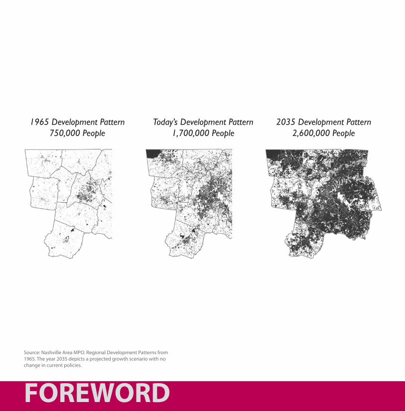
1965 Development Pattern750,000 People
Today’s Development Pattern1,700,000 People
2035 Development Pattern2,600,000 People
Source: Nashville Area MPO. Regional Development Patterns from 1965. The year 2035 depicts a projected growth scenario with no change in current policies.
5
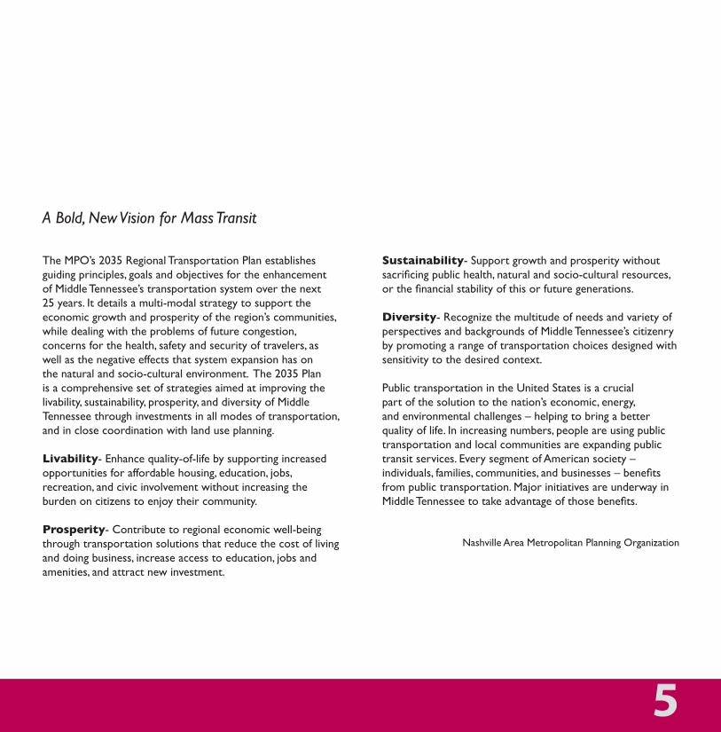
the MPO’s 2035 regional transportation Plan establishes guiding principles, goals and objectives for the enhancement of Middle tennessee’s transportation system over the next 25 years. it details a multi-modal strategy to support the economic growth and prosperity of the region’s communities, while dealing with the problems of future congestion, concerns for the health, safety and security of travelers, as well as the negative effects that system expansion has on the natural and socio-cultural environment. the 2035 Plan is a comprehensive set of strategies aimed at improving the livability, sustainability, prosperity, and diversity of Middle tennessee through investments in all modes of transportation, and in close coordination with land use planning.
Livability- enhance quality-of-life by supporting increased opportunities for affordable housing, education, jobs, recreation, and civic involvement without increasing the burden on citizens to enjoy their community.
Prosperity- Contribute to regional economic well-being through transportation solutions that reduce the cost of living and doing business, increase access to education, jobs and amenities, and attract new investment.
Sustainability- support growth and prosperity without sacrificing public health, natural and socio-cultural resources, or the financial stability of this or future generations.
Diversity- recognize the multitude of needs and variety of perspectives and backgrounds of Middle tennessee’s citizenry by promoting a range of transportation choices designed with sensitivity to the desired context.
Public transportation in the United states is a crucial part of the solution to the nation’s economic, energy, and environmental challenges – helping to bring a better quality of life. in increasing numbers, people are using public transportation and local communities are expanding public transit services. every segment of american society – individuals, families, communities, and businesses – benefits from public transportation. Major initiatives are underway in Middle Tennessee to take advantage of those benefits.
Nashville area Metropolitan Planning Organization
A Bold, New Vision for Mass Transit
INTRODUCTION
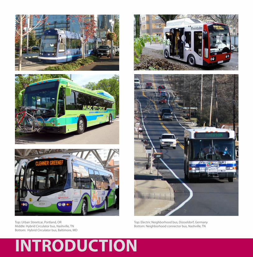
Top: Urban Streetcar, Portland, ORMiddle: Hybrid Circulator bus, Nashville, TNBottom: Hybrid Circulator bus, Baltimore, MD
Top: Electric Neighborhood bus, Düsseldorf, GermanyBottom: Neighborhood connector bus, Nashville, TN
7
Connecting People to Places
as cities across the country continue to redevelop their downtowns and urban neighborhoods, effective public transportation systems are becoming even more critical in providing people with alternatives to driving single occupancy vehicles. a successful transit system does not end when riders arrive downtown. Often destinations are not within walking distance from a centralized station. a simple and convenient “circulator” system offers a solution to this transit problem. typically free or at a reduced rate, these circulators are also popular with tourists, visitors, and downtown residents, who might utilize the services to run errands such as grocery shopping. the results include increased system ridership, promotion of tourism and the downtown economy, and reductions in auto dependency during peak travel periods. the latter is critical in congestion management and maintaining air quality levels that are not detrimental to human health.
Neighborhood connectors are a similar concept, but serve to connect neighborhoods that might be located off the main transit routes to services and amenities.
improved downtown circulation, in conjunction with new and improved neighborhood connectors, will improve the effectiveness of the existing Nashville Mta bus service, while also making regional service more attractive to those commuting into downtown from the suburbs and regional communities.
INTRODUCTION
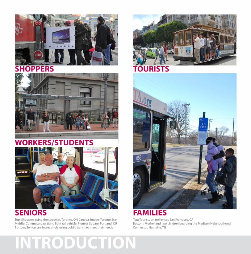
Top: Shoppers using the streetcar, Toronto, ON Canada. Image: Toronto StarMiddle: Commuters awaiting light rail vehicle, Pioneer Square, Portland, ORBottom: Seniors are increasingly using public transit to meet their needs
Top: Tourists on trolley car, San Francisco, CABottom: Mother and two children boarding the Madison Neighborhood Connector, Nashville, TN
SHOPPERS TOURISTS
WORKERS/STUDENTS
SENIORS FAMILIES
Stakeholders
a well-designed transportation system should function to serve the needs of a diversity of ridership, ranging from commuters, students, seniors and families, to tourists and shoppers. With overlapping schedules and a multitude of destinations, incorporating all users requires an extensive, frequent and efficient model that functions throughout the day and night. Using public transportation should be easy and inviting for all, creating an equal, if not better, alternative to the personal vehicle. the circulator and neighborhood connector routes become an important component to meeting peoples’ needs, mitigating challenges related to access and convenience.
9
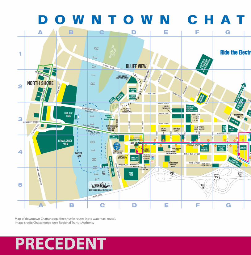
Map of downtown Chattanooga free shuttle routes (note water taxi route).Image credit: Chattanooga Area Regional Transit Authority
PRECEDENT
The Downtown Shuttle runs daily* about every 5 minutesfrom 6:30 a.m. until 11:00 p.m. on Weekdays, 9:00 a.m. until 11:00 p.m. on Saturdays,
and 9:00 a.m. until 8:30 p.m. on Sundays.The Shuttle is not in service on New Year’s Day, Thanksgiving Dayor Christmas Day and runs on a holiday schedule on M.L. King,Jr. Day, Memorial Day, Independence Day and Labor Day. For moreinformation about the Shuttle, call CARTA at 423-629-1473(TDD 423-624-4534).For the safety and convenience of all passengers,please fold strollers before boarding Shuttle.
All Downtown Shuttle busesh are wheelchair accessible.*Hours are subject to change. E�ective Date – June 2007
TRANSPORTATION, PARKING& INFORMATION
Bicycle Path & Parking InformationCall 757-5216 or log on to BikeChattanooga.orgfor more information.CARTA’s Public Bus ServicesDowntown Shuttle629-1473 www.CARTA-BUS.org
Free Electric Shuttle buses run daily (except NewYear’s, Thanksgiving and Christmas Day) aboutevery 5 minutes from Shuttle Park South at theChoo Choo to Shuttle Park North by the Tennes-see Aquarium. Convenient access to Downtownattractions, shopping & more.
Public Transit Service629-147316 Bus Routes serving Chattanooga. Daily service fromDowntown to Hamilton Place, Eastgate Town Center,Northgate & several attractions. Weekday service toHamilton Place & Eastgate about every 10 minutesmornings & afternoons, every 20 minutes midday andevery 30 minutes evenings & Saturdays.
D4 Chattanooga Visitors CenterTwo Broad St., 756-8687www.ChattanoogaFun.com
Visitor Information, Attraction Tickets & Gift Shop
F4 Republic Parking SystemRepublic Centre, 633 Chestnut St., Suite 150265-3218, www.RepublicParking.com
Meeting Your Downtown Parking NeedsIn Our Main O�ce
D4 Shuttle Park North629-1473
Public parking centrally located by the TennesseeAquarium, IMAX & Bijou Theaters & CreativeDiscovery Museum. ATM located in the plaza. Enteron 3rd between Chestnut & Broad.
J3 Shuttle Park South629-1473
Public parking next to the Choo Choo.Convenient access to the Downtown Shuttle service.
D4
F4
D4
J3
h
(SEE MAPAT FRONT
OF BROCHUREFOR ROUTE)
17
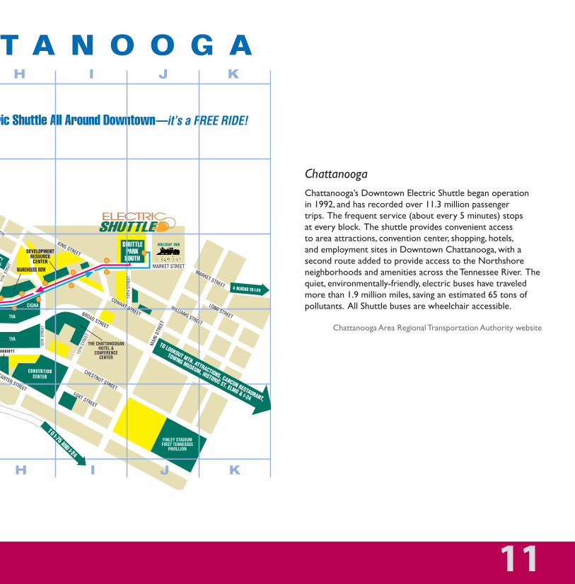
ChattanoogaChattanooga’s Downtown electric shuttle began operation in 1992, and has recorded over 11.3 million passenger trips. the frequent service (about every 5 minutes) stops at every block. the shuttle provides convenient access to area attractions, convention center, shopping, hotels, and employment sites in Downtown Chattanooga, with a second route added to provide access to the Northshore neighborhoods and amenities across the tennessee river. the quiet, environmentally-friendly, electric buses have traveled more than 1.9 million miles, saving an estimated 65 tons of pollutants. all shuttle buses are wheelchair accessible.
Chattanooga area regional transportation authority website
11
The Downtown Shuttle runs daily* about every 5 minutesfrom 6:30 a.m. until 11:00 p.m. on Weekdays, 9:00 a.m. until 11:00 p.m. on Saturdays,
and 9:00 a.m. until 8:30 p.m. on Sundays.The Shuttle is not in service on New Year’s Day, Thanksgiving Dayor Christmas Day and runs on a holiday schedule on M.L. King,Jr. Day, Memorial Day, Independence Day and Labor Day. For moreinformation about the Shuttle, call CARTA at 423-629-1473(TDD 423-624-4534).For the safety and convenience of all passengers,please fold strollers before boarding Shuttle.
All Downtown Shuttle busesh are wheelchair accessible.*Hours are subject to change. E�ective Date – June 2007
TRANSPORTATION, PARKING& INFORMATION
Bicycle Path & Parking InformationCall 757-5216 or log on to BikeChattanooga.orgfor more information.CARTA’s Public Bus ServicesDowntown Shuttle629-1473 www.CARTA-BUS.org
Free Electric Shuttle buses run daily (except NewYear’s, Thanksgiving and Christmas Day) aboutevery 5 minutes from Shuttle Park South at theChoo Choo to Shuttle Park North by the Tennes-see Aquarium. Convenient access to Downtownattractions, shopping & more.
Public Transit Service629-147316 Bus Routes serving Chattanooga. Daily service fromDowntown to Hamilton Place, Eastgate Town Center,Northgate & several attractions. Weekday service toHamilton Place & Eastgate about every 10 minutesmornings & afternoons, every 20 minutes midday andevery 30 minutes evenings & Saturdays.
D4 Chattanooga Visitors CenterTwo Broad St., 756-8687www.ChattanoogaFun.com
Visitor Information, Attraction Tickets & Gift Shop
F4 Republic Parking SystemRepublic Centre, 633 Chestnut St., Suite 150265-3218, www.RepublicParking.com
Meeting Your Downtown Parking NeedsIn Our Main O�ce
D4 Shuttle Park North629-1473
Public parking centrally located by the TennesseeAquarium, IMAX & Bijou Theaters & CreativeDiscovery Museum. ATM located in the plaza. Enteron 3rd between Chestnut & Broad.
J3 Shuttle Park South629-1473
Public parking next to the Choo Choo.Convenient access to the Downtown Shuttle service.
D4
F4
D4
J3
h
(SEE MAPAT FRONT
OF BROCHUREFOR ROUTE)
17
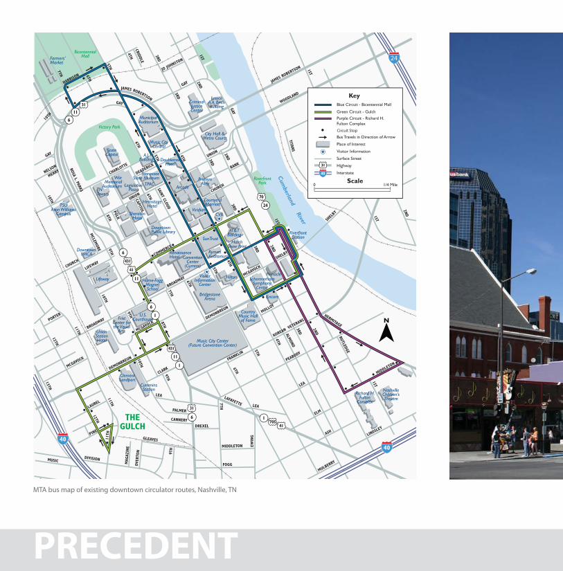
MTA bus map of existing downtown circulator routes, Nashville, TN
PRECEDENT
24
Circuit Stop
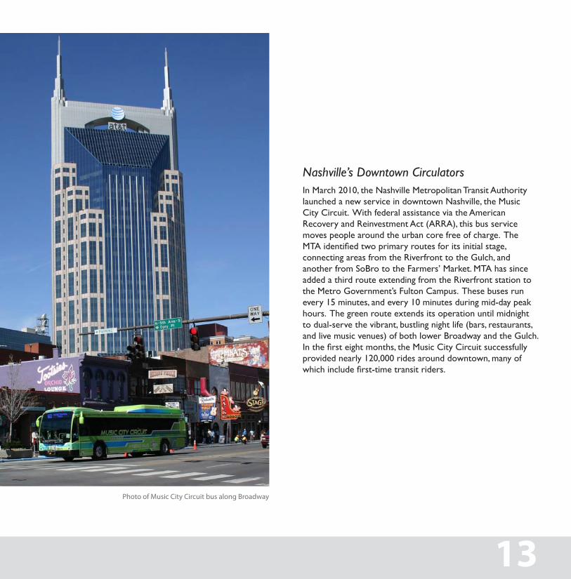
Photo of Music City Circuit bus along Broadway
Nashville’s Downtown CirculatorsIn March 2010, the Nashville Metropolitan Transit Authority launched a new service in downtown Nashville, the Music City Circuit. With federal assistance via the American Recovery and Reinvestment Act (ARRA), this bus service moves people around the urban core free of charge. The MTA identified two primary routes for its initial stage, connecting areas from the Riverfront to the Gulch, and another from SoBro to the Farmers’ Market. MTA has since added a third route extending from the Riverfront station to the Metro Government’s Fulton Campus. These buses run every 15 minutes, and every 10 minutes during mid-day peak hours. The green route extends its operation until midnight to dual-serve the vibrant, bustling night life (bars, restaurants, and live music venues) of both lower Broadway and the Gulch. In the first eight months, the Music City Circuit successfully provided nearly 120,000 rides around downtown, many of which include first-time transit riders.
13
PRECEDENT
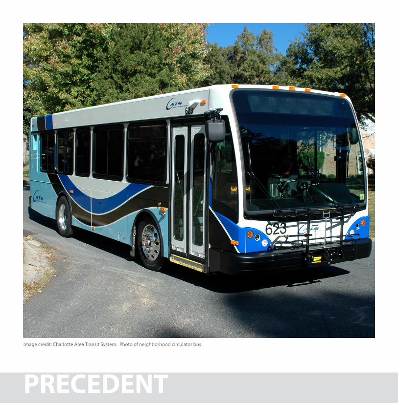
Image credit: Charlotte Area Transit System. Photo of neighborhood circulator bus
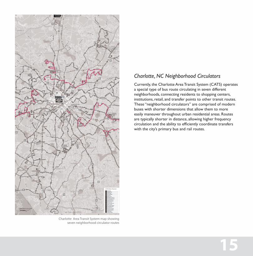
Charlotte Area Transit System map showing seven neighborhood circulator routes
Charlotte, NC Neighborhood CirculatorsCurrently, the Charlotte area transit system (Cats) operates a special type of bus route circulating in seven different neighborhoods, connecting residents to shopping centers, institutions, retail, and transfer points to other transit routes. these “neighborhood circulators” are comprised of modern buses with shorter dimensions that allow them to more easily maneuver throughout urban residential areas. routes are typically shorter in distance, allowing higher frequency circulation and the ability to efficiently coordinate transfers with the city’s primary bus and rail routes.
15
PRECEDENT
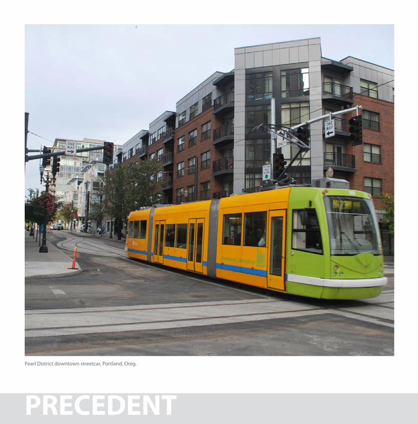
Pearl District downtown streetcar, Portland, Oreg.
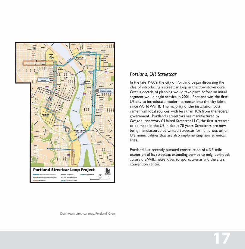
Downtown streetcar map, Portland, Oreg.
Portland, OR Streetcarin the late 1980’s, the city of Portland began discussing the idea of introducing a streetcar loop in the downtown core. Over a decade of planning would take place before an initial segment would begin service in 2001. Portland was the first Us city to introduce a modern streetcar into the city fabric since World War ii. the majority of the installation cost came from local sources, with less than 10% from the federal government. Portland’s streetcars are manufactured by Oregon Iron Works’ United Streetcar LLC, the first streetcar to be made in the Us in about 70 years. streetcars are now being manufactured by United streetcar for numerous other U.s. municipalities that are also implementing new streetcar lines.
Portland just recently pursued construction of a 3.3-mile extension of its streetcar, extending service to neighborhoods across the Willamette river, to sports arenas and the city’s convention center.
17
Nashville Strategic Transit Master Plan Draft Final Report ii
Figure E-1: Persons per Square Mile in 2007 (based on Census Block Groups)
Nashville Strategic Transit Master Plan Draft Final Report ii
Figure E-1: Persons per Square Mile in 2007 (based on Census Block Groups)
NASHVILLE, TN
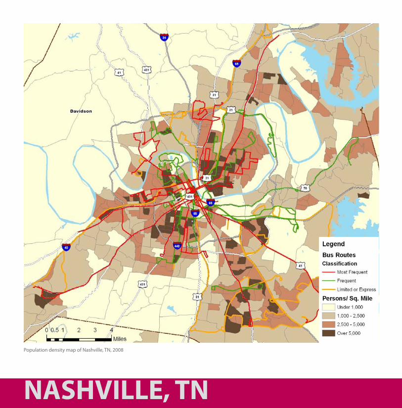
Population density map of Nashville, TN, 2008
Density Supporting Transit
in city planning, the term “density” refers to the average number of individuals or units per space unit; for example, a population density of five hundred people per square mile or a housing density of ten dwellings per acre. a truly effective mass transportation system is dependent upon achieving higher levels of density in units and individuals, because it translates to a cost-effective amount of transit riders.
in many communities the word “density” takes on a negative connotation associated with increased traffic congestion, crime, noise, and an overall feeling of change that many find unpleasant. in reality, higher-density development–when done well–can translate into increases in property values and access to the necessities and amenities of daily life. this critical mass supports patronage of public transit, groceries and pharmacies, bars and restaurants, retail shops and services.
Density also translates into more jobs opportunities for locals, and higher sales and property tax revenues for the city. redevelopment focused along the underutilized commercial corridors radiating from Nashville’s downtown core can also ease development pressures on undeveloped open spaces.
An additional benefit of more density is that it promotes good health through increased opportunities for active transportation. Walkable neighborhoods are typically the most dense, they also tend to be safe, convenient, and inviting for walking and biking trips.
19
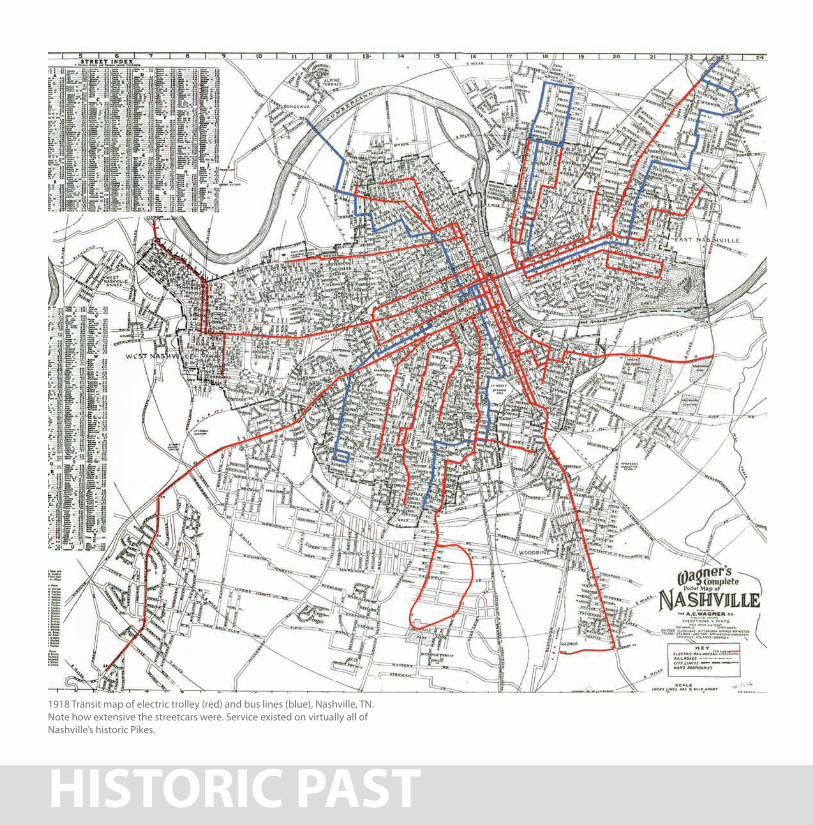
HISTORIC PAST
1918 Transit map of electric trolley (red) and bus lines (blue), Nashville, TN. Note how extensive the streetcars were. Service existed on virtually all of Nashville’s historic Pikes.
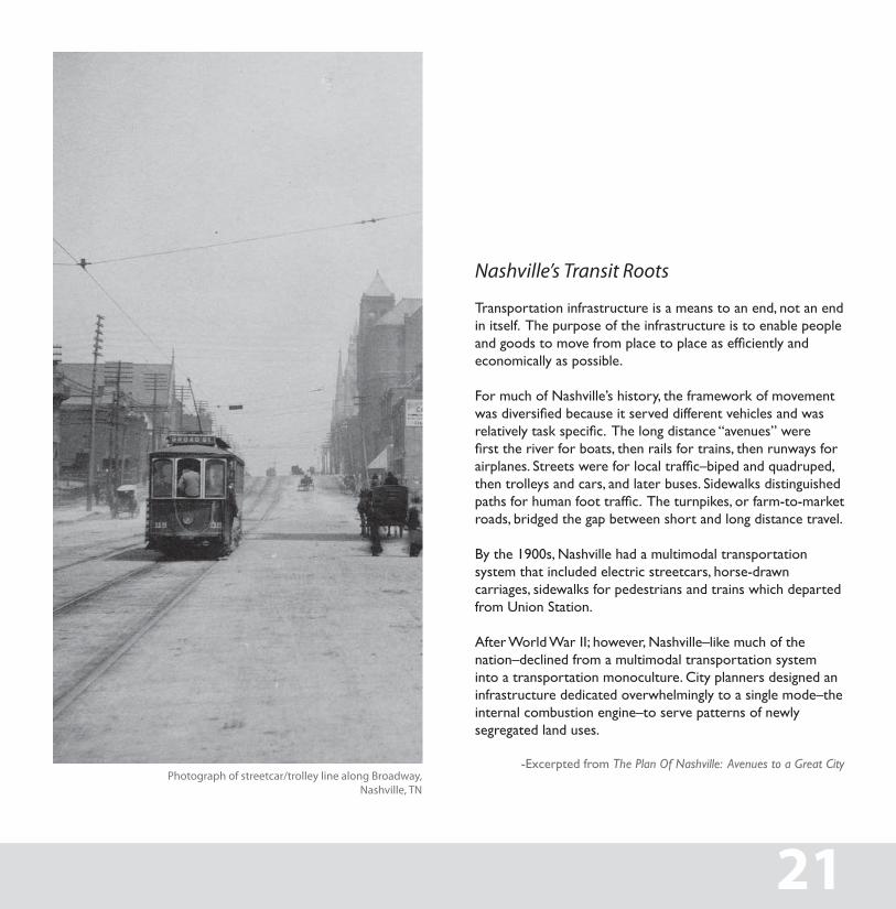
Nashville’s Transit Roots
transportation infrastructure is a means to an end, not an end in itself. the purpose of the infrastructure is to enable people and goods to move from place to place as efficiently and economically as possible.
For much of Nashville’s history, the framework of movement was diversified because it served different vehicles and was relatively task specific. The long distance “avenues” were first the river for boats, then rails for trains, then runways for airplanes. Streets were for local traffic–biped and quadruped, then trolleys and cars, and later buses. sidewalks distinguished paths for human foot traffic. The turnpikes, or farm-to-market roads, bridged the gap between short and long distance travel.
By the 1900s, Nashville had a multimodal transportation system that included electric streetcars, horse-drawn carriages, sidewalks for pedestrians and trains which departed from Union station.
after World War ii; however, Nashville–like much of the nation–declined from a multimodal transportation system into a transportation monoculture. City planners designed an infrastructure dedicated overwhelmingly to a single mode–the internal combustion engine–to serve patterns of newly segregated land uses.
-excerpted from The Plan Of Nashville: Avenues to a Great City Photograph of streetcar/trolley line along Broadway,
Nashville, TN
21
VISION
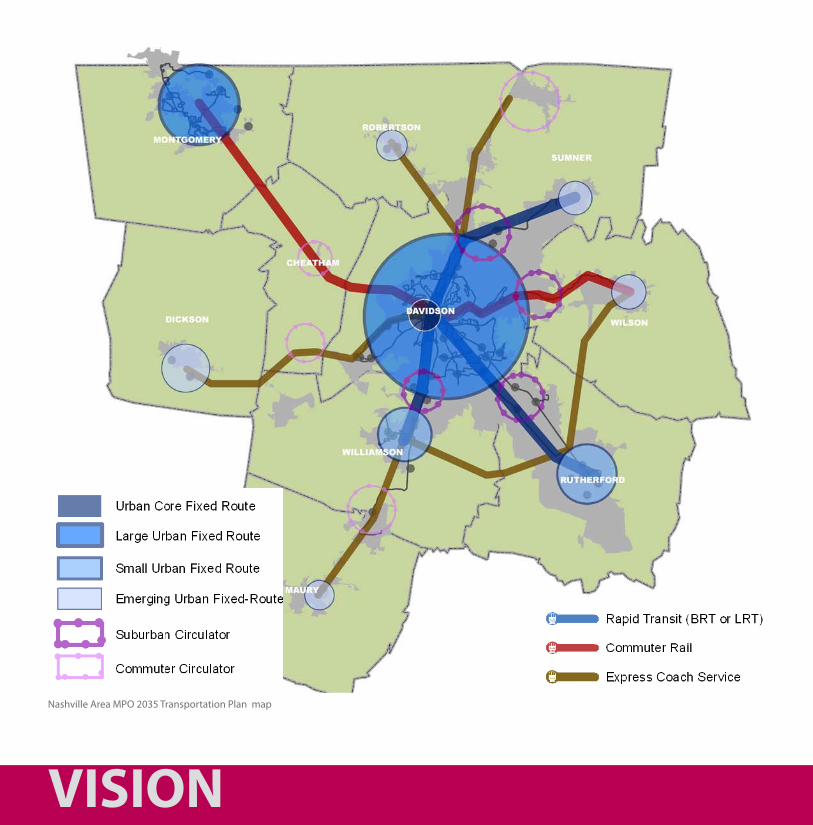
Nashville Area MPO 2035 Transportation Plan map
A Vision for Nashville - 2035the Nashville area Metropolitan Planning Organization’s 2035 regional transportation Plan for Nashville and its surrounding counties provides insight into the direction middle tennessee is headed, in terms of development and meeting the needs for future growth. the region’s expansion yields the need to facilitate additional connections and improvements to existing systems. this forward-thinking 25-year plan introduces alternative choices for mobility, some of which are rooted in the region’s history. a key component of this plan’s success and implementation will be solving crucial connections that enhance Nashville’s existing transit modes, creating an efficient regional and local transportation system. the plan calls for an increase in circulator routes, both in the urban core and suburban centers; as well as, introducing more neighborhood connectors that help reduce the need for short trips taken by personal vehicles. this comprehensive plan prompts the need for an envisioning process, to not only elaborate on its potential complexities; but also, to assist in the promotion of its ideals and overall ambitions for the future of Nashville’s transportation system.
23
AREAS OF FOCUS
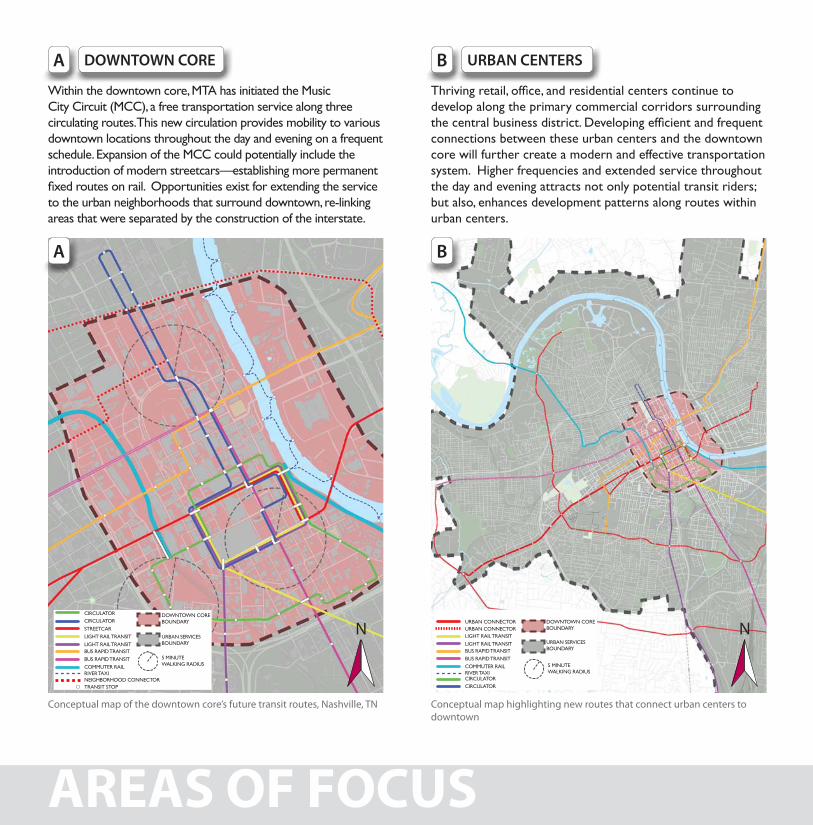
Within the downtown core, Mta has initiated the Music City Circuit (MCC), a free transportation service along three circulating routes. this new circulation provides mobility to various downtown locations throughout the day and evening on a frequent schedule. expansion of the MCC could potentially include the introduction of modern streetcars—establishing more permanent fixed routes on rail. Opportunities exist for extending the service to the urban neighborhoods that surround downtown, re-linking areas that were separated by the construction of the interstate.
Thriving retail, office, and residential centers continue to develop along the primary commercial corridors surrounding the central business district. Developing efficient and frequent connections between these urban centers and the downtown core will further create a modern and effective transportation system. higher frequencies and extended service throughout the day and evening attracts not only potential transit riders; but also, enhances development patterns along routes within urban centers.
URBAN CENTERSDOWNTOWN CORE BA
BA
Conceptual map of the downtown core’s future transit routes, Nashville, TN Conceptual map highlighting new routes that connect urban centers to downtown
CirCUlatOr DOWNtOWN COreBOUNDarY
UrBaN serviCesBOUNDarY
5 MiNUteWalKiNg raDiUs
CirCUlatOr
streetCar
light rail traNsit
light rail traNsit
BUs raPiD traNsit
BUs raPiD traNsit
COMMUter railriver taXiNeighBOrhOOD CONNeCtOrtraNsit stOP
CirCUlatOrCirCUlatOr
light rail traNsit
light rail traNsit
BUs raPiD traNsit
BUs raPiD traNsit
COMMUter railriver taXi
UrBaN CONNeCtOrUrBaN CONNeCtOr
DOWNtOWN COreBOUNDarY
UrBaN serviCesBOUNDarY
5 MiNUteWalKiNg raDiUs
NN
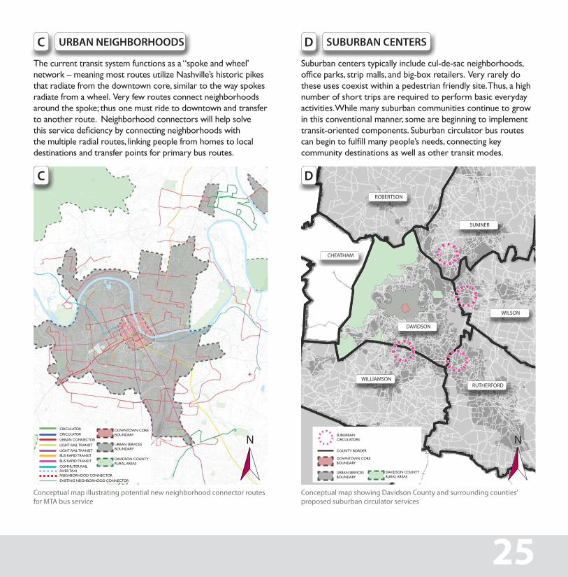
the current transit system functions as a “spoke and wheel’ network – meaning most routes utilize Nashville’s historic pikes that radiate from the downtown core, similar to the way spokes radiate from a wheel. very few routes connect neighborhoods around the spoke; thus one must ride to downtown and transfer to another route. Neighborhood connectors will help solve this service deficiency by connecting neighborhoods with the multiple radial routes, linking people from homes to local destinations and transfer points for primary bus routes.
URBAN NEIGHBORHOODS
suburban centers typically include cul-de-sac neighborhoods, office parks, strip malls, and big-box retailers. Very rarely do these uses coexist within a pedestrian friendly site. thus, a high number of short trips are required to perform basic everyday activities. While many suburban communities continue to grow in this conventional manner, some are beginning to implement transit-oriented components. suburban circulator bus routes can begin to fulfill many people’s needs, connecting key community destinations as well as other transit modes.
SUBURBAN CENTERSC D
C D
Conceptual map illustrating potential new neighborhood connector routes for MTA bus service
Conceptual map showing Davidson County and surrounding counties’ proposed suburban circulator services
DOWNtOWN COreBOUNDarY
DOWNtOWN COreBOUNDarY
COUNtY BOrDer
sUBUrBaN CirCUlatOrs
UrBaN serviCesBOUNDarY
UrBaN serviCesBOUNDarY
CirCUlatOrCirCUlatOr
UrBaN CONNeCtOr
light rail traNsit
light rail traNsit
BUs raPiD traNsit
BUs raPiD traNsit
COMMUter railriver taXiNeighBOrhOOD CONNeCtOr
WILLIAMSON
WILSON
SUMNER
ROBERTSON
CHEATHAM
RUTHERFORD
DAVIDSON
eXistiNg NeighBOrhOOD CONNeCtOr
DaviDsON COUNtY rUral areas
DaviDsON COUNtY rUral areas
25
NN
CONCEPTSDOWNTOWN CIRCULATOR
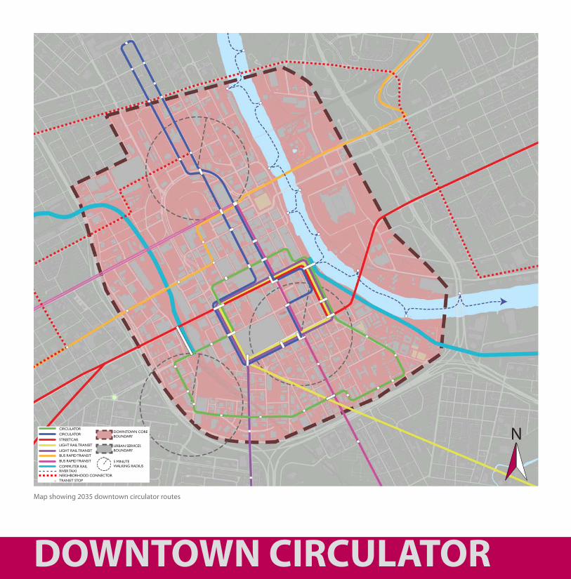
Map showing 2035 downtown circulator routes
CirCUlatOrCirCUlatOr
streetCar
light rail traNsit
light rail traNsit
BUs raPiD traNsit
BUs raPiD traNsit
COMMUter railriver taXiNeighBOrhOOD CONNeCtOrtraNsit stOP
DOWNtOWN COreBOUNDarY
UrBaN serviCesBOUNDarY
5 MiNUteWalKiNg raDiUs
N
Circulating Downtown
in this plan, Downtown becomes a hub of transit activities. Bus, light rail, commuter rail, Bus rapid transit (Brt), streetcar, automobile, cyclists and pedestrians all interact together, forming a complete transit system.
Proposed features include:
• A high frequency “downtown transit mall” loop that offers five minute headways for downtown circulation, and connects the multiple modes of transit.
• expanded two-way circulator routes, providing connections to newly redeveloped areas in soBro, the gulch, and germantown.
• integrated, multi-modal “complete streets,” creating safe and inviting urban spaces along downtown corridors for users of all ages and abilities.
• New transfer hubs where multiple routes and transit modes intersect, featuring modern shelters and real-time information systems.
• Overlapping light-rail and streetcar routes to increase circulation frequencies in the downtown transit mall.
DOWNTOWN CIRCULATOR 27
DOWNTOWN CIRCULATOR
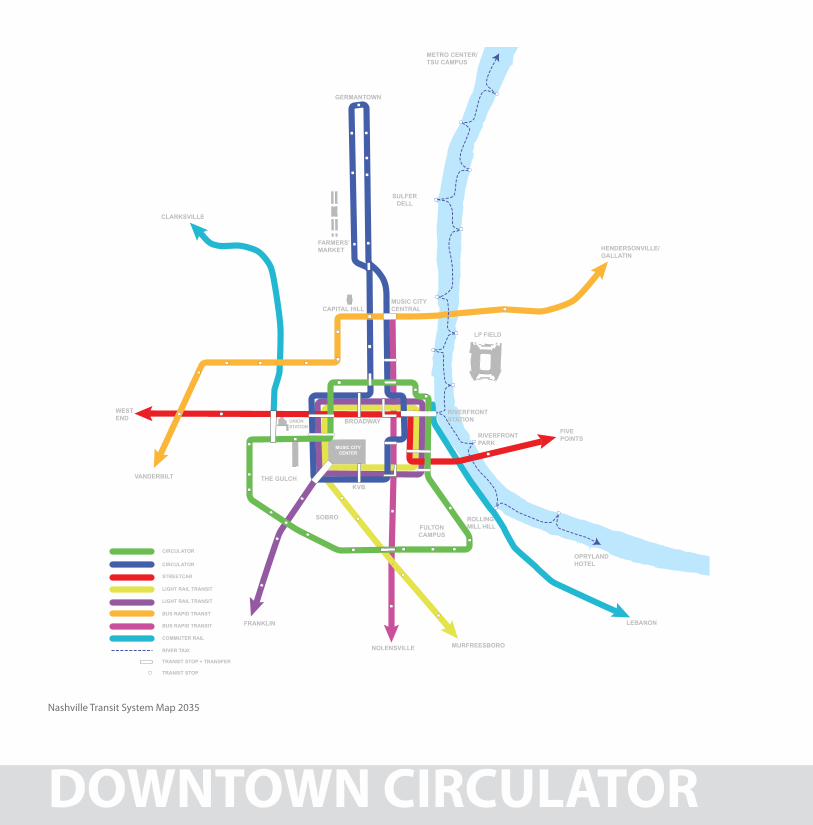
Nashville Transit System Map 2035
THE GULCH
SULFER DELL
BROADWAY
KVB
MUSIC CITY CENTER
WEST END
FIVE POINTS
VANDERBILT
FRANKLIN
MURFREESBORONOLENSVILLE
CLARKSVILLE
LEBANON
HENDERSONVILLE/GALLATIN
OPRYLAND HOTEL
RIVER TAXI
TRANSIT STOP + TRANSFER
TRANSIT STOP
COMMUTER RAIL
BUS RAPID TRANSIT
LIGHT RAIL TRANSIT
LIGHT RAIL TRANSIT
BUS RAPID TRANST
STREETCAR
CIRCULATOR
CIRCULATOR
CAPITAL HILL
FARMERS’MARKET
METRO CENTER/TSU CAMPUS
RIVERFRONTPARK
RIVERFRONTSTATIONUNION
STATION
MUSIC CITYCENTRAL
LP FIELD
GERMANTOWN
SOBROFULTON CAMPUS
ROLLINGMILL HILL
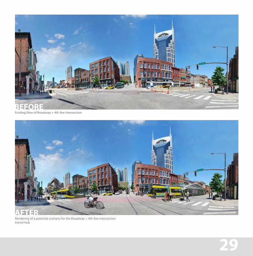
Existing View of Broadway + 4th Ave intersectionBEFORE
Rendering of a potential scenario for the Broadway + 4th Ave intersection transit hub
AFTER
29
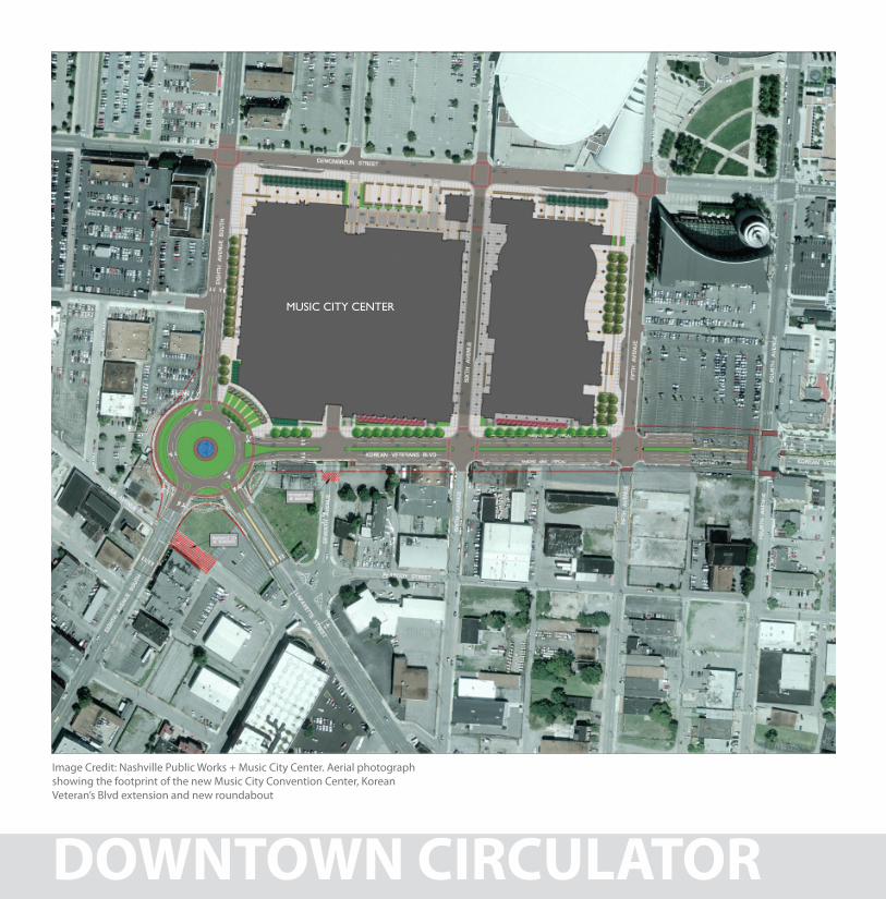
Image Credit: Nashville Public Works + Music City Center. Aerial photograph showing the footprint of the new Music City Convention Center, Korean Veteran’s Blvd extension and new roundabout
DOWNTOWN CIRCULATOR
MUsiC CitY CeNter
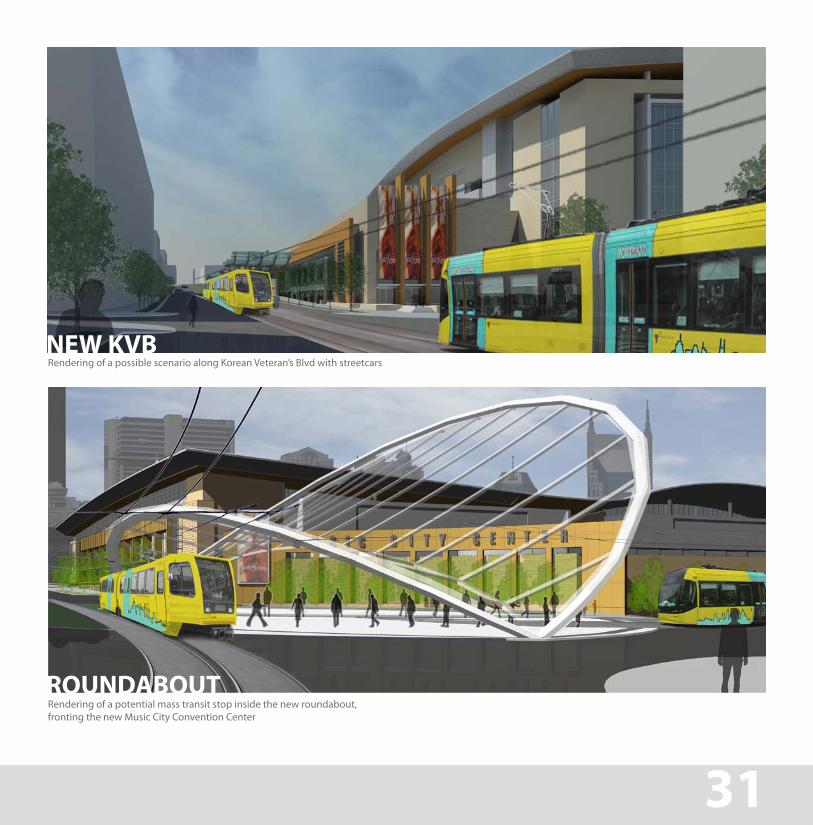
Rendering of a possible scenario along Korean Veteran’s Blvd with streetcarsNEW KVB
Rendering of a potential mass transit stop inside the new roundabout, fronting the new Music City Convention Center
ROUNDABOUT
31
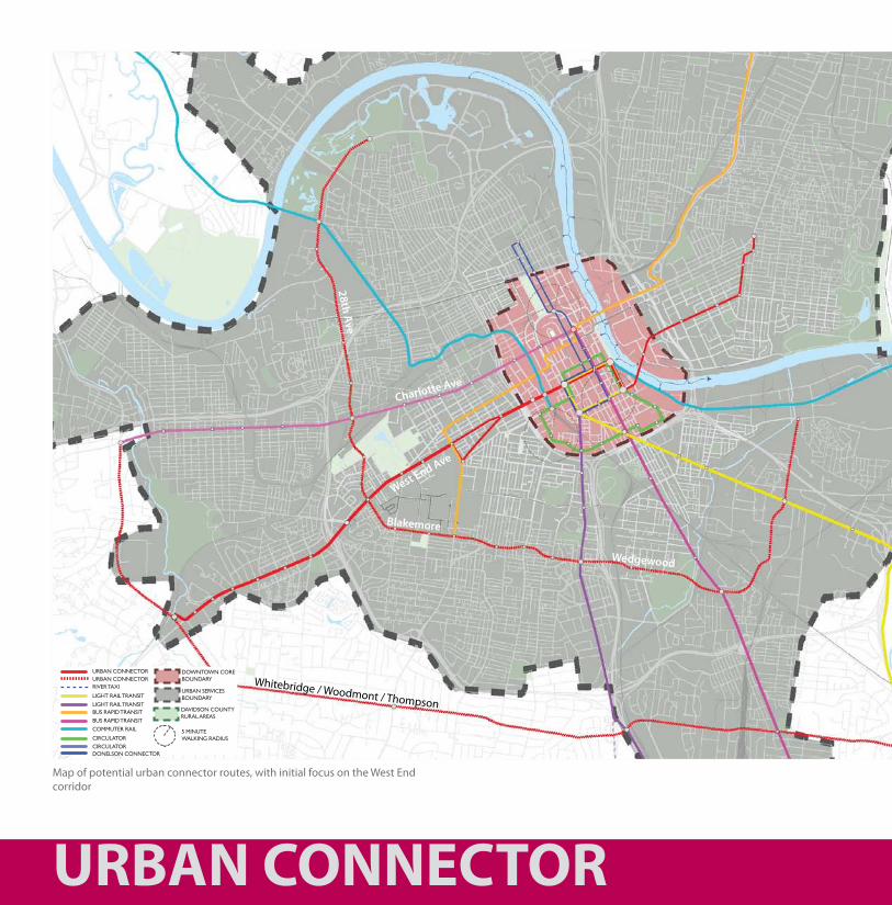
Map of potential urban connector routes, with initial focus on the West End corridor
connector
URBAN CONNECTOR
CirCUlatOrCirCUlatOrDONelsON CONNeCtOr
light rail traNsit
light rail traNsit
BUs raPiD traNsit
BUs raPiD traNsit
COMMUter rail
river taXi
UrBaN CONNeCtOrUrBaN CONNeCtOr
DOWNtOWN COreBOUNDarY
UrBaN serviCesBOUNDarY
5 MiNUteWalKiNg raDiUs
DaviDsON COUNtY rUral areas
West End Ave
Charlotte Ave
Whitebridge / Woodmont / Thompson
Wedgewood
Blakemore
28th Ave
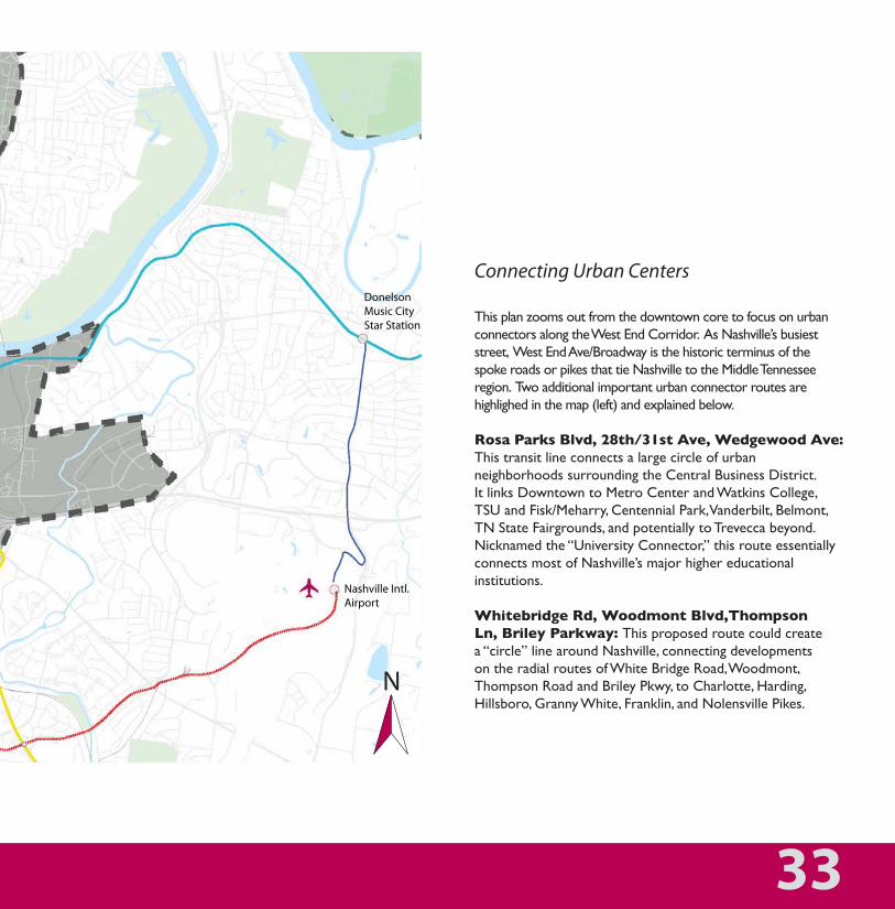
Connecting Urban Centers
this plan zooms out from the downtown core to focus on urban connectors along the West end Corridor. as Nashville’s busiest street, West end ave/Broadway is the historic terminus of the spoke roads or pikes that tie Nashville to the Middle tennessee region. two additional important urban connector routes are highlighed in the map (left) and explained below.
Rosa Parks Blvd, 28th/31st Ave, Wedgewood Ave:this transit line connects a large circle of urban neighborhoods surrounding the Central Business District. it links Downtown to Metro Center and Watkins College, tsU and Fisk/Meharry, Centennial Park, vanderbilt, Belmont, tN state Fairgrounds, and potentially to trevecca beyond. Nicknamed the “University Connector,” this route essentially connects most of Nashville’s major higher educational institutions.
Whitebridge Rd, Woodmont Blvd,Thompson Ln, Briley Parkway: this proposed route could create a “circle” line around Nashville, connecting developments on the radial routes of White Bridge road, Woodmont, thompson road and Briley Pkwy, to Charlotte, harding, hillsboro, granny White, Franklin, and Nolensville Pikes.
URBAN CONNECTOR
Donelson Music City Star Station
Nashville Intl. Airport
33
N
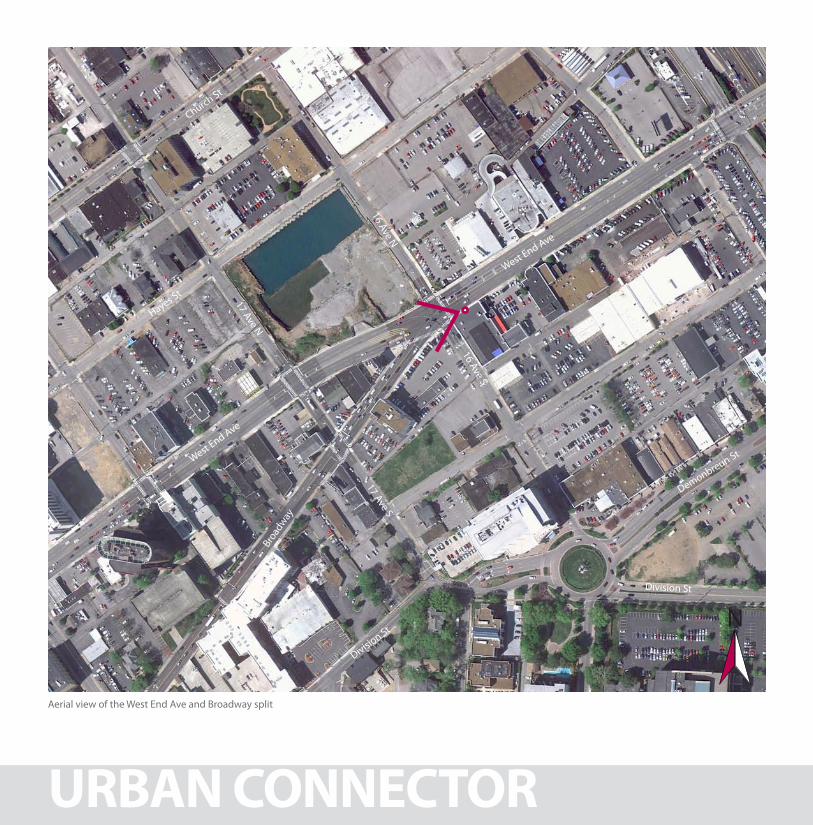
Aerial view of the West End Ave and Broadway split
URBAN CONNECTOR
West End Ave
16 Ave S
17 Ave S16 Ave N
17 Ave N
West End Ave
Hayes St
Church St
Division St
Division St
Broad
way
Demonbreun St
N
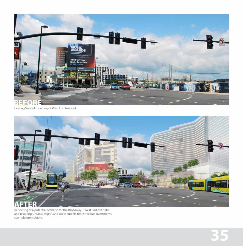
Existing View of Broadway + West End Ave splitBEFORE
Rendering of a potential scenario for the Broadway + West End Ave split, and resulting Urban Design/Land use elements that streetcar investments can help promulgate.
AFTER
URBAN CONNECTOR 35
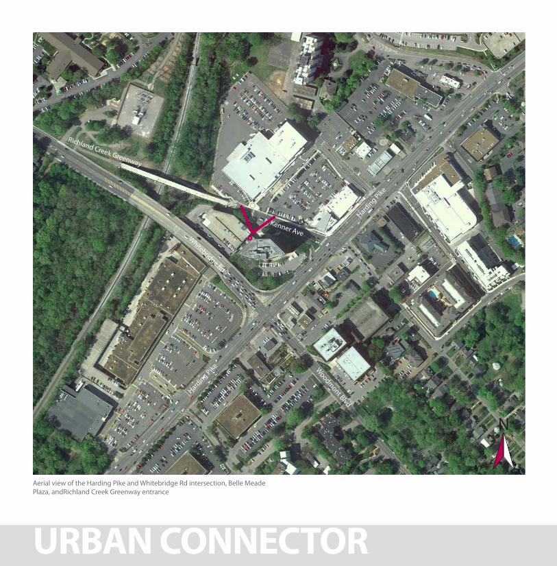
Aerial view of the Harding Pike and Whitebridge Rd intersection, Belle Meade Plaza, andRichland Creek Greenway entrance
URBAN CONNECTOR
Harding Pike
Harding Pike
Whitebridge Rd
N Kenner Ave
Richland Creek Greenway
Woodm
ont Blvd
N
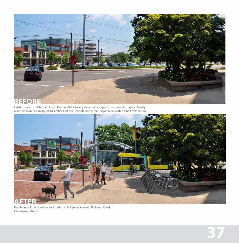
BEFORE
Rendering of the streetcar end station at N Kenner Ave and Richland Creek Greenway entrance
AFTER
Existing view of N Kenner Ave at Harding Rd. Grocery stores, office spaces, restaurants, higher density residential units, a hospital, Dr’s offices, banks, schools and retail shops are all within a half mile radius
URBAN CONNECTOR 37
NEIGHBORHOOD CONNECTOR
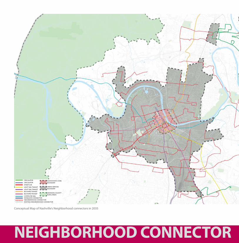
Conceptual Map of Nashville’s Neighborhood connectors in 2035
DOWNtOWN COreBOUNDarY
UrBaN serviCesBOUNDarY
CirCUlatOrCirCUlatOr
streetCar
light rail traNsit
light rail traNsit
BUs raPiD traNsit
BUs raPiD traNsit
COMMUter railDONelsON CONNeCtOrNeighBOrhOOD CONNeCtOreXistiNg NeighBOrhOOD CONNeCtOr
DaviDsON COUNtY rUral areas
NEIGHBORHOOD CONNECTOR
The First and Last Mile
For many Nashvillians, taking transit may be considered a nuisance because getting from the home to a transit stop is not easily accessible, thereby adding to total trip length, which in today’s environment for traffic congestion is not always competitive with the personal automobile. in this circumstance, those with the ability to drive alone or car/van pool will probably do so, instead of making a concerted effort to use a somewhat inconvenient transit route.
Neighborhood connectors are meant to bridge the gap between the home, main transit routes, and final destination. they connect residential neighborhoods to employment centers, local businesses, schools, hospitals, grocery stores, restaurants, retail, and main transit lines—thus greatly eliminating the need for personal vehicles for both commuting and even short trips for local services basic errands.
the 2035 Plan envisions a system of neighborhood connectors throughout the city that link neighborhoods to urban centers and downtown, greatly increasing transit usage across Nashville.
39
N
NEIGHBORHOOD CONNECTOR
Cum
berland River
WARRIOR
KINSE
Y
ARCHWOOD
JOE
PYRO
N
CHEY
ENNE
BLV
D
T
1
5
4
6
7
Madison
Due West
T
Transfer Points to 26 Gallatin Road &56 Gallatin Road BRT
31E
31E
6
6
45
23
45
45
MadisonPark
MadisonLibrary
Kroger
MadisonPost Office
MadisonTowers Riverwood
Towers
Walgreens
CumberlandView Towers
SkylineMadisonCampus
Cumberland River
ANDERSON
DUPONT
MANZANO
OLD HICKORYOL
D HIC
KORY
OLD HICKORY
APACHE LN
MANN
NEELYS BEND
DUE WEST
NEELYS BEND
MYA
TT
LARK
IN S
PRIN
GS
HOSP
ITAL
RAND
Y RD
MAY
PIERC
E
DEL
AWAR
E
GALL
ATIN
FORE
ST P
ARK
CHEYENNE BLVD
CHEYENNECT
ROBINSONRIO VISTA
LANIER
HOW
SE
HIL
LCRE
ST
76 MadisonConnector
Bus Route 76 - Neely’s Bend
Bus Route 76 - Anderson Lane
Bus Route 26 - Local Service
Bus Route 56 - Bus Rapid Transit
Buses travel in direction of arrow
Place of interest
School
Timepoint
Transfer Point
Key
1
T
a.m. trips p.m. trips
Average trip times from this stop
Average trip times from this stop
Madison Library
1
Skyline Madison Campus
27 minutes
Cumberland Towers
316 minutes
Old Hickory & Rio Vista
421 minutes
Walgreens
530 minutes
WEEKDAYS via Neely’s Bend
5:06 5:13 5:22 5:27 5:36 6:00 6:07 6:16 6:21 6:30 7:00 7:07 7:16 7:21 7:30 8:00 8:07 8:16 8:21 8:30 9:00 9:07 9:16 9:21 9:30 10:00 10:07 10:16 10:21 10:30 11:00 11:07 11:16 11:21 11:30 12:00 12:07 12:16 12:21 12:30 1:00 1:07 1:16 1:21 1:30 2:00 2:07 2:16 2:21 2:30 3:00 3:07 3:16 3:21 3:30 4:00 4:07 4:16 4:21 4:30 5:00 5:07 5:16 5:21 5:30 6:00 6:07 6:16 6:21 6:30 7:00 7:07 7:16 7:21 7:30
Walgreens
5
Anderson & Myatt
67 minutes
Madison Towers
711 minutes
Madison Library
119 minutes
WEEKDAYS via Anderson Lane
5:36 5:43 5:47 5:55 6:31 6:38 6:42 6:50 7:33 7:40 7:44 7:52 8:33 8:40 8:44 8:52 9:33 9:40 9:44 9:52 10:33 10:40 10:44 10:52 11:33 11:40 11:44 11:52 12:33 12:40 12:44 12:52 1:33 1:40 1:44 1:52 2:33 2:40 2:44 2:52 3:33 3:40 3:44 3:52 4:33 4:40 4:44 4:52 5:33 5:40 5:44 5:52 6:33 6:40 6:44 6:52 7:30 7:37 7:41 7:49
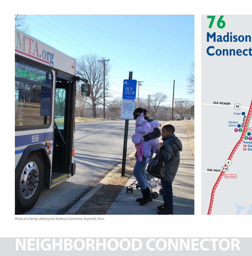
Photo of a family utilizing the Madison Connector, Nashville, Tenn
NEIGHBORHOOD CONNECTOR
Cum
berland River
WARRIOR
KINSE
Y
ARCHWOOD
JOE
PYRO
N
CHEY
ENNE
BLV
DT
1
5
4
6
7
Madison
Due West
T
Transfer Points to 26 Gallatin Road &56 Gallatin Road BRT
31E
31E
6
6
45
23
45
45
MadisonPark
MadisonLibrary
Kroger
MadisonPost Office
MadisonTowers Riverwood
Towers
Walgreens
CumberlandView Towers
SkylineMadisonCampus
Cumberland River
ANDERSON
DUPONT
MANZANO
OLD HICKORYOL
D HIC
KORY
OLD HICKORY
APACHE LN
MANN
NEELYS BEND
DUE WEST
NEELYS BEND
MYA
TT
LARK
IN S
PRIN
GS
HOSP
ITAL
RAND
Y RD
MAY
PIERC
E
DEL
AWAR
E
GALL
ATIN
FORE
ST P
ARK
CHEYENNE BLVD
CHEYENNECT
ROBINSONRIO VISTA
LANIER
HOW
SE
HIL
LCRE
ST
76 MadisonConnector
Bus Route 76 - Neely’s Bend
Bus Route 76 - Anderson Lane
Bus Route 26 - Local Service
Bus Route 56 - Bus Rapid Transit
Buses travel in direction of arrow
Place of interest
School
Timepoint
Transfer Point
Key
1
T
a.m. trips p.m. trips
Average trip times from this stop
Average trip times from this stop
Madison Library
1
Skyline Madison Campus
27 minutes
Cumberland Towers
316 minutes
Old Hickory & Rio Vista
421 minutes
Walgreens
530 minutes
WEEKDAYS via Neely’s Bend
5:06 5:13 5:22 5:27 5:36 6:00 6:07 6:16 6:21 6:30 7:00 7:07 7:16 7:21 7:30 8:00 8:07 8:16 8:21 8:30 9:00 9:07 9:16 9:21 9:30 10:00 10:07 10:16 10:21 10:30 11:00 11:07 11:16 11:21 11:30 12:00 12:07 12:16 12:21 12:30 1:00 1:07 1:16 1:21 1:30 2:00 2:07 2:16 2:21 2:30 3:00 3:07 3:16 3:21 3:30 4:00 4:07 4:16 4:21 4:30 5:00 5:07 5:16 5:21 5:30 6:00 6:07 6:16 6:21 6:30 7:00 7:07 7:16 7:21 7:30
Walgreens
5
Anderson & Myatt
67 minutes
Madison Towers
711 minutes
Madison Library
119 minutes
WEEKDAYS via Anderson Lane
5:36 5:43 5:47 5:55 6:31 6:38 6:42 6:50 7:33 7:40 7:44 7:52 8:33 8:40 8:44 8:52 9:33 9:40 9:44 9:52 10:33 10:40 10:44 10:52 11:33 11:40 11:44 11:52 12:33 12:40 12:44 12:52 1:33 1:40 1:44 1:52 2:33 2:40 2:44 2:52 3:33 3:40 3:44 3:52 4:33 4:40 4:44 4:52 5:33 5:40 5:44 5:52 6:33 6:40 6:44 6:52 7:30 7:37 7:41 7:49
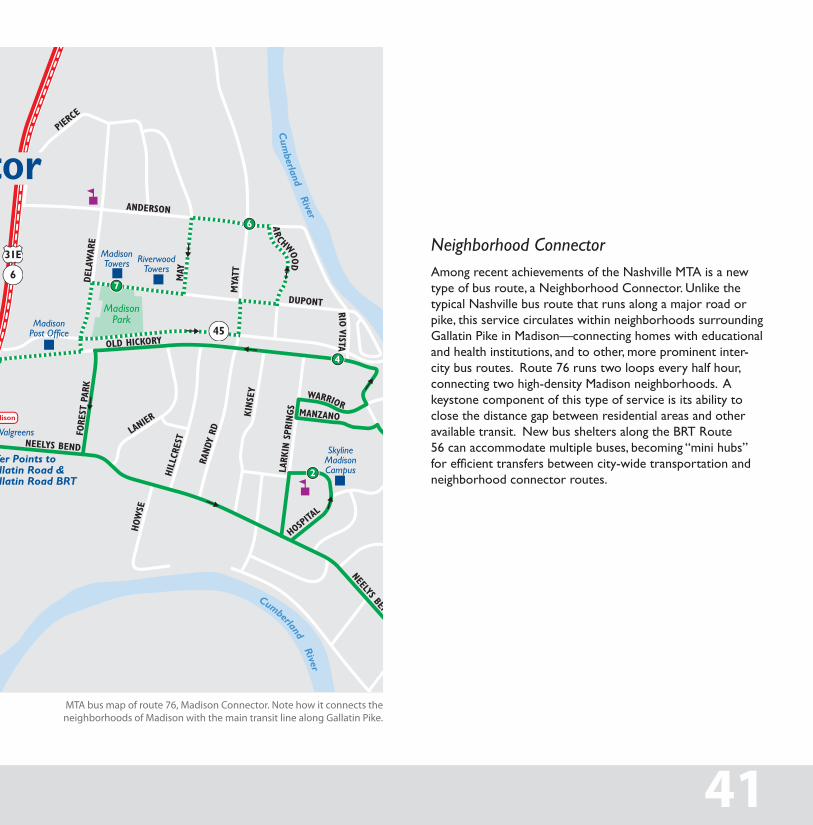
MTA bus map of route 76, Madison Connector. Note how it connects the neighborhoods of Madison with the main transit line along Gallatin Pike.
Neighborhood Connectoramong recent achievements of the Nashville Mta is a new type of bus route, a Neighborhood Connector. Unlike the typical Nashville bus route that runs along a major road or pike, this service circulates within neighborhoods surrounding gallatin Pike in Madison—connecting homes with educational and health institutions, and to other, more prominent inter-city bus routes. route 76 runs two loops every half hour, connecting two high-density Madison neighborhoods. a keystone component of this type of service is its ability to close the distance gap between residential areas and other available transit. New bus shelters along the Brt route 56 can accommodate multiple buses, becoming “mini hubs” for efficient transfers between city-wide transportation and neighborhood connector routes.
41
NEIGHBORHOOD CONNECTOR
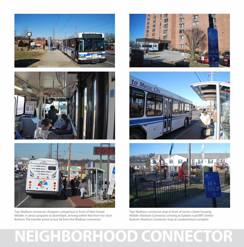
Top: Madison connector shoppers unload bus in front of their houseMiddle: A senior prepares to disembark, arriving within feet from her doorBottom: The transfer point to bus 56 from the Madison connector
Top: Madison connector stop in front of senior citizen housingMiddle: Madison Connector arriving at Gallatin road BRT shelterBottom: Madison Connector stop at condominium complex
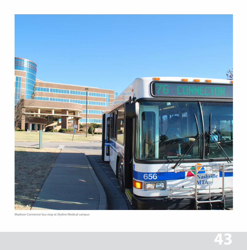
Madison Connector bus stop at Skyline Medical campus
NEIGHBORHOOD CONNECTOR 43
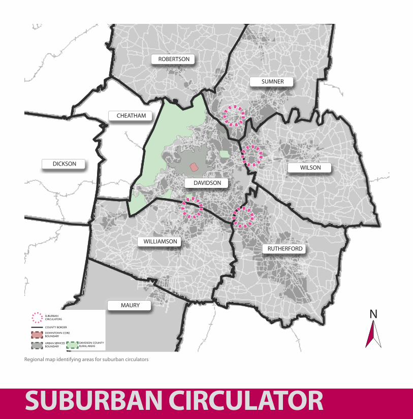
Regional map identifying areas for suburban circulators
SUBURBAN CIRCULATOR
WILLIAMSON
WILSON
SUMNER
ROBERTSON
DICKSON
CHEATHAM
RUTHERFORD
DAVIDSON
DOWNtOWN COreBOUNDarY
COUNtY BOrDer
sUBUrBaN CirCUlatOrs
UrBaN serviCesBOUNDarY
DaviDsON COUNtY rUral areas
MAURY
N
SUBURBAN CIRCULATOR
Suburban Circulators
Over half of all americans live in suburban neighborhoods. it is not surprising, then, that only a small percentage of suburban dwellers use mass transit to commute to work, as those neighborhoods were not designed to be transit friendly. Morning commutes create significant congestion for Nashville’s roadways because so many suburban residents have no mobility options other than driving from home to work. rising gas costs have catalyzed efforts to offer alternatives, including carpooling and commuter bus services. Future suburban growth has prompted long-term studies into light-rail, Brt and commuter rail as options for relieving congestion by increasing transit’s share of commuter trips.
suburban circulators follow the same concept as a neighborhood connector, linking residents to shopping districts, educational institutions, office parks, greenways, as well as other modes of transit that connect to major employment centers, but are focused in suburban areas.
in Nashville, these suburban areas typically appear just outside the border of Davidson County, in high-growth “*edge Cities.” examples include hendersonville, Mt. Juliet and Brentwood.
*term for a concentration of business, shopping, and entertainment outside a traditional urban area in what had more recently been a residential suburb or semi-rural community
45
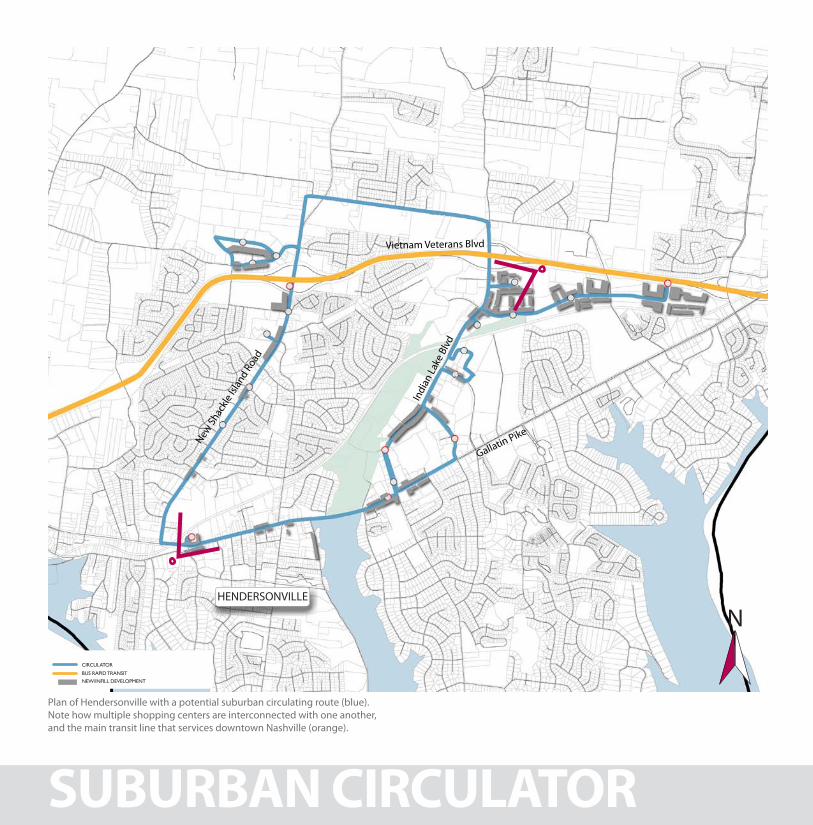
Plan of Hendersonville with a potential suburban circulating route (blue). Note how multiple shopping centers are interconnected with one another, and the main transit line that services downtown Nashville (orange).
SUBURBAN CIRCULATOR
HENDERSONVILLE
CirCUlatOr
BUs raPiD traNsit
NeW/iNFill DevelOPMeNt
Gallatin Pike
New Sh
ackle
Islan
d Ro
ad
Indi
an La
ke B
lvd
Vietnam Veterans Blvd
N
EXISTING
PLANALTERNATIVE
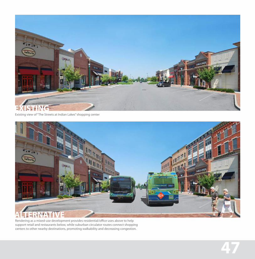
Existing view of “The Streets at Indian Lakes” shopping center
Rendering as a mixed-use development provides residential/office uses above to help support retail and restaurants below, while suburban circulator routes connect shopping centers to other nearby destinations, promoting walkability and decreasing congestion.
SUBURBAN CIRCULATOR 47
SUBURBAN CIRCULATOR
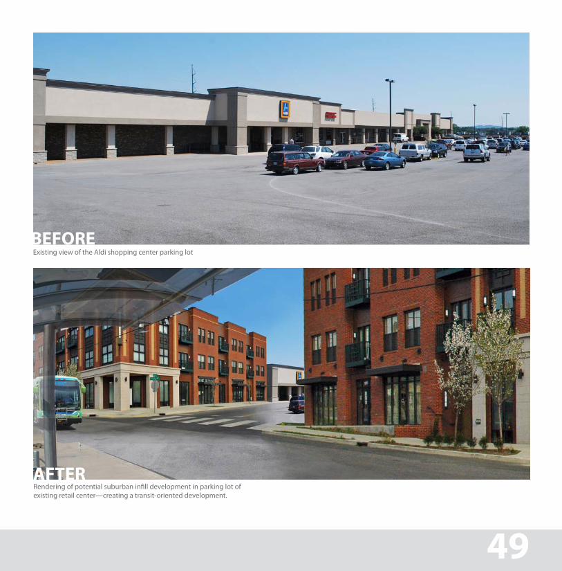
Big Box + Suburban Infill
tremendous economic opportunity exists for “Big Box” retail centers through the infill development of enormous surface parking lots into mixed-use “lifestyle centers.” these types of interventions encourage higher-density developments and help reverse suburban sprawl. including transit components within developments promotes effective and efficient public transportation.
Infill development in suburban areas of the region would increase the density of commercial centers, offer a wider range of services and activities for residents and dramatically increase the efficacy and functionality of mass transit for the community.large expanses of parking lots evolve into new buildings with internalized parking, creating a more pleasant walking experience. transit links shopping centers so that consumers can utilize a “park once” strategy - greatly reducing automobile congestion within suburban cores.
BEFORE
Rendering of potential suburban infill development in parking lot of existing retail center—creating a transit-oriented development.
BEFORE
Existing view of the Aldi shopping center parking lot
SUBURBAN CIRCULATOR 49
AFTER
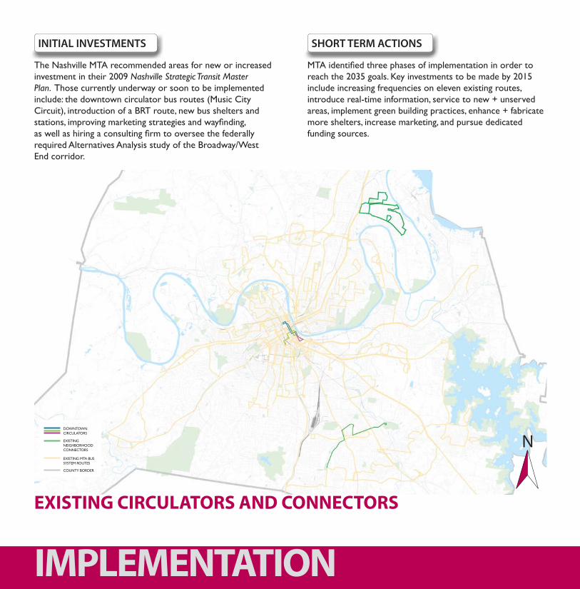
the Nashville Mta recommended areas for new or increased investment in their 2009 Nashville Strategic Transit Master Plan. those currently underway or soon to be implemented include: the downtown circulator bus routes (Music City Circuit), introduction of a Brt route, new bus shelters and stations, improving marketing strategies and wayfinding, as well as hiring a consulting firm to oversee the federally required alternatives analysis study of the Broadway/West end corridor.
MTA identified three phases of implementation in order to reach the 2035 goals. Key investments to be made by 2015 include increasing frequencies on eleven existing routes, introduce real-time information, service to new + unserved areas, implement green building practices, enhance + fabricate more shelters, increase marketing, and pursue dedicated funding sources.
SHORT TERM ACTIONSINITIAL INVESTMENTS
N
IMPLEMENTATION
eXistiNg Mta BUs sYsteM rOUtes
eXistiNg NeighBOrhOOD CONNeCtOrs
DOWNtOWN CirCUlatOrs
COUNtY BOrDer
EXISTING CIRCULATORS AND CONNECTORS

From 2016-2025, Mta foresees all prior goals met, allowing for further expansion of the service area. this may include extending of the gallatin road Brt, instituting more “mini hubs,” phasing in Brt on additional Neighborhood Connectors throughout the city, and revising the downtown system map to clarify routes to transit riders.
the previous investment phases should put the Mta in a position to pursue in higher-capacity services reaching beyond Davidson County and into surrounding communities experiencing high levels of growth, through partnerships with the rta and other transit providers. investments may include light rail, commuter rail, and more intensive Brt routes. it will be crucial, however, to parallel these investments with increasing neighborhood connectors and circulators + bike/ped facilities, to fully support and feed into the regional and city routes.
MID TERM ACTIONS LONG TERM ACTIONS
NeXistiNg Mta BUs sYsteM rOUtes
eXistiNg NeighBOrhOOD CONNeCtOrs
2035 NeighBOrhOOD CONNeCtOrs
2035 DOWNtOWN CirCUlatOrs
COUNtY BOrDer
51
2035 CIRCULATORS AND CONNECTORS
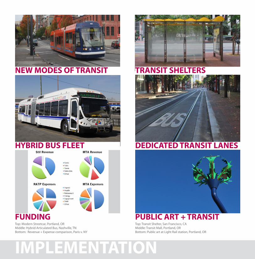
Top: Modern Streetcar, Portland, ORMiddle: Hybrid Articulated Bus, Nashville, TNBottom: Revenue + Expense comparison, Paris v. NY
Top: Transit Shelter, San Francisco, CAMiddle: Transit Mall, Portland, ORBottom: Public art at Light Rail station, Portland, OR
IMPLEMENTATION
NEW MODES OF TRANSIT TRANSIT SHELTERS
DEDICATED TRANSIT LANESHYBRID BUS FLEET
FUNDING PUBLIC ART + TRANSIT
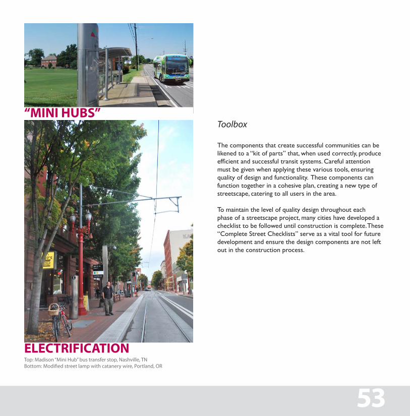
Top: Madison “Mini Hub” bus transfer stop, Nashville, TNBottom: Modified street lamp with catanery wire, Portland, OR
Toolbox
The components that create successful communities can be likened to a “kit of parts” that, when used correctly, produce efficient and successful transit systems. Careful attention must be given when applying these various tools, ensuring quality of design and functionality. These components can function together in a cohesive plan, creating a new type of streetscape, catering to all users in the area.
to maintain the level of quality design throughout each phase of a streetscape project, many cities have developed a checklist to be followed until construction is complete. these “Complete street Checklists” serve as a vital tool for future development and ensure the design components are not left out in the construction process.
53
“MINI HUBS”
ELECTRIFICATION
IMPLEMENTATION
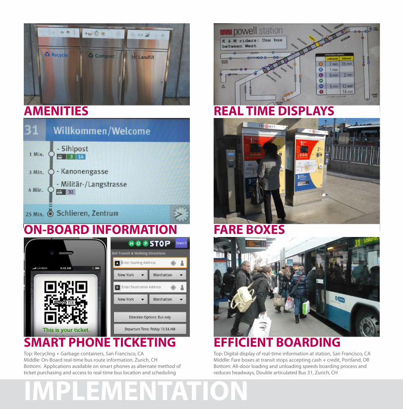
Top: Recycling + Garbage containers, San Francisco, CAMiddle: On-Board real-time bus route information, Zurich, CHBottom: Applications available on smart phones as alternate method of ticket purchasing and access to real-time bus location and scheduling
Top: Digital display of real-time information at station, San Francisco, CAMiddle: Fare boxes at transit stops accepting cash + credit, Portland, ORBottom: All-door loading and unloading speeds boarding process and reduces headways, Double articulated Bus 31, Zurich, CH
AMENITIES REAL TIME DISPLAYS
FARE BOXESON-BOARD INFORMATION
SMART PHONE TICKETING EFFICIENT BOARDING
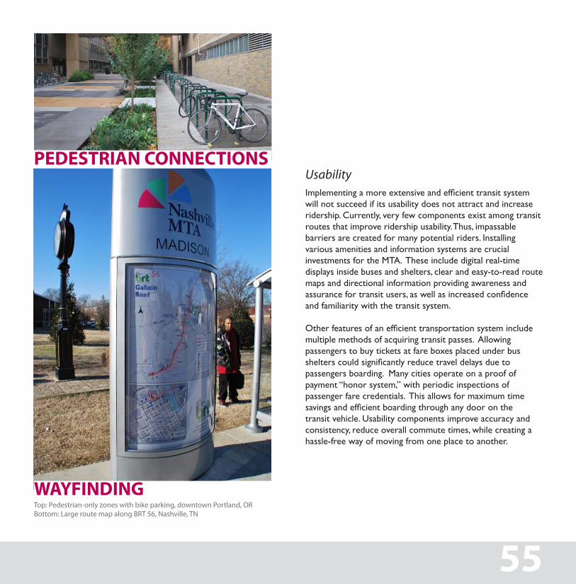
Top: Pedestrian-only zones with bike parking, downtown Portland, ORBottom: Large route map along BRT 56, Nashville, TN
UsabilityImplementing a more extensive and efficient transit system will not succeed if its usability does not attract and increase ridership. Currently, very few components exist among transit routes that improve ridership usability. Thus, impassable barriers are created for many potential riders. Installing various amenities and information systems are crucial investments for the MTA. These include digital real-time displays inside buses and shelters, clear and easy-to-read route maps and directional information providing awareness and assurance for transit users, as well as increased confidence and familiarity with the transit system.
Other features of an efficient transportation system include multiple methods of acquiring transit passes. Allowing passengers to buy tickets at fare boxes placed under bus shelters could significantly reduce travel delays due to passengers boarding. Many cities operate on a proof of payment “honor system,” with periodic inspections of passenger fare credentials. This allows for maximum time savings and efficient boarding through any door on the transit vehicle. Usability components improve accuracy and consistency, reduce overall commute times, while creating a hassle-free way of moving from one place to another.
55
PEDESTRIAN CONNECTIONS
WAYFINDING
ACKNOWLEDGEMENTSthis book was designed and written by ron Yearwood, Urban Designer, and gary gaston, Design Director of the Nashville Civic Design Center.
this book was edited by Julia landstreet, executive Director of the Nashville Civic Design Center, and Michael skipper, executive Director of the Metropolitan Planning Organization.
april 2011www.civicdesigncenter.org
Nashville Civic Design Center staff
Julia Fry landstreet, executive Directorgary gaston, Design Directorstephanie McCullough, Communications Directorron Yearwood, Urban Designer
Kira appelhans, Design FellowMelissa alexander, Design Fellow
Keaton Browder, internFinis ray, interngabrielle Westbrook, intern


LIVABILITY • PROSPERITY • SUSTAINABILITY • DIVERSITY