connecticut coastal and estuarine land conservation ... connecticut coastal and estuarine land...
TRANSCRIPT
Draft Connecticut Coastal and Estuarine Land
Conservation Program Plan
Connecticut Department of Energy and Environmental Protection
79 Elm Street Hartford CT 06106-5127
January 2015
Certification and Approval
This certifies that the Connecticut Coastal and Estuarine Land Conservation Program Plan is consistent with the federally-approved Connecticut Coastal Management Program and is adopted by the Connecticut Department of Energy and Environmental Protection pursuant to the Coastal and Estuarine Land Conservation Program Final Guidelines (June 2003) issued by the National Ocean Service National Oceanic and Atmospheric Administration Office of Ocean and Coastal Resource Management
__________________________________________ Robert J Klee Commissioner
Connecticut Department of Energy and Environmental Protection
Date______________________________________
Preparation of this plan was funded in part by National Oceanic and Atmospheric Administration Award no NA03N0S4190077
Table of Contents
List of Figures Tables and Appendices ii
I Introduction 1
A Program Background 1
B Purpose 2
II Coastal and Estuarine Land Protection Priorities 2
A Connecticutrsquos Coastal and Estuarine Area 2
B Connecticutrsquos Priority Coastal Land Conservation Values and Areas 6
B1 Coastal Land Conservation Values and Areas 6
B11 Ecologically Significant Areas 6
B12 Coastal Recreation Access Areas 8
B13 Other Areas of Significant Conservation Value 9
B2 Assessment of Need and Threats to Coastal Land Values 10
B21 The Need for Coastal Land Conservation 10
B22 Threats 21
C CELCP Project Area and Conservation Targets 26
D Description of Existing Plans Incorporated into the CELCP Plan 32
III Implementation 36
A Identification of State Lead Agency 36
B Agencies Eligible to Hold Title to Property 36
C Land Acquisition Project Nomination Process 37
C1 Identifying Coastal Land Acquisition Projects 37
C2 RFP response review and prioritization 38
C21 Proposal acceptance 40
C22 Project proposal review and ranking 38
IV Interagency Coordination and Public Involvement 41
i
Figures Tables and Appendices
Figures
Figure 1 ndash Connecticutrsquos Coastal and Estuarine Area 4 Figure 2 ndash Connecticutrsquos Coastal Watershed 5 Figure 3 ndash Connecticut Land Cover 12 Figure 4a ndash Western Project Area 2002 Land Cover 13 Figure 4b ndash Eastern Project Area 2002 Land Cover 14 Figure 5 ndash Connecticutrsquos Coastal Eco-region 29 Figure 6 ndash CELCP Project Area Municipalities 30 Figure 7 ndash CELCP Focus Areas 30
Tables
Table 1 ndash Typical or Representative Coastal Systems of Long Island Sound 7 Table 2 ndash Outstanding Coastal Habitats or Systems 8 Table 3 - Connecticut Coastal Shoreline Statistics 15 Table 4 ndash 2001-2007 Coastal Land Acquisitions with Water or Marsh Frontage 16 Table 5 ndash Demand for Coastal Public Access by Type of Activity 19 Table 6 ndash Connecticut Project Nomination Criteria 35 Table 7 - National Project Selection Criteria 37
Appendices -not included in this draft
Appendix 1 ndash Coastal and Estuarine Planning Area Municipalities Appendix 2 ndash Connecticutrsquos Coastal Resource Definitions Appendix 3 ndash Coastal Land Assessment Methodology Results Summary Appendix 4 ndash CELCP Project Area Municipalities Appendix 5 ndash Rare and Endangered Species of Connecticut and Their Habitats Appendix 6 ndash Connecticut Statewide Comprehensive Outdoor Recreation Plan Appendix 7 ndash Connecticut Green Plan Appendix 8 ndash Long Island Sound Stewardship Initiative Strategy Appendix 9 ndash Connecticut Coastal Recreation Access Survey Results Appendix 10 ndash Northeast Coastal Areas Study Significant Coastal Habitats of Southern New
England and Portions of Long Island New York Appendix 11 ndash Connecticut River Estuary and Tidal River Wetlands Complex Appendix 12 ndash Criteria for Inclusion ndash Ramsar Wetlands of International Importance Nomination Appendix 13 ndash Ramsar Core Sites Appendix 14 ndash Long Island Sound Habitat Restoration Sites Appendix 15 ndash Connecticut Comprehensive Wildlife Conservation Strategy Appendix 16 ndash Connecticut Statewide Forest Resource Plan Appendix 17 ndash Responses to CELCP Conservation Needs Survey Appendix 18 ndash Connecticut Waterfowl Concentration Areas map Appendix 19 ndash Connecticut Waterfowl Concentration Area Descriptions
ii
Connecticut Coastal and Estuarine Land Conservation Program Plan
I Introduction
A Program Background
The national Coastal and Estuarine Land Conservation Program (CELCP) was established by the Department of Commerce Justice and State Appropriations Act of 2002 It directs the Secretary of Commerce through the National Oceanic and Atmospheric Administration (NOAA) to administer a federal financial assistance program available to coastal states for coastal land acquisition The purpose of CELCP is to ldquoprotect important coastal and estuarine areas that have significant conservation recreation ecological historical or aesthetic values or that are threatened by conversion from their natural or recreational state to other uses giving priority to lands which can be effectively managed and protected and that have significant ecological value1rdquo Available program funds are administered through a competitive grant program by NOAArsquos Office of Ocean and Coastal Resource Management (OCRM) pursuant to the Coastal and Estuarine Land Conservation Program Final Guidelines (2003) 2 Prior to 2007 CELCP funds were directed by Congress through federal agency appropriation bills rather than through a NOAA-administered competitive state coastal land acquisition grant program Beginning in fiscal year 2007 CELCP funds were awarded through a NOAA-administered competitive state grant program which is expected to continue in future federal funding cycles Notices of CELCP federal funding opportunities are usually issued in early winter with proposals due in early spring In order to receive CELCP coastal land acquisition funding through the NOAA-administered competitive state grant program coastal states are expected to
bull Develop a state CELCP plan for approval by NOAA-OCRM bull Solicit land acquisition project proposals (which may include acquisition of conservation
easements) from stakeholders (eg coastal municipalities land trusts regional planning agencies state agencies) consistent with the conservation priorities outlined in its CELCP plan
bull Nominate its highest priority coastal land acquisition projects for review by a national project review selection committee
bull Successfully compete with other coastal state land acquisition project proposals pursuant to a national CELCP project review committeersquos scoring and ranking of land acquisition project proposals
1 Public Law 107ndash77 2 Unless otherwise defined here the Guidelinesrsquo definitions apply to the terms used in Connecticutrsquos Coastal and Estuarine Land Conservation Program Plan (CELCP Plan) The Guidelines may be accessed at httpcoastalmanagementnoaagovlandmediaCELCPfinal02Guidelinespdf
1
B Purpose
Connecticutrsquos CELCP Plan describes the Statersquos coastal land conservation needs and prioritizes the types of coastal land acquisition opportunities that can be nominated for federal CELCP grant financing assistance The Plan outlines a process to promote partnerships with municipalities and land trusts to identify land acquisition opportunities that address Connecticutrsquos priority conservation needs which that the basis for Connecticutrsquos CELCP Plan In addition to identifying Connecticutrsquos priority coastal land conservation needs the Plan provides guidance for selecting coastal land acquisition projects for nomination to the national CELCP project selection competition In the past coastal land acquisitions by the State of Connecticut were typically made on an ad hoc basis in response to acquisition opportunities offered to the Connecticut DEEP by landowners or others who became aware of properties being offered for sale Although this approach to coastal land acquisition has resulted in successful acquisitions important coastal land acquisition opportunities have been missed because they were not identified and acted upon early enough in the landownerrsquos property disposition decision-making process Connecticutrsquos CELCP Plan offers a more proactive and strategic approach to coastal land acquisition based on
bull Priority coastal land conservation values identified in consultation with resource experts and land conservation interest groups
bull Land acquisition targets within areas where acquisition opportunities are most likely to address priority coastal land conservation needs
bull Cooperation with coastal land acquisition partners to identify possible coastal land acquisition opportunities that meet a priority coastal land conservation need
bull Strong working relationships with owners of high priority coastal conservation land who have been contacted in advance of NOAA CELCP Program funding announcements
bull Partnering with other land acquisition funding programs with objectives complementary to CELCP and
bull Land stewardship for newly acquired properties through partnerships with local land trusts and other land managers especially if state or municipal agencies holding title to acquisitions do not have the resources to effectively manage acquired properties
II Coastal and Estuarine Land Protection Priorities
A Connecticutrsquos Coastal and Estuarine Planning Area
National CELCP Guidelines require coastal states to identify areas within which coastal land conservation values and potential coastal land conservation acquisition opportunities should be evaluated This area referred to as the coastal estuarine planning area defines the broadest area in which to evaluate coastal land conservation values and potential coastal land acquisition opportunities (see Section II B for a description of Connecticutrsquos priority coastal land conservation values) Connecticut has adopted a portion of its federally-approved coastal nonpoint source pollution management (CNPM) area as its Coastal and Estuarine Planning Area
2
(see Figure 1- Coastal and Estuarine Planning Area and Appendix 1 - Coastal and Estuarine Planning Area Municipalities) 3 Three fundamental water quality protection planning factors used to define Connecticutrsquos CNPM area are also appropriate for defining Connecticutrsquos Coastal and Estuarine Planning Area They include (1) existing land uses likely to contribute pollutants of concern to Long Island Sound (2) proximity of those uses to the Sound and (3) existing condition of coastal waters including areas with existing impaired uses as well as those that might be threatened by future development particularly by land uses known to generate significant pollutant loads Connecticutrsquos CNPM area was determined to be appropriate to ensure implementation of CZARA required management measures to restore and protect Connecticutrsquos coastal and estuarine waters The CNPM area includes the area containing all 13 classes of Connecticutrsquos statutorily defined coastal resources (see Appendix 2 - Connecticutrsquos Coastal Resources) and other coastal resources identified as a conservation priority through resource conservation planning initiatives (eg coastal forests identified through the LIS Stewardship Initiative) The national CELCP Final Guidelines provide that a statersquos coastal watershed is the maximum allowable Coastal and Estuarine Area Connecticutrsquos coastal watershed 4 includes a 4600 square-mile area within Connecticut as shown in Figure 2 Connecticutrsquos Coastal and Estuarine Planning Area contains 2073 square miles or 45 percent of Connecticutrsquos coastal watershed Connecticutrsquos Coastal and Estuarine Area therefore is a reasonable area within which to evaluate possible coastal land acquisition opportunities that address Connecticutrsquos priority coastal land conservation needs
3 The CNPM area was developed pursuant to Section 6217 of Coastal Zone Act Reauthorization Amendments (CZARA) of 1990 [16 USC Section 1455] that required states with approved coastal management programs to develop coastal nonpoint source pollution control plans This planning area was adopted in lieu of Connecticutrsquos federally-recognized Coastal Zone Management Programrsquos coastal area (defined by the boundaries of Connecticut 36 cities and towns containing coastal waters the limits of which are approximated by the coastal boundary line shown in Figure 1) because it better identified those areas where conversions in land use could adversely affect coastal water quality or provide new water-dependent outdoor recreation opportunities along tidal watercourses 16 USC Section 1455 4 Coastal watersheds are defined in NOAArsquos Coastal Boundary Review (1992) as the watershed area defined by the inland boundary of those USGS cataloguing units that contain the extent of tidal influence (ie head of tide)
3
Figure 1 Coastal and Estuarine Planning Area
4
Figure 2 Connecticutrsquos Coastal Watershed
5
B Connecticutrsquos Priority Coastal Land Conservation Values and Areas
B1 Priority Coastal Land Conservation Values and Areas Defined Connecticutrsquos priority coastal land conservation values and areas are those that provide or are capable of providing (1) Ecologically significant areas especially unique rare or representative LIS habitat and landscape types under- represented in Connecticutrsquos system of protected open space (2) coastal access recreation sites providing coastal resource-based outdoor recreation opportunities serving areas of significant unmet need and (3) other areas of exceptional or unique ecological productivity or value and sites of significant cultural or historic heritage value These conservation values as further described below serve as the basis for Connecticutrsquos CELCP Plan and will be used to help identify the Statersquos most critical coastal land conservation needs B11 Ecologically Significant Areas
Connecticutrsquos ecologically significant coastal areas are those areas (1) typical or representative of Long Island Sound coastal systems (2) providing outstanding examples of those coastal systems or (3) providing rare species habitat or habitat for species warranting special management attention or greatest conservation need B111 Coastal systems typical or representative of the Long Island Sound ecosystem Preserving through acquisition the best of Connecticutrsquos remaining unprotected largely intact representative coastal habitats or landscapes types is critical to sustaining the ecological services of core areas providing such benefits Such conservation actions will also ensure that future generations will be able to study and understand Connecticutrsquos coastal natural heritage as only remnants of many of these coastal systems remain today and new threats to these areas are expected Emphasis will be placed on acquiring property containing coastal habitats or landscape types under-represented in Connecticutrsquos system of existing protected open space (eg state and municipal parks preserves wildlife management areas or land in conservation ownership held for dedication conservation purposes) Table 1 provides a description of coastal systems habitats and landscapes typical or representative of Connecticutrsquos Coastal and Estuarine Area and lists their conservation priority
6
Table 1 Typical or Representative Coastal Systems of Long Island Sound5
5 Not including subtidal resource systems (eg submerged aquatic vegetation selfish beds etc) which are already held as State public trust land
6 Beaches and dunes with significant biologic andor flood control value designated as units of the Federal Coastal Barrier Resources System (CBRS) are a high conservation priority within this class (see general locations for CBRS units in Connecticut at httpwwwfwsgovcbraMapsLocatorCTpdf then select corresponding Connecticut CBRS unit of interest to access more detailed maps using the following link httpwwwfwsgovcbraMapsCBRSindexhtml 7 Only upland areas adjacent to these resources capable of supporting marine transgression are considered a highest
conservation priority resource area Refers only to undeveloped uplands adjacent these intertidal resource areas Coastal forests are characterized by a vegetation pattern influenced by a climate regime affected by the
moderating effects of Long Island Sound that extends 5 to 7 miles inland of Long Island Sound On well-drained soils coastal hardwoods often with dense thickets of vines and shrub dominate Coastal hardwoods are dominated by Red (Quercus rubra) White (Quercus alba) and especially Black Oak (Quercus velutina) Hickories especially Mockernut (Carya tomentosa) Black Cherry (Prunus serotina) and Sassafras (Sassafras albidum)) (Dowhan and Craig 1976) Coastal forests occurring on less well-drained soils referred to as ldquomoist coastal forestsrdquo are characterized by a predominance of less drought resistant trees shrubs and vines
Secondary dunes are those dunes landwards of primary dune systems Back barrier sand flats are gently sloping sandy unvegetated or sparsely vegetated intertidal areas of coarse sediment on the inland side of barrier beaches
Coastal HabitatSystemLandscape
Under-Represented in Existing System of
Protected Open Space ()
Highest Conservation Priority
()
Barrier beachdune6 Brackishsalt water tidal marsh7 Freshwater tidal marsh Rocky shorefronts Bluffsescarpments (unarmored) Estuarine embayments Coves within estuarine embayments Islands ndash Long Island Sound Islands- riverine
Large unfragmented coastal forest
Intertidal mud flats Coastal area grasslands Secondary dunesback barrier sand flats
7
B112 Outstanding habitats and systems representative of Long Island Sound ecosystems
This class of ecologically significant areas includes those that provide outstanding examples of coastal systems because of their quality or scarcity in the regional landscape Such areas offer the best examples of Connecticutrsquos coastal landscapes or are the last remaining examples of their kind and therefore are a high priority conservation target especially where they are part of a larger high conservation priority coastal system Table 2 provides descriptions and examples of these systems
Table 2 Outstanding Coastal Habitats or Systems
Refers to adjacent upland riparian areas that buffer these water areas B113 Habitat for rare species or species requiring speial management attention
These sites provide habitat for species identified as (a) Rare by virtue of being listed as Federally or State-endangered threatened or species of special concern8 (b) Greatest Conservation Need (GCN) pursuant to Connecticutrsquos Comprehensive Wildlife Conservation Strategy9 or (c) rated ldquonear-threatenedrdquo or greater according to the IUCN ldquoRed Listrdquo10 Conservation emphasis is placed on sites with multiple species or high concentrations of a single
8 See State list at httpwwwctgovdeepcwpviewaspa=2702ampq=323486ampdepNav_GID=1628ampdepNav=| and Federal list wwwfwsgovnortheastendangered 9 See Chapter 4 of CT CWCS at wwwctgovDEEPcwpviewaspa=2723ampq=329520ampDEEPNav_GID=1719 Area) 10 See International Union for the Conservation of Nature and Natural Resources (IUCN) Red-List at httpwwwiucnredlistorg
HabitatEcosystemLandscape Type Site Example Undeveloped LIS islands Duck Island (Westbrook) Unditched tidal marshlowast Nells Island marsh (Milford) Secondary dunes Black Point Beach (East Lyme) Riverine coveembayment Poquetanuck Cove (PrestonLedyard) LIS coveembayment Wequetequock Cove (Stonington)
Sand plain grassland Lower Quinnipiac River grassland (North
Haven) Estuarine embayments with extraordinary aquatic habitat value (eg shellfishSAV) Niantic RiverBay (East LymeWaterford) Coastal forest Barn Island WMA (Stonington) Coastal grass land Niering Natural Area Preserve (Waterford) Traprock ridge West Rock (New HavenHamden) Colonial waterbird complex Falkner Island Guilford) Sites of significant diadromous fish runs Head-of-tide Hammonassett River (Madison)
8
species These sites are therefore a conservation priority and in some cases should be acquired to solely meet ecological conservation objectives rather than supporting multiple use objectives
B12 Coastal Recreation and Access
A hallmark of Connecticutrsquos coastal management program is the enhancement of public access to coastal waters for coastal resource-based recreation Areas capable of providing coastal access opportunities particularly in areas underserved by existing recreational access and ldquodistressed municipalitiesrdquo11 are a conservation priority12 Access opportunities range from sites providing visual access to coastal waters (eg scenic overlooks) to those providing direct physical access to coastal waters (eg boating access facilities) and include
bull Car-top boating not requiring trailered-launch facilities bull Shore-based fishing crabbing or recreational shell fishing access especially those sites
identified as an acquisition priority through coastal access surveys bull Passive recreation activities (eg hiking) in areas of significant or unique geologic or
biologic interest or part of an existing or planned greenway trail or linear park bull Wildlife observation (particularly birding) access areas especially observation areas
underserved by existing public access sites (eg Quinnipiac River marshes) bull Waterfowl hunting bull Sandy beach areas providing access to saltwater bathing opportunities bull Urban waterfront sites with coastal recreation value (eg waterfront lsquopocket-parksrsquo in
high density residential neighborhoods) that meet a priority municipal recreation need (eg fishing access) as identified in a municipal plans of conservation and development or recreation plan
B13 Other Areas of Significant Coastal Conservation Value
Other coastal resource values that meet a significant coastal land conservation need but are not identified above constitute an additional category of coastal conservation values and include
bull Significant foragingnesting habitat for water birds shorebirds and migratory waterfowl including uplands adjacent to these habitats that provide protective buffers13
bull Sites identified as priority coastal resource restoration sites pursuant to the Long Island Sound Habitat Restoration Initiative14 where public ownership is necessary to complete a proposed restoration project and for which funding has already been secured or is imminent
11 Defined in Connecticut General Statutes Section 32-9p(b) 12 Although coastal resource based outdoor recreation is a priority conservation value it should be noted that CELCP grants can only be used to fund land acquisition and cannot fund construction of recreation facilities 13 See locations of waterfowl concentration areas in Appendix _ for descriptions of these areas Other areas not yet documented believed to serve as important habitat functions may qualify as priority acquisition areas 14 See Appendix 14 - LIS Habitat Restoration Sites Map Restoration projects must include a detailed description of the proposed restoration plan and confirmation of a restoration funding source
9
bull Lands adjacent to or significantly contributing to the quality of coastal waters of exceptional quality or aquatic resource value (eg shellfish concentration areas and natural seed beds)
bull Sites of statewide historic or cultural significance as confirmed by the Connecticut Office of the State Historic Preservation
bull Scenic areas visible from an area accessible to the general public (eg state or municipal parks state highway etc) that significantly contribute to defining a local coastal landscape
bull Parcels adjacent to or in-holdings withinan existing CT DEEP or other regionally-significant protected open space which if developed would significantly diminish existing or potential plant or wildlife habitat or create public lands management problems
bull Inland wetlands with significant or rare ecologicalhabitat value (eg highly productive vernal pools fens bogs)
bull Sites capable of providing connections for public access or habitat between existing protected open space parcels
bull Sites that can be documented as significantly contributing to watershed health especially by protecting coastal water quality
B2 Assessment of Need and Threats to Coastal Land Values
B21 The Need for Coastal Land Conservation
B211 Context and obstacles to coastal land conservation
From Connecticutrsquos earliest colonial period Connecticutrsquos shoreline communities have been principal centers of trade commerce and transportation Over 350 years of post-European settlement history along has resulted in the conversion of much of Connecticutrsquos coastal area to uses that have adversely affected coastal land conservation values For example it is estimated that approximately 30 percent of Connecticutrsquos tidal wetlands have been filled and up to 90 percent may have been ditched or otherwise altered through human activity15 It is within such context that Connecticut must develop coastal land strategies to conserve its most significant remaining unprotected coastal areas capable of supporting important ecological services and coastal resource based outdoor recreation opportunities
Competition for use and development of Connecticutrsquos coastal area continues to diminish Connecticutrsquos priority land conservation values and result in lost conservation acquisition opportunities Development population densities and land values within Connecticutrsquos coastal
15 Tidal Marshes of Long Island Sound Bulletin No 34 The Connecticut College Arboretum and US Environmental Protection Agency Technical Support for Coastal Habitat Restoration
10
area exceed statewide averages Connecticutrsquos Coastal and Estuarine Program Project Area16 is highly urbanized [see Figures 3 4a and 4b] For example 37 of the Connecticutrsquos population resides within the Statersquos 36 coastal municipalities which comprise only 19 of the Statersquos land area17 Further 34 of the area within Connecticutrsquos CELCP Project Area and 51 of the area within Connecticutrsquos coastal boundary18 is classified as ldquodevelopedrdquo land cover compared to 23 statewide19 These population density and land development statistics indicate that there is a disproportionate need to address Connecticutrsquos most significant remaining coastal land acquisition opportunities
16 Connecticutrsquos Coastal and Estuarine Land Conservation Program Project Area is the area within the Coastal and Estuarine Planning Area that is most likely to include Connecticutrsquos priority coastal conservation values and areas as shown in Figures 5 and 6 17 2000 Census data provided Connecticut Office of Policy and Management 18 Connecticutrsquos coastal boundary is generally defined by a line 1000 feet inland of a coastal water body or tidal
wetland whichever is further inland 19University of Connecticut Changing Landscape Project (2003)
11
Figure 3 Connecticut Land Cover
2002 Land Cover State of Connecticut
23
12
56
3 4 2 Developed
Other Grasses
Forest
Water
Wetland
Other
2002 Land Cover CELCP Project Area
34
7 47
4 6 2 Developed
Other Grasses
Forest
Water
Wetland
Other
2002 Land Cover Coastal Boundary
51
5
19
6t
15 4
Developed
Other Grasses
Forest
Water
Wetland
Other
Developed land includes built areas containing impervious surface such as roads parking lots structures and maintained turfgrass (distinguished from the ldquoother grassesrdquo land cover) associated with commercial industrial and residential uses
Source University of Connecticut-CLEAR Coastal Area Land Cover Analysis Project
12
13
14
When interpreting the maps shown in Figures 4a and 4b it is important to note that Connecticut coastal land cover is depicted at a statewide scale which is intended to show general patterns of coastal land cover at a moderate (ie 30 square meter) resolution20 These maps are not intended for site level coastal land acquisition planning For example although the Western Connecticut Project Area 2002 Land Cover Map indicates that much of the near shore area in Western Connecticut Project Area is developed important conservation acquisition opportunities may still exist in this region When such opportunities arise they should be given special consideration if they advance priority conservation values identified in Section II B of this Plan When land cover data is projected at a larger scale and combined with other parcel-scale land conservation data land that may warrant protection through acquisition particularly for coastal recreation purposes may still be identified However it is expected that larger undeveloped parcels with significant ecological value are more likely to occur in the eastern Connecticut CELCP Project Area where land values are significantly lower than along the western Connecticut shoreline It is therefore within this region that Connecticut will likely identify its best remaining coastal land conservation opportunities that may qualify for CELCP land acquisition funding assistance
Table 3 compares the amount of land fronting on Connecticut coastal waters in conservation ownership with land not managed for conservation purposes or without conservation restrictions The table derived from data obtained through the Connecticut Shoreline Statistics Project classifies Connecticutrsquos shore by type of shoreline (eg direct Long Island Sound frontage embayments saltwater rivers etc) and ownership (ie protected vs unprotected classes of ownership)21 Table 3 also describes the type of ownership for each of these classes of shoreline These data indicate that 31per cent of Connecticutrsquos total coastal shoreline (1065 miles) is held in protective forms of ownership or subject to conservation restrictions The State of Connecticut (almost entirely the Department of Energy and Environmental Protection) holds title to 13t of the Statersquos shoreline or 140 miles of protected shorefront
20 See the University of Connecticut CLEAR project website lthttpclearuconneduprojectslandscapev1analysisCALCAPindexhtmgt for more on map scale data and resolution
21 The project defined coastal shoreline as any land fronting on tidal waters up to Connecticutrsquos statutorily defined coastal boundary (Connecticutrsquos coastal boundary generally extends 1000 feet upland of the inland boundary of tidal waters with at least 5 parts per thousand of salt) For the purposes of these statistics coastal shoreline is classified according to the following classes of coastal waterbodies they abut or a unique type of shoreline including (1) directly fronting on Long Island Sound (2) bays harbors and coves (3) major rivers including their tributaries (4) minor coastal rivers (5) islands in Long Island Sound (6) islands within rivers and (7) shoreline created through artificial fill (such as filled piers groins or jetties)
15
Table 3 Connecticut Shoreline Statistics 12
1 Protected shoreline is land classified as protected open space fronting on coastal waters including rivers within Connecticutrsquos coastal boundary Protected open space is defined as land or an interest in land held for the permanent protection of natural features of the statersquos landscape essential habitat for endangered or threatened species non facility-based outdoor recreation (does not include ballfields cemeteries school grounds etc) forestry and fishery activities and other wildlife or natural resource conservation or preservation purposes 2 All measurements are rounded to the nearest tenth of a mile 3 LIS Direct = Direct Long Island Sound frontage not including frontage on bays harbors coves or the mouths of rivers on Long Island Sound 4 BHC = Bay harbor cove frontage on Long Island Sound 5 Includes coastal (ie saltwater influenced) segments of the Housatonic Connecticut Thames Rivers and their tributaries up to Connecticutrsquos statutorily defined coastal boundary (For example frontage on the Eight Mile River a tributary to the Connecticut River was included in major river shoreline frontage) Major river shoreline frontage includes coves within major rivers Frontage on watercourses that originate in tidal wetlands were excluded from all shoreline frontage calculations 6 All coastal (ie saltwater influenced) rivers not classified as major rivers up to Connecticutrsquos statutorily defined coastal boundary 7 Shoreline created through the placement of fill material in coastal waters that can be readily identified such as artificial shoreline perpendicular to the course of the natural shoreline This does not include existing transportation infrastructure such as railroad causeways 8 Sandy beach shoreline occurs within several shoreline types in this table but is reported separately because it is a significant ecological and recreational resource in Connecticut
LIS Direct BHC Major River Minor River Island (LIS) Island (River) Artificial Fill
Miles3 Miles4 Miles5 Miles6 Miles Miles Miles7 Miles of CT Miles of CT Protected Public 25 53 34 69 22 45 2 250 23 27 3 Federal 0 12 2 2 6 0 0 22 2 1 0 State 9 13 26 45 2 44 1 140 13 9 1 Municipal 16 28 6 22 13 2 0 88 8 17 2Protected Private 4 9 27 27 4 7 0 78 7 4 0 Land Trusts 0 5 10 17 2 3 0 38 4 0 0 Utility 0 0 0 1 0 0 0 1 0 0 0 Churches 0 0 0 0 0 0 0 0 0 0 0 Private 3 4 12 7 2 4 0 33 3 2 0 Conserv Easement 1 0 4 1 0 0 0 6 1 1 0 Other 0 0 0 0 0 0 0 0 0 0 0Total Protected 29 62 61 96 26 52 2 328 31 31 3Unprotected 84 157 160 227 60 24 25 737 69 57 5Total Shoreline 113 219 221 323 86 77 27 1065 100 88 8
Ownership ClassTotal Sandy Beach8
16
Much of Connecticutrsquos coastal area not protected through public or private non-profit land conservation organization ownership is already developed22 An assessment of the larger remaining undeveloped and unprotected parcels within 32 of Connecticutrsquos 36 coastal municipalities indicates that only 78 undeveloped parcels greater than 25 acres exist within 1000 feet of coastal waters (see Appendix 3-Coastal Land Assessment Methodology Results) Of these approximately 50 may have significant conservation value warranting further investigation These larger undeveloped parcels are also expected to be highly desirable for future residential development Once such properties are acquired by developers and particularly after municipal land use permits have been issued it is difficult to acquire these properties for conservation purposes at prices approximating their pre-permit approval appraised values Acquiring properties for conservation after ownership is transferred or is under option for sale to a developer accelerates the depletion of limited conservation acquisition resources The coastal real estate market for raw land in Connecticut is highly constrained Very few undeveloped waterfront or near-waterfront properties on Long Island Sound including coves embayments and the mouth of major tributaries are placed on the market each year Those parcels that are offered tend to be less than 10 acres Seven coastal area properties greater than 10 acres with water or tidal marsh frontage within Connecticutrsquos CELCP Project Area were acquired by CT DEEP for conservation purposes between 2001 and 2011 (see Table 4) These properties were acquired at acquisition prices ranging from $7500acre to $228689acre with a median value of $24173acre Excluding the two lowest-value waterfrontmarsh-front acquisitions that were largely undevelopable the average cost of these acquisitions was $71866acre The average cost of a CT DEEP non-coastal fee acquisition (ie not including conservation easement acquisitions) from 2005-2014 was $8138acre (73 properties) Such a differential in coastal versus inland parcel acquisition cost often makes it difficult to justify allocating limited state land acquisition funding for coastal land acquisition projects Although average value of coastal land acquisitions were derived from a small sample of coastal acquisitions and cannot confidently be interpreted to represent lsquotypicalrsquo coastal area marsh or waterfront land values compared to average acquisition costs for inland parcels the cost of land acquisition along the coast is significantly greater than comparable inland parcels
22 ldquoDevelopedrdquo is defined as built areas typically associated with commercial industrial and residential uses containing impervious surface such as roads parking areas and structures and also includes maintained turfgrass
17
Table 4 2001-2009 CT DEEP Coastal Project Area Land Acquisitions with WaterMarsh Frontage23
As a result the single greatest impediment to acquiring coastal land for conservation is the gap between available funding and the cost of such acquisitions Nevertheless another impediment to effective state coastal land acquisition has been the lack of a comprehensive evaluation of the most significant remaining potential coastal land acquisition opportunities based on identified coastal land conservation needs Until recently Connecticut used a more opportunistic approach to coastal land conservation relying on ad hoc acquisition decisions as coastal land acquisition were offered to CT DEEP In the past the Department did no pursue opportunities to acquire high conservation value lands not yet formally offered on the open real estate market Such opportunities are often identified only after a property with significant conservation value is proposed for development or has already been sold to a developer Developers sometimes acquire open land to speculate of future increases in the propertyrsquos value upon obtaining the necessary municipal land development approvals irrespective of their plans to actually develop the property At times developers have attempted to enhance the potential value of such lands by proposing more intensive development than what is allowed ldquoas-of-rightrdquo by municipal zoning regulations In this scenario a developer applies to a municipal zoning agency to re-zone the property or applies for a special use permit or affordable housing development24 to develop the land beyond its existing permitted uses or densities to maximize the developerrsquos potential return on investment Such an investment includes costs associated with
23 Does not include conservation acquisitions by others (eg municipalities) funded in part by CT DEEPrsquoS Open Space and Watershed Protection Grant Program 24 See Connecticut General Statutes Sections 8-30g (et seq) for description of how municipal zoning and affordable housing law generally places the burden of proof on municipal land use commissions denying an affordable housing permit application to demonstrate that a denial is necessary torsquo protect substantial public interests in health safety or other matters which the commission may legally consider and such public interests clearly outweigh the need for affordable housingrsquo
Property Name
Town
Purchase Date
Purchase Price ($)
Size (Acres)
$Acre
Harkness State Park-Verkades Nursery
Waterford 2002 3800000 1572 24173
Clark Creek WMA-Camelot Cruise
Haddam 2003 1350000 174 77586
Eagle Landing State Park - Camelot Cruises
Haddam 2003 2790000 122 228689
Barn Island WMA-Manousus
Stonington 2003 1400000 1441 9715
Barn Island WMA-Crowley 1
Stonington 2009 920000 480 19167
East River Marsh WMA Guilford 2010 360000 480 7500 Barn Island WMA-Crowley 2
Stonington 2011 1512500 170 94531
Acquisition contains significant constraints to development
18
identifying developable land negotiating and executing the land acquisition holding the property (eg cost to acquire an option debt service and real estate taxes) designing the development (eg engineering services) and obtaining permits to develop the property Once these costs are incurred the value of the property increases to reflect the uses allowed by ldquoup-zoningrdquo the property or upon issuance of development permits At this point the risk associated with developing the property declines (ie permits have been secured) and the price the developer will sell the property (eg to a builder or land conservation organization) will increase significantly sometimes eliminating or greatly reducing opportunities to acquire it for conservation The price of several recent DEEP coastal land acquisitions listed in Table 4 were affected by this land speculation process and other acquisition opportunities were forgone because they became lsquounaffordablersquo or they were sold to other developers or builders By identifying priority coastal land acquisition opportunities and negotiating land acquisition deals with landowners before they sell to developers or begin the development permitting process DEEP and other coastal land conservation partners can more effectively use limited land conservation acquisition funds to conserve lands that meet Connecticutrsquos coastal land conservation objectives B212 Need for coastal recreation opportunities
There are approximately 300 public access sites providing a range of outdoor recreation opportunities along Connecticutrsquos coastal shoreline Of these sites approximately 75 percent are either small municipally-owned (less than 10 acres) or privately-owned sites (less than 1 acre) open to the public access through public access easements or other enforceable municipal land use permit conditions About 20 percent of the access sites are larger state-owned properties (eg State Parks) while relatively few (5 percent) properties are private non-profit land conservation organization holdings or a unit of the Stewart B McKinney National Wildlife Refuge (NWR)25 However the number of coastal sites is not an entirely accurate indicator of the extent of Connecticutrsquos shoreline accessible to the general public That is the number of public access sites does not describe the miles or percent of Connecticut shoreline available for public use or degree to which Connecticutrsquos shoreline is under protective ownership (for statistics describing Connecticutrsquos shoreline ownership see Table 3 Shoreline Ownership Statistics) Nor do these shoreline access statistics indicate the quality of shoreline recreation experience at public access sites or whether the sites can accommodate some of the most popular coastal recreational activities such as saltwater bathing boating access saltwater fishing wildlife viewing) Demand for many of the statersquos most popular coastal recreational activities along some part of the coast already exceed and will likely continue to exceed the capacity of existing coastal recreation areas to accommodate these uses Opportunities for new public saltwater swimming beaches are limited because there are few significant lengths of sandy beach not already under public ownership or operated by a private beach association These factors and the proximity of several of the statersquos most densely populated metropolitan areas to the coastline are expected to continue to generate significant demand for coastal recreation opportunities at Connecticutrsquos shoreline state and municipal parks Two of the statersquos four coastal parks with saltwater
25 SB McKinney NWR is the only federal agency land generally available for public use
19
swimming beaches periodically must turn away prospective patrons by mid-day on summer weekends when parking lots meet capacity Similarly municipally owned shoreline beach parks routinely operate near capacity during summer weekends State boat-launching facilities on coastal and tidal waters are also consistently unable to meet the publicrsquos boating access needs on summer weekends Of the 13 state-owned boat launch ramps located directly on Long Island Sound four routinely turn away boaters on popular summer weekends due to parking space limitations (personal communication DEEP Bureau of Outdoor Recreation State Parks Field Operations Division) Pursuant to a 2002 NOAA-OCRM national effectiveness study of state coastal public access programs coastal states were encouraged to conduct needs assessments of coastal land conservation and public access enhancement priorities In 2004 Connecticut distributed over 1000 surveys to members of coastal recreation user groups and individuals with an interest in coastal recreation seeking to identify public access facilities needs and the recreation habits of saltwater anglers waterfowl hunters marine boaters and wildlife observation enthusiasts The principal purpose of the survey was to assess whether existing coastal recreation facilities in Connecticut were meeting demand for these popular recreation activities and how these facilities could be managed to better meet user needs identified through the surveys The survey responses are summarized in Table 5 by type of recreational activity26 The responses indicate a continued need to acquire sites capable of accommodating these coastal recreation activities
26 Saltwater swimming a highly popular coastal recreation activity was not included in the survey because existing information already confirms that demand for this activity exceeds the capacity of existing facilities to meet demand Further a lack of available sites to develop new salt water swimming facilities would make futile any investigation of new facilities save the unlikely event that private beach clubs and associations with suitable sandy beach make their land available for acquisition
Table 5 Demand for Coastal Public Access by Type of Activity
Recreational Activity
Indicating Additional Access
Needed Crossing Private
Land to Access Shore Wildlife Observation 81 NA
Boating Access 83 NA Saltwater Angling NA 36
20
B22 Threats
B221 Threats to Connecticutrsquos coastal conservation values
Human disturbance particularly through new residential development is the principal threat to Connecticutrsquos remaining unprotected coastal lands with significant ecological or outdoor recreation value If such development is not managed through regulatory review processes to protect these resources to the maximum extent possible the habitats and recreational uses they support are diminished sometimes irretrievably The following describes the principal threats to Connecticutrsquos highest priority coastal conservation values and discusses strategies to identify and manage sites that support these values principally through land acquisition B222 Threats to ecological values
Human encroachment and land disturbance within the coastal area has resulted in the loss or degradation of essential estuarine and coastal habitats The extirpation or population declines of several species of plants and animals within the coastal area with the consequent biological diminution of the region can be attributed to many factors Historically destruction of natural habitats through dredging filling ditching and draining of wetlands was associated with the construction of transportation infrastructure However the enactment and improved administration of regulatory programs governing such activities since the late 1970s has greatly reduced the direct adverse effects of large scale infrastructure projects on coastal resources Despite additional controls and conditions placed on permits for coastal area residential development and attendant ancillary shoreline structures (eg docks piers bulkheads etc) cumulative and secondary impacts associated with such development often fragment habitat diminishing its ability to support species of conservation concern (US Fish and Wildlife Service Northeast Coastal Areas Study and personal communication with DEEP-Geological and Natural History Survey staff) New threats to coastal resources particularly threats to tidal marshes such as sea-level rise also should be considered when identifying coastal land acquisition targets to preserve priority coastal land conservation values
B2221 Foragingnesting habitat for water birds shorebirds and waterfowl
Human disturbance associated with public recreational use of foraging and nesting habitat for water birds shorebirds and waterfowl can adversely affect these important bird habitats In some coastal areas repeated disturbances can result in abandonment or limited productivity of important habitats such as coastal mudflats and sandy beach nesting areas affecting in some cases species of continental or global conservation concern Development along coastal estuarine and contributing upstream areas is believed to alter hydrologic regimes in essential habitats such as tidal marshes resulting in displacement of native plant species by invasive species and the degradation of water quality in shallow water habitats such as obstructed coves Activities that disturb waterbird colonies in Long Island Sound during the nesting period (mid March to August) including significant pedestrian traffic low flying aircraft recreational vehicle use boat landings and nearby boat traffic can impair breeding success Freedom from
21
human disturbance while early spring roosts are established and maintained may also be critical to colony use in the ensuing breeding season B2222 Undeveloped coastal islandsriparian areascoastal forest
Undeveloped coastal resource areas including coastal islands riparian habitats and coastal forests provide important ecological lsquoservicesrsquo such as maintaining coastal water quality in estuarine embayments As these areas are converted to support primarily residential use the ecological services they provide are increasingly at risk For example residential development at waterfront and marshfront sites frequently results in further proposals for shoreline alterations such as flood and erosion control structures and docks exacerbating the adverse effects of the sitersquos principal residential use In particular the development of off-shore islands adversely affects colonial waterbird and shorebird populations by reducing the number of limited feeding and resting areas that these areas provide and migrating populations depend upon to rest and feed Off-shore islands and other marginally-developable sites such as bluffs and escarpments previously thought to be immune to significant development are increasingly being evaluated as developable land as coastal property values increase Island development generally requires significant land disturbance due to the need for docks utility line extensions and on-site sewage disposal systems that can adversely affect coastal resources Removal or disturbance of vegetation and direct loss of habitat through development on coastal islands has a significant impact on colonial nesting water bird populations in Long Island Sound Disturbance or elimination of vegetation and preferred wetland feeding areas may also affect birds nesting on islands Introduction or attraction of mammalian predators including pets attendant with residential development into nesting areas is also detrimental to the colonial bird populations B2223 Undeveloped coves estuarine embayments and tidal rivers
As indicated above much of Connecticutrsquos coastal area has already been developed and developed land cover is common along Connecticutrsquos waterfront (see Figures 4a and 4b) The lack of undeveloped waterfront land directly fronting on the Sound has resulted in increased interest in developing land with frontage views or access to waters on coves estuarine embayments tidal rivers and tidal marshes These lands are believed to have potential for significant appreciation in value and marketability (personal communication Chris Miner Miner amp Silverstein Appraisal Company) principally for residential development Development of such parcels particularly within riparian areas can adversely affect the ecological value that coves embayments and tidal rivers provide particularly if the development is not properly sited and designed to maintain the propertyrsquos ecological values Some of these areas are valuable as nursery habitat for commercially and recreationally important fish species and provide essential habitat for all or part of the life cycle of many forage species on which other fish species depend Development activities that degrade the water quality of streams and ponds and wetlands that are part of these critical sub-estuary systems impair the biological integrity of Connecticutrsquos coastal area as a whole
22
B2224 Diadromous fish migration corridors
Diadromous fishes are species that migrate between freshwater and saltwater habitats and include such species as American eel shad and alewife Some species migrate only short distances inland from Long Island Sound while others penetrate a great distance to the hills and mountains of interior Connecticut and New England The streams lakes and ponds through which these species migrate are known as riverine migratory corridors Modifications to these corridorsmdashmostly by human development such as damsmdashhave created barriers to migration and resulted in partial or complete extirpation of populations of diadromous species The degree of extirpation varies depending upon the species involved the habitat and the nature of the development The restoration of these populations is a high priority but cannot always be realized unless these physical barriers can be removed Solutions usually involving dam removal or fishway construction can be complex when structures are owned by parties unwilling or simply not interested in cooperating to remove the barriers Thus the best approach is often for the site to be acquired by an interested party who will then participate in a partnership to provide a solution Lands critical to the effective management and restoration of diadromous fish are not limited to fish passage projects Other locations critical to the well-being of these species are often located at the head-of-tide the upstream terminus of saltwater penetration or at a physical constriction in an estuarine embayment or river system Physiological and behavioral activities in affected species often occur in these areas Therefore the protection of these key parcels through conservation acquisitions is sometimes the most appropriate management action for conserving diadromous fish runs (personal communication Steve Gephard CT DEEP- Supervising Fisheries Biologist) B2225 Tidal wetland and associated upland buffer areas
Tidal wetlands are especially vulnerable to development activities that disrupt or reduce tidal exchange or disturb the wetlandrsquos adjacent upland areas (sometimes referred to as the riparian areas) Because there are few large undeveloped waterfront parcels available for residential development residential developers are developing larger parcels with frontage on tidal marshes that provide views of marshes and open water for placing these critical coastal resource areas increasingly at risk of secondary impacts from development (eg storwmater runoff discharges) Although Connecticutrsquos Tidal Wetlands Act and Regulations provide significant protection from filling excavation or other direct disturbance these laws do not regulate development within upland areas adjacent to tidal wetlands that frequently generate indirect or secondary impacts to coastal resources Further some activities affecting tidal wetlands such as the construction of docks although regulated to avoid or minimize direct impacts can pose potential indirect impacts such as habitat fragmentation and tidal wetland shading Development within the upland vegetated buffer area also can result in unauthorized and often undetected minor encroachments into wetlands often associated with residential development activities such as construction of ancillary support structures (eg sheds gazebos etc) landscape retaining walls and disposal of yard debris at the wetland edge Other potential adverse impacts from such activities include
23
obstruction of culverts that provide tidal water exchange between tidal wetlands and tidal creeks and rivers and removal of the upland buffer areas vegetation diminishing the riparian arearsquos effectiveness in filtering pollutants from stormwater prior to discharge to coastal waters and marshes A more recently recognized threat to tidal wetlands is the accelerating rate of sea level rise in Long Island Sound One forecast for the Northeast by the year 2100 predicts a 41 to 55 inch increase in mean sea-level by the end of the century under a lsquorapid Greenland and West Antarctica ice-melt sea level risersquo scenario 27 Regardless of an absolute rate of sea level rise increased rates of sea level rise will threaten tidal wetlands if upland areas adjacent to tidal marshes do not provide appropriate conditions to support the inland migration of these marshes Accommodating this phenomena of lsquomarine transgressionrsquo will require support for management initiatives to identify potential tidal marsh refuge sites that is expected to be part of the first update to Connecticutrsquos CELCP Plan To view potential SLR inundation scenarios along Connecticutrsquo coast use NOAArsquos Sea Level Rise viewer at httpcscnoaagovslrviewer and select lsquoConnecticutrsquo under the lsquoZoom to State or Territoryrsquo tab in the upper right of this web page
B2226 Estuarine embayments with extraordinary aquatic habitat value
Estuarine embayments with exceptional water quality especially those supporting extraordinary aquatic habitats (such as productive shellfish beds) provide critical ecological values that are particularly vulnerable to degradation For example eelgrass beds and other submerged aquatic vegetation (SAV) are particularly sensitive to water quality degradation from development within local coastal drainage basins especially if riparian areas are disturbed Maintaining water quality particularly water clarity for light penetration to SAV beds such as eelgrass are critical to maintaining scallop and hard clam fisheries Development within coastal forests draining to such embayments that contribute to estuarine water quality particularly within riparian areas often increases pollutant loads from stormwater runoff and creates on-site sewage disposal system discharges to groundwater These discharges increase nitrogen loads and phytoplankton growth thereby reducing water clarity light penetration within the water column that in turn adversely affects the health and abundance of SAV
B223 Threats to coastal recreational values
B2231 Car-top (eg kayak paddleboard) boating access
As previously indicated surveys of non-motorized boaters indicate there is significant unmet demand for car-top boating access facilities Additional boating access for kayaks and paddleboards is especially needed within the lower Connecticut River region and areas where existing launch facilities are restricted to municipal residents primarily along Connecticutrsquos western Long Island Sound shoreline Limited public land along and extensive development of Connecticutrsquos Long Island Sound shoreline and even its coves and popular lsquoback-waterrsquo
27 New York City Panel on Climate Change (NPCCC) 2009 Climate Risk Information PlaNYC City of New York NY
24
paddling area such as those on the Connecticut Quinnipiac and Thames Rivers make it difficult to acquire land and develop new car-top launch facilities Competition between paddle craft and motorized boats for parking and launch ramps at some State boat launches create user conflicts and facilities management problems Other obstacles to car-top boating access is the lack of neighborhood support new launch facilities and the policy of some towns to limit use of their boat launches to town residents only or making access to town launches prohibitively expensive to non-residents
B2232 Access for trailered boats and parking
Because launching trailered-boats requires sufficient water depths and space for trailer parking there are even more limited opportunities to acquire new sites well-suited to providing new trailered boat launch facilities Neighborhood opposition to developing new or expanding existing boating facilities also contribute to preventing DEEP from providing new boating access facilities This situation is even further exacerbated by the closing or conversion to residential uses of small-craft marinas that previously offered boat launching services to the public
B2233 Shore-based fishingcrabbingshell-fishing areas
A 2004 DEEP survey of shore-based marine anglers indicated that 36 percent of surveyed respondents cross private lands to access shore-based fishing areas These informal fishing and crabbing access areas used by the public through custom and the goodwill of the landowners are being lost as coastal waterfront property is developed or sold to owners who prohibit public use of their shoreline property Similarly recreational shellfishing is threatened by shoreline access restrictions and shellfish bed closures due to water quality impairments Such impairments are caused in part by polluted stormwater runoff discharged into recreational shellfish areas from upland development with inadequate stormwater quality management controls Further many recreational saltwater anglers and shellfishers access waters by walking along the public trust area of the shore to reach a preferred fishing spot from an available public access point such as a public road end However as shorelines erode and sea level rises the publicrsquos ability to pass within the public trust area waterward of the mean high water will be lost particularly in regions of the coast where inland migration of the mean high water is restricted by shoreline flood and erosion control structures such as groins and seawalls B2234 Coastal greenwaystrails
Due in large part to the highly developed nature of Connecticutrsquos shoreline and the predominance of relatively small sized parcels (eg less than 10 acres) Connecticut has few long (eg over 1 mile) continuous public access trails near coastal waters Within 1000 feet of coastal waters especially land fronting directly on Long Island Sound assembling large numbers of small parcels to create continuous public trails is extremely challenging The few remaining larger undeveloped parcels with potential to provide new or expand existing recreation trails such as those along Niantic River in East Lyme are often valued well beyond the budgets of local land conservation organizations to acquire these lands However some communities within
25
highly developed shoreline areas such as the Mill River in Stamford are gradually creating shoreline trails or greenways along coastal waters by acquiring land with assistance from State and federal agencies as it becomes available or are requiring private dedications of public land to fill gaps within planned trail systems through the municipal coastal site plan review process C CELCP Project Area and Focus Area Conservation Targets
In order to better identify potential coastal land acquisition opportunities that address Connecticutrsquos coastal conservation goals a more focused geographic analysis is needed than that which can practically accomplished using Connecticutrsquos Coastal and Estuarine Planning Area (Figure 1) Therefore two more planning sub-areas are proposed to help identify future CELCP acquisition projects The first referred to as Connecticutrsquos CELCP Project Area identifies an area that contains Connecticutrsquos priority conservation values described in Section II B and is defined as the area within the 42 municipalities identified in Figure 6 not already developed (as defined in Figure 3 and shown in Figures 4a and 4b) or held as lsquoprotected open spacersquo (as defined in footnote 1 in Table 3 on page 16)28
The CELCP Project Area was then further distilled to identify unprotected coastal area land with attributes indicative of Connecticutrsquos targeted priority coastal land conservation values This was done using lsquoweightedrsquo evaluation criteria (described in Table 6) to identify areas with potentially significant conservation value referred to here as lsquofocus areasrsquo The purpose of further refining the CELCP Project Area to focus areas is to concentrate limited financial and analytical resources to high-priority land acquisition opportunities likely to successfully compete in the highly selective national CELCP funding process Because national CELCP competition guidelines assign priority to acquisition projects with significant ecological value ecological-based evaluation criteria were used to identify potential lsquofocus areasrsquo This emphasis on using the ecologically-based project selection criteria described in Table 6 is not intended to discount the importance of acquiring coastal land that can support other land conservation objectives such as natural resource based outdoor recreation Rather these criteria were selected because they reflect national CELCP program conservation priorities and because they are supported by relatively strong available geo-spatial data sets As new state compatible geospatial data sets (eg shorebird breeding areas) become available the criteria used to identify CELCP focus areas can be modified
28 Three datasets were used to identify Connecticutrsquos CELCP project arearsquos 42 coastal municipalities They include (1)The boundaries of Connecticutrsquos 36 statutorily-defined coastal municipalities (defined in Connecticut General Statutes Section 22a-94) (2) the boundaries of the 6 lower Connecticut River Valley municipalities that contain lsquoRamsar wetlandrsquo core sites designated ldquowetlands of international importancerdquo pursuant to Ramsar Convention on Wetlands (see Section IID7 for a description of the Ramsar Convention and the Connecticut River Estuary and Tidal Wetlands Complex Ramsar Convention nomination and Appendix 13-Connecticut River Ramsar Core Sites) and (3) Connecticutrsquos coastal eco-regions as defined in the publication Rare and Endangered Species of Connecticut and Their Habitats (shown in Figure 6 and further described in Appendix 5- Rare and Endangered Species of Connecticut and their Habitats CT DEEP 1976) Collectively the 42 municipalities depicted in Figure 5 encompass 1145 square miles comprising 55 percent of Connecticutrsquos Coastal and Estuarine Area (2073 square miles) and 25 percent of Connecticutrsquos coastal watershed (4600 square miles)
26
Ten ecological-based criteria were used to develop a lsquoweighted-sumrsquo scoring mechanism to refine the CELCP Project Area to identify more discrete coastal acquisition lsquofocus areasrsquo still in non- protective forms of ownership Using a spatial statistics algorithm a clustering analysis was conducted to identify ldquohot-spotsrdquo representing concentrations of high ecological value warranting additional investigation as potential conservation acquisition targets Each criterion was assigned a weighting-factor to reflect its perceived value relative to other criteria As indicated in the following table Connecticut places significant value on conserving large blocks of unfragmented coastal forest blocks and marsh advancement zones particularly those proximate to areas of existing protected open space (POS) Note however that other criteria not used to help identify focus area (eg shorebird foraging areas) were excluded from the analysis not because they are unimportant but because insufficient geospatial data exist to use the criteria As additional geo-spatial data for important ecological evaluation criteria not included in this analysis become available the focus areas identified here will be modified
Table 6 Evaluation Criteria to Identify Potential
lsquoFocus Areasrsquo
Criteria Weight Forest Blocks lt100 4 Forest Blocks 100-250 8 Forest Blocks 250-500 12 Forest Blocks gt500 20 Proximity to POS Property 15 Marsh Advancement Zones 14 Natural Diversity Database Areas (eg CT endangered or threatened species areas) 10 Migratory Waterfowl Concentration Areas 6 Critical GCN Species Habitat 10 Land UseLand Cover 1
Total 100 In order to help lsquoscorersquo the relative ecological value of potential focus areas a grid dividing the Project Area into 500 foot by 500 foot cells was applied to the area This grid size was selected to balance the size of the input data with the data processing capacity of the GIS tool used to conduct the analysis Raw score values were determined for each cell within the CELCP Project Area based upon whether the area of the cell contained the ecological value described by each criterion listed in Table 6 These raw scores were used to develop a composite scoring index derived using a geo-processing model to aggregate area scores The resulting scores represent the potential relative ecological value of specific locations within the CELCP Project Area using a spatial statistics algorithm Each location within the Project Area was evaluated by applying the algorithm within each grid cell By aggregating neighboring individual grid cell values with similar characteristics the resulting data could more readily be interpreted at an appropriate
Species of Greatest Conservation Need identified in Connecticutrsquos Comprehensive Wildlife Conservation Strategy
27
scale In other words the individual grid cell aggregation process identified lsquohot-spotsrsquo representing areas of potentially significant conservation value These areas are shown in the lsquohotterrsquo colors red orange yellow in Figure 7 below Conversely areas less likely to contain lands with high priority coastal conservation value are shown in the lsquocoolerrsquo colorsrsquo royal blue aqua blue green We expect that additional investigation of coastal land conservation opportunities will be focused within areas identified as potential conservation lsquohot spotsrsquo
28
Figure 5 Connecticut Coastal Eco-regions Relationship to the Coastal and Estuarine Planning Area
29
See description of CELCP Project Area in Section IIC
Figure 6 CELCP Project Area Municipalities
30
Figure 7 CELCP Focus Areas
Larger scale views of CELCP Focus Areas forthcoming at ltwww gt
31
D Description of Existing Plans and Studies Incorporated into the CELCP Plan
The following resource conservation and management plans surveys and studies were consulted when drafting Connecticutrsquos CELCP Plan The first set of documents (Section D1) provided spatial information used to help define Connecticutrsquos CELCP Project Area and may be used by project applicants and reviewers to determine the location of priority land conservation values The second set of documents (Section D2) more generally describe agency-wide conservation values relevant to this plan and can be consulted by CELCP conservation project proponents and reviewers to better understand Connecticutrsquos priority land conservation values All the plans surveys and studies referred to are incorporated into this CELCP Plan by reference and will be consulted to identify potential land acquisition projects to the national CELCP project selection process D1 Plans Surveys and Studies Containing Geographic Information within the Project Areas D11 Coastal Land Assessment Methodology (CLAM)
DEEP OLISP developed a coastal land acquisition planning tool called Coastal Land Assessment Methodology (CLAM) to identify priority coastal land acquisition opportunities CLAM is a municipal tax parcel based computer model that uses a geographic information systems (GIS) application to perform simple spatial analyses The model queries tax parcel and natural resource information to identify potential coastal land conservation opportunities based upon a parcelrsquos size land cover presence of significant natural resources and proximity to existing protected land This land acquisition-planning tool is being used to identify coastal land acquisition opportunities (Appendix 3 provides a summary of the CLAM projectrsquos findings and how project data can be accessed) D12 Long Island Sound Stewardship Initiative
The LIS Stewardship Initiative (LISSI) is a program of the EPArsquos Long Island Sound Study office developed in response to the recommendations of the LIS Comprehensive Conservation and Management Plan to conserve the Soundrsquos most significant ecological areas and increase public access to the Sound The goals of the Long Island Sound Stewardship Initiative are to
bull Identify sites or site complexes with exceptional recreational and ecological value bull Facilitate funding for permanent protection and stewardship of identified sites or
complexes of sites bull Provide site managers or owners with access to technical support and assistance for
improved resource stewardship bull Link related sites to promote landscape-scale planning for long-term ecological health and
public enjoyment of the Sound bull Collaborate with related public and private entities to protect open space improve the
ecological health of the Sound and increase public access and recreational opportunities around the Sound and
32
bull Foster voluntary partnerships to leverage limited public funds available for open space protection public access management and activities designed to maintain and enhance the ecological health of the Sound
LISSIrsquos Stewardship Work Group is coordinating efforts to identify areas with outstanding ecological and recreational resource value and to develop a strategies to protect and enhance them The Work Group outlined a two-phase strategy to accomplish this objective The first planning phase is an inventory of ecological and recreational resources of Sound-wide importance the most significant of which are designated as Stewardship areas that include specific sites or properties As funding allows more detailed resource inventories management plans that identify resource threats and conservation opportunities are completed The second phase focuses on implementation of on-the-ground stewardship actions to protect or enhance the public resource values these sites provide Both phases of the process will be iterative requiring additional planning and implementation phases An in-depth description of the Stewardship Initiative can be accessed using the EPA Long Island Sound Study Web sitersquos Stewardship pages lthttplongislandsoundstudynetissues-actionsstewardshipbackgroundgt D13 Connecticut Coastal Recreation Access Survey
In 2004 CT DEEPrsquos OLISP conducted a series of coastal recreation access and facilities needs surveys the results of which are incorporated into the needs assessment section B2 of this plan The surveys gauged the publicrsquos coastal recreation needs and illuminated the publicrsquos coastal recreation habits and preferences and our understanding of the most popular types of coastal recreation activities The recreational activities assessed by the access surveys included (1) saltwater angling and waterfowl hunting (2) wildlife observation and (3) marine boating Approximately 1000 surveys were distributed to targeted recreational user groups or individuals with special knowledge or interest in these coastal recreation activities (the survey response rate was 39) Geographic data compiled as part of the survey can be used to identify and prioritize coastal land acquisition opportunities and target coastal recreation facilities improvement funds A summary of the survey results is included in Appendix 9 D14 Northeast Coastal Areas Study Significant Coastal Habitats of Southern New England
and Portions of Long Island New York (NECAS)
Northeast Coastal Areas Study Significant Coastal Habitats of Southern New England and Portions of Long Island New York (Appendix 10) evaluated the quality of and threats to regionally significant fish and wildlife habitat in coastal and estuarine areas of southern New England and northern and eastern Long Island The study contains an analysis of regionally significant habitat most in need of protection to preserve natural diversity in the coastal southern New England-New York bight eco-region The study can be accessed at httplibraryfwsgovpubs5necasbeginhtm D15 RAMSAR Nomination Connecticut River Estuary and Tidal Wetlands Complex
In 1994 the Connecticut River Estuary and Tidal River Wetlands Complex was designated ldquowetlands of international importancerdquo pursuant to the Ramsar Convention on Wetlands (see
33
Appendix 11 for a map describing the complex) The Convention on Wetlands signed in Ramsar Iran in 1971 is an intergovernmental treaty that provides a framework for national action and international cooperation for the conservation and wise use of wetlands Consistent with the Ramsar Convention primary emphasis is placed upon wetlands but in several instances sites include subtidal areas upland riparian areas and coastal zones adjacent to the wetlands These areas represent the complex of wetlands and tidal waters that meet the criteria for designation as ldquowetlands of international importancerdquo pursuant to the Ramsar Convention (see Appendix 12 Ramsar Criteria for Inclusion) Within the Connecticut River Estuary and Tidal River Wetlands Complex Ramsar designation area there are 20 discrete major wetland complexes or core sites listed in the Ramsar nomination report (see Appendix 13 Ramsar Core Sites) These Ramsar-designated cores sites will be used to help identify high priority coastal land acquisition opportunities for possible nomination to the national CELCP project selection review process A list of the Ramsar-designated core sites can be accessed at httplibraryfwsgovpubs5ramsarweb_linksiteshtmListper cent20ofper cent20Coreper cent20Sites and a map of the site locations at httplibraryfwsgovpubs5ramsarweb_linkimagesmaphtm D16 Long Island Sound Study Habitat Restoration Initiative
The Long Island Sound Study Habitat Restoration Initiativersquos list of potential habitat restoration sites is incorporated into this Plan (see Appendix 14 - Long Island Sound Habitat Restoration Sites) as a guide for identifying potential CELCP land acquisition sites The Long Island Sound Study Habitat Restoration Initiative is a partnership of state federal and non-governmental organizations working to restore habitats that support the Soundrsquos living resources The goals of the Initiative are to restore an additional 532 acres of tidal wetlands and 200 miles of fish riverine migratory corridors between 2015-2035 A list of restoration sites in Connecticut can be obtained by reviewing the Habitat Restoration Database on the EPA Long Island Sound Studyrsquos Habitat Restoration web page at httplisshabitatrestorationcomsearchaspx and contacting the coastal resource restoration specialist at CT DEEPrsquos Office of Long Island Sound Programs D17 Connecticutrsquos Comprehensive Wildlife Conservation Strategy
Connecticutrsquos 2005 Comprehensive Wildlife Conservation Strategy (CCWCS) (Appendix 15) describes the Statersquos 12 key habitat types identifies species of ldquogreatest conservation needrdquo (GCN species) threats to these species potential conservation actions to address identified threats and a plan implementation monitoring program to evaluate the effectiveness of conservation strategies The most significant threats to Connecticutrsquos GCN species habitats include degradation and fragmentation from development changes in land use and competition from non-native invasive species Other threats include insufficient scientific knowledge regarding wildlife and their habitats (distribution abundance and condition) lack of landscape-level conservation plans insufficient resources to maintain or enhance wildlife habitat and public indifference toward conservation Connecticutrsquos CELCP Plan can contribute to the implementation of the CCWCS through acquisition of lands or interest in lands that provide key habitat for GCN species Acquisition projects nominated for CELCP funding assistance should if possible describe how the acquisition will benefit GCN species and their key habitats
34
described in Chapter 4 of the CCWCS The CCWCS is currently (January 2015) being updated and is now referred to as Connecticut Wildlife Action Plan For more on this effort see httpwwwctgovdeepcwpviewaspa=2723ampq=329520ampdeepNav_GID=1719 D2 Plans Surveys and Studies That Support CELCP Priority Lands and Values D21 Connecticut Statewide Comprehensive Outdoor Recreation Plan (SCORP) (2005-2010)
Connecticutrsquos Statewide Comprehensive Outdoor Recreation Plan or SCORP (Appendix 6) identifies Connecticutrsquos natural resource-based outdoor recreation needs and provides a blueprint for prioritizing federal and state resources to address the Planrsquos goals Through the SCORP planning process a survey of Connecticut residents was conducted to identify the most popular outdoor recreation activities Among the top ten outdoor recr eation activities that Connecticut households participated in during 2004 ldquobeach activitiesrdquo (2nd) and ldquosaltwater swimmingrdquo (4th) ranked among the most popular The most commonly cited priority action suggested by survey respondents was to acquire additional open space Properties that can accommodate water-based recreation such as swimming boating and fishing as well as trail-based activities are identified as among the highest land acquisitions priorities Other specific acquisition priorities include private in-holdings within DEEP-owned lands properties capable of supporting multiple recreational uses and properties with joint ownership and management cost-sharing potential D22 The Green Plan Guiding Land Acquisition and Protection in Connecticut 2007-2012 The Green Plan Guiding Land Acquisition and Protection in Connecticut 2007-2012 (see Appendix 7) is Connecticutrsquos principal strategic plan for land acquisition and protection The Plan is currently (Fall 2014) in the process of being comprehensively revised and updated The Plan provides general guidance for State land acquisition program managers and is a tool for organizations that wish to cooperate with the State to address statewide land acquisition priorities The Green Plan identifies multiple land conservation criteria to consider when prioritizing potential land conservation opportunities These criteria are classified into the following four categories (1) ecological values (2) use needs (3) location concerns and (4) general evaluation considerations Individual criteria within these four categories are presented on pages 6-9 of the Plan One of the principal goals in the Green Plan is to conserve 21 percent of Connecticutrsquos land area This include 10 percent held as State-owned land with the balance held by municipalities nonprofit land conservation organizations and water company lands held as Class I and Class II watershed lands The Statersquos two principal land conservation funding programs through which to accomplish the goals of the Green Plan are the Recreation and Natural Heritage Trust Program (RNHTP) and the Open Space and Watershed Land Acquisition Grant Program (Open Space Grant Program) The RNHTP is DEEPrsquos primary program for acquiring land to expand the Statersquos system of parks forests wildlife and other DEEP managed lands and funds land acquisitions of statewide natural recreational and cultural significance Of special conservation interest are lands with unique landscape features such as rivers ridgelines rare natural communities scenic qualities historic significance water access and connections to existing conservation land The Open Space Grant Program provides financial assistance to
35
municipalities nonprofit land conservation organizations and water companies to acquire land for many of the same purposes and to protect lands critical to protecting public water supplies but to be managed by the grantees The Green Plan includes in its list of acquisition and protection priorities several CELCP objectives including protecting sensitive coastal resources preserving exemplary coastal ecosystems habitats or landscape and enhancing coastal public access and other coastal recreational opportunities
D23 Connecticut Forest Resource Assessment and Strategy The Connecticut Forest Resource Assessment and Strategy lthttpwwwctgovdeepcwpviewaspa=2697ampq=454164ampdeepNav_GID=1631gt identifies the principal issues facing the long-term viability and health of Connecticutrsquos forestlands and strategies actions to address and address these issues over the ten-year period (2010-2015) Many of the proposed principles and actions listed in the Strategy section of the document are consistent with and could be furthered by the CELCP Plan They include creating partnerships to accomplish planning objectives need for improved long-term conservation planning well-managed forests provide important public benefits including abundant high quality water resources and protecting core forest areas from conversion to non-forest uses III Implementation A Identification of State Lead Agency
The DEEPrsquos Office of Long Island Sound Programs (OLISP) is the lead state agency responsible for preparing and overseeing implementation of Connecticutrsquos CELCP plan in coordination with DEEPrsquos Land Acquisition and Management (LAM) Division DEEP-OLISP administers Connecticutrsquos federally approved coastal management program and is responsible for ensuring that state agency actions are consistent with the program DEEP-OLISP works in close coordination with DEEP divisions that manage coastal property to promote management activities that protect and restore coastal resources and where appropriate provide public recreation opportunities DEEP-LAM is the agencyrsquos lead division for acquiring lands to be held under DEEPrsquos custody and control DEEP-LAM also assigns management responsibility to the appropriate DEEP division primarily responsible for managing newly acquired conservation land
B Agencies Eligible to Hold Title to Property
CELCP Final Guidelines require that title to property or other property interests acquired using CELCP funds be held by an eligible state agency or local government and that a permanent conservation restriction be placed on such property Eligible agencies include DEEP and municipalities within Connecticutrsquos Coastal and Estuarine Area (see Figure 1) CELCP grant
36
awards are typically awarded to DEEP although DEEP may sub-award CELCP grant funds to an eligible municipality if it is more appropriate for a municipality to hold title to property acquired through CELCP NOAA may also make awards directly to the sub-recipient with concurrence from DEEP in order to expedite completion of projects awarded funding Other land conservation organizations such as land trusts ineligible to receive CELCP funding may serve as lsquoproject cooperatorsrsquo by committing the value of lands they own through a conservation easement if such land contributes to a proposed CELCP acquisition projectrsquos conservation value By contributing the value of such lands cooperating entities can assist eligible entities meet substantial CELCP matching funds requirements Such organizations can also play a significant role in implementing Connecticutrsquos CELCP Plan by identifying potential coastal land acquisition projects for nomination to the national project selection process Upon acquisition of coastal land by an eligible entity land trusts and other land ineligible organizations can continue to participate in the propertyrsquos stewardship by managing lands acquired by others through CELCP Locally-focused land acquisition identification and management roles may be particularly appropriate for land trusts or other land conservation organizations since they are often most aware of local land acquisition opportunities and best positioned to manage conservation lands C Land Acquisition Project Nomination Process
C1 Identifying Coastal Land Acquisition Projects
In order to generate potential acquisition projects that can successfully compete for land acquisition funding assistance through the national CELCP competition CT DEEP will solicit project proposals using a two-phase solicitation process Phase 1 will use CT DEEPrsquos electronic newsletter Sound Outlook and other public outreach methods to describe national CELCP project evaluation criteria Connecticutrsquos priority conservation values and focus areas The purpose of this informal lsquonoticersquo is to create a lsquopoolrsquo of potential land conservation projects for nomination to the highly competitive national CELCP grant program competition Following this notice upon official announcement of a NOAA-sponsored national CECLP grant competition CT DEEP will issue a more detailed request for proposals (RFP) nominations This two-phase project solicitation process should help project develop proposals geared to state and national project selection criteria well in advance of formal notification of a CELCP funding announcement Municipalities within Connecticutrsquos Coastal and Project Area regional planning agencies serving those municipalities and land conservation organizations registered with the Connecticut Land Conservation Council serving eligible municipalities will be notified of CELCP federal funding opportunities In the second phase project proponents will be encouraged to provide a brief summary of project proposals to CT DEEP so that we can provide guidance on how to develop a complete and competitive CELCP project nomination Responses to CELCP funding opportunity notices require detailed information describing a proposed projectrsquos consistency with Connecticutrsquos CELCP Plan and national project evaluation review criteria
37
C2 Request for Proposal Response Review and Prioritization
C21 Proposal Acceptance
Responses to CT DEEPrsquos RFP project nominations to the national CELCP competition will be screened to determine if proposals are complete and eligible Applicants submitting incomplete proposals will be provided a time-limited opportunity to provide all required information For instance projects that propose to vest title to property with an eligible municipality must include documentation demonstrating that the municipality or other participating organizations can provide required non-federal acquisition matching funds Matching funds provided in part by DEEPrsquos Open Space and Watershed Protection Grant Program must include a grant award letter documenting that awarded funds are being held in reserve as part of the required non-federal match A demonstration of municipal sources of matching funds should include documentation that such funds have been encumbered by a municipal finance committee Other sources of required match should provide a letter from the organizationrsquos governing body verifying that the funds have been encumbered and are being held in reserve for the acquisition
C22 Project Proposal Review and Ranking
Complete project proposals will be reviewed and ranked by Connecticutrsquos CELCP Project Review Committee The Committee will consist of representatives from the land trust community municipal conservation commissions and CT DEEP The committee will review proposals for consistency with the Plan according to a scoring system to be developed using the Connecticut Project Nomination Criteria in Table 6 as a guide These criteria may be modified from year to year to reflect the current funding priorities of the CT DEEP and NOAA which will be provided as part of the RFP solicitation process The Committeersquos interpretation of the criteria and their application to score project nominations will be guided by this Plan The Project Review Committee will accept and review proposals outside the CELCP Project Area that are within the Coastal and Estuarine Area only if the Committee determines that the project directly responds to a priority coastal land conservation value described in Section II B of the Plan and that the project would be a competitive proposal according to the state and national CELCP project scoring process For projects selected by the Committee for referral to the national CELCP competition completed Project Nomination Forms will be reviewed according to the project selection criteria that states are required to consider when nominating project proposals (Table 7)
38
Table 7 Draft Connecticut Project Nomination Evaluation Criteria29
Criteria Maximum Potential
Score
(1) General Conservation ValueProject Readiness Size (10-50 acres 50 -100 acres 100-200 acres gt200 acres) 4 Leverages conservation of related parcel(s) of conservation value 2 Contains frontage on tidal waters or tidal marsh 3 Property can be readily managedhas a dedicated management funding source 2 Abuts existing protected open spaceeliminates an lsquoin-holdingrsquo 4 Proximate to existing protected open space (proximity based on principal purpose of acquisition)
2
Reduces potential boundary management problems of abutting protected open space 1 Property does not require contaminant remediation per phase 1 environ assessment 1 Project sponsor can provide required non-federal funding match 5 Advances a priority goal of a local watershed or area management plan 1 Demonstrated commitment of landowner to complete conservation sale 5 Significantly reduces potential to degrade an aquatic resource or habitat type dependent on high water quality (eg shellfish and eel grass beds)
2
Significantly contributes to the conservation of a larger landscape feature of statewide conservation signficance (eg traprock ridges)
2
Clearly describes how acquisition protects a CT CELCP Plan priority conservation value or area
3
Subtotal 35 (2) Ecological Value Significantly contribute to the healthviability of a rare biological community (eg freshwater tidal marsh free of invasive plants Atlantic white cedar swamp etc)
4
Includes exemplary LIS habitatecosystem type (eg barrier beachdune) especially those under-represented in the Statersquos existing system of protected open space
4
Includes outstanding LIS habitatecosystem type (eg unditched salt marsh) 5 Protects one or more of 12 key habitats described in CTrsquos Comprehensive Wildlife Conservation Strategy (ftpftpstatectuspubdepwildlifecwcsCWCSCh4pdf)
3
Provides rare species habitat 4 Provides habitat for GCN species described in CTrsquos Comprehensive Wildlife Conservation Strategy
4
Provides area capable accommodating upland migration of an exemplary tidal wetland system
4
Provides habitat for species identified on the IUCNrsquos ldquoRed Listrdquo with a ldquothreatenedrdquo ranking of near-threatened or greater30
2
Links wildlife travel or seed dispersal corridor between critical habitats 3
29 Criteria weighting subject to change by Connecticut DEEP CELCP Project Nomination Committee 30 See International Union for the Conservation of Nature and Natural Resources (IUCN) Red-List at
httpwwwiucnredlistorgsearchsearch-basic
39
Enhances an ecological value in at a LIS Stewardship site (see (httplongislandsoundstudynetissues-actionsstewardshipstewardship-areas-atlas)
1
Withinadjacent to recognized or identified IBA or other important bird habitat 1 Protects large (gt200 acres) unfragmented block of coastal forest 3 Protects upland adjacent to Ramsar-designated Wetlands of International Importance ldquocorerdquo sites (see httptrainingfwsgovlibrarypubs5ramsarweb_linksiteshtm)
2
Subtotal 40 (3) Recreational Value31 Provides public access to coastal waters in a distressed municipality (as referenced in current list at httpwwwctgovecdcwpviewaspa=1105ampq=251248 )
3
Provides public access to coastal waters for boating swimming fishing shellfishing or wildlife observation in an area underserved by existing public access
5
Enhances recreational useenjoyment of a designated EPA LIS Stewardship site 4
Part of an existing or planned recreation trail or greenway near coastal waters 5
Demonstrated commitment of funds to improve or prepare the site for public use 3
Subtotal 20
(4) Other Exceptional SiteUnique Area Value
Facilitates restoration of a LIS Study Habitat Restoration Initiative site (see httplongislandsoundstudynetwp-contentuploads201003LISSHabMap021pdf)
1
Preserves a State-recognized historiccultural value 1
Preserves a unique geological feature 1 Protects an exceptional public scenic value (eg ridgeline ) 1 Other factors 1
Subtotal 5
Total score 100
31Acquisition nominations proposed to provide recreational access opportunities must demonstrate that access will be available to the general public consistent with ecological values being protected without regard to municipal residency requirements and include a commitment of funds to improve the site to support public use (eg parking trails etc)
40
Table 8
National CELCP Project Selection Criteria
Criteria (1) Protects important areas with significant ecological recreation historical or aesthetic values
andor lands threatened by conversion from their natural or recreational state to other uses Priority is given to those lands that can be effectively managed have significant ecological value in need of protection and can successfully leverage funds among participating entities
(2) Advances the goals objectives or implementation of Connecticutrsquos CELCP Plan and regional
or state watershed protection plans
(3) Is consistent with the Connecticutrsquos Coastal Management Program
(4) Can be completed during the performance period (typically 18 months) (5) Qualifications of the applicant to successfully complete the project (6) Description of project costs including acquisition costs matching funds and any proposed
indirect costs
IV Inter-agency Coordination and Public Involvement
Connecticutrsquos CELCP plan was developed in coordination with federal state and municipal public agency officials and non-governmental organizations with expertise or special knowledge of coastal resource management issues Members of the general public with an interest in coastal land conservation were also provided opportunities to offer their opinions on Connecticutrsquos coastal land values and coastal land acquisition priorities Public comment on the proposed Connecticut CELCP Plan was collected through a series of public meetings interviews and surveys Two public information meetings were held to review the proposed content of the Plan and to solicit public input on the coastal land conservation issues and priorities in Connecticut In addition opinion surveys were sent to 66 state and municipal agencies or non-governmental organizations with an interest in coastal land conservation issues Seventeen governmental and non-governmental organizations responded with information on Connecticutrsquos most significant land conservation needs Survey responses are summarized in Appendix 18 Public opinion assessing needs for public access to Connecticutrsquos shoreline for coastal recreation was also separately assessed through a series of public access surveys described in Section II D above Connecticutrsquos draft CELCP Plan was posted on the CT DEEP Web site for public review and comment after OLISP issued a press announcing its availability and participated in a radio interview describing the Plan on Connecticut Public Radio Notice of the draft Planrsquos availability was sent via e-mail to approximately 75 individuals who expressed interested in reviewing it and twelve individuals or representatives of interested organizations provided written comments All written comments were considered and where appropriate incorporated into the final Plan
41
Works Cited
Connecticut Department of Environmental Protection US Fish and Wildlife Service and The
Nature Conservancy Nomination Report to the Convention of Wetlands of International Importance Connecticut River Estuary and Tidal River Wetlands Complex September 1994
Connecticut Department of Environmental Protection State Comprehensive Outdoor Recreation
Plan 2005-2010 2005 Connecticut DEEPartment of Environmental Protection Connecticut Comprehensive Wildlife
Conservation Strategy 2006 Dowhan J Joseph Robert J Craig Rare and Endangered Species of Connecticut and Their
Habitats State Geological and Natural History Survey of Connecticut The Natural Resources Center Department of Environmental Protection 1976
Dreyer Glenn D William A Niering eds Tidal Marches of Long Island Sound Ecology
History and Restoration The Connecticut College Arboretum Bulletin 34 1995 Long Island Sound Stewardship System Work Group of the Long Island Sound Study US
Environmental Protection Agency Proposed Strategy for Developing a Long Island Sound Stewardship System September 2004
Long Island Sound Habitat Restoration Initiative Work Group of the Long Island Sound Study
US Environmental Protection Agency Technical Support for Coastal Habitat Restoration November 2003
Connecticut Department of Environmental Protection The Connecticut Green Plan Open Space
Acquisition 2001
United States US Fish and Wildlife Service Northeast Coastal Areas Study Significant Coastal Habitats of Southern New England and Portions of Long Island New York 1991
United States Office of Ocean and Coastal Resource Management National Ocean Service
National Oceanic and Atmospheric Administration Coastal and Estuarine Land Conservation Program Final Guidelines 2003
University of Connecticut-Center for Land Use Education and Research (UCONN-CLEAR)
Changing Landscape Project website httpclearuconneduprojectslandscape 2004 University of Connecticut-Center for Land Use Education and Research (UCONN-CLEAR)
Coastal Area Land Cover Analysis Project website httpclearuconneduprojectslandscapeanalysiscalcaphtm 2005
42
- Connecticut Department of Energy and Environmental Protection
- List of Figures Tables and Appendices ii
- I Introduction 1
-
- A Program Background 1
- B Purpose 2
-
- II Coastal and Estuarine Land Protection Priorities 2
-
- A Connecticutrsquos Coastal and Estuarine Area 2
- B Connecticutrsquos Priority Coastal Land Conservation Values and Areas 6
-
- B1 Coastal Land Conservation Values and Areas 6
-
- B11 Ecologically Significant Areas 6
- B12 Coastal Recreation Access Areas 8
- B13 Other Areas of Significant Conservation Value 9
-
- B2 Assessment of Need and Threats to Coastal Land Values 10
-
- B21 The Need for Coastal Land Conservation 10
- B22 Threats 21
-
- C CELCP Project Area and Conservation Targets 26
- D Description of Existing Plans Incorporated into the CELCP Plan 32
-
- III Implementation 36
-
- A Identification of State Lead Agency 36
- B Agencies Eligible to Hold Title to Property 36
- C Land Acquisition Project Nomination Process 37
-
- C1 Identifying Coastal Land Acquisition Projects 37
- C2 RFP response review and prioritization 38
-
- C21 Proposal acceptance 40
- C22 Project proposal review and ranking 38
-
- IV Interagency Coordination and Public Involvement 41
-
- A Program Background
- B Purpose
-
- II Coastal and Estuarine Land Protection Priorities
-
- A Connecticutrsquos Coastal and Estuarine Planning Area
- B Connecticutrsquos Priority Coastal Land Conservation Values and Areas
-
- B1 Priority Coastal Land Conservation Values and Areas Defined
-
- B11 Ecologically Significant Areas
-
- Typical or Representative Coastal Systems of Long Island Sound4F
- B112 Outstanding habitats and systems representative of Long Island Sound ecosystems
- B113 Habitat for rare species or species requiring speial management attention
-
- B12 Coastal Recreation and Access
- B13 Other Areas of Significant Coastal Conservation Value
-
- B2 Assessment of Need and Threats to Coastal Land Values
-
- B21 The Need for Coastal Land Conservation
-
- B211 Context and obstacles to coastal land conservation
- B212 Need for coastal recreation opportunities
-
- B22 Threats
-
- B221 Threats to Connecticutrsquos coastal conservation values
- B222 Threats to ecological values
-
- B2221 Foragingnesting habitat for water birds shorebirds and waterfowl
- B2222 Undeveloped coastal islandsriparian areascoastal forest
- B2223 Undeveloped coves estuarine embayments and tidal rivers
- B2224 Diadromous fish migration corridors
- B2225 Tidal wetland and associated upland buffer areas
- B2226 Estuarine embayments with extraordinary aquatic habitat value
-
- B223 Threats to coastal recreational values
-
- B2231 Car-top (eg kayak paddleboard) boating access
- B2232 Access for trailered boats and parking
- B2233 Shore-based fishingcrabbingshell-fishing areas
- B2234 Coastal greenwaystrails
-
- C CELCP Project Area and Focus Area Conservation Targets
- D Description of Existing Plans and Studies Incorporated into the CELCP Plan
-
- D11 Coastal Land Assessment Methodology (CLAM)
- D12 Long Island Sound Stewardship Initiative
- D17 Connecticutrsquos Comprehensive Wildlife Conservation Strategy
- D21 Connecticut Statewide Comprehensive Outdoor Recreation Plan (SCORP) (2005-2010)
-
- A Identification of State Lead Agency
- B Agencies Eligible to Hold Title to Property
- C Land Acquisition Project Nomination Process
-
- C1 Identifying Coastal Land Acquisition Projects
- C2 Request for Proposal Response Review and Prioritization
-
- C21 Proposal Acceptance
- C22 Project Proposal Review and Ranking
-
- IV Inter-agency Coordination and Public Involvement
-
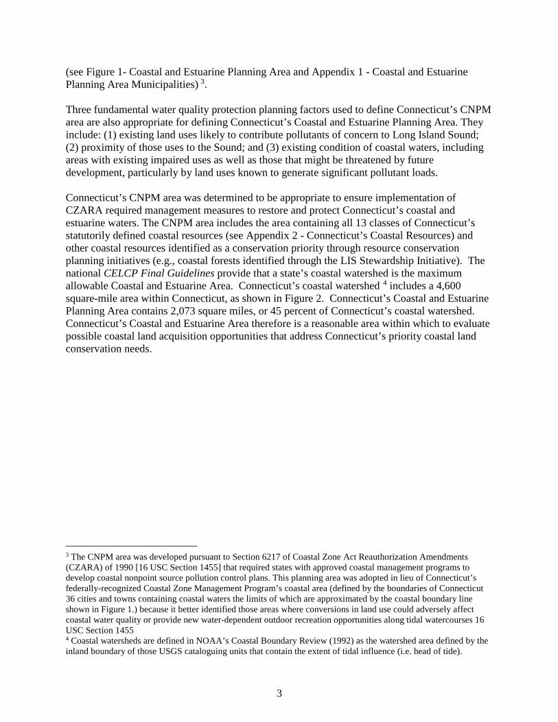
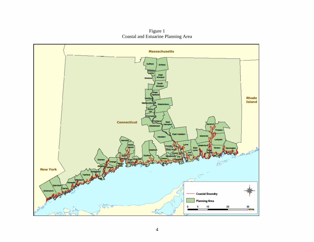
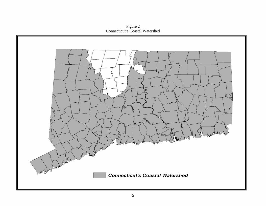
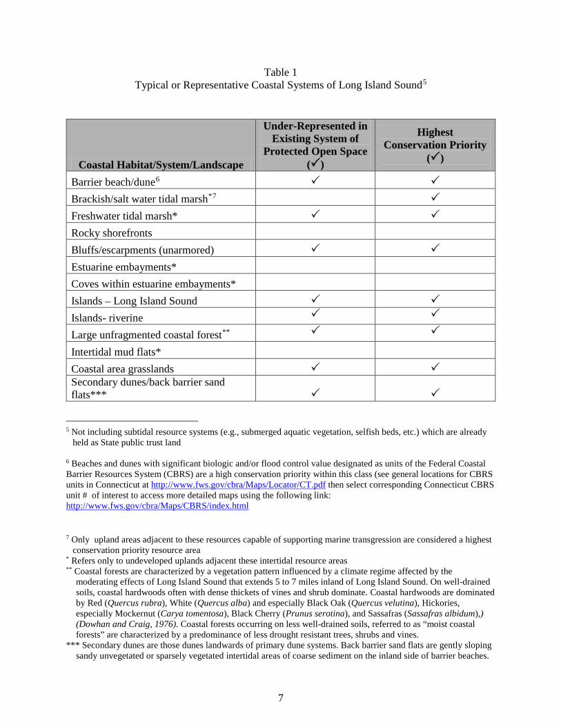
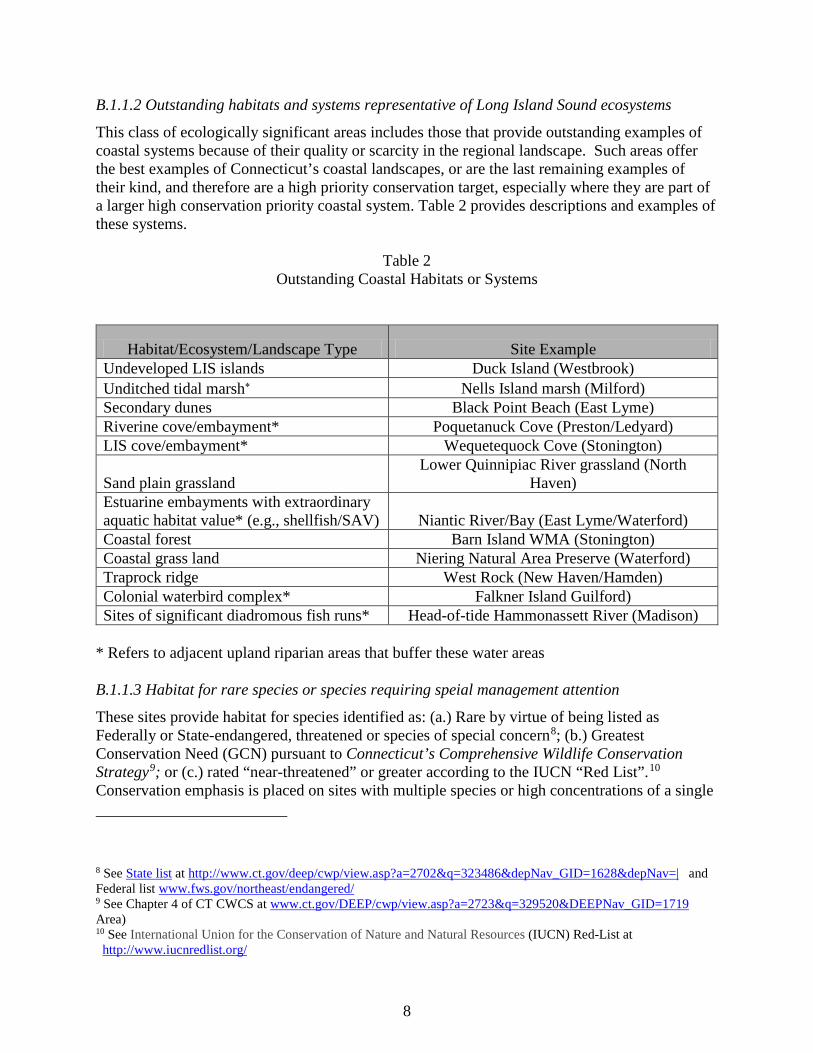
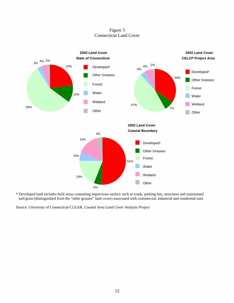
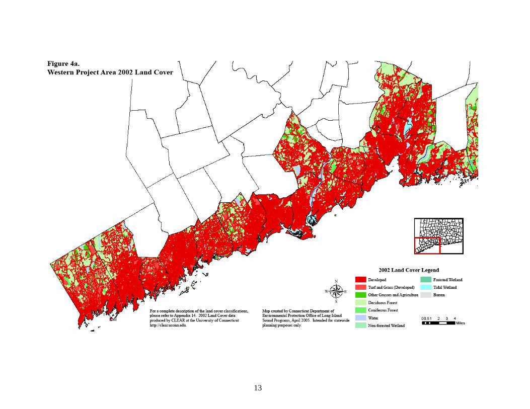
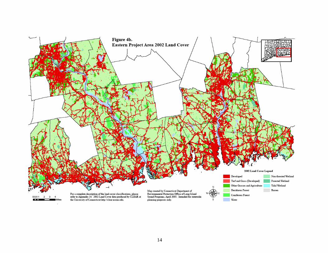
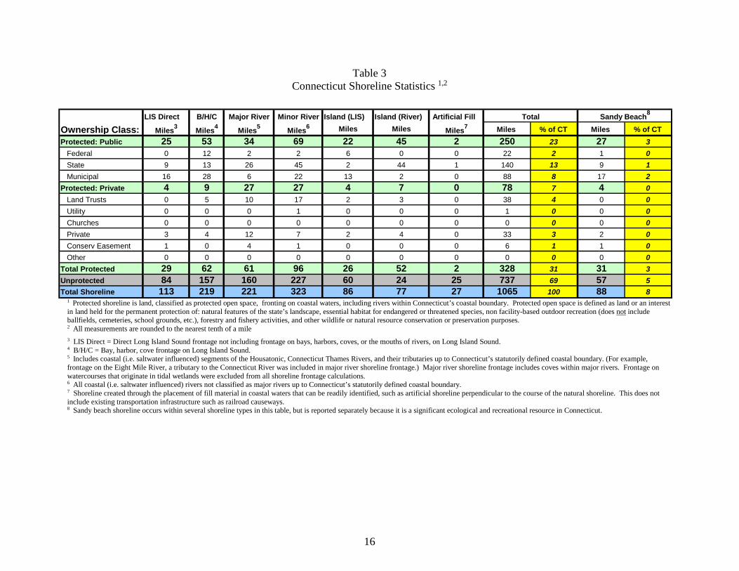
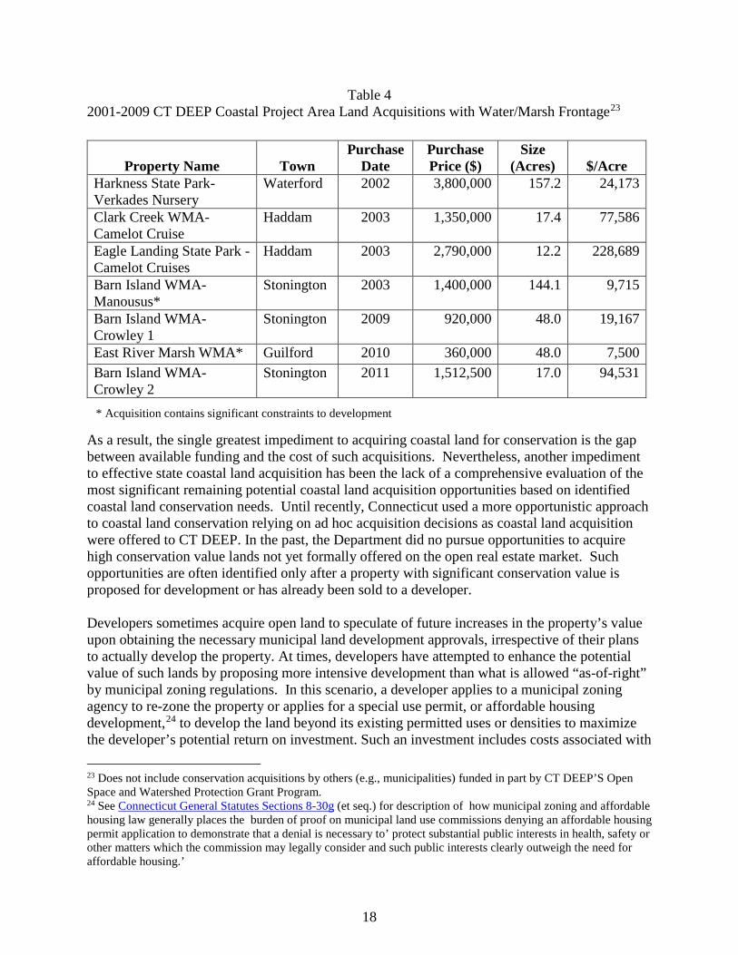
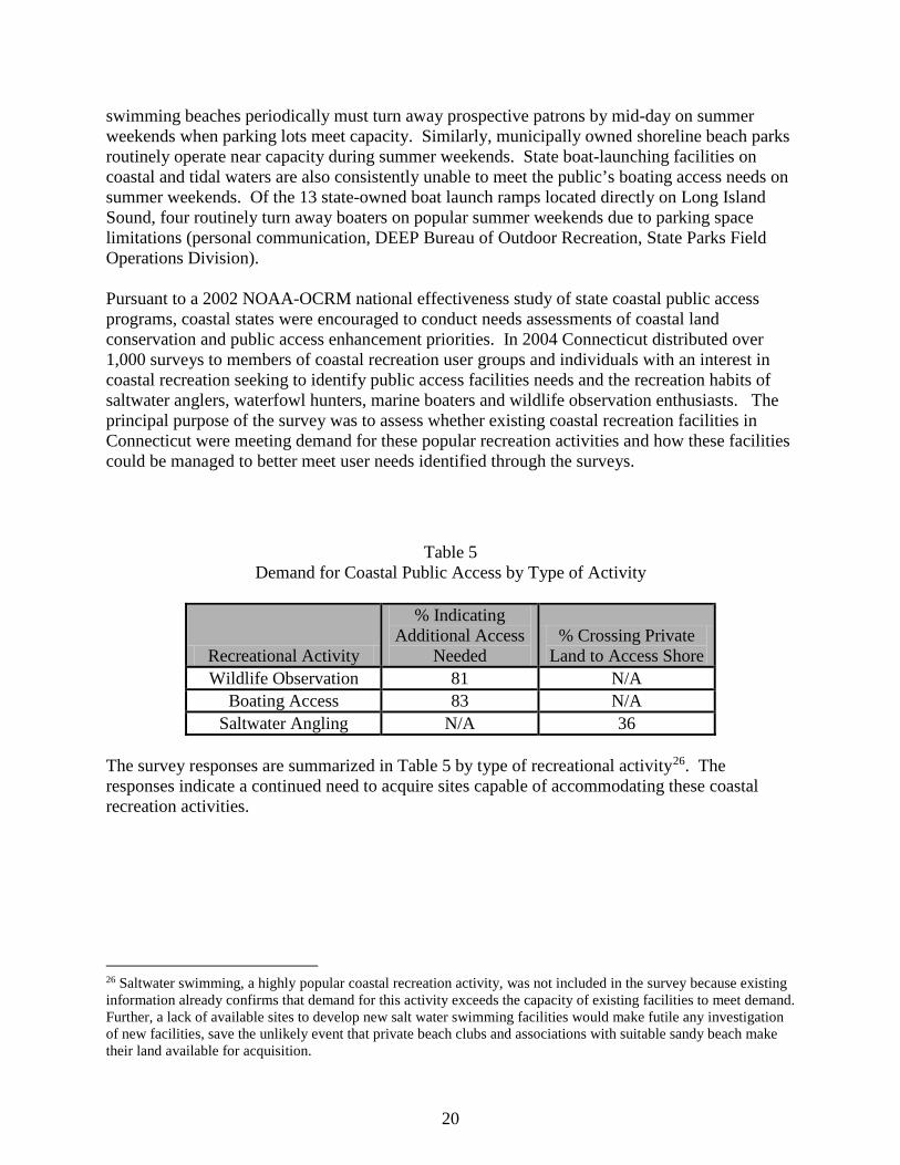
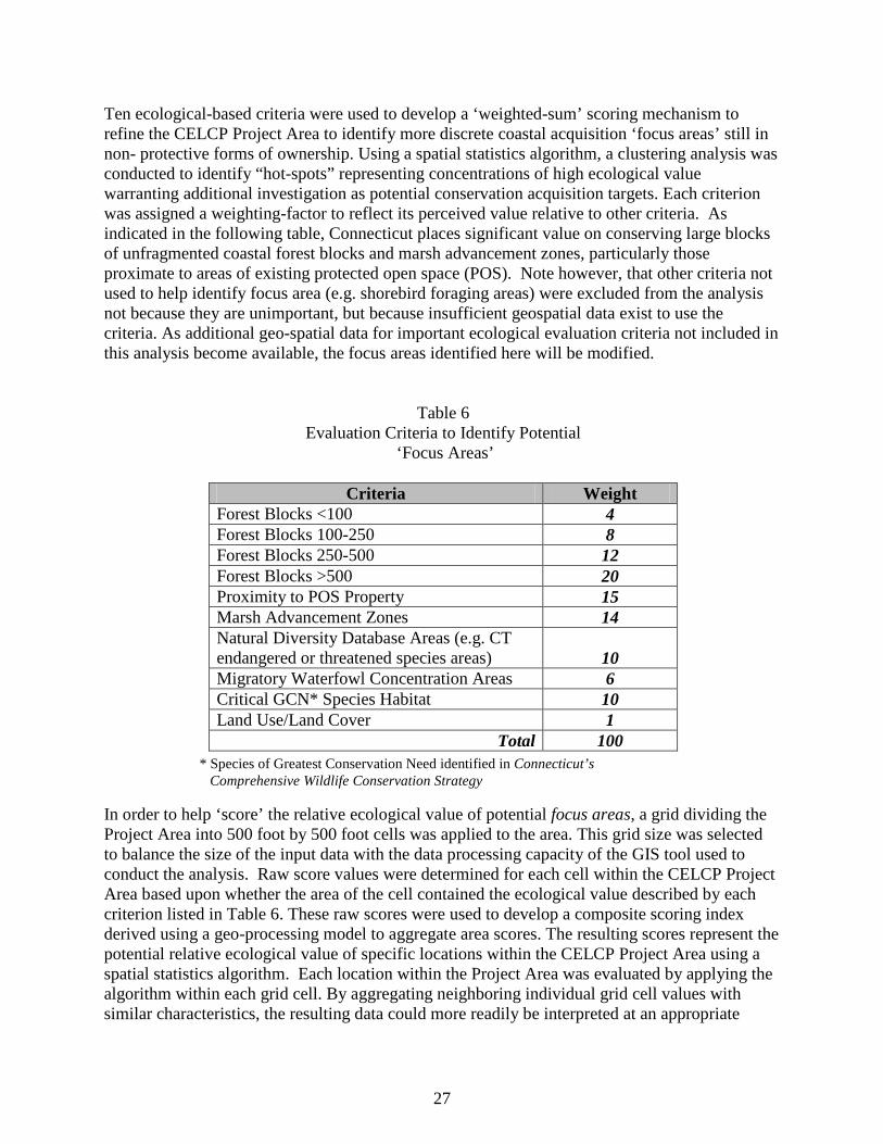
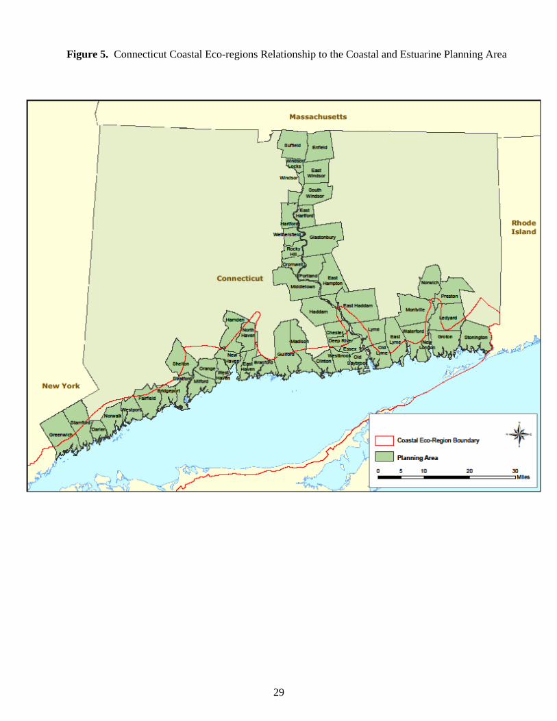
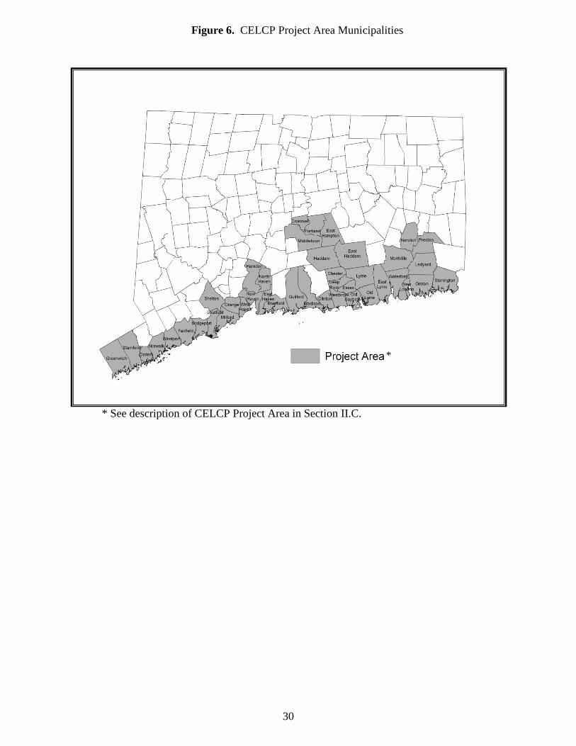
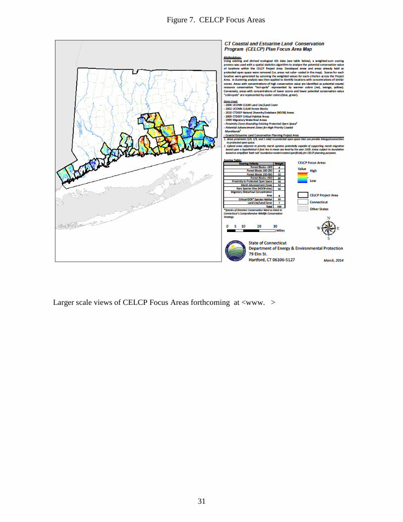
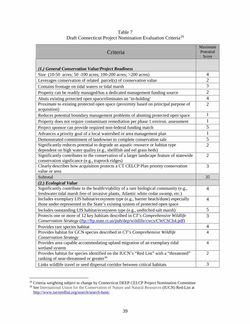
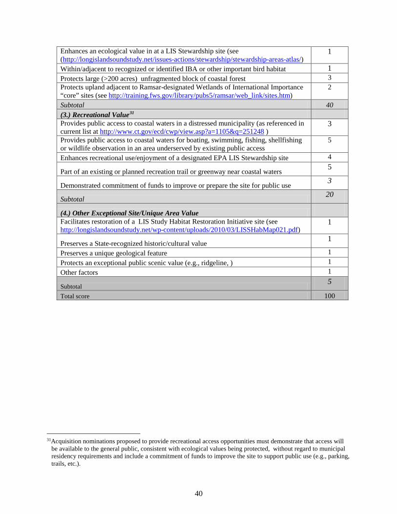
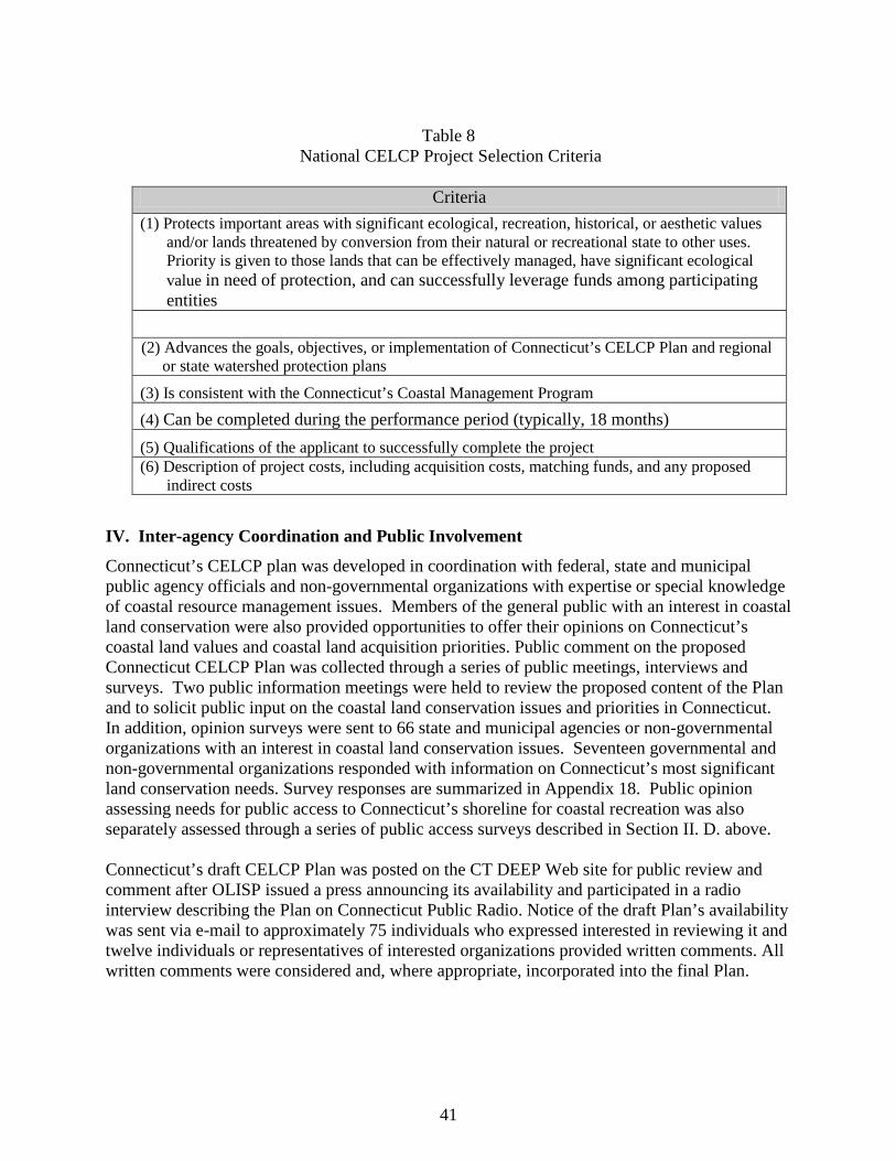