como creek final report feb 2002
DESCRIPTION
See what the City of Coquitlam has in store for existing urban watersheds.TRANSCRIPT
D - 95
City of Coquitlam
Como Creek Integrated Stormwater Management Plan: Flood Risk Management and Watershed Restoration ":
February 2002
WO22002002VBC '

CITY OF COQUITLAM
E I - v
f '_
II A B
COMO CREEK INTEGRATED STORMWATER MANAGEMENT PLAN:
FLOOD RISK MANAGEMENT AND WATERSHED RESTORATION
PREPARED BY:
CH2MHILL 920 - 475 West Georgia Street
Vancouver, BC V6B 4M9 Te1.604 684-3282 I Fax. 604 684-3292
February 2002

COMO CREEK INTEGRATED STORMWATER MANAGEMENT PLAN FINAL REPORT TABLE OF CONTENTS FEBRUARY 2002
TABLE OF CONTENTS
PAGE
EXECUTIVE SUMMARY
PART A . STRATEGY FOR FLOOD RELIEF AND HABITAT RESTORATION IN THE FRASER MILLS LOWLAND
CHAPTER I
CHAPTER 2
CHAPTER 3
CHAPTER 4
CHAPTER 5
INTRODUCTION 1.1 Background .................................................................................................. 1-1 1.2 Approach ............................. : ........................................................................ 1-1
1.4 Study Area .................................................................................................... 1-2 1.5 Project Issues ............................................................................................... 1-2
1.3 Deliverables .................................................................................................. 1-1
PROBLEM IDENTIFICATION 2.1 Introduction ................................................................................................... 2-1 2.2 Overview of Previous Reports ...................................................................... 2-1 2.3 Nature of the Problem .................................................................................. 2-2 2.4 Recent Storm Events ................................................................................... 2-4 2.5 Summary of Findings ................................................................................... 2-4
WATERSHED MODELLING
3.2 Rainfall and Streamflow Data ....................................................................... 3-1 3.3 Modelling Approach ...................................................................................... 3-1
3.1 Background .................................................................................................. 3-1
3.4 Selection of Storm Events ............................................................................ 3-2 3.5 Results for December 1999 Storm ............................................................... 3-2 3.6 Results for January 1968 Storm ...................... : ............................................ 3-3
3.8 Future Modelling Applications ...................................................................... 3-3 3.9 Summary of Findings ................................................................................... 3-4
4.1 Watershed Vision ......................................................................................... 4-1
4.3 Hydraulic Control Elevations ........................................................................ 4-2
4.5 Integration with Uplands Strategy ................................................................ 4-3 4.6 Popeye Creek Stream Corridor Restoration ................................................ 4-3
4.8 2001 Action Plan .......................................................................................... 4-4
3.7 Lowering the GVRD Sewer .......................................................................... 3-3
ELEMENTS OF AN INTEGRATED LOWLANDS PLAN
4.2 Plan Elements for Flood Relief and Habitat Restoration .............................. 4-1
4.4 Flow Control at Trans-Canada Highway ...................................................... 4-3
4.7 Capital Cost Estimates .................................................................................. 4-4
INTEGRATION OF LOWLANDS AND UPLANDS STRATEGIES 5.1 Summary of Flood Mitigation for the Lowlands ............................................ 5-1 5.2 Land Use and Aquatic System Overview ..................................................... 5-1
i CH2M HILL

COMO CREEK INTEGRATED STORMWAT~R MANAGEMENT PIAN FINAL REPORT TABLE OF CONTENTS FEBRUARY 2002
PART B . STRATEGY FOR FLOOD RISK MANAGEMENT AND WATERSHED RESTORATION IN THE COMO UPLANDS
CHAPTER 6
CHAPTER 7
CHAPTER 8
CHAPTER 9
CHAPTER 10
MANAGEMENT'STRATEGY FOR THE COMO UPLANDS 6.1 Problem Statement ..................................................................................... 6-1 6.2 Identifying Solutions to the Erosion Problem .............................................. 6-3 6.3 Identifying Solutions to the Flooding Problem ............................................ 6-5 6.4 Summary of Findings .................................................................................. 6-6
LONG-TERM WATERSHED RESTORATION 7.1 The Water Balance Approach ...................................................................... 7-1 7.2 7.3
Adaptive Approach to Watershed Retrofit ................................................. 7-2 Step 1 - Preliminary Targets for Rainfall Capture and Runoff Control ....... 7-3
7.4. Step 2 -Validation of Preliminary Rainfall Capture and ............................ 7-8
7.5 Steps 3 and 4 - Facilitating the Process of Change ..... ............................. 7-10 7.6 Steps 5 and 6 - Ongoing Assessment of the Watershed ........................... 7-11
7.7 Watercourse Restoration ............................................................................ 7-12
Runoff Control Targets
Retrofit Strategy
7.8 Summary of Findings .................................................................................. 7-12
SHORT-TERM FLOOD RISK MANAGEMENT 8.1 8.2' 8.3 Culvert Upgrading and Bedload Interception .............................................. 8-4
8.5 Summary of Findings .................. ; ............................................................... 8-9
ELEMENTS OF AN INTEGRATED PLAN FOR THE COMO UPLANDS 9.1 Description of Uplands Plan Elements ....................................................... 9-1 9.2 Plan Elements for Long-Term Watershed Restoration ............................... 9-1 9.3 Plan Elements for Short-Term Flood Risk Management ............................ 9-1
Options for Flood Risk Management .......................................................... 8-1 Community Storage for Runoff Control ...................................................... 8-1
8.4 Inter-Watershed Connections ..................................................................... 8-8
CONCEPTS FOR RAINFALL CAPTURE AT.SOURCE 10.1 Performance Targets for Rainfall Capture ............................................... 10-1 10.2 Land Use Redevelopment Scenarios ...................................................... 10-2 10.3 Examples of Rainfall Capture Techniques .............................................. 10-8
PART C . IMPLEMENTATION OF THE COMO CREEK WATERSHED MANAGEMENT PLAN
CHAPTER 11 IMPLEMENTATION ACTIONS FOR COMO WATERSHED 1 1.1 Introduction ............................................................................................. 11-1 11.2 Summary of the Como Watershed Plan ................................................ 11-1 11.3 Description of Watershed Actions .......................................................... 11-3 11.4 Overall Costs of the Watershed Actions ................................................ 11-3 11.5 Financing the Watershed Management Plan ............ ............................ 11-4 11.6 Measuring Success ................................................................................ 11-4
CHAPTER 12 CONCLUSIONS AND RECOMMENDATIONS 12.1 Conclusions ............................................................................................ 12-1 12.2 Recommendations .................................................................................. 12-2
ii CHPM HILL

a d 8 s:
' a
COMO CREEK INTEGRATED STORMWATER MANAGEMENT PLAN FINAL REPORT TABLE OF CONTENTS FEBRUARY 2002
LIST OF TABLES Follows
Page
Table A
Table 4-1
Table 4-2
Table 7-1
Table 9-1
Table 1 1-1
Figure A
Figure 1-1
Figure 2-1 Figure 2-2 Figure 213
Figure 3-1 Figure 3-2
Figure 4-1 Figure 4-2
Figure 4-3 Figure 4-4
Figure 5-1 Figure 5-2
Figure 6-1
Figure 7-1 Figure 7-2 Figure 7-3 Figure 7-4 Figure 7-5
Figure 7-6
Implementation Actions for the Como Creek Watershed Management Plan ........ ES-2
Elements of an Integrated Plan for Flood Relief and Habitat Restoration ............. 4-2 In the Fraser Mills Lowlands
2001 Action Plan Projects for Flood Relief and Flow Control in ............................ 4-5 Fraser Mills Lowlands
Components of an Integrated Strategy for Managing the Complete ..................... 7-3 Spectrum of Rainfall
Elements of an Integrated Plan for Flood Risk Management and Watershed ....... 9-1 Restoration in the Como Uplands
Implementation Actions for the Como Creek Watershed Management Plan ........ 11-3
LIST OF FIGURES
Shared 50-Year Vision for Watershed Restoration
Existing Watershed
Problem Identification Potential for Flood Inundation Existing Control Points
Levels of Modelling Intensity Duration Frequency Plots for Storm Events
Concept for Surface Water Management in Fraser Mills Lowlands Elements of an Integrated Plan for Flood Relief and Habitat Restoration In the Fraser Mills Lowlands Proposed Control Elevations Schematic of Plan Elements and Flow Paths at Como and Popeye Drainage Outlets
Fish Habitat Values and Constraints Watershed Health Classification System
Typical Stream Bank Erosion in the Como Creek Ravine
Typical Distribution for Annual Rainfall Events Strategy for Managing the Complete Spectrum of Rainfall Events Typical Distribution of Small Storms and Average Rainfall Intensity Typical Volume Distribution of Annual Rainfall Estimated Annual Water Balance for the Como Watershed Under Natural Forested Conditions Creek Health (B-IBI) versus Watershed Impervious Land Cover
iii CHZM HILL
;p
COMO CREEK ~NTEGRATED STORMWATER MANAGEMENT PIAN FINAL REPORT TABLE OF CONTENTS FEBRUARY 2002
Figure 7-7 Figure 7-8 Figure 8-1 Figure 8-2
Figure 8-3 Figure 8-4 Figure 8-5
. Figure 8-6 Figure 8-7 Figure 8-8 Figure 8-9
Figure 9-1
Figure 10-1 Figure 10-2 Figure 10-3 Figure 10-4 Figure 10-5 Finure 10-6
Effectiveness of Source'Storage and Community Storage in Reduction Erosion Options for Long-Term Watershed Restoration in the Como Uplands Options for Short-Term Flood Risk Management in the Como Uplands Identification and Assessment of Opportunities and Constraints For Community Storage Tier C Storage Volume Needed for the Como Watershed Como Creek Culvert at Rochester Avenue Booth Creek Culvert at Austin Avenue Como Creek Culvert at Austin Avenue Como Creek Culvert at Rochester Avenue (top view) Booth Creek Diversion Culvert Inlet at Sheridan Operation of Inter-Watershed Connections for Flood Control
Elements of an Integrated Plan for Flood Risk Management and Watershed Restoration in the Como Uplands
Typical Existing Residential Street Impermeable Surface Area of a Typical Older Home Impermeable Surface Area of a Newer Home Block With Several New Two-Family Dwellings 1mpermeable.Surface Area of a New Two-Family Home Installation of Rainfall Capture Techniaues
Figure 10-7a Installation Detail of Infiltrator Chambers Figure 10-7b Installation Detail of Infiltrator Chambers Figure 10-8 Mixing of a Soil and Organic Matter to Create a Good Landscape Soil Figure 10-9 Permeable Pavers (Rima Pavers by Westcon) Figure 10-1 0 Spaced Wood Deck Figure 10-1 1 Skinny Buildings Figure 10-1 2 Multi-storey Building with Underground Parking Figure 10-1 3 Absorbent Soils and Flow Control Over Parking Garage Figure 10-1 4 Installation of Cisterns in Parking Garages or Landscape Areas Figure 10-1 5 Rainwater Reuse Figures 10-1 6a-b Rainfall Capture Techniques for Medium Density Multi-Familv and Commercial Figure 10-1 7 Figures1 0-1 8a-b Figure 10-1 9a Figure 1 OT1 9b Figure 10-1 9c Figure 10-20 Figure 10-21 Figure 10-22 Figure 10-23 Figure 10-24 Figure 10-25 Figure 10-26
Green Roof on a Large Airport Building Bioswales and Rain Gardens for Parking Area Runoff Local Urban Roadside Drainage Local Urban Roadside Drainage Concept at Lawn Local Urban Roadside Drainage Concept at Tree Key Functions of Riparian Habitat Stream Restoration Characteristics Pool and Riffle Construction Macro Pool for Summer Rearing Habitat and Deep Water Refuge Placement of Large Organic Debris Boulder Clusters Placed in Stream Brush Layering for Erosion Control
iv CHPM HILL

Executive Summary
CHZM HILL

,
Restore natuxal. water balance through a Watershed Retrofit Strategy. ,I,’\
I I
t
I
\ a -I- - -I- lestore natural rainage pattern of IVO separate ubwatersheds. LEGEND 1 1 - 1 - 1 1 W a Q S h e d m ----
w- ............... Endmed-
tdluwalemxrsa
timize Operation of L*lershedrnnedian eh#een~andpopeye
Zestore Popeye :reek and riparian
reeks.
:reale new drainage oubl to erve Boovl /popeve tributary rea.
COMO CREEK WATERSHED MAHIIGEMEH” Puul /I
COMO CREEK WATERSHED MANAGEMENT Pwc FINAL REPORT E~ECUTNE SUMMARY FEBRUARY 2002
Executive Summary
1. Drivers for a Watershed Plan The pressing need for a Como Creek Watershed Management Plan is driven by the drainage problems in this watershed, particularly the chronic flooding in the Lowlands. The City of Coquitlam is impacted by the consequences, which include:
periodic property damage and road closures caused by flooding. high-risk of flooding related failure, such as road washout. sigruficant staff time to deal with the ongoing drainage problems. rapid watercourse erosion and instability in the Como Creek Ravine.
. . Watercourse erosion is a particularly sigruficant impact because it increases the risk of flooding and degrades aquatic habitat. There is a strong expectation for aquatic habitat restoration from Coquitlam residents and the environmental agencies, and profitable land use must also be allowed to continue. The Como Watershed Plan provides watershed management solutions that integrate engineering, planning and ecological perspectives.
2. Integrated Solution for the Como Watershed Providing flood control and restoring aquatic habitat are complementary objectives because flooding and habitat degradation have the same root cuuse:
~~
Increased Impervious Sugace due to development alters the natural water balance - The volume and rate of surface runoff from the Como Uplands is much greater as a result of urban development.
~~ - ~ ~
The City of Coquitlam has recognized the need for an infegrufed so2ution that not only recognizes and supports land use change, but also eliminates the root cause of drainage- related problems. The Como Watershed Plan presents an integrated solution for the entire watershed to provide immediate flood relief, and eventually restore aquatic habitat. The Plan is organized into three parts:
Part A develops specific solutions to provide immediate flood relief in the Lowlands. . Part B focuses on the opportunity to reduce runoff at the source in conjunction with future re-development in the Uplands. Part C presents a plan for implementing an integrated solution for the watershed. .
Note that Part A was developed as an Interim Report to satisfy the City's need for immediate action, but included a shared 50-year vision for the entire watershed. The watershed planning process was holistic from the beginning.
Figure A provides a picture of the shared vision for the Como Watershed and highlights its key elements.
11 825535 ES-1 CHZM HILL
COMO CREEK WATERSHED MANAGWENT PIAN FINALREPORT EXECUTIVE SUMMARY FEBRUARY 2002
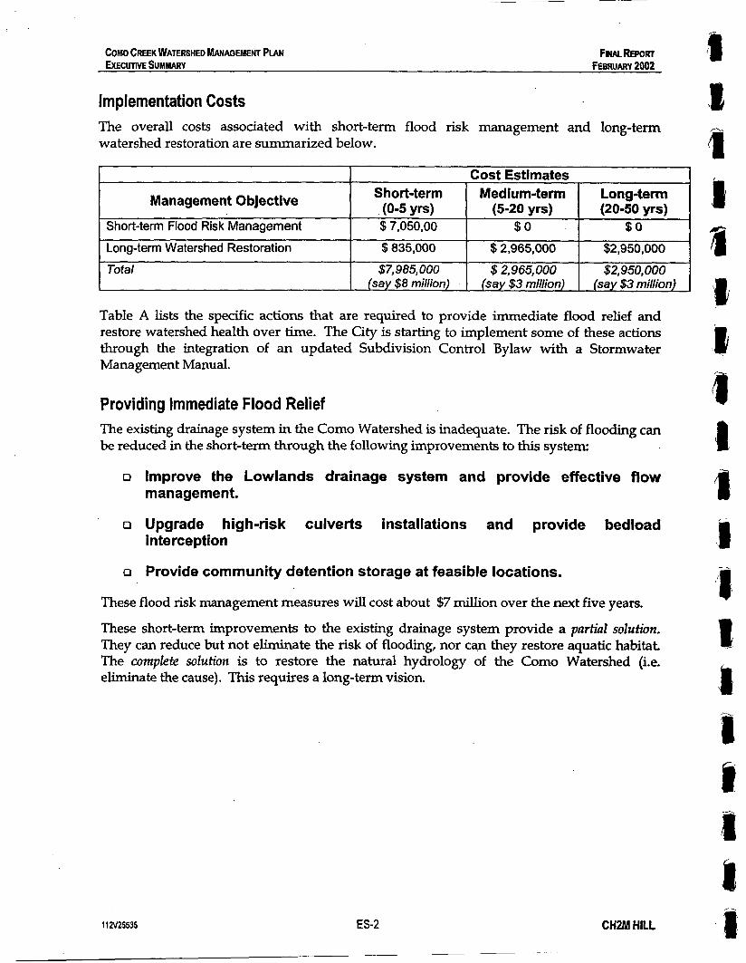
Management Objective Short-term Flood Risk Management
Implementation Costs The overall costs associated with short-term flood risk management and long-term watershed restoration are summarized below.
Short-term Medium-term Long-term (0-5 yrs) (5-20 yrs) (20-50 yrs) $7,050,00 $ 0 $ 0
I Cost Estimates 1
Long-term Watershed Restoration Total
1
$835,000 $2,965,000 $2,950,000
$7,985,000 $2,965,000 $2,950,000 (say $8 milion) (say $3 million) (say $3 million)
Table A lists the specific actions that are required to provide immediate flood relief and restore watershed health over time. The City is starting to implement some of these actions through the integration of an updated Subdivision Control Bylaw with a Stormwater Management Manual.
Providing Immediate Flood Relief The existing drainage system in the Como Watershed is inadequate. The risk of flooding can be reduced in the short-term through the following improvements to this system:
Improve the Lowlands drainage system and provide effective flow management.
Upgrade high-risk culverts installations and provide bedload interception
Provide community detention storage at feasible locations.
These flood risk management measures will cost about $7 million over the next five years.
These short-term improvements to the existing drainage system provide a partial solution. They can reduce but not eliminate the risk of flooding, nor can they restore aquatic habitat The complete solution is to restore the natural hydrology of the Como Watershed (i.e. eliminate the cause). This requires a long-term vision.
1 1 ZV25535 ES-2 CHZM HILL

DRAFT FOR REVIEW MARCH 2001
COP0 CREEK WATERSHED MANAGEMENT PLAN EXECUTIVE SUMMARY
TABLE A* Implementation Actions for the Como Creek Watershed Management Plan
jhort- erm 0-5 years)
Short- :erm '
'0-5 years)
Short- term 10-5 years)
Short- term (0-5 years)
Short- term (0-5 years)
112~25535
mprove Lowlands Drainage System I) Remove Booth Creek channel constrictions at and below Lucille Starr Way )) Expand the Rainfall and Streamflow Monitoring Network. :) Build a calibrated hydraulic model for the Lowlands drainage system 1) Upgrade the Booth/ Popeye Inter-Watershed Connection ?) Implement the Inter-Watershed Flow Control System at the Trans-Canada Highway ) Create a separate drainage outlet for Booth Creek under the Lougheed Highway Jpgrade High-Risk Culverts and Provide Bedload Interception I) Upgrade the Como Creek culvert at Rochester Ave. and provide bedload interception 3) Upgrade the Booth Creek culvert at Austin Ave. and provide bedload interception :) Upgrade the Como Creek culvert at Austin Ave. and provide bedload interception Drovide Community Storage Facilities I) Implement the Como Lake Storage and Flow Regulation Modifications I) Construct Popeye Detention Pond on BC Hydro Site
Identify Appropriate Targets and Design Options for Source Storage and Infiltration 3) Implement the Casey Place Bedload Management Plan b) Build a calibrated hydrology model for the Como Watershed 2) Complete a hydrogeologic investigation of the Como Watershed d) Implement and monitor source storage and infiltration pilot projects on public works.
e) Establish a consultation process with landowners and the development community. 9 Create a technical manual of options for on-lot storage and infiltration, including draft
standard details and specifications, and make the manual available on-line. ~~
Build Support for Watershed Retrofit through Education a) Provide a self-guided training program including tours of pilot projects, fact sheets, videos,
and website information. b) Offer training workshops and seminars to the development community. c) Work with other agencies and local governments to design a one-day watershed training
workshop and certification program. d) Require that all public works staff and contractors on Coquitlam public works become
watershed-certified.
CHZM HILL

DRwr FOR REVIEW MARCH 2001
COMO CREEK WATERSHED MANAGEMENT PIAN EXECUTIVE SUMMARY
;hod- .em 0-5 years]
Medium- term (5-20 Y S )
Medium- term
Long-tern (20-50 yrs
(5-20 Yrs)
Change Development Regulations to Ensure that Source Storage Retrofit will Occur in Conjunction with Future Re-development a) Remove barriers to source storage and infiltration in existing development regulations. b) Incorporate the most appropriate targets and design options for source storage and
infiltration into the Engineering Standards.
c) Incorporate the new Engineering Standards into the Subdivision Bylaw, Building Bylaw, Zoning Bylaw, and Development Permit Guidelines.
d) Complete an Interagency Memorandum of Understanding (MOW for one-window approvals.
Demonstrate a Commitment to Watershed Restoration in the Short-term a) Implement a Water Quality Source Control Program in the Lowlands b) Implement the East Surge Channel Habitat Bank
Facilitate the Implementation of Source Storage Retrofit Strategy a) Provide expedited approvals on private sector projects that implement source storage and
infiltration. b) Implement a composting program to provide low-cost organic matter for absorbent soils c) Implement a program for bulk purchase and resale of storage and infiltration specialty
products to participating developers d) Continuously monitor rainfall-runoff response and other indicators of watershed health as
the watershed becomes retrofitted with source storage and infiltration over time (note: requires expansion of rainfall and streamflow monitoring network)
Restore the Natural Watershed Drainage Pattern (two separate sub-watersheds) e) Create a new drainage outlet at the highways for the Booth/Popeye sub-watershed.
~
Restore Watercourses to Their Natural State a) Restore the Popeye Creek stream corridor between Brunette and Lougheed b) Daylight the piped section of Booth Creek between Sheridan and Myrnam c) Daylight the piped section of Como Creek below Como Lake d) Daylight the piped section of Booth Creek below Foster e) Daylight the piped section of Como Creek below Rochester
* Part C of this report includes an expanded version of Table A that provides additional information for each project, including: Cost estimates Management objectives City Department to take the lead role for project implementation
112v25535 CHZM HILL

COMO CREEK WATERSHED MANAGEMENT PLAN FINAL REPORT EXECUTIVE SUMMARY FEBRUARY 2002
3. Achieving a Long-Term Vision for Watershed Restoration The key elements of the shared 50-year vision for the Como Watershed (see Figure A) are summarized below:
o Restore natural water balance - A substantial portion of the Como watershed will likely redevelop over the next 50 years. Without a strategy for managing runoff at the source, the resulting land cover changes will exacerbate existing flooding problems and further degrade aquatic habitat.
With an appropriate Watershed Retrofit Strategy to restore the natural water balance, re- development can become an opportunity to eliminate the root cause of drainage related problems. The key to this strategy is improving the existing ‘standard practice’ of development so that future re-development projects incorporate source control facilities to reduce the volume and rate of runoff from rooftops and paved surfaces.
Most of the short term watershed restoration costs ($835,000) are related to implementation of the Watershed Retrofit Strategy.
o Restore natural drainage pattern - In its natural state the Como Watershed consisted of two separate sub-watersheds, Como/ MacDonald and Booth/Popeye. This natural drainage pattern has been altered, so that the runoff from the entire watershed is now channeled into the lower section of Como Creek. The result is a convoluted drainage pattern which causes flooding in the Lowlands.
Creating a new drainage outlet at the Highways for the Booth/Popeye system will enable restoration of the natural drainage pattern. This will reduce the risk of flooding in the Lowlands and create opportunities for aquatic habitat restoration.
o Restore the Popeye Stream Corridor - The process of restoring the natural drainage pattern provides the opportunity to restore healthy aquatic and riparian ecosystems to the Popeye Creek stream corridor, between Brunette and Lougheed. This stream corridor could become the ‘crown jewel’ of the Como Watershed.
11 ZV25535 ES-3 CHZM HILL
COMO CREEK WATERSHED MANAGEMENT PLAN FINAL REPORT EXECUTIVE SUMMARY FEBRUARY 2002
Managing the Complete Spectrum of Rainfall Events
The Como Watershed Plan provides a strategy that is comprehensive in managing the runoff from all rainfall events. The following management objectives and targets for this strategy are based on site-specsic rainfall characteristics.
~~
1) Rainfall Capture for Small Storms (Retain the first 30 mm of rainfall per day) - Infiltrate the runoff from frequently occurring small storms (up to 30 rrun per day) at the source (on lots and road right-of ways) to'reduce total runoff volume. This will achieve a key target for long-term watershed restoration, reduce total runofvolume to Zess than 10% of total rainfall volume.
2) Runoff Control for Large Storms (Detain the next 30 rnrn of rainfall. per day) - Store the runoff from the infrequent large storms, up to the size of a mean annual rainfall (60 mm per day), and release it a rate that approximates a natural forested condition.
3) Flood Risk Management for the Extreme Storms (Convey the extreme events) - Ensure that the drainage system can safely convey extreme storms, up to the size of a 100-year storm (140 mm per day).
All of these elements are essential to an integrated watershed management plan. Rainfall capture and runoff control are necessary to stabilize the rate of watercourse erosion, eliminate the source of flooding problems, and restore aquatic habitat. Flood risk management is necessary to address immediate flooding problems.
Source Control vs. Community Storage Source control facilities are necessary to achieve the Rainfall Capture target defined above. Community detention facilities provide little reduction in runoff volume.
The runoff control target can be achieved through a combination of on-site (e.g. infiltration facilities on lots and road) and off-site (e.g. community detention ponds) facilities.
A key conclusion of the Como Creek Plan is that there are limited opportunities for building large community detention facilities. Therefore, the objective of the Watershed Retrofit Strategy is to provide rainfall capture and runoff control at the source (i.e. capture the first 60 mm of rainfall per day on lots and roads).
112V25535 E S 4 CHZM HILL

COMO CREEK WATERSHED MANAGEMENT PLAN FINAL REPORT EXECUTIVE SUMMARY FEBRUARY 2002
4. Integrated Watershed Planning Process The key to successful development of the Como Watershed Plan was a process which involved the following two 'tracks' of effort working together:
o Plan Development Track #I : Technical analysis -Watershed characteristics, problems and potential management solutions were identified bough a technical analysis process that combined the analytical skills and tools from engineering planning and ecology.
Q Plan Development Track #2: Workshops and working sessions - technical information was presented at a series of workshops and working sessions with city staff, environmental agencies and representatives of the local business community and streamkeeper groups.
Input from both tracks led to a shared 50-year vision and watershed management decisions that are based on technically sound information and supported by an informed group of stakeholders.
The 'triple eye' watershed planning process for the Como Watershed was truly integrated:
o Inter-departmental - The process was guided by an Inter-Departmental Steering Committee of senior managers from Operations, Parks & Open Space, and Development Services. This facilitates co-operation within the local government.
o Inter-agency - Having provincial and federal environmental agencies involved at every stage of plan development will facilitate future agency approval processes.
o Inter-disciplinary - engineering, planning and ecological perspectives were integrated from the beginning of the watershed planning process.
11 a25535 ES-5 CHSM HILL

i
I
COMO CREEK WATERSHED MANAGEMENT PLAN FINNREPORT EXECUTIVE SUMMARY FEBRUARY 2002
5. Implementing the 50-Year Plan Changes in land use and development practices will be needed to translate the 50-year vision for watershed restoration into action. These changes must be implemented through an adaptive and collaborative approach that builds on the 'two-track process' and improves the 'standard practice' of development over time.
o Plan Implementation Track #I: Technical analysis - The City can take a leadership role by implementing and monitoring demonstration projects to test the effectiveness of site-design options for stormwater source control.
o Plan Implementation Track #2: Workshops and working sessions - The development community and landowners should be included in future consultation processes to ensure that changes in development standards and regulations are supported by those affected.
Constant Improvement
The 50-year vision for the Como Watershed is an over-arching target that provides direction for a long-term process of change, and the Watershed Action Plan provides a 'road map' for getting there. Over time, as better development practices evolve and the watershed becomes retrofitted with source control, it is important to monitor the success of watershed restoration. Since the change in rainfall-runoff response is a key indicator, an adequate rainfall and streamflow monitoring network is essential for the adaptive approach to watershed management. Ongoing monitoring and assessment of progress towards a long-term vision will improve understanding of the p o k y , science and site-design aspects of integrated stormwater management. Improved understanding will:
o lead to the evolution of better land development and stormwater management practices.
P enable action plans to be adjusted accordingly.
Learning from experience and constant improvement are the foundations of an ndaptiue approach to change.
1 1 N25W ES-6 CHZM HILL

COMO CREEK WATERSHED MANAGEMENT PIAN FINAL REPORT EXECUTIVE SUMMARY FEBRUARY 2002
6. Recent Innovation in Stormwater Management The purpose of this section is to present a summary of recent innovations in stormwater management, particularly relating to source control, that will enable the City of Coquitlam to leapfrog forward. The starting point for moving forward with implementation of the Action Plan is now well beyond the point where the Como Creek Watershed Management Plan left off.
Since Como Plan was completed in March 2001, there have been several initiatives in this region that have expanded on the 'how to' details of implementing stormwater source control. These initiatives (described in this section) have built on the conclusions and recommendations of the Como Plan to further advance the integration of stormwater management and land development at the watershed, neighbourhood and site scales.
The Como Plan has already been a catalyst for change in this region. The Plan is part of a process of change on a regional scale, towards a better standard practice of land development and stormwater management.
Regional Interest in Source Control A key conclusion of the Como Plan is that the only complete solution to control watercourse erosion and restore stream health is to retrofit the watershed with source controls as land re- develops. Other municipalities in the Greater Vancouver Regional District (GVRD) are also starting to embrace a source control philosophy as a 'central element of integrated stormwater management. The state of the Como Creek Watershed (fully developed with sigrulicant drainage problems) is typical of many other watersheds in the GVRD. There is widespread recognition that the problems in these watersheds are likely to be made worse in the future due to land use dekification and the effects of climate change (both of which are likely to increase the volume and rate of surface runoff). Significant interest has emerged in the application of stormwater source controls on re- development projects as a way to avoid the worsening of drainage problems and also support restoration of aquatic ecosystems and decrease flooding risk over time, thus turning potential problems into an opportunities (watershed restoration). However, there is a lack of scientifically defensible data on the long-term effectiveness and benefits of stormwater source controls.
'
GVRD Study on the Effectiveness of Source Control The interest and the lack of information on source controls prompted the GVRD to complete a study and report on the Efictiueness of Stomwater Source Control. This report provides a quantitative reference on the effectiveness of the following categories of stormwater source controls, in terms of how well they reduce the volume and rate of surface runoff:
- Absorbent landscaping - - Green roofi - Rainwater reuse.
Infiltration$mlities (on lots and along roads)
11 N25% ES-7 CHOM HILL
COMO CREEK WATERSHED W G E M E N T PLAN FINAL REPORT EXECUTIVE SUMMARY FEBRUARY 2002
The focus of the Source Control Report is on defining the hydrologic performance of each source control category for a range of land use types, soil conditions, rainfall conditions, and source control design options. For each source control category, the report also provides design guidance and discusses cost implications, operation and maintenance requirements, and water quality benefits.
The report on the Efictiveness of Sfomwafer Source Control provides guidance for local government staff and developers regarding where and how to implement various source control options. The results of the study also demonstrate that it is achievable to sign@cantZy improve and pofenfidly restore watershed health over a SO-year timeline by applying combinations of source controls. The information in the GVRD report can complement the Como Watershed Plan in terms of helping City staff determine:
R which source control options are worth pursuing for different land use types and soil conditions, and
> what can realistically be achieved through the application of source controls.
The next step in a restoration strategy for the Como Watershed would focus on the catchments of critical stream reaches (e.g. the portion of the Como Watershed above the eroded ravine). The costs and benefits of source control options for these catchments must be evaluated in the context of site-specific information on soil conditions, hydrogeology, drainage infrastructure, and land use/ site design characteristics.
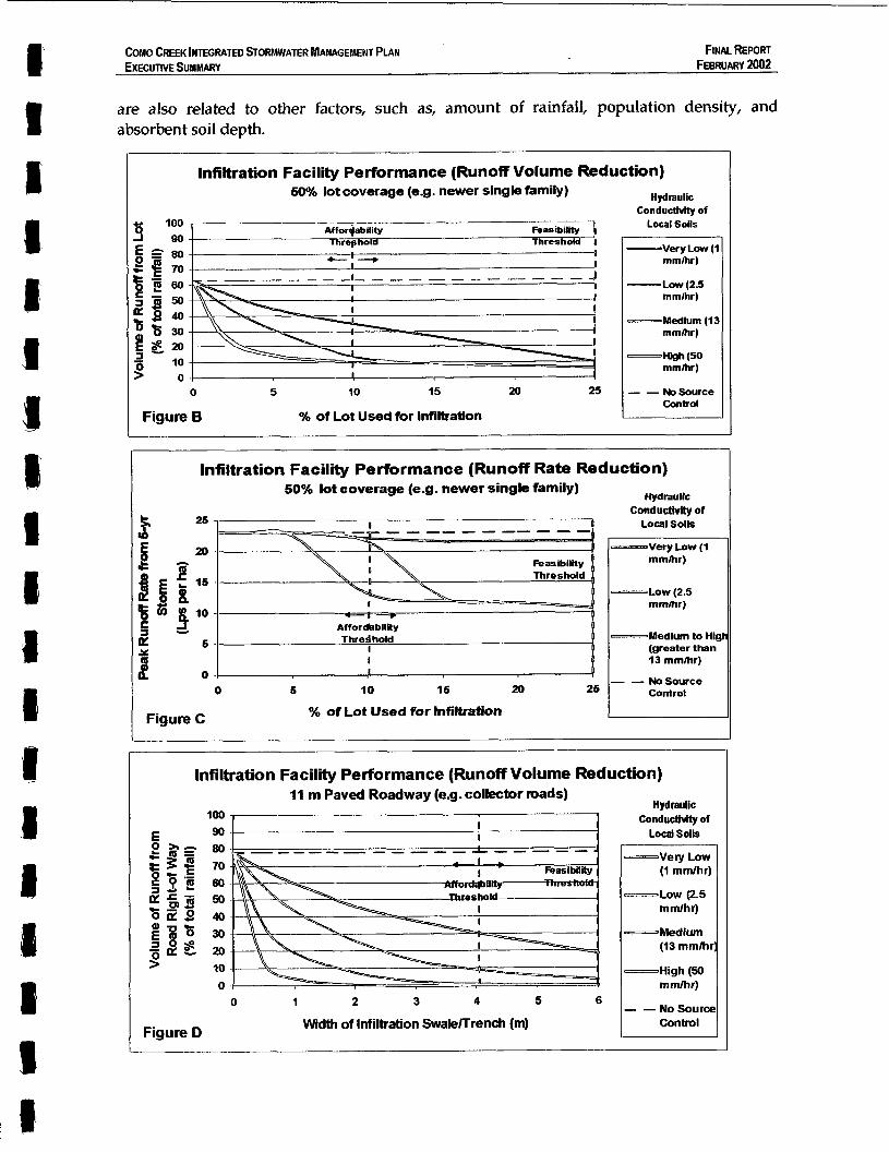
Application of the Water Balance Model The GVRD source control evaluation project has resulted in a decision support tool named the Water Balance Model It provides an interactive and transparent means for municipalities to evaluate the potential effectiveness of stormwater source controls in a watershed context, and to evaluate source control design options at the site level. This model is available to the City.
An early version of the WBM was used to test rainfall capture and runoff control criteria for the Como Watershed (see Section 7.4). For the GVRD study, the model was enhanced to generate performance relationships for the various categories of source controls. These relationships provide guidance regarding how to integrate source controls with land development/re-development, at the planning and site design levels.
Figures B, C and D show example performance curves for infiltration facilities, which show how the performance of infiltration facilities vary depending on soil type and the amount of space provided for infiltration.
The GVRD Source Control Report includes similar infiltration performance curves for: R 8 land use types, with total lot coverage ranging from 30% (e.g. low-density single
family) to 98% (e.g. town centre commercial). R 4 road types, with paved roadway widths ranging from 8.5 m (e.g. local roads) to 16 m
(e.g. divided arterials).
The Report also includes performance curves for other types of source controls, including green roofs, rainwater reuse, and absorbent landscaping. The performance of source controls
1 l N 2 5 S 5 ES8 CHZM HILL
FINAL REPORT FEBRUARY 2002
COMO CREEK INTEGRATED STORMWATER MANAGEMENT PLAN EXECUTIVE SUMMARY
Hydraulic Conductivity of
Local Soils
-Vel]( Low (1 mmlhr)
-Low (2.5 mmlhr)
-Medium (13 mmlhi
-High (So
- - No Soura
mm/hr)
Control
are also related to other factors, such as, amount of rainfall, population density, and absorbent soil depth.
I
Infiltration Facility Performance (Runoff Volume Reduction) 60% lot coverage (eg. newer single family)
100
0 5 10 15 25
Figure B O h of Lot Used for Inflltratlon
Hydraulic Conductivity of
Local Soils
-Very Low (1 mmhr)
-Low ( 2 5 mmihr)
-Medium (13 mmlhr)
Wh (50 mmlhr)
- - NoSource
Infiltration Facility Performance (Runoff Rate Reduction) 50% lot coverage (e-g. newer single family) Hydraulic
conductiwity of Local soils
m m h )
rnmhr)
(greater than 13 mmhr)
I 04 - - Nosource
Control 0 6 10 16 20 26
Figure C % of Lot Used for Infiltration L ~
Infiltration Facility Performance (Runoff Volume Reduction) I 1 m Paved Roadway (e.g. collector mads)
0 1 2 3 4 5 6
Width of Infiltration Swale/Trench (m) Figure D
I Y I Y I.
COMO CREEK INTEGRATED STORMWATER MANAGEMENT PLAN FINAL REPORT EXECUTIVE SUMMARY FEBRUARY 2002
Other Relevant Advances in Stormwater Management The products and lessons learned from the following initiatives can also help the City of Coquitlam move forward with the Action Plan for the Como Creek Watershed:
R Stormwater Planning: A Guidebook for British Columbia - This document provides guidance for local governments on how to achieve Integrated Stormwater Management at both planning and site levels. The Guidebook emphasizes an adaptive approach to site design, and develops performance-based methodologies that will lead to constant improvement in standard practice. The Guidebook draws heavily on case study experience by leading local governments and developers in BC. The Como Watershed Plan has provided a leading example that has influenced the development of the Guidebook.
R Burnaby Mountain Watercourse and Stomwater Management Plan - This Plan translates hydrologic performance targets and design criteria established at the watershed level (through the Stoney Creek Watershed Plan) into specific site design practices for the Burnaby Mountain Community Development. Construction has begun on Burnaby Mountain, and over the next few years monitoring data will be collected to enable a comprehensive evaluation of the stomwater system performance. Performance data will be collected for:
- on-lot infiltration facilities, - ‘self-mitigating roads’ (infiltration swale/trench systems designed to virtually
eliminate roadway runoff), and - community detention ponds.
Continuous monitoring of water level and overflow from these stormwater system components will enable the system performance to be evaluated relative to the established targets, and provide a better understanding of stormwater infiltration systems.
o City of Chilliwack’s Policy and Design Criteria Manual for Surface Water Management - The Manual is a case study application of the Provincial Guidebook, and includes ‘how-to’ guidelines for the design of stormwater systems. These Developer Guidelines include design tables that show developers how much space they need to provide for infiltration facilities to achieve rainfall capture targets, based on investigation of local soil conditions (rainfall capture targets for Chilliwack are very similar to those established in the Como Plan). The Guidelines that have been vetted through the local development community, and applied on several development projects in Chilliwack. Performance monitoring data from these demonstration projects will enable constant improvement of the City’s design guidelines.
11 2’425535 ES-10 CHZM HILL
PART A
for Flood Relief and Habitat Restoration in the
Fraser Mills Lowlands

Chapter 1 Introduction
CHZM HILL

COMO CREEK INTEGRATED STORMWATER MANAGEMENT PLAN PART A - STRATEGY FOR FLOOD RELIEF AND HAEIITAT RESTORATION IN THE FINMREWRT FRASER MILLS LOWLANDS FEBRUARY 2002
CHAPTER 1 Introduction 1.1 Background The work plan for development of the Coma Creek Watershed Management Plan was implemented in three parts over a 12-month period: 0 Part A - Strategy for the Flood Relief and Habitat Restoration in the Fraser Mills
Lowlands. 0 Part B - Strategy for Flood Risk Management and Watershed Restoration in the Como
Uplands 0 Part C - Implementation of the Como Creek Watershed Management Plan
Part A was prepared as an Interim Report to satisfy the City's need for immediate action to address the flooding problems in the Lowlands. This part of the report consolidates and summarizes the results of the work effort completed during the January through June 2000 period.
1.2 Approach The Watershed Management Plan was developed through a workshop process that provides a forum for inter-departmental communication and stakeholder participation. The process comprised seven sessions as follows: 0
,a
0
0
0
0
0
The agenda and the record of each session are included as Appendix A. This appendix provides documentation of the process. It was a structured process. Each workshop had a specific purpose, objectives, and desired outcome. This approach facilitates understanding and trust-building.
Working Session #1- Chartering of Client/Consultant Project Team Working Session #2 - Hydrology Workshop Working Session #3 - Flood Mitigation Plan Review Working Session #4 - Potential Actions Workshop Working Session #5 - Fisheries and Environment Workshop Working Session #6 - Retrofitting Impervious Area Reduction Working Session #7 - Elements of an Uplands Strategy
1.3 Deliverables A series of deliverables were presented at the seven workshops to provide a focus for soliciting stakeholder feedback and input. The deliverables are incorporated herein, and comprise a set of iawings and tables. The key deliverables are the Ekmenfs of an Integrated Plan, and a Matrix that captures the decision analysis for the plan elements.
11N25535 1-1 CHZM HILL

COMO CREEK lNTEGRATED STORMWATER MANAGEMENT PLAN PART A - STRATEGY FOR FLOOD RELIEF AND M I T A T RESTORATION IN THE FINAL REPORT FRASER MILLS LOWUNDS FEBRUARY 2002
The Lowlands Strategy was developed in the context of a holistic framework that considers the inter-relationship of the plan elements with an Uplands Strategy. While Part A focuses on immediate flooding problems in the Lowlands, it includes a shared 50- year vision for the entire watershed.
1.4 Study Area Figure 1-1 shows the extent of the 825-hectare study area in the southwest comer of Coquitlam. Como Lake Road defines the northern boundary. Como Creek flows through a series of closed conduits and open ravines from its headwaters at Como Lake south to the Fraser River floodplain. There, four major tributaries (Booth, Popeye, McDonald and Mill Creeks) join it and together they drain through an open channel to the Fraser Rver. The study area characteristics are described as follows: + An upper benchland and a lower floodplain + A ravine system along the face of the benchland + An abrupt change in grade at the ravine outlets + Tidal influence in a portion of the floodplain The benchland is primarily single family residential, with much of the development having taken place in the 1950s and. 1960s. Redevelopment of the older neighbourhoods (e.g. Maillardville) is now taking place. The floodplain has been transformed by 'big box' commercial development.
1.5 Project Issues In the 199Os, the Como Creek watershed has undergone many changes. New challenges have emerged. These challenges are driving the need for an integrated approach to stormwater and stream corridor management. These include consideration of flood risk management, habitat enhancement, and land use planning. Looking ahead, the 'integrated plan' must address five key issues: 0 Impervious Cover: Replacement of small houses with large houses is increasing the
percentage of impervious ground cover (i.e. now 53%).
Storm Sewer System: Surface runoff in the upper watershed is now being conveyed faster and more efficiently by storm sewers to receiving creeks. The impact of impervious area changes is magrufied because new houses are connected to storm sewers. Drainage Hot Spots: Changes in upstream hydrology have resulted in chronic flooding problems at several downstream locations. During storm events, three (3) of the City's eight (8) drainage crews are required in this area.
Land Use Changes: The lower watershed is being redeveloped to higher value commercial land use. This results in 'zero tolerance' for disruption' of public access due to road corridor closures.
.
0
s I B 3 I I I 1 I 112V25535 1 -2 CHPM HILL
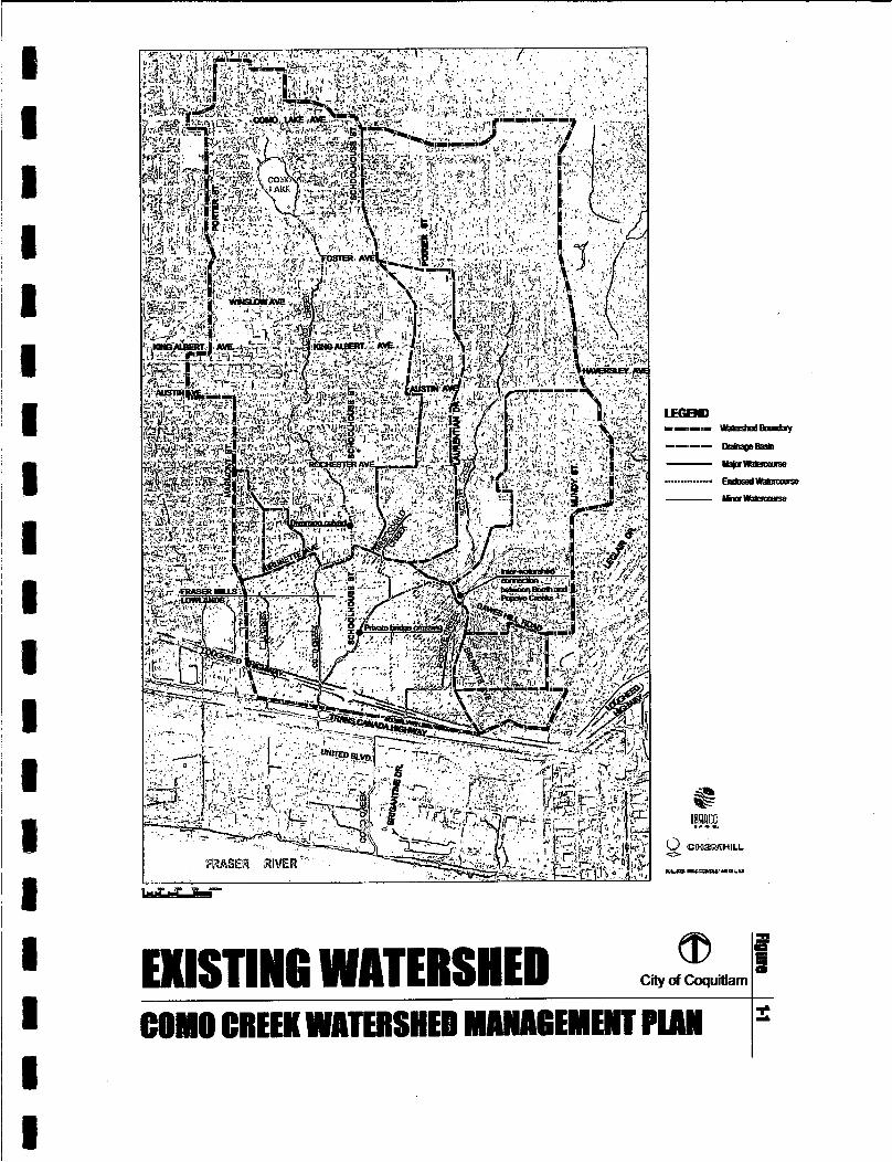
C i i of Coquitlam
COHO CREEK WBTERSHED MACIAGEMEWT PlAW
COMO CREEK INTEGRATED STORMWATER MANAGEMENT PLAN PART A - STRATEGY FOR FLOOD RELIEF AND HABITAT RESTORATION IN THE FINALREPORT FRASER MILLS LOWLANDS FEBRUARY 2002
I 1 1
Stream Stewardship: Community interest, involvement and expectations are rising as a result of stream enhancement projects. The City’s bylaws are not current in dealing with these issues and require updating.
Historic flooding problems have occurred over the years in the lower reaches of the creek, particularly Booth Creek between Schoolhouse and Myrnam Streets. The goal of Part A is to develop an Action Plan that provides the City with a path forward.
112V25535 1-3 CHZM HILL

I
. .
. .
. .
. I
. .
I
. . .
. . .
. . . . .
I---- I i i
Figure
X LLI
2-3

I I I I 8 1
COMO CREEK INTEGRATED STORMWATER MANAGEMENT PLAN PART A - STRATEGY FOR FLOOD RELIEF AND HABITAT RESTORATION IN THE FINALREPORT FRASER Mius LOWLANDS FEBRUARY 2002
2.3 Nature of the Problem Watershed Changes The Como Creek watershed has undergone considerable change over the decades, especially during the 1945 through 1975 period. This was the era of rapid urbanization. The consequences of these changes are summarized as follows: 0 More Surface Runoff - Under natural forested conditions, there is no surface runoff.
Replacement of the origmal forest cover with roads and buildings results in surface runoff.
Flow Concentration - The resulting surface runoff from the upper watershed is discharged into the ravines, and is then intercepted at the ravine outlets by a system of man-made channels. These convey the runoff through the lowlands to the eht ing Como outlet at the Trans-Canada.
Water Trapped - The highway is a barrier that restricts the rate of outflow. "'his results in channel back-watering and flood overflows in lowlying areas (e.g. along Schoolhouse Street). The back-watering problem is aggravated by tidal conditions in the lower reaches.
In the year 2000, the incremental impact of larger and larger storm events is observed to be as follows: + A 25mm rainfall event results in the lowland channels flowing 'bank full' + A 75mm rainfall event results in Booth Creek flooding along Schoolhouse Street
0
0
The cause of overflows is a channel constriction at Lucille Starr Drive. The constriction is a private access bridge. Rainstorms in the order of 75- occur frequently (i.e. every couple of years). The most recent was on December 15th 1999.
Comparison of Conditions Conditions in 2000 are considerably improved over those in 1975, and flooding frequency has been reduced, but: + The two highways are still a barrier + The drainage system is sti l l looped + There are no hydraulic controls to direct flow + Channels. sti l l have limited floodway capacity + Culvert openings are still restricted by siltation + The Popeye Creek system sti l l lacks a proper drainage outlet The last point is key. Histor@ly, Popeye and Como had separate outlets to the Fraser River. As of 1975, there was a single combined outlet on the alignment of Mill Creek parallel to King Edward. In 1975, a key recommendation was to restore the Popeye outlet. In 1990, however, the decision was made to route Popeye west alongside the Lougheed and combine it with Como. Popeye is presently routed alongside the Trans-Canada to connect with Como.
112v25535 2-2 CHZM HILL

COMO CREEK INTEGRATED STORMWATER hbNAGEMENT PIAN PART A - STRATEGY FOR FLOOD RELIEF AND HABITAT RESTORATION M THE FINALREPORT FRASER Mius LOWLANDS FEBRUARY 2002
Culvert Performance The absence of culvert inlet structures, combined with the lack of flow regulation at the Trans-Canada Highway, results in extremely poor hydraulic performance under high flow conditions. Furthermore, culvert capacity ratings are highly sensitive to head and discharge losses resulting from poor entrance conditions and siltation, respectively. Good design practice is to provide suffiaent waterway openings under roadways such that a 'zero surcharge' condition will pass the 'design flow'. Another way to express this is to say that the streamflow should not even be aware that there is a culvert installation. This is the essence of a 'bridged' condition. The consequences of insufficient waterway openings at the Trans-Canada Highway are three-fold: + The highway culverts surcharge + Surcharging results in back-watering + Back-watering then results in channel overflows The City is in the process of installing a new battery of 1200mm culverts at the Trans- Canada. The hydraulic analysis for the 100-year flood event is apparently keyed to surcharging the pipes to a Hydraulic Grade Line (HGL) elevation that is close to pavement level (i.e. El 4.3m). As noted previously, the area along Schoolhouse Street is situated below the El 4m contour. Given that a 'weak link' in the upstream channel system is the private bridge at Lucille Starr Drive, the 100-year flood event for the Booth Creek tributary cannot be conveyed directly to the Trans-Canada. Of relevance, the 100-year event corresponds to a 13Omm rainfall. As noted previously, a 75mm rainfall results in bridge overflows.
Tidal Influence Appendix B includes a graph of typical Fraser River levels under winter high tide conditions. The winter tidal range is also shown on Figure 2-3. Based on the culvert elevations shown on Figure 2-3, key points to note are highhghted as follows: 0 The maximum tide corresponds to El 1.9m (approximately). This matches the invert
elevation of the Como centre culvert at the Trans-Canada Highway.
It is also apparent that the tidal influence extends upstream from the Trans-Canada Highway. The maximtlm high tide results in a partially submerged condition for all highway culverts other than the Como centre outlet.
Under a winter high tide condition, the area on either side of the Trans-Canada has the appearance of a lake.
The worst case scenario is that the peak rate of runoff will be coincident with the maximum high tide. Experience shows that worst case scenarios do occur. Hence, this is a governing condition for hydraulic analysis.
The sigmficance of the foregoing is that an elevation difference (i.e. an HGL over and above the high tide level) is required to drive flow through the highway culverts and then down the downstream channel to the Fraser River.
0
0
112V25535 2-3 CHZM HILL

COMO CREEK mGRATED STORMWATER ?dANAGEMENl PIAN PART A - m l E G Y FOR FLOOD REUEF AND HABITAT RESTORATION IN THE FIN~LREPORT FRASERMILLS LOWLANDS FEBRUARY 2002
24-Hour .Rainfall 25mm 75mm
130mm
2.4 Recent Storm Events
Hydraulic Impact Results in channel 'bank full' condition throughout the lowlands Results in channel overflows at the Booth Creek private bridge. Occurs every few years and exceeds the Mean Annual Flood This is the storm of record. It correlates roughly with the 100-Year Flood
On December 15th 1999, Booth Creek overflowed onto Schoolhouse Street and resulted in a prolonged road closure. The relative magnitude of this event is assessed as follows:
+ The rainfall over 24 hours totalled 75mm + This had a return period between 2- and 5-years (i.e. based on the rainfall IDF curve) + This was the 12th ranked annual 24-hour event in 40 years of record + It was also the 7th largest annual 24-hour event in the past 20 years + Only three events in the past 20 years have exceeded 8Omm + Only ten times in 40 years has the annual 24hour maximum been less than 6Omm + The minimum 24-hour annual event in 40 years of record is 38mm Annual 24-hour rainfall maximums typically fall into a tight band between 6Omm and 8Omm. This is a sigruficant finding, and provides an approximate basis for correlating the severity of storms. A rule-of-thumb for the Greater Vancouver region is that a winter rainstorm of roughly 50mm to 60mm is likely to result in a Mean Annual Flood (MAF) which by definition is a flood with a 2.33-year return period frequency. On March 18th 2000, the rainfall totalled 23mm. At the end of the storm, the lowland channels were observed to be 'bank full'. Bank overflow was occurring east of the Bargain Castle and in the Highway Channel Loop to the west of Como Creek. The recently installed culvert at the Trans-Canada Highway was flowing almost full.
2.5 Summary of Findings
3. The lack of flow control plus insufficient waterway openings at the Trans-Canada result in poor culvert performance, especially when rainstorms coincide with high tide levels in the Fraser River.
4. Concentrating the total watershed runoff at the Trans-Canada drainage outlet for Como is contrary to the historical drainage pattern (whereby Popeye Creek had its own outlet), and exacerbates the back-watering problem.
Based on the foregoing findings, it is apparent that the private bridge should be removed, and that Popeye Creek needs its own drainage outlet.
112v25535 2-4 CHZM HILL
Chapter 2 Problem Identification
CHSM HILL
, I ~I I I I I I I I I M ' I
COMO CREEK lNTEGRAED STORMWATER MANAGEMENT PIAN PART A- STRATEGY FOR FLOOD RELIEF AND HABITAT RESTORATION IN THE FINALREPOAT FRASER Mius Lowwr~s FEBRUARY 2002
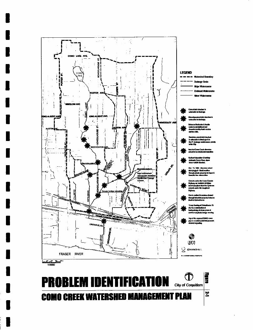
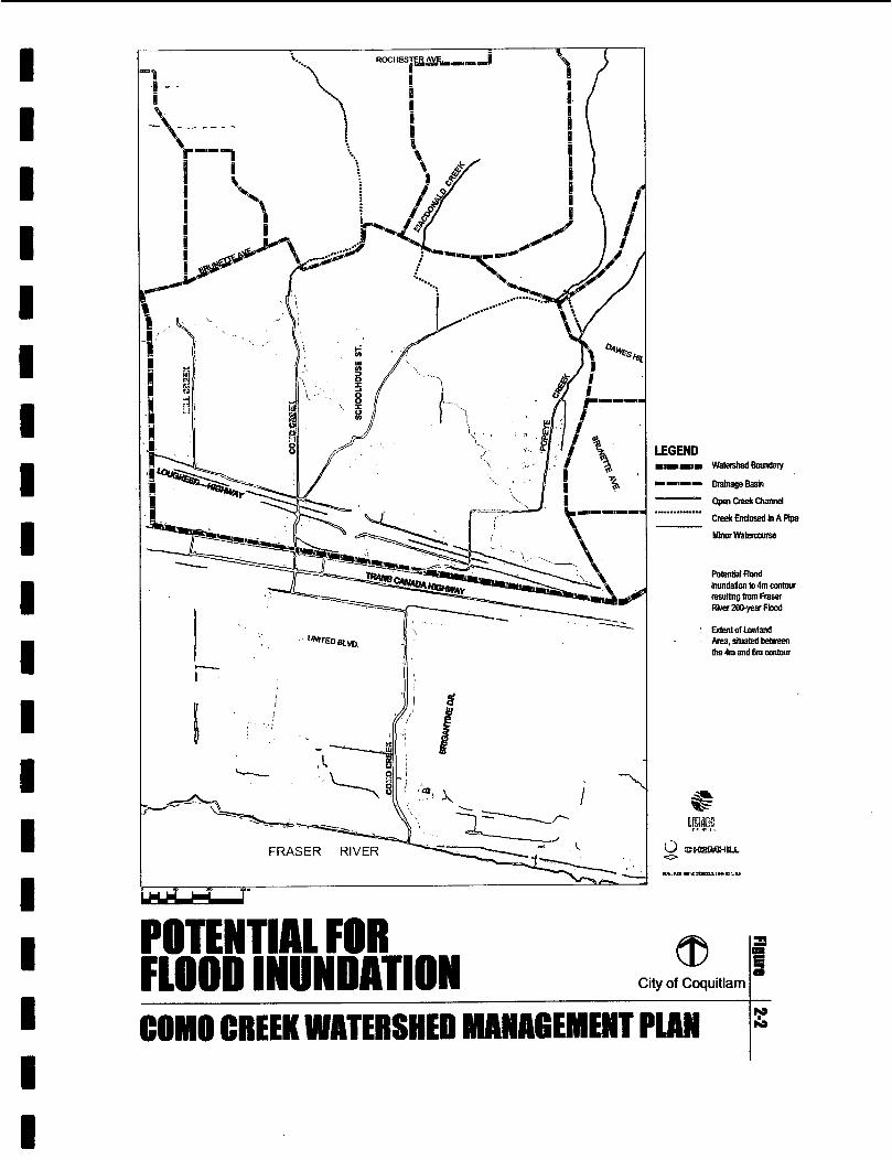
CHAPTER 2 Problem Identification 2.1 Introduction Previous reports on lowland drainage present a complex and confusing picture of conditions in the study area. Hence, one of the objectives of this report is to provide the reader with a clear picture of problem causes. To achieve this objective, three drawings have been developed. The emphasis is on the lowlands. 0 Problem Locations - Figure 2-1 identifies eleven (11) drainage 'hot spots' in the
watershed. Six (6) are in the upstream ravines and five (5) are in the lowlands. The chronic location for flood overflows is Schoolhouse Street at the intersection with Lucille Starr Drive. Note that these flood overflows are normally associated with a Fall/ Winter rainstorm that is coincident with a high tide condition in the Fraser River.
Flood Inundation - Figure 2-2 illustrates the potential for flood inundation resulting from a 200-Year Flood in the Fraser River during the May/June freshet period. The flood inundation limit corresponds to the El 4m contour. Note that the area along Schoolhouse Street that is prone to flooding is situated below the El 4m contour.
Control Points - Figure 2-3 is a schematic cross-section drawing that shows the existing control points that are established by the culvert installations under the Lougheed and Trans-Canada highways. Note that the Trans-Canada culverts are installed at a higher invert elevation than the upstream Lougheed culverts.
The sigruficance of Figure 2-1 is that it shows that the problem locations are relatively few in number. However, they can generally be characterized as either chronic or high risk. Understanding Figure 2-3 is also key. Its relevance has to do with the hydraulic performance of drainage facilities.
0
0
2.2 Overview of Previous Reports Previous investigations were completed in 1975,1989,1990,1993 and 1998. The first three were major studies, whereas the latter two were undertaken in support of specific projects (i.e. railway bridge construction at CP right-of-way in 1993; and design of culverts under Trans-Canada in 1998). Appendix B includes a synopsis of each report in tabular form. Key points to note are listed below: + The scope of each investigation was limited to lowlands drainage + The focus was on the strip between the Lougheed Highway and the Fraser River + The emphasis was on hydraulic modelling Although the overall picture provided by previous reports is complex and confusing, the value of these reports is that they do enable a comparison of conditions in 2000 versus those in 1975. Of relevance, the flow routing in 2000 is completely different to that in 1975.
11 2\125535 2-1 CHZM HILL
I I I I
@ PROBLEM IDENTIFICATION Wd-uiUarn
I
I I
I
7
City of Coquitlam
CONI0 CREER WATERSHED MAWAGEMENT PLAN

Chapter 3 Watershed Modelling
CHZM HILL
C o M O CREEK b E G R A l E D STORMWATER hhNAGEMENI PWS PART A - STRATEGY FOR FLOOD RELIEF AND HAB~AT RESTORATION IN THE FINAL REPORT FWER Mius LOWLANDS FEBRUARY 2002
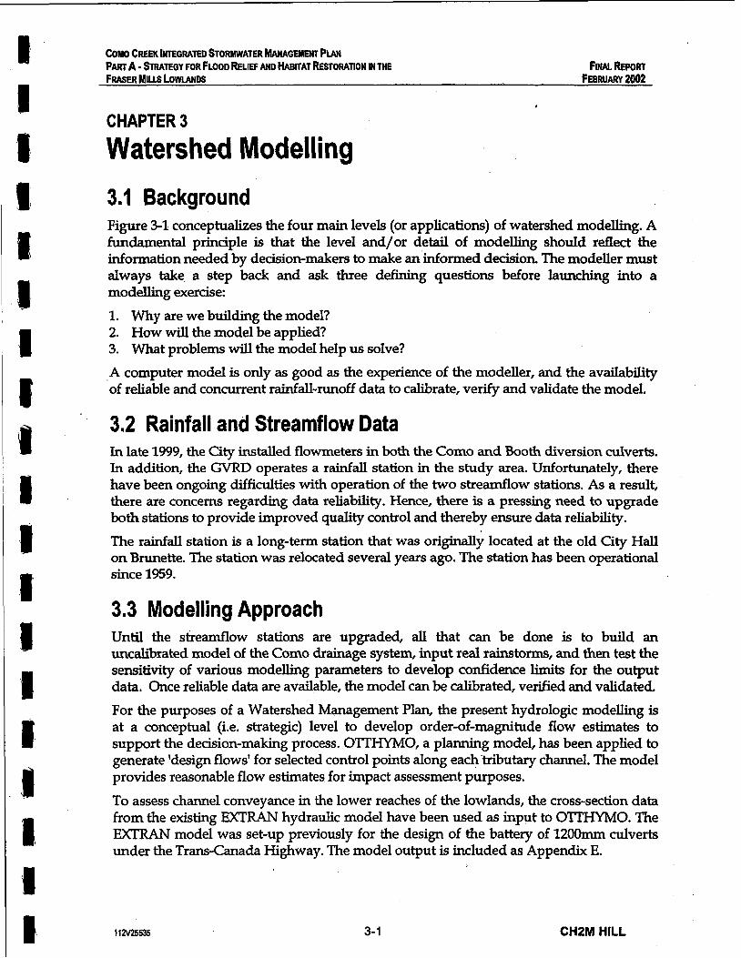
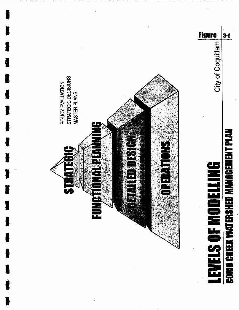
CHAPTER 3 Watershed Modelling 3.1 Background Figure 3-1 conceptualizes the four main levels (or applications) of watershed modelling. A fundamental prinaple is that the level and/or detail of modelling should reflect the information needed by decision-makers to make an informed decision. The modeller must always take a step back and ask three defining questions before launching into a modelling exercise: 1. W h y are we building the model? 2. How will the model be applied? 3. What problems will the model help us solve? A computer model is only as good as the experience of the modeller, and the availability of reliable and concurrent rainfall-runoff data to calibrate, verdy and validate the model.
3.2 Rainfall and Streamflow Data In late 1999, the City installed flowmeters in both the Como and Booth diversion culverts. In addition, the GVRD operates a rainfall station in the study area. Unfortunately, there have been ongoing difficulties with operation of the two streamflow stations. As a result, there are concerns regarding data reliability. Hence, there is a pressing need to upgrade both stations to provide improved quality control and thereby ensure data reliability. The rainfall station is a long-term station that was origmally located at the old City Hall on Brunette. The station was relocated several years ago. The station has been operational since 1959.
3.3 Modelling Approach Until the streamflow stations are upgraded, all that can be done is to build an uncalibIated model of the Como drainage system, input real rainstorms, and then test the sensitivity of various modelling parameters to develop confidence limits for the output data. Once reliable data are available, the model can be calibrated, verified and validated. For the purposes of a Watershed Management Plan, the present hydrologic modelling is at a conceptual (i.e. strategic) level to develop order-of-magnitude flow estimates to support the decision-making process. OTTHYMO, a planning model, has been applied to generate 'design flows' for selected control points along eachtributary channel. The model provides reasonable flow estimates for impact assessment purposes. To assess channel conveyance in the lower reaches of the lowlands, the cross-section data from the existing EXTRAN hydraulic model have been used as input to OTTHYMO. The EXTRAN model was set-up previously for the design of the battery of 120Omm culverts under the Trans-Canada Highway. The model output is included as Appendix E.
112V25535 3- 1 CHZM HILL
L = o o m
Figure 3-1

COMO CREEK INTEGRATED STORWATER h!ANAGEMENT PLAN PART A - STRATEGY FOR FLOOD RELlEF AND HABITAT RESTORATION IN THE FINALREPORT FRASER MILLS LOWLANDS FEBRUARY 2002
3.4 Selection of Storm Events In the 199Os, a key issue in hydrologic modelling was the use of 'design storms' versus 'real storms'. Design storms are synthetic, worst-case events created through statistical . distributions of historical rain data. These distributions are derived from IDF curves, which are a composite of winter and summer storms. Hence, they are not representative of West Coast rainfall conditions. The use of IDF curves originated in an era when neither the databases nor the technology to process the data were available to hydrologists. This resulted in the development of the simplified and empirical methodologies that underpin design storm applications. Rather than use IDF curves, two real storm events have been selected for analysis: the 75mm storm on December 15th 1999 is recent and is therefore fresh in everyone's memory; the 134mm event on January 19th 1968 is the storm of record and has a 100-year return period. Figure 3-2 shows the rainfall pattern superimposed on the IDF curve. It can be seen that the real events have a different pattern as compared to the composite IDF curves. The real winter events are more evenly distributed over time and less intense.
3.5 Results for December 1999 Storm The 75mm rainstorm on December 15th 1999 is a defining event. As noted in Section 2, it resulted in a condition very close to the Mean Annual Flood. Key findjngs are: 0 If Booth Creek had not overflowed at Schoolhouse on December 15*, and if all the
runoff could have been safely conveyed under the private bridge to the Trans-Canada Highway, then the peak runoff rate resulting from the rainstorm would likely have been in the range 9cms to llcms, with a distribution approximately as follows:
I 1 Creek Branch Proportion of Total Flow I Como I 45% Booth/McDonald 35%
I Popeye I ' 20% I 0 If all six 1200mm culverts had been installed under the Trans-Canada, they likely
could have handled 80% of the 9cms to llcms, albeit with limited surcharging However, it must again be emphasized that culvert capacity ratings are highly sensitive to head losses resulting from poor entrance conditions and siltation. On a practical basis, then, a larger surcharge would undoubtedly be required at the flood peak. The other 20% of the flow would have been routed through the Highway Loop.
If Popeye had been physically separated from Como, the existing lOOOmm culvert at the Trans-Canada would have required about a 0.5m surcharge to discharge the 2cms flow share originating from the Popeye watershed. Under this condition, and comparing it with the 'bank-full' observations noted on March 18*, the stream enhancement area east of the Bargain Castle would have been completely inundated.
In summary, a 75mm event can be considered a good test of drainage system performance on a continuing basis.
0
112V25535 3-2 CHZM HILL
COMO CREEK INTEGRATED STORMWATER MANAGEMENT PLAN PART A - STRATEGY FOR FLOOD kUEF AND h K A T RESTORANON IN THE FINALREPORT FRASER M u LOWIANDS FEBRUARY 2002
3.6 Results for January 1968 Storm The record storm occurred on January 19th 1968. The total rainfall depth for this event was about BO-, and as noted previously, the 24-hour rainfall depth was 134mm. Only one other time in 40 years has the 24-hour rainfall exceeded l O O m m (i.e. 106mm on December 17th 1979). It is noteworthy that the 1979 event is the record storm for Greater Vancouver. Based on running the 1968 storm through the uncalibrated model, and applying judgement to the selection of parameter values, the flow estimates for the three branhes are in the range 13cms to 15cms. The distribution by tributary is approximately the same.
Given that the rainfall intensity for the January 1968 event is about 1.4 times that for December 1999 as shown on Figure 3-2, the flow estimates for the two events are quite consistent, as they about the same ratio. It needs to be emphasized that the existing Booth Creek channel does not have the capacity to contain and convey the 100-Year Flood (QlOO) to the Trans-Canada Highway. If it could, the required surcharge at the highway would be greater than 1.h to discharge the combined Como/Booth flow through the proposed battery of six 1200mm culverts. The existing Popeye culverts at Lougheed and the Trans-Canada should be able to handle QlOO from the existing tributary area. Minor surcharging would result. Adding the Booth flow would trigger the need for additional culverts.
3.7 Lowering the GVRD Sewer The &posed top of the GVRD sewer establishes a control point at approximately El l.la Under a winter high tide condition, this location would be submerged for about 10 hours. Hence, the benefit in lowering the sewer would mainly be for water quality purposes during the summer low flow period (i.e. to improve the channel flushing action). Lowering the sewer would have a marginal impact on water levels when a major rainstorm coincides with a high tide condition.
3.8 Future Modelling Applications Hydrologic and hydraulic modelling will take on added importance once the data collection network is in place, and once the focus shifts to the functional planning and design of surface water management facilities. A calibrated model will be an essential tool for quanbfymg water levels and inundation durations for a range of operating conditions. Over time, a calibrated model will also enable monitoring of the effectiveness of impervious area reduction measures in the upper watershed. The flat gradient and culverted system at Lougheed and the Trans-Canada means the channel hydraulics have looped flow, upstream inlet control, backwater, and surcharge conditions that cannot be accurately simulated by a planning model such as OTTHYMO. For this reason, the next step is to apply a detailed hydraulics model to simulate and confirm proposed system improvements. OTTHYMO does correlate the March 23d observation of bank overflows. Referring to Appendix E, model convergence required an excessively long processing time when routing flows through the flat gradient channels.
112v25535 3-3 . CHZM HILL

Figom
Y- O

4
COW CREEK INTEGRATED STORMWATER MANAGEMENT PIAN PART A - STRATEGY FOR FLOOD RELIEF AND HABITAT RESTORATION IN THE FINAL REPORT FRASER Mius LOWLANDS FEBRUARY 2002
3.9 Summary of Findings The results of the uncalibrated watershed modelling, as tempered by the application of judgement and experience that integrates the insights presented in Section 2, are synthesized as follows: 1.
2.
3.
4.
5.
6.
7.
Channel Capacity - A 25mm rainstorm corresponds closely to the 'bank full' condition for Booth Creek as it flows through private property after exiling from the piped section. Mean Annual Flood - At the downstream private bridge near Lucille Starr Drive, a 75- rainstorm clearly results in bank overflows. These can be expected to occur quite frequently. Hence, this channel constriction needs to be removed on a priority basis to provide immediate flood relief. Flood Relief - Removal of the Upper Booth flow would provide permanent flood relief downstream at Schoolhouse because the reduced flow could not exceed the bank-full condition. December 15th 1999 - Under a "no surcharge'' operating condition, the total rated capacity of the proposed six 120Omm culverts at the Trans-Canada is marginally acceptable to handle a 75mm rainstorm event such as occurred on December 15th 1999. The hydraulic model indicates that the battery of culverts could have handled approximately 80 percent of the flow. The other 20 percent would have been routed through the Highway Channel Loop. Flow Split - The split between the Como/Booth/McDonald tributary area and the Popeye sub-watershed is about 80/20. Combining Booth and Popeye would result in about a 50/50 split between the Como/McDonald andBooth/Popeye sub-watersheds. Culvert Capacity - The absence of culvert inlet structures combined with the lack of flow regulation at the Trans-Canada Highway results in extremely poor hydraulic performance such that culvert capacities should be de-rated. Calibrated Modelling - A concurrent rainfall-runoff data collection program is needed for callbration, verification and validation of a computer model that can then be used as both a design tool and an operational tool for surface water management in the Fraser Mills Lowlands. The hydraulic component of this tool would account for backwater, looped flow, tidal effects, and upstream and downstream hydraulic control when routing the calibrated hydrology component through the lower reaches.
Since a watercourse cross-section tends to be in equilibrium with the Mean Annual Flood (MAF), the result is channel instability if the MAF is varying. Erosion and sedimentation then degrade aquatic habitat. As a watershed urbanizes, the MAF progressively increases, and an increasingly larger cross-section is required to contain the MAF. If there is interference with this natural process, the consequence is flood overflows.
This is the Booth Creek situation in the industrial area between Booth and Schoolhouse Streets. The upper watershed has undergone major changes in recent decades, but the conveyance capaaty through the lowlands has not been increased. Hence, a 25mm rainfall now results in a 'bank full' condition, and a 75- rainfall results in overflows.
112V25535 3-4 CHSM HILL

Chapter 4 Elements of an Integrated Plan for the Fraser Mills Lowlands
CHZM HILL

FOWREPORT COMO CREEK INTEGRATED STORMWATER MANAGEMENT Pwr
FRASER MILLS LOWDS FEBRUARY 2002 PART A - m T E G Y FOR FLOOD RELIEF AND HAEITAT RESTORATION IN THE
No. Element Description No. 1 . Booth Creek Diversion 7
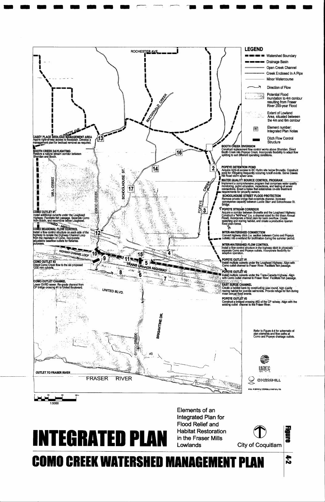
CHAPTER 4
Element Description No. Element Description East Surge Channel 13 Casey Place Bedload Mgmt Area
Elements of an Integrated Plan
2
3
for the Fraser Mills Lowlands
Popeye Creek Settling Pond ' 8 Como Outlet Channel 14 Water Quality Source Control
Popeve Stream Corridor 9 Como Drainage Outlet #E 15 Inter-Watershed Flow Control
4.1 Watershed Vision
5
6
Figure 4-1 illustrates the concept for surface water management in the Fraser Mills Lowlands as described below: 0 Sub-watersheds - Consider the watershed as two halves: Como/McDonald, and
Booth/Popeye
Como/McDonald Outlet - Improve the existing 'drainage outlet' at the Lougheed and Trans-Canada highways to serve the Como-McDonald tributary area
Booth/Popeye Outlet - Create a new 'drainage outlet' at the two highways to serve the Booth-Popeye tributary area
The over-arching goals for the lowlands are: (1) provide flood relief; and (2) restore aquatic habitat. Achieving these goals involves making effective use of the existing Infer- Wafershed Connection between Booth and Popeye Creeks.
0
0
Popeye Drainage Outlet #2 11 Inter-Watershed Connection 17 Schoolhouse St Flood Protection
PoDeve Drainage Outlet #3 12 Como Drainage Outlet # I
4.2 Plan Elements for Flood Relief and Habitat Restoration Figure 4-2 illustrates the elements of an integrated plan that provides flood relief while enabling habitat restoration. The plan elements are cross-referenced to Table 4-1, which provides supporting details for each element as follows: + Describes the scope of the project + Classifies the element as either 'core' or 'optional' + Identifies the key benefits associated with project implementation + Provides a capital cost estimate + Identifies an approximate timeframe for implementation; short-term (0-5 years),
medium term (5-20 years), or long-term (20-50 years) The plan comprises 17 elements as listed below. The first group of seven involves work along Popeye Creek. The next six relate to Como.
I 4 I Popeye Drainage Outlet # I I 10 '1 Como Seasonal Flow Control I 16 I Booth Creek Daylighting . I
112V25535 4- 1 CHPM HILL

COMO CREEK INTEGRATED STORMWATER W G E M E N T PIAN PART A - WRATEGY FOR FLOOD RELIEF AND HAENTAT RESTORATION IN THE F~NAL REPORT FRASER MILLS LOWLANDS FEBRUARY 2002
The decision analysis mat& that is presented in Appendix C complements Figure 4 2 and Table 4 1 with supporting details for each plan element, including: + Description of the element + Explanation of its function and related objectives + The advantages (pros) resulting from implementation + The disadvantages (cons) resulting from implementation
The plan is 'time-flexible'. Also, many of the elements can be implemented independently. The matrix was developed by means of a participatory approach to problem-solving that enabled the stakeholder group to brainstorm the pros and cons of each element.
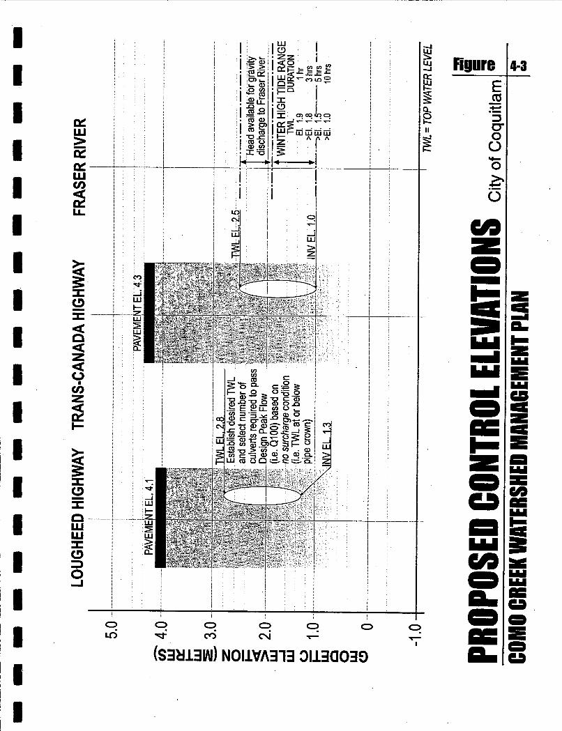
4.3 Hydraulic Control Elevations Figure 4 3 presents proposed control elevations for the purposes of surface water management in the Fraser Mills Lowlands. Good design practice results in these three guidelines:
Maximum TWL - Select a maximum allowable Top Water Level (TWL). The challenge is to optimize this selection. This involves consideration of the tidal range in conjunction with culvert selection. Waterway width is of more relevance than height in maintaining a smooth flow transition from open channel to piped flow.
Culvert Rating - Size waterway openings in roadways for 'zero surcharge'. Culvert capacity is sensitive to the configuration and condition of culvert entrances. Actual capacity will be noticeably less than theoretical. Hence, the importance of providing flow regulation to ensure a smooth transition from open channel to piped flow.
Tidal Impact - Consider duration of Fraser River winter high tide range. For a maximum high tide, the available head for gravity discharge of streamflow to the Fraser is at a minimum for about one hour. Thereafter, the head increases incrementally as the tide drops. This relationship is tabulated on Figure 4 3 .
As shown on Figure 43, the preferred culvert diameter for the two highway crossings is 1500mm. Considering the existing channel invert elevations, this establishes a desired TWL corresponding to El 2.5m at the Trans-Canada (and compares with El 4.0m that was used for the new battery of culverts). For a winter storm coincident with a high tide, the head available for gravity discharge to the Fraser is 0.6m when the tide is at its maximum.
0
0
112V25535 4-2 CHSM HILL

Concept for Surface Water @ @ Management in SURFACE WATER ~ ~ ~ n E I s City of Coquitlam
Divert Booth into Popeye.
a
Create new drainage outlet to sem Booth I Popeye tributary area.
COMO CREEK WATERSHED MAWAGEBENT PLAN /f
LEGEND I imiiml m Watershed Boundary =i-i-i- Drainage Basin - Open Creek Channel . m m . . D n O m O ~ m m D m Creek Endosed In A Pipe
Minor Watercourse
Direction of Flow -- T7Tr- *II Potential Flood
~---/b!f Inundation to4m contour resultin from Fraser River ibyear FIW
Extent of Lowland Area, situated between the 4m and 6m contour
Element number: Integrated Plan Notes - Ditch Flow Control Structure
POPEYEOUTLhR? @n?bud a bri ed crossing exlang outlet %riel to thekraser m r .
of t@P railway. Align &I the
Refer to Fyure 4-4 for schematic of plan elemenls and R o y paths at Como and Popeye drainage outlets.
Elements of an Integrated Plan for
PL
PL PL -__ W
3 i w I-
. .=- I l l
i
. . ...... ... -
! j
I i
I I 1
! I
! I
Figure
z P -.
0 Q, crl N Q1
m
m Z -4 v) 0 n > Z z
I- s . . .
P -N 8 -0 0 0
2 -0
-0
0 0
0 0
e3 N VI
0 2
2 8 -0 0 0
e3
0
0 0
23 -0
e3
0
0 0
8 -0
. 0 5 2 8 2
s
7
Y
a n 3 e
g. 2 9 I. -
5
5' rn 3 P)
L. K <
b v)-
0
v)
2. n
D O . D 0 .
UI
0 k
h)
0 z E
0 z z

tn 0
a a a a a
0 0 9 8 J --
f c .- 0
3 .- e E R r .
a a a a - a a
B P t x
3 m 5 M a
I r r

1 I I I I i I 1 I I I I I I I I I 1 I
COMO CREEK INTEGRATED STORFAWATER MANAGEMENT PIAN
FRASER MILLS LOWLANDS FEBRUARY 2002 PART A - STRATEGY FOR FLOOD RELIEF AND HABITAT RESTORATION IN M E FItW REPORT
4.4 Flow Control at Trans-Canada Highway Figure 4-4 is a schematic drawing that supplements Figure 42 in order to provide clarity. It illustrates the plan elements and flow paths at the Como and Popeye drainage outlets. Core elements are described below: 0 Popeye Creek - Install batteries of 1500mm culverts under both the Lougheed and
Trans-Canada, and construct a bridge under the railway. Connect to the existing Fraser River outlet.
Como Creek - Isolate the Highway Channel Loop, and direct most flows to the new battery of 1200mm culverts. Maintain an 'inter-watershed connection' to Popeye Creek.
Implementation of all elements would enable a 50/50 flow split between the Como/McDonald and Booth/Popeye sub-watersheds, thereby achieving the flood relief goal. This compares with the existing 80/20 split. Hydraulic modelling is an essential element of the 'flow control system'. Permanent data loggers to record water levels at culverts are needed for model calibration, verification and validation. Monitoring culvert performance will result in a measurement-based understanding of flow dynamics under flood conditions. This will provide a high degree of certainty.
0
4.5 Integration with Uplands Strategy The Lowlands Strategy has been developed in the context of a holistic framework that considers the inter-relationship of the Lowlands Plan Elements with an Uplands Strategy. It is recognized that upstream actions have downstream consequences (or benefits). This understanding will be integrated in Part B when developing the elements of the 50-Year Vision for the entire watershed. hoking ahead, if changes in the land use regulatory framework can be successfully implemented to partially restore the natural hydrology in the upper watershed, then: + Runoff frequency and magnitude can be reduced + The risk of flood overflows in the lowlands can be reduced + Erosion of the ravines and sedimentation in the lowlands can be minimized + Aquatic habitat can be improved Policies and programs that demonstrate early success in achieving watershed goals build support for the 50-year vision to improve watershed conditions.
4.6 Popeye Creek Stream Corridor Restoration Acquiring right-of-access to a corridor between Brunette and Lougheed would provide the opportunity to restore a natural stream system for greenway purposes. This could become the 'crown jewel' of the Integrated Plan. The corridor components would likely include a 'MAFway' (i.e. a channel sized for the Mean Annual FZood), spawning and rearing habitat, a floodplain for bank overflow, a riparian floodplain forest, and a park trail.
11N25535 4-3 CHZM HILL
COMO CREEK INTEGRATED STORMWATER MANAGEMENT PIAN PART A - STRATEGY FOR FLOOD RELIEF AND HABITAT RESTORATION IN THE FINA~REPORT FRASER MILLS LOWLANDS . FEBRUARY 2002
Property redevelopment may provide. opportunities to acquire land for the corridor. Since corridor restoration would be a benefit to the entire Como watershed, a watershed- based drainage utility may be an appropriate vehicle to fund an implementation plan. Having such a utility would also facilitate a watershed approach to providing habitat compensation and/ or mitigation for other projects within the watershed.
4.7 Capital Cost Estimates Table 4-1 presents Class B capital cost estimates for the seventeen (17) plan elements. Ten (10) are classified as core. The other seven (7) are considered optional. The budget items are summarized in terms of three time-frames as follows:
TIME-FRAME 1 BUDGET I Core I Oational I Total
All of the 17 plan elements will result in improve drainage and/or habitat conditions in the Lowlands (as described in Table 4-l), but the Plan does not rise or fall on any one element. The core plan elements are considered more beneficial, and thus, higher priority than the optional elements.
The 20-Year Plan covers the projects to be undertaken in years 6 through 20; while the 50- Year Plan covers years 21 through 50. The core elements account for 70% of the total cost.
4.8 2002 Action Plan Background This section presents an Action Plan that fulfils these three over-aching objectives:
0
0
Objective #1- Demonstrate that the City is taking immediate action Objective #2 - Provide improved flow management at the Trans-Canada Highway
Objective #3 - Develop a measurement-based model of watershed response to rainfall Table 4-2 identifies ten (10) priority action items that are straightforward to initiate and/or implement this year. The 2002 Action ‘Plan represents the first phase in a systematic process to resolve existing system deficiencies. The budget estimates are extracted from Table 4-1 and total $460,000. This represents approximately 27% of the overall allocation for the 5-Year Plan.
11 2V25m 4-4 CHZM HILL

I I I 1 6 I 1 I I I I I I I I I I I I

I I I I I I I I I I
COMO CREEK INTEGRATED STORFdWAlER MANAGEMENT PLAN PART A - STRATEGY FOR FLOOD RELIEF AND HABITAT RESTORATION IN THE FINALREPORT FRASER MILLS LOWLANDS FEBRUARY 2002
Plan Components Each project in the 2001 Action Plan is cross-referenced to an element in the Integrated Plan that was presented in Table 41. The proposed projects are classified into three types:
Flood Relief ($lW,OOO)
Environmental Management ($75,000) The projects are listed in order-of-priority for implementation. Furthermore, management objectives are identified, the project scope is described, and the 'level of effort to implement' is assessed on a lo.w/medium/high rating scale. The first seven are core elements of the Integrated Lowlands Plan.
Flow Management ($260,000) {{Note: Directly supports the flood relief component]]
Flood Relief Removal of the private bridge at Lucille Starr Drive, combined with reactivation of the Booth-to-Popeye flow connection above Sheridan, would immediately and considerably lessen the risk of flood overflows onto Schoolhouse Street.
Flow Management A water level monitoring system at the Trans-Canada Highway culverts wiU provide a science-based understanding of exactly what happens during periods of heavy rainfall coincident with high levels in the Fraser River. The data can then be incorporated in the hydraulic model so that it can then be used as an operations tool. Upgrading the two existing steamflow gauging stations will resolve quality control concerns related to data collection. These stations are critical in terms of first calibrating and validating the hydrology model, and then providing a second tool for effective surface water management. In addition, the stations 'and model provide the means for monitoring long-term changes in watershed response to rainfall.
112V25535 4-5 CHZM HILL

-L 0 Q) UI P h) -. ca 4
9 2. s! E 3
(P
(D
5 w 3 0
3 UI
5 4 5 s
9 2. 2 (P
-I Y P
e e e e e e e e e e e 0
e e e e e e e e e
tD B E. '0 t D 3 Y ( 0 - .... .... .... .... .... .... .... .... .... b . . . . .
Z 03
< 8 3
v) 3 ul
Z 0
z 0
z (P 5
s €
s s E; €
tf) UI 0
0 0 -0
if)
!3 -0 0 0
if )
G: 8 -0
tf) Q) 0
0 2
w -8 0 0 0
2 0 0
0 0 -0
i f )
G: s 0
i f )
!3 g -0
--r-- -
3 e
7 s! w
c

Chapter 5 Integration of Lowlands and Uplands
Strategies
CHZM HILL
,
COMO CREEK INTEGRATED STORMWATER MANAGEMENT PUN PART A - STRATEGY FOR FLOOD RELIEF AND M I T A T RESTORATION IN THE FINALREPORT FRASER MILLS LOWLANDS FEBRUARY 2002
CHAPTER 5
Integration of Lowlands and Uplands Strategies 5.1 Summary of Flood Mitigation for the Lowlands Part A of the Como Creek Watershed Management Plan was prepared as an Interim Report to satisfy the City's need for immediate solutions to flooding problems in the Fraser Mills Lowlands. Key findings relating to flood mitigation in the Lowlands are:
Consequences of Changes in Land Use - The Como Creek watershed has undergone almost complete urbanization, resulting in more surface runoff. The Trans-Canada Highway is a barrier that restricts the rate of outflow to the Fraser River. Redevelopment of the Fraser Mills Lowlands to higher value commercial land use has resulted in 'zero tolerance' for disruption of public access due to road corridor closures that are caused by flood overflows.
Critical Locations in the Lowlands - Conditions in 2001 are considerably improved over those in 1975, and flooding frequency has been reduced, but the relatively few problem locations can be characterized as chronic. The two most critical locations are the private bridge on Booth Creek at Lucille Starr Drive, and the culverts under the Trans-Canada Highway.
Impact of Threshold Events - A 25mm rainstorm results in channel 'bank full' conditions throughout the lowlands. A 75mm event results in bank overflows at the Booth Creek private bridge. The storm of record is 134mm. It is therefore apparent that the bridge should be removed, and that partial removal of the Upper Booth flow (to the Popeye drainage system) would provide permanent flood relief downstream from Lucille Starr Way.
Watershed Vision - The concept for surface water management in the Fraser Mills Lowlands is to consider the watershed as two halves (i.e. Como/McDonald, and Booth/Popeye), and restore separate drainage outlets. The concept is keyed to making effective use of the existing Inky-Watershed Connection between Booth and Popeye. This would enable a 50/50 flow split between the-two watershed halves, as compared with the existing 80/20 split for Como/McDonald/Booth versus Popeye.
Elements of an Integrated Plan - The over-arching goals of an integrated plan for the Fraser Mills Lowlands are to provide flood relief and restore aquatic habitat. The plan comprises 17 elements, many of which can be implemented independently over a 50- year period.
11 2\12595 5-1 CHZM HILL

COMO CREEK INTEGRATED STORMWATER MANAGEMENT PLAN PART A - STRATEGY FOR FLOOD RELIEF AND M I T A T RESTORATION IN THE FINAL REPORT FRASER M u s LOWMDS FEBRUARY 2002
0 2002 Action Plan - Removal of the private bridge at Lucille Starr Drive, combined with reactivation of the Booth-to-Popeye flow connection above Sheridan, would immediately and considerably lessen the risk of flood overflows onto Schoolhouse Street. Hydrologic and hydraulic modelling tools will take on added importance once the focus shifts to the functional planning and design of surface water management facilities. Hence, rainfall-runoff data collection is essential for model calibration and validation. [The total capital cost for the short-term flood mitigation projects over the next 5 years is $1.7 million, of which 27% is allocated to priority projects for 20011.
5.2 Land Use and Aquatic System Overview Background The key objective of the Como Creek Watershed Management Plan is to achieve a balance between the immediate need for hazard mitigation (the focus in Part A) and the longer- term desire for watershed restoration (the focus in Part B). This requires full integration of the engineering, planning and ecological perspectives to solve short-term flooding and habitat challenges, as well as determine how to implement changes in land use regulation that improve watershed conditions. Policies and programs that demonstrate early success in achieving watershed goals build support for the 50-year vision.
Existing Aquatic Resources Figure 5-1 provides an overview of existing aquatic resources in the Como Watershed. It shows the major environmental values and limitations in the watershed, and classifies the creek reaches. Four functional types are defined: estuarine, lower floodplain, upper floodplain, and upland. Fundamental questions to be addressed in Part B are: + What may be achievable for the Como watershed? + What is a realistic watershed restoration strategy? Figure 5-2 provides a regional context for the Como Watershed. It shows that the Como Watershed is rated as 'poor' according to the Watershed Health Classification System developed by the Greater Vancouver Regional District (GVRD). To improve the health of watercourse in the Como Watershed, either the total impervious area (TIA) that contributes surface runoff must be decreased, or the riparian forest integrity (RFI) must be increased. The latter is defined as the percentage of continuous forest cover within a 60m riparian corridor. The best opportunity for acquiring a riparian corridor to restore a natural stream system (i.e. increasing RFI) is Popeye Creek between Brunette and Lougheed.. This stream corridor and riparian floodplain forest could become the 'crown jewel' of the Como Watershed.
Part B focuses on identdymg opportunities to reduce TIA that contributes surface runoff in conjunction with future land use changes.
112V25535 5-2 CHZM HILL

I
t
I 1 Y f
VALUES AND CONSTRAINTS Cityofcoquitlam @ /I FISH HABITAT COMO CREEK WATERSHED MANAGEMENT PUN 1%

1L w w e 0
0
z - w 4 w w 0 0 z 0 0
4
I
p:
pe 0 0 e,
G \
Fiaure

COMO CREEK lNlEGRATED %ORWATER h!ANAGEMENT PUN PART A - STRATEGY FOR FLOOD RELIEF AND HABITAT RESTORATION M THE FINAL W O R T FRASER Mius LOWWCDS FEBRUARY 2002
Limiting Factors for the Health of Aquatic Resources
Current research shows that the factors limiting the ecological values of urban streams and waterways are, in order-of-priority:
1) Changes in Hydrology - greater volume and rate of surface runoff caused by increased impervious area in the watershed.
2) Disturbances to the Riparian Corridor - clearing of natural vegetation in riparian areas
3) Degradation of Aquatic Habitat - caused by erosion and sedimentation processes, bank hardening, and removal of large organic debris.
4) Deterioration of Water Quality - pollutant washoff from high density land uses, waste discharge from commercial operations and accidental spills.
Note that the top two limiting factors, changes in hydrology and disturbances to the riparian corridor, correspond to the two components of the GVRD Watershed Health Classifcution System.
Changes in hydrology are particularly important because they drive the erosion and sedimentation processes that lead to the third limiting factor, degradation of aquatic habitat.
By the time land use density reaches the level where water quality ‘degradation is a sigmficant factor in terms of fish survivability, the increase in surface runoff resulting from land use densification (i.e. changes in hydrology) would have already flushed out
. thehabitat.
The number one priority of the Department of Fisheries and Oceans (DFO) Drap Urban Sfomwater Guidelines is nmoflvolume reduction, which is the key to mitigating changes in hydrology at the source. This is a key focus for Part B.
Land Use Policies and Regulations Restoring watershed hedth by decreasing TIA/ increasing the RFI can only be achieved over time (i.e. the 50-year vision) through changes in land use policies and regulations. Appendix D contains the results of a review of current bylaws. The scope of the review was three-fold: + Present a synopsis of what is existing -3 Idenw strengths and opportunities for improvement + Assess risks and issues that might affect the future of the watershed Appendix D provides the foundation for the development of a land use and development strategy in Part B. This strategy will address the regulatory framework as one component of the implementation strategy for the Watershed Management Plan, to be used in balance with public awareness and capital works programs.
112V25535 5-3 CHPM HILL
and
PART B
Watershed for Flood Risk Management
Res to rati o n . in the Como Uplands

Chapter 6 Management Strategy for the
Como Uplands
CHZM HILL

COMO CREEK INTEGRATED STORMWATER MANAGEMENT PLAN PART B - STRATEGY FOR FLOOD RISK MANAGEMENT AND FINAL REPORT
FEBRUARY 2002 WATERSHED RESTORATION IN THE COMO UPLANDS
CHAPTER 6
Management Strategy for the Como Uplands 6.1 Problem Statement Prior to the 1990s watershed management typically meant mitigating the downstream consequences of changes in upstream land use. .The focus was on hydrotechnical solutions such as such as watercourse stabilization, with the approach to problem solving being generally reactive rather than proactive.
In recent years a more integrated, proactive approach to watershed management has evolved. This approach focuses on source control strategies that eliminate the primary causes of problems within the watershed, particularly the changes in ~uater balance resulting from land development.
While reactive solutions are still needed to provide immediate flaod relief, long-term watershed restoration requires proactive solutions that eliminate the root cause of watershed problems.
.
Root Cause of Watershed Problems The natural water balance of the Como Uplands has been dramatically altered by urban development: When natural forest is replaced w i th roads and buildings, less rainfall infiltrates into the ground, less gets taken up hj vegetation, and more becomes surface runoff. This is the root cause of drainage-related problems in the Como watershed, such as erosion of the Como Creek Ravine and chronic flooding in the Lowlands. Past development in the Como Watershed occurred in the absence of an appropriate strategy to deal with these problems. The City recognizes that the same pattern cannot be re pea ted with future r e-development .
The Future of the Como Watershed Another 20,000 people may need to be accommodated in Southwest Coquitlam over the next 50 years. Potentially half may choose to settle in the Como watershed. This would increase the current population of the watershed by about 50% (from 20,000 to 30,000 residents).
Accommodating this growth will trigger subdivision and re-development, which can be expected to increase impervious area. Without an appropriate retrofit strategy, future densification will create more surface runoff, which will worsen existing problems and continue to create new problems.
112V25535 6-1 CHZM HILL

COMO CREEK INTEGRATED STORMWATER MANAGEMENT PLAN PART B - STRATEGY FOR FLOOD RISK MANAGEMENT AND WATERsHED RESTORATION IN THE COMO UPLANDS
FINAL REPORT FE~RUARY 2002
However, future re-development also provides the opportunity to eliminate the source of existing problems. This will require a watershed retrofit strategy aimed at restoring the natural water balance of the Como Uplands as re-development occurs.
A retrofit strategy for the Uplands is needed to support the over-arching goals that have been defined in Part A for the Lowlands: to provide immediate flood relief, and to restore aquatic habitat over the long-term.
Summary of Current Problems During storm events three of the City’s eight drainage crews are required to deal with high-risk flooding locations in the Como Watershed.
ComolMacDonald Sub-watershed The primary problem in the Como sub-watershed is the continuing erosion of the Como Creek Ravine, particularly the section between Austin and Rochester, as illustrated below.
This erosion degrades aquatic habitat, increases flooding risk, and is the direct cause of many specific drainage-related problems that were identified in Figure 2-1:
Ravine instability and tree falls (problem #3)
Bedload deposition and buildup increases the risk of culvert blockage (problem # 1,4,5 and 6)
Figure 6-1 Typical Stream Bank Erosion in the Como Creek Ravine
Another sigruficant problem is that all the flow from the Como Uplands is currently directed into the lower part of Como Creek, which results in a convoluted drainage pattern and increases the risk of flooding in the lowlands.
112V25535 6-2 CHPM HILL

COMO CREEK INTEGRATED STORMWATER MANAGEMENT PLAN PART B - STRATEGY FOR FLOOD RISK MANAGEMENT AND WATERSHED RESTORATION IN THE COMO UPLANDS
FINAL REPORT FEBRUARY 2002
BoothlPopeye Su b=Watershed The main problem in the Booth sub-watershed is the chronic flooding of Booth Creek at Schoolhouse Street (problem #lo, Figure 2-1). Removal of the private bridge crossing would sigruficantly reduce the risk of flooding at this location.
Erosion is occurring in the Booth Creek ravine, although it is not as apparent as in Como Creek. There is evidence that bedload deposition and debris movement in the Booth Creek system increases the risk of localized flooding. During the Dec. 15,1999 flood for example, the blockage of a diversion culvert led to flooding of private property (problem #7, Figure 2-1).
Although the Booth Creek Ravine appears to be stable, this may not be the case over the long-term. Much of the Upper Booth Watershed was recently connected to storm sewers, and the impact of increased runoff into Booth Creek may not yet have progressed to the same stage as Como Creek.
6.2. Identifying Solutions to the Erosion Problem Nature of the Erosion Problem Watercourse erosion is a natural process. It occurs whenever the s t readow velocity exceeds a threshold level that causes sediment and bedload transport. However, the increase in surface runoff associated with development in the Como Uplands has dramatically increased erosion, far above natural levels. The increase in surface runoff means that a greater proportion of every rainfall event contributes to streamflow in downstream watercourses, which results in: = greater total flow volumes
greater peak flow rates Therefore, streamflow velocities are much larger than they were under natural conditions, and velocities remain high for longer periods of time. Frequently occurring small rainfall events that did not cause erosion prior to development now produce streamflows that exceed the critical “threshold erosive velocity”. The increase in erosion has serious consequences: . =
Degradation or elimination of aquatic and riparian habitat. Destabilization of ravine banks, which causes trees and other debris to fall into the streams. Downstream deposition of sediment and debris, which increases flooding risk.
Short Term Erosion Control The short-term reactive approach to erosion control would involve a ravine stabilization program. Much of the Como Creek ravine would have to be lined with rip-rap to prevent
11N25535 6-3 CHZM HILL

COMO CREEK INTEGRATED STORhWATER MANAGEMENT PLAN PART B - STRATEGY FOR FLOOD RISK MANAGEMENT AND WATERSHE0 RESTORATION IN THE COMO UPLANDS
FINAL REPORT FEBRUARY 2002
further downcutting and undermining of ravine slopes. Eventually, this might also be required in the Booth Creek ravine.
Ravine stabilization is a "band-aid solution that does not address the root of the erosion problem. It is considered an unacceptable approach for a number of reasons:
0
0
Cost - the cost of ravine stabilization would be very high. Not practical - there is currently no access to the Como Creek ravine for construction equipment. Eliminates the possibility of watershed restoration - the disturbances to fish habitat and the riparian corridor would be dramatic and irreversible. Nobody wants this -the senior environmental Agencies and a majority of community residents would oppose it.
0
Partid erosion control can also be provided in the short-term by building community stormwater detention facilities that control the rate of runoff from the Como Uplands. This is a partial solution because it does not reduce total runoff volume.
Long-Term Erosion Control The proactive approach to erosion control is to eliminate the causes:
Reduce total runoff volume - eliminate the surface runoff from small, frequently occurring rainfall events. Reduce peak runoff rates - reduce the rate of runoff from large rainfall events to approximate the response of a natural forested watershed.
=
These become the key objectives of a Watershed Retrofit Strategyfir the Como Uplands. As re-development occurs, the watershed can be retrofitted with source control facilities designed to: = =
Store runoff from impervious surfaces and release it at a controlled rate Infiltrate small storms into the ground.
This is a long-term solution. Erosion rates will decline incrementally as the natural water balance is restored in conjunction with re-development over the next 50 years.
Watershed retrofit is an essential component of a long-term watershed restoration strategy. Watercourse erosion must be reduced to natural levels in order to restore the health of the Como watershed.
11iV25535 6-4 CHPM HILL

FINAL REPORT FEBRUARY 2002
COMO CREEK INTEGRATED STORMWATER MANAGEMENT PLAN PART B - STRATEGY FOR FLOOD RISK MANAGEMENT AND WATERSHED RESTORATION IN THE COMO UPLANDS
6.3 Identifying Solutions to the Flooding Problem
Nature of the Flooding Problem The increase in surface runoff from the Como Uplands results in downstream peak flows. that are much higher than peak flows from a natural forested watershed. The stomwater system that was built to convey these large peak flows is inadequate. There are certain components of this system where there is high risk of flow obstruction resulting in flooding. These components include:
High-risk culverts that are vulnerable to blockage, localized flooding and potentially disastrous consequences (e.g. road washout) The private bridge on Booth Creek near Schoolhouse St. A convoluted drainage system in the lowlands, which is a result of all the watershed runoff being directed into the lower part of Como Creek.
Erosion has a big impact on the risk of flooding. Continuing erosion in the upper watershed causes bedload deposition and debris movement, which increases the risk of flooding in the lowlands. This increased flooding risk is a result of = A constantly decreasing flow capacity of lowland channels caused by bedload
deposition and buildup. culverts and storm sewer outfalls becoming blocked with debris or bedload buildup.
Short Term Flood Control There is a need for immediate flood relief in the Como Watershed. The risk of flooding can be reduced in the short-term by modifying the existing stormwater system to: 0 upgrade high-risk flooding locations (e.g. culverts that are vulnerable to blockage)
0 reduce bedload and debris transport from the Upland Ravines
0 divert peak flows away from high-risk flooding locations (e.g. Booth Creek at schoolhouse) reduce the peak runoff rates from the Como Uplands, thus reducing downstream peak flows.
0
Long-Term Flood Control These short term flood risk management options are all partial solutions (i.e. risk reduction) that deal with the consequences of water balance changes in the Uplands. The complete solution is to implement a Waterslzed Xetrofif Strategy that restores the natural water balance in the long-term, thus reducing peak flows to natural levels and eliminating the root cause of flooding. Until this complete solution is achieved the risk of flooding will remain.
1 12V25535 6-5 CHPM HILL

COMO CREEK INTEGRATED STORMWATER MANAGEMENT PLAN PART B - STRATEGY FOR FLOOD RISK MANAGEMENT AND WATERSHED RESTORATION IN THE COMO UPLANDS
FINAL REPORT FEBRUARY 2002
6.4 Summary of Findings The preferred management approach for the Como Watershed is to eliminate the causes of problems, and not just deal with the consequences. The stormwater management strategy for the Como Uplands has two key components: 0 The Complete Solution: Long-Term Watershed Restoration - Implement a watershed
retrofit strategy in conjunction with future redevelopment to restore the natural water balance of the Como Uplands and reduce watercourse erosion to natural levels.
The Partial Solution: Short-term Flood Risk Management - Implement modifications to the existing stormwater system to reduce the risk of flooding.
Details of both components are provided in the chapters that follow. Implementation of both will result in an integrated solution to erosion, flooding, and aquatic habitat issues.
II P 1 P
0
11 2~25535 6-6 CHZM HILL

Chapter 7 Long-Term Watershed Restoration
CHZM HILL

COMO CREEK INTEGRATED STORMWATER MANAGEMENT PIAN PART B - STRATEGY FOR FLOOD RISK MANAGEMENT AND WATERSHED RESTORATION IN THE COMO UPLANDS
FINAL REPORT FEBRUARY 2002
CHAPTER 7
Long-Term Watershed Restoration 7.1 The Water Balance Approach Achieving long-term restoration of the Como Watershed'requires a retrofit strategy to restore the natural water balance of the Como Uplands and thereby reduce watercourse erosion to natural levels. The key objectives of a retrofit strategy for the Como Uplands are:
Flow Volume - Reduce runoff volume to prevent erosion and support baseflow Flow Rate - Slow down the rate of runoff to prevent erosion and flooding
Components of an Integrated Strategy These volume and rate objectives form the basis for a water balance approach to watershed management, which has two components:
Rainfall Capture - Capture the frequently occurring small rainfall events at the source and restore them to their natural hydrologic pathways (i.e. runoff volume reduction). This means that small rainfall events, which account for the bulk of the annual rainfall volume, should be infiltrated into the ground and/or reused within the watershed. Runoff Control - Detain runoff from larger rainfall events and release it under controlled conditions (i.e. runoff rate control). The rate of release should approximate a natural forested condition.
Understanding Runoff Control versus Rainfall Capture Runoff control without rainfall capture is the conventional detention-based approach to stormwater management. Evidence shows that this approach does not protect downstream fish habitat because it does not maintain natural levels of erosion or support baseflows in watercourses.
The water released from conventional detention storage goes directly to a storm sewer or downstream watercourses. This slows down the water and reduces peak runoff rates, but does little to reduce total runoff volume. Therefore, the impact of extreme runoff peaks is reduced, but runoff is spread out over a longer period of time, which results in erosive streamflows for longer periods of time.
Rainfall capture requires storage at the source, where runoff from impervious surfaces is stored and infiltrated into the ground rather than released directly to surface drainage systems. This reduces runoff volume and supports stream baseflow by partially restoring the natural water balance.
Community storage facilities that serve sub-catchments of the watershed do not provide the opportunity for infiltration at the source.
112~25535 7-1 CHZM HILL
L
COMO CREEK INTEGRATED STORMWATER MANAGEMENT PLAN PART B - STRATEGY FOR FLOOD RISK MANAGEMENT AND WATERSHED RESTORATION IN THECOMO UPLANDS
FINAL REPORT FEBRUARY 2002
i
The Importance of Rainfall Capture for Water Quality Rainfall capture is important for improving water quality as well as reducing runoff volume. The objective of rainfall capture is to infiltrate small storms and the first portion of large storms at the source. This means that the ‘first flush’ of pollutants that get washed off impervious surfaces at the beginning of rainfall events will be treated as they infiltrate into the ground. In the process of mitigating changes in hydrology, the wafer balance approach also addresses water quality issues.
Opportunity for Watershed Retrofit The opportunity to retrofit individual building lots and roads with storage and infiltration facilities will arise as re-development occurs within the watershed. Most buildings in the Como watershed are more than 25 years old, and approximately half are more than 40 years old. The Como population is, on average, slightly older than the remainder of the City. These statistics indicates that there could be substantial re-development in the 5-25 year timeframe, and that the watershed will be approaching complete re-development in the 25-50 year timeframe.
This re-development will provide a real opportunity to restore the health of the Como Watershed over the next 50 years. In order to enable this long-fern watershed restoration, it is essentid to build support within the development community and to make the appropriate changes to the City‘s development regulations in the shod-fern.
Without these short-term changes, the opportunity for long-term restoration will slip away. Watershed degradation will continue to worsen and signhcant capital expenditures and staff maintenance time will be required to deal with the consequences.
7.2 Adaptive Approach to Watershed Retrofit The changes in development practices that will enable source storage retrofit cannot happen overnight. They must be phased in incrementally through a &step adaptive approach, which is summarized below.
Adpative Methodology for Watershed Retrofit
o Step 1 - Establish preliminary targets for rainfall capture and runoff control based site- specific rainfall data.
o Step 2 - Validate the preliminary targets using continuous simulation modelling. o Step 3 - Implement and monitor the performance of pilot projects on public works to
refine storage and infiltration targets and to iden* the best design practices for achieving these targets.
o Step 4 - Incorporate targets and design practices into development regulations through a consultation process with developers and landowners.
o Step 5 - Assess how well the watershed retrofit strategy restores natural water balance over time.
o Step 6 - Refine targets and design practices based on the ongoing assessment process.
112v25535 7-2 CHZM HILL

COMO CREEK INTEGRATED STORMWATER MANAGEMENT PLAN PART B - STRATEGY FOR FLOOD RISK MANAGEblENT AND WATERSHED RESTORATION IN THE COW0 UPLANDS
FINAL REPORT FEBRUARY 2002
This report focuses on Steps 1 and 2, which are the preliminary planning level steps. Steps 3 and 4 refer to the process of change that must take place in the short-term to enable long-term watershed retrofit. Steps 5 and 6 will evolve as redevelopment occurs and the performance of the retrofit strategy can be assessed and optimized.
7.3 Step 1 - Preliminary Targets for Rainfall Capture and Runoff Control
Site-Specific Rainfall Characteristics The longest running rainfall gauge operated by the GVRD is located in the Como Watershed, at the location of the old City Hall building. 42 years of hourly rainfall data is available from this station (1959 to present). Having long-term rainfall data has enabled a science-based approach to establishing prelimrnary targets for runoff control and rainfall capture.
Analysis of the rainfall data from the Como Watershed shows that, in an meruge yeur: = = =
there is a total of about 1500 mm of rainfall. It rains on about 180 days.of the year (about every second day on average). the largest daily rainfall depth is about 60 mm. This corresponds to the mean annual rainfall (MAR) for a 24-hr duration.
Figure 7-1 shows the distribution of the 180 annual rainfall events in the Como Watershed. This figure separates the annual rainfall events into three categories: = Tier @ Events - The 172 smal l rainfall events that are less than half the size of a
MAR (i.e. less than 30 mm). Tier C Events - The 7 large rainfall events that are greater than half the size of a MAR, but smaller than a MAR (between 30 mm and 60 mm).
Tier D Events - The one extreme rainfall event exceeding a MAR (greater than 60 mm) that may occur in a given year.
=
These tiers become the building blocks of an integrated strategy for managing the complete spectrum of rainfall events. The components of this strategy are summarized in Table 7-1 and illustrated in Figure 7-2. The conventional detention-based approach to stormwater management focuses onZy on managing the Tier C and D events. The water balance approach extends the management focus to include the small Tier A/B events, which account for 90% of the annual rainfall events.
11 a25535 7-3 CH2M HILL

COMO CREEK lNTEGRATE0 STORMWATER W G E M E W PlAW PART - STRATEGY FOR FLOOD RISK MANAGEMENT AND F i ~ p l REPORT WATERSHED RESTORATION IN THE COMO UPlANDS FEBRUARY 2002
TABLE 7-1
Components of an Integrated Strategy for Managing the Complete Spectrum of Rainfall
1. Rainfall Capture to Manage the Small Tier AIB Rainfall Events Figure 7-4 shows that the small Tier A/B rainfall events account for about 80% of the total annual rainfall volume. Therefore, the key to runofvu2ume reduction is infiltrating the runoff from rooftops and paved surfaces resulting from the small Tier A/B rainfall events. This can be accomplished through the following source storage retrofits:
- On-lot Drainage Modifications flier A): Retrofit individual building lots with facilities to capture and infiltrate the small storm runoff from rooftops and driveways.
- Road Drainaae Modifications (Tier B): Retrofit road right-of ways to capture and infiltrate the small storm runoff from the paved roadway.
The distinction is made between Tier A and Tier B because the specific strategies available for retrofitting building lots are very different from the strategies for roads (as discussed in Section 10). The opportunity to retrofit individual building lots will arise as re-development occurs on a lot by lot basis, however, road retrofit will likely have to be done in conjunction with larger scale neighbourhood redevelopment.
2. Runoff Control to Manage the Large Tier C Rainfall Events The runoff resulting from the large Tier C events causes the most sigruficant peak flows in downstream watercourses. Therefore, the key to mnof rate confro2 is storing the runoff from impervious surfaces resulting from the large Tier C rainfall events and releasing it at a controlled rate. This controlled release will eliminate the "spikes" that characterize the rapid response of the existing drainage system. Storage capacity for large storms can be provided by:
- Designing the retrofit facilities for building lots and roads (Tier A and 8) with enough capacity to store the runoff resulting from Tier C storms.
- Providing large community storage facilities forsub-catchments of the watershed
3. Hood Risk Management for the Extreme Tier D Rainfall Events The runoff resulting from the extreme Tier D storms causes the greatest risk of flooding. Downstream creek channels and culverts must have sufficient capacity to contain and convey flood flows resulting from very large'storms (e.g the 100-yr storm), without resulting in threats to public safety or property damage. Options for flood risk Management are discussed in Chapter 8.
1 1.2~25535 CHPM HILL

rn C c
$ 8
E E 0 CD II
\ 0 0
0 v) 0 0 cv F r
0 I v)
E E 0 <D E Q c *~ ii g! c, Q
0
E E 0 <o 0 c,
E E 0 cy)
E E 0 cy) r Q
u)
.I
5 8
I

I I 1
I
m Y
4 L
a3 .I
b
n E € 0 M v W
L r
I I
w * E W

Como Creek Rainfall Analysis Typical Distribution of Small Rainfall Events (e 30 mm)
loo
80
60
40
20
0
Note: Based on annual averages for the period of record (1959 to present)
lessthan6 SmmtolO lOmmtol6 16mmtozO 20mmto26 26mmto30 mm mm mm mm mm mm
Daily Rainfall Amount (mm)
Como Creek Rainfall Analvsis Average Intensity of Various Sized Rainfall Events
4.0
Lessthan Smmto 10mmto 16mmto 20mmto 2Smmto 30mmto Greater 6mm 10mm 16mm 2Omm 26mm 30mm 60mm than60
Rainfall Event Size (mm) mm
Figure 7-3

I,-
hi 0 z c
E E 0 (P
E Q s
L 0
E E
L
*.r aa Q
0 (P
.er C Q E E 0 e9 C Q)
3 8
I I I I I I I I I
0 0 0 0 0 0 0 0 0 0 0 o o ) o o b < D u ) * m c y ~
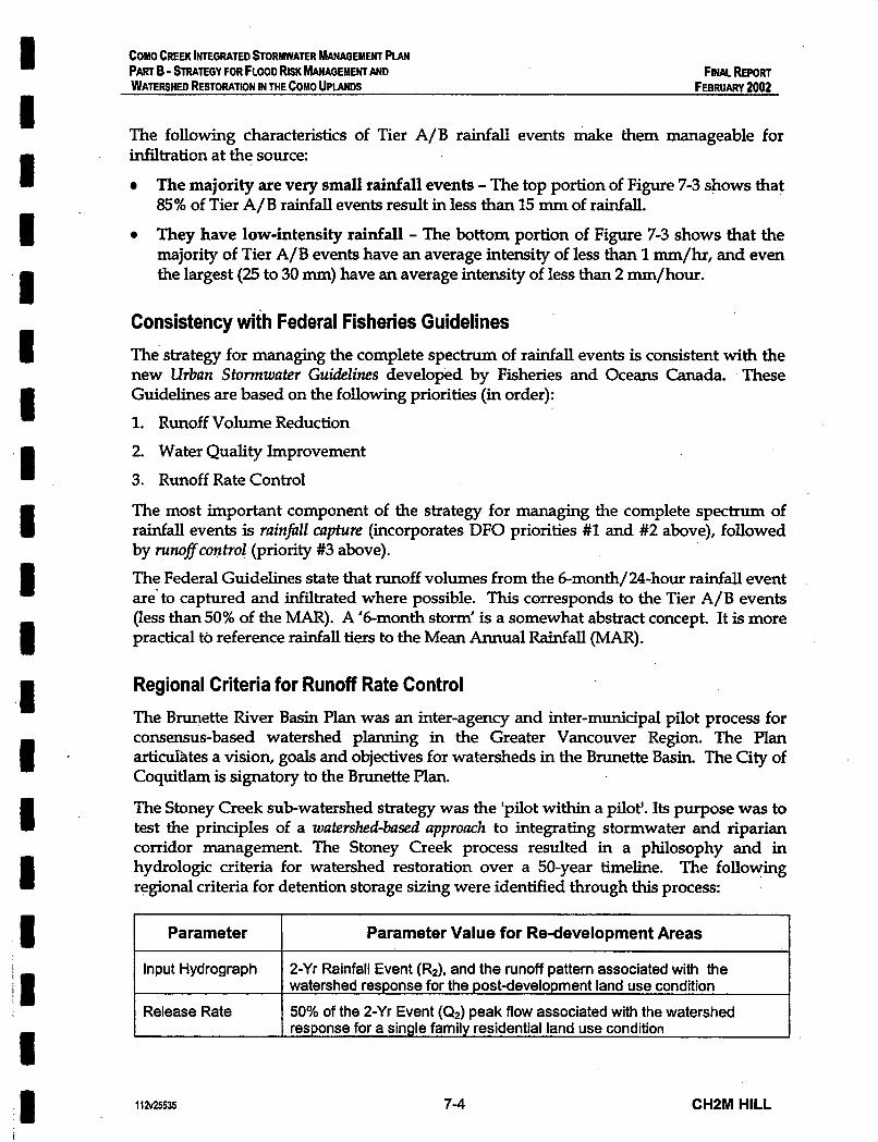
FINAL REPORT COMO CREEK INTEGRATED STORMWATER W G E M E N T PIAN PART B - STRATEGY FOR FLOOD RISK b G E M E N T AND WATERSHED RESTORATION IN THE COMO UPLANDS FEBRUARY 2002
Input Hydrograph
Release Rate
The following characteristics of Tier A/B rainfall events make them manageable for infiltration at the source:
The majority are very small rainfall events - The top portion of Figure 7-3 shows that 85% of Tier A/B rainfall events result in less than 15 mm of rainfall.
They have low-intensity rainfall - The bottom portion of Figure 7-3 shows that the majority of Tier A/B events have an average intensity of less than 1 mm/hr, and even the largest (25 to 30 mm) have an average intensity of less than 2 =/hour.
~~~~
2-Yr Rainfall Event (R2), and the runoff pattern associated with the watershed response for the post-development land use condition 50% of the 2-Yr Event ((2,) peak flow associated with the watershed response for a single family residential land use condition
Consistency with Federal Fisheries Guidelines The strategy for managing the complete spectrum of rainfall events is consistent with the new Urban Stomwater Guidelines developed by Fisheries and Oceans Canada. These Guidelines are based on the following priorities (in order): 1. Runoff Volume Reduction 2. Water Quality Improvement 3. Runoff Rate Control
The most important component of the strategy for managing the complete spectrum of rainfall events is ruinfill capture (incorporates DFO priorities #1 and #2 above), followed by runoflcontrol (priority #3 above). The Federal Guidelines state that runoff volumes from the 6-month/24-hour rainfall event are’ to captured and infiltrated where possible. This corresponds to the Tier A/B events (less than 50% of the MAR). A ‘&month storm’ is a somewhat abstract concept. It is more practical to reference rainfall tiers to the Mean Annual Rainfall (MAR).
Regional Criteria for Runoff Rate Control The Brunette River Basin Plan was an inter-agency and inter-municipal pilot process for consensus-based watershed planning in the Greater Vancouver Region. The Plan a r t i d t e s a vision, goals and objectives for watersheds in the Brunette Basin. The City of Coquitlam is signatory to the Brunette Plan.
The Stoney Creek subwatershed strategy was the ‘pilot within a pilot’. Its purpose was to test the principles of a watershed-bused approach to integrating stormwater and riparian corridor management. The Stoney Creek process resulted in a philosophy and in hydrologic criteria for watershed restoration over a 50-year timeline. The following regional criteria for detention storage sizing were identified through this process:
Parameter I Parameter Value for Re-development Areas I
112~25535 7-4 CHPM HILL

COMO CREEK lNTEGRATED STORMWATER W G E M E N T PUN PART B - STRATEGY FOR FLOOD RISK b G E M E H C AND WATERSHED RESTORATION IN THE COW0 UPLANDS
FINAL REPORT FEBRUARY 2002
These regional criteria for runojf control must coeidered in the context of site-specific conditions and data. RainfalZ capture must also be integrated into the storage concept by establishing targets for infiltrating the runoff from rooftops, driveways and roads.
Storage Volume Based on the regional criterion defined above, enough storage volume would have to be provided to capture the runoff from a 2-yr rainfall event, which is roughly equivalent to a mean annual rainfall (MAR). This storage volume would provide runoff control for all Tier C rainfall events.
This is an appropriate storage volume target hecause the runoff resulting from a MAR corresponds approximately to a mean annual flood (MAF) in downstream watercourses, which is an important parameter for watercourse protection. The cross-section of stream channels tends to reach equilibrium with the MAF. Runoff from impervious surfaces in the Como Uplands causes the MAF in Como Creek and Booth Creek to be much higher than it was under natural conditions. The result is channel instability.
By providing enough storage capacity to detain the runoff from a MAR, all streamflow events in an average year would be the result of controZZed release rather than uncontrolled runof. As a result, the MAF in downstream watercourses would be much closer to that of a natural watershed and the stream channels should stabilize over time.
600 m3 of storage volume per impervious hectare would be required to detain the MAR with a 24hr duration (6Omm). This storage volume is conservative from a watercourse protection perspective. While a shorter duration rainfall may actually govern the MAF peak rate, providing storage for a long duration rainfall (i.e. 24hour rainfall) results in a larger storage volume.
Release Rate The regional release rate criterion defined thropugh the Brunette process is based on the objective of mitigating the effects of re-development by at least maintaining existing conditions in stream corridors. This objective is not appropriate for the Como Watershed because stream corridors are currently subject to sigruficant erosion and do not support aquatic ecosystems. Given the 50-yr timeframe for the Watershed Vision, the regional release rate criterion for new development areas would be more appropriate for the Como Watershed:
50% of the 2-Yr Event (02) peak flow associated with the watershed response for a natural forested condition.
This criterion is referenced to ~ t ~ r a l forested conditions rather than single family residential, and is based on the objective of improving watershed conditions, which is an important objective for the Como Watershed
112~25535 7-5 CHZM HILL
I I I I I I I I I I I I e I I I I I 1
1 I I I I I 1 . I I I I I 1 1 I I 1 I I '
COMO CREEK INTEGRATED STORMWATER MANAGEMENT PLAN PART B - STRAEGY FOR FLOOD RISK hhNAGEMENT AND WAlERsHED RESTORATION IN THE COMO UPWCDS
FINAL REPORT FEBRUARY 2002
Figure 7-5 shows the estimated annual water balance for the Como Uplands under a natural forested condition. Note that there is virtually no surface surface runoff. The only source of streamflow in downstream watercourses is interflow, the portion of rainfall that infiltrates into the soil and travels laterally through the upper soil horizons until it is intercepted by a stream channel.
Under natural forested conditions, is approximately equal to the interflow from a 2- year rainfall event (RZ), which is approximately 60 mm per day:
> Natural forested Q = 45% of 60 rmn per day = 27 mm per day
This is roughly equivalent to the channel forming MAF under natural forested conditions. Release rate can now be defined based on the above estimate of this parameter.
> Release rate = 50% of the natural forested Q = 14 mm per day
This corresponds to flow rate of 1.6 Lps per hectare of drainage area.
Note that this is a preliminary release rate estimate. It is important to ensure that the rate of release from storage will maintain streamflow velocities below the threshold level that causes signtficant watercourse erosion. Defining this threshold for any watercourse requires an analysis of its erosion and sediment transport characteristics. There is currently no data available on the sediment transport characteristics of the watercourses within the Como watershed. Therefore, a research program to better understand erosion in the watershed is needed to validate the prelminary release rate estimate defined above.
Note: Ifstorage targets were selected based on a single rainfall event, then the 14 mm/day release rate would be subtracted from the MAR (60 mdday) to reduce the storage volume criterion to 460 m3/ha. However, evaluation of continuous rainfall patterns shows that large rainfall events ofen follow extended wet weather periods, and therefore, it is likely that a portion of the storage capacity will be full when a large rainfall event occurs. Retaining the larger 600 m3/ha storage critm'on builds redundancy into the storagefunction to account for this.
Preliminary Runoff Control Targets for a Typical Lot Based on the storage and release rate criteria defined above, a typical 8,000 square foot lot with 40% impervious cover would be required to: 0
0
Provide 18 m3 of storage volume Release this water from storage at a rate of 0.12 litres per second.
These criteria can be refined through the implementation of pilot projects, and by monitoring the effectiveness of the watershed retrofit strategy over time.
Preliminary Rainfall Capture Targets Recent research from Waskgton State shows that: . watercourses start to become degraded when total watershed imperviousness exceeds
10% . most urban watersheds may be unable to sustain abundant self-supporting ~ populations of cold water fish when imperviousness exceeds 30%.
1 la25535 7-6 CHZM HILL

COMO CREEK lNTEGRATE0 STORMWATER MANAGEMENT PLAN PART 6 - STRATEGY FOR FLOOD RISK b G E M E N T AND FINAL REPORT WATERSHED RESTORATION IN THE COMO UPLANDS FEBRUARY 2002
Figure 7-6 illustrates these thresholds. Note that the benthic index of biotic integrity, a key indicator of creek health, declines below a critical threshold (30) when the percentage of impervious cover in the watershed rises above 10%.
Currently, about 37% of the Como Uplands is impervious area, which is reflected by the degraded state of its creeks. The total impervious area (TIA) of the Como Watershed is likely to increase through future re-development (see Chapter 10). However, the eficfizw impervious urea (EM) of the watershed can be reduced over time by disconnecting impervious surfaces (EIA is a measure of impervious area that is directly connected to the drainage system). This can be accomplished by capturing and infiltrating runoff from. impervious surfaces.
An important target for restoring the health of creeks in the Como Watershed is to restore the rainfall-runoff response of the watershed when it had less than 10% impervious cover (i.e. reduce EIA to less than 10%). One way to accurately determine this historical rainfall- runoff response is to build a calibrated hydrologic model of the Como Watershed. The rainfall and streamflow monitoring network needs to be expanded in order to develop a calibrate and validate a watershed model.
When the Como Watershed was 10% impervious, it is reasonable to assume that only 10% of the total rainfall volume became surface runoff (i.e. only impervious surfaces contributed surface runoff). This assumption is reasonable because there is virtually no surface runoff from a natural forested watershed, and much of the Como Watershed would still have been forested.
Therefore an appropriate rainfall capture target for Como Watershed would be to reduce total runofi volume to 10% or less of total rainfall volume. This target could be achieved by:
o Providing rainfall capture for all Tier A/Ei events - Retrofit building lots and roads with facilities designed to infiltrate the impervious surface runoff resulting from Tier A/B rainfall events (< 30 mm). This would eliminate 80% of the total runoff volume from impervious surfaces.
o Ensuring that all pervious areas are designed to infiltrate - Design pervious areas to function as a natural forested watershed and produce no surface runoff. Providing 300 rnm of absorbent landscaped soil would eliminate virtually all of the runoff volume from pervious areas.
Assuming that future densification increases the imperviousness of the Como watershed to 50%, the preceding measures would reduce the total runoff volume to about 10% of total rainfall volume (i.e. 20% runoff from the impervious half of the watershed, and 0% runoff from the pervious half).
Source storage facilities designed onZy fir ruinfill capture (i.e. runoff' volume reduction) would only have to be large enough to capture and infiltrate 30 mm of rainfall per day (300 m3 per impervious hectare).
112~25535 7-7 CHZM HILL


I I I 1 I
COMO CREEK INTEGRATED STORWATER W G E M E N T PLAN PART 6 - STRATEGY FOR FLOOD RISK W G E M E N T AND WATERSHED &!XORATlON IN THE COMO UPLANDS
FINAL REPORT FEBRUARY 2002
Source storage facilities designedfor ruinfaZZ capture and nmoflcontrol would need twice as much storage capacity (600 m3 per impervious ha, as defined above). This would provide much improved runoff rate control, but little additional volume reduction benefit.
Infiltration Rate The preliminary storage release rate of 14 mm per day, which was established based on an estimate of interflow under natural forested conditions, would also be an appropriate infiltration rate for source storage facilities. This corresponds to an infiltration rate of about 0.6 mm per hour, which would likely be feasible for most of the Como Uplands. For comparison purposes, the minimum acceptable infiltration rate for engineered soils in drainage field design is 25 l~un per hour.
However, it is important to verlfy the feasibility of a 0.6 mm per hour infiltration rate through an analysis of hydrogeologic conditions in the Como Watershed and through the implementation of pilot projects. An analysis of hydrogeologic conditions is also needed to identdy areas within the watershed with physical constraints that could inhibit infiltration at the source (e.g. very shallow bedrock). Infiltration requirements can only apply to areas where it is feasible.
Even though an infiltration rate of 14 mm per day is very small, it would exceed the rate of rainfall accumulation in source storage facilities, most of the time. As shown in Figure 7-3 the majority of Tier A/B events result in less than 14 mm per day of rainfall.
112V25535 7-8 CHZM HILL

COMO CREEK INTEGRATED STORMWATER MANAGEMENT PLAN PART B - STRATEGY FOR FLOOD RISK hhNAGEMENT AND WATERSHED RESTORATloN IN THE COMO UPLANDS
FINALREPORT FEBRUARY 2002
7.4 Step 2 - Validation of Preliminary Rainfall Capture and Runoff Control Targets
Methodology for Continuous Simulation Modelling A spreadsheet-based water balance model was used to test the performance of the prehunary targets for rainfall capture and runoff control, and to compare the effectiveness of source storage with community storage (i.e. conventional stormwater detention). The model was set up for the upper portion of the Como Creek sub- watershed, above the most eroded section of the Como Creek ravine (between Austin and Rochester).
The model tested the benefit of incrementally retrofitting a greater portion of the upper Como sub-watershed with source storage. The following assumptions applied to the portion of the watershed retrofitted with source storage:
m
600 m3 of storage was provided per impervious hectare
The runoff accumulating in the lower half of the source storage facilities (i.e. the first 300 m3 per ha) was assumed to infiltrate into the ground at a rate of 14 -/day. This reflects the rainfall capture target of infiltrating Tier A/B rainfall events (less than 30 mm).
The runoff accumulating in the lower half of the source storage facilities was assumed to release directly to the storm sewer system at a rate of 14 -/day.
m
Three different retrofit scenarios were tested:
o Scenario A - No community storage
o Scenario B - One Community Storage Facility - Como Lake (20,000 m3 of storage)
o Scenario C - Two Community Storage Facilities - Como Lake (20,000 m3) and the Ravine below Austin (13,000 m3)
Hourly rainfall data from 1999 was the input to the model, which provided a continuous simulation of the resulting water levels in both source storage facilities and community storage facilities. The model assumed a direct connection between the two storage components.
The following components contributed to surface runoff into the Como Creek Ravine (below Austin):
For sub-catchments without community storage - the direct runoff from impervious surfaces for the portion of the watershed without
source storage. - the overflow from source storage and the water released from source storage directly
to the storm sewer system.
11 a25535 7-9 CHZM HILL

I I I I I I I I I
'I I 1
I
COMO CREEK INTEGRATED ~ORMWATER W G E M E N T PLAN PART B - STRATEGY FOR FLOOD RISK W G E b l E N T AND FINALREPORT WATERSHED RESTORATION IN THE COMO UPLANDS FEBRUARY 2002
For sub-catchments with community storage - the overflow and release from community storage (release at 14 mm per day).
Modelling Results The effectiveness of incremental source storage retrofit (with and without community storage) was tested by running a continuous simulation for 1999, a wetter than average year with a rainfall event that was about 25% larger than a MAR (December 15th). Effectiveness was measured by the following indicators:
0 Runoff Control Indicator - Number runoff events exceeding a 'threshold for signtficant watercourse erosion'. For modelling purposes this threshold was defined as the amount of surface runoff resulting from a 25 mm rainfall event, under current unmitigated conditions. This threshold was selected because a 25 mm rainfall event has been observed to result in watercourses flowing 'bankfull' in the Lowlands.
Rainfall Capture Indicator - Total volume of runoff into the Como Creek Ravine. 0
Figure 7-7 demonstrates the following key findings:
>
>
9
>
Source storage retrofit provides incremental runoff control and rainfall Capture - As more of the upper Como watershed becomes retrofitted with source storage and infiltration, there is a proportional decline in the number of threshold runoff events and total runoff volume into Como Creek Ravine. When complete source storage retrofit is achieved in the long-term (50 years), threshold runoff events are eliminated and only about 20 % of the total volume of rain that falls on impervious surfaces contributes to runoff in the Como Creek Ravine.
Community storage provides short-term runoff control but limited rainfall Capture -Community storage facilities can reduce the number of threshold streamflow events in the short term, but do not reduce the total volume of runoff into Como Creek Ravine.
Community storage becomes redundant in the long-term - Once about 85% of the upper Como watershed becomes retrofitted with source storage, community storage facilities provide no additional benefit in terms of reducing the number of threshold events.
The 600 m3 per ha storage volume criterion is conservative - Even though the largest rainfall event in 1999 was about 25% larger than a MAR, there was very little overflow from source storage or community storage facilities.
112~25535 7-1 0 CHZM HILL
COMO CREEK hl'EGRATED &OWWATER h'lANAGEMENT PLAN
WATERSHED RESTORATION IN THE COMO UPlANDS PART B - STRATEGY FOR FLOOD RISK MANAGEMENT AND Fuwlhpm
FEBRUARY 2002
7.5 Steps 3 and 4 - Facilitating the Process of Change The process of changing development regulations and moving towards a new 'standard practice' for urban design that incorporates stormwater source control will be challenging. This Section presents the key challenges associated with changing standard practice, followed by a summary of actions required to overcome these challenges. These actions are presented in Table 11-1 along with cost estimates and department to take the lead role in implementing each action.
Challenges 1. Lack of Precedents - Stormwater source control requires a sigxuficant change in basic
site design philosophy, from pipe and remove to captue and infiIfm2fe. There is a lack of precedents to demonstrate the application of this emerging design philosophy, which leads to uncertainty. pin adaptive approach to change is key to resolving this uncertainty. Monitoring and evaluating the performance of Demonstration Projects will provide confidence in the new design approach. It will also provide the basis for optimizing stormwater system design to reduce costs while still achieving defined goals for protecting downstream property, aquatic habitat and receiving water quality.
. 2. Regulatory Barriers - Certain development standards and regulations make it 'against the rules' to implement stormwater source controls. These barriers need to be removed to enable low impact development practices. For example, bylaw or building code regulations that require roof leaders to connect to a storm sewer would have to be changed to allow infiltration of rooftop runoff at the source.
3. Operation and Maintenance Responsibilities - Infiltration facilities require maintenance to ensure that they continue to function effectively over the long term. While City staff can operate and maintain community detention facilities and- certain types of source control facilities (e.g. infiltration facilities within road right-of-ways), many source control facilities are likely to be on private property (e.g. on-lot infiltration facilities). Maintenance responsibility for these facilities shifts to individual landowners or strata corporations. In general, this places a greater reliance on the conscientiousness of individuals, hence the need for education. There may be opportunities to implement City-maintained source control facilities through neighbourhood planning (e.g. infiltration facility within City parks that serve multiple dwelling units).
4. Approval Process Discourages Innovation - The development approval process is often more difficult for development projects that incorporate innovative development practices, especially if these practices differ from a local government's development standards. This is a built in disincentive for developers wishing to deviate from the
11 2~25% 7-1 1 CHPM HILL
I I I I. I I D 1 1 1 I I I I I I I I I

1 I I 1 I I 1 I I I I I 1 I I I 8 I I
A

COMO CREEK INTEGRATED STORbWATER W G E M E N T PUN PART B - h T E G Y FOR FLOOD RISK fdANAGEMENl AND WATERSHED RE!RORAnON IN THE COMO UPlANDS
FINALREPORT FEBRUARY 2002
status quo. To provide an incentive, the approval process could be facilitated for projects that? incorporate innovative urban design and/or stormwater management practices (e.g. developments that capture rainfall at the source for infiltration and/or reuse).
5. Market Size - The present market for source control facilities (in North America) is apparently too s m a l l to be economically efficient.
Bull< purchases at the municipal level may be required to achieve initial economies of scale that make source control facilities more affordable.
Actions to Overcome Challenges The following measures will help overcome the challenges described above, and facilitate the process of improving the standard practice of urban design and stomwater management:
1. Establish an enabling regulatory framework - Make regulatory changes that will facilitate the approval process for re-developments projects that incorporate source storage and infiltration. Some key changes in this regard include: = providing an expedited approval process for developments that implement on-lot
storage and infiltration, = removing existing regulatory barriers (e.g. bylaw requirements for roof drainage
connection to storm sewers) = establishing a ’one-windod process for obtaining agency approval.
2. Establish monitoring programs for demonstration projects - Install monitoring equipment and implement ongoing performance monitoring programs for demonstration projects that incorporate infiltration systems. These monitoring programs could be established on public works projects or in co-operation with developers.
3. Ensure that any new design standards reflect the design options that are most effective in the context of local conditions - Through the implementation and monitoring of demonstration projects, establish the design options for source storage and infiltration’ that would be most effective in the context of the site-specific conditions in the Como Watershed. Implementing demonstration projects will allow the City to take a lead role in demonstrating successes to landowners and the development community.
4. Adopt a collaborative approach to change - Consult with landowners and the development community to: 9
5. Incorporate the most effective and acceptable design options into the City’s Engineering Standards - Revisions to the Engineering Standards should reflect local conditions as
’
determine their preferred design options for source storage and infiltration. develop an appropriate implementation strategy for regulatory change. develop an appropriate financing strategy for source storage retrofits.
112~25535 7-1 2 CHPM HILL
COMO CREEK INTEGRATED STORMWATER W G E M E N T PLAN PART B - STRATEGY FOR FLOOD RISK W G E M E N T A N D WATERSHED RESTORATION IN M E COMO UPlANDS
Fitw REPORT FEBRUARY 2002 I
6.
7.
8.
well as the preferences of landowners and the development community. These new Engineering Standards can then be incorporated into the relevant development regulations (Subdivision Bylaw, the Building Bylaw, Zoning Bylaw, Development Permit Guidelines).
Make the details of new design standards readily available - Create a technical manual of options for on-lot storage and infiltration, including details and specifications of design standards, typical costs, and operation and maintenance requirements. Make the manual available on-line.
Facilitate procurement of materials needed to implement new design standards - Implement a bull< purchase/resale program that makes it easy and affordable for developers to obtain the specialty products needed to implement source storage and infiltration. Also, investigate options and costs related to providing a cheap source of material for absorbent soils. These options to indude: - establishment of a City composting program utilizing overburden sediments from
local gravel pits, and examining large volume discounts through negotiated contracts with local topsoil supply companies.
Build support through education - Implement education programs to inform city staff, the development community, and the general public about the need for the changes in development practices and how to implement them.
-
7.6 Steps 5 and 6 - Ongoing Assessment of the Watershed Retrofit Strategy
In order to assess the performance of the watershed retrofit strategy, it is important to monitor changes in the runoff characteristics of the Como Watershed over time. This monitoring will make it possible to:
Determine the extent of the reduction in runoff rates and total volume of runoff that is being achieved through the watershed retrofit strategy and program initiatives. Correlate changes in &off characteristics with improvements to watershed health. Constantly evaluate and improve the watershed retrofit strategy
. =
In order to monitor changes in runoff characteristics it is necessary to upgrade the two streamflow monitoring stations in the Lowlands and provide new streamflow stations at two key locations in the Uplands, Como Creek at Austin and Booth Creek at Austin. These should be complemented by a water level monitoring network in the Lowlands. These measures should be fully completed &soon as possible to enable the collection of the baseline data needed to define the existing runoff characteristics of the watershed. Without this baseline data, there will be no benchmark for monitoring and evaluating future changes.
1 la25535 7-1 3 CHPM HILL
a I I I I- I c LI
I 1 I
COHO CREEK lNTEGRATED aORMWATER ?&NAGEMEWr PLAN PART B - STRATEGY FOR FLOOO RISK MANAGEMENT AND WATERSHED RESTORATION IN THE COMO UPLANDS
FINAL REPORT FEBRUARY 2002
It is also important to determine the runoff characteristics of a healthy watershed, which could be defined as natural forested or less than 10% impervious. This will provide a suitable ‘target condition’ for long-term watershed restoration. However, the characteristics of a healthy watershed cannot be defined through data collection because the Como Watershed is already degraded.
The way to establish’a target condition for watershed restoration is to build a calibrated model for the Como Watershed and simulate historical watershed conditions, before development eliminated aquatic ecosystems. This model would also be a valuable tool for refining watershed management solutions and making predictions to guide future monitoring efforts. An adequate streamflow monitoring network is necessary to develop a calibrated watershshed model.
The current rainfall gauge in the Como Watershed is located in the Lowlands. Since elevation change tends to have a sigruficant impact on rainfall, it is likely that the Uplands have slightly different rainfall characteristics than the Lowlands. Since the primary focus of the watershed retrofit strategy is on changing the rainfall-runoff response of the Como Uplands, establishing a rainfall gauge in the Uplands would provide better data than the current Lowlands gauge for monitoring, modelling and evaluation purposes.
7.7 Watercourse Restoration The ultimate goal of a long-term restoration strategy for the Como Watershed is to restore its watercourses to their natural state, with healthy aquatic and riparian ecosystems. In order to achieve this goal, the piped sections of Como Creek and Booth Creek would eventually have to be daylighted.
Land will need to be acquired in order to provide the setbacks that are needed to establish healthy streams. Therefore, stream daylighting projects must be undertaken in close consultation with affected landowners and developers to ensure that adequate compensation and/or incentives (e.g. density bonuses for developers) are provided for any land needed for setback purposes.
.There is not much point in daylighting piped section of the creeks until the natural water balance of the Como Uplands has been at least partially restored. If daylighting projects were undertaken in the short-term, the new channels would experience the same erosion problems as the existing ravines and would not support healthy aquatic ecosystems.
Restoration of the Popeye Creek stream corridor (Lowlands Plan Element #3) has been proposed as a long-term plan element for the same reason.
Figure 7-8 illustrates the piped section of Como Creek and Booth Creek that should be daylighted as part of a long-term watershed restoration strategy. This figure also emphasiies that source storage retrofit is the primary watershed restoration strategy that must precede creek daylighting.
112~25535 7-1 4 CHSM HILL

I COMO CREEK lNTEGRATED STORMWATER MANAGEMENT PLAN PART 6 - STRATEGY FOR FLOOD RISK MANAGEMENT AND WATERSHED RESTORATION IN THE COMO UPLANDS
FINAL REPORT FEBRUARY 2002
7.8 Summary of Findings Long-term watershed restoration requires a watershed retrojt strategy that incrementally restores the natural water balance of the Como Uplands as the watershed re-develops over the next 50 years.
Key watershed retrofit target = reduce the total volume of surface runoff to less than 10% of total rainfall volume
In order to retrofit the watershed, changes in development practices are needed to ensure that future re-development projects provide:
Rainfall Capture - Miltrate runoff from small storms (up to 30 mm of rainfall per day) into the ground to reduce total runoff volume.
= Runoff Control - Store runoff from large storms (up to 60 mm of rainfall per day), and release it at a rate that approximates natural forested conditions.
Change must be implemented through an adaptiue process, which is characterized by: = the monitoring of demonstration projects prior to any changes in development
regulations. ongoing assessment and optimization of the watershed retrofit strategy.
The piped sections of Como Creek and Booth Creek should be restored to their natural state once the natural water balance of the Como Uplands has been partially restored.
112~25535 7-1 5 CHZM HILL

@ 1 Options for Long-Term Watershed Restoration On the Como Uplands City of Coquitlarn
COMfiREEK WATERSHED MANA6EMEWT PlAN /r a

Chapter 8 Short-Term Flood Risk Management
CHZM HILL
COMO CREEK INTEGRATED STORMWATER MANAGEMENT PLAN PART B - STRATEGY FOR FLOOD RISK MANAGEMENT AND WATERSHED RESTORATION IN THE COMO UPLANDS
FINAL REPORT FEBRUARY 2002
CHAPTER 8
ShortmTerm Flood Risk Management 8.1 Options for Flood Risk Management Restoring the natural water balance of the Como Uplands will eventually eliminate the root cause of existing flooding problems. However, this is a long-term strategy and there is a need for immediate flood relief in the Como Watershed. The focus of the Strutegyfir the Fruser Milk Jholands (Part A of this report) is providing short-term flood risk management. The Uplands Strategy must also deal with short-term flooding risk because:
the high peak runoff rates and bedload transport originating from the Uplands increase the risk of flooding in the Lowlands. there are high-risk flooding locations in the Uplands
Options for short-term flood risk management in the Como Uplands include: 1. Building Community Storage Facilities - Reduce the peak runoff rates from the
Como Uplands, thus reducing downstream peak flows and providing partial erosion control.
2. . Upgrading High-risk Culverts and Providing Bedload Interception - Reduce the risk of culvert blockage, localized flooding and potential road washout. Reduce bedload and debris transport from the Upland Ravines, thus reducing deposition and flooding risk in the Lowlands.
3. Use Inter-Watershed Connections to Divert Peak Flows - Reduce the risk of localized flooding by diverting peak flows away from high-risk flooding locations, such as Booth Creek at schoolhouse.
These options are illustrated in Figure 8-1.
8.2 Community Storage for Runoff Control Providing community storage facilities for sub-catchments of the Como Watershed can reduce peak runoff rates (i.e. provide rainfall capture), which reduces the risk of downstream flooding by: = Reducing downstream peak flows
The feasibility of providing community storage is constrained by: . . 8
Partially controlling erosion and reducing downstream bedload deposition
the existing storm sewer network existing development within the watershed the steep topography of the Uplands
112V25535 8-1 CH2M HILL

I
I
COMO CREEK INTEGRATED STORMWATER MANAGEMENT PIAN PART B - STRATEGY FOR FLOOD RISK MANAGEMENT AND WATERSHED RESTORATION IN THE COMO UPLANDS
FINAL REPORT FEBRUARY 2002
Opportunities and Constraints for Community Storage Figure 8-2 shows locations for community storage facilities to serve each sub-catchment that would be appropriate based on the existing storm sewer layout. Providing storage at other locations would be much more difficult because of the need to reconstruct existing storm sewer. The appropriate locations are classified as either: o Not practical - There is not enough public land available to provide a pond with the
required storage volume, and the cost of acquiring enough private land or building a detention structure (e.g. concrete storage vault) would be prohibitively high.,
o Potentially suitable - There is enough public land and/or.relatively low value private land available to provide an adequate storage pond. It is questionable whether the benefits of providing community storage at these locations would jus* the costs.
o Feasible - Community storage at these sites are feasible components of a short-term flood risk management strategy for the Como Uplands. Only 2 sites out of 12 sites have been identified as feasible.
Figure 8-3 illustrates the storage volume that would be needed to detain the runoff from the Como Uplands resulting from a mean annual rainfall @.e. 600 m3 per impervious hectare). This figure shows that there is a large discrepancy between the desired storage volume and the volume available at feasible community storage sites. The classificaton of potential community storage sites is based on a site by site evaluation, which is summarized below.
Evaluation of Community Storage Sites Community storage facilities serving sub-catchments C1, C2 and C3 would be the most beneficial because they would reduce the rate of runoff (but not the runoff volume) into the most unstable portion of the Como Creek Ravine, between Austin and Rochester.
C1- Como Lake Storage: The existing storage volume in Como Lake could be utilized by optimizing the operation of the lake outlet. Only about 400 mm of operating depth would be needed to control the runoff from the area tributary to Como Lake (sub-catchment Cl), which represents about 40% of the runoff into the most unstable portion of the Como Creek Ravine (see Figure 8-3). A new outlet structure would be needed to regulate flow releases and mimic natural forested conditions. The geotechnical implications of raising the level of Como Lake would also need to be determined. It may be necessary to stabilize the banks of Como Lake (possibly by means of bio-engineering techniques), particularly the existing unstable bank on the eastern and southern shorelines. Improvements to the footpath around the Lake would likely be required. This provides an opportunity to enhance the wheelchair accessibility of this path.
C2 - No feasible site: The topography at this location is too steep at to build a detention pond, which is a typical problem for the Como Uplands. The only other option is to build a large storage structure (e.g. underground detention vault). The costs of such a structure would be prohibitively high, on the order of $14 million plus land acquisition costs.
112'425535 8-2 CHZM HILL

OntOons for Sbort=lerm Hood ROsk Management On tbe Como Oflands
a city ofcoquitlalr
6 i l l iCREEK WATERSHED MAWA6EMEWT PWN

Identj€ication and Assessment 0t Owortunities a COMO CREEK WATERSHED MllwAGEMElFc PUN and Constraints for CommunU Storage City of Coquitlam
f

I 3 00
L I
9 E
0-
0 0 0
(\I II a, % m 2 0 E 0 0
\ \
0 0 0
0
0 (Y
0 c3
U
I I 0
0,
0 0
0
0 0
0 d
0, 0 0
0 ua 0,
0 0
0 (D
F
0, 0, 0,

COMO CREEK INTEGRATED STORMWATER MANAGEMENT PLAN PART B - STRATEGY FOR FLOOD RISK MANAGEMENT AND FINAL REPORT WATERSHED RESTORATION IN THE COMO UPLANDS . FEBRUARY 2002
C3 - Austin Ravine Storage Site: Enough storage volume to control the runoff from sub- catchment C3 could be provided in the ravine below Austin Ave. (just west of Como Creek) by building a four metre high dam spanning the ravine (about 100 m across). There is currently no access to the ravine. Given its steepness and unknown stability, it may not be feasible to build an access road for construction equipment. Building a road and dam in the Austin Ravine would be very costly and would likely cause sigruficant damage to the riparian vegetation of Como Creek.
Note: The majority of the runoff to the Austin Ravine site comes from the commercial area west of Como Creek, between King Albert and Austin. About 85% of this area is impm'ous, much of which is surface parking. Retrofitting this area with source storage through re-development would make a detention facirify in the Austin Ravine redundant.
C4 - Schoolhouse Ravine Storage Site: A community storage facility could be built in the ravine between Rochester Ave. and Schoolhouse St. to reduce the rate of runoff from sub- catchment C-4. This would reduce downstream peak flows slightly, but would not contribute to erosion control in the Como Creek ravine because the site is located downstream of the eroded open channel sections of Corno Creek.
C5, C6 and C7 - Forested Area below Brunette: There are flat, forested areas where adequate space could be cleared for community storage ponds to serve these sub- catchments. Similarly to the Schoolhouse ravine site, these ponds would reduce downstream peak flows slightly, but would not contribute to erosion control in the Como Creek ravine.
B1 and B2 - N o feasible site: There is no public land available to provide community storage ponds for these sub-catchments. The cost of either acquiring enough private land for a pond or building a storage structure would be prohibitively expensive.
M1 and M2 - Low-value Private Land below Brunette: There is no public land available a for storage pond, but there are many low-value private lots below Brunette (assessed value of buildings less than $40,000). About 20 adjacent lots would have to be acquired to provide enough storage capacity for the whole MacDonald Creek sub-watershed (M1 and M2). A pond at this location would reduce peak flows in lower Booth Creek but would not contribute to erosion control.
.
Pl - No feasible site: There is no public land available for a for storage pond. The public land adjacent to the track/playing field west of Montgomery St. is too steep to build a pond. The cost of either acquiring enough private land for a pond or building a storage structure would be prohibitively expensive.
P2 - BC Hydro Storage Site (Lowlands Plan Element L2): A storage pond at this site was identified as a core element of the Lowlands Strategy. It would improve the effectiveness of the Booth to Popeye Inter-watershed connection (Lowlands Plan element L1) by reducing peak flows in Popeye Creek and increasing the channel capacity available for flow transfer from Booth to Popeye. This would improve flood relief in lower Booth Creek. This pond would also contribute to the restoration of the Popeye Creek system by reducing runoff rates from sub-catchment P2.
112V25535 8-3 CHPM HILL
I
No.
COMO CREEK INTEGRATED STORMWATER MANAGEMENT PIAN PART B - STRATEGY FOR FLOOD RISK MANAGEMENT AND WATERSHED RESTORATION IN THE COMO UPLANDS
F w REPORT FEBRUARY 2002
8.3 Culvert Upgrading and Bedload Interception The primary objective of flood risk management is to protect property by ensuring that the drainage system is adequate to safely convey the 'design flood' (i.e. the 100 year peak flow). The high-risk locations for drainage system failure are most often at culvert installations.
Risk Analysis for Culvert Installations The adequacy of a culvert installation can be assessed on the basis of two criteria: o Hydraulic Adequacy - By definition, a comparison of rated capaaty versus design
flow o Physical Adequacy - By definition, a qualitative judgement regarding physical
constraints (i.e. culvert blockage) that could adversely impact hydraulic adequacy.
Based on long-term experience, the governing criterion is almost always physical adequacy, with hydraulic adequacy being a secondary concern. The assessment of physical adequacy becomes a key input in a risk analysis that considers the consequences of culvert blockage.
Assessment of Physical Adequacy The Como Creek Watershed Plan addresses the issue of physical adequacy by ensuring that culvert installations conform to the following guidelines:
Guidelines for Effective Culvert Design
Maintain line and grade of creek channel
Maintain the waterway opening by "bridging" the creek channel
Construct inlet structure to provide direct entry and accelerated velocity
Ensure that it can pass trash, small debris and bedload material
Install debris interceptor upstream to provide protection from large debris
Provide scour protection to prevent undermining of the outlet structure
Incorporate provision for an overflow route in the event of a worst-case scenario
Provide equipment access for ease of maintenance (debris removal)
Consider environmental issues, such as fish passage
In the Como Uplands there are three major culvert installations that do not meet these design guidelines:
0
0
0
Como Creek culvert at Rochester Ave. Booth Creek culvert at Austin Ave. Como Creek culvert at Austin Ave.
11 2\125S5 8-4 CHPM HILL
i
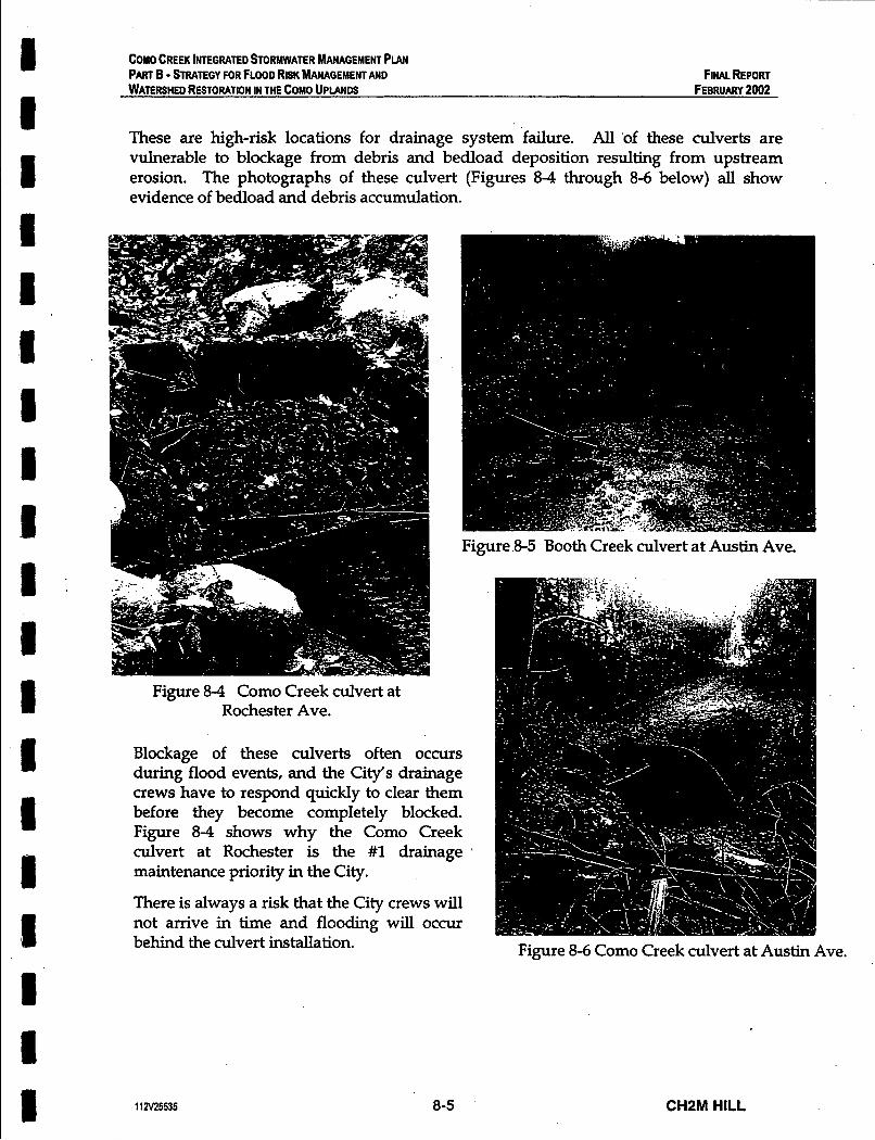
COMO CREEK INTEGRATED STORMWATER MANAGEMENT PUN PART B - STRATEGY FOR FLOOD RISK MANAGEMENT AND WATERSHED RESTORATION IN THE COMO UPlANDS
FINAL REPORT FEBRUARY 2002
I I
These are high-risk locations for drainage system failure. All 'of these culverts are vulnerable to blockage from debris and bedload deposition resulting from upstream erosion. The photographs of these culvert (Figures 8-4 through 8-6 below) all show evidence of bedload and debris accumulation.
I I I s I 1 1
Figure 8-4 Como Creek culvert at Rochester Ave.
Blockage of these culverts often occurs during flood events, and the City's drainage crews have to respond quickly to clear them before they become completely blocked. Figure 8-4 shows why the Como Creek culvert at Rochester is the #1 drainage maintenance priority in the City.
There is always a risk that the City crews will not arrive in time and flooding will occur behind the culvert installation.
11N25535 8-5
Figure 8-5 Booth Creek culvert at Austin Ave.
Figure 8-6 Como Creek culvert at Austin Ave.
CH2M HILL

COMO CREEK INTEGRATED STORMWATER MANAGEMENT PLAN PART 6 - STRATEGY FOR FLOOD RISK MANAGEMENT AND WATERSHED RESTORATION IN THE COMO UPLANDS
FINAL REPORT FEBRUARY 2002
Rated Capacity (assuming no
High-Risk Culvert swc harge)
Potential Consequences of Blockage Culvert blockage would result in water levels building up behind the roadfills of Rochester Ave. and/or Austin Ave. These roadfills were not designed as dams. Therefore, there would be a high-risk of road washout. The expense of dealing with such a disaster would potentially be far greater than the capital costs associated with culvert replacement or upgrading.
Peak flow from storm of record (- 100-yr flood)
Assessment of Hydraulic Adequacy The high-risk culverts in the Como Uplands all fail based on physical adequacy (i.e. vulnerability to blockage). The following table assess hydraulic adequacy by comparing the rated capacity of the three high-risk culvert installations with the peak flows that were generated by the OTTHYMO model for the Como Watershed (developed in Part A).
Como Creek at Rochester 1.8 m3/s 4.0 m3/s
Booth Creek at Austin
Como Creek at Austin
I
2.3 m3/s 2.2 m3/s
3.8 m3/s 3.2 m3/s
Rating of Hydraulic Adequacy
I Grossly deficient
~ - 1 Adequate
The Como Creek Culvert at Rochester Ave. is grossly deficient from a hydraulic adequacy point of view, in adition to being physically inadequate. Figure 8-7 shows evidence of bedload and debris deposition on top of the Rochester Culvert, which indicates frequent overtopping.
Figure 8-7 Como Creek culvert at Rochester Ave. (top view)
112V25535 8-6
Note that the rated capacity of the pipe downstream of the Rochester culvert is 8.3 m3/s. So if the inlet structure could be improved to get the peak flows into the pipe, there would not be a hydraulic adequacy problem.
The hydraulic adequacy of the two Austin Ave. culverts is not such a concern (although the Booth Creek culvert is marginal).
However, the key point is that all three culverts are physically inadequate, and are therefore, high-risk locations for
drainage system failure.
CH2M HILL

COPO CREEK INTEGRATED STORMWATER MANAGEMEW PLAN PART 6 - STRATEGY FOR FLOOD RISK MANAGEMENT AND WATERSHED RESTORATION IN THE COP0 UPLANDS
FINAL REPORT FEBRUARV 2002
Building community storage facilities to reduce peak flows does little to reduce the risk of culvert failure due to blockage. Improvements to the culvert installations are needed.
Replacement versus Upgrading The first issue to be addressed is replacement versus upgrading. The key objective in replacing culverts is to maintain the natural waterway opening (i.e. Guidline #2 above). This is the preferred approach, unless there are over-riding factors which prevent replacement. The importance of Austin Road as an arterial route, combined with the height of the roadfills, means that culvert replacement is likely neither an acceptable nor feasible option. The fallback position is to reduce risk through structural improvements. This rationale also applies to the Rochester culvert.
The key upgrade requirement for the three high-risk culverts is to re-construct the inlet structure to provide direct entry and accelerated velocity (i.e. Guideline #3 above). A smooth flow condition should be maintained through the culvert installation to minimize interference with natural creek processes.
A high-level emergency overflow pipe is also needed for all three culverts, and permanent equipment access must be developed for the Booth Creek culvert at Austin (Figure 8-5 shows that there is currently no access to this culvert). The purpose of an overflow is to limit the depth of ponded water in the event of a blockage. Equipment access is critical for rapid response and to remove bedload deposition.
Bedload Interception Eliminating the source of the erosion problems in the Como Watershed requires source storage retrofit in the Uplands. However, this is a long-term strategy and there is also a need to deal with immediate erosion problems. It is appropriate to manage 'erosion control at the locations where the impact of bedload deposition and debris movement is most sigruficant, the high-risk qulverts.
Constructing debris basins immediately upstream of these culverts would intercept bedload and debris, thus reducing the risk of blockage and localized flooding at these locations. Debris basins in the Uplands would also reduce the risk of flooding in the Lowlands by reducing downstream bedload deposition.
An alternative short-term erosion control strategy would be to stabilize the most critical eroded sections of the Como Creek ravines. This is not an appropriate strategy because:
0 the equipment access needed for ravine stabilization work does not exist and would be very difficult and costly to provide.
0 there is sigruficant erosion along most of the Como Creek ravine, and there is limited benefit associated with stabilizing individual locations.
Providing community storage facilities for sub-catchments C1 and C3 (Como Lake and Austin Ravine, respectively) could also contribute to reducing erosion in the short-term.
J
112V25535 8-7 CHZM HILL
COMO CREEK INTEGRATED STORHATER MANAGEMENT PLAN PART B - STRATEGY FOR FLOOD RISK MANAGEMENT AND WATERSHED RESTORATION IN THE COMO UPLANDS
FINAL REPORT FEBRUARY 2002
8.4 Inter-Watershed Connections The watershed vision presented in the Lowlands Strategy is based on creating two separate sub-watersheds, Como/ MacDonald and Booth/Popeye, using the existing inter- watershed Connection between Booth Creek and Popeye Creek (element Ll).
Use of this inter-watershed connection is also a key strategy for short-term flood risk management. Transferring peak flows from Booth to Popeye will reduce the risk of bank overflows in lower Booth, which is particularly important for the chronic flooding location at Schoolhouse.
The Booth/Popeye connection could be designed to intercept bedload and debris, similarly to the Uplands culverts. This would reduce the risk of blockage and flooding at the downstream diversion culvert inlet (Problem #7 identified on Figure 2-1). Figure 8-8 shows that there is no capacity for overflow at this culvert installation
This culvert inlet
during the December 15* 1999 flood event resulting in flood overflows onto private property.
became plugged
Figure 8-8 Booth Creek Diversion Culvert Inlet at Sheridan
Creating a new inter-watershed connection to transfer flows from the upper MacDonald watershed (catchment MI) into Como Creek would also reduce the peak flows and flooding risk in lower Booth.
Figure 8-9 illustrates the impact that inter-watershed connections could have had on reducing peak flows in Lower Booth Creek during the December 15th 1999 flood event. This figure demonstrates that:
the magnitude of peak flows that can be diverted from Booth to Popeye is limited by the available capacity of the Popeye Flume. This capacity can be increased by providing a community storage facility to reduce runoff rates from the Lower Popeye Sub-watershed (catchment E).
11825535 a-a CHZM HILL

I 8 I 1 I I I I I ~I I
I n
1 1
m
4-
7 I I I \ L-
.
8
i!! a i i a

COMO CREEK INTEGRATED S T O W A E R MANAGEMENT PLAN PART B - STRATEGY FOR FLOOD RISK MANAGEMENT AND WATERSHED RESTORATION IN THE COMO UPlANDS
F i w REPORT FEBRUARY 2002
m the MacDonald/Como connection would be much less effective than the Booth/Popeye connection because the runoff from catchment M1 contributes a small fraction of the total peak flows in Lower Booth.
The peak flows during the December 15th flood could have been reduced to a ’bankfull condition’ using both inter-watershed connections.
In order to develop appropriate operating rules for inter-watershed connections, it is essential to have streamflow data from the watercourse affected by the diversions. A calibrated model of the watershed would also be a valuable tool for developing these operating rules. An adequate streamflow monitoring network is clearly needed.
.
8.5 Summary of Findings The following short-term flood risk management options are appropriate for the Como Uplands: a Upgrade the three high-risk culverts in the Uplands to reduce the risk of blockage and
to provide bedload interception. a Modify the flow regulation at the outlet of Como Lake to increase its storage capacity
and reduce the rate of runoff from the upper Como Creek sub-watershed. a Upgrade the Booth/ Popeye inter-watershed connection and develop appropriate
operating rules for diverting peak flows from Booth to Popeye.
11 2V25S5 8-9 CHZM HILL

I I I I I I 1 I I I u I I I I I I I I
Chapter 9 Elements of an Integrated Plan
For the Como Uplands
CHZM HILL

I 1 I 1 I I 1 I I 1 I I I I I I I I I
COMO CREEK INTEGRATED STORMWATER MANAGEMENT PLAN PART B - STRATEGY FOR FLOOD RISK MANAGEMENT AND WATERSHED RESTORATION IN THE COMO UPLANDS
FINAL REPORT FEBRUARY 2002
CHAPTER 9
Elements of an Integrated Plan for the Como Uplands 9.1 Description of Uplands Plan Elements Figure 9-1 illustrates the plan elements for the Como Uplands and the related plan elements for the Lowlands. The plan elements are cross-referenced to Table 9-1, which provides supporting details for each element as follows:
+ Describes the scope of the project + Identifies the key benefits associated with project implementation + Provides a capital cost estimate + Identifies an approximate timeframe for implementation; short-term (0-5 years), medium term (5-20 years), or long-term (20-50 years)
9.2 Plan Elements for Long-Term Watershed Restoration The key element for long-term watershed restoration is source storage and infiltration retrofit (element U2). The timeframe for implementation is defined as short-term (0-5 years) because the process of changing development practices and regulations must occur in the short-term to enable source storage retrofit in conjunction with re- development in the medium- to long-term (5-50 years). Given the age of the housing stock in the Como Uplands, there will likely be substantial redevelopment in the 5 to 25 year timeframe, which underscores the need for change in the next 5 years.
There are three creek daylighting projects in the Como Uplands that have been identified as long-term plan elements (U6, U7, and U8). These projects only make sense once the natural water balance has been suffiaently restored to allow healthy aquatic ecosystems to establish in the creeks.
9.3 Plan Elements for Short-Term Flood Risk Management Four plan elements have been identified to reduce the risk of flooding in the short-term:
Modlfying the operation of Como Ldke to increase its storage capacity (element U1) Upgrading the three high-risk culverts in the Como Uplands to reduce the risk of blockage and provide bedload interception (elements U3, U4 and U5)
The fact that three of the four plan elements are culvert upgrades reflects the flood risk management priorities for the Uplands, which is to’target the highest risk locations. The Como Lake storage is proposed because it makes use of an existing resource and provides runoff control for a key sub-catchment that is upstream of the most unstable pokion of the Como Creek Ravine.
11 a125535 9-1 CHSM HILL
Elements of an lntemrated Plan for
Watershed Restoration in the Como Uplands City of Coquitlam
GOMO GREEK WATERSHED MiiNACEMENT PLAN
Flood Risk Management and
cp 4
LEGEND I' I' ww Watershed Boundary
Watercourses
' Open Channel
Piped Seclion - Lowlands Watercourses
(see Figure 2-1)
aD.mD=mm-e~a..DDo
-_ - -- -I_
Plan Elements for Short-term Flood Risk Management Plan Elements for Long-term Watershed Restorabon Lowlands Plan Etements (see Figure 4-2)
Source Storage Retrofit Change development regulations through an adaptive and consultative process, so that the entire watershed can be rebfitted with source storage as redevelopment OCCUR. lndude requirements for infiltration, in areas where it is feasible.
Booth Creek Daylighting below Foster Avenue Daylight piped section of Booth Creek in conjunction with neighbomood redevelopment.
Austin East (Booth) Culvert Reconstruction Develop permanent equipment access. Reconstruct the inlet structure. Provide bedload interception. Add a high level emergency overflow pipe.
Booth-to-Po ye Creek
Provide flood relief in Booth Creek by diverting peak flows into Popeye.
Inter-Waters R" ed Connection
Po eye Detention Pond (Be Hydro Site) Provide additional Rood relief m Booth Creek by creating additional channel capacity in Popeye.
Popeye Stream Corridor Optimize the effectiveness of the BootbtePopeye Inter-Watershed Connection.
R.U. tusmrz COUSUTANTS L~D.

_- I - - = -
z ? c
VI E c 0
9 & s 3
(0
z P,
(P
0 . . . . 0 . . . . . o m . . . 0
A 8
5' -0 (D
5 E 2 id n c a s
A 8 s 4. 5'
a
8
(D
7
3 9) 7 n id n
8
3
c 0
E 3 e. 0 7
2 -u 8 -0 0 0
2 8 0
0 0 -0
2 -a
-0
0 0
0 0
% 8 -0 0 0
I . . . 0 . . 0 . . . . 0 0 .
.
3 g e
zl zl

0
cv B
0 0
2 0- ___ v) ti)
0
cv 3
0 0
0 0-
3- 3 3
3 3--.
?
R
e .
3
Chapter 10 Conceptsfor Rainfall Capture
at Source
CHZM HILL
COMO CREEK INTEGdATED STORMWATER MANAGEMENT PLAN PART B - STRATEGY FOR FLOOD RISK MANAGEMENT AND WATERSHED RESTORATION IN THE COMO UPLANDS
FINAL REPORT FEBRUARY 2002
CHAPTER 10
Concepts for Rainfall Capture at Source 10.1 Performance Targets for Rainfall Capture To create a complete solution for the problems facing the Como Creek Watershed, it is necessary to include strategies for rainfall source storage and infiltration. These strategies will capture rainfall events that are less than 60mm in 24 hours.
This rainfall capture will be gradually implemented at the time of redevelopment, over the next 50 years. In the long term, it will restore hydrological performance to the watershed that will solve flooding problems and support sustainable aquatic ecosystems.
Chapter 7 has calculated the following preliminary targets for rainfall capture:
o Store and infiltrate - the first 30mm rainfall per 24 hours per contributing surface area, and infiltrate at a rate of at least 0.6m.m per contributing surface area per hour.
Store and infiltrate or release - the second 30mm rainfall per 24 hours per contributing surface area, and provide for release to the stormwater system at a rate not to exceed 14mm per 24 hours per contributing surface area, if the capacity for infiltration is exceeded.
o
o Provide storage for 600 cu.m. per impervious hectare - to allow for the worst condition, this storage amount will hold all of the 30+30 = 60mm rainfall listed above.
o Bypass to storm sewer or surface flow - rainfall amounts greater than 60mm per 24 hours.
This chapter illustrates how these performance targets can be achieved in single family, high density, medium density, and roadway land uses.
The concepts presented herein for rainfall capture at source provide the City with a starting point for moving forward with the Adaptive Approach that we presented in Chapter 7 for watershed restoration. The objective is to provide a clear picture of practical solutions. This is achieved by incorporating a set of "how to" graphics that illustrate how to change high Tofal lmpewious Area PIA) to low Efictive lnzpewious Area (EIA).
The fact that most buildings in the Como watershed are more than 25 years old, and approximately half are more than 40 years old, results in a real opportunity to incrementally restore the natural water balance in conjunction with redevelopment.
112~25535 10-1 CHZM HILL
COMO CREEK INTEGRATED STORMWATER MANAGEMENT PLAH PART B - STRATEGY FOR FLOOD RISK MANAGEMENT AND WATERSHED RESTORATION IN THE COMO UPLANDS
FINAL REPORT FEBRUARY 2002
10.2 Land Use Redevelopment Scenarios I Redevelopment Tends to Increase Impervious. Area
An analysis of recent'redevelopment in the Como Creek Watershed illustrates how impervious area is likely to increase as redevelopment takes place. This increase will create increasing flooding and erosion problems in the watershed if rainfall capture techniques are not employed.
The figures that follow illustrate the impacts of redevelopment on impermeable area, using single family as an example, since it is the largest land area in the upper watershed.
112~25535 10-2 CHPM HILL

COMO CREEK INTEGRATED STORMWATER MANAGEMENT PLAN PART B - STRATEGY FOR FLOOD RISK MANAGEMENT AND WATERSHED RESTORATION IN THE COMO UPLANDS
FINAL REPORT FEBRUARY 2002
Figure 10-1 shows a typical existing residential street in the upper Como Creek Watershed.
CI Darker roofs show older buildings. Research has shown @an m y of these houses are in the 25 to 40 year age span, with the older homes reaching the end of their normal life cycle.
CI The righter roof is a newer building. Its roof area has increased in comparison to the older home. More sigrufrcantly, its driveway area is substantially larger, and paved.
Fig 10-1
112~25535 10-3 CHZM HILL

1 COMO CREEK INTEGRATED STORMWATER MANAGEMENT PLAN PART B - STRATEGY FOR FLOOD RISK MANAGEMENT AND WATERSHED RESTORATION IN THE COMO UPLANDS
FINAL REPORT FEBRUARY 2002
Figure 10-2 analyzes the impermeable surface area of a typical older home in the upper Como Creek Watershed.
a Impermeable surface area (roof and driveway) represent about 28% of the lot area, with the remaining 72% being lawn and garden.
I R Using the performance targets, the 250 sq.m. (2700 sq.ft) of impermeable area would
require 15 cu.m. of rainfall storage on the site.
sSngle farnlly dvuelllng 1860's - typical
Fig 10-2
il =I r I I I I I
Impemeabk surface areas
112v25535 10-4
penwrble surtsce areas
percentage of lot:
CHZM HILL

COMO CREEK INTEGRATED STORMWATER MANAGEMENT PLAN
WATERSHED RESTORATION IN THE COMO UPlANDS PART B - STRATEGY FOR FLOOD RISK MANAGEMENT AND FINAL REPORT
FEBRUARY 2002
Figure 10.3 analyzes the impermeable surface area of a newer home in the upper Comb Creek Watershed.
o Impermeable surface area (roof, driveway and concrete deck) almost doubles, to about 53% of the lot area, with the remaining 47% being lawn and garden.
o Using the performance targets, the 437 sq.m. (4700 sq.ft) of impermeable area would require 26 cu.m. of rainfall storage on the site.
single family dwelling 2001 - typical
Fig 10-3
Impermeable surface areas
rod WWB so00 W.W. p.wd urrl*cr+ totat area 4-
permeabte wrlaee areas
l a m *tea 4200 8q.fl.
percentage of lot:
impormoablo eutfaco 53 'w pcmno;rblo 8UUrtaCO 47%
112~25535 10-5 CHZM HILL

COMO CREEK INTEGRATED STORMWATER MANAGEMENT PLAN PART B - %RATEGY FOR FLOOD RISK MANAGEMENT AND WATERSHED RESTORATION IN THE COMO UPLANDS
FINAL REPORT FEBRUARY 2002
Figure 10-4 shows a block with several new two-family dwellings in the upper Como Creek Watershed.
o Darker roofs, with dark driveways, generally show older buildings.
o The lighter roofed buildings and light coloured driveways are new two-family dwellings. Note the increased roof area, driveway and patio paving.
o This type of densification is likely to be common as the watershed adds to its population during redevelopment, as envisioned by the Regional Growth Management Strategy.
Fig 10-4
112~25535 10-6 CHZM HILL

3 .s 1 s a
A-7 <";
COMO CREEK INTEGRATED STORMWATER MANAGEMENT PLAN PART B - STRATEGY FOR FLOOD RISK MANAGEMENT AND WATERSHED RESTORATION IN THE COMO UPLANDS
FINAL REPORT FEBRUARY 2002
<, I . . F
Figure 10-5 analyzes the impermeable surface area of a new two-family home in the upper Como Creek Watershed.
o Impermeable surface area (roof, driveway and concrete deck) is about 56% of the lot area, with the remaining 44% being lawn and garden.
v : ' b
o Using the performance targets, the 465 sq.m. (5000 sq.ft) of impermeable area would require 28 cam. of rainfall storage on the site.
two family dwelling 2001 - typical
t
Fig 10-5
112~25535 10-7
impermeable surface areas
rwtwl.8 2sm 84-h pmod wdacas 2600 aq.& total area 5wo sq.ft-
psrmeabls surface areas
t.wn we. 3900 -.e.
percentage of lot:
Impennesble surface 56% permeable surface 44%
CHSM HILL

COW0 CREEK INTEGRATED %ORWATER MANAGEMENT PLAN PART B - STRATEGY FOR FLOOD RISK MANAGEMENT AND WATERSHED RESTORATION IN THE COMO UPLANDS
FINAL REPORT FEBRUARY 2002
10.3 Examples of Rainfall Capture Techniques
~
Objective: Change high Total Impervious Area (TIA) to low Effective Impervious Area (EM)
The examples in Section 10.2 assume that all roof and hardened surface areas shed rainfall to a stormdrain, and are therefore calculated as part of 'Total Impervious Area' (TIA).
This section provides examples of how to provide 'hydraulic disconnects' between the hard surface and the stormdrain, so that a low 'Effective Impervious Area' (EIA) is created.
While allowing redevelopment and densification to take place, there are many techniques that can be used to meet the performance targets for rainfall capture.
The following pages illustrate examples of rainfall capture techniques for various land uses, including:
Single and Two Family Residential
D
o Miltrator Chambers
o Absorbent Soils
o Pervious Paving and Reservoir Base Course
o Spaced Wood Deck
o SkinnyBuildings
High Density Multi-family, Commercial, Office and Institutional - same as above, plus:
o Multi-storey Buildings over Underground Parking
o Absorbent Soils over Underground Parking
o Cisterns
o Rainwater Reuse
112~25535 10-8 CHPM HILL

COMO CREEK INTEGRATED STORMWATER MANAGEMENT PLAN PART B - STRATEGY FOR FLOOD RISK MANAGEMENT AND WATERSHED RESTORATION IN THE COMO UPLANDS
FINAL REPORT . FEBRUARY 2002
Medium Density Multi-Family and Commercial - same as above, plus:
o Oil-water interceptor
o Roof Storage
o Permeable Parking Areas
o Shared Parking Areas
o Bioswales and Constructed Wetlands
Roadways
o Permeable Roadside Parking
o Separated Sidewalk
o Reservoir Base Course
o Dry Swale with Underdrain
Backup / Overflow to Stormdrain System
o Development Parcel
o Public Roadway
112~25535 10-9 CHPM HILL

COMO CREEK INEGRATED STORWATER MANAGEMENT PLAN PART - STRATEGY FOR FLOOD RISK MANAGEMENT AND FINAL REPORT WATERSHED RESTORATION IN THE COMO UPLANOS FEBRUARY 2002
I
Single and Two Family Residential
Figure 10-6 shows the installation of selected techniques on a typical single-family or two-family redevelopment.
Roof drain leaders outfall through a debris catcher to an array of ‘Miltrator 0
0
0
0
0
0
0
Chambers’ in the front lawn. Storage for the 279 sq.m. (3000 &. ft.) roof, to meet the 600 cu.m. / hectare performance target would be 16.7 cu.m.. This would require 22 Infiltrator Chambers based on 0.76 cu.m. per chamber in drain rock bedding. In an array, this would take a total land area of approximately 7.6m x 6 m. This could be entirely in the front yard, or could be split to various locations in the yard based on soil and landscape characteristics. See Figure 10-7 for details.
The Infiltrator Chambers have a pipe connected to the existing street storm drainage system that allows rainfall events that exceed the storage capacity to overflow.
The Plan also shows an interceptor perforated drain along the downstream property boundary. This is shown as an illustration only. It could be installed as required on lots with steep slopes or seepage problems, to remove surface water and shallow interflow and take it to the storm drain system. Ideally, there will be at least 9m (30’) between the Infiltrator Chamber and this perforated drain. This would provide an approximately 30 day delay between the time that water is absorbed as interflow and it being removed by the perforated drain. The 30 day delay is based on a moderate 12.5mm/hr (1/2”/hr) infiltration and interflow rate. Delays between Miltrator Chamber and footing drains would follow a similar pattern, where each foot of interflow distance represents a day or more of delay.
The bulk of the site is maintained with absorbent soils. Special care is taken to ensure that the top 300mm of soil are highly absorbent, by avoiding compaction and ensuring a high content of organic matter. See Figure 10-8 for details.
Driveway and surface paving is shown as permeable pavers, with a reservoir base course. This ensures that rainfall landing on the driveway is stored underground and allowed to soak into the underlying soils. See Figure 10-9 for details.
The rear outdoor living area is a spaced wood deck over absorbent ground. This allows rainfall to fall through and infiltrate into the ground below. See Figure 10-10 for details.
Skinny buildings (Not shown on this plan, see Figure 10-11) would reduce the building roof area on this site, and would thus reduce the amount of Infiltrator Chamber storage required.
112v25535 10-1 0 CHPM HILL

COMO CREEK INTEGRATED STORMWATER MANAGEMENT PLAN PART B - STRATEGY FOR FLOOD RISK MANAGEMENT AND WATERSHED RESTORATION IN THE COMO UPLANDS
FINAL REPORT FEBRUARY 2002
stormwater management incarporating new strategies
L- slope
Fig 104
1 1 a25535 10-1 1 CHZM HILL
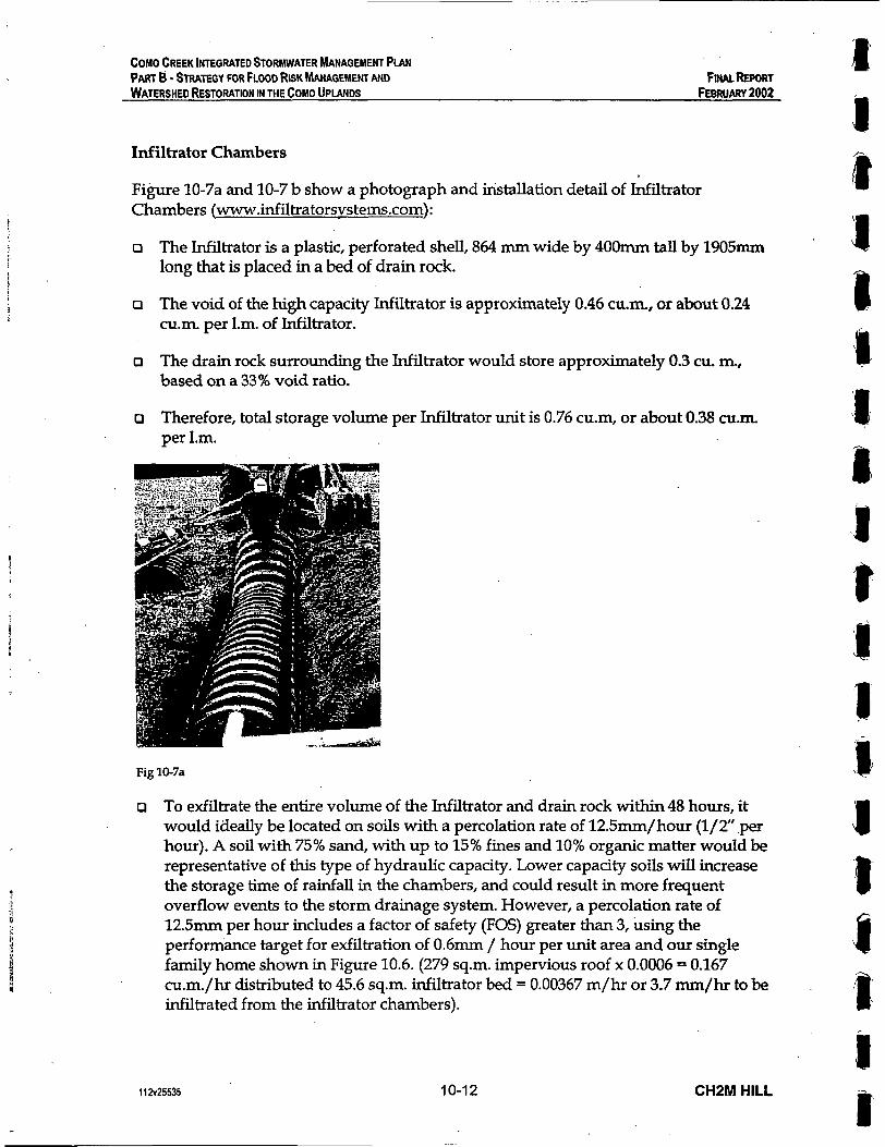
COMO CREEK INTEGRATED STORWATER MANAGEMENT PIAN PAKT 6 - STRATEGY FOR FLOOD RISK MANAGEMEW AND WATERSHED RESTORATION IN THE COMO UPLANDS
I FINAL REPORT
FEBRUARY 2002
Infiltrator Chambers
Figure 10-7a and 10-7 b show a photograph and installation detail of Infiltrator Chambers (www.infiltratorsvstems.com):
a The Infiltrator is a plastic, perforated shell, 864 mm wide by 400mm tall by 1905mm long that is placed in a bed of drain rock.
a The void of the high capacity Infiltrator is approximately 0.46 cu.rn, or about 0.24 1 cu.m. per 1.m. of Infiltrator.
a The drain rock surrounding the Infiltrator would store approximately 0.3 cu. m., based on a 33% void ratio.
a Therefore, total storage volume per Infiltrator unit is 0.76 cu.m, or about 0.38 cu.n per 1.m.
Fig 10-7a
To exfiltrate the entire volume of the Infiltrator and drain rock within 48 hours, it would ideally be located on soils with a percolation rate of 12.5mm/hour (l/2” .per hour). A soil with 75% sand, with up to 15% fines and 10% organic matter would be representative of this type of hydraulic capacity. Lower capacity soils will increase the storage time of rainfall in the chambers, and could result in more frequent overflow events to the storm drainage system. However, a percolation rate of 12.5mm per hour includes a factor of safety (FOS) greater than 3, using the performance target for exfiltration of 0.6mm / hour per unit area and our single family home shown in Figure 10.6. (279 sq.m. impervious roof x 0.0006 = 0.167 cu.m./hr distributed to 45.6 sq.m. infiltrator bed = 0.00367 m/hr or 3.7 m / h r to be infiltrated from the infiltrator chambers).
11 a25535 10-1 2 CHZM HILL
1 1 I t s 1 @
P I 1;

Cos0 CREEK INTEGRATED STORMWATER MANAGEMENT PLAN PART B - STRATEGY FOR FLOOD RISK MANAGEMENT AND WATERSHED RESTORATION IN THE COMO UPlANDS
FINAL REPORT FEBRUARY 2002
o The exfiltration site should be protected during construction from either compaction or sedimentation, by pre identification and fencing or other means. Inadvertent compaction should be removed by ripping or scarifying the site prior to installation of the infiltrator chambers.
R Pipes leading to Infiltration Chambers should be fitted with debris catchers and cleanouts, to minimize the movement of sediment and debris into the chamber.
o The entire Infiltration System is sub-surface. Normal landscape or lawn can be installed over the surface.
o Other exfiltration systems also should be considered. Note, however, that systems that are as shallow as possible (ASAP) provide the best opportunity for recharging the soil interflow zone.
GROWING MEDIUM 1
1 112’ - 3” WASHED CRUSHED STONE - INFILTRATION CHAMBER
UNDISTURBED NATIVE SOILS
STORMWATER STORAGE: INFILTRATION CHAMBER
Fig 10-7b
11 a25535 10-13 CHPM HILL
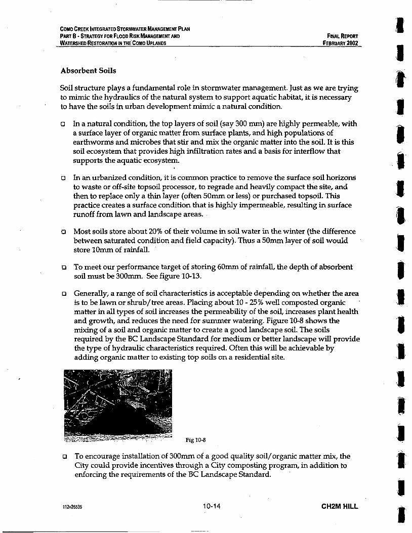
COMO CREEK INTEGRATED STORMWATER MANAGEMENT PLAN PART B - STRATEGY FOR FLOOD RISK MANAGEMENT AND WATERSHED RESTORATION IN MECOMO UPLANDS
FINAL REPORT FEBRUARY 2002
Absorbent Soils
Soil structure plays a fundamental role in stormwater management. Just as we are trying to mimic the hydraulics of the natural system to support aquatic habitat, it is necessary to have the soils in urban development mimic a natural condition.
o In a natural condition, the top layers of soil (say 300 mm) are highly permeable, with a surface layer of organic matter from surface plants, and high populations of earthworms and microbes that stir and mix the organic matter into the soil. It is this soil ecosystem that provides high infiltration rates and a basis for interflow that supports the aquatic ecosystem.
o In an urbanized condition, it is common practice to remove the surface soil horizons to waste or off-site topsoil processor, to regrade and heavily compact the site, and then to replace only a thin layer (often 50mm or less) or purchased topsoil. This practice creates a surface condition that is highly impermeable, resulting in surface runoff from lawn and landscape areas.
o Most soils store about 20% of their volume in soil water in the winter (the difference between saturated condition and field capacity). Thus a 50mm layer of soil would store lOmm of rainfall.
CI To meet our performance target of storing 60mm of rainfall, the depth of absorbent soil must be 300mm. See figure 10-13.
o Generally, a range of soil characteristics is acceptable depending on whether the area is to be lawn or shrub/tree areas. Placing about 10 - 25% well composted organic *
matter in all types of soil increases the permeability of the soil, increases plant health and growth, and reduces the need for summer watering. Figure 10-8 shows the mixing of a soil and organic matter to create a good landscape soil. The soils required by the BC Landscape Standard for medium or better landscape will provide the type of hydraulic characteristics required. Often this will be achievable by adding organic matter to existing top soils on a residential site.
Fig 10-8
o To encourage installation of 300mm of a good quality soil/organic matter mix, the City could provide incentives through a City composting program, in addition to enforcing the requirements of the BC Landscape Standard.
112v25535 10-14 CHPM HILL
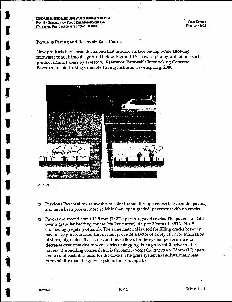
d E
COMO CREEK INTEGRATED STORMWATER MANAGEMENT PLAN PART B - STRATEGY FOR FLOOD RISK MANAGEMENT AND WATERSHED RESTORATION IN THE COMO UPLANDS
FINAL REPORT FEBRUARY 2002
Pervious Paving and Reservoir Base Course
New products have been developed that provide surface paving while allowing rainwater to soak into the ground below. Figure 10-9 shows a photograph of one such product (Rima Pavers by Westcon). Reference: Permeable Interlocking Concrete Pavements, Interlocking Concrete Paving Institute, www.icui.org, 2000
Fig 10-9
o Pervious Pavers allow rainwater to enter the soil through cracks between the pavers, and have been proven more reliable than ’open graded‘ pavement with no cracks.
o Pavers are spaced about 12.5 mm (l/2”) apart for gravel cracks. The pavers are laid over a granular bedding course (choker course) of up to 50mm of ASTM No. 8 crushed aggregate (not sand). The same material is used for filling cracks between pavers for gravel cracks. This system provides a factor of safety of 10 for infiltration of short, high intensity storms, and thus allows for the system performance to decrease over time due to some surface plugging. For a grass infill between the pavers, the bedding course detail is the same, except the cracks are 25mm (1”) apart and a sand backfill is used for the cracks. The grass system has substantially less permeability than the gravel system, but is acceptable.
11 2125535 10-1 5 CHPM HILL

0
0
0
0
0
COMO CREEK INTEGRATED STORMWATER MANAGEMENT PLAN PART B - STRATEGY FOR FLOOD RISK MANAGEMENT AND WATERSHED RESTORATION IN THE COMO UPlANDS
FINAL REPORT FEBRUARY 2002
The pavers are placed over a reservoir base course of fractured drain rock, similar to railway ballast. This reservoir is sized to store the design storm. For a 6Omm storm, the reservoir part of the base course would be about 180mm deep (33% void). Additional depth may be required for structural strength in heavy use conditions, but is not likely required in driveways. The reservoir base course is placed over lightly compacted ground (about 80% modified proctor density), to maximize exfiltration of the rainfall into the underlying subsoil.
Slope on the pervious pavers should be at least 1%, and should not exceed 6%. Calculation of the reservoir capacity should consider drainage areas that flow to the pavement.
Depth to water table or bedrock under the reservoir base course should be at least 600mm. Infiltration rate of soils under the reservoir should be a minimum of vi” /hour for full exfiltration without a perforated underdrain. Pervious paving should not be used on any ‘stormwater hotspots’ where surface contaminants may be concentrated and enter the groundwater e.g. gas stations, wrecking yard, fleet storage yards, or other sites that store hazardous materials.
Due to the soil requirements for use of this technology, it is recommended that a hydrogeotechnical study be performed to identrfy areas in Coquitlam where existing soil conditions are appropriate.
A vertical pipe inlet can be installed so that the reservoir base course overflows to the storm drain when full. Where soil infiltration is limited, a similar cross section detail can be used to store the design storm, with a perforated drain to slowly remove the stored water to the storm drainage system.
1 1 a25535 10-1 6 CHPM HILL

COMO CREEK INTEGRATED STORMWATER MANAGEMENT PLAN PART B - STRATEGY FOR FLOOD RISK MANAGEMENT AND WATERSHED RESTORATION IN THE COMO UPLANDS
FINAL REPORT FEBRUARY 2002
Spaced Wood Deck
Simple, well known, technologies also can meet the performance target. Figure 10-10 shows a typical wood deck with space between the boards.
o Rainfall hitting this wood deck flows to the ground below.
o Provided the ground below meets the.performance target for absorption, there is no runoff from this technique.
Fig 10-10
Skinny Buildings
Building designs that minimize roof area by a taller, more slender building form, effectively reduce impervious area. Figure 10-11 shows this form of building. Whereas in this photo they are located close together on narrow lots, similar buildings on a standard lot would leave more permeable space in the yard. These types of buildings might be especially appropriate on steeply sloping sites, or sites with valuable existing vegetation.
Fig 10-11
1 12~25535 10-1 7 CH2M HILL
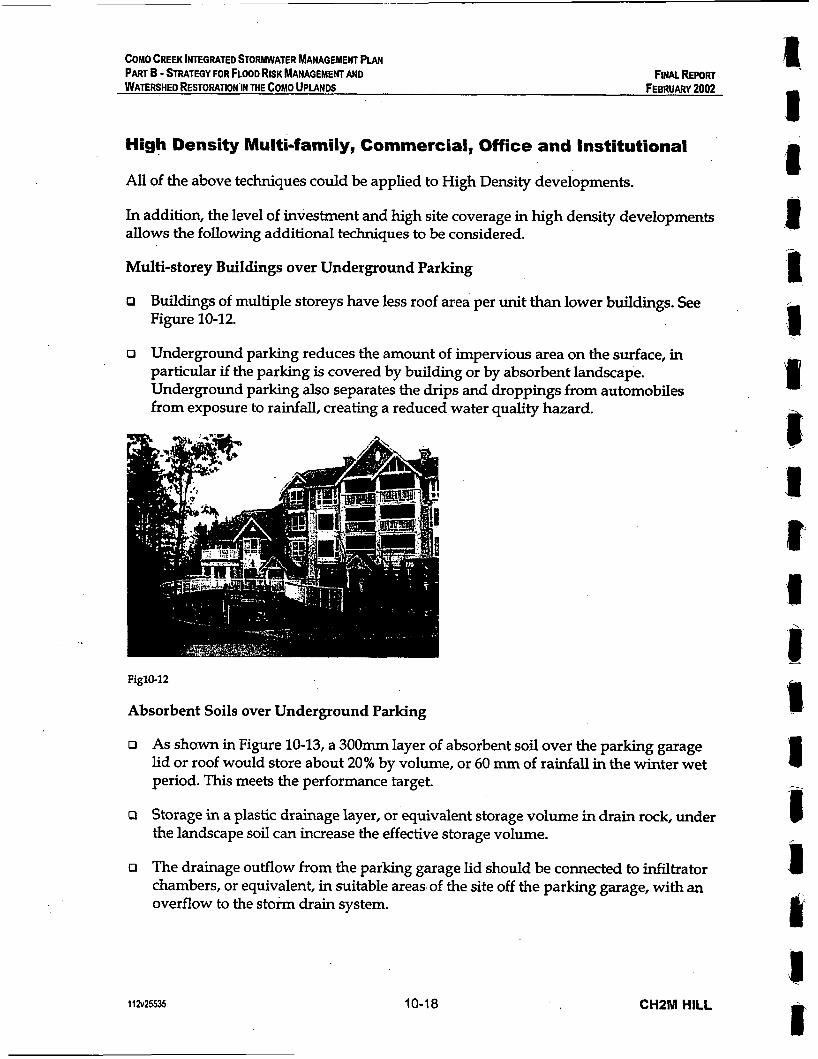
COMO CREEK INTEGRATED STORMWATER fdANAGEMENT PLAN
WATERSHED RESTORATION’IN THE COMO UPIANDS PART B - STRATEGY FOR FLOOD RISK MANAGEMENT AND FINAL WORT
FEBRUARY 2002
High Density Multi-family, Commercial, Office and Institutional
All of the above techniques could be applied to High Density developments.
In addition, the level of investment and high site coverage in high density developments allows the following additional techniques to be considered.
Multi-storey Buildings over Underground Parking
o Buildings of multiple storeys have less roof area per unit than lower buildings. See Figure 10-12.
o Underground parking reduces the amount of impervious area on the surface, in particular if the parking is covered by building or by absorbent landscape. Underground parking also separates the drips and droppings from automobiles from exposure to rainfall, creating a reduced water quality hazard.
Figlo-12
Absorbent Soils over Underground Parking
o As shown in Figure 10-13, a 300mm layer of absorbent soil over the parking garage lid or roof would store about 20% by volume, or 60 mm of rainfall in the winter wet period. This meets the performance target.
P Storage in a plastic drainage layer, or equivalent storage volume in drain rock, under the landscape soil can increase the effective storage volume.
o The drainage outflow from the parking garage lid should be connected to infiltrator chambers, or equivalent, in suitable areas of the site off the parking garage, with an overflow to the storm drain system.
I 1 a25535 10-18 CHZM HILL

COMO CREEK INTEGRATED STORWATER MANAGEMENT PLAN PART B - STRATEGY FOR FLOOD RISK MANAGEMENT AND WATERSHED RESTORATION IN THE COMO UPLANDS
FINAL REPORT FEBRUARY 2002
+: , ,4.-,-,?:,- A\-,. J*+*ai,
8 I 1
. -%
PLANTING
WATERPROOF
DRAFI COLLAR FLOW CONTROL+
ABSORBANT SOILS AND FLOW CONTROL OVER PARKING GARAGE
SOIL MIX
Fig 10-13
Cisterns
o Figure 10-14 shows schematically the installation of cisterns in parking garages or landscape areas.
P These concrete vaults would generally be used to store roof drainage, and to release it slowly into infiltrator chambers with overflows to the storm drainage system.
On-Parcel 8 OnStwet Strategies
Fig 10-14
Rainwater Reuse
o Once rainwater is stored in cisterns, there are opportunities for its adaptive reuse.
11225535 10-19 CHPM HILL
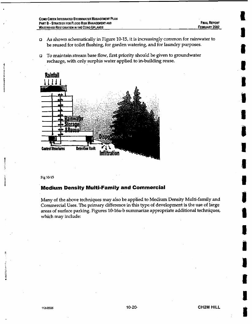
COMO CREEK INTEGRATED STORMWATER MANAGEMENT PLAN PART B - STRATEGY FOR FLOOD RISK MANAGEMENT AND WATERSHED RESTORATION IN THE COMO UPlANDS FEBRUARY 2002
FINAL REPORT
o As shown schematically in Figure 10-15, it is increasingly common for rainwater to be reused for toilet flushing, for garden watering, and for laundry purposes.
o To maintain stream base flow, first priority should be given to groundwater recharge, with only surplus water applied to in-building reuse.
Rainfall
Fig 10-15
Medium Density Multi-Family and Commercial
Many of the above techniques may also be applied to Medium Density Multi-family and Commercial Uses. The primary difference in this type of development is the use of large areas of surface parking. Figures 10-16a-b summarize appropriate additional techniques, which may include:
1 a ,R I .1 8 J
112~25535 10-20, CHZM HILL I'

E I
II
COMO CREEK INTEGRATED STORMWATER MANAGEMENT PIAN PART B - STRATEGY FOR FLOOD RISK MANAGEMENT AND WATERSHED RESTORATION IN THE COMO UPlANDS
FINAL REPORT FEBRUARY 2002
I I I I I I I I I I I I I I I I I I 1 I I I !
e m - - - . -----------------
Fig 10-16a-b
Roof Storage
D Commercial developments often have large expanses of flat roof. It is feasible to store rainfall on these roofs, making it available to evaporation.
R Figure 10-17 shows a 'green roof' on a large airport building. This thin layer of lightweight growing medium, sedums, mosses and thrift provide some stormwater absorption, but also offer excellent insulation and aesthetic effect while reducing the 'urban heat island' effect and absorbing greenhouse gases. These treatments are common in Europe, and are being introduced to North America.
a Roof water should be kept separate from parking area drainage, which can be polluted with hydrocarbons and heavy metals. Whereas parking area water requires treatment, most roof water could be released directly to storage and receiving waters.
Fig 10-17
1 1 a25535 10-21 CHZM HILL
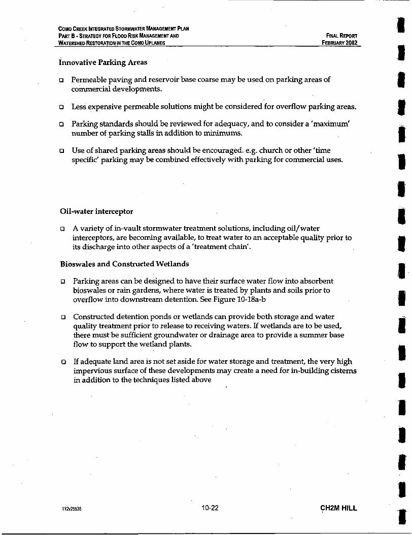
COMO CREEK INTEGRATED STORMWATER MANAGEMEW PLAN PART B - STRATEGY FOR FLOOD RISK MANAGEMENT AND WATERSHED RESTORATION IN THE COMO UPLANDS
Innovative Parking Areas
a Fiw REPORT
FEERUARV 2002
o Permeable paving and reservoir base coarse may be used on parking areas of commercial developments.
o Less expensive permeable solutions might be considered for overflow parking areas.
o Parking standards should be reviewed for adequacy, and to consider a 'maximum' number of parking stalls in addition to minimums.
o Use of shared parking areas should be encouraged. e.g. church or other 'time specific' parking may be combined effectively with parking for commercial uses.
Oil-water interceptor
o A variety of in-vault stormwater treatment solutions, including oil/water interceptors, are becoming available, to treat water to an acceptable quality prior to its discharge into other aspects of a 'treatment chain'.
Bioswales and Constructed Wetlands
Parking areas can be designed to have their surface water flow into absorbent bioswales or rain gardens, where water is treated by plants and soils prior to overflow into downstream detention. See Figure 10-18a-b
Constructed detention ponds or wetlands can provide both storage and water quality treatment prior to release to receiving waters. If wetlands are to be used, there must be sufficient groundwater or drainage area to pro'vide a summer base flow to support the wetland plants.
If adequate land area is not set aside for water storage and treatment, the very high impervious surface of these developments may create a need for in-building cisterns in addition to the techniques listed above
11 a25535 10-22 CHZM HILL I

COMO CREEK INTEGRATED STORMWATER MANAGEMENT PLAN PART B - STRATEGY FOR FLOOD RISK MANAGEMENT AND WATERSHED RESTORATION IN THE COMO UPLANDS
FINAL WORT FEBRUARY 2002
I c
A. a I d I Fig 10-18a
I
P
I Pavement
Fig 10-18b
11 2~25535 10-23 CHZM HILL
COMO CREEK INTEGRATED STORMWATER MANAGEMENT PLAN PART 6 - STRATEGY FOR FLOOD RISK MANAGEMENT AND WATERSHED RESTORATION IN THE COMO UPLANOS
FINAL REPORT FEBRUARY 2002
Roadways
Most roadways in the Como Creek Watershed are already established. In some parts of the watershed, open swales have recently been replaced with curb, gutter and underground storm drainage pipes.
Mitigating the hydrological impacts of roadways will be a slow process, with opportunities being limited to the time of major redevelopment of industrial/cormnercial frontages, or to redevelopment of existing roads at the end of their service life.
The notes that follow show some concepts on how to create roads that meet the performance targets. With these concepts, the roads would 'self-mitigate'. That is, they would be designed to store and treat up to 60mm of water that would fall on them, and to pass the water from larger,storms through the pipe or overflow system.
Permeable Roadside Parking and Sidewalk
0
0
0
0
0
0
Figure 10-19a, b and c show Permeable Paving for parking areas of the street cross section. This permeable paving could be similar to that described for driveways, excepting that a deeper reservoir course would be sized to hold the water flowing from the adjacent asphalt traveled lanes.
Also shown is permeable paving on the sidewalk. The sidewalk is also separated from the curb by a 3.0 m boulevard, which is dished to contain the drainage that hits it. With this dished boulevard, a second, acceptable, option would be for the sidewalk to be impervious pavement, pitched to slope to the boulevard.
This detail has an upright curb, to avoid cars encroaching on the boulevard. The boulevard surface has 200 mm of sandy loam, with sodded grass surface for erosion control and permeability.
Below the grass boulevard is a 'Dry Swale with Underdrain'. This is a 600- deep sand filter with a perforated drain in drain rock under it. The sand filter both stores rainwater (20% by volume) and filters out pollutants as water passes through it.
To allow drainage to get from the reservoir base course under the parking and sidewalk into the sand filter, the reservoir base course extends under the grass boulevard. This provides a large volume of underground storage for rainwater, and also a large surface area for the rainwater to infiltrate into the subsurface interflow.
Street trees are shown in Figure 10-19c. Standard topsoil mix would be used for the tree pit. If streets slope greater than 3-6% in profile, 'dams' of gravel material could be extended out from the tree topsoil to form an underground pool, encouraging the rainwater to soak into the sand filter. A cleanout and overflow drain could be provided upstream of each tree.
112~25535 10-24 CHPM HILL
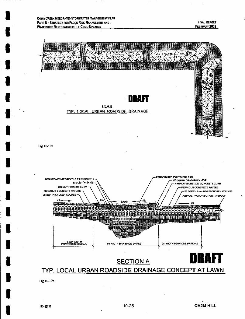
1 ‘I
I m
COMO CREEK INTEGRATED STORMWATER MANAGEMENT PIAN PART B - STRATEGY FOR FLOOD RISK MANAGEMENT AND WATERSHED RESTORATION IN THE COMO UPLANDS
FINAL REPORT FEBRUARY 2002
Fig 10-19a
PERFORPTED WC TO CE L W 300 DEPTH DRAINROCK -NP.
NRRRUW BASE (900) CONMETE PERVIOUS CONCRETE PAVER5
25 Ourrn Yrnm MINUS M O K E U C Q U H B
K O M SECTION TO W E 7
NONNWWEN GEOlMTlLE FILTERUOTH 600 DEPTH SAND
PERVIOUS CONCRRE PAVER 25 DEPTH CUOKW C O U R S E 7
1.83m WIDTH PERVlOUS SIDEWAM 3m WIDTH DRAINAGE 5VhU.E 2n1H’ItiTH PERVIOUS PARKINS
r r
SECTION A DRAFT TYP. LOCAL URBAN ROADSIDE DRAINAGE CONCEPT AT LAWN
Fig 10-19b
I
112~25535 10-25 CHZM HILL
COMO CREEK lNTEGRAlED STORMWATER hlANAGEMENT PLAN
WATERSHED RESTORATION IN THE COMO UPLANDS PART B - STRATEGY FOR FLOOD RISK MANAGEMENT AND FINAL REPORT
FEBRUARY 2002
Y
SECTION B DRAFT TYP. LOCAL URBAN ROADSIDE DRAINAGE CONCEPT AT TREE
Fig 10-19c
Backup / Overflow to Stormdrain System
o All of the above systems include an overflow connection to the existing piped stormwater system. This provides redundancy, a route for storms over 6 0 m , and insurance in case of any failure of these techniques. In the case of the Como Creek Watershed, this does not represent an added cost, since the piped system exists.
o However, in ’greenfield’ watersheds, it is likely that the ‘infiltration’ system could reduce the size and extent of the required ’piped‘ stormwater system. For the resulting savings to be safely realized, it is necessary to prove that the infiltration systems will perform reliably. A scientific monitoring program of the Como Watershed pilot projects and implementation is therefore recommended to determine the necessity of the ‘piped’ stormwater backup system, and to make recommendations for design of future ’greenfield’ systems.
112~25535 10-26 CHZM HILL
8 I rn
COMO CREEK INTEGRATED STORMWATER MANAGEMENT PLAN PART B - STRATEGY FOR FLOOD RISK MANAGEMENT AND WATERSHED RESTORATION IN THE COMO UPlANDS
FINALREPORT FEBRUARY 2002
Riparian Corridors
This study has focused on the hydrological aspects of watershed management. However, a second vital part of watershed management is the management of riparian , zones. Figure 10-20 illustrates some of the key functions of riparian habitat.
Fig 10-20
During the course of this study, the Province of British Columbia has passed the Streamside Protection Regulation under the Fish Protection Act.
This regulation sets out provincial requirements for protection of streamside riparian areas. The level of protection varies depending on a number of criteria, including:
o Whether the watercourse is fish-bearing or non fish-bearing;
o Whether the watercourse is permanent or non-permanent;
'o The state of the existing riparian vegetation;
R The state of existing land use and development along the watercourse.
11 2~25535 10-27 CHZM HILL

COMO CREEK INTEGRATED STORMWATER MANAGEMENT PIAN 8 I
PART B - STRATEGY FOR FLOOD RISK MANAGEMENT AND FINAL REPORT WATERSHED RESTORATION IN THE COMO UPLANDS FEBRUARY 2002
Target riparian setbacks vary from 5m to 30m from top of bank depending on the above factors.
The riparian zones in the Como Creek watershed are highly variable. Although most of the ravines are well vegetated, there are many cases where development crowds the top of bank. Riparian areas in the lower watershed are especially impacted by development. However, opportunities exist for limited restoration of riparian function at the time of redevelopment.
The Streamside Protection Regulation sets out the potential for ’Intergovernmental Cooperation Agreements’ to allow for a watershed and site-specific agreement on how the Fish Protection Act requirements can be met. Given its urbanized state, the Como Creek Watershed is a prime candidate for such a customized agreement.
It is suggested that the City of Coquitlam seek financial assistance under the Streamside Protection Regulation of the Fish Protection Act to create an intergovernmental agreement specific to the Como Creek Watershed and its existing condition and future potential.
The intent of the Intergovernmental Cooperation Agreement is to bring all parties which share a common goal - or who are essential players in achieving other jurisdictions’ goals - together so that they can apply their various mandates, resources, and capabilities to do the job both efficiently and effectively for all concerned.
112~25535 10-28 CHPM HILL

COMO CREEK INTEGRATED STORMWATER MANAGEMENT PLAN PART B - STRATEGY FOR FLOOD RISK MANAGEMENT AND WATERSHED RESTORATION IN THE COMO UPLANDS
FINAL REPORT FEBRUARY 2002
Restoration of Aquatic Habitat
A first priority of this watershed management plan is addressing the causes of flooding and erosion in the watercourses. As these problems are reduced, there will be increasing opportunities for restoration of aquatic habitat in the watershed.
Nature, given time, will perform admirably in restoring watershed health in many areas. However, habitat restoration activities can speed up the natural regeneration process, and provide inputs to the stream that would not be available in a heavily urbanized environment.
Types of habitat restoration that might be included in various projects include:
P As shown in Figure 10-21, where streams are constructed (e.g. the Popeye Corridor or daylighting projects), they should include a curvilinear system of pool / riffle complexes, as well as adjacent floodplain areas and riparian vegetation.
Fig 10-21
P Figure 10-22 shows a constructed riffle with pools above and below. This type of rock structure may reduce instream erosion and provide varied habitats in areas where machine access can readily be gained.
Fig 10-22
1 12v25535 10-29 CHZM HILL
COMO CREEK INTEGRATED STORWATER MANAGEMENT PLAN PART B - STRATEGY FOR FLOOD RISK MANAGEMENT AND WATERSHED RESTORATION IN THE COMO UPLANDS
Fits REPORT FEBRUARY 2002
a Figure 10-23 shows a 'macro pool' that has been excavated to provide summer I a rearing habitat and deep water refuge from high temperatures and predators.
Fig 10-23
o Figure 10-24 shows large organic debris for fish shade, cover and insect use. Note that the root wad has been cabled to a boulder weight to keep it from flushing downstream during storm flows.
Fig 10-24
I
I
1 1
n
8
8 I
a Figure 10-25 shows boulder clusters placed in the stream. These modify current patterns, providing varied fish habitats, and create scoured micro-pools around them.
112~255.35 10-30
Fig 10-25
CHOM HILL

COMO CREEK INTEGRATED STORMWATER MANAGEMENT PLAN
WATERSHED RESTORATION IN THE COMO UPLANDS FINAL REPORT
FEBRUARY 2002 PART B - STRATEGY FOR FLOOD RISK MANAGEMENT AND
o Figure 10-26 shows brush layering of willow cuttings to provide erosion control and leaf drop along a constructed stream bank.
Fig 10-26
Como Creek Watershed is an excellent opportunity to demonstrate these types of habitat restoration techniques in an urban setting. Every opportunity should be taken to both gain senior government assistance, but also to engage the community in the application, monitoring and appreciation of these techniques.
The restoration of the hydrology and habitat of the Como Creek Watershed is a project that will take 50 years - a generation.
It will be a fine legacy to leave to generations to come.
a I 112~25535 10-31 CH2M HILL

COW CREEK WATERSHED hbJUGEMENT PLAN PART C - PLAN IMPEMENATION
FIWLREPORT FEBRUARY 2002
PART C
Implementation of the Como Creek Integrated Stormwater Management Plan

Chapter Implementation Actions for
Corno Watershed
CHPM HILL

COHO CREEK lNTE0RAlED STROMWATER MANAGEMENT PLAN PART C - Pwc IMPLEMENTATION
FINALREPORT FEBRUARY 2002
CHAPTER 11 Imdementation Actions for Como Watershed 11 .I Introduction Parts A and B of this report developed strategies for the Fraser Mills Lowlands and Como Uplands, respectively. Although they were presented in separate parts of the report the Lowlands and Uplands strategies are components of one Integrated Stormwater Management Plan for the Como Watershed. This chapter presents the specific actions that are needed to implement this integrated plan.
1 I .2 Summary of the Como Watershed Plan The Como Watershed Plan is based on the following primary objectives: R Short-term objective - reduce flooding risk over the next 5 years P Long-term objective - restore the health of the watershed over the next 50 years
The key strategies for achieving these objectives are summarized below.
SHORT-TERM FLOOD RISK MANAGEMENT STRATEGIES
Improve the drainage system in the Lowlands - The risk of flooding in the Lowlands can be substantially reduced by improving the inadequate drainage system and providing flow management. Key improvements to lowlands drainage include:
Removing flow obstructions, particularly the private bridge on Booth Creek Providing inter-watershed flow control at Highways and existing Booth/Popeye connection. Expanding rainfall and streamflow monitoring networks to enable effective flow management.
- -
-
Upgrade high-risk culverts and provide bedload interception - There are three culvert installations in the Como Uplands where there is high risk of blockage, localized flooding and potential road washout. Key improvements to these culverts include: - -
Upgrading the inlet structure to reduce the risk of blockage and localized flooding Providing bedload interception to reduce downstream deposition and flooding risk.
Provide community storage facilities - The following ~~mmuni ty storage options are feasible for short-term flood risk management:
- Increasing the storage capacity of Como Lake to reduce erosion in the most unstable section of the Como Creek Ravine, thus reducing downstream deposition and flooding risk. Building a storage pond on the BC Hydro site below Brunette to improve flow management in the Lowlands and enable restoration of the Popeye Creek system.
-
112~25535 11-1 CHZM HILL

COMO CREEK WATERSHED MANAGEMENT PIAN PART C - PLAN IMPLEMENATION
FIN~LREPORT FEBRUARY 2002
LONG-TERM WATERSHED RESTORATION STRATEGIES
tetrofit the watershed with source storage and infiltration facilities - The key to ong-term watershed restoration is restoring the natural water balance of the watershed md reducing watercourse erosion to natural levels. The only way to accomplish this is to Setrofit the watershed with source storage and infiltration facilities as redevelopment ~ccurs. Watershed retrofit must be pursued through an incremental adaptive approach.
n the short-term it is important to: - Identify appropriate targets and design options for source storage and infiltration
facilities. This will require research of watershed conditions, implementation and monitoring of pilot projects, and consultation with landowners and the development community. Build support for watershed retrofit by educating city staff, the development community, and the general public. Change the appropriate development regulations to ensure that source storage retrofit will occur in conjunction with future redevelopment.
-
-
[n the medium to long-term it is important to: - Assist the implementation of individual source storage retrofit projects by
facilitating the procurement of necessary products and facilitating the development approval process. Monitor improvements in watershed conditions, particularly the reduction in runoff rates and volumes, as the watershed becomes retrofitted with source storage over time.
Optimize the source storage retrofit strategy based on on-going assessment of the monitoring feedback.
-
-
Restore the natural watershed drainage pattern (two separate su b-watersheds) - The overall vision for surface water management in the Como Watershed is to restore the natural drainage pattern of two separate sub-watersheds, Como/MacDonald and Booth/Popeye. A new drainage outlet at the highways for the Booth/Popeye sub- watershed must be created in order to achieve this vision.
Restore watercourses to their natural state - Restoring natural water balance will eliminate the source of stream degradation. Once this occurs watercourses can be restored to support healthy aquatic and riparian ecosystems can be restored to watercourses. Daylighting piped sections of creek is an essential element of watercourse restoration.
112~25% 11-2 CHZM HILL

1 I
Management Objective
Short-term Flood Risk Management
Long-term Watershed Restoration
Total
I 1 1 I I 1 I I 1
Cost Estimates Short-term Medium-term Long-term
(0-5 yrs) (5-20 yrs) (20-50 yrs) $7,050,00 $ 0 $ 0
$835,000 $2,965.000 $2.950.000
$7,985,000 $2, 965,000 $2,950,000 (say $8 million) (say $3 million) (say $3 milion)
COMO CREEK WATERSHED MANAGEMENT PUN PART C - PLAN IMPEMENATION
FINALREPORT FEBRUARY 2002
1 I .3 Description of Watershed Actions Table 11-1 defines the specific actions that are required to implement the strategies for short-term flood risk management and long-term watershed restoration. This table provides the following information for each specific action:
Time-frame for implementation Management objectives
. . Related plan element(s)
City agency to take a lead role Estimated cost (new funds over and above staff time)
Table 11-1 is the key deliverable of the Como Creek Watershed Management Plan. It provides an outline of what needs to be done to solve immediate problems and eventually achieve the 50-year vision of a restored watershed.
11.4 Overall Costs of the Watershed Actions The overall costs associated with short-term flood risk management and long-term watershed restoration are summarized below.
The total estimated cost of implementing the Como Creek Watershed Management Plan is close to $14 million over the next 50 years. About 56% of the total expenditures will be required over the next 5 years. The majority of these short-term expenditures (about 90%) are for flood risk management.
The $7 million required for short-term flood risk management reflects the cost of dealing with the consequences of past development. If future redevelopment follows the same pattern as past development and occurs without a strategy for managing runoff at the source, it is likely that similar expenditures will be required to deal with future problems. There is clearly a need to improve future development practices.
The magnitude of the required capital investment underscores the pressing need for an appropriate funding strategy.
112~25535 11-3 CHSMHILL -

A
f u
I r r
a a e a s
3 a s a s
as Y 0.
s %
--. tp--- P
m
a 0 U (D
Z s u)
P - 3 Y
P = s Y
5; ,G; 5; Iu 5;
0 e 5; -.
VI

v)
d
-I
n m
-!!
s
1 B
r n r n r n r n r n c c c c c .9 e - .o .g .g .g 8 8 n n n E E g g f 0 0 0 0 0
- - A m n o s s - - v u h m s n n v u - U c m Q) cn E B 8
s; 3 m U 0 0 G=
E 3 m c m Q) E > E n
.- 0 5 E 8 f U
0 .I= cn Q) I= m m
n .-
P e! 0
d
e m v) e - E
.- d c I- -
e!
w 5 w 8 E 8 Z Q ) s
h h n v =
L
P
h o s

I 1 m I I I I I 1 1 I I I I I I I I I
COMO CREU( WATERSHED MANAGEMENT Pwr PART C - Pws IYPLEYENATDN
FMAL REPORT FEBRUARY 2002
1 I .5 Financing the Watershed Management Plan Currently the only way to obtain funds for watershed management actions is from the Citfs general revenue. This makes implementation of the Como Watershed Plan very difficult because funding for individual projects must be approved by Council on a year by year basis. It is essential to establish a funding strategy to ensure the continued financing of much needed watershed improvements.
Stormwater Utilities Establishing a stonnwuter utility would provide a continuous and self-liquidating source of funds for implementing the Como Watershed Plan, and other stormwater management programs. Establishing a stormwater utility would provide a stable funding source for sustainable programs, which allows for long-term strategic planning and reduce reliance on reactive stormwater management.
The Local Government Act provides the legislative authority to establish a stormwater
To set up a Stormwater Utility, the City must first make the following decisions:
P City-wide or Watershed-based Stormwater Utility? - This decision comes down to the question ‘who should’pay?’. Collecting money from all Coquitlam residents to finance improvements in the Como Watershed could be perceived as unfair to residents outside the watershed. However, a city-wide drainage utility would give the City flexibility to finance future stormwater management activities in other parts of the City.
o Separate Stormwater Utility or Combined Sanitq/Stormwater Utility? - This decision relates to the question ‘what is the easiest and most politically acceptable way to implement a drainage utilty?’. The cities of Surrey and North Vancouver, for example, have both opted for a combined Sanitary/Stormwater Utility because this facilitated political acceptance. Various cases in Washington State (notably Bellevue and Bellingham) have successfully established separate stormwater utilities.
Utility.
In order to develop an appropriate long-term financing strategy for a stormwater utility, it is important to determine what programs will be funded through the utility. These may include operation and maintenance, capital improvements, development regulation, - monitoring, emergency response, and education. It is also important to determine how these programs will be phased in.
Once the scope of the stormwater utility (i.e. programs to be funded) is determined, the utility rates, and a plan for phasing in these rates can be established. A general financing principle of a stormwater utility is that rates are based on the costs (and benefits) of the services provided (i.e. user pays). Part of the revenue for a utility may also be derived from Development Costs Charges.
It usually takes about 2 to 3 years to start up a utility, and initially, there may be a need for some working capital to establish the utility.
112v25535 11-4 CHPM HILL
COMO CREEK WATERSHED MANAGEMENT PIAN PART c - PIAN lMPLEMENATlON
F ~ L R T FEBRUARY 2002
Development Cost Charges Another option for funding watershed improvements would be to rely on Development Cost Charges in the Como Watershed. This would transfer some of the City's watershed management costs to future developers. This is not equitable because: . the bulk of the City's expenditures are required to solve current problems, which are the
result of past development in the watershed. the source storage retrofit strategy ensures that future developers will pay their share. The costs associated with source storage and infiltration facilties will add to the total costs of each individual redevelopment project.
=
A stormwater utility is the only appropriate funding mechanism available to the City.
11.6 Measuring Success As watershed improvements are implemented over time, it is important to monitor the success of watershed restoration, measure progress towards the 50-year vision, and constantly improve integrated watershed management solutions. This is the foundation of an adaptive approach. The change in rainfall-runoff response is a key indicator for monitoring success. A key target is to reduce total runoff volume to less than 10% of total rainfall volpme. A more refined target would be to replicate the hydrograph for natural forested conditions, which can be defined using a calibrated watershed model. An expanded rainfall and streadow monitoring network is key to the monitoring and modelling components of an adaptive approach
112~25535 11-5 CHZM HILL
I 1 I 1 I I 1 I 8 I 1 I 1 I I I I I I

I
Chapter 12 Conclusions and .Recornmendations
‘I I
CHSM HILL

I I I I I I I I I I I I I I I I I I I
COMO CREEK INTEGRATED STORMWATER MANAGEMENT PLAN PART C - PLAN IMPLEMENTATION
FINAL REPORT FEERUARY 2002
CHAPTER 12 Conclusions and Recommendations 12.1 Conclusions The, key conclusions from the Como Creek Watershed Management Plan are summarized below.
1. Watershed Objectives - The primary objectives for the Como Watershed are to provide immediate flood relief and to restore the health of the watershed over time.
2. Flood Risk Management - The risk of flooding can be reduced in the short-term through a combination of improvements to the existing stormwater system including: . Improved flow management in the Lowlands . . Removal of the private bridge constricting Booth Creek
Structural improvements at high-risk culverts, including installation of bedload interception facilities. Improvements to increase the storage capacity of Como Lake .
3. Watershed Restoration - The key to long-term watershed restoration is restoring natural water balance and reducing watercourse erosion to natural levels. A key target in this regard is to reduce total runoff volume to less than 10% of total rainfall volume. This can only be accomplished by retrofitting the watershed with source storage and infiltration facilities as re-development occurs.
4. Adaptive Management - The changes in development practices that are needed to retrofit the watershed must be implemented through an adaptive approach with: . initial changes based on monitoring of pilot projects and consultation with
developers and landowners. continuous improvement based on monitoring and assessment of watershed restoration over time.
5. Data Collection and Modelling - Good baseline hydrologic data is essential to
. enable the monitoring, modelling, and ongoing refinement of watershed management solutions. Expansion of the rainfall and streamflow monitoring network is needed to provide this baseline data.
6. Funding - A drainage utility and an appropriate strategy for project financing are necessary to enable the sustained capital investment (i.e. almost $8 million in the first 5 years plus another $6 million over a 50-year period) that is required to resolve flooding and erosion problems and to achieve watershed restoration.
1 12~25535 12-1 CHPM HILL
COMO CREEK hTEGRATED SrORMWATER b G E M E N T PLAN PART c - PLAN IMPLEMENlATlON
FINAL REPORT FEBRUARY 2002
The CURE for the Como Watershed Restoring watershed health requires an integrated approach. The following elements must all work together to CURE the Como Watershed:
0
0
0
0
CAPRAL INVESTMENT - Providing immediate flood relief requires short-term capital investment to improve the performance of the existing drainage system. A financing strategy for watershed improvements is clearly needed in the short-term.
UNDERSTANDING SCIENCE - Improving the understanding of the watershed, the nature of its problems, and the effectiveness of technical solutions is key to an adaptive approach, which optimizes watershed management practices over time. Greater understanding can be gained through data collection, monitoring and modelling.
REGULATORY CHANGE - Changes in development regulations are needed to drive the source storage retrofit strategy that will restore natural water balance and eliminate the rout cause of drainage-related problems.
EDUCATION AND CONSULTATION - Changes in development practices cannot be implemented without building support among city staff, the general public, and the development community through education and consultation.
12.2 Recommendations Over-arching Recommendation Adopt-in-principle the Lowlands and Uplands components of the Como Creek Watershed Management Plan (as presented on Figures 4 1 and 9-1 respectively) subject to the development of a financing strategy.
The following recommended actions flow from the above over-arching recommendation, and are key steps towards implementation of the Como Watershed Plan:
o Action #1- Expand the rainfall and streamflow monitoring network
o Action #2 - Implement a flow control system in the Lowlands
o Action #3 - Remove the private bridge constricting Booth Creek
o Action #4 - Increase the stormwater detention capacity of Como Lake
o Action #5 - Adopt an adaptive approach to source storage retrofit
o Action #6 - Proceed with pre-design for structural upgrades and bedload interception facilities at high-risk culvert installations
o Action #7 - Establish a drainage utility and associated financing strategy
112~25535 12-2 CHPM HILL
I 1 I I I I I I I I I 1 I I I I I 1 I

APPENDIX A
RECORD OF WORKSHOPS
a

CITY OF COQUlTlAM COMO CREEK WATERSHED MANAGEMENT PLAN JANUARY ~ O T H 2000 WORKING SESSION #I - CHARTERING OF CLIENT/CONSULTANT PROJECT TEAM
RECORD OF WORKING SESSION #1
DATE OF MEETING: January loth 2000 DURATION: 930am - 12:15pm
ATTENDED B Y
AGENDA ITEMS:
Mike Nihls Rob lnnes David Reid AI Kersey Ron Kistritz
See next page for a listing of the five agenda items and the scope of the discussion under each.
The Agenda is supplemented by a 30-slide PowerPoint presentation that provided a framework for brainstorming. &is framework was adhered to closely.
PURPOSE OF SESSION Charter the Client/Consultant Project Team to:
Clarlfygoals Define roles Clady expectations Build alignment
0 Establish operating guidelines 0 Make use of collective resources & knowledge
A critical element of the project delivery process is 'endorsement'. This means securing the commitment of the stakeholders to cooperate and work towards a successful project outcome.
Endorsement is an ongoing process that requires period reaffirmation as the Watershed Management Plan evolves.
OUTCOMEOFSESSION: The direction and/or action items arising from the session are highlighted as follows.:
1. Agreed on the Vision Statement below. This is to be validated by the other stakeholders in subsequent working sessions. The emphasis is on managing expectations and maintaining a reality-based time perspective for improving conditions.
Through an integrated management plan, the goal of the City is to protect property, support development, and preserve and over time enhance the natural environment in the Como Creek watershed.
11 N25535 1 CHZM

CITY OF COPUITlAM
WORKING SESSION #I - CHARTERING OF CLIENTICONSULTANT PROJECT TEAM COMO CREEK WATERSHED MANAGEMENT PIAN JANUARY 1oTH 2000
2. Selected Jan 19th for a 'creek walkabou? to familiarize the Steering Committe with existing conditions in the ravines and on the floodplain. Include the Como Streamkeepers Group.
3. Selected Feb 16th and April 5th for the next two'working sessions ( W S #2 and WS #3).
This will provide targets for focussing the work effort of the team. Invite agencies to participate in the working sessions to get their buy-in to process
4. Theme for WS #2 will be "Analysis of the Problem". Provide background and have some initial thoughts for agencies. For purposes of discussion, include 'parks and recreation' with the 'land use' component.
December 15th 1999 flood overflows at Sheridan culvert inlet and at Schoolhouse Street underscore urgency of situation.
Provide a science-based understanding. Previous work has been hampered by a lack of science and differing objectives. There is no uniform, reliable, robust model of what is existing.
5.
Need a practical predictive hydraulic model for flood routing. Make use of existing models to the extent possible (e.g. for survey cross-sections and boundary water level conditions).
Approach to modelling will be based on applying common- sense in order to ensure effective use of the limited budget.
. Immediate purpose of modelling is to generate peak flow values for testing scenarios for improved flood routing through the lowlands.
6. Mandate is to create options for consideration by City. Demonstrate a thorough understanding of the watershed to build support for resolving immediate flood risks.
I
Complexity is induced because of Fraser River flood risk, lack of dyking, seismic concerns, and MOTH corridors.
Lack of science, differing objectives between the levels of government, and lack of money are three noteworthy factors that have historically hampered development of a comprehensive solution to flood hazards in the lowlands.
7. Cross-fertilize with the current OCP process. Provide an understanding of the issues, and identrfy where stormwater management policy should be incorporated in OCP.
DATE ISSUED: January 3lSt 2000
112V25535 2 CHZM '

.1 CITY OF COQUlTLAM COMO CREEK WATERSHED MANAGEMENT PIAN JANUARY IOTH 2000 WORKING SESSION #I - CHARTERING OF CLIENT/CONSULTANT PROJECT TEAM
Time Slot
0930 - 0940
0940 - 1000
1000 - 1100
1100 - 1120
1120 - 1205
1205- 121 5
AGENDA
Topic and Scope of Discussion
Welcome and Introductions (by Neil Nyberg)
Setting the Context for Chartering (Bill Hayes) 0 why we're here 0 goals for this session - desired deliverables 0 roles 0 agenda for session
terms of engagement ~~
Purpose (Kim Stephens) project vision, purpose, deliverables
0 critical success factors performance measures
0 barriers, opportunities 0 guiding principles
Roles & Responsibilities, and Operating Guidelines (Bill Hayes & Kim Stephens)
0 reporting structure communications decisions resolving conflicts evaluating team performance
identify roles and responsibilities for 'clienVconsultant team'
Work Program Elements (Kim Stephens, David Reid and Ron Kistritz)
0
information and mapping to be provided by City details of program elements (engineering, land use, fisheries, communications) selection of attendees for future workshops
Follow-Through Plan & Commitments (Bill Hayes) documenting our charter
0 benefits to us
getting it endorsed (who, how) investments required of us to make it work
11 2\125535 3 CHZM

City of Coquitlam Como Creek Watershed Management Plan
Working Session #'I
Chartering of Client/Consdtant Project Team January 10,2000
I
Chartering a Project Team
Conveys certain authorities and resources to the team and team members Authority has a defined boundary and scope of work In return the team is responsible for generating certain results The definition of the purpose, scope, goals, behaviors and roles and relationships is the chartering process
@ CHPMHIU 4%.
Project Delivery Process
Chartering
Workplan
Chartering A term borrowed from the British sovereign
King or Queen granted or chartered certain
Privileges often in form of property and the
Given in exchange for a percentage of profits
system
rights or privileges on an individual
right to own it
from the land or a tax
W h y Charter the Team?
To clarify goals To define roles To clanfy expectations To build alignment To establish operating guidelines To make better use of collective resources and knowledge
Chartering will include:
Project purpose Vision Measures of Success Roles and Responsibilities Operating Guidelines
Endorsement of the Project

Workplan will include:
Scope & Tasks Resources Schedule and Milestones Budget Client Information and Involvement Change Management
Endorsement Not a single event (e.g. approving the
An ongoing process Recurs when buy-in is needed to
workplan)
accommodate change during project execution Informed Involvement Collaboration (open process)
Goals for Working Session
Define a ‘Common Understanding’ Establish Protocols for Study Execution Select Dates for Next Two Workshops Identify Attendees for Workshops
Endorsement I Not just the approval of the workplan On-going commitment of the stakeholders to work toward a successful project Substantiated in a document that is signed by all stakeholders to the project All the stakeholders buy into the project for its successful for execution
L
Agenda Items
Setting the Context pili)
Purpose O<im)
Roles and Responsibilities @ili B Kim)
Work Program Elements meream)
FOllOW-ThrOugh mill)
Terms of Engagement
Funding in place for all four phases? Build a ClientKonsultant partnership!
2

Project Management Objectives
Spend budget wisely Solve problems Evolve the deliverables
The Goal is to Integrate:
Sharing a Vision Requires an Integrated Approach to...
Reduce Flood Hazards Prevent Stream Erosion Protect Aquatic Habitat Improve Water Quality
~~
Vision Statement
Through an integrated management plan. the goal of the Cify is to protect property, support development, and preserve and over time enhance the natural environment in the Como Creek watershed.
Purpose
Apply a science-based approach to create a shared vision of achievable goals
Facilitate a participatory decision urocess to build stakeholder consensus and agree on expectations
Phased Approach
Phase 1 : Interim Plan Phase 2: Decision Framework Phase 3: Planning Scenarios Phase 4: Integrated Plan
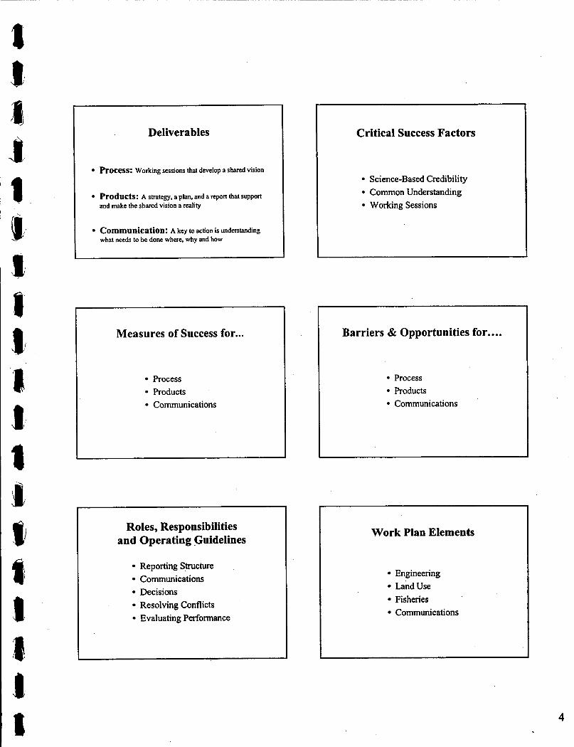
Deliverables
Process: Working sessions that develop a shared vision
Products: A strategy, a plan, and a report that support and make the shared vision a reality
Communication: A key to action is understanding what needs to be done where, why and how
Measures of Success for...
Process Products Communications
Roles, Responsibilities and Operating Guidelines
Reporting S,mcture Communications Decisions Resolving Conflicts Evaluating Performance
~~ ~
Critical Success Factors
Sci ence-B ased Credibility Common Understanding Working Sessions
Barriers & Opportunities for....
Process Products Communications
Work Plan Elements
Engineering Land Use Fisheries Communications
4

Engineering Objectives
I
Stabilize the eroding ravines Bridge creek channels at road crossings Daylight piped sections of creek channel Route floodflows through the floodplain Create a drainage outlet under the highways
Scope of Modelling Workshop
Hydrology Concepts Land Use Implications Modelling Rationale
Aquatic Habitat Assessment I
Develop an Ecosystem Overview Identify and Fill Critical Data Gaps Prioritize Ecosystem Values Integrate Ecosystem Values
Modelling Appropriate to the Decision Needed
Why are we building the model? How will the model be applied? What problems will the model solve?
Cross-Fertilization with OCP Process
In Phase 1, Como inputs to OCP In Phase 2, OCP influences Como
Building Consensus
Level 1: Within the Steering Committee Level 2: Among the key watershed stakeholders Level 3: Among the broader community

CllY OF COQUmAM COMO CREEK WATERSHED MANAGEMENT PLAN WORKING SESSION #2 - HYDROLOGY WORKSHOP
FEBRUARY 16m 2000
City Steering CH2M Team
Ken Wright, Chair Kim Stephens Mike Nihls David Reid Rob Innes Ron Kistritz Randv Evans PhiliD Cheune
Committee
RECORD OF WORKING SESSION #2
Fed/ProvAgencies & Streamkeeper Group
Scott Barrett, MELP Lisa Christensen, DFO Vince Busto, DFO Pamela Zevit, CWG
DATE OF MEETING:
DURATION 8:40am - 12:40pm
February 16" 2000
ATTENDED B Y
AGENDA ITEMS: See the attached copy of the Agenda for a listing of the five agenda topics and the scope of discussion under each. The Agenda was complemented by a PowerPoint presentation that was adhered to closely.
The workshop format comprised a series of short presentations, with each followed by a discussion period.
PURPOSE OF SESSION: Begin to build alignment among the stakeholders, and gain commitment to developing a shared vision for the watershed by:
1. 2. 3.
Providing a forum for stakeholder participation Developing a common understanding of hydrology Providing a clear picture of the flood threat in the lowlands
At the end of the session, it was concluded that there was general agreement on objectives and approach, and a common understanding of hydrology concepts and the flood threat, but more work was needed to develop a 'shared vision' of what the future might look like for the watershed.
VISION STATEMENT: The draft Vision Statement developed by the Steering Committee was presented to the other stakeholders for validation. This generated sigruhcant discussion and resulted in two modified versions as presented below. The choice of wording will be finalized at the April workshop:
112V25535
Preferred Version: Through an integrated management plan, the goal of the City is to balance protection of property, responsible development, and environmental presmation and res toration throughout the Como Creek watershed.
Alternative Version: Through an integrated management plan, the goal of the City is to . protect property, accommodate responsible development, and conserve and Over time restore the natural environment.
1 CH2M

clrv OF COQUillAM COMO CREEK WATERSHED MANAGEMENT P W
Name Scott Barrett
Lisa Christensen Vince Busto
Pamela Zevit '
FEBRUARY 16" 2000
Role and Expectations As the primary lead for the Province, his expectations are two-fold develop alternative development standards; and streamline the environmental review process Her role is to be the primary lead for DFO His role is to provide Lisa with technical support on stormwater management issues In representing the Como Watershed Group (streamkeepers), her expectations are two-fold: enhance the existing partnership with the City; and develop common goals, with a habitat emphasis
1
Scott Barrett
Pamela Zevit
WORKING SESSION #2 - HYDROLOGY WORKSHOP
to see the focus on b&ws. Pleased to see focus on land use changes. Thought Dave Reid's summary was excellent. Need to consider political climate and will.
PARTICIPANT ROLES: The Como Creek Watershed Management Plan is a year long process that involves a total of 11 working sessions. At the start of the workshop, the four new participants were asked two questions: how do you see your role evolving in this workshop process; and what are your expectations for what we can collectively accomplish? The responses are summarized below:
1 4
DELNERABLES: The following handouts were included in the handout package, and will be incorporated in the final report to fulfil the Phase 1 deliverables:
0
8 Summary of previous reports on flood control in lowlands - These enable a comparison of conditions in 2000 versus 1975. Analysis of existing watershed policies and risks - This provides a starting point for making improvements to bylaws and regulations.
OUTCOME OF SESSION. The final agenda item was an around-the-table recap. Everyone
and what had been accomplished. was asked to state whether his or her expectations were fulfilled, ,,
I Name Comments Ken Wright I Achieved objectives, but need to work on the
I and the need for impervious area controls I Good overview. Looking forward to the details. Lisa Christensen I Land development issues are critical to DFO I Interested to see how urocess wiU unfold. Good Vince Busto
8 Q s s I Stakeholder involvement an issue with Council. I
112V25535 2 CH2M

CITY OF COQUITLAM COMO CREEK WATERSHED MANAGEMENT PLAN WORKING SESSION #2 - HYDROLOGY WORKSHOP
FEBRUARY 16TH 2000
HIGHLIGHTS:
DATE ISSUED
11 2\125535
Key observations and/or action items arising from the session are highlighted as follows:
1. The City selected Como Creek as a pilot program for a watershed management planning process because there are real and immediate problems that need solving (because they are consuming a disproportionate share of City resources). Como will build on the Stoney Creek process and become a model for a fully integrated approach that addresses land use, engineering, and ecological issues. The intent is that
2. The initial work effort by the Study Team has been directed into providing a clear picture of existing watershed conditions. Once stakeholders have a common understanding of the 'big picture', it simplifies the process of getting into the details to solve problems. To this end, an important graphic is the one that identifies 'problem locations'. The objective is to provide a context and perspective for qualitatively evaluating the relative magnitude and severity of the problem types.
3. The City is making improvements to the recently installed Como and Booth streamflow gauging stations. Once the QA/QC protocols are established, the stations should provide a reliable long-term means of calibrating, validating and fine- tuning the runoff simulation model for the Como watershed. In the interim, a 'planning level' approach (using the OTTHYMO model) will be applied to generate preliminary design values for floodway and drainage outlet analyses.
4. Because different approaches and/or strategies are required, it is necessary to apply multi-level thinking to fundamental aspects of the study, notably:
- Lowlands versus uplands drainage - Big storms versus small storms
5. Through its watershed health classification system, the GVRD has developed a relationship between Riparian Integrity @I) and Total Impervious Area (TIA), and has rated Como as 'poor' in comparison to other watersheds in the Greater Vancouver region. The significance of this comparison is that it provides a starting point for determining how Como's rating can be shifted (either by reducing TIA or increasing RI), especially when correlated with Stoney Creek to the west. Impervious area reduction will be the subject of Workshop #6.
6. An issue that needs better definition is that of 'hydraulic stress' on the fisheries resource (e.g. how would the fishery react to adjustments in the MAF/Baseflow ratio?).
February 21st 2000
3 CHZM
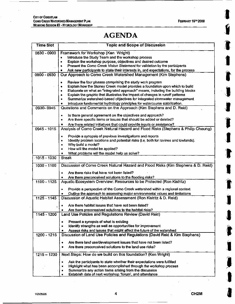
CnV OF COQUITlAM COMO CREEK WATERSHED MANAGEMENT PLAN WORKING SESSION #2 - HYDROLOGY WORKSHOP
FEBRUARY 16" 2000
AGENDA Time Slot
1830 - 0900
I900 - 0930
0930- 0945
1945 - 1015
1015 - 1030 1030 - 1100
1100 - 1125
1125- 1145
1145 - 1200
1200 - 1215
1215 - 1230
11N25535
Topic and Scope of Discussion
Framework for Workshop (Ken Wright) B Introduce the Study Team and the workshop process D Explain the workshop purpose, objectives and desired outcome
Present the Como Creek Vision Statement for validation by the participants w Ask new participants to state their interests in, and expectations, for the process Our Approach to Como Creek Watershed Management (Kim Stephens)
Review the four phases comprising the study work program Explain how the Stoney Creek model provides a foundation upon which to build Elaborate on what an "integrated approach" means, including the building blocks Explain the graphic that illustrates the impact of changes in runoff patterns
0 Summarize watershed-based objectives for integrated stormwater management 0 Introduce fundamental hydrology principles for watercourse stabilization. Questions and Comments on the Approach (Kim Stephens and D. Reid)
0 Is there general agreement on the objectives and approach? 0 Are there specific items or issues that should be added or deleted? 0 Are there related initiatives that could provide inputs or assistance? Analysis of Como Creek Natural Hazard and Flood Risks (Stephens & Philip Cheung)
0
0
0 Why build a model? 0
0
Break
Provide a synopsis of previous investigations and reports Identify problem locations and potential risks (i.e. both for ravines and lowlands).
How will the model be applied? What problems will the model help us solve?
Discussion of Como Creek Natural Hazard and Flood Risks (Kim Stephens & D. Reid)
0
0
Aquatic Ecosystem Overview: Resources to be Protected (Ron Kistiritz)
0
Are there risks that have not been listed? Are there preconceived solutions to the flooding risks?
Provide a perspective of the Como Creek watershed within a regional context 0
Discussion of Aquatic Habitat Assessment (Ron Kistritz & D. Reid) Outline the approach to assessing major environmental values and limitations
0 Are there habitat issues that have not been listed? 0 Are there preconceived solutions to the habitat risks? Land Use Policies and Regulations Review (David Reid)
0
0
Present a synopsis of what is existing Identify strengths as well as opportunities for improvement
0
Discussion of Land Use Policies and Regulations (David Reid & Kim Stephens) Assess risks and issues that might affect the future of the watershed
0
0
Next Steps: How do we build on this foundation? (Ken Wright)
0
0
0
Are there land use/development issues that have not been listed? Are there Preconceived solutions to the land use risks?
Ask the participants to state whether their expectations were fulfilled Highlight what has been accomplished through the workshop process Summarize any action items arising from the discussion Establish date of next workshop 'fonrm', and attendance
4 CHPM

City of Coquitlam Como Creek Watershed Management Plan
I 1
Working Session #2 Hydrology Workshop (“Statement of the Problem”)
February 16th 2000 I
Framework for Workshop Process
The Study Team Overview of Issues and Process Objectives and Desired Outcome Vision Statement Stakeholder Expectations
Session Objectives
Fonrm for stakeholder participation Common understanding of hydrology Clear picture of the flood threat
Workshop Agenda
Framework for Workshop Process Approach to Watershed Management Analysis of Hazard and Flood Risks Aquatic System Overview Land Use Policies & Regulations Review Next Steps
Issues
Flood Problem Areas Impervious Cover (53%) Storm Sewer System Land Use UpZoning Stream Stewardship
Desired Outcome ll I I II
Clear understanding of the problem
Commitment to develop a shared vision

a
Vision Statement L
Through an integrated management plan, the goal of the City is to protect property, support development, and preserve and over time enhance the natural environmenl in the Como Creek watershed
l l
' The Goal is to Integrate: l 1
Interests & Expectations (Questions for the new partidpan&)
How do you see your role evolving in this workshop process?
What are your expectations for .what we can collectively accomplish?
Time-Line for Action r 1
Near-Term: Priodty is to protect life and prop*
2O-Year Horlzon: Polides and programs that build support for 50-year vision
50-Year Horizon: Poiides and programs tha~ result in stream enhancement
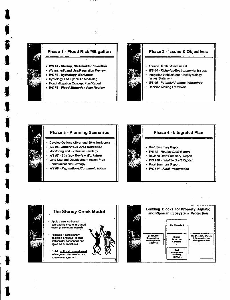
Phase 1 - Flood Risk Mitigation r I
WS #l - Startup, Stakeholder Selection WatershedlLand UselRegulation Review WS #2 - Hydrology Workshop Hydrology and Hydraulic Modelling Flood Mitigation Concept PlanlReport WS #3 - Flood Mitigation Plan Review
I Phase 3 - Planning Scenarios I
Develop Options (20-yr and 50-yr horizons) WS #6 - Impervious Area Reduction Monitoring and Evaluation Strategy WS #7 - Strategy Review Workshop - Land Use and Development Action Plan
l r
Communications Strategy WS #8 - Regulations/Communlcatlons
The Stoney Creek Model
Apply a science-based approach to create a shapd vision of achievable aoals
I I Facilitate a DarticiDatorv declslon &cess to build stakeholder mnsensus and
I agree on expectations
1 Obtain political commitment to integrated stormwater and streammanagement
1 Phase 2 - Issues & Objectives 11 I L ' 1 1
Aquatic Habitat Assessment WS #4 - Fisheties/Environmental Issues Integrated Habitaaand UselHydrology Issues Statement WS #5 - Potential Actions Workshop Decision Making Framework
Phase 4 - Integrated Plan a Draft Summary Report WS #9 - Review Draft Report Revised Draft Summary Report WS #10 - Finalize Draft Repori
I Final Summary Report I WS #l I - Final Presentation

'Changes in Hydrology"
Same Rainfall + Change the Land Cover
Different Runoff Pattern - -
Different Strategies for Different Storms
L 1
I
1 Mitigation of Small Storms Key to Watercourse Stabilization
I
rainfall and runoff have return different periods a 2-year event is a "big storm" "small storms' have return periods e 2-years number of small runoff events increases magnitude of Mean Annual Flood increases toc I
the MAF determines the channel mss-sedion an increasing MAF = channel instability = erosion
erosion = f (no. of runoff events natural MAF) bed material moved = f (velocity to the 6th power) erosion + sedimentation = habitat degradation
ratio of MAF to winter baseflow also critical

Integrated Strategy
Flood Risk Management: Accommodate and convey the "peak design event"(i.e. QIOO)
Environmental Risk Management: Reduce the frequency of small events; and Reduce the MAFlBaseflow ratio
Overview of Previous Reports
Scope limited to lowlands drainage Focus on the strip btw Lougheed & Fraser Emphasize hydraulic modelling Present a complex and confus'ing picture
Questions and Comments on the Approach for Como Creek
Is there general agreement on the objectives and approach?
Are there specific items or issues that should be added or deleted?
Are there related initiatives that could provide inputs or assistance?
Analysis of Natural Hazard and Flood Risks
I
9 Synopsis of Previous Investigations (1975.1989.1990.1993 and 1998 reports)
Problem Locations and Potential Risks
Key Findings for Lowlands 1 Conditions in 2000 are improved over those in 1975, and flooding frequency has been reduced, but:
- Trans-Canada Highway is still a barrier - Drainage system is still looped - Channels still have limited floodway capacity
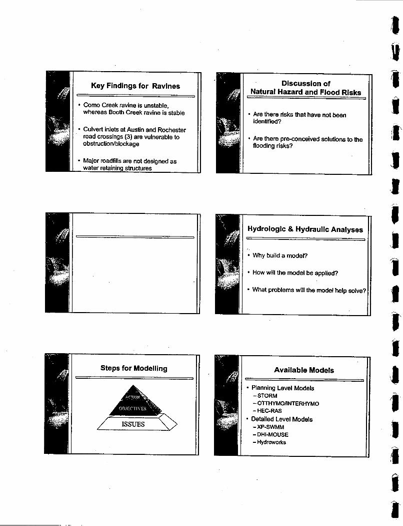
II Key Findings for Ravines
r I
Como Creek ravine is unstable, whereas Booth Creek ravine is stable
Culvert inlets at Austin and Rochester road crossings (3) are vulnerable to obstruction/blockage
Major roadfills are not designed as water retaining structures
Hydrologic & Hydraulic Analyses I I
Why build a model?
How will the model be applied?
What problems will the model help solve?

\ . E .._
p I .II i 1. 1
Considerations c I
Start simple Use the simplest tool to do the job Use "real" data
Approach for Hydraulic Analysis ~ ~~
Use hydraulic models set up in previous
review and validate previous models for
or, set up new model using existing
studies ?
this project
model data .
Evaluate Alternatives ~~
Upstream alternatives - improve culvert capacities (size, grading) - improve entrance & exit of culvert
-high level diversions - stormwater management to control or
improve drainage
crossings
Approach for Hydrology Analysis
I 1
OTTHYMOANTERHYMO -use larger subcatchments - estimate flows for flood risk planning -estimate flows for environmental risk
- evaluate land use impact - evaluate alternatives
planning
Approach for Hydraulic Analysis
HECRAS, XP-SWMM for evaluation of r -I
hydraulics downstream -determine flood inundation levels - determine flow velocities -analyze stream management - analyze erosion protection requirements
Evaluate Alternatives
Downstream alternatives -improve culvert capacities (size, grading) - improve channel connectivity -drainage diversion - consolidate flow channels & paths - creation of flood zones (wetlands. ponds) - improve grading and profile

Lotic Ecosystem Indicators
il Prognoses & Questions
1 a
Aquatic Ecosystem Overview
Como Creek watershed within a regional context
Assessing major environmental values and limitations
GVRD's Watershed Health Classification System
% Total impervious Area (%TIA) - where water cannot infiltrate into soil or ground
% Riparian Forest integrity (%RFI) - percent of continuous forest cover within a 60
metre riparian corridor
IJ
Assessing Major Environmental Values and Limitations
Step #I :
Step #2!
Step #3:
Step #4:
Step #5:
R W ~ W axiruq wopt~ysifal hfonnation
FIU dtid hfonna(i0n oaps
mp hab(lat w and IIIIIWOPS
F~SIWLB and EnvimnmeW Workshop
imepraion WMI hydmtem~~~ ~g~iremanb
Step #2: ~iii critical information gaps
I 1
* Temporakpatial drainage patterns
- Functional values of minor watercourses
Overwintering juvenile salmon downstream of Trans Canada Highway
Discussion of Aquatic Habitat Assessment , I
Are there habitat issues that have not been listed?
Are there preconceived solutions to the ha bitat risks?
Discussion of Land Use Policies and Regulations
I I
II
1 I Are there land use/development issues I I that have not been listed?
Are there pre-conceived solutions to the 1 I land use risks? I I
step #3: Map habitat values and limitations
Land Use Policies II and Regulations Review
r I
Present a synopsis of what is existing
Identify strengths and opportunities for improvement
Assess risks and issues that might affect the future of the watershed
How do we build on this foundation? I
Expectations fulfilled? What has been accomplished? Action items Next workshop
CITY OF COQUITlAM COMO CREEK WATERSHED MANAGEMENT PLAN APRIL 2000 WORKING SESSION #3 - FLOOD MITIGATION PLAN REVIEW
committee- Ken Wright, Chair
RECORD OF WORKING SESSION #3
I - Stakeholders
Kim Stephens I Scott Barrett, MEW
DATE OF MEETING:
DURATION
ATI'ENDED BY:
Mike Nihls Rob Innes Randy Evans Dave Palidwor
AGENDA ITEMS:
David Reid Lisa Christensen, DFO Ron Kistritz Vince Busto, DFO Philip Cheung Pamela Zevit, CWG
Barb Warmer. Business ReD
PURPOSE OF SESSION
VISION STATEMENT:
PARTICIPANT ROLES
DELIVERABLES:
DATE ISSUED
11 2\125S5
April 5* 2000
1:OOpm - 500pm
I Citysteering I CH2MTeam I AgenciestkWatershed I
See the attached copy of the Agenda for a listing of topics. The Agenda was complemented by a PowerPoint presentation.
Reach consensus on the elements of an integrated plan for the Fraser Mills lowlands, and gain commitment to working towards a shared vision for the watershed by:
1. Finalizing the wording of the Vision Statement 2. Understanding the nature of the historical flooding problem 3. Developing a matrix of the pros and cons for each element of
the integrated plan
The format involved an overview-type presentation followed by a 'facilitated discussion' to promote a two-way sharing of ideas.
Two versions of a draft Vision' Statement were considered by the Steering Committee. The wording of the preferred version was finalized as follows:
Through an integrated management plan, the goal of the City is to time balance protection of property, responsibZe development, and & G d s for environmental preservation and restoration throughout the Como Creek watershed.
The Stakeholder Group was expanded to include Barb Wagner as a representative from the local business community.
A set of six poster-size drawings suitable for public display provided the focus for discussion on the elements of an integrated plan that provides flood relief while enabling habitat restoration.
The deliverable resulting from the session was the matrix summarizing the pros and cons for each element.
April 12th 2000
1 CHZM

CITY OF COWTIAM COMO CREEK WATERSHED MANAGEMENT PIAN WORKING SESSION #3 - FLOOD MITIGATION PLAN REVIEW
APRIL 5m 2000
OUTCOMEOFSESSION At the end of the session, there was consensus on the basic concept for surface water management in the lowlands:
0 Consider the watershed as two sub-watersheds: Como- McDonald, and Booth-Popeye
0 Improve the existing 'drainage outlet' at the Lougheed and Trans-Canada highways to serve the Como-McDonald tributary area
0 Create a new 'drainage outlet' at the two highways to serve the Booth-Popeye tributary area
Attached is a completed matrix that captures the pros and cons (as identified during the brainstorming session) for each plan element. Arising from the discussion were these six issues:
1. How should the bedload distribution be managed at the Booth-Popeye diversion?
2. Should settling ponds be located in Booth or Popeye? (i.e. Element#2)
3. Would construction of the proposed Popeye crossing of the Trans-Canada Highway result in deleterious water quality?
4. What is the fate of the Highway Loop? Should it be kept open or closed? If kept open, how should it be managed?
5. Should the Inter-Channel (Element #11) at the Trans-Canada be used as a water quality benefit for Como? (Consensus= yes)
6. Is a settling pond near Casey Place required for Como Creek?
The final agenda was an around-the-table recap.
Name I Comments Dave Palidwor I Demonstrates complexity of system. Need to
I look at tradeoffs for each element. I Tradeoff is the defininn word. Do we need Mike Nihls
1 1 a25535 2 CHZM

CnV OF COPUlllAM COMO CREEK WATERSHED MANAGEMENT PLAN APRIL 5m 2000 WORKlNQ SESSION #3 - FLOOD MfflGATlON PLAN REVIEW
rime Slot
2 5 5 - 1:20
1 :20 - 1:40
1:40 - 3:15
3:15 - 3:30
DETAILS OF AGENDA ITEMS , Topic and Scope of Discussion
Framework for Workshop (Ken Wright) 0
0
0
Overview of Historical Flooding Problems (Kim Stephens) 0
0
0
Elements of an Integrated Plan for Flood Relief - Part 1 Discussion {Facilitated and Interactive Discussion, with David Reid as Moderator) . 0
0
0
Break
Outline the workshop purpose, objectives, format, and desired outcome Finalize the wording of the Vision Statement Review the documentation for the January IOth and February 16'h workshops
Present Figures 1.2 and 3 to provide a context Establish guiding principles for problem-solving Outline the participatory approach to plan development
Present Figure 4 to establish a frame-of-reference for brainstorming Introduce Figure 5 ("the elements plan") to initiate the brainstorming Brainstorming discussion to compile a matrix of pros and cons for each plan element
3:30 - 4:45
4:45 - 500
Elements of an Integrated Plan for Flood Relief - Part 2 Discussion Facilitated and Interactive Discussion. with David Reid as Moderatotj 0
0
0
Next Steps: How do we build on this foundation? (Ken Wright) 0
0
0
0
Complete the element-by-element brainstorming to compile a matrix of pros and cons Summarize the relevance and sensitivity of uncalibrated rainfall-runoff modelling Outline the approach to hydraulic modelling to test drainage outlet performance
Ask the participants to state whether their expectations were fulfilled Summarize what was accomplished by the workshop Summarize any action items arising from the discussion Select dates for next two workshops, and attendance
112V25535 3 CHZM

City of Coquitlam Como Creek Watershed Management Plan
L I
Working Session #3 Flood Mitigation Plan Review
("Elements of an Integrated Plan")
April 5th 2000
I
Workshop Agenda
Vision Statement Nature of the Flooding Problem Elements of an Integrated Plan Next Steps
Desired Outcome L I
Reach consensus on the elements of an integrated plan for the lowlands
Commitment to work towards a shared vision for the watershed
Phased Approach (Building Blocks)
A
Phase 1: Interim Flood Mitigation Plan Phase 2: Environmental Issues & Objectives Phase 3: Environmental Planning Scenarios Phase 4: Integrated Management Plan
Session Objectives L 1
- Understand nature of flood problem Develop a matrix for plan elements
Also: - Finalize the Vision Statement - Approve the record of previous sessions - Schedule next two sessions
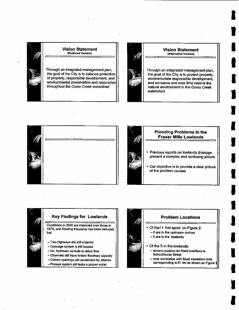
Key Findings for Lowlands
Conditions in 2000 are improved over those in 1975, and flooding frequency has been reduced, but:
c I
-Two highways are still a barrier - Drainage system is still looped - No hydraulic controls to direct flow - Channels still have limited floodway capacity - Culvert openings still constricted by siltation - Popeye system still lacks a proper outlet
Vision Statement (Alternative Version)
Through an integrated management plan, the goal of the City is to protect property, accommodate responsible development, and conserve and over time restore the natural environment in the Como Creek watershed
Previous reports on lowlands drainage present a complex and confusing picture
Our objective is to provide a clear picture of the problem causes
n Problem Locations
Of the1 1 'hot spots' on Figure 2: - 6 are In the upstream ravines - 5 are in the lowlands
Of the 5 in the lowlands:
Schoolhouse Street
corresponding to El 4m as shown on Figure
I I
- chronic location for flood ovemows is
- note correlation with flood inundation area

3 1.
I,
Significance of December 15th 1999 Rainstorm
I I
75mm in 24 hours Corresponds to 2-yr event 12th ranked event in 40 years of record 7th largest event in past 20 years Only 3 events in past 20 years > 80mm Only 10 times has annual been e60mm Minimum event in 40 years is 38mm
Nature of the Problem
More surface runoff Flow concentration Water trapped
I I Existing control points have
been established by ... 8 I
Lougheed Highway Culverts Trans-Canada Highway Culverts Fraser River Winter Tidal Range
Observations on March 18th 2000 at the end of a 23mm rainfall
Lowland channels flowing 'bank full' Bank overflow east of Bargain Castle Bank overflow in 'Western Loop'
Eastern TCH culvert 2/3 full New TCH culvert flowing almost full Central TCH culvert had some flow
L I
I I Good design practice
results in these guidelines ... I 1
Select a maximum allowable TWL (Top Water Level)
Size waterway openings in roadways for 'zero surcharge'
Consider duration of Fraser River winter high tide range
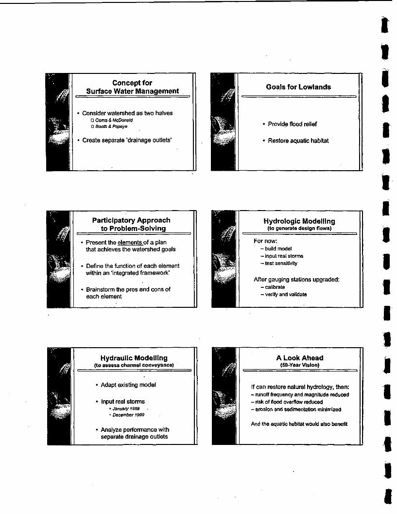
Consider watershed as two halves 17 Como 8 McDonald 0 800th 8 Popeye
9 Create separate 'drainage outlets'
Hydraulic Modelling (to assess channel conveyance)
Adapt existing model
Input real storms January 7968 .
* December 1999
Analyze performance with separate drainage outlets
I i Hydrologic Modelling
(to generate design flows)
For now: -build model - input real storms -test sensitivity
After gauging stations upgraded: -calibrate -verify and validate
u
t
s 8 1 jl 1
I
1' 3 I I 1
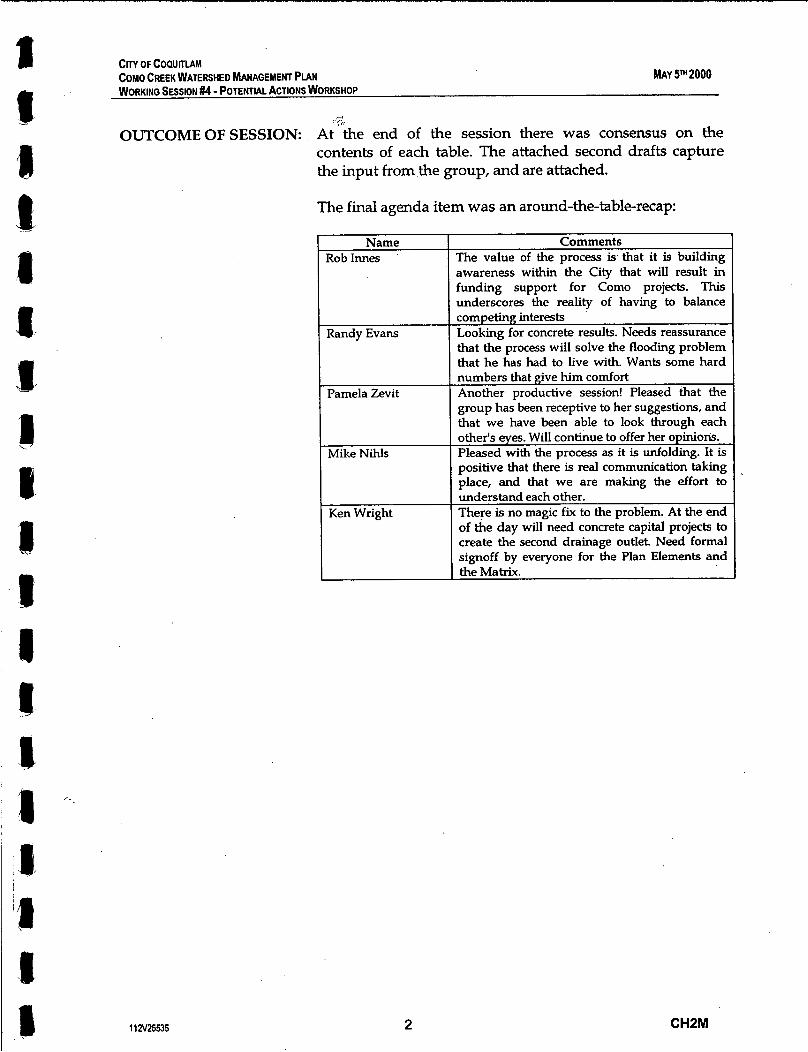
CITY OF COQUITLAM COMO CREEK WATERSHED MANAGEMENT PLAN WORKING SESSION #4 - POTENTIAL ACTIONS WORKSHOP
MAY 5m2000
7:
OUTCOMEOFSESSION: At"the end of the session there was consensus on the contents of each table. The attached second drafts capture the input from the group, and are attached.
of the day will need concrete capital projects to create the second drainage outlet. Need formal signoff by everyone for the Plan Elements and the Matrix.
The final agenda item was an around-the-table-recap:
Name I Comments Rob lnnes I The value of the process is. that it is building
Randy Evans
awareness within-the city that will result in funding support for Como projects. This underscores the reality of having to balance competing interests Looking for concrete results. Needs reassurance that the process will solve the flooding problem that he has had to live with. Wants some hard I numbers that give him comfort
1 Another productive session! Pleased that the Pamela Zevit group has been receptive to her suggestions, and that we have been able to look through each
I other's eyes. Will continue to offer her opinions. 1 Pleased with the process as it is unfolding. It is Mike NihIs
positive that there is real communication taking I place, and that we are making the effort to
11 a25535 2 CH2M

CITY OF COWITLAM COMO CREEK WATERSHED MANAGEMENT PIAN WORKING SESSION #4 I POTENTIAL ACTIONS WORKSHOP
MAY 5m 2000
1255 - 1:15
3:OO - 3 ~ 1 5
3~15 - 3:30
3130- 4:45
4~45 - 5:OO
DETAILS OF AGENDA ITEMS
Topic and Scope of Discusslon
Workshop Overview (Ken Wright)
0
0
Outline the workshop purpose, objectives, and desired outcome Validate the documentation for the three previous workshops
Elements of an Integrated Plan for Flood Relief - Part 1 Discussion {Facilitated and Interactive Discussion, with David Reid as Moderator)
0
0
0
Reaffirm the concept for surface water management as presented on Figures 4 and 5 Validate the matrix of pros and cons for each element of the integrated plan Decide on the appropriate time-frame for implementation of each element
Break for refreshments (and to move our cars before we get a parking ticket!)
Decision Framework for Watershed Planning (Kim Stephens)
0
0
Recap the process for developing a shared vision Describe the framework for making timely and effective decisions
Elements of an Integrated Plan for Flood Relief - Part 2 Discussion {Facilitated and Interactive Discussion, with David Reid as Moderator)
0
0
0
Review the list of interim measures proposed for implementation in 2000 Make decisions on what can be accomplished in 2000, and how to do that Develop a protocol for fast-tracking the approval process for the interim measures
Next Steps: How do we build on this foundation? (Ken Wright)
0
0
Ask the participants to state what was accomplished Summarize action items arising from the discussion
11 N25535 3 CHZM
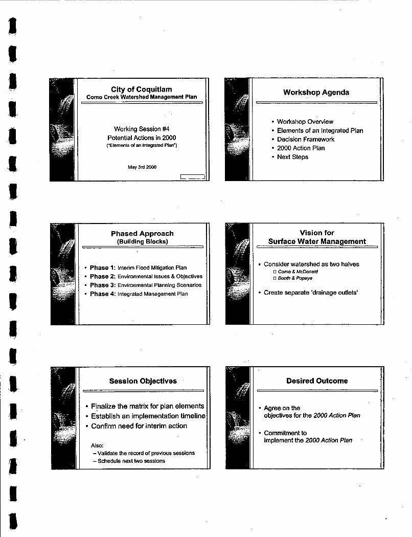
City of Coquitlam Como Creek Watershed Management Plan , 3
Working Session #4 Potential Actions in 2000 (“Elements of an Integrated Plan“)
May 3rd 2000 - Phased Approach
(Building Blocks) , I
Phase 1: interim Flood Mitigation Pian Phase 2: Environmental issues & Objectives Phase 3: Environmental Planning Scenarios Phase 4: Integrated Management Plan
I
Session Objectives r I
Finalize the matrix for plan elements Establish an implementation timeline Confirm need for interim action
Also: -Validate the record of previous sessions - Schedule next two sessions
Workshop Agenda
Workshop Overview Elements of an Integrated Plan Decision Framework 2000 Action Plan Next Steps
Vision for Surface Water Management
Consider watershed as two halves 0 Como 8 McDonald 0 Booth 8 Popeye
Create separate ‘drainage outlets’
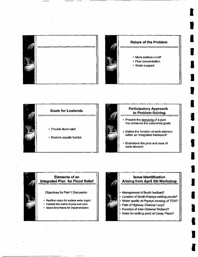
r 1
I
I Goals for Lowlands L I
Provide flood relief , I Restore aquatic habitat
Elements of an Integrated Plan for Flood Relief
I 1
Objectives for Part 1 Discussion
Reaffirm vision for surface water mgmt Validate the matrix of pros and cons Select time-frame for implementation
Nature of the Problem
More surface runoff Flow concentration
1
Present the elements of a plan that achieves the watershed goals
Define the function of each element within an 'integrated framework'
Brainstorm the pros and cons of each element
Issue Identification Arising from April 5th Workshop
I 1
Management of Booth bedload? Location of Booth-Popeye settling ponds? Water quality at Popeye crossing of TCH? Fate of Highway Channel Loop? Function of Inter-Channel Wetland? Need for settling pond at Casey Place?
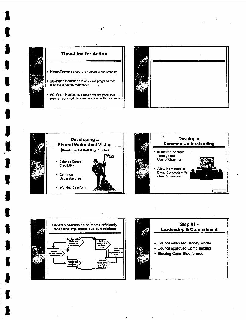
Time-Line for Action I 1
Near-Term: Priority is to protect life and property
ZO-Year Horizon: Policies and programs that build support for 50-year vision
50-Year Horizon: Policies and programs that restore natural hydrology and result in habitat restoration
-
Develop a Common Understanding 1 I
Illustrate ConceDts II ’
~, 1 I Allow Individuals to - - t Blend Concepts with
. “1 Own Experience
I r - l l I
Step#l - Leadership & Commitment
t I
Council endorsed Stoney Model Council approved Como funding Steering Committee formed
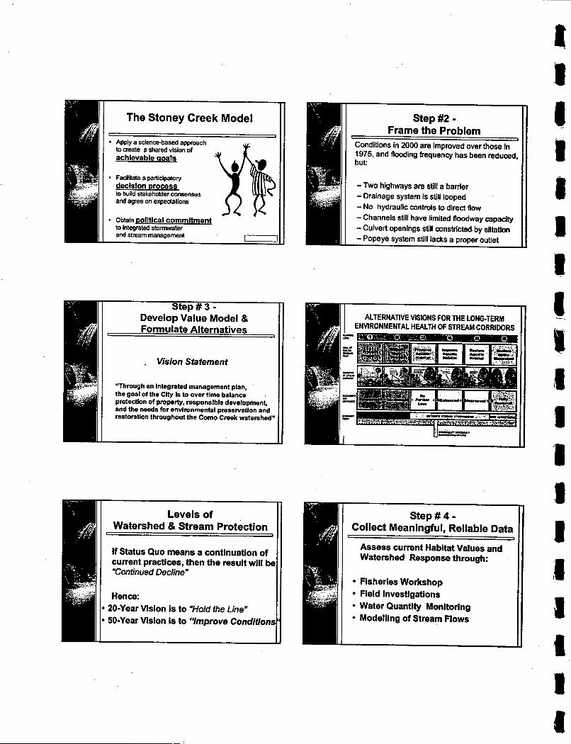
The Stoney Creek Model
Apply a science-based approach to create a shared vision of achievable qoals
F M i a parUclpatory decision process to bund stakeholder consensus and agree on expectations
Step # 3 - Develop Value Model & Formulate Alternatives
t 1
. Vision Statement
"Through an integrated management pian, the goal of the City is to over time balance . protection of property, responsible development, and the needs for environmental preservation and restoration throughout the Como Creek watershed"
Levels of Watershed & Stream Protection
If Status Quo means a continuation of current practices, then the result will be "Continued Declinen
r J
Hence: 20-Year Vision is to Wold the Line" 50-Year Vision is to *'Improve Conditions
m
Step #2 - Frame the Problem
Conditions in 2000 are improved over those in 1975. and flooding frequency has been reduced, but:
- Two highways are still a barrier - Drainage system is still looped - No hydraulic controls to direct flow -Channels still have limited floodway capacity -Culvert openings still constricted by siltation - Popeye system still lacks a proper outlet
Step # 4 - Collect Meaningful, Reliable Data
Assess current Habitat Values and Watershed Response through:
Fisheries Workshop Field Investigations Water Quantity Monitoring Modelling of Stream Flows

, - . - I
Each decision- maker has to rely in part on their own
evaluate the alternatives.
Objectives of 2000 Action Plan L ,
Demonstrate that City is taking action Improve flow management at TCH Develop a measurement-based model
If can restore natural hydrology, then: -runoff frequency and magnitude reduced - risk of flood overflow reduced - erosion and sedimentation minimized
And the aquatic habitat would also benefit
Elements of an Integrated Plan for Flood Relief
I 1
Objectives for Part 2 Discussion
Review 2000 Action Plan Make decisions Fast-track approval process
Components of 2000 Action Plan t 1
Flood Relief Computer Modelling Flow Management Environmental Management
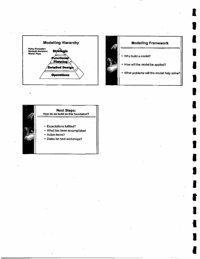
Modelling Hierarchy Policy Evaluation Strategic Decisions Master Plans
Next Steps: How do we build on this foundation?
Expectations fulfilled? What has been accomplished Action items? Dates for next workshops?
Modelling Framework I J
Why build a model?
How will the model be applied?
What problems will the model help solve?

CITY OF COQUmAM DRAFT FOR REVIEW COMO CREEK WATERSHED MANAGEMENT PLAN WORKING SESSION #5 - FISHERIES & ENVIRONMENT WORKSHOP
JUNE 2 P 2000
I(
AGENDA FOR WORKING SESSION #5
DATE OF MEETING: AGENDA ITEMS: TIME ALLOCATION: PARTICIPANTS:
WORKSHOP FORMAT PURPOSE OF SESSION:
SESSION OBJECTIVES:
DESIRED OUTCOME
DELIVERABLES:
NEXT WORKSHOP
June 28th 2000
See 2nd page for topics and discussion notes
1:lOpm to 5:lOpm
Ken Wright, Chair Mike Nihls Rob Innes Randy Evans
CH2M Team I Agencies &Watershed 1 - Stakeholders
Kim Stephens Scott Barrett, MELP David Reid Lisa Christensen, DFO
Pamela Zevit, CWG
Presentations followed by facilitated discussion periods Finalize the framework for an integrated plan for flood relief and habitat restoration in the Fraser Mills lowlands. Set the scene for development of an Uplands Strategy in the 2nd half of 2000 These are listed below: 1. Validate the record of the May 3rd workshop 2. Finalize the Interim Report on the Lowlands Strategy 3. Present results of June 10th fisheries working session 4. Define management objectives for each creek reach 5. Introduce approach to developing the Uplands Strategy Obtain agency concurrence for the Lowlands Strategy (i.e. the first of two components of the Integrated Plan) The deliverables for presentation and review during the workshop are: 0 The May 2000 Interim Report on Strategyfbr Fruser Mills
Lowlands (note: draft submitted to City on May 26th)
The Aquatic Habitat Assessment prepared by Ron Kistritz following the June 10th workshop with the Como Watershed Group (CWG)
Last week of September 2000
1 12V25535 1 CHZM

Cm OF COQUmAM DRAFT FOR RMEW COMO CREEK WATERSHED MANAGEMENT PLAN WORKING SESSION #5 - FISHERIES & ENVIRONMENT WORKSHOP
JUNE 25" 2000
DETAILS OF AGENDA ITEMS ~~
r ime Slot
:oo- 1:20
1:20 - 2115
211 5 - 2135
2:35 - 3:15
311 5 - 3130
3:30 - 4:35
4135- 450
4:50 - 5100
112V25535
Topic and Scope of Discussion
Workshop Overview (Ken Wright & Kim Stephens)
D
D
Interim Report on Strategy for Fraser Mills Lowlands {Facilitated and Interactive Discussion, with Dave Reid as Moderator)
0
0
0
Results of Aquatic Habitat Assessment (Ron Kistritz)
0
Discussion of Aquatic Habitat Assessment - Part 1 {Facilitated and Interactive Discussion, with Dave Reid as Moderator)
0 What are the resources to be protected? How does the Popeye Stream Corridor achieve 'functional equivalency'?
0 What are the management objectives for each reach in a watershed context? How will the lowlands and uplands strategies be integrated to achieve objectives?
0 What form of protocol agreement will be established for agency signoff?
Break for refreshments (and to move our cars before we get a parking ticket!)
Discussion of Aquatic Habitat Assessment - Part 2 {Facilitated and Interactive Discussion, with Dave Reid as Moderator)
0
0
0
0
0
Outline the workshop purpose, objectives, and desired outcome Comment on the lowland and upland components of the Integrated Plan Recap the 'two-track' approach to plan development Review the steps in the decision framework, and where we are now
Review report format for consolidating workshop outcomes (Kim Stephens) Introduce the ecosystem concept of 'functional equivalency' (Ron Kistritz) Provide feedback on desired refinements to report contents (City) Confirm basis for agency signoff on Lowlands Strategy (DFO, MELP)
Provide a regional context for assessing Como Creek watershed health Describe the steps in assessing major environmental values and limitations Present the map that documents the June loth workshop outcome
What are the resources to be protected? How does the Popeye Stream Corridor achieve 'functional equivalency'? What are the management objectives for each reach in a watershed context? How will the lowlands and uplands strategies be integrated to achieve objectives? What form of protocol agreement will be established for agency signoff?
Decision Framework for Watershed Planning (Kim Stephens)
Recap the process for developing a shared vision for an Integrated Plan Preview the next phases in the program for integrating the lowlands and uplands strategies
Next Steps: How do we build on this foundation? (Ken Wright & David Reid)
0
0
Ask the participants to state what was accomplished Summarize what we have learned from the discussion Select date in September for the Impervious Area Workshop
2 CHZM
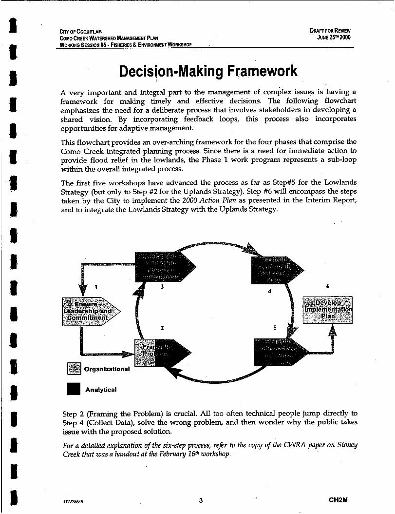
CITY OF COQUITlAM DRAFT FOR REVIEW COMO CREEK WATERSHED MANAGEMENT PLAN WORKING SESSION #5 - FISHERIES 8 ENVIRONMENT WORKSHOP
JUNE 25m 2000
Decision-Making Framework A very important and integral part to the management of complex issues is having a framework for making timely and effective decisions. The following flowchart emphasizes the need for a deliberate process that involves stakeholders in developing a shared vision. By incorporating feedback loops, this process also incorporates opportunities for adaptive management.
This flowchart provides an over-arching framework for the four phases that comprise the Como Creek integrated planning process. Since there is a need for immediate action to provide flood relief in the lowlands, the Phase 1 work program represents a sub-loop within the overall integrated process.
The first five workshops have advanced the process as far as Step#5 for the Lowlands Strategy (but only to Step #2 for the Uplands Strategy). Step #6 will encompass the steps taken by the City to implement the 2000 Action Plan as presented in the Interim Report, and to integrate the Lowlands Strategy with the Uplands Strategy.
Step 2 (Framing the Problem) is crucial. All too often technical people jump directly to Step 4 (Collect Data), solve the wrong problem, and then wonder why the public takes issue with the proposed solution.
For a detailed explanation of the six-step process, refer to the copy of the CWRA paper on Stoney Creek that was a handout at the February 1 6 t h workshop.
112V25535 3 CHPM

t
City of Coquitlam Como Creek Watershed Management Plan
r I
Working Session #5 Fisheries & Environmental Issues
(‘Elements of an Integrated Plan”)
June 28th 2000
I
Session Objectives 1 6
Finalize the Lowlands Strategy Present Aquatic Habitat Assessment Define Management Objectives Introduce Uplands Strategy
Also: -Validate the record of previous session -Schedule next two sessions
Vision for Surface Water Management
I
Consider watershed as two halves 0 Como 8 McDonald 0 800th 8 popeye
Create separate ‘drainage outlets’
Desired Outcome I 1
Obtain agency sign-off for the Lowlands Strategy .
Como Creek environmental I protection strategy built around. ... L 1
Limiting Factors for Urban Streams Small Stoms versus Big Storms Effective Impervious Area (EIA)
I
s
1
rl 8 1 1
P

Jmiting Factors for Environmental Health of Urban Streams
I I
(listed in order-of-priority)
Changes in hydrology Disturbance to riparian corridor Degradation of aquatic habitat Deterioration of water quality
8-IBI in Relation to Cumulative Upstream Riparian Zone Width
r I
B-IBI Over a Gradient of Watershed Impervious Land Cover
I I
. _. .. . . . . . ..... . , : .
..... ..... - ...................... . . . . . . . . . . . . . . . . ... ....................
-. . . . . . . . . . . . . . . . . . . . . . . . . . . . . . . . . . . . . . . .
Tot4 Zinc Event Mean Concentrations in Puget Sound Lowland Streams During Storm Runoff Over a Gradlent of
Watershed Impervious Land Cover L I
Impervious Area Reference Points for Planning Purposes
0 1
I AtTIA=10% Biodiversity and fish abundance initially and significantly impacted
I Above TIA = 30% Most urban watersheds unable to sustain abundant selfsupporting populations of coldwater fish
Pollutant loading impacts on fish survivability 9 By TIA = 60%

Phased Approach (Building Blocks)
I I
Phase 1 : Interim Flood Mitigation Plan Phase 2: Environmental Issues 8 Objectives Phase 3: Environmental Planning Scenarios Phase 4: Integrated Management Plan
A Work Plan with Two Tracks because.. ..
Technical analysis in isolation of stakeholder understanding will not survive the agency and politica approval process
Conversely. Stakeholder decisions that are made on technically faulty information are at high risk of failure
However, when two tracks used together simultaneously, both processes lead to better understanding and better decisions with more stakeholder support
I 'I Track #I - Technical Analysis
Track #2 - Workshop Process
Six-step process helps teams efficiently make and implement quality decisions
Interim Report on Lowlands Strategy
L I
Developed the elements of a plan that achieves the watershed goals
Defined the function of each element
Brainstormed a Decision Analysis Matrix
' -provide flood relief -restore aquatic habitat
within an 'integrated framework' .
for each element

I I I a
Time-Line for Action I 1
2000 Action Plan: Priority is to protect life and property
20-Year Horizon: Policies and programs that build support for 50-year vision
50-Year Horizon: Policies and programs that restore natural hydrology and result in habitat restomtion
Executive Summary 1
Consequences of Changes in Land Use Critical Locations in the Lowlands - mnditions impmved. but problems ChrOniC
Impact of Threshold Events - 25mm rainfall = 'bank-full'. and 75mm = bank wernows
Watershed Vision Elements of an Integrated Plan 2000 Action Plan - r e m m private bridge - reactivate Boov1-t~Popeye flow connection - implement rainfalCRlnoffdata Collection
AQUATIC ECOSYSTEM OVERVIEW
1 Como Watershed within a regional context
2 Assessing major environmental values &
Report Outline
Executive Summary Introduction Problem Identification Watershed Modelling Elements of an Integrated Plan Land Use and Aquatic System Overview 2000 Action Plan
Classification System
% Total Impervious Area (%TIA) - where water cannot infiltrate into soil or ground
% Riparian Forest Integrity (%RFI) - peroent of continuous forest cover within a 60
metre riparian conidor
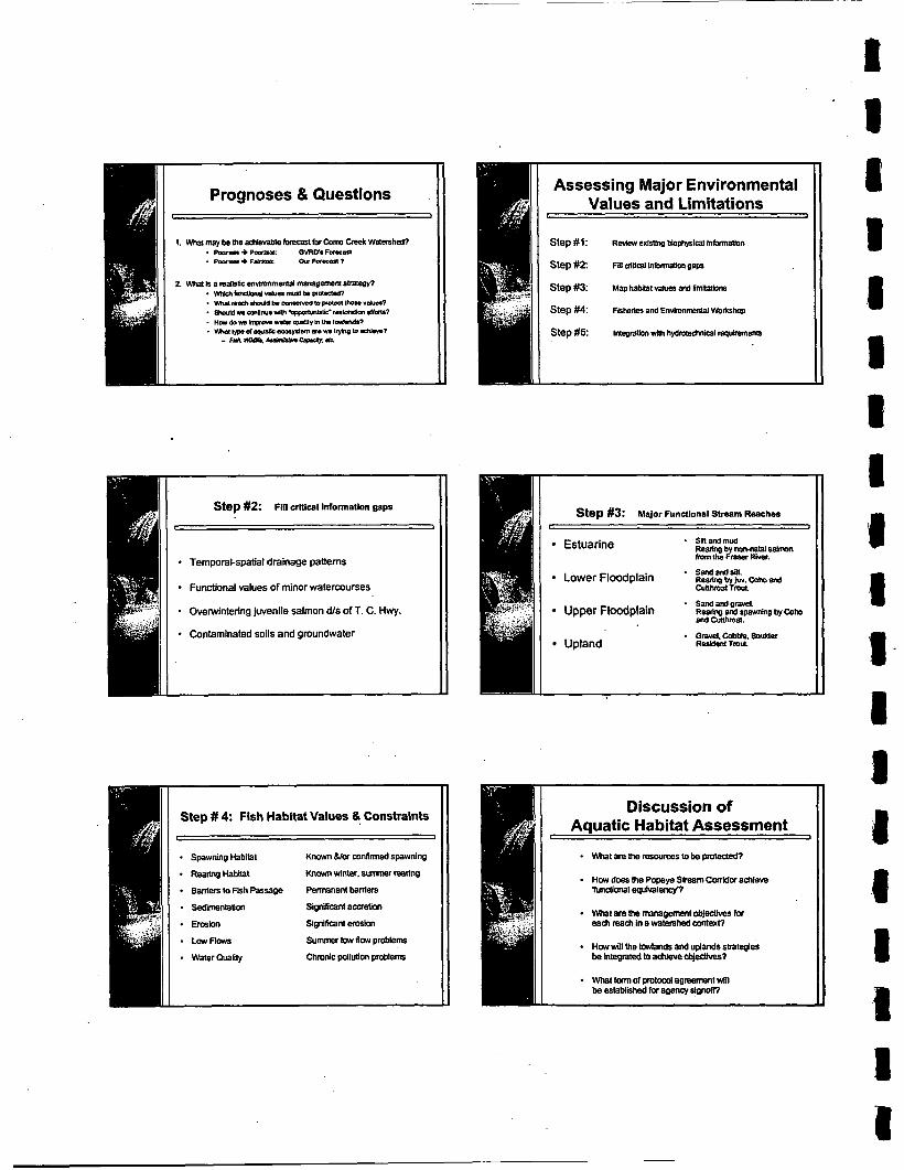
Prognoses & Questions
I I Step #2: FIII crittcal information naps
C 1
11 1 Temporal-spatial drainage patterns
Functional values of minor watercourses
* Ovelwintering juvenile salmon dls of T. C. Hwy.
11 I Contaminated soils and groundwater
Step # 4 Fish Habitat Values & Constraints c 1
Spawningtiabltal Known &lor mnfirmed sparmine - ReadqHabit Knownwinter. w m r rearing
Penmnenl baniem - SedimentaIicm Signititant amtion Erns1011 Signiftcanl emlon
LowFlows Su- low flow pmMem - Water Quality Chmnic pollution pmbiem
Baniers lo %h Passage
Assessing Major Environmental Values and Limitations
Step #I:
Step #2:
Step #3:
Step #4:
Step #5:
~ ~ l l e w exrsthg biophysira~ in~natlon
mi ~ U W I in!nrma(ion gaps
Map habital vabtes end nmna~iaui
Fisheries and Emimnmenlal Worxthop
tntegration wiu~ hydmtechnlca~ requirements
r step #3: Major Functional Stream Reaches
Snandrnud R e m by norrna(al &almon fmmuls F m River.
Estuarine
Lower Floodplain R e a m Sandand* b y b . COhD and Cutlhmal Trap.
Rearlw and CutUlma(, and spwning by Coho - Sandandgravel. Upper Floodplain
* Gravel,CobMe.BouIder Upland Resldem TmuL
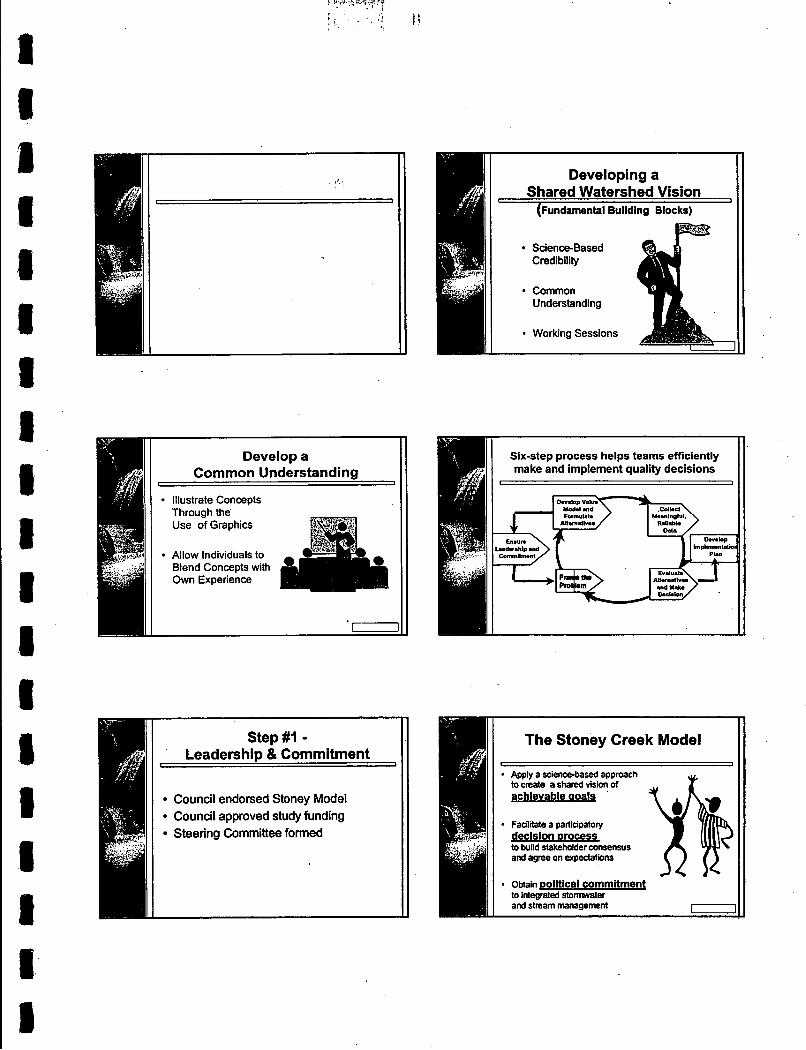
I . . . d. .
1 8 1 s I s 1 I I
Develop a Common Understanding
Illustrate ConceDts Through the Use of Graphics
Allow Individuals to Blend Concepts with Own Experience
Step#l - Leadership & Commitment
I
Council endorsed Stoney Model Council approved study funding Steering Committee formed
Six-step process helps teams efficiently make and implement quality decisions
I I
The Stoney Creek Model , J
Apply a science-based approach to create a shared visi? of achievable aoals
- F a c l i e a participatory declslon process to bund stakeholder consensus and agree on expectations
- obtain political commitment to integrated stomrwater and stream management
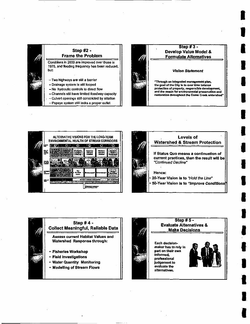
Step #2 - Frame the Problem
Levels of Watershed & Stream Protection
If Status Quo means a continuation of current practices, then the result will be "Continued Decline-
Hence: 20-Year Vision is to "Hold the Line" 50-Year Vision is to "hprove Conditions
I 1
Conditions in 2000 are improved over those in 1975, and flooding frequency has been reduced. but:
-Two highways are still a barrier - Drainage system is still looped - No hydraulic controls to direct flow -Channels still have limited floodway capacity
, -Culvert openings still constricted by siltation - Popeye system still lacks a proper outlet
Formulate Alternatives
Vision Statement
"Through an integrated management plan, the goal of the Cily Is to over time balance protedon of properly. responsible development, and the needs for environmental presewation and restoration throughout the C o r n Creek watershed"
Make Decisions
Each decision- maker has to rely in part on their own

Step#6 - A Look Ahead to Implementation
(SO-Year Vision) I I
If can restore natural hydrology, then: - runoff frequency and magnitude reduced -risk of flood overflow reduced - erosion and sedimentation minimized
And the aquatic habitat would also benefit
Elements of an Uplands Strategy
Culvert Improvements and Ravine Stabilization to Reduce Risk Hazards
Changes in Land Use and Regulation to Improve Watershed Conditions
Storm Sewer Re-Routing to Strategically Located Sites for Stormwater Detention
Tiered Approach to Impervious Area Reduction
I -I
Tier A - Source Control Disperse localized runoff In a natural way
Tier B - Interception and Infiltration
Tier C - Detention Storage
Shed road runoff and Integrate escape routes
MImIc before development runoff pattern
Dual Drainage System (An Old Concept. A New Way of Thinking)
1 1
Minor Rainfall Events: Disperse runoff in a 'natural' way (Le. not piped)
Major Rainfall Events: Direct runoff overland to drainage outlets
I I
Tree protection andlor replanting Soils for Salmon (deep porous landscape soils) Absorbent landscape over parking garages Rooftop storage Rainwater storage - rainbarrels, dstems Rainwater re-use - irrigation, toilet flushing Rainwater leader infiltration trench
w-

CENTACE OF TOTAL .&XWAL R A I N F L L ATTIUBUATBLE TO MINOR, MODERATE. AND SUBSTANTIAL RAIN EVESTS.
...,e.., .I I.,., '* ..I.I n.w.a
t ,
.LY CAPTURED WIT11 A SYSTEM
Upper Watershed Source Controls r 1
Limits on Impervious Area: - multi-level (Skinny) buildings - parking under building (or landscape) - l imb on (paved) driveway area and patios - use pervious paving and spaced wood deck
Flood Management - Treeremoval
increases nnmff by 25%. due to deceased ekapc-
- manic layer under woods increases inRltraUon
- imilhaled gmundwater supports base Rows
I 8.
I
I 1
I
. ( t I '
8
I I
Roadway Cross Section: - minimize'pavement width - pelvious paving for parking and sidewalks - open, porous drainage - e.g. bioswales with
- separate sidewalks from mad, with aborbent
- short term storage of runoff in swales (up to 24
- secondary major flood system
underdrains
boulevard
hours)
Aquatic Habitat Greenways
/-P--=!!,
Upper Watershed Runoff Storage
Dry detention pond Wet detention pond Constructed wetlands Lake detention
Upper Watershed
I - Riparian vegetation conservation and restoration
- Erosion control
- Consider stream day-lighting where benefits are dear

Expectations fulfilled? What has been accomplished Action items? Date for next workshop?

' CRY OF COQUlTLAM COMO CREEK WATERSHED MANAGEMENT PIAN WORKING SESSION #6 - RETROF~ING lMPERVlOUS AREA REDUCTION SEPTEMBER 27m 2000
Committee- I
RECORD OF WORKING SESSION #6
- Stakeholders
SESSION THEME
Jennifer Wilkie ' Joe Sulmona David Palidwor Chris Roberts
DATE
DURATION:
PARTICIPANTS:
Jason Cordoni Brian Shields
Improving Conditions in an Urban Watershed through Green Infrastructure Standards
CHZM Team Philip Cheung
September 27th 2000
Other City Departments Andrew Wood Russ Carmichael Emily Chu Ken McLaren Peter Longhi Roberta Cuthbert-Webber
8:30am to 4:30pm
I s t e e r i n g I CHPM Team I Agencies &Watershed
Mike Nihls Randy Evans
David Reid Scott Barrett, MELP Ron Kistritz Lisa Christensen, DFO
Bill Derry Pamela Zevit, CWG
ABSENT:
AGENDA ITEMS:
PURPOSE OF SESSION:
112V25535
Stakeholders Barb Wagner
See the attached copy of the Agenda for a listing of topics
The main focus was on Green Infrastructure Standards, and the need for changes in land use and renulation to improve watershed conditions. The purpose of the workshop was two-fold: 1. Paint a picture of the Como Creek watershed, the work
completed to date, and introduce the tools that will be key to implementing the 50-year vision for improving watershed conditions.
2. Get participants thinking, reacting and interacting so that there will be general acceptance regarding the need to align individual roles and responsibilities (within the City, and externally with the Agencies) to achieve the 50-year vision.
1 CHZM
CITY OF COQUITLAM COMO CREEK WATERSHED MANAGEMENT PIAN WORKING SESSION #6 - RETROF~ING IMPERVIOUS AREA REDUCTION SEPTEMBER 2pH2000
Group I Joe Sulmona, City Jennifer Wilkie, City Dave Palidwor, City Jason Cordoni, City Vince Busto, DFO Scott Barrett, MELP Pamela Zevit, CWG Fernando Pasquel, CH2M
STRUCTURE
Group 2
Mike Nihls, City Chris Roberts, City Randy Evans, City Lisa Christensen. DFO Cristina Baldaui, CWG Bill Deny, CH2M
BREAKOUT GROUPS:
The program was organized into four components:
0 Presentations - Introduce the Plan Elements. Outline case study approaches that reflect practical experience related to Green Infrastructure Standards.
0 Video - Introduce key locations and provide an impression of existing conditions and future changes.
Breakout Groups - Start with Vision Statement. Brainstorm what the watershed could look like in 50 years. Tackle a set of specific questions, with the responses becoming input to Plan development.
Roundtable - Identify items that the participants agree on (consensus), and items they do not agree on (issues)
It is expected that the Como watershed will be redeveloped to a higher percentage of impervious area to accommodate population growth. The resulting hydrologic impacts drive the need for Green Infrastructure Standards to protect natural resources. Participants were divided into two groups to brainstorm what they would like to see in 50 years, and how regulatory changes could achieve the desired watershed vision.
0
Breakout sessions were organized as follows: 0
0
Each group appointed a facilitator and a recorder
Each group was asked to fill out a Response Form comprising a series of questions
At the end of the Breakout Session, each group reported back on 'consensus points' and 'issues' Participants also filled out individual response forms
The purpose of the Response Form was to focus the groups on the regulatory changes and incentives necessary to achieve the "watershed vision", the challenges that presents, and the solutions to address the challenges.
112v25535 2 CHZM

1
CONSENSUS (where there was agreement)
All BMPs should be considered, but there is special interest in: 0 Roof leader disconnects 0
0 0 Most BMPs should be implemented regardless of Total Impervious Area
Permeable paving (while distinguishing btw classes of parking - e.g. overflow a good application) Absorbent soils in landscaped areas Water quality inlets and bioretention in a chain
I
CITY OF COQUmAM
ISSUES (where there was not agreement)
BMP issues to be addressed include: 0 Installation standards 0 Safety (e.9. against sidewalk trips) - should
these be private only? 0 Reduction in permeability afier construction
(i.e. due to compaction and plugging) 0 Cost and maintenance There are many caveats on BMP use (e.g. detention criteria, effectiveness, applicability to site). However, standards such as the BCSLA
COMO CREEK WATERSHED MANAGEMENT PLAN WORKING SESSION #6 - RETROF~ING IMPERVIOUS AREA REDUCTION SEPTEMBER 27TH 2000
-
Detention vaults should be considered as a last resort because do not usually address water quality Piping on major roads should outfall to water quality treatment facilities Narrower paved roads should be pursued
Setbacks from top of bank along streams should be 15m where possible
Development Permits at watercourses are supported, as is the Tree Protection Bylaw
Need for publidcontractor awareness programs in partnership with the City Consider private property. drainage and soils issues
Little support for irrigation as a requirement (i.e. to indirectly supplement baseflows)
OUTCOME OF SESSION: Refer to attached analysis of Response F u m s regarding these
regulations is appropriate? Where should . regulations reside - in zoning, building, subdivision or other bylaws?
Public safety and parking control must be addressed Re-vegetation of setbacks, especially in private areas, is an issue. Setbacks and treatment need to be site-specific depending on existing built condition The rationale and process for watercourse regulations should be tied to the Streamside Directives under the Fish Protection Act Who pays? Who has manpower? What are the political considerations around this? Concern over the City’s ability to enforce BMPs, especially site works, on single family development Landscape over parking is controversial
five questions: 1. What stormwater management options do you support as a
part of single family development? 2. What stormwater management options do you support as a
part of multiple family development? What stormwater management options do you support as a part of commercial/industrial development?
4. What stormwater management options do you support as a part of street development?
5. What regulatory changes and incentives are necessary? The results of the group discussions as recorded on flipcharts are tabulated below. This becomes input to the watershed planning process.
3.
I Landscape Standard will help I What blend of performance versus prescriptive BMPS should be part of the City’s design criteria
112V25535 3 CHZM

CITY OFCOPUmAM COMO CREEK WATERSHED MANAGEMENT PLAN WORKING SESSION #6 - RETROF~TTING IMPERVIOUS AREA REDUCTION SEPTEMBER 2pH 2000
<
Bill Derry
EXPECTATIONS At the end of the Plenary Session, participants were asked whether expectations had been fulfilled. Their replies are tabulated below:
Always comes down to political will. So, important to bring leaders and elected officials along. A long-term issue is what to do with existing streets that might not be redeveloped
Name Comments
112\125535 4 CHZM
CllY OF COQUlTLAM COMO CREEK WATERSHED MANAGEMENT PIAN WORKING SESSION #6 - RETROFIITING IMPERVIOUS AREA REDUCTION SEPTEMBER 27"2000
Action items arising from t$e workshop are listed below:
1) Distribute copies of the Interim Report 2) Schedule a working session with the City's Management
Team to provide an update on the planning process
3) Organize Workshop #7 to elaborate on the Uplands Strategy (Note: proposed date is December 7th)
* - NEXT STEPS:
UPLANDS STRATEGY The UpZands Strategy will build on what was accomplished in Workshop #6. The strategy has three elements:
Changes in land use and regulations to improve watershed conditions over time (i.e. the 50-year vision) Storm sewer re-routing to strategically located sites for stormwater detention Culvert improvements and ravine stabilization to reduce risk hazards
=
If can mimic natural hydrology, then:
Erosion and sedimentation minimized And the aquatic habitat would also benefit.
Runoff frequency and magnitude reduced Risk of flood overflow reduced
In view of what needs to be done next to translate the foregoing into practical principles and achievable targets, Workshop#6 was a milestone event. It hopefully laid the foundation for an inter-departmental process that will in fact result in regulatory changes to achieve watershed objectives.
DATE OF ISSUE
ATTACHMENTS:
October 3 r d 2000
Watershed BMP Options Response Form
1 IN25535 5 CHZM
CITY OF COQUITLAM COMO CREEK WATERSHED MANAGEMENT PIAN WORKING SESSION #6 - RETROF~TTING IMPERVIOUS AREA REDUCTION SEPTEMBER 2P 2000
DETAILS OF AGENDA ITEMS
Time Slot
0800 - 0830
0830 - 0855
0855 - 0935
0935 - 1040
1040 - 1055 1055 - 1200
1200 - 1230
1230 - 1245
1245 - 300
300 - 315 315 - 345
345- 415
112V25535
Topic and Scope of Discussion
Social Period (Refreshments and muffins will be served. Please be on time for a prompt 8:30am start)
Workshop Purpose and Structure Welcome (Ken Wright) Outline the Workshop Purpose and Objectives (Ken Wright) Workshop Structure and Desired Outcome (David Reid)
0 Round-the-Table Introductions and Participant Expectations (fadlitated by David Reid) Overview of Como Creek Management Plan
Two-Track Approach to Plan Development (Kim Stephens) Drainage System Overview (Kim Stephens) Lowland and Upland Components of the Integrated Plan (Kim Stephens) Rainfall Capture Criteria (Kim Stephens) Concept for Popeye Creek Stream Corridor Habitat Restoration (Ron Kiitritz) Integration of Stormwater Management with Land Use Regulation (David Reid)
0 Question Period (10 minutes) Case Studies on Impervious Area Reduction: Practical Approaches to BMP Design and Maintenance - (Fernando Pasquel)
BMPsDefined Need for Improved BMP Design Criteria Challenges in Retrofitting BMPs in an Urban Environment Opportunities for Integration with Site Plan Design BMP Maintenance Issues Infiltration Trenches - Lessons Learned
0 Question Period (15 minutes)
Refreshment Break Case Studies on Impervious Area Reduction: Practical Approaches to Policy Development & Planning - (Bill Derry)
Integration of Stormwater Management with Land Use Regulation Salmon Recovery Planning and Adaptive Management Watershed Protection and Selection of Appropriate BMPs Implementation of Low Impact Development (LID) Updating Stormwater Manuals to Reflect Science-Based Understanding
0 Question Period (1 5 minutes)
Lunch Break Como Creek Vldeo (Provide an irnpmssion of existing conditions. Narration by David Rei9
Breakout Groups: Discuss how material presented in the morning session can be applied to Corn0 Creek Specific questions in Response'Form provide a focus for discussion
0 Questions revolve around the presentations on BMP applications and policy approaches Promote in-depth discussion on tradeoffs in an urban environment
Refreshment Break Plenary Session: Breakout Groups Report Back (facilitated by David Reid) 0 Identify where there is consensus and where there are issues 0 Identify constraints and opportunities for rainfall capture and runoff control What Have We Accomplished and Next Steps
Ask participants whether expectations were fulfilled and what was accomplished (David Reld) Summarize what the Steering Committee has learned from the discussion (Ken Wright)
6 CHZM

I I I I i I
CHPM Team
Kim Stephens ,
David Reid Ron Kistritz Fernando Pasquel Bill Deny
CITY OF COWTIAM COMO CREEK WATERSHED MANAGEMENT PIAN WORKING SESSION #6 - R E T R O F ~ N G IMPERVIOUS AREA REDUCTION SEPTEMBER 27' 2000
Agencies &Watershed Stakeholders
Glen Carlson, MELP Scott Barrett, MELP Lisa Christensen, DFO Vince Busto, DFO Pamela Zevit, CWG Barb Wagner, Business Rep
AGENDA FOR WORKING SESSION #6
Andrew Wood Joe Sulmona Russ Carmichael Chris Roberts Peter Long hi Jason Cordoni Emily Chu Ken McLaren
SESSION THEME Improving Conditions in an Urban Watershed through Green Infrastructure Standards
DATE: September 27th 2000
Jennifer Wilkie David Palidwor Roberta Cuthbert-Webber
DURATION
PARTICIPANTS
BACKGROUND
8:30am to 4:15pm
Mike Nihls Randy Evans
PLAN OVERVIEW: The Man comprises lowland and upland components. An Interim Report has been completed for the lowland component. The theme for each component is summarized below. The two must be integrated to ensure an holistic solution.
Lowlands component - provide flood relief to solve existing problems, while enabling long-term habitat restoration
Uplands component - determine how to implement changes in land use and regulation that improve watershed conditions
Successfully implementing changes in land use and regulation is dependent on having understanding and support at all levels within the City. This is the over-arching theme for WS #6.
0
112V25535 7 CHZM

City of Coquitlam Como Creek Watershed Management Plan
I 1
1
Working Session #6 Retrofitting Impervious Area Reduction
('lmprovlng Conditions in an Urban Watershed")
Watershed Restoration Issues I
September 27th 2000
I
Background on the Como Plan I
Pilot program for watershed management Inter-departmental & interdisciplinary Lowlands and uplands components Two tracks of effort: - Track #I - technical analysis - Tradc #2 -workshop PWSS
Translate a 50-year vision into action
Our Challenge
Another 20,000 people may have to be accommodated in the Como watershed
I 1
This will trigger redevelopment to a higher percentage of impervious area
The resulting impacts on creeks drive the need for Green infrastructure Standards that effectively reduce impervious area
I I ' I II Is restoration achievable? How can restoration be achieved? What will be the cost? Do the benefits justify the cost? What level is affordable?
II
Time-Line for Action I I
Near-Term: Priority is to protect life and pope*
B 20-Year Horizon: Polides and p m g m s that build support for 50-year vision
1 50-Year Horlzon: Pofides and programs that restore natural hydrology and result in habitat restoration

I I 1 I I 1
More surface runoff Flow concentration Water trapped
Components of the Integrated Plan
0 I
Lowlands- Provide flood relief to solve existing problems, while enabling long-term habitat restoration
Determine how to implement changes in land use and regulation that improve watershed conditions
Same Rainfall + Change the Land Cover
Different Runoff Pattern
I I

Key Findings for Lowlands I 1
Conditions in 2000 are improved over those in 1975. and flooding frequency has been reduced.
Major roadfills are not designed as water retaining structures
but:
-
-Two highways are still a barrier - Drainage system is still looped . - No hydraulic controls to direct flow - Channels still have limited floodway capacity - Culvert openings still constricted by siltation - Popeye system still lacks a proper outlet
!I
I
Vision for Surface Water Management
3
Consider watershed as two halves 0 Como & McDonald 0 800th & Popeye
Create separate ‘drainage outlets’
Restore the Popeye Stream Corridor
Elements of an Uplands Strategy
Culvert Improvements and Ravine Stabilization to Reduce Risk Hazards
Changes in Land Use and Regulation to Improve Watershed Conditions
Storm Sewer Re-Routing to Strategically Located Sites for Stomwater Detention
d

I I I I I 1 I
Burnaby Mountain Rainfall Analysis Typkal Fnplnnsy DWIbutlon for Annual Ratnlabl I Typical Frequency Distribution
I I
Source Control and Interception Measures - Target the 160 Tier A and B events to prevent surface runoff and maintain inter-flow
Detention Storage Facilities - Taro& the 8 Tier C events to mimic before development
II Typical Volume Distribution
Since the Tier A and B events account for 74% of the total annual runoff. the effectiveness of source control and interception measures is key to transforming potential surface runoff to inter-flow
Magnitude and Frequency of Small Events
I 1
50% of the Tier A and B events result in less than 5mm of rainfall
Only 5% of the Tier A and B events result in more than 25mm of rainfall

I
A Look Ahead to Implementation (50-Year Vision)
I f can mimic natural hydrology, then: - runoff frequency and magnitude reduced -risk of flood overtlow reduced -erosion and sedimentation minimized
And the aquatic habitat would also benefit
I1 Framework for
Aquatic Habitat Assessment c I
II - What are the resources to be pmtmed?
* How does the Popeye Sham COnidM achieve Yundional equivalency")
- What are the management objeahres fa each reach In a watershed omled?
- HOW WRI (he lowlands and wmnds strategies be Integrated lo achieve obleahres?
- What fonn of potocol agreement mll be esIabllshed for agency signor?
Average Intensity of Small Events
Seasonal pattern is consistent year-round
Rainfall intensity correlates with infiltration
Suggests rainfall capture is attainable
I
Concept for Popeye Creek Stream Corridor Habitat Restoration
IJ
I
1 I I 1 I i I I I I

I 8 I I I I
1 I I I I
I
Land Use Policies I Presented a synopsis of what is existing
Identified strengths and opportunities for improvement
I Assessed risks and issues that might affect the future of the watershed
I I
tegration of Stormwater Managemen with Land Use Regulation

Case Studies on Impervious Area Reduction
L 1
Practical Approaches to BMP Design and Maintenance by Fernando Pasquel
Practical Approaches to Policy Development and Planning by Bill Deny
Integration of Stomwater Management with Land Use Regulation
Salmon Recovery Planning and Adaptive Management
Watershed Protection and Selection of Appropriate BMPs
Implementation of Low Impact Development
Themes for Breakout Groups
What does the community have to look like to achieve the desired Watershed vision"
What regulatory changes and incentives are necessary to achieve that vision?
- What challenges does that present?
What are the solutions to address the challenges?
Practical Approaches to t BMP Design and Maintenance * - BMPs Defined
Need for lmpmved BMP Design Criteria
Challenges In Retrofitting BMPs In an Urban Envlmnment
Opportunntes for BMP Integration with Landscape AmhitWutelSite Planning
- Infiltration Trenches - Lessons Learned
I U I 1 I 1 1 I 1 I 1 I 1 I I 1
CITY OF COQUlTLAM FINAL DRAFT
WORKING SESSION #7 - ELEMENTS OF UPLANDS STRATEGY DECEMBER 1 P 2000 COMO CREEK WATERSHED MANAGEMENT PLAN
I I
City Steering Committee
Ken Wright, Chair Mike Nihls Randy Evans
Joe Sulmona (not available)
I I I I I I I
CH2M Team
Kim Stephens David Reid Patrick Graham
I- 8 I I I I I I I I
Laura Tait Chris Roberts (or Sarah Dal Santo)
AGENDA FOR WORKING SESSION #7
Dave Palidwor
SESSION THEME
DATE:
DURATION
PARTICIPANTS
Watershed Retrofit Strategy for Rainfall Capture & Runoff Control
December 15* 2000
11:30am to 4:OOpm
BACKGROUND
PLAN OVERVIEW:
I
Agencies &Watershed Stakeholders
Scott Barrett, MELP Lisa Christensen, DFO Vince Busto, DFO Pamela Zevit, CWG Barb Wagner, Business Rep
Staff Representatives from City Departments
In December 1999, the City initiated the Como Creek pilot program to implement an interdepartmental and interdisciplinary approach to development of an integrated plan for urban watershed management (i.e. "the Plan").
The Plan comprises lowland and upland components. The theme for each component is summarized below. The two must be integrated to ensure an holistic solution.
0 Lowlands component - provide flood relief to solve existing problems, while enabling long-term habitat restoration
Uplands component - determine how to implement changes in land use and regulation that will enable implementation of a watershed retrofit strategy over time (for rainfall capture and runoff control)
DETAILED AGENDA See page 3 for topics and timeline. The agenda is structured in five . parts, with brief presentations providing the lead-in for
roundtable discussion periods.
11 N25S5 1 CHLM

ClN OF COQUrTlAM FINAL DRAFT
WORKING SESSION #7 - ELEMENTS OF UPlANDS STRATEGY DECEMBER IF 2000 COMO CREEK WATERSHED MANAGEMENT PLAN
SESSION OBJECTIVES: The focus of WS #7 is on the Plan Elemenfs for rainfall capture and control in the Como Uplands. The goal is to encourage City Staff to think about how they can align their individual roles and responsibilities to successfully implement changes in land use and regulation. -
Objectives are listed as follows:
1. Present the results of the analysis of the Watershed BMP Options Form completed by participants in WS #6
2. Provide participants with a clear picture of the Plan Elements that comprise the Uplands Strategy
3. Work through the details of Source Control Options (in conjunction with land redevelopment) for rainfall capture and controlled release to resolve erosion issues in Como Creek
4. Explain how the uplands and lowlands strategies are integrated to resolve flooding issues in Booth Creek
5. Idenbfy the steps that will bring closure to the watershed planning process
DESIRED OUTCOME Reach agreement on the Plan Elements and Implementation Scenarios
Sign the Consensus and Understanding document for the Interim Report on the Lowlands Strategy
112V25535 2 CHZM

CITY OF COQUITlAM FINAL DRAFT
WORKING SESSION #7 - ELEMENTS OF UPLANDS STRATEGY DECEMBER 1 P 2000 CQMQ CREEK WATERSHED MANAGEMENT PLAN
DETAILS OF AGENDA ITEMS
Time Slot
1130 - 1200
1200 - 1230
1230 - 100
100 - 230
230 - 240
240 - 315
315 - 400
Topic and Scope of Discussion
lunch ( to be provided by City)
Dart 1 -Workshop Process b
b
B Discussion Period (15 minutes) B
Outline the Purpose, Objectives, and Desired Outcome (5 minutes) Summarize Watershed BMP Options Response Forms (5 minutes)
Signing Ceremony for the Consensus document related to the Interim Report on the Lowlands Strategy (5 minutes)
Part 2 - Overview of Uplands Strategy D Define the Problem
Assess Storage Opportunities and Constraints Introduce the Plan Elements Describe Implementation Scenarios Discussion Period (1 5 minutes)
Part 3 - Details of Plan Elements for Erosion Control in Como Creek 0
0 Roundtable Discussion (20 minutes) 0
Roundtable Discussion (40 minutes)
S T R E T C H
Part 4 - Details of Plan Elements for Flood Control in Booth Creek Presentation on Inter-Watershed Connections (1 0 minutes)
0 Roundtable Discussion (25 minutes)
Part 5 - Next Steps to Bring Closure to Planning Process
0 Roundtable Discussion (30 minutes) 0 Validate Expectations and Workshop Outcome (1 0 minutes) 0 Summarize Action Plan (5 minutes)
Presentation on Watershed Retrofit Strategy (1 5 minutes)
Presentation on Source Control Options (1 5 minutes)
11 2V25535 3 CHPM
1 I I City of Coquitlam
Como Creek Watershed Management Plan
Working Session #7 Elements of Uplands Strategy
('Walershed Retmfit Strategy for Rainfall Capture 8 Runoff Controt')
December 15th 2000
Part 1 Workshop Process
rn Objectives and Desired Outcome rn Watershed BMP Options Response F m rn Discussion Period (1 5 minutes) rn Signing Ceremony for Lowlands Consensus
Desired Outcome
Reach basic agreement on the Plan Elemenfs and Implemntatfon Scenarios for the Uplands Strategy
Sign the Consensus 8nd Understanding document that was prepared for the Lowlands Strategy
Agenda
I Part 1 - Process I Part 2 - Uplands Strategy
Part 3 - Erosion Control in Como Creek I Part 4 - Flood Control in Booth Creek I Part 5 - Closure
Workshop Objectives
rn Summarize results of September workshop rn Provide dear picture of Uplands Strategy w Examine some control options I Explain integration of uplands and lowlands s h t e g i i I Identify next steps to bring dosure to planning process
Part 2 Overview of Uplands Strategy
I Define the Problem Assess Storage Opportunities and Constraints Introduce the Plan Elements Desaibe Implementation Scenarios
m Discussion Period (15 minutes)
1
I
I, I I I I
Problem Statement rn Another 2O.OOO people need to be aaxmmOdated in Southwest
CoquiUam wer the nexI50 yean. Potentially hdf (7) wlll settle in the can0 watershed
Aaxnmodab 'ng this pvhh Vvnl trigger sllbdvision and fedevdopment of single fan@ Ids. The expected changes in rmpenriws area will likely result in mae freqmt runoff
I The assodated erosion and R d n g iripacls dive the need fa a W a h M R e m t SWegy to restm the natural hvctolcqy fa the Cwno Uplane. This wuld be implemented as the M n g housirig stodc is replaced wer time.
Watershed Restoration Issues
Is restoration achievable? w How can restoration be achieved? rn What will be the cost? w Do the benefits justify the cost? w What level is affordable?
Elements of an Uplands Strategy
RehM Onlot Storage to Improve Watershed CondiSons
Cldvwt Improvements and Ravine Stab l ion to Reduce Risk Hazards
Storm Sewer ReRouting to Smtegically Located Sites for Ccmmunity Stonnwater Detention
Mantra for Uplands Strategy
Practical and Achievable
Effective and Affordable
Establish goals ...
For Como Creek Subwatershed: Reduce the number of erosio~using events
w For Booth Creek SubWatershed: Reduce flood 0verRowpotenlial at Schoolhouse
2

Reduce Runoff Volume w Provide Rate Control
Protect Water Quality
... and achieve these fundamental objectives:
Slow down the water (through rate control)
(through runoff volume reduction) w support baseflow
Assessment of Detention Retrofit Opportunities & Constraints
L d o n identiiication for canmunily detention based on compatibility with existing stum sewer layout 11 locations considered, induding Can0 Lake I Only 4, induding Cam0 Lakb, have possible potential
No opportunities in either Booth or McDonald
1 I I
A Watershed Retrofit Strategy involves.. . a On-Lot Storage
a Hydraulic Disconnects
Como Ravine Stabilization Program - tine channel bottom to prevent fudw downcutting and undermining of ravine slopes Booth Ravine Stabilization Program - Although ravine bottan is presently sWe, the need for channel lining may develop over tima
I

I I I I I II I I I I
I I I I I I _
I InSummary,' 1
the Alternative Scenarios are...
Deal with the Consequences - through a Ravine Stabilization Program
Eliminate the Causes - through a Watershed Retrofit Program
I
Part 3 Plan Elements for Erosion
Control in Como Creek
rn Watershed Retmfit Strategy rn Roundtable Discussion (20 minutes) rn Source Control Options rn Roundtable Discussion (40 minutes)
I Watershed ftetroffi SbateJry for Corn Uplands Req14mdTkrCstorogevrAval~bbCanmunfIyStorage~
1980s Reactive Mitigation
C m Creek Rainfall Analvsis Typical Dktributbn for Annual Rainfall Events
WaterrhedRebofdStmtav for Corn Uplands Controlling Runoff from A Typkal Bullding Lot
4

-t Sbateavlor Como Untan& hpad olOn-Ld Storage and CmVnunNy Storage on Redudng
eodon P o t e m
I Part 4
Plan Elements for Flood Control in Booth Creek
Inter-Watmhed Connections Roundtable Discussion (25 minutes)
Vision for Surface Water Management
Consider watershed as two halves D crmO&McLkmaAi I -spqPeue
Create separate 'drainage outlets'
Restore the Papeye Sbeam Caridor
---_ ...
5
I 8 I 1 .I 1
I I I
I 1 8 I 1 I 1 I

I I II I I 1 I I I 1 I II I I I I
I I 11
j '.ELTIo. FS,Z3 I 'CR 74.c 'r3.75
CONCEPT DESIGN FOR ENVIRONMENTALLY ENHANCED FLOODWAY IN TIDAL FLOOPLAIN
Action Items
I Housing Stock Turnover Plan I Council Working Session I Report Submission I Infiltration Characterization
BuldersForum
Part 5 Next Steps to Bring Closure
Roundtable Discussion (30 minutes) Validate Expectations and Outcome Summarize Adon Plan
6

I
APPENDIX B
I I I I I I I I I I 1 I I I I I 1 I I
PREVIOUS REPORTS ON LOWLANDS DRAINAGE
I

0 0 0 ~~
0 0 0 0 0
;o (0 U 0
0 (D v) 3
U
a n
2 a 5. n n 2 E. ci r? 8 a
i3 T 3
(D
a
3 rn U
U
fn r?
e 0 0 0
I I I I I I I I
I m
U d 8 a J n
0 0
I I I I I
0 s 2 c
_. -gL W 0 '0 (D Y (D v)
'tf B 3

A d I a cy I 0
Y al 2 0 0
5
I I I I I
I I I I I I l
0 0 0 a
I I I I

I I I I I I o gJ 5'
3 a
3 n crr - 5'
3 %
b
E fn 5
0
fn
I l l
w
3
s U 9) s 3 (D
9 9 % x
2
!?

I
0
8 3
B a Q
Q Y al
z
2 s .E a
jj 2 hj ci 9:
0 0 0 0
I I I I I
0 0 0 0 0 0 0 0
e e e e
e e e e e
I I I I
U a. d B a 0 0
!t J I 3. rn
k
e e e e e e
I I
s nl
3 a E =P 0
W 0
5
4-
2 8
s B 0 CD Y Q,
9'
0
E E. r r
i5

APPENDIX C
DECISION ANALYSIS FOR INTEGRATED LOWLANDS PLAN

h) c,
B e e e e e e e
e 0 e e e e a
e e e e e e e
i C 0 ”
0
E E r r
5
3. B 2 -a
09 B 9
Q B Q
e e
ai d 1 a- s $
Q -& Y
$
1 I
I
B 3
9
8 7 e . . . e . . . .
m
Q E c
oa U
8
a
P . . .
i w
. . . . . . ~ .
. 0 . . .
. . . . . . . . 0 . .
I
.. . . * .

APPENDIX D
REVIEW OF LAND USE REGULATIONS

COMO CREEK INTEGRATED STORMWATER MANAGEMENT PLAN APPENDIX D - REVIEW OF LAND USE REGUUTIONS
FINAL REPORT FEBRUARY 2002
Summary of Analysis of Existing Watershed Policies & Risks I
Table 1
continue to provide valuable linear wildlife
values of habitat, and map key ravine areas as ‘Open Space’.
has been landfilled and is being built out.
practice of the 60’s to 80’s.
112~255% 1 CHSM HILL
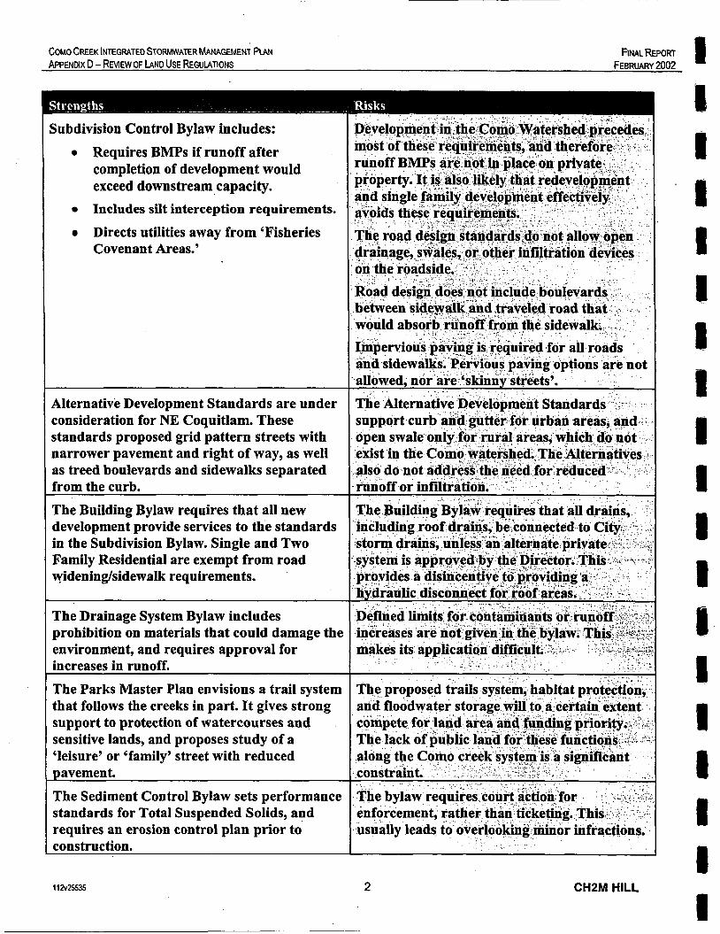
COMO CREEK lNTEGRATED STORMWATER MANAGEMENT PLAN APPENDIX D - REVIEW OF LAND USE REGULATIONS
FINAL REPORT FEBRUARY 2002
Subdivision Control Bylaw includes: 0 Requires BMPs if runoff after
completion of development would exceed downstream capacity. Includes silt interception requirements. Directs utilities away from ‘Fisheries Covenant Areas.’
Alternative Development Standards are under consideration for NE Coquitlam. These standards proposed grid pattern streets with narrower pavement and right of way, as well as treed boulevards and sidewalks separated from the curb.
The Building Bylaw requires that all new development provide services to the standards in the Subdivision Bylaw. Single and Two Family Residential are exempt from road wideninghidewalk requirements.
The Drainage System Bylaw includes prohibition on materials that could damage the environment, and requires approval for increases in runoff.
The Parks Master Plan envisions a trail system that follows the creeks in part. It gives strong support to protection of watercourses and sensitive lands, and proposes study of a ‘leisure’ or ‘family’ street with reduced pavement.
The Sediment Control Bylaw sets performance standards for Total Suspended Solids, and requires an erosion control plan prior to construction.
11 2~25535 2 CHZM HILL

I I 1 I I I. I I I I
I I I 1 # 8 I 1
e
COMO CREEK INTEGRATED STORMWATER MANAGEMENT PLAN APPENDIX D - REVIEW OF LAND USE REGULATIONS
FINAL REPOR; FEBRUARY 2002
A Proposed Draft Watercourse Protection Strategy is under consideration by the :North East Sector Stream Stewardship Committee. It would provide a similar sediment control provision to adjacent municipalities, and would add Development Permits along watercourses, an open watercourse policy, and consistent tree protection, zoning and stormwater management practices.
The existing Tree Cutting Permit Bylaw requires a permit to cut trees in designated areas (ravines).
A Proposed Tree Preservation Bylaw broadens the regulation of tree cutting, to make it apply to all environmentally sensitive areas and public property, as well as requiring tree replacement and protection of trees to remain.
The Ditch Elimination Program has been completed in the upper watershed. Other proposed Public Sector Projects include minor school additions, and redevelopment of the Poirier St. civic facilities in the medium term. Pending Private Sector projects include redevelopment of the lumber yard property, development of a IMAX/bowling complex across Lucille Star Drive from Famous Players, and a minor addition to the Canadian Tire store, plus several single family dwellings.
Vacant land parcels along the creek system include one property o n Booth Creek at Schoolhouse, as well as several properties between Lougheed Hwy. and the Trans Canada along Como Creek. The Fraser River frontage east of Como Creek is filled but not built upon. BC Hydro owns a strategic property along Popeye Creek south of Brunette.
1 1 2 ~ 2 5 3 5 3
~~
CHSM HILL

033
E m
a 0 cn E
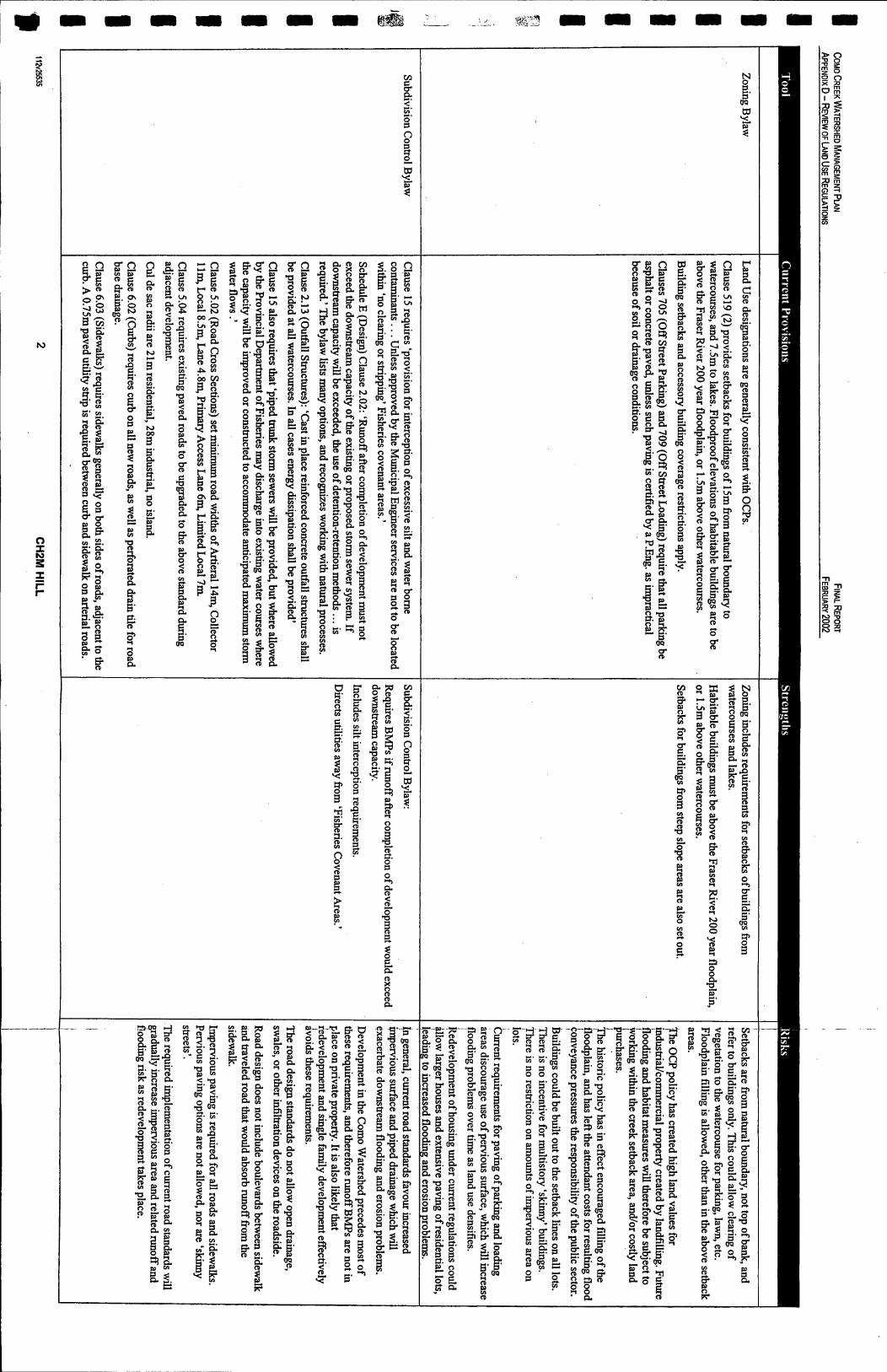
8 8
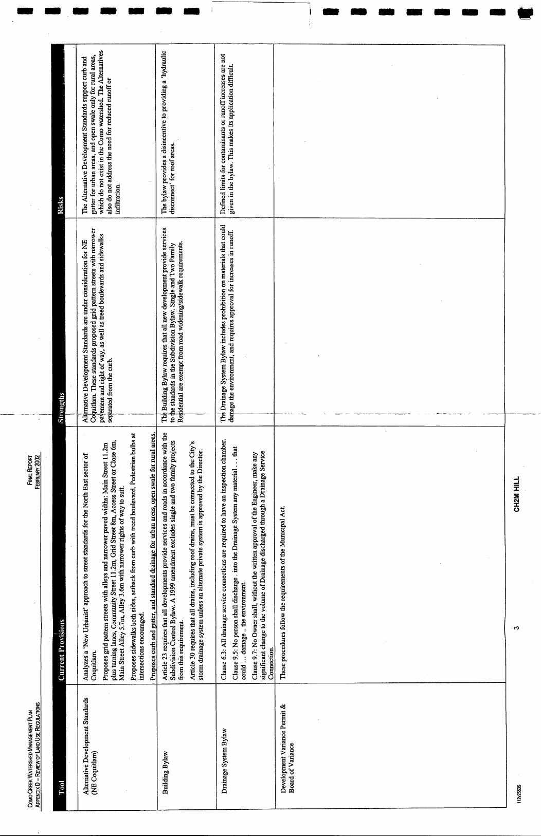
I
B cu 0
B

W
e 3
I I I I l l l

In

APPENDIX E
RESULTS OF COMPUTER MODELLING