community services department planning and development ......fence with barbed wire. the lease area...
TRANSCRIPT

Community Services Department
Planning and Development
SPECIAL USE PERMIT(see page 5)
SPECIAL USE PERMIT FOR GRADING(see page 11)
SPECIAL USE PERMIT FOR STABLES(see page 16)
APPLICATION
Community Services DepartmentPlanning and Development
1001 E. Ninth St., Bldg. AReno, NV 89520
Telephone: 775.328.3600

October 2016
Washoe County Development ApplicationYour entire application is a public record. If you have a concern about releasing personal information, please contact Planning and Development staff at 775.328.3600.
Project Information Staff Assigned Case No.:
Project Name:
Project Description:
Project Address:Project Area (acres or square feet):Project Location (with point of reference to major cross streets AND area locator):
Assessor’s Parcel No.(s): Parcel Acreage: Assessor’s Parcel No.(s): Parcel Acreage:
Section(s)/Township/Range:Indicate any previous Washoe County approvals associated with this application:Case No.(s).
Applicant Information (attach additional sheets if necessary)Property Owner: Professional Consultant:Name: Name:Address: Address:
Zip: Zip:Phone: Fax: Phone: Fax:Email: Email:Cell: Other: Cell: Other:
Contact Person: Contact Person:Applicant/Developer: Other Persons to be Contacted:Name: Name:Address: Address:
Zip: Zip:Phone: Fax: Phone: Fax:Email: Email:Cell: Other: Cell: Other:Contact Person: Contact Person:
For Office Use OnlyDate Received: Initial: Planning Area:County Commission District: Master Plan Designation(s):CAB(s): Regulatory Zoning(s):
3
Sacramento, CA916-313-3730
Sacramento, CA
916-313-3730
Reno, NV
Verizon Wireless "Rolling Thunder"Verizon Wireless proposes a new unmanned wireless telecommunicationsfacility serving valley residents along Hwy 445.
5205 Wayside Road, Reno, NV 89510
2,500 square feet
Hillside above existing development on parcel, located at 5205 Wayside Road. Parcel located at east end of Wayside Road, past intersection with Stirrup Dr.
077-350-01 42.46
23-21-33
Brian Akre Complete Wireless Consulting, Inc.
PO Box 7710 2009 V Street
[email protected] [email protected]
Brian Akre Michelle Ellis, Planning Manager
Sacramento Valley LP d/b/a Verizon Wireless
Attn: CWC, 2009 V Street
Michelle Ellis
DCA16-007
89510-7710775-475-1295
95818916-764-2454
775-475-1295 916-764-2454
95818916-764-2454
916-764-2454


Washoe County Planning and Development October 2016SPECIAL USE PERMIT APPLICATION SUPPLEMENTAL INFORMATION
Special Use Permit ApplicationSupplemental Information
(All required information may be separately attached)
Chapter 110 of the Washoe County Code is commonly known as the Development Code. Specific references to special use permits may be found in Article 810, Special Use Permits.
1. What is the type of project being requested?
2. What currently developed portions of the property or existing structures are going to be used with this permit?
5
Verizon Wireless unmanned telecommunications facility, 150' monopole
None, lease area is raw land
Washoe County Planning and Development October 2016SPECIAL USE PERMIT APPLICATION SUPPLEMENTAL INFORMATION
3. What improvements (e.g. new structures, roadway improvements, utilities, sanitation, water supply, drainage, parking, signs, etc.) will have to be constructed or installed and what is the projected time frame for the completion of each?
4. What is the intended phasing schedule for the construction and completion of the project?
5. What physical characteristics of your location and/or premises are especially suited to deal with the impacts and the intensity of your proposed use?
6
New 150' monopole, 2500 sq ft lease area, gravel access road.
Construction will last approximately two months.
Elevated hillside, clear view over Warm Springs Valley for excellent coverage.

Washoe County Planning and Development October 2016SPECIAL USE PERMIT APPLICATION SUPPLEMENTAL INFORMATION
6. What are the anticipated beneficial aspects or effects your project will have on adjacent properties and the community?
7. What will you do to minimize the anticipated negative impacts or effects your project will have on adjacent properties?
7
Improved Verizon 4G LTE coverage. Please see Project Support Statement.
No impacts on other properties anticipated.
Washoe County Planning and Development October 2016SPECIAL USE PERMIT APPLICATION SUPPLEMENTAL INFORMATION
8. Please describe operational parameters and/or voluntary conditions of approval to be imposed on the project special use permit to address community impacts:
9. How many improved parking spaces, both on-site and off-site, are available or will be provided? (Please indicate on site plan.)
8
Facility will be unmanned, technician visit 1-2 times per month.
No parking proposed. Facility will be unmanned.

Washoe County Planning and Development October 2016SPECIAL USE PERMIT APPLICATION SUPPLEMENTAL INFORMATION
10. What types of landscaping (e.g. shrubs, trees, fencing, painting scheme, etc.) are proposed? (Please indicate location on site plan.)
11. What type of signs and lighting will be provided? On a separate sheet, show a depiction (height, width, construction materials, colors, illumination methods, lighting intensity, base landscaping, etc.) of each sign and the typical lighting standards. (Please indicate location of signs and lights on site plan.)
12. Are there any restrictive covenants, recorded conditions, or deed restrictions (CC&Rs) that apply to the area subject to the special use permit request? (If so, please attach a copy.)
� Yes � No
9
6' chain link fence with barbed wire at lease area perimeter.
Down-tilted light at equipment cabinets, contact signage on fence. See site plans.
✔
Washoe County Planning and Development October 2016SPECIAL USE PERMIT APPLICATION SUPPLEMENTAL INFORMATION
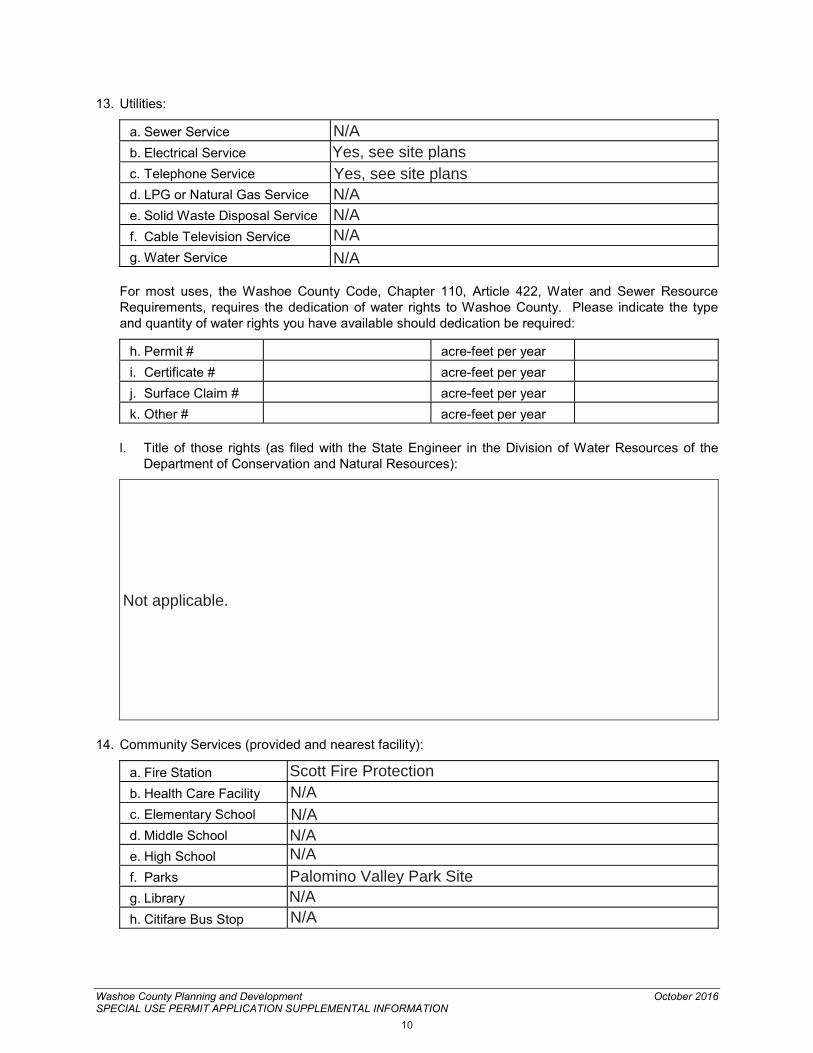
13. Utilities:
a. Sewer Serviceb. Electrical Servicec. Telephone Serviced. LPG or Natural Gas Servicee. Solid Waste Disposal Servicef. Cable Television Serviceg. Water Service
For most uses, the Washoe County Code, Chapter 110, Article 422, Water and Sewer Resource Requirements, requires the dedication of water rights to Washoe County. Please indicate the type and quantity of water rights you have available should dedication be required:
h. Permit # acre-feet per yeari. Certificate # acre-feet per yearj. Surface Claim # acre-feet per yeark. Other # acre-feet per year
l. Title of those rights (as filed with the State Engineer in the Division of Water Resources of the Department of Conservation and Natural Resources):
14. Community Services (provided and nearest facility):
a. Fire Stationb. Health Care Facilityc. Elementary Schoold. Middle Schoole. High Schoolf. Parksg. Libraryh. Citifare Bus Stop
10
N/AYes, see site plansYes, see site plansN/AN/AN/AN/A
Not applicable.
Scott Fire ProtectionN/AN/AN/AN/APalomino Valley Park SiteN/AN/A


PROJECT SUPPORT STATEMENT VERIZON WIRELESS
SITE NAME: ROLLING THUNDER LOCATION: 5205 Wayside Road, Reno, NV 89510 APN: 077-350-01
Introduction Verizon Wireless is seeking to improve communications service to residences, businesses, public services, and area travelers in the Warm Springs area of Washoe County. Verizon maintains a strong customer base in Washoe County and strives to improve coverage for both existing and potential customers. The proposed facility is needed to bring improved wireless communication coverage to Warm Springs Valley residents and along Hwy 445, south of Pyramid Lake. This project will expand Verizon’s existing network and improve call quality, signal strength, and wireless connection services in Washoe County. The improved wireless service will benefit residents, local businesses, and public services, and roadway safety throughout the region. Location/Design Verizon Wireless proposes a new wireless communications facility on a new 150’ monopole on the property located at 5205 Wayside Road, in unincorporated Reno. The property is located in the General Rural Agricultural (GRA) zone and is largely undeveloped. Owner Brian Akre uses the property for a home and a small orchard. Surrounding parcels are zoned GRA and General Rural (GR). The nearest residentially zoned property is over 2,000’ from the proposed facility.

Project Support Statement – Verizon Wireless ‘Rolling Thunder’
[2]
Project Description The proposed facility consists of nine (9) Verizon Wireless panel antennas, to be installed on a proposed 150’ monopole. The 50’ by 50’ equipment area will be surrounded by a 6’ tall chain link fence with barbed wire. The lease area will contain outdoor equipment cabinets on a new concrete pad. Power and telecommunications cables will be installed underground from the point of connection to the lease area. The unmanned facility will provide enhanced wireless network coverage 24 hours a day, 7 days a week. Public Benefits of Improved Wireless Service Modern life has become increasingly dependent upon wireless communications. Wireless access is critical to many facets of everyday life, such as safety, recreation, and commerce. This site will allow current and future Verizon Wireless customers to have access to wireless services in the areas shown on the Coverage Plots included in this application. Additionally, this site will serve as a backup to the existing landline service in the area and will provide improved wireless communication, which is essential to first responders, community safety, local businesses and area residents. As a backup system to traditional landline phone service, mobile phones have proven to be extremely important during natural disasters and other catastrophes.
Aesthetic Impacts Verizon is proposing a slim monopole, of similar height and character to other utility poles and structures in the area. The height of pole and size of lease area will provide other carriers with opportunities for future collocation. Verizon Wireless has carefully chosen a location that will minimize any visual impact to the surrounding area. The facility will be located on hillside in the middle of the parcel, set back significantly from Wayside Drive and Hwy 445. Ground equipment will be enclosed within outdoor equipment cabinets and screened from view, and the equipment area will be surrounded by a security fence. The proposed facility height complies with the County’s development standards for wireless facilities in the General Rural Agricultural zoning designation. Because of the surrounding topography and development, the proposed facility needs to be a total of 150’ for the signal to reach the intended service area. The proposed facility has been designed at its minimum functional height.

Project Support Statement – Verizon Wireless ‘Rolling Thunder’
[3]
Alternative Site Analysis The selection of a location for a wireless telecommunications facility that is needed to improve wireless coverage is dependent upon many factors, such as: topography, zoning regulations, existing structures, co-location opportunities, available utilities, access, and the existence of a willing landlord. Wireless communication utilizes line-of-sight technology that requires facilities to be in relative close proximity to the wireless handsets to be served. Each proposed site is unique and must be investigated and evaluated on its own terms.
The proposed coverage area consists of agricultural and residential uses in Washoe County. Verizon strives to minimize visual and acoustic impacts for each facility and seeks to incorporate ways to preserve the local community character to the greatest extent feasible at all stages of site selection and design process. The proposed facility will consist of nine Verizon panel antennas mounted on a proposed 150’ monopole. Equipment cables will be run underground in order to minimize visual impacts and equipment will be screened by a chain link fence. The proposed location best serves the interest of Washoe County and the Warm Springs area because it is the least intrusive means available to improve service to the area. The process that Verizon implements to identify the least intrusive location is outlined below. Selection Process and Candidates Considered In February 2015, Verizon Wireless determined that the service objectives discussed above must be met. After establishing the need for the proposed facility, Verizon set out to identify the least intrusive means of achieving the necessary service objective. A total of seven candidates were considered prior to selecting the proposed location. VZW begins its process by identifying a search area called a "search ring" (see image below) and a required centerline height.

Project Support Statement – Verizon Wireless ‘Rolling Thunder’
[4]
The search ring represents the area within which a facility can be located to produce the desired coverage objective. The centerline height of 146’ represents the required height of the antennas to produce the desired coverage objective. After reviewing the County’s zoning regulations, the next step is to identify any existing towers within the search ring that could allow for collocation. In this case, Verizon determined a new tower must be constructed to adequately meet its coverage goals in this search ring. Verizon identified several potential alternative sites prior to selecting the presently proposed location. Below is a list of the candidate properties that were considered for the proposed facility, as well as an explanation as to why each site was not selected:
1. Clark (5900 Grass Valley Rd / APN 077-350-06) Verizon investigated this 68.20 acre parcel for a new monopole. The landlord was interested in leasing land on their property to Verizon for the development of a new wireless facility. There is no existing access to the proposed lease area location, and selecting this facility would require the construction of a new road. This candidate was presented to Verizon but was not preferred by Verizon’s radio frequency engineer. This candidate remains in a back-up position.
2. Washoe County Treasurer (100 Stirrup Dr / APN 076-430-01)
Verizon investigated this site for a new monopole. The property is privately owned, but is subject to so many liens it is now listed as a County-owned property. The County treasurer provided Verizon with the property owner’s mailing address. Verizon sent two interest letters to the address, but received no response from the owner.
3. Sweitzer (5915 Grass Valley Road / APN 077-350-08) Verizon investigated this site for a new monopole. The candidate was presented to Verizon’s radio frequency engineer, who rejected the property due to its low elevation. This site was not selected because it would not meet Verizon’s coverage objects in the search ring.
4. Murphy (105 Stirrup Dr / APN 076-450-07) Verizon investigated this site for a new monopole. The landlord did not respond to two interest letters sent to the address, and Verizon was unable to locate a phone number for the current owner.
5. Maykovitch & Leonard (Wayside Road / APN 077-550-11)
Verizon investigated this site for a new monopole. The property owners on title stated that they were in the process of selling the property. They were unwilling to provide updated contact information for the individuals purchasing the property. This candidate was not pursued further because a lease agreement was not feasible.
Project Support Statement – Verizon Wireless ‘Rolling Thunder’
[5]
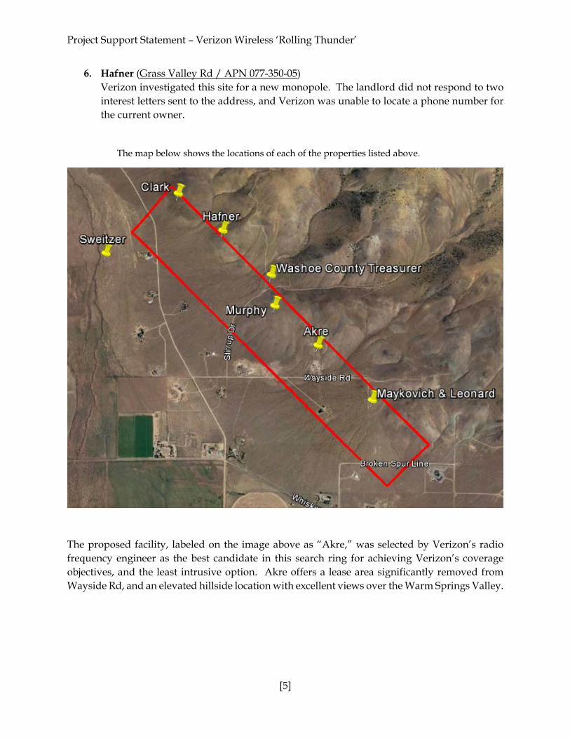
6. Hafner (Grass Valley Rd / APN 077-350-05) Verizon investigated this site for a new monopole. The landlord did not respond to two interest letters sent to the address, and Verizon was unable to locate a phone number for the current owner.
The map below shows the locations of each of the properties listed above.
The proposed facility, labeled on the image above as “Akre,” was selected by Verizon’s radio frequency engineer as the best candidate in this search ring for achieving Verizon’s coverage objectives, and the least intrusive option. Akre offers a lease area significantly removed from Wayside Rd, and an elevated hillside location with excellent views over the Warm Springs Valley.

Project Support Statement – Verizon Wireless ‘Rolling Thunder’
[6]
Coverage Area Existing Coverage
Proposed Coverage

Project Support Statement – Verizon Wireless ‘Rolling Thunder’
[7]
Statement of Commitment to Allow Collocation The proposed facility has been designed in a manner that will structurally accommodate additional antennas and future collocation. Verizon Wireless welcomes other carriers to collocate on their facilities whenever possible. Safety Benefits of Improved Wireless Service Verizon Wireless offers its customers multiple services such as voice calls, text messaging, mobile email, picture/video messaging, mobile web, navigation, broadband access, V CAST, and E911 services. Mobile phone use has become an extremely important tool for first responders and serves as a back-up system in the event of a natural disaster. Compliance with FCC and FAA Standards This project will not interfere with any TV, radio, telephone, satellite, or any other signals. Any interference would be against federal law and a violation of Verizon Wireless’s FCC License. Unless tower lighting is required by the FAA, the only lighting on the facility will be a hooded and down-titled security light near the equipment cabinets. Maintenance and Battery Back-Up Verizon Wireless installs batteries at all of its cell sites. The batteries play a vital role in Verizon’s emergency and disaster preparedness plan. In the event of a power outage, Verizon Wireless communications equipment will transition to the back-up batteries. The batteries can run the site for a several hours depending on the demand placed on the equipment. Back-up batteries allow Verizon Wireless’s communications sites to continue providing valuable communications services in the event of a power outage, natural disaster or other emergency. Following construction, the security fence will include a small sign indicating the facility owner and a 24-hour emergency telephone number. The lease area will be surrounded by a 6’ chain link fence with barbed wire for additional security. Construction Schedule The construction of the facility will be in compliance with all local rules and regulations. The crew size will range from two to ten individuals. The construction phase of the project will last approximately two months and will not exceed acceptable noise levels. Landscaping No landscaping is proposed at the facility. The lease area is over 660’ from the nearest road, and is not visible to the public. In an attempt to conserve water and to reduce ongoing maintenance at unmanned facilities, Verizon avoids live landscaping whenever possible. Notice of Actions Affecting Development Permit Verizon Wireless requests notice of any proposal to adopt or amend the: general plan, specific plan, zoning ordinance, ordinance(s) affecting building or grading permits that would in any manner affect this development permit. Any such notice may be sent to 2009 V Street, Sacramento, CA 95818.


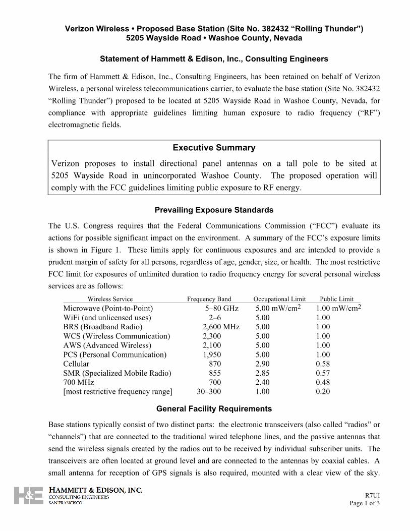
Verizon Wireless • Proposed Base Station (Site No. 382432 “Rolling Thunder”) 5205 Wayside Road • Washoe County, Nevada
R7UI Page 1 of 3
Statement of Hammett & Edison, Inc., Consulting Engineers
The firm of Hammett & Edison, Inc., Consulting Engineers, has been retained on behalf of Verizon Wireless, a personal wireless telecommunications carrier, to evaluate the base station (Site No. 382432 “Rolling Thunder”) proposed to be located at 5205 Wayside Road in Washoe County, Nevada, for compliance with appropriate guidelines limiting human exposure to radio frequency (“RF”) electromagnetic fields.
Executive Summary
Verizon proposes to install directional panel antennas on a tall pole to be sited at 5205 Wayside Road in unincorporated Washoe County. The proposed operation will comply with the FCC guidelines limiting public exposure to RF energy.
Prevailing Exposure Standards
The U.S. Congress requires that the Federal Communications Commission (“FCC”) evaluate its actions for possible significant impact on the environment. A summary of the FCC’s exposure limits is shown in Figure 1. These limits apply for continuous exposures and are intended to provide a prudent margin of safety for all persons, regardless of age, gender, size, or health. The most restrictive FCC limit for exposures of unlimited duration to radio frequency energy for several personal wireless services are as follows:
Wireless Service Frequency Band Occupational Limit Public Limit Microwave (Point-to-Point) 5–80 GHz 5.00 mW/cm2 1.00 mW/cm2 WiFi (and unlicensed uses) 2–6 5.00 1.00 BRS (Broadband Radio) 2,600 MHz 5.00 1.00 WCS (Wireless Communication) 2,300 5.00 1.00 AWS (Advanced Wireless) 2,100 5.00 1.00 PCS (Personal Communication) 1,950 5.00 1.00 Cellular 870 2.90 0.58 SMR (Specialized Mobile Radio) 855 2.85 0.57 700 MHz 700 2.40 0.48 [most restrictive frequency range] 30–300 1.00 0.20
General Facility Requirements
Base stations typically consist of two distinct parts: the electronic transceivers (also called “radios” or “channels”) that are connected to the traditional wired telephone lines, and the passive antennas that send the wireless signals created by the radios out to be received by individual subscriber units. The transceivers are often located at ground level and are connected to the antennas by coaxial cables. A small antenna for reception of GPS signals is also required, mounted with a clear view of the sky.

Verizon Wireless • Proposed Base Station (Site No. 382432 “Rolling Thunder”) 5205 Wayside Road • Washoe County, Nevada
R7UI Page 2 of 3
Because of the short wavelength of the frequencies assigned by the FCC for wireless services, the antennas require line-of-sight paths for their signals to propagate well and so are installed at some height above ground. The antennas are designed to concentrate their energy toward the horizon, with very little energy wasted toward the sky or the ground. This means that it is generally not possible for exposure conditions to approach the maximum permissible exposure limits without being physically very near the antennas.
Computer Modeling Method
The FCC provides direction for determining compliance in its Office of Engineering and Technology Bulletin No. 65, “Evaluating Compliance with FCC-Specified Guidelines for Human Exposure to Radio Frequency Radiation,” dated August 1997. Figure 2 describes the calculation methodologies, reflecting the facts that a directional antenna’s radiation pattern is not fully formed at locations very close by (the “near-field” effect) and that at greater distances the power level from an energy source decreases with the square of the distance from it (the “inverse square law”). The conservative nature of this method for evaluating exposure conditions has been verified by numerous field tests.
Site and Facility Description
Based upon information provided by Verizon, including zoning drawings by MST Architects, Inc., dated June 20, 2016, it is proposed to install nine Andrew directional panel antennas – six Model SBNHH-1D65C and three Model SBNHH-1D45C – on a new 150-foot steel pole to be sited in the hills above the residence located at 5205 Wayside Road, about 8 miles southwest of Pyramid Lake in unincorporated Washoe County. The antennas would employ up to 4° downtilt, would be mounted at an effective height of about 146 feet above ground, and would be oriented in groups of three toward 140°T, 200°T, and 290°T. The maximum effective radiated power in any direction would be 16,340 watts, representing simultaneous operation at 6,570 watts for AWS, 6,760 watts for PCS, and 3,010 watts for 700 MHz service; no operation on cellular frequencies is presently proposed from this site. There are reported no other wireless telecommunications base stations at the site or nearby.
Study Results
For a person anywhere at ground, the maximum RF exposure level due to the proposed Verizon operation is calculated to be 0.0029 mW/cm2, which is 0.32% of the applicable public exposure limit. The maximum calculated level at the nearby residence is 0.032% of the public exposure limit. It should be noted that these results include several “worst-case” assumptions and therefore are expected to overstate actual power density levels from the proposed operation.

Verizon Wireless • Proposed Base Station (Site No. 382432 “Rolling Thunder”) 5205 Wayside Road • Washoe County, Nevada
R7UI Page 3 of 3
No Recommended Mitigation Measures
Due to their mounting location and height, the Verizon antennas would not be accessible to unauthorized persons, and so no mitigation measures are necessary to comply with the FCC public exposure guidelines. It is presumed that Verizon will, as an FCC licensee, take adequate steps to ensure that its employees or contractors receive appropriate training and comply with FCC occupational exposure guidelines whenever work is required near the antennas themselves.
Conclusion
Based on the information and analysis above, it is the undersigned’s professional opinion that operation of the base station proposed by Verizon Wireless at 5205 Wayside Road in Washoe County, Nevada, will comply with the prevailing standards for limiting public exposure to radio frequency energy and, therefore, will not for this reason cause a significant impact on the environment. The highest calculated level in publicly accessible areas is much less than the prevailing standards allow for exposures of unlimited duration. This finding is consistent with measurements of actual exposure conditions taken at other operating base stations.
Authorship
The undersigned author of this statement is a qualified Professional Engineer, holding California Registration Nos. E-13026 and M-20676, which expire on June 30, 2017. This work has been carried out under his direction, and all statements are true and correct of his own knowledge except, where noted, when data has been supplied by others, which data he believes to be correct.
_________________________________ William F. Hammett, P.E. 707/996-5200 July 28, 2016

FCC Radio Frequency Protection Guide
FCC GuidelinesFigure 1
Frequency (MHz)
1000
100
10
1
0.1
0.1 1 10 100 103 104 105
Occupational Exposure
Public Exposure
PCSCell
FM
Pow
erD
ensi
ty(m
W/c
m2 )
The U.S. Congress required (1996 Telecom Act) the Federal Communications Commission (“FCC”)to adopt a nationwide human exposure standard to ensure that its licensees do not, cumulatively, havea significant impact on the environment. The FCC adopted the limits from Report No. 86, “BiologicalEffects and Exposure Criteria for Radiofrequency Electromagnetic Fields,” published in 1986 by theCongressionally chartered National Council on Radiation Protection and Measurements (“NCRP”).Separate limits apply for occupational and public exposure conditions, with the latter limits generallyfive times more restrictive. The more recent standard, developed by the Institute of Electrical andElectronics Engineers and approved as American National Standard ANSI/IEEE C95.1-2006, “SafetyLevels with Respect to Human Exposure to Radio Frequency Electromagnetic Fields, 3 kHz to300 GHz,” includes similar limits. These limits apply for continuous exposures from all sources andare intended to provide a prudent margin of safety for all persons, regardless of age, gender, size, orhealth.
As shown in the table and chart below, separate limits apply for occupational and public exposureconditions, with the latter limits (in italics and/or dashed) up to five times more restrictive:
Frequency Electromagnetic Fields (f is frequency of emission in MHz) Applicable
Range(MHz)
ElectricField Strength
(V/m)
MagneticField Strength
(A/m)
Equivalent Far-FieldPower Density
(mW/cm2)
0.3 – 1.34 614 614 1.63 1.63 100 1001.34 – 3.0 614 823.8/ f 1.63 2.19/ f 100 180/ f2
3.0 – 30 1842/ f 823.8/ f 4.89/ f 2.19/ f 900/ f2 180/ f2
30 – 300 61.4 27.5 0.163 0.0729 1.0 0.2300 – 1,500 3.54 f 1.59 f f /106 f /238 f/300 f/1500
1,500 – 100,000 137 61.4 0.364 0.163 5.0 1.0
Higher levels are allowed for short periods of time, such that total exposure levels averaged over six orthirty minutes, for occupational or public settings, respectively, do not exceed the limits, and higherlevels also are allowed for exposures to small areas, such that the spatially averaged levels do notexceed the limits. However, neither of these allowances is incorporated in the conservative calculationformulas in the FCC Office of Engineering and Technology Bulletin No. 65 (August 1997) forprojecting field levels. Hammett & Edison has built those formulas into a proprietary program thatcalculates, at each location on an arbitrary rectangular grid, the total expected power density from anynumber of individual radio sources. The program allows for the description of buildings and uneventerrain, if required to obtain more accurate projections.

RFR.CALC™ Calculation Methodology
Assessment by Calculation of Compliance with FCC Exposure Guidelines
MethodologyFigure 2
The U.S. Congress required (1996 Telecom Act) the Federal Communications Commission (“FCC”) toadopt a nationwide human exposure standard to ensure that its licensees do not, cumulatively, have asignificant impact on the environment. The maximum permissible exposure limits adopted by the FCC(see Figure 1) apply for continuous exposures from all sources and are intended to provide a prudentmargin of safety for all persons, regardless of age, gender, size, or health. Higher levels are allowed forshort periods of time, such that total exposure levels averaged over six or thirty minutes, foroccupational or public settings, respectively, do not exceed the limits.
Near Field. Prediction methods have been developed for the near field zone of panel (directional) and whip(omnidirectional) antennas, typical at wireless telecommunications base stations, as well as dish(aperture) antennas, typically used for microwave links. The antenna patterns are not fully formed inthe near field at these antennas, and the FCC Office of Engineering and Technology Bulletin No. 65(August 1997) gives suitable formulas for calculating power density within such zones.
For a panel or whip antenna, power density S = 180��BW
�0.1� Pnet� �D2 � h
, in mW/cm2,
and for an aperture antenna, maximum power density Smax = 0.1 � 16 � � � Pnet
� � h2 , in mW/cm2,
where �BW = half-power beamwidth of the antenna, in degrees, andPnet = net power input to the antenna, in watts,
D = distance from antenna, in meters,h = aperture height of the antenna, in meters, and� = aperture efficiency (unitless, typically 0.5-0.8).
The factor of 0.1 in the numerators converts to the desired units of power density.
Far Field. OET-65 gives this formula for calculating power density in the far field of an individual RF source:
power density S = 2.56 �1.64 �100 � RFF2 � ERP
4 �� �D2 , in mW/cm2,
where ERP = total ERP (all polarizations), in kilowatts,RFF = relative field factor at the direction to the actual point of calculation, and
D = distance from the center of radiation to the point of calculation, in meters.
The factor of 2.56 accounts for the increase in power density due to ground reflection, assuming areflection coefficient of 1.6 (1.6 x 1.6 = 2.56). The factor of 1.64 is the gain of a half-wave dipolerelative to an isotropic radiator. The factor of 100 in the numerator converts to the desired units ofpower density. This formula has been built into a proprietary program that calculates, at each locationon an arbitrary rectangular grid, the total expected power density from any number of individualradiation sources. The program also allows for the description of uneven terrain in the vicinity, toobtain more accurate projections.

Washoe County Treasurer Tammi Davis
Washoe County Treasurer P.O. Box 30039, Reno, NV 895203039 ph: (775) 3282510 fax: (775) 3282500 Email: [email protected]
The Washoe County Treasurer’s Office makes every effort to produce and publish the most current and accurate information possible. No warranties, expressed or implied, areprovided for the data herein, its use, or its interpretation. If you have any questions, please contact us at (775) 3282510 or [email protected]
This site is best viewed using Google Chrome, Internet Explorer 11, Mozilla Firefox or Safari.
Account Detail
Washoe County Parcel Information
Parcel ID Status Last Update
07735001 Active 2/10/2017 2:10:21 AM
Current Owner:AKRE, BRIAN M & MARIA M
PO BOX 7710 RENO, NV 89510
SITUS:5205 WAYSIDE RD WCTY NV
Taxing District9400
Geo CD:
Legal Description
Range 21 Section 33 SubdivisionName _UNSPECIFIED Township 23
Tax Bill (Click on desired tax year for due dates and further details)Tax Year Net Tax Total Paid Penalty/Fees Interest Balance Due
$1,552.73 $1,164.55 $0.00 $0.00 $388.18
$1,549.63 $1,549.63 $0.00 $0.00 $0.00
$1,504.50 $1,504.50 $0.00 $0.00 $0.00
$1,460.68 $1,460.68 $0.00 $0.00 $0.00
$1,418.14 $1,418.14 $0.00 $0.00 $0.00
Total $388.18
Important Payment InformationALERTS: If your real property taxes are delinquent, the search results displayed may not reflect thecorrect amount owing. Please contact our office for the current amount due. For your convenience, online payment is available on this site. Echeck payments are accepted without afee. However, a service fee does apply for online credit card payments. See Payment Information fordetails.
Pay Online
Payments will be appliedto the oldest charge first.
Select a payment option:
Total Due $388.18 Partial
ADD TO CART
$0.00
Pay By Check
Please make checks payable to:WASHOE COUNTY TREASURER Mailing Address:P.O. Box 30039 Reno, NV 895203039 Overnight Address:1001 E. Ninth St., Ste D140Reno, NV 895122845
Back to Search Results Change of Address Print this Page
2016
2015
2014
2013
2012

295 Parkshore Drive, Folsom, CA 95630
1520
Riv
er P
ark
Driv
e, S
acra
men
to, C
A 95
815
916-
505-
3811
Man
uel S
. Tsi
hlas
, Arc
hite
ct


1520
Riv
er P
ark
Driv
e, S
acra
men
to, C
A 95
815
916-
505-
3811
Man
uel S
. Tsi
hlas
, Arc
hite
ct

1520
Riv
er P
ark
Driv
e, S
acra
men
to, C
A 95
815
916-
505-
3811
Man
uel S
. Tsi
hlas
, Arc
hite
ct

1520
Riv
er P
ark
Driv
e, S
acra
men
to, C
A 95
815
916-
505-
3811
Man
uel S
. Tsi
hlas
, Arc
hite
ct

1520
Riv
er P
ark
Driv
e, S
acra
men
to, C
A 95
815
916-
505-
3811
Man
uel S
. Tsi
hlas
, Arc
hite
ct