communities, biomes, and ecosystems - …images.pcmac.org/.../documents/chap03_nopw_1.pdf · 60...
TRANSCRIPT
Communities, Biomes, and Ecosystems
Section 1 Community Ecology
All living organisms are limited by factors in the environment.
Section 2Terrestrial Biomes
Ecosystems on land are grouped into biomes primarily based on the plant communities within them.
Section 3Aquatic Ecosystems
Aquatic ecosystems are grouped based on abiotic factors such as water flow, depth, distance from shore, salinity, and latitude.
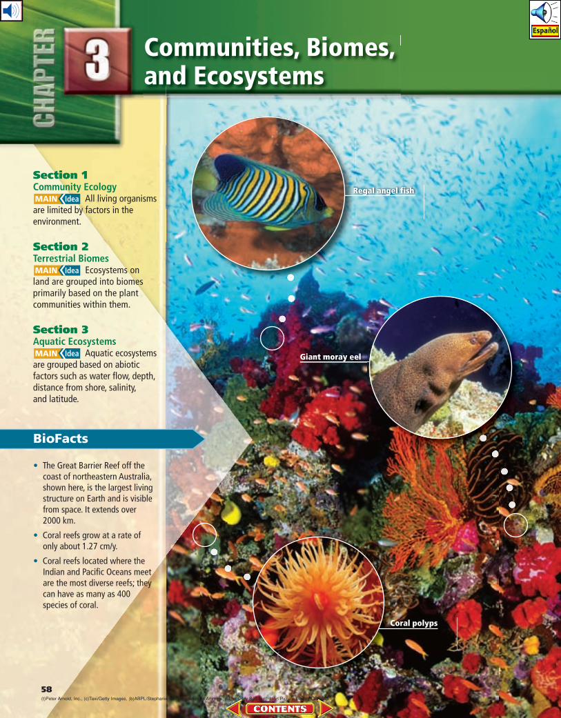
BioFacts
• The Great Barrier Reef off the coast of north eastern Australia, shown here, is the largest living structure on Earth and is visible from space. It extends over 2000 km.
• Coral reefs grow at a rate of only about 1.27 cm/y.
• Coral reefs located where the Indian and Pacific Oceans meet are the most diverse reefs; they can have as many as 400 species of coral.
58
Giant moray eel
Regal angel fish
Coral polyps
(t)Peter Arnold, Inc., (c)Taxi/Getty Images , (b)ABPL/Stephanie Lamberti/Animals Animals , (bkgd)Gary Bell/Australian Picture Library/CORBIS
Section 1 • XXXXXXXXXXXXXXXXXX 59Chapter 3 • Communities, Biomes, and Ecosystems 59
Start-Up Activities
What is my biological address?Just as you have a postal address, you also have a biological “address.” As a living organism, you are part of interwoven ecological units that vary in size from as large as the whole biosphere to the place you occupy right now.
Procedure
1. Consider the following question: What do the terms community and eco system mean to you?
2. Describe the biological community and an ecosystem to which you belong.
Analysis
1. Compare Did your classmates all identify the same community and ecosystem? How would you describe, in general, the plants and animals in your area to someone from another country?
2. Examine Communities and ecosystems are constantly changing through a process known as succession. What changes do you think your biological community has under-gone in the last 100 to 150 years?
LAUNCH Lab Terrestrial Biomes Make this Foldable to help you understand primary succession and secondary succession.
STEP 1 Draw a line through the middle of a sheet of notebook paper as shown.
STEP 2 Fold the paper from the top and bottom so the edges meet at the center line.
STEP 3 Label the two tabs as illustrated.
Use this Foldable with Section 3.1. As you read the chapter, record what you learn about primary succession and secondary succession under the tabs. Use the front of the tabs to draw a visual representation of each.
Visit biologygmh.com to:
study the entire chapter online
explore Concepts in Motion, Microscopy
Links, and links to virtual dissections
access Web links for more information,
projects, and activities
review content online with the Inter-
active Tutor and take Self-Check Quizzes
60 Chapter 3 • Communities, Biomes, and Ecosystems
■ Figure 3.1 Notice that populations of organisms live within a relatively small area surrounding the oasis.
Objectives
Recognize how unfavorable abiotic and biotic factors affect a species.
Describe how ranges of tolerance affect the distribution of organisms.
Sequence the stages of primary and secondary succession.
Review Vocabulary
abiotic factor: the nonliving part of an organism’s environment
New Vocabulary
communitylimiting factortoleranceecological successionprimary successionclimax communitysecondary succession
Community Ecology
All living organisms are limited by factors in the
environment.
Real-World Reading Link Wherever you live, you probably are used to the conditions of your environment. If it is cold outdoors, you might wear a coat, hat, and gloves. Other organisms also adapt to their environment, even when conditions are harsh and changing.
CommunitiesWhen you describe your community, you probably include your family, the students in your school, and the people who live nearby. A biological com munity is a group of interacting populations that occupy the same area at the same time. Therefore, your community also includes plants, other animals, bacteria, and fungi. Not every community includes the same variety of organisms. An urban com-munity is different from a rural community, and a desert community is different from an arctic community.
In Chapter 2, you learned that organisms depend on one another for survival. You also learned about abiotic factors and that abiotic factors affect individual organisms. How, then, might abiotic factors affect com-munities? Consider soil, which is an abiotic factor. If soil becomes too acidic, some species might die or become extinct. This might affect food sources for other organisms, resulting in a change in the community.
Organisms adapt to the conditions in which they live. For example, a wolf ’s heavy fur coat enables it to survive in harsh winter climates, and a cactus’s ability to retain water enables it to tolerate the dry condi-tions of a desert. Depending on which factors are present, and in what quantities, organisms can survive in some ecosystems but not in others. As an example, the plants in the desert oasis shown in Figure 3.1 decrease in abundance away from the water source.
Section 3.1
Yann Arthus-Bertrand/CORBIS
Section 1 • Community Ecology 61
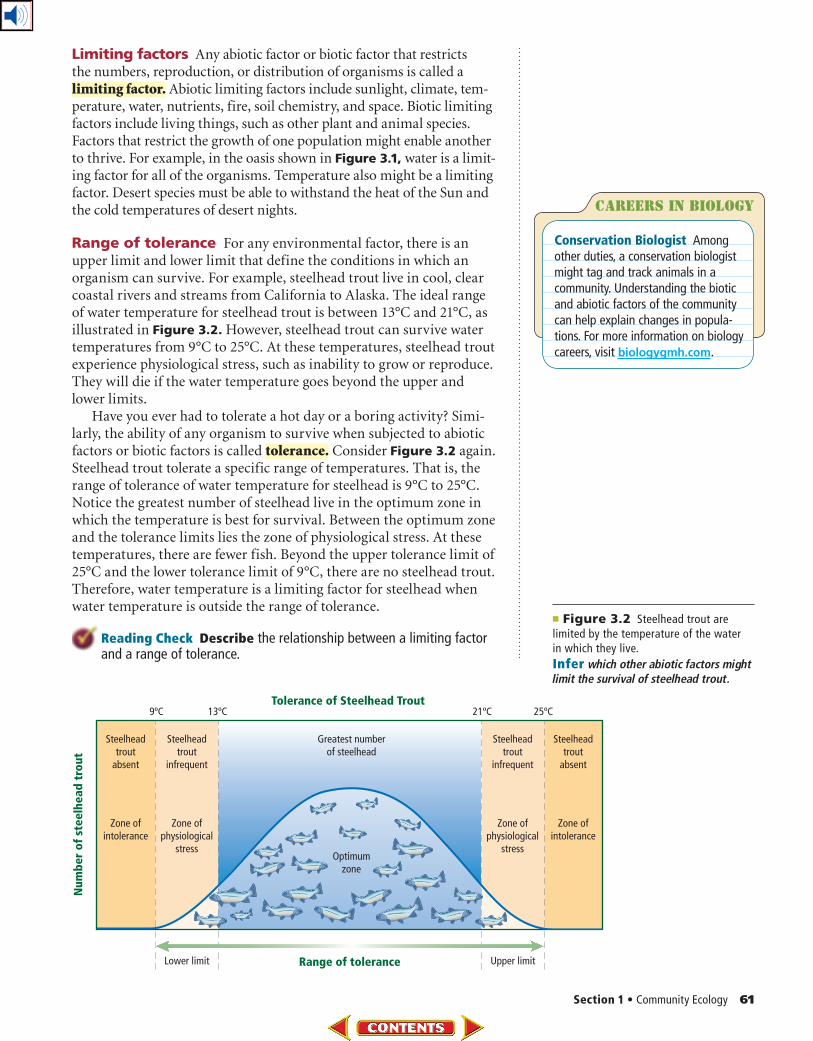
■ Figure 3.2 Steelhead trout are limited by the temperature of the water in which they live.
Infer which other abiotic factors might limit the survival of steelhead trout.
Limiting factors Any abiotic factor or biotic factor that restricts the numbers, reproduction, or distribution of organisms is called a limiting factor. Abiotic limiting factors include sunlight, climate, tem-perature, water, nutrients, fire, soil chemistry, and space. Biotic limiting factors include living things, such as other plant and animal species. Factors that restrict the growth of one population might enable another to thrive. For example, in the oasis shown in Figure 3.1, water is a limit-ing factor for all of the organisms. Temperature also might be a limiting factor. Desert species must be able to withstand the heat of the Sun and the cold temperatures of desert nights.
Range of tolerance For any environmental factor, there is an upper limit and lower limit that define the conditions in which an organism can survive. For example, steelhead trout live in cool, clear coastal rivers and streams from California to Alaska. The ideal range of water temperature for steelhead trout is between 13°C and 21°C, as illustrated in Figure 3.2. However, steelhead trout can survive water temperatures from 9°C to 25°C. At these temperatures, steelhead trout experience physiological stress, such as inability to grow or reproduce. They will die if the water temperature goes beyond the upper and lower limits.
Have you ever had to tolerate a hot day or a boring activity? Simi-larly, the ability of any organism to survive when subjected to abiotic factors or biotic factors is called tolerance. Consider Figure 3.2 again. Steelhead trout tolerate a specific range of temperatures. That is, the range of tolerance of water temperature for steelhead is 9°C to 25°C. Notice the greatest number of steelhead live in the optimum zone in which the temperature is best for survival. Between the optimum zone and the tolerance limits lies the zone of physiological stress. At these temperatures, there are fewer fish. Beyond the upper tolerance limit of 25°C and the lower tolerance limit of 9°C, there are no steelhead trout. Therefore, water temperature is a limiting factor for steelhead when water temperature is outside the range of tolerance.
Reading Check Describe the relationship between a limiting factor and a range of tolerance.
Careers In biology
Conservation Biologist Among other duties, a conservation biologist might tag and track animals in a community. Understanding the biotic and abiotic factors of the community can help explain changes in popula-tions. For more information on biology careers, visit biologygmh.com.
62 Chapter 3 • Communities, Biomes, and Ecosystems
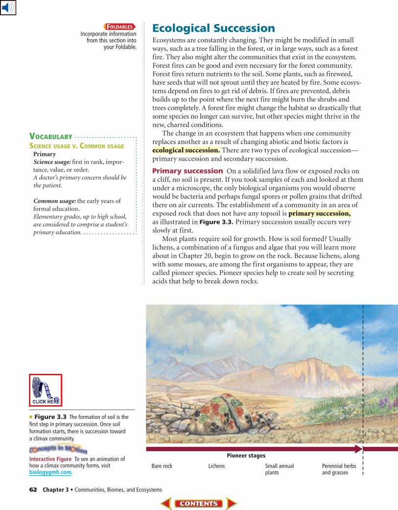
■ Figure 3.3 The formation of soil is the first step in primary succession. Once soil formation starts, there is succession toward a climax community.
Ecological SuccessionEcosystems are constantly changing. They might be modified in small ways, such as a tree falling in the forest, or in large ways, such as a forest fire. They also might alter the communities that exist in the ecosystem. Forest fires can be good and even necessary for the forest community. Forest fires return nutrients to the soil. Some plants, such as fireweed, have seeds that will not sprout until they are heated by fire. Some ecosys-tems depend on fires to get rid of debris. If fires are prevented, debris builds up to the point where the next fire might burn the shrubs and trees completely. A forest fire might change the habitat so drastically that some species no longer can survive, but other species might thrive in the new, charred conditions.
The change in an ecosystem that happens when one community replaces another as a result of changing abiotic and biotic factors is ecological succession. There are two types of ecological succession—primary succession and secondary succession.
Primary succession On a solidified lava flow or exposed rocks on a cliff, no soil is present. If you took samples of each and looked at them under a microscope, the only biological organisms you would observe would be bacteria and perhaps fungal spores or pollen grains that drifted there on air currents. The establishment of a community in an area of exposed rock that does not have any topsoil is primary succession, as illustrated in Figure 3.3. Primary succession usually occurs very slowly at first.
Most plants require soil for growth. How is soil formed? Usually lichens, a combination of a fungus and algae that you will learn more about in Chapter 20, begin to grow on the rock. Because lichens, along with some mosses, are among the first organisms to appear, they are called pioneer species. Pioneer species help to create soil by secreting acids that help to break down rocks.
Incorporate information from this section into
your Foldable.
VOCABULARY
SCIENCE USAGE V. COMMON USAGE
Primary
Science usage: first in rank, impor-
tance, value, or order.
A doctor’s primary concern should be
the patient.
Common usage: the early years of
formal education.
Elementary grades, up to high school,
are considered to comprise a student’s
primary education.
Interactive Figure To see an animation of how a climax community forms, visit biologygmh.com.
Section 1 • Community Ecology 63
As pioneer organisms die, their decaying organic materials, along with bits of sediment from the rocks, make up the first stage of soil development. At this point, small weedy plants, including ferns, and other organisms such as fungi and insects, become estab-lished. As these organisms die, additional soil is cre-ated. Seeds, brought in by animals, water, or wind, begin to grow in the newly formed soil. Eventually, enough soil is present so that shrubs and trees can grow.
A climax community eventually can develop from bare rock, as illustrated in Figure 3.3. The stable, mature community that results when there is little change in the composition of species is a climax community. Scientists today realize that disturbances, such as climate change, are ongoing in communities, thus a true climax community is unlikely to occur.
Secondary succession Disturbances such as fire, f lood, or a windstorm can disrupt a commu-nity. After a disturbance, new species of plants and animals might occupy the habitat. Over time, there is a natural tendency for the species belonging to the mature community to return. Secondary succession is the orderly and predictable change that takes place after a community of organisms has been removed but the soil has remained intact. Pioneer species—mainly plants that begin to grow in the disturbed area—are the first species to start second-ary succession.
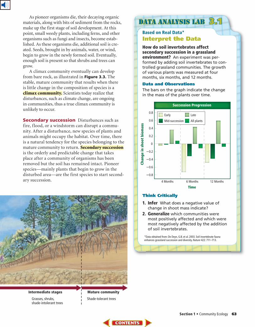
Based on Real Data*
Interpret the Data
How do soil invertebrates affect secondary succession in a grassland environment? An experiment was per-formed by adding soil invertebrates to con-trolled grassland communities. The growth of various plants was measured at four months, six months, and 12 months.
Data and Observations
The bars on the graph indicate the change in the mass of the plants over time.
Think Critically
1. Infer What does a negative value of change in shoot mass indicate?
2. Generalize which communities were most positively affected and which were most negatively affected by the addition of soil invertebrates.
Data Analysis lab 3.1
*Data obtained from: De Deyn, G.B. et al. 2003. Soil invertebrate fauna enhances grassland succession and diversity. Nature 422: 711–713.
64 Chapter 3 • Communities, Biomes, and Ecosystems
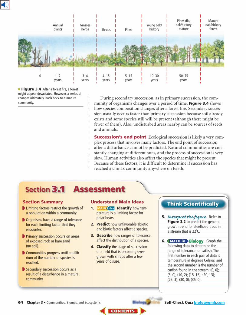
During secondary succession, as in primary succession, the com-munity of organisms changes over a period of time. Figure 3.4 shows how species composition changes after a forest fire. Secondary succes-sion usually occurs faster than primary succession because soil already exists and some species still will be present (although there might be fewer of them). Also, undisturbed areas nearby can be sources of seeds and animals.
Succession’s end point Ecological succession is likely a very com-plex process that involves many factors. The end point of succession after a disturbance cannot be predicted. Natural communities are con-stantly changing at different rates, and the process of succession is very slow. Human activities also affect the species that might be present. Because of these factors, it is difficult to determine if succession has reached a climax community anywhere on Earth.
Section 3.1 Assessment
Section Summary
◗ Limiting factors restrict the growth of a population within a community.
◗ Organisms have a range of tolerance for each limiting factor that they encounter.
◗ Primary succession occurs on areas of exposed rock or bare sand (no soil).
◗ Communities progress until equilib-rium of the number of species is reached.
◗ Secondary succession occurs as a result of a disturbance in a mature community.
Understand Main Ideas
1. Identify how tem-perature is a limiting factor for polar bears.
2. Predict how unfavorable abiotic and biotic factors affect a species.
3. Describe how ranges of tolerance affect the distribution of a species.
4. Classify the stage of succession of a field that is becoming over-grown with shrubs after a few years of disuse.
Think Scientifically
5. Interpret the figure Refer to Figure 3.2 to predict the general growth trend for steelhead trout in a stream that is 22˚C.
6. Graph the following data to determine the range of tolerance for catfish. The first number in each pair of data is temperature in degrees Celsius, and the second number is the number of catfish found in the stream: (0, 0); (5, 0); (10, 2); (15, 15); (20, 13); (25, 3); (30, 0); (35, 0).
■ Figure 3.4 After a forest fire, a forest might appear devastated. However, a series of changes ultimately leads back to a mature community.
Self-Check Quiz biologygmh.com
Section 2 • Terrestrial Biomes 65
Section 3.2
Atmosphere
North Pole
South Pole
60˚N
60˚S
30˚S
30˚N
0˚(equator)
Tropic of Cancer
Tropic of Caprico
rn
Low angle ofincoming sunlight
Sunlight directlyoverhead
Low angle ofincoming sunlight
■ Figure 3.5 Earth’s climate is determined largely by the unequal amounts of solar radiation that different areas receive.
Terrestrial Biomes
Ecosystems on land are grouped into biomes primarily
based on the plant communities within them.
Real-World Reading Link If you live in the eastern part of the United States, you might live in an area surrounded by deciduous forests. If you live in the central part of the United States, there might be a grassy prairie nearby. If you live on the west coast of the United States, oaks, pines, shrubs, and brush are common. Plant communities are specific to particular ecosystems.
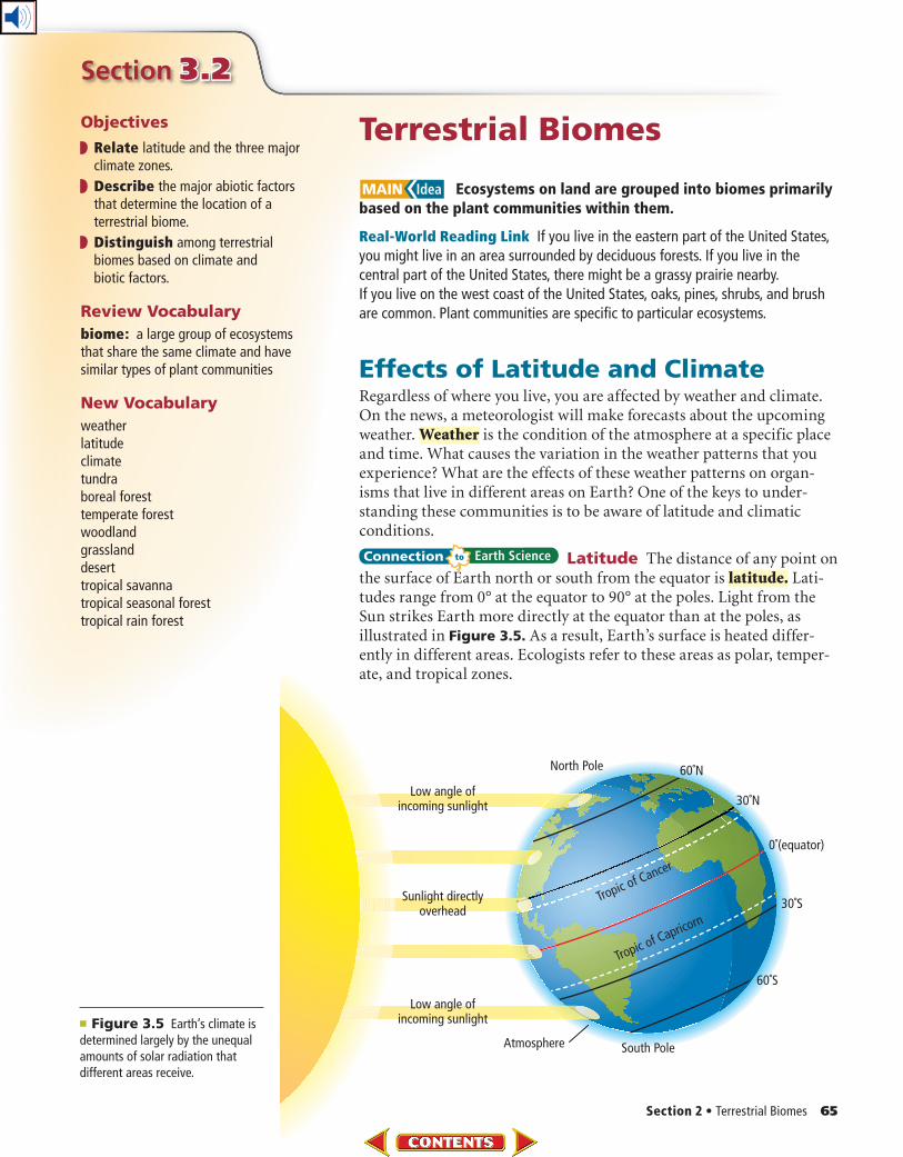
Effects of Latitude and ClimateRegardless of where you live, you are affected by weather and climate. On the news, a meteorologist will make forecasts about the upcoming weather. Weather is the condition of the atmosphere at a specific place and time. What causes the variation in the weather patterns that you experience? What are the effects of these weather patterns on organ-isms that live in different areas on Earth? One of the keys to under-standing these communities is to be aware of latitude and climatic conditions.
Latitude The distance of any point on the surface of Earth north or south from the equator is latitude. Lati-tudes range from 0° at the equator to 90° at the poles. Light from the Sun strikes Earth more directly at the equator than at the poles, as illustrated in Figure 3.5. As a result, Earth’s surface is heated differ-ently in different areas. Ecologists refer to these areas as polar, temper-ate, and tropical zones.
Objectives
Relate latitude and the three major climate zones.
Describe the major abiotic factors that determine the location of a terrestrial biome.
Distinguish among terrestrial biomes based on climate and biotic factors.
Review Vocabulary
biome: a large group of ecosystems that share the same climate and have similar types of plant communities
New Vocabulary
weatherlatitudeclimatetundraboreal foresttemperate forestwoodlandgrasslanddeserttropical savannatropical seasonal foresttropical rain forest
66 Chapter 3 • Communities, Biomes, and Ecosystems
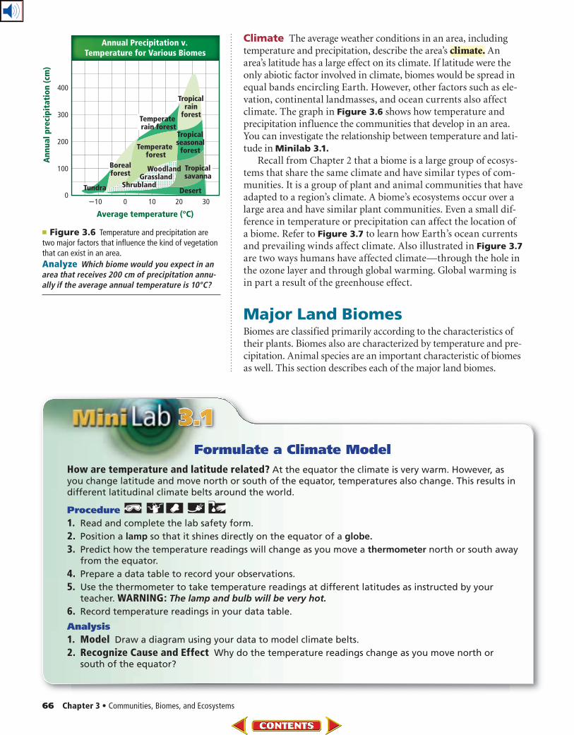
■ Figure 3.6 Temperature and precipitation are two major factors that influence the kind of vegetation that can exist in an area.
Analyze Which biome would you expect in an area that receives 200 cm of precipitation annu-ally if the average annual temperature is 10°C?
Climate The average weather conditions in an area, including temperature and precipitation, describe the area’s climate. An area’s latitude has a large effect on its climate. If latitude were the only abiotic factor involved in climate, biomes would be spread in equal bands encircling Earth. However, other factors such as ele-vation, continental landmasses, and ocean currents also affect climate. The graph in Figure 3.6 shows how temperature and precipitation influence the communities that develop in an area. You can investigate the relationship between temperature and lati-tude in Minilab 3.1.
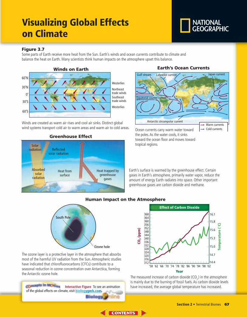
Recall from Chapter 2 that a biome is a large group of ecosys-tems that share the same climate and have similar types of com-munities. It is a group of plant and animal communities that have adapted to a region’s climate. A biome’s ecosystems occur over a large area and have similar plant communities. Even a small dif-ference in temperature or precipitation can affect the location of a biome. Refer to Figure 3.7 to learn how Earth’s ocean currents and prevailing winds affect climate. Also illustrated in Figure 3.7 are two ways humans have affected climate—through the hole in the ozone layer and through global warming. Global warming is in part a result of the greenhouse effect.
Major Land BiomesBiomes are classified primarily according to the characteristics of their plants. Biomes also are characterized by temperature and pre-cipitation. Animal species are an important characteristic of biomes as well. This section describes each of the major land biomes.
Formulate a Climate Model
How are temperature and latitude related? At the equator the climate is very warm. However, as you change latitude and move north or south of the equator, temperatures also change. This results in different latitudinal climate belts around the world.
Procedure
1. Read and complete the lab safety form.
2. Position a lamp so that it shines directly on the equator of a globe.
3. Predict how the temperature readings will change as you move a thermometer north or south away from the equator.
4. Prepare a data table to record your observations.
5. Use the thermometer to take temperature readings at different latitudes as instructed by your teacher. WARNING: The lamp and bulb will be very hot.
6. Record temperature readings in your data table.
Analysis
1. Model Draw a diagram using your data to model climate belts.
2. Recognize Cause and Effect Why do the temperature readings change as you move north or south of the equator?
Section 2 • Terrestrial Biomes 67
Visualizing Global Effects on Climate
Figure 3.7Some parts of Earth receive more heat from the Sun. Earth’s winds and ocean currents contribute to climate and balance the heat on Earth. Many scientists think human impacts on the atmosphere upset this balance.
Interactive Figure To see an animation of the global effects on climate, visit biologygmh.com.
Winds are created as warm air rises and cool air sinks. Distinct global wind systems transport cold air to warm areas and warm air to cold areas.
Ocean currents carry warm water toward the poles. As the water cools, it sinks toward the ocean floor and moves toward tropical regions.
Earth’s surface is warmed by the greenhouse effect. Certain gases in Earth’s atmosphere, primarily water vapor, reduce the amount of energy Earth radiates into space. Other important greenhouse gases are carbon dioxide and methane.
The ozone layer is a protective layer in the atmosphere that absorbs most of the harmful UV radiation from the Sun. Atmospheric studies have indicated that chlorofluorocarbons (CFCs) contribute to a seasonal reduction in ozone concentration over Antarctica, forming the Antarctic ozone hole.
The measured increase of carbon dioxide (CO2) in the atmosphere
is mainly due to the burning of fossil fuels. As carbon dioxide levels have increased, the average global temperature has increased.
60˚N
60˚S
30˚S
30˚N
0˚ EquatorSoutheasttrade winds
Northeasttrade winds
Westerlies
Westerlies
Winds on Earth Earth’s Ocean Currents
Warm currents
Gulf stream Japan currentLabrador current
Antarctic circumpolar current
Cold currents
Equatorial counter current
320316
328324
336332
340
368364360356352348344
16.1
15.8
15.6
15.3
15.0
14.7
14.4
Tem
pe
ratu
re (
°C
)
312'58 '62 '66 '70 '74 '78 '82 '86 '90 '94 '98 '02
Year
CO
2 (
pp
m)
Effect of Carbon Dioxide
South Pole
Ozone hole
Greenhouse Effect
Heat trapped bygreenhouse
gases
Absorbedsolar
radiation
Solarradiation Reflected
solar radiation
Heat fromsurface
Human Impact on the Atmosphere
68 Chapter 3 • Communities, Biomes, and Ecosystems
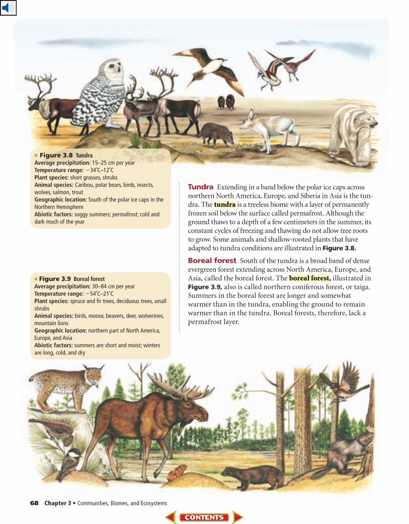
Tundra Extending in a band below the polar ice caps across northern North America, Europe, and Siberia in Asia is the tun-dra. The tundra is a treeless biome with a layer of permanently frozen soil below the surface called permafrost. Although the ground thaws to a depth of a few centimeters in the summer, its constant cycles of freezing and thawing do not allow tree roots to grow. Some animals and shallow-rooted plants that have adapted to tundra conditions are illustrated in Figure 3.8.
Boreal forest South of the tundra is a broad band of dense evergreen forest extending across North America, Europe, and Asia, called the boreal forest. The boreal forest, illustrated in Figure 3.9, also is called northern coniferous forest, or taiga. Summers in the boreal forest are longer and somewhat warmer than in the tundra, enabling the ground to remain warmer than in the tundra. Boreal forests, therefore, lack a permafrost layer.
■ Figure 3.8 TundraAverage precipitation: 15–25 cm per yearTemperature range: �34˚C –12˚CPlant species: short grasses, shrubsAnimal species: Caribou, polar bears, birds, insects, wolves, salmon, troutGeographic location: South of the polar ice caps in the Northern HemisphereAbiotic factors: soggy summers; permafrost; cold and dark much of the year
■ Figure 3.9 Boreal forestAverage precipitation: 30–84 cm per yearTemperature range: �54˚C–21˚CPlant species: spruce and fir trees, deciduous trees, small shrubsAnimal species: birds, moose, beavers, deer, wolverines, mountain lionsGeographic location: northern part of North America, Europe, and AsiaAbiotic factors: summers are short and moist; winters are long, cold, and dry
Section 2 • Terrestrial Biomes 69
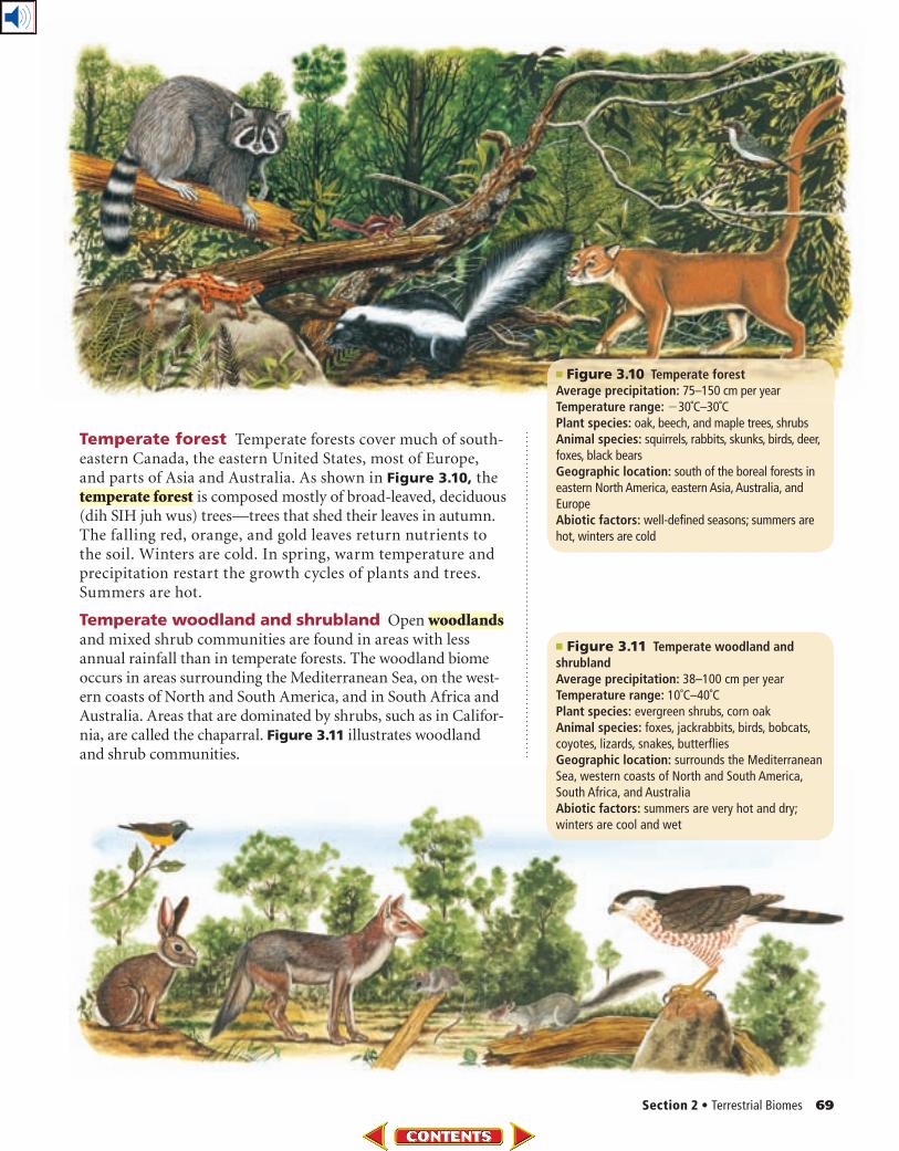
Temperate forest Temperate forests cover much of south-eastern Canada, the eastern United States, most of Europe, and parts of Asia and Australia. As shown in Figure 3.10, the temperate forest is composed mostly of broad-leaved, deciduous (dih SIH juh wus) trees—trees that shed their leaves in autumn. The falling red, orange, and gold leaves return nutrients to the soil. Winters are cold. In spring, warm temperature and precipitation restart the growth cycles of plants and trees. Summers are hot.
Temperate woodland and shrubland Open woodlands and mixed shrub communities are found in areas with less annual rainfall than in temperate forests. The woodland biome occurs in areas surrounding the Mediterranean Sea, on the west-ern coasts of North and South America, and in South Africa and Australia. Areas that are dominated by shrubs, such as in Califor-nia, are called the chaparral. Figure 3.11 illustrates woodland and shrub communities.
■ Figure 3.10 Temperate forestAverage precipitation: 75–150 cm per yearTemperature range: �30˚C–30˚CPlant species: oak, beech, and maple trees, shrubsAnimal species: squirrels, rabbits, skunks, birds, deer, foxes, black bearsGeographic location: south of the boreal forests in eastern North America, eastern Asia, Australia, and EuropeAbiotic factors: well-defined seasons; summers are hot, winters are cold
■ Figure 3.11 Temperate woodland and shrublandAverage precipitation: 38–100 cm per yearTemperature range: 10˚C–40˚CPlant species: evergreen shrubs, corn oakAnimal species: foxes, jackrabbits, birds, bobcats, coyotes, lizards, snakes, butterfliesGeographic location: surrounds the Mediterranean Sea, western coasts of North and South America, South Africa, and AustraliaAbiotic factors: summers are very hot and dry; winters are cool and wet
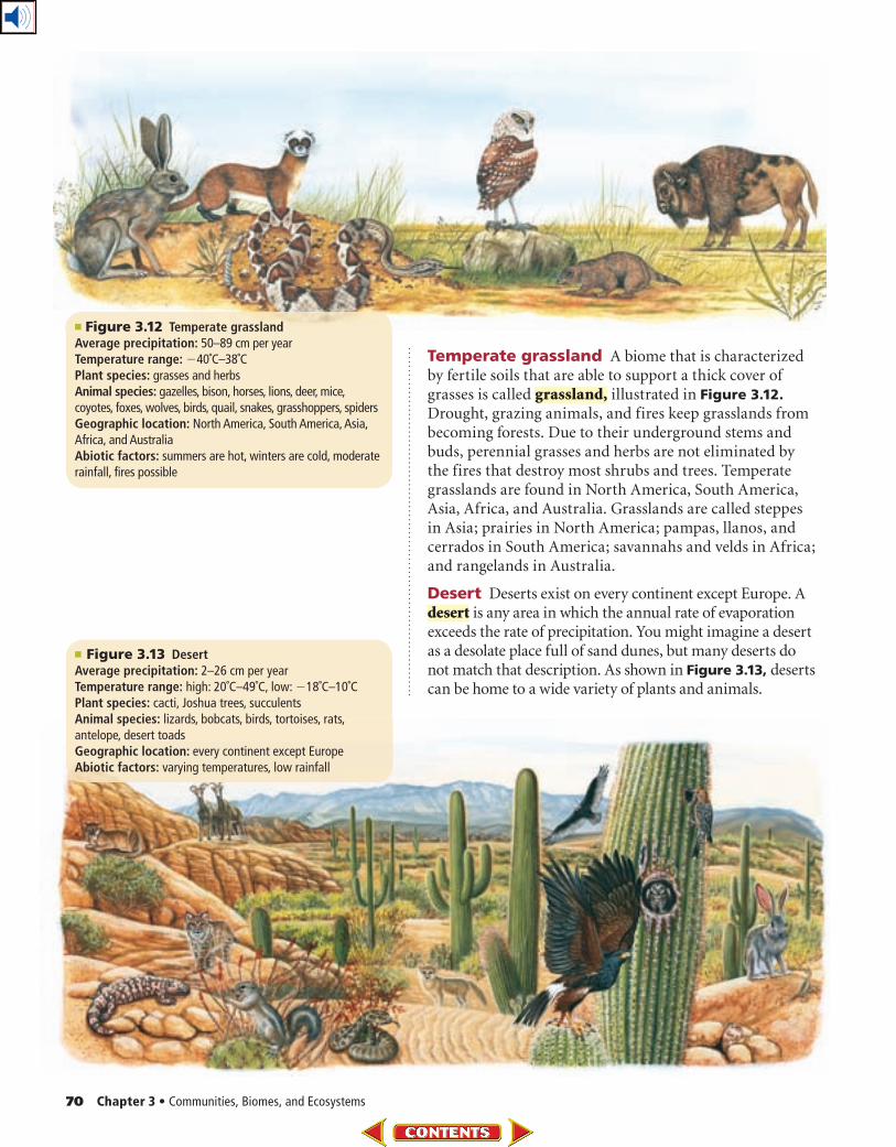
70 Chapter 3 • Communities, Biomes, and Ecosystems
Temperate grassland A biome that is characterized by fertile soils that are able to support a thick cover of grasses is called grassland, illustrated in Figure 3.12. Drought, grazing animals, and fires keep grasslands from becoming forests. Due to their underground stems and buds, perennial grasses and herbs are not eliminated by the fires that destroy most shrubs and trees. Temperate grasslands are found in North America, South America, Asia, Africa, and Australia. Grasslands are called steppes in Asia; prairies in North America; pampas, llanos, and cerrados in South America; savannahs and velds in Africa; and rangelands in Australia.
Desert Deserts exist on every continent except Europe. A desert is any area in which the annual rate of evaporation exceeds the rate of precipitation. You might imagine a desert as a desolate place full of sand dunes, but many deserts do not match that description. As shown in Figure 3.13, deserts can be home to a wide variety of plants and animals.
■ Figure 3.12 Temperate grasslandAverage precipitation: 50–89 cm per yearTemperature range: �40˚C–38˚CPlant species: grasses and herbsAnimal species: gazelles, bison, horses, lions, deer, mice, coyotes, foxes, wolves, birds, quail, snakes, grasshoppers, spidersGeographic location: North America, South America, Asia, Africa, and AustraliaAbiotic factors: summers are hot, winters are cold, moderate rainfall, fires possible
■ Figure 3.13 DesertAverage precipitation: 2–26 cm per yearTemperature range: high: 20˚C–49˚C, low: �18˚C–10˚CPlant species: cacti, Joshua trees, succulentsAnimal species: lizards, bobcats, birds, tortoises, rats, antelope, desert toadsGeographic location: every continent except EuropeAbiotic factors: varying temperatures, low rainfall
Section 2 • Terrestrial Biomes 71
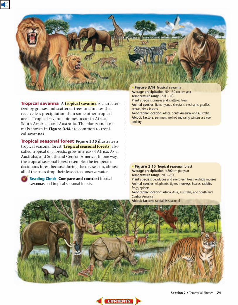
Tropical savanna A tropical savanna is character-ized by grasses and scattered trees in climates that receive less precipitation than some other tropical areas. Tropical savanna biomes occur in Africa, South America, and Australia. The plants and ani-mals shown in Figure 3.14 are common to tropi-cal savannas.
Tropical seasonal forest Figure 3.15 illustrates a tropical seasonal forest. Tropical seasonal forests, also called tropical dry forests, grow in areas of Africa, Asia, Australia, and South and Central America. In one way, the tropical seasonal forest resembles the temperate deciduous forest because during the dry season, almost all of the trees drop their leaves to conserve water.
Reading Check Compare and contrast tropical savannas and tropical seasonal forests.
■ Figure 3.14 Tropical savannaAverage precipitation: 50–130 cm per yearTemperature range: 20˚C–30˚CPlant species: grasses and scattered treesAnimal species: lions, hyenas, cheetahs, elephants, giraffes, zebras, birds, insectsGeographic location: Africa, South America, and AustraliaAbiotic factors: summers are hot and rainy, winters are cool and dry
■ Figure 3.15 Tropical seasonal forestAverage precipitation: >200 cm per yearTemperature range: 20˚C–25˚CPlant species: deciduous and evergreen trees, orchids, mossesAnimal species: elephants, tigers, monkeys, koalas, rabbits, frogs, spidersGeographic location: Africa, Asia, Australia, and South and Central AmericaAbiotic factors: rainfall is seasonal
72 Chapter 3 • Communities, Biomes, and Ecosystems
■ Figure 3.17 As you climb a mountain or increase in latitude, the temperature drops and the climate changes.
Describe the relationship between altitude and latitude.
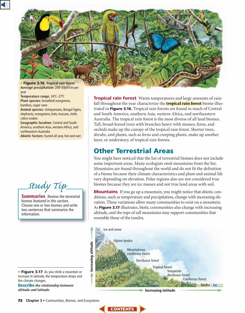
Tropical rain forest Warm temperatures and large amounts of rain-fall throughout the year characterize the tropical rain forest biome illus-trated in Figure 3.16. Tropical rain forests are found in much of Central and South America, southern Asia, western Africa, and northeastern Australia. The tropical rain forest is the most diverse of all land biomes. Tall, broad-leaved trees with branches heavy with mosses, ferns, and orchids make up the canopy of the tropical rain forest. Shorter trees, shrubs, and plants, such as ferns and creeping plants, make up another layer, or understory, of tropical rain forests.
Other Terrestrial AreasYou might have noticed that the list of terrestrial biomes does not include some important areas. Many ecologists omit mountains from the list. Mountains are found throughout the world and do not fit the definition of a biome because their climate characteristics and plant and animal life vary depending on elevation. Polar regions also are not considered true biomes because they are ice masses and not true land areas with soil.
Mountains If you go up a mountain, you might notice that abiotic con-ditions, such as temperature and precipitation, change with increasing ele-vation. These variations allow many communities to exist on a mountain. As Figure 3.17 illustrates, biotic communities also change with increasing altitude, and the tops of tall mountains may support communities that resemble those of the tundra.
Summaries Review the terrestrial biomes featured in this section. Choose one or two biomes and write two sentences that summarize the information.
Study Tip
■ Figure 3.16 Tropical rain forestAverage precipitation: 200–1000 cm per yearTemperature range: 24˚C–27˚CPlant species: broadleaf evergreens, bamboo, sugar caneAnimal species: chimpanzees, Bengal tigers, elephants, orangutans, bats, toucans, sloth, cobra snakesGeographic location: Central and South America, southern Asia, western Africa, and northeastern AustraliaAbiotic factors: humid all year, hot and wet
Section 2 • Terrestrial Biomes 73
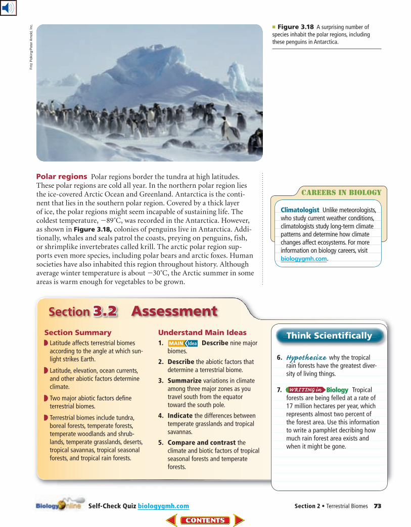
■ Figure 3.18 A surprising number of species inhabit the polar regions, including these penguins in Antarctica.
Polar regions Polar regions border the tundra at high latitudes. These polar regions are cold all year. In the northern polar region lies the ice-covered Arctic Ocean and Greenland. Antarctica is the conti-nent that lies in the southern polar region. Covered by a thick layer of ice, the polar regions might seem incapable of sustaining life. The coldest temperature, �89˚C, was recorded in the Antarctica. However, as shown in Figure 3.18, colonies of penguins live in Antarctica. Addi-tionally, whales and seals patrol the coasts, preying on penguins, fish, or shrimp like invertebrates called krill. The arctic polar region sup-ports even more species, including polar bears and arctic foxes. Human societies have also inhabited this region throughout history. Although average winter temperature is about �30˚C, the Arctic summer in some areas is warm enough for vegetables to be grown.
Section 3.2 Assessment
Section Summary
◗ Latitude affects terrestrial biomes according to the angle at which sun-light strikes Earth.
◗ Latitude, elevation, ocean currents, and other abiotic factors determine climate.
◗ Two major abiotic factors define terrestrial biomes.
◗ Terrestrial biomes include tundra, boreal forests, temperate forests, temperate woodlands and shrub-lands, temperate grasslands, deserts, tropical savannas, tropical seasonal forests, and tropical rain forests.
Understand Main Ideas
1. Describe nine major biomes.
2. Describe the abiotic factors that determine a terrestrial biome.
3. Summarize variations in climate among three major zones as you travel south from the equator toward the south pole.
4. Indicate the differences between temperate grasslands and tropical savannas.
5. Compare and contrast the climate and biotic factors of tropical seasonal forests and temperate forests.
Think Scientifically
6. Hypothesize why the tropical rain forests have the greatest diver-sity of living things.
7. Tropical forests are being felled at a rate of 17 million hectares per year, which represents almost two percent of the forest area. Use this information to write a pamphlet decribing how much rain forest area exists and when it might be gone.
Careers In biology
Climatologist Unlike meteorol ogists, who study current weather conditions, climatologists study long-term climate patterns and determine how climate changes affect eco systems. For more information on biology careers, visit biologygmh.com.
Self-Check Quiz biologygmh.com
Fritz
Po
lkin
g/P
ete
r A
rno
ld,
Inc.
74 Chapter 3 • Communities, Biomes, and Ecosystems
Aquatic Ecosystems
Aquatic ecosystems are grouped based on abiotic
factors such as water flow, depth, distance from shore, salinity,
and latitude.
Real-World Reading Link Think about the body of water that is closest to where you live. What are its characteristics? How deep is it? Is it freshwater or salty? For centuries, bodies of water have been central to cultures around the world.
The Water on EarthWhen you think about water on Earth, you might recall a vacation at the ocean or a geography lesson in which you located Earth’s oceans and seas. You probably have heard about other large bodies of water, such as the Amazon river and the Great Salt Lake. A globe of Earth is mainly blue in color because the planet is largely covered with water. Ecologists recognize the importance of water because of the biological communities that water supports. In this section, you will read about freshwater, transitional, and marine aquatic ecosystems. You also will read about the abiotic factors that affect these ecosystems.
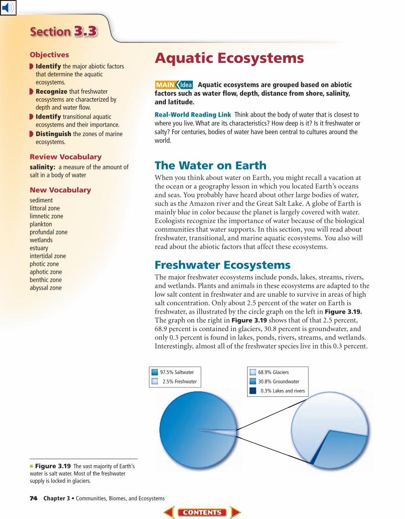
Freshwater EcosystemsThe major freshwater ecosystems include ponds, lakes, streams, rivers, and wetlands. Plants and animals in these ecosystems are adapted to the low salt content in freshwater and are unable to survive in areas of high salt concentration. Only about 2.5 percent of the water on Earth is freshwater, as illustrated by the circle graph on the left in Figure 3.19. The graph on the right in Figure 3.19 shows that of that 2.5 percent, 68.9 percent is contained in glaciers, 30.8 percent is groundwater, and only 0.3 percent is found in lakes, ponds, rivers, streams, and wetlands. Interestingly, almost all of the freshwater species live in this 0.3 percent.
■ Figure 3.19 The vast majority of Earth’s water is salt water. Most of the freshwater supply is locked in glaciers.
Section 3.3
Objectives
Identify the major abiotic factors that determine the aquatic ecosystems.
Recognize that freshwater ecosystems are characterized by depth and water flow.
Identify transitional aquatic ecosystems and their importance.
Distinguish the zones of marine ecosystems.
Review Vocabulary
salinity: a measure of the amount of salt in a body of water
New Vocabulary
sedimentlittoral zonelimnetic zoneplanktonprofundal zonewetlandsestuaryintertidal zonephotic zoneaphotic zonebenthic zoneabyssal zone
Section 3 • Aquatic Ecosystems 75
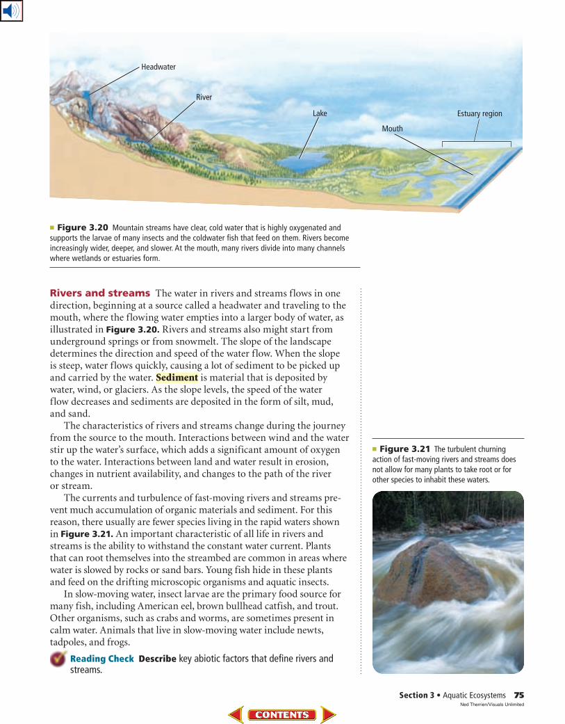
■ Figure 3.20 Mountain streams have clear, cold water that is highly oxygenated and supports the larvae of many insects and the coldwater fish that feed on them. Rivers become increasingly wider, deeper, and slower. At the mouth, many rivers divide into many channels where wetlands or estuaries form.
Rivers and streams The water in rivers and streams flows in one direction, beginning at a source called a headwater and traveling to the mouth, where the flowing water empties into a larger body of water, as illustrated in Figure 3.20. Rivers and streams also might start from underground springs or from snowmelt. The slope of the landscape determines the direction and speed of the water flow. When the slope is steep, water flows quickly, causing a lot of sediment to be picked up and carried by the water. Sediment is material that is deposited by water, wind, or glaciers. As the slope levels, the speed of the water flow decreases and sediments are deposited in the form of silt, mud, and sand.
The characteristics of rivers and streams change during the journey from the source to the mouth. Interactions between wind and the water stir up the water’s surface, which adds a significant amount of oxygen to the water. Interactions between land and water result in erosion, changes in nutrient availability, and changes to the path of the river or stream.
The currents and turbulence of fast-moving rivers and streams pre-vent much accumulation of organic materials and sediment. For this reason, there usually are fewer species living in the rapid waters shown in Figure 3.21. An important characteristic of all life in rivers and streams is the ability to withstand the constant water current. Plants that can root themselves into the streambed are common in areas where water is slowed by rocks or sand bars. Young fish hide in these plants and feed on the drifting microscopic organisms and aquatic insects.
In slow-moving water, insect larvae are the primary food source for many fish, including American eel, brown bullhead catfish, and trout. Other organisms, such as crabs and worms, are sometimes present in calm water. Animals that live in slow-moving water include newts, tadpoles, and frogs.
Reading Check Describe key abiotic factors that define rivers and streams.
■ Figure 3.21 The turbulent churning action of fast-moving rivers and streams does not allow for many plants to take root or for other species to inhabit these waters.
Ned Therrien/Visuals Unlimited
76 Chapter 3 • Communities, Biomes, and Ecosystems
Summer Stratification
Winter Stratification
Wind
Wind
Wind
Wind
24˚–25˚C13˚–18˚C5˚–8˚C
Spring Overturn Fall Overturn
most of lake4˚C
2˚–3˚C
Ice
■ Figure 3.22 The temperature of lakes and ponds varies depending on the season. During spring and autumn, deep water receives oxygen from the surface water and surface water receives inorganic nutrients from the deep water.
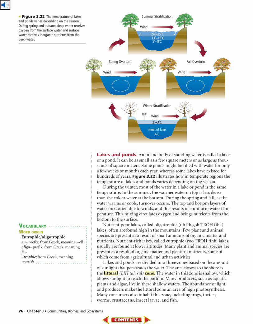
Lakes and ponds An inland body of standing water is called a lake or a pond. It can be as small as a few square meters or as large as thou-sands of square meters. Some ponds might be filled with water for only a few weeks or months each year, whereas some lakes have existed for hundreds of years. Figure 3.22 illustrates how in temperate regions the temperature of lakes and ponds varies depending on the season.
During the winter, most of the water in a lake or pond is the same temperature. In the summer, the warmer water on top is less dense than the colder water at the bottom. During the spring and fall, as the water warms or cools, turnover occurs. The top and bottom layers of water mix, often due to winds, and this results in a uniform water tem-perature. This mixing circulates oxygen and brings nutrients from the bottom to the surface.
Nutrient-poor lakes, called oligotrophic (uh lih goh TROH fihk) lakes, often are found high in the mountains. Few plant and animal species are present as a result of small amounts of organic matter and nutrients. Nutrient-rich lakes, called eutrophic (yoo TROH fihk) lakes, usually are found at lower altitudes. Many plant and animal species are present as a result of organic matter and plentiful nutrients, some of which come from agricultural and urban activities.
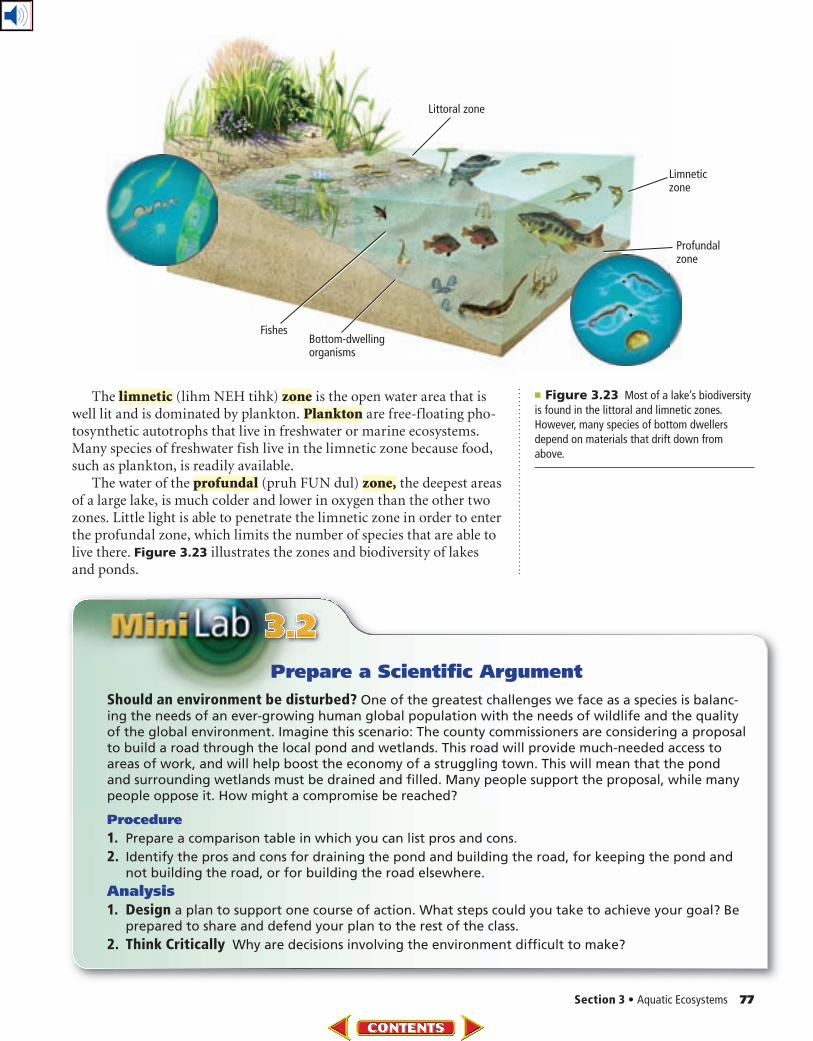
Lakes and ponds are divided into three zones based on the amount of sunlight that penetrates the water. The area closest to the shore is the littoral (LIH tuh rul) zone. The water in this zone is shallow, which allows sunlight to reach the bottom. Many producers, such as aquatic plants and algae, live in these shallow waters. The abundance of light and producers make the littoral zone an area of high photosynthesis. Many consumers also inhabit this zone, including frogs, turtles, worms, crustaceans, insect larvae, and fish.
VOCABULARY
WORD ORIGIN
Eutrophic/oligotrophiceu – prefix; from Greek, meaning well
oligo – prefix; from Greek, meaning
few
–trophic; from Greek, meaning
nourish.
Section 3 • Aquatic Ecosystems 77
The limnetic (lihm NEH tihk) zone is the open water area that is well lit and is dominated by plankton. Plankton are free-floating pho-tosynthetic autotrophs that live in freshwater or marine ecosystems. Many species of freshwater fish live in the limnetic zone because food, such as plankton, is readily available.
The water of the profundal (pruh FUN dul) zone, the deepest areas of a large lake, is much colder and lower in oxygen than the other two zones. Little light is able to penetrate the limnetic zone in order to enter the profundal zone, which limits the number of species that are able to live there. Figure 3.23 illustrates the zones and biodiversity of lakes and ponds.
Prepare a Scientific Argument
Should an environment be disturbed? One of the greatest challenges we face as a species is balanc-ing the needs of an ever-growing human global population with the needs of wildlife and the quality of the global environment. Imagine this scenario: The county commissioners are considering a proposal to build a road through the local pond and wetlands. This road will provide much-needed access to areas of work, and will help boost the economy of a struggling town. This will mean that the pond and surrounding wetlands must be drained and filled. Many people support the proposal, while many people oppose it. How might a compromise be reached?
Procedure
1. Prepare a comparison table in which you can list pros and cons.
2. Identify the pros and cons for draining the pond and building the road, for keeping the pond and not building the road, or for building the road elsewhere.
Analysis
1. Design a plan to support one course of action. What steps could you take to achieve your goal? Be prepared to share and defend your plan to the rest of the class.
2. Think Critically Why are decisions involving the environment difficult to make?
■ Figure 3.23 Most of a lake’s biodiversity is found in the littoral and limnetic zones. However, many species of bottom dwellers depend on materials that drift down from above.
■ Figure 3.25 Salt-tolerant plants above the high-tide line dominate estuaries formed in temperate areas.
Infer How would an estuary differ in a tropical area?
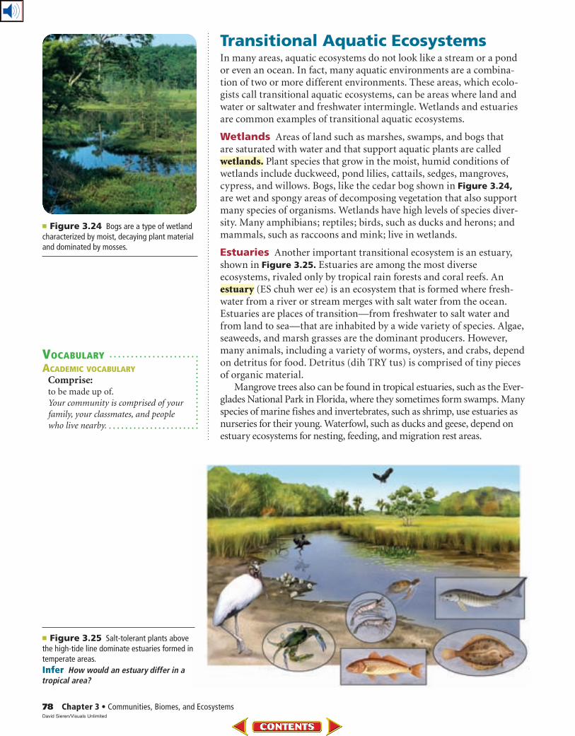
Transitional Aquatic EcosystemsIn many areas, aquatic ecosystems do not look like a stream or a pond or even an ocean. In fact, many aquatic environments are a combina-tion of two or more different environments. These areas, which ecolo-gists call transitional aquatic ecosystems, can be areas where land and water or saltwater and freshwater intermingle. Wetlands and estuaries are common examples of transitional aquatic ecosystems.
Wetlands Areas of land such as marshes, swamps, and bogs that are saturated with water and that support aquatic plants are called wetlands. Plant species that grow in the moist, humid conditions of wetlands include duckweed, pond lilies, cattails, sedges, mangroves, cypress, and willows. Bogs, like the cedar bog shown in Figure 3.24, are wet and spongy areas of decomposing vegetation that also support many species of organisms. Wetlands have high levels of species diver-sity. Many amphibians; reptiles; birds, such as ducks and herons; and mammals, such as raccoons and mink; live in wetlands.
Estuaries Another important transitional ecosystem is an estuary, shown in Figure 3.25. Estuaries are among the most diverse ecosystems, rivaled only by tropical rain forests and coral reefs. An estuary (ES chuh wer ee) is an ecosystem that is formed where fresh-water from a river or stream merges with salt water from the ocean. Estuaries are places of transition—from freshwater to salt water and from land to sea—that are inhabited by a wide variety of species. Algae, seaweeds, and marsh grasses are the dominant producers. However, many animals, including a variety of worms, oysters, and crabs, depend on detritus for food. Detritus (dih TRY tus) is comprised of tiny pieces of organic material.
Mangrove trees also can be found in tropical estuaries, such as the Ever-glades National Park in Florida, where they sometimes form swamps. Many species of marine fishes and invertebrates, such as shrimp, use estuaries as nurseries for their young. Waterfowl, such as ducks and geese, depend on estuary ecosystems for nesting, feeding, and migration rest areas.
VOCABULARY
ACADEMIC VOCABULARY
Comprise:to be made up of.
Your community is comprised of your
family, your classmates, and people
who live nearby.
■ Figure 3.24 Bogs are a type of wetland characterized by moist, decaying plant material and dominated by mosses.
78 Chapter 3 • Communities, Biomes, and EcosystemsDavid Sieren/Visuals Unlimited
Section 3 • Aquatic Ecosystems 79
■ Figure 3.26 The intertidal zone is further divided into zones where different communities exist.
Compare and contrast the zones illustrated in Figures 3.23 and 3.26.
Salt marshes are transitional ecosystems similar to estuaries. Salt-tolerant grasses dominate above the low-tide line, and seagrasses grow in submerged areas of salt marshes. Salt marshes support different species of animals, such as shrimp and shellfish.
Marine Ecosystems Earth is sometimes called “the water
planet.” As such, marine ecosystems have a significant impact on the planet. For example, through photosynthesis, marine algae consume carbon dioxide from the atmosphere and produce over 50 percent of the atmosphere’s oxygen. Additionally, the evaporation of water from oceans eventually provides the majority of precipitation—rain and snow. Like ponds and lakes, oceans are separated into distinct zones.
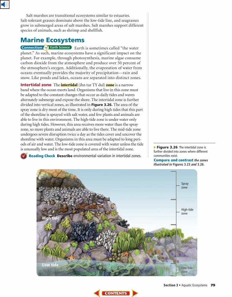
Intertidal zone The intertidal (ihn tur TY dul) zone is a narrow band where the ocean meets land. Organisms that live in this zone must be adapted to the constant changes that occur as daily tides and waves alternately submerge and expose the shore. The intertidal zone is further divided into vertical zones, as illustrated in Figure 3.26. The area of the spray zone is dry most of the time. It is only during high tides that this part of the shoreline is sprayed with salt water, and few plants and animals are able to live in this environment. The high-tide zone is under water only during high tides. However, this area receives more water than the spray zone, so more plants and animals are able to live there. The mid-tide zone undergoes severe disruption twice a day as the tides cover and uncover the shoreline with water. Organisms in this area must be adapted to long peri-ods of air and water. The low-tide zone is covered with water unless the tide is unusually low and is the most populated area of the intertidal zone.
Reading Check Describe environmental variation in intertidal zones.
80 Chapter 3 • Communities, Biomes, and Ecosystems
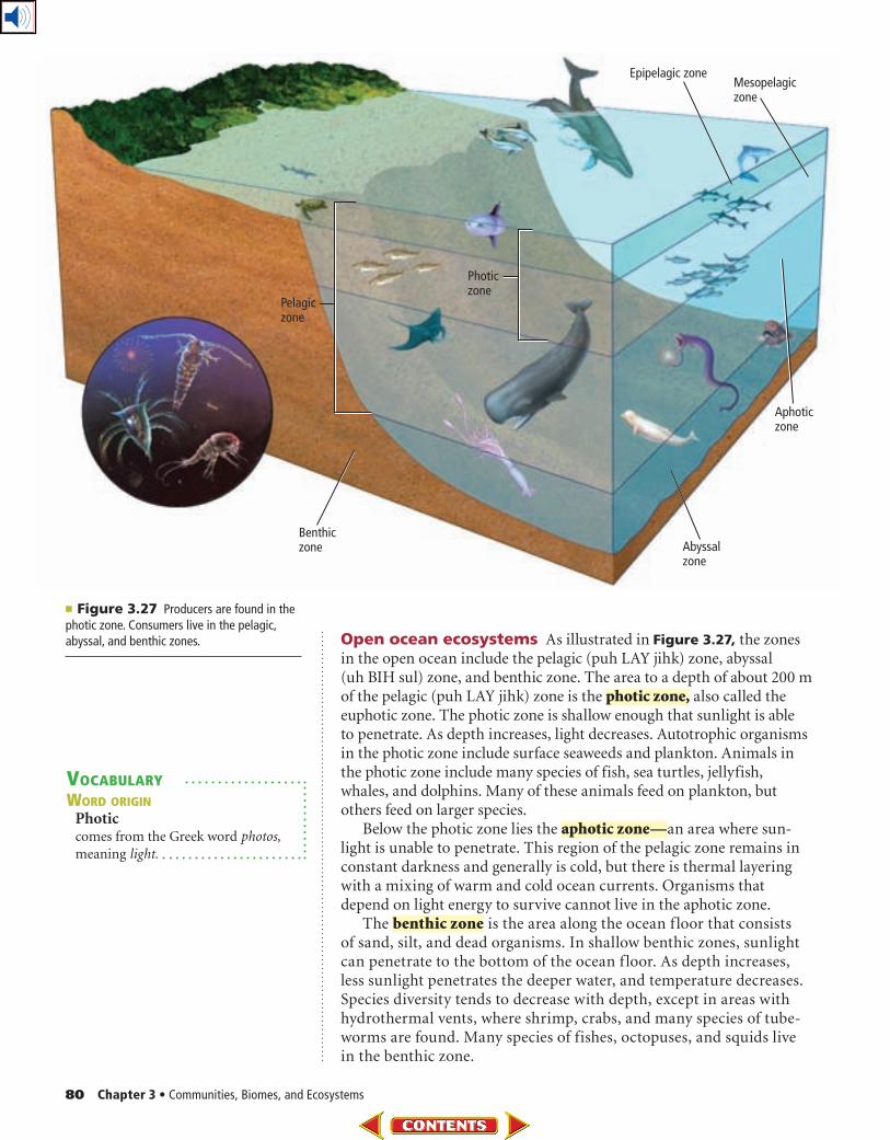
■ Figure 3.27 Producers are found in the photic zone. Consumers live in the pelagic, abyssal, and benthic zones. Open ocean ecosystems As illustrated in Figure 3.27, the zones
in the open ocean include the pelagic (puh LAY jihk) zone, abyssal (uh BIH sul) zone, and benthic zone. The area to a depth of about 200 m of the pelagic (puh LAY jihk) zone is the photic zone, also called the euphotic zone. The photic zone is shallow enough that sunlight is able to penetrate. As depth increases, light decreases. Autotrophic organisms in the photic zone include surface seaweeds and plankton. Animals in the photic zone include many species of fish, sea turtles, jellyfish, whales, and dolphins. Many of these animals feed on plankton, but others feed on larger species.
Below the photic zone lies the aphotic zone—an area where sun-light is unable to penetrate. This region of the pelagic zone remains in constant darkness and generally is cold, but there is thermal layering with a mixing of warm and cold ocean currents. Organisms that depend on light energy to survive cannot live in the aphotic zone.
The benthic zone is the area along the ocean f loor that consists of sand, silt, and dead organisms. In shallow benthic zones, sunlight can penetrate to the bottom of the ocean f loor. As depth increases, less sunlight penetrates the deeper water, and temperature decreases. Species diversity tends to decrease with depth, except in areas with hydrothermal vents, where shrimp, crabs, and many species of tube-worms are found. Many species of fishes, octopuses, and squids live in the benthic zone.
VOCABULARY
WORD ORIGIN
Photic comes from the Greek word photos,
meaning light.
Section 3 • Aquatic Ecosystems 81
The deepest region of the ocean is called the abyssal zone. Water in this area is very cold. Most organisms in this zone rely on food materi-als that drift down from the zones above. However, on the seafloor along the boundaries of Earth’s plates, hydrothermal vents spew large amounts of hot water, hydrogen sulfide, and other minerals. Scientists have found bacterial communities existing in these locations that can use the sulfide molecules for energy. These organisms are at the bottom of a food chain that includes invertebrates, such as clams and crabs, and vertebrates, such as fishes.
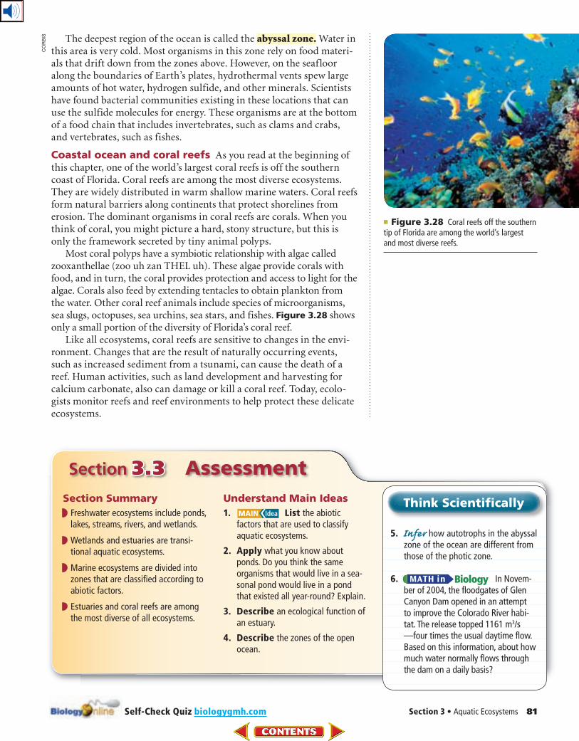
Coastal ocean and coral reefs As you read at the beginning of this chapter, one of the world’s largest coral reefs is off the southern coast of Florida. Coral reefs are among the most diverse ecosystems. They are widely distributed in warm shallow marine waters. Coral reefs form natural barriers along continents that protect shorelines from erosion. The dominant organisms in coral reefs are corals. When you think of coral, you might picture a hard, stony structure, but this is only the framework secreted by tiny animal polyps.
Most coral polyps have a symbiotic relationship with algae called zooxanthellae (zoo uh zan THEL uh). These algae provide corals with food, and in turn, the coral provides protection and access to light for the algae. Corals also feed by extending tentacles to obtain plankton from the water. Other coral reef animals include species of microorganisms, sea slugs, octopuses, sea urchins, sea stars, and fishes. Figure 3.28 shows only a small portion of the diversity of Florida’s coral reef.
Like all ecosystems, coral reefs are sensitive to changes in the envi-ronment. Changes that are the result of naturally occurring events, such as increased sediment from a tsunami, can cause the death of a reef. Human activities, such as land development and harvesting for calcium carbonate, also can damage or kill a coral reef. Today, ecolo-gists monitor reefs and reef environments to help protect these delicate ecosystems.
Section 3.3 Assessment
Section Summary
◗ Freshwater ecosystems include ponds, lakes, streams, rivers, and wetlands.
◗ Wetlands and estuaries are transi-tional aquatic ecosystems.
◗ Marine ecosystems are divided into zones that are classified according to abiotic factors.
◗ Estuaries and coral reefs are among the most diverse of all ecosystems.
Understand Main Ideas
1. List the abiotic factors that are used to classify aquatic ecosystems.
2. Apply what you know about ponds. Do you think the same organisms that would live in a sea-sonal pond would live in a pond that existed all year-round? Explain.
3. Describe an ecological function of an estuary.
4. Describe the zones of the open ocean.
Think Scientifically
5. Infer how autotrophs in the abyssal zone of the ocean are different from those of the photic zone.
6. In Novem-ber of 2004, the floodgates of Glen Canyon Dam opened in an attempt to improve the Colorado River habi-tat. The release topped 1161 m3/s—four times the usual daytime flow. Based on this information, about how much water normally flows through the dam on a daily basis?
■ Figure 3.28 Coral reefs off the southern tip of Florida are among the world’s largest and most diverse reefs.
Self-Check Quiz biologygmh.com
CO
RB
IS
In the Field
82 Chapter 3 • Communities, Biomes, and Ecosystems
Oral Report Visit biologygmh.com
for links to video and images from
the Megatransect. Develop an oral
presentation describing the skills
and knowledge that made the
project a success.
Imagine you are hiking through a dense
forest, thick with undergrowth and trailing
vines. There are no roads or even foot paths.
Sound like a nightmare? To wildlife conser-
vation biologist Dr. Michael Fay, it’s paradise.
Megatransect Dr. Fay is a conservation
biologist who studies how human activities
affect ecosystems. While working in central
Africa, Fay realized that a vast, intact forest
corridor untouched by human activities ran
from the center of the continent to the
Atlantic Ocean. Fay began to envision walk-
ing the length of this corridor to study what
he called “the last wild place on earth.” He
named this historic project the Megatransect.
The name for the project stems from a tech-
nique used by field biologists called a line-
transect survey. Using this method, a line
between two points, called a transect, is
established. Biologists move along this line,
systematically recording organisms encoun-
tered and signs of animal activity. Fay’s
journey and data are recorded through
video, photos, and copious notes.
Through the heart of Africa The Mega -
transect began in 1999. During the 15-month
jour ney, Fay’s team covered 3200 km on foot,
travel ing through the republics of Congo,
Came roon, and Gabon. This area is home to
some of the world’s last untouched tropical
forests.
Megatransect data at work Megatransect
data are helping to define human impact in
measurable terms. Using satellite and field
data, conservation biologists have designed
a global map called the Human Footprint,
which describes the extent of human
influence in central Africa.
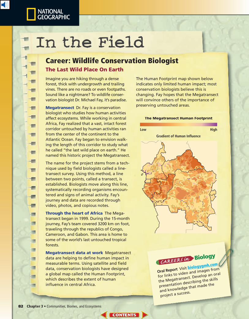
The Human Footprint map shown below
indicates only limited human impact; most
conservation biologists believe this is
changing. Fay hopes that the Megatransect
will convince others of the importance of
preserving untouched areas.
Gradient of Human Influence
Low High
The Megatransect Human Footprint
Career: Wildlife Conservation BiologistThe Last Wild Place On Earth
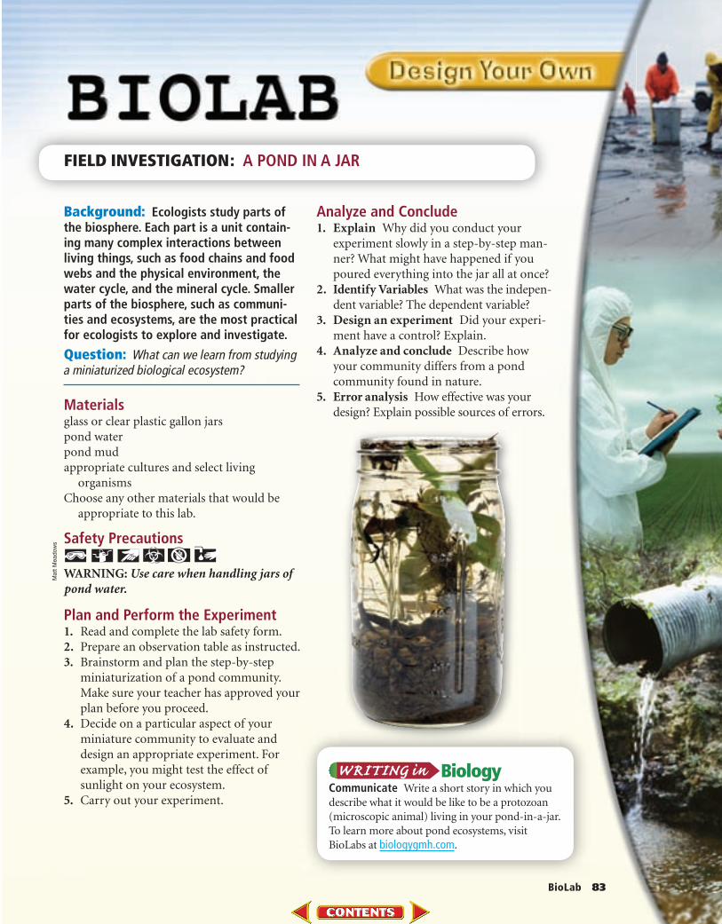
Background: Ecologists study parts of the biosphere. Each part is a unit contain-ing many complex interactions between living things, such as food chains and food webs and the physical environment, the water cycle, and the mineral cycle. Smaller parts of the biosphere, such as communi-ties and ecosystems, are the most practical for ecologists to explore and investigate.
Question: What can we learn from studying a miniaturized biological ecosystem?
Materials glass or clear plastic gallon jarspond waterpond mudappropriate cultures and select living
organismsChoose any other materials that would be
appropriate to this lab.
Safety Precautions
WARNING: Use care when handling jars of pond water.
Plan and Perform the Experiment1. Read and complete the lab safety form.2. Prepare an observation table as instructed.3. Brainstorm and plan the step-by-step
miniaturization of a pond community. Make sure your teacher has approved your plan before you proceed.
4. Decide on a particular aspect of your miniature community to evaluate and design an appropriate experiment. For example, you might test the effect of sunlight on your ecosystem.
5. Carry out your experiment.
Analyze and Conclude1. Explain Why did you conduct your
experiment slowly in a step-by-step man-ner? What might have happened if you poured everything into the jar all at once?
2. Identify Variables What was the indepen-dent variable? The dependent variable?
3. Design an experiment Did your experi-ment have a control? Explain.
4. Analyze and conclude Describe how your community differs from a pond community found in nature.
5. Error analysis How effective was your design? Explain possible sources of errors.
FIELD INVESTIGATION: A POND IN A JAR
Communicate Write a short story in which you
describe what it would be like to be a protozoan
(microscopic animal) living in your pond-in-a-jar.
To learn more about pond ecosystems, visit
BioLabs at biologygmh.com.
BioLab 83
Matt
Meadow
s

Vocabulary PuzzleMaker biologygmh.com84 Chapter X • Study Guide84 Chapter 3 • Study Guide Vocabulary PuzzleMaker biologygmh.com
FOLDABLES
Vocabulary Key Concepts
Section 3.1 Community Ecology
• climax community (p. 63)• community (p. 60)• ecological succession (p. 62)• limiting factor (p. 61)• primary succession (p. 62)• secondary succession (p. 63)• tolerance (p. 61)
All living organisms are limited by factors in the environment.
• Limiting factors restrict the growth of a population within a community.
• Organisms have a range of tolerance for each limiting factor that they
encounter.
• Primary succession occurs on areas of exposed rock or bare sand (no soil).
• Communities progress until there is little change in the composition of
species.
• Secondary succession occurs as a result of a disturbance in a climax
community.
Section 3.2 Terrestrial Biomes
• boreal forest (p. 68)• climate (p. 66)• desert (p. 70)• grassland (p. 70)• latitude (p. 65)• temperate forest (p. 69)• tropical rain forest (p. 72)• tropical savanna (p. 71)• tropical seasonal forest (p. 71)• tundra (p. 68)• weather (p. 65)• woodland (p. 69)
Ecosystems on land are grouped into biomes primarily based on
the plant communities within them.
• Latitude affects terrestrial biomes according to the angle at which sunlight
strikes Earth.
• Latitude, elevation, ocean currents, and other abiotic factors determine
climate.
• Two major abiotic factors define terrestrial biomes.
• Terrestrial biomes include tundra, boreal forests, temperate forests,
temperate woodlands and shrublands, temperate grasslands, deserts,
tropical savannas, tropical seasonal forests, and tropical rain forests.
Section 3.3 Aquatic Ecosystems
• abyssal zone (p. 81)• aphotic zone (p. 80)• benthic zone (p. 80)• estuary (p. 78)• intertidal zone (p. 79)• limnetic zone (p. 77)• littoral zone (p. 76)• photic zone (p. 80)• plankton (p. 77)• profundal zone (p. 77)• sediment (p. 75)• wetlands (p. 78)
Aquatic ecosystems are grouped based on abiotic factors such as
water flow, depth, distance from shore, salinity, and latitude.
• Freshwater ecosystems include ponds, lakes, streams, rivers, and wetlands.
• Wetlands and estuaries are transitional aquatic ecosystems.
• Marine ecosystems are divided into zones that are classified according to
abiotic factors.
• Estuaries and coral reefs are among the most diverse of all ecosystems.
FOLDABLES Research a natural disaster that occurred twenty or more years ago. Determine what the community looked like before the disaster and what the area looks like today. Draw a “then and now” picture.
Download quizzes, key terms, and flash cards from biologygmh.com.
Chapter 3 • Assessment 85Chapter Test biologygmh.com
Section 3.1
Vocabulary Review
Choose the correct italicized term to complete each
sentence.
1. An area of forest that experiences very little change
in species composition is a climax community/
primary succession.
2. The amount of oxygen in a fish tank is a tolerance
zone/limiting factor that affects the number of fish
that can live in the tank.
3. Ecological succession/Secondary succession describes
the events that take place on a hillside that has expe-
rienced a destructive mudslide.
Understand Key Concepts
4. Lack of iron in the photic zone of the open ocean
restricts the size of plankton populations. Iron is
what kind of factor for marine plankton?
A. distribution
B. tolerance
C. limiting
D. biotic
For questions 5-7, use the generalized graph below that
describes an organism’s tolerance to a particular factor.
5. According to the graph, which letter represents the
zone of intolerance for the factor in question?
A. A C. C
B. B D. D
6. What does the letter “D” in the graph represent?
A. zone of intolerance
B. zone of physiological stress
C. optimum range
D. upper limit
7. Which letter represents the zone of physiological
stress?
A. A C. C
B. B D. D
8. Which is a place you most likely would find
pioneer species growing?
A. climax forest C. disturbed grassland
B. coral reef D. newly formed volcano
Constructed Response
9. Careers In biology A state parks and
wildlife department stocks several bodies of water,
including rivers and lakes, with rainbow trout. The
trout survive, but do not reproduce. In terms of
tolerance, discuss what might be happening.
Use the image below to answer question 10.
10. Short Answer Describe how the successional
stages would differ from primary succession.
11. Open Ended Explain why the concepts of limiting
factors and tolerance are important in ecology.
Think Critically
12. Infer whether species diversity increases or
decreases after a fire on a grassland. Explain your
response.
13. Generalize the difference between a successional
stage and a climax community.
Section 3.2
Vocabulary Review
Choose the vocabulary term from the Study Guide page
that best fits each definition below.
14. the condition of the atmosphere
15. the average conditions in an area
16. a biome characterized by evaporation exceeding
precipitation
Getty Images
86 Chapter 3 • Assessment Chapter Test biologygmh.com
Understand Key Concepts
17. Which best describes the distribution of communi-
ties on a tall mountain?
A. Evergreen forests exist up to the tree line and
no vegetation is found above the tree line.
B. Several communities might be stratified
according to altitude and might end in an ice
field at the top of the highest mountains.
C. As altitude increases, tall trees are replaced by
shorter trees, and ultimately are replaced by
grasses.
D. Tundra-like communities exist at the top of
the highest mountains, and deserts are found
at the lower elevations.
Use the diagram below to answer question 18.
18. Which area receives the least amount of solar
energy per unit of surface area?
A. north of 60°N and south of 60°S
B. south of 30°N and north of 30°N
C. between the Tropic of Cancer and the
Tropic of Capricorn
D. north and south temperate zones
19. What is the name for large geographic areas with
similar climax communities?
A. assemblages C. successions
B. communities D. biomes
20. Which biome occurs in the United States and once
contained huge herds of grazing herbivores?
A. boreal forest C. grassland
B. temperate forest D. savanna
21. Which land biome contains the greatest species
diversity?
A. tundra C. desert
B. grassland D. tropical rain forest
Constructed Response
Use the image below to answer question 22.
22. Open Ended Describe a biome that might be
found in the shaded area shown above.
23. Open Ended In December 2004, a huge iceberg
caused a large number of penguin chicks to die of
starvation. Ice shelves broke apart in areas where
the air temperature increased. The parents of the
penguins were cut off from their food source. How
is this an example of temperature as a limiting factor?
Think Critically
24. Suggest why land biomes are classified according
to their plant characteristics rather than according
to the animals that inhabit them.
25. Classify a biome that is warm to hot in the sum-
mer and cool or cold in the winter and that receives
approximately 50–89 cm of precipitation annually.
Section 3.3
Vocabulary Review
Replace the underlined words with the correct terms
from the Study Guide page.
26. A(n) area where freshwater and saltwater meet
provides habitat for a diversity of organisms.
27. The well-lit portion of the ocean is the area where
all of the photosynthetic organisms live.
28. The shoreline of the ocean contains communities
that are layered depending on how long they are
submerged by tides.
Additional Assessment
Chapter 3 • Assessment 87Chapter Test biologygmh.com
Understand Key Concepts
29. Where is the largest percentage of water located?
A. groundwater C. oceans
B. rivers D. glaciers
Use the diagram below to answer question 30.
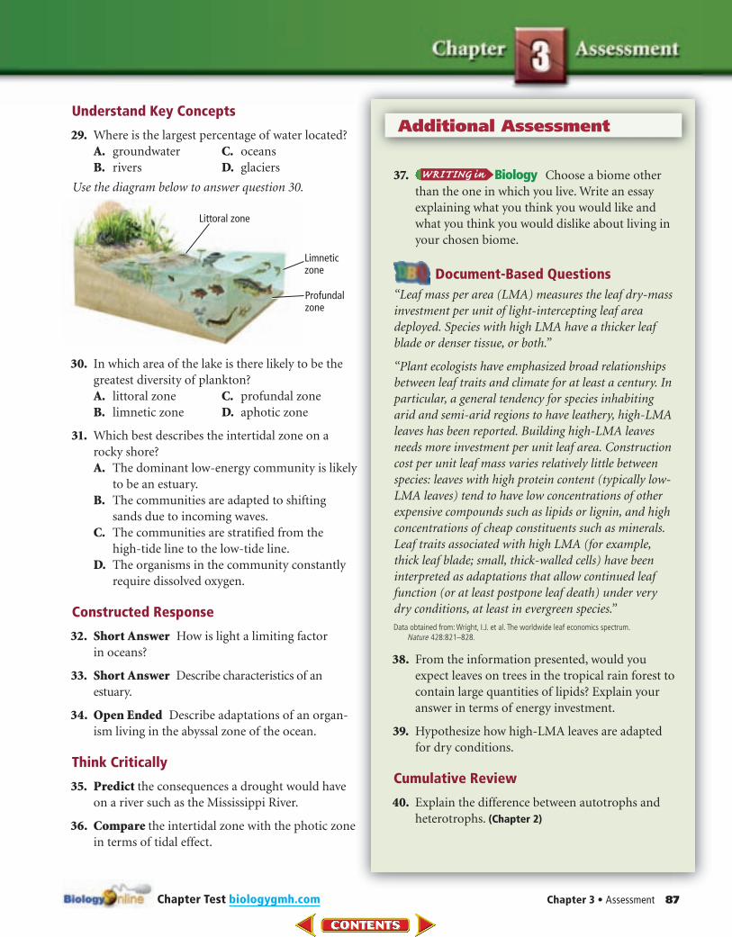
30. In which area of the lake is there likely to be the
greatest diversity of plankton?
A. littoral zone C. profundal zone
B. limnetic zone D. aphotic zone
31. Which best describes the intertidal zone on a
rocky shore?
A. The dominant low-energy community is likely
to be an estuary.
B. The communities are adapted to shifting
sands due to incoming waves.
C. The communities are stratified from the
high-tide line to the low-tide line.
D. The organisms in the community constantly
require dissolved oxygen.
Constructed Response
32. Short Answer How is light a limiting factor
in oceans?
33. Short Answer Describe characteristics of an
estuary.
34. Open Ended Describe adaptations of an organ-
ism living in the abyssal zone of the ocean.
Think Critically
35. Predict the consequences a drought would have
on a river such as the Mississippi River.
36. Compare the intertidal zone with the photic zone
in terms of tidal effect.
37. Choose a biome other
than the one in which you live. Write an essay
explaining what you think you would like and
what you think you would dislike about living in
your chosen biome.
Document-Based Questions
“Leaf mass per area (LMA) measures the leaf dry-mass
investment per unit of light-intercepting leaf area
deployed. Species with high LMA have a thicker leaf
blade or denser tissue, or both.”
“Plant ecologists have emphasized broad relationships
between leaf traits and climate for at least a century. In
particular, a general tendency for species inhabiting
arid and semi-arid regions to have leathery, high-LMA
leaves has been reported. Building high-LMA leaves
needs more investment per unit leaf area. Construction
cost per unit leaf mass varies relatively little between
species: leaves with high protein content (typically low-
LMA leaves) tend to have low concentrations of other
expensive compounds such as lipids or lignin, and high
concentrations of cheap constituents such as minerals.
Leaf traits associated with high LMA (for example,
thick leaf blade; small, thick-walled cells) have been
interpreted as adaptations that allow continued leaf
function (or at least postpone leaf death) under very
dry conditions, at least in evergreen species.”
Data obtained from: Wright, I.J. et al. The worldwide leaf economics spectrum. Nature 428:821–828.
38. From the information presented, would you
expect leaves on trees in the tropical rain forest to
contain large quantities of lipids? Explain your
answer in terms of energy investment.
39. Hypothesize how high-LMA leaves are adapted
for dry conditions.
Cumulative Review
40. Explain the difference between autotrophs and
heterotrophs. (Chapter 2)
Multiple Choice
Cumulative
1. If science can be characterized as discovery, then
technology can be characterized as which?
A. application
B. information
C. manufacturing
D. reasoning
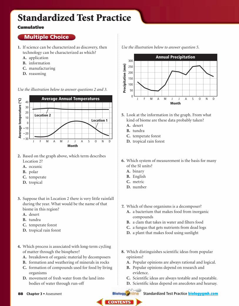
Use the illustration below to answer questions 2 and 3.
2. Based on the graph above, which term describes
Location 2?
A. oceanic
B. polar
C. temperate
D. tropical
3. Suppose that in Location 2 there is very little rainfall
during the year. What would be the name of that
biome in this region?
A. desert
B. tundra
C. temperate forest
D. tropical rain forest
4. Which process is associated with long-term cycling
of matter through the biosphere?
A. breakdown of organic material by decomposers
B. formation and weathering of minerals in rocks
C. formation of compounds used for food by living
organisms
D. movement of fresh water from the land into
bodies of water through run-off
Use the illustration below to answer question 5.
5. Look at the information in the graph. From what
kind of biome are these data probably taken?
A. desert
B. tundra
C. temperate forest
D. tropical rain forest
6. Which system of measurement is the basis for many
of the SI units?
A. binary
B. English
C. metric
D. number
7. Which of these organisms is a decomposer?
A. a bacterium that makes food from inorganic
compounds
B. a clam that takes in water and filters food
C. a fungus that gets nutrients from dead logs
D. a plant that makes food using sunlight
8. Which distinguishes scientific ideas from popular
opinions?
A. Popular opinions are always rational and logical.
B. Popular opinions depend on research and
evidence.
C. Scientific ideas are always testable and repeatable.
D. Scientific ideas depend on anecdotes and hearsay.
88 Chapter 3 • Assessment biologygmh.comStandardized Test Practice
Standardized Test Practice
biologygmh.com
9. How is a tundra similar to and different from a
boreal forest? Use a Venn diagram to organize
information about the similarities and differences
of these biomes.
10. What is the role of a pioneer species in primary
succession?
11. Give two examples of how the human body shows
the living characteristic of organization.
12. Suppose a certain insect species lives only in a
specific species of tree. It feeds off the sap of the
tree and produces a chemical that protects the
tree from certain fungi. What kind of relationship
is this?
13. Why would you expect to find different animals in
the photic and aphotic zones of the ocean?
14. Suppose a gardener learns that the soil in a garden
has low nitrogen content. Describe two ways to
increase the nitrogen available for plants in the
garden.
15. Explain how the establishment of a climax commu-
nity through primary succession differs from the
establishment of a climax community that occurs
through secondary succession.
16. Why is the ability to adapt an important character-
istic of living things?
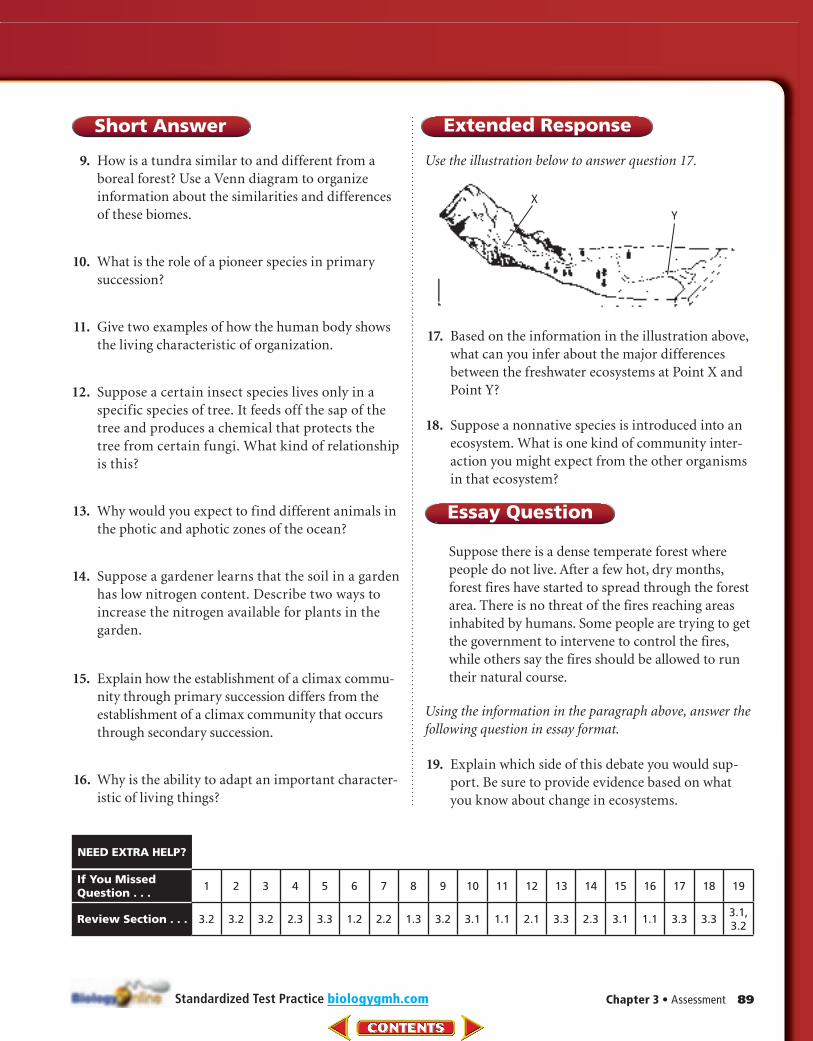
Use the illustration below to answer question 17.
17. Based on the information in the illustration above,
what can you infer about the major differences
between the freshwater ecosystems at Point X and
Point Y?
18. Suppose a nonnative species is introduced into an
ecosystem. What is one kind of community inter-
action you might expect from the other organisms
in that ecosystem?
Essay Question
Suppose there is a dense temperate forest where
people do not live. After a few hot, dry months,
forest fires have started to spread through the forest
area. There is no threat of the fires reaching areas
inhabited by humans. Some people are trying to get
the government to intervene to control the fires,
while others say the fires should be allowed to run
their natural course.
Using the information in the paragraph above, answer the
following question in essay format.
19. Explain which side of this debate you would sup-
port. Be sure to provide evidence based on what
you know about change in ecosystems.
Chapter 3 • Assessment 89
Short Answer Extended Response
biologygmh.com
If You Missed Question . . .
1 2 3 4 5 6 7 8 9 10 11 12 13 14 15 16 17 18 19
Review Section . . . 3.2 3.2 3.2 2.3 3.3 1.2 2.2 1.3 3.2 3.1 1.1 2.1 3.3 2.3 3.1 1.1 3.3 3.33.1, 3.2
NEED EXTRA HELP?
Standardized Test Practice