columbia pike the history of an early turnpike
TRANSCRIPT
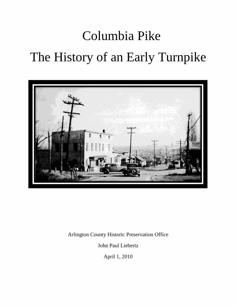
Columbia Pike
The History of an Early Turnpike
Arlington County Historic Preservation Office
John Paul Liebertz
April 1, 2010
Table of Contents
Turnpike History…………………………………………………………………………… 1
District of Columbia and Virginia Turnpike, Early 1800s………………………...………. 3
District of Columbia’s Impact on the Development of the Columbia Turnpike Co………. 5
Origin of Columbia Turnpike……………………………………………………………… 7
Provisions of the Act to Create Columbia Turnpike Company………………………….… 9
Benjamin Henry Latrobe’s Influence on Columbia Turnpike……………………………... 12
Columbia Turnpike and the Civil War…………………………………………………….. 14
Columbia Turnpike and Railroads, 1860 – 1930…………………………………………... 17
Columbia Turnpike Experiments, 1911 – 1915…………………………………....……… 19
Columbia Turnpike Experiments, 1921…………………………………………………… 21
Arlington County Road Improvements, 1925……………………………………………… 22
Columbia Turnpike Becomes a State Route……………………………………………….. 23
Prominent Structures Along Columbia Turnpike…………………….…………..……….. 24
Development along Columbia Turnpike…………………………………………………… 28
Bibliography……………………………………………………………………………….. 30
1
Turnpike History
Need for Turnpikes in America
Public maintenance of early Virginian roads was inadequate due to the heavy traffic
generated by wagons and carriages moving goods between the Potomac and the rest of
the state. Local property owners who were liable for upkeep of the roadway performed
enough maintenance to keep the route passable for local traffic. In the late 1700s, the idea of an improved roadway maintained by the collection of tolls
took hold throughout the country. Turnpikes offered a superior method of road care due to inherent organizational
advantages.
Turnpikes were not a technological innovation, but a legislative authorization to construct
roadways and collect a toll.
British Turnpikes
First toll road in 1663.
Prevailed in Britain circa 1750-1772.
Organized as trusts, which were non-profit organizations financed by bonds.
o Committee of citizens borrowed money, constructed roads, and collected tolls for
their maintenance and the amortization of the debt.
o After debt was paid, the trust was to stop collecting tolls and give control of the
right of way to the public.
New England vs. Virginia Turnpikes
The United States turnpike laws were modeled on the English system. However, there
was a significant difference between the New England and Virginian turnpike policy.
New England
VS.
Virginia
States left private enterprise to
acquire funds.
State gave financial aid to
turnpike companies.
Unlike the English system, neither New England nor Virginia adopted the planned
surrender of the turnpike to the public when the debt was negated by the collection of
tolls.
o In theory, the turnpike companies would be able to profit from the turnpikes
indefinitely.
o However, in most cases, turnpikes resulted in little profits and the roads reverted
to the public within a few decades.
2
Economics of Turnpike Companies
Structure of turnpike companies
o Companies sold stock to individuals, companies, or governments.
o Stockholders elected a board of directors.
o Directors levied tolls to pay for repairs, expenses, and dividends.
Early transportation corporations had poor financial performance.
Economic motivation of investors was based on indirect benefits of improved
transportation.
o Higher land values o Increased local commerce
o Greater ability to market crops o Better access to consumer goods
Thomas Gordon, A Gazetteer of the State of Pennsylvania,
“None have yielded profitable returns to the stockholders, but
everyone feels that he has been repaid for his expenditures in the
improved value of lands, and the economy of business.”
The Collection of Tolls
Tolls were collected at tollhouses where the road was barred by a long pole or pike,
which had to be turned to allow passage.
Toll keepers, who resided in the tollhouse, acted as a security guard, custodian,
handyman, representative and conduit to the turnpike executives of information from the
public.

3
District of Columbia and Virginia Turnpikes, Early 1800s
Little River Turnpike
First turnpike in the area ~ Chartered by the Virginia Assembly in 1796.
o Duke Street, Alexandria to the ford on the Little River.
o Roadway leading west from Alexandria towards the lower Shenandoah Valley.
Washington and Alexandria Turnpike
Chartered by United States Congress (April 21, 1808).
“…opening, graveling, and improving a road not exceeding one
hundred, nor less than thirty feet wide, between the town of
Alexandria and Bridgepoint, on Alexander’s island, opposite the
city of Washington, and of erecting a bridge over Fourmile Creek,
in the county of Alexandria.”
Road constructed between Virginia end of Long Bridge and Alexandria.
Washington and Alexandria Turnpike is now part of Jefferson Davis Highway.
1: Left, the advance guard of the grand army of the United States crossing the Long Bridge of the Potomac River, 1861. Right, the 14
th Street Bridge looking toward the District of Columbia, 1932. Long Bridge had been burnt or destroyed and rebuilt on
multiple occasions before developing into the current 14th
Street Bridge.
4
Condition of Turnpikes
Transportation on early turnpikes was difficult.
March 17, 1875 Alexandria Gazette,
“Arlington Turnpike Company owing to the terrible condition of
its road or perhaps to the ominous muttering of those who are so
unfortunate as to have to travel it, have thrown its gate open until
the road and the aforesaid mutter dries up.”
General Assembly of Virginia Turnpike Law (February 17, 1817)
Regulates the chartering of companies, the exercise of eminent domain and the
assessment of damages, the width, grades, and surfacing of turnpikes, the weight of loads,
width of wheels, tollgates and rates of toll, and remedies against toll evaders.
“60 feet wide at least, eighteen feet of which shall be well covered
with gravel or stone where necessary and at all times by kept firm
and smooth, free from all mudholes, ruts and other obstructions
and in all respects fit for the use of heavy laden wagons and of
other carriages; and on each side of the parts so to be made and
preserved, they shall clear a summer road eighteen feet wide and
keep the same always in good repair, free from stumps, roots,
rocks, stones, mud holes, ruts and other obstructions fit for the use
of wagons and other carriages in dry weather between the first day
of May and thirty-first day of October, and fit for the use of horses
and foot travelers at all times.”
5
District of Columbia’s Impact on the Development of the Columbia
Turnpike Company
Legislation to Create a Permanent Seat of the Government
Article 1, Section 8, United States Constitution
“To exercise exclusive Legislation in all Cases whatsoever, over such District (not
exceeding ten miles square) as may, by Cession of particular States, and the
Acceptance of Congress, become the Seat of the Government of the United States,
and to exercise like Authority over all Places purchased by the Consent of the
Legislature of the State in which the Same shall be, for the Erection of Forts,
Magazines, Arsenals, dock-Yards, and other needful Buildings;”
Residence Act
o An act for establishing the temporary and permanent seat of the government of
the United States. Enacted by Congress, July 16, 1790.
o District to be located on the Potomac River.
o Ten years to construct buildings for Congress.
District of Columbia Organic Act of 1801
o An act concerning the District of Columbia. Enacted by Congress, February 27,
1801.
o Incorporated District of Columbia and divided the territory into two counties
Washington County, east of the Potomac River.
Alexandria County, west of the Potomac River.
o Alexandria County included present day Arlington, Virginia.
In 1852, Alexandria County returned to Virginia.
In 1870, the city of Alexandria seceded from Alexandria County.
In 1920, Alexandria County renamed Arlington County.
Growing Pains of Washington DC
Initially, the District of Columbia was isolated.
o Lack of major traffic routes to urban centers.
o Lack of transportation options even to neighboring towns, Georgetown and
Alexandria.
Residents complained of a “City of Magnificent Distances” with inadequate streets and
waterways.
Lack of a mercantile community.
Lack of integration into regional and national market.
6
Solution to DC’s Slow Growth
City’s economy hinged upon its ability to expand its external market, which would then
provide the “means for an increase in the size of the domestic market, growth in money
income, and the spread of specialization and division of labor.”
The development of transportation such as turnpikes, canals, and railroads was critical to
the success of the district.
o The earliest transportation developments were turnpikes that connected DC to the
rest of the country.
7
Origin of Columbia Turnpike
Creation of the Columbia Turnpike Company
An Act to incorporate a company for making certain turnpike roads in the District of
Columbia. Enacted by Congress, April 12, 1810.
Board of commissioners:
o Daniel Carrol, George W.P. Custis, Thomas Fenwick, John Taylor, Samuel
Harrison Smith, Daniel Brent, Daniel Rapine, Frederick May, Elias B. Caldwell,
William Brent, James D. Barry, and John Law.
o Responsible for raising a minimum of $60,000 in shares of $100.
Note: Congress chartered the turnpike as a private corporation and did not
provide monetary aid similar to the New England turnpike policy.
Creation of three turnpikes
o Capitol to Baltimore
Allowed for easier access to the northeastern cities. The route follows
current Bladensburg Road, N.E.
o Capitol to Montgomery Courthouse
Would have facilitated access to the northwest. Surveyed and planned,
but never constructed by the Columbia Turnpike Company, who sold the
rights to the road in 1818 to the Rockville and Washington Turnpike
Company. The roadway was to be an extension of New Jersey Avenue,
N.W.
o Capitol to Southwest ~ Columbia Pike
“One road from the western extremity of the causeway leading from
Alexander’s island to the boundary line of the district of Columbia, and
the most direct and practicable route towards the Little River turnpike
road, in the state of Virginia.”
Importance of turnpikes
As stated previously, the District of Columbia was isolated from other adjacent urban
areas and major cities. The act allowed for the integration of DC into a larger national
and local economic market, and for the city to become a profitable urban center.
8
Importance of Columbia Pike
Opens the District of Columbia to the west and southwest.
Connects to the Little River Turnpike.
o The Little River Turnpike, chartered by the Virginia Assembly (1796), improved
the roadway leading west from Alexandria towards the lower Shenandoah Valley.
Easier transportation of goods by creating a more direct route to Washington DC, instead
of traveling via Alexandria.
Creation of mills along tributaries of Potomac in proximity to Columbia Pike.
Virginia Expands Columbia Turnpike
The Little River Turnpike is not part of the District of Columbia, but a part of Fairfax
County, Virginia. Therefore, the Virginia General Assembly had to charter the Fairfax
Turnpike Company to construct the Virginia portion of the Columbia Turnpike outlined
by Congress.
9
Provisions of the Act to Create Columbia Turnpike Company
Specification for the roads
“Not less than sixty-six feet in breadth, in such routes, tracts, or courses for the same
respectively as in the best of their judgment will combine shortness of distance with the
most convenient ground, and the smallest expense of money.”
Dimensions of roads
“…shall cause at least twenty-four feet in breadth, throughout the whole length thereof,
to be made an artificial road, of stone, gravel, or other hard substance of sufficient depth
of thickness to secure a solid and firm road, with a surface as smooth as the materials will
admit, and so nearly level, that it shall in no case rise or fall more than an angle of four
degrees with a horizontal line, and the said road shall thereafter be kept in good and
perfect repair.”
Toll Gates and Tolls
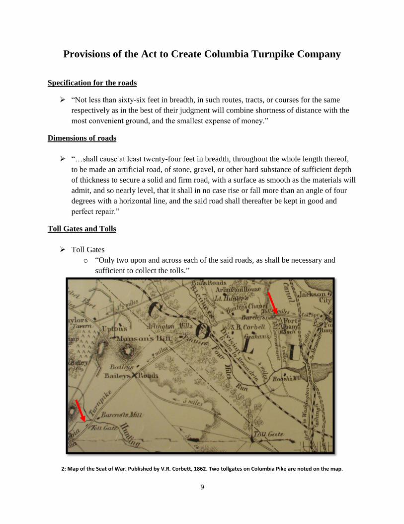
Toll Gates
o “Only two upon and across each of the said roads, as shall be necessary and
sufficient to collect the tolls.”
2: Map of the Seat of War. Published by V.R. Corbett, 1862. Two tollgates on Columbia Pike are noted on the map.
10
o Lawful to appoint “toll-gatherers” to collect and receive tolls from individuals
using the turnpike.
o “It shall be lawful for them to appoint such and so many toll-gatherers as they
shall deem necessary to collect and receive of and from all and every person and
persons using the said road or roads, the tolls and rates herein after mentioned,
and to stop any person or persons, riding, leading or driving any horses, mules,
cattle, hogs, sheep, sulkey, chair, chaise, phaeton, chariot, coach, cart, wagon,
sleigh, sled, or any carriage of burden or pleasure from passing through the said
gates, until the said tolls shall be paid.”
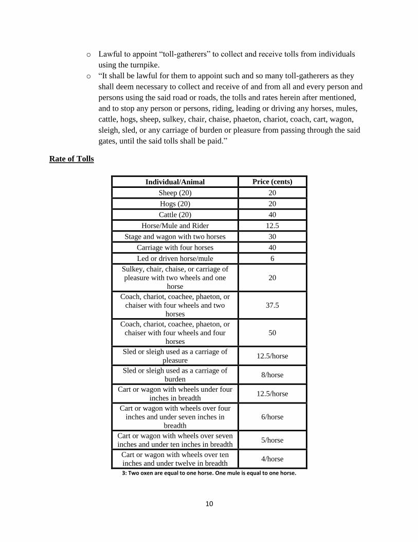
Rate of Tolls
Individual/Animal Price (cents)
Sheep (20) 20
Hogs (20) 20
Cattle (20) 40
Horse/Mule and Rider 12.5
Stage and wagon with two horses 30
Carriage with four horses 40
Led or driven horse/mule 6
Sulkey, chair, chaise, or carriage of
pleasure with two wheels and one
horse
20
Coach, chariot, coachee, phaeton, or
chaiser with four wheels and two
horses
37.5
Coach, chariot, coachee, phaeton, or
chaiser with four wheels and four
horses
50
Sled or sleigh used as a carriage of
pleasure 12.5/horse
Sled or sleigh used as a carriage of
burden 8/horse
Cart or wagon with wheels under four
inches in breadth 12.5/horse
Cart or wagon with wheels over four
inches and under seven inches in
breadth
6/horse
Cart or wagon with wheels over seven
inches and under ten inches in breadth 5/horse
Cart or wagon with wheels over ten
inches and under twelve in breadth 4/horse
3: Two oxen are equal to one horse. One mule is equal to one horse.
11
Repair of Roads
Duty of the corporation to keep the roads safe
o Poor repair, unsafe or inconvenient for passengers, corporation will be held liable.
o Company may be fined up to $100 by the US Government for infractions.
o Corporation will be held liable for damages incurred on person or persons.
Roads to become free
“Whenever the net proceeds of tolls collected on said roads shall amount to a sum
sufficient to reimburse the capital which shall be expended in the purchase of such land
and making said roads, and twelve percent interest per annum thereon, to be ascertained
by the circuit court of the United States, in and for the district of Columbia, that same
shall become free roads, and tolls shall no longer be collected thereon; and said company
shall annually make returns to said circuit court of the amount of the tolls collected, and
of their necessary expenses, so as to enable said circuit court to determine when said tolls
shall cease.”
The above policy is unusual for American chartered turnpikes, and is more in line with
the British turnpike system.
o In theory, since the District of Columbia is the center of the American
government, access to the district should not be confined by the payment of tolls.
An 1852 Senate report states that all roads and bridges approaching the
seat of government within the District of Columbia have been made free
of toll except two turnpikes.
However, the report does not include Columbia Pike. In 1852,
Alexandria County had been returned to Virginia.
12
Benjamin Henry Latrobe’s Influence on Columbia Turnpike
Latrobe’s Background
Emigrated from England in 1795.
Surveyor of Public Building in the city of Washington, 1801.
Prominent for his architectural work.
o United States Capitol
o Baltimore Basilica
District of Columbia was center for Latrobe’s transportation work.
Columbia Turnpike Company Hires Latrobe
President of company, Daniel Carroll, applied to the circuit court of the District of
Columbia for the appointment of three commissioners to lay out the turnpike routes.
o Benjamin Henry Latrobe
o Griffith Coombe
o Joseph Forrest
Latrobe designates himself “Chairman of the Columbia Turnpike Commissioners.”
o Only engineer on the commission.
Company pays Latrobe $2 daily compensation.
o $8 less than normal compensation.
o Latrobe wrote that he “spared no labor, or fatigue” and “devoted many weary &
hungry days to it.”
He believed that the transportation initiatives were critical to the success
of the city, which is why he accepted a low pay rate.
Latrobe’s Responsibilities
Survey and outline the three turnpike
routes.
Columbia Pike
o Latrobe received political
pressure from prominent
individuals who had financial
interests in the route of Columbia
Turnpike in Alexandria County.
o George Washington Parke Custis
asked Latrobe for the road to be
moved closer to his mill on Four
Mile Run. Latrobe declined his
request.
o From 1812-1815, Columbia Pike
cost approximately $40,000 to
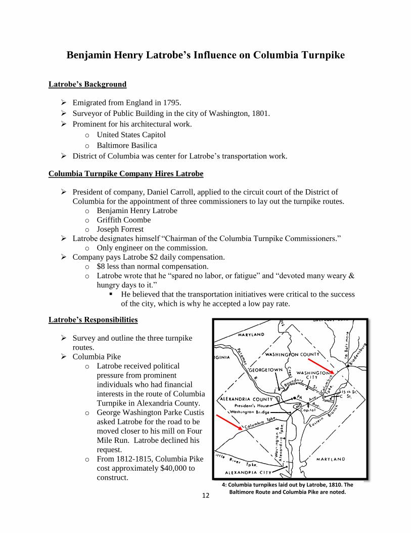
construct. 4: Columbia turnpikes laid out by Latrobe, 1810. The
Baltimore Route and Columbia Pike are noted.

13
Columbia Turnpike Co. and Washington-Alexandria Turnpike Co. Conflict
Columbia Pike started at the “western edge of the causeway” leading to
Washington/Long Bridge. Consequently, Columbia Pike traffic entering and leaving DC
would use Long Bridge and the causeway built by Washington and Alexandria Turnpike
Company.
o The Act to charter Columbia Turnpike Company required commissioner to decide
the “proportion of the cost already incurred of making the causeway” which the
Columbia Turnpike Company would pay the Washington and Alexandria
Turnpike Company.
Latrobe determined that it was possible to build a causeway for $900 even though the
Washington and Alexandria Turnpike Company spent over $4,700.
o Washington and Alexandria Turnpike Company sued the commissioners for
larger compensation, but settled for $900 before the case went to court.
14
Columbia Turnpike and the Civil War
Arlington House
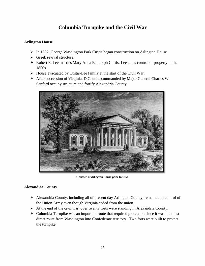
In 1802, George Washington Park Custis began construction on Arlington House.
Greek revival structure.
Robert E. Lee marries Mary Anna Randolph Curtis. Lee takes control of property in the
1850s.
House evacuated by Custis-Lee family at the start of the Civil War.
After succession of Virginia, D.C. units commanded by Major General Charles W.
Sanford occupy structure and fortify Alexandria County.
Alexandria County
Alexandria County, including all of present day Arlington County, remained in control of
the Union Army even though Virginia ceded from the union.
At the end of the civil war, over twenty forts were standing in Alexandria County.
Columbia Turnpike was an important route that required protection since it was the most
direct route from Washington into Confederate territory. Two forts were built to protect
the turnpike.
5: Sketch of Arlington House prior to 1861.
15
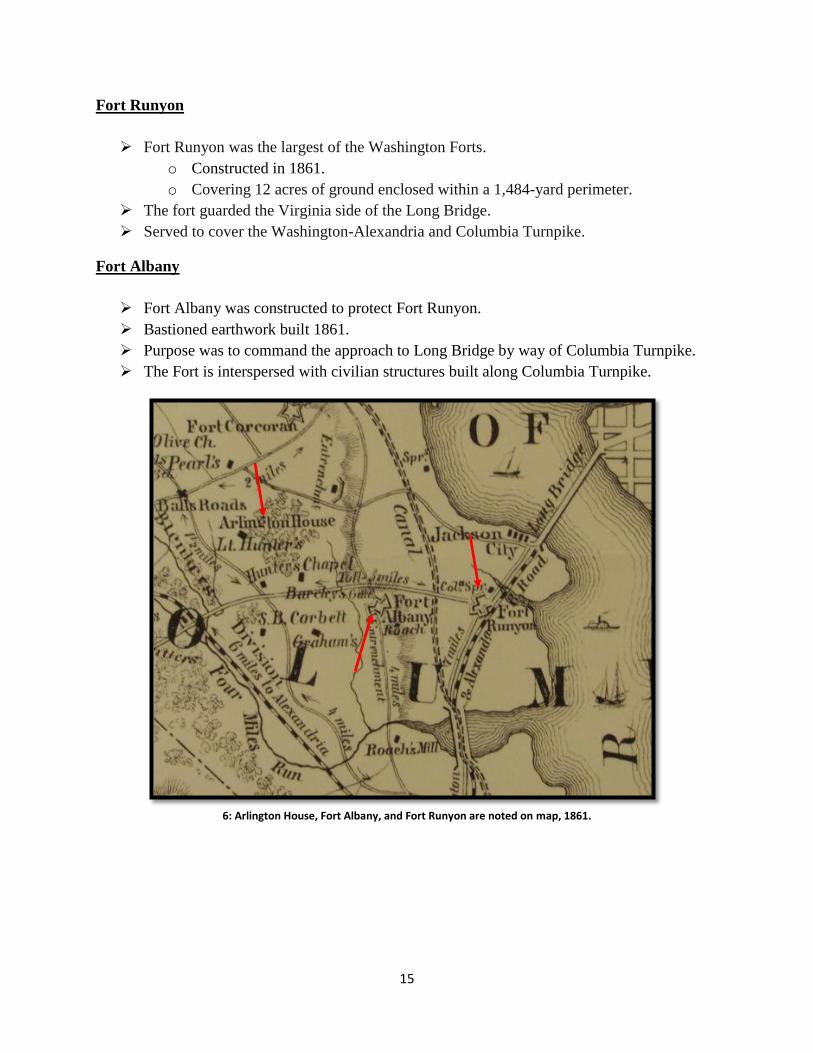
Fort Runyon
Fort Runyon was the largest of the Washington Forts.
o Constructed in 1861.
o Covering 12 acres of ground enclosed within a 1,484-yard perimeter.
The fort guarded the Virginia side of the Long Bridge.
Served to cover the Washington-Alexandria and Columbia Turnpike.
Fort Albany
Fort Albany was constructed to protect Fort Runyon.
Bastioned earthwork built 1861.
Purpose was to command the approach to Long Bridge by way of Columbia Turnpike.
The Fort is interspersed with civilian structures built along Columbia Turnpike.
6: Arlington House, Fort Albany, and Fort Runyon are noted on map, 1861.
16
Columbia Turnpike Company Claim
“This is a claim of the Columbia Turnpike Company for the use and occupation of their
road [Columba Pike] on the Virginia Side of the Potomac river from June 1, 1861, to
June 1, 1866, by United States troops.” Senate Report, 1868.
o Estimated that 1,000 government horses per day passed over the route.
o Claim against the government in the amount of $73,000
US government claimed that the road was discontinued to public travel in November
1861.
o No proof of expenditures of the company to repair turnpike during Civil War.
o No official account of government use of turnpike.
o Turnpike and tollhouse were in enemy’s country.
Damages sustained by this company “must be considered under the class of losses
occasioned by the general ravages or war” and no government is responsible for such
losses.
Damage sustained to Columbia Pike Residences
Account of Sewell Corbett, Southern Claims Commission
“I live on the farm opposite Young’s. The Columbian Turnpike
separates our land. I knew the farm before Young purchased it
fifteen years ago. He bought it from the Fairfax estate, and built the
house in 1852 or ’53. The farm is three miles from the Long
Bridge. It has a blacksmith shop, carriage house, barn, stable,
cornhouse, and other buildings. Fort Woodbury, Tillinghast,
Whipple, Craig, Albany, Richardson, Berry, Barnard and Blenker
are within one-half to one mile from our farms. A large number of
troops were stationed on these lands – from 10,000 to 100,000
men. We were ordered to leave in 1862. We did so. Our farms
were badly damaged, our buildings destroyed, and the crops gone.”
17
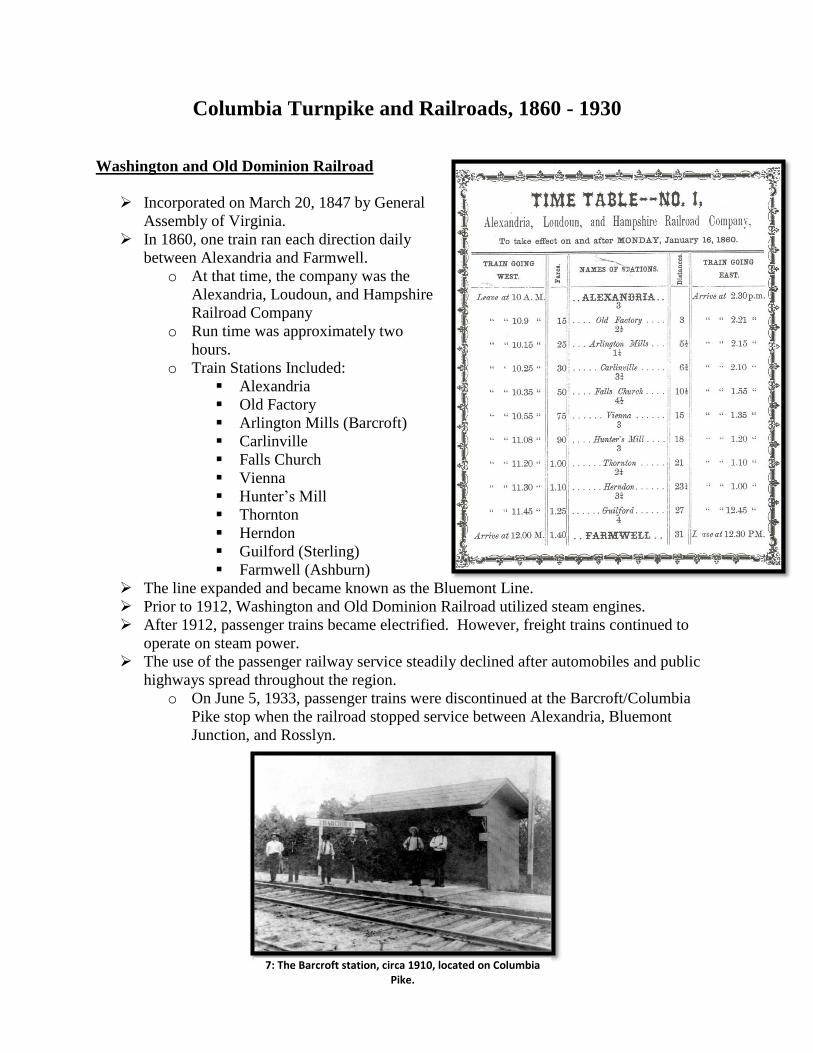
Columbia Turnpike and Railroads, 1860 - 1930
Washington and Old Dominion Railroad
Incorporated on March 20, 1847 by General
Assembly of Virginia.
In 1860, one train ran each direction daily
between Alexandria and Farmwell.
o At that time, the company was the
Alexandria, Loudoun, and Hampshire
Railroad Company
o Run time was approximately two
hours.
o Train Stations Included:
Alexandria
Old Factory
Arlington Mills (Barcroft) Carlinville
Falls Church
Vienna
Hunter’s Mill
Thornton
Herndon
Guilford (Sterling)
Farmwell (Ashburn)
The line expanded and became known as the Bluemont Line.
Prior to 1912, Washington and Old Dominion Railroad utilized steam engines.
After 1912, passenger trains became electrified. However, freight trains continued to
operate on steam power.
The use of the passenger railway service steadily declined after automobiles and public
highways spread throughout the region.
o On June 5, 1933, passenger trains were discontinued at the Barcroft/Columbia
Pike stop when the railroad stopped service between Alexandria, Bluemont
Junction, and Rosslyn.
7: The Barcroft station, circa 1910, located on Columbia Pike.
18
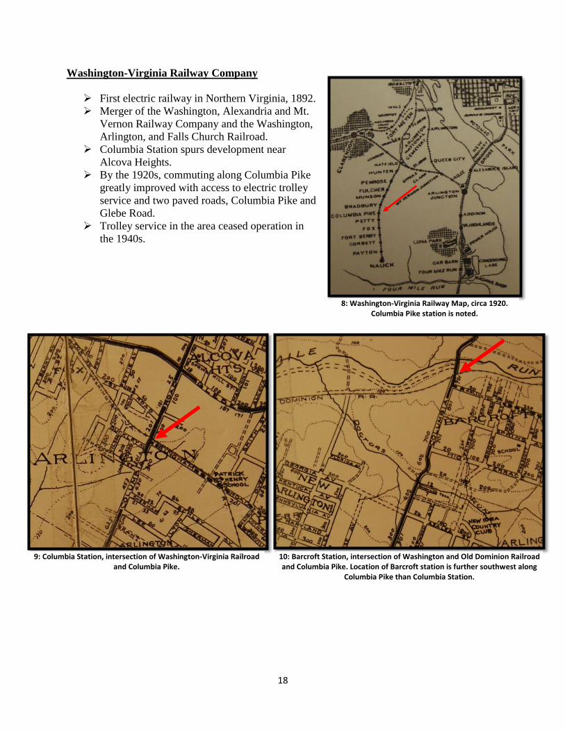
Washington-Virginia Railway Company
First electric railway in Northern Virginia, 1892.
Merger of the Washington, Alexandria and Mt.
Vernon Railway Company and the Washington,
Arlington, and Falls Church Railroad.
Columbia Station spurs development near
Alcova Heights.
By the 1920s, commuting along Columbia Pike
greatly improved with access to electric trolley
service and two paved roads, Columbia Pike and
Glebe Road.
Trolley service in the area ceased operation in
the 1940s.
8: Washington-Virginia Railway Map, circa 1920. Columbia Pike station is noted.
9: Columbia Station, intersection of Washington-Virginia Railroad and Columbia Pike.
10: Barcroft Station, intersection of Washington and Old Dominion Railroad and Columbia Pike. Location of Barcroft station is further southwest along
Columbia Pike than Columbia Station.
19
Columbia Turnpike Experiments, 1911-1915
Earth Road Maintenance Experiments
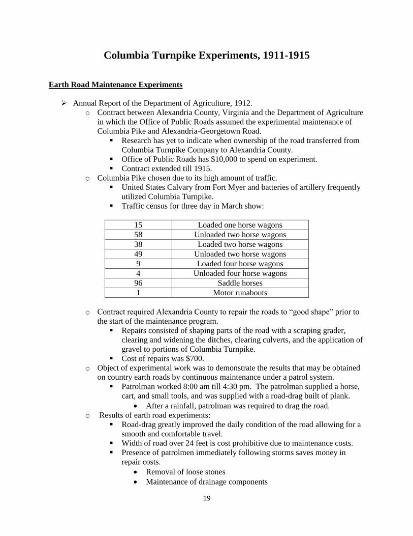
Annual Report of the Department of Agriculture, 1912.
o Contract between Alexandria County, Virginia and the Department of Agriculture
in which the Office of Public Roads assumed the experimental maintenance of
Columbia Pike and Alexandria-Georgetown Road.
Research has yet to indicate when ownership of the road transferred from
Columbia Turnpike Company to Alexandria County.
Office of Public Roads has $10,000 to spend on experiment.
Contract extended till 1915.
o Columbia Pike chosen due to its high amount of traffic.
United States Calvary from Fort Myer and batteries of artillery frequently
utilized Columbia Turnpike.
Traffic census for three day in March show:
15 Loaded one horse wagons
58 Unloaded two horse wagons
38 Loaded two horse wagons
49 Unloaded two horse wagons
9 Loaded four horse wagons
4 Unloaded four horse wagons
96 Saddle horses
1 Motor runabouts
o Contract required Alexandria County to repair the roads to “good shape” prior to
the start of the maintenance program.
Repairs consisted of shaping parts of the road with a scraping grader,
clearing and widening the ditches, clearing culverts, and the application of
gravel to portions of Columbia Turnpike.
Cost of repairs was $700.
o Object of experimental work was to demonstrate the results that may be obtained
on country earth roads by continuous maintenance under a patrol system.
Patrolman worked 8:00 am till 4:30 pm. The patrolman supplied a horse,
cart, and small tools, and was supplied with a road-drag built of plank.
After a rainfall, patrolman was required to drag the road.
o Results of earth road experiments:
Road-drag greatly improved the daily condition of the road allowing for a
smooth and comfortable travel.
Width of road over 24 feet is cost prohibitive due to maintenance costs.
Presence of patrolmen immediately following storms saves money in
repair costs.
Removal of loose stones
Maintenance of drainage components
20
Presence of old cobblestones and poorly consolidated gravel is an
impediment to the dragging of roads. Stones must be removed prior to
dragging.
Section of Columbia Pike that was graveled has responded particularly
well to maintenance system and remains in perfect condition since
graveling was completed. (Annual Report of the Department of
Agriculture, 1913)
Maintenance was discontinued on a portion of Columbia Pike since it was
exceedingly rough after county repair due to years of improper
maintenance and the dumping of cobblestone. (Annual Report of the
Department of Agriculture, 1913)
21
Columbia Turnpike Experiments, 1921
Pavement Experiments
Agriculture Appropriation Bill. Hearing before the Committee on Agriculture, House of
Representatives, December 14, 1917.
o “During the present fiscal year surveys have been made and plans and
specifications prepared for the experimental construction of a road in Alexandria
County, Virginia loyally known as the Columbia Pike from the Mount Vernon
Avenue experimental road to beyond Barcroft, Virginia a distance of over three
miles.”
o Alexandria County will pay for half of the expense of the construction.
Experimental concrete road completed in winter of 1921.
o Consisted of 32 sections of both plain and reinforced concrete. The variations in
the sections consisted of changes in thickness, cross-section design, the use of
cinders, and the use of various percentage of reinforced steel.
o Certain sections utilized the use of inverted curbs and center longitudinal joints.
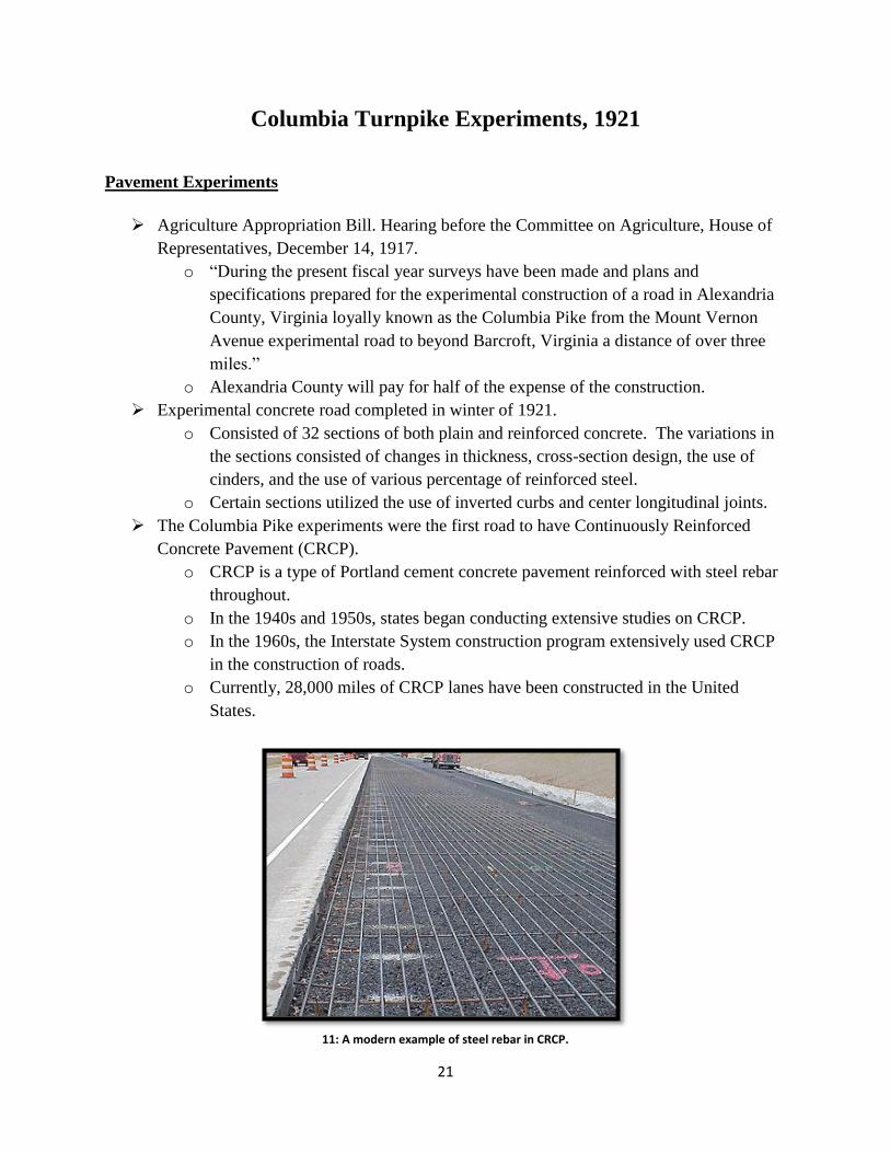
The Columbia Pike experiments were the first road to have Continuously Reinforced
Concrete Pavement (CRCP).
o CRCP is a type of Portland cement concrete pavement reinforced with steel rebar
throughout.
o In the 1940s and 1950s, states began conducting extensive studies on CRCP.
o In the 1960s, the Interstate System construction program extensively used CRCP
in the construction of roads.
o Currently, 28,000 miles of CRCP lanes have been constructed in the United
States.
11: A modern example of steel rebar in CRCP.
22
Arlington County Road Improvements, 1925
State of County Roads
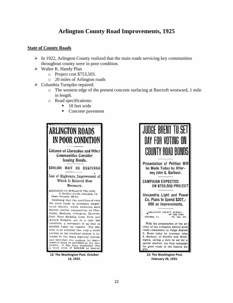
In 1922, Arlington County realized that the main roads servicing key communities
throughout county were in poor condition.
Walter K. Handy Plan
o Project cost $753,503.
o 20 miles of Arlington roads
Columbia Turnpike repaired.
o The western edge of the present concrete surfacing at Barcroft westward, 1 mile
in length.
o Road specifications:
18 feet wide
Concrete pavement
12: The Washington Post. October 14, 1922.
13: The Washington Post. February 26, 1925.
23
Columbia Turnpike Becomes a State Route
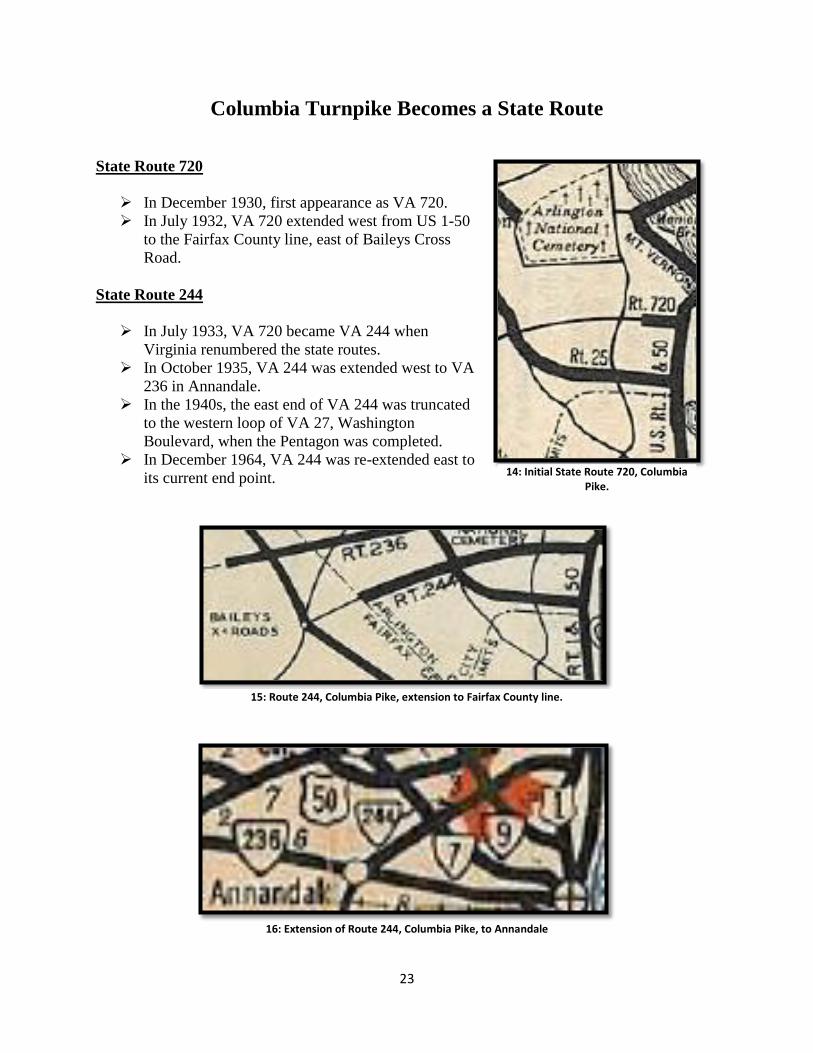
State Route 720
In December 1930, first appearance as VA 720.
In July 1932, VA 720 extended west from US 1-50
to the Fairfax County line, east of Baileys Cross
Road.
State Route 244
In July 1933, VA 720 became VA 244 when
Virginia renumbered the state routes.
In October 1935, VA 244 was extended west to VA
236 in Annandale.
In the 1940s, the east end of VA 244 was truncated
to the western loop of VA 27, Washington
Boulevard, when the Pentagon was completed.
In December 1964, VA 244 was re-extended east to
its current end point.
15: Route 244, Columbia Pike, extension to Fairfax County line.
16: Extension of Route 244, Columbia Pike, to Annandale
14: Initial State Route 720, Columbia Pike.
24
Prominent Structures Along Columbia Turnpike
Early Churches
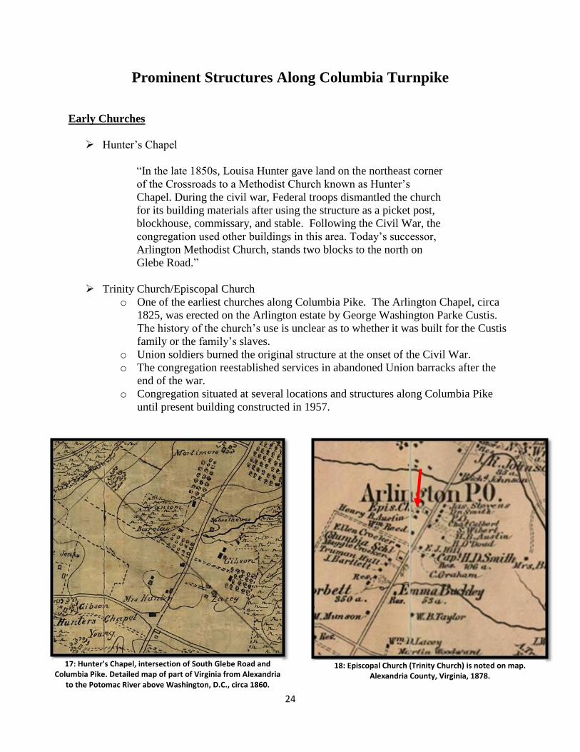
Hunter’s Chapel
“In the late 1850s, Louisa Hunter gave land on the northeast corner
of the Crossroads to a Methodist Church known as Hunter’s
Chapel. During the civil war, Federal troops dismantled the church
for its building materials after using the structure as a picket post,
blockhouse, commissary, and stable. Following the Civil War, the
congregation used other buildings in this area. Today’s successor,
Arlington Methodist Church, stands two blocks to the north on
Glebe Road.”
Trinity Church/Episcopal Church
o One of the earliest churches along Columbia Pike. The Arlington Chapel, circa
1825, was erected on the Arlington estate by George Washington Parke Custis.
The history of the church’s use is unclear as to whether it was built for the Custis
family or the family’s slaves.
o Union soldiers burned the original structure at the onset of the Civil War.
o The congregation reestablished services in abandoned Union barracks after the
end of the war.
o Congregation situated at several locations and structures along Columbia Pike
until present building constructed in 1957.
17: Hunter's Chapel, intersection of South Glebe Road and Columbia Pike. Detailed map of part of Virginia from Alexandria
to the Potomac River above Washington, D.C., circa 1860.
18: Episcopal Church (Trinity Church) is noted on map. Alexandria County, Virginia, 1878.
25
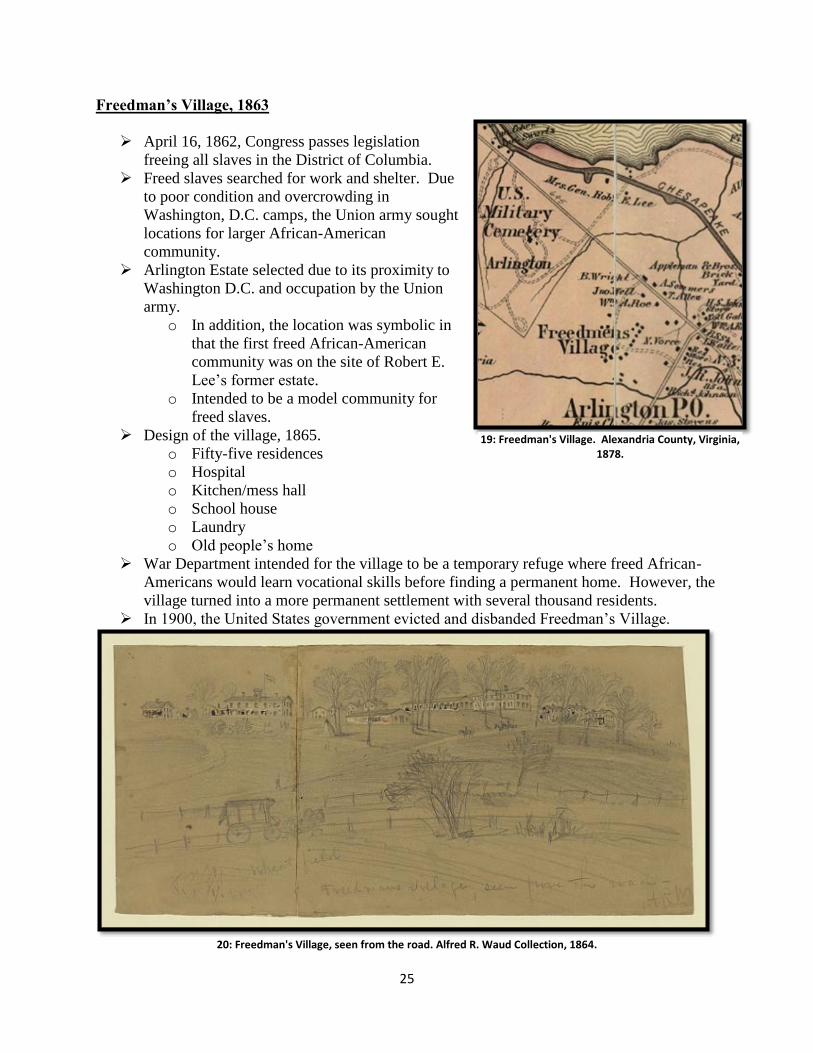
Freedman’s Village, 1863
April 16, 1862, Congress passes legislation
freeing all slaves in the District of Columbia.
Freed slaves searched for work and shelter. Due
to poor condition and overcrowding in
Washington, D.C. camps, the Union army sought
locations for larger African-American
community.
Arlington Estate selected due to its proximity to
Washington D.C. and occupation by the Union
army.
o In addition, the location was symbolic in
that the first freed African-American
community was on the site of Robert E.
Lee’s former estate.
o Intended to be a model community for
freed slaves.
Design of the village, 1865.
o Fifty-five residences
o Hospital
o Kitchen/mess hall
o School house
o Laundry
o Old people’s home
War Department intended for the village to be a temporary refuge where freed African-
Americans would learn vocational skills before finding a permanent home. However, the
village turned into a more permanent settlement with several thousand residents.
In 1900, the United States government evicted and disbanded Freedman’s Village.
20: Freedman's Village, seen from the road. Alfred R. Waud Collection, 1864.
19: Freedman's Village. Alexandria County, Virginia, 1878.
26
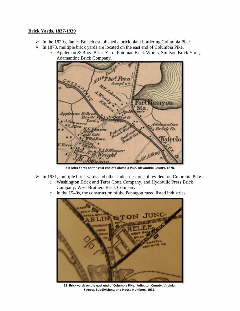
Brick Yards, 1837-1930
In the 1820s, James Breach established a brick plant bordering Columbia Pike.
In 1878, multiple brick yards are located on the east end of Columbia Pike.
o Appleman & Bros. Brick Yard, Potomac Brick Works, Smitson Brick Yard,
Adamantine Brick Company.
21: Brick Yards on the east end of Columbia Pike. Alexandria County, 1878.
In 1931, multiple brick yards and other industries are still evident on Columbia Pike.
o Washington Brick and Terra Cotta Company, and Hydraulic Press Brick
Company, West Brothers Brick Company.
o In the 1940s, the construction of the Pentagon razed listed industries.
22: Brick yards on the east end of Columbia Pike. Arlington County, Virginia.
Streets, Subdivisions, and House Numbers, 1931.
27
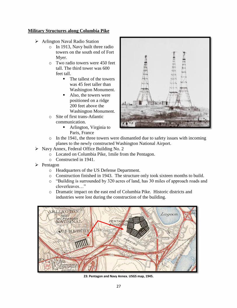
Military Structures along Columbia Pike
Arlington Naval Radio Station
o In 1913, Navy built three radio
towers on the south end of Fort
Myer.
o Two radio towers were 450 feet
tall. The third tower was 600
feet tall.
The tallest of the towers
was 45 feet taller than
Washington Monument.
Also, the towers were
positioned on a ridge
200 feet above the
Washington Monument.
o Site of first trans-Atlantic
communication.
Arlington, Virginia to
Paris, France
o In the 1941, the three towers were dismantled due to safety issues with incoming
planes to the newly constructed Washington National Airport.
Navy Annex, Federal Office Building No. 2
o Located on Columbia Pike, 1mile from the Pentagon.
o Constructed in 1941.
Pentagon
o Headquarters of the US Defense Department.
o Construction finished in 1943. The structure only took sixteen months to build.
o “Building is surrounded by 320 acres of land, has 30 miles of approach roads and
cloverleaves…”
o Dramatic impact on the east end of Columbia Pike. Historic districts and
industries were lost during the construction of the building.
23: Pentagon and Navy Annex. USGS map, 1945.
28
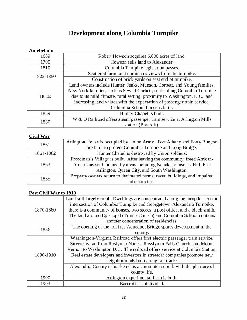
Development along Columbia Turnpike
Antebellum
1669 Robert Howson acquires 6,000 acres of land.
1700 Howson sells land to Alexander.
1810 Columbia Turnpike legislation passes.
1825-1850 Scattered farm land dominates views from the turnpike.
Construction of brick yards on east end of turnpike.
1850s
Land owners include Hunter, Jenks, Munson, Corbett, and Young families.
New York families, such as Sewell Corbett, settle along Columbia Turnpike
due to its mild climate, rural setting, proximity to Washington, D.C., and
increasing land values with the expectation of passenger train service.
Columbia School house is built.
1859 Hunter Chapel is built.
1860 W & O Railroad offers steam passenger train service at Arlington Mills
station (Barcroft).
Civil War
1861 Arlington House is occupied by Union Army. Fort Albany and Forty Runyon
are built to protect Columbia Turnpike and Long Bridge.
1861-1862 Hunter Chapel is destroyed by Union soldiers.
1863
Freedman’s Village is built. After leaving the community, freed African-
Americans settle in nearby areas including Nauck, Johnson’s Hill, East
Arlington, Queen City, and South Washington.
1865 Property owners return to decimated farms, razed buildings, and impaired
infrastructure.
Post Civil War to 1910
1870-1880
Land still largely rural. Dwellings are concentrated along the turnpike. At the
intersection of Columbia Turnpike and Georgetown-Alexandria Turnpike,
there is a community of houses, two stores, a post office, and a black smith.
The land around Episcopal (Trinity Church) and Columbia School contains
another concentration of residencies.
1886 The opening of the toll free Aqueduct Bridge spurrs development in the
county.
1890-1910
Washington-Virginia Railroad offers first electric passenger train service.
Streetcars ran from Roslyn to Nauck, Rosslyn to Falls Church, and Mount
Vernon to Washington D.C. The railroad offers service at Columbia Station.
Real estate developers and investors in streetcar companies promote new
neighborhoods built along rail tracks
Alexandria County is marketed as a commuter suburb with the pleasure of
county life.
1900 Arlington experimental farm is built.
1903 Barcroft is subdivided.
29
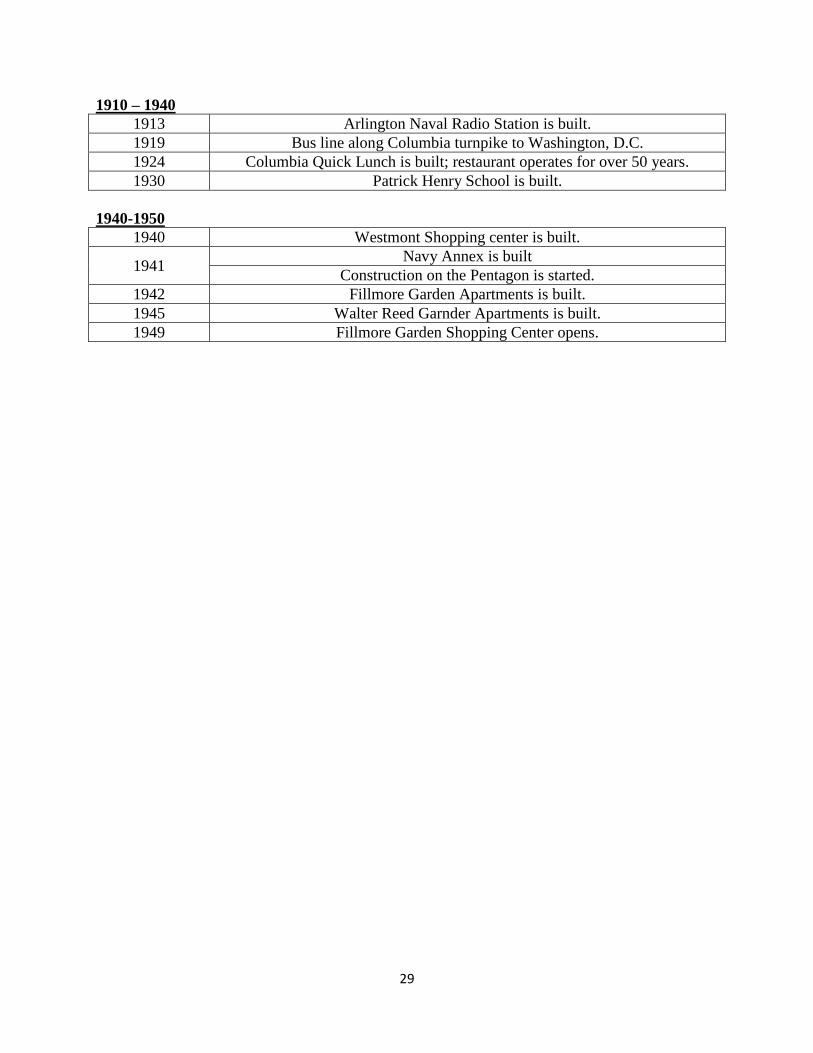
1910 – 1940
1913 Arlington Naval Radio Station is built.
1919 Bus line along Columbia turnpike to Washington, D.C.
1924 Columbia Quick Lunch is built; restaurant operates for over 50 years.
1930 Patrick Henry School is built.
1940-1950
1940 Westmont Shopping center is built.
1941 Navy Annex is built
Construction on the Pentagon is started.
1942 Fillmore Garden Apartments is built.
1945 Walter Reed Garnder Apartments is built.
1949 Fillmore Garden Shopping Center opens.
30
Bibliography
“$326,000 Road Bond Issue Planned for Arlington County.” The Washington Post. July 2, 1924.
http://www.washingtonpost.com (accessed April 4, 2010).
“Arlington Accepts Tentative Additions to Road Schedule.” The Washington Post. July 27, 1924.
http://www.washingtonpost.com (accessed April 4, 2010).
“Arlington District to get New Roads in Building Program.” The Washington Post. September 7,
1924. http://www.washingtonpost.com (accessed April 4, 2010).
“Arlington House, The Robert E. Lee Memorial.” National Park Service. http://www.nps.gov
(accessed April 4, 2010).
“Arlington Roads in Poor Condition.” The Washington Post. October 14, 1922.
http://www.washingtonpost.com (accessed April 4, 2010).
Barron, James. “Then & Now, A Pictorial History of Northern Virginia: Death Trap Still There.”
Northern Virginia Sun. January 22, 1974.
Branagan, Michael F. “Two Hundred Years of Transportation: Historic Columbia Pike in 2008:
A Preservation Plan.” Preservation Planning, University of Virginia, 1988.
Breed, Eltinge. “The Design, Construction and Maintenance of Reinforced Concrete Pavement.”
Good Roads 68, no.6 (July 1925): 950.
Bunting-Hallock, Jennifer. “National Register Nomination: Harry W. Gray House.” United
States Department on the Interior. (May 2003).
Carter, Edward C., II. Benjamin Henry Latrobe and Public Works: Professionalism, Private
Interests, and Public Policy in the Age of Jefferson. Washington, D.C.: Public Works
Historical Society, 1976.
Collins, Sara. “Columbia Pike – Some History.” Arlington Historical Magazine 9, no. 1
(1989): 21-38.
Columbia Heights Civic Association. “Neighborhood Conservation Plan, Appendix A: A History
of Arlington County and Columbia Heights.” (May 16, 2004).
http://www.on-the-pike.com (accessed April 04, 2010).
Dalette, Norbert. Concrete Pavement, Design, Construction and Performance. New York:
Taylor and Francis, 2008.
Department of Agriculture. Annual Reports of the Department of Agriculture For the Year
Ended June 30, 1912. Washington, D.C.: Government Printing Office, 1913.
31
Department of Agriculture. Annual Reports of the Department of Agriculture For the Year
Ended June 30, 1913. Washington, D.C.: Government Printing Office, 1914.
“Design of Continuously Reinforced Concrete Pavements Using Glass Fiber Reinforced Polymer
Rebars.” U.S. Department of Transportation, Federal Highway Administration.
http://www.fhwa.dot.gov (accessed April 4, 2010).
“Emancipation at Arlington: Freedman’s Village, 1863.” National Park Service.
http://www.nps.gov (accessed April 4, 2010).
Froehlig, Adam and Roberson, Mike. “The Virginia Highways Project.”
http://www.vahighways.com (accessed April 4, 2010).
Formwalt, Lee. “Benjamin Henry Latrobe and the Development of Transportation in the District
of Columbia, 1802-1817.” Records of the Columbia Historical Society, Washington, D.C.
50 (1980):36-66.
Goldback, A.T. “What the Arlington investigations are showing.” Good Roads 64, no. 8
(May 2, 1923): 163-167.
Harwood, Herbert. Rails to the Blue Ridge: The Washington and Old Dominion Railroad, 1847-
1968. Washington, D.C.: Northern Virginia Regional Park Authority, 2009.
House of Representatives of the United States. “Agriculture Appropriation Bill, Hearings before
the Committee on Agriculture.” 65th
Congress, 2nd
Session. (December 15, 1917).
Hunter, Robert Fleming. “The Turnpike Movement in Virginia, 1816-1860.” The Virginia
Magazine of History and Biography 69, no. 3 (July 1961): 278-289.
_____. “Turnpike Construction in Antebellum Virginia.” Technology and Culture 4, no. 2
(Spring 1963): 177-200.
“Judge Brent to Set Day for Voting on County Road Bonds.” The Washington Post. February 26,
1925. http://www.washingtonpost.com (accessed April 4, 2010).
Lee, Dorothy Ellis. A History of Arlington County, Virginia. Richmond: Dietz Press, 1946.
Majewski, John. “Economy, Community, and Law: The Turnpike Movement in New York,
1797-1845.” Law & Society 26, no. 13 (1992): 469-512.
_____. “Who Financed the Transportation Revolution? Regional Divergence and Internal
Improvements in Antebellum Pennsylvania and Virginia.” The Journal of Economic
History 56, no. 4 (December 1996): 763-78.
Merriken, John E. Old Dominion Trolley Too: A History of the Mount Vernon Line. Washington
D.C.:L.O. King, JR, 1987.
32
“Member of Old Area Family.” The Washington Post. August 1, 1972.
http://www.washingtonpost.com (accessed April 4, 2010).
Minutes of the United States Court of the District of Columbia, 1801-1863. June 6, 1810.
National Archives, Washington, D.C.
Netheron, Nan and Netheron Ross. Arlington County in Virginia: A Pictorial History. Norfolk,
Virginia: Donning Company Publishing, 1987.
Paulin, Charles. “Alexandria County in 1861.” Records of the Columbia Historical Society 28
(1926):107-131.
Pawlett, Nathaniel Mason. A Brief History of the Roads of Virginia1607-1840. Charlottesville:
Virginia Highway and Transportation Research Council, 1977.
Rose, Cornelia Bruere. “The Map of Arlington in 1878 – People and Places.” Arlington
Historical Society Magazine 2, no. 2 (1962).
_____. Arlington County, Virginia: A History. Arlington, Virginia: Arlington Historical Society,
1976.
Senate of the United States. “The Committee on Claims, to whom was referred S.R. 73, for the
relief of the Columbia Turnpike Company.”40th
Congress, 2nd Session, No. 153.
(July 2, 1868).
Senate of the United States. “The Committee on District of Columbia, to whom was referred
the memorial of sundry citizens of the county and city of Washington, in the district, and
the adjoining county of Maryland, as also the resolution of the Legislature of the State of
Maryland on the same subject, report.”32nd
Congress, 1st Session, No. 176. (April 12,
1852).
“Short Road to Arlington.” The Washington Post. March 30, 1911.
http://www.washingtonpost.com (accessed April 4, 2010).
Statutes at Large of the United States. “An Act for establishing the temporary and permanent seat
of this Government of the United States.” 1st Congress, 2
nd Session, Chapter 28.
(July 16, 1970): 130.
Statutes at Large of the United States. “An act to incorporate a company for making certain
turnpike roads in the District of Columbia.” 11th
Congress, 2nd
Session, Chapter 23, 26.
(April 20, 1810): 570.
Templeman, Elanor Lee. Arlington House: Vignettes of a Virginia County. Arlington: Author
Published, 1976.
33
Waud, Alfred. “Freemens Village Seen from the Road.” Library of Congress.
http://www.loc.gov (accessed April 4, 2010).
Williams, Ames. Washington & Old Dominion Railroad: 1847-1968. Virginia: Arlington
Historical Society, 1989.
_____. “The Washington and Old Dominion Railroad.” Records of the Columbia Historical
Society, Washington, D.C. 66/68 (1966/1968): 231-276.

34