collector wind farm environmental assessmentratchaustralia.com/collector/ratch collector wf/01...
TRANSCRIPT
APP Corporation
Collector Wind Farm Environmental Assessment June 2012
Collector Wind Farm Environmental Assessment June 2012
STATEMENT OF VALIDITY Submission of Environmental Assessment
Prepared under Part 3A of the Environmental Planning and Assessment Act 1979 by:
Name: APP Corporation Pty Ltd
Address: Level 7, 116 Miller Street North Sydney NSW 2060
In respect of: Collector Wind Farm Project
Applicant and Land Details
Applicant name RATCH Australia Corporation Limited
Applicant address Level 13, 111 Pacific Highway North Sydney NSW 2060
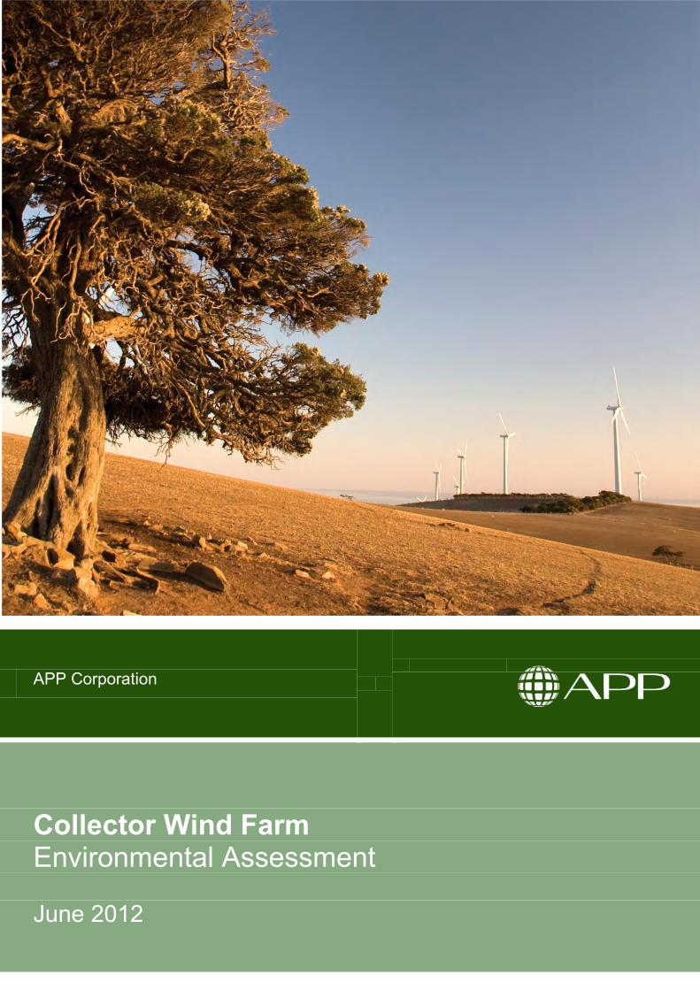
Land to be developed Land 6,215ha in area within the Upper Lachlan Shire, located along the Cullerin Range, bound to the north by the Hume Highway and to the south by Collector Road, comprising the lots listed in Table 1 of the Environmental Assessment.
Proposed development Construction and operation of up to 68 wind turbines with installed capacity of up to 228MW, and associated electrical and civil infrastructure for the purpose of generating electricity from wind energy.
Environmental Assessment An Environmental Assessment (EA) is attached.
Certification I certify that I have prepared the contents of this EA and to the best of my knowledge:
• it contains all available information that is relevant to the environmental assessment of the development to which the EA relates;
• it is true in all material particulars and does not, by its presentation or omission of information, materially mislead; and
• it has been prepared in accordance with the Environmental Planning and Assessment Act 1979
Signature
Name NICK VALENTINE
Qualifications BSc (Hons), MAppSc
Date 30 June 2012

Collector Wind Farm Environmental Assessment June 2012
EXECUTIVE SUMMARY ........................................................................................................ I 1. INTRODUCTION .......................................................................................................... 2
1.1. OBJECTIVES OF THE ASSESSMENT .......................................................................................... 2 1.2. THE PROPOSAL ..................................................................................................................... 2 1.3. OVERVIEW OF THE PLANNING PROCESS .................................................................................. 3 1.4. THE PROPONENT ................................................................................................................... 4 1.5. NSW RENEWABLE ENERGY PRECINCTS .................................................................................. 4 1.6. DOCUMENT STRUCTURE ........................................................................................................ 4
2. DESCRIPTION OF THE PROPOSAL ........................................................................... 8
2.1. KEY TERMS ........................................................................................................................... 8 2.2. LOCATION AND PROJECT COMPONENTS .................................................................................. 8 2.3. WIND FARM INFRASTRUCTURE ............................................................................................. 13 2.4. SITE ACCESS ....................................................................................................................... 19 2.5. WIND FARM DEVELOPMENT PROGRAM .................................................................................. 22 2.6. RESOURCE REQUIREMENTS ................................................................................................. 26
3. STATUTORY, POLICY AND PLANNING CONTEXT ................................................. 30
3.1. COMMONWEALTH LEGISLATION ............................................................................................. 30 3.2. COMMONWEALTH POLICY ..................................................................................................... 31 3.3. STATE LEGISLATION ............................................................................................................. 31 3.4. STRATEGIC PLANNING .......................................................................................................... 34 3.5. ENVIRONMENTAL PLANNING INSTRUMENTS ........................................................................... 35
4. STRATEGIC JUSTIFICATION OF THE PROPOSAL ................................................. 46
4.1. ENERGY DEMAND PROJECTIONS .......................................................................................... 46 4.2. CLIMATE CHANGE ................................................................................................................ 46 4.3. GOVERNMENT POLICY POSITION ........................................................................................... 49 4.4. GREENHOUSE GAS ABATEMENT ........................................................................................... 50 4.5. ELECTRICITY MARKET MODELLING ........................................................................................ 51 4.6. NEED FOR RENEWABLE ENERGY GENERATION IN NSW ......................................................... 52 4.7. SUITABILITY OF THE PROJECT SITE ....................................................................................... 53 4.8. ALTERNATIVES CONSIDERED ................................................................................................ 54 4.9. COMMUNITY SUPPORT FOR RENEWABLE ENERGY ................................................................. 55 4.10. SUMMARY ........................................................................................................................... 58
5. KEY ASSESSMENT REQUIREMENTS ..................................................................... 60
6. LANDSCAPE AND VISUAL IMPACT ......................................................................... 64
6.1. METHODOLOGY ................................................................................................................... 64
APP Corporation
Contents
Collector Wind Farm Environmental Assessment June 2012
6.2. VISUAL ELEMENTS OF THE PROPOSAL ................................................................................... 64 6.3. PERCEPTION AND COMMUNITY CONSULTATION ...................................................................... 65 6.4. VIEWSHED, VISIBILITY AND ZONE OF VISUAL INFLUENCE......................................................... 66 6.5. LANDSCAPE CHARACTER AREAS AND SENSITIVITY ................................................................. 68 6.6. POTENTIAL IMPACTS ............................................................................................................ 71 6.7. PHOTOMONTAGES ............................................................................................................... 72 6.8. AVIATION OBSTACLE LIGHTING ............................................................................................. 73 6.9. CUMULATIVE VISUAL IMPACTS .............................................................................................. 73 6.10. PRE-CONSTRUCTION AND CONSTRUCTION ............................................................................ 75 6.11. MANAGEMENT AND MITIGATION ............................................................................................ 75
7. NOISE ASSESSMENT ............................................................................................... 78
7.1. WIND FARM NOISE ............................................................................................................... 78 7.2. NOISE GUIDELINES .............................................................................................................. 80 7.3. EXISTING ENVIRONMENT ...................................................................................................... 82 7.4. METHODOLOGY ................................................................................................................... 82 7.5. IMPACT ASSESSMENT – CONSTRUCTION AND DECOMMISSIONING ........................................... 83 7.6. IMPACT ASSESSMENT – OPERATION ..................................................................................... 86 7.7. MITIGATION MEASURES – CONSTRUCTION AND DECOMMISSIONING ........................................ 90 7.8. MITIGATION MEASURES - OPERATION ................................................................................... 91
8. FLORA AND FAUNA ASSESSMENT ......................................................................... 94
8.1. ASSESSMENT METHODOLOGY .............................................................................................. 94 8.2. EXISTING ENVIRONMENT ...................................................................................................... 98 8.3. IMPACT ASSESSMENT......................................................................................................... 102 8.4. CUMULATIVE IMPACTS ........................................................................................................ 106 8.5. MITIGATION MEASURES ...................................................................................................... 106
9. INDIGENOUS HERITAGE ........................................................................................ 112
9.1. ASSESSMENT APPROACH ................................................................................................... 112 9.2. EXISTING ENVIRONMENT .................................................................................................... 114 9.3. POTENTIAL IMPACTS – CONSTRUCTION AND DECOMMISSIONING ........................................... 115 9.4. POTENTIAL IMPACTS – OPERATION ..................................................................................... 115 9.5. MITIGATION MEASURES ...................................................................................................... 115
10. TRAFFIC AND TRANSPORT ................................................................................... 118
10.1. EXISTING ENVIRONMENT .................................................................................................... 118 10.2. IMPACT ASSESSMENT – CONSTRUCTION AND DECOMMISSIONING ......................................... 119 10.3. IMPACT OF GENERATED TRAFFIC ........................................................................................ 121 10.4. MITIGATION MEASURES – CONSTRUCTION AND DECOMMISSIONING ...................................... 124 10.5. MITIGATION MEASURES - OPERATION ................................................................................. 125
11. HAZARDS AND RISKS ............................................................................................ 128
11.1. AVIATION IMPACTS ............................................................................................................. 128 11.2. TELECOMMUNICATIONS IMPACTS ........................................................................................ 131 11.3. FIRE AND BUSHFIRE IMPACTS ............................................................................................. 135 11.4. HEALTH AND SAFETY ......................................................................................................... 138
12. WATER QUALITY ..................................................................................................... 156
12.1. EXISTING ENVIRONMENT .................................................................................................... 156 12.2. WATER DEMAND ................................................................................................................ 157
Collector Wind Farm Environmental Assessment June 2012
12.3. IMPACT ASSESSMENT – CONSTRUCTION AND DECOMMISSIONING ......................................... 158 12.4. IMPACT ASSESSMENT – OPERATION ................................................................................... 159 12.5. MANAGEMENT AND MITIGATION .......................................................................................... 160
13. GENERAL ENVIRONMENTAL ASSESSMENT........................................................ 164
13.1. CLIMATE AND AIR QUALITY ................................................................................................. 164 13.2. SOILS AND LANDFORMS ..................................................................................................... 165 13.3. NON-INDIGENOUS HERITAGE .............................................................................................. 166 13.4. WASTE MINIMISATION AND MANAGEMENT ........................................................................... 168 13.5. PROPERTY VALUES ............................................................................................................ 170 13.6. MINERAL EXPLORATION ..................................................................................................... 172 13.7. SOCIO-ECONOMIC CONSIDERATIONS .................................................................................. 173 13.8. LAND USE ......................................................................................................................... 176
14. COMMUNITY AND STAKEHOLDER CONSULTATION ........................................... 180
14.1. CONSULTATION METHODOLOGY ......................................................................................... 180 14.2. COMMUNITY CONSULTATION .............................................................................................. 185 14.3. CONCLUSION ..................................................................................................................... 197
15. ENVIRONMENTAL RISK ANALYSIS ....................................................................... 200
15.1. APPROACH TO ENVIRONMENTAL RISK ASSESSMENT ............................................................ 200
16. STATEMENT OF COMMITMENTS .......................................................................... 206
16.1. PROJECT ENVIRONMENTAL MANAGEMENT PLAN: ................................................................. 206 16.2. CONSTRUCTION ENVIRONMENTAL MANAGEMENT PLAN ........................................................ 206 16.3. OPERATION ENVIRONMENTAL MANAGEMENT PLAN .............................................................. 208 16.4. STATEMENT OF COMMITMENTS ........................................................................................... 208
17. CONCLUSION .......................................................................................................... 228
18. REFERENCES ......................................................................................................... 230
Collector Wind Farm Environmental Assessment June 2012
Tables
TABLE 1 PROPERTIES TO BE INVOLVED IN THE COLLECTOR WIND FARM PROJECT ......................... 9 TABLE 2 PROJECT COMPONENT DIMENSIONS ............................................................................. 12 TABLE 3 WIND TURBINE MODELS UNDER CONSIDERATION .......................................................... 15 TABLE 4 WIND TURBINE GENERATOR LOCATIONS ....................................................................... 17 TABLE 5 ESTIMATED DURATION OF WIND FARM PROJECT PHASES .............................................. 22 TABLE 6 MAIN STAGES IN THE CONSTRUCTION PROGRAM ........................................................... 24 TABLE 7 NSW PLANNING GUIDELINES CHECKLIST ...................................................................... 36 TABLE 8 KEY ASSESSMENT REQUIREMENTS ............................................................................... 61 TABLE 9 WIND TURBINE PARAMETERS (VESTAS V112) ................................................................ 65 TABLE 10 RELATIONSHIP OF VIEWSHED, ZVI AND VISIBILITY ......................................................... 66 TABLE 11 VIEWSHED DESCRIPTORS ............................................................................................. 67 TABLE 12 CRITERIA FOR THE ASSESSMENT OF LANDSCAPE SENSITIVITY ....................................... 70 TABLE 13 LANDSCAPE CHARACTER AREAS AND SENSITIVITY ......................................................... 71 TABLE 14 WIND FARM DEVELOPMENTS IN THE REGION ................................................................. 74 TABLE 15 TYPICAL NOISE LEVELS ................................................................................................ 78 TABLE 16 CONSTRUCTION NOISE LEVEL PREDICTIONS .................................................................. 84 TABLE 17 CURRENT AND CONSTRUCTION TRAFFIC NOISE LEVELS (DB) ......................................... 85 TABLE 18 MAXIMUM PREDICTED NOISE LEVEL AT RESIDENTIAL RECEIVERS ................................... 87 TABLE 19 RATING SCALE APPLIED TO FLORA SURVEY .................................................................. 96 TABLE 20 SUMMARY OF METHODOLOGY OF FAUNA SURVEYS ....................................................... 96 TABLE 21 SUMMARY OF OCCURRENCE OF THREATENED VEGETATION COMMUNITIES ..................... 99 TABLE 22 PROJECTED EXTENT OF CLEARING OF EEC AND ASSESSMENT OF SIGNIFICANCE ........ 103 TABLE 23 ASSESSMENT OF IMPACT ON THREATENED OR MIGRATORY SPECIES ........................... 105 TABLE 24 FLORA AND FAUNA IMPACT MITIGATION MEASURES ..................................................... 107 TABLE 25 POTENTIAL IMPACTS ON INDIGENOUS HERITAGE .......................................................... 116 TABLE 26 CONSTRUCTION VEHICLES VISITING SITE .................................................................... 120 TABLE 27 FIRE INCIDENTS FOR WTGS WORLDWIDE .................................................................... 136 TABLE 28 LOW FREQUENCY NOISE MEASUREMENTS ................................................................... 140 TABLE 29 EMF SOURCES AND MAGNETIC FIELD STRENGTH ........................................................ 148 TABLE 30 SHADOW FLICKER RESULTS (HOURS PER YEAR) – WORST CASE ................................. 151 TABLE 31 SUMMARY OF WEATHER DATA FOR GOULBURN STATION (BOM, 2011) ......................... 164 TABLE 32 LARGEST INDUSTRIES BY EMPLOYMENT FOR UPPER LACHLAN SHIRE IN 2006 ............... 174 TABLE 33 COLLECTOR WIND FARM KEY STAKEHOLDERS ............................................................. 181 TABLE 34 STAKEHOLDER CONSULTATION PROGRAM ................................................................... 182 TABLE 35 SUMMARY OF GOVERNMENT STAKEHOLDER ISSUES .................................................... 186 TABLE 36 COMMUNITY QUESTIONS AND PROPONENT RESPONSES .............................................. 191 TABLE 37 MEASURE OF PROBABILITY CATEGORIES .................................................................... 201 TABLE 38 MEASURE OF CONSEQUENCE CATEGORIES ................................................................. 201 TABLE 39 RISK MATRIX ............................................................................................................. 202 TABLE 40 ENVIRONMENTAL RISK ASSESSMENT AFTER APPLICATION OF MITIGATION MEASURES ... 202 TABLE 41 DRAFT STATEMENT OF COMMITMENTS ........................................................................ 209
Collector Wind Farm Environmental Assessment June 2012
Figures
FIGURE 1 NSW RENEWABLE ENERGY PRECINCTS .......................................................................... 5 FIGURE 2 LOCATION OF THE PROJECT SITE .................................................................................... 8 FIGURE 3 WIND TURBINE GENERATOR COMPONENTS ................................................................... 13 FIGURE 4 WIND TURBINE LAYOUT ................................................................................................ 15 FIGURE 5 WIND FARM INFRASTRUCTURE ...................................................................................... 20 FIGURE 6 LAND USE ZONES OF THE PROJECT SITE ....................................................................... 38 FIGURE 7 GREENHOUSE GAS SAVINGS - 230MW WIND FARM ....................................................... 50 FIGURE 8 WIND TURBINE NOISE................................................................................................... 79 FIGURE 9 NOISE CONTOURS – SUZLON S88 ................................................................................. 87 FIGURE 10 NOISE CONTOURS – REPOWER 3.4M ............................................................................ 87 FIGURE 11 NOISE CONTOURS – SIEMENS SWT-2.3 ........................................................................ 87 FIGURE 12 FAUNA HABITAT TYPES ............................................................................................... 101 FIGURE 13 PROPOSED TRUCK ROUTE FROM PORT KEMBLA TO THE PROJECT SITE .......................... 119
Appendices
APPENDIX A STAKEHOLDER CORRESPONDENCE .................................................................. VOLUME 2 APPENDIX B DECOMMISSIONING AND REHABILITATION PLAN ................................................ VOLUME 2 APPENDIX C LANDSCAPE AND VISUAL IMPACT ASSESSMENT ................................................. VOLUME 2 APPENDIX D COMMUNITY ATTITUDES SURVEY ..................................................................... VOLUME 2 APPENDIX E PHOTOMONTAGES .......................................................................................... VOLUME 2 APPENDIX F NOISE IMPACT ASSESSMENT ........................................................................... VOLUME 2 APPENDIX G ECOLOGICAL ASSESSMENT ............................................................................. VOLUME 2 APPENDIX H INDIGENOUS AND NON-INDIGENOUS HERITAGE ASSESSMENT ............................ VOLUME 2 APPENDIX I TRAFFIC AND TRANSPORT STUDY .................................................................... VOLUME 2 APPENDIX J AERONAUTICAL ASSESSMENT .......................................................................... VOLUME 2 APPENDIX K TELECOMMUNICATIONS IMPACT ASSESSMENT .................................................. VOLUME 2 APPENDIX L SHADOW FLICKER ASSESSMENT ...................................................................... VOLUME 2 APPENDIX M COMMUNITY CONSULTATION DOCUMENTATION ................................................ VOLUME 2
Collector Wind Farm Environmental Assessment June 2012
THIS PAGE LEFT INTENTIONALLY BLANK

i Collector Wind Farm Environmental Assessment June 2012
APP Corporation
Executive Summary
ii Collector Wind Farm Environmental Assessment June 2012
Executive Summary This Environmental Assessment (EA) has been prepared in accordance with the Director-General’s
Requirements (DGR’s) issued by NSW Department of Planning and Infrastructure (DoPI). The objective of the
EA is to support the application by Transfield Services Wind Developments Pty Ltd (the Proponent) for Project
Approval under Part 3A of the Environmental Planning and Assessment Act 1979 (EP&A Act) for the proposed
Collector Wind Farm (the Proposal).
This EA identifies the potential environmental impacts relating to the construction, operation and
decommissioning of the Proposal, and includes a draft Statement of Commitments which details proposed
environmental safeguards and mitigation measures the Proponent will implement to minimise any adverse
impacts.
This EA has been prepared by APP Corporation Pty Limited on behalf of the Proponent. It includes the
findings from specialist technical assessments and inputs from consultation with the Collector community and
other stakeholders.
The Proposal
The Proposal involves the construction, operation and decommissioning of a wind farm comprising up to 68
wind turbine generators (WTGs) and associated electrical and civil infrastructure.
Noise performance analysis has determined that the proposal for up to 68 WTGs is compliant with all relevant
operational noise criteria, including the Draft NSW Wind Farm Noise Guidelines. The maximum number of
turbines that can be installed on the site, whilst remaining fully compliant with noise guidelines, is dependent
on the type of turbine used. Several WTG models are under consideration for the Proposal. Depending on the
WTG model, and subject to conditions of approval which may be imposed on the Proposal, there could be
fewer than 68 WTGs eventually installed.
The specific WTG chosen for the project will be determined through a competitive tender process. The
Proposal will have an installed generating capacity of up to 228 megawatts (MW) depending on the capacity
and number of WTGs installed.
The Proposal includes electrical and civil infrastructure associated with the WTGs. This includes access roads,
underground cabling, a control building, substation, connection to the transmission grid, and wind monitoring
masts. Additional infrastructure will be required during the construction phase, including a construction
compound and potentially an on-site concrete batching plant (which would be subject to a separate
development application).
The Proposal will be located in the Upper Lachlan Shire Local Government Area (LGA) approximately 55
kilometres (km) north-east of Canberra and 35km south-west of Goulburn. Situated in the NSW Southern
Tablelands along the Cullerin Range, the project site is bounded to the north by the Hume Highway and to the
south by the Collector-Gunning Road and is bisected by Lerida Road South. The population within a 5km
iii Collector Wind Farm Environmental Assessment June 2012
radius of the Proposal is approximately 350, with the majority residing in Collector village, approximately
3.5km to the south-east of the Project site.
Following selection of the turbine model and determination of the final number of WTGs, the wind farm layout
would be subject to minor adjustments - ‘micro-siting’ - prior to construction in response to various factors
including:
environmental constraints, such as avoidance of significant vegetation, drainage lines, and geological
conditions;
final wind speed and energy yield analysis;
detailed site survey and geotechnical/civil engineering analysis; and
turbine manufacturer’s recommendations.
Statutory Context
The Proposal was declared a Major Project under Part 3A of the EP&A Act by the Minister for Planning on 15
February 2010. Through an Instrument of Delegation (14 September 2011), the Minister for Planning and
Infrastructure delegated the determination of the Proposal to the Planning Assessment Commission. The
Proposal was declared to be a “critical infrastructure project” under Section 75C of the EP&A Act, being a wind
energy project with a ”…capacity to generate at least 30 megawatts”. Hence, the Proposal has been assessed
in accordance with Part 3A of the EP&A Act.
This Environmental Assessment (EA) was prepared in accordance with the DGRs issued under section 75F of
the EP&A Act. The DGRs, which were issued on 15 October 2010 in response to a Major Project Application
made by the Proponent on 17 September 2010, identify the key issues that must be assessed in this EA.
The relevant local government planning instrument is the Upper Lachlan Local Environmental Plan 2010
(LEP). The Proposal will be situated on land zoned RU2 Rural Landscape under the LEP and is permissible
with development consent.
Draft NSW Wind Farm Guidelines were released by the NSW Government in December 2011. In accordance
with instructions from the Department of Planning and Infrastructure, the Proponent has had regard to these
guidelines in the preparation of this document.
Strategic Justification
In August 2009, the Federal Government implemented the Renewable Energy Target (RET) scheme, which
aims to “…ensure that 20 per cent of Australia's electricity supply will come from renewable sources by 2020”.
On 1 January 2011, the Large-scale Renewable Energy Target (LRET) - covering large-scale renewable
energy projects including wind farms – was introduced.
The NSW Government – through the State Plan NSW 2021: A Plan to Make NSW Number One – has
committed to 20% renewable energy by 2020 “…by promoting energy security through a more diverse energy
iv Collector Wind Farm Environmental Assessment June 2012
mix, reducing coal dependence, increasing energy efficiency and moving to lower emission energy sources”.
To support this policy, the Government has appointed a Parliamentary Secretary for Renewable Energy and is
developing a 2020 NSW Renewable Energy Plan. The Government has also maintained the Renewable
Energy Precincts initiative, which designates six areas of the state where significant renewable energy
development is anticipated. The Proposal is situated within NSW/ACT Cross Border Region Precinct.
The Proposal will contribute to the Federal and State Government strategic initiatives by generating up to 586
gigawatt-hours (GWh) of electricity per annum, equivalent to powering approximately 80,000 homes. Over the
projected life of the Proposal (approximately 25 years) emissions of up to 11 million tonnes of greenhouse
gases will be avoided through substitution for fossil-fuelled energy generation,.
Local employment will be generated by the Proposal through direct employment during construction and
operational phases of the project. It is anticipated that there will be economic benefits to the local community
from the flow on effect of construction activity. By taking into consideration stakeholder concerns and
requirements in the iterative development of the Proposal, including conserving biodiversity values and
mitigating environmental impacts, the Proponent intends to sustain the broad community support for
renewable energy developments in the region, as expressed in community perception surveys which are
described in more detail in the EA.
Visual Impact Assessment
The Landscape and Visual Impact Assessment (LVIA) of the Proposal involved a comprehensive evaluation of
the visual character of the landscape in which the Proposal would be located, consideration of community
values of the local and regional amenity, and an assessment of the potential visual impacts from the
construction and operation of the Proposal, taking into account feasible and reasonable mitigation measures.
The LVIA considered the largest dimensioned WTG model under consideration for the Proposal – the Vestas
V112, with a tower height of 94m and a blade length of 56m – as the worst case scenario.
The LVIA determined the landscape within the Proposal viewshed has a medium sensitivity to accommodate
change, with this capability derived from the presence of large-scale and open landscape across the project
site and its relatively low settlement density. In the context of landscape sensitivity, the LVIA determined that
the wind farm would not be an unacceptable development within the viewshed, which in a broader context also
contains approved wind farm developments and other built elements such as roads, agricultural industry,
aircraft landing strips, telecommunications towers, and power lines.
The LVIA assessed both 114 residential and nine public view locations within 10km of the wind farm. The
assessment concluded that six of the 114 residential view locations (or 5%) would experience a high visual
impact and four would experience a moderate to high impact. Eighty-six residences (75%) would experience a
low or nil visual impact. All nine public view locations assessed would experience low visual impact. Three of
the residences determined to have a high visual impact are project-involved residences and two non-involved
residences are situated on the same property. Of the non-involved residences within 2km of a proposed

v Collector Wind Farm Environmental Assessment June 2012
turbine, two are expected to experience a high visual impact and the third a low to moderate impact, given the
screening vegetation within the residential curtilage.
This LVIA determined the Proposal is unlikely to result in any significant ‘direct’, ‘indirect’ or ‘sequential’
cumulative visual impact resulting from associated views toward existing wind farm developments within a
10km viewshed, including the Cullerin Range, Gunning and Capital/Woodlawn Wind Farms.
Measures are proposed to minimise and mitigate visual impacts by reducing the visual contrast between the
turbines and the landscape, designing and siting ancillary infrastructure sympathetically, providing the option
of screening views from specific locations, and minimising visibility during construction. These measures are
outlined in the draft Statement of Commitments.
Noise Assessment
The potential noise and vibration impacts from the construction, operation and decommissioning of the
Proposal were assessed using relevant construction, wind farm and traffic noise guidelines.
Operational noise was assessed in accordance with the South Australia Environment Protection Authority (SA
EPA) Wind Farms – Environmental Noise Guidelines (2003) (SA EPA Guidelines) and the NSW Wind Farm
Noise Guidelines (2011). The Proposal took a conservative approach by adopting the base noise criterion of
35dBA for non-involved receivers stipulated in the SA EPA guidelines. Noise criteria based on background
noise were not used to assess compliance of the Proposal as the background noise monitoring data set was
considered inconclusive due to uncharacteristic night time noise readings at some of the background noise
monitoring locations.
For project-involved receivers, reference was made to the European Working Group on Noise from Wind
Turbines document ETSU R-97 The Assessment and Rating of Noise from Wind Farms, which recognises that
where landowners have a financial involvement with the wind farm, higher noise levels are acceptable. The
noise assessment for the Proposal adopts the recommended criteria of 45dBA for involved receivers, which is
in agreement with the World Health Organisation (WHO) criterion for protection of amenity and avoidance of
sleep disturbance as published in the document Guidelines for Community Noise (1999).
Noise levels were predicted for three different wind turbine models - Suzlon S88-2.1MW,V3, REPower 3.4M
104 and Siemens SWT-2.3-101 - which represent a range of sound power levels. The results show that to be
able to achieve the target noise criterion of 35dBA for all non-involved residences, some turbines would need
to be removed from the layout for the turbine models with higher sound power levels. The current Proposal is
for a maximum of 68 WTGs, with the number of turbines to be eventually included in the Proposal depending
on the wind turbine model to be selected and governed by noise compliance.
The potential impact of low frequency noise from the operation of the WTGs was also considered as part of
the noise impact assessment in accordance with NSW Wind Farm Noise Guidelines (2011). The predicted low
frequency noise levels are below the 65dBC (day) and 60dBC (night) trigger levels requiring further detailed
low frequency noise assessments.
vi Collector Wind Farm Environmental Assessment June 2012
An assessment of potential cumulative noise effects associated with the combined operation of the existing
Cullerin Range Wind Farm and the proposed Collector Wind Farm has been carried out. This assessment
demonstrated compliance with the 2003 SA Guideline limits.
Flora and Fauna Assessment
A Biodiversity Assessment has been undertaken to assess biodiversity values of the project site, identify and
assess potential impacts to these values and develop mitigation measures to avoid or otherwise minimise the
potential impact of the Proposal on these biodiversity values. The assessment was carried out in stages,
allowing for three survey periods across seasons thereby maximising opportunities for detecting and
identifying target species. The assessment focused on the development envelope - the area within which
infrastructure may be located - plus a significant buffer zone to allow micro-siting of the wind turbines after the
final model is selected. The field survey also covered relevant habitat areas outside the project site, including
Lake George.
Areas of two vegetation communities listed under the Threatened Species Conservation Act 1995 (TSC Act)
as Endangered Ecological Communities (EECs) – Box-Gum Woodland and Tablelands Snow Gum Grassy
Woodland – were identified at the Project site. Box-Gum Woodland is also listed as a Critically Endangered
Ecological Community (CEEC) under Environment Protection and Biodiversity Conservation Act 1999 (EPBC
Act). Consequently, the matter was referred to the Minister for Sustainability, Environment, Water, Population
and Communities for assessment. The Proposal is not a “controlled action” and hence does not require further
assessment and approval under the EPBC Act.
The EECs described above will be directly impacted by vegetation clearing for the Proposal infrastructure,
mainly for access roads. The Ecological Assessment concluded that the clearance areas of Box-Gum
Woodland EEC and Tablelands Snow Gum Grassy Woodland EEC is not considered to be significant if the
recommended management measures as outlined in the draft Statement of Commitments are implemented.
The key management measure is the implementation of an Offset Plan to meet the ‘maintain or improve’ test
for biodiversity values, The Proponent has secured an adequate potential offset area within the project
envelope and it is intended that this offset will be formalised through a Property Vegetation Plan. The offset
plan will also include specific habitat elements such as tree hollows.
The Proposal could potentially impact directly on threatened fauna, mainly birds and bats, through collision
with turbines, and through loss or degradation of their habitats. Species listed under the TSC Act with the
potential to be impacted by the Proposal include raptors, woodland birds and microbats. Species listed under
the EPBC Act with the potential to be impacted include the Vulnerable Superb Parrot and Migratory-listed
White-bellied Sea Eagle. The assessment of significance of impacts for these species showed that the
potential impacts from risk of collision and loss of habitat arising from the Proposal are not considered
significant.
vii Collector Wind Farm Environmental Assessment June 2012
Indigenous Heritage
An archaeological assessment of the project site was undertaken in accordance with the draft Guidelines for
Aboriginal Cultural Impact Assessment and Community Consultation (DEC, July 2005). As part of this
assessment, consultation was undertaken with the aboriginal community and stakeholders, in accordance with
the Aboriginal Cultural Heritage Consultation Requirements for Proponents (ACHCRP) (DECCW, 2010).
The Aboriginal Heritage Information System (AHIMS) database identified three known sites of Aboriginal
archaeological heritage in the vicinity to the project site. Following the desktop analysis, archaeological
surveys were undertaken across the project site. A total of five Aboriginal object locales containing stone
artefacts were identified and four trees were recorded as possible Aboriginal scarred trees. None of the five
Aboriginal locales were assessed to be of archaeological significance.
Ground disturbance activities during the construction and decommissioning stages of the Proposal may impact
areas or items of indigenous cultural heritage. Considering the relatively minor significance of the identified
Aboriginal object locales and scarred trees and their sparse distribution within the project site, it is unlikely that
construction of the Proposal would disturb an item or area of archaeological significance.
Traffic and Transport
A traffic and transport assessment was undertaken in accordance with the NSW RTA Guide to Traffic
Generating Developments and the DGR’s to evaluate the potential impacts of the Proposal on traffic and
public road infrastructure.
The primary access to the project site would be via the Hume Highway and Lerida Road South. Access to
turbine locations within the project site would be through Lerida Road South, existing Crown roads and new
internal access roads to be constructed where there are no existing roads. All access roads will be constructed
or upgraded to handle construction loads. Internal roads will be maintained for operational and maintenance
access after construction.
For the purpose of this EA it has been assumed that the wind turbine components would be transported to the
project site from Port Kembla via the Southern Freeway/Mt. Ousley Road, Picton Road and Hume Highway.
The intersection of Hume Highway and Lerida Road South will be upgraded to enable oversize vehicles that
will float construction plant and deliver wind turbine components to safely turn into the site.
Hazards and Risks
Aeronautical
An aeronautical impact assessment of the Proposal considered in detail the likely impact of the location, height
and blade rotation of the Proposal’s wind turbines on the nearest aerodromes, air navigation and air traffic
management services, transiting air routes, designated airspace, other aviation activity, and electromagnetic
interference with airborne radio.
viii Collector Wind Farm Environmental Assessment June 2012
The assessment found that the Proposal will not impact upon aircraft operations to and from Canberra or
Goulburn or the private aerodromes at Gundaroo and Winderadeen. Furthermore, it will not interfere with
airborne radio or navigation aid performance. Flights operating under Visual Flight Rules (VFR) are not likely
to be affected as these are conducted well above the level of the turbines which will be sufficiently
conspicuous by day; night VFRs fly at or above the published lowest safe altitude (LSALT) for the route and
would be sufficiently clear of the wind turbines. Similarly, Instrument Flight Rules (IFR) flights fly at or above
LSALT. The risk to civil aviation activities posed by the Proposal is considered trivial; hence the Proponent
does not propose to install aviation obstacle lighting.
The Proposal would not affect the safety of aerial agricultural operations near the site nor hang gliding
activities near Collector.
Telecommunications
A telecommunications impact assessment identified the potential impacts from the Proposal on existing
telecommunications services and any required mitigation measures. Outcomes from preliminary consultation
and assessments have been considered in iterations of the turbine layout development, resulting in the
relocation or removal of several turbines from the preliminary layout to mitigate against potential
telecommunications impacts. Once the locations of wind turbines are finalised, the Proponent will verify the
coordinates of the communications towers, the status of the services and the requirements of the
telecommunications licensees.
Fire and Bushfire Impacts
Construction activities, including the handling and storage of flammable substances, would increase the risk of
fire in the project site. These risks would be managed in accordance with a Bushfire Risk Management Plan to
be prepared in consultation with the Rural Fire Service (RFS) and the NSW Fire Brigade. The plan would
restrict certain activities on high fire-risk days and would provide for basic fire fighting equipment at active work
sites, among other measures.
The potential for fires occurring in wind turbines or fire caused by the operation of a wind farm is considered to
be extremely low (1 in 14,000 years). However, factors such as overheating of machinery, electrical faults and
lightning strikes can initiate a fire. The Proposal will incorporate fire safety features such as automatic
shutdown, alarm for electrical faults, and lightning arresters to minimise the risk of equipment initiating fires.
Moreover, buffers would be maintained around the control room and substation buildings to prevent the
spread of fire from these structures.
Wind Farm Noise and Health
Concerns have been expressed by members of the Collector community over the potential impacts of wind
turbine noise on human health, in particular low frequency noise. Low frequency noise is generally defined as
noise in the range of 10-200 hertz (Hz), with noise levels at frequencies below 20Hz often referred to as
infrasound. Low frequency noise is part of the environment, emitted from man-made sources including
ix Collector Wind Farm Environmental Assessment June 2012
machinery and traffic, and natural sources including wind, sea and thunder. In the design of older wind
turbines, where the rotor assembly was placed downwind from the tower, low frequency noise was produced
when turbulence created by the tower was cut through by the blades. This issue has been rectified in modern
turbines designed with the rotor assembly placed upwind of the tower, resulting in much lower levels of low
frequency sound.
A review of the literature on environmental noise from wind farms noted that whilst noise generated by wind
turbines has an infrasound component, the actual levels of infrasound from modern wind turbines would not be
perceptible at receiver locations beyond 200 metres (m).
Electromagnetic Fields
There is limited possibility for the general public to be exposed to electric and magnetic fields (EMF) from the
Proposal as it is located entirely on private land. Access to these areas by persons other than those involved
in agricultural activities on the land would be restricted to appropriately trained and qualified maintenance staff.
Property owners accessing the project site would not be expected to spend long periods near the wind
turbines which are located away from frequent use areas such as sheds, yards and residences.
Water Quality
The project site sits on the drainage divide between the Lerida Creek and Frankfield Creek catchments to the
west, which are within the Upper Lachlan River catchment, and the Collector Creek catchment to the east. The
majority of the project site is drained by intermittent (non-perennial) streams. Most of the Proposal
infrastructure will be sited on elevated locations along the Cullerin Range which are sufficiently offset from
drainage lines.
Construction activities involving earthworks, including hardstand and access track construction, and cable
trench installation, could impact surface water quality through sedimentation and contamination. Potential
impacts to surface water and groundwater quality will be mitigated through the measures outlined in the
Statement of Commitments, including erosion and sediment controls, progressive rehabilitation, proper
drainage design and proper storage and handling of potential contaminants.
Stakeholder and Community Consultation
The DGRs require that the consultation process include measures for disseminating information about the
Proposal to increase awareness and active engagement of stakeholders on issues of interest/concern to them.
In addition, the level of consultation is required to be commensurate with the level of interest/concern or likely
impact. As the project site is situated in a rural area near the village of Collector, the focus of consultation
activities was on the local community including village residents and landowners adjoining the project site.
Consultation efforts undertaken in conjunction with the environmental assessment process include the
following:
Newsletters;
x Collector Wind Farm Environmental Assessment June 2012
Website launch;
Community open house forums;
Question and answer newsletter;
Advertising and media releases; and
One-on-one consultation.
Relevant stakeholders identified in the DGR’s were consulted in preparation of this EA and are listed in the
table below.
Group Stakeholder
Local Council Upper Lachlan Council
Yass Valley Council
Goulburn Mulwaree Council
Government NSW Office of Environment and Heritage
NSW Office of Water
NSW Roads and Traffic Authority
Department of Defence
NSW Rural Fire Service
Murrumbidgee Catchment Management Authority
Lachlan Catchment Management Authority
Civil Aviation Safety Authority
Airservices Australia
Community Local Community
Collector Community Association
Friends of Collector
Non-Government and Heritage Aerial Agricultural Society of Australia;
Pejar Local Aboriginal Council;
Onerwal Local Aboriginal Land Council;
Ngunawal Native Title Claimant Group.
Gunning Historical Society;
Goulburn and District Historical Society;
xi Collector Wind Farm Environmental Assessment June 2012
Statement of Commitments
RATCH-Australia Corporation Limited is committed to achieving a sustainable project which minimises the
potential impacts on the environment and community whilst remaining economically viable. Given the extent
and nature of the development, RATCH-Australia Corporation Limited will commit to a detailed list of mitigation
measures in a draft Statement of Commitments (SoC) to ensure such balances are achieved and maintained
throughout all project phases. For the purpose of canvassing the full scope of issues, the draft SoC has been
prepared in relation to those issues outlined within the EA.
Conclusion
The potential environmental impacts associated with the proposed Collector Wind Farm have been assessed
in this Environmental Assessment. The proposal involves the construction, operation and decommissioning of
up to 68 wind turbine generators and associated civil and electrical infrastructure along the Cullerin Range in
the Upper Lachlan Shire and within the NSW/ACT Border Region Renewable Energy Precinct. There are
already a number of operating and approved wind farms within this precinct.
With an installed capacity of up to 228MW, the Proposal would generate for the NSW network electricity from
renewable energy, which translates to a reduction in greenhouse gases from fossil fuel-based power plants
generating an equivalent output. The Proposal is consistent with the State’s priorities to secure a reliable
electricity supply with an increased renewable energy component, and contributes significantly to the
achievement of the State’s renewable energy target.
This EA has demonstrated that the potential impacts of the Proposal could be avoided or otherwise mitigated
to reduce any residual environmental risks to insignificant levels.

xii Collector Wind Farm Environmental Assessment June 2012
THIS PAGE LEFT BLANK INTENTIONALLY

1 Collector Wind Farm Environmental Assessment June 2012
1 APP Corporation
Introduction
1
2 Collector Wind Farm Environmental Assessment June 2012
1. Introduction APP Corporation Pty Ltd (APP) has prepared this Environmental Assessment (EA) to accompany a Project
Application for the proposed Collector Wind Farm (the Proposal). This EA has been prepared on behalf of
the proponent RATCH-Australia Corporation Limited (RAC) in accordance with Part 3A of the Environmental
Planning and Assessment Act 1979 (EP&A Act).
This EA satisfies the Environmental Assessment Requirements issued by the Director-General of the
Department of Planning and Infrastructure (DoPI) dated 15 October 2010 (the Director-General’s
Requirements [DGRs]) (Appendix A). It describes the proposed development, including the site and its
environs, and identifies and assesses the potential environmental impacts arising from the Proposal. The EA
also proposes environmental safeguards and mitigation measures to ensure the identified potential impacts
are minimised.
This EA is supported by technical assessments that cover the key assessment requirements identified in the
DGRs. These assessments are summarised in this document and the technical reports are included as
appendices.
1.1. Objectives of the Assessment
This EA identifies potential environmental impacts relating to the construction, operation and
decommissioning of the Proposal. In accordance with the General Requirements of the DGRs this document
includes:
an executive summary;
a detailed description of the Proposal;
consideration of relevant statutory provisions;
an assessment of key environmental issues;
a draft Statement of Commitments for environmental management and monitoring;
justification for the project taking into consideration the environmental, social and economic impacts of the
Proposal;
certification by the author that the assessment is neither false nor misleading; and
details of consultation with community groups, local residents and key stakeholders.
1.2. The Proposal
The Proposal involves the construction and operation of a wind farm comprising up to 68 wind turbine
generators (WTGs) and associated electrical and civil infrastructure for the purpose of generating electricity
from wind energy for the NSW electricity network.
Various WTG models are being considered for the Proposal, with the final model to be selected following a
competitive tender process. Depending on the WTG model selected, and subject to conditions of approval
1
3 Collector Wind Farm Environmental Assessment June 2012
which may be imposed on this Proposal, there could be fewer than 68 WTGs installed. The final turbine
model will determine the Proposal’s installed capacity, which could be up to 228 megawatts (MW).
The associated infrastructure includes access roads, underground cabling, control buildings, substation,
connection to the transmission grid, monitoring masts and temporary construction facilities.
1.3. Overview of the Planning Process
This Environmental Assessment was prepared and is submitted for assessment under Part 3A of the EP&A
Act, which was repealed on 1 October 2011. Transitional arrangements for declared Part 3A projects were
documented in Planning Circular PS 11-021 (30 September 2011) as follows:
…Part 3A continues to apply to most undetermined project and concept plan applications where Director-
General’s (of the Department of Planning and Infrastructure) environmental assessment requirements
(DGRs) were issued before 1 October 2011 and a current major project declaration remains in force.
These undetermined applications will continue to be assessed and determined under Part 3A, as in force
immediately before its repeal.
Accordingly, DoPI will assess the Proposal in accordance with Part 3A of the EP&A Act.
State Environmental Planning Policy (Major Development) 2005 (SEPP Major Development) identifies
development to which the development assessment and approvals process under Part 3A of the EP&A Act
applies.
Clause 24 of Schedule 1 of SEPP Major Development classifies
...development for the purpose of a facility for the generation of electricity or heat or their co-generation
(using any energy source, including gas, coal, bio-fuel, distillate and waste and hydro, wave, solar or wind
power), being development that has a capital investment value (CIV) of more than $30 million
as Major Development to be assessed under Part 3A of the EP&A Act. The Proposal, which has a CIV of
approximately $350 million falls within this description. On 15 February 2010 the Minister for Planning
formed the opinion that the Proposal is development of a kind described in Schedule 1 of the SEPP Major
Development (see Appendix A).
Section 75C of the EP&A Act provides that a project to which Part 3A applies may also be declared a critical
infrastructure project if it is of a category that, in the opinion of the Minister, is essential for the State for
economic, environmental and social reasons. In 2009, the Minister declared renewable energy projects with
a peak generating capacity of 30MW or more to be critical infrastructure. The declaration was published in
the NSW Government Gazette on 27 November 2009. The Proposal, being a renewable energy
development with an installed capacity of up to 228MW, falls under this description and is therefore a critical
infrastructure project for the purposes of Part 3A of the EP&A Act.
1
4 Collector Wind Farm Environmental Assessment June 2012
1.4. The Proponent
Transfield Services Wind Developments Pty Ltd (the Proponent) is a subsidiary of RATCH-Australia
Corporation Limited (RAC), formerly known as Transfield Services Infrastructure Fund (TSIF). Following the
completion of an ownership and corporate restructuring in July 2011, the company is now 80%-owned by
Ratchaburi Electricity Generating Holding PCL (RATCH) and 20% by Transfield Services Limited (TSE).
RAC is an independent power producer with a portfolio of Australian power generation assets consisting of
five thermal power stations and three operating wind farms: Starfish Hill (South Australia), Toora (Victoria)
and Windy Hill (Queensland). In addition, RAC owns the rights to a further 11 wind farm development
projects throughout Australia.
RATCH is a leading Thailand-based power generation company and is the owner of approximately 14% of
the installed generation capacity in Thailand. TSE delivers essential services to key industries in the
resources and industrial, infrastructure services and property and facilities management sectors and is a
leading Australian provider of operations, maintenance, and asset and project management services. TSE
continues to provide operations and maintenance services for the RAC power generation facilities. TSE is
publicly listed in Australia and included in the S&P/ASX 100.
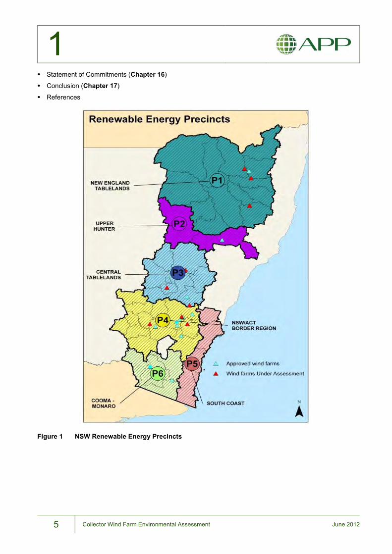
1.5. NSW Renewable Energy Precincts
The NSW Government, through the Office of Environment and Heritage (OEH), established six renewable
energy precincts within which significant renewable energy development is encouraged, especially wind
farms. These precincts are New England Tablelands, Upper Hunter, Central Tablelands, NSW/ACT Border
Region, Cooma-Monaro and the South Coast. The Proposal falls within the NSW/ACT Border Region
precinct (Figure 1). There are a number of operating wind farm developments within this Precinct, together
with approved projects and those currently under assessment.
1.6. Document Structure
This EA has been prepared in accordance with the DGRs issued for the Proposal under Part 3A of the EP&A
Act and provides a detailed assessment of potential environmental impacts resulting from the development
and operation of a wind farm.
The EA is in two volumes: Volume 1 – Environmental Assessment (this document) and Volume 2 –
Appendices. This document has the following structure:
Executive Summary
Introduction and Project Description (Chapters1 – 2)
Statutory, Policy and Planning Context (Chapter 3)
Strategic Justification of the Project (Chapter 4)
Assessment of Key Issues (Chapters 5 – 13)
Stakeholder Engagement and Consultation (Chapter 14)
Environmental Risk Analysis (Chapter 15)
1
5 Collector Wind Farm Environmental Assessment June 2012
Statement of Commitments (Chapter 16)
Conclusion (Chapter 17)
References
Figure 1 NSW Renewable Energy Precincts
1
6 Collector Wind Farm Environmental Assessment June 2012
THIS PAGE LEFT BLANK INTENTIONALLY

7 Collector Wind Farm Environmental Assessment June 2012
2 APP Corporation
Description of the Proposal
2
8 Collector Wind Farm Environmental Assessment June 2012
2. Description of the Proposal This chapter provides a detailed description of the Proposal including project components, construction,
operation and decommissioning details, and resource requirements.
2.1. Key Terms
The following terms are used to refer to the Proposal throughout this EA:
Project site: the land within the cadastral boundaries of all properties involved with the Proposal,
comprising an area of 6,215 hectares (ha).
Development envelope: the area of the project site in which the wind farm infrastructure (turbines,
hardstands, access roads, electrical cables and substation) could potentially be sited, comprising an area
of approximately 800ha. The development envelope was the subject of detailed environmental
investigations, including flora and fauna and indigenous heritage.
Development footprint: the final locations of the wind farm infrastructure. This includes the infrastructure
footprint - the area occupied by turbines, access tracks, substation etc. during the operational phase
(approximately 29ha) - and other areas that will be affected by construction (approximately 45ha) (for
example, cable trench easements, construction phase access track width, construction compound, crane
pads) which can be rehabilitated post-construction.
2.2. Location and Project Components
The Proposal location is within the Upper Lachlan Shire local government area approximately 55 kilometres
(km) north-east of Canberra and 35km south-west of Goulburn (Figure 2). The project site is in the NSW
Southern Tablelands along the Cullerin Range, which is the northern continuation of the Lake George Range.
Elevations in the project site range between 700 and 900 metres (m) Australian Height Datum (AHD). The
project site is bounded to the north by the Hume Highway and to the south by Collector Road. The Cullerin
Range Wind Farm is located north of the project site across Hume Highway. The settlement closest to the
project site is the Collector township, which is approximately 3.5km to the south-east (Figure 2).
For the purposes of community engagement, the Proponent undertook primary consultation with residents
within a 5km radius of the development footprint. The 5km radius was adopted from the Upper Lachlan
Development Control Plan 2010 and is the notification area for wind farm development applications under the
DCP. The area circumscribed by a 5km radius generally coincides with the Collector Census Region defined
by the Australian Bureau of Statistics allowing the following inferences based on 2006 Census data:
the population is approximately 350, mostly residing within Collector village;
the population comprises approximately 100 families; and
there are approximately 120 dwellings within the area.
LAKE GEORGE
LAKE BATHURST
THE MORASS
WOLLOGORANG LAGOON
ROSE LAGOON
Hume Hwy
Federal Hwy
Kings Hw
y
Bart on H
wy
Monaro H
wy
Barton Hwy
Barton Hwy
Barton Hwy
Federal Hwy
Mon
aro
Hw
y
Kings Hwy
Tarago
BywongSutton
Dalton
Manton
Gunning
Karabar
Goulburn
Cullerin
Gundaroo
Carwoola
Environa
Crookwell
Collector
Lade Vale
Bungendore
QueanbeyanLetchworthGreenleigh
Hoskinstown
Run O WatersRun-o-waters
Blakney Creek
Jerrabomberra
Murrumbateman
Grabben Gullen
Bellmount Forest
0 2.5 5 7.5km
F:\G
IS\A
PP\C
olle
ctor
Win
dfar
m\F
ebru
ary
2011
Foc
us G
IS
N
KEY
Town
Watercourse
Main Road
Secondary Road
Lake selectionUrban area
Reserve
State Border
Project Site
2
9 Collector Wind Farm Environmental Assessment June 2012
Detailed wind energy yield and layout studies have been previously commissioned for the general area of
Collector to confirm its suitability for wind farm development. Further detailed wind turbine layout studies
considered access to turbine sites (landowner agreement) and environmental constraints such as ecologically
sensitive areas and potential adverse impacts on the local community, especially noise and visual impacts.
The operating wind farm will include the following components:
up to 68 wind turbines with a maximum height of 150m;
hardstand areas adjacent to each wind turbine site for crane operations during the construction, operation
and decommissioning phases;
a wind farm substation and overhead turn-in connection to the existing 330 kilovolt (kV) transmission
network, which traverses the northern part of the project site; this overhead turn-in connection to the
transmission network would be subject to a separate development approval;
underground 33kV electrical connection and control cables between each wind turbine and the
substation/control room;
access roads connecting the public road network to each wind turbine site and to the wind farm substation;
control room and maintenance facilities; and
up to four wind monitoring masts.
During the construction phase additional project components include the construction compound (including
site offices and storage areas) and potentially an on-site concrete batching plant, the latter to be subject to a
separate development approval.
Land portions owned by seven individual landowners make up the project site. A lot and deposited plan
schedule is shown in Table 1.
Table 1 Properties to be involved in the Collector Wind Farm Project
Lot Number Deposited Plan Lot Deposited Plan
7004 94490 159 750031
1 119192 160 750031
2 126022 161 750031
1 126023 168 750031
1 126027 181 750031
1 126038 182 750031
2 126038 191 750031
3 126038 196 750031
1 126056 197 750031
2
10 Collector Wind Farm Environmental Assessment June 2012
Lot Number Deposited Plan Lot Deposited Plan
1 126060 198 750031
9 133758 201 750031
10 133758 203 750031
1 191728 206 750031
2 304983 207 750031
M 400627 208 750031
O 403201 210 750031
C 403577 215 750031
D 403577 221 750031
E 403668 222 750031
F 403668 223 750031
H 403670 225 750031
J 403670 37 754110
K 404449 145 754110
L 404449 146 754110
G 404619 147 754110
5 439996 3 754127
221 652223 10 754127
23 735248 15 754127
15 750008 19 754127
18 750008 20 754127
40 750008 23 754127
41 750008 24 754127
43 750008 26 754127
44 750008 28 754127
50 750008 29 754127
2
11 Collector Wind Farm Environmental Assessment June 2012
Lot Number Deposited Plan Lot Deposited Plan
51 750008 30 754127
53 750008 31 754127
54 750008 32 754127
55 750008 33 754127
77 750008 34 754127
81 750008 35 754127
83 750008 36 754127
84 750008 37 754127
85 750008 38 754127
86 750008 39 754127
87 750008 41 754127
88 750008 42 754127
89 750008 43 754127
90 750008 44 754127
91 750008 46 754127
92 750008 47 754127
93 750008 48 754127
94 750008 52 754127
95 750008 53 754127
96 750008 54 754127
97 750008 55 754127
118 750008 56 754127
127 750008 57 754127
129 750008 58 754127
188 750008 59 754127
106 750031 65 754127
2
12 Collector Wind Farm Environmental Assessment June 2012
Lot Number Deposited Plan Lot Deposited Plan
107 750031 76 754127
108 750031 77 754127
109 750031 107 754127
110 750031 120 754127
111 750031 122 754127
112 750031 131 754127
113 750031 140 754127
114 750031 146 754127
115 750031 156 754127
158 750031 1 878685
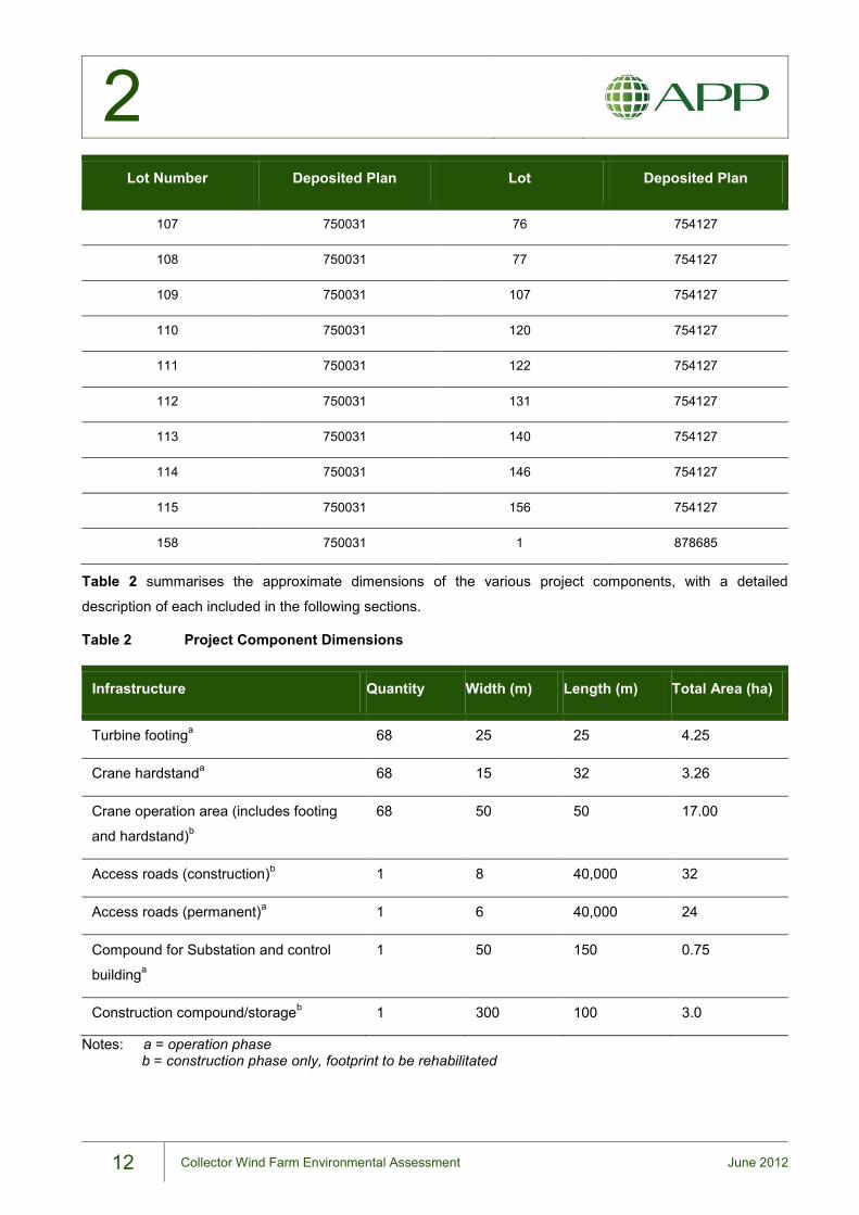
Table 2 summarises the approximate dimensions of the various project components, with a detailed
description of each included in the following sections.
Table 2 Project Component Dimensions
Infrastructure Quantity Width (m) Length (m) Total Area (ha)
Turbine footinga 68 25 25 4.25
Crane hardstanda 68 15 32 3.26
Crane operation area (includes footing
and hardstand)b
68 50 50 17.00
Access roads (construction)b 1 8 40,000 32
Access roads (permanent)a 1 6 40,000 24
Compound for Substation and control
buildinga
1 50 150 0.75
Construction compound/storageb 1 300 100 3.0
Notes: a = operation phase b = construction phase only, footprint to be rehabilitated
2
13 Collector Wind Farm Environmental Assessment June 2012
2.3. Wind Farm Infrastructure
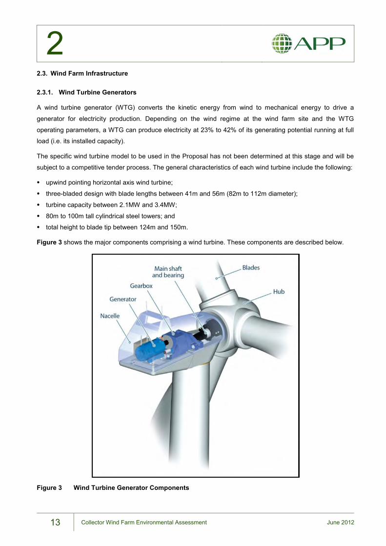
2.3.1. Wind Turbine Generators
A wind turbine generator (WTG) converts the kinetic energy from wind to mechanical energy to drive a
generator for electricity production. Depending on the wind regime at the wind farm site and the WTG
operating parameters, a WTG can produce electricity at 23% to 42% of its generating potential running at full
load (i.e. its installed capacity).
The specific wind turbine model to be used in the Proposal has not been determined at this stage and will be
subject to a competitive tender process. The general characteristics of each wind turbine include the following:
upwind pointing horizontal axis wind turbine;
three-bladed design with blade lengths between 41m and 56m (82m to 112m diameter);
turbine capacity between 2.1MW and 3.4MW;
80m to 100m tall cylindrical steel towers; and
total height to blade tip between 124m and 150m.
Figure 3 shows the major components comprising a wind turbine. These components are described below.
Figure 3 Wind Turbine Generator Components
2
14 Collector Wind Farm Environmental Assessment June 2012
Rotor
The wind turbines to be used for the Proposal would have a three-bladed rotor. Each blade is attached to a
central hub which is connected via a horizontal axis to a drive train and generator. Blades are generally
manufactured from fibreglass with a steel flange for attaching to the rotor hub. Blade lengths are variable
depending on the size of the generator and the wind characteristics under which the turbine would operate.
Various wind turbine models are under consideration with blade lengths ranging between 44m and 56m, giving
a rotor swept area of between 6,080 and 9,850 square metres (m²).
The rotor assembly, comprising the three blades attached to the rotor hub, is connected to a drive train
normally comprising a gearbox and generator. The rotor hub contains a pitch control mechanism, allowing
each blade to be rotated longitudinally, or feathered, with respect to the wind. Pitch control also allows the
rotor speed to be controlled for better performance and braked for emergency and maintenance purposes.
The wind turbines under consideration for the Proposal operate between wind speeds of approximately 15
kilometres per hour (km/h) (4 metres per second (m/s)) – the “cut-in speed” – and 90km/h (25m/s). Where
wind speeds exceed 90km/h the wind turbine is shut down for safety reasons. On the Beaufort Wind Scale,
90km/h is considered a storm-force wind, which is rarely experienced inland.
Nacelle
The nacelle is the housing used to contain the drive train and electricity generator and has dimensions of
approximately 10m length x 4m width x 4m height. The nacelle protects the various components from the
weather and provides an acoustic enclosure to reduce mechanical noise emission. The various components
within the nacelle are shown in Figure 3 and described below.
The rotor assembly is connected through a horizontal shaft to a gearbox or via a direct drive to the generator.
The generator produces electrical energy which is transmitted via cable to the base of the tower before
entering the underground collection system. The drive train also incorporates a brake mechanism to allow the
rotor to be stopped and locked for maintenance or emergency purposes. Each nacelle is fitted with
meteorological equipment to allow climatic conditions, such as wind speed and direction, to be measured and
used in the operational control of the turbine.
The nacelle’s connection to the tower includes a yaw drive which enables the turbine to be rotated toward the
prevailing wind direction, allowing maximum power generation from the available wind resource.
Tower
The nacelle and rotor assembly are mounted on a tubular steel tower up to 100m in height. The tower
diameter ranges from approximately 4.5m at the base to 2.5m at the nacelle. Towers are generally
manufactured in three sections to allow transport to the project site, where they are bolted together. The tower
houses control and power cables and is fitted with either an access ladder or lift for maintenance purposes.
2
15 Collector Wind Farm Environmental Assessment June 2012
Wind Turbine Selection
Wind turbines represent a large proportion of the capital cost of a wind farm project. Hence the selection of the
optimum turbine for a particular site is critical to maximise energy production and ensure the project’s financial
viability. Manufacturers of wind turbines which are suitable for Australian conditions include Siemens
(Germany), Acciona (Spain), Enercon (Germany), REPower (Germany), Vestas (Denmark), GE Wind (USA)
and Suzlon (India).
Wind turbine design parameters vary between manufacturers and each manufacturer has a number of turbine
models suitable for different wind regimes and particular site conditions. For this reason, wind turbine selection
for the Proposal will be subject to a competitive tender process, with several manufacturers to be invited to
submit tenders.
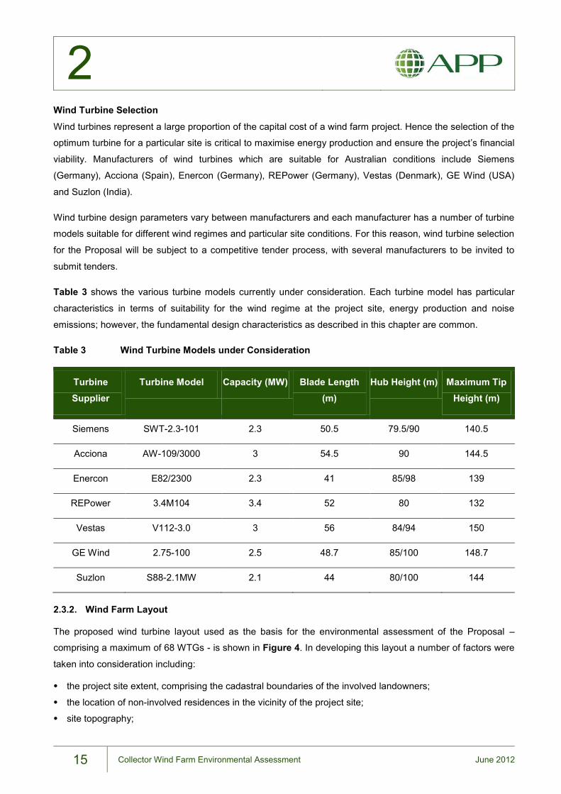
Table 3 shows the various turbine models currently under consideration. Each turbine model has particular
characteristics in terms of suitability for the wind regime at the project site, energy production and noise
emissions; however, the fundamental design characteristics as described in this chapter are common.
Table 3 Wind Turbine Models under Consideration
Turbine Supplier
Turbine Model Capacity (MW) Blade Length (m)
Hub Height (m) Maximum Tip Height (m)
Siemens SWT-2.3-101 2.3 50.5 79.5/90 140.5
Acciona AW-109/3000 3 54.5 90 144.5
Enercon E82/2300 2.3 41 85/98 139
REPower 3.4M104 3.4 52 80 132
Vestas V112-3.0 3 56 84/94 150
GE Wind 2.75-100 2.5 48.7 85/100 148.7
Suzlon S88-2.1MW 2.1 44 80/100 144
2.3.2. Wind Farm Layout
The proposed wind turbine layout used as the basis for the environmental assessment of the Proposal –
comprising a maximum of 68 WTGs - is shown in Figure 4. In developing this layout a number of factors were
taken into consideration including:
the project site extent, comprising the cadastral boundaries of the involved landowners;
the location of non-involved residences in the vicinity of the project site;
site topography;
2
16 Collector Wind Farm Environmental Assessment June 2012
wind speed data collected from two monitoring towers over a five-year period;
turbine spacing;
compliance with noise criteria; and
telecommunications paths from nearby installations.
The proposed layout can accommodate any of the wind turbine models under consideration for the Proposal,
as listed in Table 3. These models produce different noise levels. Depending on the WTG model to be
selected, the actual number of wind turbines in the final wind farm layout will be determined by compliance at
the closest non-involved residences with the relevant noise criteria contained in the Environmental Noise
Guidelines: Wind Farms (South Australia Environment Protection Authority, 2003). The SA EPA Guidelines
allow either 35dBA or background noise level plus 5dBA, whichever is the greater, as the operational noise
criteria for non-involved receivers.
The Proposal has taken the conservative approach of seeking to keep the wind farm operational noise levels
at or below 35dBA at non-involved receivers. This is because non-typical night time noise readings at some
locations during background noise monitoring make the current background noise data set inconclusive as the
basis for setting operational noise limits based on background noise in accordance with the SA EPA
guidelines. Details of the operational noise assessment are provided in Chapter 7.
Therefore, while the proposed layout shows the locations for up to 68 WTGs, it is noted that the number of
WTGs may be reduced depending on the turbine model selected for the Proposal to achieve compliance with
relevant operational noise limits.
Once the wind turbine model is chosen and the number of WTGs determined, the individual wind turbine
locations may be subject to minor adjustments, or ‘micro-siting’, prior to construction in response to various
factors including:
environmental constraints, such as avoidance of significant vegetation, and prevailing geotechnical
conditions;
final wind speed and energy yield analysis;
detailed site survey and geotechnical/civil engineering considerations;
turbine manufacturers recommendations; and
resource and cost-efficiency.
Section 75W of the EP&A Act permits a project to be modified without the Minister’s approval if the
modification will be consistent with the existing approval. The NSW Land and Environment Court (Taralga
Landscape Guardians v. Minister for Planning [NSWLEC 2007]) considered, in relation to turbine or other
component relocation at the Taralga Wind Farm project, that a “…250m relocation of any of the elements is
not unreasonable”. Further, the Department of Planning (DoP), in its Project Approval for the Boco Rock Wind
Farm, defines micro-siting as “…a location allowance of 100 metres radius for project components as long as
impacts remain consistent with that assessed.” (DoP, 2010; p. 4)
To allow design flexibility to accommodate possible layout variations between wind turbine models and the
other variables listed above, a number of scenarios were considered in this environmental assessment:
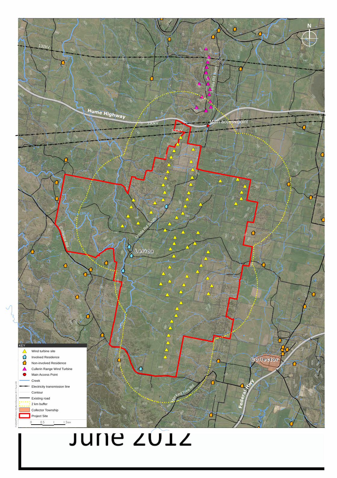
#*
#*
#*
#*
#*
#*
#*
#*#*
#*
#*
#*#*
#*#*
#*
#*
#*
#*
#*
#*
#*
#*
#*
#*#*
#*
#*
#*
#*
#*#*
#*
#*
#*
#*#*
#*
#*
#*
#*#*
#*#*
#*
#*
#*
#* #*
#*
#*
#*
#*#*
#*
#*
#*#*
#*
#*
#*
#*
#*#*
#*
#*
#*
#*
#*
#*
#*
#*
#*
#*
#*
#*
#*
#*
#*
#*
#*
#*
#*
�
×
��
�
�
�×
×
�
�
�
�
×
×
�
�
�
�
� �
�
�
�
�
�
�
�
�
�
�
���
�
�
�
�
�
�
�
� �
�
�
�
�
�
Lerid
a R
d N
orth
Lerid
a Rd
South
Mar
ked Tree Rd
C o l l e c t o rC o l l e c t o r
L e r i d aL e r i d a
Federal Hwy
Collector R
d
Hume HighwayMain access point
LERI D A CREEKFR
AN
KF
IELD CRE EK
MEADOW CREEK
740
720
760
680
780
660
700
800
820
840
860
640
880
620600
900
920
940
760
820
880
720
900
700
840
760
720
780
740
740
760
800
740
800
820
660
72 0
760
780
760
760780
700
820
640
740
740
860
880
800
780
720
720
840
840
640
840
840
740
760
880
860
800
78 0
700
620
720
740
720
800
740
720
740
740
780
720
680
800
920
900
740
600
720
820
620
740
720
760
800
780
760
740
700
840
720
760
740
680
660
840
760
840
820
740
740
700
700
700
760
760
820
840
760
860
720
740
720
660
720
860
880
800
720
700
780
760
720
780
780
820
780
680
740
780
720
740
780
820
760
700
900880
740
900
760
800
740
840
760
740
880
860
720
860
720
760
800
720
780
820
760
740
840
740
740
740
760
720
720
700
820
740
820
640
132kV
330kV
330kV
0 0.5 1 1.5km
F:\G
IS\APP\C
ollector Windfarm
\December 2011 Focus GIS
N
#* Wind turbine site
× Involved Residence
� Non-involved Residence
#* Cullerin Range Wind Turbine
Main Access Point
Creek
Electricity transmission line
Contour
Existing road
2 km buffer
Collector Township
Project Site
KEY
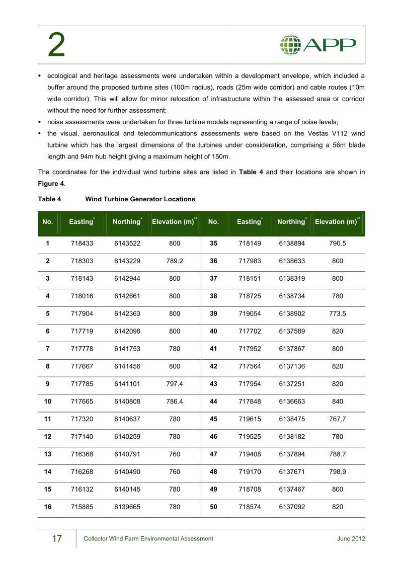
2
17 Collector Wind Farm Environmental Assessment June 2012
ecological and heritage assessments were undertaken within a development envelope, which included a
buffer around the proposed turbine sites (100m radius), roads (25m wide corridor) and cable routes (10m
wide corridor). This will allow for minor relocation of infrastructure within the assessed area or corridor
without the need for further assessment;
noise assessments were undertaken for three turbine models representing a range of noise levels;
the visual, aeronautical and telecommunications assessments were based on the Vestas V112 wind
turbine which has the largest dimensions of the turbines under consideration, comprising a 56m blade
length and 94m hub height giving a maximum height of 150m.
The coordinates for the individual wind turbine sites are listed in Table 4 and their locations are shown in
Figure 4.
Table 4 Wind Turbine Generator Locations
No. Easting* Northing* Elevation (m)** No. Easting* Northing* Elevation (m)**
1 718433 6143522 800 35 718149 6138894 790.5
2 718303 6143229 789.2 36 717983 6138633 800
3 718143 6142944 800 37 718151 6138319 800
4 718016 6142661 800 38 718725 6138734 780
5 717904 6142363 800 39 719054 6138902 773.5
6 717719 6142098 800 40 717702 6137589 820
7 717778 6141753 780 41 717952 6137867 800
8 717667 6141456 800 42 717564 6137136 820
9 717785 6141101 797.4 43 717954 6137251 820
10 717665 6140808 786.4 44 717848 6136663 840
11 717320 6140637 780 45 719615 6138475 767.7
12 717140 6140259 780 46 719525 6138182 780
13 716368 6140791 760 47 719408 6137894 788.7
14 716268 6140490 760 48 719170 6137671 798.9
15 716132 6140145 780 49 718708 6137467 800
16 715885 6139665 780 50 718574 6137092 820
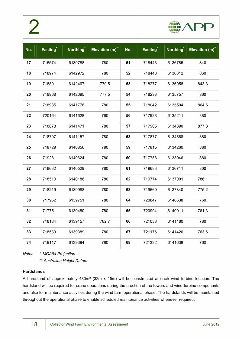
2
18 Collector Wind Farm Environmental Assessment June 2012
No. Easting* Northing* Elevation (m)** No. Easting* Northing* Elevation (m)**
17 716574 6139788 780 51 718443 6136785 840
18 718974 6142972 780 52 718448 6136312 860
19 718891 6142467 770.5 53 718277 6136058 843.3
20 718968 6142095 777.5 54 718233 6135757 860
21 718935 6141776 780 55 718042 6135504 864.6
22 720164 6141628 760 56 717928 6135211 880
23 718878 6141471 780 57 717905 6134890 877.8
24 718797 6141157 780 58 717877 6134568 880
25 718729 6140856 780 59 717815 6134260 880
26 719281 6140624 780 60 717758 6133946 880
27 718632 6140529 780 61 719683 6136711 800
28 718513 6140188 780 62 719774 6137001 786.1
29 718219 6139988 780 63 719660 6137340 775.2
30 717952 6139751 780 64 720847 6140638 760
31 717751 6139480 780 65 720994 6140911 761.3
32 718184 6139157 782.7 66 721033 6141180 780
33 718539 6139389 780 67 721176 6141420 763.6
34 719117 6139394 780 68 721332 6141638 760
Notes: * MGA94 Projection
** Australian Height Datum
Hardstands
A hardstand of approximately 480m² (32m x 15m) will be constructed at each wind turbine location. The
hardstand will be required for crane operations during the erection of the towers and wind turbine components
and also for maintenance activities during the wind farm operational phase. The hardstands will be maintained
throughout the operational phase to enable scheduled maintenance activities whenever required.
2
19 Collector Wind Farm Environmental Assessment June 2012
Foundations
Each wind turbine tower will be erected on a concrete and steel foundation. Foundations would be of either a
gravity or rock-anchor type, depending on the geotechnical conditions at each wind turbine site.
Gravity foundations are essentially reinforced concrete slabs which support the wind turbine tower by
gravitational mass. This type of foundation is a standard type for wind turbines and requires approximately 450
cubic metres (m3) of material to be excavated up to a depth of approximately 2.5m. The foundation is
constructed from concrete with reinforcing steel.
Rock anchor foundations utilise a series of tensioned steel cables (or tendons) installed into competent rock to
a depth of approximately 20m below ground. Each cable is secured to a concrete slab at the surface and
tensioned prior to erection of the tower. Rock anchor footings require excavation of approximately 100m3 of
material.
A combination of both these foundation types may be required, depending on the specific geology at each
nominated wind turbine site. Geotechnical investigations will be undertaken during the pre-construction phase
at each wind turbine site to determine the foundation type required.
Material excavated from the footings will be stockpiled for beneficial reuse on the project site for constructing
hardstand areas, filling road embankments and other earthworks requirements. Excess excavation spoil will
be disposed offsite.
Wind Monitoring Masts
Two temporary wind monitoring masts are currently installed in the vicinity of the project site, one situated on-
site and the other to the south of Collector Road. These 65m tall monitoring masts have recorded wind data
which has been utilised for the Proposal’s development and planning.
Up to four permanent wind monitoring masts will be installed within the development footprint to monitor the
performance of the wind turbines against the manufacturer’s power-generation guarantees. Each monitoring
mast, comprising a lattice structure supported by steel guy cables, will be fitted with equipment such as
anemometers, wind vanes, temperature sensors, etc., to measure climatic conditions in the vicinity of the wind
turbines. The final location for these masts will be determined once the wind turbine model is selected.
2.4. Site Access
2.4.1. External Access
Access to the project site is directly from the Hume Highway via Lerida Road South. No construction access is
proposed via the Collector-Gunning Road as topographical and alignment constraints make this road
unsuitable for construction access. However, this route would be available for emergency egress if required.
The Lerida Road South/Hume Highway intersection would require upgrading and traffic management to
ensure safe entry and exit and to allow passage for large vehicles during the construction phase. This
2
20 Collector Wind Farm Environmental Assessment June 2012
intersection upgrade and any other required road upgrade works will be the subject of an environmental
assessment under Part 5 of the EP&A Act. Further details on traffic and transport are provided in Chapter 10.
2.4.2. Internal Access Roads
Internal roads would be constructed to provide access to each wind turbine site. Where possible these routes
would follow existing Crown roads or farm tracks; however, there would be a requirement to widen the existing
roads or to construct new access roads where the existing are unsuitable or do not provide direct access to
turbine sites.
Existing roads and tracks within the project site would require upgrades to support construction phase traffic
and allow all-weather access during the operation phase.
For the construction phase of the Proposal, access roads within the project site would be constructed to an
average of 8m formed widths but up to 10m wide in some cases to allow access for the large crane required to
erect the wind turbine structures. The 8 to 10m width would only be required for the construction phase, with
the operation phase road formation requirement reduced to 6m wide only. Following the construction phase,
the redundant 2-4m road width would be rehabilitated or stabilised.
Figure 5 shows the location of proposed access roads within the project site. The exact routes would be
determined at the micro-siting/ design stage and would avoid significant vegetation, property assets and
drainage lines. Approximately 42km of access road would be required, with approximately 25% of this length
following existing Crown roads or farm tracks. Access roads would be constructed to established engineering
standards to permit all-weather access to the turbine sites. Gravel for road construction would be sourced
locally where possible in consultation with Upper Lachlan Shire Council.
2.4.3. Electrical Infrastructure
The electrical infrastructure at the wind farm will convey the electricity generated by the WTGs to the electricity
transmission grid. This infrastructure comprises the following elements which are described in detail below:
WTG transformers at each wind turbine site;
a wind farm substation with two 130 megavolt-ampere (MVA) transformers, switch gear and circuit
breakers;
approximately 35km of 33kV underground electrical and control cabling to connect each wind turbine to the
substation;
an overhead transmission connection to the existing 330kV transmission line; and
an operations building containing control and communications equipment.
Wind Turbine Generator Transformers
The WTG housed in the nacelle would produce electricity at approximately 0.7kV. This output will be
transferred via cable to a transformer located either at the base of the tower or on the hardstand next to the
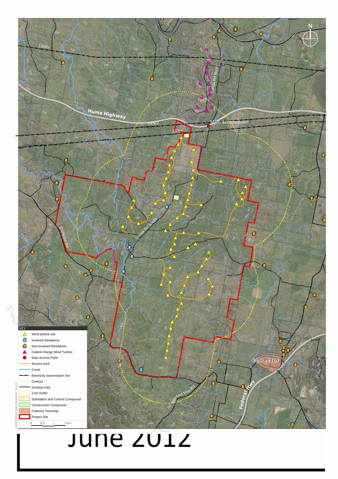
#*
#*
#*
#*
#*
#*
#*
#*#*
#*
#*
#*#*
#*#*
#*
#*
#*
#*
#*
#*
#*
#*
#*
#*#*
#*
#*
#*
#*
#*#*
#*
#*
#*
#*#*
#*
#*
#*
#*#*
#*#*
#*
#*
#*
#* #*
#*
#*
#*
#*#*
#*
#*
#*#*
#*
#*
#*
#*
#*#*
#*
#*
#*
#*
#*
#*
#*
#*
#*
#*
#*
#*
#*
#*
#*
#*
#*
#*
#*
�
×
��
�
�
�×
×
�
�
�
�
×
×
�
�
�
�
� �
�
�
�
�
�
�
�
�
�
�
���
�
�
�
�
�
�
�
� �
�
�
�
�
�
Lerid
a R
d N
orth
Lerid
a Rd
South
Mar
ked Tree Rd
C o l l e c t o rC o l l e c t o r
Federa
l H
wy
Collector R
d
Hume HighwayMain access point
LERI D A CREEKFR
AN
KF
IELD CRE EK
MEADOW CREEK
740
720
760
680
780
660
700
800
820
840
860
640
880
620600
900
920
940
760
820
880
720
900
700
840
760
720
780
740
740
760
800
740
800
820
660
72 0
760
780
760
760780
700
820
640
740
740
860
880
800
780
720
720
840
840
640
840
840
740
760
880
860
800
78 0
700
620
720
740
720
800
740
720
740
740
780
720
680
800
920
900
740
600
720
820
620
740
720
760
800
780
760
740
700
840
720
760
740
680
660
840
760
840
820
740
740
700
700
700
760
760
820
840
760
860
720
740
720
660
720
860
880
800
720
700
780
760
720
780
780
820
780
680
740
780
720
740
780
820
760
700
900880
740
900
760
800
740
840
760
740
880
860
720
860
720
760
800
720
780
820
760
740
840
740
740
740
760
720
720
700
820
740
820
640
132kV
330kV
330kV
0 0.5 1 1.5 km
F:\G
IS\A
PP
\Co
llect
or
Win
dfa
rm\D
ece
mb
er
20
11
Fo
cus
GIS
N
#* Wind turbine site
× Involved Residence
� Non-involved Residence
#* Cullerin Range Wind Turbine
Main Access Point
Access track
Creek
Electricity transmission line
Contour
Existing road
2 km buffer
Substation and Control Compound
Construction Compound
Collector Township
Project Site
KEY
2
21 Collector Wind Farm Environmental Assessment June 2012
tower. This transformer would step-up the voltage from 0.7kV to 33kV to allow transmission via the
underground cable system to the wind farm substation.
Wind Farm Substation
The wind farm substation would be situated in close proximity to the existing TransGrid 330kV transmission
line traversing the northern portion of the project site (see Figure 5). This would limit the length of the
overhead transmission line required to connect to the grid. The substation, which will sit on a compound of
approximately 50m by 150m, is proposed to be located near the wind farm’s northernmost wind turbine.
The connections between the incoming 33kV cabling, the wind farm transformer and the 330kV transmission
line would involve various components including busbars, circuit breakers and isolators. The design
specifications will be prepared to meet the requirements of the transmission network owner TransGrid.
Electrical infrastructure within the substation compound will be founded on concrete slabs with gravel
surrounds. The compound itself would be enclosed to restrict unauthorised access. The transformers will be
placed on concrete pads with protective bunding to contain any leak or spill of transformer oil.
Underground Cabling
Underground 33kV electrical cables will connect each wind turbine to the wind farm substation. Placement of
the cables underground will minimise the visual impact of overhead lines. The proposed underground cable
routes would generally follow the access tracks as shown on Figure 5.
Control cables would connect each wind turbine to a computerised operation system in the wind farm control
room, allowing turbines to be monitored and managed at all times. Individual turbines can be automatically
controlled for start-up and shut-down. In addition, wind speed and direction will be monitored allowing
individual turbines to be adjusted to suit the prevailing wind conditions to maximise energy production.
Overhead Transmission Connection
As the proposed substation site is located adjacent to the existing TransGrid 330kV transmission line, the new
turn-in connection will consist of approximately 250m long overhead transmission line between the wind farm
substation and the connection point along the 330kV TransGrid transmission line.
A separate development approval for the turn-in connection will be sought under Part 5 of the EP&A Act by
TransGrid, who will be the proponent for this element of the Proposal. Noise impacts associated with the turn-
in connection have been considered in this EA (Section 7.6.5); however, other potential environmental
impacts associated with the transmission connection will be considered under a future Part 5 environmental
assessment.
Operations and Maintenance Building
An operations and maintenance building will be constructed within the substation compound. This building will
house the wind farm operational infrastructure, including monitoring and communications equipment.
Maintenance facilities would include a store, work area and staff amenities, supported with rainwater tanks

2
22 Collector Wind Farm Environmental Assessment June 2012
and a septic system. Car parking for operations and maintenance staff and visitors will also be provided
adjacent to the substation compound.
2.5. Wind Farm Development Program
Following the planning and approvals phase the Proposal would involve four primary phases which include the
following:
pre-construction;
construction;
operation and maintenance (including refurbishment); and
decommissioning.
The estimated duration of each phase is shown in Table 5 and the main activities associated with each phase
are described in the following sections.
Table 5 Estimated Duration of Wind Farm Project Phases
Project Phase Duration
Pre-construction 9 Months
Construction 24 Months
Operation and Maintenance 20 - 25 Years
Decommissioning 12 Months
2.5.1. Pre-construction Phase
The pre-construction phase of the development would involve engaging contractors/turbine manufacturers,
carrying out detailed site investigations, preparing detailed design and undertaking pre-construction works.
This phase would be approximately nine months in duration.
Detailed Design and Contracting
Following the development approval process, a tender would be let for the Proposal’s detailed design and
construction. The successful tenderer would be responsible for the detailed design of the wind farm which
would involve the final micro-siting of the wind turbines and site infrastructure within the boundaries imposed
by the conditions of the project determination.
The detailed design process would also involve preparation of an Environmental Management Plan (EMP) for
the construction phase. The EMP content would be determined by the Proponent’s commitments, conditions
of approval and any licensing requirements. The EMP would likely be subject to the approval of the DPI prior
to works commencing. The EMP would be a component of the contract specifications for the design and
construction contractor/s.

2
23 Collector Wind Farm Environmental Assessment June 2012
During this phase the community would be provided with details of the forthcoming construction activities.
Community consultation will continue throughout the construction phase at key stages and the community will
be advised of any changing circumstances. A dedicated community liaison officer will be employed by the
Proponent to consult with the community and resolve issues that may arise.
Pre-construction Works
Prior to the main construction commencing, a number of enabling works and further site investigations would
be undertaken by the selected Contractor, including:
geotechnical investigations at each wind turbine site to determine the required foundation;
upgrading existing roads and constructing new access roads within the project site, including upgrades at
the Hume Highway/Lerida Road South intersection and installation of signage;
stripping of surface vegetation and topsoil from infrastructure locations;
stockpile establishment;
establishment of a temporary construction compound;
preparation works for siting of a mobile concrete batching plant (if required); and
detailed survey and pegging of infrastructure locations and exclusion areas (e.g. significant vegetation).
The final location for the construction site compound will be subject to discussions and agreement with the
host landowner. The proposed location is shown on Figure 5. In selecting the compound site, consideration
would be given to logistical requirements, avoidance of endangered ecological communities and drainage
lines, and limiting the visual and noise impact to nearby residences. The construction site compound would
cover an area of approximately three hectares and would include storage and laydown areas of equipment,
materials and machinery; site offices and amenities; and parking areas. This area will be rehabilitated after
construction.
2.5.2. Construction Phase
The main stages of the wind farm construction program and the associated activities are outlined in Table 6
and further discussed below. It is anticipated the duration of the construction phase would be up to 24 months.
Access Roads, Hardstands and Cabling
Site access roads within the project site and crane hardstands will need to be constructed to a standard to
support construction traffic and machinery. This will involve excavation of the road and hardstand areas to a
suitable depth and the laying of all-weather road base. A proportion of the road base material would be
sourced from excavations for turbine foundations, with the remainder sourced by the construction contractor
from established facilities off-site in the local area.
For the construction phase, access roads will be constructed to an average width of 8m to allow for movement
of large construction plant, including heavy lift cranes and long and wide loads. For the operation phase,
access roads would be reduced to a width of 6m, with the redundant width from the construction phase
rehabilitated.
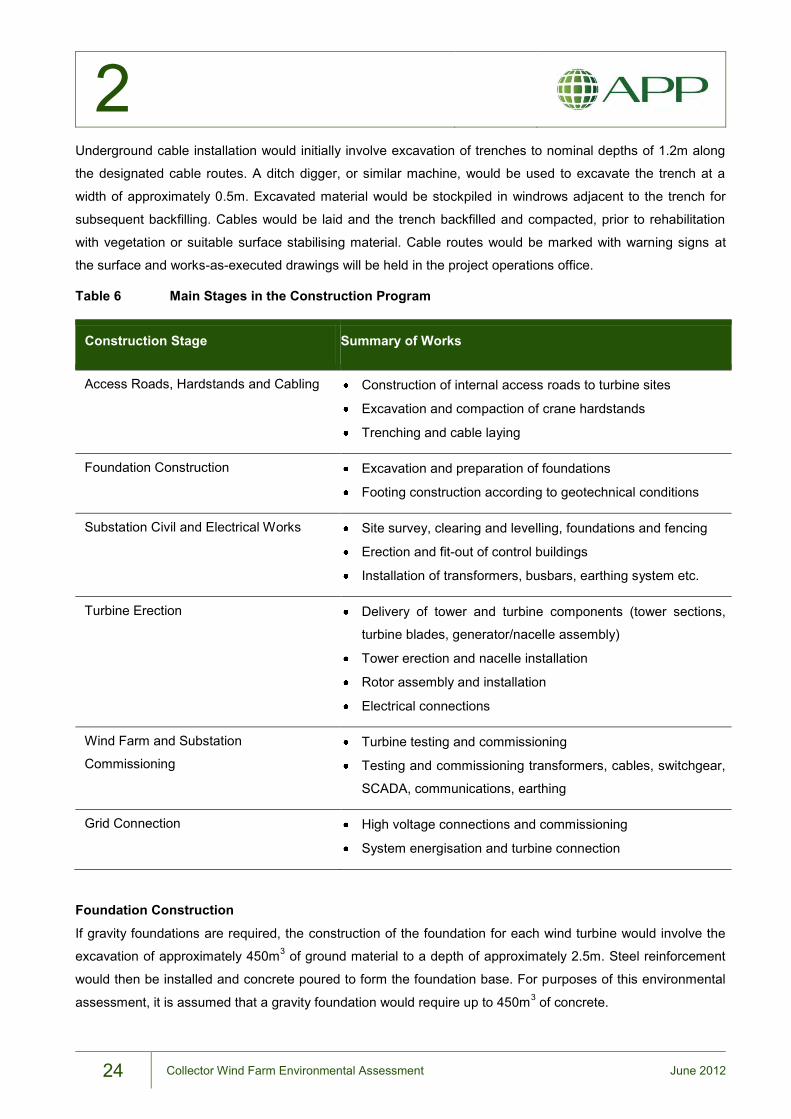
2
24 Collector Wind Farm Environmental Assessment June 2012
Underground cable installation would initially involve excavation of trenches to nominal depths of 1.2m along
the designated cable routes. A ditch digger, or similar machine, would be used to excavate the trench at a
width of approximately 0.5m. Excavated material would be stockpiled in windrows adjacent to the trench for
subsequent backfilling. Cables would be laid and the trench backfilled and compacted, prior to rehabilitation
with vegetation or suitable surface stabilising material. Cable routes would be marked with warning signs at
the surface and works-as-executed drawings will be held in the project operations office.
Table 6 Main Stages in the Construction Program
Construction Stage Summary of Works
Access Roads, Hardstands and Cabling Construction of internal access roads to turbine sites
Excavation and compaction of crane hardstands
Trenching and cable laying
Foundation Construction Excavation and preparation of foundations
Footing construction according to geotechnical conditions
Substation Civil and Electrical Works Site survey, clearing and levelling, foundations and fencing
Erection and fit-out of control buildings
Installation of transformers, busbars, earthing system etc.
Turbine Erection Delivery of tower and turbine components (tower sections,
turbine blades, generator/nacelle assembly)
Tower erection and nacelle installation
Rotor assembly and installation
Electrical connections
Wind Farm and Substation
Commissioning Turbine testing and commissioning
Testing and commissioning transformers, cables, switchgear,
SCADA, communications, earthing
Grid Connection High voltage connections and commissioning
System energisation and turbine connection
Foundation Construction
If gravity foundations are required, the construction of the foundation for each wind turbine would involve the
excavation of approximately 450m3 of ground material to a depth of approximately 2.5m. Steel reinforcement
would then be installed and concrete poured to form the foundation base. For purposes of this environmental
assessment, it is assumed that a gravity foundation would require up to 450m3 of concrete.

2
25 Collector Wind Farm Environmental Assessment June 2012
Rock anchor foundations would involve the excavation of approximately 100m3 of ground material to a depth
of approximately 2.5m. Individual rock anchor cores would be drilled into bedrock to a depth of approximately
20m, with rock anchor tendons grouted into place, stressed and secured at the surface.
Substation Civil and Electrical Works
The substation compound area will be approximately 0.75 hectares (i.e. 50m x 150m or similar dimensions).
The compound yard would be surfaced with compacted gravel to form a hardstand. Reinforced concrete pads
and footings would be constructed to support electrical infrastructure and buildings. Infrastructure to be
installed within the substation yard includes the two units 33/330kV step-up transformers, switchgear and the
operation facilities building.
Turbine Erection
The turbine components would be delivered to the project site on semi-trailers. Each tower would be delivered
in three parts, and blades would be delivered in single units. Nacelles and turbine substations would also be
delivered as individual loads.
The construction method would involve a small mobile crane (up to 100 tonne) for the erection of the bottom
two tower sections and the assembly of the rotor unit. A larger 600-1,000 tonne crane would be required to
erect the top tower section and install the nacelle and rotor unit. Turbine erection is expected to take
approximately 2 to 3 days per turbine.
Wind Farm and Substation Commissioning
The wind farm would be commissioned progressively in ‘strings’ of turbines. Each string would comprise the
number of turbines within a cable circuit. There will be six to eight strings of WTGs for the Proposal.
The wind farm substation would be commissioned in conjunction with TransGrid to ensure viable connections
from the WTGs to the substation and the substation to the transmission line. Once the electrical system has
been energised, the wind turbines would be put into service.
2.5.3. Operation and Maintenance
Once operational, the wind farm would be continuously monitored by staff. Operations staff would be
responsible for wind farm operations management, environmental monitoring, routine servicing, malfunction
rectification and site visits.
Maintenance would be undertaken on a routine basis, with major servicing undertaken approximately six-
monthly on each wind turbine. Each major service visit would involve a number of service vehicles.
Maintenance staff would also respond to problems as they arise, with turbine downtime dictated by the
complexity of maintenance required. Unscheduled maintenance on equipment such as turbine blades may
require the use of large cranes and associated equipment. This can result in a turbine being offline for several
weeks whilst the appropriate equipment and materials are sourced.

2
26 Collector Wind Farm Environmental Assessment June 2012
After approximately 20 to 25 years of operation (or sooner if technology developments allow) the blades,
nacelles and towers could be removed and replaced with more efficient component parts. Redundant
equipment would be removed from site for recycling and new components installed on existing or new
foundations. Refurbishment could extend the life of the Proposal for a further 20 years.
2.5.4. Decommissioning
At the end of the operational life of the Proposal, the turbines and all above-ground infrastructure would be
dismantled and removed from the site. This includes all the above-ground electrical and substation
infrastructure. Foundations would be cut back to below cultivation depth and soil profiles re-established over
the footing.
Internal access roads, if not wanted by the landowner, would be removed and the land rehabilitated to as
close as possible to the original condition. All decommissioning would be the responsibility of the wind farm
owner and would be governed by the conditions of project approval, with decommissioning clauses included in
landowner leases. Decommissioning of wind farm infrastructure would take up to 12 months.
A Decommissioning and Rehabilitation Plan is included as Appendix B.
2.6. Resource Requirements
2.6.1. Water supply
The construction phase of the project will require water for the following uses:
moisture conditioning of earth fill;
equipment washdown;
dust suppression;
potable water for site personnel; and
fire fighting.
The potential sources of water would depend on the water quality requirement for each application.
Water for moisture conditioning of fill and for dust suppression can be sourced from sedimentation basins
which may be built to settle silted run-off from construction areas, or from external sources. It is estimated that
about 20 kilolitres (kL) per day (or two 10kL water cart loads) would be sufficient for moisture conditioning and
dust suppression.
Potable water will be required for the consumption of the construction workforce and site visitors. The
estimated potable water requirement during construction is estimated to reach a maximum of 42kL per day,
based on a peak number of 120 workers and 20 site visitors, if the average daily consumption is
conservatively assumed to be 300L per person. (On average, per capita household water consumption in
Australia is 285L per day, according to the Australian Water Association).
2
27 Collector Wind Farm Environmental Assessment June 2012
As there is no supply at the project site, potable water will be delivered by tankers. Potable water requirements
during the operational phase will drop dramatically as the number of permanent staff on site is not expected to
exceed 25.
Water storage tanks will be provided within the construction compound (during construction) and control
building compound (during operation) for bulk potable water storage. Provisions will also be made to allow
collection and storage of rainwater from the roof of site buildings. Water will be made available in site storages
for fire emergency response.
If required, water will be accessed from an unregulated water source under the relevant water permits from the
NSW Office of Water. The Proposal does not anticipate constructing any new bores to access groundwater
during construction or operation.
2.6.2. Gravel
Gravel and aggregates will be required by the Proposal for the following:
concrete for WTG foundations, hardstands and building slabs;
pavement material for upgrading of existing or construction of new access roads; and
surface overlay for hardstands, and some of the drainage channels and outlet structures.
For a worst case of using all gravity foundations for the maximum 68 WTGs, the concrete requirement is
estimated to be 30,600m3 (based on the conservative estimate of 450m3 concrete required per foundation),
which would require an estimated 20,000m3 of aggregates. Should geotechnical investigations indicate that a
rock anchor foundation is suitable for some of the WTG locations, the concrete requirement would reduce
significantly as this type of foundation requires only about 100m3 excavation. If the concrete requirement for
the Proposal will be provided by an external supplier, this supplier will source its own aggregate requirement. If
the Proponent establishes an on-site batching plant, aggregate will be delivered in bulk to the project site from
local sources.
The construction and operation traffic along Lerida Road South will be mainly confined to the section from
Hume Highway up to the crossing of Lerida Creek as this section and the Crown roads that branch from it
provide the connection to the proposed internal roads that lead directly to the WTG sites (Figure 5). An
assessment of the traffic and transport requirements for the Proposal (Chapter 10) recommended that
sections of Lerida Road South and Crown roads be upgraded to an all-weather formed pavement using
crushed quarry materials or natural gravels, to be able to handle construction loads. It is estimated that the
section of Lerida Road South (approximately 7.5km long) and sections of Crown roads (approximately 12km
combined length) to be upgraded may require up to 40,000m3 of gravel material to build up and/or widen the
existing pavement (for road formation up to 10m width during the construction phase).
The internal roads will also be built, or upgraded where there is an existing farm road, to take construction
loads. This would require an estimated 60,000m3 of crushed quarry material or natural gravel for the
placement of two pavement layers over subgrade on an average 8m formation width for an estimated
2
28 Collector Wind Farm Environmental Assessment June 2012
combined length of 30km. Fill for road subgrade construction, if required, will be sourced from suitable
materials won from the excavation of foundations.
The above estimates of gravel or crushed quarry material requirements for road construction and upgrade are
considered to be conservative. The condition of existing roads will be assessed prior to the commencement of
construction to more accurately establish the extent of upgrading required.
It is anticipated that the aggregate requirement for concrete batching, and the gravel and/or crushed quarry
material for access road pavement construction or upgrade, can be adequately sourced from operating
quarries in the area, with preference given to sources in close proximity to the project site to reduce transport
costs and traffic impacts.
29 Collector Wind Farm Environmental Assessment June 2012
3 APP Corporation
Statutory, Policy and Planning Context
3
30 Collector Wind Farm Environmental Assessment June 2012
3. Statutory, Policy and Planning Context This chapter addresses the statutory regulations and prescribed guidelines considered and referenced in the
preparation of this EA. The EA, including the technical appendices, has been prepared in accordance with
Part 3A of the EP&A Act and the Environmental Planning and Assessment Regulation 2000. In addition,
Commonwealth, State and local government guidelines and planning controls are referenced where relevant.
3.1. Commonwealth Legislation
3.1.1. Environment Protection and Biodiversity Conservation Act 1999
The Environment Protection and Biodiversity Conservation Act 1999 (EPBC Act) provides for the protection of
the environment, especially matters of national environmental significance (MNES). Under the EPBC Act, a
person must not take an action that has, will have, or is likely to have a significant impact on any MNES
without approval from the Federal Minister for Sustainability, Environment, Water, Population and
Communities (the Minister) or the Minister’s delegate. MNES include World Heritage places, national heritage
places, wetlands of international importance, the Commonwealth marine environment, nuclear actions, listed
migratory species, and listed threatened species and ecological communities.
Whilst the biodiversity assessment (Chapter 8) undertaken for this EA concluded that the Proposal would be
unlikely to result in significant impacts on matters of NES, a referral to the Department of Sustainability,
Environment, Water, Population and Communities (SEWPaC) was made. SEWPaC determined that the
Proposal is not a controlled action and does not require further assessment under the EPBC Act.
3.1.2. Civil Aviation Act 1998
Under the Civil Aviation Act 1998, the Civil Aviation Regulations 1998 (CAR) or the Civil Aviation Safety
Regulations 1998 (CASR), the proponent of a structure “…the top of which will be 110m or more above
ground level…” has a duty to notify the Civil Aviation Safety Authority (CASA) of its intention and provide the
height and location of the structure. In accordance with CASR Circular #139.370 CASA may determine, after
conducting an aeronautical assessment, that an obstacle, building or structure is or will be hazardous to
aircraft operations. Should such an obstacle, building or structure be deemed hazardous to aircraft operations
CASA may direct the proponent to light or mark the hazard in accordance with the Manual of Standards
(MOS) - Part 139 Aerodromes.
Section 11.1 details the potential impacts of the Proposal on aeronautical operations and addresses the
regulatory requirements under the Civil Aviation Act 1998.
3.1.3. Radio Communications Act 1992
Part 4.1 of the Radio Communications Act 1992 are intended to make systems, such as wind turbines,
efficient, flexible and responsive to the potential interference of radio emissions. The standards also require an
adequate level of immunity from electromagnetic disturbances. As wind turbines and other ancillary structures
3
31 Collector Wind Farm Environmental Assessment June 2012
produce electromagnetic fields, the Proposal has the potential to impact radio communications. An
assessment of the potential impacts of the Proposal on radio communications is provided in Section 11.2.
3.2. Commonwealth Policy
3.2.1. Renewable Energy Target
In August 2009, the Government implemented the Renewable Energy Target (RET) scheme, which is
designed to ensure that 20 per cent of Australia’s electricity supply will come from renewable sources by 2020.
The RET expands on the previous Mandatory Renewable Energy Target (MRET), which began in 2001.
Further reforms to the RET were introduced on 1 January 2011, splitting the scheme into two parts: Small-
scale Renewable Energy Scheme (SRES) and Large-scale Renewable Energy Target (LRET).
Liable entities will need to meet obligations under both the SRES and LRET by acquiring and surrendering
Renewable Energy Certificates (RECs) created from renewable energy schemes. Collector Wind Farm is
considered a large-scale renewable energy project and therefore falls under the requirements for the LRET.
Section 4.3.1 discusses the strategic justification of the Proposal in relation to the RET.
3.3. State Legislation
3.3.1. Environmental Planning and Assessment Act 1979
On 15 February 2010 the Department of Planning (DoP), formed the opinion - under clause 6 of State
Environmental Planning Policy (Major Development) 2005 (Major Development SEPP) that the proposed
Collector Wind Farm was development of a kind described in the SEPP (Schedule 1, Group 8, clause 24 ) as:
Development for the purpose of a facility for the generation of electricity or heat or their co-generation
(using any energy source, including gas, coal, bio-fuel, distillate and waste and hydro, wave, solar or
wind power), being development that:
(a) has a capital investment value of more than $30 million…
Consequently, the project was declared to be a Major Project to which Part 3A of the Environmental Planning
and Assessment Act 1979 (EP&A Act) applied. The purpose of Part 3A of the EP&A Act is to facilitate major
project and infrastructure delivery and encourage economic development, while implementing environmental
safeguards and involving the community through consultation. Part 3A consolidates the assessment and
approvals process for major developments, providing a streamlined assessment and determination process for
major infrastructure and other projects of State or regional significance.
Part 3A of the EP&A Act was repealed on 1 October 2011. Transitional arrangements for existing projects
were documented in Planning Circular PS 11-021 (30 September 2011) as follows:
…Part 3A continues to apply to most undetermined project and concept plan applications where
Director-General’s (of the Department of Planning and Infrastructure) environmental assessment
requirements (DGRs) were issued before 1 October 2011 and a current major project declaration
3
32 Collector Wind Farm Environmental Assessment June 2012
remains in force.These undetermined applications will continue to be assessed and determined under
Part 3A, as in force immediately before its repeal.
The correspondence declaring the Proposal a Major Project is included in Appendix A.
Under section 75C of the EP&A Act, the Minister for Planning declared developments such as the Proposal to
be critical infrastructure projects (NSW Government Gazette No. 184, 11 November 2009):
I, the Minister for Planning, having formed the opinion that the category of development referred to in
Schedule 1 is essential for the State for economic reasons, and for social reasons, and for
environmental reasons, declare project within that category to be critical infrastructure projects under
Section 75V of the Environmental Planning and Assessment Act 1979.
…
Schedule 1
Development for the purpose of a facility for the generation of electricity derived from renewable fuel
sources (that is, wind energy, solar energy, geothermal energy, hydro energy, wave energy and bio
energy), being development that:
(a) is the subject of an application lodged pursuant to section 75E or section 75M of the Environmental
Planning and Assessment Act 1979 lodged after the date of this declaration; and
(b) is the subject of an application that proposes a development with a capacity to generate at least 30
megawatts.
Part 3A of the EP&A Act integrates the assessment and approval regime for all Major Projects that require the
approval of the Minister for Planning. Under the Part 3A process, projects are exempt from several statutory
provisions which would otherwise require detailed consideration and subsequent licences/approvals. Projects
approved under Part 3A of the EP&A Act do not require separate authorisation under the following Acts:
Fisheries Management Act 1994;
Heritage Act 1977;
National Parks and Wildlife Act 1974;
Rural Fires Act 1997;
Water Management Act 2000;
Threatened Species Conservation Act 1995;
Protection of the Environment Operations Act 1997; and
Local Government Act 1993.
In addition, section 75V provides that in circumstances where nominated authorisations are required then an
application for such authorisation cannot be refused if the works proposed are consistent with the Part 3A
approval and are necessary for carrying out the approved project. This applies, for example, to authorisations
under section 138 of the Roads Act 1993 to undertake work in, on or over a public road.
Section 5 of the EP&A Act outlines the following objectives:

3
33 Collector Wind Farm Environmental Assessment June 2012
a) To encourage:
i) the proper management, development and conservation of natural and artificial resources,
including agricultural land, natural areas, forests, mineral, water, cities, towns and villages for
the purpose of promoting the social and economic welfare of the community and better
environment,
ii) the promotion and coordination of the orderly and economic use and development of land,
iii) the protection, provision and coordination of communication and utility services,
iv) the provision of coordination of community services and facilities,
v) the protection of the environment including the protection and conservation of native animals
and plants including threatened species, populations and ecological communities and their
habitats,
vi) ecologically sustainable development,
vii) the provision and maintenance of affordable housing,
b) to promote the sharing of the responsibility for environmental planning between the different levels
of government in the state, and
c) to provide increased opportunity for public involvement and participation in environmental planning
and assessment.
The Proposal is consistent with these in that it:
conserves natural resources and promotes a better environment through the generation of electricity via
renewable energy sources;
provides mitigation measures which will ensure the proper management of the development thereby
promoting the social and economic welfare of the community;
proposes the efficient and orderly use of the land, enabling the co-location of viable agricultural activity with
renewable energy generation;
facilitates the generation of electricity in a sustainable and environmentally friendly manner;
includes the environmental protection measures which will ensure the protection of the environment; and
supports the principles of ecologically sustainable development.
Prior to 28 May 2011, determination of Part 3A projects was the responsibility of the Minister for Planning and
Infrastructure. Under an Instrument of Delegation (28 September 2011), the Minister delegated certain
decisions to the Planning Assessment Commission (PAC). The PAC was established on 3 November 2008,
with certain functions under section 23D of the EP&A Act including the determination of a project or concept
plan when delegated by the Minister. The PAC has a delegation to make decisions on major project
applications and modifications submitted by a private proponent, where:
There has been 25 or more objections to the application; or
The local council has objected; or
There has been a reportable political donation in connection with the application, or to a previous related
application.
3
34 Collector Wind Farm Environmental Assessment June 2012
It is anticipated that the Proposal will be determined by the PAC.
3.3.2. Protection of the Environment Operations Act
The Protection of the Environment Operations Act 1997 (POEO Act), administered by the Office of
Environment and Heritage (OEH), includes a licensing regime to control the air, noise, water and waste
impacts of a scheduled activity. Schedule 1 of the POEO Act lists the activities requiring a licence. As the
source of energy generation for the Proposal is wind power, a licence for the operation of the Proposal is not
required under the POEO Act. Should an on-site concrete batching plant be required for the Proposal, a
licence will be obtained.
3.3.3. Roads Act
The Roads Act 1993 provides for certain rights of the public with respect to public roads and the regulation of
activities relating to public roads. The Proposal would require upgrade works to the Hume Highway/Lerida
Road South intersection, Crown roads and internal access tracks to accommodate construction vehicles.
Under Section 138 of the Roads Act 1993, approval is required from the appropriate road authority for
proposed upgrade works on public roads. An assessment under Part 5 of the EP&A Act will be required for
any public road upgrade works.
3.3.4. Crown Lands Act
Under the Crown Lands Act 1989 any person proposing access via a Crown road to serve a proposed
development must obtain the approval of the Land and Property Management Authority (LPMA). These works
must be approved by LPMA under sections 71 or 138 of the Roads Act 1993 on behalf of the Minister for
Lands as Roads Authority. As portions of some access tracks are proposed over Crown roads, this approval
would be obtained.
3.4. Strategic Planning
3.4.1. NSW State Plan
The NSW Government – through the State Plan NSW 2021: A Plan to Make NSW Number One – has
committed to 20% renewable energy by 2020 “…by promoting energy security through a more diverse energy
mix, reducing coal dependence, increasing energy efficiency and moving to lower emission energy sources”.
To support this policy, the Government has appointed a Parliamentary Secretary for Renewable Energy and is
developing a 2020 NSW Renewable Energy Plan. The Government has also maintained the Renewable
Energy Precincts initiative, which designates six areas of the state where significant renewable energy
development is anticipated. The Proposal is situated within NSW/ACT Cross Border Region Precinct.
3.4.2. Draft NSW Planning Guidelines Wind Farms
The Draft NSW Planning Guidelines: Wind Farms (DoPI, 2011) were released for public exhibition on 23
December 2011. DoPI issued an Interim Wind Farm Planning Policy (April 2012) to provide direction on the
3
35 Collector Wind Farm Environmental Assessment June 2012
application of the guidelines to transitional Part 3A wind farm projects, such as the Proposal. The Interim
Policy notes, in relation to applications for which DGRs have been issued but are yet to be exhibited, that:
The guidelines will apply to the maximum extent possible to all wind farm applications for which the
DGRs have been issued, but an environmental assessment has not yet been exhibited.
Proponents are encouraged to adopt relevant provisions of the guideline relating to the construction
and operation of wind farms in their environmental assessment, in particular relating to noise
assessment, visual assessment, aviation safety, bushfire hazards, construction, decommissioning,
monitoring and compliance programs.
Proponents should consult with all neighbours with dwellings within 2km of proposed wind turbines
to identify any issues and potential approaches to mitigate any adverse impacts. Proponents
should, where possible, seek the written agreement from neighbours with a dwelling within 2km of a
proposed wind turbine.
It is strongly recommended that proponents, if not done so already, immediately establish a
Community Consultation Committee to provide for ongoing communication with the local
community.
The Policy Statement was accompanied by a check list of key matters from the Guidelines to be considered in
this environmental assessment. Table 7 is a reproduction of the checklist cross-referenced to the relevant
sections of this report.
3.5. Environmental Planning Instruments
3.5.1. State Environmental Planning Policy (Major Development)
State Environmental Planning Policy (Major Development) 2005 (SEPP Major Development) specifies classes
of development to which Part 3A of the EP&A Act applies. These types of development are referred to as Part
3A projects. As discussed in Section 3.3.1, clause 24 of Schedule 1 of the SEPP identifies an electricity
generation facility that has a capital investment value of greater than $30 million and which uses wind
generation as a type of development to which Part 3A applies. The DPI has declared the Proposal as a Major
Project to which Part 3A of the EP&A Act applies (Appendix A).
3.5.2. State Environmental Planning Policy (Rural Lands)
State Environmental Planning Policy (Rural Lands) 2008 (Rural Lands SEPP) aims to:
a) facilitate the orderly and economic use and development of rural lands for rural and related
purposes;
b) identify the Rural Planning Principles and the Rural Subdivision Principles so as to assist in the
proper management, development and protection of rural lands for the purpose of promoting the
social, economic and environmental welfare of the State;
c) implement measures designed to reduce land use conflicts;
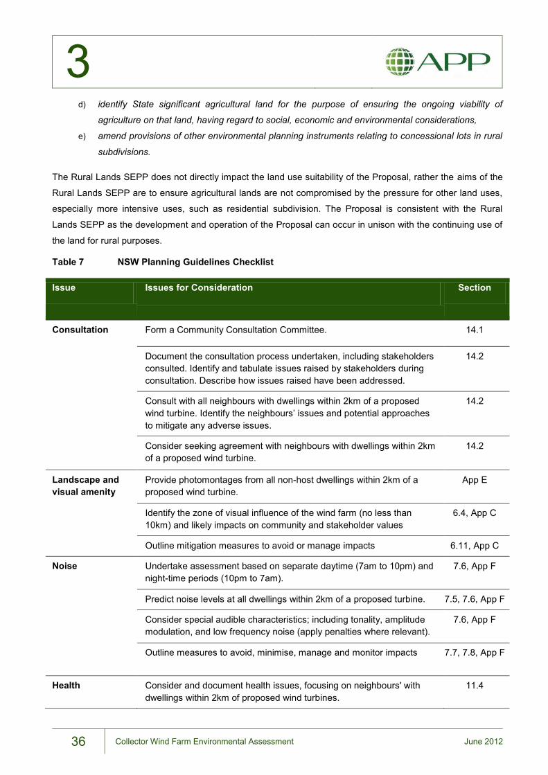
3
36 Collector Wind Farm Environmental Assessment June 2012
d) identify State significant agricultural land for the purpose of ensuring the ongoing viability of
agriculture on that land, having regard to social, economic and environmental considerations,
e) amend provisions of other environmental planning instruments relating to concessional lots in rural
subdivisions.
The Rural Lands SEPP does not directly impact the land use suitability of the Proposal, rather the aims of the
Rural Lands SEPP are to ensure agricultural lands are not compromised by the pressure for other land uses,
especially more intensive uses, such as residential subdivision. The Proposal is consistent with the Rural
Lands SEPP as the development and operation of the Proposal can occur in unison with the continuing use of
the land for rural purposes.
Table 7 NSW Planning Guidelines Checklist
Issue Issues for Consideration Section
Consultation Form a Community Consultation Committee. 14.1
Document the consultation process undertaken, including stakeholders consulted. Identify and tabulate issues raised by stakeholders during consultation. Describe how issues raised have been addressed.
14.2
Consult with all neighbours with dwellings within 2km of a proposed wind turbine. Identify the neighbours’ issues and potential approaches to mitigate any adverse issues.
14.2
Consider seeking agreement with neighbours with dwellings within 2km of a proposed wind turbine.
14.2
Landscape and visual amenity
Provide photomontages from all non-host dwellings within 2km of a proposed wind turbine.
App E
Identify the zone of visual influence of the wind farm (no less than 10km) and likely impacts on community and stakeholder values
6.4, App C
Outline mitigation measures to avoid or manage impacts 6.11, App C
Noise Undertake assessment based on separate daytime (7am to 10pm) and night-time periods (10pm to 7am).
7.6, App F
Predict noise levels at all dwellings within 2km of a proposed turbine. 7.5, 7.6, App F
Consider special audible characteristics; including tonality, amplitude modulation, and low frequency noise (apply penalties where relevant).
7.6, App F
Outline measures to avoid, minimise, manage and monitor impacts 7.7, 7.8, App F
Health Consider and document health issues, focusing on neighbours' with dwellings within 2km of proposed wind turbines.
11.4
3
37 Collector Wind Farm Environmental Assessment June 2012
Ecological Issues Consider potential impacts on birds and bats, particularly migratory species and outline the proposed monitoring and mitigation strategy
8.3, App G
Aviation Safety Outline current agricultural aerial uses on neighbouring properties 11.1
Consider the potential for the proposed wind farm to impact on aviation safety associated with aerial agricultural uses consistent with the draft guidelines.
11.1
Bushfire hazard Consider bush fire issues consistent with the draft guidelines, including the risks that a wind farm will cause bush fire and any potential impacts on the aerial fighting of bush fires.
11.3
Blade throw Assess blade throw risks consistent with the draft guidelines. 11.7
Outline measures to avoid, minimise, manage and monitor impacts 11.7
Mineral resources Consider potential to impact upon mining/petroleum leases and exploration licences. If relevant, consult with the Minerals and Petroleum Division of the NSW Department of Trade and Investment, Regional Infrastructure and Services.
13.6
Property values Consider whether the wind farm use is consistent with local or regional land use planning strategies
3.4, 3.5, 4.3
Consider any potential impacts upon property values consistent with the draft guidelines, including properties within 2km.
13.5
Decommissioning Include a Decommissioning and Rehabilitation Plan in the EA, including proposed funding arrangements.
App B
Confirm that the proponent not the landowner is responsible for decommissioning.
2.6.4
Council planning controls
Outline whether the proposal is consistent with any relevant provisions of the relevant Council’s Development Control Plan and list any variations
3.5.4
3.5.3. Upper Lachlan Local Environmental Plan 2010
The project site falls within the Upper Lachlan Shire Local Government Area (LGA) where the principal
planning instrument is the Upper Lachlan Local Environmental Plan 2010 (ULLEP). All land within the
development envelope is zoned RU2 Rural Landscape as shown in Figure 6.
Under the ULLEP the Proposal is considered to be “electricity generating works”, which is defined as “…a
building or place used for the purpose of making or generating electricity.” Electricity generating works are a
type of development permitted with consent in the RU2 zone. The RU2 zone objectives are listed below
together with a description of the Proposal’s compatibility with these objectives:
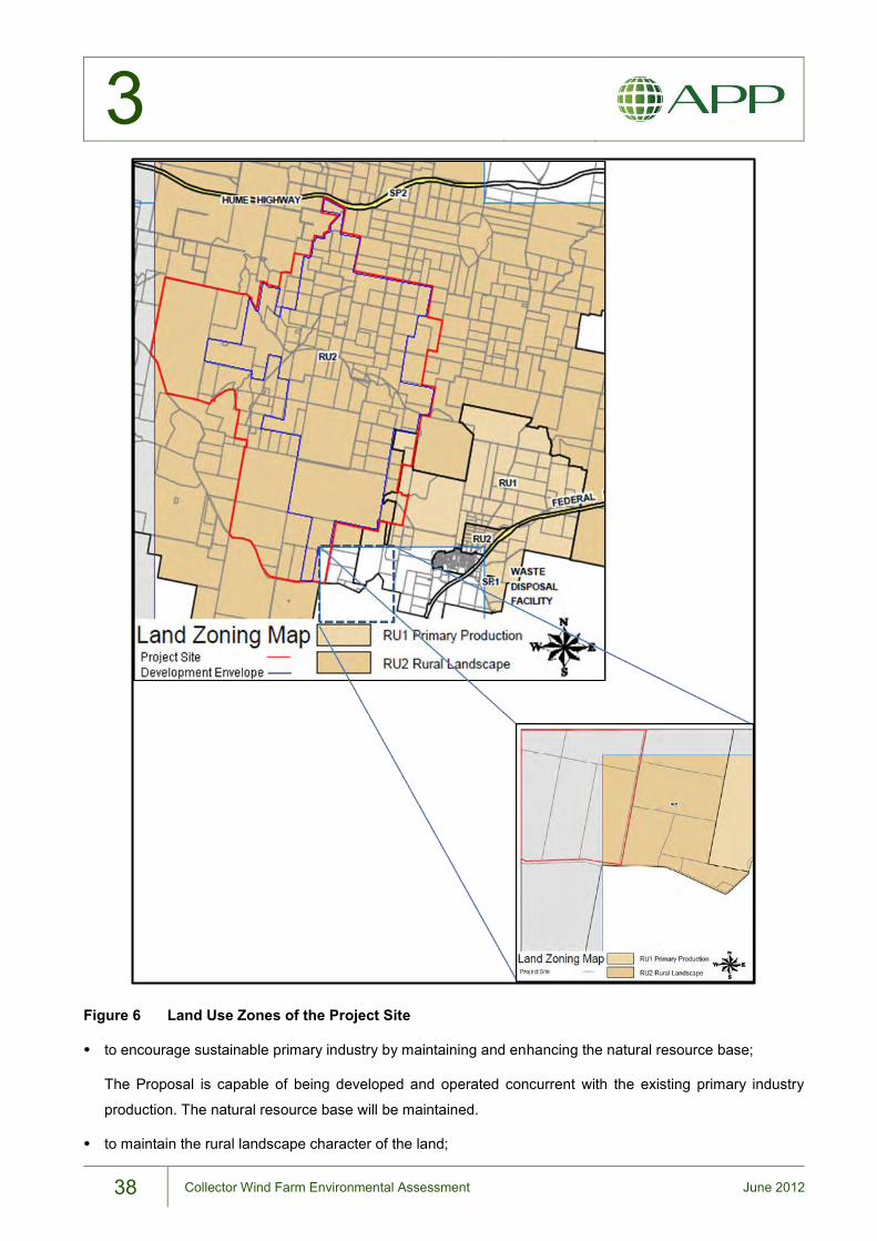
3
38 Collector Wind Farm Environmental Assessment June 2012
Figure 6 Land Use Zones of the Project Site
to encourage sustainable primary industry by maintaining and enhancing the natural resource base;
The Proposal is capable of being developed and operated concurrent with the existing primary industry
production. The natural resource base will be maintained.
to maintain the rural landscape character of the land;
3
39 Collector Wind Farm Environmental Assessment June 2012
The rural and agricultural land use present today will continue to exist. The Proposal will introduce a new
element into the landscape; however the rural landscape character will be maintained during both the
operational phase and post-decommissioning.
to provide for a range of compatible land uses, including extensive agriculture;
The Proposal is compatible with the existing land use, which generally comprises extensive sheep and
cattle grazing. Both land uses can operate concurrently.
to preserve environmentally sensitive areas including waterways and prevent inappropriate development
likely to result in environmental harm;
The Proposal will not impact environmentally sensitive areas as defined in clause 3.3 of the ULLEP. The
siting and design of the Proposal and the mitigation measures proposed seek to prevent or mitigate
environmental harm arising from the Proposal.
to protect the Pejar catchment area from inappropriate land uses and activities and minimise risk to water
quality;
The project site is not in the Pejar catchment area.
to minimise the visual impact of development on the rural landscape;
The Proposal will introduce new visual elements into the rural landscape. The visual impact on the rural
landscape from the erection of the wind turbines will be minimised by the following measures:
- use of low glare and non-reflective colours; - limiting the extent of disturbance to construct access roads; - micro-siting of the wind turbines and infrastructure; - provision of screening vegetation at dwellings with a high visual impact; - clearing vegetation only to the extent required; and - rehabilitation of construction areas not required for the operation phase.
to minimise the impact of development on the existing agricultural landscape character;
The rural and agricultural land use present today will continue to exist. The Proposal will introduce a new
element into the landscape; however the agricultural landscape character will be maintained during both
the operational phase and post-decommissioning.
to protect and enhance the water quality of watercourses and groundwater systems and to reduce land
degradation;
The Proposal is not expected to have a significant impact on groundwater systems. An environmental
management plan will be implemented during all phases of the development to protect water quality.
to maintain areas of high conservation value vegetation.
3
40 Collector Wind Farm Environmental Assessment June 2012
The Proposal will involve clearance of small areas of high conservation value vegetation as classified under
NSW and Commonwealth legislation. The overall conservation value of the landscape will be maintained or
improved through a dedicated vegetation offset to be facilitated through a Property Vegetation Plan.
The ULLEP does not contain any specific objectives or controls applying to electricity generating works.
3.5.4. Upper Lachlan Development Control Plan 2010
Upper Lachlan Development Control Plan (DCP) 2010 came into force on 9 July 2010 and contains detailed
provisions relating to the development of land in Upper Lachlan LGA. The following sections identify and
discuss the relevant provisions of this DCP and their consistency with the Proposal.
(a) The development should be sited and carried out to minimise impacts on, or restrictions to grazing,
farming and forestry practices
The land on which the proposed infrastructure is to be developed is privately-owned farmland used
primarily for sheep and cattle grazing. There will be minimal impact on existing farming activities, allowing
the land to remain productive.
(b) The development should be carried out in a way that minimises any physical adverse effects on adjoining
land and the development site, including, but not limited to:
(i) land degradation
The Proposal will not cause any significant land degradation. In the short-term, only a small percentage of
the project site will be alienated from agricultural production. At the conclusion of the project life, the land
will be rehabilitated to its former use.
(ii) alteration to drainage patterns
The Proposal will have only minor interaction with drainage features, through infrastructure crossings of
creek lines. This is not expected to have any significant impact on drainage patterns.
(iii) pollution of ground water
The risk of groundwater pollution from the Proposal is low. All hazardous substances will be appropriately
stored to prevent spills and the wind turbine foundations are unlikely to affect groundwater conditions.
(iv) spread of noxious plants and animals, and
A Weed Management Plan will be developed to avoid spread of noxious plants to or from the site. The
Proposal will not introduce noxious animals to the site.
(v) bushfire hazard
The Proposal is not expected to increase bushfire hazard (see Section 11.3). Conversely, the ability of
wind turbines to conduct lightning strikes safely to the ground, may reduce the bushfire hazard.
3
41 Collector Wind Farm Environmental Assessment June 2012
(c) The developer must assess the visual impact of the project including an assessment of scenic value. The
developer must consult with the Council and the community on appropriate visual impact measures
A Landscape and Visual Impact Assessment (LVIA) is presented in Appendix C and summarised in
Chapter 6. Consultation has been undertaken with the Council and the community in the preparation of
this EA and this consultation will continue through subsequent phases of the development.
(d) The developer must assess the cumulative impact of the development having regard to wind farms in
existence and those approved but yet to be constructed. Council does not favour large expanses of
ridgelines being covered with wind farms and turbines;
The LVIA includes a cumulative visual impact assessment of the operational Cullerin Range Wind Farm to
the north and Capital Wind Farm to the east of the project site. Similarly, the Noise Assessment (see
Chapter 7 and Appendix F) has considered the cumulative impacts associated with these projects.
(e) Proposed wind turbines shall comply with the South Australia Environment Protection Authority Wind
farms environmental noise guidelines (July 2009) or any replacement guidelines.
The Noise Assessment (see Chapter 7 and Appendix F) was prepared in accordance with the South
Australian Environment Protection Authority Noise Guidelines for Wind Farms (February 2003) as required
by the Director-General’s Requirements. The assessment has also had regard to the draft NSW Planning
Guidelines: Wind Farms (December 2011).
(f) Turbines shall not be located within 2.0 kilometres of any dwelling not associated with the development or
from any lot upon which a dwelling may be constructed. The 2.0 kilometre setback proposes utilising a
precautionary principle in addressing perceived visual and health concerns;
Three non-involved dwellings are situated within 2km of wind turbines. These dwellings have been
considered in accordance with Department of Planning and Infrastructure advice (Appendix A) on the
application of the Draft NSW Planning Guidelines: Wind Farms (2011).
(g) Turbines shall not be located within a distance two times the height of the turbine (including the tip of the
blade) from a formed public road. A greater distance may be required by the road authority.
The largest turbine under consideration is 150m tall. Five proposed wind turbine sites are within 300m of
Lerida Road South, a public road. This inconsistency is considered acceptable given the very low traffic
volumes on Lerida Road South and the extremely low risk of blade throw (see Section 11.4.4).
(h) Turbines shall not be located within a distance two times the height of the turbine (including the tip of the
blade) from a non-related property boundary
Several turbines are situated within 300m of non-related property boundaries. This is considered
acceptable given the extremely low risk of blade throw (see Section 11.4.4).
3
42 Collector Wind Farm Environmental Assessment June 2012
(i) Existing and proposed screenings may be used to minimise visual impacts to non-related properties.
However, due to the height of turbines, screening is not the preferred method of minimising visual impact.
Turbines shall be located in positions so as to have minimal visual impact on nearby properties, especially
existing dwellings and lots on which dwellings may be constructed;
Wind farms, by virtue of the requirement to be situated on elevated terrain, are conspicuous. The wind
farm layout has been designed to minimise the visual impact on nearby properties. Where the visual
impact is considered unacceptable by a property owner, vegetative screenings at the dwelling will be
offered as a mitigation measure.
(j) Turbine locations are to be sensitive to existing related dwellings on the subject site. Noise and shadow
flicker should be minimised and turbines should not be located in close proximity to existing dwellings;
The wind farm layout has been developed in full consultation with host landowners. Where turbines are
located in close proximity to involved dwellings, mitigation measures will be offered to the host landowner.
(k) Turbine locations shall not surround a non-related property. Turbines shall be located with the specified
setbacks from property boundaries to minimise the visual impact of the development on adjacent and
nearby non-related property. Cumulative impacts, having regard to existing turbines and turbines
approved but yet to be constructed, should be assessed;
The are no circumstances where wind turbines surround a non-related property. The Proposal has been
amended to reduce the visual impact at non-related properties.
The cumulative impact associated with the Cullerin Range and Capital wind farms has been assessed in
terms of noise and visual impact.
(l) A communications study should identify the existing status of communications and detail the proposed
method of dealing with potential communication interference.
A telecommunications assessment is included as Appendix K and summarised in Section 11.2. The
assessment concluded that there would be minimal impact on telecommunications infrastructure and that
this impact can be readily mitigated through the micrositing of WTGs. If the development detracts from
local telecommunications reception, the proponent will undertake necessary remedial work.
(m) Construction vehicles, including concrete trucks, carriers of turbine components, and related heavy
vehicles (including relevant contractors) shall only travel on an approved route. This route shall be
identified and approved in accordance with this Plan;
It is proposed that the main access to the project site will be via the Hume Highway and Lerida South
Road. Relevant approvals will be obtained from Roads and Maritime Services and Upper Lachlan Shire
Council for use of this route.

3
43 Collector Wind Farm Environmental Assessment June 2012
(n) A report detailing investigations into the impact of construction vehicles on the proposed route shall
accompany the development application. Detailed road condition reports will be required as part of any
consent.
Appendix I and Chapter 10 include an assessment of traffic and transport impacts from the Proposal.
(o) Council will require road works to cope with the over size and overweight traffic movements related to the
construction of a wind farm. Bonds will also be required for any potential damage to roads during the
construction phase.
The intersection of Hume Highway and Lerida South Road will require upgrading to accept oversize and
heavy vehicles during the construction phase. In addition, suitable upgrades to Lerida South Road and
other Crown roads will be made to cope with construction vehicles.
(p) The construction and maintenance of internal roads (roads within the property subject to the development)
shall be the responsibility of the developer. Council will require proof that they have been adequately
designed and constructed for their purpose.
All internal access roads will be constructed by the proponent to established engineering standards to
permit all-weather access to each WTG site.
(q) All infrastructure related to the wind farm should be included in the development application. Management
of temporary facilities, waste, numbers of contractors/employees, etc, should be part of the Development
Application information. All infrastructure should be located in low visual impact locations and
interconnection cables/wiring and the like should be underground;
A description of the Proposal, including all associated construction and operation phase infrastructure is
included as Chapter 2. As far as possible infrastructure has been sited to minimise visual impact. All
internal cabling will be installed underground.
(r) Developers shall consider and refer to all relevant polices and legislation applicable to the proposed
development.
This chapter details the statutory context of the Proposal, including all applicable policies and legislation.
The Proposal has been considered in accordance with the Draft NSW Planning Guidelines: Wind Farms,
in accordance with DoPI instructions.
(s) If appropriate, the development application should include details of a viewing area where safe vehicle and
pedestrian movements can view the wind farm.
A viewing area is not part of the current Proposal.
(t) Within six months of the wind turbine generators ceasing to operate, any rights of carriageways that were
created to enable maintenance to be conducted on the wind turbine generators are to be extinguished by
the developer and the land made good, unless otherwise agreed with the landowner.

3
44 Collector Wind Farm Environmental Assessment June 2012
Decommissioning of the wind farm will occur over a 12 month period. All access tracks not required by the
landowner will be removed and the land rehabilitated.
(u) Within twelve months of the wind turbine generators ceasing to operate, they are to be fully dismantled
and removed from the site.
Wind turbine generators and associated above-ground infrastructure will be removed within 12 months of
wind farm closure. A decommissioning plan is included as Appendix B. All decommissioning would be the
responsibility of the Proponent and would be governed by conditions of approval. Decommissioning
clauses will be included in landowner leases.
(v) Details of the proposed connection to the electricity reticulation network shall be included as part of the
Development Application Environmental Assessment.
The wind farm connection to the electricity grid will be the subject of a separate development approval to
be prepared under Part 5 of the EP&A Act.
45 Collector Wind Farm Environmental Assessment June 2012
4 APP Corporation
Strategic Justification of the Proposal
4
46 Collector Wind Farm Environmental Assessment June 2012
4. Strategic Justification of the Proposal This chapter provides strategic justification for the Proposal. The use of renewable wind energy to provide
additional or alternative capacity for electricity generation in NSW supports state and Commonwealth
government policy objectives to combat climate change through a reduction in greenhouse gases. The chapter
also outlines the suitability of the project site in terms of wind energy potential and compatibility with existing
land uses.
4.1. Energy Demand Projections
Energy demand in the NSW region is projected to grow by 2.3% summer peak demand (14.05 to 19.27GW)
and 2.2% winter peak demand (13.09 to 18.41GW) for the for the period 2010-11 to 2019-20 (estimated with
10% probability of exceedance) (TransGrid 2010). These rates are marginally higher than the 2.0% rate of
growth in summer and winter peak demand for the period 2000-01 to 2009-10. The higher energy demand is
expected to be met by a 2.2% increase in electricity generation in NSW, from 80 Terawatt-hours (TWh, one
thousand GWh) in 2007-8 to 127TWh in 2029-30 (ABARE 2010). Wind energy is projected to contribute
significantly to this increase in generating capacity. In NSW, wind energy (from generators with 30MW and
above installed capacities) is projected to contribute 106MW (at an assumed 5% availability of installed
capacity) to the 19.27GW summer peak demand for 2019-20 (TransGrid 2010).
Aside from generating capacity, the contribution of wind energy in general and the Proposal in particular, in
terms of avoiding greenhouse gas emissions and addressing climate change, is discussed in more detail in
the following sections.
4.2. Climate Change
Since 1988 the scientific findings on atmospheric change and the potential for human induced changes in the
Earth’s climate have been reviewed and summarised by the Intergovernmental Panel on Climate Change
(IPCC). The IPCC was established by the United Nations Environment Programme and World Meteorological
Organisation to examine the links between greenhouse gas emissions and climate change.
Climate change is defined by the IPCC as a change in the state of the climate that can be identified by
changes in the mean (and/or the variability), and that persists for an extended period, typically decades or
longer. The Fourth Assessment Report on the physical science basis of climate change (IPCC 2007a)
concluded that:
Global atmospheric concentrations of carbon dioxide, methane and nitrous oxide have increased markedly
as a result of human activities since 1750 and now far exceed pre-industrial values determined from ice
cores spanning many thousands of years.
Warming of the climate system is unequivocal as is now evident from observations of increases in global
average air temperatures, widespread melting of snow and ice, and rises in global average sea level.
Most of the observed increase in globally averaged temperatures since the mid-20th century is very likely
due to the observed increase in anthropogenic greenhouse gas concentrations. Continued greenhouse gas
4
47 Collector Wind Farm Environmental Assessment June 2012
emissions at or above current rates would cause further warming and induce many changes in the global
climate system during the 21st century that would very likely be larger than those observed during the 20th
century.
Even if greenhouse gas concentrations were to be stabilised, anthropogenic warming and sea level rise
would continue for centuries, due to the time scale associated with climate processes.
The messages from the IPCC are that;
global warming from climate change is real;
humans activities are very likely to be causing climate change; and
it is very likely that there will changes in the global climate system in the centuries to come larger than
those seen in the recent past.
Future changes to the global climate have the potential to have a major impact on human and natural systems
throughout the world.
The IPCC, in its report Renewable Energy Sources and Climate Change Mitigation (IPCC, 2012), notes that:
Climate change is one of the great challenges of the 21st century. Its most severe impacts may still be
avoided if efforts are made to transform current energy systems. Renewable energy sources have a
large potential to displace emissions of greenhouse gases from the combustion of fossil fuels and
thereby to mitigate climate change. If implemented properly, renewable energy sources can contribute
to social and economic development, to energy access, to a secure and sustainable energy supply, and
to a reduction of negative impacts of energy provision on the environment and human health.
In State of the Climate 2012, CSIRO/BoM (2012) note:
Multiple lines of evidence show that global warming continues and that human activities are mainly
responsible. The fundamental physical and chemical processes leading to climate change are well
understood. CSIRO and Bureau of Meteorology observations provide further evidence that climate
change is real. The scientific understanding and the observations show that global trends in
temperatures and sea level rise since the mid-20th century have been caused predominantly by human
activities. Natural climate variability also affected global-mean temperature and sea level during the past
century, but much less than increasing greenhouse gases. It is clear that increasing greenhouse gas
concentrations will result in significant further global warming.
The Commonwealth Government position paper Adapting to Climate Change in Australia (Department of
Climate Change, 2010) has as its key message that some climate change in the world today is unavoidable as
the opportunity to avoid climate change altogether has passed. Efforts therefore are being directed to minimise
the extent of change and the consequences of that change, including a commitment to reduce and stabilise
Australia’s greenhouse gas emissions.
The position paper identifies the effects of climate change currently being experienced, including the following:
Rainfall in south-west Western Australia has dropped by about 15 per cent. Stream flow into Perth’s
dams between 1976 and 2000 almost halved as a result. Research indicates that climate change has
4
48 Collector Wind Farm Environmental Assessment June 2012
contributed to this. There is also evidence that reduced rainfall in south-eastern Australia – Victoria and
the southern part of South Australia – cannot be explained by natural variations alone. Temperatures
have risen across Australia and a number of consequences are already evident. We experience more
hot days and fewer cold nights. Droughts are more severe because higher temperatures increase
evaporation. The incidence of extreme fire weather in south-eastern Australia has increased. Warmer
temperatures have led to a decline in spring snow cover in alpine regions of Australia, and there have
been a number of serious bleaching events on the Great Barrier Reef over the last decade.
The NSW Climate Impact Profile (DECCW, 2010) - which provides an assessment of the likely impacts of
future climate change on NSW’s biophysical environment - states:
The natural, social and economic systems of NSW have all evolved under certain climatic conditions.
NSW supports a range of industries such as agriculture, forestry and fishing, which have all developed
based on the particular rainfall and temperature patterns of a region. Species and ecosystems have
evolved to survive in a particular climate. The design of buildings and critical infrastructure such as
roads, stormwater drains and dams are based on certain assumptions about temperature and extreme
weather events. Our society and the natural resources on which we depend are all finely attuned to our
climate.
In this context, the report notes that Australia is vulnerable to the impacts of climate change. NSW, in
particular – with 34% of the national population, coastal settlement patterns susceptible to sea level rise,
highly variable climate and highly productive agricultural areas – is likely to experience significant impacts from
climate change. Some of the predicted changes in the NSW climate include:
NSW is expected to become hotter, with higher maximum and minimum temperatures very likely to be
experienced across the state in all seasons.
North-eastern NSW is likely to experience a slight increase in rainfall during summer while the south-
western regions are likely to experience a significant decrease in winter rainfall. Many parts of the state will
experience a shift from winter-dominated to summer-dominated rainfall.
Higher temperatures are likely to result in significantly increased evaporation across much of the state by
2050.
Physical responses such as sea level rise; changes in run-off patterns; increased flood frequency, height
and extent; and increased fire frequency, including larger and more intense fires.
Projected responses to climate change include:
Land impacts including increased soil erosion, mass movement and wind erosion; changes to soil salinity;
and threats to coastal dune systems;
Impacts on coastal settlements and infrastructure from sea level rise and extreme storm impacts, including
exacerbated flooding; and
Impacts on ecosystems from temperature increases, changing rainfall patterns, altered hydrology and
changing fire regimes; changes that may well favour introduced and pest species.
4
49 Collector Wind Farm Environmental Assessment June 2012
4.2.1. Greenhouse Gas Emissions in NSW
The NSW DECCW, in its 2010 Emissions Overview paper, identified the main contributor to greenhouse gas
build up as the release of carbon dioxide from the burning of fossil fuels. The IPCC nominates six sectors of
human activity responsible for the generation of greenhouse gas emissions, primary among these is the
energy sector which is broken down into stationary energy (electricity and heating/cooling), transport and
fugitive emissions (fossil fuel gases such as methane gas which escapes during extraction of fossil fuels).
Coal-fired electricity generation accounts for 75% of all stationary greenhouse gas emissions in NSW. In 2007,
the Australian Department of Climate Change and Energy Efficiency (DCCEE) estimated Australia’s
greenhouse gas emissions and recorded that NSW produced 163 million tonnes of CO2e (carbon dioxide
equivalent), representing 27% of Australia’s emissions, with 47% of the total generated by stationary energy or
coal-fired electricity generation.
In 2010 NSW annual emissions were 23.6 tonnes CO2e per capita as compared to just over 10 tonnes for the
UK, Germany and Japan, with 13 tonnes being the average for industrialised nations. The trend in emissions
in NSW between 1990 and 2007 showed a growth of 21% primarily in the industrial and fossil fuel burning
sector which included an increase in that period of 38% in the emissions from electricity generation.
4.3. Government Policy Position
4.3.1. Commonwealth Renewable Energy Target
The Renewable Energy Target (RET) aims to (Commonwealth of Australia, 2012):
encourage the additional generation of electricity from renewable sources;
reduce emissions of greenhouse gases in the electricity sector; and
ensure that renewable energy sources are ecologically sustainable.
The RET comprises two parts: the Small-scale Renewable Energy Scheme (SRES) and the Large-scale
Renewable Energy Target (LRET). The Proposal would be considered to meet the requirements of the LRET.
The primary objective of the LRET scheme is to encourage additional and continuing generation of electricity
from renewable energy sources and achieve a real reduction in the greenhouse gas emissions generated by
the electricity sector. The scheme relies on electricity retailers obtaining a target amount of electricity from
renewable energy sources such as the Proposal. If the targets are not met then the retailer incurs a financial
penalty. The mechanisms to achieve these aims are:
the creation of online certificates – previously known as Renewable Energy Certificates (RECs) and now
termed Large-scale Generation Certificates (LGCs) – based on the amount of electricity generated (in
megawatt hours) by eligible renewable energy sources, such as the Proposal; and
placing a legal obligation on liable entities (usually electricity retailers) to purchase and surrender a certain
amount of these certificates each year.
The trade in these certificates provides financial incentives for investment in renewable energy power stations
such as wind farms.
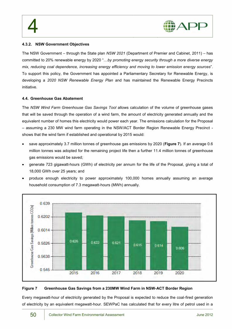
4
50 Collector Wind Farm Environmental Assessment June 2012
4.3.2. NSW Government Objectives
The NSW Government – through the State plan NSW 2021 (Department of Premier and Cabinet, 2011) – has
committed to 20% renewable energy by 2020 “…by promoting energy security through a more diverse energy
mix, reducing coal dependence, increasing energy efficiency and moving to lower emission energy sources”.
To support this policy, the Government has appointed a Parliamentary Secretary for Renewable Energy, is
developing a 2020 NSW Renewable Energy Plan and has maintained the Renewable Energy Precincts
initiative.
4.4. Greenhouse Gas Abatement
The NSW Wind Farm Greenhouse Gas Savings Tool allows calculation of the volume of greenhouse gases
that will be saved through the operation of a wind farm, the amount of electricity generated annually and the
equivalent number of homes this electricity would power each year. The emissions calculation for the Proposal
– assuming a 230 MW wind farm operating in the NSW/ACT Border Region Renewable Energy Precinct -
shows that the wind farm if established and operational by 2015 would:
save approximately 3.7 million tonnes of greenhouse gas emissions by 2020 (Figure 7). If an average 0.6
million tonnes was adopted for the remaining project life then a further 11.4 million tonnes of greenhouse
gas emissions would be saved;
generate 723 gigawatt-hours (GWh) of electricity per annum for the life of the Proposal, giving a total of
18,000 GWh over 25 years; and
produce enough electricity to power approximately 100,000 homes annually assuming an average
household consumption of 7.3 megawatt-hours (MWh) annually.
Figure 7 Greenhouse Gas Savings from a 230MW Wind Farm in NSW-ACT Border Region
Every megawatt-hour of electricity generated by the Proposal is expected to reduce the coal-fired generation
of electricity by an equivalent megawatt-hour. SEWPaC has calculated that for every litre of petrol used in a
4
51 Collector Wind Farm Environmental Assessment June 2012
car, around 2.3kg of carbon dioxide is released. This equates to 3,600kg per year for a car with a fuel
consumption of 10L/100km travelling a distance of 15,000km in one year. The greenhouse gas emission
savings over the life of the project would equate to the removal of 122,222 cars off the road each year for 25
years.
The greenhouse gas abatement that will be achieved by the Proposal needs to be balanced against the
emissions/energy that would be generated in the production of the components used in the construction of the
wind farm. The wind farm operation itself would not generate any carbon dioxide emissions. It is noted that at
the end of the economic life of the project the wind farm would be decommissioned and infrastructure
removed, thereby minimising the potential for future pollution or degradation of the land.
The Danish Wind Turbine Manufacturers Association prepared a lifecycle analysis for wind turbine
manufacture to identify the emissions that would be generated by manufacture of the component parts. The
study found that an energy payback of four months would be required for a 150MW on-shore wind farm. The
Proposal, which has an initial 20-25 year life, would generate approximately 60 to 75 times the energy used to
construct the wind farm.
Martinez et al. (2009) undertook a life-cycle analysis (LCA) of a 2MW turbine in accordance with the ISO
14044 standard Environmental Management—Life Cycle Assessment. The application of LCA, according to
the corresponding international standards, has made it possible to determine and quantify the environmental
impact associated with a wind turbine. On the basis of this data, the final environmental effect of the wind
turbine after a lifespan of 20 years and its subsequent decommissioning have been studied. The
environmental advantages of the generation of electricity using wind energy, that is, the reduction in emissions
and contamination due to the use of a clean energy source, have also been evaluated. The study concluded
that the environmental pollution resulting from all the phases of the wind turbine (manufacture, start-up, use,
and dismantling) during the whole of its lifetime is recovered in less than 1 year.
4.5. Electricity Market Modelling
OEH engaged McLennan Magasanik and Associates (2010) to prepare a report on the electricity market
modelling to determine the emissions abatement impact of wind farms in New South Wales. The study
examined four different scenarios. The study’s second scenario related to a 150MW wind farm being an
average large wind farm. This is the capacity closest to that of the Proposal. The study found the following:
A 150MW wind farm would affect an abatement of greenhouse gases of between 150 kilo tonnes (kt) CO2e
to 450ktCO2e per annum. The variability in the volume of gas abatement achieved was a result of whether
the wind farm was replacing gas-fired or coal-fired electricity generation with a black coal plant having
higher emissions intensity when compared to a gas plant.
It was anticipated that following the commencement of the CPRS (assumed by the study to occur in 2015),
wind capacity will displace a greater proportion of gas-fired generation than coal and so that the average
abatement intensity achieved by wind generation will reduce over time. Less greenhouse gas emissions
would be abated for the same level of electricity produced.
4
52 Collector Wind Farm Environmental Assessment June 2012
There is variation in greenhouse abatement depending on the location of the wind farm. The most
greenhouse abatement occurs in the Cooma-Monaro region; however, the NSW/ACT Border region in
which the project site is located was placed second by a small margin.
By 2020 the power generation market share held by coal would reduce to 91% with renewables holding a
7.25% share and gas the remaining 1.75%. In order to achieve the targeted 20% renewable electricity
generation required by RET it is necessary to have a greater capacity of wind generation in NSW.
4.6. Need for Renewable Energy Generation in NSW
TransGrid is an electricity transmission network provider connecting generation to distribution networks and to
large electricity consumers in NSW. In its NSW Annual Planning Report 2010, TransGrid advised that it
anticipates that there will be an increase in interest for connections of new electricity generation into the grid.
The report examines the future of renewable electricity generation and notes the following:
TransGrid has developed a negotiating framework approved by the AER (Australian Energy Regulator)
to provide access to its network to the proponents of the alternative generation such as wind, gas and
solar…
An important part of TransGrid’s planning and development function is to provide connections for
proposed new generators. In recent years the vast majority of applications to connect to TransGrid’s
network have been from proponents of gas or wind powered generation.
Since 2008, TransGrid has successfully directly connected to its network the following generation:
Uranquinty Gas Fired Power Station, capacity 664MW;
Capital Wind Farm, capacity 141MW; and
Colongra Gas Fired Power Station, capacity 667MW.
In addition to these new direct connections, TransGrid has also worked with the NSW Distributors to
coordinate and assist with the connection of new generating systems of various technologies and scale.
This includes the 400MW Tallawarra gas fired power station embedded into Integral Energy’s 132kV
network and the Cullerin Range Wind Farm embedded into Country Energy’s 132kV network.
The status of the supply demand balance in the NSW region, the scope for peaking generators to assist
in managing trading risk and the Mandatory Renewable Energy Target scheme are among the factors
contributing to the above mentioned new generation connections.
There is a material amount of good quality wind generation resource in NSW that is also proximate to
existing transmission lines. Generation developments that do not require the construction of new
transmission links can be developed relatively quickly. To date this has been the focus of wind
generation development in NSW.
The Proposal seeks to provide additional and new electricity generating capacity in NSW. The wind farm is
located in the strategic Sydney-Canberra growth corridor and is proximate to the South Coast
industrial/employment centre of Wollongong and Port Kembla. The electricity generated from the Proposal is
4
53 Collector Wind Farm Environmental Assessment June 2012
easily fed into the grid through a connection into the 330kV lines that cross the northern edge of the project
site.
4.7. Suitability of the Project Site
4.7.1. Wind Energy Potential
The project site’s wide open space and location along a line of hills across the direction of prevailing winds
makes it very suitable in harnessing the region’s excellent wind resource which has been proven consistent
and suitable for the operation of wind turbines. Wind energy yield and layout studies have confirmed the site’s
potential for wind energy generation.
4.7.2. Co-existence and Compatibility with Current Land Uses
The wide separation between WTGs allows the Proposal to co-exist with the predominantly pastoral land use
of the project site, with only the very minor portions of land to be occupied by infrastructure and access roads
taken out of agricultural production. In simple terms, wind turbines typically need to be separated widely
across and along the prevailing wind direction to allow the turbines to turn and follow the wind, and to allow
wind speed to recover sufficiently to power the succeeding row of turbines downwind.
The Proposal is not expected to alienate land for residential purposes. Residences in and around the project
site are relatively sparse. Except for a development approval for the subdivision (but not including residential
development) of one property to the south of the project site, information from the local Council showed there
are no other approved subdivisions in the immediate area.
The Proposal’s siting of WTGs has taken into consideration potential environmental impacts. In particular,
areas of ecological and heritage sensitivity have been avoided. The layout of WTG has also been designed to
minimise the potential noise and amenity impacts on the local community.
The NSW Land and Property Management Authority (LPMA) defines the following reserves located within the
project site:
Reserve 17318 (Lot 7003 DP94490) for trigonometric purposes, located at the central north east section of
the project site, east of Lerida Road South;
Reserve 198 (Lot 7002 DP94461) for water supply, located in the central section of the project site near the
upper reaches of Sandy Creek west of Lerida Road South; and
Reserve 530137 (Lot 66 DP754127) as a dedication for public school site, located at the south west section
of the project site adjacent to Lerida Road South.
No works are planned within or in the immediate vicinity of any of these reserves and the Proposal will not
impede access to these reserves.
There are two conservation reserves in the vicinity of the project site at the junction of Lerida Road South and
Collector Road and at the junction of Marked Tree Road and Collector Road. Neither of these reserves will be
4
54 Collector Wind Farm Environmental Assessment June 2012
impacted by the proposal. There are no significant water, mineral or forestry resources that will be sterilised or
alienated by the Proposal.
4.7.3. Existing Access and Transmission Infrastructure
The Proposal intends to take advantage of the proximity of existing infrastructure, including Hume Highway,
Lerida Road South and various Crown roads, which provide traffic access, and the 330kV transmission lines
along the northern end of the project site which reduces the required length of the connection to the electricity
grid.
The 330kV single circuit transmission line that passes along the north of the project site forms part of the four
330kV lines that connect the southern transmission grid at Yass and Canberra to the remainder of the NSW
main system. Power sources in the south-west of NSW include the Snowy scheme, Uranquinty gas turbine,
minor hydro power stations, and new wind farm developments. There is also significant power transfer
between NSW and Victoria through this part of the grid.
TransGrid (2010) notes that supply to the NSW south-west will increasingly rely on southern generation or
import from Victoria. By virtue of its location, the Proposal is expected to contribute in supplying this load. This
increased load is expected to require an upgrade of the 330kV system in this section of the transmission grid
within the next decade. These upgrades will reduce transmission constraints and allow the electricity
generation of the Proposal and of other wind farms proposed or approved for development in the region, to be
absorbed more efficiently into the NSW transmission grid.
4.8. Alternatives Considered
4.8.1. Location
The Proposal was originally being developed by another electricity generation company which had
commissioned detailed wind energy yield and layout studies for the general area of Collector to confirm the
site’s suitability for wind farm development. The Proponent took over the Collector wind farm project as part of
its acquisition of a renewable energy development portfolio from the original proponent.
The Proponent has since carried out further wind turbine layout studies which considered access to turbine
sites (landowner agreement) and environmental constraints such as ecologically sensitive areas and potential
adverse impacts on the local community, especially noise and visual impacts. These have been the main
considerations in assessing options with respect to the number and location of wind turbines across the
project site. The proposed number (maximum of 68 WTGs) and layout of wind turbines is described in Section
2.3.2. After the selection of the WTG model and the determination of the final number of WTGs that would
comply with applicable operational noise criteria, the proposed WTG locations will be subject to further minor
adjustments or micro-siting to optimise generation capacity and address environmental and other constraints.
4
55 Collector Wind Farm Environmental Assessment June 2012
4.8.2. Design
The WTG models being considered for the Proposal are shown in Section 2.3.1. These models are generally
similar in that all are upwind pointing horizontal axis wind turbines. They vary in generation capacity (from 2.1
to 3.4MW), blade diameters (from 44 to 54.5m) and hub heights (from 80 to 100m), but all these models
belong to the utility-scale category in terms of size.
While, the Proponent still has to select the model of the WTGs to be installed for the Proposal, the following
are considered preferred design and construction parameters:
installed capacity will be up to 228MW;
step-up transformers will be two units 130MVA;
connection to the electricity transmission grid will be through the existing 330kV transmission line traversing
the northern section of the project site;
cabling from WTGs to the site substation will be generally underground; and
construction and equipment delivery access to the project site will be through Hume Highway and Lerida
Road South.
The final number and location of WTGs will be determined by compliance with noise criteria, as discussed in
more detail in Chapter 7. Detailed geotechnical investigations will be carried out during the pre-construction
phase to select the type of foundation for each WTG location (either gravity or rock anchor footing), and to
scope the extent of construction and/or upgrade of access roads.
4.9. Community Support for Renewable Energy
Surveys show that there is generally broad community support for renewable energy developments in NSW
and the surrounding region. These surveys are described in more detail in the following sections.
4.9.1. National Telephone Survey 2003
The Australian Research Group (2003) on behalf of the Australian Wind Farm Association undertook a survey
telephone survey of 1027 people in August 2003. The survey was focussed on the use of renewable energy
and in particular sought opinions on wind farms. The results in summary revealed that:
94% of the respondents thought that a target to increase the contribution of clean energy from renewable
resources was a good or very good idea (32% and 62% respectively). Less than 3% of respondents
considered the current target to be too high or much too high;
76% of respondents stated they were prepared to pay 5% more on electricity bills for 10% more clean
energy. They were prepared to pay more even when given the option of having cheaper electricity at any
cost;
88% of respondents stated they wanted the Government to increase support to the renewable energy
sector. In contrast 26% stated they wanted to see an increase in support for the fossil fuel sector;
95% of respondents supported or strongly supported (27% and 68% respectively) the building of wind
farms to meet Australia’s rapidly increasing demand for electricity; and
4
56 Collector Wind Farm Environmental Assessment June 2012
91% stated it was more important to build wind farms for electricity than avoid building them in rural
Australia.
It is interesting to note that a majority of respondents were prepared to pay more for electricity to facilitate
alternate renewable energy sources being used. Significantly greater support was shown for the reduction of
greenhouse gas through the use of renewable energy sources such as wind power than the protection of fossil
fuel based industry.
4.9.2. NSW Southern Tablelands Survey 2007
REARK Research (2007) on behalf of Epuron carried out a random telephone survey in July 2007 of 300
residents of the Goulburn-Crookwell-Yass region. The purpose of the survey was to determine the community
perception of wind farm developments in the NSW Southern Tablelands. Outcomes of the survey can be
summarised as follows:
80% of respondents were concerned, at the time of the survey, with the threat of global warming and its
impact on the environment, Sixteen per cent were unconcerned with the threat of global warming;
awareness of wind farms was very high with more than 8 in 10 respondents having seen the Crookwell
wind farm and associated infrastructure.
89% of respondents were in favour of wind farms being developed in the Southern Tablelands, with only
5% of respondents opposed; and
when asked about the acceptability of a wind farm being located near where they lived 87% of respondents
supported a wind farm within 25km of where they lived while 71% of respondents favoured a wind farm
within one kilometre of their home.
The survey revealed that the majority of respondents were concerned about global warming and the impact on
the environment. The respondents were aware of, had viewed and understood what a wind farm and the
component turbines were and how they looked and were supportive of wind farms generally and within close
proximity (one kilometre) to their homes.
4.9.3. Upper Lachlan Shire Council Poll 2008
As part of the 2008 Local Government Elections, Upper Lachlan Shire Council conducted a community poll
which posed the question: Do you support the continuing development and construction of wind farm turbines
in the Upper Lachlan Council area? The poll results (with 88.2% voter participation) showed that 70% of
electors supported continuing development of wind farms in the Shire, with 30% opposed (NSW Electoral
Commission, 2009).
4.9.4. Auspoll Community Opinion Survey
The Proponent engaged Auspoll to undertake a Community Opinion Survey. The responses are summarised
in Chapter 14. It is relevant to note that 68% of the 400 persons surveyed stated their support for the
Proposal, with 14% opposed.
4
57 Collector Wind Farm Environmental Assessment June 2012
4.9.5. Department of Environment, Climate Change and Water 2010
The NSW Department of Environment, Climate Change and Water (DECCW) commissioned a survey of
community attitudes toward wind farms, which was undertaken in May and June 2010 by AMR Interactive
(2010). The survey was of 2,022 residents across the six NSW Renewable Energy Precincts (see Figure 1),
with a control sample from elsewhere in regional NSW. The key findings of the survey were:
wind power was regarded as acceptable for power generation by 81% of the surveyed residents;
85% of residents supported wind farms being established in NSW, with 80% supporting wind farms in their
local region; and
79% of residents supported wind farms being established within 10km of their residence, with 60%
supporting developments within 1 to 2km of their residence.
Results for the NSW/ACT Border Region - which included the largest installed wind farm capacity (145.8 MW)
of all Precincts at the time of the survey – showed the highest levels of support for wind farms in NSW at 89%.
This indicates ongoing high levels of support for wind farm developments post-establishment.
4.9.6. CSIRO Report 2012
The CSIRO report Exploring Community Acceptance of Rural Wind Farms in Australia: a Snapshot (CSIRO,
2012), noted:
There is strong community support for the development of wind farms, including support from rural
residents who do not seek media attention or political engagement to express their views. This finding
contrasts with the level of opposition that may be assumed from the typically ‘conflict-oriented’ portrayal of
wind farm proposals in the popular media. This media coverage frequently gives significant attention to
legal challenges, political protests, and vocal opponents including ‘Landscape Guardians’ and high profile
individuals, but fails to balance this with coverage of middle ground views, or with equivalent attention to
the potential benefits of with wind farms.
This finding is consistent with the results of the surveys outlined above, which show majority community
support for development of wind farm projects.
4.9.7. Qdos Research 2012
Qdos Research (2012) undertook community research in April 2012 on behalf of Infigen Pty Ltd. The objective
was “…to explore and test local attitudes towards wind farms in the communities surrounding the Capital Wind
Farm in New South Wales amongst residents and local business operators.” This research specifically
targeted a community hosting an established wind farm development.
The telephone survey - which sampled approximately 30% of the local population - made the following
findings:
75% of respondents believed that wind farms benefit the environment;
Approximately 50% of respondents considered the wind farms were good for the local community and local
business (approximately 35% thought there was no difference);
4
58 Collector Wind Farm Environmental Assessment June 2012
68% of respondents supported future wind farm developments in the local area, with 15% in opposition;
In addition to the resident survey, 34 local businesses were surveyed with 64% believing that the wind farm
was good for local business.
4.10. Summary
The project site is considered to be suitable for the development of a wind farm due to the following factors:
the region’s excellent wind resource which has been proven consistent and suitable for the development
and long term operation of a wind energy facility;
the relatively sparse density of residences within the vicinity of the project site;
immediate proximity to a suitable electricity grid connection;
low environmental impacts, as demonstrated by technical studies and environmental investigations; and
broad community support for renewable energy developments in the region from the community, local and
State government.

59 Collector Wind Farm Environmental Assessment June 2012
5 APP Corporation
Key Assessment Requirements
5
60 Collector Wind Farm Environmental Assessment June 2012
5. Key Assessment Requirements This Environmental Assessment (EA) was prepared in accordance with the Director-General’s Requirements
(DGRs) issued under section 75F of the EP&A Act. The DGRs (issued on 15 October 2010 in response to a
Major Project Application made by the Proponent on 17 September 2010) identify the key issues that must be
assessed in this EA. The DGRs were supplemented on 2 February 2011 (following a revised Major Project
Application made on 17 January 2011), requiring additional ecological assessment, and on 16 August 2011 in
relation to community consultation. The supplementary DGRs, included in Appendix A, are also addressed in
this document.
Table 8 summarises the assessment method for each of the issues identified in the DGRs, together with the
supplementary requirements and the relevant section of this document containing the assessment. The
respective chapters provide a description of the existing environment, assessment methodologies and relevant
criteria, identification and assessment of potential impacts, and detailed mitigation measures to minimise any
residual environmental impacts.
In addition to the DGRs, this EA was prepared with regard to the Draft NSW Planning Guidelines: Wind Farms
(December 2011). As the Guidelines were in draft form at the time of preparation of this EA, and the
environmental assessment process was well-advanced, the Proponent met with DoPI officers on 19 January
2012 to discuss the applicability of the Guidelines to the Proposal. Formal advice from DoPI (dated 18 April
2012; see Appendix A) listed the key aspects of the Guidelines relevant to the Proposal. These matters are
summarised in Section 3.4.2.
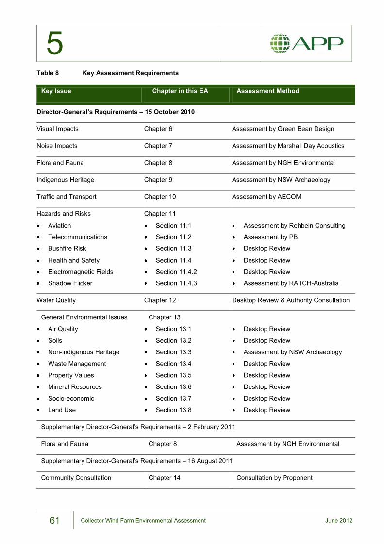
5
61 Collector Wind Farm Environmental Assessment June 2012
Table 8 Key Assessment Requirements
Key Issue Chapter in this EA Assessment Method
Director-General’s Requirements – 15 October 2010
Visual Impacts Chapter 6 Assessment by Green Bean Design
Noise Impacts Chapter 7 Assessment by Marshall Day Acoustics
Flora and Fauna Chapter 8 Assessment by NGH Environmental
Indigenous Heritage Chapter 9 Assessment by NSW Archaeology
Traffic and Transport Chapter 10 Assessment by AECOM
Hazards and Risks
Aviation
Telecommunications
Bushfire Risk
Health and Safety
Electromagnetic Fields
Shadow Flicker
Chapter 11
Section 11.1
Section 11.2
Section 11.3
Section 11.4
Section 11.4.2
Section 11.4.3
Assessment by Rehbein Consulting
Assessment by PB
Desktop Review
Desktop Review
Desktop Review
Assessment by RATCH-Australia
Water Quality Chapter 12 Desktop Review & Authority Consultation
General Environmental Issues
Air Quality
Soils
Non-indigenous Heritage
Waste Management
Property Values
Mineral Resources
Socio-economic
Land Use
Chapter 13
Section 13.1
Section 13.2
Section 13.3
Section 13.4
Section 13.5
Section 13.6
Section 13.7
Section 13.8
Desktop Review
Desktop Review
Assessment by NSW Archaeology
Desktop Review
Desktop Review
Desktop Review
Desktop Review
Desktop Review
Supplementary Director-General’s Requirements – 2 February 2011
Flora and Fauna Chapter 8 Assessment by NGH Environmental
Supplementary Director-General’s Requirements – 16 August 2011
Community Consultation Chapter 14 Consultation by Proponent

5
62 Collector Wind Farm Environmental Assessment June 2012
THIS PAGE LEFT BLANK INTENTIONALLY