cloudburst 2012 winter
DESCRIPTION
Cloudburst is the newsletter published semi-annually by the Federation of Mountain Clubs of BC for our members and the general public. Issues of Cloudburst include articles written by FMCBC members and committee chairs, educational articles, trip reports, stories, poems and general backcountry recreation information.TRANSCRIPT
CLOUDBURST
FEDERATION OF MOUNTAIN CLUBS OF BC Fall/Winter 2012
Black Tusk Meadows & Tuck Lake Trail Progress
Ski Skills for the Backcountry
Spearhead Traverse Summer Route—Almost

The Federation of Mountain Clubs of British Columbia (FMCBC) is a non-profit organization dedicated to the conservation of and the accessibility to British Colum-bia’s backcountry wilderness and mountain areas
Membership in the FMCBC is open to any club or individual who supports our vision, mission and purpose. Member fees go to-wards furthering our work to protect and preserve the backcountry for non-motorized recreation users. Member benefits include a subscription to our Cloudburst newsletter, monthly updates through our FMCBC E-News, and access to an inexpensive third-party liability insurance program.
FMCBC Executive President: Scott Webster (VOC) Treasurer: Elisa Kreller (ACC-Van) Secretary: Mack Skinner (NSH) Past President: Brian Wood (BCMC) FMCBC Directors Dave King (ACC-PG, CR), Caroline Clapham (ACC-Van), Andrew Pape-Salmon (VISTA), Rob Gunn and Judy Carlson (AVOC), Francis St. Pierre and Brian Wood (BCMC), Dean Pollack (BOC), Bob St. John (CDMC), Sam Waddington (COC), Roy Howard (FHA), Al Jenkins (FOGP), Ken Vande Burgt (FoSP), Patrick Har-rison (Hike BC National Hiking Trail), Bill Perry (IMR), Doug Smith (KHC), Peter Oostlander (KMC), Travis Carter (MRBS), Mack Skinner and Cristina Jacob (NSH), Sheila Mitchell (NVOC), Dianne Comens (OC), Layla Ma and Rosalinde Nicholls (SFU), Eric Burkle (VITIS), Mike Stewart (VOA), Ben Singleton-Polster (VOC), Claire Wooton (VRCG), Peter Rothermel (VI Reg. Director) Committee Chairs Provincial Advocacy: Gary Guthrie & Brian Wood SW BC Recreation and Conservation: Brian Wood & Monika Bittel SW BC Trails: Alex Wallace & Patrick Harrison Fundraising: Elisa Kreller Outreach/Communications: Caroline Clapham Insurance: Scott Webster Cloudburst Editors: Bill Perry & Jay MacArthur Production: Jodi Appleton Staff Program and Administration Manager: Jodi Appleton
CONTACT INFO: PO Box 19673 Vancouver, BC V5T 4E7 Telephone: 604-873-6096 http://www.mountainclubs.org [email protected]
INDEX
About the FMCBC.………………………………
President’s Report……………………………….
FMCBC News……………………………………...
Recreation & Conservation……………………….
Trail Updates…..………………………………..
Club Ramblings……………...………………….
Club Activities and Updates………………………
Cover Photo Story………………………………..
Backcountry Skills……………….………………
Literature of Interest……………..…………..…..
Announcements……………….………………….
3
4
4
5
7
11
15
18
19
20
23
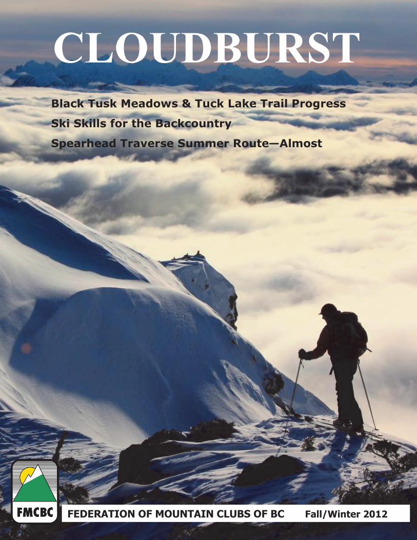
Cover Photo submitted by Linda Bily
Check out page 18 for
the story behind the photo.
Articles and Advertising
Articles should not exceed 1000 words. Photos should be at least 4x6 inches at 150-300 DPI resolu-tion. We only accept PNG, TIF, EPS and JPEG file format for photos and advertisements. For photos, please include photographer, location, names and a description to be included with the photo. For arti-cles please include the author and a title. For ad-vertisements please include a web link. Submission Deadlines: Fall/Winter - September 30 Spring/Summer - March 31
Email articles and advertising inquiries to: Jodi Appleton [email protected]
Ad Size Rate Full Page (7” x 9”) $400.00
½ Page Horizontal (7” x 4.5”) $210.00
½ Page Vertical (3.5” x 9”) $190.00
¼ Page (3.5”x 4.5”) $100.00
Business Card (3.5” x 2”) $50.00
Add FMCBC E-News lnk and up to 50 words +$15.00
FMCBC E-News Link and up to 50 words $40.00

Cloudburst —Fall/Winter 2012 3
The Federation of Mountain Clubs of BC
Working on your behalf
The Federation of Mountain Clubs of BC (FMCBC) is a democratic, grassroots organization dedicated to the conservation of and the accessibility to British Columbia’s backcountry wilderness and mountain areas. As our name indicates we are
a federation of outdoor clubs with a membership of approximately 3800 people from 27 clubs across the province. Our
membership is comprised of a diverse group of non-motorized mountain recreationists including hikers, climbers, moun-taineers, trail runners, backcountry skiers and snowshoers. The FMCBC also has several individual members who are
not affiliated with any club, but share our concerns and interests.
The FMCBC recognizes backcountry hikers, mountaineers and ski-tourers to be a traditional user group of BC’s wilder-
ness and mountain areas and represents their rights province-wide to freely access and enjoy a high quality experience.
As an organization, we believe that the enjoyment of these pursuits in an unspoiled environment is a vital component to the quality of life for British Columbians and by acting under the policy of “talk, understand and persuade” the FMCBC
advocates for these interests.
Membership in the FMCBC is open to any club or individual who supports our vision, mission and purpose as outlined below and includes benefits such as a subscription to the FMCBC newsletter Cloudburst, monthly updates through the
FMCBC E-News, and access to an inexpensive Third-Party Liability insurance program.
FMCBC’s vision is that British Columbia’s backcountry is shared amongst all recreational users in a way that self-
propelled users have reasonable access to an enjoyable experience.
FMCBC’s mission is to advocate for safe, self-propelled activities (such as hiking, mountaineering, backcountry skiing,
snowshoeing, trail running and other backcountry activities) and the protection of BC’s backcountry for current and fu-
ture generations to experience.
FMCBC’s purpose is:
To represent clubs and the public interested in non-motorized backcountry recreation in BC, and to advise
and take action on their behalf in matters which may impact their backcountry recreation experiences.
To make recommendations to government and non-government organizations regarding the protection of
and access to BC’s backcountry and trails.
To encourage self-propelled backcountry recreation, and to promote low-impact and safe practices.
To promote the development and maintenance of a system of trails in BC.
To promote the sound management and preservation of BC’s backcountry recreation resources.
The FMCBC fulfills its purpose with a comprehensive approach to mountain recreation and conservation by:
Participating in provincial land use decision processes
Working to positively change government agency policies so that self-propelled outdoor recreation opportu-
nities are recognized and protected
Representing wilderness as a legitimate land use and a resource of identifiable value to society
Advocating for new parks and wilderness resources, and working to maintain the integrity of existing parks
and wilderness resources
Advocating for improved access to existing recreational resources
Supporting the building, maintaining and protecting of hiking and mountain access trails
Promoting non-motorized and self-propelled recreation activities in BC’s mountains and wilderness
Educating its member and the public on mountain and backcountry safety issues and working with member
clubs to address risk management issues
Promoting membership within our member clubs
Negotiating with insurance brokers to provide extensive liability insurance coverage for our members clubs
At the core of FMCBC’s projects, issues and successes are the countless hours donated by dedicated volunteers from our member clubs across the province. Much of the FMCBC’s work is done through committees including our Trails Commit-
tee and Recreation and Conservation Committee. With the exception of part-time assistance provided by the FMCBC’s
Program and Administration Manager, work on these programs is done mainly by volunteers. Without these volunteers the FMCBC would not exist and we appreciate all those who have volunteered in the past or are current volunteers and
we encourage others to join us to help us reach our vision. ■

4 Federation of Mountain Clubs of BC
President’s Report
President Report Scott Webster (FMCBC President, UBC Varsity Outdoor Club Member)
O ur latest big project is the result of hard work on your behalf by our relatively new Ad-
vocacy Committee. We've partnered with Simon Fraser University to conduct a survey
of British Columbians on non-motorized recreation. The survey will be conducted
online, through a company that has access to a large random pool of BC residents. This
random sampling will give us truly representative data on non-motorized recreation in BC. SFU's
participation ensures that the results will be academically rigorous and defensible, allowing their use
while advocating to the government or others.
There will also be an opportunity for club members to complete the survey. This data won't be
added to the same pool as the random sampling, but will give us a better picture of what activities
our members participate in. This type of project is a new one for us, but I think it could provide
very valuable information and am excited to get the results, probably sometime in the spring. ■
Anne W
ebste
r
Scott with his son Joel in Lynn
Valley
FMCBC News
The FMCBC held its Annual General Meeting in Squamish on June 2,
2012. The weekend was hosted by the North Shore Hikers who did a great
job of welcoming our Directors and members and showcasing the Squam-
ish area by offering a variety of outdoor activities and socials in addition to
the Saturday meeting.
The NSH held a ‘Meet and Greet’ social on the Friday night during which
Elyse Curley gave a presentation on National Parks on behalf of CPAWS
(Canadian Parks and Wilderness Society).
The AGM took place at
the Squamish District
Public Library on the
Saturday. During the
afternoon portion of the
AGM, Jeremy McCall,
Executive Director for
the Outdoor Recreation Council of BC gave an update on ORC's current projects and
Ric Careless, Executive Director for BC Spaces for Nature gave a presentation on a
campaign he is working on with CPAWS and the Elders Council for Parks in BC to
find for more funding for BC Parks.
Two walks were offered on Saturday after the AGM including one to Smoke Bluffs
Park to see the land which the FMCBC holds in trust for the climbing community.
After the walks, the group went for dinner at the Howe Sound Brewing Company.
On Sunday two hikes were organized and led by NSH members with several
FMCBC Directors and members participating.
We thank all of those who were able to attend and invite Club Directors, representa-
tives and members to join us for our AGM on June 8th in Kamloops next year hosted
by Doug Smith and the Kamloops Hiking Club. If you are interested in attending
contact me at [email protected] to be kept up to date on the details, or fol-
low announcements in our monthly E-News and on our website ■
North Shore Hikers led a walk near the FMCBC’s Smoke Bluffs property
Dave K
ing
AGM session on Saturday
Dave K
ing
AGM 2012 Jodi Appleton (FMCBC Program and Administration Manager)
INDEX

Cloudburst —Fall/Winter 2012 5
FMCBC Advocacy Committee Report Gary Guthrie (Advocacy Committee Co-Chair) After enjoying a summer hiatus, the Advocacy Committee (AC) met in early September. These are the six main initiatives the commit-
tee will focus on this fall:
SFU Research Project
The main focus will be the monitoring of this Project which relates to assessing the benefits of non-motorized back country recreation in
BC. The Project got underway this summer with a literature search of the health benefits of exercise, specifically outdoor non-
motorized exercise. The majority of the work is complete and SFU is developing its report. The AC expects a draft report in time for its
October meeting. Committee members will review the draft, summarize their comments and forward the suggestions to SFU for consid-
eration in the preparation of the final report, which is expected in late October.
SFU drafted preliminary questions for the statistical public opinion internet-based survey. The AC will discuss the draft questionnaire,
develop suggested changes/improvements and work with SFU to finalize it. It is expected that the survey will be distributed and com-
pleted by year end. Compilation and analysis will be complete early in the New Year.
Advocacy Toolkit
Advocating for support to improve our members’ outdoor experiences is something all members and member groups can do. To assist
with this, the AC is developing an Advocacy Toolkit which will be available online. The Toolkit will include results from the SFU Pro-
ject and other information the AC believes will assist members in their advocacy efforts.
Private Land Access Position Paper
Often our members access private property and rarely experience any difficulties. Recently, however, access issues related to private
land restrictions arose on parts of Vancouver Island. These situations can also arise when government and private resort owners disagree
over whether land is public or private.
FMCBC’s Strategic Plan notes the need for a position paper to address this issue. This paper should include the FMCBC’s position and
examples of past and current land access agreements with private property owners. The paper could serve as a rational model for future
agreements.
The AC started this project by reviewing some of the current conflicts with property owners.
Trail Wiki
The Committee is developing a list of hiking trails throughout the province that require maintenance or upgrades. It is believed that an
efficient way of logging and tracking these trails is through an internet-based listing that is accessible by all FMCBC members. A Trail
Wiki is under development, and once fully operational will be rolled out to members. The wiki will allow members to post trails in their
area that require work and the type of work necessary. A priority mechanism will be developed so that those trails in the worst condition
will rise to the top of the list. The prioritized list will help in applying for grants to fund repairs.
FMC Roofed Accommodation Policy
The AC is reviewing and will develop its comments on this Policy. When “finalized”, the policy will be posted to our wiki for use by our
members when reviewing proposals to build backcountry huts. We expect that this will be a “Work in Progress” as our ideas develop.
Brainstorming Session
The AC met for a half-day on November 4th in Burnaby to focus its activities going forward. The committee revisited the FMCBC Stra-
tegic Plan to ensure that its activities and efforts are properly aligned with the organization’s goals and objectives and identified those
activities not currently underway, but necessitated by the plan.
Finally, I’d like to recognize Jodi’s continued management of our relationship with MEC, advising them regularly of the FMC’s activi-
ties. ■
Southwest BC Recreation and Conservation Report Brian Wood (SW BC Recreation and Conservation Committee Co-Chair) Callaghan Valley Backcountry Recreation Area The proposed trail leading from the top of the Olympic ski jump to Madeley Lake (the Madeley Highline Nordic Trail) will not go
ahead. The FMC objected to the trail as originally proposed because of its width (15-20m), which was more like an industrial logging
Recreation and Conservation INDEX

6 Federation of Mountain Clubs of BC
road than a Nordic ski trail. The proposed width of the trail would also cause considerable disturbance of old growth trees and other
vegetation, which is not permitted in a "Wildland Zone" through which the proposed trail would have to pass.
For the coming winter season, Whistler Olympic Park will reduce its fees for backcountry users to $10 per vehicle. This is more consis-
tent with the price suggested by the FMC, based on the survey conducted a few years ago. Hopefully, this policy change will result in
increased backcountry use from Whistler Olympic Park, thereby sending the message that they made the right decision by reducing the
price and charging per vehicle rather than person. The reduced price only applies to the Whistler Olympic Park, not Callaghan Country,
which will require backcountry users to buy a regular cross-country ticket if using groomed trails for access.
21 Mile Creek and Rainbow Wildlands Area
This Land and Resource Management Plan (LRMP) designated non-motorized area continues to be heavily used by snowmobiles, de-
spite signage and some publicity in the local Whistler press about the area being closed to snowmobiles. Allistair McCrone, of Recrea-
tion Sites and Trails BC who manages public recreation on Crown Land, attended the June Recreation and Conservation Committee
meeting to discuss this and other issues. McCrone informed us that road closures and parking restrictions were not effective options to
prevent snowmobiles from accessing the non-motorized area because there were other users that needed to be considered. He also ad-
vised that a Section 58 designation would not resolve the enforcement challenge. McCrone advised that the focus would remain on edu-
cating and informing snowmobilers of the closure. He reported that the maps now being supplied by snowmobile clubs had all closures
marked, that he had additional funds for signage to further educate snowmobilers and he planned to increase his presence in the area.
There are two Compliance and Enforcement Officers who can ticket offenders. McCrone encouraged members to report any snowmo-
bile use of the area to him as well as any snowmobile outfits that advertised or encouraged snowmobile use of the area.
Backcountry users are therefore encouraged to continue to report any motorized recreation in or use of non-motorized areas, including
provincial parks, to www.bivouac.com or our website.
Tricouni
McCrone agreed that Powder Mountain Cat Ski, local First Nations, the VOC and backcountry travellers continue to have problems
with snowmobilers in this area, and had some suggestions, including groomed trails for snowmobiles which would direct them away
from terrain used by backcountry skiers and non-motorized users. He indicated that once the ORV legislation is passed, enforcement
should be more effective. Unfortunately, there continues to be delay in getting this critical legislation passed.
Fitzsimmons Creek Bridge
When installed, this proposed bridge would facilitate access to the Singing Pass Trail by avoiding the present slumped section and pos-
sibly permitting vehicle access to the old parking area. However, because many entities are involved with this issue, namely Whistler
Municipality (RMOW), Whistler/Blackcomb Resort, Energex (Fitzsimmons IPP) and the Whistler Sliding Centre, it is difficult to get a
consensus on how best to proceed. McCrone advised he would investigate the cause of the delay. He suggested installing a footbridge
first and, if feasible, a vehicle bridge later.
Garibaldi Park Management Plan Amendment
BC Parks has received a lot of public input after posing a series of questions regarding the Garibaldi Park Management Plan. BC Parks
anticipates distributing for public comment a draft Amendment Report within the next month. There will be open houses in Vancouver
and Whistler for public review and discussion of the draft report. Many of the questions posed by BC Parks related to the Spearhead
Huts Proposal, which proposes building three huts/cabins along the popular Spearhead Traverse, connecting the Blackcomb and Whis-
tler ski areas. In May 2012, the Spearhead Hut Committee submitted the detailed Spearhead Huts Proposal to BC Parks, and this can be
seen here.
Friends of Garibaldi Park
The recently formed Friends of Garibaldi Park Society, organized two three-day work parties for the Black Tusk Meadows Trail. Two
enthusiastic groups of volunteers worked on bridges, trail drainage ditches and board walks, supervised and assisted by several park
rangers, who provided rare sightings of endangered species - themselves!
Sea-to-Sky Gondola Project
While there is a lot of support, particularly in Squamish, for this project because of the anticipated improved access to more back-
country, there continues to be resistance to the project because of the failure to follow the proper protocol for adjusting the park
boundary. Some critics raised the issue with the Office of the Ombudsperson, which will be reviewing the matter and submitting a report. Some of those who objected to this gondola project did so because of the location of the proposed gondola. It would detract
from the aesthetic values of Stawamus Chief Park. Others suggest there are more suitable locations for a gondola, including one from
Squamish to a high viewpoint on the west side of the Squamish River. Such a location would not only provide spectacular views of the
Stawamus Chief, Howe Sound and Mt. Garibaldi, but would also provide a river crossing and potentially new trail access to Tantalus
Provincial Park.
Recreation and Conservation INDEX

Cloudburst —Fall/Winter 2012 7
Recreation and Conservation
Even though the boundary adjustment has now been made into law, BC Parks informs us that the Sea-to-Sky Gondola Project still has to
pass an environmental assessment process and a permitting process.
The FMCBC lands in Smoke Bluffs Park
In 1987 the FMCBC purchased property adjacent to the Smoke Bluffs climbing area in Squamish to preserve access to the climbing
bluffs. For many years the FMCBC, along with the Climbers’ Access Society, Squamish Access Society and the climbing community
generally, has worked towards the creation of a Smoke Bluffs park to protect climbers’ access and climbing in the Smoke Bluffs in per-
petuity.
In June, a representative from the FMCBC, Squamish Access Society and the District of Squamish met to discuss possible transfer of
the FMCBC lands to the District for the purpose of a climbing park. Recently, the District made a promising proposal, which is being
considered. Prior to the FMCBC landbeing transferred, the FMC clubs and other climbing groups will be consulted to ensure that the
transfer satisfies the goals of the climbing community.
New VOC Trail to access Harrison Hut
The Harrison Hut, located near the northern edge of the Pemberton Ice Field, used to be accessed via a trail which started near Meager
Hot Springs, but the bridge washout and mud slides have made this approach virtually impossible. Consequently, apart from trespassing
snowmobilers, this hut has had few visitors over the last several years. So, as the Meager access is unlikely to be revived in the foresee-
able future, the VOC has started work on a new trail which starts in a clear-cut on the south side of the Lillooet River.
BC Parks Volunteer Strategy
A copy of the BC Parks Volunteer Strategy is available through BC Parks www.bcparksvolunteers.ca. In April 2012, BC Parks commit-
ted $200,000 to support volunteer projects in parks and protected areas across the province, and is continuing to work with Risk Man-
agement Branch on the development of a group insurance program, which is planned for early 2013. BC Parks has recently hired a pro-
vincial community engagement specialist to liaise with community partners, ensure consistency of volunteer programs and continue to
engage with communities across the province. Ms. Becs Hoskins can be reached at [email protected] or at 250-953-3428. ■
Trails Report October 2012 Alex Wallace (FMCBC SW Trails Committee Co-Chair)
Howe Sound Crest Trail Report
With the remaining funds, BC parks hired Rare Earth, an experienced trail crew
that had worked on the project in 2011, and we are now past Strachan Meadows
and approaching the awful worn-out switchbacks on the approach to the ‘First
Minor’ peak of St Marks.
Apart from being worn out and trail braided, they also have very little gradient
and wander back and forward across the slope, so it will be a pleasure to re-align
them - and make sure that they are not in the Capilano Watershed, of course.
The crew worked to the end of the season and then were pulled back on October
1st to work on the very first section of the Howe Sound Crest Trail right at Cy-
press Creek in Cypress Bowl, where the trail leaves the Yew Lake (wheelchair
accessible) loop, which FMCBC rebuilt under Lesley Bohm’s direction some 20
years ago. These projects take time and money, and as of October 2012 all funds
we were successful in getting [i.e. from VANOC and Ottawa] have been used
up. It now falls to us to remind Government in Victoria that, while we will look for other sources of funds, as our partner in this project
they need to kick in some matching funds as it is one of the busiest and best-known high elevation trails in the BC Parks system.
I note that the amiable West Vancouver MLA, Ralph Sultan (with whom I have discussed the
HSCT some years ago) is now the Minister for Seniors ...so any hikers who qualify, please
feel free to remind him that many seniors hike—and vote, too!
Trail markers are in!!
Thanks to the perseverance of Christian Veenstra of VOC, a large bulk order of reflective trail
markers was purchased at a very low price (actually less the cost when we ordered ten years
ago) on the basis that they are now available at FMC and clubs can purchase the number that
they need for trail projects at a flat rate of $1 each.
Trail Updates
Ale
x W
allace
Howe Sound Crest: Typical eroded trail switchback to
be rerouted / realigned as the project progresses.
INDEX

8 Federation of Mountain Clubs of BC
Trail Updates
This was the formula worked out at the Squamish AGM, and there 2,000 left. They are heavy-duty reflective orange markers with a nice
5mm hole in the top corner. Get your orders in soon!
BC Parks Volunteer Strategy
Many Clubs will have received a September 28th Draft Volunteer strategy document, and a follow-up call from Judy Becker of BC Parks
Mt. Seymour office ,who is making a preliminary assessment of the numbers of volunteers in clubs that might potentially need to be in-
sured. It looks to us like the General Liability Insurance offered by Government for “certain specified activities” will be similar to that
offered under the Crown land Trail Agreements, which clubs were not completely comfortable signing up with. So although it is a step
in the right direction we still will need to see the details of liability, what is covered, etc. This, apparently, is still some months in the
future (January 2013), but the document did give a nice summary of the stakeholder consultation process, and when we met with Lori
Halls, the Assistant Deputy Minister, she made a commitment to get the Volunteer Strategy back on track. ■
Trail Works underway in the Black Tusk Meadows Cathy Ross (Friends of Garibaldi Park) This September, eleven passionate Friends of Garibaldi Park (FOGP) volunteers and the committed Rangers of Garibaldi Park combined
their resources and worked together to carry out some of the much needed restoration work on the Black Tusk trail.
For the past ten years, the trail leading to one of the most popular features of the Park had deteriorated due to lack of maintenance and
neglect. The broken down ditching had allowed portions of the trail to turn into a creek bed and many plugged culverts had forced water
onto the trail and caused significant erosion damage. All of this had eventually resulted in extensive trail braiding and irreparable dam-
age to the fragile alpine vegetation.
The poor state of the Black Tusk trail had served as glaring evidence that our B.C. Parks may actually be ‘in peril’. For many years,
Garibaldi Park has been suffering from a variety of problems, and it is hard to believe that the Garibaldi Park we know of today was
once promoted as a ‘Flagship Park’ in the provincial fleet.
As a result, the idea of forming the FOGP was initiated in 2010 and a ‘Stewardship Commitment’ to Garibaldi Park was made. Under
the leadership of Al Jenkins, the FOGP developed an action plan to care for and upgrade the Black Tusk Trail. The plan outlined a rec-
ommended scope of work and was eventually presented to Chris Platz, the Area Supervisor for the Whistler Area. The ‘Black Tusk
Meadows Trail Upgrade Proposal’ advocated for a major renovation and upgrade in order to prevent further damage to the fragile alpine
meadows.
The objective was one of conservation and protecting the ecological integrity of Black Tusk Meadows. The plan suggested establishing
better drainage control with improved ditching, installing adequate Big O culverting, and selecting a ‘capping’ material to establish a
hard-wearing trail surface. It was also suggested that the section of the trail through Parnassus Flats required a boardwalk similar to that
already constructed through Taylor Campground.
Statistics indicate that Garibaldi Provincial Park attracts well over 80,000 visitors a year and with the passage of time, millions of hikers
have walked along the Black Tusk Meadows Trail. It is estimated that approximately one hundred people use this trail daily on a busy
day in Garibaldi Park.
How many have paused to consider how this wilderness
trail came to be or how it is maintained?
Starting as far back 1909, a group of early mountaineers
known as the British Columbia Mountaineering Club
(BCMC), dedicated themselves to protecting the natural
resources of Garibaldi Park. At that time, there was a
growing public interest in the outdoors and Parks were
valued as places that were good for health and vitality.
Our National and Provincial Parks were viewed as areas
where the public could enjoy wonderful scenery and also
contribute valuable dollars to the economy.
Using only simple hand tools and without the modern
mechanical equipment that we have today, the trail into
Black Tusk Meadows was cleared by three members of
the BCMC up from Rubble Creek, through the steep,
wooded mountainside to the meadows located at an eleva-
Jason W
hite
It was a beautiful day for the Friends of Garibaldi Park to do some trail
work
INDEX

Cloudburst —Fall/Winter 2012 9
Trail Updates
tion of 1700 metres. These first trails have historically served as the gateway into the beautiful alpine of Garibaldi Provincial Park.
Factor in that before they could make trail, they had to get themselves to the location where the trail would begin. Back then, this meant
a five hour steamship voyage from Vancouver to Squamish, as there was no railway until 1956. Then after arriving in Squamish, a mo-
torized stage would have be taken to Brackendale. It was here that most of the early mountaineers stayed the night before making the 32
kilometre trek along the Squamish-Pemberton trail to the foot of Rubble Creek.
Fast forward to 2012 and the access to Garibaldi Park has become much easier. The two September FOGP work parties carpooled along
the Sea to Sky Highway and met at the Rubble Creek trailhead. From there everyone hiked up the modern trail to Taylor Campground
where camp was made for three days.
With hand tools provided by the Garibaldi Park Rangers, FOGP volunteers cleared drainage ditches, repaired and rebuilt wooden bridges
along both the Black Tusk Trail and Ranger’s Trail near Taylor Cabin. Approximately 15 metres of boardwalk was constructed and even
a set of stairs was built at the Parnassus Creek crossing.
The early mountaineers who blazed the first trails in the Park were passionate individuals with a true sense of pride. Their commitment
to preserving the ‘extraordinary natural beauty” of the Park was instrumental to the creation of Garibaldi Provincial Park back in 1927.
During this era, the formation of National and Provincial Parks was influenced by the popular philosophy credited to Canada’s first Na-
tional Parks Commissioner, John Bernard Harkin:
‘Parks were to be dedicated to the people of Canada for their benefit, education and enjoyment … parks would be maintained and made
use of so as to leave them unimpaired for the enjoyment of future generations.’
Garibaldi Park was fondly known as ‘Vancouver’s Alpine Playground’ and promoted as having beautiful scenery comparable to that of
Lake Louise in Banff.
In fact, during the 1930’s, the Garibaldi Park Board put forward a proposal for Garibaldi Provincial Park to become a National Park.
This was due to concerns that the Provincial Government was unable to provide funding to support the care and development of the park.
Today there seems to be a similar dilemma as to who is responsible for maintaining our Provincial Parks and what should be the standard
of care is for them?
In our search for answers, perhaps the concept of ‘Positive Impact Living’ would be helpful. Bruce Wilson, an instructor for Capilano
University, describes Positive Impact Living as actively encouraging people to interact and participate, within the areas in which they are
living or traveling. It is about giving more than taking because it realizes that by being in a place physically, we are already taking be-
cause of our presence. It also recognizes the fact that we are way beyond sustainable living and need to participate in active rebuilding,
of the environment, and natural systems that we have almost completely depleted, or disrupted.
Having an awareness that everyone can make a difference in the care of Garibaldi Park is a start.
B.C. Parks has indicated that there will be more volunteer opportunities in Garibaldi Park during the summer of 2013. Updates will be
posted on the BC Parks Garibaldi website and Friends of Garibaldi Park website. ■
Chilliwack River Valley Trails Association morphing into the Chilliwack Recreation Advisory Group (CRAG) Jack Bryceland (Chilliwack Outdoor Club)
As a result of the Outdoor Recreation Council’s 2010 workshop titled Working Together: Finding Solutions to Regional and Community
Trail Issues, an ad-hoc group was formed to see if it could make improvements to the situation in the Chilliwack River Valley (CRV).
Calling itself the Chilliwack River Valley Trails Association, it was made up of one, or maybe two, representatives from each of the user
groups: cavers, mountain bikers, hikers/climbers, canoers/kayakers, ATV riders, motorcyclists, snowmobilers, 4-wheel drivers, horse
riders & paragliders/hang gliders. Our membership objective was to have the people be members of some local club that used the valley
recreationally, but also for that club to be a member of some provincial organization that was, hopefully, also a member of the Outdoor
Recreation Council. That, we felt, was the way to maximize the communication potential . . . assuming that we were going to able to
resolve something.
The major initial issue was a simmering feud, exacerbated by extensive media coverage, in 2010, saying that the Trans Canada Trail
(TCT) was being ‘destroyed’ by ATV riders. Reducing two years of discussion to a simple description: we have separated the TCT in the
valley into three sections: one section now being shared with motorized users, one section being non-motorized, and one section (partly
within a Provincial Park) still in limbo, since it is mostly old Forest Service road.
INDEX

10 Federation of Mountain Clubs of BC
Another success was the removal of the gates placed by the Department of National Defense at the toe of International Ridge and at the start
of the Slesse Forest Service Road. You can now drive some distance up the Slesse FSR to access the Slesse Mountain Trail, rather than hav-
ing to walk/bike all the way from Chilliwack Lake Road.
Now here’s the current situation with this ad-hoc committee: Mike Peters, the Recreation Officer for the Chilliwack District of the Ministry
of Forests, Lands & Natural Resource Operations, would like to have a multi-user group who could advise on recreational objectives and
provide guidance on allocation of funding to recreational projects. This is the essence of the Chilliwack Recreation Advisory Group (CRAG).
Perhaps I should first clarify the extent of the Chilliwack District: it extends from Bowen Island to Boston Bar and from the International
Boundary to the top of Harrison Lake. Some of the members of the committee are dubious that we can knowledgeably discuss topics in such
a large area; however, I am all for it. Here’s one reason why: around the year 2000 a provincial government list of hiking trails in the Chilli-
wack District showed only one established (i.,e. officially recognized) trail: the Mount Grainger Trail. All the others (Slesse, Rexford, Wil-
liams, Baby Munday, etc.) had vanished from the list. An amazing amount of work over the last few years (separate letters to 28 separate
aboriginal bands for each trail) has resulted in the re-establishment of 14 trails. Now we need to do the same for all the others that used to be
official (Buntzen’s Eagle Ridge, Hope Mtn., Mt. Outram, Silverdaisy Mtn. etc.).
Here’s a memory test: how many of you can remember the 2006 effort that FMC put in to mapping the recreational areas of value to us in the
Chilliwack Forest District? Most of the Lower Mainland clubs marked up the maps. Then Brian Wood persuaded Western Canada Wilder-
ness Committee to digitize our data. There were two problems with that process. The first problem was that a bunch of polygons on a map
are just that. What do the polygons mean?. What is required is documentation to explain the significance of the mapped areas, e.g., lists of
the trails, the summits, alpine vistas, etc. I started to do this but got overwhelmed by the immensity of the task. The second problem is tied
into the first one. We had nowhere to go with the data even if we finished it. We had hoped to perhaps stimulate a Land and Resource Man-
agement Plan for the Fraser Valley, but government knew that it was too hot a potato to touch. However, maybe we have it now! The answer
could be CRAG.
So I’ll get back to working on detailing the polygons but I need you to send me your long-term ideas for recreational work in the Chilliwack
District. Of course it will be a compromise with the other user groups (I’d say ‘horse trade’ but the BC Horse Council might be offended).
But compromise is the essence of democracy . . . if only I could get Stephen Harper to un-
derstand that we’d all be better off. Jack Bryceland, [email protected], 604-858-6601 ■
Tuck Lake Trail Andy Cain-Ogle (VISTA)
The Vancouver Island Spine Trail is roughly 30 km closer to completion thanks to a small
but dedicated band of volunteers who spent half-a-dozen weekends this summer and fall
working on the “Tuck Lake” trail.
Extending from Nitinat River and Tuck Lake in the east to Francis Lake in the west, the
trail section will extend the Runners Trail which was built in 2010, and finalize the link
from the west end of Cowichan Lake to the Alberni Canal, a key part of the southern half of
the Spine Trail. The VI Spine Trail, as proposed, will ultimately run from Victoria up the
“spine” of the island to Cape Scott, a distance of some 700 km.
Some work remains to be done on the Tuck Lake section, but most of it, from Nitinat
River, over a pass, down Nadira Road, and in the timber along the north shore of Francis
Lake has now been flagged and cleared of brush and small trees. The crews, led by trail
boss Jay Rastogi from Nanaimo, did relatively little soil disturbance but created a wilder-
ness trail that is well flagged and fairly easy to follow. While it passes by several clear-cut
logged areas, the trail mostly stays in or close to riparian zones, where timber stands are left
intact.
The use of volunteer labour has kept down the cost of building the 30-km section, which is
budgeted at just $13,500. Donations, including the $2,100 grant from the FMCBC, will
cover the cost.
Volunteers have come from the Alberni Valley Outdoor Club, the Alpine Club of Canada, several other Island centres, as well as VISTA
board members and friends, including Gil Parker, VISTA’s founder and past-president, who has been out for nearly every work weekend.
Robert Gunn, VISTA’s regional coordinator for the Alberni-Clayquot region, determined the initial route. Weekend efforts often included
camping overnight at a boulder beach at the northwestern end of Francis Lake, where the Runners’ Trail from Headquarters Bay on the Al-
berni Inlet formerly ended. On several hot weekends in August, the trail builders rewarded themselves with swims in the pristine waters of
Tuck and Francis Lakes.
Some more clearing, trail marking and signage is planned for this fall, depending on weather, with a view to official opening in the spring of
2013. ■
Trail Updates
Charles Turner, Gil Parker, Jay Rastogi, and
Andy Cain-Ogle are hard at work on the Tuck
Lake Trail
Charles B
urn
ett
INDEX

Cloudburst —Fall/Winter 2012 11
Chasm
Mike Nash (Caledonia Ramblers)
In decades of driving between Prince George and the lower
mainland, I had many times passed the sign to Chasm a few kilome-
tres north of Clinton without giving it much thought. There are two
nice viewpoints along this stretch of Highway 97, a pleasant ten-
minute hike up to the fire lookout at Begbie Summit just south of
100 Mile, and the large highway rest stop atop the hill immediately
north of Clinton. The rest of the boulder-strewn high volcanic pla-
teau between 100 Mile and Clinton struck me as being the least in-
teresting part of the 800-kilometre journey to Vancouver. However,
gradually becoming intrigued by the name, I resolved to check out
Chasm on my next drive through the area. I was stunned by what I
found.
Chasm Provincial Park is only five kilometres east of Highway 97
on a paved road. It has no facilities beyond a rough parking area, an old interpretive sign, a single outhouse and a plain chain link fence.
Behind that, though is a dry gorge, similar to that below Helmcken Falls which is still cutting through the volcanic plateau of Wells Gray
Provincial Park. Fed today only by a small stream and lacking a waterfall, Chasm more than compensates with a long, spectacular gorge
revealing colourful banding from successive depositions of flood basalts. The chain link fence protects steep drop offs in the vicinity of
the parking lot at the head of the gorge, but there are kilometres of rustic rim trails through dry Douglas fir and pine forests along both
sides that you can hike at your own risk. The interpretive sign, which itself is nearly historic (1966), reads: “THE CHASM: At the close
of the Ice Age about 10,000 years ago, a stream fed by melting ice cascaded over a falls forming this chasm by cutting into some of the
lava flows that helped to build the Fraser Plateau. Individual lava flows are show here by the horizontal layering. When the glacial ice
finally disappeared the flow of meltwater stopped.”
The lighting on the clear day that I was there was intense and was not ideal for seeing all of the features, but the opportunity to walk
around both sides of the chasm allows you to view the walls of the gorge and the colourful layering from different aspects. According to
Wikipedia, it was “…created from melting glacial waters eroding a lava plateau over a 10 million year span called the Chilcotin Group.
The walls of the Chasm contain tones of red, brown yellow, and purple and are an average of 300 metres in height. The Chasm is ap-
proximately 600 metres wide and 8 km long, and lies adjacent to the route of the Cariboo Road.” There were also recent tracks of Big-
horn Sheep and other wildlife all along the dusty rim.
Because of these outstanding features, Chasm is at least as interesting as Helmcken Falls or even the spectacular Dry Falls in Washing-
ton State’s Grand Coulee; and it reminded me in a small way of Arizona’s Grand Canyon. ■
http://en.wikipedia.org/wiki/Chasm_Provincial_Park
http://www.env.gov.bc.ca/bcparks/explore/parkpgs/chasm/
Mike Nash is a Prince George author and a member of the FMCBC. His latest book is Outdoor Safety & Survival, Rocky Mountain
Books, 2012: http://www3.telus.net/pgoutdoors/
This article first appeared in the September 2012 issue of The North Call, the newsletter of the Prince George Section of the Alpine Club
of Canada.
A Third Name Nowell Senior (Caledonia Ramblers)
While helping with renovations of Red Mountain Cabin, Peter had difficulty remembering my name. I made it easier for him by suggest-
ing he call me according to whatever job I was doing. Consequently, since I spent a stretch of time removing bark from logs with a spud
peeler, I became Spud for a while. Later, I filled the chinks between the logs of the cabin, and became Chink. I also carried rocks from
the creek as supports for the porch floor, and, although hoping I’d become “Rocky” – it wasn’t to be, and I remained interchangeably,
Spud and Chink.
Anyway, as we prepared for leaving the cabin, I decided on what to leave behind. I stashed extra clothing and tools I didn't want to carry
back, but the liter of wine leftover from what Lyle had donated to the crew wasn't staying behind, and, since only beer-drinkers remained
- I drank the liter with my lunch. I reasoned that the 11km hike back was all downhill, and I'd have the company of the other four to
steady me. As I sipped away, I absently gazed at Wayne, frantically painting the cabin floor, but not long after, without thinking, I went
Club Ramblings
Mik
e N
ash
INDEX

12 Federation of Mountain Clubs of BC
Club Ramblings
striding into the cabin, and I don't even know what for - I don't think it was for more wine. Anyway, in I went, skidded across Wayne's
still wet masterpiece, somehow recovered my balance, slunk out, and kept silent. As we made movements to leave, Wayne entered the
cabin to admire his work - at that precise moment I received my third name. I have to confess I was impressed by it, because, whereas
my other two names consisted of single guttural syllables, this new name had a lilting four syllables, and a distinctive ring to it, but sadly
not a name that I could flaunt!
By now it was time to leave, but, by the time I'd wrestled my pack on, the Fabulous Four had flown! So, I'm somewhat tipsy and tired
from a week of spudding, chinking and rocking; I'm also alone in an area where as many as 23 grizzly bears have been seen in a single
day. I staggered up the gully toward the ridge, turned for one last look at the cabin, and saw not one, but two of them! How was I going
to make it down that trail? One thing for certain was that I wasn't staying, and so off I went. And, it's funny because the paranoia of
bumping into a bear never bothered me. In fact I sang happily and unworriedly for the next four hours or so, and maybe the singing kept
the bears away. To be on the safe side, I think I’ll invest my money in wine rather than bear spray - it was the most carefree, solitary
walk in bear country that I’ve had. ■
The Spearhead Traverse Summer Route—Almost. September 2012 Brian Wood (BC Mountaineering Club) My oldest son, Michael, suggested that we should try to follow the proposed summer route of the Spearhead Traverse before the three
huts are built. I thought this was a great idea as both of us had been “weathered off” the winter route, and the weather over the Labour
Day weekend seemed promising. So we planned on a leisurely three night’s trip, with one spare night just in case, which resulted in our
packs weighing about 45 pounds each because we did not intend to forgo food or our creature comforts. Liz Scremin of the ACC Van-
couver Section had kindly pencilled the proposed rough route on my excellent Backcountry Whistler map (by John Baldwin) to supple-
ment the Google maps which showed approximate portions of the proposed summer route available on the Spearhead huts website.
After dropping off Michael's wife and children at the ferry, we drove to the overnight parking lot #5 at Whistler, and caught the Whistler
Village Gondola to the Roundhouse arriving at about noon. On the ride up we watched in awe as the body-armoured, Darth Vader-
helmeted mountain bikers hurled themselves down unforgiving steep trails. I wondered how the biker body count compared with the
skier/snowboarder body count, and resolved to do a little research later. As the ski area summer alpine scene was new to us we did not
hurry, but instead enjoyed the views of the endless peaks and relatively few crowds. Before taking the Peak-to-Peak Gondola to the
Blackcomb side, we examined the terminal of this record-breaking engineering marvel, and were surprised at the number of gondolas
traversing the cables in both directions.
It was about 1:00 pm when we finally started hiking generally south-east along the well-manicured Overlord Trail which was provided
with excellent direction signs, maps and a surprising number of interpretive signs, the like of which I have never seen in a BC provincial
park. There were many day hikers of all ages using the trail, mostly older folks returning while younger folks were heading out like us.
Where the Overlord Trail looped back at the Decker Loop, we traded the luxury of easy on-trail footing to off-trail reality, which was
side-hilling on loose gravel held in place by scrubby trees and heather. In spite of Liz's route penciled on our map we were soon off-route
on some unpleasantly steep ground and so we headed upwards to join her recommended route which included some very pleasant undu-
lating heather benches which was a big improvement over the steep side-hilling. These benches led us easily to a partially frozen un-
named lake between Decker Mountain and Mount Trorey surrounded by some inviting level spots and a few creeks. This was a scenic
area, and, as it was about 5:00 pm, it was late enough to camp,
especially as the immediate route ahead did not seem to have an
obvious water source. So we decided to camp about a hundred
meters above the lake, and while eating dinner we had marvelous
views of the steep, glaciated peaks on the east and south portions
of the traverse. As the sun went down, we caught its reflections off
the silvery metal roof of the Himmelsbach Hut at Russet Lake on
the south side of Fitzsimmons Creek.
After a windless and peaceful night at about 2200m, we woke to a
beautiful clear morning with a little frost on the tent. Marvelling at
this rugged scenery so close to Vancouver, we had a leisurely
breakfast and followed relatively easy benches to a position below
the southeast ridge of Mt. Pattison, where we had lunch. To avoid
falling asleep in the warm sun, we left our packs and headed up the
snow and gained a rocky ridge to an approximately level piece of
bedrock (?) at about 2400m. We assumed this was the proposed
cabin site as it was quite close to the 2483 m summit of Mt. Patti-
son. This hut would be the highest and most exposed hut of the
Brian W
ood
First campsite between Decker Mountain and Mount Trorey
INDEX

Cloudburst —Fall/Winter 2012 13
Club Ramblings
three Spearhead huts and the views of the adjacent gla-
ciers and peaks are certainly spectacular. However, I
could not help wondering what the approach and descent
would be like on skis in a whiteout which is quite com-
mon on the Spearhead during the spring season. All
three cabins are required to provide tent sites, and this
site called for tent platforms as there were no obvious
natural tent sites due to the rocks.
We descended back to our packs and continued on the
traverse, and, in view of the time, we agreed that our
original plan to not camp near the Macbeth proposed
cabin site was a good idea. We started a slow descending
traverse across heather towards a steep gravelly open
slope leading eventually into drainages which joined re-
vegetated old moraines of the Curtain and Fitzsimmons
Glaciers. If we had studied the map we would have seen
that our descent started a bit too soon relative to Liz's
route which took a less direct route, but it looked alright,
at least at first. Further down the drainage we found our-
selves hedged in by bush and were forced to extricate
ourselves, which was time-consuming and frustrating
and revived fading memories of some of my earlier trips which had turned into “epics”. This is another example of not learning from my
previous mistakes due to my fading memory of them! As it was now about 5:00 pm we switched into our “epic avoidance mode” and
increased the pace as we saw very few inviting campsite anywhere near us. The most promising area was close by the steep snout of the
Fitzsimmons Glacier and so we skirted high above the bush and arrived there just as it was dusk. The site was pretty good and the glacier
snout was very impressively high and steep, with large boulders poised on it lip, so we made sure we had good rocky barriers to protect
us from any night-time rolling rocks.
Wednesday dawned clear again, and after breakfast I discovered that my 10 year old Garmin 12 GPS unit displayed only “UPLOAD
NOT PRESENT” and not the usual comforting signs of satellite circles. So it was back to basic map and compass navigation and I would
have to kick my GPS dependency habit and suffer the inevitable withdrawal symptoms of “location uncertainty”(which is not the same
as being lost). We confirmed our earlier decision not to visit the MacBeth cabin site as it involved about 500m of climbing over a steep,
loose-looking lateral moraine, followed by some unaesthetic slopes leading to the MacBeth Glacier snout. So, instead, we forded
Fitzsimmons Creek near the glacier snout, which was not too deep as it was early in the day, but we were still thankful that we wore our
“Crocs” for the crossing.
Following the creek down the moraine soon led us into the bush, which provided a reasonable route apart from patches of alder and wil-
low in some avalanche chutes. After a sunny lunch by the river, we climbed towards and then below the snout of the Overlord Glacier,
hopping over the many creeks draining this area. The scenery improved as we climbed up the slopes towards Russet Lake, but we did not
want to camp near the Himmelsbach Hut, as we knew it was likely to be crowded, and we preferred to camp in deserted wilderness. As it
was approaching late afternoon we decided to camp on a small, level bench, which provided spectacular views of the Overlord Glacier,
Overlord Mountain, Fissile Peak and other peaks. We had another peaceful windless night with the muffled sounds of waterfalls echoing
off the peaks.
Thursday morning was again perfect and during breakfast we noticed a lone figure descending towards us from the skyline above. This
figure turned out to be Karl Ricker, a well-travelled and very experienced BCMC Honorary Member with a passion for geology, glaciol-
ogy, alpine biology and local mountain history. He joined us for tea and then enlisted us to assist him on his glacier snout measurements
that he has been conducting every year at this time since 1986. So, by 9:00AM, we were walking around the snout of the Overlord Gla-
cier trying to find the extreme tip of the ice under its late season rocky debris.
Karl used his pre-GPS measuring gear such as an accurate sighting compass and a surveyor's tape, taking measurements from painted
datum points he first established when he started these voluntary studies decades ago. The Overlord Glacier has a bi-lobed snout and so
two separate sets of measurement were required, and he found that the snout had advanced about 1.9 m since last year's measurements.
To quieten the expected cheers from the climate-change deniers, as a comparison, this glacier's small advance contrasts markedly with
the other local glacier that Karl has been measuring, the nearby Wedgemont Glacier, which retreated 28.6 m from last year's measure-
ments!
After finishing the measurements, we packed up our gear and followed Karl along the trail which passed through pleasant sub-alpine
vegetation to the Himmelsbach Hut, which is close by Russet Lake. The hut was built by the BCMC in 1968 and then donated to BC
Brian W
ood
Michael at the last camp with Overlord Glacier and Overlord Mountain
INDEX

14 Federation of Mountain Clubs of BC
Parks. The current plan was to build the third of the Spearhead huts away from the lake, about 1.3 kms south of this hut, but we did not
visit the proposed location as there were several other options in this area and we felt the actual location might change before building
commenced.
After a quick snack and checking out the recently built outhouse, well guyed by cables to resist the winter storms, we followed the good
trail to Singing Pass and its beautiful meadows. While descending the Singing Pass Trail, we were entertained by Karl's stories of the
UBC Varsity Outdoor Club (VOC) building the first hiking trail to Singing Pass in1965, and BC Parks later building the present trail,
which, in some sections, is very close to the old VOC trail. We were pleased to see that several new bridges had had been installed over
the larger creeks, and as we neared Whistler we passed under the Peak-to-Peak with its gondolas looking so small from below.
We negotiated the section of the trail which had been washed out many years ago by hanging onto a length of knotted 1/4 inch polypro
rope, which I am sure, could approach its breaking point if a heavy climber with a heavy pack slipped while using the rope. This section
of the trail is well outside the park and presumably not BC Park’s responsibility, but I hope this dodgy hand line will be replaced with
something more substantial before there is an accident. Where the trail came out of the forest, we had to sprint across the mountain bike
routes to avoid being hit by the bikers, who did not seem to expect anyone crossing their trail. By now we had worked up a good thirst,
which Karl helped us quench at his favourite local watering hole. ■
First Ascent of Nasokwen Mountain: into The Forbidden Forest Doug Brown (Kootenay Mountaineering Club)
I have a hate-hate relationship with Silverton Creek. And it is mutual. I've thrashed my way up the bush in that drainage more times than I care to remember. It is thick, it is wet (always), it is slippery, it is pointy, spiky and generally unpleasant. I swear, not love nor money could make me go back. But I've said that before - several times. Like after climbing Titei. And after climbing
Blacktail. And after climbing Long ...
And finally, after not climbing Nasokwen. Which brings us to this story. In June of 2010, Sandra convinced me I was being a girly-man and the bush just wasn't that bad (fool me once, shame on you, fool me 3 times ...) and that going up Nasokwen was a great idea. So it was that Sandra McGuinness, Jen Kyler, Micha Forestell, and I banged the truck up the remains of the Silverton Creek
FSR, put on our Kevlar clothing, strapped on protective eyewear, ducked our heads, and entered into The Forbidden Forest. Sev-eral days later we emerged, bloodied and bruised, into the sub-alpine of the impressive cirque on the north side of Titei. We easily crossed over the crest of Wilfred Ridge, and gazed, downcast, at the turreted and corniced ridge running east to Nasokwen. We
had more chance of spying a Bowtruckle than traversing that ridge in soft early-summer snow conditions. A short jaunt down the nearby SE-trending ridge triggered a class 2 wet slide, which we took as a reasonably unambiguous sign that continuing would be
foolhardy. We begrudgingly accepted that we would be facing the Hippogriffs on the way home without a summit to embolden us. Home we went. Never again would I risk life and limb in that ghastly forest.
Well, I hate not making the summit. I really hate it, especially when there are no recorded ascents. Surely the bush wasn't as bad as I remembered it? If we went a little later in the year, the snow would be better ...
Fast forward to July 1, 2011. Sandra is out with a sprained ankle, so it is Jen, Vicki Hart, and I who again tackle the beasts of The
Forbidden Forest with only ice axes for defence. Guess what? It was wet and nasty, and I whined the whole way. This time it only took us a day and a half to clear the bush and escape into the Titei cirque, Vicki and I coughing up bits of lung trying to keep up to
the EverReady Bunny. Our route was the same as last time: from the lake at 863-240 (6750'), we climbed east up moderate snow
to the ridge connecting Long Mountain to Wilfred Ridge (around 869-246, 7600'). Then easy scrambling took us south to the west ridge of Nasokwen. This time snow conditions cooperated, and we easily descended moderate snow down the south ridge and then northeast down a snow gully into the basin on the south side of Nasokwen. From there it was a straightforward grind up the south
slopes of Nasokwen to the top. It is double-summitted, with the east peak slightly more sporting than the west – we climbed both to make sure. It being Canada Day, Vicki had brought a Canadian flag, and we patriotically took pictures of ourselves adorned
with our nation's emblem.
No recorded ascents, no cairn on top, and Kratky-san knows of no ascents. That's good enough for me; I'm claiming the FA.
One more time through the dastardly bush, this time softened by the euphoria of our conquest, and we were back at the truck. I
will never go up Silverton Creek again. I will never go up Silverton Creek again. I will never ... ■
Nasokwen Mountain from Silverton Creek, via south slopes
1 July 2011—Jennifer Kyler, Vicki Hart, Doug Brown
Class 2-3 10:40 truck-to-truck (not including the axe fight with a Bowtruckle)
Club Ramblings INDEX

Cloudburst —Fall/Winter 2012 15
Club Activities and Updates
Valleyview Silt Cliffs Michelle Dressler (Kamloops Hiking Club)
Ever wonder what it might be like to walk on the bottom of a lake? That’s pretty much what the Valleyview Silt Cliffs in Kamloops,
BC is. Remains from a lake that once occupied the area back in the last ice age that traveled through the region. Today, it holds a vast
network of trails, gullies, ridges, and clay bridges, with the odd sink hole along its banks, and no large rocky boulders.
Being one of the earlier hiking trips made with the Kamloops Hiking Club in February of this year, we were lucky to have a mild winter
to allow us to explore this area, located 10 minutes east of the downtown core. Though some snow and ice, shadowed by the higher
south ridges remained, adding some interesting challenges in the ravine and gully crossing, the majority of the trail we hiked was dry.
Grassy benchlands describe this area, marked by Ponderosa pines and ever present sage brush. This park borders the residential area of
Juniper Ridge to the south, and Barnharvale to the east. Highway #1 borders the north. Our hiking group accessed the trailhead from the
parking lot of the Valleyview arena, marked by the Valleyview Nature Park sign on the north side of the parking lot. The trail starts
heading east. Traveling up the first gully you reach the grassy benchland. Continuing east, the trail fans out to many other smaller trails,
although staying on the main trail provides a loop bringing you back to the parking lot.
The area is pleasantly quiet, and is shared by hikers, walkers, runners and mountain bikers, who test their riding skills down the steep
gullies and ridges that intersect the trails. Since the lack of trees provide little shade in the summer, it is definitely recommended to do
the trail in early spring or late fall, when the desert-like temperatures of Kamloops aren’t a factor.
Earlier this spring, it was discussed by City Council and members of the Valleyview Community Association to petition the Ministry of
Environment to designate the silt cliffs as a park. Being a remarkable area to explore, I would rather it be saved as a natural park than
be turned into a future heavy truck access route (once proposed to the city council) or having more residences built there. But as it
stands, being stuck in between 1,000 hectares of crown, city and private land, it may take some time to have it come to fruition and be
approved by the Ministry. For now, all we can do is enjoy the area for all it’s worth. ■
Caledonia Ramblers South Tweedsmuir Hike August 11th – 18th, 2012 Hilary Crowley (Caledonia Ramblers) Sixteen of us car-pooled from Prince George and Quesnel to the Dean River campground in the Chilcotin, a few kilometers east of
Anaheim Lake. After a hearty breakfast the next morning we set off on our hike from the South Tweedsmuir trail-head, just west of
Anaheim, up through the recent burn. The denuded forest afforded early views of small lakes and distant mountains. After an hour and a
half we emerged into the alpine and our first glimpses of the colourful Rainbow Range. We soon left the trail and made our way across
the blooming meadows to our first camp by a lovely alpine lake. This is certainly a great hiking area for easy access to the alpine.
Mic
helle D
ressle
r
Valley view Silt Cliffs
INDEX

16 Federation of Mountain Clubs of BC
Club Activities and Updates
We woke early to clouds and set off hiking with just our day
packs. We skirted the lake then climbed Black Mountain, 2200
metres, which afforded great views of the Rainbow Range. After
drinking this in, we descended to the shoulder and climbed an-
other peak of 2100 metres. By then it was raining, and we met
another group of 14 intrepid hikers from Vancouver who were on
a catered and pack-horse supported trip. We witnessed more
views of the aptly named Rainbow Range including the red vol-
canic rock at our feet. After descending from this peak we
strolled back through the meadows and along the lake, stopping
to take photos of the many paintbrush of various hues, large
patches of arctic cotton, lupine and many more botanical speci-
mens. The meadows were full of tarns, and small streams drained
the melting snow from the higher peaks. We returned to camp in
plenty of time to cook supper and have an early night. The mos-
quitoes were ferocious and it was still drizzling.
It rained in the night. We woke to a wet morning, packed up
damp tents and re-loaded our heavy packs. After about an hour of
hiking we reached a magnificent rainbow. After that the skies
cleared, the sun came out and we were done with rain for the
week. From then on we experienced glorious sunny weather, which gave us magnificent views of the mountains and spectacular flow-
ers. We lunched on the pass amongst expanses of paintbrush, asters, lupine and even orchids. We reached the next camp by a tumbling
creek in mid-afternoon. After setting up camp, small groups took off in different directions to explore our new environs. The ridges
gave us expansive views of the snow-capped coast mountains. That night we watched a radiant sunset and alpen glow on the surround-
ing mountains. The clear skies later enabled wonderful star gazing including the milky-way and many familiar galaxies.
We woke to a cold, clear morning, again broke camp, and took a long traverse to Crystal Lake, which is on the Mackenzie grease trail.
This was one of two official camp sites that we saw on our hike and one of the few times we followed an actual trail. This day took us
through even more amazing stretches of colourful flowers. The arctic cotton rippled in the breeze like ocean waves. We all agreed that
this was the best hike for alpine flowers any of us had ever seen. The colours of the rocks and mountains were also amazing, ranging
from red, purple and orange to yellow. The Rainbow range was formed from volcanic eruptions 9 million years ago. The spectacular
colours come from various iron compounds found in the volcanic lava. Obsidian and crystals add to this variety.
We lunched on the pass under a snow field, then climbed the ridge, leaving our packs below. The ridge gave us a 360 degree view of all
the surrounding mountains, the Coast Range to the west and the Rainbow Range curving around us to the north, south and east. After
descending to get our packs, we continued traversing across snow fields, scrambled around cliffs, and pushed through some patches of
alpine fir. We reached our new camp by a high alpine lake by late afternoon. We saw several ptarmigan and a couple of large yellow
marmots. We were surprised that we didn’t see more game but in fact we never saw any bear sign and relatively few ungulate tracks.
Ptarmigan and marmot were the extent of our wildlife viewing.
We stayed at this camp for two nights, which gave us a full long day with just our day packs to make our way towards Mackenzie
Mountain, which towered in the distance. The route mostly followed a ridge but also necessitated a scramble up steep rocks over a
mountain, which was in our path, down the scree and up to a pass
below the summit, where we stopped for lunch. We found a reason-
able route up the rock cliff, then an amble along the top to the actual
summit. Again we were rewarded with spectacular panoramic views.
After absorbing this beauty we descended and took an easier route
back to camp along the verdant valley bottom. We reached camp
tired but exhilarated.
The next day we packed up camp and started the descent down to
Young Creek, where we spent the last night camped in the trees and
enjoyed a soak in the refreshing river. The last day we waded across
this river and made our way out and back to Anaheim Lake. We all
agreed that this was a wonderful trip. Our average age was 60 and
we hiked approximately 80 km over the week, but we all managed
without difficulty and were thankful for Dave King, our intrepid
leader, who led us to such heights and this magical experience. We
can’t wait until next year’s trip! ■
Caledonia Ramblers from L-R: Ric Mlynarczyk, Gail Yezovich,
Dave King, Brenda Leslie, Judy McGregor, Melanie Karjala, Bill
Poole, Uta Schuler. Bottom row: Ruby Chow, Peter Drewcock, Peggy Tobin
Hilary
Cro
wle
y
Wildflowers in the alpine meadow
Hilary
Cro
wle
y
INDEX

Cloudburst —Fall/Winter 2012 17
Lake O’Hara: Chilliwack Outdoor Club Ron Dart (ACC-Vancouver)
The Chilliwack Outdoor Club does a variety of week long trips from May-September each year. Many were the rambles, scrambles,
climbs, ocean paddling and cycle trips in the spring, summer and autumn of 2012. The 9-day trip from July 21-29 to the Lake O’Hara
area and back was a keeper and a charmer—such a magical kingdom for the mountain gods to be enthroned.
Most of us met at the Lake Louise campsite the evening of July 21 to ponder our paths for the upcoming week. Some of us had been to
Lake O’Hara before, others had not. We caught the early bus on July 22 (it was an exquisite blue bonnet morning) up the long and dirt
filled road to the Le Relais Shelter, then, packs on backs, it was to Elizabeth Parker Huts in the spacious meadow. The day, being such a
beauty, some scrambled to the summit of Little Odaray and others basked by the turquoise lakes of Oesa and nearby Lake McArthur
(still snow-crusted ice on the lakes). I was delighted to meet Donald Smith (a retired professor of History from University of Calgary) at
Parker Hut, and he was quite keen to discuss his ongoing work on aboriginal peoples.
July 23 was a busy day. We trudged the steeper path through the lower forest to Wiwaxy Gap (the wind was quite stern at the Gap and
Wiwaxy meaning windy), inched our way across the thin Huber Trail, then dropped down to Lake Oesa. Dark clouds were coming in,
but we pressed forward to and across Yukness Ledges. The darkening clouds dropped yet lower, and we had to make our way on the thin
ledge through a snow storm. All’s well that ends well, and we returned to Parker Hut to dry clothes and sit by the cracking fire.
July 24 weather did not begin well, so no high ridge trekking for the day. A few of us did an in-the-forest loop around Morning Glory
Lakes (such snow sights worth the seeing) and others ambled up to McArthur again. We took in the lecture (sponsored by the Lake
O’Hara Trail Association) at Le Relais on a history of the Burgess Shale in the early evening. July 25 we were up early and on All Soul’s
-Opabin Lake trail—some fine photos taken from the high knob that overlooks the spacious O’Hara area. A few scrambled up to Yuk-
ness col to get a good view of Abbot Hut. We were fortunate to
share Parker Hut with Frank Spears (chair of the Prince George
ACC) and friends. Frank has climbed Robson a couple of times,
and he is on a committee that will be part of celebrating, in 2013,
the first ascent of Robson by Conrad Kain. Most of us went again
in the evening to Le Relais Shelter to hear an informed lecture by
Ben Gadd (one of the best raconteurs of the Rockies)---needless to
say, he was selling his books after his animated lecture---a few
were even given away free, and a few family tales were told about
Will Gadd when young.
July 26th a few of us took to Lake Oesa, then up the thread-like
trail to Sleeping Poet’s Pool (the lake was still frozen in, but the
poet’s voice could still be heard). Sleeping Poet’s Pool is a shrine
not to miss when in O’Hara. I spent part of the afternoon after
returning from Sleeping Poet’s Pool with Klaus Exner (President
of Lake O’Hara Trails Association) and Tim Auger (a legend of
sorts in the Canadian Search and Rescue ethos----Tim was hob-
Club Activities and Updates
Lake O’Hara has a reputation for being impossible to visit
just once.
~ Lisa Christensen, A Hiker’s Guide to the Rocky
Mountain Art of Lawren Harris p.87
I must tell you about the beauty of the campground at Lake
O’Hara. A small meadow to the left and right dense forest.
Snow covered mountains above forest, some beautiful for-
mations, like the Swiss or Tyrol mountains. Further down,
a large deep blue lake (Lake O’Hara), surrounded by for-
est. To the right in the forest, two very long lakes, one dark
blue, one light green. Higher up, a small lake, which is
frozen most of the year, Lake Oesa, the “Ice Lake”. An
hour further lays a glacier and in the middle of a beautiful
lake, you need two hours to walk around it. You can imag-
ine the sight of it. I like the green lake best. I often went
there in the evening, laid down in the soft moss, and lis-
tened to the stillness of the lake.
~ Conrad Kain (September 8 1909) John Laframboise, Judy Pasemko, Gerry Unruh and Ron Dart on
Abbot Pass J
ohn M
cle
llan
Ron Dart, Gerry Unruh, Judy Pasemko and John Laframboise
at Abbot Hut
John M
cle
llan
INDEX

18 Federation of Mountain Clubs of BC
Club Activities and Updates
bling around on a cane---a bad fall had taken its toll). I picked up some interesting tidbits about Sid Marty from Tim (both were
Rangers at Lake O’Hara in the late 1960s-early 1970s).
Some from the Club headed down from O’Hara on July 27, and 4 of us padded our way up to Abbot Hut (one of the highest Huts in
Canada). We had the Hut mostly to ourselves in the late morning-early afternoon. There were 3 from another group that attempted to
climb Lefroy. One took a nasty fall, so the 4 of us from COC assisted in the rescue. Abbot Hut wasmore than packed in the eve-
ning—climbs up Lefroy and Victoria were the grails for the next day.
A Search and Rescue helicopter joined us at the col between Lefroy and Victoria at dawn on July 28th, loaded the injured climber on
board and it was to the hospital in Banff with him. We hastened down from Abbot Hut to Le Relais Hut in just over 2 hours (6:45 am
-9:00am), caught the first bus and headed to Canyon Hot Springs to freshen up. We spent the evening at Wheeler Hut (after rambling
about in the upper regions of Revelstoke Park for the afternoon). We were quite surprised we had Wheeler to ourselves for the night.
July 29 we were up and gone from Wheeler and back in the Fraser Valley by midafternoon. ■
Appendix: 1
I mentioned meeting with Klaus Exner and Tim Auger when in Lake O’Hara. Klaus is the President of the Lake O’Hara Trails Club
(LOTC) and Tim is on the Executive. The LOTC does all sorts of splendid work on trails maintenance, history of O’Hara, lectures at
Le Relais Shelter and much else. The cost to join LOTC is minimal, and the work (that means so much for so many) by LOTC does
need support by those who are drawn to mountains and the O’Hara area. Those who have an interest in the history of O’Hara must
read Tommy and Lawrence: The Ways and the Trails of Lake O’Hara (published by the LOTC) for an intriguing and not to be forgot-
ten history of the area. I enjoyed sitting by the bench July 26 near the Ranger Station beside Lake O’Hara with Tim Auger as he re-
counted many a tale of those he knew when he was a Ranger in O’Hara (1969-1974)----if the mountains could but speak. We still
await a good conversation between Sid Marty and Tim Auger on Lake O’Hara life in the late 1960s-early 1970s. Tim’s innovation
and leadership work in Canadian search and rescue has been well documented in Kathy Calvert/Dale Portman’s Guardians of the
Peaks: Mountain Rescue in the Canadian Rockies and Columbia Mountains.
Appendix: 2
I mentioned above that I met Frank Spears (chair of the ACC in Prince George) when at Parker Hut. It is 100 years in 2013 since
Conrad Kain climbed the formidable Mount Robson. Kain also led one of the first ACC annual camps in O’Hara in 1909---he arrived
in Canada as the first ACC guide in 1909. Frank (and a few others) is preparing to put on a series of events (including a climb of
Robson in 2013 on the same day Kain climbed Robson in 1913). I was sent a couple of months ago a book in transcript form to re-
view for possible publication by University of Alberta Press: Your Friend From The Western Woods, Conrad Kain: Letters from a
Wandering Mountain Guide (1906-1933). Zac Robinson has gone the extra mile to edit the letters and Chic Scott has written a gener-
ous ‘Forward’---hopefully this breakthrough tome on the much awaited letters between Conrad Kain and Amelie Malek will leave
the tarmac of the publishing press in time for the 2013 celebration of Kain’s summit climb of Robson. Both Frank and Zac are on the
committee to honour the pioneering work of Kain as, probably, the finest of the 1st generation of Canadian mountaineers---keep eyes
alert and ears attuned for all the Kain events planned for 2013.
Cover Photo Story
Mount Cairn Backcountry Ski trip
Linda Bily (BC Mountaineering Club)
We had been keen to explore the backcountry skiing in
the Mount Cain area for many years but finally had a chance to
get there in February 2012. Situated in the northern part of
Vancouver Island about 120km south east of Port Hardy, the
Mount Cain area is pretty well off the beaten track. During our
5 days stay there we were able to sample a few of the many ski
lines this area has to offer. The backcountry is accessed either
from the quaint two T-bar non-profit ski hill of Mount Cain, or
directly from the road at the ski area. Much of the skiing is
through stunning old cedar trees blanketed thickly with fur-like
lichen. Adjacent to Mount Cain is Mount Abel, which is just a
little bit higher at 1822m, and Mount Hapush. We were very
impressed by the amble snow, the steep terrain and stunning
scenery. From the shoulder of Mount Cain we were surprised
with glimpses of Mount Waddington which is roughly 160km
away on the coast mainland. ■
CLOUDBURST
Cover Photo Contest
If you have a photo that you think would make a great cover please email it to us at
Congratulations and thank you to Linda Bily whose photo made the cover of our
Fall/Winter 2012 Issue. Please submit photos for our next issue
by April 1, 2013.
INDEX

Cloudburst —Fall/Winter 2012 19
Backcountry Skills
Ski Skills for the Backcountry Nigel Harrison (Island Alpine Guides Ski Instructor) Balance
When you’re out in the backcountry, have you ever noticed how your multi day backpack pulls you around? Somehow with a pack on,
skiing just feels different, more awkward than it does whipping down the groomers.
This is all to do with our ability to balance and, sadly, nothing to do with the pack. The skier who gets pulled around experiences this
because they are out of balance, probably along the line of the skis, either too far forward or too far back. By learning to balance well on
skis, with and without our packs on, we will find that the sensation of being tugged around by the pack, toppled back or to the outside of
the turn will largely disappear.
Good balance is central to good, safe, efficient skiing, and who out in the backcountry doesn’t want to stay safe and save energy for an
extra lap?
Most of us never think about our balance when we ski, yet we would all agree skiing is first and foremost a balance sport. Next time
you’re skiing, ask yourself if it’s your balance or the stiffness of your boots that is holding you up.
No one out there has perfect balance, and as our balance improves, we will get more performance out of our skis, be less tired, and less
likely to hurt ourselves. Doesn’t it make sense to spend just a few moments each ski day thinking about our balance?
A body in balance looks the same in any sport. The feet will be apart, the ankles, knees and hips lightly flexed, the back rounded, the
hands pushed out, down and forward, and the eye-line level. This is the shape a mountain bike’s geometry puts you in. It’s the shape your
body takes if you think your mate might be about to push you over into a snow bank. In racket sports and soccer, it is called the ‘ready
position’ and it is how you stand when waiting for a serve or in goal waiting to stop a penalty. The ready position is our body in balance,
best prepared to move quickly to save the ball, return the serve or stay on our feet through a turn. Next time you’re watching a really great
tennis player, goalkeeper or skier notice how still and quiet their upper body remains in between shots or turns and how quickly they re-
turn to the ready position. The best performers are the ones who make their sport look the easiest; they do this through great skills built on
a foundation of good balance.
A great way to put yourself into the ready position is to climb onto a waist high wall and then drop off, landing as soundlessly as possi-
ble. You will land in the shape described above. Pretend you’re James Bond if it helps.
You can do this same drill with skis on, by turning your skis perpendicular to the fall line and taking a few sideways jumps down the hill
before starting your run. Again, your body will make the same shape. Try to dial in the feel of this shape: which parts of your leg and foot
press on the boot, and where you feel tension in the body. For most people the calves, thighs, backside and abdominal muscles will be
lightly tensed. Then go for a run, focusing on returning briefly to the ready position in between each turn. I think of this shape as my
‘homebase’, and try to pass through it on my way from one turn to the next. It’s worth noting that skiing is not a static sport but a dy-
namic one, meaning movement is always happening. We don’t return to homebase and then stop there for a while, we simply pass
through it. If you ever feel yourself coming out of balance whilst skiing, focus on fighting to return to your homebase as fast as you can.
When we put on a pack, we change our centre of mass, moving it back and up from where it normally rests. Next time you are out touring
try the same drill; a few hops at the start of each run. Your body will adjust for the pack, all you have to do is notice how it does this and
return to your adjusted homebase between turns. Typically you will flex more at the waist to bring the centre of mass forward, thus keep-
ing your centre of mass above the balls of your feet. By using this adjusted homebase you will find it easier to deal with all the changes in
snow type and terrain that we find in the back country.
By being in balance, we are able to use the full length of the ski to give us grip on icy surfaces and support us in deep, soft snow. Because
we are now using the whole ski, not just the tails as someone who leans back does, we are more able to steer the skis into and through
each turn with less effort and greater accuracy. Because we are standing and moving as nature intended, we carry more of our weight on
our bones, saving energy. Because our muscles are more relaxed, we carry less tension in our ligaments and tendons and reduce load on
our joints, so are less likely to hurt ourselves. If your knees hurt a lot or your thighs are burning at the end of a day skiing or touring, it is
because you are out of balance. We evolved for skiing, but not for out-of-balance skiing.
And here we reach the limits of what can be done on paper and in the living room. I hope that’s been interesting and useful. Enough talk.
Let’s go skiing. ■
About the author: Nigel Harrison has been teaching skiing for so long that his old mum has given up hope of him ever getting a proper job. He runs
backcountry performance clinics and courses at Mount Washington on behalf of Island Alpine Guides. Please see www.islandalpineguides.com or email
[email protected] with any questions.
INDEX

20 Federation of Mountain Clubs of BC
Literature of Interest
Outdoor Safety & Survival Written by Mike Nash 2012 Book Review by Ron Dart (ACC-Vancouver)
Mike Nash has done it again—yet another keeper. Two arrows have left the quiver and hit the bull’s eye well: Exploring Prince
George: A Guide to North Central BC Outdoors (2004) and The Mountain Knows No Expert: George Evanoff, Outdoorsman and Con-
temporary Hero (2009) are must-read gems for those from the Prince George area and environs. Outdoor Safety & Survival casts the net
wider and is much more comprehensive. This is a book that one and all should have if serious time is going to be spent in the outdoors.
Most of the essential topics are covered and done so in a timely, wise and insightful manner.
I was taken, again and again, by the fact that Nash returned to ‘Reality Check’ boxes—this is a constant refrain in the book. Those who
have little or no reality check in the out of doors often become victims of the outdoors. Those who have trained themselves to have a
reality check are usually safe to travel with in the outdoors. Nash has done well to keep this constant in focus.
All of the chapters (and there are quite a few) are short and pithy but each covers the main issues in an informative and compact man-
ner. The many colour photographs in the book with personal reflections and hard earned tales make this book a delight of a read. The
burden of Outdoor Safety and Survival is, primarily, about being safe in the outdoors and how to survive in such a place. This means
that a wide variety of topics from water to mountain to desert safety are covered—all the seasons of the year are also covered.
Most of the chapters could have gone deeper and further, but for those in need of a general primer on all the topics needful to be aware
of in the outdoors, Outdoor Safety and Survival should be daily reading and have a safe place in all knapsacks. I would, in fact, highly
recommend this tome as a text book for those taking classes in basic outdoor awareness and skills. Those who long to go deeper and
further in more specialized areas of mountaineering should consult other books, but Outdoor Safety and Survival is a must have book
for the basics.
I quite enjoyed Nash’s brief mention of an unexpected hike that he and his wife (Judy) had with Fred Becky in the Assiniboine area (28-
29), and, rightly so, homage is paid to George Evanoff (181).
Appendix A-B-C are worth the read for their pointers to books on the topics, knots needed to know and sources and resources. This
means that which is not covered in the book can be easily and handily found by following Nash’s leads. Outdoor Safety and Survival
offers the aspiring and tired outdoors keeners a safe way to more than survive in their treks. ■
INDEX

Cloudburst —Fall/Winter 2012 21
Literature of Interest
Alpine Anatomy: The Mountain Art of Arnold Shives 2012
Review by Ron Dart
Arnold Shives is one of the most creative and probing mountain artists on the West Coast, and Alpine Anatomy: The Mountain Art of
Arnold Shives ably and amply illustrates why this is the obvious case. The compact hardbound edition of Alpine Anatomy brings to-
gether, from a variety of informative sources, essays about Shives from such artistic and mountain worthies as John Grande, Bill Jeffries,
Edward Lucie-Smith, Darrin Martens, Toni Onley and Glenn Wordsworth---it, also, is a superb survey of Shives’ outdoors and mountain
art work from 1961-2010. There are many fine photographs of Shives at different mountain locations in the book that track and trace his
mountain journey from the late 1950s to the present.
The publication of Alpine Anatomy was a joint effort by Burnaby Art Gallery, Simon Fraser University Gallery and Tricouni Press. The
book opens with a classic black-white photo of Shives on the ‘true summit of the Black Tusk’ in 1961 with a rope dangling over the
rocks and into the empty space and void below. Frank de Bruyn (who tragically was killed in a climbing accident in the early 1960s)
took the photo of Shives on Black Tusk.
Those who take the time to slowly read the various essays and meditatively ponder the enticing mountain artwork of Shives cannot help
but be drawn into a unique and evocative read of the mountains both on the West Coast and beyond. There is no doubt that Shives has a
distinctive outdoors and mountain style, and it is this compelling artistic vision that cannot be missed in Alpine Anatomy. The title for the
book is, indeed, wisely chosen for the simple reason that Shives’ artwork deals, mostly, with the Alpine region and does so in a way that
is anatomical. This is not mountain art as is often depicted in a realistic fashion----Shives, in fact, interprets the deeper anatomy, the lines
and structures of the mountains in an uncanny manner. The curious cannot but be drawn into Shives artistic vision, mountains and the
anatomy of them.
Alpine Anatomy begins, after a few essays about Shives, with ‘Bare Trees and Mountain’ (1961), leads the reader through a variety of
artistic styles and forms in the book, and concludes with ‘Homage to Riopelle XX’ (2010). There is a broad range of artistic styles in
Alpine Anatomy that reflect and embody Shives’ ongoing attempt to read and interpret the message of the Alpine. Such an approach is
neither realism nor impressionism---the incisive mountain and outdoor vision is much more complex than either ways of depicting out-
door and mountain life.
I was quite fortunate that Arnold did sketches for two of my books: Thomas Merton and the Beats of the North Cascades and Mountain-
eering and the Humanities---Shives’ contribution to both missives merely scratched the surface of his much grander mountain project
and artistic vision. Alpine Anatomy highlights what such a vision is, and it brings together, in an exquisite manner, some of the finest of
Shives’ artwork with essays that reflect in a meaningful manner on Shives’ artistic pilgrimage ---this distinctive combination makes this
a must purchase book for those interested in both art and mountaineering culture. ■
Sir Arnold Lunn and Modern Skiing: The Murren Heritage: 90th Anniversary Ron Dart (ACC-Vancouver)
Arnold Shives has obsessively hiked, climbed and depicted British Columbia’s mountains since the early 1960s. The
fiftieth anniversary of his first extended mountaineering expedition seems an apposite moment to reconsider hiswork
and life in the range of contexts that he himself created through the two activities that have been the focus of his prac-
tice: mountain climbing and mountain picturing. This book is the result of that reconsideration.
~Forward and Acknowledgements (p.7)
In the early days, without mechanical lifts, people skied uphill, downhill and cross-country, usually on the same pair of
big wooden skis. Technological changes split skiing into different disciplines with specialized equipment: the Alpine skier
with heavy boots, skis and fixed heals, dependent on the lift: the self-propelled cross-country skier with narrow skinny
skis; and the ski mountaineer. Skiers increasingly focussed on one discipline or another.
~David Mittelstadt, Calgary Goes Skiing: A History of the Calgary Ski Club (2005) p.4
To this entirely new form of race he (Arnold Lunn) gave the name slalom. So the first slalom, as we now understand the
term, was set on the Murren practices slope on 21 January 1922.
~Peter Lunn, Guinness Book of Skiing p. 28
The protagonists now instigating this modern stage of skiing as a sport were both enthusiastic skiers and alpinists: Arnold
Lunn (1888-1974) and Walter Amstutz (1902-1997). The course of their lives crossed serendipitously in Murren. This
encounter would turn out to have a lasting influence on the history of skiing.
~Max Amstutz, The Golden Age of Alpine Ski-ing pgs. 52-53
INDEX

22 Federation of Mountain Clubs of BC
I was fortunate to be in Murren (Switzerland) in 1972 to celebrate
the 50th anniversary of the emergence of alpine (slalom/downhill)
skiing. My wife and I were in Murren in June 2012 to celebrate the
90th anniversary of the birth of Alpine skiing. The Nordic tradition
of jumping and cross country skiing dominated the ski world until
Sir Arnold Lunn pioneered, in Murren, the Alpine approach to ski-
ing that we so take for granted today (that is, both piste and off
piste).
The publication of The Golden Age of Alpine Ski-ing (2011) by
Max Amstutz (in German-English) is a visual and textual tour de
force of the formative years of Alpine skiing in Switzerland. Inter-
esting enough, the Preface to the book (by Beat Hodler) was writ-
ten in Vancouver at the 2010 Olympics. Hodler had this to say
about Amstutz’s classic primer:
‘Anyone wanting to appreciate the significance of alpine racing in
today’s time---I am writing this preface in 2010 during the XXVth
Olympic Winter Games in Vancouver –and who wished to under-
stand the starting point of this phenomenal development, will read
this book from cover to cover with fascination’. The combination of Nordic skiing (jumping-langlauf) in Callaghan Valley and Alpine
skiing at Whistler in 2010 had, in their different ways, their origins in Murren in 1922 with Sir Arnold Lunn.
I was, as I mentioned above, most fortunate to be in Murren for the 90th anniversary of the birth of alpine skiing. There is a large plaque
of Sir Arnold Lunn beside the train station in Murren that honours and recognizes his pivotal role in birthing Alpine skiing. The Jung-
frau, Eiger and Monch stand white, regal and stately in the background and Wengen hovers at a lower level across the valley. I was
quite fortunate and grateful to spend ample amount of time with the owner of Hotel Eiger (Adrian Stahli) and his mother, Annelis
Stahli-von Allmen when in Murren. Annelis knew Sir Arnold Lunn and his son, Peter Lunn, quite well. I was filled in on many a his-
toric detail, including being put in touch with Sir Arnold Lunn’s aging secretary (now well into her 90s), Elisabeth Hussey. Elisabeth
has written an unpublished biography of Sir Arnold Lunn, and given many lectures on Lunn----Elisabeth sent me her archives and in-
formation on Lunn----quite a treasure trove. Adrian Stahli arranged for me to get a copy from the Murren Ski Club (which began in
1912 , hence their 100th anniversary) of their DVD of the history of skiing in the area----Act Eis! Die Chronik zum hundertjahrigen
Jubilaum des SCM is a graphic and not to miss chronicle of the early years of alpine skiing in Murren sans lifts and other modern forms
of uphill taxi treks.
Those who took to the white slopes in the 19th century often called their thought of their skis as snowshoe, and keeners on their boards
descended steep slopes and made their turns with a solid stick—this was called ‘stick riding’ or using the ‘alpine lance’. Needless to
say, skiing progressed beyond these more primitive styles, and it was the Nordic tradition that took the lead with jumping and long dis-
tance skiing.
The generation that challenged the Nordic approach to skiing and brought into being, in many ways, back country and alpine skiing,
emerged with Sir Arnold Lunn in Switzerland in 1922. It was Lunn who did the first ascent on skis of the Eiger in May 1924. Lunn was
there both to launch downhill/slalom skiing and take to the high Swiss Alp summits on touring skis----slopes were not groomed for the
Alpine ski races, and they were certainly not groomed for such ascents as the Eiger and other white towers in the Swiss Alps. Lunn and
his generation have been mostly forgotten today as the momentum of skiing moves ever forward and onward, but Lunn remains, proba-
bly, the most important and dominant literary and ski activist of the first generation of alpine and ski mountaineering---he is also a
wordsmith of the highest calibre—a delight and charm to read.
The tale and unfolding drama of the controversies and battles within the ski world about defining which form of skiing is the most
genuine and authentic have been lavishly told, in many books, by Sir Arnold Lunn, and, in a lighter and slimmer book, by Arnold’s
son, Peter (who recently died---skied well into his 80s), in Guinness Book of Skiing. Those who are interested in how the English
played a significant role in making Switzerland the ski and mountaineering mecca it is today must read Jim Ring’s How the English
Made the Alps (2000)—needless to say, Sir Arnold Lunn and Murren factors large in Ring’s tome.
90 years have passed this year since Sir Arnold Lunn initiated Alpine skiing and nudged forward the possibilities of ski mountaineering
and peak ascents on skis. The Callaghan Valley-Whistler Olympics in 2010 were, in many ways, the vision of Sir Arnold Lunn writ
large. The growing interest in ski touring and mountaineering is also part of the line and lineage of Lunn. I’m doing my best these days
to make sense of all that Sir Arnold Lunn did in his full life with the abundance of material sent to me by his generous secretary, Elisa-
beth Hussey—interpreting the mountaineering tale in Switzerland and British Columbia (and the Swiss-Canadian connection) does go
ever on. ■
Literature of Interest
Ron Dart poses with a plaque of Sir Arnold Lunn beside the
train station in Murren, Switzerland
Karin D
art
INDEX

Cloudburst —Fall/Winter 2012 23
We would like to thank Mountain Equipment Co-op
for supporting the FMCBC through their
generous contribution of office space from which to
base our administration.
Welcome to our new Member Club:
Varsity Outdoor Club Okanagan
(VOCO)
The FMCBC would like to thank Karl
Stevenson (FOSP) and Michelle Hall (SFU)
for their past service as FMCBC Directors
The FMCBC welcomes our newest FMCBC
Directors: Layla Ma and Rosalinde Nicholls (SFU) and Ken Vande Burgt (FOSP)
Thank you for supporting the FMCBC
FMCBC Member Club Project Grant
Thank you to all those who made a donation to the FMCBC last year. Your donation has made it possible for
the FMCBC to support two of our member clubs and their projects this year. The Vancouver Island Spine Trail
Association was awarded $2100 towards their Construction of Tuck Lake Hiking Trail project. The BC Moun-taineering Club was awarded $2100 towards their Sigurd Creek Bridge project. Congratulations to these two
clubs on your successful grant applications. You can read an update on VISTA’s Tuck Lake Hiking Trail project
on page 10 of this issue of Cloudburst.
The FMCBC is now making an appeal for donations for our 2013 Member Club Project Grant. All donations
to the FMCBC received between April 1, 2012 and March 31, 2013 will go towards our 2013 grant fund.
Your donation is tax-deductible for the year in which it was made. A charitable tax receipt will be issued auto-
matically and for donations over $500.00, you and/or your organization have the option to be listed as a sup-
porter on the FMCBC website and in our Cloudburst newsletter.
To make a donation please complete the printable donation form on our website and mail it along with your
cheque to: FMCBC, PO Box 19673, Vancouver BC, V5T 4E7. Please make your cheque payable to FMCBC.
You can also make a secure online donation to the FMCBC via the Canada Helps website
Type in FMCBC to find us and make your donation. Canada Helps is a registered char-
ity whose goal is to make giving to charities simple. Their site provides an easy and se-
cure way to make donations. Thank you for your support.
Announcements
FMCBC AGM—June 8th, 2013
This year we’re heading to Kamloops to join
Doug Smith and the Kamloops Hiking Club for a
weekend of socials, hikes and FMCBC business.
If you’re interested in attending some AGM
weekend events be sure to watch the FMCBC
E-News for details or contact Jodi directly at
How can your club get its hands on some of those cheap trail markers? Contact Jodi via phone 604-873-6096 or email ([email protected]) to order your trail markers.
They are just a buck a piece for FMCBC Member Clubs. Jodi will be travelling to Kamloops, Victoria and
Castlegar in March and can deliver to clubs in those areas if that helps get them around the province.
News from VISTA
The Vancouver Island Spine Trail Association (VISTA)
hired Pat Morris as Executive Director in September
2012, based in Victoria. His current priority is ad-
vancing discussions with both TimberWest and Island Timberlands, two major private owners of forest lands
on southern Vancouver Island. It is VISTA’s hope that
the discussions and a formal land-use application will
facilitate access and right-of-way to private lands for the proposed 700km Vancouver Island Spine Trail
from Victoria to Cape Scott.
On a different note, VISTA commis-
sioned design work to create a new logo that will cement the trail’s identity
on wayfinding and informational sign-
age as well as on pamphlets and docu-
ments. Through a social media con-
test, participating members of the pub-lic selected the logo.
INDEX

FMCBC Member Clubs CENTRAL INTERIOR
Alpine Club of Canada – Prince George Section http://www.accprincegeorge.ca/ Caledonia Ramblers Hiking Club
http://caledoniaramblers.ca/ Fraser Headwaters Alliance http://www.fraserheadwaters.org/
FRASER VALLEY Backroads Outdoor Club http://backroadsoutdoor.ca/ Chilliwack Outdoor Club
http://www.chilliwackoutdoorclub.com/ SOUTHERN INTERIOR
Kamloops Hiking Club http://www.kamloopshikingclub.net/ Kootenay Mountaineering Club http://www.kootenaymountaineering.bc.ca/
Varsity Outdoor Club Okanagan http://www.ubco-voco.com/
METRO VANCOUVER Alpine Club of Canada – Vancouver Section http://www.accvancouver.ca/ BC Mountaineering Club
http://www.bcmc.ca Friends of Garibaldi Park http://www.friendsofgaribaldipark.org
Hike BC www.nationalhikingtrail.org North Shore Hikers http://www.northshorehikers.org/
North Vancouver Outdoors Club http://www.northvanoutdoorsclub.ca/ Outsetters Club of Vancouver
http://www.outsetters.org/ SFU Outdoor Club http://sfuoutdoors.wikidot.com/ Valley Outdoor Association
http://www.valleyoutdoor.org/ Vancouver Rock Climbing Group http://www.vrcg.ca Varsity Outdoor Club – Vancouver (UBC)
http://www.ubc-voc.com/ NORTH COAST
Mount Remo Backcountry Society http://www.mtremo.ca/ VANCOUVER ISLAND
Alberni Valley Outdoor Club http://www.mountainclubs.org/AVOC.htm Alpine Club of Canada – Vancouver Island Section
http://www.accvi.ca/ Comox District Mountaineering Club http://www.comoxhiking.com Friends of Strathcona Park
http://friendsofstrathcona.org/ Island Mountain Ramblers http://sites.google.com/site/islandmountainramblers/
Vancouver Island Spine Trail Association http://www.vispine.ca/ Vancouver Island Trails Information Society http://www.hikingtrailsbooks.com/
John Baldwin jumping over a crevasse, Stikine Icefield ski trip, May 2012.
Hiking Eagle Pass Mountain in Sicamous BC in July 2011- not winter but sure
looks like it! I am resting overlooking the view from the summit!
Caro
le P
ugle
Lin
da B
ily