classification of green spaces in helsinki and vantaa of green spaces in helsinki and vantaa ......
TRANSCRIPT
Matti O. Hannikainen Full Report of the ‘Green Issues’ ProjectUniversity of Helsinki Helsinki 14.1.2013
Classification of Green Spaces in Helsinki and Vantaa
In the leading Finnish newspaper Helsingin Sanomat, a headline declared on 24th November that a field at Tuomarinkylä was earmarked for housing development despite its extensive recreational use and its importance for local landscape. The proposal to build over this green space was based on the need of the city council to attract middle-class residents by allocating land for detached and semi-detached houses. The deputy mayor, Hannu Penttilä, and later some leading councillors argued that because the green space in question is not a historic green space being created during the first decades of the 20 th century, its development does not affect the nearby historical manor. An important point was that by allocating a field for housing, local forests would remain for recreation indicating a preference defining green spaces in the Finnish culture.1 This case exemplifies two main elements of the current problem about green spaces in the capital region of Finland: first, city councils want to allow the construction of new houses as a favoured way of living although there is no acute housing shortage; secondly, the classification as well as protection of green spaces in Finnish cities is fragmented and incoherent.
Even today, green spaces cover extensive areas of both Helsinki and Vantaa, although built-up areas within both cities have increased substantially since the late 1960s. However Helsinki and Vantaa have opted for different policies concerning planning their growth. The city of Helsinki has focused on densification as its land use policy whereas the city of Vantaa as a more rural by its character chose to use its land resources for detached housing in the 1970s and in the 1980s. Since the 1990s, the land use policy of Vantaa has been re-oriented towards densification of built-up areas following the policy of Helsinki. While policies of these two cities have focused on continuous growth of their built-up areas, what has happened to green spaces within their administrative areas? How have various administrative bodies like the planning departments and the councils classified their green spaces? What have been the functions and roles of green spaces in Helsinki and in Vantaa between the 1970s and the early 2010s?
This final report, which is a part of the Green Issus and the Metropolitan City –project funded by the KatuMetro in 2012, attempts to explain development of green space polices in both cities concentrating on the classification of green spaces in their master plans (for Helsinki in 1972, 1992, and 2002; for Vantaa in 1982, 1992, and 2007). In addition to scrutiny of the master plans, I have used Minutes of the Helsinki City Council and Recorded Minutes of Discussions of the Council Meetings. It is regrettable that in Vantaa, the city council does not
1 Helsingin Sanomat. Arvomaisemaan ehkä tuhat taloa, A 14, 24. 11.2012; Helsingin Sanomat. Puolueiden kannat levällään Tuomarinkylän asuntoasiassa, A 10. 26.11.2012.
1

record its debates. To compensate vague archive material, I did three in-depth interviews with planning officers – two in Helsinki (Richard Manninen and Maria Jaakkola) and one in Vantaa (Anne Mäkynen). This report suggest that the classification of green spaces in both cities remains fragmented because of the priority given to the town planning as statutory obligation for the municipalities. Different maintenance practises of various kinds of green spaces not to mention their uses also affect creation of coherent classification policy. Because both cities recognise importance of green spaces for recreation, this report concludes that there is a need for a coherent typology of green spaces that pays attention to their various roles in the planning as well as varied uses suggesting criteria for such classification. First, we will briefly analyse impact of the Finnish planning system on classification of green spaces. Secondly, we concentrate on the earlier master plans before we finally discuss the present master plans. In the end, I make two recommendations for the cities.
Green in Plans – Ideas and Practises
Before we continue, it is in order to briefly spell out the Finnish three-tier planning system. First, there are regional plans (seutukaava) setting out strategic frameworks for land uses, landscape, and location of industries. Secondly, master plans drafted by city councils or municipalities usually cover their administrative areas and set out visionary, but at the same time, specific plans on future land uses. As an example, one of the major issues in the 1992 master plan of Helsinki was re-locating two harbours (Jätkäsaari and Sompasaari) into a new harbour in Vuosaari. It was referred by many councillors as visionary project, but they argued that as soon as the plan would be approved, the project will be executed, which is what happened.2 Finally, as the third tier, there are local town plans (asemakaava) which are the most detailed plans. We need to acknowledge that major conflicts concerning development of green spaces occur when local plans are drafted. However, in preparation of master plan, local residents and associations are encouraged to comment and criticise the draft plan. Although politics have had a crucial impact on town planning, party ideologies have not played as a crucial role due to the emphasis put on municipal finances. Hence, in many ways master plans which I have studied for this project can be argued to be visionary as many projects have later been modified when local plans have been created. Their importance has been in setting out broad land use strategies for cities including provision as well as loss of public and private green spaces.
In Finland, green space has not been a key definition in town planning. Concept ‘green space’ has built on their actual uses by local residents as well as actual land uses like, for instance, agriculture and forestry. In the master plans of both cities, green has been a kind of general concept under which a more precise terms like recreation, park, farm, forest, and nature reserves have been differentiated. Thus, in the early master plans created during the 1970s, the focus was on recreational areas which in fact consisted of forests, parks, meadows, and fields. Green space as term was reserved for conventional parks rather than used as a general
2 Helsingin kaupunki 1992; Helsingin kaupunginvaltuusto – Keskustelupöytäkirja 9.12.1992. Ca:782.
2

concept.3 In the early 1970s and the early 1980s, green spaces covered over 40% of land areas within both cities and the subsequent growth of their built-up areas has partially focused on various kinds of green spaces.4 Yet the predominant feature of these master plans has been network of recreational green spaces which successive plans have aimed to preserve from development. (Figure 1) The preservation of large recreational areas has meant that smaller patches of green could have been allocated for building. An important difference between the cities is the landownership. In Helsinki, the city owns almost green spaces marked in its master plans, but in Vantaa, most of green spaces are owned by private landowners.5
Figure . Green Space System of the Capital Region.6
Green space remained as an undefined term in Finnish planning terminology until the early 1990s. In 1988, it was pointed out in a seminar publication that in all master plans concerning cities of the capital region, green spaces were most often presented in accordance to their
3 See Helsingin kaupunki 1972; Vantaa 1983.
4 Helsingin kaupunki 1972; Vantaa 1983.
5 Jaakkola 2012aa; Mäkynen 2012.
6 Helsingin kaupunki 1992a, p. 24.
3
recreational or actual land use.7 In the 1980s, densification of Finnish cities accelerated because it was a general policy advocated by the Ministry of Environment to improve their sustainability in terms of e.g. land use, energy consumption, and transportation.8 In order to respond to the densification policies of cities, the Ministry of Environment published a booklet Viheralueiden käsitteistöt. The booklet declared that green space meant an unbuilt area covered at least partially by vegetation.9 According to planning legislation and codified terminology, in the early 1990s there were many concepts to define ‘green space’ that had been created by various authorities in order to cope with e.g. provision of adequate recreation areas and nature protection areas. Many of these concepts based on maintenance practises including notably parks. Therefore, the Ministry of Environment published another booklet Taajaman viheralueet in which it attempted to combine maintenance practices with new planning typology.10 Publication of these booklets took place during the recession which explains why authorities were able to implement recommendations of the latter booklet. In Helsinki, for instance, new maintenance category was officially adopted in the late 1990s.11 As a result, in the current planning, there still is definite term for a green space. In regional plans as well as in master plans, “green spaces” continue to be defined in accordance to their recreational value and use.12 Only in town plans of Helsinki and Vantaa, there is a more precise albeit traditional typology for green spaces recognising, for instance, parks and allotment gardens.13 Helsinki, for instance, referred until 1996 parks as its green spaces.14 So, in planning legislation, green space is a general concept that is more precisely defined in accordance to its actual use.
Green or Recreational Space? Master Plans of the Two Cities, 1976-1992
How these concepts and planning policies have been implemented? In general, green spaces have been valued by their function. In Helsinki, densification of built-up areas was established as the main planning objective in the late 1960s.15 Densification provided a starting point for the following master plan of Helsinki which was formally approved by the
7 Nukari 1988, p. 29.
8 Niemi 2006, p. 221.
9 Ympäristöministeriö (YM) 1992 (a), pp. 6, 28.
10 YM 1992 (b), pp. 7, 10-11, Liite 3.
11 Hannikainen 2011.
12 YM 1992 (a), pp. 10–15.
13 YM 1992 (a), pp. 16–18; see Vantaa 2007; Helsingin kaupunki 2002.
14 See, for instance, Hannikainen 2011.
15 Kolbe 2002, pp. 181–2.
4

city council in November 1972. While the master plan approved policy to densify built-up areas, it nonetheless aimed at preserving existing recreational network of green spaces as shown in Figure 1.16 In the meeting of the city council which discussed about the proposed master plan, it was noted that green spaces should not obstruct housing development on prestigious areas like, for example, by waterfront.17 The need to attract wealthy tax-payers with good housing sites intensified debates on re-allocation of public green spaces for housing already in the 1970s. As we have seen, town planning emphasised recreational uses of green spaces rather than their existence as such, but in the 1972 master plan, ecology surfaced as a criterion and a role for a green space.18 However, many councillors agreed that one of the aims of the master plan was to reduce acreage of “unmanaged” green spaces.19 Whilst most residents used these “unmanaged” like forests green spaces for their recreation, the city council aimed at increasing its influence on maintenance of all kinds of green spaces including forested areas, notably Central Park. The densification policy coupled with the policy to reduce “unmanaged” green spaces had two results. First, as a more detailed analysis of local plans shows, in the early 1980s, many districts in Helsinki witnessed a stripping of small public green spaces like in Etelä-Haaga or in Viikki.20 Yet conventional parks and gardens when marked as such in the local plans enjoy relatively strong support from development.21 Secondly, the city began to create more conventional parks as a part of its new large housing projects. As a result, the number of parks increased more than 70% between 1975 and 1987.22 We need to remember that many of these green spaces existed as such only in the master plan and in the local plans as they were forest and fields in most cases. It was noted in the late 1980s that there were some 1,370 hectares of parks within Helsinki, but their acreage was over 2,600 in the master plan.23
Vantaa, which received the status of a city in 1974, had begun to draft its master plan in 1964, but it was not until 1983 when the draft master plan was approved by the city council.24 Differences between planning policies of Helsinki and Vantaa were clearly captured in the main objectives of the 1983 master plan which included, for instance, defining land use for the entire city in order to reserve enough land for various uses; permanently defining boundaries for recreational areas to merge them into network that covers the whole city in accordance to the objectives of the current regional plan; and retaining rural character of the
16 Schulman 2000, p. 57.
17 Helsingin kaupunginvaltuuston kokous 29.11.2972. Ca:416.
18 Helsingin kaupunki 1970 (a), pp. 16–17, 58–60; 1970 (b), 28.
19 Helsingin kaupunginvaltuuston kokous 29.11.2972. Ca:416.
20 Helsingin kaupunki 1983, p. 19.
21 Jaakkola 2012a.
22 Helsingin kaupunki 1989, p. 130.
23 Helsingin kaupunki 1989, p. 132.
24 Vantaa 1983, p. 10.
5

city.25 Between 1970 and 1980, the population of Vantaa increased from 72,000 to 129,900.26 Rurality remained as an important issue in the planning of Vantaa, and the part of the 1983 master plan titled Use of green spaces and sport actually began with a section on farming and forestry. The main focus of the 1983 plan was on establishing coherent zoning for these objectives as they suffered from unclear policies implemented previously. The fragmented classification of green spaces in Vantaa was illustrated in the fact that recreational areas totalled only 2,340 hectares while green spaces covered nearly 40% of the overall acreage of the city as shown in Figure 2.27 There are two important points that defined development of Vantaa which have had a huge impact on the evolution of green spaces. First, the development of the city had literally built on rocky ridges on which main roads (including railway lines) have been constructed leaving most of low-lying areas located between them as fields and forests – green spaces. Secondly, most of green spaces located within Vantaa were owned by private persons.28
In Helsinki, it took nearly two decades before the city council ordered its planning department to draft a new master plan. The 1992 master plan advocated infilling of detached housing areas arguing that it was necessary for the preservation of existing larger, regional green spaces. Recreation as the main role of public green spaces was underlined by the reinforcement of densification as the main objective of the 1992 master plan of Helsinki.29 It was thus no coincidence that green spaces were referred as ‘network of recreation areas’ (virkistysaluejärjestelmä), which ranged from the Central Park into small local parks (korttelipuisto).30 This kind of a hierarchical network of green spaces in accordance to their size and catchment areas was similar with, for instance, the Greater London Development Plan (1969/1976). In Finland, catchment-oriented typology was first introduced by a governmental committee in the early 1970s. A crucial point is that it marked an attempt for incorporating size, location, users, and uses of green spaces as a hierarchical network.31 However, despite the recent booklets published by the Ministry of Environment, it was argued in the 1992 master plans that there existed no coherent typology for green spaces.32 The 1992 master plan promoted creation of new nature reserves, but in the council meeting, these were not unanimously supported because the city wanted many areas including Vuosaari for development.33
25 Vantaa 1983, p. 46.
26 Vantaa 2010, p. 9.
27 Vantaa 1983, p. 73.
28 Mäkynen 2012.
29 Helsingin kaupunki 1992a, p. 30.
30 Helsingin kaupunki 1992a, pp. 26, 28.
31 Helsingin kaupunki 1992a, pp. 32–33.
32 Helsingin kaupunki 1992, pp. 31–34.
6

The policy of the Ministry of Environment succeeded in introducing combined maintenance of green spaces. Due to the fragmented management of green spaces placed under at least four different departments in Helsinki, there was a growing sentiment to combine their management under one department. Following publication of the Ministry’s booklet in 1992 and during the recovery from the recession of the early 1990s, this policy was realised and the Public Works Department (Rakennusvirasto) came to maintain most of conventional green spaces in Helsinki. However, sports areas including sports parks remained vested in the Sports Department (Liikuntavirasto). Despite the re-organisation of their management, classification of green spaces remained fragmented. While there were some 1,550 hectares of park-like green spaces, the overall acreage of green spaces as marked in the 1992 plan was over 13,000 hectares.34
In Vantaa, due its unexpectedly fast growth, the city council decided to revise its master plan in 1988. Between the early 1980s and the early 1990s, the population of Vantaa grew from 129,900 to over 152,000.35 Similar with the land use policy of Helsinki, densification of land use was the key objective of the 1992 master plan of Vantaa.36 The 1992 plan attempted to structure the projected growth of the city in a more coherent and controlled way compared to its predecessor. One of the crucial aims of the new master plan was to define network of city’s green spaces in a more detailed fashion due to continuously increasing acreage of built up areas. As a result, most of remaining agricultural land was re-zoned into recreational areas.37 Compared to the 1983 master plan, acreage of recreational areas within Vantaa doubled to some 4,800 hectares in the 1992 plan.38Therefore, the total acreage of green spaces included into the 1992 master plan reached 11,842 hectares out of 24,254 hectares of the city of Vantaa (48.8%) as shown in Figure 2 below.39 The overall acreage of green spaces was over 12,000 hectares.40
33 Kaupunkisuunnitteluvirasto, Julkaisuja A8/1992, P. XXXVIII. Kaupunkisuunitteluvirasto, Yleiskaava 1992, Hb:12; Helsingin kaupunginvaltuuston kokous 29.11.2972. Ca:416.
34 Helsingin kaupunki 1992b, p. 33.
35 Vantaa 2010, p. 9.
36 Vantaa 1992, p. 16.
37 Vantaa 1992, pp. 4, 16.
38 Vantaa 1992, p. 23.
39 Vantaa 1992, Liite 1(1) Yleiskaavaehdotuksen pinta-alat.
40 Mäkynen 2002, p. 89.
7
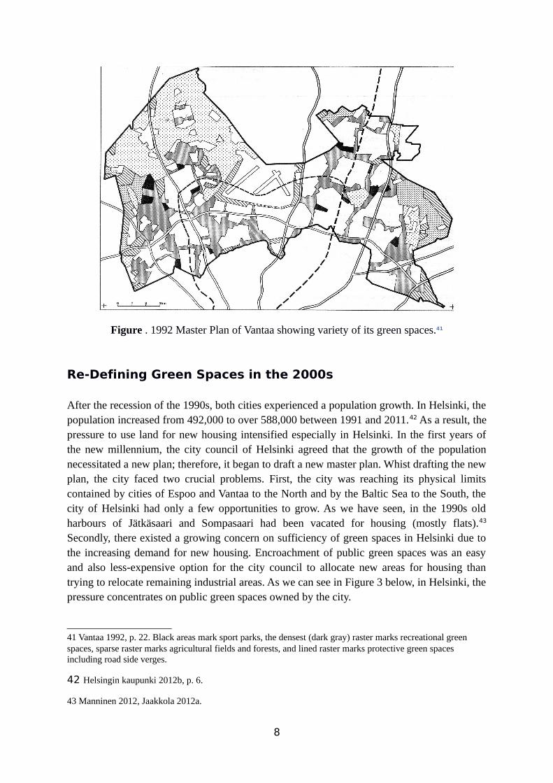
Figure . 1992 Master Plan of Vantaa showing variety of its green spaces.41
Re-Defining Green Spaces in the 2000s
After the recession of the 1990s, both cities experienced a population growth. In Helsinki, the population increased from 492,000 to over 588,000 between 1991 and 2011.42 As a result, the pressure to use land for new housing intensified especially in Helsinki. In the first years of the new millennium, the city council of Helsinki agreed that the growth of the population necessitated a new plan; therefore, it began to draft a new master plan. Whist drafting the new plan, the city faced two crucial problems. First, the city was reaching its physical limits contained by cities of Espoo and Vantaa to the North and by the Baltic Sea to the South, the city of Helsinki had only a few opportunities to grow. As we have seen, in the 1990s old harbours of Jätkäsaari and Sompasaari had been vacated for housing (mostly flats).43 Secondly, there existed a growing concern on sufficiency of green spaces in Helsinki due to the increasing demand for new housing. Encroachment of public green spaces was an easy and also less-expensive option for the city council to allocate new areas for housing than trying to relocate remaining industrial areas. As we can see in Figure 3 below, in Helsinki, the pressure concentrates on public green spaces owned by the city.
41 Vantaa 1992, p. 22. Black areas mark sport parks, the densest (dark gray) raster marks recreational green spaces, sparse raster marks agricultural fields and forests, and lined raster marks protective green spaces including road side verges.
42 Helsingin kaupunki 2012b, p. 6.
43 Manninen 2012, Jaakkola 2012a.
8
Figure . Projected Loss of Green Spaces in Helsinki as Shown in Master Plan 2002.44
In Helsinki, the city council favoured the established policy to enhance development of housing even if it meant building over green spaces as long as major recreational areas could be preserved from major encroachments. The 2002 master plan focused on areas that had not been included in the previous plans paying attention to preservation waterfront of the city and islands. The plan furthermore included an attempt to define all green spaces as generally unbuilt land – a clear statement that unless zoned, for instance, as recreational area or nature reserve, green space acted as a land reserve for the city. According to the 2002 plan, a general loss of public green spaces was estimated to reach 3% out of their total amount. Areas earmarked for possible development are shown in Figure 3 above.45 To create a denser city, the 2002 master plan projected that many green spaces that had previously been maintained as urban forests were likely to be converted into more park like green spaces due to their increased use which would reduce appearance as semi-wild nature.46 Perhaps the most positive element in the 2002 master plan concerning green spaces was creation of new “culture parks” like Helsinki Park (Helsinki-puisto). The idea was not to construct a new park, but to merge various adjoining green spaces into a large unit to create new scenery elements for the city.47 However, this kind of a new “park” further fragmented classification of green spaces. First, it consisted of green spaces marked in the master plan creating only a
44 Helsingin kaupunki 2002,
45 Helsingin kaupunki 2002, pp. 51-52, 98.
46 Helsingin kaupunki 2002, p. 102.
9
meta-level park existing only on paper. Secondly, by naming the loosely connected areas as a park, the new Helsinki-park, for instance, was not a park compared to existing conventional parks, but an attempt to preserve important unbuilt-up landscapes like national parks. The policy to promote Helsinki as a green city was one of the objectives of the 2002 master plan.48 However, as we can see, the objective was more rhetorical stressing the need to present green policies that included development of a more sustainable urban infrastructure.49 The preservation and provision of green spaces remained a secondary issue for the city.
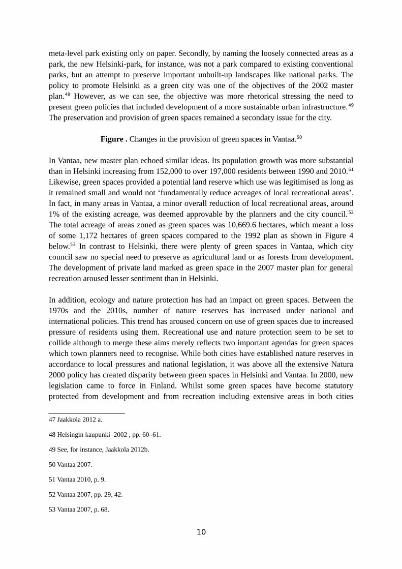
Figure . Changes in the provision of green spaces in Vantaa.50
In Vantaa, new master plan echoed similar ideas. Its population growth was more substantial than in Helsinki increasing from 152,000 to over 197,000 residents between 1990 and 2010.51 Likewise, green spaces provided a potential land reserve which use was legitimised as long as it remained small and would not ‘fundamentally reduce acreages of local recreational areas’. In fact, in many areas in Vantaa, a minor overall reduction of local recreational areas, around 1% of the existing acreage, was deemed approvable by the planners and the city council.52 The total acreage of areas zoned as green spaces was 10,669.6 hectares, which meant a loss of some 1,172 hectares of green spaces compared to the 1992 plan as shown in Figure 4 below.53 In contrast to Helsinki, there were plenty of green spaces in Vantaa, which city council saw no special need to preserve as agricultural land or as forests from development. The development of private land marked as green space in the 2007 master plan for general recreation aroused lesser sentiment than in Helsinki.
In addition, ecology and nature protection has had an impact on green spaces. Between the 1970s and the 2010s, number of nature reserves has increased under national and international policies. This trend has aroused concern on use of green spaces due to increased pressure of residents using them. Recreational use and nature protection seem to be set to collide although to merge these aims merely reflects two important agendas for green spaces which town planners need to recognise. While both cities have established nature reserves in accordance to local pressures and national legislation, it was above all the extensive Natura 2000 policy has created disparity between green spaces in Helsinki and Vantaa. In 2000, new legislation came to force in Finland. Whilst some green spaces have become statutory protected from development and from recreation including extensive areas in both cities
47 Jaakkola 2012 a.
48 Helsingin kaupunki 2002 , pp. 60–61.
49 See, for instance, Jaakkola 2012b.
50 Vantaa 2007.
51 Vantaa 2010, p. 9.
52 Vantaa 2007, pp. 29, 42.
53 Vantaa 2007, p. 68.
10

increasing pressures of the authorities to develop other green spaces which remain outside statutory protection. In Vantaa, for instance, there were over 1,440 hectares of nature reserves marked in its 2007 master plan.54
The incorporation and development of Östersundom exemplified the impact of the creation of nature reserves on town planning. What actually saved many public green spaces in the 2002 master plan of Helsinki was the idea of the city to utilise its land located outside its boundaries. It seems that the idea was presented perhaps for the first time in public when the City Council approved the 2002 plan when some councillors regretted that the military island of Santahamina was not earmarked for housing. In contrast, other councillors, notably Risto Rautava, suggested use of hundreds of hectares of land owned by the city in Östersundom adjoining eastern boundaries of Helsinki.55 Eventually, in 2008 the government resolved to incorporate Östersundom from the municipality of Sipoo to Helsinki.56 However, the city of Helsinki faced a problem concerning its use, because substantial areas of the annexed area were under statutory nature reserves and there was a strong public opinion that the large recreational area called Sipoonkorpi should be preserved as a national park. After a brief, but efficient lobbying, the government decided to establish Sipoonkorpi area as a new national park in 2011 effectively restricting land use of Östersundom.57 The most important point was the strong sentiment of the public for a (forested) national park. It reflected disparity among different kinds of green spaces.
Conclusion and Further Research
To conclude, the evidence shows that in planning terminology of Helsinki and Vantaa, green space has not been clearly or coherently defined. It remains as a general concept compared to more precise terms like recreational areas or parks used both in master plans and town plans. As growth of built-up areas in both cities has continued to occupy areas referred as green spaces, it almost seems as if green spaces have been deliberately left undefined in order to accommodate their subsequent takeover. Yet we need to remember that aims of the master plans have focused on to preserve main recreational green spaces and routes – green networks – but not to promote any acreage-based provision or preservation of public green spaces. Indeed, both cities approve the reduction of private green spaces and to certain extent public green spaces in order to preserve larger public green spaces within their administrative areas. While there is no need to create an acreage-standard or deficiency area to guide the future
54 Vantaa 2007, p. 51.
55 Helsingin kaupunginvaltuuston keskustelupöytäkirjat 2003 kesäkuu-elokuu.
56 Helsingin kaupunki 2012a, p. 188.
57 Kaupunkisuunnitteluvirasto 2012. Eduskunnan hyväksymä laki Sipoonkorven kansallispuistosta tulivoimaan 1.toukokuuta 2011. Sipoonkorven kansallispuiston pinta-alaon 1 847 hehtaaria, josta 1 268 hehtaaria kuuluu Sipoonkorven Natura2000-alueeseen
11

provision and preservation of green spaces, it would be advisable for each city to conduct a survey on their green spaces and to establish a framework for the preservation and provision of public green spaces within their administrative areas.
What the cities need is a new coherent typology for their green spaces. Interviews with town planners of both cities have shown that there is potential to create a new typology for green spaces. A good starting point to combine these criteria is provided by the Ministry of Environment with its 1992 typology of green spaces. The main target would be creating a uniform statistic including every kind of green space despite their ownership, maintenance, and status according to the master plan. Thus the new typology would bridge the gap that exists between the acreage of green spaces in the current master plans compared to the acreage of green spaces that the cities present in their statistics. This kind of a uniform definition of green spaces would allow the city councils both to preserve adequate amount of green spaces while enabling continuation of their housing developments and to promote themselves as green cities. I recommend that the cities need to define the coherent overall acreage of their green spaces. In order to achieve this, the cities need to create a uniform concept of green space including the whole variety of different kinds of green spaces in accordance to their size and function disregarding their given maintenance, recreational, or protection status. The new classification should be based on multi-criteria paying attention, for instance, on their use, vegetation, and value as nature. Secondly, due to the fact that green space remains an extremely difficult and varied concept both in professional and academic discussion, it remains important that the definition of the new typology is not confined to the city officers, but researches from universities are involved, too. When well-defined, the new uniform classification may reduce conflicting aims of various departments concerning the amount and role of green spaces in the planning. Facing a crucial juncture concerning their future structure, cities need to be bold and innovative in their approaches instead of relying to established models.
Sources
Hannikainen, Matti (2011). Green Spaces and Recession in the Capital Region. Final Report of KatuMetro 14.12.2011.
Helsingin kaupunki
(2012b) Helsingin väestö vuodenvaihteessa 2011/2012 ja väestönmuutokset vuonna 2011. Tietokeskus.(2012a). Helsinki alueittain 2011.(2002). Helsingin yleiskaava 2002 ehdotus: selostus.(1992 b). Viheralueiden kestävän käytön mahdollisuudet tiivistyvässä kaupunkirakenteessa – Helsingin yleiskaava 1992:n arviointi. A20/1992.
12
(1992 a). Helsingin yleiskaava 1992, luonnos: Lähtökohdat: virkistys- ja viheralueet, luonnonsuojelu.(1989). Kulttuuri ja vapaa-aika Helsingissä. Tilastokeskuksen tilastoja 1989, E1.(1983). Esikaupunkien yleiskaavan seuranta. Seurantaraportti 1. YA:8/83.(1970) (b). Yleiskaavaehdotus 1970, osa 2 – Maankäyttösuunnitelma. (1970) (a). Yleiskaavaehdotus 1970, osa 1 – Perusselvitys.
Jaakkola, Maria (2012b). Helsinki, Finland: Greenness and Urban Form. in Beatley, Timothy (ed.) Green Cities of Europe. Island Press, Washington, 109-128.
Kolbe, Laura (2002). Helsinki kasvaa suurkaupungiksi. in Helin, Heikki and Kolbe, Laura - Helsingin historia vuodesta 1945, osa 3. Helsinki, 13-511.
Mäkynen, Anne (2002). Viheralueselvitys.
Niemi, Marjaana (2006). in Clark, Peter (ed.) The European City and Green Space – London, Stockholm, Helsinki, and St.Petersburg, 1850-2000. Ahsgate.
Nukari, Terttu (1988). Kaavoituksen mahdollisuudet luonnon säilyttämiseksi kaupunki-ympäristössä. in Pääkaupunkiseudun yhteistyövaltuuskunta YTV. Vihertoimen uusia haasteita. Pääkaupunkiseudun julkaisusarja C 1988:18, 28-33.
Schulman, Harri. (2000). Helsingin suunnittelu ja rakentaminen. in Schulman, Harry, Pulma, Panu and Aalto, Seppo (eds.) Helsingin historia vuodesta 1945, osa 2. Helsinki, 13–108
Vantaan kaupunki.(2010) Vantaan väestö 2009/2010.(2007). Yleiskaavan selostus.(1992). Yleiskaavan selostus.(1983). Yleiskaavan selostus.
Ympäristöministeriö (YM)(1992 a). Viheralueiden käsitteistöt. Selvitys 10:1992.(1992 b). Taajaman viheralueet. Selvitys 5:1992.
Interviews
Rikhard Manninen, City of Helsinki 24.10.2012
Maria Jaakkola, City of Helsinki 8.10.2012
Anne Mäkynen, City of Vantaa 11.10.2012
13
Web-sources
Kaupunkisuunnitteluvirasto (2012). http://www.hel.fi/static/public/hela/Kaupunkisuunnittelulautakunta/Suomi/Esitys/2012/Ksv_2012-02-28_Kslk_7_El/A095DACC-255B-4C87-9DA8-D042FC758A47/Ostersundomin_yhteinen_yleiskaavaluonnos_%28a-asia%29.pdfAccessed on 10th December 2012.
14