characterization of quaternary and suspected quaternary ... · characterization of quaternary and...
TRANSCRIPT

U.S. DEPARTMENT OF THE INTERIOR U.S. GEOLOGICAL SURVEY
Characterization of Quaternary andSuspected Quaternary Faults,
Amargosa area, Nevada and California
R. Ernest Anderson, Anthony J. Crone, Michael N. Machette,
Lee-Ann Bradley, and Sharon R Diehl
Open-File Report 95-613
This report is preliminary and has not been reviewed for conformity with U.S. Geological Survey editorial standards (or with the North American Stratigraphic Code). Any use of trade, product, or firm names is for descriptive purposes only and does not imply endorsement by the U.S. Government.
Box 25046, MS 966 Denver, Colorado 80225 U.S.A.
1995

CONTENTS
Introduction............................................................................................................................................ 1
Pahrump-Stewart Valley fault zone (PSV)......................................................................................... 8
Amargosa River fault zone (AR)......................................................................................................... 14
East Nopah fault (EN)........................................................................................................................... 19
Ash Meadows fault zone (AM) ........................................................................................................... 25
Rock Valley fault zone (RV), southwestern extension...................................................................... 33
Summary................................................................................................................................................. 38
References............................................................................................................................................... 40
Appendix A: Definitions...................................................................................................................... A-l
Appendix B: Scarp Profiles.................................................................................................................. B-l
Profile of the Pahrump-Stewart Valley fault zone.............................................................. B-2
Profile of the Amargosa River fault zone............................................................................. B-2
Profiles of the East Nopah fault............................................................................................ B-2
Profiles of the Ash Meadows fault zone .............................................................................. B-4
Profiles of the Rock Valley fault zone, southwestern extension....................................... B-7
ILLUSTRATIONS
FIGURE 1. Map of regional faults studied ............................................................................................ 2
2. Definitions of scarp parameters .......................................................................................... 5
3. Scarp-height slope-angle values for selected single-event scarps in Utah................. 5
4. Maps of faults western Great Basin and structural blocks Walker Lane belt............... 6
5. Map of Pahrump-Stewart Valley fault zone ...................................................................... 9
6. Profile across Pahrump-Stewart Valley fault zone ........................................................... 12
7. Scarp-height slope-angle value for Pahrump-Stewart Valley fault zone ................... 13

FIGURE 8. Map of Amargosa River fault zone..................................................................................... 16
9. Scarp-height slope-angle values for Amargosa River fault zone ................................ 18
10. Map of East Nopah fault...................................................................................................... 20
11. Profile across typical scarp on East Nopah fault .............................................................. 21
12. Scarp-height slope-angle values for East Nopah fault................................................. 23
13. Map of Ash Meadows fault zone........................................................................................ 26
14. Scarp-height slope-angle values for Ash Meadows fault zone ................................... 29
15. Map of part of Ash Meadows fault zone ........................................................................... 31
16. Map of part of Rock Valley fault zone near Nevada Highway 29 ................................. 34
17. Map of part of Rock Valley fault zone near Skeleton Hills ............................................. 35
18. Scarp-height slope-angle values for Rock Valley fault zone........................................ 37
TABLES
TABLE 1. Fault data for selected regional faults ................................................................................. 3
2. Time intervals for the Quaternary ....................................................................................... 4
3. Scarp-profile data for Amargosa River fault zone (AR) ................................................... 17
4. Scarp-profile data for East Nopah fault (EN)..................................................................... 22
5. Scarp-profile data for Ash Meadows fault zone (AM) ..................................................... 28
6. Scarp-profile data for southwestern extension, Rock Valley fault zone (RV)................ 36
11

Characterization of Quaternary and suspected Quaternary faults,
Amargosa area, Nevada and California
By R. Ernest Anderson, Anthony J. Crone, Michael N. Machette,
Lee-Ann Bradley, and Sharon F. Diehl
INTRODUCTION
This report presents the results of geologic studies that help define the Quaternary history of selected faults in the region around Yucca Mountain, Nevada. These results are relevant to the seismic-design basis of a potential nuclear waste repository at Yucca Mountain. The relevancy is based, in part, on a need for additional geologic data that became apparent in ongoing studies by S. Pezzopane (written commun., 1995) that resulted in the identification of 51 relevant and potentially relevant (see appendix A for definitions) individual and compound faults and fault zones in the 100-km-radius region around the Yucca Mountain site. These structures were divided into local and regional categories by Pezzopane (1995); this report deals with selected regional structures. In this introduction, we outline the scope and strategy of the studies and the tectonic environment of the studied structures.
Geologic data used in the characterization of the regional faults and fault zones as relevant or poten tially relevant seismic sources (Pezzopane, 1995, written commun., 1995) includes age (Quaternary) and displacement information, maximum fault lengths, and minimum distances between the fault and the Yucca Mountain site. Most of these data are found in Piety (1994) who compiled the data from maps, literature reviews, and reconnaissance investigations of faults. For many of the regional faults, no paleoseismic field studies had been conducted at the time of Piety's study, and age and displacement data were sparse to nonexistent. In November 1994, the Branch of Earthquake and Landslide Hazards entered into two memo randa of agreement with the Yucca Mountain Project Branch to conduct field reconnaissance, analysis, and interpretation of six relevant and six potentially relevant regional faults whose approximate traces are shown on figure 1. Data on these faults taken from Pezzopane (1995) are given in table 1. Because there were two separate memoranda of agreement, we prepared two separate reports, one for each project. This report describes the results of study of the faults in the Pahrump-Stewart Valley, Amargosa River, and Ash Mead ows areas. The results of studies of the other faults are described in a companion report (Anderson and others, 1995). Although not on the list of relevant or potentially relevant faults (Pezzopane, written commun., 1995), we include the results of a cursory study of Quaternary fault scarps along the east base of the Nopah Range southwest of Pahrump, Nevada. Also, because the Rock Valley fault zone, a relevant source located southeast of Yucca Mountain, extends southwestward into the Amargosa Desert where we were working, we made a cursory examination of scarps that mark its apparent southwesternmost extent and report the results here,.
A four-phase strategy was implemented for both projects. It consisted first of a 4-day field orientation that utilized the expertise of geologists and paleoseismologists with past and current research experience in
1

CHARACTERIZATION OF SUSPECTED QUATERNARY FAULTS, AMARGOSA AREA, NEVADA AND CALIFORNIA
117
Southwestern Nevada volcanic field
-|."1'L. _._._._
Silent V \ Canyon
Timber Mountain- Oasis Valley
Claim Canyon cauldron
Nevada Test Site boundary
Faults and Fault ZonesAM Ash MeadowsAR Amargosa RiverBLR Belted RangeEN East Nopah
KRW Kawich Range WestKW Keane WonderLC Last Chance Range
OSV Oasis Valley PSV
RWBW Rocket Wash-Beatty Wash steps in Walker Lane boundarySF Sarcobatus Flat
TOL Tolicha PeakWSM West Spring Mountains...-_ ... -K » _ .
fault zonespaMara hnimHaru caldera boundary
JL u_ u_ii_ volcanic field boundary ===== Walker Lane belt boundary
West Specter Range
FIGURE 1. Map showing generalized traces of the regional faults studied under the two Memoranda of Agree ment between the Yucca Mountain Project Branch and Branch of Earthquake and Landslide Hazards, U.S.G.S. Abbreviations in bold type identify faults described in this report, abbreviations in regular type identify faults described in a companion report (Anderson and others, 1995). Selected regional geologic features include Walker Lane belt, boundaries of the southern Nevada volcanic field, and some calderas within that field (modi fied from Carr, 1988). Dot at center of 50- and 100-km-radius circles marks location of proposed repository site. Most fault traces and abbreviations are from Pezzopane (1995).

CHARACTERIZATION OF SUSPECTED QUATERNARY FAULTS, AMARGOSA AREA, NEVADA AND CALIFORNIA
TABLE 1. Fault data for selected regional faults from Pezzopane (1995, written commun., 1995).
[These data pre-date our results. They are organized according to distance from Yucca Mountain (YM). Fault names in bold type indicate structures described in this report; others are described in a companion report (Anderson and others, 1995).]
Minimum distance to YM
(km)
19
24
27
34
40
42
43
52
53
55
57
70
Fault name and
abbreviation
Rocket Wash-Beatty Wash RWBW
Oasis Valley OSV
Rock Valley RV
Ash Meadows AM
Amargosa River AR
Tolicha Peak TOL
Keane Wonder KW
Sarcobatus Flat SF
West Spring Mountain WSM
Belted Range BLR
Kawich Range West KRW
Pahrump-Stewart Valley PSV
Relevant fault*
yes?
yes?
yes
yes
yes
yes?
yes?
yes
yes
yes
yes?
yes
Documented Quaternary
displacement**
yes?
yes?
yes
yes
yes
yes?
yes?
yes?
yes
yes
yes?
yes
Maximum fault length
(km)
17
20
65
60
15
22
25
51
60
54
84
70
yes indicates relevant; yes? indicates potentially relevant
yes indicates documented Quaternary displacement or compelling evidence for displacement potential such as seismicity; yes? indicates suspected Quaternary displacement
the region including J. Whitney, S. Pezzopane, J. Yount, C. Menges, L. Anderson, and D. Donovan. The purpose was to familiarize project personnel with the geography, access, and geology of the region, including a visit to Yucca Mountain, several faults, and trench sites. The second phase consisted of office and lab study of aerial photographs and maps which, for some areas, included unpublished Quaternary fault maps provided by M. Reheis and L. Anderson. The third phase consisted mainly of field study of the faults shown by bold type on figure 1. Each of the faults was studied by a field team led by A. J. Crone (Pahrump- Stewart Valley fault zone PSV, East Nopah fault EN, and Ash Meadows fault zone AM) and M.N. Machette (Amargosa River fault zone AR, and Rock Valley fault zone RV). The scope of these field studies, as outlined in the memorandum of agreement, included: (1) determining the geomorphic character that defines the subject faults capability, (2) determining the length of the fault with such capability, and (3) estimating the time of the most recent surface offset and, where indicated, evidence of recurrent offsets

CHARACTERIZATION OF SUSPECTED QUATERNARY FAULTS, AMARGOSA AREA, NEVADA AND CALIFORNIA
TABLE 2. Terminology of time intervals for the Quaternary Period used in this report and approxi mate dates of time boundaries (modified from Morrison, 1991, and Izett and Obradovich, 1994).
Subdivision
Holocene
latest Pleistocene
late Pleistocene
middle Pleistocene
early Pleistocene
Pleistocene
late Quaternary
Quaternary
Time Span
present-1 0 ka
10ka-~28ka
10ka-~128ka
~128ka-770ka
770ka-1650ka
1 0ka-1 650 ka
present-~128 ka
present-1 650 ka
in the Quaternary. The final phase consisted of a 5-day field review (with the team leaders, R.E. Anderson, Principal Investigator, and others) by M. Reheis and A. Nelson. This field review served as a formal review of the field-data package pertaining to these studies.
In this report we use terminology for several subdivisions of the Quaternary period. Although the terminology for most subdivisions is widely agreed upon by earth scientists, the accepted age of these subdivisions has varied through the years. In this report, we generally follow the subdivisions as defined by Morrison (1991), but we use a revised age of 770 ka for the early Pleistocene-middle Pleistocene bound ary (Izett and Obradovich, 1994) and use an informal latest Pleistocene subdivision. The subdivisions we use are shown in table 2.
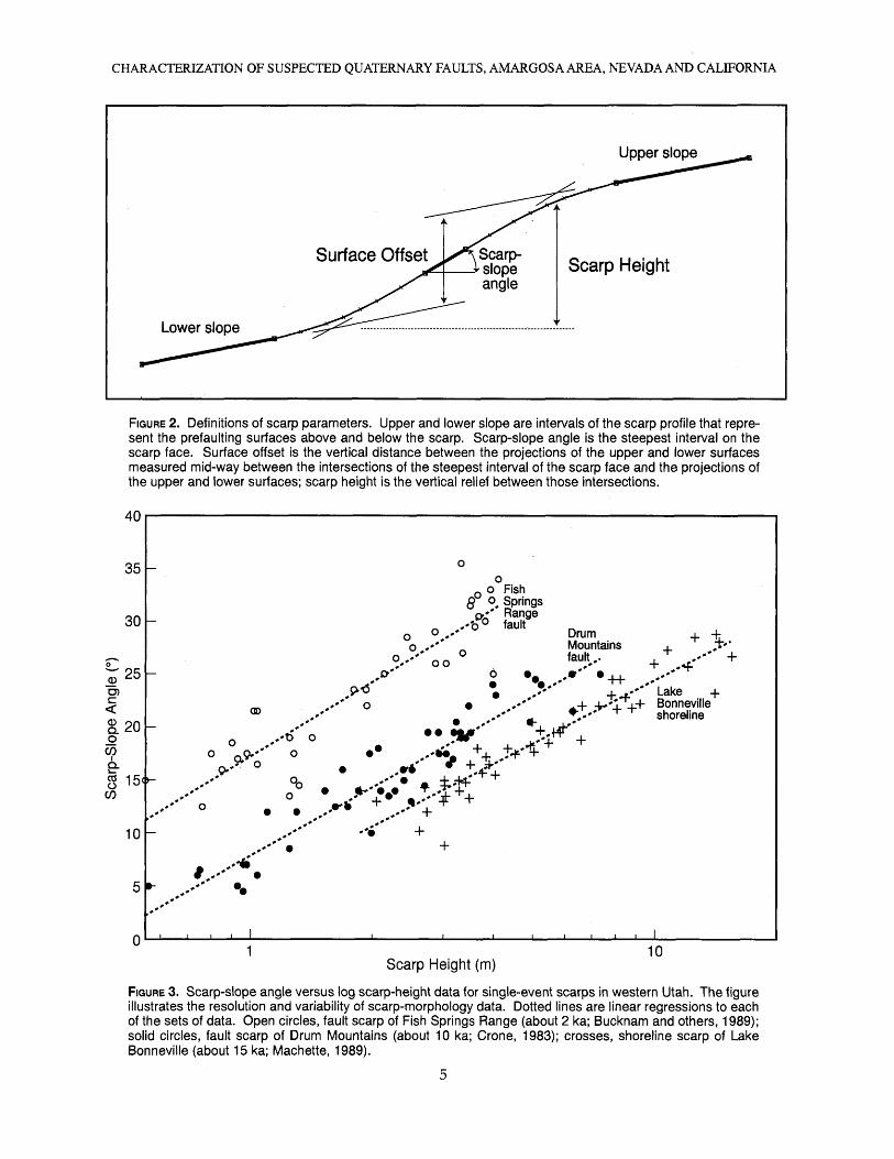
We use the morphology of fault scarps on alluvium to characterize the history of surface faulting. The morphology is defined by topographic profiles measured across the scarp. Parameters derived from the profiles and used in this report to characterize the scarps are defined on figure 2. The parameters are either taken directly from measurements recorded in the field (scarp-slope angle) or derived from the profile (scarp height, surface offset).
Profiles were made by measuring a sequence of short intervals (typically <4.5 m) of slope distance and slope angle along the ground surface, perpendicular to the local strike of the scarp. The profiles are long enough to include intervals of the surfaces above and below the scarp that are judged to be unaffected by scarp modification processes, such as erosion and deposition. To minimize the influence of local topo graphic irregularities, several measurements of the scarp-slope angle may be made adjacent to the line of profile.
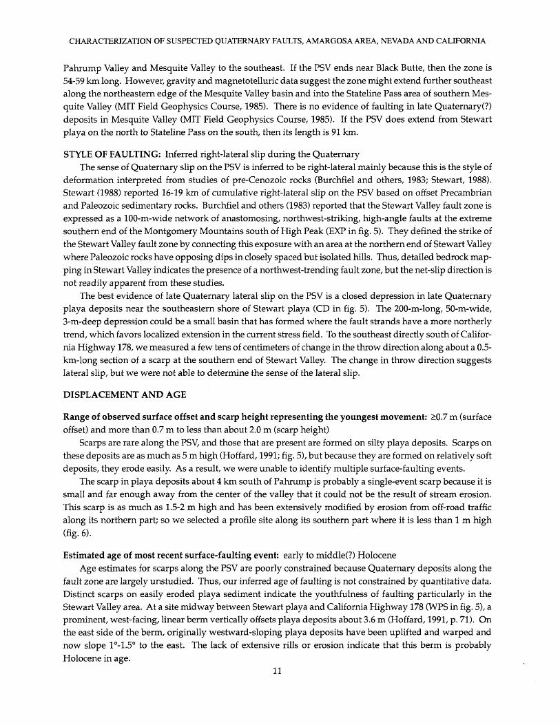
Scarp profiles provide information for estimating the time of surface-faulting events based on the intu itively obvious observation that with increasing age a scarp profile becomes more rounded and the slope of the scarp face becomes less steep. A variety of methods of analyzing the form of scarp profiles have been developed, and most of these methods model the profile as a solution to the diffusion equation (Nash, 1980; Hanks and others, 1984). In most cases, the profile data in this study are very limited, and we have not attempted to model the scarps using the diffusion model. Instead we graph several parameters of our profiles as a convenient visual means of characterizing the relative age based on the morphology of the scarps. For this we use the relation of Bucknam and Anderson (1979), who showed that at a given scarp height, the scarp-slope angle decreases with increasing age. They also found that, for a scarp of a given age, there is a linear relation between scarp-slope angle and the logarithm of the scarp height. Figure 3 shows this relation for 3 scarps in western Utah. The ages of the scarps are about 15 ka for the Lake Bonneville
4
CHARACTERIZATION OF SUSPECTED QUATERNARY FAULTS, AMARGOSA AREA, NEVADA AND CALIFORNIA
Upper slope
Surface Offset Scarp Height
FIGURE 2. Definitions of scarp parameters. Upper and lower slope are intervals of the scarp profile that repre sent the prefaulting surfaces above and below the scarp. Scarp-slope angle is the steepest interval on the scarp face. Surface offset is the vertical distance between the projections of the upper and lower surfaces measured mid-way between the intersections of the steepest interval of the scarp face and the projections of the upper and lower surfaces; scarp height is the vertical relief between those intersections.
40
35
30
O)
§.20 oV) cb.§ 15<h
CO
10
o o Fish
o o
0
Q o, Springs o,** Range
X0 ° faultDrum Mountains
00 .-*
00
o ^x*
o.» °
»'Lake +
. +**V1ii.+ Bonneville - * shoreline
99 .*"
++
+
Scarp Height (m)10
FIGURE 3. Scarp-slope angle versus log scarp-height data for single-event scarps in western Utah. The figure illustrates the resolution and variability of scarp-morphology data. Dotted lines are linear regressions to each of the sets of data. Open circles, fault scarp of Fish Springs Range (about 2 ka; Bucknam and others, 1989); solid circles, fault scarp of Drum Mountains (about 10 ka; Crone, 1983); crosses, shoreline scarp of Lake Bonneville (about 15 ka; Machette, 1989).

CHARACTERIZATION OF SUSPECTED QUATERNARY FAULTS, AMARGOSA AREA, NEVADA AND CALIFORNIA
shoreline (Machette, 1989), about 10 ka for the Drum Mountains fault (Crone, 1983), and about 2 ka for the Fish Springs Range fault (Bucknam and others, 1989). The data points are shown on figure 3 to illustrate the resolution and variability expected from profile data taken from late Pleistocene and Holocene scarps that represent a single scarp-forming event. In this report we use plots of scarp-slope angle versus log scarp height to qualitatively compare the data from this study to the approximately 10 ka fault scarp of the Drum Mountains, the approximately 15 ka shoreline scarp of Lake Bonneville in western Utah, and the approxi mately 100 ka Santa Rita scarp in southern Arizona (Pearthree and Calvo, 1987).
To assess the Quaternary history of most of the faults, we estimated the age of most recent displacement and placed some boundaries (constraints) on fault slip rates. We did this by estimating the age of the offset surface based on its surface morphology and degree of soil development.
The faults discussed in this report are located within the Walker Lane structural belt of the Basin and Range. Mountain ranges in this belt are characterized by varied shapes and trends (figs. 1,4A, 4B) resulting from an irregular mixture of (1) strike-slip faults, (2) regional sections of quasi-coherent internal structure, (3) basin-range faults, (4) oroflexural folds, and (5) areas of large-scale extension, detachment faults, and metamorphic core complexes (Stewart, 1988). The Walker Lane belt is divided into regional structural sec tions each of which has undergone internal deformation independent of adjacent sections, with adjust ments for intersectional strain contrasts most likely made at section boundaries (Stewart, 1988, Carr, 1988). Individual strike-slip faults do not extend along the length of the Walker Lane belt or even from one section to another.
Although the Quaternary faults described in this report, all fall within the Walker Lane belt, they are located in a structurally complex part of the belt characterized by boundaries and intersections between four of the structural sections (fig. 4B) recognized by Stewart (1988). Accordingly, the faults include known or inferred right-slip (PSV, AR, EN), left-slip (RV), and normal (AM) faults. The way in which these faults interact or interconnect with one another is of potential importance to hazards and ground-water assess ments at Yucca Mountain.
120° 118° 116° 114 C 120° 118° 116° 114°
40 C
38C
36 C 36
FIGURE 4, A, Map showing the Yucca Mountain site (dot at center of 50- and 100-km circles) relative to late Cenozoic faults in the western Great Basin (modified from Stewart, 1988). B, Same area as in A showing selected major faults and regional structural blocks (cross ruled) of the Walker Lane belt (from Stewart, 1988).

CHARACTERIZATION OF SUSPECTED QUATERNARY FAULTS, AMARGOSA AREA, NEVADA AND CALIFORNIA
The surface trace of each fault is located mainly in basin-fill sediment that lack deep incision or strong tilting that might otherwise provide access to detailed knowledge of their stratigraphy and structure. Lack ing this knowledge, the tasks of assessing fault interaction and interconnectedness are extremely difficult ones that cannot be accomplished by surface studies of the kind reported here. Nevertheless, information we provide on related matters of fault length and surface-trace continuity help address those tasks.
Structural development of the Yucca Mountain region during the Tertiary was strongly influenced by volcano-tectonic processes related to formation of the southwest Nevada volcanic field (Byers and others, 1976) from which hundreds of cubic kilometers of silicic tuff and lava were erupted (Carr, 1984). All the faults reported on here are located outside the boundary of the southwest Nevada volcanic field and associ ated calderas (fig. 1) and probably have no volcano-tectonic component to their history.
We describe each fault or fault zone separately using the abbreviations of Pezzopane (1995). The de scriptions are grouped according to faulting style. First we describe the strike-slip faults that are reported to be part of the right-slip Walker Lane the Pahrump-Stewart Valley and the Amargosa River and, as we have determined, the East Nopah. Second, we describe the Ash Meadows fault zone of probable normal displacement. Finally, we describe our cursory observations of reported left-slip displacement on the south western part of the Rock Valley fault zone. The descriptions are organized to facilitate the integration of our results into future updates of regional compilations such as that of Piety (1994).

CHARACTERIZATION OF SUSPECTED QUATERNARY FAULTS, AMARGOSA AREA, NEVADA AND CALIFORNIA
PAHRUMP-STEWART VALLEY FAULT ZONE (PSV)
SUMMARY: The Pahrump-Stewart VaUey fault zone (PSV) trends about N. 45° W. along the axial part of Pahrump and Stewart Valleys in Nye County, Nevada, and Inyo County, California. The PSV has been estimated to be as much as 130 km long, but compelling evidence of late Quaternary deformation is present only along about 18.5-km-long section between the southeastern end of Stewart playa and about 6 km south of the town of Pahrump. Farther south and southeast of Pahrump, the PSV is characterized by sinuous, 8- to 15-m-high escarpments in Quaternary or Tertiary deposits, and by vegetation lineaments, fissures, and patches of cemented fan deposits in the medial part of the valley. No significant late or middle Pleistocene move ment has occurred on the dissected, greatly eroded escarpments.
At the northwestern end of the PSV, we found no evidence of a connection between Quaternary faulting in Stewart Valley and faulting along the Ash Meadows or Amargosa River fault zones. Unfaulted Quater nary deposits at least several hundred thousand years old cross the mapped trace of the Stewart Valley fault in northern Stewart Valley. A15- to 20-km-long gap separates Quaternary scarps and lineaments along the PSV from similar features in the Amargosa Desert.
The southeastern end of the PSV is difficult to define. High-altitude imagery suggests that Quaternary deformation may extend as far south as Black Butte, whereas gravity and magnetotelluric data suggest that the PSV may continue to near Stateline Pass in southeastern Mesquite Valley.
Quaternary slip is inferred to be right-lateral mainly because this is the sense of slip indicated by offset Paleozoic and Precambrian rocks, which are offset 16-19 km. Most of this offset probably occurred during the Mesozoic and early Cenozoic. The amount of Quaternary lateral slip on the PSV is unknown. Scarps are rare along the PSV, and those that are present are formed on silty playa deposits. The morphology of a small single-event(?) scarp suggests that the most recent faulting event may be early or middle Holocene in age.
Most of the 8- to 15-m-high escarpments in southern Pahrump Valley are probably fault-line scarps that mark the general location of underlying faults. The relief of these escarpments provides a first-order esti mate of a long-term vertical slip rate. Sediment in the escarpments is thought to be Tertiary or early Pleis tocene in age. If these sediments are early Pleistocene and vertically displaced 15 m, then the vertical slip rate is about 0.02 mm/yr. If the sediment is late Tertiary (latest Pliocene), then the vertical slip rate is 0.009 mm/yr. The limited expression of the PSV in Quaternary deposits is evidence that the fault zone's long-term Quaternary slip rate is low.
LOCATION: The PSV extends along the axial part of Pahrump and Stewart Valleys in Nye County, Nevada, and Inyo County, California. The fault zone is essentially coincident with the California-Nevada state boundary and, therefore, has been referred to as the "Stateline" fault system by some investigators (see Hoffard, 1991). Scarps and lineaments mapped as part of the PSV (Hoffard, 1991) are as close as 3-5 km from the town of Pahrump (fig. 5), which is the largest settlement in the region.
ORIENTATION: about N. 45° W.

CHARACTERIZATION OF SUSPECTED QUATERNARY FAULTS, AMARGOSA AREA, NEVADA AND CALIFORNIA
FIGURE 5. Map showing selected features of Pahrump-Stewart Valley fault zone (PSV) (after Hoffard, 1991). Locations discussed in the text include: CD, closed depression; ES, eroded scarp; EXP, exposure of Stewart Valley fault; PSV-1, profile site PSV-1; and WPS, warped playa sediment. Extent of mostly continuous bedrock shown by half tone fill. The most prominent scarps on late Quaternary deposits are in the Stewart Val ley area, but the biggest escarpments asso ciated with faulting are highly dissected and are restricted to the southern part of Pahrump Valley.
Explanation*> scarp x7
lineamentmajor escarpment

CHARACTERIZATION OF SUSPECTED QUATERNARY FAULTS, AMARGOS A AREA, NEVADA AND CALIFORNIA
LENGTH
Length reported in Piety (1994): 50-130 km. Maximum length is from Stewart (1988), and minimum value is from Hoffard (1991).
Length of known Quaternary scarps (this study): 18.5 kmCompelling evidence of Quaternary deformation on the PSV is present in only a few areas of Pahrump
and Stewart Valleys. Our length estimate of 18.5 km is based on the distance between the northwesternmost and southeasternmost features that we interpret as unequivocal evidence of late Quaternary deformation. The northwestern feature is an unusual closed depression on the southeastern side of Stewart playa (CD in fig. 5), and the southeastern feature is a small, distinct scarp in playa deposits located 4-6 km south of Pahrump (PSV-1 in fig. 5).
Southeast of the playa scarp in southern Pahrump Valley, the PSV is marked by two kinds of features: (1) sinuous, 8- to 15-m-high escarpments (fig. 5) and (2) vegetation and tonal lineaments, fissures, and aligned patches of cemented alluvial-fan deposits in the medial parts of the valley (Hoffard, 1991). We do not include these features in our length estimate because there is no convincing evidence that they represent significant Quaternary movement. As a result, our estimated length of the PSV is shorter than the lengths cited by other investigators. Below, we summarize the evidence used by others to define the PSV's length. It is important to note that none of these other studies defined the length solely on evidence of significant Quaternary faulting.
Hoffard (1991) interpreted the main trace of the PSV in the southern Pahrump Valley to coincide with prominent escarpments that expose sediment of Tertiary or early Quaternary age in the uplifted blocks. The escarpments probably mark the location of faults associated with the PSV, but the escarpment's dissected and eroded character indicate little or no late or middle Quaternary displacement. Thus, the escarpments are probably fault-line scarps rather than true fault scarps. Directly southeast of the playa scarp (PSV-1 in fig. 5), Hoffard (1991) mapped an eroded scarp (ES in fig. 5), which is at least 6.8 m high; this scarp is also probably a fault-line scarp and is not included in our length estimate.
The tectonic significance of the lineaments, fissures, and cemented fan deposits in southern Pahrump Valley is unclear, but they lack evidence of significant surface offset. Abundant rainfall made it impossible for us to examine these features in the field, but we supplemented our aerial-photograph study of them with the information from Hoffard (1991), who examined them in the field. We found no evidence of Qua ternary faulting on these features, so we did not include them in our length estimate.
The northwestern and southeastern ends of the PSV are poorly defined. At the northwestern end, some investigators (see Piety, 1994) have suggested that the PSV may extend across the drainage divide at the northern end of Stewart Valley and connect with faults such as the Ash Meadows (AM) or Amargosa River fault zones (AR) in the Amargosa Desert. During our examination of l:12,000-scale, low-sun-angle aerial photographs, we found no scarps, lineaments, or geomorphic evidence suggestive of Quaternary faulting in a 15- to 20-km-long gap between Stewart Valley and the Amargosa Desert. The trace of the Stewart Valley fault shown by Burchfiel and others (1983) in northern Stewart Valley projects across late or middle Pleis tocene alluvium in several locations and into an area of Quaternary-Tertiary alluvium (McKittrick, 1988). Thus, unfaulted Quaternary deposits at least several-hundred-thousand years old cross the mapped trace of the Stewart Valley fault. We conclude that Quaternary deformation along the PSV is confined to Pahrump and Stewart Valleys and does not connect with the AM or AR.
The southeastern end of PSV is also difficult to define. Unequivocal evidence of Quaternary faulting extends no more than about 10 km south of Pahrump; however, the PSV probably extends much farther to the southeast in the subsurface. Hoffard (1991, p. 49) identified lineaments and (or) scarps on high-altitude imagery that extend to Black Butte, which forms the drainage divide between the southeastern end of
10
CHARACTERIZATION OF SUSPECTED QUATERNARY FAULTS, AMARGOSA AREA, NEVADA AND CALIFORNIA
Pahrump Valley and Mesquite Valley to the southeast. If the PSV ends near Black Butte, then the zone is 54-59 km long. However, gravity and magnetotelluric data suggest the zone might extend further southeast along the northeastern edge of the Mesquite Valley basin and into the Stateline Pass area of southern Mes quite Valley (MIT Field Geophysics Course, 1985). There is no evidence of faulting in late Quaternary (?) deposits in Mesquite Valley (MIT Field Geophysics Course, 1985). If the PSV does extend from Stewart play a on the north to Stateline Pass on the south, then its length is 91 km.
STYLE OF FAULTING: Inferred right-lateral slip during the QuaternaryThe sense of Quaternary slip on the PSV is inferred to be right-lateral mainly because this is the style of
deformation interpreted from studies of pre-Cenozoic rocks (Burchfiel and others, 1983; Stewart, 1988). Stewart (1988) reported 16-19 km of cumulative right-lateral slip on the PSV based on offset Precambrian and Paleozoic sedimentary rocks. Burchfiel and others (1983) reported that the Stewart Valley fault zone is expressed as a 100-m-wide network of anastomosing, northwest-striking, high-angle faults at the extreme southern end of the Montgomery Mountains south of High Peak (EXP in fig. 5). They defined the strike of the Stewart Valley fault zone by connecting this exposure with an area at the northern end of Stewart Valley where Paleozoic rocks have opposing dips in closely spaced but isolated hills. Thus, detailed bedrock map ping in Stewart Valley indicates the presence of a northwest-trending fault zone, but the net-slip direction is not readily apparent from these studies.
The best evidence of late Quaternary lateral slip on the PSV is a closed depression in late Quaternary playa deposits near the southeastern shore of Stewart playa (CD in fig. 5). The 200-m-long, 50-m-wide, 3-m-deep depression could be a small basin that has formed where the fault strands have a more northerly trend, which favors localized extension in the current stress field. To the southeast directly south of Califor nia Highway 178, we measured a few tens of centimeters of change in the throw direction along about a 0.5- km-long section of a scarp at the southern end of Stewart Valley. The change in throw direction suggests lateral slip, but we were not able to determine the sense of the lateral slip.
DISPLACEMENT AND AGE
Range of observed surface offset and scarp height representing the youngest movement: >0.7 m (surface offset) and more than 0.7 m to less than about 2.0 m (scarp height)
Scarps are rare along the PSV, and those that are present are formed on silty playa deposits. Scarps on these deposits are as much as 5 m high (Hoffard, 1991; fig. 5), but because they are formed on relatively soft deposits, they erode easily. As a result, we were unable to identify multiple surface-faulting events.
The scarp in playa deposits about 4 km south of Pahrump is probably a single-event scarp because it is small and far enough away from the center of the valley that it could not be the result of stream erosion. This scarp is as much as 1.5-2 m high and has been extensively modified by erosion from off-road traffic along its northern part; so we selected a profile site along its southern part where it is less than 1 m high (fig. 6).
Estimated age of most recent surface-faulting event: early to middle(?) HoloceneAge estimates for scarps along the PSV are poorly constrained because Quaternary deposits along the
fault zone are largely unstudied. Thus, our inferred age of faulting is not constrained by quantitative data. Distinct scarps on easily eroded playa sediment indicate the youthfulness of faulting particularly in the Stewart Valley area. At a site midway between Stewart playa and California Highway 178 (WPS in fig. 5), a prominent, west-facing, linear berm vertically offsets playa deposits about 3.6 m (Hoffard, 1991, p. 71). On the east side of the berm, originally westward-sloping playa deposits have been uplifted and warped and now slope 1°-1.5° to the east. The lack of extensive rills or erosion indicate that this berm is probably Holocene in age.
11

CHARACTERIZATION OF SUSPECTED QUATERNARY FAULTS, AMARGOSA AREA, NEVADA AND CALIFORNIA
^ NE , . ,. SWjzD)"0
.C
CL
0 f 0) L
scarp height surface offset
scarp-slope angle
) 10 20
= 0.7m = 0.7m = 6.2°^^ ^ * ̂ ^~^ xx x
30 40 50 Distance (m)
X XX~ X XX
60 70 80
\ ir~ r»..
FIGURE 6. Profile of fault scarp along the Pahrump-Stewart Valley fault zone (PSV) at location PSV-1 shown in figure 5. The scarp is formed on unconsolidated, silty playa deposits that erode easily and degrade to rounded morphology in a few thousand years.
A scarp formed on silty playa deposits should degrade much more rapidly than a similar size scarp on alluvial-fan gravels, thus, the scarp's morphology should appear older than its actual age. From the plot of profile PSV-1 (fig. 7), the relative age of the playa scarp south of Pahrump is younger than Lake Bonneville shoreline scarps, and we speculate that it might be early or middle Holocene in age.
Range of observed total surface offset along scarps on alluvium: maximum of about 5 m on late Quater nary deposits (from Hoffard, 1991); 8-15 m in Tertiary or early(?) Pleistocene lacustrine deposits
Large scarps on Quaternary deposits are confined to the Stewart Valley part of the PSV. Three- to 5-m-high scarps on soft playa sediment suggest multiple late Quaternary surface-faulting events. How ever, the large scarps are all within 0.5-0.6 km of the axis of Stewart Valley, where fluvial erosion may have increased the size of a scarp. The largest scarp reported by Hoffard (1991) (5-m-high scarp in fig. 5) probably is eroded, so it is a fault-line scarp rather than a fault scarp.
The 8- to 15-m-high escarpment (fault-line scarp) in southern Pahrump Valley probably reflects the location of faults that affect the ground-water flow in the valley (Quade and others, 1995). The topographic relief on the escarpment offers a first-order estimate of the long-term dip-slip movement on this part of the fault zone because the relief is largely the product of faulting. There are few geologic constraints on the age of the faulting other than fault movement has exposed fine-grained sediment that is inferred to be either Tertiary or early Pleistocene in age. If we assume that the sediments are early Pleistocene and that they are vertically displaced about 15 m, then the inferred maximum vertical slip rate is about 0.02 mm/yr (15 m/770 k. y). If the sediments are latest Pliocene in age, then the rate is 0.009 mm/yr (15 m/1650 k. y). Thus, the long-term vertical slip rate on the southern part of the PSV is less than a few hundredths of a millimeter per year and is most likely on the order of thousandths of a millimeter per year.
We know of no geologic constraints on the amount of Quaternary lateral slip on the fault zone. Stewart (1988) reported 16-19 km of right-lateral offset on Paleozoic and Precambrian rocks, but the timing of this offset is unknown. Stewart noted that many faults in the Walker Lane belt originated in Mesozoic time and have been reactivated in the Cenozoic. Geologic studies in the Yucca Mountain area indicate that the most recent major episode of regional Cenozoic deformation ceased between about 11.5-12.5 m. y. ago (Carr, 1988). Mesozoic and early Cenozoic deformation was so widespread and pervasive in the region that it probably produced most of the lateral slip on the PSV. The limited expression of the PSV in Quaternary deposits is evidence that the fault zone's long-term Quaternary slip rate is low.
12

CHARACTERIZATION OF SUSPECTED QUATERNARY FAULTS, AMARGOSA AREA, NEVADA AND CALIFORNIA
AMARGOSA RIVER FAULT ZONE (AR)
SUMMARY: The Amargosa River fault zone (AR) is a diffuse band of scarps that extends northwest across the central Ash Meadows portion of the Amargosa Desert, directly east of the California-Nevada boundary. The fault zone has a strike of N. 47° W., but individual scarps trend N. 30°-57° W. The only strong evidence for Quaternary strike-slip motion is from a 40- to 50-m-wide left step in a previously unmapped strand. If the left step is associated with compressional deformation, the lateral component of slip is right lateral. The youngest movement is probably late Pleistocene rather than Holocene, as suggested by others. We found no scarps from this event that could yield reliable values of scarp height or surface offset. Most scarps associated with the fault zone are either modified by fluvial erosion or deposition or are on dissected or truncated Tertiary(?) sediment. The few scarps that we observed have small vertical offsets and unknown amounts of horizontal offset. The only information pertinent to recurrence intervals or slip rates on the AR is our estimate that more than 10 k. y. have elapsed since the most recent faulting event.
LOCATION: The AR as defined by Donovan (1991) is a diffuse band of scarps that extend northwest across the Ash Meadows portion of the Amargosa Desert, directly east of the California-Nevada boundary.
The AR as defined by Donovan (1991) is comprised of a few fault scarps, linear reaches of stream channels that lie along older faults and scarps, and many vegetational and tonal lineaments associated with faults in Quaternary and Tertiary sediment. Collectively, these features form a diffuse band that extends northwest across the central Ash Meadows portion of the Amargosa Desert, 1-4 km east of the California-Nevada boundary. For most of its length, the AR parallels the Amargosa River. Donovan (1991, fig. 3,4) restricts the AR to a narrow band of faults and includes many other features in the diffuse band as a secondary fault zone based on orientation. Donovan (1991) omitted a prominent scarp that strikes north-northwest through sec. 31 (T. 17 S., R. 50 E.) and sec. 6 (T. 18 S., R. 50 E.) from her compilation. This scarp probably has been eroded by streams; however, a distinct 40- to 50-m-wide left step at its northern end suggests that the scarp is also a product of strike-slip faulting (see later discussion about sense of movement). The AR has been interpreted by Donovan (1991) as the northwestern extension of the Pahrump-Stewart Valley fault zone (PSV). Our analysis indicates that the two fault zones are different systems, separated by a 15- to 20-km-long gap that lacks evidence of Quaternary faulting (see discussion of PSV). The AR seems to end at its intersection with the Rock Valley fault zone (RV) on the northwest and the Ash Meadows fault zone (AM) on the southeast; its lateral extent may be controlled by movement on the RV and AM. However, the northwesterly trend of the AR also seems to be controlled by Tertiary structures, which have been reactivated in the Quaternary.
ORIENTATION: N. 47° W., but individual scarps trend N. 30°-57° W.As defined by Donovan (1991), the AR is comprised of discontinuous, en echelon, northwest-trending
scarps. Within the zone, most scarps are within about 10° of the overall N. 47° W. trend as defined from the designated end points (see discussion of fault length below). Faults within the secondary fault zone of Donovan (1991) are more northerly, and have individual trends of N. 25° W. to N. 35° E. These trends are similar to those along the AM to the east, and thus may be related.
14

CHARACTERIZATION OF SUSPECTED QUATERNARY FAULTS, AMARGOSA AREA, NEVADA AND CALIFORNIA
LENGTH
Length reported in Piety (1994): 15 km
Length of known Quaternary scarps (this study): 11.8 kmThe total length of the AR (fig. 8) as recorded by Donovan (1991) is 15 km (measured from sec. 17,
T. 17 S., R. 49 E. southeastward to sec. 16, T 18 S., R. 50 E., Franklin Well 7.5' quadrangle). The southeastern end of the AR includes fractures and faults in eroded Tertiary strata (Donovan, 1991, pi. 1); because none of the features in this area show evidence of Quaternary deformation, they are not included in our length of known Quaternary scarps. The southeastern end of the active AR is a fluvially eroded scarp (scarp channel of Donovan, 1991) in the NE 1 A sec. 7 (T. 18 S., R. 50 E., Franklin Well 7.5' quadrangle) and the northwestern end is another scarp channel in the NEX A sec. 17 (T. 17 S., R. 49 E., Franklin Well 7.5' quadrangle). The AR between these two scarps has a straight-line length of 11.8 km; a length along trace could not be measured because of the discontinuous, en echelon nature of faulting.
STYLE OF FAULTING: Probably right-lateral (dextral) strike slip. Where an oblique normal component is present, the down-dip component alternates between northeast and southwest.
Donovan (1991) inferred right-lateral slip on the AR because she assumed it is a continuation of the Pahrump-Stewart Valley fault zone (PSV). However, we found no direct evidence to define the amount of offset or style of Quaternary faulting on the PSV. We examined several exposures of the AR mapped by Donovan (1991) and found that the orientation of faulting is probably related to reactivation of Tertiary (Miocene-Pliocene?) strike-slip faults. For example, faults exposed in a deep arroyo channel in the SW! A SWV4SEV4 sec. 35, T. 17 S., R. 49 E. (Franklin Well 7.5' quadrangle) strike N. 35° W., parallel to scarps and lineations in Quaternary deposits to the north and east. The faults in the arroyo tilt Tertiary lacustrine sediment and tufas to the northeast 10°-12°; some of these same faults cut the overlying gravel (Quater nary?) and some do not, showing partial reactivation of older faults. Likewise, near the northern end of the AR, vegetation lineaments mapped by Donovan (1991) are controlled by fractures and faults in Tertiary sediment that is beneath a thin cover of unfaulted Quaternary eolian and fluvial sediment.
The only compelling evidence for Quaternary strike-slip motion along the AR comes from the previ ously mentioned 40- to 50-m- wide left-step, which Donovan (1991) and other compilers (Reheis and Noller, 1991) did not map. On low-sun angle photographs, the downdropped (northeast) side of the fault seems to be bowed up in a ramp between the left-stepping sections (LS in fig. 8), indicating that the step is associated with compression and, thus, right-lateral slip.
DISPLACEMENT AND AGE
Range of observed surface offset and scarp height representing the youngest movement: unknownWe cannot estimate the amount of surface offset and scarp height caused by the youngest movement on
the AR. Most of the scarps associated with the AR are either eroded by streams (scarp channels of Donovan, 1991), or are on dissected or truncated Tertiary(?) sediment. The few scarps that we observed in the field (table 3) have small vertical offsets and unknown amounts of horizontal offset. Donovan (1991, pi. 1) mapped other scarps on the basis of vegetation or tonal lineaments including the 5.6-m-high fluvial terrace scarp (TS in fig. 8) in the NW 1 A sec. 20 (T. 17. S., R. 49 E., Franklin Well 7.5' quadrangle). The lineament on trend with this scarp is probably caused by fracturing of the underlying Tertiary strata, which allowed the Amargosa River to easily erode laterally into the eastern (downdropped) block.
15

CHARACTERIZATION OF SUSPECTED QUATERNARY FAULTS, AMARGOSA AREA, NEVADA AND CALIFORNIA
116° 30'
Amargosa Valley (Lathrop Wells)
AR lineament or scarp, showing downthrown side
Other lineaments or scarps
Profiles -x> Springs
36°30'
\
36°15'
\
\
FIGURE 8. Map of the Amargosa River fault zone (AR) and selected geographic and cultural features in the Amargosa Valley. Features associated with Donovan's (1991) secondary fault zone are enclosed by dotted line. Abbreviations include AM, Ash Meadows fault zone and RV, Rock Valley fault zone, southwestern exten sion. Location of scarp profiles listed in table 3 are shown by bar symbol.
16

CHARACTERIZATION OF SUSPECTED QUATERNARY FAULTS, AMARGOSA AREA, NEVADA AND CALIFORNIA
TABLE 3. Scarp-profile data for the Amargosa River fault zone, southern Nevada.
[Some parameters estimated from a scarp profile P-3| shown in Donovan (1991, Appendix A). Fault parameters as defined in figure 2: LS, lower surface angle; US, upper surface angle; SO, surface offset; SH, scarp height; 6, scarp-slope angle; e, estimated; ?, questionable.]
Profile No.
AR-1
P-3t
Fault
Main fault zone
Secondary fault zone
Scarp type, aspect
Dextral(?), E
Unknown, W
LS
2.1°
0.5°e
US
1.5°
0.5°e
SO(m)
2.5-3.0
1.1e
SH (m)
>1.6
1.3e
e
5.0°
3.5°
Estimated age of most recent surface-faulting event: late PleistoceneAlthough Piety (1994) lists Holocene for the age of the most recent surface-faulting event, this estimate
depends on the age of surfaces on which scarps and lineaments have been mapped. Our field work indi cates that much of the AR is mapped on surfaces that are formed on eroded Tertiary sediment; parts of these surfaces have been preserved by erosion-resistant tufas and calcretes. The 5.6-m-high fluvial terrace scarp (TS in fig. 8) has an old, degraded morphology (large height and low scarp-slope angle of <5°). On figure 9, this scarp would plot below the regression line for the Santa Rita scarps, which Pearthree and Calvo (1987) estimated to have formed about 100 ka. Evidence for the youngest movement along the scarp is recorded by the seemingly young morphology of the left step in sec. 31 (LS in fig. 8) and by profile AR-1 (table 3, appen dix B). The terrace on the downdropped northeast side has at least a weak soil (Av and B horizon), is covered by a mantle of younger (Holocene?) eolian sand, and is about 6 m above modern stream level. From the low elevation and soil development we infer that the terrace is pre-Holocene and probably latest Pleistocene in age. The age of the uplifted surface to the southwest is poorly constrained; from shallow pits, the surface appears to be mantled by a well-developed petrocalcic horizon or tufa, although these may in part be Tertiary in age, like other deposits seen along the AR. In places the scarp is quite prominent, prob ably as a result of the presence of an erosion-resistant surface and vegetation that traps eolian sand along the scarp.
Range of observed total surface offset along scarps on alluvium: unknownAs previously mentioned, most scarps associated with the AR are either modified by fluvial erosion or
deposition or are on dissected or eroded Tertiary(?) sediment. The more than 1.6 m of vertical surface offset measured on alluvium from profile AR-1 (appendix B) at the left step in sec. 31 (LS in fig. 8) is a minimum value because similar-age surfaces may not be present on both sides of the fault. Donovan's profile P-3 (appendix B) is for a scarp in the secondary fault zone that has about 1.1 m (estimated) of surface offset.
Estimates of recurrence intervals and slip rates: >10 k. y. and unknownThe only information pertinent to recurrence intervals is the amount of time since the most recent fault
ing event (>10 ka, pre-Holocene). No information about slip rates was obtained from the literature or this study.
17

CHARACTERIZATION OF SUSPECTED QUATERNARY FAULTS, AMARGOSA AREA, NEVADA AND CALIFORNIA
30
25
20
O)
a> *c o. 15 o
COe-co ow 10
DrumMountains,**' Lake fault .*'' ^ Bonneville
shoreline
Santa Rita fault
Scarp Height (m)10
FIGURE 9. Plot of scarp-height slope-angle values for scarps on alluvium along the Amargosa River fault zone (AR). Data point 1 is plot for profile AR-1 and data point 3 is for profile P-3; site numbers shown in figure 8 and table 3. Solid lines, regression lines for reference scarps; dotted lines, 1-o limits for regressions. Lake Bonneville shoreline scarp (about 15 ka; Machette, 1989) and Drum Mountains fault scarp (about 10 ka; Crone, 1983) both from Bucknam and Anderson (1979); Santa Rita fault scarp (estimated age about 100 ka; Pearthree and Calvo, 1987). Points that plot above or below the 1-o limits of a regression line suggest relative ages that are younger or older than those of the reference scarps, respectively.
18
CHARACTERIZATION OF SUSPECTED QUATERNARY FAULTS, AMARGOSA AREA, NEVADA AND CALIFORNIA
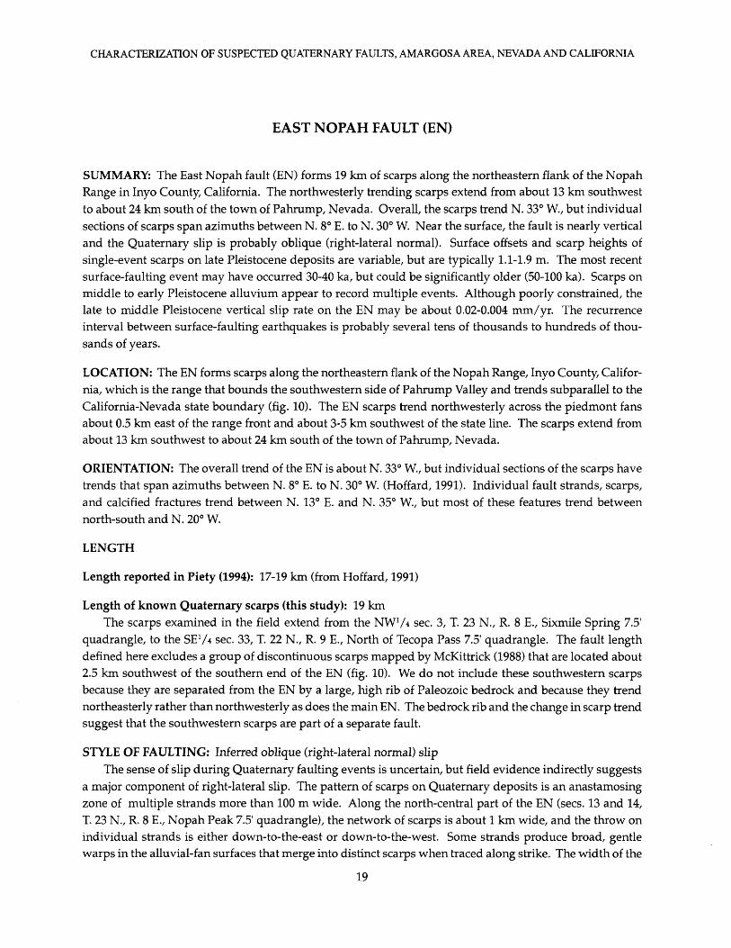
EAST NOPAH FAULT (EN)
SUMMARY: The East Nopah fault (EN) forms 19 km of scarps along the northeastern flank of the Nopah Range in Inyo County, California. The northwesterly trending scarps extend from about 13 km southwest to about 24 km south of the town of Pahrump, Nevada. Overall, the scarps trend N. 33° W., but individual sections of scarps span azimuths between N. 8° E. to N. 30° W. Near the surface, the fault is nearly vertical and the Quaternary slip is probably oblique (right-lateral normal). Surface offsets and scarp heights of single-event scarps on late Pleistocene deposits are variable, but are typically 1.1-1.9 m. The most recent surface-faulting event may have occurred 30-40 ka, but could be significantly older (50-100 ka). Scarps on middle to early Pleistocene alluvium appear to record multiple events. Although poorly constrained, the late to middle Pleistocene vertical slip rate on the EN may be about 0.02-0.004 mm/yr. The recurrence interval between surface-faulting earthquakes is probably several tens of thousands to hundreds of thou sands of years.
LOCATION: The EN forms scarps along the northeastern flank of the Nopah Range, Inyo County, Califor nia, which is the range that bounds the southwestern side of Pahrump Valley and trends subparallel to the California-Nevada state boundary (fig. 10). The EN scarps trend northwesterly across the piedmont fans about 0.5 km east of the range front and about 3-5 km southwest of the state line. The scarps extend from about 13 km southwest to about 24 km south of the town of Pahrump, Nevada.
ORIENTATION: The overall trend of the EN is about N. 33° W., but individual sections of the scarps have trends that span azimuths between N. 8° E. to N. 30° W. (Hoffard, 1991). Individual fault strands, scarps, and calcified fractures trend between N. 13° E. and N. 35° W., but most of these features trend between north-south and N. 20° W.
LENGTH
Length reported in Piety (1994): 17-19 km (from Hoffard, 1991)
Length of known Quaternary scarps (this study): 19 kmThe scarps examined in the field extend from the NW1 /* sec. 3, T. 23 N., R. 8 E., Sixmile Spring 7.5'
quadrangle, to the SE 1 /* sec. 33, T. 22 N., R. 9 E., North of Tecopa Pass 7.5' quadrangle. The fault length defined here excludes a group of discontinuous scarps mapped by McKittrick (1988) that are located about 2.5 km southwest of the southern end of the EN (fig. 10). We do not include these southwestern scarps because they are separated from the EN by a large, high rib of Paleozoic bedrock and because they trend northeasterly rather than northwesterly as does the main EN. The bedrock rib and the change in scarp trend suggest that the southwestern scarps are part of a separate fault.
STYLE OF FAULTING: Inferred oblique (right-lateral normal) slipThe sense of slip during Quaternary faulting events is uncertain, but field evidence indirectly suggests
a major component of right-lateral slip. The pattern of scarps on Quaternary deposits is an anastamosing zone of multiple strands more than 100 m wide. Along the north-central part of the EN (sees. 13 and 14, T. 23 N., R. 8 E., Nopah Peak 7.5' quadrangle), the network of scarps is about 1 km wide, and the throw on individual strands is either down-to-the-east or down-to-the-west. Some strands produce broad, gentle warps in the alluvial-fan surfaces that merge into distinct scarps when traced along strike. The width of the
19

CHARACTERIZATION OF SUSPECTED QUATERNARY FAULTS, AMARGOSA AREA, NEVADA AND CALIFORNIA
116°00'
36°00' \
5km
V : :-.v,.."li
In-
FIGURE 10. Generalized map of Quater nary fault scarps along the East Nopah fault, Inyo County, California (modified from McKittrick, 1988 and Piety, 1994). Extent of mostly continuous bedrock shown by half-tone fill. About 19 km of Quaternary scarps are shown in bold lines. Northeast- trending scarps at southern end of range are not included in this length measure ment because they are separated from range-front scarps by a large bedrock ridge. Open circles are locations of scarp profiles listed in table 4. RL identifies lo cation of speculative right-lateral slip.
fault zone and the variable sense of throw suggest a significant component of lateral slip. Furthermore, the scarps commonly have a left-stepping pattern of offsets at scales ranging from faults (see maps of Hoffard, 1991) to individual fault strands. Such left-stepping patterns are common in lateral-slip fault systems.
The near-surface attitude of the EN is almost vertical. We measured the strike and dip of calcified fractures and faults in six natural exposures formed by incised arroyos. At all of these locations, the frac tures and faults are associated with deformation on the adjacent fan surfaces. Nearly all of the faults and fractures dip steeply between 80° W. and 76° E.; such opposing steep dips are also typical of lateral-slip faults.
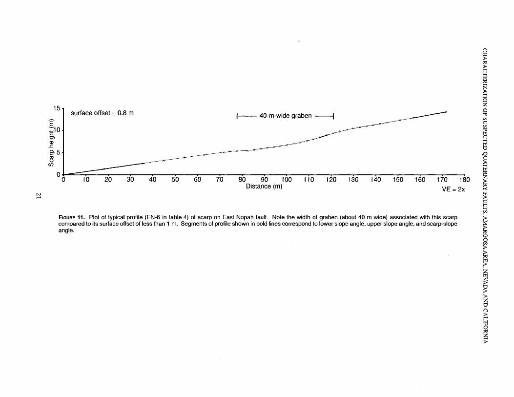
The most prominent scarps are down-to-the-east. Locally, fault-related tilting has flattened the east- sloping fan gradient to nearly horizontal or slightly westward sloping. Although broad grabens disrupt the gradient of the alluvial fans at several locations (fig. 11), the net vertical offset across them is small (about 1-1.5 m). Wide grabens having nominal amounts of net throw are typical of lateral-slip faults.
We found weak evidence of right-lateral offset at one site near the southern end of the fault zone (RL in fig. 10). Here, a fault with a small amount of down-to-the-west throw offsets a southeasterly sloping alluvial fan. A small, eastward-flowing arroyo may be deflected as much as 12 m right laterally at the trace of the fault, although the apparent lateral offset could also have been caused by headward erosion of a stream, which breached the small west-facing escarpment. The amount of apparent right-lateral slip is unexpectedly
20
70 80 90 100 Distance (m)
110 120 130 140 150 160 170 180
VE = 2x
FIGURE 11. Plot of typical profile (EN-6 in table 4) of scarp on East Nopah fault. Note the width of graben (about 40 m wide) associated with this scarp compared to its surface offset of less than 1 m. Segments of profile shown in bold lines correspond to lower slope angle, upper slope angle, and scarp-slope angle.

CHARACTERIZATION OF SUSPECTED QUATERNARY FAULTS, AMARGOSA AREA, NEVADA AND CALIFORNIA
TABLE 4. Scarp-profile data for the East Nopah fault, eastern California.
[Positive surface and scarp angles denote normal geomorphic gradients; that is, toward basin center and away from sedi ment sources. Fault parameters as defined in figure 2: LS, lower slope angle; US, upper slope angle; SO, surface offset; SH, scarp height; 0, scarp-slope angle.]
Profile No.
EN-1
EN-2A
EN-2B
EN-3
EN-4A
EN-4B
EN-5
EN-6
EN-7
Scarp type, aspect
Normal, E
Normal, lower of two scarps, E
Normal, upper of two scarps, E
Normal, NE
Normal, lower oftwo scarps, NE
Normal, upper of two scarps, NE
Normal, NE
Normal, E
Normal, NE
LS
2.3°
2.8°
3.2°
1.8°
2.6°
3.1°
3.3°
4.1°
1.7°
US
2.8°
3.2°
3.9°
2.2°
3.1°
3.2°
3.5°
5.2°
1.4°
SO(m)
1.1
0.3
0.5
1.0
1.1
0.9
02
0.8
2.8
SH (m)
1.9
0.6
1.1
1.4
1.7
1.6
0.3
1.6
4.0
e
6.0°
5.3°
6.4°
6.5°
8.7°
7.3°
4.9°
9.04.9°
large at this location, because the site is at the southeastern end of the EN where typically fault displacements should be small. Thus, this evidence of lateral slip is tenuous, but noteworthy.
DISPLACEMENT AND AGE
Range of observed surface offset and scarp height representing the youngest movement: 0.2-1.1 m (sur face offset) and 0.3-1.9 m (scarp height)
Surface offsets across individual strands of the fault are typically less than 1 m (table 4, except profile EN-7); however, these offsets probably do not reflect the total offset if the EN has a significant lateral-slip component. Dip-slip components can vary greatly within short distances on lateral-slip faults depending on the orientation and gradient of geomorphic surfaces traversed by the fault.
Estimated age of most recent surface-faulting event: late to possibly middle PleistoceneScarps along the EN are present only on alluvial fans that are estimated to be late to middle(?) Pleis
tocene in age (Qf2 of McKittrick, 1988) or older (Qf1 and QTf). Alluvium thought to be latest Pleistocene and Holocene in age (Qf3 and Qf4 of McKittrick, 1988) is not faulted. Age estimates of the fans are based on soil development and alluvial-fan morphology (McKittrick, 1988). The soil development and morphology of the Nopah Range fans compare well with characteristics of the well-studied alluvial fans of Kyle Canyon, which are about 60 km to the northeast on the east flank of the Spring Mountains (Sowers, 1986; Reheis and others, 1992). If the Nopah Range fans correlate with the Kyle Canyon fans, then the Qf2 deposits along the Nopah Range probably correspond to surface 3 at Kyle Canyon. Soils on surface 3 have been dated by 14C at 10-15 ka and by the uranium-series method at 47±20 and 76±6 ka; the deposits appear to represent a time- transgressive late Pleistocene alluvial sequence (Reheis and others, 1992). Thus, if the correlations are cor rect, the Qf2 deposits (surface 3) along the Nopah Range might be as young as 15 ka, but actually could be considerably older. The unfaulted Qf3 and Qf4 deposits of McKittrick (1988) would be less than 15 ka.
22

CHARACTERIZATION OF SUSPECTED QUATERNARY FAULTS, AMARGOSA AREA, NEVADA AND CALIFORNIA
The faulted Qf2 fans have a well-developed, shallow, calcic to petrocalcic horizon with stage III-IV soil- carbonate morphology (Birkeland, 1984; Machette, 1985). Soils with stage III-IV carbonate morphology are indicative of deposits that are more than 100 k. y. old (see table 2 in Machette, 1985). However, laterally flowing, shallow, carbonate-rich ground water can produce laminar carbonate horizons that are similar to pedogenic deposits. Although some of the petrocalcic horizon could be of ground-water origin, sufficient pedogenic carbonate is present in the near-surface of Qf2 deposits to suggest that their age is probably on the order of about 50 k. y. rather than 15 k. y. as the suggested by the 14C ages at Kyle Canyon.
The morphology of the fault scarps suggests that the age of the most recent event on the EN is no younger than late Pleistocene (fig. 12). The plot of scarp height versus scarp-slope angle suggests that the EN scarps are as old or older than the Lake Bonneville shoreline. However, several factors can make the scarps appear to be either morphologically younger or older than their actual age. One factor is that the scarps may have originally lacked a free face when they formed because fault slip was dominantly lateral. Similarly, scarps produced by small amounts of throw on several closely spaced strands will have a rela tively rounded original morphology. In both of these cases, the inferred age of the scarps based on their
30
25
20
O)
<D 1K Q. 15
CO
<a ow 10
DrumMountains X* Lake fault .»'' ^ Bonneville
shoreline
Santa Rita fault
Scarp Height (m)10
FIGURE 12. Plot of scarp-height slope-angle values for scarps on alluvium along the East Nopah fault (EN). Open circle indicates probable multiple-event scarp; X indicates scarps that lack evidence of multiple periods of movement and are inferred to be single-event scarps; site numbers shown in table 4 (profiles 2B and 4B are not plotted). Solid lines, regression lines for reference scarps; dotted lines, 1-o limits for regressions. Lake Bonneville shoreline scarp (about 15 ka; Machette, 1989) and Drum Mountains fault scarp (about 10 ka; Crone, 1983) both from Bucknam and Anderson (1979); Santa Rita fault scarp (estimated age about 100 ka; Pearthree and Calvo, 1987). Points that plot above or below the 1-0 limits of a regression line suggest relative ages that are younger or older than those of the reference scarps, respectively.
23

CHARACTERIZATION OF SUSPECTED QUATERNARY FAULTS, AMARGOSA AREA, NEVADA AND CALIFORNIA
morphology is greater than their actual age. Another factor is the presence of prominent petrocalcic hori zons, which slow scarp degradation and give scarps a youthful appearance. In evaluating the competing influence of these factors on the scarps' morphology, we believe that the presence of a petrocalcic horizon has the greatest impact, and thus, the scarps tend to be have a morphology that appears younger than their true age.
The antiquity of the scarps is demonstrated by scarp-slope angles that are only 2°-4° steeper than the adjacent fan slope. The newly formed scarps probably had slope angles that were at least 20° steeper than the fan slope, but the slope angles gradually decrease with increasing time. To reduce the relatively steep scarp slopes to angles within a few degrees of the fan slopes requires tens of thousand of years of erosion, especially because the petrocalcic horizon enhances the scarp-slope angle.
The field evidence indicates that the most recent surface-faulting event on the EN occurred several tens of thousands of years ago. Based on our observations of other faults in the Western U.S., we suspect that this event probably occurred at least 30-40 ka, but could be older (50-100 ka).
Range of observed total surface offset along scarps on alluvium: maximum 2.8 mMost of the scarp-profile data on the EN was collected for inferred single-event scarps on late Pleis
tocene Qf2 deposits, but we profiled one scarp (EN-7, table 4) near the southern end (NE1 A sec. 29, T. 22 N., R. 9 E.) of the EN that is probably the product of multiple events. This scarp has a surface offset of 2.8 m, which is about three times the typical offset for single-event scarps. This scarp contains several fault strands on middle or early Pleistocene deposits (unit Qft of McKittrick, 1988). Our profile of this scarp (profile EN-7, appendix B) crosses several small, steep steps that are spaced 5-20 m apart where an indurated petro calcic horizon is exposed at the surface; each step may mark the location of an individual fault strand. McKittrick's unit Qf1 probably correlates with the deposits of surface 2 at Kyle Canyon, which have an age of 130 ka (Reheis and others, 1992). If we accept this age, then the post-late Pleistocene vertical slip rate is 0.02 mm/yr (2.8 m/130 k. y). Alternatively, if we use maximum age of 770 ka for the Qfa deposits, then the vertical slip rate since middle Pleistocene time is 0.004 mm/yr (2.8 m/770 k. y).
Hoffard (1991, p. 40) reports scarps as much as 8 m high on Quaternary-Tertiary deposits along the EN. However, she did not specify their location, and we did not find them during our brief field investigations.
If the single, 12-m offset at the southern end of the EN is accepted as a tectonic feature (which is very uncertain), then it is likely the product of more than one earthquake. If the offset fan deposits are older than 770 ka (unit QTf of McKittrick, 1988), then a maximum Pleistocene slip rate is about 0.015 mm/yr (12 m/770 k. y.) at this site.
The long-term vertical slip rate on the EN is less than a few hundredths of a millimeter per year, and the recurrence time of surface-faulting earthquakes is probably several tens of thousands to perhaps hundreds of thousands of years. Surface-rupturing earthquakes have occurred on the EN during the Quaternary, but the slip rate is very low.
24

CHARACTERIZATION OF SUSPECTED QUATERNARY FAULTS, AMARGOSA AREA, NEVADA AND CALIFORNIA
ASH MEADOWS FAULT ZONE (AM)
SUMMARY: The Ash Meadows fault zone (AM) consists of discontinuous lineaments and subdued scarps that extend north-south for about 30 km along the eastern side of the Amargosa Desert through Ash Mead ows in Nye County, Nevada, and Inyo County, California. The fault zone is informally divided into north ern, central, and southern sections that individually are 6-8 km long, 3-6 km wide, and are separated by gaps of 2-5 km. Collectively, the sections extend from the area of Rock Valley Wash southward to the west flank of Shadow Mountain, which is at the northern end of the Resting Spring Range. We also include two north-trending Quaternary scarps north of Rock Valley Wash in the AM, which increases its length to about 40 km. Scarps are present only along 25-30 percent of this 40 km length.
Slickenlines in trenches reported by Donovan (1991) and antithetic scarps and grabens are direct and indirect evidence of normal slip on the AM. Surface offsets on most scarps are small (generally < 1 m), and the most recent surface-rupturing event is probably late Pleistocene in age. Multiple-event scarps are pre served at two locations along the southern part of the AM. The largest of two multiple-event scarps has 3.4 m of surface offset on middle or early Pleistocene deposits near Shadow Mountain and 1.8 m of surface offset on late Pleistocene alluvium. On the basis of this offset, a maximum slip rate is 0.1 mm/yr, but the small, discontinuous scarps along the remainder of the AM suggest a lower slip rate of less than 0.01 mm/yr.
Thus, the AM is characterized mainly by numerous discontinuous lineaments and relatively few, small scarps on Quaternary deposits. The widespread distribution of these lineaments and scarps, and the loca tion of high-yield springs along some of them suggests that they are the surface expression of a significant underlying fault zone that has been reactivated infrequently in the Quaternary. This zone is parallel to and east of the "gravity fault," a major separate intrabasin structure.
Because the age of the most recent event on each of the sections of the AM is very poorly resolved, it is impossible to determine if individual sections rupture independently or simultaneously. The rate of Qua ternary deformation on this structure is very slow, and the recurrence of surface-rupturing events is prob ably in the range of several tens of thousands of years.
LOCATION: The AM is located along the eastern part of the Amargosa Desert in Nye County, Nevada, and Inyo County, California (fig. 13). As defined by Donovan (1991), the AM extends from an area about 14 km southeast of the settlement of Amargosa Valley (Lathrop Wells), Nevada, southward through Ash Meadows to about 6 km east of Death Valley Junction, California, near the northwestern end of the Resting Spring Range. The scarps and lineaments of the AM are generally east of Rock Valley Wash and Carson Slough. In this report, we also include two subtle, discontinuous scarps located from 3-7 km southeast of Amargosa Valley in the AM.
A recent 27-km-long seismic-reflection profile across the northern Amargosa Desert has revealed the presence of buried Tertiary subbasins in the area (Brocher and others, 1993). One of the subbasins is bounded on the east by a feature named the "gravity fault", which is a 2-km-wide, north-trending system of listric faults. Scarps and lineaments in the northern AM are in the footwall of the "gravity fault", 3-5 km east of its eastern strand. Thus, scarps associated with the AM appear to be unrelated to this prominent subsurface Tertiary fault.
ORIENTATION: The AM is composed of numerous, short (<1- to 2-km-long) scarps and lineaments that trend between northwesterly and northeasterly (Donovan, 1991); we measured scarp trends between N. 24° W.
25

CHARACTERIZATION OF SUSPECTED QUATERNARY FAULTS, AMARGOSA AREA, NEVADA AND CALIFORNIA
116°30'
36°30'
36°15'
~o selected springs
X lineament or scarp,bar on downthrown side
Amargosa Valley (Lathrop Wells)
\
FIGURE 13. Map of Quaternary fault scarps along the Ash Meadows fault zone (AM), Nye County, Nevada, and Inyo County, California (modified from Donovan, 1991; McKittrick, 1988; Piety, 1994). Areas labeled: N, northern; C, central; S, and southern sections of scarps are generalized after Donovan (1991). Scarps in the northern extension (NE) and near Shadow Mountain (SM) and the geomorphic anomaly near Eagle Mountain are dis cussed in the text. Numbered open circles indicate locations of scarp profiles; numbers correspond to the profiles listed in table 5. Extent of mostly continuous bedrock shown by half-tone fill.
26

CHARACTERIZATION OF SUSPECTED QUATERNARY FAULTS, AMARGOSA AREA, NEVADA AND CALIFORNIA
and N. 29° E. Numerous aligned springs that trend N. 24 W. in Ash Meadows characterize the central section of the AM (DonoVan, 1991, p. 55).
LENGTH
Length reported in Piety (1994): 30-60 km
Length of known Quaternary scarps (this study): 30.2 km to about 40 km if our proposed northern exten sion is included. Scarps are present along 25-30 percent of the 40 km length. Length would be increased an additional 9 km to about 49 km, if speculative late Quaternary deformation on the east side of Eagle Moun tain is also included.
Donovan (1991) defined the AM as extending from the area near Rock Valley Wash in the northern Amargosa Desert southward to the western side of the Resting Spring Range, 4.5 km north-northeast of Shoshone, California. She mapped the northern 30 km of the fault zone in detail (from the Rock Valley area to the northern end of the Resting Spring Range), which was the limit of her aerial photography coverage. However, Donovan (1991, p. 71) states that the AM extends "at least as far south as the southern Resting Spring Range" on the basis of mapping by McKittrick (1988). Piety (1994) also included the scarps along the Resting Spring Range as part of the AM, which yields a total length of 60 km.
Donovan (1991) divided the AM into northern, central, and southern sections. Her northern section is a zone of discontinuous, northeast- to northwest-trending scarps and lineaments in an area about 8 km long (north-south) and 6 km wide (east-west). The central section, which is centered on the springs in Ash Meadows, is separated from the northern section by a 2-km-long gap, which coincides with part of the modern valley of Carson Slough. In the central section, the zone of scarps and lineaments mapped by Donovan (1991) are about 6.5 km long and 3 km wide. The boundary between the central and southern sections is diffuse: the southernmost scarp in the central section and the northernmost scarp in the southern section are about 4-5 km apart. The southern section is about 7 km long, 4 km wide, and includes scarps and lineaments on the distal part of the piedmont at the northwestern end of the Resting Spring Range.
Along the western piedmont of the Resting Spring Range, McKittrick (1988) mapped a system of scat tered lineaments and scarps that Donovan (1991) and Piety (1994) included in the AM (for a length of 60 km). The traces of most of these features are not marked by scarps, thus their relevance to regional seismic- hazard assessments is uncertain. The southernmost scarps mapped by McKittrick (1988) (4.5 km north- northeast of Shoshone, California) may have been cut on the distal part of middle to early Pleistocene allu vial fans by the Amargosa River, which is less than 1 km valley ward (west) of the scarps. Because alluvial- fan gravels in this area are interstratified with river sand, we suspect differential erosion of the loose sand in a fluvial terrace riser has steepened the scarp.
Of the traces mapped by McKittrick (1988), we found only one definite Quaternary fault scarp along the entire central and northern part of the Resting Spring Range: a conspicuous, 1.5-km-long, west-facing scarp (profiles AM-15, AM-16, AM-17 in table 5, fig. 14) on the northwest flank of Shadow Mountain (fig. 13). If we include this scarp in the AM, the length of the fault zone is the same as the 30 km length mapped by Donovan (1991).
We suspect that the AM may extend southward as far Eagle Mountain. An anomalous drainage pattern on the northeast side of Eagle Mountain (fig. 13) may be the result of subtle late Quaternary deformation. In this 300-m-wide area, several 10- to 50-cm-deep, active, northwestward-flowing (N. 70° W.) channels are deflected abruptly in a more northerly direction (N. 35° W.) for several tens of meters where they return equally as abruptly to their original northwestward flow direction. The original northwestward flow direc tion is down the gradient of the alluvial fan, whereas the more northerly flow direction is anomalous be cause it is oblique to the fan gradient. In this area, creosote bushes are preferentially aligned along a
27

CHARACTERIZATION OF SUSPECTED QUATERNARY FAULTS, AMARGOSA AREA, NEVADA AND CALIFORNIA
TABLE 5. Scarp-profile data for the Ash Meadows fault zone, southern Nevada and eastern California.
[Positive surface and scarp angles denote normal geomorphic gradients; that is, toward basin center and away from sedi ment sources; negative angles indicate abnormal geomorphic gradients such as antithetic fault scarps. Fault section refers to informal subdivisions of fault described in text. Fault parameters as defined in figure 2: LS, lower slope angle, US, upper slope angle; SO, surface offset; SH, scarp height; 0, scarp-slope angle; NA, measurement not applicable; , no measure ment.]
Profile No.
AM-1
AM-2
AM-3
MA-4
AM-5
AM-6
AM-7
AM-8
AM-9
AM-10
AM-11
AM-1 2
AM-1 3
AM-1 4
AM-1 5
Fault section
Northern extension
Northern extension
Northern extension
Northern
Central
Central
Southern
Southern
Southern
Southern
Southern
Southern
Southern
Southern
Southern
Scarp type, aspect
Normal, W
Normal with graben, W
Normal, W
Antithetic, NW
Normal, W
Normal, W
Normal, W
Antithetic, E
Normal, W
Antithetic, E
Antithetic, E
Antithetic, E
Normal with graben, W
Normal, W
Normal, W
LS
1.2°
0.8°
0.7°
0.5°
1.1°
0.0°
0.5°
1.2°
1.4°
.1.9°
1.3°
3.5°
7.1°
6.9°
US
1.2°
1.0°
0.5°
0.5°
1.1°
0.1°
0.5°
1.0°
2.1°
1.1°
1.6°
1.2°
3.8°
7.0°
6.5°
SO(m)
0.5
0.6
1.4
0.2
0.4
0.7
0.4
0.4
0.7--
0.6
0.4
1.5
3.4
1.8
SH (m)
1.0
0.9
1.8
02
1.6
0.8
0.6
NA
1.6
>1.9
NA
NA
3.2
6.5
3.5
9
2.9°
2.7°
2.8°
-2.8°
1.5°
2.1°
1.5°
-0.2°
3.3°
-4.0°
-0.7°
0.4°
7.1°
17.5°
15.6°
N. 30° W. trend. This anomalous drainage pattern may reflect young deformation that has affected small, active channels along a 300-m-long zone.
We extend the AM north of the Rock Valley Wash area, which increases it length by about 10 km. This extension is based on the presence of low, north-trending fault scarps (profiles AM-1 through AM-3 in table 5) on the southwest and northwest sides of the Skeleton Hills. Their northerly trend and their down-to-the-west throw indicate that these scarps are part of the AM rather than the Rock Valley fault zone (RV). The scarps trend between N. 3° E. and N. 10° E., whereas scarps associated with the RV trend N. 55° E. Furthermore, the down-to-the-west throw is consistent with the throw direction of AM, whereas RV scarps generally have variable throw directions because their sense of slip is dominantly left-lateral.
STYLE OF FAULTING: Normal, down to westSlickenlines in trenches (Donovan, 1991) and other evidence summarized by Piety (1994) indicate nor
mal dip slip on the AM. Antithetic scarps and grabens at several locations support normal slip.
DISPLACEMENT AND AGE
Range of observed surface offset and scarp height representing the youngest movement: 0.2-1.8 m (sur face offset); 0.2-3.5 m (scarp height)
Scarp height and surface offset measurements range widely along the fault zone, but surface offsets are generally less than 1 m; exceptions are a scarp at the northern end with 1.4 m of surface offset (profile AM-3
28
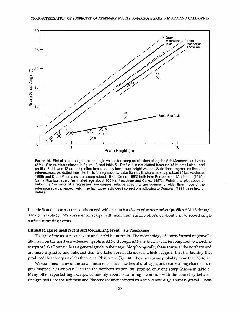
CHARACTERIZATION OF SUSPECTED QUATERNARY FAULTS, AMARGOSA AREA, NEVADA AND CALIFORNIA
30
25
05 -1C Q. lOO V)
10
DrumMountains ,»'* Lake fault ,»** ^ Bonneville
shoreline
Scarp Height (m)10
FIGURE 14. Plot of scarp-height slope-angle values for scarp on alluvium along the Ash Meadows fault zone (AM). Site numbers shown in figure 13 and table 5. Profile 4 is not plotted because of its small size , and profiles 8, 11, and 12 are not plotted because they lack scarp height values. Solid lines, regression lines for reference scarps; dotted lines, 1-o limits for regressions. Lake Bonneville shoreline scarp (about 15 ka; Machette, 1989) and Drum Mountains fault scarp (about 10 ka; Crone, 1983) both from Bucknam and Anderson (1979); Santa Rita fault scarp (estimated age about 100 ka; Pearthree and Calvo, 1987). Points that plot above or below the 1-0 limits of a regression line suggest relative ages that are younger or older than those of the reference scarps, respectively. The fault zone is divided into sections following to Donovan (1991); see text for details.
in table 5) and a scarp at the southern end with as much as 3.4 m of surface offset (profiles AM-13 through AM-15 in table 5). We consider all scarps with maximum surface offsets of about 1 m to record single surface-rupturing events.
Estimated age of most recent surface-faulting event: late PleistoceneThe age of the most recent event on the AM is uncertain. The morphology of scarps formed on gravelly
alluvium on the northern extension (profiles AM-1 through AM-3 in table 5) can be compared to shoreline scarps of Lake Bonneville as a general guide to their age. Morphologically, these scarps at the northern end are more degraded and subdued than the Lake Bonneville scarps, which suggests that the faulting that produced these scarps is older than latest Pleistocene (fig. 14). These scarps are probably more than 30-40 ka.
We examined many of the tonal lineaments, linear reaches of drainages, and scarps along channel mar gins mapped by Donovan (1991) in the northern section, but profiled only one scarp (AM-4 in table 5). Many other reported high scarps, commonly about 1-1.5 m high, coincide with the boundary between fine-grained Pliocene sediment and Pliocene sediment capped by a thin veneer of Quaternary gravel. These
29

CHARACTERIZATION OF SUSPECTED QUATERNARY FAULTS, AMARGOSA AREA, NEVADA AND CALIFORNIA
linear escarpments are probably structurally controlled and probably coincide with faults in the Pliocene deposits. Resistant tufa beds are common in the Pliocene deposits and, where the tufa is fractured and jointed, differential erosion probably forms scarps.
In some areas, resistant tufa beds cap gently sloping, planar surfaces that are locally offset by faults (for example, a N. 24° W.-trending scarp in SE1 A sec. 4, T. 17 S., R. 50 E., Skeleton Hills 7.5' quadrangle). Locally, the surfaces are mantled by unfaulted eolian sand, which is probably of Holocene age. Scarps on these tufa- capped piedmonts are prominent on aerial photographs where they mark a sharp boundary between parts of the piedmont that have little or no eolian sand and adjacent parts that have abundant sand. These bound aries look like faults on aerial photographs because they mark sharp tonal contrasts. They probably reflect minor differences in vegetation density, which subsequently controls the capture of sand that moves across the scarp. Regardless of their origin, the low heights and gentle slopes of the scarps (profile AM-4 in table 5) indicate an age of at least several tens of thousands of years. The scarps could be much older if it is the relatively resistant tufa that is preserving their youthful morphologic expression.
The age of the most recent event on the central section is poorly constrained. Donovan (1991) notes that some scarps are on late Pleistocene alluvium, but many are at the boundary between Quaternary-Pliocene lacustrine sediment and Quaternary alluvium. Thus, correlative deposits are not present on both sides of the scarps and thus cannot be used to constrain the timing or amount of faulting. The ages of the Quater nary deposits in the central section are not well documented. Donovan (1991) reports the age of the faulting as late Pleistocene because deposits thought to be late Pleistocene in age are displaced in trench exposures (trenches TR3 and TR4 of Donovan, 1991). The late Pleistocene age designation seems realistic based the description of the soil exposed in Donovan's trench TR4.
The majority of the features included in the southern section (Donovan, 1991) are channel-edge scarps and vegetation and tonal lineaments, but this section also contains five scarps that are 0.2-1.0 km long. We profiled four of the scarps in this section, but the fifth is probably a fluvial scarp. Two of the scarps (profiles AM-11 and AM-12 in table 5) are on late Pleistocene alluvium that has a 3- to 5-cm-thick, sandy Av horizon, a 10- to 20-cm-thick sandy Bw or Bt horizon, and a Btk horizon (stage II soil carbonate morphology) about 24-30 cm below the surface. On the basis of this soil development, the surface is probably late Pleistocene in age. The subdued morphology of these scarps suggests that they are older that the latest Pleistocene shore line of Lake Bonneville.
The largest single-event scarp in the AM is on the northwestern piedmont of Shadow Mountain (AM-15 in table 5). The scarp is high (3.5 m) because it is formed on a steep (>6.5°) fan surface, but its surface offset (1.8 m) is not unusually large compared to single-event scarps on historic normal faults that are at least 20 km long (Wells and Coppersmith, 1994). This scarp is on deposits mapped by McKittrick (1988) as late or middle Pleistocene (Qf2). Its morphology suggests an age similar to that of the Lake Bonneville shoreline scarp.
Range of observed total surface offset along scarps on alluvium: 0.2 m-3.4 mScarps along the AM are generally small; the largest ones are in Donovan's (1991) southern section and
in the Shadow Mountain area. In this part of the AM, there is evidence of multiple surface-rupturing events on east-facing antithetic scarps in sees. 6 and 16, T. 25 N., R. 6 E., and on a west-facing scarp in NEV4 sec. 25, T. 25 N., R. 6 E. (both in Bole Spring 7.5' quadrangle). At the first location, scarps are present on alluvial surfaces of three different ages. The scarp on late Pleistocene deposits has a surface offset of 0.4-0.6 m (AM- 11 and AM-12 in table 5, fig. 15). On a different antithetic scarp about 1 km to the north, the surface offset is 0.4 m (AM-8) on a deposit of probable early late Pleistocene or middle Pleistocene age. Southward, this scarp is on an older, partially preserved alluvial surface of probable middle Pleistocene age (AM-10) (because
30

CHARACTERIZATION OF SUSPECTED QUATERNARY FAULTS, AMARGOSA AREA, NEVADA AND CALIFORNIA
VV>AM-8
\AM-9
\x
\
<i!iiii
AM-1K
AM-12*
\300 600 meters
FIGURE 15. Detailed map of prominent scarps along Ash Meadows fault zone (AM) in NEV4 sec. 25, T. 25 N., R. 6 E., Inyo County, California (Bole Spring 7.5' quadrangle). Open circles show profile sites; profile numbers correspond to the profiles listed in table 5. The deposit mapped as Qf-| is inferred to be middle Pleistocene, and the scarp on it is larger than scarps on the adjacent deposits (not mapped in detail) that are thought to be late Pleistocene in age.
this scarp is poorly preserved and erosionally modified, profile AM-10 does not traverse the entire scarp, but does show the scarp's general morphology and offers a perspective of its height).
At the second location (Shadow Mountain), a single-event scarp is formed on late or middle Pleistocene Qf2 deposits (McKittrick, 1988), and a multiple-event scarp is formed on Qfa deposits, which McKittrick assigns a middle or early Pleistocene age. The Qf2 deposits probably correlate with deposits that underlie surface 3 at Kyle Canyon (Sowers, 1986; Reheis and others, 1992), and the Q^ deposits probably correlate with those that underlie surface 2. Surface 3 deposits have been dated by 14C at 10-15 ka and by the ura nium-series method at 47±20 and 76±6 ka, and they appear to be a time-transgressive late Pleistocene allu vial sequence in which the age of the deposit increases toward the head of the fan (Reheis and others, 1992). Surface 2 deposits at Kyle Canyon are considered to be 130 ka (Reheis and others, 1992).
31

CHARACTERIZATION OF SUSPECTED QUATERNARY FAULTS, AMARGOSA AREA, NEVADA AND CALIFORNIA
At the Shadow Mountain site, the single-event scarp has a surface offset of 1.8 m (AM-15), and the multiple-event scarp has a surface offset of 3.4 m (AM-14). If correlations with the Kyle Canyon deposits are correct, then the single-event scarp could be on deposits that are as young as 10-15 ka, although we suspect that their age in this area is probably at least 30-50 ka because the deposits have a well-developed desert pavement and well-varnished clasts. The morphology of the single-event scarp indicates that it is compa rable to Lake Bonneville scarps (fig. 14).
The penultimate event in this area predates deposition of the Qf2 deposits, which we assume ended 30-50 ka. If we use these constraints, then the maximum late Pleistocene slip rate is 0.1 mm/yr (3.4 m/30 k. y). However, based on the morphology of scarp AM-13, which may be a single-event scarp from the penultimate event, the age of this older event could easily be 100 ka. Thus, the recurrence time between events is at least 15-20 k. y. (time between 30 ka and most recent event which produced Lake Bonneville-like scarp), and more likely is greater than 50 k. y. (if penultimate event is about 100 ka and most recent event is latest Pleistocene).
Slip-rate estimates from other places along the AM are plagued with similarly large uncertainties be cause the ages of Quaternary deposits are poorly known and because correlative deposits are rarely pre served on both sides of scarps. If the estimates that we offer for the Shadow Mountain scarps apply to the entire zone, then the long-term slip rate is no more than 0.1 mm/yr and is more likely an order of magnitude less (~0.01 mm/yr). The rounded, small scarps along the AM suggest that a slip rate of less than 0.01 mm/yr is a more realistic estimate.
The widespread distribution of the lineaments and scarps that define the AM suggests that they iden tify the location of a significant underlying fault zone that has been reactivated infrequently in the Quater nary. Because the age of the most recent event on each of the sections is very poorly resolved, it is impos sible to determine if individual sections rupture independently or simultaneously. The rate of Quaternary deformation on this structure is very slow, and the recurrence of surface ruptures is probably in the range of several tens of thousands of years.
32

CHARACTERIZATION OF SUSPECTED QUATERNARY FAULTS, AMARGOSA AREA, NEVADA AND CALIFORNIA
ROCK VALLEY FAULT ZONE (RV), SOUTHWESTERN EXTENSION
SUMMARY: Several authors have suggested that the Rock Valley fault zone (RV) extends southwest into the area of our study. Fault scarps that may mark this southwestern extension trend N. 55° E. across the Amargosa Desert north of Ash Meadows. The most continuous part forms a 7-km-long fault trace that trends N. 62° E. across Nevada Highway 29 about 0.8 km north of the Amargosa Valley Post Office. Other similarly oriented scarps are present to the northeast, primarily south of the Striped Hills. The entire RV has a N. 50° E. orientation over its 65 km length, which extends from Amargosa Valley northeast to Frenchman Flat. The RV is inferred to be primarily left-lateral, but there is no direct evidence for the amount or direc tion of lateral slip along the part of the fault we studied. Also unknown are the amount of surface offset and the resulting scarp heights from the most recent surface-faulting event, which is estimated to be late Pleis tocene in age. Scarps along the southwestern extension of the RV have 0.3-1.3 m of vertical offset in Quater nary alluvium, but the amount of lateral slip is unknown; thus, meaningful slip rates cannot be calculated.
LOCATION: This possible southwestern extension of the RV trends west-southwest into the Amargosa Desert from its type locality in Rock Valley (fig. 16). Its northeastern end is problematic (see Piety, 1994). Donovan (1991) shows it continuing about 5 km northeast of U.S. Highway 95 with traces both north and south of the Skeleton Hills (beyond the area shown in fig. 17). Restricted access prevented us from confirm ing the location or age of scarps north of the highway. The most continuous trace of the fault crosses Ne vada Highway 29 about 0.8 km north of the Amargosa Valley, Nevada, Post Office (fig. 16). The fault is marked by Quaternary scarps from about 2.8 km west of Nevada Highway 29 (W. edge of sec. 34, T. 16 S., R. 49 E., South of Amargosa Valley 7.5' quadrangle) northeastward to the center of sec. 36, T. 15 S., R. 50 E. (Skeleton Hills 7.5' quadrangle), where it crosses Rock Valley Wash at an acute angle (fig. 17). Scarps in the Amargosa Desert have many trends. Those believed to be associated with the RV are defined on the basis of a northeast-trending orientation. Donovan (1991) used this rational to include some features within and north of the Striped Hills as part of the RV; however, we did not study these features. South of the Skeleton Hills, faults that may be part of the RV form a wide, subdued graben between uplifted blocks of alluvium that divert the drainage of Rock Valley Wash from a southerly (down-fan) course to a southwesterly course (fig. 17).
ORIENTATION: N. 55° E.The southwestern extension of the RV has a N. 55° E. orientation. The mostly continuous, 7-km-long
trace of the fault adjacent to Nevada Highway 29 trends N. 62° E., whereas the portion of the fault south of the Skeleton Hills has a N. 55° E. orientation. A series of kilometer-scale left steps gives the RV a N. 50° E. orientation from Amargosa Valley to Frenchman Flat (within the Nevada Test Site).
LENGTH
Length reported in Piety (1994): 32-65 km (RV and its southwest extension)
Length of known Quaternary scarps (this study): 16.0 km in Amargosa Valley (includes discontinuous scarps from west of Nevada Highway 29 to about 2 km south of U.S. Highway 95)
Several authors (see Piety, 1994) have suggested that the RV extends southwest into the area of our study. The RV has been described as being 32-65 km in length depending on whether or not this extension is included. We found evidence for Quaternary movement along many parts of the fault in the Amargosa
33

CHARACTERIZATION OF SUSPECTED QUATERNARY FAULTS, AMARGOSA AREA, NEVADA AND CALIFORNIA
116° 27'30" 116° 25' 116° 22'30"
36°32'30"
EXPLANATION
Prominent fault scarp Minor or degraded
fault scarpFluvial terrace (ticks=up) Uplifted and dissected
deposits (Quat. & Tert.) Scarp profile Trench location
AmargosaValley
Post Office
FIGURE 16. Map of the southwest extension of the Rock Valley fault zone (RV) adjacent to Nevada Highway 29 showing associated geographic and cultural features. Scarp profiles correspond to those listed in table 6. Trench locations are from Donovan (1991).
Desert. In addition, along the projection of the RV there are fault-line scarps, deflected or incised stream channels, and tonal lineations that suggest at least 16 km of Quaternary movement. The main RV (Rock Valley fault proper in Piety, 1994) extends from the Specter Range northeast through Rock Valley and as far east as Frenchman Flats, a distance of 32 km. If the RV extends from the Specter Range southwest to sec. 33 T. 16 S., R. 49 E., the total fault length is about 65 km (Piety, 1994).
STYLE OF FAULTING: Primarily strike slip (inferred left lateral)Evidence for left-lateral slip and amounts of displacement are documented in studies of the fault in its
type area in Rock Valley. There, Yount and others (1987) argued for an unknown amount of left-lateral- oblique (north-side down) offset of latest Pleistocene deposits. Some streams that cross the fault in Amargosa Valley (fig. 16) show an apparent right-lateral sense of offset, but other streams, both larger and smaller, do not. Along the southwestern extension of the RV we found no direct evidence for the amount or direction of lateral slip. Indirect evidence for left-lateral strike-slip faulting comes from a right-stepping pattern of scarps (see fig. 16). Donovan (1991) argues for a left step in the fault in order to connect the two areas of northeast-trending fault scarps shown in figures 16 and 17. The RV has a small amount of down-to-the- south throw near and west of Nevada Highway 29 and a small amount of down-to-the-north throw east of Nevada Highway 29, a pattern typical of strike-slip faults. "Scarp profiles measured by Donovan" (1991)
34

CHARACTERIZATION OF SUSPECTED QUATERNARY FAULTS, AMARGOSA AREA, NEVADA AND CALIFORNIA
116° 22'30" 36°37'30"
116° 20'00" 116° 17'30"
36°35'00"
EXPLANATION
Prominent fault scarp i._ Minor or degraded
fault scarp-J-L-j- Fluvial terrace (ticks=up)
Jiilllllilllp.............. ^
TXw*&.i A-.>jP..-.-.:v':.TA5 S.
T. 16 S.
w w
I / ...,.--<* - "
I______I
0 0.5 1.0 2.0 2.0km
* ':':S'. - - ./: : ' .:. ' /'.' :.' . : '.
/.' .". :V /!:.
^;-^-^'.-^:^- .^:-.::..1 .:-^. ;.: ' ' -: .;. :.-: .' '. ' '6^. . ' '' ' : i- ' ' * ' ' ^ : ':' *. .'.: ':' *.'. .; .;;..;.vr. ; t. :. ;.:.; . . .'.' .' : -
FIGURE 17. Map of the southwest extension of the Rock Valley fault zone (RV) south of the Skeleton Hills showing selected geographic and cultural features. Extent of mostly continuous bedrock shown by half-tone fill, uplifted alluvium shown by stipple pattern.
and this study (table 6) indicate a maximum vertical surface offset of about 1 m and scarp heights of 3.3 m or less. South of the Skeleton Hills (fig. 17), the majority of Quaternary fault scarps are associated with down- to-the-north throw on the RV.
DISPLACEMENT AND AGE
Range of observed surface offset and scarp height representing the youngest movement: not documented We made no definitive measurements of scarp heights or offsets in this study. Nevertheless, the
370-m-long scarp profile measured just west of Nevada Highway 29 (profile RV-1 in appendix B) shows the remarkable width of the graben at this site and implies a long and complex history of movement. The southeast-facing scarp is about 3.3 m high, yet it only relates to about 0.5 m of net vertical offset of the surface (profile RV-1 in table 6, fig. 18). This disparity in height versus offset (1:6.6) suggests that the scarp is related to multiple faulting events and a wide zone of deformation. The most recent faulting event may have caused a slight steepening near the base of the main scarp, as noted by a 4.5°-4.6° slope angle on the broader, more gently inclined scarp (generally 2.5°-3.8°, fig. 18; see profiles RV-1 and RV-2, table 6). However,
35

CHARACTERIZATION OF SUSPECTED QUATERNARY FAULTS, AMARGOSA AREA, NEVADA AND CALIFORNIA
TABLE 6. Scarp-profile data for the southwestern extension of the Rock Valley fault zone (RV), southern Nevada.
[Some parameters estimated from scarp profiles (£) shown in Donovan (1991, Appendix A). Fault parameters as defined in figure 2: LS, lower surface angle; US, upper surface angle; SO, surface offset; SH, scarp height; 9, scarp-slope angle; , no measurement; e, estimated.]
Profile No.
P-4*
P-5t
RV-1
RV-2
Mt
P-7t
P-8*
Fault section
Southwestern extension
Southwestern extension
Southwestern extension
Southwestern extension
Southwestern extension
Southwestern extension
Southwestern extension
Scarp type, LS aspect
Oblique-normal, <1° SE
Oblique-normal, <1° SE
Oblique-normal 1.1° with graben, SE
Oblique-normal 1.2° with graben, SE
Oblique-normal, <1° NW
Oblique-normal, <1° NW
Oblique-normal, <1° NW
US SO SH(m) (m)
<1° 0.8e
<1° 0.7e
1.0° 0.5 3.3
1.1° >0.9 >1.2
<1° 0.3e
<1° 0.5e
<1° 1.1e -
e
14°
8°
4.6°
4.5°
6°
5
6.5
the steepening also could be related to resistant units that outcrop elsewhere along the scarp; for example, Donovan (1991) measured scarp-slope angles of 8° and 14°, which are caused by resistant petrocalcic horizons exposed in and near her trench TR-2 (fig. 16).
Estimated age of most recent surface-faulting event: probably late PleistoceneAlthough Donovan (1991) inferred offset of Holocene deposits (Qls and Qlc of Swadley, 1983) in our
study area, we found no compelling evidence that the most recent fault movement is Holocene. Donovan's age estimate appears to be based on unit correlations and inferences about groundwater levels and climatic considerations rather than from dating faulted deposits. For example, Donovan (1991) states that the petro calcic horizon in trench TR-1 (unit TRIG), which contains fractures, is most likely part of unit Qla of Swadley (1983) and thus is Holocene. From our experience and published studies of the rates of calcic soil formation (Machette, 1985), it appears that most petrocalcic horizons (stage IV or more advanced) require consider ably more time than 10 k. y. to develop perhaps 100 k. y. is a more reasonable estimate. The scarp's mor phology is not suggestive of a significant (>0.5 m) amount of young vertical motion, nor is there evidence for a consistent pattern of lateral slip in the geomorphology or stream patterns that would be indicative of young faulting. Donovan (1991) noted scarp-slope angles of 8° and 14°, which seem to be related to resistant petrocalcic horizons rather than young faulting. In addition, many of the scarps formed along the fault are on older (Tertiary?) deposits, and thus may reflect differential erosion along the fault. Although the discon tinuous pattern of faulting might be explained by young lateral motion (right steps), it may also be a result of fluvial erosion since the most recent faulting event. Thus, we conclude that the most-recent faulting event along the southwestern extension of the RV is probably late Pleistocene in age.
Range of observed total surface offset along scarps on alluvium: 0.3-1.3 m vertical (estimated); amount of lateral component unknown
Scarp profiles by Donovan (1991) and this study indicate a maximum vertical surface offset of about 1.1 m (profile P-8, in table 6) and a scarp height of 3.3 m (profile RV-1 in table 6) where a graben that crosses
36

CHARACTERIZATION OF SUSPECTED QUATERNARY FAULTS, AMARGOSA AREA, NEVADA AND CALIFORNIA
30
25
O)
<D ic Q. 15_gC/36.
DrumMountains,'*' Lake fault x* >x Bonneyille
shoreline
Santa Rita fault
Xi
Scarp Height (m)10
FIGURE 18. Plot of scarp-height slope-angle values for scarps on the southwest extension of the Rock Valley fault zone (RV). Numbers refer to scarp profiles from this study in table 6. Solid lines, regression lines for reference scarps; dotted lines, 1 -o limits for regressions. Lake Bonneville shoreline scarp (about 15 ka; Machette, 1989) and Drum Mountains fault scarp (about 10 ka; Crone, 1983) both from Bucknam and Anderson (1979); Santa Rita fault scarp (estimated age about 100 ka; Pearthree and Calvo, 1987). Points that plot above or below the 1-o limits of a regression line suggest relative ages that are younger or older than those of the reference scarps, respectively.
Nevada Highway 29 is well developed. Most other fault scarps associated with the fault have less than 1 m of vertical surface offset. Donovan (1991) notes that much of the fault has scarps developed on Quaternary and or Tertiary lake deposits (QTld), so surface offsets across these scarps are too old to be useful for estimates of offset or slip rate. However, at profile sites RV-1 and RV-2 (fig. 16), the scarp is formed on a thin (<1 m) mantle of alluvial gravel that lies on older deposits of probable Tertiary age; thus, it may reflect the total vertical offset since the gravel was deposited. Soils in the gravel have a thick Av horizon that is being engulfed by the underlying Bt horizon and a stage III calcic horizon with thick coatings of carbonate on clasts, all of which suggest the soil is probably late to middle Pleistocene in age (100-200 ka?). South of the Skeleton Hills, most of the fault scarps face north, and thus have been subject to fluvial erosion from southward-flowing streams. Because many of these scarps are larger (5-10 m high) than those to the southwest, they suggest both multiple-faulting events, some with more net vertical offset than other scarps along the RV. However, because of a lack of exposures, we cannot be sure that the same deposits are present on both sides of the fault, and thus the true amounts of vertical surface offset are not well constrained. Meaningful slip rates across the southwestern extension of the RV cannot be calculated without better data on offset per event and recurrence times.
37

CHARACTERIZATION OF SUSPECTED QUATERNARY FAULTS, AMARGOSA AREA, NEVADA AND CALIFORNIA
SUMMARY
Quaternary faults in the California-Nevada border area south and southeast of Yucca Mountain have diverse orientations and senses of slip consistent with their location along or near the junctures between structurally contrasting sections of the Walker Lane belt. Because issues of possible interconnectedness or mechanical interaction between these structures may have relevance to the integrity of the Yucca Mountain site, five of these faults in the Amargosa Valley-Stewart Valley-Pahrump Valley area were studied as a group.
Scarps are sparse along the PSV. In Pahrump and Stewart Valleys, scarps marking the surface trace of unequivocal late Quaternary surface-faulting events were found along only 18.5 km of the estimated 50 km of trace length of the PSV. Most scarps are formed on easily erodable silty playa deposits, making them difficult to evaluate in terms of age or possible multiple-event history. Based on a qualitative assessment of a 2-m-high scarp that is inferred to have formed from a single surface-faulting event, the most recent surface- faulting event may be as young as middle Holocene. Scarps in Stewart Valley are as much as 5 m high, but are in an area with abundant evidence of fluvial modification, so the heights may be unreliable for estimating the surface offset. Scarps in southern Pahrump Valley indicate as much as 15 m of Quaternary vertical surface offset, but they also are so extensively modified by erosion that using them to characterize paleoseismic events requires many assumptions and introduces large uncertainties. The high scarps in southern Pahrump Valley may be as old as late Tertiary or early Pleistocene, and are best classified as fault-line scarps rather than fault scarps. No direct evidence was found for partitioning the displacement between dip slip and strike slip. Based on a lack of evidence for Quaternary displacement in a 15- to 20-km-long gap between Stewart and Amargosa Valleys, we conclude that Quaternary activity on the PSV has not been coextensive with deformation on either the AR or AM.
On the basis of a redefinition of the age of faulted surfaces in the Ash Meadows part of the Amargosa Desert, the most recent surface-faulting event on the AR is probably late Pleistocene rather than Holocene as previously reported. Evidence of Quaternary faulting is found along almost 12 km of the 15-km length of the fault. Most scarps associated with the fault zone are either modified by fluvial erosion or are on erosion- ally dissected or truncated Tertiary(?) sediment. None were found that are unmodified enough or on suit able sediments to yield reliable scarp-height or surface-offset measurements. Indirect evidence for Quater nary right-lateral slip is suggested by a left step in a previously unmapped strand of the fault. As previously noted, Quaternary activity on the AR appears to have been independent of the PSV.
The EN trends northwest, is steep, and is marked by a 19-km-long set of anastamosing scarps about 2 km northeast of the northeast base of the Nopah Range. Most of the scarps may have formed in a single surface-faulting event that produced maximum surface offsets of about 1 m. The age of this surface-faulting event is estimated to be late Pleistocene to possibly middle Pleistocene on the basis of soil development, alluvial-fan morphology, and scarp morphology. The late to middle Pleistocene slip rate is no greater than a few hundredths of a mm/yr, and the recurrence time for surface faulting is tens to hundreds of thousands of years. The slip sense is probably oblique (right-lateral normal).
The AM strikes approximately north and has mainly down-to-the-west normal throw. It is located east of and in the footwall of a large-displacement down-to-the-west fault, which forms the eastern margin of the 15-km-wide Amargosa Desert structural trough (Brocher and others, 1993). Quaternary displacement on the AM is indicated by discontinuous lineaments and a few discontinuous scarps on alluvium. The AM has an estimated length of 40 km, but Quaternary scarps are found only along 10-15 km of the total length. On the basis of scarp morphology and the estimated ages of offset surfaces, the most recent surface-faulting event is probably late Pleistocene. Surface offsets preserved in sparse scarps are small (<1 m), and there is
38

CHARACTERIZATION OF SUSPECTED QUATERNARY FAULTS, AMARGOSA AREA, NEVADA AND CALIFORNIA
equivocal evidence of recurrent movement during the late Pleistocene. Using data from the largest scarp, an isolated feature adjacent to Shadow Mountain in the northern Resting Spring Range, the maximum slip rate is estimated at 0.1 mm/yr, but the small size, discontinuous nature, and subdued morphology of most scarps along the AM suggest a much lower slip rate (<0.01 mm/yr) may be possible. Low slip rates are consistent with long-term structural stability indicated by seismic-reflection data (Brocher and others, 1993).
Northeast-trending scarps located in the Amargosa Desert near Amargosa Valley may represent a south western extension of the RV. Measured surface offset on the scarps is less than or equal to 1.3 m, and the partitioning of dip slip versus strike slip is not known. The most recent surface faulting event is estimated to be late Pleistocene. Meaningful slip rates and recurrence cannot be calculated.
39

CHARACTERIZATION OF SUSPECTED QUATERNARY FAULTS, AMARGOSA AREA, NEVADA AND CALIFORNIA
REFERENCES
Anderson, R.E., Bucknam, R.C., Crone, A.J., Haller, K.M., Machette, M.N., Personius, S.R, Barnhard, T.P.,Cecil, M.J., and Dart, R.L., 1995, Characterization of Quaternary and suspected Quaternary faults,regional studies, Nevada and California: U.S. Geological Survey Open-File Report 95-599, 56 p.
Birkeland, P.W., 1984, Soils and geomorphology: New York, Oxford University Press, 372 p. Brocher, T.M., Carr, M.D., Fox, K.F., Jr., and Hart, P.E., 1993, Seismic reflection profiling across Tertiary exten-
sional structures in the eastern Amargosa Desert, southern Nevada, Basin and Range province:Geological Society of America Bulletin, v. 105, p. 30-46.
Bucknam, R.C., and Anderson, R.E., 1979, Estimation of fault-scarp ages from a scarp-height slope-anglerelationship: Geology, v. 7, p. 11-14.
Bucknam, R.C., Crone, A.J., and Machette, M.N., 1989, Characteristics of active faults, in National EarthquakeHazard Reduction Program, Summaries of Technical Reports, v. XXVIII: U.S. Geological SurveyOpen-File Report 89-453, p. 117.
Burchfiel, B.C., Harm'11, G.S., IV, and Wilhelms, D.E., 1983, Structural geology of the Montgomery Mountainsand the northern half of the Nopah and Resting Spring Ranges, Nevada and California: GeologicalSociety of America Bulletin, v. 94, p. 1359-1376.
Byers, KM., Jr., Carr, W.J., Orkild, P.P., Quinlivan, W.D., and Sargent, K.A., 1976, Volcanic suites and relatedcauldrons of Timber Mountain-Oasis Valley caldera complex, southern Nevada: U.S. GeologicalSurvey Professional Paper 919, 70 p.
Carr, W.J., 1984, Regional structural setting of Yucca Mountain, southwestern Nevada, and late Cenozoicrates of tectonic activity in part of the southwestern Great Basin, Nevada and California: U.S.Geological Survey Open-File Report 84-854,109 p.
1988, Volcano-tectonic setting of Yucca Mountain and Crater Flat, southwestern Nevada, in Carr,M.D., and Yount, J.C., eds., Geologic and hydrologic investigations of a potential nuclear wastedisposal site at Yucca Mountain, southern Nevada: U.S. Geological Survey Bulletin 1790, p. 35-49.
Crone, A.J., 1983, Amount of displacement and estimated age of a Holocene surface faulting event, easternGreat Basin, Millard County Utah, in Crone, A.J., ed., Paleoseismicity along the Wasatch front andadjacent areas, central Utah: Utah Geological and Mineral Survey Special Studies 62, p. 49-55.
Donovan, D.E., 1991, Neotectonics of the southern Amargosa Desert, Nye County, Nevada and Inyo County,California: Reno, Nevada, University of Nevada, unpublished M.S. thesis, map scale 1:48,000,151 p.,5 pis.
Hanks, T.C., Bucknam, R.C., Lajoie, K.R., and Wallace, R.E., 1984, Modification of wave-cut and faulting-controlled landforms: Journal of Geophysical Research, v. 89, p. 5771-5790.
Hoffard, J.L., 1991, Quaternary tectonics and basin history of Pahrump and Stewart Valleys, Nevada andCalifornia: Reno, University of Nevada, unpublished M.S. thesis, 138 p., 5 pis.
Izett, G.A., and Obradovich, J.D., 1994, 40Ar/39Ar age constraints for the Jaramillo normal subchron and theMatuyama-Brunhes geomagnetic boundary: Journal of Geophysical Research, v. 99, p. 2925-2934.
MIT Field Geophysics Course, 1985, A geophysical study of Mesquite Valley-Nevada-California border:Journal of Geophysical Research, v. 90, p. 8685-8689.
40

CHARACTERIZATION OF SUSPECTED QUATERNARY FAULTS, AMARGOSA AREA, NEVADA AND CALIFORNIA
Machette, M.N., 1985, Calcic soils of the southwestern United States, in Weide, D.L., ed., Soils and Quaternarygeology of the southwestern United States: Geological Society of America Special Paper 203, p. 1-21.
1989, Slope-morphometric dating, in Forman, S.L., ed., Dating methods applicable to Quaternarygeologic studies in the Western United States: Utah Geological and Mineral Survey MiscellaneousPublication 89-7, p. 30-42.
McKittrick, M.A., 1988, Surficial geologic map of the Resting Spring and Nopah Ranges, Inyo County,California, and Nye County, Nevada: U.S. Geological Survey Miscellaneous Field Studies MapMF-1941,1 sheet, scale 1:62,500.
Morrison, R.B., 1991, Introduction, in Morrison, R.B., ed., Quaternary nonglacial geology ConterminousU.S.: Boulder, Colorado, Geological Society of America, The Geology of North America, v. K-2,p. 1-12.
Nash, D.B., 1980, Morphologic dating of degraded normal fault scarps: Journal of Geology, v. 88, p. 353-360. Pearthree P.A., and Calvo, S.S., 1987, The Santa Rita fault zone Evidence for large magnitude earthquakes
with very long recurrence intervals, Basin and Range Province of southeastern Arizona: SeismologicalSociety of America Bulletin, v. 77, p. 97-116.
Pezzopane, S.K., 1995, Preliminary table of characteristics of known and suspected Quaternary faults in theYucca Mountain region: Administrative report to U.S. Geological Survey in cooperation with U.S.Department of Energy, Denver, Colorado, under Interagency Agreement DE-A108-92NV10874,November 1994, 23 p.
Piety, L.A., 1994, Compilation of known and suspected Quaternary faults within 100 km of Yucca Mountain,Nevada and California: U.S. Geological Survey Open-File Report 94-112,32 p., 2 pi., scale 1:250,000.
Quade, Jay, Mifflin, M.D., Pratt, W.L., McCoy, W.D., and Burckle, Lloyd, 1995, Fossil spring deposits in thesouthern Great Basin and their implications for changes in water-table levels near Yucca Mountain,Nevada, during Quaternary time: Geological Society of America Bulletin, v. 107, p. 213-230.
Reheis, M.C., and Noller, J.S., 1991, Aerial photographic interpretation of lineaments and faults in late Cenozoicdeposits in the eastern part of the Benton Range 1:100,000 quadrangle and the Goldfield, Last ChanceRange, Beatty, and Death Valley Junction 1:100,000 quadrangles, Nevada: U.S. Geological SurveyOpen-File Report 91-41,9 p., 4 pis., scale 1:100,000.
Reheis, M.C., Sowers, J.M., Taylor, E.M., McFadden, L.D., and Harden, J.W., 1992, Morphology and genesisof carbonate soils on the Kyle Canyon fan, Nevada, U.S.A.: Geoderma, v. 52, p. 303-342.
Sowers, J.M., 1986, Geomorphic map of the Kyle Canyon alluvial fan, Clark County, Nevada: U.S. GeologicalSurvey Open-File Report 86-210, 9 p., 2 pi.
Stewart, J.H., 1988, Tectonics of the Walker Lane belt, western Great Basin Mesozoic and Cenozoicdeformation in a zone of shear, in Ernst, W.G., ed., Metamorphism and crustal evolution of theWestern United States, Rubey Volume VII: Englewood Cliffs, New Jersey, Prentice-Hall, Inc.,p. 683-713.
Swadley, WC, 1983, Map showing surficial geology of the Lathrop Wells quadrangle, Nye County, Nevada:U.S. Geological Survey Miscellaneous Investigations Series Map 1-1361, scale 1:48,000.
Wells, D.L., and Coppersmith, K.J., 1994, New empirical relationships among magnitude, rupture length,rupture width, rupture area, and surface displacement: Seismological Society of America Bulletin,v. 84, p. 974-1002.
Yount, J.C., Shroba, R.R., McMasters, C.R., Huckins, H.E., and Rodriquez, E.A., 1987, Trench logs from astrand of the Rock Valley fault system, Nevada Test Site, Nye County, Nevada: U.S. GeologicalSurvey Miscellaneous Field Studies Map MF-1824,1 sheet.
41

CHARACTERIZATION OF SUSPECTED QUATERNARY FAULTS, AMARGOSA AREA, NEVADA AND CALIFORNIA
APPENDIX A: DEFINITIONS
A-l

CHARACTERIZATION OF SUSPECTED QUATERNARY FAULTS, AMARGOSA AREA, NEVADA AND CALIFORNIA
candidate source Faults or fault zones within a 100 km radius of Yucca Mountain that needed to be evalu ated for their relevance with respect to the seismic-design basis of the proposed repository.
compound source Fault zones composed of separate faults that are assumed to join across obvious gaps, steps, or discontinuities to form a continuous zone. A compound source is assumed to be a continuous fault zone at depth across areas where it is not mapped at the surface. An example is the Amargosa River-Stewart Valley-Pahrump compound source to which Pezzopane (1995) assigned a maximum fault length of 130 km.
distance to Yucca Mountain The closest distance from the surface trace of the fault to the center of the con ceptual repository outline (approximately lat 36.85°N., long 116.45°W.) measured in plan view.
fault length The trace length along which there is evidence for Quaternary displacement, including sec tions portrayed as concealed or discontinuous. Fault length as given here may differ considerably from the maximum fault length tabulated by Pezzopane (1995) and used in his evaluation of relevant earth quake sources.
fault-line scarp A steep slope or cliff formed by differential erosion along a fault line.
lower slope Part of a standard scarp profile as illustrated in figure 2. Taken to represent or approximate the slope of the prefaulting surface below the scarp.
petrocalcic A soil horizon that is characterized by induration (cementation) from calcium carbonate.
potentially relevant source Faults or fault zones that have the potential to generate peak acceleration, on average, equal to or greater than 0.1 g at the 84th-percentile level and have a geologic record of Quater nary faulting that is incomplete, equivocal, or unknown, but, because of their structural relation to relevant sources or their orientation in the existing stress regime, are considered potentially relevant (Pezzopane, written commun, 1995).
relevant source Faults or fault zones that have documented Quaternary activity (and/or a relation to his toric seismicity) and the potential to generate peak acceleration, on average, equal to or greater than 0.1 g at the 84th-percentile level (Pezzopane, written commun., 1995).
scarp height The height of a scarp derived from a scarp profile as illustrated in figure 2.
scarp-slope angle The maximum slope measured in a scarp profile as illustrated in figure 2.
surface offset The vertical offset of the prefaulting surface at the scarp derived from a scarp profile as illus trated in figure 2.
upper slope Part of a standard scarp profile as illustrated in figure 2. Taken to represent or approximate the slope of the prefaulting surface above the scarp.
A-2

CHARACTERIZATION OF SUSPECTED QUATERNARY FAULTS, AMARGOSA AREA, NEVADA AND CALIFORNIA
APPENDIX B: SCARP PROFILES[Upper number on profiles is site number as discussed in text;
lower number is field-record number]
B-l

Sca
rp h
eigh
t (m
)S
carp
hei
ght (
m)
O r
o. co.
cn.
o
o
cno
cn
Sca
rp h
eigh
t (m
) o
cn
o
cn
mm
m
01
o
ro
o 6 Ol
CO
01 o
ro
o
ro
8
CO 01
o
ro
o
o1
I i tn
Sca
rp h
eigh
t (m
) o
en
o
cn
.O -
.O
H
& o>.
OH
00.
OH
CO
.o
*
o-
o
CD -*
O
i s O
Hi
^ i en 8
Sca
rp h
eigh
t (m
)o
cn
o
I 18-
i§ ro 2
N
ro-
o
D c
o.
O)-
o CD
- O C
O-
O N5
IVJ-
O cn
- o ro o>
-o ro -v
l-
o

Sca
rp h
eigh
t (m
)S
carp
hei
ght
(m)
o
01
o
01S
carp
hei
ght
(m)
Sca
rp h
eigh
t (m
)S
carp
hei
ght
(m)
Sca
rp h
eigh
t (m
)
CO
.o
CO
O 0
1.
J>
O r
CD
Oi
Oi
o hO o o Oi
O
N)
&
O CD ro
o W
m
W.
m
CD en
o o 00
f

Sca
rp h
eig
ht
(m)
o
en
o
en
Sca
rp h
eigh
t (m
)
o
en
o
en
Sca
rp h
eigh
t (m
)
o
en
o
en
CD
01
o
ro ro
r>
r?en
o
ro ro
o
o1
i^.,
o1
en.
o
a c
»M
." O
5T B CD
'5
CD«2
- o
gw" 8§
co_ o
S"
CD
Oi
O ro o
o>
Sca
rp h
eigh
t (m
)S
carp
he
igh
t (m
)
o
en
o
en
.&..
o s.
0H
CD
,
O CD
O>O
iO ro
I S1

Sca
rp h
eigh
t (m
) S
carp
hei
ght (
m)
Sca
rp h
eigh
t (m
) S
carp
hei
ght (
m)
Sca
rp h
eigh
t (m
) S
carp
hei
ght
(m)
5o
o
-
o'
CO o * 8- 8-
2
w O p
"
<T> j?
8- 8' I' o' s- co-
o si
en
o
en
en
<
1*°
£
co
ro.
6
*sf
e
g
;
I8' *
;
8-
;
1C
8-
[ 1 1
P
cn
p
pcn
.o
cn
o
cn
ptn
o
cn
pcn
o
cn
otn
3
'. CO
^
8- 0" 8-
2 I8
'
i a- 8- 8- 8' p* § *
O ^
^ "^
O
^^
"^
' O
^^
~L-
; .0
:
o
: c o
ro
ro
ro;
' -*
. 1
:
, I
ro
ro
O
ro
O
ro
<£>
°=
2
°':
fe
°"
CO
;-
CO
C
O0-:
o
.
oj
O"
; V
>' O
"
, t
O"
$
' S
.|
8-:
1§-
8j
I
: i
!
Oj.
O>^
,
O>-
o
o
; o
O
, O
" (
O"
00 m
00 ,
( 0
0 j
; O
O
" O
;8-
8-
8-
o p
. o
' S g- i- s-o «. !§
i i- & I' ro o
'
ro
ro*
o 8- 1' cn-
o rOj
ro 00
«
M)
i
°; oi C
O o"
CO ro-
1 &
I
r
S^
sa,
.. _
i JS
"
?
^«
a
^
:: «>
3 2
+>
1x
0» 1 ^ I
1 fe
.
[ : 1 1

Profiles of the Ash Meadows fault zone (AM) continued
10-AM-10 (AC950208-02)
10 20 30 40 50 60 70 Distance (m)
80 90 100 110 120
o.CO
AM-11 (MM950208-01)
0 10 20 30 40 50 Distance (m)
60 70 80
I 0
AM-12 (AC950208-01)
10 20 30 40 50 60 70 80 90 100 110 Distance (m)
15 'AM-13 (MM950211-01)
10 20 30 40 50 Distance (m)
60 70 80 90 100 110 120 130
10
AM-14 (MM950211-03)
30 40 Distance (m)
f1<H "0
t 5H
AM-15 (MM950211-02)
10 20 30 40 50 60 Distance (m)
70 80 90 100
B-6