chapter 2 soils - usda...soil is a basic irrigation resource that determines how irrigation water...
TRANSCRIPT
Chapter 2 Soils
(210-vi-NEH, FL Amendment, FL-16, December 2016) FL2-i
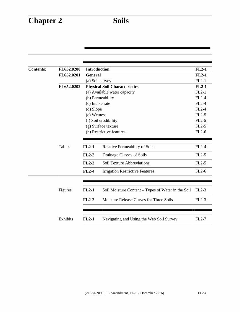
Contents: FL652.0200 Introduction FL2-1 FL652.0201 General FL2-1 (a) Soil survey FL2-1 FL652.0202 Physical Soil Characteristics FL2-1 (a) Available water capacity FL2-1 (b) Permeability FL2-4 (c) Intake rate FL2-4 (d) Slope FL2-4 (e) Wetness FL2-5 (f) Soil erodibility FL2-5 (g) Surface texture FL2-5 (h) Restrictive features FL2-6
Tables FL2-1 Relative Permeability of Soils FL2-4 FL2-2 Drainage Classes of Soils FL2-5 FL2-3 Soil Texture Abbreviations FL2-5 FL2-4 Irrigation Restrictive Features FL2-6
Figures FL2-1 Soil Moisture Content – Types of Water in the Soil FL2-3
FL2-2 Moisture Release Curves for Three Soils FL2-3
Exhibits FL2-1 Navigating and Using the Web Soil Survey FL2-7

Chapter 2 Soils Part 652 Irrigation Guide
FL2-1 (210-vi-NEH, FL Amendment, FL-16, December 2016)
FL652.0200 Introduction Plant response to irrigation is influenced by the physical condition, fertility, and biological status of the soil. Soil condition, texture, structure, depth, organic matter, bulk density, drainage, topography, fertility, and chemical characteristics all determine the extent to which a plant root system grows into and uses available moisture and nutrients in the soil. Many of these factors directly influence the soil’s ability to store, infiltrate, or upflux water delivered by precipitation or irrigation (including water table control). The irrigation system(s) used should match all or most of these conditions.
Many conditions influence the value of these factors. The actual value may vary from site to site on the same soil, season to season, and even throughout the season. It varies throughout the season depending on the type of farm and tillage equipment, number of tillage operations, residue management, crop type, water quality, and even water temperature.
Irrigated soils must have adequate surface and subsurface drainage. Internal drainage within the crop root zone can be either natural or from an installed subsurface drainage system.
This guide describes ways to interpret site conditions for planning and design decisions. Conduct actual field tests where necessary, to determine specific planning and design values for a specific field. Use evaluation results can to fine tune individual irrigation system operations and management.
FL652.0201 General
Soil consists of mineral and organic materials, covering much of the Earth’s surface. It contains living matter, air, and water, and can support vegetation. The soil functions as a storehouse for plant nutrients, as habitat for soil organisms and plant roots, and as a reservoir for water to meet evapotranspiration (ET) demands of plants. It contains and supplies water, oxygen, nutrients, and mechanical support for plant growth. Soil is a basic irrigation resource that determines how irrigation water should be managed. The
amount of water the soil can hold for plant use is determined by its physical and chemical properties. This amount determines the length of time that a plant can be sustained adequately between irrigation or rainfall events, the frequency of irrigation, and the amount and rate to be applied. Along with plant ET, it also determines the irrigation system capacity needed for desired crop yield and product quality. Knowledge of soils is essential for the efficient use of water for crop production. (a) Soil survey NRCS is responsible for leadership of the National Cooperative Soil Survey. Partners include other Federal, State, and local agencies and institutions. Soil survey data and interpretations have information that can be used for planning design, and management decisions for irrigation. Soil survey maps for the areas mapped in the state are available online through the NRCS Web Soil Survey (WSS), http://websoilsurvey.nrcs.usda.gov/app/. See Exhibit FL2-1 for instructions on how to use and access the NRCS WSS. Important physical and chemical characteristics of each soil type can be obtained from WSS. Some characteristics of these soils that are important to understanding soil-moisture plant relationships are discussed in this guide. They include but are not limited to, available water capacity, permeability, intake rate, slope, wetness (drainage and depth to water table), and surface texture.
FL652.0202 Physical Soil Characteristics (a) Available water capacity
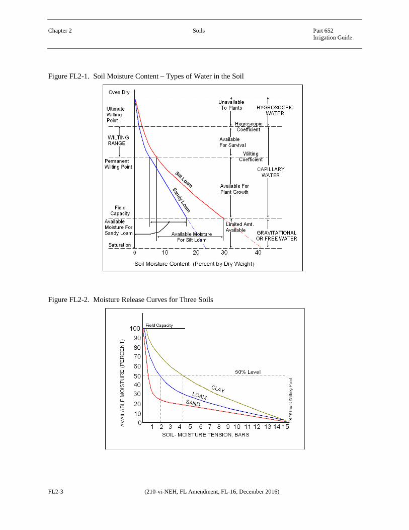
The available water capacity (AWC) of a soil is a measure of its capacity to make water available for plant growth. The AWC is the amount of water held between field capacity (FC) and the permanent wilting point (WP) as shown in Figure FL2-1. AWC is expressed as the water retained between 0.33 bar and 15 bar tension for fine to medium textured soils and between 0.10 bar and 15 bar for moderately coarse to very coarse textured soils. AWC of a soil is primarily related to the soil texture,
Chapter 2 Soils Part 652 Irrigation Guide
(210-vi-NEH, FL Amendment, FL-16, December 2016) FL2-2
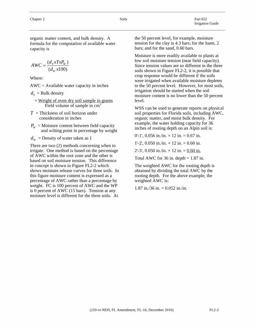
organic matter content, and bulk density. A formula for the computation of available water capacity is
)100()(
xdxTxPdAWC
W
Wb=
Where: AWC = Available water capacity in inches
bd = Bulk density = Weight of oven dry soil sample in grams
Field volume of sample in cm3
T = Thickness of soil horizon under consideration in inches
WP = Moisture content between field capacity and wilting point in percentage by weight
Wd = Density of water taken as 1 There are two (2) methods concerning when to irrigate. One method is based on the percentage of AWC within the root zone and the other is based on soil moisture tension. This difference in concept is shown in Figure FL2-2 which shows moisture release curves for three soils. In this figure moisture content is expressed as a percentage of AWC rather than a percentage by weight. FC is 100 percent of AWC and the WP is 0 percent of AWC (15 bars). Tension at any moisture level is different for the three soils. At
the 50 percent level, for example, moisture tension for the clay is 4.3 bars; for the loam, 2 bars; and for the sand, 0.60 bars. Moisture is more readily available to plants at low soil moisture tension (near field capacity). Since tension values are so different in the three soils shown in Figure FL2-2, it is possible that crop response would be different if the soils were irrigated when available moisture depletes to the 50 percent level. However, for most soils, irrigation should be started when the soil moisture content is no lower than the 50 percent level. WSS can be used to generate reports on physical soil properties for Florida soils, including AWC, organic matter, and moist bulk density. For example, the water holding capacity for 36 inches of rooting depth on an Alpin soil is: 0'-1', 0.056 in./in. × 12 in. = 0.67 in. 1'-2', 0.050 in./in. × 12 in. = 0.60 in. 2'-3', 0.050 in./in. × 12 in. = 0.60 in. Total AWC for 36 in. depth = 1.87 in. The weighted AWC for the rooting depth is obtained by dividing the total AWC by the rooting depth. For the above example, the weighted AWC is: 1.87 in./36 in. = 0.052 in./in.
Chapter 2 Soils Part 652 Irrigation Guide
FL2-3 (210-vi-NEH, FL Amendment, FL-16, December 2016)
Figure FL2-1. Soil Moisture Content – Types of Water in the Soil
Figure FL2-2. Moisture Release Curves for Three Soils

Chapter 2 Soils Part 652 Irrigation Guide
(210-vi-NEH, FL Amendment, FL-16, December 2016) FL2-4
(b) Permeability Permeability is the quality of soil that enables it to transmit air and water. It is independent of the viscosity of water. The permeability of a soil is based on the most restrictive layer in the soil. The relative permeability of soils is described in Table FL2-1.
Table FL2-1. Relative Permeability of Soils
Permeability Class Permeability Rate (in./hr.)
Very slow <0.06 Slow 0.06 - 0.2 Moderately slow 0.2 - 0.6 Moderate 0.6 - 2.0 Moderately rapid 2.0 - 6.0 Rapid 6.0 - 20.0 Very rapid >20
Permeability rates for Florida soils are shown as saturated hydraulic conductivity, Ksat (µm/sec) in the Soil Properties and Qualities tab in the Soil Physical Properties menu in WSS. These values can be converted to in./hr. for design purposes. (c) Intake rate Intake rate is a measure of soil's capacity to absorb irrigation water from the surface, and move it into and through the soil profile. It is an expression of several factors, including infiltration and percolation. The term, “basic intake rate” is the rate at which water percolates into soil after infiltration has decreased to a low and nearly constant value. Infiltration is the downward flow of water from the surface through the soil. Water enters the soil through pores, cracks, worm and decayed root holes, and cavities introduced by tillage. Surface sealing or crusting will restrict infiltration. Percolation is the movement of water through the soil profile. In order for irrigation water to be effective in replenishing the soils water supply, it must be able to move through the profile, or percolate, to a predetermined irrigation depth. The percolation rate is governed by the permeability of the soil or its hydraulic conductivity. Both terms are used to describe the ease with which soil transmits water and air.
The amount of moisture already in the soil greatly influences the rate at which water enters the soil. The soil takes in and absorbs irrigation water rapidly when water is first applied to the field surface. As the irrigation application continues, the surface soil gradually becomes saturated and the intake rate decreases until it reaches a nearly constant value. The intake rate of any soil is limited by any restriction to the flow of water into or through the soil profile. The soil layer with the lowest transmission rate, either at the surface or directly below it, usually determines intake rate. The most important general factors that influence intake rate are the physical properties of the soil and, in sprinkler irrigation, the plant cover. But for any given soil, other factors may affect the intake rate. Since so many factors affect the water intake, it is not surprising that it varies so much among soils. Furthermore, the intake characteristics of a given field vary from place to place, from irrigation to irrigation, and from season to season. The intake characteristics that must be considered in sprinkler irrigation design differ from those for surface methods. Actual measured intake rates are unavailable for Florida soils. Intake rates are estimates based on the characteristics of the top two feet of the soil. If the soil has a water table within two feet of the surface, the intake rate is assigned as if the soil is drained. Typically, for a well-drained soil, the intake rate is estimated at 3.0 in./hr. For other soil types, consult with a soil scientist to determine an intake rate value. (d) Slope Slope refers to the incline of the surface of the soil area. A simple, or single, slope is defined by its gradient, shape, and length. Slopes may also be defined as single or complex depending on the nature of the area. Soil slope is expressed in terms of percentage. It is the difference in elevation in feet for each 100-feet horizontal. A soil with a slope of 45 degrees is a slope of 100 percent since the difference in elevation of two points 100 feet apart horizontally is 100 feet. Soil slope and intake rate are important factors in determining runoff.

Chapter 2 Soils Part 652 Irrigation Guide
FL2-5 (210-vi-NEH, FL Amendment, FL-16, December 2016)
(e) Wetness Wetness is expressed as a function of soil drainage and depth to water table. Internal soil drainage is a natural condition of the soil that refers to the frequency and duration of periods when the soil is free of saturation. For example, in well drained soils the water is removed readily but not rapidly; in poorly drained soils the root zone is waterlogged for long periods unless artificially drained. In excessively drained soils water is removed so completely that most plants suffer from lack of water. Except for very young soils, the natural soil drainage conditions are reflected in soil morphology. The drainage class shown for the various soils is the drainage that existed during the development of the soil as opposed to altered drainage as the result of artificial drainage. Table FL2-2 lists classes (with their abbreviations) to define natural soil drainage in broad terms.
Table FL2-2. Drainage Classes of Soils
Drainage Class Abbreviation Very poorly drained VP Poorly drained P Somewhat poorly drained
SP
Moderately well drained
MW
Well drained W Somewhat excessively drained
SE
Excessively drained E
High water table is defined as the top of the zone of saturation at the highest average depth elevation during the wettest season. It persists in the soil for more than a few days. The depth to water table is given for each soil in the Water Features report on WSS on the Soil Properties and Qualities Tab in the Water Features menu. Refer to the NEH Part 623.0208 Water Table Contribution for more in depth discussion of how a high water can supply part of the crop evapotranspiration requirements. The presence of a saturated zone (water table) is a prime factor in determining soils adaptability for irrigation. If a saturated zone is at a shallow depth, a hazard always exists that heavy rains
can raise the saturated zone to depths shallow enough to slow or inhibit plant growth. Thus, soils with wetness limitations are given different considerations than other similar soils that do not have a wetness limitation. (f) Soil erodibility The erodibility of a soil should be considered in the planning stage of any irrigation system. The rate and method at which water is applied should be controlled so that it will not cause excessive runoff and erosion. Soil erodibility hazard for surface irrigation is based on soil structure, permeability, percent organic matter, percent silt and very fine sand, and field slope. The erosion factor, K indicates the susceptibility of a soil to sheet and rill erosion by water. Erosion factors (Kw, Kf, and T) are displayed in the Soil Properties and Qualities tab in the Soil Erosion Factors menu in WSS for all soil series. (g) Surface texture Surface texture is displayed in the Soil Properties and Qualities tab in the Soil Physical Properties menu in WSS, for all soil series. The abbreviations in Table FL2-3 are used to describe soil texture. Table FL2-3. Soil Texture Abbreviations
Soil Texture Abbreviation Sand S Coarse sand COS Fine sand FS Loamy coarse sand LCOS Loamy sand LS Loamy fine sand LFS Coarse sandy loam COSL Sandy loam SL Fine sandy loam FSL Very fine sandy loam VFSL Loam L Silt loam SIL Clay loam CL Sandy clay loam SCL Silty clay loam SICL Silty clay SIC Sandy clay SC Clay C Muck or peat MK or PT
Chapter 2 Soils Part 652 Irrigation Guide
(210-vi-NEH, FL Amendment, FL-16, December 2016) FL2-6
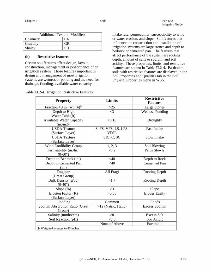
Additional Textural Modifiers Channery CN Gravelly GR Shaley SH
(h) Restrictive features Certain soil features affect design, layout, construction, management or performance of an irrigation system. Those features important in design and management of most irrigation systems are wetness or ponding and the need for drainage, flooding, available water capacity,
intake rate, permeability, susceptibility to wind or water erosion, and slope. Soil features that influence the construction and installation of irrigation systems are large stones and depth to bedrock or cemented pan. The features that affect performance of the system are rooting depth, amount of salts or sodium, and soil acidity. These properties, limits, and restrictive features are shown in Table FL2-4. Particular soils with restrictive features are displayed in the Soil Properties and Qualities tab in the Soil Physical Properties menu in WSS.
Table FL2-4. Irrigation Restrictive Features
Property Limits Restrictive Factors
Fraction >3 in. (wt. %)1/ >25 Large Stones Depth to High
Water Table(ft) <3 Wetness Ponding
Available Water Capacity (in./in.)1/
<0.10 Droughty
USDA Texture (Surface Layer)
S, FS, VFS, LS, LFS, VFSL
Fast Intake
USDA Texture (Surface Layer)
SIC, C, SC Slow Intake
Wind Erodibility Group 1, 2, 3 Soil Blowing Permeability (in./hr.)
(0-60") <0.2 Percs Slowly
Depth to Bedrock (in.) <40 Depth to Rock Depth to Cemented Pan
(in.) <40 Cemented Pan
Fragipan (Great Group)
All Fragi Rooting Depth
Bulk Density (g/cc) (0-40")
>1.7 Rooting Depth
Slope (%) >3 Slope Erosion Factor (K)
(Surface Layer) >0.35 Erodes Easily
Flooding Common Floods Sodium Absorption Ratio (Great
Group) >12 (Natric, Halic) Excess Sodium
Salinity (mmho/cm) >8 Excess Salt Soil Reaction (pH) <3.6 Too Acidic
------------- None of Above Favorable 1/ Weighted average to 40 inches.
Chapter 2 Soils Part 652 Irrigation Guide
(210-vi-NEH, FL Amendment, FL-16, December 2016) FL2-7
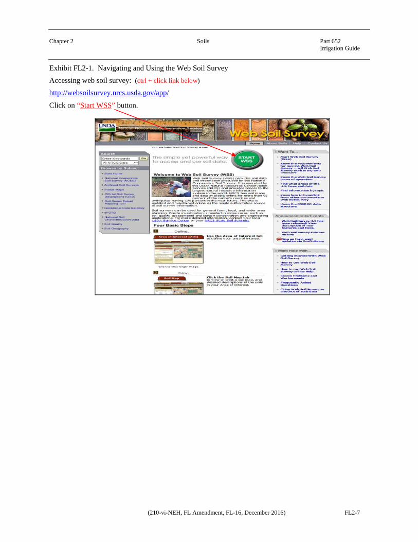
Exhibit FL2-1. Navigating and Using the Web Soil Survey Accessing web soil survey: (ctrl + click link below)
http://websoilsurvey.nrcs.usda.gov/app/
Click on “Start WSS” button.
Chapter 2 Soils Part 652 Irrigation Guide
(210-vi-NEH, FL Amendment, FL-16, December 2016) FL2-8
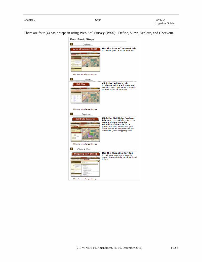
There are four (4) basic steps in using Web Soil Survey (WSS): Define, View, Explore, and Checkout.
Chapter 2 Soils Part 652 Irrigation Guide
(210-vi-NEH, FL Amendment, FL-16, December 2016) FL2-9
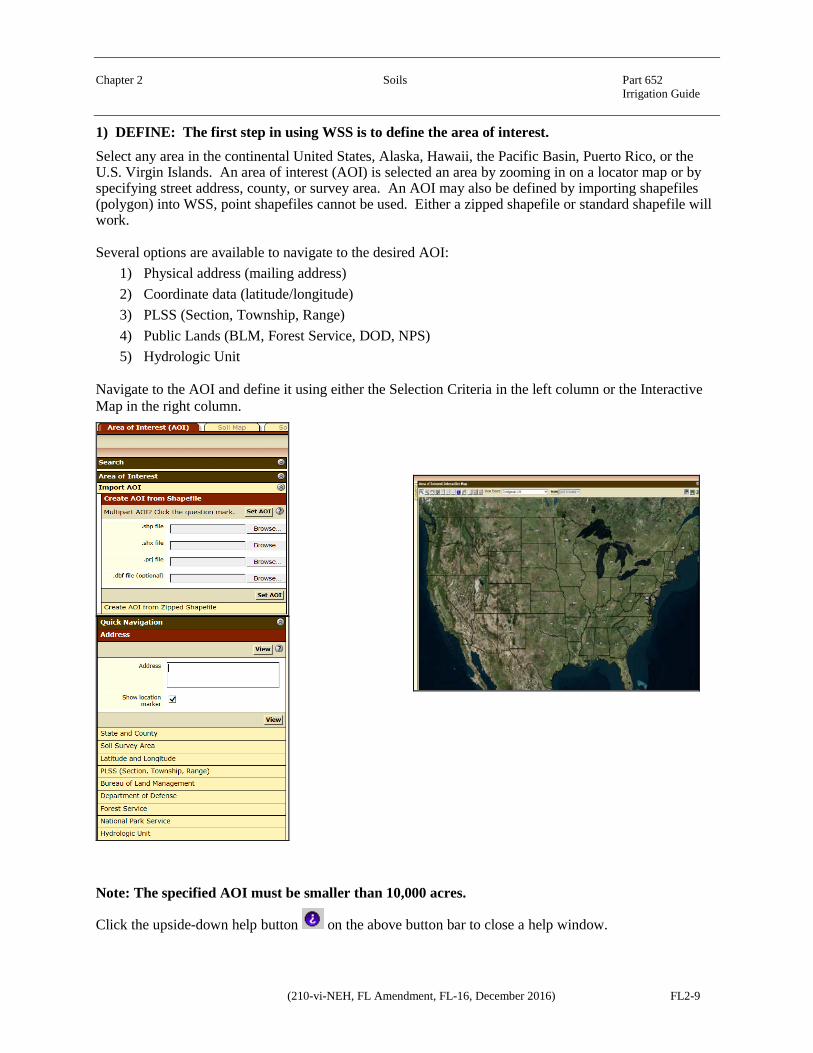
1) DEFINE: The first step in using WSS is to define the area of interest. Select any area in the continental United States, Alaska, Hawaii, the Pacific Basin, Puerto Rico, or the U.S. Virgin Islands. An area of interest (AOI) is selected an area by zooming in on a locator map or by specifying street address, county, or survey area. An AOI may also be defined by importing shapefiles (polygon) into WSS, point shapefiles cannot be used. Either a zipped shapefile or standard shapefile will work.
Several options are available to navigate to the desired AOI: 1) Physical address (mailing address) 2) Coordinate data (latitude/longitude) 3) PLSS (Section, Township, Range) 4) Public Lands (BLM, Forest Service, DOD, NPS) 5) Hydrologic Unit
Navigate to the AOI and define it using either the Selection Criteria in the left column or the Interactive Map in the right column.
Note: The specified AOI must be smaller than 10,000 acres.
Click the upside-down help button on the above button bar to close a help window.
Chapter 2 Soils Part 652 Irrigation Guide
(210-vi-NEH, FL Amendment, FL-16, December 2016) FL2-10
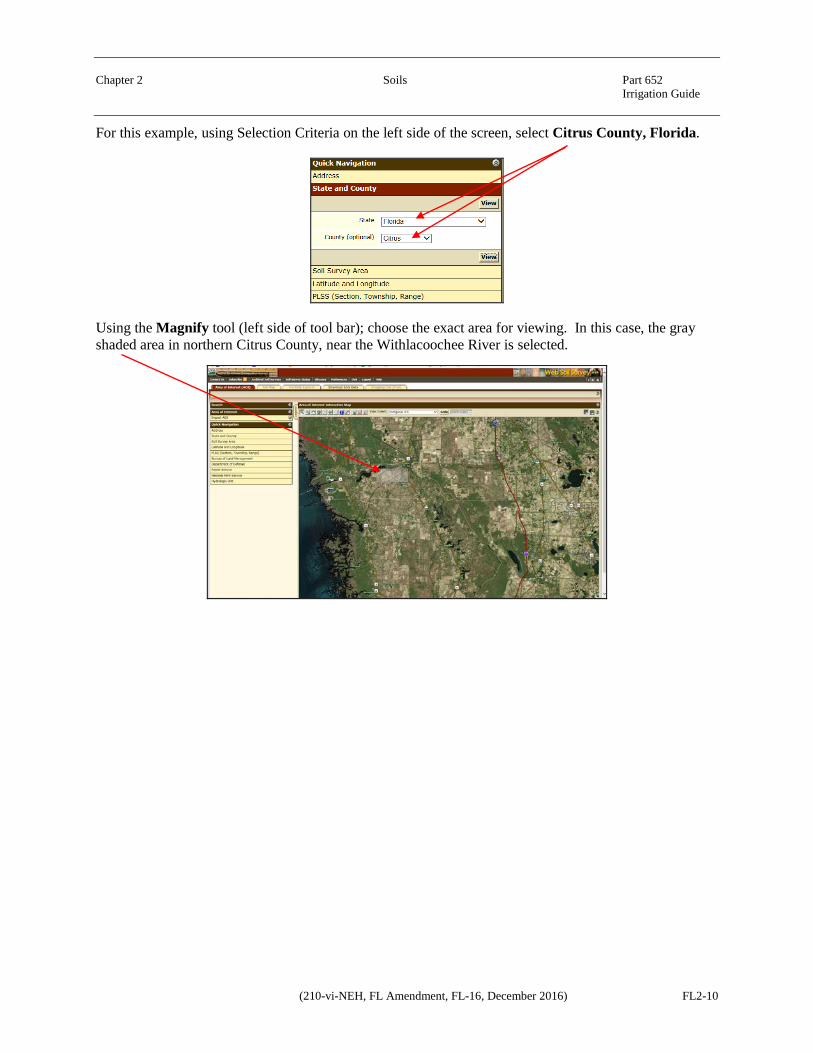
For this example, using Selection Criteria on the left side of the screen, select Citrus County, Florida.
Using the Magnify tool (left side of tool bar); choose the exact area for viewing. In this case, the gray shaded area in northern Citrus County, near the Withlacoochee River is selected.

Chapter 2 Soils Part 652 Irrigation Guide
FL2-11 (210-vi-NEH, FL Amendment, FL-16, December 2016)
To define the AOI, use the Interactive Map, and select the button at the top of the page with the red rectangular AOI label. This selection will show a crosshair that will allow you to select the preferred area in rectangular shape.
The AOI can also be defined by irregular shaped polygons by using the AOI button to the right of the rectangular AOI label button.
The defined AOI will be displayed in a crosshatched pattern and the soil data within the AOI is ready for viewing.

Chapter 2 Soils Part 652 Irrigation Guide
(210-vi-NEH, FL Amendment, FL-16, December 2016) FL2-12
2) VIEW: The second step in using WSS is to look at the Soil Map for the AOI. The soil map shows the map unit symbols in the AOI.
Available maps in WSS consist of aerial photography overlain by lines that indicate the boundaries of the various types of soil.
The Map Unit Legend Summary table in the left column displays the name and map symbol of each map unit, the percent of each map unit in the AOI, and the total acreage of each map unit in the AOI.
Soil Map Tab
Chapter 2 Soils Part 652 Irrigation Guide
FL2-13 (210-vi-NEH, FL Amendment, FL-16, December 2016)
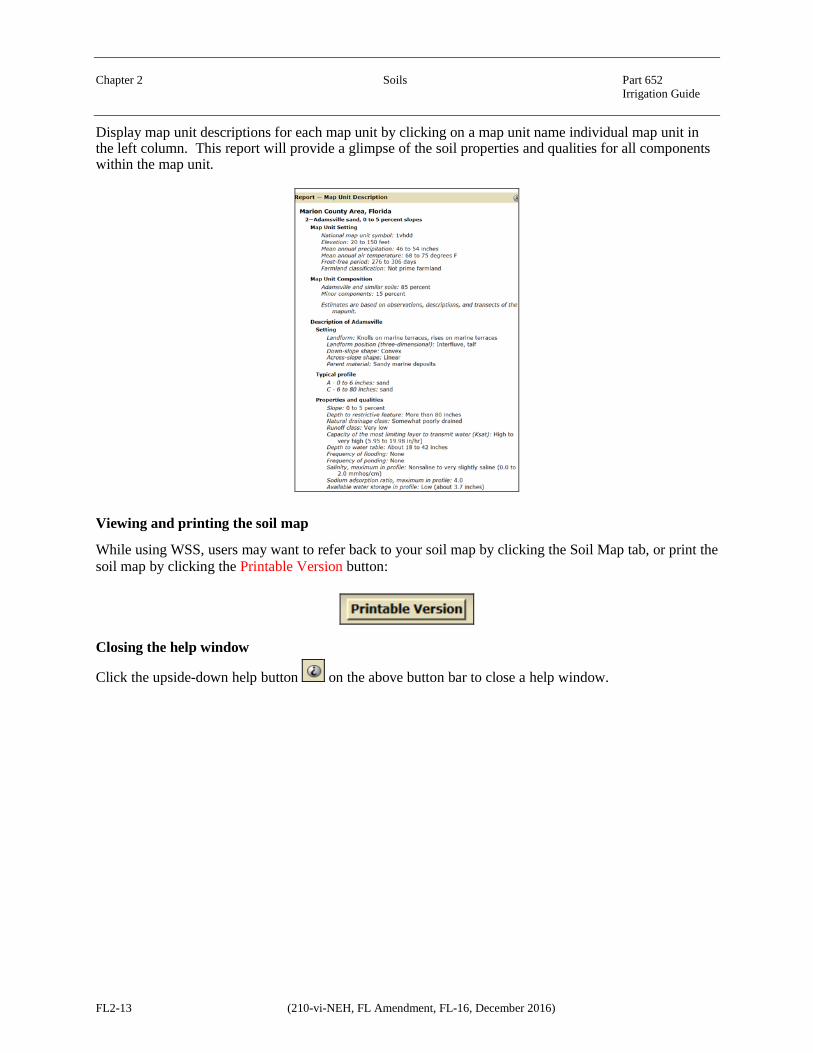
Display map unit descriptions for each map unit by clicking on a map unit name individual map unit in the left column. This report will provide a glimpse of the soil properties and qualities for all components within the map unit.
Viewing and printing the soil map
While using WSS, users may want to refer back to your soil map by clicking the Soil Map tab, or print the soil map by clicking the Printable Version button:
Closing the help window
Click the upside-down help button on the above button bar to close a help window.
Chapter 2 Soils Part 652 Irrigation Guide
(210-vi-NEH, FL Amendment, FL-16, December 2016) FL2-14
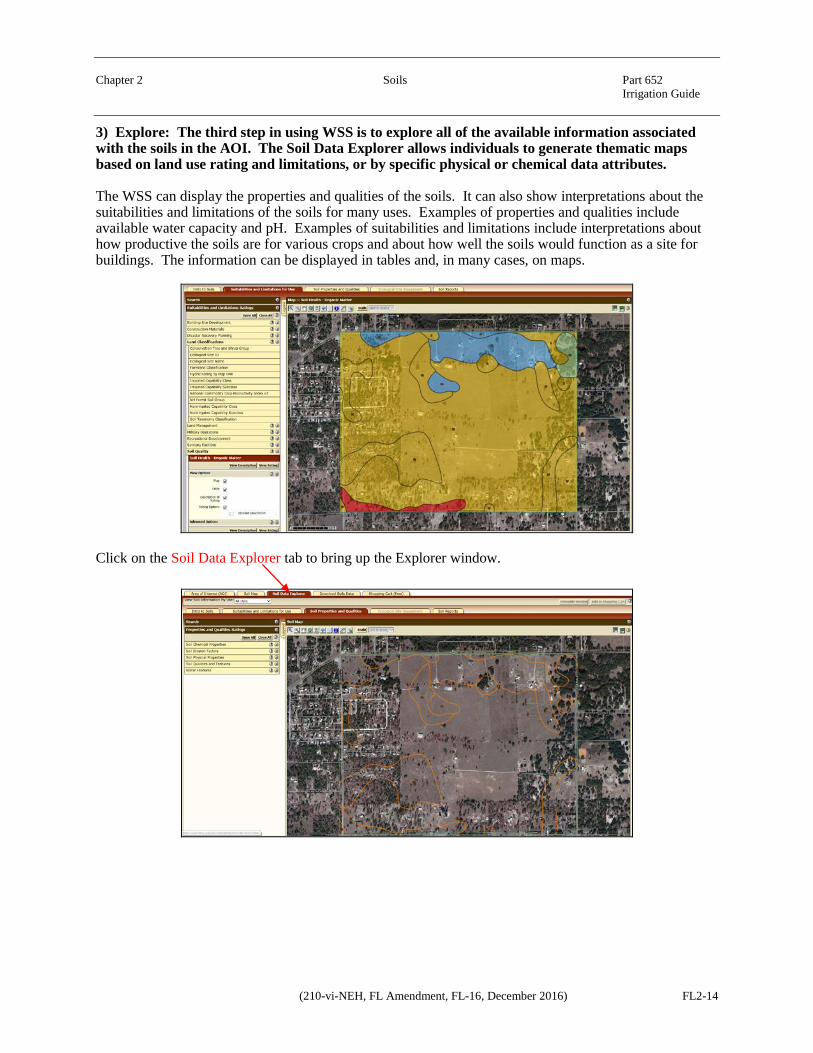
3) Explore: The third step in using WSS is to explore all of the available information associated with the soils in the AOI. The Soil Data Explorer allows individuals to generate thematic maps based on land use rating and limitations, or by specific physical or chemical data attributes.
The WSS can display the properties and qualities of the soils. It can also show interpretations about the suitabilities and limitations of the soils for many uses. Examples of properties and qualities include available water capacity and pH. Examples of suitabilities and limitations include interpretations about how productive the soils are for various crops and about how well the soils would function as a site for buildings. The information can be displayed in tables and, in many cases, on maps.
Click on the Soil Data Explorer tab to bring up the Explorer window.

Chapter 2 Soils Part 652 Irrigation Guide
FL2-15 (210-vi-NEH, FL Amendment, FL-16, December 2016)
Finding relevant information
View soils information about a specific use, such as cropland, forestland, rangeland, urban development, and so forth, by selecting the View Soil Information By Use drop-down list.
For a particular type of soils information, use the Soil Data Explorer's inner tabs:
Depending on the specific use selected in the drop-down list, the tabs and the contents of the tabs will change. For example, click on the Soil Properties and Qualities tab.
Chapter 2 Soils Part 652 Irrigation Guide
(210-vi-NEH, FL Amendment, FL-16, December 2016) FL2-16
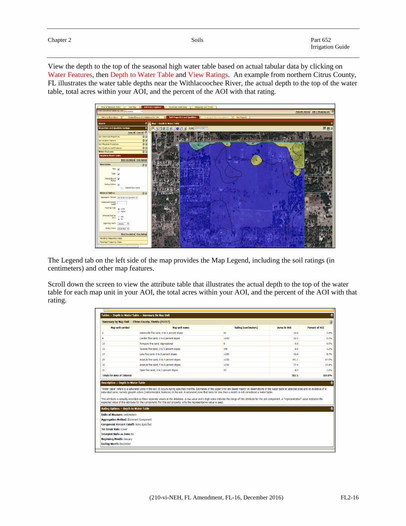
View the depth to the top of the seasonal high water table based on actual tabular data by clicking on Water Features, then Depth to Water Table and View Ratings. An example from northern Citrus County, FL illustrates the water table depths near the Withlacoochee River, the actual depth to the top of the water table, total acres within your AOI, and the percent of the AOI with that rating.
The Legend tab on the left side of the map provides the Map Legend, including the soil ratings (in centimeters) and other map features.
Scroll down the screen to view the attribute table that illustrates the actual depth to the top of the water table for each map unit in your AOI, the total acres within your AOI, and the percent of the AOI with that rating.

Chapter 2 Soils Part 652 Irrigation Guide
FL2-17 (210-vi-NEH, FL Amendment, FL-16, December 2016)
Other choices for thematic maps for Suitabilities and Limitations include Building Site Development for Shallow Excavations or Commercial Buildings, Cropland Productivity, Forestland Management, Hydric Soils Rating, Land Capability Classification, among others. Display Soil Properties and Qualities and Chemical attributes thematically such as, Cation Exchange Capacity, pH, Calcium Carbonate Equivalent, OR Physical Properties, such as Available Water Capacity, Organic Matter, Saturated Hydraulic Conductivity, Percent Sand, Silt, and Clay.
All maps can be printed locally for use.
After generating a specific report (soil properties such as, depth to water table, drainage class or Suitabilities such as Dwellings with basements or Septic Tanks), the report must added to the Shopping Cart. To add items to the shopping cart, click the Add to Shopping Cart button. After generating the report, it is recommended that items are added to the shopping cart because items are not saved until the end of the process.
Click on the Shopping Cart (Free) tab to bring up the Explorer window.
First, enter a Subtitle and choose Map Options, if desired, in the Report Properties panel.
Chapter 2 Soils Part 652 Irrigation Guide
(210-vi-NEH, FL Amendment, FL-16, December 2016) FL2-18
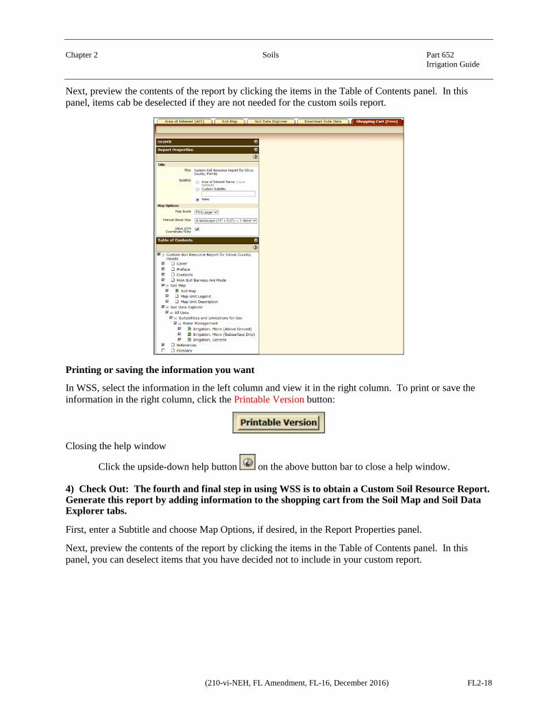
Next, preview the contents of the report by clicking the items in the Table of Contents panel. In this panel, items cab be deselected if they are not needed for the custom soils report.
Printing or saving the information you want
In WSS, select the information in the left column and view it in the right column. To print or save the information in the right column, click the Printable Version button:
Closing the help window
Click the upside-down help button on the above button bar to close a help window.
4) Check Out: The fourth and final step in using WSS is to obtain a Custom Soil Resource Report. Generate this report by adding information to the shopping cart from the Soil Map and Soil Data Explorer tabs.
First, enter a Subtitle and choose Map Options, if desired, in the Report Properties panel.
Next, preview the contents of the report by clicking the items in the Table of Contents panel. In this panel, you can deselect items that you have decided not to include in your custom report.

Chapter 2 Soils Part 652 Irrigation Guide
FL2-19 (210-vi-NEH, FL Amendment, FL-16, December 2016)
Finally, click the Check Out button and select a delivery method.

Chapter 2 Soils Part 652 Irrigation Guide
(210-vi-NEH, FL Amendment, FL-16, December 2016) FL2-20
Custom printable reports are available for immediate download or downloaded later. There are size requirements that require large reports to be downloaded.
For detailed help information, click the question-mark icon in the specific panel or dialog.