central regional logistics council … the crossroads: driving central indiana’s logistics ......
TRANSCRIPT

CENTRAL REGIONAL LOGISTICS COUNCIL
OCTOBER 2015
STRENGTHENING THE CROSSROADS: DRIVING CENTRAL INDIANA’S LOGISTICS INDUSTRY

Conexus Indiana is the state’s advanced manufacturing
and logistics initiative, dedicated to making Indiana
a global leader in these high-growth, high-tech industries.
The mission of CILC is to work with a sense of urgency to
strengthen the logistics sector in Indiana by identifying and
acting on concrete opportunities for enhancement, which
better positions the State to grow existing business, attract
new business, and thereby create new jobs.

I
CONEXUS INDIANA CENTRAL REGIONAL LOGISTICS COUNCIL
CHAIR
*Mark DeFabisPresident & CEOIntegrated Distribution Services, Inc.Plainfield
*Kevin AdamsVP, OperationsOHL Contract LogisticsPlainfield(Workforce Development Chair)
Stephen AlexanderCEO/Chief ArchitectRees AlexanderIndianapolis
*Timothy AlmackPartnerKatz, Sapper & Miller, LLPIndianapolis
Bob BabcockSVP, Operations and Business DevelopmentIndiana Rail Road CompanyIndianapolis
Alex BluesteinChief Global Rep., Business DevelopmentOscar WinskiLafayette
John BrandPresidentButler Fairman & Seufert Civil EngineersIndianapolis
*Mike BroughtonAdvisor, Global LogisticsEli Lilly and CompanyIndianapolis
Mark BrownGeneral ManagerCentral Indiana & Western RailroadLapel
Keith BucklewPrincipal & Freight Discipline LeaderCDM SmithIndianapolis
Jeff CastellSenior Managing Director, PrincipalDTZIndianapolis
*Greg ChaneyExecutive Director, Global Supply ChainAllison TransmissionIndianapolis
Dan CorcoranVP, Midwest RegionContainer Port GroupIndianapolis
Beth CriderDivision Mgr., LogisticsFirestone Building Products, Co.Indianapolis
Andrew ElsenerPresidentSpot FreightIndianapolis
*Dennis FaulkenbergPresident & CEOAppianIndianapolis
Phillip GerrianSenior VPFraley & Schilling, Inc.Rushville
Nate GhaimPresident & CEOHanzo Logistics, Inc.Plainfield
Brian GildeaExecutive DirectorDevelop IndyIndianapolis
Rodney GrahamCFOCNG Source, Inc.Indianapolis
Bob GrzegorekPlant Manager - IndianapolisCoregisticsWhitestown
Brad HastingsSenior VPTippmann Group/ Interstate WarehousingFranklin
Greg HennekeExecutive VPAmerican Structurepoint, Inc.Indianapolis
*Nick HoaglandCOOBackhaul DirectIndianapolis

II
John HongLeader- North American Logistics & International Trade Operations Dow AgroSciencesIndianapolis
Andrea HopperSenior Dir., Industrial Advisory ServicesSummit Realty GroupIndianapolis
*Mark HosfeldVP, Leasing & DevelopmentDuke Realty Corp.Indianapolis
Michael HuberPresident & CEOIndy ChamberIndianapolis
Jim HumphreyVP/COO, Commercial ServicesGoodwill Industries of Central Indiana, Inc.Indianapolis
Paul HuncklerRegional Account ManagerDematic CorporationWestfield
Maeghan HurleyPresidentMKM Distribution ServicesIndianapolis
Layth HussainDir., Operations AmericasBelkinPlainfield
Jennifer Coulter-LissmanGeneral ManagerTOC Logistics International, LLCIndianapolis
*Cathy LanghamPresidentLangham LogisticsIndianapolis
Patrick LindleyExecutive Managing PartnerDTZIndianapolis
Jim LongestPresidentBeam, Longest and NeffIndianapolis
Jennifer MarcumCEOSentry LogisticsIndianapolis
*Sean MaroneyVP, Market Unit Field OperationsCoca-Cola Refreshments USA, Inc.Indianapolis
David MartinVP, Global SourcingOerlikon FairfieldLafayette
John McCaneExecutive DirectorRush County ECDCRushville
Betsy McCawCOOCICPIndianapolis
David McDougallVice PresidentHNTB CorporationIndianapolis
John McDowellPresidentMulti Modal Transportation LogisticsWhitestown
Steve McGillDirector of Business DevelopmentTonn and Blank ConstructionIndianapolis
Tim MillerProject ManagerLochmueller GroupIndianapolis
Andi MontgomeryOwner & Vice PresidentMontgomery AviationZionsville
Craig MooreDirector, Corporate DevelopmentCitizens Energy GroupIndianapolis
Dean MunnTechnical VP, Systems Planning DivisionCorradino, LLCIndianapolis
*Kevin MurrayVP, Supply ChainRed GoldElwood
Mark NicastroDirector- Indianapolis Distribution CenterCVS PharmacyIndianapolis
Brad OrtmanOperations ManagerKokomo Grain Co, Inc.Kokomo
Chet ParsonsPrincipalPCS EngineersAvon
John PaughCEOCarter LogisticsAnderson(Infrastructure, Co-Chair)
Dan PetersonVP, Industry & Government AffairsCook Group, Inc.Bloomington
III
*Dawn ReplogleVP, Area Interface Mgr. – Transportation, DCS AmericasURS CorporationIndianapolis
Ed RounsavilleGeneral ManagerGENCO/BDPlainfield
*John RoweManaging DirectorCargo Services, Inc.Indianapolis
Bruno SanziVP, Business Dev., Contract ServicesNorbert Dentressangle GroupPlainfield
Thomas J. ScimecaManager, Global Logistics & Customs AdministrationAllison TransmissionIndianapolis
*Mark SellPresident & CEOMD LogisticsPlainfield
*Mark ShublackAttorney at LawIce MillerIndianapolis
Tim SiddiqPresident & CEOMerchandise Warehouse Co., Inc.Indianapolis
(Public Policy, Co-Chair)
Steve SmithMJ Insurance, Inc.Indianapolis
(Infrastructure, Co-Chair)
Roger StephensClient Service ManagerRQAWIndianapolis
Jake SturmanSenior VPJLL America, Inc.Indianapolis
Shelby SwangoArea Manager/VPParsons BrinckerhoffIndianapolis
Michael TaylorPresidentIntegrated Services, Inc.Kokomo
*Phil TerryCEOMonarch Beverage Company, Inc.Indianapolis
Jim TiltonDirector, MaterialsDraper, Inc.Spiceland
*Jim WadeVice PresidentCHA Companies
Indianapolis
Amy WaggonerClient Services ManagerLochmueller GroupIndianapolis
Spence WendelinPresidentWabash Central Railway, Big Four Terminal Railroad and C&NCCorydon
Paul WillVice Chairman, President & CEOCeladon Group, Inc.
Indianapolis
*Doug WilliamsPresidentVenture Logistics, Inc.Indianapolis
Mark WrittSenior VP, Industrial ServicesCB Richard Ellis, Inc.Indianapolis
Bob WuVP, Production Control, Materials Logistics and Information SystemsSubaru of Indiana Automotive, Inc.Lafayette
* Conexus Indiana Logistics Council Member
IV

V
Strengthening the Crossroads: Driving Central Indiana’s Logistics Industry was created by leading members of the logistics users community throughout Central Indiana.
The logistics community, composed of service providers from the four modes of transportation (air, rail, truck and water) as well as other logistics stakeholders including users of logistics services such as advanced manufacturing, warehouse/distribution companies, and infrastructure design and construction companies, gathered and agreed unanimously on the key deliverables and priorities for Central Indiana. The Conexus Indiana Logistics Council, partnering with Central Indiana Corporate Partnership, regional economic development organizations and chambers of commerce in Central Indiana created the Central Regional Logistics Council (CRLC) and was the catalyst in creating the forum of logistics executives to discuss issues affecting their industry and to build a common agenda across all logistics sectors, including both private and public. We believe that by aligning priorities in the areas of infrastructure, public policy and workforce development, Central Indiana will be able to maximize short-term and long-term success for the logistics industry in this region.
Strengthening the Crossroads: Driving Central Indiana’s Logistics Industry was prepared from the input of a broad cross section of logistics providers and users, ensuring that the priorities identified for the Central Region will enhance the environment for growth of existing companies, create a more attractive business climate to attract companies to Indiana, and create high paying jobs for the citizens in this region.
Implementation by both the public and private sectors of the strategies, goals and tactics contained in this plan will continue to grow our region’s reputation as a logistics hub and ensure the region’s leadership in logistics well into the future.
The countless hours and dedication of the volunteer executives from CRLC provide the Conexus Indiana Logistics Council (CILC), the Indiana Department of Transportation (INDOT), the Ports of Indiana, the Indiana Economic Development Corporation, and the regional and local economic groups and chambers of commerce with a strong foundation to make the goals outlined in this plan a reality. The talented and dedicated staff of Conexus Indiana together with the regional and local economic development groups and chambers of commerce will carry out these initiatives and drive the implementation of the tactics necessary to ensure the plan’s success.
We look forward to continuing conversations on future opportunities that will continue to enhance the logistics sector in the Central Region, and we will continue our work by updating the plan on a regular basis to ensure that it is as dynamic as the logistics industry itself.
Respectfully,
Mark DeFabis President & CEO, Integrated Distribution Services, Inc.Chair, Central Regional Logistics Council
LETTER FROM CONEXUSCENTRAL REGIONAL LOGISTICS COUNCIL CHAIR

VI
TABLE OF CONTENTS
EXECUTIVE SUMMARY .....................................................................................1
PROBLEM STATEMENT ..............................................................................................1
MISSION STATEMENT .............................................................................................1
OBJECTIVES ............................................................................................................2
LOGISTICS STRATEGIES ....................................................................................3
INFRASTRUCTURE GOALS .........................................................................................3
PUBLIC POLICY GOALS .............................................................................................4
PUBLIC AWARENESS GOALS .....................................................................................4
WORKFORCE DEVELOPMENT GOALS ........................................................................4
IMPLEMENTATION TACTICS ............................................................................5
INFRASTRUCTURE .....................................................................................................5Regional Tactics .....................................................................................................5 Local Tactics ........................................................................................................10
PUBLIC POLICY ......................................................................................................68
PUBLIC AWARENESS ..............................................................................................69
WORKFORCE DEVELOPMENT .................................................................................69
LOGISTICS MARKET ANALYSIS ....................................................................70
TRANSPORTATION MODE SWOT ANALYSIS .............................................................70
PUBLIC POLICY SWOT ANALYSIS .............................................................................74
WORKFORCE DEVELOPMENT SWOT ANALYSIS ........................................................77
PUBLIC AWARENESS SWOT ANALYSIS .....................................................................78
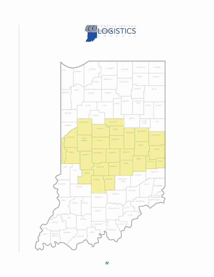
CENTRAL REGION INFRASTRUCTURE DATA ...............................................................79

1
The Conexus Indiana Central Regional Logistics Council (CRLC) is a forum of 76 logistics executives and thought leaders from throughout Central Indiana representing the following logistics sectors: air, infrastructure, rail, trucking, warehousing/distribution, waterborne, advanced manufacturing and services firms. Logistics users are manufacturers, distributors/warehousing, and third-party providers.
CRLC is working to:
◆◆ Enhance the environment for companies in advanced manufacturing and logistics to grow their business, taking advantage of Indiana’s position at the heart of the global supply chain;
◆◆ Create a more attractive environment for manufacturing and logistics companies to relocate to or expand in the Central Region, thereby creating jobs and increasing State and local revenue; and
◆◆ Create high paying jobs for Hoosiers – the average wage of Indiana manufacturing and logistics jobs is more than 33% higher than the State’s median income.
PROBLEM STATEMENTThe Central Region’s transportation network has opportunities for improvement due to transportation “bottlenecks,” lack of direct rail service, underutilized air facilities with little international freight movement, lack of efficient mode-to-mode connectivity (e.g. road to rail, road to water, road to air, rail to water), a decaying lock and dam infrastructure, and lack of dredging that prohibits barges/ships to maximize capacity. This disconnect has created higher costs, potential environmental impacts, inefficient freight movement, loss of productivity for Central Region business, and safety impacts.
MISSION STATEMENTThe mission of the Central Regional Logistics Council is to work to provide logistics excellence in Central Indiana through the development of infrastructure, public policy, public awareness, and workforce development to promote logistics competitiveness for the hub of the “Crossroads of America” by driving economic development and business growth.
EXECUTIVE SUMMARY: CENTRAL REGIONAL LOGISTICS COUNCIL

2
OBJECTIVES
1. Executive Forum: Provide a forum for Central Region logistics executives to discuss issues affecting the industry;
2. Infrastructure: Develop a comprehensive plan to strengthen the Central Region’s public and private logistics infrastructure;
3. Public Awareness: Develop paid and earned media to promote the sector;
4. Public Policy: Identify State and Federal public policy areas that impact the logistics industry and work with State and Federal thought leaders from government, academia and associations to enhance the sector;
5. Workforce Development: Develop and implement strategies to build the human capital needed to support the growing demand for logistics services through innovative workforce programs in the Central Region.

3
◆◆ Increase the flow of goods originating, terminating, and adding value within the Central Region over the next five years, thereby creating an increase of net new jobs and growing the logistics sector.
◆◆ Provide a broad-based forum, consisting of Central Region business executives throughout the logistics industry, for collectively vetting critical relevant logistics public policy issues of commonality, therefore optimizing the business climate.
◆◆ Strengthen and grow the logistics qualified workforce in the Central Region by creating portable skills curricula leading to academic degrees/certifications that will increase the pipeline of qualified workers over the next five years.
◆◆ Increase the public’s awareness of the importance of the logistics industry on the Central Region’s economy.
INFRASTRUCTURE GOALS
1. Reduce bottlenecks in the Central Region to improve the reliability and efficiency of freight movement leading to less congestion, reduced infrastructure repairs, and lower emissions.
2. Ensure global access by connecting Central Region cities based on impact and potential to Interstate-like access.
3. Create better connectivity of Indiana’s water ports via roads and rail modes and improve the reliability and efficiency of water freight movement to and from the Central Region.
4. Develop a fast and efficient process for unplanned economic development infrastructure needs.
5. Develop and implement transportation networks that provide direct rail, truck access and air cargo expansion leading to the improvement and establishment of multimodal and intermodal service and air cargo facilities.
LOGISTICS STRATEGIES

4
PUBLIC POLICY GOALS
1. Ensure State and Federal Government do not legislate or regulate barriers to the safe, efficient and innovative movements of goods and resources that are necessary to support the growth of the logistics sector.
2. Ensure State and Federal Government provide the necessary funding for the public infrastructure needed to support the efficient and cost effective operation of Indiana’s logistics sector.
3. Ensure CRLC is recognized by governmental entities as a resource of first resort and the voice for the logistics industry.
PUBLIC AWARENESS GOALS
1. Develop brand awareness of CRLC.
2. Create general public understanding of logistics by ensuring that the population has a basic understanding of logistics.
3. Increase the perception of the need to improve/expand Indiana’s infrastructure.
4. Highlight Indiana’s logistics companies by bringing awareness to their products and services.
5. Increase the public’s understanding of the positive impact of global trade on Indiana’s economy and jobs.
WORKFORCE DEVELOPMENT GOALS
1. Increase the skill levels of the Central Region’s logistics workers through workforce education programs.
2. Increase the upward mobility and job prospects of current and future Central Region logistics workers.

5
REGIONAL TACTICS IN SUPPORT OF ACHIEVING CRLC INFRASTRUCTURE GOALS
◆ REGIONAL TACTICS IN SUPPORT OF ACHIEVING AVIATION GOALS
◆◆ Air Cargo Volume Study: Conduct a private sector study on air cargo volume for integrated and non-integrated freight and air passenger travel, with the long-term objective of maximizing the use of air capacity
◆◆ Jet Fuel Refinery Feasibility Study – Conduct a private sector study on the need for a jet fuel refinery in Central Indiana
◆ REGIONAL PRIORITY PROJECTS
PROJECT # COUNTY CENTRAL REGIONAL PROJECTS TIER 1 TIER 2 TIER 3 TIER 4
0601 Boone, Clinton, Hamilton, Marion US 421 Additional Lanes
0602 Boone, Hamilton, Madison I-65/I-69 Connector
1008 Boone, Clinton, Hendricks, Johnson, Marion, Shelby, Tippecanoe I-65 Additional Lanes
1801 Delaware, Hamilton, Madison, Marion I-69 Additional Lanes
2501 Hamilton, Howard, Tipton US 31 Indianapolis to Benton Harbor, MI
3201 Boone, Hendricks Ronald Reagan Parkway Extension
3202 Hendricks, Marion US 36 Corridor
3205 Hendricks I-70/I-74 Connector
4517 Out of state Soo Locks
4803 Hancock, Hendricks, Johnson, Madison, Morgan, Shelby Indiana Commerce Connector
4910 Marion Senate Avenue Intermodal
5401 Montgomery, Tippecanoe US 231 Additional Lanes
3802 Randolph, Wayne US 27 Improvements
4101 Johnson, Marion, Morgan I-69 Completion
4909 Boone, Marion I-465 Additional Lanes
6506 Out of state Olmstead Lock Reconstruction
8403 Hancock, Hendricks, Henry, Marion, Morgan, Putnam, Wayne I-70 Third Lane/Dedicated Truck Lanes
2101 Fayette, Wayne Connersville Connector
5408 Boone, Montgomery US 32 Additional Lanes
7001 Decatur, Henry, Rush SR 3 Improvements
IMPLEMENTATION TACTICS

!
!
!
!!
!
!
!!
!!
!
!
!
¹º»¼
!
¬ «1¬ «34
2
¬ «134
¬ «431
¬ «445
¬ «267
¬ «352
¬ «46
¬ «232
¬ «140
¬ «641
¬ «9
¬ «67
¬ «135
¬ «15
¬ «11
¬ «225
¬ «750
¬ «25¬ «34
1
¬ «144
¬ «22
¬ «148
¬ «341
¬ «15
¬ «103
¬ «340
¬ «29
¬ «44
¬ «48
¬ «19
¬ «236 ¬ «7
¬ «246
¬ «42¬ «14
4
¬ «116
¬ «236
¬ «43
¬ «332
¬ «26
¬ «267
¬ «129
¬ «55
¬ «267
¬ «159
¬ «236
¬ «57
¬ «67
¬ «163
¬ «103
¬ «252
¬ «252
¬ «243
¬ «71
¬ «157
¬ «59¬ «28
¬ «3
¬ «26¬ «26
¬ «227
¬ «142
¬ «240
¬ «55¬ «16
7
¬ «28
¬ «128
¬ «18
¬ «55
¬ «38
¬ «44
¬ «252
¬ «5
¬ «931
¬ «67¬ «34
1
¬ «258
¬ «263
¬ «54
¬ «54
¬ «154
¬ «38
¬ «246
¬ «3
¬ «218
¬ «46
¬ «28
¬ «262
¬ «246
¬ «67
¬ «121
¬ «7¬ «63
¬ «129¬ «67
¬ «157
¬ «101
¬ «38
¬ «62
¬ «44
¬ «67
¬ «22
¬ «101
¬ «11
¬ «32
¬ «58¬ «56
¬ «352
¬ «159
¬ «37
¬ «29
¬ «28
¬ «44¬ «67
¬ «71
¬ «1¬ «46
¬ «109
¬ «446
¬ «135
¬ «38
¬ «45
¬ «37
¬ «28
¬ «236
¬ «25
¬ «43
¬ «244
¬ «75
¬ «47
¬ «350
¬ «54
¬ «229
¬ «26
¬ «227
¬ «213
¬ «3
¬ «28
¬ «48
¬ «25
¬ «3
¬ «234
¬ «39
¬ «45
¬ «48
¬ «32
¬ «18
¬ «19¬ «28
¬ «39
¬ «46
¬ «58
¬ «46
¬ «44
¬ «32
¬ «75
¬ «47
¬ «135
¬ «46
¬ «1
¬ «9
¬ «38
¬ «3
¬ «18¬ «18
¬ «1
¬ «13
¬ «234
¬ «9
¬ «42
¬ «37
¬ «63
¬ «59
¬ «32
¬ «26
£ ¤35
£ ¤231
£ ¤421
£ ¤150
£ ¤136
£ ¤35
£ ¤421
£ ¤35
£ ¤35
£ ¤31
£ ¤136
£ ¤31
£ ¤421
£ ¤40
£ ¤40
£ ¤52 £ ¤3
6
£ ¤36
£ ¤50
£ ¤52
£ ¤27
£ ¤231
£ ¤41
£ ¤41
§̈ ¦275
§̈ ¦865§̈ ¦46
5
§̈ ¦69 §̈ ¦74
§̈ ¦70
§̈ ¦65
VE
RM
ILLI
ON
PA
RK
E
MO
NR
OE
LA
WR
EN
CE
MO
NT
GO
ME
RY
CL
IN
TO
N
UN
ION
RA
ND
OL
PH
WA
YN
E
FOU
NTA
IN
PU
TN
AM
HE
ND
RIC
KS
TIP
PE
CA
NO
E
CA
RR
OLL
BA
RT
HO
LO
ME
W
HA
NC
OC
K
MIA
MI
GR
AN
T
WE
LL
SA
DA
MS
BE
NT
ON
JOH
NS
ON
JA
Y
VI
GO
OW
EN
MO
RG
AN
CA
SS
TI
PT
ON
MA
DIS
ON
BLA
CK
FOR
D
GR
EE
NE
MA
RIO
N
HA
MIL
TO
N
JEN
NIN
GS
JEFF
ER
SO
N
HE
NR
Y
DE
AR
BO
RN
BR
OW
N
JA
CK
SO
N
SU
LL
IVA
N
CL
AY
WA
RR
EN
BO
ON
E
RIP
LE
Y
RU
SH
OH
IO
FR
AN
KL
IN
WH
IT
E
SH
EL
BY
DE
CA
TU
R
DE
LA
WA
RE
FAY
ETT
E
0601
8902
3204
5301
4102
4907
1201
3401
8403
5402
1202
8002
3002
4104
4901
4909
7902
8301
1202
7302
6702
3206
8403
8403
3201
7301
6704
7001
6701
5302
3202
7903
3201
2501
3802
0803
2904
2101
1008
5401
5408
3205
4101
1801
1009
1008
0602
0602
4803
4803
4803
0603
1802
5501
5304
5303
6703
670554
04
5407
3402
3403 49
06
2102
8901
4802
Ü 010
5M
iles
Dat
e: 8
/12/
2015
Coo
rdin
ate
Sys
tem
: NA
D 1
983
UTM
Zon
e 16
NPr
ojec
tion:
Tra
nsve
rse
Mer
cato
rD
atum
: Nor
th A
mer
ican
198
3Fa
lse
Eas
ting:
500
,000
.000
0Fa
lse
Nor
thin
g: 0
.000
0C
entra
l Mer
idia
n: -8
7.00
00Sc
ale
Fact
or: 0
.999
6La
titud
e O
f Orig
in: 0
.000
0U
nits
: Met
er
Priv
ate
Sec
tor I
dent
ified
Reg
iona
l N
eeds
Dat
a: In
dian
a G
IS L
ibra
ry &
Sta
keho
lder
Inpu
tIN
DO
T E
ngin
eerin
g &
Ass
et M
anag
emen
t
Plea
se N
ote:
Thi
s m
ap d
epic
ts n
on-c
omm
itted
, non
-fund
ed, c
once
ptua
l reg
iona
l tra
nspo
rtatio
nin
frast
ruct
ure
need
s id
entif
ied
by th
e pr
ivat
e se
ctor
. Th
ese
need
s ar
e di
spla
yed
as p
lace
hold
ers
for g
raph
ic re
pres
enta
tion.
Use
of t
his
map
sho
uld
be li
mite
d to
pre
limin
ary
plan
ning
pur
pose
son
ly. A
dditi
onal
pla
nnin
g, e
nviro
nmen
tal s
tudy
, and
cos
t-ben
efit
anal
ysis
is n
eede
d to
iden
tify
optim
um a
ltern
ativ
es, a
ctua
l cor
ridor
alig
nmen
ts, a
nd s
yste
m im
pact
to s
uppo
rt fu
rther
dec
isio
nm
akin
g. A
lso
note
, the
dat
a us
ed to
cre
ate
this
map
are
from
the
best
kno
wn
sour
ce a
t the
time
and
is s
ubje
ct to
cha
nge.
Cen
tral R
egio
n
Iden
tifie
d En
hanc
emen
tC
ateg
orie
s fo
r Loc
al a
ndSt
ate
Faci
litie
s
Cen
tral
Mob
ility
Impr
ovem
ents
(Add
ed tr
avel
lane
s,fr
eew
ay u
pgra
de)
Stat
e Fa
cilit
yN
ew T
erra
in, S
tate
Faci
lity
Loca
l Fac
ility
New
Ter
rain
, Loc
alFa
cilit
yN
ew R
ail C
apac
ity(n
ew ra
il lin
e or
add
edca
paci
ty)
Ope
ratio
nal I
mpr
ovem
ents
(Inte
rsec
tion
impr
ovem
ents
,ne
w in
terc
hang
e,in
terc
hang
e m
odifi
catio
n,an
d sp
ot im
prov
emen
ts)
!St
ate
Faci
lity
!Lo
cal F
acili
ty
¹º»¼R
ail C
ross
ing
Impr
ovem
ent
Mul
ti-M
odal
Enha
ncem
ents
oAi
rpor
t Im
prov
emen
ts
!ÎPo
rt Im
prov
emen
ts
Stat
e Fa
cilit
ies
are
US,
Sta
teR
oute
, or U
S H
ighw
ay fu
nded
w
ith s
tate
and
fede
ral f
unds
.
Loca
l Fac
ilitie
s ar
e no
n-st
ate
jurs
idic
tion
faci
litie
s th
at c
anus
e st
ate
or lo
cal f
unds
.
Oth
er F
acili
ties
Exis
ting
Rai
l
Non
-Inte
rsta
te
Inte
rsta
te
Nav
igab
le S
tream
s
Cor
p. L
imits
7
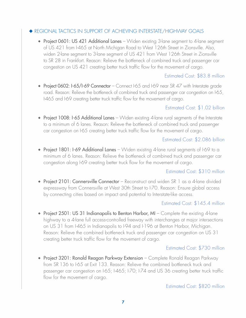
◆ REGIONAL TACTICS IN SUPPORT OF ACHIEVING INTERSTATE/HIGHWAY GOALS
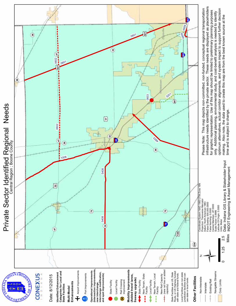
◆◆ Project 0601: US 421 Additional Lanes – Widen existing 3-lane segment to 4-lane segment of US 421 from I-465 at North Michigan Road to West 126th Street in Zionsville. Also, widen 2-lane segment to 3-lane segment of US 421 from West 126th Street in Zionsville to SR 28 in Frankfort. Reason: Relieve the bottleneck of combined truck and passenger car congestion on US 421 creating better truck traffic flow for the movement of cargo.
Estimated Cost: $83.8 million
◆◆ Project 0602: I-65/I-69 Connector – Connect I-65 and I-69 near SR 47 with Interstate grade road. Reason: Relieve the bottleneck of combined truck and passenger car congestion on I-65, I-465 and I-69 creating better truck traffic flow for the movement of cargo.
Estimated Cost: $1.02 billion
◆◆ Project 1008: I-65 Additional Lanes – Widen existing 4-lane rural segments of the Interstate to a minimum of 6 lanes. Reason: Relieve the bottleneck of combined truck and passenger car congestion on I-65 creating better truck traffic flow for the movement of cargo.
Estimated Cost: $2.086 billion
◆◆ Project 1801: I-69 Additional Lanes – Widen existing 4-lane rural segments of I-69 to a minimum of 6 lanes. Reason: Relieve the bottleneck of combined truck and passenger car congestion along I-69 creating better truck flow for the movement of cargo.
Estimated Cost: $310 million
◆◆ Project 2101: Connersville Connector – Reconstruct and widen SR 1 as a 4-lane divided expressway from Connersville at West 30th Street to I-70. Reason: Ensure global access by connecting cities based on impact and potential to Interstate-like access.
Estimated Cost: $145.4 million
◆◆ Project 2501: US 31 Indianapolis to Benton Harbor, MI – Complete the existing 4-lane highway to a 4-lane full access-controlled freeway with interchanges at major intersections on US 31 from I-465 in Indianapolis to I-94 and I-196 at Benton Harbor, Michigan. Reason: Relieve the combined bottleneck truck and passenger car congestion on US 31 creating better truck traffic flow for the movement of cargo.
Estimated Cost: $730 million
◆◆ Project 3201: Ronald Reagan Parkway Extension – Complete Ronald Reagan Parkway from SR 136 to I-65 at Exit 133. Reason: Relieve the combined bottleneck truck and passenger car congestion on I-65; I-465; I-70; I-74 and US 36 creating better truck traffic flow for the movement of cargo.
Estimated Cost: $820 million
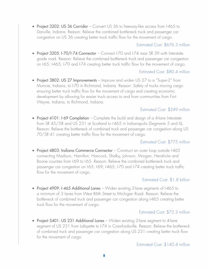
8
◆◆ Project 3202: US 36 Corridor – Convert US 36 to freeway-like access from I-465 to Danville, Indiana. Reason: Relieve the combined bottleneck truck and passenger car congestion on US 36 creating better truck traffic flow for the movement of cargo.
Estimated Cost: $676.3 million
◆◆ Project 3205: I-70/I-74 Connector – Connect I-70 and I-74 near SR 39 with Interstate grade road. Reason: Relieve the combined bottleneck truck and passenger car congestion on I-65; I-465; I-70 and I-74 creating better truck traffic flow for the movement of cargo.
Estimated Cost: $80.4 million
◆◆ Project 3802: US 27 Improvements – Improve and widen US 27 to a “Super-2” from Monroe, Indiana, to I-70 in Richmond, Indiana. Reason: Safety of trucks moving cargo ensuring better truck traffic flow for the movement of cargo and creating economic development by allowing for easier truck access to and from communities from Fort Wayne, Indiana, to Richmond, Indiana.
Estimated Cost: $249 million
◆◆ Project 4101: I-69 Completion – Complete the build and design of a 4-lane Interstate from SR 45/58 and US 231 at Scotland to I-465 in Indianapolis (Segments 5 and 6). Reason: Relieve the bottleneck of combined truck and passenger car congestion along US 70/SR 41 creating better traffic flow for the movement of cargo.
Estimated Cost: $775 million
◆◆ Project 4803: Indiana Commerce Connector – Construct an outer loop outside I-465 connecting Madison, Hamilton, Hancock, Shelby, Johnson, Morgan, Hendricks and Boone counties from I-69 to I-65. Reason: Relieve the combined bottleneck truck and passenger car congestion on I-65; I-69; I-465; I-70 and I-74 creating better truck traffic flow for the movement of cargo.
Estimated Cost: $1.8 billion
◆◆ Project 4909: I-465 Additional Lanes – Widen existing 2-lane segments of I-465 to a minimum of 3 lanes from West 86th Street to Michigan Road. Reason: Relieve the bottleneck of combined truck and passenger car congestion along I-465 creating better truck flow for the movement of cargo.
Estimated Cost: $72.3 million
◆◆ Project 5401: US 231 Additional Lanes – Widen existing 2-lane segment to 4-lane segment of US 231 from Lafayette to I-74 in Crawfordsville. Reason: Relieve the bottleneck of combined truck and passenger car congestion along US 231 creating better truck flow for the movement of cargo.
Estimated Cost: $140.4 million
9
◆◆ Project 5408: US 32 Additional Lanes – Widen existing 2-lane segment to 4-lane segment of US 32 from I-65 at Lebanon to East Crawfordsville Truck Route in Crawfordsville. Reason: Relieve the bottleneck of combined truck and passenger car traffic creating better truck traffic flow for the movement of cargo.
Estimated Cost: $149.1 million
◆◆ Project 7001: SR 3 Improvements – Improve and widen SR 3 from I-70 at Exit 123 to I-74 at Exit 134. Reason: Relieve the bottleneck of combined truck and passenger congestion on SR 3 creating better truck traffic flow for the movement of cargo.
Estimated Cost: $178.7 million
◆◆ Project 8403: I-70 Third Lane/Dedicated Truck Lanes – Widen existing 4-lane rural segments of I-70 to a minimum of 6 lanes from state line to state line. Reason: Relieve the bottleneck of combined truck and passenger car congestion along I-70 creating better truck flow for the movement of cargo.
Estimated Cost: $1.43 billion
◆ REGIONAL TACTICS IN SUPPORT OF ACHIEVING RAIL GOALS
EXPAND THE SENATE AVENUE RAIL YARD IN INDIANAPOLIS
◆◆ Project 4910: Senate Avenue Intermodal – Expand the Senate Avenue Rail Yard in Indianapolis that provides direct West Coast intermodal rail service from Prince Rupert and Vancouver, Canada, via the CN and Indiana Rail Road Company. Reason: Provide direct rail access leading to the improvement and establishment of intermodal service facilities.
Estimated Cost: Not Applicable
◆ REGIONAL TACTICS IN SUPPORT OF ACHIEVING WATERBORNE GOALS
SUPPORT RECONSTRUCTION OF SOO AND OLMSTED LOCKS
◆◆ Project 4517: Soo Locks – Construct a new lock to ease the passage of large vessels between Lake Superior ports and steel mills and power plants that support the businesses of the Central Region. Reason: Create better connectivity of Indiana’s water ports.
Estimated Cost: $550 million
◆◆ Project 6506: Olmsted Lock Reconstruction – Replace Locks and Dams 52 and 53, known as the Olmsted Locks and Dam, which are under construction between Illinois and Kentucky upstream from the confluence of the Ohio and Mississippi rivers. Olmsted will replace Locks and Dams 52 and 53 and greatly reduce tow and barge delays through the busiest stretch of river in America’s inland waterways. Reason: Create better connectivity of Indiana’s water ports.
Estimated Cost: $1.38 billion
10
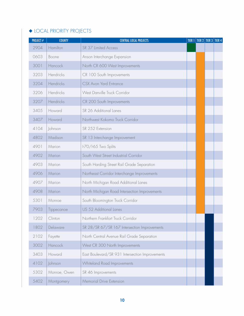
◆ LOCAL PRIORITY PROJECTS
PROJECT # COUNTY CENTRAL LOCAL PROJECTS TIER 1 TIER 2 TIER 3 TIER 4
2904 Hamilton SR 37 Limited Access
0603 Boone Anson Interchange Expansion
3001 Hancock North CR 600 West Improvements
3203 Hendricks CR 100 South Improvements
3204 Hendricks CSX Avon Yard Entrance
3206 Hendricks West Danville Truck Corridor
3207 Hendricks CR 200 South Improvements
3405 Howard SR 26 Additional Lanes
3407 Howard Northwest Kokomo Truck Corridor
4104 Johnson SR 252 Extension
4802 Madison SR 13 Interchange Improvement
4901 Marion I-70/I-65 Two Splits
4902 Marion South West Street Industrial Corridor
4903 Marion South Harding Street Rail Grade Separation
4906 Marion Northeast Corridor Interchange Improvements
4907 Marion North Michigan Road Additional Lanes
4908 Marion North Michigan Road Intersection Improvements
5301 Monroe South Bloomington Truck Corridor
7903 Tippecanoe US 52 Additional Lanes
1202 Clinton Northern Frankfort Truck Corridor
1802 Delaware SR 28/SR 67/SR 167 Intersection Improvements
2102 Fayette North Central Avenue Rail Grade Separation
3002 Hancock West CR 300 North Improvements
3403 Howard East Boulevard/SR 931 Intersection Improvements
4102 Johnson Whiteland Road Improvements
5302 Monroe, Owen SR 46 Improvements
5402 Montgomery Memorial Drive Extension

11
PROJECT # COUNTY CENTRAL LOCAL PROJECTS TIER 1 TIER 2 TIER 3 TIER 4
5403 Montgomery East Crawfordsville Truck Route
5404 Montgomery East Market Street Rail Grade Separation
5406 Montgomery CSX Transfer Rail Station
5407 Montgomery Nucor Road Overpass
5501 Hendricks, Morgan I-70/SR 39 Interchange Improvements
6701 Putnam East Greencastle Truck Corridor
6702 Putnam US 231 Additional Lanes
6703 Putnam US 231 Intersection Improvements
6705 Putnam CSX Rail Bridge Replacement
7301 Shelby West Shelbyville Truck Corridor
7302 Johnson, Shelby SR 44 Improvements
7902 Tippecanoe South Tippecanoe Truck Corridor
8902 Wayne Midwest Industrial Park Rail Extension
0803 Clinton Western Southern Railroad Rail Line Extension
1201 Clinton West CR 0 North Improvements
3401 Howard West Morgan Street Extension
3402 Howard East Lincoln Road/SR 931 Intersection Improvements
3404 Howard Touby Pike Additional Lanes
3406 Howard West Defenbaugh Street Improvements
5303 Monroe Arlington Road/West 17th Street/North Monroe Street Intersection Improvements
5405 Montgomery CSX Railroad Track Removal
6704 Putnam, Morgan SR 75 Extension
6706 Putnam Stardust Road Improvements
7904 Tippecanoe Steel Site Industrial Park Improvements
8002 Tipton Tipton Agriculture Corridor
8301 Vermillion Vermillion Rise Mega Park Improvements
8901 Wayne Norfolk Southern Transloading Facility
5304 Monroe South Rockport Road/West Tapp Road/West Country Club Drive Intersection Improvements
12
◆◆
*Pro
ject
060
1: U
S 42
1 A
dditi
onal
Lan
es –
Thi
s is
a re
gion
al
proj
ect r
eflec
ted
on th
e m
ap o
n pa
ge 6
.
◆◆
*Pro
ject
060
2: I-
65/I
-69
Con
nect
or –
Thi
s is
a re
gion
al
proj
ect r
eflec
ted
on th
e m
ap o
n pa
ge 6
.
◆◆
Proj
ect 0
603:
Ans
on In
terc
hang
e Ex
pans
ion
– Re
-eng
inee
r, re
confi
gure
and
rede
sign
SR 2
67 In
terc
hang
e at
Exi
t 133
. Re
ason
: Rel
ieve
the
bottle
neck
of c
ombi
ned
truck
and
pa
ssen
ger c
ar tr
affic
cre
atin
g be
tter t
ruck
traf
fic fl
ow fo
r the
m
ovem
ent o
f car
go.
Estim
ated
Cos
t: $3
4.8
milli
on
◆◆
*Pro
ject
100
8: I-
65 A
dditi
onal
Lan
es –
Thi
s is
a re
gion
al
proj
ect r
eflec
ted
on th
e m
ap o
n pa
ge 6
.
◆◆
*Pro
ject
320
1: R
onal
d Re
agan
Par
kway
Ext
ensi
on –
Thi
s is
a re
gion
al p
roje
ct re
flect
ed o
n th
e m
ap o
n pa
ge 6
.
◆◆
*Pro
ject
480
3: In
dian
a C
omm
erce
Con
nect
or –
Thi
s is
a re
gion
al p
roje
ct re
flect
ed o
n th
e m
ap o
n pa
ge 6
.
◆◆
*Pro
ject
490
9: I-
465
Add
ition
al L
anes
– T
his
is a
regi
onal
pr
ojec
t refl
ecte
d on
the
map
on
page
6.
◆◆
*Pro
ject
540
8: U
S 32
Add
ition
al L
anes
– T
his
is a
regi
onal
pr
ojec
t refl
ecte
d on
the
map
on
page
6.
BO
ON
E CO
UN
TYPR
OJE
CTS
* Th
ese
proj
ects
are
refle
cted
in o
ther
sec
tions
of t
his
repo
rt.
!
¬ «38
¬ «267
¬ «234
¬ «38
¬ «75¬ «75
¬ «39
¬ «39
¬ «47¬ «47
¬ «47
¬ «32¬ «32
¬ «32
£ ¤136
£ ¤52
£ ¤421
£ ¤421
§̈ ¦465
§̈ ¦865
§̈ ¦74
§̈ ¦65
Zion
svill
e
Adva
nce
Jam
esto
wn
Thor
ntow
n
Leba
non
Whi
test
own
Ule
n
0601
0601
4909
4909
3201
4803
1008
5408
5408
0602
0602
0603
Ü 02.
51.
25M
iles
Dat
e: 8
/12/
2015
Coo
rdin
ate
Sys
tem
: NA
D 1
983
UTM
Zon
e 16
NPr
ojec
tion:
Tra
nsve
rse
Mer
cato
rD
atum
: Nor
th A
mer
ican
198
3Fa
lse
Eas
ting:
500
,000
.000
0Fa
lse
Nor
thin
g: 0
.000
0C
entra
l Mer
idia
n: -8
7.00
00Sc
ale
Fact
or: 0
.999
6La
titud
e O
f Orig
in: 0
.000
0U
nits
: Met
er
Priv
ate
Sec
tor I
dent
ified
Reg
iona
l N
eeds
Dat
a: In
dian
a G
IS L
ibra
ry &
Sta
keho
lder
Inpu
tIN
DO
T E
ngin
eerin
g &
Ass
et M
anag
emen
t
Plea
se N
ote:
Thi
s m
ap d
epic
ts n
on-c
omm
itted
, non
-fund
ed, c
once
ptua
l reg
iona
l tra
nspo
rtatio
nin
frast
ruct
ure
need
s id
entif
ied
by th
e pr
ivat
e se
ctor
. Th
ese
need
s ar
e di
spla
yed
as p
lace
hold
ers
for g
raph
ic re
pres
enta
tion.
Use
of t
his
map
sho
uld
be li
mite
d to
pre
limin
ary
plan
ning
pur
pose
son
ly. A
dditi
onal
pla
nnin
g, e
nviro
nmen
tal s
tudy
, and
cos
t-ben
efit
anal
ysis
is n
eede
d to
iden
tify
optim
um a
ltern
ativ
es, a
ctua
l cor
ridor
alig
nmen
ts, a
nd s
yste
m im
pact
to s
uppo
rt fu
rther
dec
isio
nm
akin
g. A
lso
note
, the
dat
a us
ed to
cre
ate
this
map
are
from
the
best
kno
wn
sour
ce a
t the
time
and
is s
ubje
ct to
cha
nge.
Cen
tral R
egio
n ; B
oone
Cou
nty
Iden
tifie
d En
hanc
emen
tC
ateg
orie
s fo
r Loc
al a
ndSt
ate
Faci
litie
s
Mul
ti-M
odal
Enha
ncem
ents
oAi
rpor
t Im
prov
emen
ts
!ÎPo
rt Im
prov
emen
ts
Ope
ratio
nal I
mpr
ovem
ents
(Inte
rsec
tion
impr
ovem
ents
,ne
w in
terc
hang
e,in
terc
hang
e m
odifi
catio
n,an
d sp
ot im
prov
emen
ts)
!St
ate
Faci
lity
!Lo
cal F
acili
ty
¹º»¼R
ail C
ross
ing
Impr
ovem
ent
Mob
ility
Impr
ovem
ents
(Add
ed tr
avel
lane
s,fr
eew
ay u
pgra
de)
Stat
e Fa
cilit
yN
ew T
erra
in, S
tate
Faci
lity
Loca
l Fac
ility
New
Ter
rain
, Loc
alFa
cilit
y
New
Rai
l Cap
acity
(new
rail
line
or a
dded
capa
city
)
Stat
e Fa
cilit
ies
are
US,
Sta
teR
oute
, or U
S H
ighw
ay fu
nded
w
ith s
tate
and
fede
ral f
unds
.
Loca
l Fac
ilitie
s ar
e no
n-st
ate
jurs
idic
tion
faci
litie
s th
at c
anus
e st
ate
or lo
cal f
unds
.
Oth
er F
acili
ties
Non
-Inte
rsta
te
Inte
rsta
te
Exis
ting
Rai
l
Nav
igab
le S
tream
s
Cor
p. L
imits
£ ¤31

14
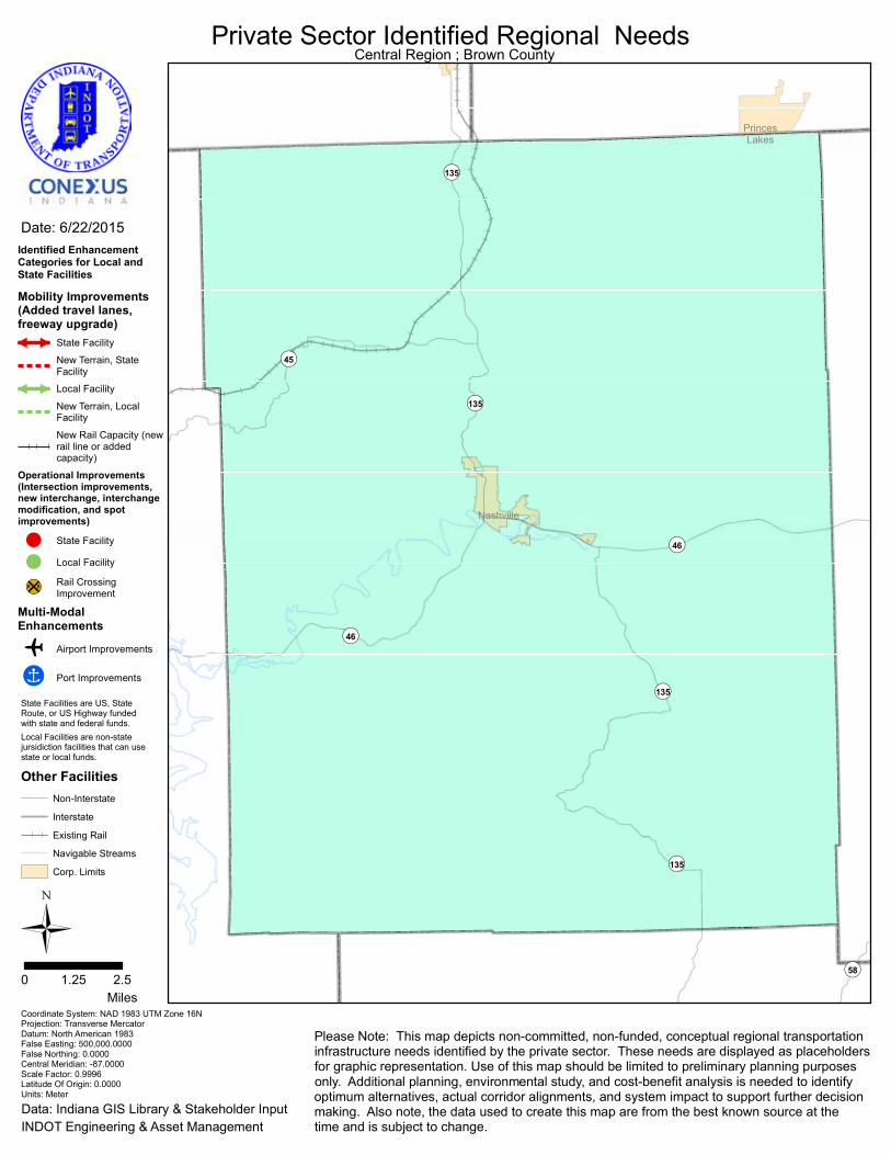
BROWN COUNTYPROJECTS
Nothing local that affects the movement of cargo.
¬«58
¬«45
¬«135
¬«135
¬«135
¬«135
¬«46
¬«46
Nashville
PrincesLakes
Ü0 2.51.25
Miles
Date: 6/22/2015
Coordinate System: NAD 1983 UTM Zone 16NProjection: Transverse MercatorDatum: North American 1983False Easting: 500,000.0000False Northing: 0.0000Central Meridian: -87.0000Scale Factor: 0.9996Latitude Of Origin: 0.0000Units: Meter
Private Sector Identified Regional Needs
Data: Indiana GIS Library & Stakeholder InputINDOT Engineering & Asset Management
Please Note: This map depicts non-committed, non-funded, conceptual regional transportationinfrastructure needs identified by the private sector. These needs are displayed as placeholdersfor graphic representation. Use of this map should be limited to preliminary planning purposesonly. Additional planning, environmental study, and cost-benefit analysis is needed to identifyoptimum alternatives, actual corridor alignments, and system impact to support further decisionmaking. Also note, the data used to create this map are from the best known source at thetime and is subject to change.
Central Region ; Brown County
Identified EnhancementCategories for Local andState Facilities
Mobility Improvements(Added travel lanes,freeway upgrade)
State Facility
New Terrain, StateFacility
Local Facility
New Terrain, LocalFacility
New Rail Capacity (newrail line or addedcapacity)
Operational Improvements(Intersection improvements,new interchange, interchangemodification, and spotimprovements)
! State Facility
! Local Facility
¹º»¼Rail CrossingImprovement
Multi-ModalEnhancements
o Airport Improvements
!Î Port Improvements
Other FacilitiesNon-Interstate
Interstate
Existing Rail
Navigable Streams
Corp. Limits
State Facilities are US, StateRoute, or US Highway funded with state and federal funds.Local Facilities are non-statejursidiction facilities that can usestate or local funds.
16
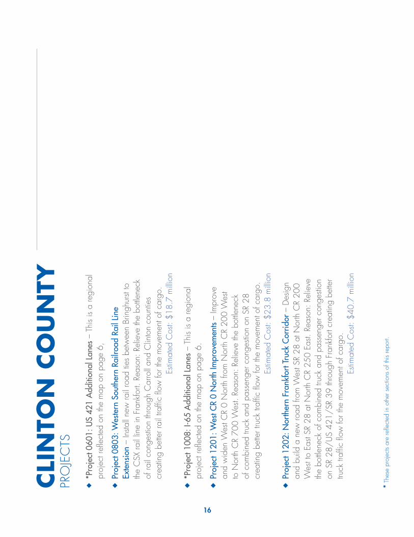
CLI
NTO
N C
OU
NTY
PRO
JEC
TS
◆◆
*Pro
ject
060
1: U
S 42
1 A
dditi
onal
Lan
es –
Thi
s is
a re
gion
al
proj
ect r
eflec
ted
on th
e m
ap o
n pa
ge 6
,
◆◆
Proj
ect 0
803:
Wes
tern
Sou
ther
n Ra
ilroa
d Ra
il Li
ne
Exte
nsio
n –
Insta
ll ne
w ra
il ro
ad ti
es b
etw
een
Brin
ghur
st to
th
e C
SX ra
il lin
e in
Fra
nkfo
rt. R
easo
n: R
elie
ve th
e bo
ttlene
ck
of ra
il co
nges
tion
thro
ugh
Car
roll
and
Clin
ton
coun
ties
crea
ting
bette
r rai
l tra
ffic
flow
for t
he m
ovem
ent o
f car
go.
Estim
ated
Cos
t: $1
8.7
milli
on
◆◆
*Pro
ject
100
8: I-
65 A
dditi
onal
Lan
es –
Thi
s is
a re
gion
al
proj
ect r
eflec
ted
on th
e m
ap o
n pa
ge 6
.
◆◆
Proj
ect 1
201:
Wes
t CR
0 N
orth
Impr
ovem
ents
– Im
prov
e an
d w
iden
Wes
t CR
0 N
orth
from
Nor
th C
R 20
0 W
est
to N
orth
CR
700
Wes
t. Re
ason
: Rel
ieve
the
bottle
neck
of
com
bine
d tru
ck a
nd p
asse
nger
con
gesti
on o
n SR
28
crea
ting
bette
r tru
ck tr
affic
flow
for t
he m
ovem
ent o
f car
go.
Estim
ated
Cos
t: $2
3.8
milli
on
◆◆
Proj
ect 1
202:
Nor
ther
n Fr
ankf
ort T
ruck
Cor
ridor
– D
esig
n an
d bu
ild a
new
road
from
Wes
t SR
28 a
t Nor
th C
R 20
0 W
est t
o Ea
st SR
28
at N
orth
CR
250
East.
Rea
son:
Rel
ieve
th
e bo
ttlene
ck o
f com
bine
d tru
ck a
nd p
asse
nger
con
gesti
on
on S
R 28
/U
S 42
1/SR
39
thro
ugh
Fran
kfor
t cre
atin
g be
tter
truck
traf
fic fl
ow fo
r the
mov
emen
t of c
argo
. Es
timat
ed C
ost:
$40.
7 m
illion
* Th
ese
proj
ects
are
refle
cted
in o
ther
sec
tions
of t
his
repo
rt.

¬ «28
¬ «39
¬ «38
¬ «38
¬ «28¬ «28
¬ «75¬ «29
¬ «38
¬ «38
¬ «26¬ «26
¬ «26
£ ¤52
£ ¤421
£ ¤421
§̈ ¦65
Col
fax
Kirk
lin
Fran
kfor
t
Mic
higa
ntow
n
Ros
svill
e
Mul
berry
1201
1202
1202
08030803
1008
1008
0601
0601
Ü 02.
51.
25M
iles
Dat
e: 8
/12/
2015
Coo
rdin
ate
Sys
tem
: NA
D 1
983
UTM
Zon
e 16
NPr
ojec
tion:
Tra
nsve
rse
Mer
cato
rD
atum
: Nor
th A
mer
ican
198
3Fa
lse
Eas
ting:
500
,000
.000
0Fa
lse
Nor
thin
g: 0
.000
0C
entra
l Mer
idia
n: -8
7.00
00Sc
ale
Fact
or: 0
.999
6La
titud
e O
f Orig
in: 0
.000
0U
nits
: Met
er
Priv
ate
Sec
tor I
dent
ified
Reg
iona
l N
eeds
Dat
a: In
dian
a G
IS L
ibra
ry &
Sta
keho
lder
Inpu
tIN
DO
T E
ngin
eerin
g &
Ass
et M
anag
emen
t
Plea
se N
ote:
Thi
s m
ap d
epic
ts n
on-c
omm
itted
, non
-fund
ed, c
once
ptua
l reg
iona
l tra
nspo
rtatio
nin
frast
ruct
ure
need
s id
entif
ied
by th
e pr
ivat
e se
ctor
. Th
ese
need
s ar
e di
spla
yed
as p
lace
hold
ers
for g
raph
ic re
pres
enta
tion.
Use
of t
his
map
sho
uld
be li
mite
d to
pre
limin
ary
plan
ning
pur
pose
son
ly. A
dditi
onal
pla
nnin
g, e
nviro
nmen
tal s
tudy
, and
cos
t-ben
efit
anal
ysis
is n
eede
d to
iden
tify
optim
um a
ltern
ativ
es, a
ctua
l cor
ridor
alig
nmen
ts, a
nd s
yste
m im
pact
to s
uppo
rt fu
rther
dec
isio
nm
akin
g. A
lso
note
, the
dat
a us
ed to
cre
ate
this
map
are
from
the
best
kno
wn
sour
ce a
t the
time
and
is s
ubje
ct to
cha
nge.
Cen
tral R
egio
n ; C
linto
n C
ount
y
Iden
tifie
d En
hanc
emen
tC
ateg
orie
s fo
r Loc
al a
ndSt
ate
Faci
litie
s
Mul
ti-M
odal
Enha
ncem
ents
oAi
rpor
t Im
prov
emen
ts
!ÎPo
rt Im
prov
emen
ts
Ope
ratio
nal I
mpr
ovem
ents
(Inte
rsec
tion
impr
ovem
ents
,ne
w in
terc
hang
e,in
terc
hang
e m
odifi
catio
n,an
d sp
ot im
prov
emen
ts)
!St
ate
Faci
lity
!Lo
cal F
acili
ty
¹º»¼R
ail C
ross
ing
Impr
ovem
ent
Mob
ility
Impr
ovem
ents
(Add
ed tr
avel
lane
s,fr
eew
ay u
pgra
de)
Stat
e Fa
cilit
yN
ew T
erra
in, S
tate
Faci
lity
Loca
l Fac
ility
New
Ter
rain
, Loc
alFa
cilit
y
New
Rai
l Cap
acity
(new
rail
line
or a
dded
capa
city
)
Stat
e Fa
cilit
ies
are
US,
Sta
teR
oute
, or U
S H
ighw
ay fu
nded
w
ith s
tate
and
fede
ral f
unds
.
Loca
l Fac
ilitie
s ar
e no
n-st
ate
jurs
idic
tion
faci
litie
s th
at c
anus
e st
ate
or lo
cal f
unds
.
Oth
er F
acili
ties
Non
-Inte
rsta
te
Inte
rsta
te
Exis
ting
Rai
l
Nav
igab
le S
tream
s
Cor
p. L
imits
£ ¤31

18
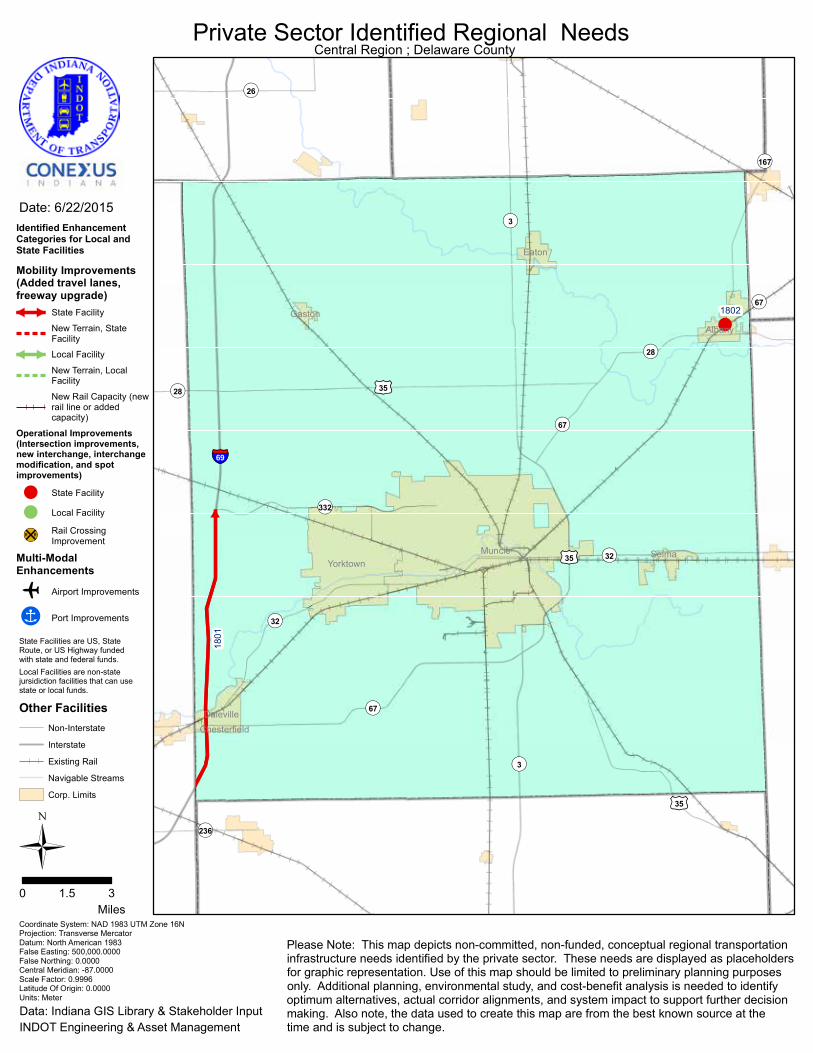
DELAWARE COUNTYPROJECTS
◆◆ *Project 1801: I-69 Additional Lanes – This is a regional project reflected on the map on page 6.
◆◆ Project 1802: SR 28/SR 67/SR 167 Intersection Improvements – Re-engineer, reconfigure and redesign SR 28/SR 67/SR 167 intersection. Reason: Ensure the safety of trucks moving cargo ensuring better truck traffic flow for the movement of cargo.
Estimated Cost: $1.5 million
* These projects are reflected in other sections of this report.
!
§̈¦69
¬«28
¬«67
¬«236
¬«67
¬«26
¬«332
¬«167
¬«28
¬«3
¬«3
¬«67
¬«32
¬«32
£¤35
£¤35
£¤35
Eaton
Daleville
Yorktown
Gaston
Muncie
Albany
Chesterfield
Selma
1801
1802
Ü0 31.5
Miles
Date: 6/22/2015
Coordinate System: NAD 1983 UTM Zone 16NProjection: Transverse MercatorDatum: North American 1983False Easting: 500,000.0000False Northing: 0.0000Central Meridian: -87.0000Scale Factor: 0.9996Latitude Of Origin: 0.0000Units: Meter
Private Sector Identified Regional Needs
Data: Indiana GIS Library & Stakeholder InputINDOT Engineering & Asset Management
Please Note: This map depicts non-committed, non-funded, conceptual regional transportationinfrastructure needs identified by the private sector. These needs are displayed as placeholdersfor graphic representation. Use of this map should be limited to preliminary planning purposesonly. Additional planning, environmental study, and cost-benefit analysis is needed to identifyoptimum alternatives, actual corridor alignments, and system impact to support further decisionmaking. Also note, the data used to create this map are from the best known source at thetime and is subject to change.
Central Region ; Delaware County
Identified EnhancementCategories for Local andState Facilities
Mobility Improvements(Added travel lanes,freeway upgrade)
State Facility
New Terrain, StateFacility
Local Facility
New Terrain, LocalFacility
New Rail Capacity (newrail line or addedcapacity)
Operational Improvements(Intersection improvements,new interchange, interchangemodification, and spotimprovements)
! State Facility
! Local Facility
¹º»¼Rail CrossingImprovement
Multi-ModalEnhancements
o Airport Improvements
!Î Port Improvements
Other FacilitiesNon-Interstate
Interstate
Existing Rail
Navigable Streams
Corp. Limits
State Facilities are US, StateRoute, or US Highway funded with state and federal funds.Local Facilities are non-statejursidiction facilities that can usestate or local funds.

20
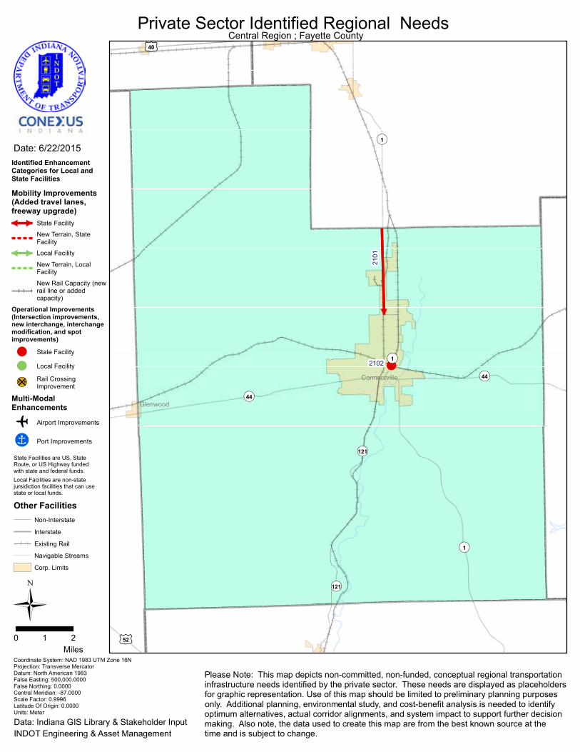
FAYETTE COUNTYPROJECTS
◆◆ *Project 2101: Connersville Connector Lanes – This is a regional project reflected on the map on page 6.
◆◆ Project 2102: North Central Avenue Rail Grade Separation – Re-engineer, reconfigure and redesign the rail grade separation on North Central Avenue near East 10th Street. Reason: Ensure the safety of trucks moving cargo ensuring better truck traffic flow for the movement of cargo.
Estimated Cost: $5 million
* These projects are reflected in other sections of this report.
!¬«44
¬«44
¬«121
¬«121
¬«1
¬«1
¬«1
£¤52
£¤40
Connersville
Glenwood
2102
Ü0 21
Miles
Date: 6/22/2015
Coordinate System: NAD 1983 UTM Zone 16NProjection: Transverse MercatorDatum: North American 1983False Easting: 500,000.0000False Northing: 0.0000Central Meridian: -87.0000Scale Factor: 0.9996Latitude Of Origin: 0.0000Units: Meter
Private Sector Identified Regional Needs
Data: Indiana GIS Library & Stakeholder InputINDOT Engineering & Asset Management
Please Note: This map depicts non-committed, non-funded, conceptual regional transportationinfrastructure needs identified by the private sector. These needs are displayed as placeholdersfor graphic representation. Use of this map should be limited to preliminary planning purposesonly. Additional planning, environmental study, and cost-benefit analysis is needed to identifyoptimum alternatives, actual corridor alignments, and system impact to support further decisionmaking. Also note, the data used to create this map are from the best known source at thetime and is subject to change.
Central Region ; Fayette County
Identified EnhancementCategories for Local andState Facilities
Mobility Improvements(Added travel lanes,freeway upgrade)
State Facility
New Terrain, StateFacility
Local Facility
New Terrain, LocalFacility
New Rail Capacity (newrail line or addedcapacity)
Operational Improvements(Intersection improvements,new interchange, interchangemodification, and spotimprovements)
! State Facility
! Local Facility
¹º»¼Rail CrossingImprovement
Multi-ModalEnhancements
o Airport Improvements
!Î Port Improvements
Other FacilitiesNon-Interstate
Interstate
Existing Rail
Navigable Streams
Corp. Limits
State Facilities are US, StateRoute, or US Highway funded with state and federal funds.Local Facilities are non-statejursidiction facilities that can usestate or local funds.
2101

22
FOUNTAIN COUNTYPROJECTS
Nothing local that affects the movement of cargo.

§̈¦74
¬«28
¬«25
¬«341
¬«341
¬«55
¬«28
¬«55
¬«28
¬«341
¬«263
¬«25
¬«25
¬«234¬«234
¬«32
¬«32
¬«63
¬«63
¬«63
£¤136
£¤136
£¤41
£¤41
£¤41
Kingman
VeedersburgHillsboro
Attica
Mellott
Covington
Wallace
Newtown
Ü0 31.5
Miles
Date: 6/22/2015
Coordinate System: NAD 1983 UTM Zone 16NProjection: Transverse MercatorDatum: North American 1983False Easting: 500,000.0000False Northing: 0.0000Central Meridian: -87.0000Scale Factor: 0.9996Latitude Of Origin: 0.0000Units: Meter
Private Sector Identified Regional Needs
Data: Indiana GIS Library & Stakeholder InputINDOT Engineering & Asset Management
Please Note: This map depicts non-committed, non-funded, conceptual regional transportationinfrastructure needs identified by the private sector. These needs are displayed as placeholdersfor graphic representation. Use of this map should be limited to preliminary planning purposesonly. Additional planning, environmental study, and cost-benefit analysis is needed to identifyoptimum alternatives, actual corridor alignments, and system impact to support further decisionmaking. Also note, the data used to create this map are from the best known source at thetime and is subject to change.
Central Region ; Fountain County
Identified EnhancementCategories for Local andState Facilities
Mobility Improvements(Added travel lanes,freeway upgrade)
State Facility
New Terrain, StateFacility
Local Facility
New Terrain, LocalFacility
New Rail Capacity (newrail line or addedcapacity)
Operational Improvements(Intersection improvements,new interchange, interchangemodification, and spotimprovements)
! State Facility
! Local Facility
¹º»¼Rail CrossingImprovement
Multi-ModalEnhancements
o Airport Improvements
!Î Port Improvements
Other FacilitiesNon-Interstate
Interstate
Existing Rail
Navigable Streams
Corp. Limits
State Facilities are US, StateRoute, or US Highway funded with state and federal funds.Local Facilities are non-statejursidiction facilities that can usestate or local funds.

24
◆◆
*Pro
ject
060
2: I-
65/I
-69
Con
nect
or –
Thi
s is
a re
gion
al
proj
ect r
eflec
ted
on th
e m
ap o
n pa
ge 6
.
◆◆
*Pro
ject
180
1: I-
69 A
dditi
onal
Lan
es –
Thi
s is
a re
gion
al
proj
ect r
eflec
ted
on th
e m
ap o
n pa
ge 6
.
◆◆
*Pro
ject
250
1: U
S 31
Indi
anap
olis
to B
ento
n H
arbo
r, M
I –
This
is a
regi
onal
pro
ject
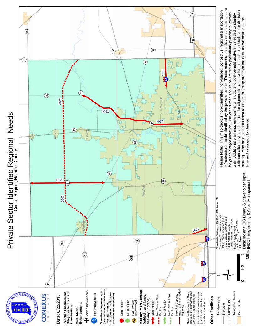
refle
cted
on
the
map
on
page
6.
◆◆
Proj
ect 2
904:
Pro
ject
SR
37 L
imite
d A
cces
s –
Free
way
-lik
e ac
cess
from
I-69
to th
e I-6
5/I-6
9 C
onne
ctor
. Re
ason
: Re
lieve
the
bottl
enec
k of
com
bine
d tru
ck a
nd p
asse
nger
co
nges
tion
on S
R 37
cre
atin
g be
tter t
ruck
traf
fic fl
ow fo
r the
m
ovem
ent o
f car
go.
Estim
ated
Cos
t: $2
65.4
milli
on
HA
MIL
TON
CO
UN
TYPR
OJE
CTS
* Th
ese
proj
ects
are
refle
cted
in o
ther
sec
tions
of t
his
repo
rt.
¬ «38
¬ «9
¬ «128
¬ «47
¬ «213
¬ «38
¬ «19
¬ «37
¬ «37
¬ «38
¬ «38
¬ «13
¬ «13
¬ «32¬ «32
¬ «32
£ ¤36
£ ¤421
£ ¤31
£ ¤31
§̈ ¦65§̈ ¦86
5
§̈ ¦465
§̈ ¦69
Atla
nta
Wes
tfiel
d
Arca
dia
Car
mel
Sher
idan
Cic
ero
Fish
ersN
oble
svill
e
2501
0601
1801
2904
2904
0602
0602
Ü 03
1.5
Mile
s
Dat
e: 6
/22/
2015
Coo
rdin
ate
Syst
em: N
AD 1
983
UTM
Zon
e 16
NPr
ojec
tion:
Tra
nsve
rse
Mer
cato
rD
atum
: Nor
th A
mer
ican
198
3Fa
lse
Eas
ting:
500
,000
.000
0Fa
lse
Nor
thin
g: 0
.000
0C
entra
l Mer
idia
n: -8
7.00
00Sc
ale
Fact
or: 0
.999
6La
titud
e O
f Orig
in: 0
.000
0U
nits
: Met
er
Priv
ate
Sec
tor I
dent
ified
Reg
iona
l N
eeds
Dat
a: In
dian
a G
IS L
ibra
ry &
Sta
keho
lder
Inpu
tIN
DO
T E
ngin
eerin
g &
Ass
et M
anag
emen
t
Plea
se N
ote:
Thi
s m
ap d
epic
ts n
on-c
omm
itted
, non
-fund
ed, c
once
ptua
l reg
iona
l tra
nspo
rtatio
nin
frast
ruct
ure
need
s id
entif
ied
by th
e pr
ivat
e se
ctor
. Th
ese
need
s ar
e di
spla
yed
as p
lace
hold
ers
for g
raph
ic re
pres
enta
tion.
Use
of t
his
map
sho
uld
be li
mite
d to
pre
limin
ary
plan
ning
pur
pose
son
ly. A
dditi
onal
pla
nnin
g, e
nviro
nmen
tal s
tudy
, and
cos
t-ben
efit
anal
ysis
is n
eede
d to
iden
tify
optim
um a
ltern
ativ
es, a
ctua
l cor
ridor
alig
nmen
ts, a
nd s
yste
m im
pact
to s
uppo
rt fu
rther
dec
isio
nm
akin
g. A
lso
note
, the
dat
a us
ed to
cre
ate
this
map
are
from
the
best
kno
wn
sour
ce a
t the
time
and
is s
ubje
ct to
cha
nge.
Cen
tral R
egio
n ; H
amilt
on C
ount
y
Iden
tifie
d En
hanc
emen
tC
ateg
orie
s fo
r Loc
al a
ndSt
ate
Faci
litie
s
Mul
ti-M
odal
Enha
ncem
ents
oAi
rpor
t Im
prov
emen
ts
!ÎPo
rt Im
prov
emen
ts
Ope
ratio
nal I
mpr
ovem
ents
(Inte
rsec
tion
impr
ovem
ents
,ne
w in
terc
hang
e,in
terc
hang
e m
odifi
catio
n,an
d sp
ot im
prov
emen
ts)
!St
ate
Faci
lity
!Lo
cal F
acili
ty
¹º»¼R
ail C
ross
ing
Impr
ovem
ent
Mob
ility
Impr
ovem
ents
(Add
ed tr
avel
lane
s,fr
eew
ay u
pgra
de)
Stat
e Fa
cilit
y
New
Ter
rain
, Sta
teFa
cilit
yLo
cal F
acili
tyN
ew T
erra
in, L
ocal
Faci
lity
New
Rai
l Cap
acity
(new
rail
line
or a
dded
capa
city
)
Stat
e Fa
cilit
ies
are
US,
Sta
teR
oute
, or U
S H
ighw
ay fu
nded
w
ith s
tate
and
fede
ral f
unds
.
Loca
l Fac
ilitie
s ar
e no
n-st
ate
jurs
idic
tion
faci
litie
s th
at c
anus
e st
ate
or lo
cal f
unds
.
Oth
er F
acili
ties
Non
-Inte
rsta
te
Inte
rsta
te
Exis
ting
Rai
l
Nav
igab
le S
tream
s
Cor
p. L
imits
26
HA
NCO
CK
CO
UN
TYPR
OJE
CTS
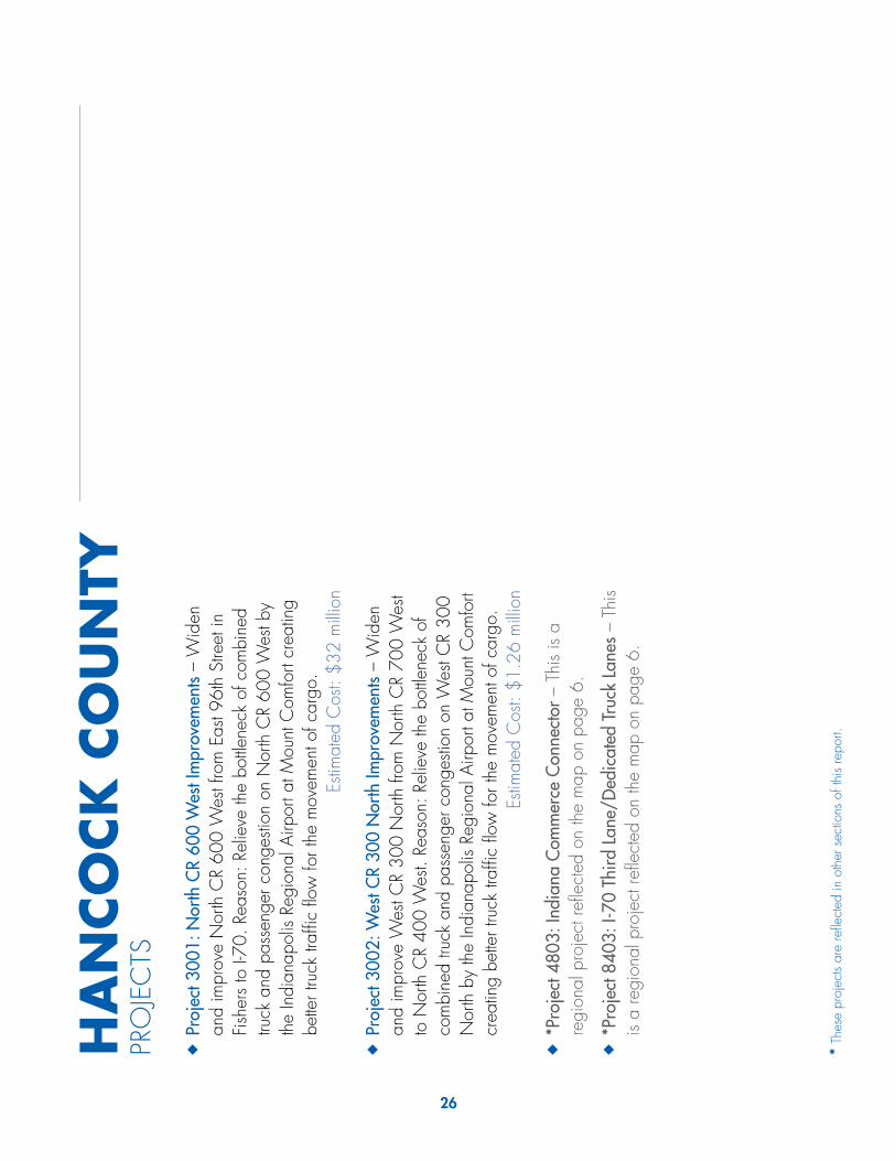
◆◆
Proj
ect 3
001:
Nor
th C
R 60
0 W
est I
mpr
ovem
ents
– W
iden
an
d im
prov
e N
orth
CR
600
Wes
t fro
m E
ast 9
6th
Stre
et in
Fi
sher
s to
I-70
. Rea
son:
Rel
ieve
the
bottle
neck
of c
ombi
ned
truck
and
pas
seng
er c
onge
stion
on
Nor
th C
R 60
0 W
est b
y th
e In
dian
apol
is Re
gion
al A
irpor
t at M
ount
Com
fort
crea
ting
bette
r tru
ck tr
affic
flow
for t
he m
ovem
ent o
f car
go.
Estim
ated
Cos
t: $3
2 m
illion
◆◆
Proj
ect 3
002:
Wes
t CR
300
Nor
th Im
prov
emen
ts –
Wid
en
and
impr
ove
Wes
t CR
300
Nor
th fr
om N
orth
CR
700
Wes
t to
Nor
th C
R 40
0 W
est.
Reas
on: R
elie
ve th
e bo
ttlene
ck o
f co
mbi
ned
truck
and
pas
seng
er c
onge
stion
on
Wes
t CR
300
Nor
th b
y th
e In
dian
apol
is Re
gion
al A
irpor
t at M
ount
Com
fort
crea
ting
bette
r tru
ck tr
affic
flow
for t
he m
ovem
ent o
f car
go.
Estim
ated
Cos
t: $1
.26
milli
on
◆◆
*Pro
ject
480
3: In
dian
a C
omm
erce
Con
nect
or –
Thi
s is
a re
gion
al p
roje
ct re
flect
ed o
n th
e m
ap o
n pa
ge 6
.
◆◆
*Pro
ject
840
3: I-
70 T
hird
Lan
e/D
edic
ated
Tru
ck L
anes
– T
his
is a
regi
onal
pro
ject
refle
cted
on
the
map
on
page
6.
* Th
ese
proj
ects
are
refle
cted
in o
ther
sec
tions
of t
his
repo
rt.

¬ «37¬ «13
¬ «140
¬ «109
¬ «109
¬ «9
¬ «9¬ «23
4¬ «23
4£ ¤3
6
£ ¤52
£ ¤40
£ ¤40
§̈ ¦69
§̈ ¦74
§̈ ¦70
Sprin
gLa
ke
Fortv
ille
Shirl
ey
New
Pale
stin
e
McC
ords
ville
Wilk
inso
n
Cum
berla
nd
Gre
enfie
ld
3001
3002
8403
8403
3002
4803
4803
PO
PE
FIE
LD
IND
IAN
AP
OLI
SR
EG
ION
AL
AIR
PO
RT
Ü 02.
51.
25M
iles
Dat
e: 6
/22/
2015
Coo
rdin
ate
Syst
em: N
AD 1
983
UTM
Zon
e 16
NPr
ojec
tion:
Tra
nsve
rse
Mer
cato
rD
atum
: Nor
th A
mer
ican
198
3Fa
lse
Eas
ting:
500
,000
.000
0Fa
lse
Nor
thin
g: 0
.000
0C
entra
l Mer
idia
n: -8
7.00
00Sc
ale
Fact
or: 0
.999
6La
titud
e O
f Orig
in: 0
.000
0U
nits
: Met
er
Priv
ate
Sec
tor I
dent
ified
Reg
iona
l N
eeds
Dat
a: In
dian
a G
IS L
ibra
ry &
Sta
keho
lder
Inpu
tIN
DO
T E
ngin
eerin
g &
Ass
et M
anag
emen
t
Plea
se N
ote:
Thi
s m
ap d
epic
ts n
on-c
omm
itted
, non
-fund
ed, c
once
ptua
l reg
iona
l tra
nspo
rtatio
nin
frast
ruct
ure
need
s id
entif
ied
by th
e pr
ivat
e se
ctor
. Th
ese
need
s ar
e di
spla
yed
as p
lace
hold
ers
for g
raph
ic re
pres
enta
tion.
Use
of t
his
map
sho
uld
be li
mite
d to
pre
limin
ary
plan
ning
pur
pose
son
ly. A
dditi
onal
pla
nnin
g, e
nviro
nmen
tal s
tudy
, and
cos
t-ben
efit
anal
ysis
is n
eede
d to
iden
tify
optim
um a
ltern
ativ
es, a
ctua
l cor
ridor
alig
nmen
ts, a
nd s
yste
m im
pact
to s
uppo
rt fu
rther
dec
isio
nm
akin
g. A
lso
note
, the
dat
a us
ed to
cre
ate
this
map
are
from
the
best
kno
wn
sour
ce a
t the
time
and
is s
ubje
ct to
cha
nge.
Cen
tral R
egio
n ; H
anco
ck C
ount
y
Iden
tifie
d En
hanc
emen
tC
ateg
orie
s fo
r Loc
al a
ndSt
ate
Faci
litie
s
Mul
ti-M
odal
Enha
ncem
ents
oAi
rpor
t Im
prov
emen
ts
!ÎPo
rt Im
prov
emen
ts
Ope
ratio
nal I
mpr
ovem
ents
(Inte
rsec
tion
impr
ovem
ents
,ne
w in
terc
hang
e,in
terc
hang
e m
odifi
catio
n,an
d sp
ot im
prov
emen
ts)
!St
ate
Faci
lity
!Lo
cal F
acili
ty
¹º»¼R
ail C
ross
ing
Impr
ovem
ent
Mob
ility
Impr
ovem
ents
(Add
ed tr
avel
lane
s,fr
eew
ay u
pgra
de)
Stat
e Fa
cilit
y
New
Ter
rain
, Sta
teFa
cilit
yLo
cal F
acili
tyN
ew T
erra
in, L
ocal
Faci
lity
New
Rai
l Cap
acity
(new
rail
line
or a
dded
capa
city
)
Stat
e Fa
cilit
ies
are
US,
Sta
teR
oute
, or U
S H
ighw
ay fu
nded
w
ith s
tate
and
fede
ral f
unds
.
Loca
l Fac
ilitie
s ar
e no
n-st
ate
jurs
idic
tion
faci
litie
s th
at c
anus
e st
ate
or lo
cal f
unds
.
Oth
er F
acili
ties
Non
-Inte
rsta
te
Inte
rsta
te
Exis
ting
Rai
l
Nav
igab
le S
tream
s
Cor
p. L
imits

28
◆◆
*Pro
ject
100
8: I-
65 A
dditi
onal
Lan
es –
Thi
s is
a re
gion
al
proj
ect r
eflec
ted
on th
e m
ap o
n pa
ge 6
.
◆◆
*Pro
ject
320
1: R
onal
d Re
agan
Par
kway
Ext
ensi
on –
Thi
s is
a re
gion
al p
roje
ct re
flect
ed o
n th
e m
ap o
n pa
ge 6
.
◆◆
*Pro
ject
320
2: U
S 36
Cor
ridor
– T
his
is a
regi
onal
pro
ject
re
flect
ed o
n th
e m
ap o
n pa
ge 6
.
◆◆
Proj
ect 3
203:
CR
100
Sout
h Im
prov
emen
ts –
Wid
en a
nd
impr
ove
CR
100
Sout
h fro
m D
an Jo
nes
Road
to R
onal
d Re
agan
Par
kway
. Rea
son:
Rel
ieve
the
bottle
neck
of
com
bine
d tru
ck a
nd p
asse
nger
con
gesti
on o
n C
R 10
0 So
uth
by th
e in
dustr
ies
in P
lain
field
cre
atin
g be
tter t
ruck
traf
fic fl
ow
for t
he m
ovem
ent o
f car
go.
Estim
ated
Cos
t: $8
.5 m
illion
◆◆
Proj
ect 3
204:
CSX
Avo
n Ya
rd E
ntra
nce
– D
esig
n an
d bu
ild a
ne
w e
ntra
nce
to A
von
Yard
from
CR
100
Sout
h ne
ar A
llpoi
nts
Cou
rt to
Mai
n Ro
ad in
Avo
n Ya
rd. R
easo
n: R
elie
ve th
e bo
ttlene
ck o
f com
bine
d tru
ck a
nd p
asse
nger
con
gesti
on o
n U
S 36
cre
atin
g be
tter t
ruck
traf
fic fl
ow fo
r the
mov
emen
t of c
argo
. Es
timat
ed C
ost:
$3.5
milli
on
◆◆
*Pro
ject
320
5: I-
70/I
-74
Con
nect
or –
Thi
s is
a re
gion
al
proj
ect r
eflec
ted
on th
e m
ap o
n pa
ge 6
.
◆◆
Proj
ect 3
206:
Wes
t Dan
ville
Tru
ck C
orrid
or –
Des
ign
and
build
a n
ew ro
ad fr
om N
orth
SR
39 a
t Nor
th C
R 20
0 W
est
to S
outh
SR
39 a
t Wes
t CR
200
Sout
h. R
easo
n: R
elie
ve th
e bo
ttlene
ck o
f com
bine
d tru
ck a
nd p
asse
nger
con
gesti
on o
n SR
39
thro
ugh
Dan
ville
cre
atin
g be
tter t
ruck
traf
fic fl
ow fo
r th
e m
ovem
ent o
f car
go.
Estim
ated
Cos
t: $2
5.2
milli
on
◆◆
Proj
ect 3
207:
CR
200
Sout
h Im
prov
emen
ts –
Wid
en a
nd
impr
ove
CR
200
Sout
h fro
m D
an Jo
nes
Road
to R
onal
d Re
agan
Par
kway
. Rea
son:
Rel
ieve
the
bottle
neck
of
com
bine
d tru
ck a
nd p
asse
nger
con
gesti
on o
n C
R 20
0 So
uth
by th
e in
dustr
ies
in P
lain
field
cre
atin
g be
tter t
ruck
traf
fic fl
ow
for t
he m
ovem
ent o
f car
go.
Estim
ated
Cos
t: $1
2.1
milli
on.
◆◆
*Pro
ject
480
3: In
dian
a C
omm
erce
Con
nect
or –
Thi
s is
a re
gion
al p
roje
ct re
flect
ed o
n th
e m
ap o
n pa
ge 6
.
◆◆
Proj
ect 5
501:
I-70
/SR
39 In
terc
hang
e Im
prov
emen
ts –
Re
-eng
inee
r, re
confi
gure
and
rede
sign
the
I-70
inte
rcha
nge
at
SR 3
9. R
easo
n: R
elie
ve th
e bo
ttlene
ck o
f com
bine
d tru
ck a
nd
pass
enge
r car
traf
fic c
reat
ing
bette
r tru
ck tr
affic
flow
for t
he
mov
emen
t of c
argo
.Es
timat
ed C
ost:
$3.5
milli
on
◆◆
*Pro
ject
840
3: I-
70 T
hird
Lan
e/D
edic
ated
Tru
ck L
anes
– T
his
is a
regi
onal
pro
ject
refle
cted
on
the
map
on
page
6.
HEN
DR
ICK
S CO
UN
TYPR
OJE
CTS
* Th
ese
proj
ects
are
refle
cted
in o
ther
sec
tions
of t
his
repo
rt.
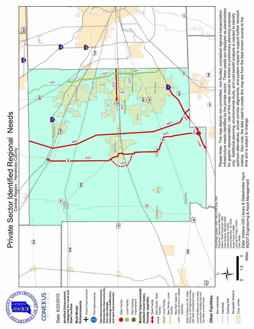
!
¬ «134
¬ «267
¬ «144
¬ «267
¬ «42
¬ «267
¬ «37¬ «24
0¬ «67
¬ «234
¬ «39
¬ «39
¬ «236
¬ «236
¬ «75
¬ «75
£ ¤421
£ ¤231
£ ¤136
£ ¤36
£ ¤36
£ ¤40
£ ¤40
§̈ ¦865
§̈ ¦65§̈ ¦74
§̈ ¦465
§̈ ¦70
Lizt
on
Amo
Pitts
boro
Coa
tesv
ille
Stile
svill
e
Nor
thSa
lem
Dan
ville
Plai
nfie
ldC
layt
on
Avon
Brow
nsbu
rg
3204
8403
3203
3207
3201
3206
3202
3201
3201
3205
3205
4803
4803
5501
Ü 03
1.5
Mile
s
Dat
e: 6
/22/
2015
Coo
rdin
ate
Syst
em: N
AD 1
983
UTM
Zon
e 16
NPr
ojec
tion:
Tra
nsve
rse
Mer
cato
rD
atum
: Nor
th A
mer
ican
198
3Fa
lse
Eas
ting:
500
,000
.000
0Fa
lse
Nor
thin
g: 0
.000
0C
entra
l Mer
idia
n: -8
7.00
00Sc
ale
Fact
or: 0
.999
6La
titud
e O
f Orig
in: 0
.000
0U
nits
: Met
er
Priv
ate
Sec
tor I
dent
ified
Reg
iona
l N
eeds
Dat
a: In
dian
a G
IS L
ibra
ry &
Sta
keho
lder
Inpu
tIN
DO
T E
ngin
eerin
g &
Ass
et M
anag
emen
t
Plea
se N
ote:
Thi
s m
ap d
epic
ts n
on-c
omm
itted
, non
-fund
ed, c
once
ptua
l reg
iona
l tra
nspo
rtatio
nin
frast
ruct
ure
need
s id
entif
ied
by th
e pr
ivat
e se
ctor
. Th
ese
need
s ar
e di
spla
yed
as p
lace
hold
ers
for g
raph
ic re
pres
enta
tion.
Use
of t
his
map
sho
uld
be li
mite
d to
pre
limin
ary
plan
ning
pur
pose
son
ly. A
dditi
onal
pla
nnin
g, e
nviro
nmen
tal s
tudy
, and
cos
t-ben
efit
anal
ysis
is n
eede
d to
iden
tify
optim
um a
ltern
ativ
es, a
ctua
l cor
ridor
alig
nmen
ts, a
nd s
yste
m im
pact
to s
uppo
rt fu
rther
dec
isio
nm
akin
g. A
lso
note
, the
dat
a us
ed to
cre
ate
this
map
are
from
the
best
kno
wn
sour
ce a
t the
time
and
is s
ubje
ct to
cha
nge.
Cen
tral R
egio
n ; H
endr
icks
Cou
nty
Iden
tifie
d En
hanc
emen
tC
ateg
orie
s fo
r Loc
al a
ndSt
ate
Faci
litie
s
Mul
ti-M
odal
Enha
ncem
ents
oAi
rpor
t Im
prov
emen
ts
!ÎPo
rt Im
prov
emen
ts
Ope
ratio
nal I
mpr
ovem
ents
(Inte
rsec
tion
impr
ovem
ents
,ne
w in
terc
hang
e,in
terc
hang
e m
odifi
catio
n,an
d sp
ot im
prov
emen
ts)
!St
ate
Faci
lity
!Lo
cal F
acili
ty
¹º»¼R
ail C
ross
ing
Impr
ovem
ent
Mob
ility
Impr
ovem
ents
(Add
ed tr
avel
lane
s,fr
eew
ay u
pgra
de)
Stat
e Fa
cilit
y
New
Ter
rain
, Sta
teFa
cilit
yLo
cal F
acili
tyN
ew T
erra
in, L
ocal
Faci
lity
New
Rai
l Cap
acity
(new
rail
line
or a
dded
capa
city
)
Stat
e Fa
cilit
ies
are
US,
Sta
teR
oute
, or U
S H
ighw
ay fu
nded
w
ith s
tate
and
fede
ral f
unds
.
Loca
l Fac
ilitie
s ar
e no
n-st
ate
jurs
idic
tion
faci
litie
s th
at c
anus
e st
ate
or lo
cal f
unds
.
Oth
er F
acili
ties
Non
-Inte
rsta
te
Inte
rsta
te
Exis
ting
Rai
l
Nav
igab
le S
tream
s
Cor
p. L
imits
8403

30
◆◆
*Pro
ject
700
1: S
R 3
Impr
ovem
ents
– Th
is is
a re
gion
al
proj
ect r
eflec
ted
on th
e m
ap o
n pa
ge 6
.
◆◆
*Pro
ject
840
3: I-
70 T
hird
Lan
e/D
edic
ated
Tru
ck L
anes
– T
his
is a
regi
onal
pro
ject
refle
cted
on
the
map
on
page
6.
HEN
RY
CO
UN
TYPR
OJE
CTS
* Th
ese
proj
ects
are
refle
cted
in o
ther
sec
tions
of t
his
repo
rt.
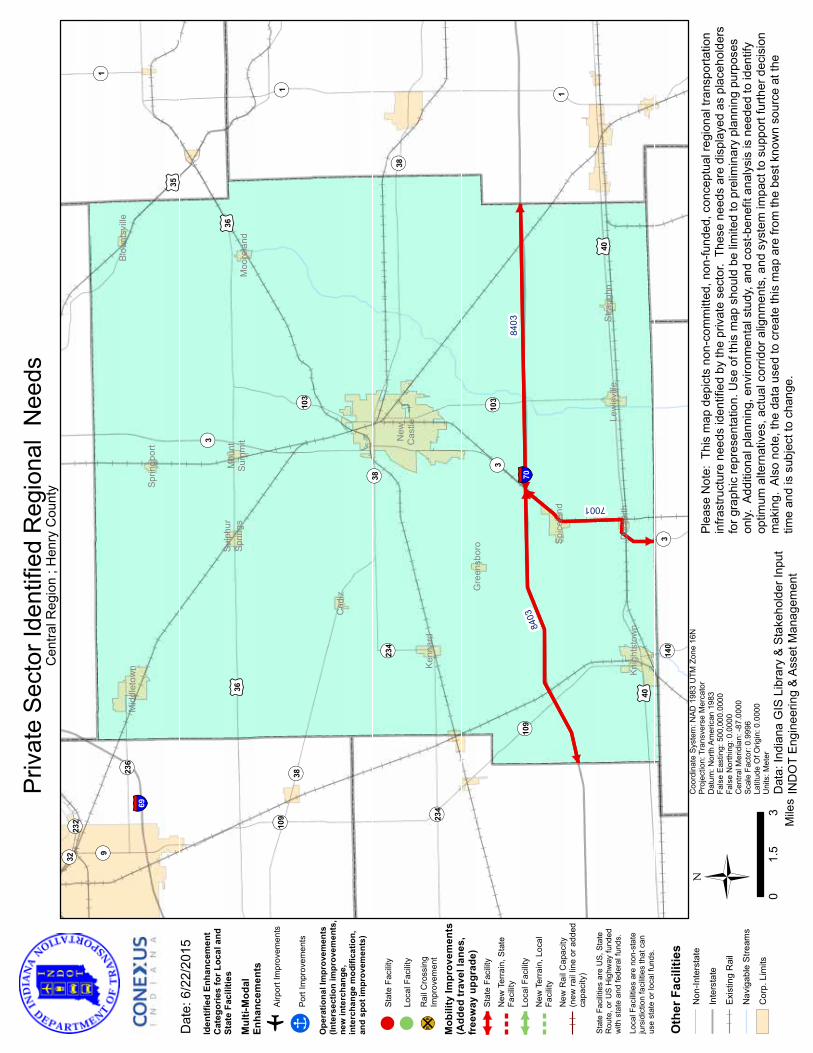
¬ «32
¬ «140
¬ «232
¬ «3
¬ «1¬ «9
¬ «103
¬ «236
¬ «103
¬ «234
¬ «234
¬ «1 ¬ «1
¬ «109
¬ «109
¬ «3
¬ «3
¬ «38
¬ «38
¬ «38
£ ¤35
£ ¤40
£ ¤40
£ ¤36
£ ¤36
§̈ ¦69
§̈ ¦70
Mid
dlet
own
Dun
reith
Moo
rela
nd
Sulp
hur
Sprin
gsM
ount
Sum
mit
Cad
iz
Blou
ntsv
ille
Kenn
ard
Spic
elan
d
Sprin
gpor
t
Lew
isvi
lle
Knig
htst
own
Gre
ensb
oro
New
Cas
tle
Stra
ughn
700184
0384
03
Ü 03
1.5
Mile
s
Dat
e: 6
/22/
2015
Coo
rdin
ate
Syst
em: N
AD 1
983
UTM
Zon
e 16
NPr
ojec
tion:
Tra
nsve
rse
Mer
cato
rD
atum
: Nor
th A
mer
ican
198
3Fa
lse
Eas
ting:
500
,000
.000
0Fa
lse
Nor
thin
g: 0
.000
0C
entra
l Mer
idia
n: -8
7.00
00Sc
ale
Fact
or: 0
.999
6La
titud
e O
f Orig
in: 0
.000
0U
nits
: Met
er
Priv
ate
Sec
tor I
dent
ified
Reg
iona
l N
eeds
Dat
a: In
dian
a G
IS L
ibra
ry &
Sta
keho
lder
Inpu
tIN
DO
T E
ngin
eerin
g &
Ass
et M
anag
emen
t
Plea
se N
ote:
Thi
s m
ap d
epic
ts n
on-c
omm
itted
, non
-fund
ed, c
once
ptua
l reg
iona
l tra
nspo
rtatio
nin
frast
ruct
ure
need
s id
entif
ied
by th
e pr
ivat
e se
ctor
. Th
ese
need
s ar
e di
spla
yed
as p
lace
hold
ers
for g
raph
ic re
pres
enta
tion.
Use
of t
his
map
sho
uld
be li
mite
d to
pre
limin
ary
plan
ning
pur
pose
son
ly. A
dditi
onal
pla
nnin
g, e
nviro
nmen
tal s
tudy
, and
cos
t-ben
efit
anal
ysis
is n
eede
d to
iden
tify
optim
um a
ltern
ativ
es, a
ctua
l cor
ridor
alig
nmen
ts, a
nd s
yste
m im
pact
to s
uppo
rt fu
rther
dec
isio
nm
akin
g. A
lso
note
, the
dat
a us
ed to
cre
ate
this
map
are
from
the
best
kno
wn
sour
ce a
t the
time
and
is s
ubje
ct to
cha
nge.
Cen
tral R
egio
n ; H
enry
Cou
nty
Iden
tifie
d En
hanc
emen
tC
ateg
orie
s fo
r Loc
al a
ndSt
ate
Faci
litie
s
Mul
ti-M
odal
Enha
ncem
ents
oAi
rpor
t Im
prov
emen
ts
!ÎPo
rt Im
prov
emen
ts
Ope
ratio
nal I
mpr
ovem
ents
(Inte
rsec
tion
impr
ovem
ents
,ne
w in
terc
hang
e,in
terc
hang
e m
odifi
catio
n,an
d sp
ot im
prov
emen
ts)
!St
ate
Faci
lity
!Lo
cal F
acili
ty
¹º»¼R
ail C
ross
ing
Impr
ovem
ent
Mob
ility
Impr
ovem
ents
(Add
ed tr
avel
lane
s,fr
eew
ay u
pgra
de)
Stat
e Fa
cilit
y
New
Ter
rain
, Sta
teFa
cilit
yLo
cal F
acili
tyN
ew T
erra
in, L
ocal
Faci
lity
New
Rai
l Cap
acity
(new
rail
line
or a
dded
capa
city
)
Stat
e Fa
cilit
ies
are
US,
Sta
teR
oute
, or U
S H
ighw
ay fu
nded
w
ith s
tate
and
fede
ral f
unds
.
Loca
l Fac
ilitie
s ar
e no
n-st
ate
jurs
idic
tion
faci
litie
s th
at c
anus
e st
ate
or lo
cal f
unds
.
Oth
er F
acili
ties
Non
-Inte
rsta
te
Inte
rsta
te
Exis
ting
Rai
l
Nav
igab
le S
tream
s
Cor
p. L
imits

32
HO
WA
RD
CO
UN
TYPR
OJE
CTS
◆◆
*Pro
ject
250
1: U
S 31
Indi
anap
olis
to B
ento
n H
arbo
r, M
I –
This
is a
regi
onal
pro
ject
refle
cted
on
the
map
on
page
6.
◆◆
Proj
ect 3
401:
Wes
t Mor
gan
Stre
et E
xten
sion
– D
esig
n an
d bu
ild a
n ex
tens
ion
of W
est M
orga
n St
reet
from
Nor
th
Philli
ps S
treet
to Ju
dson
Roa
d/W
est C
R 20
0 N
orth
at
Nor
th C
R 10
0 W
est/
Nor
th D
ixon
Roa
d. R
easo
n: R
elie
ve
the
bottle
neck
of c
ombi
ned
truck
and
pas
seng
er c
ar tr
affic
cr
eatin
g be
tter t
ruck
traf
fic fl
ow fo
r the
mov
emen
t of c
argo
.Es
timat
ed C
ost:
$7.5
milli
on
◆◆
Proj
ect 3
402:
Eas
t Lin
coln
Roa
d/SR
931
Inte
rsec
tion
Impr
ovem
ents
– Re
-eng
inee
r, re
confi
gure
and
rede
sign
the
East
Linco
ln R
oad/
SR 9
31 in
ters
ectio
n. R
easo
n: E
nsur
e th
e sa
fety
of t
ruck
s m
ovin
g ca
rgo
ensu
ring
bette
r tru
ck tr
affic
flow
fo
r the
mov
emen
t of c
argo
. Es
timat
ed C
ost:
$2 m
illion
◆◆
Proj
ect 3
403:
Eas
t Bou
leva
rd/S
R 93
1 In
ters
ectio
n Im
prov
emen
ts –
Re-e
ngin
eer,
reco
nfigu
re a
nd re
desig
n th
e Ea
st Bo
ulev
ard/
SR 9
31 in
ters
ectio
n. R
easo
n: E
nsur
e th
e sa
fety
of t
ruck
s m
ovin
g ca
rgo
ensu
ring
bette
r tru
ck tr
affic
flow
fo
r the
mov
emen
t of c
argo
.Es
timat
ed C
ost:
$2 m
illion
◆◆
Proj
ect 3
404:
Toub
y Pi
ke A
dditi
onal
Lan
es –
Wid
en e
xisti
ng
2-la
ne s
egm
ent t
o 4-
lane
seg
men
t of T
ouby
Pik
e fro
m U
S 31
at
Exi
t I-6
5 to
SR
931
via
East
Mor
gan
Stre
et. R
easo
n: R
elie
ve
the
bottle
neck
of c
ombi
ned
truck
and
pas
seng
er c
ar tr
affic
cr
eatin
g be
tter t
ruck
traf
fic fl
ow fo
r the
mov
emen
t of c
argo
.Es
timat
ed C
ost:
$11.
9 m
illion
◆◆
Proj
ect 3
405:
SR
26 A
dditi
onal
Lan
es –
Wid
en e
xisti
ng
3-la
ne s
egm
ent t
o 4-
lane
seg
men
t of S
R 26
from
Sou
th D
ixon
St
reet
to U
S 31
at E
xit 1
56. R
easo
n: R
elie
ve th
e bo
ttlene
ck
of c
ombi
ned
truck
and
pas
seng
er c
ar tr
affic
cre
atin
g be
tter
truck
traf
fic fl
ow fo
r the
mov
emen
t of c
argo
.Es
timat
ed C
ost:
$28.
1 m
illion
◆◆
Proj
ect 3
406:
Wes
t Def
enba
ugh
Stre
et Im
prov
emen
ts –
Wid
en a
nd im
prov
e W
est D
efen
baug
h St
reet
from
Sou
th
Dix
on S
treet
to W
est P
ark
Aven
ue. R
easo
n: R
elie
ve th
e bo
ttlene
ck o
f com
bine
d tru
ck a
nd p
asse
nger
con
gesti
on
on D
efen
baug
h St
reet
by
the
indu
strie
s in
Kok
omo
crea
ting
bette
r tru
ck tr
affic
flow
for t
he m
ovem
ent o
f car
go.
Estim
ated
Cos
t: $3
milli
on
◆◆
Proj
ect 3
407:
Nor
thw
est K
okom
o Tr
uck
Cor
ridor
– D
esig
n an
d bu
ild a
new
road
from
US
35 a
t SR
931
to C
R 20
0 W
est/
Nor
th D
ixon
Roa
d at
CR
300
Nor
th. R
easo
n: R
elie
ve
the
bottle
neck
of c
ombi
ned
truck
and
pas
seng
er c
ar tr
affic
cr
eatin
g be
tter t
ruck
traf
fic fl
ow fo
r the
mov
emen
t of c
argo
.Es
timat
ed C
ost:
$9.5
milli
on
* Th
ese
proj
ects
are
refle
cted
in o
ther
sec
tions
of t
his
repo
rt.

!!
¬ «29
¬ «19
¬ «13
¬ «19¬ «21
3
¬ «931
¬ «29¬ «29¬ «22
¬ «22
¬ «26¬ «26
¬ «26
¬ «18
¬ «18¬ «18
£ ¤35
£ ¤35
£ ¤31
£ ¤31
Koko
mo
Gre
ento
wn
Rus
siav
ille
2501
3406
3401
3404
3407
3405
3402
3403
Ü 02.
51.
25M
iles
Dat
e: 6
/22/
2015
Coo
rdin
ate
Syst
em: N
AD 1
983
UTM
Zon
e 16
NPr
ojec
tion:
Tra
nsve
rse
Mer
cato
rD
atum
: Nor
th A
mer
ican
198
3Fa
lse
Eas
ting:
500
,000
.000
0Fa
lse
Nor
thin
g: 0
.000
0C
entra
l Mer
idia
n: -8
7.00
00Sc
ale
Fact
or: 0
.999
6La
titud
e O
f Orig
in: 0
.000
0U
nits
: Met
er
Priv
ate
Sec
tor I
dent
ified
Reg
iona
l N
eeds
Dat
a: In
dian
a G
IS L
ibra
ry &
Sta
keho
lder
Inpu
tIN
DO
T E
ngin
eerin
g &
Ass
et M
anag
emen
t
Plea
se N
ote:
Thi
s m
ap d
epic
ts n
on-c
omm
itted
, non
-fund
ed, c
once
ptua
l reg
iona
l tra
nspo
rtatio
nin
frast
ruct
ure
need
s id
entif
ied
by th
e pr
ivat
e se
ctor
. Th
ese
need
s ar
e di
spla
yed
as p
lace
hold
ers
for g
raph
ic re
pres
enta
tion.
Use
of t
his
map
sho
uld
be li
mite
d to
pre
limin
ary
plan
ning
pur
pose
son
ly. A
dditi
onal
pla
nnin
g, e
nviro
nmen
tal s
tudy
, and
cos
t-ben
efit
anal
ysis
is n
eede
d to
iden
tify
optim
um a
ltern
ativ
es, a
ctua
l cor
ridor
alig
nmen
ts, a
nd s
yste
m im
pact
to s
uppo
rt fu
rther
dec
isio
nm
akin
g. A
lso
note
, the
dat
a us
ed to
cre
ate
this
map
are
from
the
best
kno
wn
sour
ce a
t the
time
and
is s
ubje
ct to
cha
nge.
Cen
tral R
egio
n ; H
owar
d C
ount
y
Iden
tifie
d En
hanc
emen
tC
ateg
orie
s fo
r Loc
al a
ndSt
ate
Faci
litie
s
Mul
ti-M
odal
Enha
ncem
ents
oAi
rpor
t Im
prov
emen
ts
!ÎPo
rt Im
prov
emen
ts
Ope
ratio
nal I
mpr
ovem
ents
(Inte
rsec
tion
impr
ovem
ents
,ne
w in
terc
hang
e,in
terc
hang
e m
odifi
catio
n,an
d sp
ot im
prov
emen
ts)
!St
ate
Faci
lity
!Lo
cal F
acili
ty
¹º»¼R
ail C
ross
ing
Impr
ovem
ent
Mob
ility
Impr
ovem
ents
(Add
ed tr
avel
lane
s,fr
eew
ay u
pgra
de)
Stat
e Fa
cilit
y
New
Ter
rain
, Sta
teFa
cilit
yLo
cal F
acili
tyN
ew T
erra
in, L
ocal
Faci
lity
New
Rai
l Cap
acity
(new
rail
line
or a
dded
capa
city
)
Stat
e Fa
cilit
ies
are
US,
Sta
teR
oute
, or U
S H
ighw
ay fu
nded
w
ith s
tate
and
fede
ral f
unds
.
Loca
l Fac
ilitie
s ar
e no
n-st
ate
jurs
idic
tion
faci
litie
s th
at c
anus
e st
ate
or lo
cal f
unds
.
Oth
er F
acili
ties
Non
-Inte
rsta
te
Inte
rsta
te
Exis
ting
Rai
l
Nav
igab
le S
tream
s
Cor
p. L
imits
£ ¤31

34
JOHNSON COUNTYPROJECTS
◆◆ *Project 4101: I-69 Completion – This is a regional project reflected on the map on page 6.
◆◆ Project 4102: Whiteland Road Improvements – Improve and widen Whiteland Road from I-65 to Graham Road. In addition, re-engineer, reconfigure and redesign the intersection at Whiteland Road and Graham Road. Reason: Relieve the bottleneck of combined truck and passenger car traffic creating better truck traffic flow for the movement of cargo.
Estimated Cost: $3.9 million
◆◆ Project 4104: SR 252 Extension – Extend SR 252 from US 31 to I-65. In addition, design and build an interchange at SR 252 and I-65. Reason: Relieve the bottleneck of combined truck and passenger car traffic creating better truck traffic flow for the movement of cargo.
Estimated Cost: $28.1 million
◆◆ *Project 4803: Indiana Commerce Connector – This is a regional project reflected on the map on page 6.
◆◆ *Project 7302: SR 44 Improvements – This is a local project reflected in the Shelby County map on page 57.
* These projects are reflected in other sections of this report.

§̈¦65
¬«252
¬«144
¬«252
¬«144
¬«252
¬«37
¬«44
¬«44
¬«135
¬«135
¬«135
£¤31
£¤31
£¤31
Greenwood
Bargersville
Whiteland
PrincesLakes Edinburgh
Franklin
Trafalgar
NewWhiteland
7302
4102
4104
4101
1008
1008
4803
4803
1009
1009
Ü0 21
Miles
Date: 6/22/2015
Coordinate System: NAD 1983 UTM Zone 16NProjection: Transverse MercatorDatum: North American 1983False Easting: 500,000.0000False Northing: 0.0000Central Meridian: -87.0000Scale Factor: 0.9996Latitude Of Origin: 0.0000Units: Meter
Private Sector Identified Regional Needs
Data: Indiana GIS Library & Stakeholder InputINDOT Engineering & Asset Management
Please Note: This map depicts non-committed, non-funded, conceptual regional transportationinfrastructure needs identified by the private sector. These needs are displayed as placeholdersfor graphic representation. Use of this map should be limited to preliminary planning purposesonly. Additional planning, environmental study, and cost-benefit analysis is needed to identifyoptimum alternatives, actual corridor alignments, and system impact to support further decisionmaking. Also note, the data used to create this map are from the best known source at thetime and is subject to change.
Central Region ; Johnson County
Identified EnhancementCategories for Local andState Facilities
Mobility Improvements(Added travel lanes,freeway upgrade)
State Facility
New Terrain, StateFacility
Local Facility
New Terrain, LocalFacility
New Rail Capacity (newrail line or addedcapacity)
Operational Improvements(Intersection improvements,new interchange, interchangemodification, and spotimprovements)
! State Facility
! Local Facility
¹º»¼Rail CrossingImprovement
Multi-ModalEnhancements
o Airport Improvements
!Î Port Improvements
Other FacilitiesNon-Interstate
Interstate
Existing Rail
Navigable Streams
Corp. Limits
State Facilities are US, StateRoute, or US Highway funded with state and federal funds.Local Facilities are non-statejursidiction facilities that can usestate or local funds.
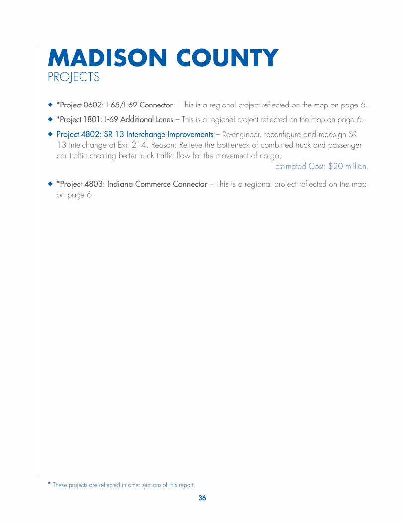
36
MADISON COUNTYPROJECTS
◆◆ *Project 0602: I-65/I-69 Connector – This is a regional project reflected on the map on page 6.
◆◆ *Project 1801: I-69 Additional Lanes – This is a regional project reflected on the map on page 6.
◆◆ Project 4802: SR 13 Interchange Improvements – Re-engineer, reconfigure and redesign SR 13 Interchange at Exit 214. Reason: Relieve the bottleneck of combined truck and passenger car traffic creating better truck traffic flow for the movement of cargo.
Estimated Cost: $20 million.
◆◆ *Project 4803: Indiana Commerce Connector – This is a regional project reflected on the map on page 6.
* These projects are reflected in other sections of this report.
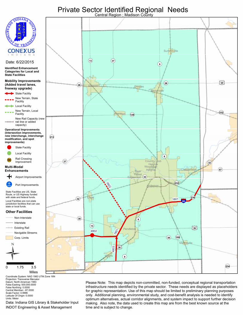
!
§̈¦69
¬«232
¬«234
¬«9
¬«332
¬«67
¬«9
¬«236
¬«37
¬«213
¬«109
¬«38
¬«128
¬«32
¬«37
¬«38
¬«32
¬«32
¬«28 ¬«28
¬«9
¬«9
¬«13
¬«13
£¤35
£¤36
£¤36
Orestes
Country ClubHeights
Markleville
Edgewood
RiverForest
Pendleton
Frankton
Summitville
Ingalls
Lapel
Anderson
Alexandria
Elwood
WoodlawnHeights Chesterfield
4803
0602
1801
1801
4802
Ü0 3.51.75
Miles
Date: 6/22/2015
Coordinate System: NAD 1983 UTM Zone 16NProjection: Transverse MercatorDatum: North American 1983False Easting: 500,000.0000False Northing: 0.0000Central Meridian: -87.0000Scale Factor: 0.9996Latitude Of Origin: 0.0000Units: Meter
Private Sector Identified Regional Needs
Data: Indiana GIS Library & Stakeholder InputINDOT Engineering & Asset Management
Please Note: This map depicts non-committed, non-funded, conceptual regional transportationinfrastructure needs identified by the private sector. These needs are displayed as placeholdersfor graphic representation. Use of this map should be limited to preliminary planning purposesonly. Additional planning, environmental study, and cost-benefit analysis is needed to identifyoptimum alternatives, actual corridor alignments, and system impact to support further decisionmaking. Also note, the data used to create this map are from the best known source at thetime and is subject to change.
Central Region ; Madison County
Identified EnhancementCategories for Local andState Facilities
Mobility Improvements(Added travel lanes,freeway upgrade)
State Facility
New Terrain, StateFacility
Local Facility
New Terrain, LocalFacility
New Rail Capacity (newrail line or addedcapacity)
Operational Improvements(Intersection improvements,new interchange, interchangemodification, and spotimprovements)
! State Facility
! Local Facility
¹º»¼Rail CrossingImprovement
Multi-ModalEnhancements
o Airport Improvements
!Î Port Improvements
Other FacilitiesNon-Interstate
Interstate
Existing Rail
Navigable Streams
Corp. Limits
State Facilities are US, StateRoute, or US Highway funded with state and federal funds.Local Facilities are non-statejursidiction facilities that can usestate or local funds.

38
◆◆
*Pro
ject
100
8: I-
65 A
dditi
onal
Lan
es –
Thi
s is
a re
gion
al p
roje
ct
refle
cted
on
the
map
on
page
6.
◆◆
*Pro
ject
180
1: I-
69 A
dditi
onal
Lan
es –
Thi
s is
a re
gion
al p
roje
ct
refle
cted
on
the
map
on
page
6.
◆◆
*Pro
ject
320
2: U
S 36
Cor
ridor
– T
his
is a
regi
onal
pro
ject
re
flect
ed o
n th
e m
ap o
n pa
ge 6
.
◆◆
*Pro
ject
410
1: I-
69 C
ompl
etio
n –
This
is a
regi
onal
pro
ject
re
flect
ed o
n th
e m
ap o
n pa
ge 6
.
◆◆
Proj
ect 4
901:
I-70
/I-6
5 Tw
o Sp
lits
– Re
-eng
inee
r, re
confi
gure
and
re
desig
n N
orth
I-65
/I-7
0 sp
lit a
nd S
outh
I-65
/I-7
0 sp
lit. R
easo
n:
Relie
ve th
e bo
ttlene
ck o
f com
bine
d tru
ck a
nd p
asse
nger
car
traf
fic
crea
ting
bette
r tru
ck tr
affic
flow
for t
he m
ovem
ent o
f car
go.
Estim
ated
Cos
t: $8
63 m
illion
◆◆
Proj
ect 4
902:
Sou
th W
est S
treet
Indu
stria
l Cor
ridor
– W
iden
an
d im
prov
e So
uth W
est S
treet
from
I-70
to W
est R
aym
ond
Stre
et
and
re-e
ngin
eer,
reco
nfigu
re a
nd re
desig
n th
e So
uth W
est S
treet
/W
est R
aym
ond
Stre
et in
terse
ction
. Rea
son:
Rel
ieve
the
bottle
neck
of
com
bine
d tru
ck a
nd p
asse
nger
con
gesti
on b
y in
dustr
ies o
n So
uth W
est
Stre
et c
reat
ing
bette
r tru
ck tr
affic
flow
for t
he m
ovem
ent o
f car
go.
Estim
ated
Cos
t: $4
milli
on
◆◆
Proj
ect 4
903:
Sou
th H
ardi
ng S
treet
Rai
l Gra
de S
epar
atio
n –
Build
and
des
ign
a ra
il gr
ade
sepa
ratio
n on
Sou
th H
ardi
ng S
treet
ne
ar th
e IP
L H
ardi
ng S
treet
Sta
tion.
Rea
son:
Rel
ieve
the
bottle
neck
of
com
bine
d tru
ck a
nd p
asse
nger
car
traf
fic c
reat
ing
bette
r tru
ck
traffi
c flo
w fo
r the
mov
emen
t of c
argo
.Es
timat
ed C
ost:
$5 m
illion
◆◆
Proj
ect 4
906:
Nor
thea
st C
orrid
or In
terc
hang
e Im
prov
emen
ts –
Re
-eng
inee
r, re
confi
gure
and
rede
sign
the
East
82nd
Stre
et
Inte
rcha
nge
at I-
69 a
nd I-
465.
Rea
son:
Rel
ieve
the
bottle
neck
of
com
bine
d tru
ck a
nd p
asse
nger
car
traf
fic c
reat
ing
bette
r tru
ck
traffi
c flo
w fo
r the
mov
emen
t of c
argo
. Estim
ated
Cos
t: $1
00 m
illion
◆◆
Proj
ect 4
907:
Nor
th M
ichi
gan
Road
Add
ition
al L
anes
– W
iden
ex
istin
g 3-
lane
seg
men
t to
4-la
ne s
egm
ent o
f Nor
th M
ichi
gan
Road
from
Wes
t 86t
h St
reet
to I-
465
in In
dian
apol
is. R
easo
n:
Relie
ve th
e bo
ttlene
ck o
f com
bine
d tru
ck a
nd p
asse
nger
car
traf
fic
crea
ting
bette
r tru
ck tr
affic
flow
for t
he m
ovem
ent o
f car
go.
Estim
ated
Cos
t: $2
0 m
illion
◆◆
Proj
ect 4
908:
Nor
th M
ichi
gan
Road
Inte
rsec
tion
Impr
ovem
ents
– Re
-eng
inee
r, re
confi
gure
and
rede
sign
the
Nor
th M
ichi
gan
Road
in
ters
ectio
n at
Wes
t 86t
h St
reet
. Rea
son:
Rel
ieve
the
bottle
neck
of
com
bine
d tru
ck a
nd p
asse
nger
car
traf
fic c
reat
ing
bette
r tru
ck
traffi
c flo
w fo
r the
mov
emen
t of c
argo
.Es
timat
ed C
ost:
$4 m
illion
◆◆
*Pro
ject
490
9: I-
465
Add
ition
al L
anes
– T
his
is a
regi
onal
pro
ject
re
flect
ed o
n th
e m
ap o
n pa
ge 6
.
◆◆
*Pro
ject
840
3: I-
70 T
hird
Lan
e/D
edic
ated
Tru
ck L
anes
– T
his
is a
regi
onal
pro
ject
refle
cted
on
the
map
on
page
6.
MA
RIO
N C
OU
NTY
PRO
JEC
TS
* Th
ese
proj
ects
are
refle
cted
in o
ther
sec
tions
of t
his
repo
rt.
!
!
!
¬ «134
¬ «267
¬ «234
¬ «267
¬ «135
¬ «37¬ «26
7¬ «67
£ ¤31
£ ¤421
£ ¤31
£ ¤36
£ ¤136 £ ¤40
£ ¤40
£ ¤52
£ ¤36
§̈ ¦69§̈ ¦86
5
§̈ ¦74
§̈ ¦70
§̈ ¦65
§̈ ¦465
Beec
hG
rove
Willi
ams
Cre
ek
War
ren
Park
Sout
hpor
t
Hom
ecro
ft
Spee
dway
Nor
th C
row
sN
est
Roc
kyR
ippl
eMer
idia
nH
ills
Law
renc
e
Indi
anap
olis
Cum
berla
nd
Cle
rmon
t
Wyn
neda
le
Cro
ws
Nes
t
4902
4907
3201
4901
4909
3202
4101
1009
4903
4906
4908
Ü 03
1.5
Mile
s
Dat
e: 8
/26/
2015
Coo
rdin
ate
Sys
tem
: NA
D 1
983
UTM
Zon
e 16
NPr
ojec
tion:
Tra
nsve
rse
Mer
cato
rD
atum
: Nor
th A
mer
ican
198
3Fa
lse
Eas
ting:
500
,000
.000
0Fa
lse
Nor
thin
g: 0
.000
0C
entra
l Mer
idia
n: -8
7.00
00Sc
ale
Fact
or: 0
.999
6La
titud
e O
f Orig
in: 0
.000
0U
nits
: Met
er
Priv
ate
Sec
tor I
dent
ified
Reg
iona
l N
eeds
Dat
a: In
dian
a G
IS L
ibra
ry &
Sta
keho
lder
Inpu
tIN
DO
T E
ngin
eerin
g &
Ass
et M
anag
emen
t
Plea
se N
ote:
Thi
s m
ap d
epic
ts n
on-c
omm
itted
, non
-fund
ed, c
once
ptua
l reg
iona
l tra
nspo
rtatio
nin
frast
ruct
ure
need
s id
entif
ied
by th
e pr
ivat
e se
ctor
. Th
ese
need
s ar
e di
spla
yed
as p
lace
hold
ers
for g
raph
ic re
pres
enta
tion.
Use
of t
his
map
sho
uld
be li
mite
d to
pre
limin
ary
plan
ning
pur
pose
son
ly. A
dditi
onal
pla
nnin
g, e
nviro
nmen
tal s
tudy
, and
cos
t-ben
efit
anal
ysis
is n
eede
d to
iden
tify
optim
um a
ltern
ativ
es, a
ctua
l cor
ridor
alig
nmen
ts, a
nd s
yste
m im
pact
to s
uppo
rt fu
rther
dec
isio
nm
akin
g. A
lso
note
, the
dat
a us
ed to
cre
ate
this
map
are
from
the
best
kno
wn
sour
ce a
t the
time
and
is s
ubje
ct to
cha
nge.
Cen
tral R
egio
n ; M
ario
n C
ount
y
Iden
tifie
d En
hanc
emen
tC
ateg
orie
s fo
r Loc
al a
ndSt
ate
Faci
litie
s
Mul
ti-M
odal
Enha
ncem
ents
oAi
rpor
t Im
prov
emen
ts
!ÎPo
rt Im
prov
emen
ts
Ope
ratio
nal I
mpr
ovem
ents
(Inte
rsec
tion
impr
ovem
ents
,ne
w in
terc
hang
e,in
terc
hang
e m
odifi
catio
n,an
d sp
ot im
prov
emen
ts)
!St
ate
Faci
lity
!Lo
cal F
acili
ty
¹º»¼R
ail C
ross
ing
Impr
ovem
ent
Mob
ility
Impr
ovem
ents
(Add
ed tr
avel
lane
s,fr
eew
ay u
pgra
de)
Stat
e Fa
cilit
y
New
Ter
rain
, Sta
teFa
cilit
y
Loca
l Fac
ility
New
Ter
rain
, Loc
alFa
cilit
yN
ew R
ail C
apac
ity(n
ew ra
il lin
e or
add
edca
paci
ty)
Stat
e Fa
cilit
ies
are
US,
Sta
teR
oute
, or U
S H
ighw
ay fu
nded
w
ith s
tate
and
fede
ral f
unds
.
Loca
l Fac
ilitie
s ar
e no
n-st
ate
jurs
idic
tion
faci
litie
s th
at c
anus
e st
ate
or lo
cal f
unds
.
Oth
er F
acili
ties
Non
-Inte
rsta
te
Inte
rsta
te
Exis
ting
Rai
l
Nav
igab
le S
tream
s
Cor
p. L
imits
£ ¤31
Sena
te A
ve.
Term
inal
0601
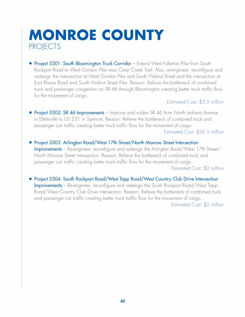
40
MONROE COUNTYPROJECTS
◆◆ Project 5301: South Bloomington Truck Corridor – Extend West Fullerton Pike from South Rockport Road to West Gordon Pike near Clear Creek Trail. Also, re-engineer, reconfigure and redesign the intersection at West Gordon Pike and South Walnut Street and the intersection at East Rhorer Road and South Walnut Street Pike. Reason: Relieve the bottleneck of combined truck and passenger congestion on SR 46 through Bloomington creating better truck traffic flow for the movement of cargo.
Estimated Cost: $5.5 million
◆◆ Project 5302: SR 46 Improvements – Improve and widen SR 46 from North Indiana Avenue in Ellettsville to US 231 in Spencer. Reason: Relieve the bottleneck of combined truck and passenger car traffic creating better truck traffic flow for the movement of cargo.
Estimated Cost: $36.5 million
◆◆ Project 5303: Arlington Road/West 17th Street/North Monroe Street Intersection Improvements – Re-engineer, reconfigure and redesign the Arlington Road/West 17th Street/ North Monroe Street intersection. Reason: Relieve the bottleneck of combined truck and passenger car traffic creating better truck traffic flow for the movement of cargo.
Estimated Cost: $2 million
◆◆ Project 5304: South Rockport Road/West Tapp Road/West Country Club Drive Intersection Improvements – Re-engineer, reconfigure and redesign the South Rockport Road/West Tapp Road/West Country Club Drive intersection. Reason: Relieve the bottleneck of combined truck and passenger car traffic creating better truck traffic flow for the movement of cargo.
Estimated Cost: $2 million

!
!
¬«54
¬«252
¬«43 ¬«48
¬«67
¬«45
¬«46
¬«46
¬«446
¬«446
¬«45
¬«45
¬«37
¬«37
¬«37
Ellettsville
Stinesville
Bloomington
53015302
5304
5303
Ü0 31.5
Miles
Date: 8/12/2015
Coordinate System: NAD 1983 UTM Zone 16NProjection: Transverse MercatorDatum: North American 1983False Easting: 500,000.0000False Northing: 0.0000Central Meridian: -87.0000Scale Factor: 0.9996Latitude Of Origin: 0.0000Units: Meter
Private Sector Identified Regional Needs
Data: Indiana GIS Library & Stakeholder InputINDOT Engineering & Asset Management
Please Note: This map depicts non-committed, non-funded, conceptual regional transportationinfrastructure needs identified by the private sector. These needs are displayed as placeholdersfor graphic representation. Use of this map should be limited to preliminary planning purposesonly. Additional planning, environmental study, and cost-benefit analysis is needed to identifyoptimum alternatives, actual corridor alignments, and system impact to support further decisionmaking. Also note, the data used to create this map are from the best known source at thetime and is subject to change.
Central Region ; Monroe County
Identified EnhancementCategories for Local andState Facilities
Mobility Improvements(Added travel lanes,freeway upgrade)
State Facility
New Terrain, StateFacility
Local Facility
New Terrain, LocalFacility
New Rail Capacity (newrail line or addedcapacity)
Operational Improvements(Intersection improvements,new interchange, interchangemodification, and spotimprovements)
! State Facility
! Local Facility
¹º»¼Rail CrossingImprovement
Multi-ModalEnhancements
o Airport Improvements
!Î Port Improvements
Other FacilitiesNon-Interstate
Interstate
Existing Rail
Navigable Streams
Corp. Limits
State Facilities are US, StateRoute, or US Highway funded with state and federal funds.Local Facilities are non-statejursidiction facilities that can usestate or local funds.

42
MONTGOMERY COUNTYPROJECTS
◆◆ *Project 5401: US 231 Additional Lanes – This is a regional project reflected on the map on page 6.
◆◆ Project 5402: Memorial Drive Extension – Design and build an extension of Memorial Drive from Whitlock Avenue West to US 231. Reason: Relieve the bottleneck of combined truck and passenger car congestion through Crawfordsville creating better truck traffic flow for the movement of cargo.
Estimated Cost: $10.9 million
◆◆ Project 5403: East Crawfordsville Truck Route – Design and build a new road from Memorial Drive at SR 47 to South US 231 near East CR 300 South. Reason: Relieve the bottleneck of combined truck and passenger congestion on US 231/SR 47 through Crawfordsville creating better truck traffic flow for the movement of cargo.
Estimated Cost: $67 million
◆◆ Project 5404: East Market Street Rail Grade Separation – Build and design a rail grade separation on East Market Street at the CSX rail tracks. Reason: Relieve the bottleneck of combined truck and passenger car traffic creating better truck traffic flow for the movement of cargo.
Estimated Cost: $30 million
◆◆ Project 5405: CSX Railroad Track Removal – Remove the CSX rail line at Schenck Road to US 231. Reason: Ensure the safety of trucks moving cargo ensuring better truck traffic flow for the movement of cargo. Also relieve the bottleneck of combined truck and passenger car traffic in Crawfordsville creating better truck traffic flow for the movement of cargo.
Estimated Cost: $5 million
◆◆ Project 5406: CSX Transfer Rail Station – Design and build a new rail transfer station at East CR 200 South. Reason: Relieve the bottleneck of rail traffic creating better rail traffic flow for the movement of cargo.
Estimated Cost: $20 million
◆◆ Project 5407: Nucor Road Overpass – Design and build an overpass at US 136 and Nucor Road. Reason: Safety of trucks moving cargo ensuring better truck traffic flow for the movement of cargo.
Estimated Cost: $5 million
◆◆ *Project 5408: US 32 Additional Lanes – This is a regional project reflected on the map on page 6.
* These projects are reflected in other sections of this report.

! !
§̈¦74
¬«236
¬«28
¬«55
¬«25
¬«59 ¬«236
¬«32
¬«32
¬«236
¬«25
¬«47
¬«47
¬«47
¬«28 ¬«28
¬«234
¬«234
£¤52
£¤136
£¤136
£¤231
£¤231
NewMarket
New Ross
Crawfordsville
Waynetown
NewRichmond
Wingate
Waveland
Alamo
Darlington
Ladoga
Linden
5406
5402
540554
03
5408
5401
54045407
Ü0 31.5
Miles
Date: 6/22/2015
Coordinate System: NAD 1983 UTM Zone 16NProjection: Transverse MercatorDatum: North American 1983False Easting: 500,000.0000False Northing: 0.0000Central Meridian: -87.0000Scale Factor: 0.9996Latitude Of Origin: 0.0000Units: Meter
Private Sector Identified Regional Needs
Data: Indiana GIS Library & Stakeholder InputINDOT Engineering & Asset Management
Please Note: This map depicts non-committed, non-funded, conceptual regional transportationinfrastructure needs identified by the private sector. These needs are displayed as placeholdersfor graphic representation. Use of this map should be limited to preliminary planning purposesonly. Additional planning, environmental study, and cost-benefit analysis is needed to identifyoptimum alternatives, actual corridor alignments, and system impact to support further decisionmaking. Also note, the data used to create this map are from the best known source at thetime and is subject to change.
Central Region ; Montgomery County
Identified EnhancementCategories for Local andState Facilities
Mobility Improvements(Added travel lanes,freeway upgrade)
State Facility
New Terrain, StateFacility
Local Facility
New Terrain, LocalFacility
New Rail Capacity (newrail line or addedcapacity)
Operational Improvements(Intersection improvements,new interchange, interchangemodification, and spotimprovements)
! State Facility
! Local Facility
¹º»¼Rail CrossingImprovement
Multi-ModalEnhancements
o Airport Improvements
!Î Port Improvements
Other FacilitiesNon-Interstate
Interstate
Existing Rail
Navigable Streams
Corp. Limits
State Facilities are US, StateRoute, or US Highway funded with state and federal funds.Local Facilities are non-statejursidiction facilities that can usestate or local funds.

44
◆◆
*Pro
ject
410
1: I-
69 C
ompl
etio
n –
This
is a
regi
onal
pro
ject
re
flect
ed o
n th
e m
ap o
n pa
ge 6
.
◆◆
*Pro
ject
480
3: In
dian
a C
omm
erce
Con
nect
or –
Thi
s is
a re
gion
al p
roje
ct re
flect
ed o
n th
e m
ap o
n pa
ge 6
.
◆◆
*Pro
ject
670
4: S
R 75
Ext
ensi
on –
Thi
s is
a lo
cal p
roje
ct
refle
cted
in th
e Pu
tman
Cou
nty
map
on
page
51.
◆◆
*Pro
ject
840
3: I-
70 T
hird
Lan
e/D
edic
ated
Tru
ck L
anes
– T
his
is a
regi
onal
pro
ject
refle
cted
on
the
map
on
page
6.
MO
RG
AN
CO
UN
TYPR
OJE
CTS
* Th
ese
proj
ects
are
refle
cted
in o
ther
sec
tions
of t
his
repo
rt.
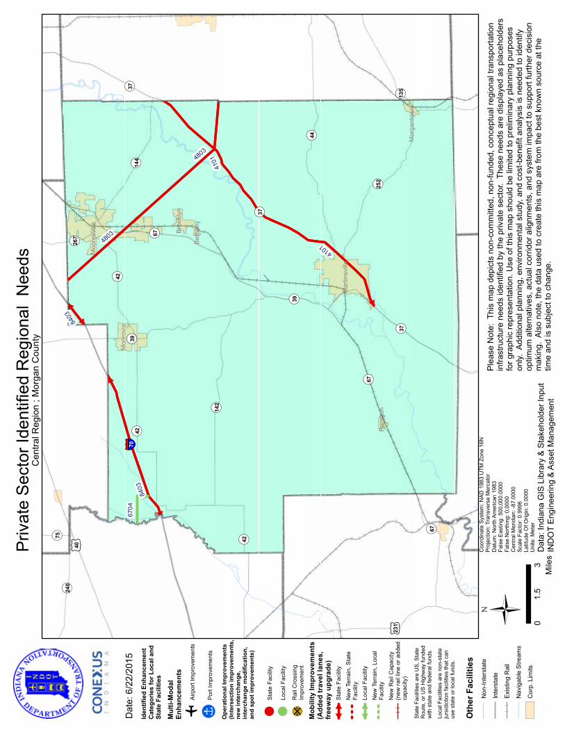
!
¬ «75
¬ «267
¬ «240
¬ «42
¬ «144
¬ «252
¬ «135
¬ «142
¬ «44
¬ «67
¬ «67
¬ «67
¬ «39
¬ «39
¬ «42
¬ «42
¬ «37
¬ «37
¬ «37
£ ¤231
£ ¤40
§̈ ¦70
Mar
tinsv
ille
Mor
gant
own
Beth
any
Broo
klyn
Moo
resv
ille
Para
gon
Mon
rovi
a
8403
4803
4803
4101
4101
Ü 03
1.5
Mile
s
Dat
e: 6
/22/
2015
Coo
rdin
ate
Syst
em: N
AD 1
983
UTM
Zon
e 16
NPr
ojec
tion:
Tra
nsve
rse
Mer
cato
rD
atum
: Nor
th A
mer
ican
198
3Fa
lse
Eas
ting:
500
,000
.000
0Fa
lse
Nor
thin
g: 0
.000
0C
entra
l Mer
idia
n: -8
7.00
00Sc
ale
Fact
or: 0
.999
6La
titud
e O
f Orig
in: 0
.000
0U
nits
: Met
er
Priv
ate
Sec
tor I
dent
ified
Reg
iona
l N
eeds
Dat
a: In
dian
a G
IS L
ibra
ry &
Sta
keho
lder
Inpu
tIN
DO
T E
ngin
eerin
g &
Ass
et M
anag
emen
t
Plea
se N
ote:
Thi
s m
ap d
epic
ts n
on-c
omm
itted
, non
-fund
ed, c
once
ptua
l reg
iona
l tra
nspo
rtatio
nin
frast
ruct
ure
need
s id
entif
ied
by th
e pr
ivat
e se
ctor
. Th
ese
need
s ar
e di
spla
yed
as p
lace
hold
ers
for g
raph
ic re
pres
enta
tion.
Use
of t
his
map
sho
uld
be li
mite
d to
pre
limin
ary
plan
ning
pur
pose
son
ly. A
dditi
onal
pla
nnin
g, e
nviro
nmen
tal s
tudy
, and
cos
t-ben
efit
anal
ysis
is n
eede
d to
iden
tify
optim
um a
ltern
ativ
es, a
ctua
l cor
ridor
alig
nmen
ts, a
nd s
yste
m im
pact
to s
uppo
rt fu
rther
dec
isio
nm
akin
g. A
lso
note
, the
dat
a us
ed to
cre
ate
this
map
are
from
the
best
kno
wn
sour
ce a
t the
time
and
is s
ubje
ct to
cha
nge.
Cen
tral R
egio
n ; M
orga
n C
ount
y
Iden
tifie
d En
hanc
emen
tC
ateg
orie
s fo
r Loc
al a
ndSt
ate
Faci
litie
s
Mul
ti-M
odal
Enha
ncem
ents
oAi
rpor
t Im
prov
emen
ts
!ÎPo
rt Im
prov
emen
ts
Ope
ratio
nal I
mpr
ovem
ents
(Inte
rsec
tion
impr
ovem
ents
,ne
w in
terc
hang
e,in
terc
hang
e m
odifi
catio
n,an
d sp
ot im
prov
emen
ts)
!St
ate
Faci
lity
!Lo
cal F
acili
ty
¹º»¼R
ail C
ross
ing
Impr
ovem
ent
Mob
ility
Impr
ovem
ents
(Add
ed tr
avel
lane
s,fr
eew
ay u
pgra
de)
Stat
e Fa
cilit
y
New
Ter
rain
, Sta
teFa
cilit
yLo
cal F
acili
tyN
ew T
erra
in, L
ocal
Faci
lity
New
Rai
l Cap
acity
(new
rail
line
or a
dded
capa
city
)
Stat
e Fa
cilit
ies
are
US,
Sta
teR
oute
, or U
S H
ighw
ay fu
nded
w
ith s
tate
and
fede
ral f
unds
.
Loca
l Fac
ilitie
s ar
e no
n-st
ate
jurs
idic
tion
faci
litie
s th
at c
anus
e st
ate
or lo
cal f
unds
.
Oth
er F
acili
ties
Non
-Inte
rsta
te
Inte
rsta
te
Exis
ting
Rai
l
Nav
igab
le S
tream
s
Cor
p. L
imits
6704
8403

46
OW
EN C
OU
NTY
PRO
JEC
TS
◆◆
*Pro
ject
530
2: S
R 46
Impr
ovem
ents
– Th
is is
a lo
cal p
roje
ct
refle
cted
in th
e M
onro
e C
ount
y m
ap o
n pa
ge 4
0.
* Th
ese
proj
ects
are
refle
cted
in o
ther
sec
tions
of t
his
repo
rt.

¬ «45
¬ «246
¬ «243
¬ «48¬ «48
¬ «37
¬ «67
¬ «43
¬ «157
¬ «46
¬ «246
¬ «42¬ «42
¬ «46
¬ «46
¬ «59¬ «59
£ ¤231
£ ¤231
§̈ ¦70
Spen
cer
Gos
port
Ü 03
1.5
Mile
s
Dat
e: 6
/22/
2015
Coo
rdin
ate
Syst
em: N
AD 1
983
UTM
Zon
e 16
NPr
ojec
tion:
Tra
nsve
rse
Mer
cato
rD
atum
: Nor
th A
mer
ican
198
3Fa
lse
Eas
ting:
500
,000
.000
0Fa
lse
Nor
thin
g: 0
.000
0C
entra
l Mer
idia
n: -8
7.00
00Sc
ale
Fact
or: 0
.999
6La
titud
e O
f Orig
in: 0
.000
0U
nits
: Met
er
Priv
ate
Sec
tor I
dent
ified
Reg
iona
l N
eeds
Dat
a: In
dian
a G
IS L
ibra
ry &
Sta
keho
lder
Inpu
tIN
DO
T E
ngin
eerin
g &
Ass
et M
anag
emen
t
Plea
se N
ote:
Thi
s m
ap d
epic
ts n
on-c
omm
itted
, non
-fund
ed, c
once
ptua
l reg
iona
l tra
nspo
rtatio
nin
frast
ruct
ure
need
s id
entif
ied
by th
e pr
ivat
e se
ctor
. Th
ese
need
s ar
e di
spla
yed
as p
lace
hold
ers
for g
raph
ic re
pres
enta
tion.
Use
of t
his
map
sho
uld
be li
mite
d to
pre
limin
ary
plan
ning
pur
pose
son
ly. A
dditi
onal
pla
nnin
g, e
nviro
nmen
tal s
tudy
, and
cos
t-ben
efit
anal
ysis
is n
eede
d to
iden
tify
optim
um a
ltern
ativ
es, a
ctua
l cor
ridor
alig
nmen
ts, a
nd s
yste
m im
pact
to s
uppo
rt fu
rther
dec
isio
nm
akin
g. A
lso
note
, the
dat
a us
ed to
cre
ate
this
map
are
from
the
best
kno
wn
sour
ce a
t the
time
and
is s
ubje
ct to
cha
nge.
Cen
tral R
egio
n ; O
wen
Cou
nty
Iden
tifie
d En
hanc
emen
tC
ateg
orie
s fo
r Loc
al a
ndSt
ate
Faci
litie
s
Mul
ti-M
odal
Enha
ncem
ents
oAi
rpor
t Im
prov
emen
ts
!ÎPo
rt Im
prov
emen
ts
Ope
ratio
nal I
mpr
ovem
ents
(Inte
rsec
tion
impr
ovem
ents
,ne
w in
terc
hang
e,in
terc
hang
e m
odifi
catio
n,an
d sp
ot im
prov
emen
ts)
!St
ate
Faci
lity
!Lo
cal F
acili
ty
¹º»¼R
ail C
ross
ing
Impr
ovem
ent
Mob
ility
Impr
ovem
ents
(Add
ed tr
avel
lane
s,fr
eew
ay u
pgra
de)
Stat
e Fa
cilit
y
New
Ter
rain
, Sta
teFa
cilit
yLo
cal F
acili
tyN
ew T
erra
in, L
ocal
Faci
lity
New
Rai
l Cap
acity
(new
rail
line
or a
dded
capa
city
)
Stat
e Fa
cilit
ies
are
US,
Sta
teR
oute
, or U
S H
ighw
ay fu
nded
w
ith s
tate
and
fede
ral f
unds
.
Loca
l Fac
ilitie
s ar
e no
n-st
ate
jurs
idic
tion
faci
litie
s th
at c
anus
e st
ate
or lo
cal f
unds
.
Oth
er F
acili
ties
Non
-Inte
rsta
te
Inte
rsta
te
Exis
ting
Rai
l
Nav
igab
le S
tream
s
Cor
p. L
imits
5302

48
PARKE COUNTYPROJECTS
Nothing local that affects the movement of cargo.

¬«71
¬«236
¬«341
¬«163
¬«236
¬«47
¬«59
¬«59
¬«234 ¬«234
¬«63
¬«63
¬«63
£¤150
£¤40
£¤36
£¤36
£¤41
£¤41
£¤41
Mecca
Montezuma
Rosedale
Rockville
Marshall
Bloomingdale
Ü0 31.5
Miles
Date: 6/22/2015
Coordinate System: NAD 1983 UTM Zone 16NProjection: Transverse MercatorDatum: North American 1983False Easting: 500,000.0000False Northing: 0.0000Central Meridian: -87.0000Scale Factor: 0.9996Latitude Of Origin: 0.0000Units: Meter
Private Sector Identified Regional Needs
Data: Indiana GIS Library & Stakeholder InputINDOT Engineering & Asset Management
Please Note: This map depicts non-committed, non-funded, conceptual regional transportationinfrastructure needs identified by the private sector. These needs are displayed as placeholdersfor graphic representation. Use of this map should be limited to preliminary planning purposesonly. Additional planning, environmental study, and cost-benefit analysis is needed to identifyoptimum alternatives, actual corridor alignments, and system impact to support further decisionmaking. Also note, the data used to create this map are from the best known source at thetime and is subject to change.
Central Region ; Parke County
Identified EnhancementCategories for Local andState Facilities
Mobility Improvements(Added travel lanes,freeway upgrade)
State Facility
New Terrain, StateFacility
Local Facility
New Terrain, LocalFacility
New Rail Capacity (newrail line or addedcapacity)
Operational Improvements(Intersection improvements,new interchange, interchangemodification, and spotimprovements)
! State Facility
! Local Facility
¹º»¼Rail CrossingImprovement
Multi-ModalEnhancements
o Airport Improvements
!Î Port Improvements
Other FacilitiesNon-Interstate
Interstate
Existing Rail
Navigable Streams
Corp. Limits
State Facilities are US, StateRoute, or US Highway funded with state and federal funds.Local Facilities are non-statejursidiction facilities that can usestate or local funds.

50
PUTNAM COUNTYPROJECTS
◆◆ Project 6701: East Greencastle Truck Corridor – Design and build a new road from US 231 North of Greencastle at West CR 75 North to South US 231 near East CR 350 South. Reason: Relieve the bottleneck of combined truck and passenger congestion on US 231 through Greencastle creating better truck traffic flow for the movement of cargo.
Estimated Cost: $42 million
◆◆ Project 6702: US 231 Additional Lanes – Widen existing 2-lane segment to 4-lane segment of US 231 from I-70 to Veterans Memorial Highway/SR 240 in Greencastle. Reason: Relieve the bottleneck of combined truck and passenger car traffic creating better truck traffic flow for the movement of cargo.
Estimated Cost: $33.9 million
◆◆ Project 6703: US 231 Intersection Improvements – Re-engineer, reconfigure and redesign US 231 providing turn lanes and acceleration lanes at intersection of East CR 800 South. Reason: Relieve the bottleneck of combined truck and passenger car traffic creating better truck traffic flow for the movement of cargo.
Estimated Cost: $1 million
◆◆ Project 6704: SR 75 Extension – Design and build an extension of SR 75 from US 40 to I-70 Exit 51. Reason: Create economic development by giving increased access to the industrial areas of Eastern Greencastle.
Estimated Cost: $25.2 million
◆◆ Project 6705: CSX Rail Bridge Replacement – Design and build a new replacement rail bridge over US 231 south of West CR 25 South. Reason: Safety of trucks moving cargo ensuring better truck traffic flow for the movement of cargo.
Estimated Cost: $12 million
◆◆ Project 6706: Stardust Road Improvements – Widen existing road from US 231 to South CR 125 East. Reason: Relieve the bottleneck of combined truck and passenger car traffic creating better truck traffic flow for the movement of cargo.
Estimated Cost: $4.2 million
◆◆ *Project 8403: I-70 Third Lane/Dedicated Truck Lanes – This is a regional project reflected on the map on page 6.
* These projects are reflected in other sections of this report.
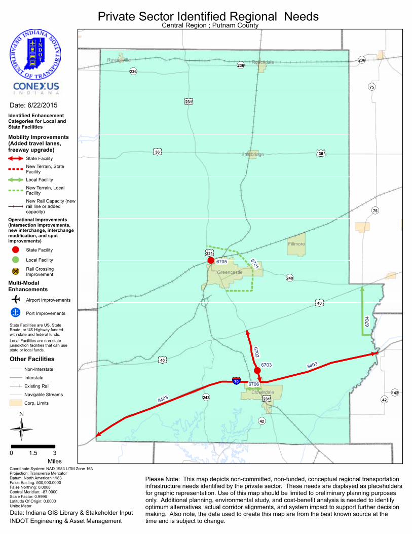
!
!
§̈¦70
¬«142
¬«236
¬«243
¬«240
¬«236¬«236
¬«75
¬«75
¬«42
¬«42
£¤36 £¤36
£¤40
£¤40
£¤231
£¤231
£¤231
Russellville
Greencastle
Roachdale
Cloverdale
Fillmore
Bainbridge
8403
8403
6706
6702
6704
6701
6703
6705
Ü0 31.5
Miles
Date: 6/22/2015
Coordinate System: NAD 1983 UTM Zone 16NProjection: Transverse MercatorDatum: North American 1983False Easting: 500,000.0000False Northing: 0.0000Central Meridian: -87.0000Scale Factor: 0.9996Latitude Of Origin: 0.0000Units: Meter
Private Sector Identified Regional Needs
Data: Indiana GIS Library & Stakeholder InputINDOT Engineering & Asset Management
Please Note: This map depicts non-committed, non-funded, conceptual regional transportationinfrastructure needs identified by the private sector. These needs are displayed as placeholdersfor graphic representation. Use of this map should be limited to preliminary planning purposesonly. Additional planning, environmental study, and cost-benefit analysis is needed to identifyoptimum alternatives, actual corridor alignments, and system impact to support further decisionmaking. Also note, the data used to create this map are from the best known source at thetime and is subject to change.
Central Region ; Putnam County
Identified EnhancementCategories for Local andState Facilities
Mobility Improvements(Added travel lanes,freeway upgrade)
State Facility
New Terrain, StateFacility
Local Facility
New Terrain, LocalFacility
New Rail Capacity (newrail line or addedcapacity)
Operational Improvements(Intersection improvements,new interchange, interchangemodification, and spotimprovements)
! State Facility
! Local Facility
¹º»¼Rail CrossingImprovement
Multi-ModalEnhancements
o Airport Improvements
!Î Port Improvements
Other FacilitiesNon-Interstate
Interstate
Existing Rail
Navigable Streams
Corp. Limits
State Facilities are US, StateRoute, or US Highway funded with state and federal funds.Local Facilities are non-statejursidiction facilities that can usestate or local funds.
52
◆◆
*Pro
ject
380
2: U
S 27
Impr
ovem
ents
– Th
is is
a re
gion
al
proj
ect r
eflec
ted
on th
e m
ap o
n pa
ge 6
.
RA
ND
OLP
H C
OU
NTY
PRO
JEC
TS
* Th
ese
proj
ects
are
refle
cted
in o
ther
sec
tions
of t
his
repo
rt.

!
¬ «67
¬ «167
¬ «1
¬ «67
¬ «32
¬ «227
¬ «32¬ «32
¬ «1
¬ «1
¬ «28¬ «28
¬ «28
£ ¤35
£ ¤35
£ ¤27
£ ¤27
£ ¤36
£ ¤36
Farm
land
Park
erC
ity
Losa
ntvi
lle
Win
ches
ter
Alba
ny
Sara
toga
Mod
oc
Rid
gevi
lle
Uni
onC
ity
Lynn
3802
3802
Ü 03
1.5
Mile
s
Dat
e: 6
/22/
2015
Coo
rdin
ate
Syst
em: N
AD 1
983
UTM
Zon
e 16
NPr
ojec
tion:
Tra
nsve
rse
Mer
cato
rD
atum
: Nor
th A
mer
ican
198
3Fa
lse
Eas
ting:
500
,000
.000
0Fa
lse
Nor
thin
g: 0
.000
0C
entra
l Mer
idia
n: -8
7.00
00Sc
ale
Fact
or: 0
.999
6La
titud
e O
f Orig
in: 0
.000
0U
nits
: Met
er
Priv
ate
Sec
tor I
dent
ified
Reg
iona
l N
eeds
Dat
a: In
dian
a G
IS L
ibra
ry &
Sta
keho
lder
Inpu
tIN
DO
T E
ngin
eerin
g &
Ass
et M
anag
emen
t
Plea
se N
ote:
Thi
s m
ap d
epic
ts n
on-c
omm
itted
, non
-fund
ed, c
once
ptua
l reg
iona
l tra
nspo
rtatio
nin
frast
ruct
ure
need
s id
entif
ied
by th
e pr
ivat
e se
ctor
. Th
ese
need
s ar
e di
spla
yed
as p
lace
hold
ers
for g
raph
ic re
pres
enta
tion.
Use
of t
his
map
sho
uld
be li
mite
d to
pre
limin
ary
plan
ning
pur
pose
son
ly. A
dditi
onal
pla
nnin
g, e
nviro
nmen
tal s
tudy
, and
cos
t-ben
efit
anal
ysis
is n
eede
d to
iden
tify
optim
um a
ltern
ativ
es, a
ctua
l cor
ridor
alig
nmen
ts, a
nd s
yste
m im
pact
to s
uppo
rt fu
rther
dec
isio
nm
akin
g. A
lso
note
, the
dat
a us
ed to
cre
ate
this
map
are
from
the
best
kno
wn
sour
ce a
t the
time
and
is s
ubje
ct to
cha
nge.
Cen
tral R
egio
n ; R
ando
lph
Cou
nty
Iden
tifie
d En
hanc
emen
tC
ateg
orie
s fo
r Loc
al a
ndSt
ate
Faci
litie
s
Mul
ti-M
odal
Enha
ncem
ents
oAi
rpor
t Im
prov
emen
ts
!ÎPo
rt Im
prov
emen
ts
Ope
ratio
nal I
mpr
ovem
ents
(Inte
rsec
tion
impr
ovem
ents
,ne
w in
terc
hang
e,in
terc
hang
e m
odifi
catio
n,an
d sp
ot im
prov
emen
ts)
!St
ate
Faci
lity
!Lo
cal F
acili
ty
¹º»¼R
ail C
ross
ing
Impr
ovem
ent
Mob
ility
Impr
ovem
ents
(Add
ed tr
avel
lane
s,fr
eew
ay u
pgra
de)
Stat
e Fa
cilit
y
New
Ter
rain
, Sta
teFa
cilit
yLo
cal F
acili
tyN
ew T
erra
in, L
ocal
Faci
lity
New
Rai
l Cap
acity
(new
rail
line
or a
dded
capa
city
)
Stat
e Fa
cilit
ies
are
US,
Sta
teR
oute
, or U
S H
ighw
ay fu
nded
w
ith s
tate
and
fede
ral f
unds
.
Loca
l Fac
ilitie
s ar
e no
n-st
ate
jurs
idic
tion
faci
litie
s th
at c
anus
e st
ate
or lo
cal f
unds
.
Oth
er F
acili
ties
Non
-Inte
rsta
te
Inte
rsta
te
Exis
ting
Rai
l
Nav
igab
le S
tream
s
Cor
p. L
imits

54
RUSH COUNTYPROJECTS
◆◆ *Project 7001: SR 3 Improvements – This is a regional project reflected on the map on page 6.
* These projects are reflected in other sections of this report.

§̈¦74
¬«103¬«3¬«109
¬«140
¬«44
¬«44
¬«3
¬«3
¬«3
¬«3
¬«244 ¬«244
£¤40
£¤40
£¤52
£¤52
Carthage
Rushville
Glenwood70
01
7001
7001
Ü0 2.51.25
Miles
Date: 6/22/2015
Coordinate System: NAD 1983 UTM Zone 16NProjection: Transverse MercatorDatum: North American 1983False Easting: 500,000.0000False Northing: 0.0000Central Meridian: -87.0000Scale Factor: 0.9996Latitude Of Origin: 0.0000Units: Meter
Private Sector Identified Regional Needs
Data: Indiana GIS Library & Stakeholder InputINDOT Engineering & Asset Management
Please Note: This map depicts non-committed, non-funded, conceptual regional transportationinfrastructure needs identified by the private sector. These needs are displayed as placeholdersfor graphic representation. Use of this map should be limited to preliminary planning purposesonly. Additional planning, environmental study, and cost-benefit analysis is needed to identifyoptimum alternatives, actual corridor alignments, and system impact to support further decisionmaking. Also note, the data used to create this map are from the best known source at thetime and is subject to change.
Central Region ; Rush County
Identified EnhancementCategories for Local andState Facilities
Mobility Improvements(Added travel lanes,freeway upgrade)
State Facility
New Terrain, StateFacility
Local Facility
New Terrain, LocalFacility
New Rail Capacity (newrail line or addedcapacity)
Operational Improvements(Intersection improvements,new interchange, interchangemodification, and spotimprovements)
! State Facility
! Local Facility
¹º»¼Rail CrossingImprovement
Multi-ModalEnhancements
o Airport Improvements
!Î Port Improvements
Other FacilitiesNon-Interstate
Interstate
Existing Rail
Navigable Streams
Corp. Limits
State Facilities are US, StateRoute, or US Highway funded with state and federal funds.Local Facilities are non-statejursidiction facilities that can usestate or local funds.

56
SHELBY COUNTYPROJECTS
◆◆ *Project 4803: Indiana Commerce Connector – This is a regional project reflected on the map on page 6.
◆◆ Project 7301: West Shelbyville Truck Corridor – Design and build a new road from West CR 400 North near I-74 exit 109 to SR 44. Reason: Relieve the bottleneck of combined truck and passenger congestion on SR 9/SR 44 through Shelbyville creating better truck traffic flow for the movement of cargo.
Estimated Project: $50.4 million
◆◆ Project 7302: SR 44 Improvements – Improve and widen SR 44 from I-65 to Miller Avenue in Shelbyville. Reason: Relieve the bottleneck of combined truck and passenger car traffic creating better truck traffic flow for the movement of cargo.
Estimated Cost: $49.2 million
* These projects are reflected in other sections of this report.

§̈¦65
§̈¦74
¬«244
¬«252
¬«44
¬«44
¬«9
¬«9
¬«9
£¤31
£¤52
£¤52
Shelbyville
St. Paul
Edinburgh
Fairland
Morristown
7302
7301
480348
03
Ü0 2.51.25
Miles
Date: 6/22/2015
Coordinate System: NAD 1983 UTM Zone 16NProjection: Transverse MercatorDatum: North American 1983False Easting: 500,000.0000False Northing: 0.0000Central Meridian: -87.0000Scale Factor: 0.9996Latitude Of Origin: 0.0000Units: Meter
Private Sector Identified Regional Needs
Data: Indiana GIS Library & Stakeholder InputINDOT Engineering & Asset Management
Please Note: This map depicts non-committed, non-funded, conceptual regional transportationinfrastructure needs identified by the private sector. These needs are displayed as placeholdersfor graphic representation. Use of this map should be limited to preliminary planning purposesonly. Additional planning, environmental study, and cost-benefit analysis is needed to identifyoptimum alternatives, actual corridor alignments, and system impact to support further decisionmaking. Also note, the data used to create this map are from the best known source at thetime and is subject to change.
Central Region ; Shelby County
Identified EnhancementCategories for Local andState Facilities
Mobility Improvements(Added travel lanes,freeway upgrade)
State Facility
New Terrain, StateFacility
Local Facility
New Terrain, LocalFacility
New Rail Capacity (newrail line or addedcapacity)
Operational Improvements(Intersection improvements,new interchange, interchangemodification, and spotimprovements)
! State Facility
! Local Facility
¹º»¼Rail CrossingImprovement
Multi-ModalEnhancements
o Airport Improvements
!Î Port Improvements
Other FacilitiesNon-Interstate
Interstate
Existing Rail
Navigable Streams
Corp. Limits
State Facilities are US, StateRoute, or US Highway funded with state and federal funds.Local Facilities are non-statejursidiction facilities that can usestate or local funds.
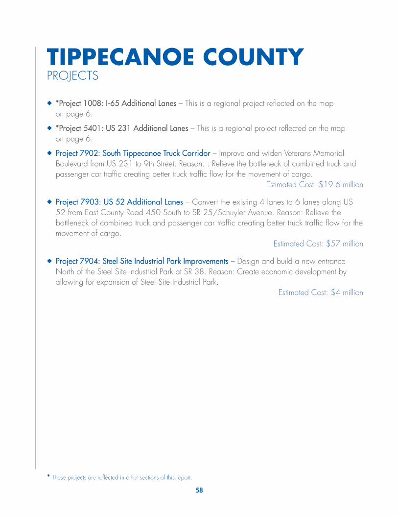
58
TIPPECANOE COUNTYPROJECTS
◆◆ *Project 1008: I-65 Additional Lanes – This is a regional project reflected on the map on page 6.
◆◆ *Project 5401: US 231 Additional Lanes – This is a regional project reflected on the map on page 6.
◆◆ Project 7902: South Tippecanoe Truck Corridor – Improve and widen Veterans Memorial Boulevard from US 231 to 9th Street. Reason: : Relieve the bottleneck of combined truck and passenger car traffic creating better truck traffic flow for the movement of cargo.
Estimated Cost: $19.6 million
◆◆ Project 7903: US 52 Additional Lanes – Convert the existing 4 lanes to 6 lanes along US 52 from East County Road 450 South to SR 25/Schuyler Avenue. Reason: Relieve the bottleneck of combined truck and passenger car traffic creating better truck traffic flow for the movement of cargo.
Estimated Cost: $57 million
◆◆ Project 7904: Steel Site Industrial Park Improvements – Design and build a new entrance North of the Steel Site Industrial Park at SR 38. Reason: Create economic development by allowing for expansion of Steel Site Industrial Park.
Estimated Cost: $4 million
* These projects are reflected in other sections of this report.

§̈¦65
¬«43
¬«28
¬«28
¬«55
¬«225
¬«43
¬«26
¬«26
¬«38
¬«25
¬«18¬«18
¬«25
¬«25
¬«28 ¬«28
£¤421
£¤231
£¤231
£¤231
£¤52
£¤52
£¤52
Otterbein
WestLafayette
Dayton
Shadeland
BattleGround
Lafayette
ClarksHill
79047902
7903
5401
1008
1008
Ü0 31.5
Miles
Date: 8/12/2015
Coordinate System: NAD 1983 UTM Zone 16NProjection: Transverse MercatorDatum: North American 1983False Easting: 500,000.0000False Northing: 0.0000Central Meridian: -87.0000Scale Factor: 0.9996Latitude Of Origin: 0.0000Units: Meter
Private Sector Identified Regional Needs
Data: Indiana GIS Library & Stakeholder InputINDOT Engineering & Asset Management
Please Note: This map depicts non-committed, non-funded, conceptual regional transportationinfrastructure needs identified by the private sector. These needs are displayed as placeholdersfor graphic representation. Use of this map should be limited to preliminary planning purposesonly. Additional planning, environmental study, and cost-benefit analysis is needed to identifyoptimum alternatives, actual corridor alignments, and system impact to support further decisionmaking. Also note, the data used to create this map are from the best known source at thetime and is subject to change.
Central Region ; Tipecanoe County
Identified EnhancementCategories for Local andState Facilities
Mobility Improvements(Added travel lanes,freeway upgrade)
State Facility
New Terrain, StateFacility
Local Facility
New Terrain, LocalFacility
New Rail Capacity (newrail line or addedcapacity)
Operational Improvements(Intersection improvements,new interchange, interchangemodification, and spotimprovements)
! State Facility
! Local Facility
¹º»¼Rail CrossingImprovement
Multi-ModalEnhancements
o Airport Improvements
!Î Port Improvements
Other FacilitiesNon-Interstate
Interstate
Existing Rail
Navigable Streams
Corp. Limits
State Facilities are US, StateRoute, or US Highway funded with state and federal funds.Local Facilities are non-statejursidiction facilities that can usestate or local funds.
Central Region ; Tippecanoe County

60
TIPTO
N C
OU
NTY
PRO
JEC
TS
◆◆
*Pro
ject
250
1: U
S 31
Indi
anap
olis
to B
ento
n H
arbo
r, M
I –
This
is a
regi
onal
pro
ject
refle
cted
on
the
map
on
page
6.
◆◆
Proj
ect 8
002:
Tip
ton
Agr
icul
ture
Cor
ridor
– D
esig
n an
d bu
ild a
new
road
from
Div
ision
Roa
d Ea
st of
US
31 to
SR
28. R
easo
n: R
elie
ve th
e bo
ttlene
ck o
f com
bine
d tru
ck a
nd
pass
enge
r car
traf
fic c
reat
ing
bette
r tru
ck tr
affic
flow
for t
he
mov
emen
t of c
argo
.Es
timat
ed C
ost:
$14
milli
on
* Th
ese
proj
ects
are
refle
cted
in o
ther
sec
tions
of t
his
repo
rt.

¬ «128
¬ «931
¬ «28¬ «28
¬ «28¬ «28
¬ «13
¬ «13
¬ «19
¬ «19
¬ «213 ¬ «213
¬ «26¬ «26
£ ¤31
£ ¤31
Win
dfal
l
Shar
psvi
lle
Kem
pton
Tipt
on25012501 8002
Ü 02
1M
iles
Dat
e: 6
/22/
2015
Coo
rdin
ate
Syst
em: N
AD 1
983
UTM
Zon
e 16
NPr
ojec
tion:
Tra
nsve
rse
Mer
cato
rD
atum
: Nor
th A
mer
ican
198
3Fa
lse
Eas
ting:
500
,000
.000
0Fa
lse
Nor
thin
g: 0
.000
0C
entra
l Mer
idia
n: -8
7.00
00Sc
ale
Fact
or: 0
.999
6La
titud
e O
f Orig
in: 0
.000
0U
nits
: Met
er
Priv
ate
Sec
tor I
dent
ified
Reg
iona
l N
eeds
Dat
a: In
dian
a G
IS L
ibra
ry &
Sta
keho
lder
Inpu
tIN
DO
T E
ngin
eerin
g &
Ass
et M
anag
emen
t
Plea
se N
ote:
Thi
s m
ap d
epic
ts n
on-c
omm
itted
, non
-fund
ed, c
once
ptua
l reg
iona
l tra
nspo
rtatio
nin
frast
ruct
ure
need
s id
entif
ied
by th
e pr
ivat
e se
ctor
. Th
ese
need
s ar
e di
spla
yed
as p
lace
hold
ers
for g
raph
ic re
pres
enta
tion.
Use
of t
his
map
sho
uld
be li
mite
d to
pre
limin
ary
plan
ning
pur
pose
son
ly. A
dditi
onal
pla
nnin
g, e
nviro
nmen
tal s
tudy
, and
cos
t-ben
efit
anal
ysis
is n
eede
d to
iden
tify
optim
um a
ltern
ativ
es, a
ctua
l cor
ridor
alig
nmen
ts, a
nd s
yste
m im
pact
to s
uppo
rt fu
rther
dec
isio
nm
akin
g. A
lso
note
, the
dat
a us
ed to
cre
ate
this
map
are
from
the
best
kno
wn
sour
ce a
t the
time
and
is s
ubje
ct to
cha
nge.
Cen
tral R
egio
n ; T
ipto
n C
ount
y
Iden
tifie
d En
hanc
emen
tC
ateg
orie
s fo
r Loc
al a
ndSt
ate
Faci
litie
s
Mul
ti-M
odal
Enha
ncem
ents
oAi
rpor
t Im
prov
emen
ts
!ÎPo
rt Im
prov
emen
ts
Ope
ratio
nal I
mpr
ovem
ents
(Inte
rsec
tion
impr
ovem
ents
,ne
w in
terc
hang
e,in
terc
hang
e m
odifi
catio
n,an
d sp
ot im
prov
emen
ts)
!St
ate
Faci
lity
!Lo
cal F
acili
ty
¹º»¼R
ail C
ross
ing
Impr
ovem
ent
Mob
ility
Impr
ovem
ents
(Add
ed tr
avel
lane
s,fr
eew
ay u
pgra
de)
Stat
e Fa
cilit
y
New
Ter
rain
, Sta
teFa
cilit
yLo
cal F
acili
tyN
ew T
erra
in, L
ocal
Faci
lity
New
Rai
l Cap
acity
(new
rail
line
or a
dded
capa
city
)
Stat
e Fa
cilit
ies
are
US,
Sta
teR
oute
, or U
S H
ighw
ay fu
nded
w
ith s
tate
and
fede
ral f
unds
.
Loca
l Fac
ilitie
s ar
e no
n-st
ate
jurs
idic
tion
faci
litie
s th
at c
anus
e st
ate
or lo
cal f
unds
.
Oth
er F
acili
ties
Non
-Inte
rsta
te
Inte
rsta
te
Exis
ting
Rai
l
Nav
igab
le S
tream
s
Cor
p. L
imits

62
UN
ION
CO
UN
TYPR
OJE
CTS
Not
hing
loca
l tha
t affe
cts
the
mov
emen
t of c
argo
.

¬ «1
¬ «227
¬ «44
¬ «101
¬ «1
¬ «44¬ «44
£ ¤27
£ ¤27
Wes
tC
olle
geC
orne
r
Libe
rty
Ü 02
1M
iles
Dat
e: 6
/22/
2015
Coo
rdin
ate
Syst
em: N
AD 1
983
UTM
Zon
e 16
NPr
ojec
tion:
Tra
nsve
rse
Mer
cato
rD
atum
: Nor
th A
mer
ican
198
3Fa
lse
Eas
ting:
500
,000
.000
0Fa
lse
Nor
thin
g: 0
.000
0C
entra
l Mer
idia
n: -8
7.00
00Sc
ale
Fact
or: 0
.999
6La
titud
e O
f Orig
in: 0
.000
0U
nits
: Met
er
Priv
ate
Sec
tor I
dent
ified
Reg
iona
l N
eeds
Dat
a: In
dian
a G
IS L
ibra
ry &
Sta
keho
lder
Inpu
tIN
DO
T E
ngin
eerin
g &
Ass
et M
anag
emen
t
Plea
se N
ote:
Thi
s m
ap d
epic
ts n
on-c
omm
itted
, non
-fund
ed, c
once
ptua
l reg
iona
l tra
nspo
rtatio
nin
frast
ruct
ure
need
s id
entif
ied
by th
e pr
ivat
e se
ctor
. Th
ese
need
s ar
e di
spla
yed
as p
lace
hold
ers
for g
raph
ic re
pres
enta
tion.
Use
of t
his
map
sho
uld
be li
mite
d to
pre
limin
ary
plan
ning
pur
pose
son
ly. A
dditi
onal
pla
nnin
g, e
nviro
nmen
tal s
tudy
, and
cos
t-ben
efit
anal
ysis
is n
eede
d to
iden
tify
optim
um a
ltern
ativ
es, a
ctua
l cor
ridor
alig
nmen
ts, a
nd s
yste
m im
pact
to s
uppo
rt fu
rther
dec
isio
nm
akin
g. A
lso
note
, the
dat
a us
ed to
cre
ate
this
map
are
from
the
best
kno
wn
sour
ce a
t the
time
and
is s
ubje
ct to
cha
nge.
Cen
tral R
egio
n ; U
nion
Cou
nty
Iden
tifie
d En
hanc
emen
tC
ateg
orie
s fo
r Loc
al a
ndSt
ate
Faci
litie
s
Mul
ti-M
odal
Enha
ncem
ents
oAi
rpor
t Im
prov
emen
ts
!ÎPo
rt Im
prov
emen
ts
Ope
ratio
nal I
mpr
ovem
ents
(Inte
rsec
tion
impr
ovem
ents
,ne
w in
terc
hang
e,in
terc
hang
e m
odifi
catio
n,an
d sp
ot im
prov
emen
ts)
!St
ate
Faci
lity
!Lo
cal F
acili
ty
¹º»¼R
ail C
ross
ing
Impr
ovem
ent
Mob
ility
Impr
ovem
ents
(Add
ed tr
avel
lane
s,fr
eew
ay u
pgra
de)
Stat
e Fa
cilit
y
New
Ter
rain
, Sta
teFa
cilit
yLo
cal F
acili
tyN
ew T
erra
in, L
ocal
Faci
lity
New
Rai
l Cap
acity
(new
rail
line
or a
dded
capa
city
)
Stat
e Fa
cilit
ies
are
US,
Sta
teR
oute
, or U
S H
ighw
ay fu
nded
w
ith s
tate
and
fede
ral f
unds
.
Loca
l Fac
ilitie
s ar
e no
n-st
ate
jurs
idic
tion
faci
litie
s th
at c
anus
e st
ate
or lo
cal f
unds
.
Oth
er F
acili
ties
Non
-Inte
rsta
te
Inte
rsta
te
Exis
ting
Rai
l
Nav
igab
le S
tream
s
Cor
p. L
imits

64
VERMILLION COUNTYPROJECTS
◆◆ Project 8301: Vermillion Rise Mega Park Improvements – Design and build a new entrance North of the Vermillion Rise Mega Park West of SR 63 and East of CR 200 East and widen the 4 existing roads surrounding the Mega Park. Reason: Create economic development by allowing for expansion of Vermillion Rise Mega.
Estimated Cost: $14.7 million
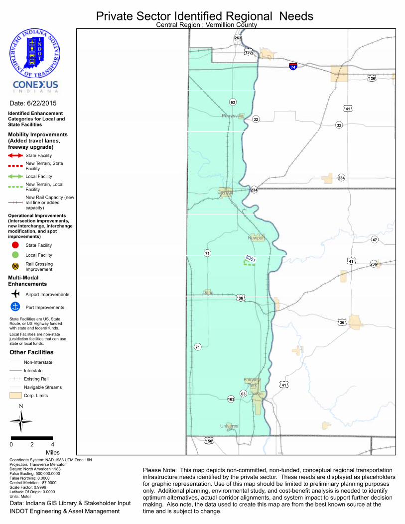
§̈¦74
¬«263
¬«236
¬«47
¬«163
¬«71
¬«71
¬«234
¬«234
¬«32
¬«32
¬«63
¬«63
£¤150
£¤136
£¤136
£¤36
£¤36
£¤41
£¤41
£¤41
Newport
Universal
Clinton
Cayuga
Perrysville
Dana
FairviewPark
8301
Ü0 42
Miles
Date: 6/22/2015
Coordinate System: NAD 1983 UTM Zone 16NProjection: Transverse MercatorDatum: North American 1983False Easting: 500,000.0000False Northing: 0.0000Central Meridian: -87.0000Scale Factor: 0.9996Latitude Of Origin: 0.0000Units: Meter
Private Sector Identified Regional Needs
Data: Indiana GIS Library & Stakeholder InputINDOT Engineering & Asset Management
Please Note: This map depicts non-committed, non-funded, conceptual regional transportationinfrastructure needs identified by the private sector. These needs are displayed as placeholdersfor graphic representation. Use of this map should be limited to preliminary planning purposesonly. Additional planning, environmental study, and cost-benefit analysis is needed to identifyoptimum alternatives, actual corridor alignments, and system impact to support further decisionmaking. Also note, the data used to create this map are from the best known source at thetime and is subject to change.
Central Region ; Vermillion County
Identified EnhancementCategories for Local andState Facilities
Mobility Improvements(Added travel lanes,freeway upgrade)
State Facility
New Terrain, StateFacility
Local Facility
New Terrain, LocalFacility
New Rail Capacity (newrail line or addedcapacity)
Operational Improvements(Intersection improvements,new interchange, interchangemodification, and spotimprovements)
! State Facility
! Local Facility
¹º»¼Rail CrossingImprovement
Multi-ModalEnhancements
o Airport Improvements
!Î Port Improvements
Other FacilitiesNon-Interstate
Interstate
Existing Rail
Navigable Streams
Corp. Limits
State Facilities are US, StateRoute, or US Highway funded with state and federal funds.Local Facilities are non-statejursidiction facilities that can usestate or local funds.

66
WAY
NE
CO
UN
TYPR
OJE
CTS
◆◆
*Pro
ject
210
1: C
onne
rsvi
lle C
onne
ctor
Lan
es –
Thi
s is
a re
gion
al p
roje
ct re
flect
ed o
n th
e m
ap o
n pa
ge 6
.
◆◆
*Pro
ject
380
2: U
S 27
Impr
ovem
ents
– Th
is is
a re
gion
al
proj
ect r
eflec
ted
on th
e m
ap o
n pa
ge 6
.
◆◆
*Pro
ject
840
3: I-
70 T
hird
Lan
e/D
edic
ated
Tru
ck L
anes
– T
his
is a
regi
onal
pro
ject
refle
cted
on
the
map
on
page
6?.
◆◆
Proj
ect 8
901:
Nor
folk
Sou
ther
n Tr
anslo
adin
g Fa
cilit
y –
Des
ign
and
build
a n
ew tr
anslo
adin
g fa
cilit
y at
the
form
er
Dan
a C
orpo
ratio
n sit
e at
Will
iam
sbur
g Pi
ke.
Reas
on:
Cre
ate
econ
omic
dev
elop
men
t giv
ing
furth
er ra
il ac
cess
to
indu
stria
l pro
duct
s.
Estim
ated
Cos
t: $6
milli
on
◆◆
Proj
ect 8
902:
Mid
wes
t Ind
ustri
al P
ark
Rail
Exte
nsio
n –
Exte
nd
the
Nor
folk
Sout
hern
rail
track
s th
roug
hout
the
Mid
wes
t In
dustr
ial P
ark.
Rea
son:
Cre
ate
econ
omic
dev
elop
men
t giv
ing
furth
er ra
il ac
cess
to W
ayne
Cou
nty
indu
strie
s.Es
timat
ed C
ost:
$2.4
milli
on
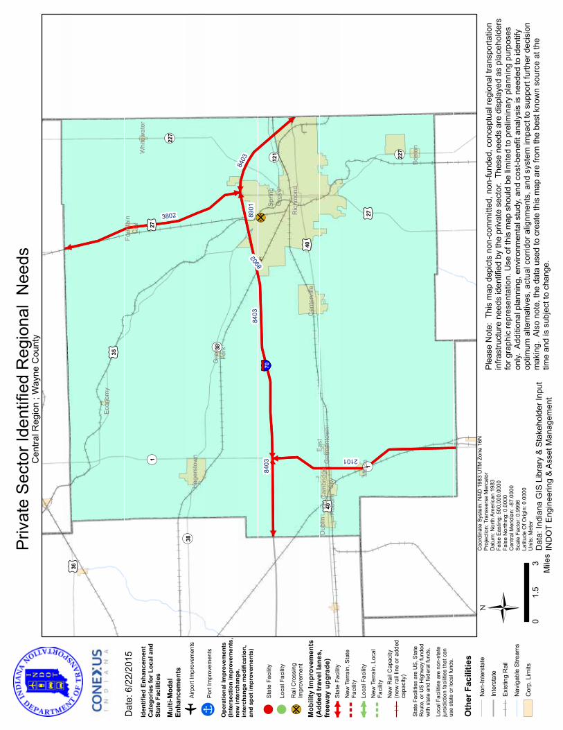
¹º»¼
¬ «121 ¬ «227
¬ «227
¬ «38
¬ «38
¬ «1
¬ «1
£ ¤36
£ ¤35
£ ¤27
£ ¤27
£ ¤40
£ ¤40
§̈ ¦70
Dub
linC
ambr
idge
City
Econ
omy
Foun
tain
City
Whi
tew
ater
Mt.
Aubu
rn
Ric
hmon
d
Milt
on
East
Ger
man
tow
n
Sprin
gG
rove
Cen
terv
ille
Gre
ens
Fork
Hag
erst
own
Bost
on
3802
8902
8403
8403
8403
2101
8901
Ü 03
1.5
Mile
s
Dat
e: 6
/22/
2015
Coo
rdin
ate
Syst
em: N
AD 1
983
UTM
Zon
e 16
NPr
ojec
tion:
Tra
nsve
rse
Mer
cato
rD
atum
: Nor
th A
mer
ican
198
3Fa
lse
Eas
ting:
500
,000
.000
0Fa
lse
Nor
thin
g: 0
.000
0C
entra
l Mer
idia
n: -8
7.00
00Sc
ale
Fact
or: 0
.999
6La
titud
e O
f Orig
in: 0
.000
0U
nits
: Met
er
Priv
ate
Sec
tor I
dent
ified
Reg
iona
l N
eeds
Dat
a: In
dian
a G
IS L
ibra
ry &
Sta
keho
lder
Inpu
tIN
DO
T E
ngin
eerin
g &
Ass
et M
anag
emen
t
Plea
se N
ote:
Thi
s m
ap d
epic
ts n
on-c
omm
itted
, non
-fund
ed, c
once
ptua
l reg
iona
l tra
nspo
rtatio
nin
frast
ruct
ure
need
s id
entif
ied
by th
e pr
ivat
e se
ctor
. Th
ese
need
s ar
e di
spla
yed
as p
lace
hold
ers
for g
raph
ic re
pres
enta
tion.
Use
of t
his
map
sho
uld
be li
mite
d to
pre
limin
ary
plan
ning
pur
pose
son
ly. A
dditi
onal
pla
nnin
g, e
nviro
nmen
tal s
tudy
, and
cos
t-ben
efit
anal
ysis
is n
eede
d to
iden
tify
optim
um a
ltern
ativ
es, a
ctua
l cor
ridor
alig
nmen
ts, a
nd s
yste
m im
pact
to s
uppo
rt fu
rther
dec
isio
nm
akin
g. A
lso
note
, the
dat
a us
ed to
cre
ate
this
map
are
from
the
best
kno
wn
sour
ce a
t the
time
and
is s
ubje
ct to
cha
nge.
Cen
tral R
egio
n ; W
ayne
Cou
nty
Iden
tifie
d En
hanc
emen
tC
ateg
orie
s fo
r Loc
al a
ndSt
ate
Faci
litie
s
Mul
ti-M
odal
Enha
ncem
ents
oAi
rpor
t Im
prov
emen
ts
!ÎPo
rt Im
prov
emen
ts
Ope
ratio
nal I
mpr
ovem
ents
(Inte
rsec
tion
impr
ovem
ents
,ne
w in
terc
hang
e,in
terc
hang
e m
odifi
catio
n,an
d sp
ot im
prov
emen
ts)
!St
ate
Faci
lity
!Lo
cal F
acili
ty
¹º»¼R
ail C
ross
ing
Impr
ovem
ent
Mob
ility
Impr
ovem
ents
(Add
ed tr
avel
lane
s,fr
eew
ay u
pgra
de)
Stat
e Fa
cilit
y
New
Ter
rain
, Sta
teFa
cilit
yLo
cal F
acili
tyN
ew T
erra
in, L
ocal
Faci
lity
New
Rai
l Cap
acity
(new
rail
line
or a
dded
capa
city
)
Stat
e Fa
cilit
ies
are
US,
Sta
teR
oute
, or U
S H
ighw
ay fu
nded
w
ith s
tate
and
fede
ral f
unds
.
Loca
l Fac
ilitie
s ar
e no
n-st
ate
jurs
idic
tion
faci
litie
s th
at c
anus
e st
ate
or lo
cal f
unds
.
Oth
er F
acili
ties
Non
-Inte
rsta
te
Inte
rsta
te
Exis
ting
Rai
l
Nav
igab
le S
tream
s
Cor
p. L
imits
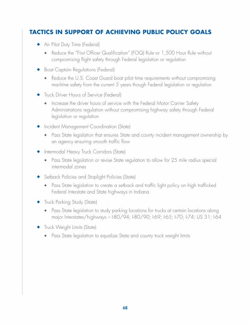
68
TACTICS IN SUPPORT OF ACHIEVING PUBLIC POLICY GOALS
◆◆ Air Pilot Duty Time (Federal)
◆◆ Reduce the “First Officer Qualification” (FOQ) Rule or 1,500 Hour Rule without compromising flight safety through Federal legislation or regulation
◆◆ Boat Captain Regulations (Federal)
◆◆ Reduce the U.S. Coast Guard boat pilot time requirements without compromising maritime safety from the current 5 years though Federal legislation or regulation
◆◆ Truck Driver Hours of Service (Federal)
◆◆ Increase the driver hours of service with the Federal Motor Carrier Safety Administrations regulation without compromising highway safety through Federal legislation or regulation
◆◆ Incident Management Coordination (State)
◆◆ Pass State legislation that ensures State and county incident management ownership by an agency ensuring smooth traffic flow
◆◆ Intermodal Heavy Truck Corridors (State)
◆◆ Pass State legislation or revise State regulation to allow for 25 mile radius special intermodal zones
◆◆ Setback Policies and Stoplight Policies (State)
◆◆ Pass State legislation to create a setback and traffic light policy on high trafficked Federal Interstate and State highways in Indiana
◆◆ Truck Parking Study (State)
◆◆ Pass State legislation to study parking locations for trucks at certain locations along major Interstates/highways – I-80/94; I-80/90; I-69; I-65; I-70; I-74; US 31; I-64
◆◆ Truck Weight Limits (State)
◆◆ Pass State legislation to equalize State and county truck weight limits
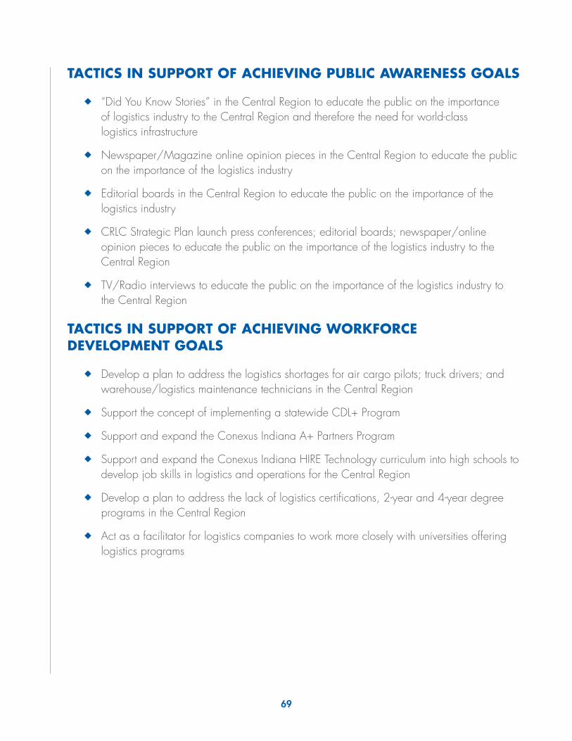
69
TACTICS IN SUPPORT OF ACHIEVING PUBLIC AWARENESS GOALS
◆◆ “Did You Know Stories” in the Central Region to educate the public on the importance of logistics industry to the Central Region and therefore the need for world-class logistics infrastructure
◆◆ Newspaper/Magazine online opinion pieces in the Central Region to educate the public on the importance of the logistics industry
◆◆ Editorial boards in the Central Region to educate the public on the importance of the logistics industry
◆◆ CRLC Strategic Plan launch press conferences; editorial boards; newspaper/online opinion pieces to educate the public on the importance of the logistics industry to the Central Region
◆◆ TV/Radio interviews to educate the public on the importance of the logistics industry to the Central Region
TACTICS IN SUPPORT OF ACHIEVING WORKFORCE DEVELOPMENT GOALS
◆◆ Develop a plan to address the logistics shortages for air cargo pilots; truck drivers; and warehouse/logistics maintenance technicians in the Central Region
◆◆ Support the concept of implementing a statewide CDL+ Program
◆◆ Support and expand the Conexus Indiana A+ Partners Program
◆◆ Support and expand the Conexus Indiana HIRE Technology curriculum into high schools to develop job skills in logistics and operations for the Central Region
◆◆ Develop a plan to address the lack of logistics certifications, 2-year and 4-year degree programs in the Central Region
◆◆ Act as a facilitator for logistics companies to work more closely with universities offering logistics programs
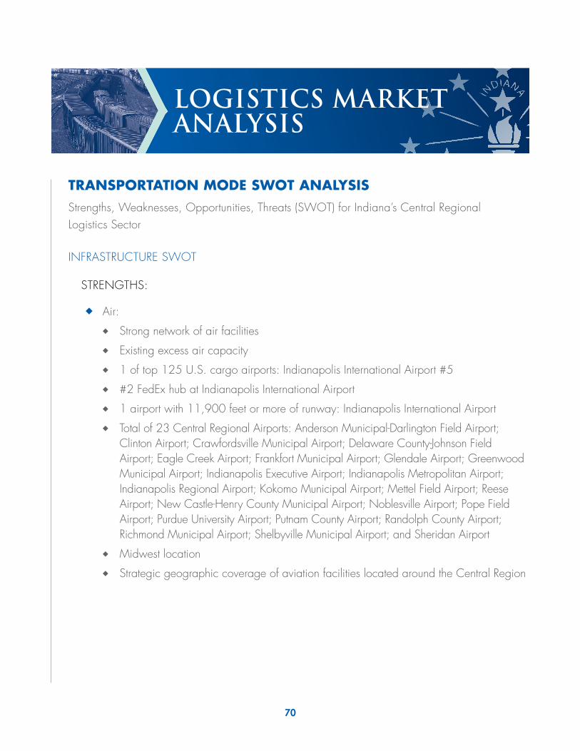
70
LOGISTICS MARKET ANALYSIS
TRANSPORTATION MODE SWOT ANALYSISStrengths, Weaknesses, Opportunities, Threats (SWOT) for Indiana’s Central Regional Logistics Sector
INFRASTRUCTURE SWOT
STRENGTHS:
◆◆ Air:
◆◆ Strong network of air facilities
◆◆ Existing excess air capacity
◆◆ 1 of top 125 U.S. cargo airports: Indianapolis International Airport #5
◆◆ #2 FedEx hub at Indianapolis International Airport
◆◆ 1 airport with 11,900 feet or more of runway: Indianapolis International Airport
◆◆ Total of 23 Central Regional Airports: Anderson Municipal-Darlington Field Airport; Clinton Airport; Crawfordsville Municipal Airport; Delaware County-Johnson Field Airport; Eagle Creek Airport; Frankfort Municipal Airport; Glendale Airport; Greenwood Municipal Airport; Indianapolis Executive Airport; Indianapolis Metropolitan Airport; Indianapolis Regional Airport; Kokomo Municipal Airport; Mettel Field Airport; Reese Airport; New Castle-Henry County Municipal Airport; Noblesville Airport; Pope Field Airport; Purdue University Airport; Putnam County Airport; Randolph County Airport; Richmond Municipal Airport; Shelbyville Municipal Airport; and Sheridan Airport
◆◆ Midwest location
◆◆ Strategic geographic coverage of aviation facilities located around the Central Region
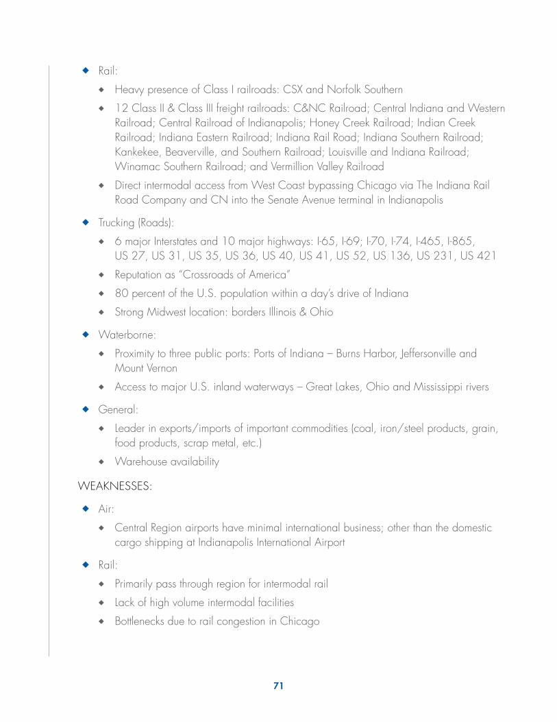
71
◆◆ Rail:
◆◆ Heavy presence of Class I railroads: CSX and Norfolk Southern
◆◆ 12 Class II & Class III freight railroads: C&NC Railroad; Central Indiana and Western Railroad; Central Railroad of Indianapolis; Honey Creek Railroad; Indian Creek Railroad; Indiana Eastern Railroad; Indiana Rail Road; Indiana Southern Railroad; Kankekee, Beaverville, and Southern Railroad; Louisville and Indiana Railroad; Winamac Southern Railroad; and Vermillion Valley Railroad
◆◆ Direct intermodal access from West Coast bypassing Chicago via The Indiana Rail Road Company and CN into the Senate Avenue terminal in Indianapolis
◆◆ Trucking (Roads):
◆◆ 6 major Interstates and 10 major highways: I-65, I-69; I-70, I-74, I-465, I-865, US 27, US 31, US 35, US 36, US 40, US 41, US 52, US 136, US 231, US 421
◆◆ Reputation as “Crossroads of America”
◆◆ 80 percent of the U.S. population within a day’s drive of Indiana
◆◆ Strong Midwest location: borders Illinois & Ohio
◆◆ Waterborne:
◆◆ Proximity to three public ports: Ports of Indiana – Burns Harbor, Jeffersonville and Mount Vernon
◆◆ Access to major U.S. inland waterways – Great Lakes, Ohio and Mississippi rivers
◆◆ General:
◆◆ Leader in exports/imports of important commodities (coal, iron/steel products, grain, food products, scrap metal, etc.)
◆◆ Warehouse availability
WEAKNESSES:
◆◆ Air:
◆◆ Central Region airports have minimal international business; other than the domestic cargo shipping at Indianapolis International Airport
◆◆ Rail:
◆◆ Primarily pass through region for intermodal rail
◆◆ Lack of high volume intermodal facilities
◆◆ Bottlenecks due to rail congestion in Chicago

72
◆◆ Trucking (Roads):
◆◆ Bottlenecks or traffic congestion at major points of interchange
◆◆ Lack of adequate capacity on Central Region’s Interstate highways
◆◆ Lack of designated heavy haul routes
◆◆ Lack of truck parking
◆◆ Waterborne:
◆◆ Not applicable
◆◆ General:
◆◆ Warehouse availability volatility
OPPORTUNITIES:
◆◆ Air:
◆◆ Position the Central Region as a reliever airport for domestic/international air cargo by utilizing excess capacity
◆◆ Create a strategy to better utilize the Central Region’s airports
◆◆ Utilize runways and facilities at several airports to accommodate air shipping opportunities
◆◆ Rail:
◆◆ Freight tonnage will nearly double by 2035, according to the U.S. Department of Transportation (USDOT)
◆◆ Seek opportunity to position Indiana as an East/West Corridor for Class I railroads to bypass Chicago bottleneck
◆◆ Trucking (Roads):
◆◆ Freight tonnage will nearly double by 2035, according to USDOT
◆◆ Relieve bottlenecks around Central Region
◆◆ Upgrade Central Region strategic bridges
◆◆ Build dedicated truck lanes on selected corridors that separate trucks from passenger cars on major Interstates
◆◆ Align truck weight limits comparable with surrounding states
◆◆ Create designated heavy haul routes and align with surrounding states

73
◆◆ Waterborne:
◆◆ Not applicable
◆◆ General:
◆◆ The value of U.S. imports and exports is expected to be equivalent to 60 percent of GDP by 2030
◆◆ Work for diversification of exports/imports
THREATS:
◆◆ Air:
◆◆ Continued underutilization of Central Region airports
◆◆ Lack of Federal, State, and local funding to meet infrastructure needs
◆◆ Rail:
◆◆ Continuation of the Central Region as a pass through area for rail
◆◆ Lack of investment in infrastructure by Class I railroads
◆◆ Adjacent states direct investment in rail
◆◆ Lack of private rail investment by private sector in Class II & III railroads
◆◆ Trucking (Roads):
◆◆ Lack of funding to build roads to relieve bottle necks or traffic congestion
◆◆ Lack of funding to upgrade Central Region strategic bridges that are structurally deficient or functionally obsolete
◆◆ Waterborne:
◆◆ Not applicable
◆◆ General:
◆◆ Lack of diversification of exports/imports
◆◆ Lack of funding for all infrastructure modes
◆◆ Impact of Federal Government energy policy on all modes of transportation
◆◆ Loss of competitive advantage in energy costs due to Federal regulations

74
PUBLIC POLICY SWOT
STRENGTHS:
◆◆ Air:
◆◆ Federal government reimburses up to 90% of costs for qualified airport projects
◆◆ Local funding of all Central Region airports
◆◆ Rail:
◆◆ Local rail investment
◆◆ Industrial Service Fund
◆◆ Trucking (Roads):
◆◆ P3 funding for Indiana highways and roads
◆◆ State of Indiana focus on road construction
◆◆ Waterborne:
◆◆ Not applicable
◆◆ General:
◆◆ Indiana’s use of public/private partnerships to facilitate the funding of key projects in the Central Region
◆◆ Transportation and Logistics Tax Credit
◆◆ Tax abatement for vacant buildings
WEAKNESSES:
◆◆ Air:
◆◆ Lack of awareness by public entities on air freight movement
◆◆ Lack of Federal/State funding for the Central Region
◆◆ Pilot shortages
◆◆ Airline pilot duty and entry level requirements for flight time
◆◆ Rail:
◆◆ Lack of private rail investment compared to surrounding states
◆◆ Lack of awareness by public entities on rail freight movement
◆◆ Lack of Federal/State funding
◆◆ Railroad employee hours of service requirements
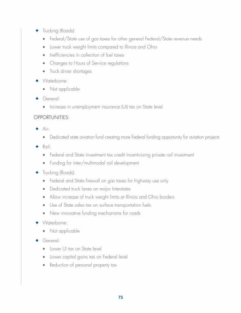
75
◆◆ Trucking (Roads):
◆◆ Federal/State use of gas taxes for other general Federal/State revenue needs
◆◆ Lower truck weight limits compared to Illinois and Ohio
◆◆ Inefficiencies in collection of fuel taxes
◆◆ Changes to Hours of Service regulations
◆◆ Truck driver shortages
◆◆ Waterborne:
◆◆ Not applicable
◆◆ General:
◆◆ Increase in unemployment insurance (UI) tax on State level
OPPORTUNITIES:
◆◆ Air:
◆◆ Dedicated state aviation fund creating more Federal funding opportunity for aviation projects
◆◆ Rail:
◆◆ Federal and State investment tax credit incentivizing private rail investment
◆◆ Funding for inter/multimodal rail development
◆◆ Trucking (Roads):
◆◆ Federal and State firewall on gas taxes for highway use only
◆◆ Dedicated truck lanes on major Interstates
◆◆ Allow increase of truck weight limits at Illinois and Ohio borders
◆◆ Use of State sales tax on surface transportation fuels
◆◆ New innovative funding mechanisms for roads
◆◆ Waterborne:
◆◆ Not applicable
◆◆ General:
◆◆ Lower UI tax on State level
◆◆ Lower capital gains tax on Federal level
◆◆ Reduction of personal property tax
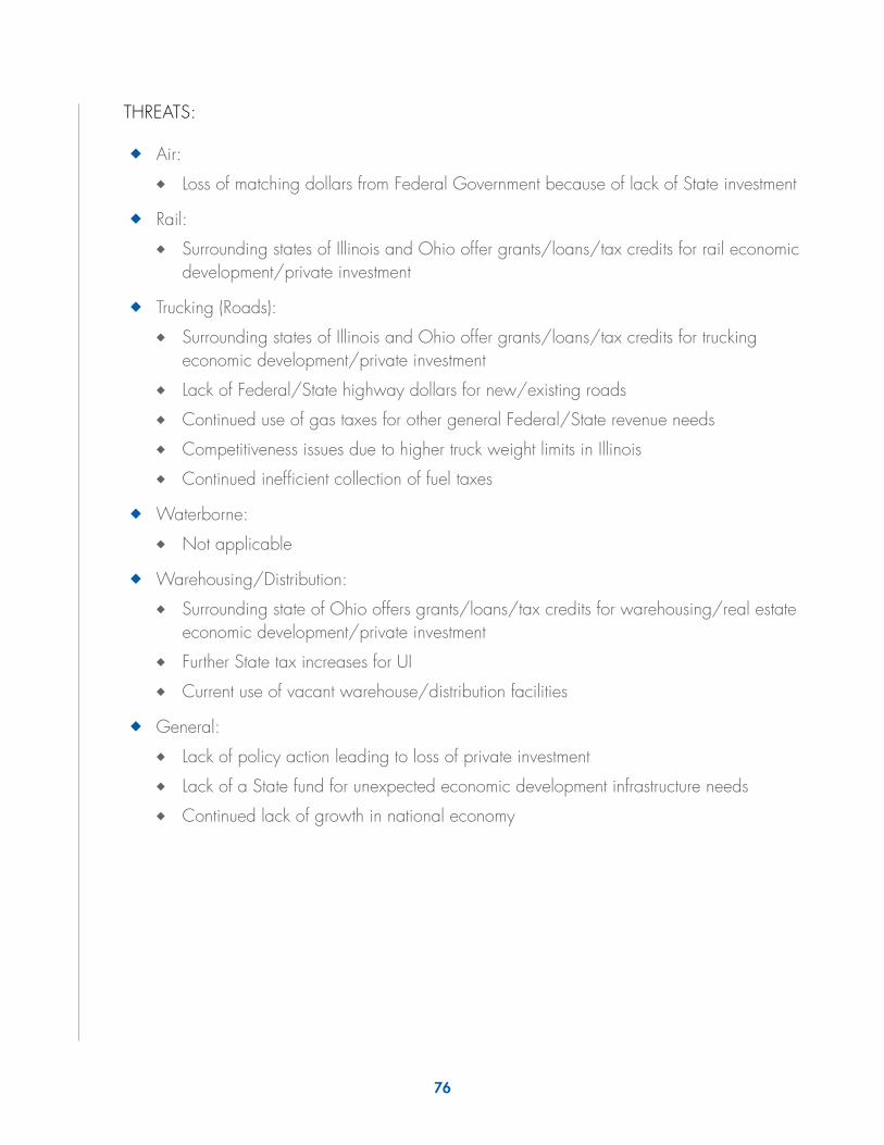
76
THREATS:
◆◆ Air:
◆◆ Loss of matching dollars from Federal Government because of lack of State investment
◆◆ Rail:
◆◆ Surrounding states of Illinois and Ohio offer grants/loans/tax credits for rail economic development/private investment
◆◆ Trucking (Roads):
◆◆ Surrounding states of Illinois and Ohio offer grants/loans/tax credits for trucking economic development/private investment
◆◆ Lack of Federal/State highway dollars for new/existing roads
◆◆ Continued use of gas taxes for other general Federal/State revenue needs
◆◆ Competitiveness issues due to higher truck weight limits in Illinois
◆◆ Continued inefficient collection of fuel taxes
◆◆ Waterborne:
◆◆ Not applicable
◆◆ Warehousing/Distribution:
◆◆ Surrounding state of Ohio offers grants/loans/tax credits for warehousing/real estate economic development/private investment
◆◆ Further State tax increases for UI
◆◆ Current use of vacant warehouse/distribution facilities
◆◆ General:
◆◆ Lack of policy action leading to loss of private investment
◆◆ Lack of a State fund for unexpected economic development infrastructure needs
◆◆ Continued lack of growth in national economy

77
WORKFORCE DEVELOPMENT SWOT
STRENGTHS:
◆◆ Public/private postsecondary institutions with ability to reach mass of workers
◆◆ Entrepreneurs creating online curriculum programs
◆◆ State government officials who understand importance of up-skilling Hoosier workers
◆◆ Growth of logistics firms in the Central Region
WEAKNESSES:
◆◆ Lack of skilled workers
◆◆ Public misconception of logistics and warehouse careers
◆◆ Assorted logistics education curriculum not meeting industry needs
◆◆ Air cargo pilot, truck driver, and boat captain shortages
◆◆ Warehouse/Logistics maintenance technician shortages
◆◆ 4-year logistics degree supervisor shortages
◆◆ Lack of fork lift certifications
OPPORTUNITIES:
◆◆ Identify logistics job skills gap areas
◆◆ Curriculum development with postsecondary education to meet job skills gap areas
◆◆ Create online program to up-skill Indiana logistics worker from places of employment
◆◆ Continued growth of logistics jobs in the Central Region
THREATS:
◆◆ Loss of logistics economic development due to workforce gaps
◆◆ Continued perception of logistics industry as undesirable work
◆◆ Lower skill workers remaining in lower level positions
◆◆ Lack of 4-year degree student interest in logistics careers
◆◆ Lack of air cargo pilots, truck drivers, and boat captains
◆◆ Lack of warehouse logistics maintenance technicians
◆◆ Lack of 4-year logistics supervisors
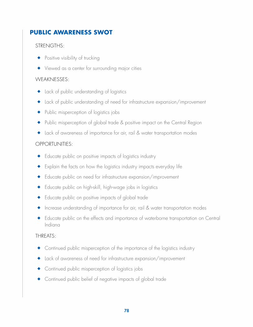
78
PUBLIC AWARENESS SWOT
STRENGTHS:
◆◆ Positive visibility of trucking
◆◆ Viewed as a center for surrounding major cities
WEAKNESSES:
◆◆ Lack of public understanding of logistics
◆◆ Lack of public understanding of need for infrastructure expansion/improvement
◆◆ Public misperception of logistics jobs
◆◆ Public misperception of global trade & positive impact on the Central Region
◆◆ Lack of awareness of importance for air, rail & water transportation modes
OPPORTUNITIES:
◆◆ Educate public on positive impacts of logistics industry
◆◆ Explain the facts on how the logistics industry impacts everyday life
◆◆ Educate public on need for infrastructure expansion/improvement
◆◆ Educate public on high-skill, high-wage jobs in logistics
◆◆ Educate public on positive impacts of global trade
◆◆ Increase understanding of importance for air, rail & water transportation modes
◆◆ Educate public on the effects and importance of waterborne transportation on Central Indiana
THREATS:
◆◆ Continued public misperception of the importance of the logistics industry
◆◆ Lack of awareness of need for infrastructure expansion/improvement
◆◆ Continued public misperception of logistics jobs
◆◆ Continued public belief of negative impacts of global trade

79
CENTRAL REGION INFRASTRUCTURE DATA
◆◆ Air
◆◆ 23 Central Region Airports
◆◆ #2 FedEx Hub in the World at Indianapolis International Airport
◆◆ Indianapolis International Airport #23 Busiest Airport by Cargo Traffic
◆◆ Rail
◆◆ 2 Class I Railroads
◆◆ 12 Class II & III Railroads
◆◆ Trucking:
◆◆ 6 Major Interstates and 10 Major Highways
◆◆ Waterborne
◆◆ Proximity to 3 Public Ports

FOR MORE INFORMATION
CONTACT:
DAVID W. HOLT Vice President Operations & Business Development
Conexus Indiana111 Monument Circle
Suite 1800Indianapolis, IN 46204
Phone: (317)638-2108email: [email protected]
www.conexusindiana.com
Brought to you in part by


111 Monument Circle, Suite 1800 Indianapolis, IN 46204 317-638-2108
www.conexusindiana.com