central lancashire - chorleychorley.gov.uk/documents/planning/planning policy/design guide...
TRANSCRIPT
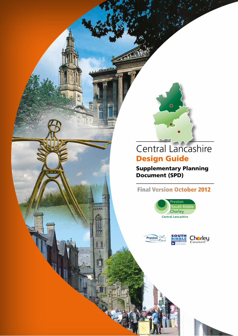
Final Version October 2012
Central Lancashire
Design GuideSupplementary PlanningDocument (SPD)
SOUTHRIBBLEBOROUGH COUNCIL
f o r w a r d w i t hS o u t h R i b b l e
Central Lancashire Design Guide SPD October 2012
Cont
ents
3
Part1: Introduction Page 4 Purpose Page 7 Structure of the Design SPD Page 8
Part 2: The Character of Central Lancashire Page 10
Preston Page 13-18
Chorley Page 19-22
South Ribble Page 23-26
Part 3: The Design Principles Page 27
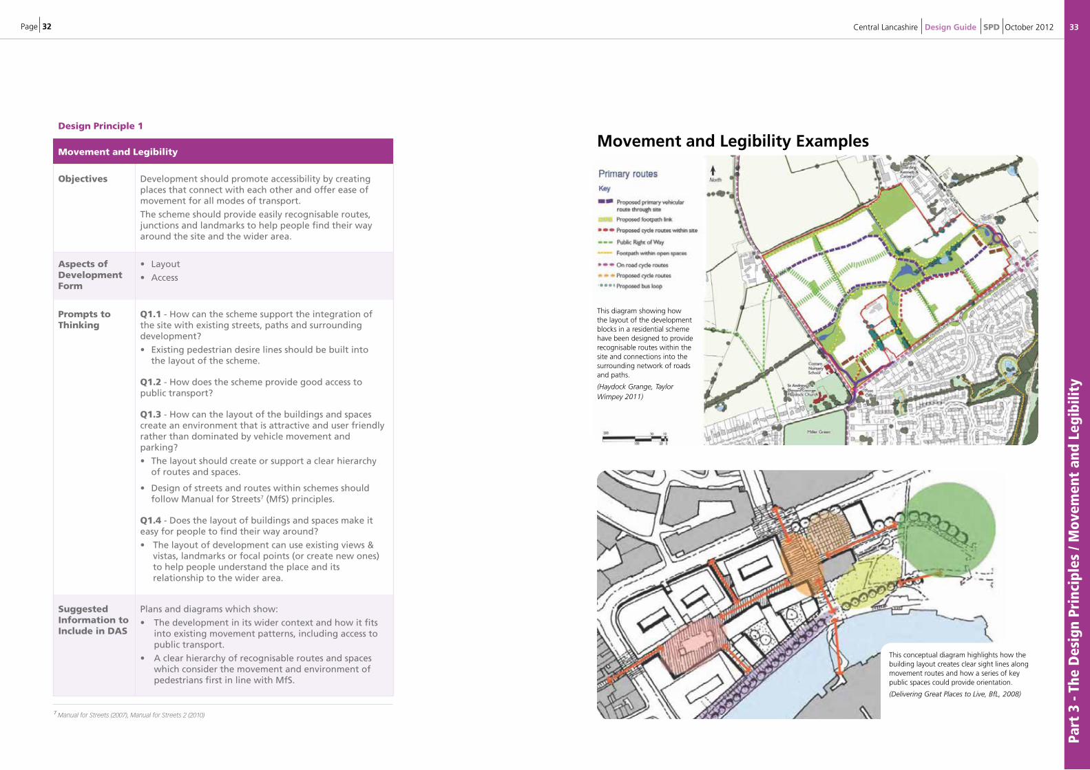
1. Movement and Legibility Page 32-33
2. Space and Enclosure Page 34-35
3. Mixed Uses and Tenures Page 36-37
4. Adaptability and Resilience Page 38-39
5. Resources and Efficiency Page 40-41
6. Architecture and Townscape Page 42-43
Part 4: The Design Process Page 44
Develop a Design Proposal Page 44
Appraise the Issues Page 44-48
Develop a Design Concept Plan Page 49
Design and access Statements Page 53-54
Design Review Page 55
Assessing the Information Page 56
5.1: Sustainability Appraisal and Habitats Regulations Assessment Page 58
5.2: Monitoring and Review Page 58
5.3: Status of SPDs Page 58
5.4: Further Information Page 59
Appendix 1: Assessment Criteria Page 60-65
Appendix 2: Quality-Reviewer Table Page 66-67
Appendix 3: Glossary Page 68-69
Appendix 4: References and Further Reading Page 70-71
Contents
Page 4
1: Introduction 1.1 This Design Guide Supplementary Planning Document (SPD) provides an overview of the design principles that the Central Lancashire authorities will employ when considering planning proposals. Within this document “Councils” refers to Chorley Council, Preston City Council and South Ribble Borough Council. The SPD covers residential, commercial, public realm and shop-front developments as well as proposals for new infrastructure. It is aimed at landowners, agents, developers and designers working on schemes throughout Central Lancashire.
1.2 The advice in this SPD draws on key policy and good practice guidance produced by the Homes and Communities Agency entitled “Quality Reviewer: Appraising the design and quality of development proposals (2010)” It applies the principles of Quality Reviewer to the specific circumstances of Central Lancashire and seeks to develop policies set out in the Central Lancashire Core Strategy. It aims to guide the implementation of those policies and, once adopted will be a material consideration in determining planning applications.
1.3 A key objective of the SPD is to raise the level and quality of design of new buildings in the built environment across Central Lancashire and in so doing reinforce its unique character. It will set a benchmark for design quality by endorsing best practice and requiring new development to enhance the character of an area through good design. Good design plays a vital part in ensuring that we achieve sustainable development, quality and local distinctiveness in the built environment.
1.4 Government guidance is set out in the National Planning Policy Framework (NPPF). The NPPF indicates at paragraph 56 that the Government attaches great importance to good design, which should contribute to positive planning and that permission should be refused for poor quality design (paragraph 64). Local and neighbourhood plans should develop robust and comprehensive policies that set out the quality of development expected for an area, based on stated objectives for the future of the area and an evaluation of its defining characteristics.
1.5 In particular, the aim should be to ensure that developments:
• Function well and add to the overall quality of the area
• Establish a strong sense of place
• Optimise the potential of the site to accommodate development, sustain an appropriate mix of uses and support local facilities and transport networks
• Respond to local character and history
• Create safe and accessible environments
• Are visually attractive.
Part
1 -
Intr
oduc
tion
5
1.6. The Regional Spatial Strategy (RSS) for the North West places an emphasis on the need for urban regeneration and renaissance to enhance quality of life in the region. The Government has made a policy commitment in the Localism Act to Revoke the Regional Spatial Strategy.
1.7. The Local Development Framework is a suite of documents which will, when complete, replace the existing old-style Local Plans as the key policy documents for the three Central Lancashire councils. The Core Strategy is the key document, as it sets the overarching vision for the area. This will be underpinned by Site Allocations and Development Management Policies Development Plan Documents (DPDs) and a series of Supplementary Planning Documents, which give more detail on areas which are only covered broadly by the Core Strategy. This SPD will fit into the Local Development Framework by setting out guidance to ensure the Core Strategy policies and objectives for design will be achieved.
1.8. The Core Strategy’s spatial vision includes “The character of the City, towns and villages will reflect their individual historic and cultural heritage, with high quality designed new buildings enhancing their local distinctiveness.” The Core Strategy’s Strategic Objective (SO15) for design and new buildings is: “To foster ‘place shaping’ to enhance the character and local distinctiveness of the built environment in Central Lancashire by encouraging high quality design of new buildings”. Achieving good design is one of three cross-cutting themes in the Core Strategy, alongside promoting health and wellbeing and tackling climate change.
1.9. The particular Core Strategy policies which relate to design are:
• Policy 16: Heritage Assets
• Policy 17: Design of New Buildings
• Policy 18: Green Infrastructure; and
• Policy 27: Sustainable Resources and New Developments
1.10. Read together, the Central Lancashire Core Strategy and the Site Allocations and Development Management Policies DPDs for the respective councils, set out the policies for the development, regeneration, protection and use of land across Central Lancashire up to 2026. They include appropriate locations for new development, and areas where specific types of development are considered preferable.
1.11. The Affordable Housing SPD, the Rural Development SPD and the forthcoming (Open Space and Playing Pitch SPD) set requirements and provide complementary guidance for these matters, including aspects relevant to design in Central Lancashire.
Central Lancashire Design Guide SPD October 2012
Page 6
Part
1 -
Intr
oduc
tion
/ Pu
rpos
e
7
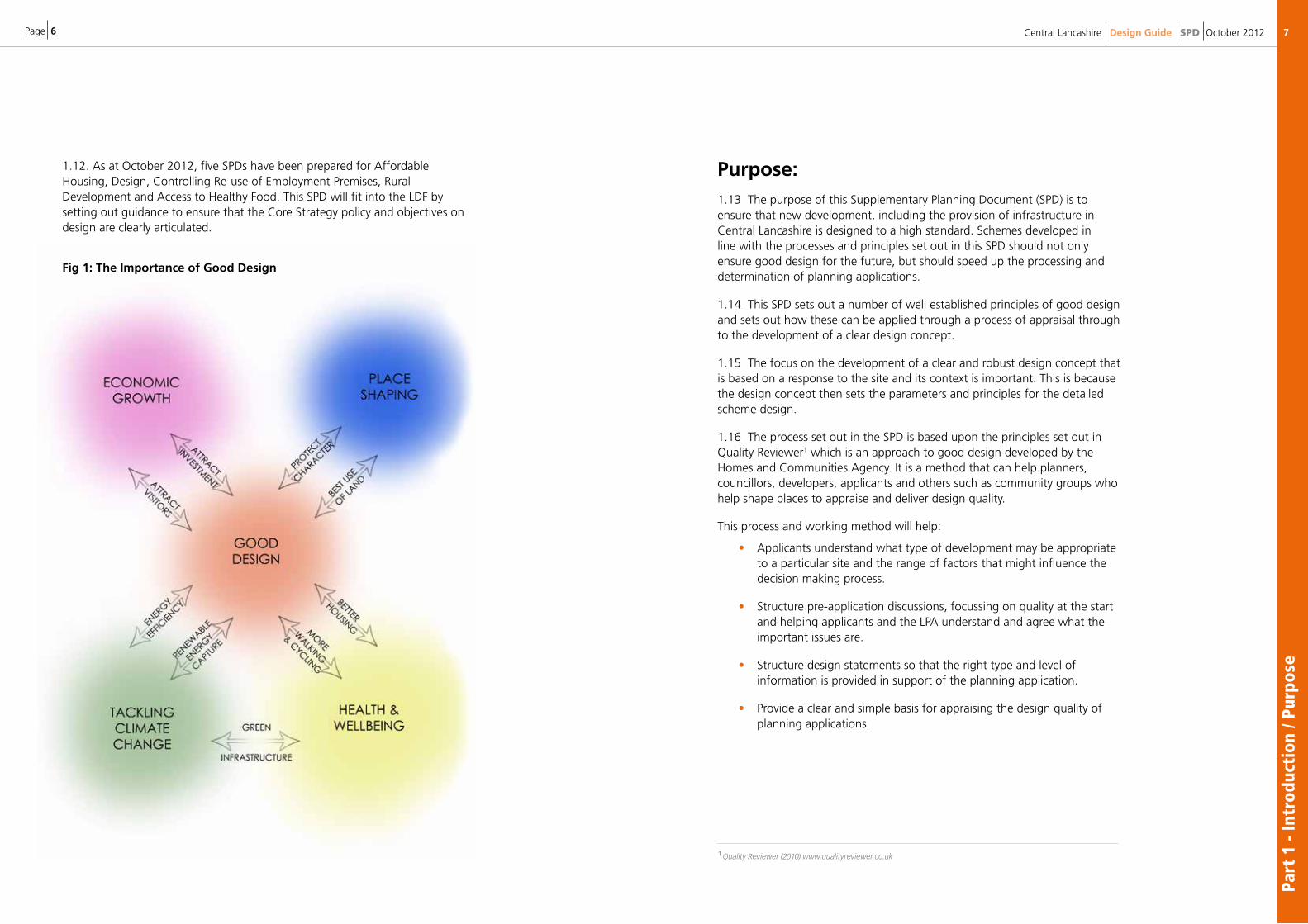
1.12. As at October 2012, five SPDs have been prepared for Affordable Housing, Design, Controlling Re-use of Employment Premises, Rural Development and Access to Healthy Food. This SPD will fit into the LDF by setting out guidance to ensure that the Core Strategy policy and objectives on design are clearly articulated.
Fig 1: The Importance of Good Design
Purpose: 1.13 The purpose of this Supplementary Planning Document (SPD) is to ensure that new development, including the provision of infrastructure in Central Lancashire is designed to a high standard. Schemes developed in line with the processes and principles set out in this SPD should not only ensure good design for the future, but should speed up the processing and determination of planning applications.
1.14 This SPD sets out a number of well established principles of good design and sets out how these can be applied through a process of appraisal through to the development of a clear design concept.
1.15 The focus on the development of a clear and robust design concept that is based on a response to the site and its context is important. This is because the design concept then sets the parameters and principles for the detailed scheme design.
1.16 The process set out in the SPD is based upon the principles set out in Quality Reviewer1 which is an approach to good design developed by the Homes and Communities Agency. It is a method that can help planners, councillors, developers, applicants and others such as community groups who help shape places to appraise and deliver design quality.
This process and working method will help:
• Applicants understand what type of development may be appropriate to a particular site and the range of factors that might influence the decision making process.
• Structure pre-application discussions, focussing on quality at the start and helping applicants and the LPA understand and agree what the important issues are.
• Structure design statements so that the right type and level of information is provided in support of the planning application.
• Provide a clear and simple basis for appraising the design quality of planning applications.
Central Lancashire Design Guide SPD October 2012
1 Quality Reviewer (2010) www.qualityreviewer.co.uk
Page 8
Part
1 -
Intr
oduc
tion
/ St
ruct
ure
of t
he D
esig
n SP
D
9
Gen
eral
Gui
danc
e
Design Standards
1.18 In addition to an assessment of schemes against the relevant design policies there are also a number of national design standards that schemes should seek to achieve. These include the overall quality of design (Building for Life), environmental standards (BREEAM, Code for Sustainable Homes), long term adaptability (Lifetime Homes) and safety and security (Secured By Design).
1.19 Schemes developed in line with this Design SPD will be well placed to meet all the national standards highlighted below.
1.20 Design schemes will be assessed using the structure outlined in this SPD – an assessment table is available in the Appendices at the end of this document.
All Major Schemes
• All schemes - High Design quality required.
• BREEAM – Very good. For Non-residential schemes / buildings.
www.breeam.org/
• Secured by Design – www.securedbydesign.com/
• Manual for Streets 1 & 2
All Major Schemes With Residential
• Building for Life standard – www.designcouncil.org.uk/our-work/CABE/Our-big-projects/Building-for-Life/
• Code for sustainable homes – level 4
wwwcommunities.gov.uk/planningandbuildingsustainabilitycodesustainablehomes/
• Lifetime homes standard.
www.lifetimehomes.org.uk/pages/revised-design-criteria.html
Central Lancashire Design Guide SPD October 2012
Structure of the Design SPD 1.17 The SPD has been split into 3 main sections:
• The Character of Central Lancashire This first section gives an overview of the character and spatial form of the three districts covered by the SPD. This information should be used as an initial baseline or reference point for appraisal for sites and their context.
• The Design Principles
The next part of the SPD sets out the key principles of design that should be considered and applied to the development proposal. These cover the key aspects of development form such as layout, scale, appearance and its setting. The principles also consider how the development proposals should address issues of sustainability through efficient use of resources.
• The Design Process The final section of the SPD sets out a simple three stage process for the development of a design concept for a site. The design concept should be used to develop the detailed planning submission and will form the basis of the Design and Access Statement (DAS) that will need to be submitted with most applications. The DAS will be used by officers to assess the design quality of the proposal against the relevant local and national policy guidance.
Page 10 11
Part
2 -
The
Char
acte
r of
Cen
tral
Lan
cash
ire
Central Lancashire Design Guide SPD October 2012
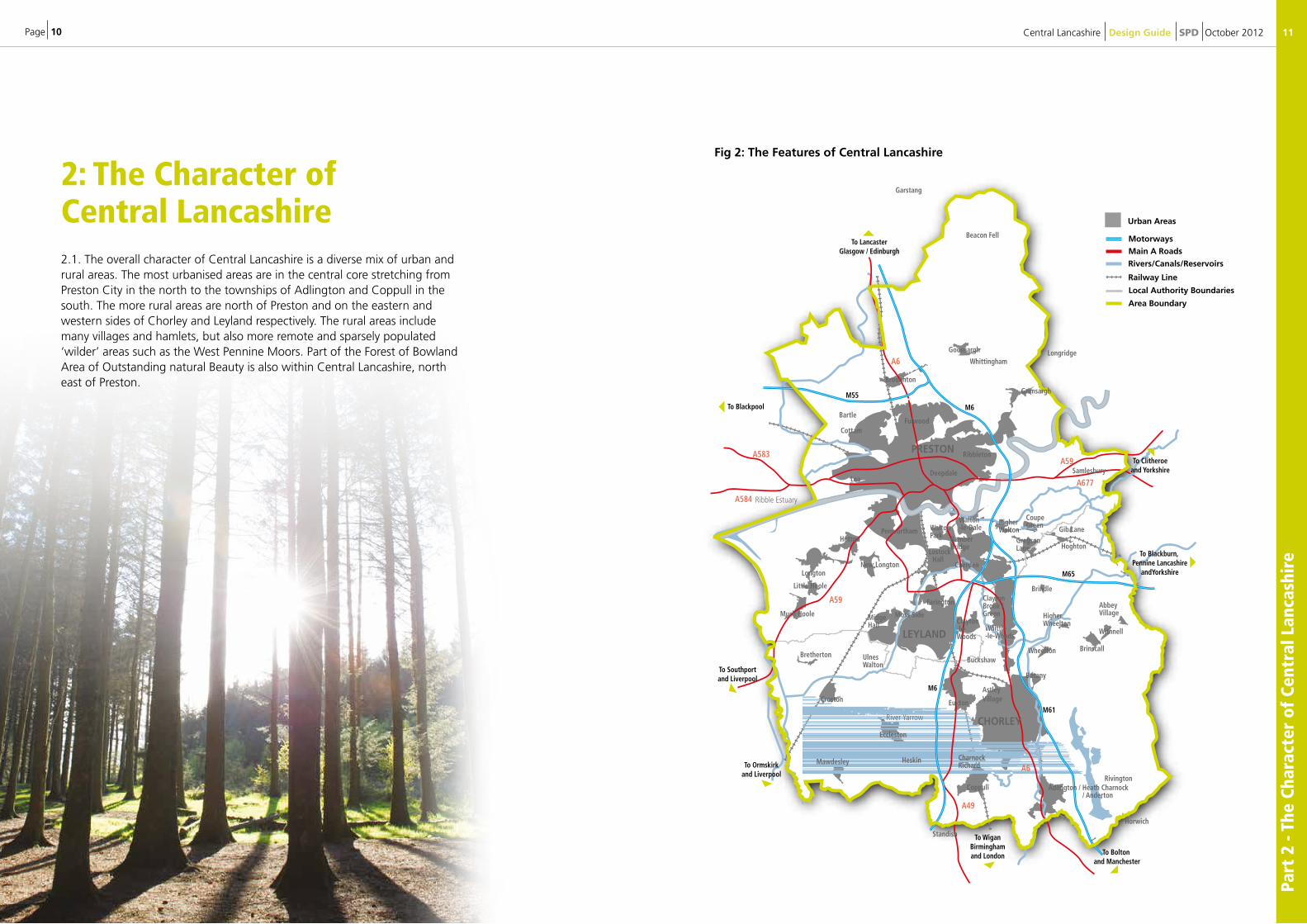
Fig 2: The Features of Central Lancashire
A49
A59
A59
A584
A583
A6
A677
A6
Local Authority Boundaries
Railway Line
Rivers/Canals/Reservoirs
LEYLAND
PRESTON
CHORLEY
Goosnargh
Beacon Fell
Garstang
BroughtonGrimsargh
Penwortham WaltonPark
Moss Side
Eccleston
Mawdesley
Walton-le-Dale
BamberBridge
ClaytonBrook /Green
Clayton-le-Woods
Euxton
CharnockRichard
Coppull Adlington / Heath Charnock / Anderton
HigherWalton Gib Lane
GregsonLane Hoghton
Brindle
Samlesbury
HigherWheelton
Withnell
AbbeyVillage
BrinscallWheelton
Lostock Hall
Cottam
BartleFulwood
Deepdale
Ribbleton
Lea
Whittle-le-Woods
Buckshaw
Rivington
AstleyVillage
Botany
Heskin
Farington
Cuerden
WhittinghamLongridge
Horwich
Standish
Hutton
New LongtonLongton
Much Hoole
Little Hoole
Bretherton
Croston
UlnesWalton
MidgeHall
River Yarrow
Ribble Estuary
CoupeGreen
Urban Areas
Main A Roads
Motorways
Area Boundary
To Clitheroeand Yorkshire
To Blackpool
To LancasterGlasgow / Edinburgh
M6
M6
M61
M65
M55
To Bolton and Manchester
To WiganBirminghamand London
To Ormskirkand Liverpool
To Southportand Liverpool
To Blackburn, Pennine Lancashire
andYorkshire
2: The Character of Central Lancashire 2.1. The overall character of Central Lancashire is a diverse mix of urban and rural areas. The most urbanised areas are in the central core stretching from Preston City in the north to the townships of Adlington and Coppull in the south. The more rural areas are north of Preston and on the eastern and western sides of Chorley and Leyland respectively. The rural areas include many villages and hamlets, but also more remote and sparsely populated ‘wilder’ areas such as the West Pennine Moors. Part of the Forest of Bowland Area of Outstanding natural Beauty is also within Central Lancashire, north east of Preston.
Page 12
Part
2 -
The
Char
acte
r of
Cen
tral
Lan
cash
ire
/ Pre
ston
13
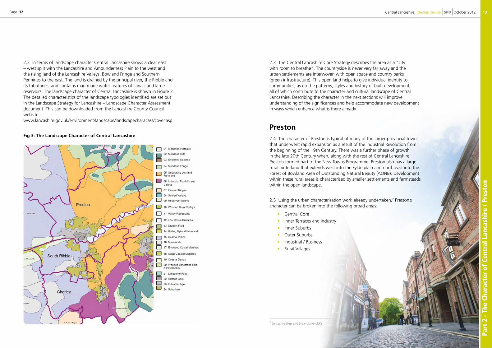
2.2 In terms of landscape character Central Lancashire shows a clear east – west split with the Lancashire and Amounderness Plain to the west and the rising land of the Lancashire Valleys, Bowland Fringe and Southern Pennines to the east. The land is drained by the principal river, the Ribble and its tributaries, and contains man made water features of canals and large reservoirs. The landscape character of Central Lancashire is shown in Figure 3. The detailed characteristics of the landscape typologies identified are set out in the Landscape Strategy for Lancashire – Landscape Character Assessment document. This can be downloaded from the Lancashire County Council website - www.lancashire.gov.uk/environment/landscape/landscapecharacass/cover.asp
Fig 3: The Landscape Character of Central Lancashire
2.3 The Central Lancashire Core Strategy describes the area as a “city with room to breathe”. The countryside is never very far away and the urban settlements are interwoven with open space and country parks (green infrastructure). This open land helps to give individual identity to communities, as do the patterns, styles and history of built development, all of which contribute to the character and cultural landscape of Central Lancashire. Describing the character in the next sections will improve understanding of the significances and help accommodate new development in ways which enhance what is there already.
Preston
2.4 The character of Preston is typical of many of the larger provincial towns that underwent rapid expansion as a result of the Industrial Revolution from the beginning of the 19th Century. There was a further phase of growth in the late 20th Century when, along with the rest of Central Lancashire, Preston formed part of the New Towns Programme. Preston also has a large rural hinterland that extends west into the Fylde plain and north east into the Forest of Bowland Area of Outstanding Natural Beauty (AONB). Development within these rural areas is characterised by smaller settlements and farmsteads within the open landscape.
2.5 Using the urban characterisation work already undertaken,2 Preston’s character can be broken into the following broad areas:
• Central Core
• Inner Terraces and Industry
• Inner Suburbs
• Outer Suburbs
• Industrial / Business
• Rural Villages
Central Lancashire Design Guide SPD October 2012
2 Lancashire Extensive Urban Survey 2006
Page 14
Part
2 -
The
Char
acte
r of
Cen
tral
Lan
cash
ire
/ Pre
ston
15Central Lancashire Design Guide SPD October 2012
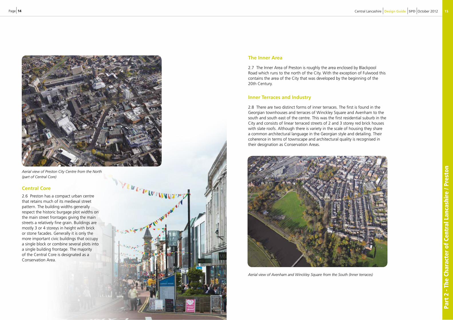
Aerial view of Preston City Centre from the North (part of Central Core)
Central Core
2.6 Preston has a compact urban centre that retains much of its medieval street pattern. The building widths generally respect the historic burgage plot widths on the main street frontages giving the main streets a relatively fine grain. Buildings are mostly 3 or 4 storeys in height with brick or stone facades. Generally it is only the more important civic buildings that occupy a single block or combine several plots into a single building frontage. The majority of the Central Core is designated as a Conservation Area.
The Inner Area
2.7 The Inner Area of Preston is roughly the area enclosed by Blackpool Road which runs to the north of the City. With the exception of Fulwood this contains the area of the City that was developed by the beginning of the20th Century.
Inner Terraces and Industry
2.8 There are two distinct forms of inner terraces. The first is found in the Georgian townhouses and terraces of Winckley Square and Avenham to the south and south east of the centre. This was the first residential suburb in the City and consists of linear terraced streets of 2 and 3 storey red brick houses with slate roofs. Although there is variety in the scale of housing they share a common architectural language in the Georgian style and detailing. Their coherence in terms of townscape and architectural quality is recognised in their designation as Conservation Areas.
Aerial view of Avenham and Winckley Square from the South (Inner terraces)
Page 16
Part
2 -
The
Char
acte
r of
Cen
tral
Lan
cash
ire
/ Pre
ston
17
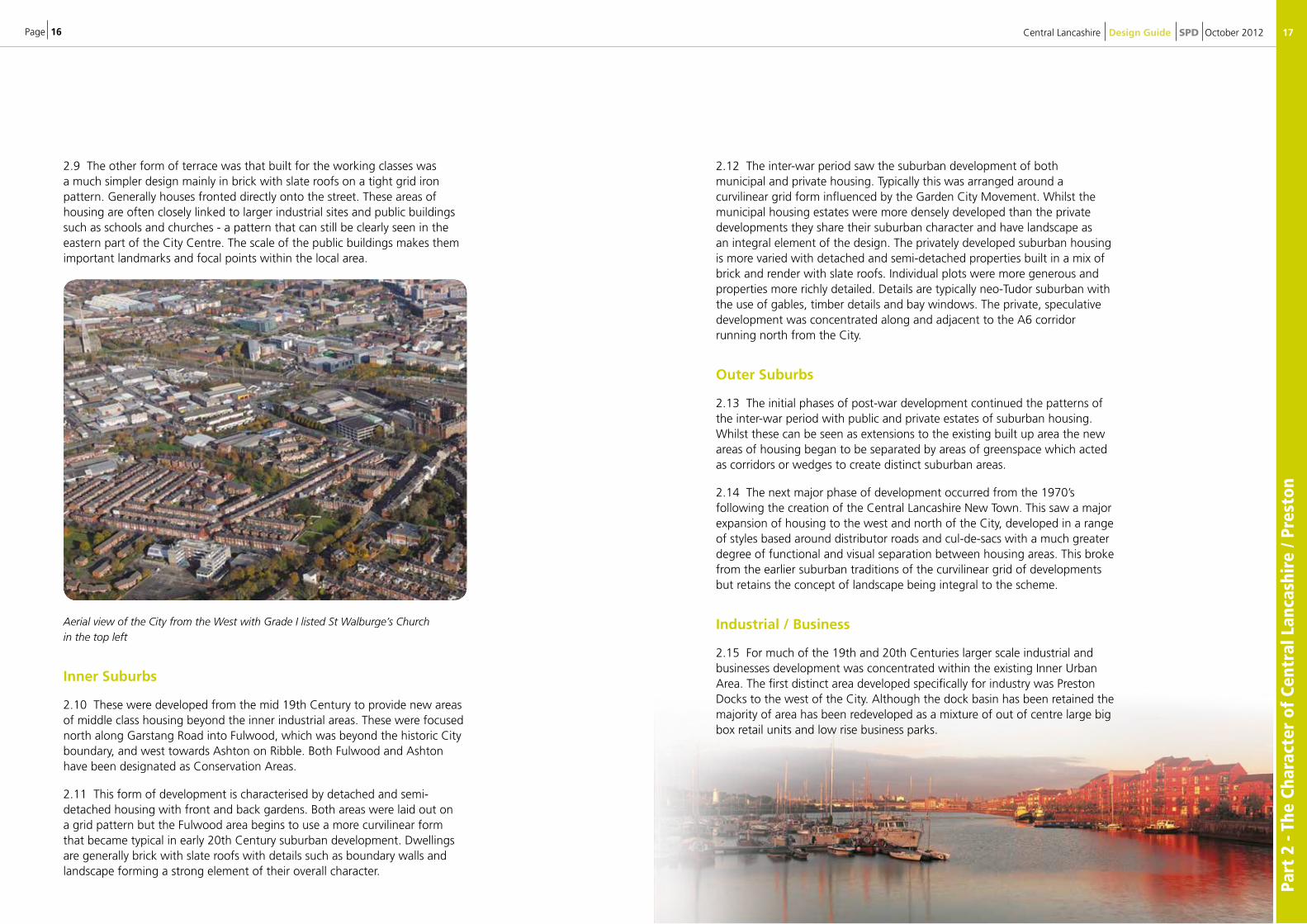
2.9 The other form of terrace was that built for the working classes was a much simpler design mainly in brick with slate roofs on a tight grid iron pattern. Generally houses fronted directly onto the street. These areas of housing are often closely linked to larger industrial sites and public buildings such as schools and churches - a pattern that can still be clearly seen in the eastern part of the City Centre. The scale of the public buildings makes them important landmarks and focal points within the local area.
Aerial view of the City from the West with Grade I listed St Walburge’s Church in the top left
Inner Suburbs
2.10 These were developed from the mid 19th Century to provide new areas of middle class housing beyond the inner industrial areas. These were focused north along Garstang Road into Fulwood, which was beyond the historic City boundary, and west towards Ashton on Ribble. Both Fulwood and Ashton have been designated as Conservation Areas.
2.11 This form of development is characterised by detached and semi-detached housing with front and back gardens. Both areas were laid out on a grid pattern but the Fulwood area begins to use a more curvilinear form that became typical in early 20th Century suburban development. Dwellings are generally brick with slate roofs with details such as boundary walls and landscape forming a strong element of their overall character.
2.12 The inter-war period saw the suburban development of both municipal and private housing. Typically this was arranged around a curvilinear grid form influenced by the Garden City Movement. Whilst the municipal housing estates were more densely developed than the private developments they share their suburban character and have landscape as an integral element of the design. The privately developed suburban housing is more varied with detached and semi-detached properties built in a mix of brick and render with slate roofs. Individual plots were more generous and properties more richly detailed. Details are typically neo-Tudor suburban with the use of gables, timber details and bay windows. The private, speculative development was concentrated along and adjacent to the A6 corridor running north from the City.
Outer Suburbs
2.13 The initial phases of post-war development continued the patterns of the inter-war period with public and private estates of suburban housing. Whilst these can be seen as extensions to the existing built up area the new areas of housing began to be separated by areas of greenspace which acted as corridors or wedges to create distinct suburban areas.
2.14 The next major phase of development occurred from the 1970’s following the creation of the Central Lancashire New Town. This saw a major expansion of housing to the west and north of the City, developed in a range of styles based around distributor roads and cul-de-sacs with a much greater degree of functional and visual separation between housing areas. This broke from the earlier suburban traditions of the curvilinear grid of developments but retains the concept of landscape being integral to the scheme.
Industrial / Business
2.15 For much of the 19th and 20th Centuries larger scale industrial and businesses development was concentrated within the existing Inner Urban Area. The first distinct area developed specifically for industry was Preston Docks to the west of the City. Although the dock basin has been retained the majority of area has been redeveloped as a mixture of out of centre large big box retail units and low rise business parks.
Central Lancashire Design Guide SPD October 2012
Page 18
Part
2 -
The
Char
acte
r of
Cen
tral
Lan
cash
ire
/ Pre
ston
/ Ch
orle
y
19
Preston Docklands
2.16. Through the New Town development large areas of land adjacent to the M6 to the east of Preston were developed for large scale business and industrial uses. These are generally large shed buildings built on single plots linked by distributor roads. There is also some smaller scale business park development with low rise office units.
Rural Villages
2.17. Preston’s rural hinterland contains a number of small scale settlements. These include Woodplumpton, Broughton, Grimsargh, Goosnargh and Inglewhite. Woodplumpton and Grimsargh are essentially linear settlements with development fronting onto the highway and as such do not have a strongly defined centre. Historically buildings were small scale in brick or stone which in some cases has been painted or rendered with slate roofs.
2.18. Goosnargh is a larger village with a more strongly defined centre with 3 storey stone built, Bushell’s Hospital along with the St. Mary’s Church the dominant buildings fronting onto a village green. Inglewhite to the north west of Preston is a small stone built village centred around a village green with a market cross. The village is a designated conservation area.
Central Lancashire Design Guide SPD October 2012
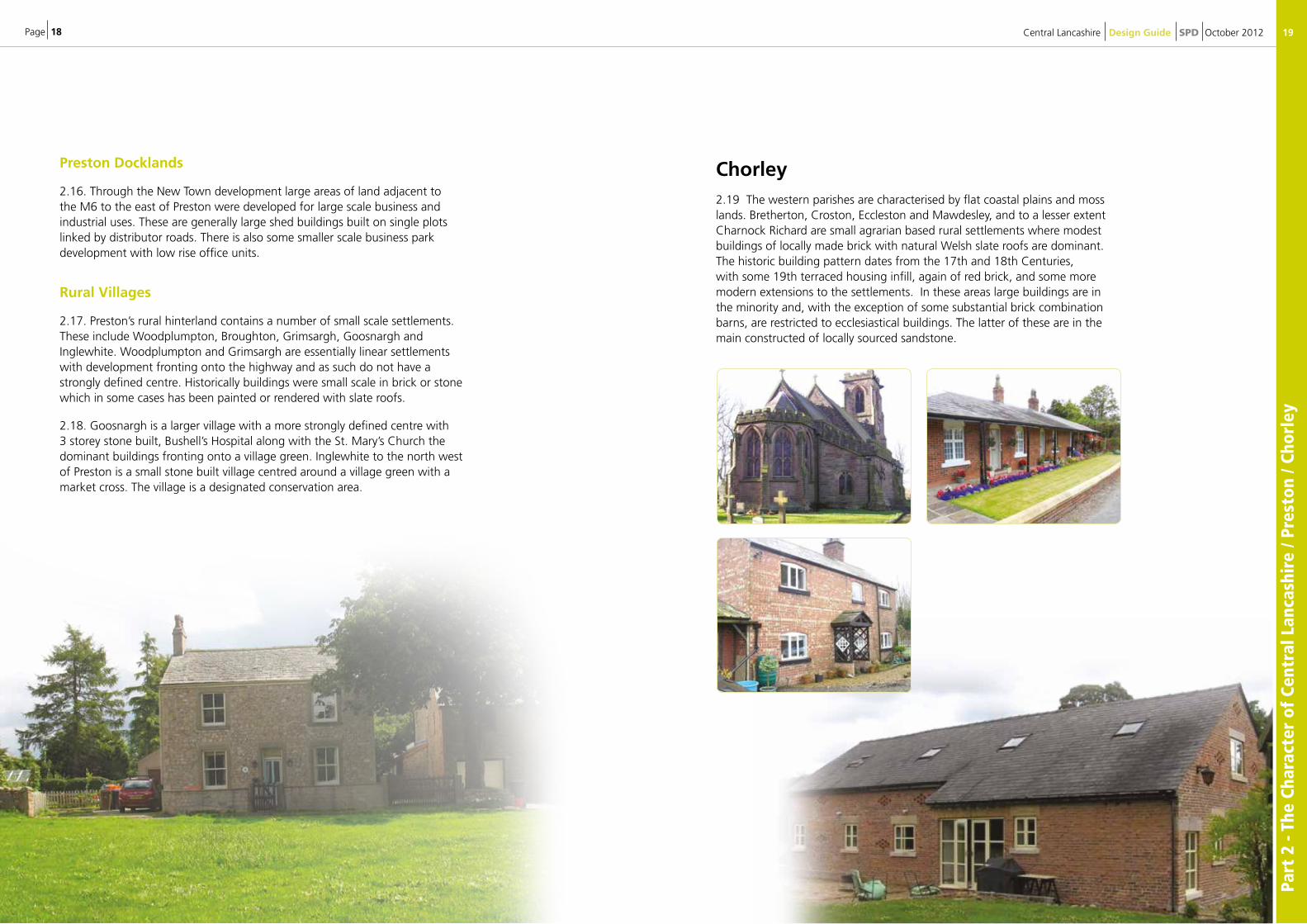
Chorley2.19 The western parishes are characterised by flat coastal plains and moss lands. Bretherton, Croston, Eccleston and Mawdesley, and to a lesser extent Charnock Richard are small agrarian based rural settlements where modest buildings of locally made brick with natural Welsh slate roofs are dominant. The historic building pattern dates from the 17th and 18th Centuries, with some 19th terraced housing infill, again of red brick, and some more modern extensions to the settlements. In these areas large buildings are in the minority and, with the exception of some substantial brick combination barns, are restricted to ecclesiastical buildings. The latter of these are in the main constructed of locally sourced sandstone.
Page 20
Part
2 -
The
Char
acte
r of
Cen
tral
Lan
cash
ire
/ Cho
rley
21Central Lancashire Design Guide SPD October 2012
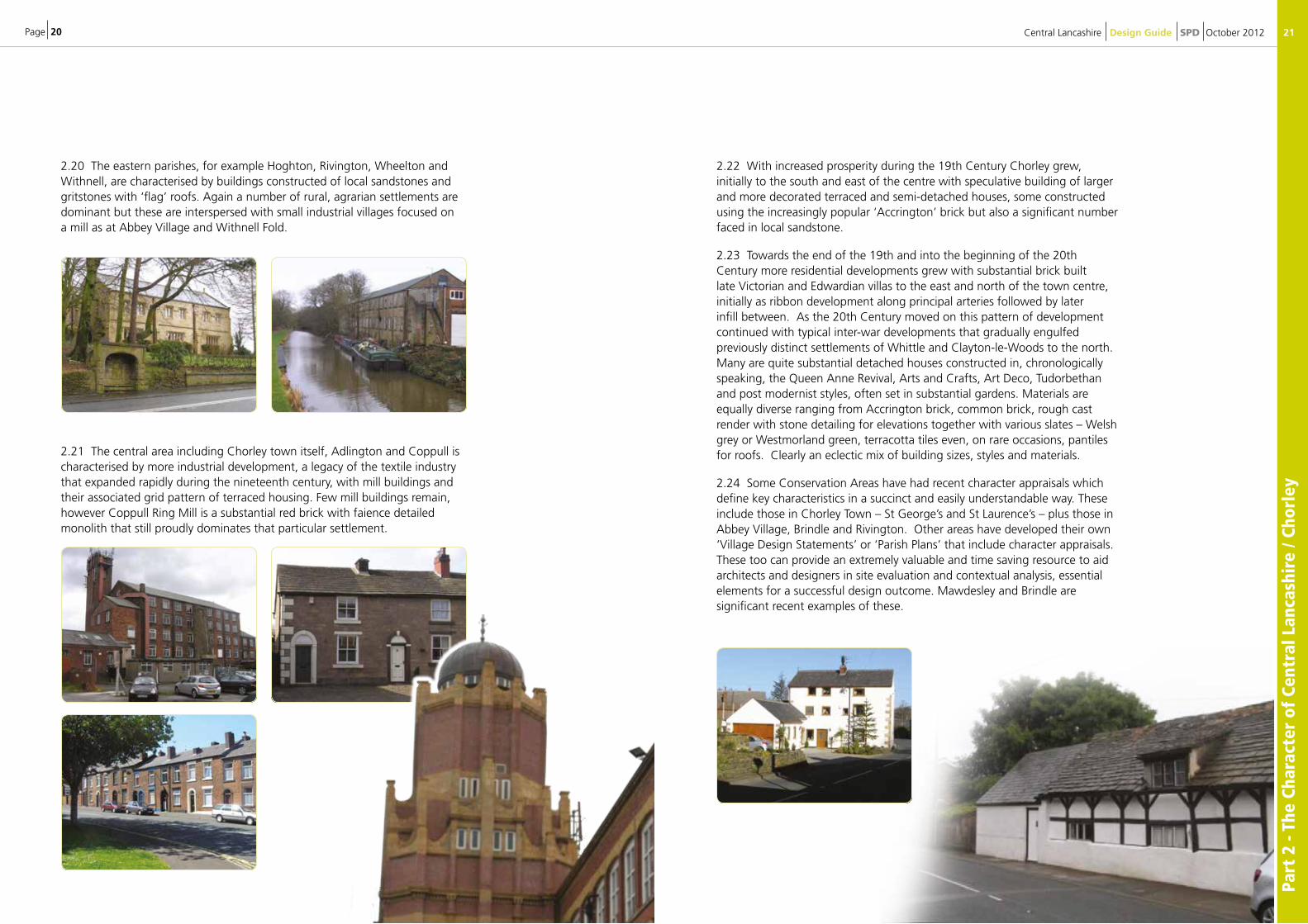
2.20 The eastern parishes, for example Hoghton, Rivington, Wheelton and Withnell, are characterised by buildings constructed of local sandstones and gritstones with ‘flag’ roofs. Again a number of rural, agrarian settlements are dominant but these are interspersed with small industrial villages focused on a mill as at Abbey Village and Withnell Fold.
2.21 The central area including Chorley town itself, Adlington and Coppull is characterised by more industrial development, a legacy of the textile industry that expanded rapidly during the nineteenth century, with mill buildings and their associated grid pattern of terraced housing. Few mill buildings remain, however Coppull Ring Mill is a substantial red brick with faience detailed monolith that still proudly dominates that particular settlement.
2.22 With increased prosperity during the 19th Century Chorley grew, initially to the south and east of the centre with speculative building of larger and more decorated terraced and semi-detached houses, some constructed using the increasingly popular ‘Accrington’ brick but also a significant number faced in local sandstone.
2.23 Towards the end of the 19th and into the beginning of the 20th Century more residential developments grew with substantial brick built late Victorian and Edwardian villas to the east and north of the town centre, initially as ribbon development along principal arteries followed by later infill between. As the 20th Century moved on this pattern of development continued with typical inter-war developments that gradually engulfed previously distinct settlements of Whittle and Clayton-le-Woods to the north. Many are quite substantial detached houses constructed in, chronologically speaking, the Queen Anne Revival, Arts and Crafts, Art Deco, Tudorbethan and post modernist styles, often set in substantial gardens. Materials are equally diverse ranging from Accrington brick, common brick, rough cast render with stone detailing for elevations together with various slates – Welsh grey or Westmorland green, terracotta tiles even, on rare occasions, pantiles for roofs. Clearly an eclectic mix of building sizes, styles and materials.
2.24 Some Conservation Areas have had recent character appraisals which define key characteristics in a succinct and easily understandable way. These include those in Chorley Town – St George’s and St Laurence’s – plus those in Abbey Village, Brindle and Rivington. Other areas have developed their own ‘Village Design Statements’ or ‘Parish Plans’ that include character appraisals. These too can provide an extremely valuable and time saving resource to aid architects and designers in site evaluation and contextual analysis, essential elements for a successful design outcome. Mawdesley and Brindle are significant recent examples of these.
Page 22
Part
2 -
The
Char
acte
r of
Cen
tral
Lan
cash
ire
/ Cho
rley
/ So
uth
Ribb
le
23Central Lancashire Design Guide SPD October 2012
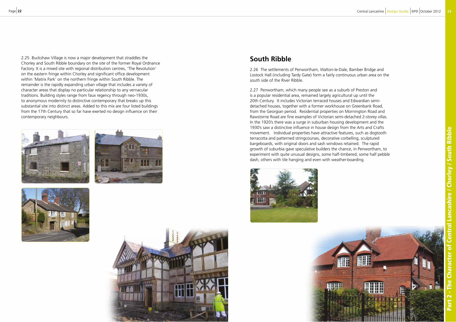
2.25 Buckshaw Village is now a major development that straddles the Chorley and South Ribble boundary on the site of the former Royal Ordnance Factory. It is a mixed site with regional distribution centres, ‘The Revolution’ on the eastern fringe within Chorley and significant office development within ‘Matrix Park’ on the northern fringe within South Ribble. The remainder is the rapidly expanding urban village that includes a variety of character areas that display no particular relationship to any vernacular traditions. Building styles range from faux regency through neo-1930s, to anonymous modernity to distinctive contemporary that breaks up this substantial site into distinct areas. Added to this mix are four listed buildings from the 17th Century that so far have exerted no design influence on their contemporary neighbours.
South Ribble2.26 The settlements of Penwortham, Walton-le-Dale, Bamber Bridge and Lostock Hall (including Tardy Gate) form a fairly continuous urban area on the south side of the River Ribble.
2.27 Penwortham, which many people see as a suburb of Preston and is a popular residential area, remained largely agricultural up until the 20th Century. It includes Victorian terraced houses and Edwardian semi-detached houses, together with a former workhouse on Greenbank Road, from the Georgian period. Residential properties on Mornington Road and Rawstorne Road are fine examples of Victorian semi-detached 2-storey villas. In the 1920’s there was a surge in suburban housing development and the 1930’s saw a distinctive influence in house design from the Arts and Crafts movement. Individual properties have attractive features, such as dogtooth terracotta and patterned stringcourses, decorative corbelling, sculptured bargeboards, with original doors and sash windows retained. The rapid growth of suburbia gave speculative builders the chance, in Penwortham, to experiment with quite unusual designs, some half-timbered, some half pebble dash, others with tile hanging and even with weather-boarding.
Page 24
Part
2 -
The
Char
acte
r of
Cen
tral
Lan
cash
ire
/ Sou
th R
ibbl
e
25Central Lancashire Design Guide SPD October 2012
2.29 Bamber Bridge and Lostock Hall have a strong industrial heritage and contain a mix of employment and residential uses, often in very close proximity. There is a range of house types from modern housing estates and apartment to brick built terraced housing. The properties in Church Road Conservation Area, in Bamber Bridge, are predominantly stone built, with grey slate roofing and many display their original architectural features.
2.30 Leyland, and the Leyland Hundred, dates back to the 10th Century, when a Saxon township with burgage plots was set out around the parish church and along Towngate. Between the 17th Century and the 19th Century the cottage based handloom weaving industry developed and expanded, based initially in the surrounding farms and the development of large purpose-built rows of brick built weavers’ cottages. The Leyland Cross Conservation Area has a varied mix of architectural styles, which are largely Victorian, although there are many good examples of buildings of Georgian age and earlier. The inter-war years saw a great expansion of the urban area of Leyland, with the steady provision of high quality semi-detached housing, including garden suburbs. The establishment of the Central Lancashire New Town saw a significant increase in the housing stock in Leyland. Over the last ten years, new housing estates have been developed on former industrial land along the northern boundary of the town.
2.28 Walton-le Dale, on the south bank of the River Ribble is characterised predominantly by Victorian terraced houses, constructed of brick with grey slate roofing although there are many good examples of buildings of Georgian age and earlier. Many of the residential properties front directly onto the pavement and several buildings in the Church Brow Conservation Area are rendered
Aerial photograph of Leyland, taken from the South

Page 26
Part
3 -
The
Des
ign
Prin
cipl
es
27Central Lancashire Design Guide SPD October 2012
2.31 There are a number of villages in the Western Parishes of South Ribble, including Hutton, Longton (which is a Rural Local Service Centre), New Longton, Walmer Bridge and Much Hoole. The villages are tightly defined by the Green Belt and they all include a range of architectural styles and dwellings ranging from Georgian farm houses to Victorian and Edwardian detached and semi-detached houses, right up to modern housing estates. The construction materials also range from stonework, render and brick, with slate or tile covered pitched roofs.
2.32 The Eastern Area of South Ribble is characterised by attractive rolling countryside and small villages, close to the foothills of the West Pennines. The villages of Higher Walton, Coup Green, Gregson Lane, Nab’s Head and Samlesbury are all located in the Eastern Area and they include a range of architectural styles from farmhouses to modern housing estates, with a variety of construction materials.
Aerial photograph of part of Worden Park, Leyland
3: The Design Principles 3.1 This chapter sets out the six key principles that should be applied to the design of new schemes. These show that the design aspect of the project goes beyond just simple aesthetic considerations i.e. its visual appearance but is equally concerned with design issues such as layout, accessibility, types of uses proposed and importantly how these relate to the site and its surroundings – its context. It should be noted that the design principles set out in this SPD are equally applicable to development proposals in both the urban and rural areas of Central Lancashire.
3.2 In order to help applicants develop high quality schemes a series of prompts on the issues to support good design and examples how it might be achieved are provided throughout this section.
3.3 The following principles of good design are used in this SPD. These have been taken from the Homes and Communities Agency Quality Reviewer guidance. These have been chosen as the key design principles on the basis that they best reflect the place making and sustainability objectives of the Core Strategy.
Design Principle Explanation
1 Movement and Legibility
A place that is easy to get to, move through and is easy to understand.
2 Space and Enclosure
A place with attractive, sustainable and successful outdoor areas where public and private spaces are clearly distinguished.
3 Mix of Uses and Tenures
A development that promotes a variety and choice in terms of uses and ownerships in response to local needs.
4 Adaptability and Resilience
A development that can adapt and respond to changing economic, social and technological conditions.
5 Resources and Efficiency
How the development contributes to tackling climate change and adapting to and mitigating its effects both in its construction and operation.
6 Architecture and Townscape
A development that responds positively to its surrounding environment through its external appearance and form.
Page 28
Part
3 -
The
Des
ign
Prin
cipl
es
29Central Lancashire Design Guide SPD October 2012
3.4. However, as the following table shows, whilst there is a variation in the terms used in the various design guidance documents they all share a series of common design objectives or goals.
Table 1: The relationship of key design principles
Design Principles in SPD
NPPF By Design: Objectives of Urban Design (Ref)
Urban Design Compendium (Ref)
Movement and
Legibility
“Integration of new development into the natural, built and historic environment”
“Address the connections between people and places”
“Are accessible, usable and easy to understand”
Ease of Movement
A place that is easy to get to and move through
Legibility
A place that has a clear image and is easy to understand
Make Connections
Places need to be easy to get to and be integrated physically and visually with their surroundings.
Space and
Enclosure “Create safe and accessible environments”
“Integration of new development into the natural, built and historic environment”
Continuity andEnclosure
A place where public and private spaces are clearly distinguished
Quality of the Public Realm
A place with attractive and successful outdoor areas
Places for People
For places to be well-used and well-loved, they must be safe, comfortable, varied and attractive.
Work with the Landscape
Places that strike a balance between the natural and man made environment and utilise each site’s intrinsic resources.
Mixed Uses
and Tenures “Sustain an appropriate mix of uses … and support local facilities and transport networks”
Diversity
A place with variety and choice
Mix Uses and Form
Stimulating, enjoyable and convenient places meet a variety of demands from the widest possible range of users, amenities and social groups. They also weave together different building forms, uses, tenures and densities.
Adaptability and Resilience
Function well and add to the overall quality of the area not just for the short term but over the lifetime of the development
Adaptability
A place that can change easily
Design for Change
New development needs to be flexible enough to respond to future changes in use, lifestyle and demography.
Resources and Efficiency
“Integration of new development into the natural, built and historic environment”
Manage the Investment
For projects to be developable and well cared for they must be economically viable, well managed and maintained.
Architecture and Townscape
“Development should be visually attractive as a result of good architecture and appropriate
landscaping”
Character
A place with its own identity
Enrich the Existing
New development should enrich the qualities of existing urban places. This means encouraging a distinctive response that arises from and complements its setting. This applies at every scale - the region, the city, the town, the neighbourhood, and the street.
Design Principles and Aspects of Development Form3.5 As By Design points out design principles or objectives on their own will not lead to the delivery of good design. Good design comes from the considered application of the design principles to the main aspects of development form from the start of the design process i.e. from the development of the design concept through to the detailed design stage.
3.6 By Design identifies five main aspects of development form – Layout, Landscape, Density and Mix, Scale and Appearance. It is these five elements3 of form together with Access that need to be addressed through Design and Access Statements (DAS). The Design Process is covered in detail in Chapter 4.
3 Circular 01/06 uses the term Amount rather than Density and Mix
Page 30
Part
3 -
The
Des
ign
Prin
cipl
es
31Central Lancashire Design Guide SPD October 2012
Amount
The amount of development is how much development is proposed. For residential development, this means the number of proposed units for residential use and for all other development this means the proposed floor space for each proposed use.
Layout
Layout is the way in which buildings, routes and open spaces (both private and public) are provided, placed and orientated in relation to each other and buildings and spaces surrounding the development.
The layout provides the basic plan on which the other aspects of development form are dependant on.
Scale
Scale is the height, width and length of a building or buildings in relation to its surroundings. It also means how the sizes of the various parts or elements of the building relate to each other.
Massing, another term used in respect to scale, is the combined effect of the arrangement and volume of the building in relation to its neighbours.
Landscaping
Landscaping is the treatment of private and public spaces to enhance or protect the amenities of the site and the area in which it is situated through hard and soft landscaping measures.
Appearance
Appearance is the aspect of a place or building that determines the visual impression it makes, including the external built form of the development, its architecture, materials, decoration, lighting, colour and texture.
Access
Access is how the scheme will support equal and convenient access to and within the site for vehicles, cycles and pedestrians in terms of the positioning and treatment of access and circulation routes and how these fit into the surrounding access network.
Table 2: How the Design Principles relate to Aspects of Development Form
Am
ou
nt
Layo
ut
Sca
le
Lan
dsc
ap
ing
Ap
peara
nce
Acc
ess
Movement and Legibility • •
Space and Enclosure • • •
Mixed Uses and Tenures •
Adaptability and Resilience • • • •
Resources and Efficiency • • •
Architecture & townscape • • • •
Applying the Design Principles3.7 For each design principle the SPD indicates the aspects of development form it is particularly relevant to. This is to both help the applicant or their design team develop the design concept but to also help them put together the information required for the DAS in a clear and structured way.
3.8 Further guidance on how the design principles could be applied to a particular site and the potential issues that need to be addressed is provided by a series of prompts to thinking for each of the principles along with illustrated examples.
3.9 These prompts should not be regarded as a series of prescriptive rules to be simply followed. Rather they should be seen as a set of questions that will allow the applicant to test and refine their design concept for the site and from that develop the detailed designs for the scheme.
3.10 Using the information gathered from the context and site appraisal stage will help ensure that the prompts to thinking are used in a site specific way
3.11 The prompts are drawn from the guidance contained in the Building for Life (BfL) assessment 4. Although BfL is a qualitative assessment method developed for residential schemes the questions are applicable to all types of development, particularly those at a larger scale.
3.12 There are other sources of information that would guide applicants in developing their design ideas and concepts. These include the Urban Design Compendium5 (HCA, 2007) referred to above and Building in Context – New Development in Historic Areas 6 (English Heritage/CABE, 2001).
4 Full information on Building for Life can be found here. http://www.designcouncil.org.uk/our-work/cabe/sectors/housing/building-for-life/ 5 http://www.homesandcommunities.co.uk/urban-design-compendium 6 http://www.building-in-context.org/index.html
Aspects of Development Form
Page 32
Part
3 -
The
Des
ign
Prin
cipl
es /
Mov
emen
t an
d Le
gibi
lity
33Central Lancashire Design Guide SPD October 2012
Design Principle 1
Movement and Legibility
Objectives Development should promote accessibility by creating places that connect with each other and offer ease of movement for all modes of transport.
The scheme should provide easily recognisable routes, junctions and landmarks to help people find their way around the site and the wider area.
Aspects of Development Form
• Layout
• Access
Prompts to Thinking
Q1.1 - How can the scheme support the integration of the site with existing streets, paths and surrounding development?
• Existing pedestrian desire lines should be built into the layout of the scheme.
Q1.2 - How does the scheme provide good access to public transport?
Q1.3 - How can the layout of the buildings and spaces create an environment that is attractive and user friendly rather than dominated by vehicle movement and parking?
• The layout should create or support a clear hierarchy of routes and spaces.
• Design of streets and routes within schemes should follow Manual for Streets7 (MfS) principles.
Q1.4 - Does the layout of buildings and spaces make it easy for people to find their way around?
• The layout of development can use existing views & vistas, landmarks or focal points (or create new ones) to help people understand the place and its relationship to the wider area.
Suggested Information to Include in DAS
Plans and diagrams which show:
• The development in its wider context and how it fits into existing movement patterns, including access to public transport.
• A clear hierarchy of recognisable routes and spaces which consider the movement and environment of pedestrians first in line with MfS.
Movement and Legibility Examples
7 Manual for Streets (2007), Manual for Streets 2 (2010)
This diagram showing how the layout of the development blocks in a residential scheme have been designed to provide recognisable routes within the site and connections into the surrounding network of roads and paths.
(Haydock Grange, Taylor Wimpey 2011)
This conceptual diagram highlights how the building layout creates clear sight lines along movement routes and how a series of key public spaces could provide orientation.
(Delivering Great Places to Live, BfL, 2008)
Page 34
Part
3 -
The
Des
ign
Prin
cipl
es /
Spac
e an
d En
clos
ure
35Central Lancashire Design Guide SPD October 2012
Design Principle 2
Space and Enclosure
Objectives Development should create quality public spaces and routes that are attractive, safe and inclusive. Development should promote the continuity of street frontages and the enclosure of spaces that clearly defines public and private areas.
Aspects of Development Form
• Layout
• Scale
• Landscaping
Prompts to Thinking
Q2.1 - Does the scheme create routes and spaces that are defined by a well structured building layout?
• Buildings and development blocks should be arranged so that they clearly define and enclose routes and spaces.
• Development should respect and reinforce established building lines.
Q2.2 - How are parking and servicing integrated into the scheme to support an attractive and safe streetscene?
• Areas of parking should be located where they are overlooked and secure.
Q2.3 - Does the scheme create spaces and pedestrian routes that are overlooked and feel safe?
• Buildings and development blocks should create active frontages to streets and public spaces.
Q2.4 - Have public spaces been well designed and how will they be looked after?
• New public spaces should form an integral part of the overall design concept rather than as ‘left over’ areas.
• Spaces should be designed for a clearly defined use and sense of ownership.
Suggested Information to Include in DAS
Drawings and diagrams which show:
• Routes and spaces that are framed by strong building frontages and which clearly overlook routes and public spaces.
• How the landscaping and public space is an integral part of the scheme and has been considered from the start.
• How parking and vehicular traffic has been sensitively incorporated into the design so that a pedestrian friendly environment is created.
Space and Enclosure Examples
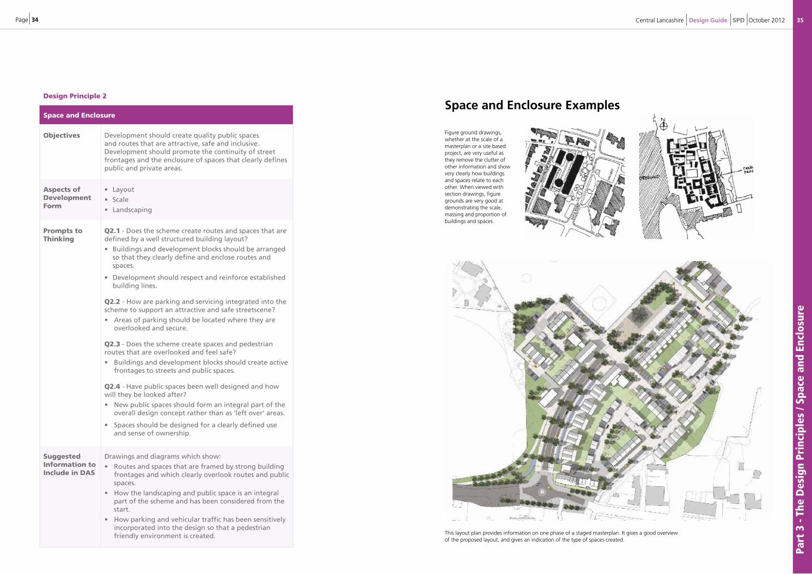
Figure ground drawings, whether at the scale of a masterplan or a site based project, are very useful as they remove the clutter of other information and show very clearly how buildings and spaces relate to each other. When viewed with section drawings, figure grounds are very good at demonstrating the scale, massing and proportion of buildings and spaces.
This layout plan provides information on one phase of a staged masterplan. It gives a good overview of the proposed layout, and gives an indication of the type of spaces created.
Page 36
Part
3 -
The
Des
ign
Prin
cipl
es /
Mix
of
Use
s an
d Te
nure
s
37Central Lancashire Design Guide SPD October 2012
Design Principle 3
Mix of Uses and Tenures
Objectives To achieve diversity and choice through a mix of compatible developments and uses that work together to create and support viable places.
Aspects of Development Form
• Amount
Prompts to Thinking
Q3.1 - Is the amount of development proposed appropriate for the site or location?
• The density of development proposed should respond to that of the surrounding area.
• Consider how the density of development can vary across the site in response to the site context or the design concept.
Q3.2 - Does the development provide (or is it close to) community facilities, such as a school, parks, play areas, shops, pubs or cafes?
• Development should consider how it can add to the vitality and viability of the area through the range of uses and tenures it proposes.
Q3.3 - Does the development contain an appropriate type and mix of uses for its location - does it reflect the needs or aspirations of the local community?
• Uses should be compatible with each other and the surrounding area.
Q3.4 - Has the development been designed to support a mix of uses and tenures that are attractive to people of a range of ages and incomes?
• Schemes should consider how a mix of uses can make an area attractive for as wide a range of users as possible.
Suggested Information to Include in DAS
Drawings and diagrams which show:
• A suitable mix of uses, mixed not just in plan but also vertically to encourage diverse and attractive places.
• An analysis of the density and uses surrounding the site and how this is supported or enhanced by the scheme.
Evidence of consultation to meet local needs including any pre-application discussions with the local planning authority.
Mix of Uses and Tenures Examples
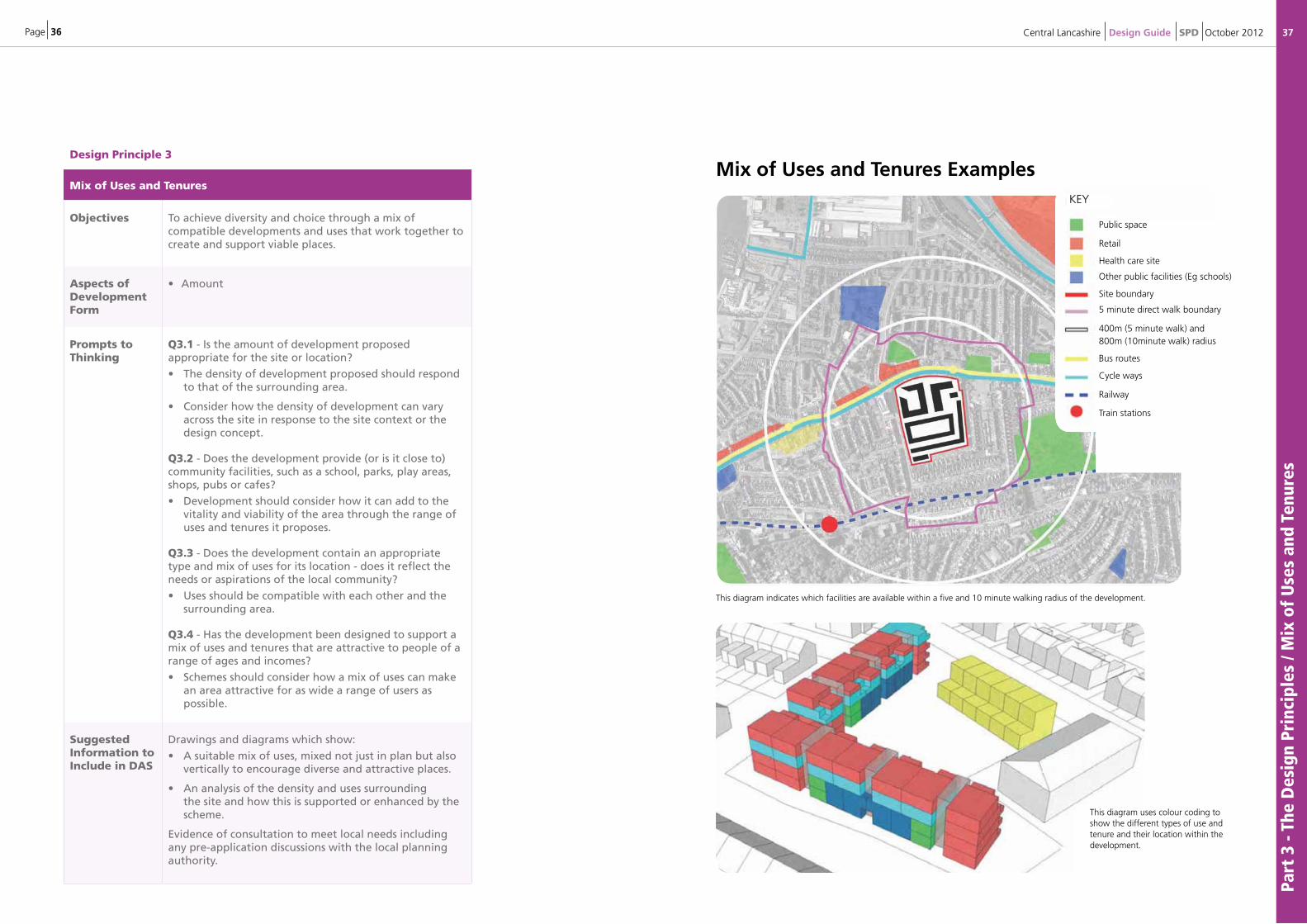
This diagram indicates which facilities are available within a five and 10 minute walking radius of the development.
KEY
This diagram uses colour coding to show the different types of use and tenure and their location within the development.
Public space
Retail
Health care site
Other public facilities (Eg schools)
Site boundary
5 minute direct walk boundary
400m (5 minute walk) and800m (10minute walk) radius
Bus routes
Cycle ways
Railway
Train stations
Page 38
Part
3 -
The
Des
ign
Prin
cipl
es /
Ada
ptab
ility
and
Res
ilien
ce
39Central Lancashire Design Guide SPD October 2012
Design Principle 4
Adaptability and Resilience
Objectives Promote adaptability through development that can respond to changing social, technological and economic conditions.
Aspects of Development Form
• Layout
• Amount
• Scale
• Appearance
Prompts to Thinking
Q4.1- Does the scale of the buildings and their use allow for future adaptation, conversion or extension?
Q4.2 - Does the layout of the development offer flexibility to support future changes?
Q4.3 - Does the development have an adaptable infrastructure to allow changes in the future?
Suggested Information to Include in DAS
Drawings, diagrams and information which shows:
• How layout and form can change to meet future needs, both in form and use.
• How buildings and spaces are built for long life use.
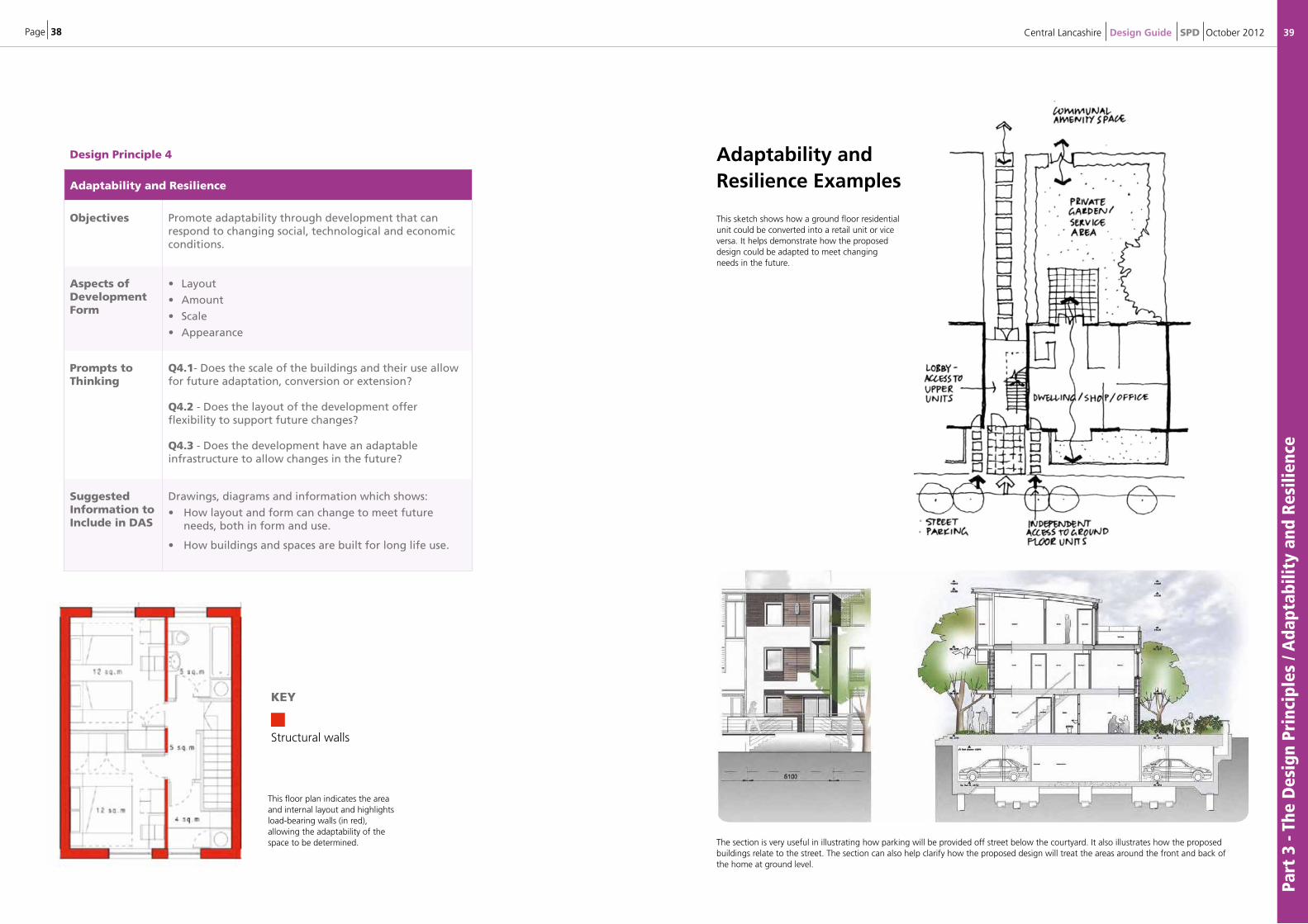
The section is very useful in illustrating how parking will be provided off street below the courtyard. It also illustrates how the proposed buildings relate to the street. The section can also help clarify how the proposed design will treat the areas around the front and back of the home at ground level.
This floor plan indicates the area and internal layout and highlights load-bearing walls (in red), allowing the adaptability of the space to be determined.
KEY
Structural walls
This sketch shows how a ground floor residential unit could be converted into a retail unit or vice versa. It helps demonstrate how the proposed design could be adapted to meet changing needs in the future.
Adaptability and Resilience Examples
Page 40
Part
3 -
The
Des
ign
Prin
cipl
es /
Reso
urce
s an
d Ef
fici
ency
41Central Lancashire Design Guide SPD October 2012
Design Principle 5
Resources and Efficiency
Objectives Development should contribute towards resource and energy efficiency (production and use); environmental sustainability including flood risk management and biodiversity.
Aspects of Development Form
• Layout• Amount• Appearance• Landscape
Prompts to Thinking
Q5.1 - What features does the development include that reduces its environmental impact?
• Schemes should consider sustainability in a site wide integrated way.
• Development should use resources efficiently in construction and operation. The 4 R’s principles are useful to follow – Reduce, Reuse, Recycle, Recover.
• Features could include: o combined heat & power (CHP) and district heating schemes
o utilising alternative energy sources,
o increasing insulation standards,
o orientating buildings southwards for passive solar gain,
o promoting recycling and waste minimisation,
o using sustainable urban drainage systems (SUDS),
o avoiding areas of flood risk,
o reducing construction waste,
o prioritising brownfield development,
o Increasing biodiversity.
Q5.2 - What use of advances in construction or technology has the scheme used to enhance its performance, quality or attractiveness?
• Does the scheme utilise modern methods of construction (MMC)?
• Does the scheme allow for the introduction of alternative energy sources and provision of other utilities?
Q5.3 - How does the design performance of buildings and spaces compare to statutory targets?
Suggested Information to Include in DAS
Drawings and diagrams which show:
• The early development and appreciation of an integrated site wide sustainability strategy.
• Information and/or commitment to utilise methods which contribute to resource / energy efficiency and to exceed statutory targets.
The Core Strategy and local policies will stipulate the current standards.
8 Contents8 intro
1 2 3 4 5
6 7 8 9 10
11 12 13 14 15
16 17 18 19 20
EnvironMEnt anD CoMMunity
CharaCtEr
strEEts, parking anD pEDEstrianisation
DEsign anD ConstruCtion
8 Further Reading
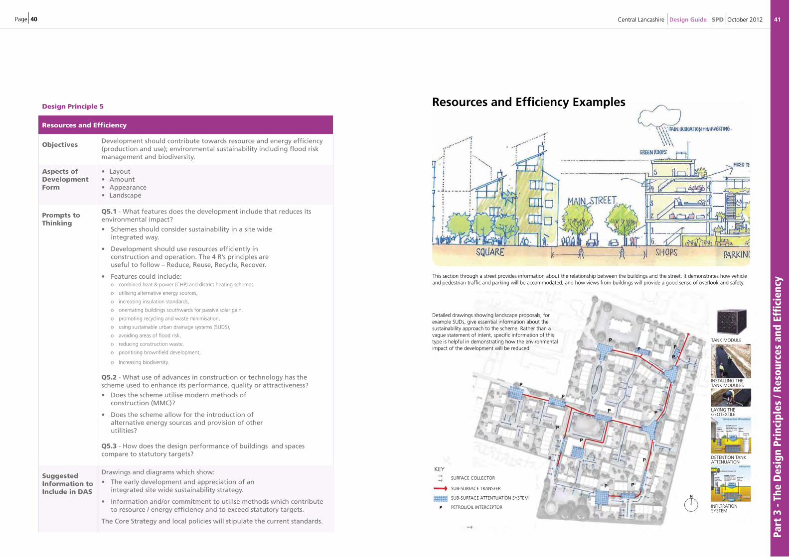
Detailed drawings showing landscape proposals, for example suDs, give essential information about the sustainability approach to the scheme. rather than a vague statement of intent, specific information of this type is helpful in demonstrating how the environmental impact of the development will be reduced.
LAnDSCAPE
page 1 page 2 page 3
relevant criteria 5 / 6 / 7 / 8
8 Contents8 intro
1 2 3 4 5
6 7 8 9 10
11 12 13 14 15
16 17 18 19 20
EnvironMEnt anD CoMMunity
CharaCtEr
strEEts, parking anD pEDEstrianisation
DEsign anD ConstruCtion
8 Further Reading
Detailed drawings showing landscape proposals, for example suDs, give essential information about the sustainability approach to the scheme. rather than a vague statement of intent, specific information of this type is helpful in demonstrating how the environmental impact of the development will be reduced.
LAnDSCAPE
page 1 page 2 page 3
relevant criteria 5 / 6 / 7 / 8
Detailed drawings showing landscape proposals, for example SUDs, give essential information about the sustainability approach to the scheme. Rather than a vague statement of intent, specific information of this type is helpful in demonstrating how the environmental impact of the development will be reduced.
This section through a street provides information about the relationship between the buildings and the street. It demonstrates how vehicle and pedestrian traffic and parking will be accommodated, and how views from buildings will provide a good sense of overlook and safety.
Resources and Efficiency Examples
TANK MODULE
INSTALLING THE TANK MODULES
LAYING THE GEOTEXTILE
DETENTION TANK ATTENUATION
INFILTRATION SYSTEM
8 Contents8 intro
1 2 3 4 5
6 7 8 9 10
11 12 13 14 15
16 17 18 19 20
EnvironMEnt anD CoMMunity
CharaCtEr
strEEts, parking anD pEDEstrianisation
DEsign anD ConstruCtion
8 Further Reading
Detailed drawings showing landscape proposals, for example suDs, give essential information about the sustainability approach to the scheme. rather than a vague statement of intent, specific information of this type is helpful in demonstrating how the environmental impact of the development will be reduced.
LAnDSCAPE
page 1 page 2 page 3
relevant criteria 5 / 6 / 7 / 8
SURFACE COLLECTOR
SUB-SURFACE TRANSFER
SUB-SURFACE ATTENTUATION SYSTEM
PETROL/OIL INTERCEPTOR
KEY
Page 42
Part
3 -
The
Des
ign
Prin
cipl
es /
Arc
hite
ctur
e an
d To
wns
cape
43Central Lancashire Design Guide SPD October 2012
Design Principle 6
Architecture and Townscape
Objectives To maintain but enhance the positive features of a place and promote its character and identity by responding to and reinforcing locally distinctive patterns of development, built heritage, culture and landscape.
Aspects of Development Form
• Scale
• Appearance
• Layout
• Landscape
Prompts to Thinking
Q6.1 - Does the scheme exploit existing buildings, landscape or topography?
• Schemes should fully consider the relationship with their surroundings with clear site and context analysis.
Q6.2 - Is the scale and massing of the scheme appropriate for the site and its surrounding context?
• Development should be designed to a suitable height and scale to surrounding buildings or its landscape setting.
Q6.3 - Does the scheme feel like a place with distinctive character?
• Schemes should demonstrate a clear design concept which has been informed by a thorough appraisal of the areas character.
Q6.4 - Do the buildings exhibit architectural quality?
• Design should reflect the positive characteristics of the area.
• Elevations should be well composed and detailed, taking into account the rhythm of the street scene (street elevations).
• The architectural response should strive for excellence and reflect a step-change in design quality.
Suggested Information to Include in DAS
Drawings and diagrams which show:
• A thorough site and context analysis which leads to a clear design concept (See chapter D).
• How the scheme relates to the scale and height of surrounding buildings or its landscape setting. This will usually require 3D massing sketches, sections, street elevations and photomontages which fully show the proposals in context.
• How the scheme enhances the area. Close consideration is required to create architectural quality including elevational treatment, detailing and materials.
Architecture and Townscape Examples
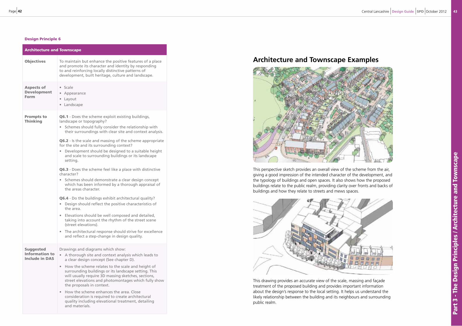
This perspective sketch provides an overall view of the scheme from the air, giving a good impression of the intended character of the development, and the typology of buildings and open spaces. It also shows how the proposed buildings relate to the public realm, providing clarity over fronts and backs of buildings and how they relate to streets and mews spaces.
This drawing provides an accurate view of the scale, massing and façade treatment of the proposed building and provides important information about the design’s response to the local setting. It helps us understand the likely relationship between the building and its neighbours and surrounding public realm.
Page 44
Part
4 -
The
Des
ign
Proc
ess
/ Dev
elop
a D
esig
n Pr
opos
al /
App
rais
e th
e Is
sues
45Central Lancashire Design Guide SPD October 2012
4: The Design Process 4.1 This section of the SPD sets out how the design process can be structured to support the delivery of high quality schemes and how the information required can be best presented so that it meets the requirements of local and national planning policies and guidelines. The information will also help applicants to understand how schemes will be assessed by the Local Planning Authority (LPA) when it makes a decision.
Develop a Design Proposal4.2 In developing a proposal for a particular site there are a number of stages or steps in the design process that can be followed to help achieve a high quality scheme.
4.3 For simplification the process can be considered as three stages:
• Appraise the Issues / Consultation
• Develop a Design Concept (Plan)
• Submission and Assessment of the Application(s)
4.4 At each stage of the process it is advised that the thinking behind the proposal is tested against the aims of the Spatial Vision for Central Lancashire which are set out in the Core Strategy and the three cross cutting themes that underpin them. These are:
• Achieving Good Design
• Promoting Health and Wellbeing
• Tackling Climate Change
Appraise the Issues4.5 The first step to achieving good design is to develop an understanding of the site and its wider context. This is not only in respect to the site’s physical characteristics and setting, both in terms of buildings and landscape, but also how the nature of the proposal relates to the wider social and economic characteristics of the area. The appraisal must also consider how the relevant planning policies and guidance for the area would apply.
Understand the Place4.6 The design of a successful, high quality scheme must be based on a full understanding of the opportunities and constraints each site presents. When looking at a site it is important that not only the individual site is considered but also how it’s wider setting (its context) has been taken in to account.
4.7. Every site will have different characteristics and it is important to ensure that the appraisal identifies the key issues for a particular site rather than applying standardised solutions.
4.8. The main issues that should be covered in the appraisal can be grouped under the following headings which reflect the priorities within the Core Strategy. Clearly the range of issues for each site will vary depending on its particular location and the nature of the scheme being proposed.
Page 46
Part
4 -
The
Des
ign
Proc
ess
/ App
rais
e th
e Is
sues
47Central Lancashire Design Guide SPD October 2012
Table 3: Key Elements of Site and Context Appraisal
Physical
Character
Social
Character
Economic
Character
Form and Setting:
• Site history
• Character of site and surroundings
• Layout and form of existing buildings and structures
• Building materials
• Location of utilities
Community:
• Community profile
• Community aspirations for site
• Stakeholders
Land Use:
• Existing land uses
• Development pressures or needs
Movement:• Existing access for different modes
• Linkages to wider area and facilities
• Parking
• Public transport
Safety and Security:
• Issues with crime or anti-social behaviour
• Management of site
Planning Context:
• Relevant local and national planning policies
• Site specific designations e.g. listed buildings or protected trees
Natural Features:
• Existing landscape features and character
• Site topography and orientation
• Greenspaces
• Ground conditions
• Key views or vistas
Health and Well Being: • Access to health, recreation and community facilities • Pollution levels• Local health and wellbeing issues
Feasibility:
• Understanding of site capacity
• Land ownerships and tenures
• Existing building conditions
• Engineering or utilities constraints
Presentation of Information4.10 There are a number of different approaches to undertaking an appraisal. However the key objective is to ensure that the information collected through the appraisal process can be clearly communicated and explained. The site appraisal should form part of the Design and Access Statement8 which will need to be submitted with the majority of applications.
4.11 In most cases simple annotated plans and photographs should be sufficient to show the required level of information. Examples of site and context appraisals are shown below.
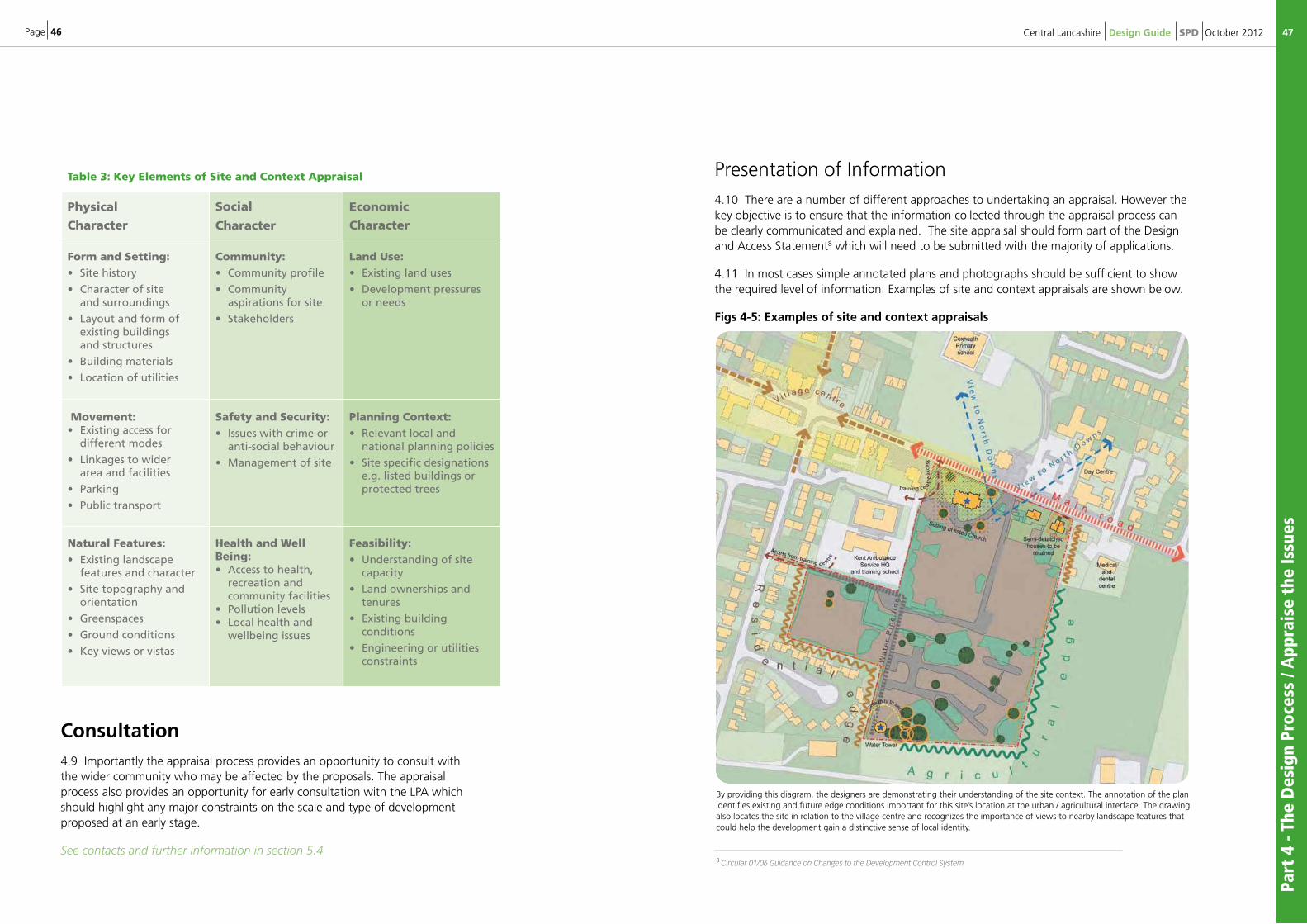
Figs 4-5: Examples of site and context appraisals
Consultation4.9 Importantly the appraisal process provides an opportunity to consult with the wider community who may be affected by the proposals. The appraisal process also provides an opportunity for early consultation with the LPA which should highlight any major constraints on the scale and type of development proposed at an early stage.
See contacts and further information in section 5.4 8 Circular 01/06 Guidance on Changes to the Development Control System
By providing this diagram, the designers are demonstrating their understanding of the site context. The annotation of the plan identifies existing and future edge conditions important for this site’s location at the urban / agricultural interface. The drawing also locates the site in relation to the village centre and recognizes the importance of views to nearby landscape features that could help the development gain a distinctive sense of local identity.
Page 48
Part
4 -
The
Des
ign
Proc
ess
/ App
rais
e th
e Is
sues
/ D
evel
op a
Des
ign
Conc
ept
Plan
49Central Lancashire Design Guide SPD October 2012
Image courtesy of RCKa architects 2011.
4.12 The following documents provide further examples and guidance on what information is required for an appraisal and how it can be presented:
• By Design
• Urban Design Compendium
• Building for Life
• Quality Reviewer
Develop a Design Concept Plan4.13 The design concept plan should set out clearly what the aims of the scheme are and how this relates to and has been informed by the following aspects of the design process:
• Site and Context Appraisal
• Design Principles (Chapter 3)
• Development Objectives for the Site
4.14 In most cases this will be an iterative process where the development objectives are tested and amended in response to the appraisal and the relevant design principles as they would apply to the site.
4.15 It is an important part of the design process to show how the concept for the site has been developed from a detailed understanding of the site’s context.
4.16 The appraisal process should not be used to support a predetermined or standardised approach to the development of the site. Such an approach is contrary to the guidance set out in the NPPF and in Circular 01/06 in terms of achieving good design.
Fig 6: Process Diagram
Page 50
Part
4 -
The
Des
ign
Proc
ess
/ Dev
elop
a D
esig
n Co
ncep
t Pl
an
51Central Lancashire Design Guide SPD October 2012
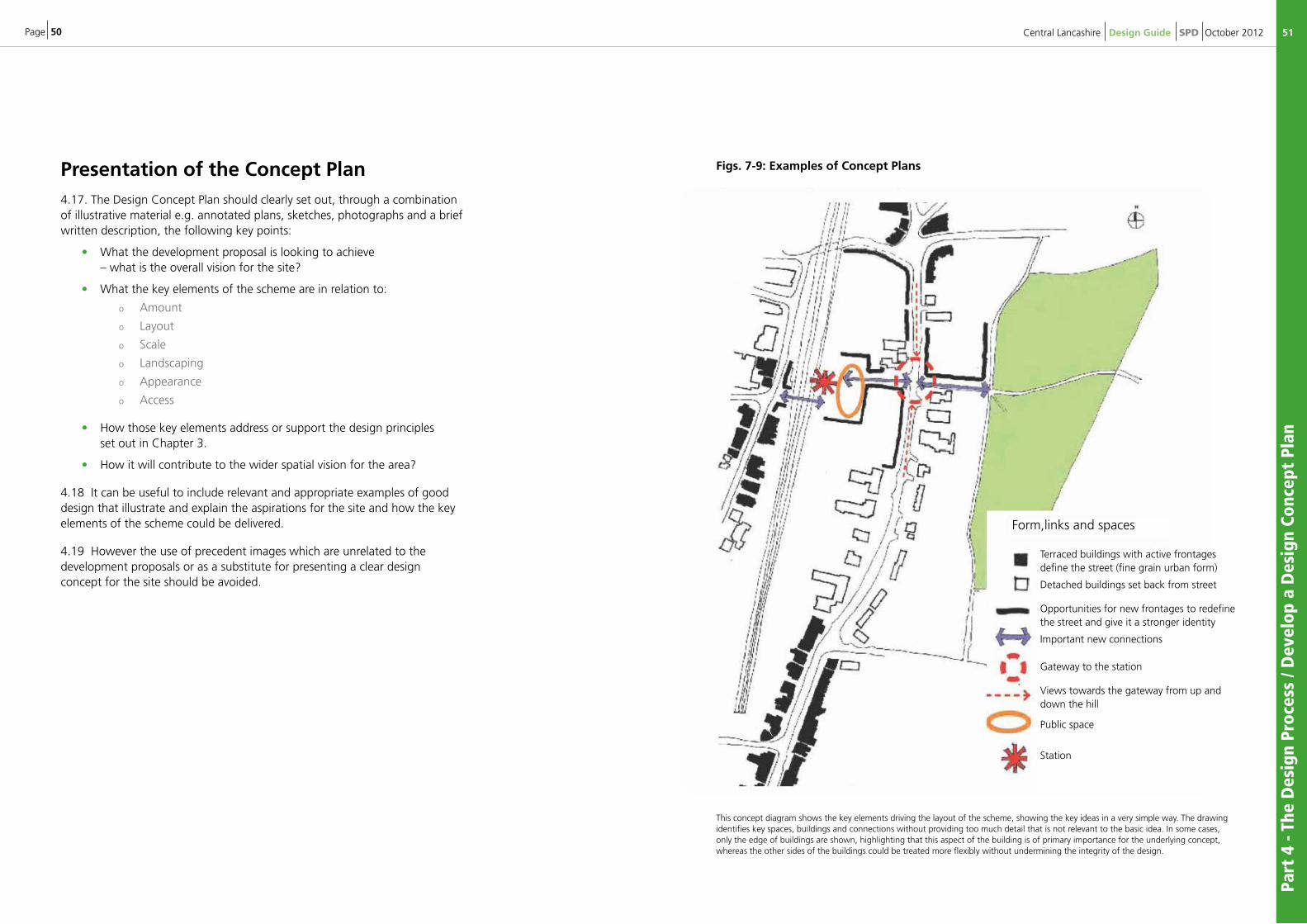
Presentation of the Concept Plan4.17. The Design Concept Plan should clearly set out, through a combination of illustrative material e.g. annotated plans, sketches, photographs and a brief written description, the following key points:
• What the development proposal is looking to achieve – what is the overall vision for the site?
• What the key elements of the scheme are in relation to:
o Amount
o Layout
o Scale
o Landscaping
o Appearance
o Access
• How those key elements address or support the design principles set out in Chapter 3.
• How it will contribute to the wider spatial vision for the area?
4.18 It can be useful to include relevant and appropriate examples of good design that illustrate and explain the aspirations for the site and how the key elements of the scheme could be delivered.
4.19 However the use of precedent images which are unrelated to the development proposals or as a substitute for presenting a clear design concept for the site should be avoided.
This concept diagram shows the key elements driving the layout of the scheme, showing the key ideas in a very simple way. The drawing identifies key spaces, buildings and connections without providing too much detail that is not relevant to the basic idea. In some cases, only the edge of buildings are shown, highlighting that this aspect of the building is of primary importance for the underlying concept, whereas the other sides of the buildings could be treated more flexibly without undermining the integrity of the design.
Figs. 7-9: Examples of Concept Plans
Terraced buildings with active frontages define the street (fine grain urban form)
Detached buildings set back from street
Opportunities for new frontages to redefine the street and give it a stronger identity
Important new connections
Gateway to the station
Views towards the gateway from up and down the hill
Public space
Station
Form,links and spaces
Page 52
Part
4 -
The
Des
ign
Proc
ess
/ Dev
elop
a D
esig
n Co
ncep
t Pl
an /
Des
ign
and
Acc
ess
Stat
emen
ts
53Central Lancashire Design Guide SPD October 2012
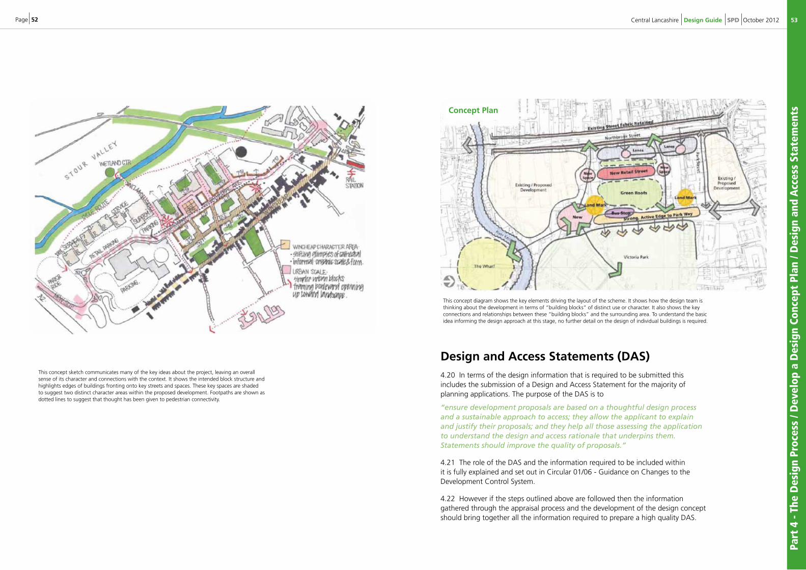
This concept sketch communicates many of the key ideas about the project, leaving an overall sense of its character and connections with the context. It shows the intended block structure and highlights edges of buildings fronting onto key streets and spaces. These key spaces are shaded to suggest two distinct character areas within the proposed development. Footpaths are shown as dotted lines to suggest that thought has been given to pedestrian connectivity.
This concept diagram shows the key elements driving the layout of the scheme. It shows how the design team is thinking about the development in terms of “building blocks” of distinct use or character. It also shows the key connections and relationships between these “building blocks” and the surrounding area. To understand the basic idea informing the design approach at this stage, no further detail on the design of individual buildings is required.
Design and Access Statements (DAS)4.20 In terms of the design information that is required to be submitted this includes the submission of a Design and Access Statement for the majority of planning applications. The purpose of the DAS is to
“ensure development proposals are based on a thoughtful design process and a sustainable approach to access; they allow the applicant to explain and justify their proposals; and they help all those assessing the application to understand the design and access rationale that underpins them. Statements should improve the quality of proposals.”
4.21 The role of the DAS and the information required to be included within it is fully explained and set out in Circular 01/06 - Guidance on Changes to the Development Control System.
4.22 However if the steps outlined above are followed then the information gathered through the appraisal process and the development of the design concept should bring together all the information required to prepare a high quality DAS.
Concept Plan
Page 54
Part
4 -
The
Des
ign
Proc
ess
/ Des
ign
and
Acc
ess
Stat
emen
ts /
Des
ign
Revi
ew
55Central Lancashire Design Guide SPD October 2012
1. Show your thinking
2. Prepare the design statement as part of the pre-application process rather than getting a consultant to prepare it in isolation
3. Start writing the statement at the start of the process
4. A design statement should form part of an audit trail of the design and approval process
5. Think of the statement as a process, not a product
6. Make sure the statement is appropriate in length; neither too long, irrelevant and confusing, nor too short and formulaic.
7. Design statements should be read, not weighed
8. Pictures should be annotated or have a caption. They should not just be wallpaper
9. Design statements should expose designs which are ill considered or inappropriate to the particular site and area
10. A good design statement cannot justify poor quality design
Design Review4.23 The NPPF states that local planning authorities should have local design review arrangements in place (paragraph 62). The purpose of the design review is to provide constructive, impartial and expert guidance to applicants as they develop their proposals to ensure high standards of design.
4.24 Design Review for schemes in Central Lancashire will be undertaken for the Councils' by Places Matter! the North West regional design support service. When appropriate Places Matter will forward schemes brought to them for national design review with Design Council Cabe. Further details of the design review process and the contact details for Places Matter can be found on their website9.
4.25 The Councils' will identify at pre-application stage which schemes due to their size, complexity or impact should be referred to Places Matter!. Alternatively applicants can request a design review directly with Places Matter as part of their consultation process during the design development.
4.26 The Councils' will have regard to the recommendations of the design review and how these have been reflected in the submitted design when determining the application.
Submission and Assessment of the Application 4.27 Following completion of the steps outlined above will allow applicants to be fully prepared for submitting an application whether that is for a detailed or outline application. This will require the preparation and submission of the detailed drawings, plans and other information required to make a valid application.
4.28 Applicants should note that where revisions or amendments for an approved scheme are proposed they will need to demonstrate that they do not erode the quality of the scheme. However if an assessment of the changes shows that they will erode or undermine the quality of the approved scheme such changes will not be approved.
Design and Access Statements10 Pointers to good practice
9 www.placesmatter.org.uk
From Urban Design Group data sheet: http://www.neighbourhood-design.org/publications/udg-publication/design-access-statements-explained
Page 56
Part
4 -
The
Des
ign
Proc
ess
/ Ass
essi
ng t
he In
form
atio
n
57Central Lancashire Design Guide SPD October 2012
Understand The Proposal1) Site and context appraisal - Design a successful scheme or appraise a planning proposal only once you have a good understanding of the place - not just the development site but also the wider area.
2) How policy and guidance apply - Establish what legislation, policy and guidance apply to the area and site, and whether the site is in a designated area or near significant features in the surrounding area. Understand the local authority's aspirations for the place and how it works to achieve them.
Understand The Place3) Concept Plan - Identify what the development proposal is intended to achieve and how. Understand the project’s aspirations and precedents.
4) Impact - Consider how significant the impact of this development proposal is likely to be and the influence of this on how the development should be handled.
5) Design quality - Consider what the proposed development’s strengths and weaknesses are in relation to the six sets of design qualities (Chapter 3 - Design principles).
6) Team – good design skills required. Importantly find out if the proposal has been designed by a person or team with design training and with a track record of good design.
Understand The Implementation7) Execution - Consider whether the design is likely to be well executed.
8) Management and maintenance - Consider whether the development is likely to be well managed and maintained after construction.
Make The Decision9) Information and advice - Determine if you have the right information to make a balanced appraisal decision. If not, ask for additional relevant and necessary information.
10) A balanced decision – Is the design good enough? Decide whether the development proposal should be accepted; accepted with conditions; negotiated; or rejected.
Assessing the Information
4.29 It is the information contained within the DAS which will be used by officers to assess the design quality of the proposal against the relevant local and national policy guidance.
4.30 Applicants need to be aware that a poor quality DAS where the required information is not provided or where there is a reliance on using generalised statements without adequate information to support them could lead to the scheme being refused on design grounds.
4.31 Assessment structure will follow the principles (below) in Qualityreviewer which is based on ten steps. (Further information can be found in the Appendices)
Page 58
Sust
aina
bilit
y, h
abit
ats
/ Mon
itor
ing
Revi
ew /
Stat
us o
f SP
Ds
/ Fur
ther
info
rmat
ion
59Central Lancashire Design Guide SPD October 2012
5.1: Sustainability appraisal and habitats regulations assessment
5.2: Monitoring and Review
5.3: Status of SPDs
Given the relationship between this SPD, the Core Strategy and the Site Allocations DPDs and the level of Sustainability Appraisal (SA) that these documents have undergone together with the anticipated absence of any significant environmental effects arising from this proposal, an independent SA of this Planning Framework SPD is not required. In addition, the Core Strategy has undergone a Habitats Regulations Screening Assessment to determine the likely significant effects of the plan on sites of international nature conservation importance. As the SPD is in conformity with the policies contained within the Core Strategy, a full Screening Assessment of this SPD is not required.
The Councils will monitor the effectiveness of this guidance including Core Strategy key indicators and review as appropriate in the light of its performance and future changes in planning law and policy guidance.
A Consultation Draft of this SPD was published under Regulation 17 of the Local Development Regulations 2004 (SI2004.2204) in April 2012. Responses to the Consultation Draft SPD were taken into consideration within a revised document. This adopted version should be afforded significant weight as a material consideration in determining planning applications.
5.4: Further Information
The SPD will primarily be implemented through the development management process and the determination of planning applications. Charges may apply for pre-application consultations; please see websites for details. Planning Officers will be pleased to provide advice and guidance on design.
They can be contacted on:
AcknowledgementsThe images in chapters 3 and 4 are sourced from Building for Life guidance unless otherwise stated.
See: www.buildingforlife.org
Preston City Council www.preston.gov.uk01772 [email protected]
Chorley Council www.chorley.gov.uk 01257 [email protected]
South Ribble Borough Council www.southribble.gov.uk01772 [email protected]
Page 60
Appendix 1: Performance Criteria and Monitoring The purpose of this section is to assist all those commenting and making decisions about planning applications, in their assessment of the design quality of the proposals. It identifies performance criteria and a set of qualitative ‘standards’ that can be used to measure the proposals against the elements of good urban design set out in the SPD. The criteria are organised in terms of the process and product recommended by the SPD. Whilst the use of performance criteria is considered useful, the aim has been not to apply ‘rigid’ assessment methods. Each site and proposal is different, and using quantitative measurements is not always appropriate in assessing the creative and thoughtful response to the objectives of good design.
Using the criteria, therefore, requires a certain level of interpretation and value judgement. The performance criteria monitoring would form part of the overall implementation package for the SPD, requiring a programme of training for those involved in using the guidance and for assessment. The assessment and monitoring would be implemented on a phased basis, entailing only certain types and sizes of applications at specific stages to reflect a gradual increase in capacity (design awareness and resources). Details of managing this process will need to be finalised once the Central Lancashire Design SPD is adopted.
Assessment criteriaProcess: putting together a Design and Access Statement1. The applicant makes early contact with the relevant Development Management Team, in order to discuss their ideas in relation to specific site and general design and policy requirements.
2. There is evidence of demonstrable pre-application community involvement for ‘major’ applications.
3. A Design and Access Statement which describes a systematic approach to the design process has been submitted with the application. The length and content of the Statement will vary according to the size and potential impact of the scheme. The Statement responds to the requirements set out by the Development Management (Control) officer at the pre-application meeting. For householder applications, a covering letter may be sufficient. For other applications, the Design and Access Statement and discussion / negotiation with the applicant convey:
App
endi
x 1:
Per
form
ance
Cri
teri
a an
d M
onit
orin
g / A
sses
smen
t Cr
iter
ia
61Central Lancashire Design Guide SPD October 2012
• An awareness of good design practice and planning policies.
• An appraisal of the character of the area around the site (its context). (The size of the area covered will vary depending on the potential visual and other impacts of the development; often 400m is appropriate.)
• A map-based appraisal of the site.
• A concept plan represents the general design objectives and principles for the site.
Product: Content of the Design and Access Statement and Scheme4. There are clear links demonstrating that the final scheme responds to the appraisal of site and context, and that it takes forward design principles identified in the concept plan.
5. The Design and Access Statement clearly identifies:
• the amount of development proposed;
• the density levels for different parts of the site; and
• the use or mix of uses proposed.
6. The scheme layout demonstrates a coherent and legible structure, is well integrated with the surrounding area and retains existing routes where possible/appropriate.
7. The scale and massing of buildings is identified using both 2D and 3D images.
8. The scale, massing and built form respond to the appraisal of site and context.
9. The public realm and landscaping is designed as a part of the overall layout and built form. It responds to the appraisal of site and context.
10. Materials and details relate to site context.
11. The design of the scheme demonstrates an intention to implement environmentally, socially and economically sustainable development which will create ‘sense of place’ and support healthy and environmentally responsible lifestyles and communities.
Page 62
App
endi
x 1:
Per
form
ance
Cri
teri
a an
d M
onit
orin
g / A
sses
smen
t Cr
iter
ia
63Central Lancashire Design Guide SPD October 2012
Performance measurement
Innovative/good quality
1. The applicant has responded to all the requirements identified at the pre-application meeting.
2. A Design and Access Statement has been submitted. The appraisal of the site and context covers an appropriate area. It not only identifies the issues, but demonstrates a thoughtful consideration of features which contribute something positive, or something negative, as well as constraints and opportunities to improve the character and appearance of the area, along with the way it is used. The appraisal demonstrates a sound knowledge of the objectives of urban design.
3. A concept plan is produced which clearly demonstrates a series of well thought out principles for development that have emerged from the appraisal process. These principles are reflected in the final scheme.
4. The scheme identifies the amount, use and density of development in a way that is clearly conveyed and easily understood.
5. The layout, massing and built form, public realm and landscape design, and materials and details successfully implement the design principles identified in the concept plan.
6. A series of 2 and 3-dimensional images (cross-sections and models) convey the scale and massing of individual buildings and convey a strong impression of what the place will be like, showing topography and the enclosure of spaces.
7. There is a strong commitment to quality and innovative attempts to implement environmentally, socially and economically sustainable development which will create ‘sense of place’ and support healthy and environmentally responsible lifestyles and communities.
8. In Conservation Areas and on Listed Buildings or sites affecting the setting of Listed Buildings, particular attention has been paid to materials and detailing.
Above average
1. The applicant has responded to most of the requirements identified at the pre-application meeting, including all the essential requirements.
2. A Design and Access Statement has been submitted, which identifies the relevant issues and begins to evaluate these critically.
3. A concept plan is produced; it makes connections to the appraisal process. The key issues and principles are reflected in the final scheme.
4. The scheme identifies the amount, use and density of development.
5. The layout, massing and footprint of buildings are appropriate for the site and context.
6. The layout and built form, public realm and landscape design, and materials and details successfully implement the design principles identified in the concept plan.
7. The application includes some 3-dimensional images (cross-sections) that help convey the scale and massing of individual buildings and an impression of what the place will be like.
8. There are attempts to implement environmentally, socially and economically sustainable development that will create ‘sense of place’ and support healthy and environmentally responsible lifestyles and communities.
9. In Conservation Areas and on Listed Buildings or sites affecting the setting of Listed Buildings, particular attention has been paid to materials and detailing.
Below average (unacceptable / poor)
1. The applicant has not requested a pre-application meeting.
2. The Design and Access Statement does not address all of the relevant issues or evaluate them critically.
3. No appraisal of the site or its context has been submitted.
4. The scheme fails to identify the amount of development, uses or density levels.
5. The layout does not respond to context, there is no apparent movement hierarchy and no focal points for public life. Roads are over-engineered and circuitous with limited access points and the needs of pedestrians and cyclists are poorly considered.
6. The scale, massing and height of buildings is unclear.
7. None of the elements of ‘massing and built form’ appear to have been considered.
8. The public realm is poorly defined and enclosed by buildings. There is little consideration of how outdoor spaces will be used, and landscape treatment is absent or cursory.
9. No information is provided on sourcing of materials or their energy efficiency.
10. The scheme creates an impression of ‘anywhere’ development, with a sense that pre-existing designs or ‘house types’ have been fitted onto the site with little or no consideration of creating spaces and a sense of place. No consideration has been given to sustainable or healthy lifestyles and communities.
Page 64
Monitoring Framework Monitoring of the impacts of this SPD will be undertaken to better understand how well the process and outputs envisaged by the SPD are being implemented, and whether there are any unforeseen adverse effects. The broad framework for monitoring is based on three main areas: the usability of the SPD, the quality of design schemes submitted, and the quality of subsequent changes to the built environment. A framework for the monitoring of the SPD will be set up and the associated indicators will be reviewed by the individual Councils (Preston, South Ribble and Chorley)
UsabilityIn order to assess usability, a customer satisfaction survey of stakeholders (architects, developers, agents, local amenity/conservation groups and parish councils) may be undertaken within 12 to 18 months of adopting the SPD. This could be supplemented by a more informal survey of a limited number of stakeholders yearly thereafter. The aim of both will be to establish the extent to which the document is understood and used, including:
• Percentage of stakeholders (identified above) who say they understand the requirements for the design process (including site and context appraisal, developing a concept, and designing a final scheme).
• Stakeholder comments on the usability of the SPD more generally.
Quality of submissionsMonitoring will be based on a phased / rolling program of implementation, starting with a limited number of application categories and a sample basis. The process will involve completing a pro forma for each affected planning application. On a phased basis, the scheme will then be rolled out to include a larger range of applications. The results will be analysed on an annual basis.
• Percentage of schemes that were judged to be either innovative / good quality, acceptable, or unacceptable under the performance criteria.
App
endi
x 1:
Per
form
ance
Cri
teri
a an
d M
onit
orin
g / A
sses
smen
t Cr
iter
ia
65Central Lancashire Design Guide SPD October 2012
• Percentage of applications meeting BREEAM ‘Very Good’ standard or Code for Sustainable Homes,
• Number of major proposals involving demonstrable pre-application community involvement.
• Number of applications refused on design grounds (including specific reasons cited).
• Number of appeals on design grounds and percentage upheld.
Quality on the groundA random sample of developments will be selected each year for monitoring purposes. This will be chosen from the completions of applications approved since the SPD has been adopted. The assessment will be undertaken by a design panel potentially reviewing the following:
• Percentage of new-build homes and house extensions meeting Code for Sustainable Homes, Level 4, and percentage of commercial buildings meeting BREEAM ‘Very Good’ standard.
• Proportion of residential schemes that fall into the silver or gold standard categories when assessed against the Building for Life standards and proportion of residential schemes that include homes designed to the Lifetime Homes standards and Secure by Design standards.
• Proportion of new developments that incorporate measures to promote environmental sustainability in each of these areas: energy efficiency, water efficiency, surface water management, site waste management, household waste management, and use and sourcing of materials.
• The number of developments that have received an award for design excellence under the Central Lancashire local awards scheme (this requires a scheme to be established in Central Lancashire).
• Implementation of scheme in accordance with approved plans. This will include a focus on quality of workmanship, use of approved materials and compliance with any conditions.
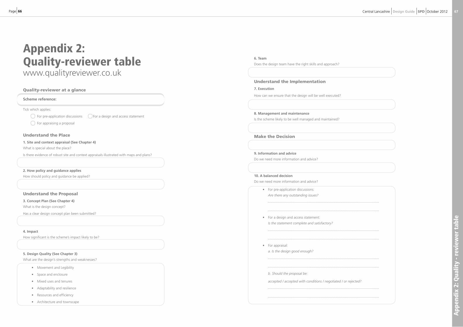
Page 66
Appendix 2:Quality-reviewer tablewww.qualityreviewer.co.uk
App
endi
x 2:
Qua
lity
- rev
iew
er t
able
67Central Lancashire Design Guide SPD October 2012
Quality-reviewer at a glance
Scheme reference:
Tick which applies:
For pre-application discussions For a design and access statement
For appraising a proposal
Understand the Place
1. Site and context appraisal (See Chapter 4)
What is special about the place?
Is there evidence of robust site and context appraisals illustrated with maps and plans?
2. How policy and guidance applies
How should policy and guidance be applied?
Understand the Proposal
3. Concept Plan (See Chapter 4)
What is the design concept?
Has a clear design concept plan been submitted?
4. Impact
How significant is the scheme’s impact likely to be?
5. Design Quality (See Chapter 3)
What are the design’s strengths and weaknesses?
• Movement and Legibility
• Space and enclosure
• Mixed uses and tenures
• Adaptability and resilience
• Resources and efficiency
• Architecture and townscape
6. Team
Does the design team have the right skills and approach?
Understand the Implementation
7. Execution
How can we ensure that the design will be well executed?
8. Management and maintenance
Is the scheme likely to be well managed and maintained?
Make the Decision
9. Information and advice
Do we need more information and advice?
10. A balanced decision
Do we need more information and advice?
• For pre-application discussions:
Are there any outstanding issues?
• For a design and access statement:
Is the statement complete and satisfactory?
• For appraisal:
a. Is the design good enough?
b. Should the proposal be:
accepted / accepted with conditions / negotiated / or rejected?
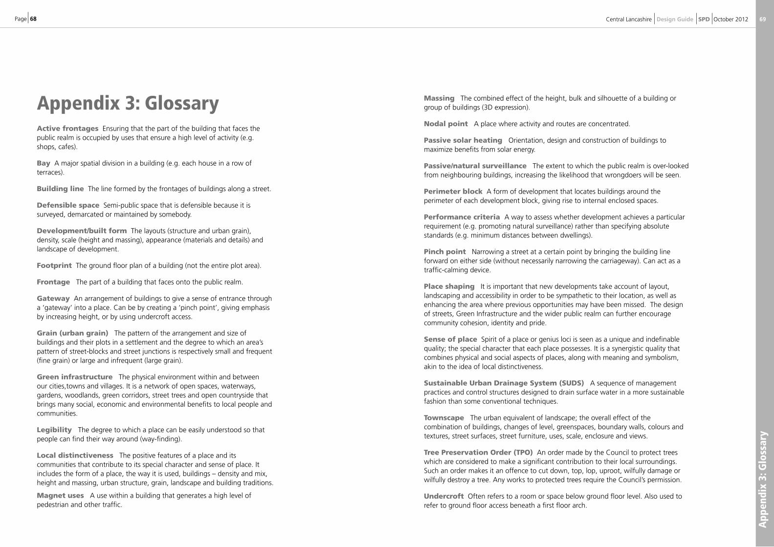
Page 68
App
endi
x 3:
Glo
ssar
y
69Central Lancashire Design Guide SPD October 2012
Massing The combined effect of the height, bulk and silhouette of a building or group of buildings (3D expression).
Nodal point A place where activity and routes are concentrated.
Passive solar heating Orientation, design and construction of buildings to maximize benefits from solar energy.
Passive/natural surveillance The extent to which the public realm is over-looked from neighbouring buildings, increasing the likelihood that wrongdoers will be seen.
Perimeter block A form of development that locates buildings around the perimeter of each development block, giving rise to internal enclosed spaces.
Performance criteria A way to assess whether development achieves a particular requirement (e.g. promoting natural surveillance) rather than specifying absolute standards (e.g. minimum distances between dwellings).
Pinch point Narrowing a street at a certain point by bringing the building line forward on either side (without necessarily narrowing the carriageway). Can act as a traffic-calming device.
Place shaping It is important that new developments take account of layout, landscaping and accessibility in order to be sympathetic to their location, as well as enhancing the area where previous opportunities may have been missed. The design of streets, Green Infrastructure and the wider public realm can further encourage community cohesion, identity and pride.
Sense of place Spirit of a place or genius loci is seen as a unique and indefinable quality; the special character that each place possesses. It is a synergistic quality that combines physical and social aspects of places, along with meaning and symbolism, akin to the idea of local distinctiveness.
Sustainable Urban Drainage System (SUDS) A sequence of management practices and control structures designed to drain surface water in a more sustainable fashion than some conventional techniques.
Townscape The urban equivalent of landscape; the overall effect of the combination of buildings, changes of level, greenspaces, boundary walls, colours and textures, street surfaces, street furniture, uses, scale, enclosure and views.
Tree Preservation Order (TPO) An order made by the Council to protect trees which are considered to make a significant contribution to their local surroundings. Such an order makes it an offence to cut down, top, lop, uproot, wilfully damage or wilfully destroy a tree. Any works to protected trees require the Council’s permission.
Undercroft Often refers to a room or space below ground floor level. Also used to refer to ground floor access beneath a first floor arch.
Appendix 3: GlossaryActive frontages Ensuring that the part of the building that faces the public realm is occupied by uses that ensure a high level of activity (e.g. shops, cafes).
Bay A major spatial division in a building (e.g. each house in a row of terraces).
Building line The line formed by the frontages of buildings along a street.
Defensible space Semi-public space that is defensible because it is surveyed, demarcated or maintained by somebody.
Development/built form The layouts (structure and urban grain), density, scale (height and massing), appearance (materials and details) and landscape of development.
Footprint The ground floor plan of a building (not the entire plot area).
Frontage The part of a building that faces onto the public realm.
Gateway An arrangement of buildings to give a sense of entrance through a ‘gateway’ into a place. Can be by creating a ‘pinch point’, giving emphasis by increasing height, or by using undercroft access.
Grain (urban grain) The pattern of the arrangement and size of buildings and their plots in a settlement and the degree to which an area’s pattern of street-blocks and street junctions is respectively small and frequent (fine grain) or large and infrequent (large grain).
Green infrastructure The physical environment within and between our cities,towns and villages. It is a network of open spaces, waterways, gardens, woodlands, green corridors, street trees and open countryside that brings many social, economic and environmental benefits to local people and communities.
Legibility The degree to which a place can be easily understood so that people can find their way around (way-finding).
Local distinctiveness The positive features of a place and its communities that contribute to its special character and sense of place. It includes the form of a place, the way it is used, buildings – density and mix, height and massing, urban structure, grain, landscape and building traditions.
Magnet uses A use within a building that generates a high level of pedestrian and other traffic.

Page 70
• Sustainable Urban Extensions – Planned through Design. English Partnerships, CPRE, DETR, 2000.
• The Value of Housing Design and Layout. FPD Savills & Davis Langdon and Everest, CABE, 2003.
• The Value of Urban Design, CABE, DTLR, UCL, 2001.
• Qualityreviewer, Appraising the design quality of development proposals, Urban Design Skills and HCA, 2010 www.qualityreviewer.co.uk
• Urban Design Compendium 1 & 2. Llewelyn-Davies, English Partnerships, Housing Corporation, 2000 & 2010.
• Urban Design Guidance. R Cowan (ed.) Urban Design Group, 2002.
• What Homebuyers Want: attitudes and decision-making among consumers. CABE, 2005.
Useful websiteswww.buildingforlife.org Web archive of building for life information
www.building-in-context.org For advice on achieving high standards of new development in historically sensitive areas.
www.breeam.org For advice on the social and environmental impacts of new development
www.communities.gov.uk For copies of Government guidance and advice
www.cabe.org.uk – (former) CABE website archive Contains a wealth of useful information on all design matters
www.designcouncil.org.uk/our-work/CABE/ Design Council cabe (CABE is now part of the design council)
www.cabe.org.uk/sustainable-places Former CABE web archive on creating sustainable places (formerly sustainable cities)
www.homesandcommunities.co.uk/urban-design-compendiumWeb based version of the urban design compendium – comprehensive guide
www.placesmatter.org.uk Details and contacts for Places Matter! the North West regional design support service.
A separate list of local references will be available from each local authority to be updated as required.
App
endi
x 4:
Ref
eren
ces
and
Furt
her
Read
ing
71Central Lancashire Design Guide SPD October 2012
Appendix 4: References and further readingPolicy and Guidance • Building for Life, the national residential design standard www.buildingforlife.org
• By Design - Urban Design in the Planning System: towards better practice. Detr/CABE, 2000.
• Circular 01/06 (DCLG); Guidance on changes to the development control system, June 2006.
• Design and Access Statements, ‘How to write, read and use them’, CABE 2006.
• National Planning Policy Framework, DCLG, 2012.
• Manual for Streets 1 & 2, Department for Transport, 2007 & 2010
• Planning and Access for Disabled People: a good practice guide. ODPM, 2003.
• Safer Places: the planning system and crime prevention. ODPM/The Home Office, 2004.
• UK Biodiversity Action Plan.
Advice • Arm Yourself with a Placecheck, a users’ guide. UDAL, 2001.
• Better Neighbourhoods, making higher densities work. CABE, 2005.
• Biodiversity by Design: A Guide for Sustainable Communities, TCPA, 2004.
• Building in context, new development in historic areas. English Heritage/CABE, 2001.
• Building for Life 12, Design Council Cabe et al, Sept 2012
• Creating Successful Masterplans, a guide for clients. CABE, 2004. www.cabe.org.uk/masterplans
• Design Coding; testing its use in England, CABE 2005.
• Design Review Programme. CABE, 2001.
• Heritage Works - the use of historic buildings in regeneration – ‘a toolkit of good practice’, English Heritage 2006.
• Homezone - Design Guidelines. Institute of Highway Incorporate Engineers, 2002.
• North West Best Practice Design Guide, North West Regional Assembly, 2006.
• One Future - different paths. The UK’s shared framework for sustainable development. HM Government, 2005.
• Paving the Way, how we achieve clean, safe and attractive streets. CABE/ODPM, 2002.
• Protecting Design Quality in Planning, Turley Associates. CABE, 2003
• Shaping Neighbourhoods, H Barton, M Grant, R Guise, spon. 2002.


SOUTHRIBBLEBOROUGH COUNCIL
f o r w a r d w i t hS o u t h R i b b l e