case study: peanut mine reclamation...
TRANSCRIPT
CASE STUDY: PEANUT MINE RECLAMATION PROJECT; GUNNISON COUNTY,
COLORADO
Steve Renner
Senior Environmental Protection Specialist, Colorado Division of Reclamation, Mining and
Safety, Grand Junction Field Office, 101 South 3rd
Street, Suite 301Grand Junction, CO 81501
ABSTRACT
The Peanut Mine is located near the Town of Crested Butte in the central Colorado Rockies. The
Peanut is an historic coal mine that was active in the late 1800’s and early 1900’s. Thousands of
yards of anthracite coal waste materials, some of which displayed a propensity to spontaneously
combust, were left at the site following abandonment.
Following abandonment of the coal mine, a silver mill was constructed at the site. The silver
mill, which processed ore transported to the site from throughout Gunnison County, operated
sporadically through the mid 1970’s. Acid generating silver mill tailings were stored in
impoundments situated within and immediately adjacent to the Peanut Mine site.
The Colorado Division of Reclamation, Mining and Safety; Inactive Mines Reclamation
Program and Peanut Mine Inc, a non-profit corporation committed to preserving open space for
public use, formed a partnership dedicated to reclaiming this mixed waste site. This unique
partnership not only overcame significant environmental issues, but was able to design and
construct this abandoned mine restoration project using innovative reclamation and revegetation
techniques, while providing for federal, state and local involvement at all stages of project design
and construction. The Inactive Mines Reclamation Program was presented with the Excellence
in Abandoned Mine Land Reclamation National Award by the U.S. Office of Surface Mining in
2008 for its reclamation efforts at the Peanut.
INTRODUCTION
The Peanut Mine Reclamation Project represents a number of unique circumstances that melded
together to create an interesting restoration problem. The complexity of the problem required
innovative partnerships and technical reclamation techniques in order to accomplish
environmental restoration of this property.
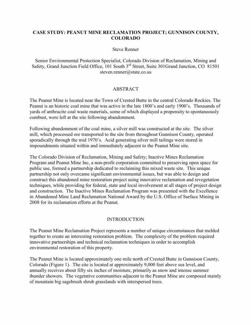
The Peanut Mine is located approximately one mile north of Crested Butte in Gunnison County,
Colorado (Figure 1). The site is located at approximately 9,000 feet above sea level, and
annually receives about fifty six inches of moisture, primarily as snow and intense summer
thunder showers. The vegetative communities adjacent to the Peanut Mine are composed mainly
of mountain big sagebrush shrub grasslands with interspersed trees.
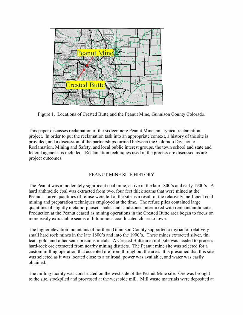
Figure 1. Locations of Crested Butte and the Peanut Mine, Gunnison County Colorado.
This paper discusses reclamation of the sixteen-acre Peanut Mine, an atypical reclamation
project. In order to put the reclamation task into an appropriate context, a history of the site is
provided, and a discussion of the partnerships formed between the Colorado Division of
Reclamation, Mining and Safety, and local public interest groups, the town school and state and
federal agencies is included. Reclamation techniques used in the process are discussed as are
project outcomes.
PEANUT MINE SITE HISTORY
The Peanut was a moderately significant coal mine, active in the late 1800’s and early 1900’s. A
hard anthracitic coal was extracted from two, four feet thick seams that were mined at the
Peanut. Large quantities of refuse were left at the site as a result of the relatively inefficient coal
mining and preparation techniques employed at the time. The refuse piles contained large
quantities of slightly metamorphosed shales and sandstones intermixed with remnant anthracite.
Production at the Peanut ceased as mining operations in the Crested Butte area began to focus on
more easily extractable seams of bituminous coal located closer to town.
The higher elevation mountains of northern Gunnison County supported a myriad of relatively
small hard rock mines in the late 1800’s and into the 1900’s. These mines extracted silver, tin,
lead, gold, and other semi-precious metals. A Crested Butte area mill site was needed to process
hard-rock ore extracted from nearby mining districts. The Peanut mine site was selected for a
custom milling operation that accepted ore from throughout the area. It is presumed that this site
was selected as it was located close to a railroad, power was available, and water was easily
obtained.
The milling facility was constructed on the west side of the Peanut Mine site. Ore was brought
to the site, stockpiled and processed at the west side mill. Mill waste materials were deposited at
Crested Butte
Peanut Mine
the east side of the Peanut Mine. This mill waste was accumulated in both constructed tailings
ponds and in naturally occurring topographic depressions.
Milling operations reportedly occurred on a sporadic basis through the early 1970’s. Milling
operations had completely ceased by the mid 1970’s, and the property fell into disrepair,
primarily being used as a convenient, albeit illicit, junkyard and paint ball facility through the
late 1990’s.
During the 1990’s a trail system was being established through the upper Gunnison valley for
use by hikers and mountain bike riders. A significant portion of the trail system includes the
Lower Loop Trail, which begins at Crested Butte, bisects the Peanut Mine property and extends
further north (Figure 2). As a result, hundreds of walking or bicycling visitors pass through the
Peanut Mine property daily during the summer months. Historically, these visitors have
complained about the yellow stained dirt and the sulfuric smell associated with it.
Figure 2. Aerial View of Sixteen Acre Peanut Mine Site, With Locations of Coal Refuse
Materials and Silver Mill Wastes.
The property languished as an eyesore and an environmental problem along the Lower Loop
Trail due to the acid production and metals mobilization that occurred as a result of the
weathering of the silver mill wastes. The coal waste material on the west side of the Lower Loop
Trail compounded site problems. Additionally the lack of any vegetative cover at the site lead to
erosion of the mine and mill wastes, and resultant sediment deposition in nearby Peanut Lake.
During the summer of 2000, one of the coal refuse piles spontaneously combusted, reportedly
not for the first time. The land owner, an energy company, was notified of the occurrence, and
responded to the site. The Colorado Division of Reclamation, Mining and Safety (the Division)
consulted to the Crested Butte Fire Protection District, providing guidance on how best to advise
the energy company to extinguish the burning refuse pile.
The fire was eventually excavated and extinguished by the land owner. The propensity of the
Peanut coal mine refuse to spontaneously combust elevated the mine to a Priority 1 site by the
Division, as the potential for another combustion event to occur was thought to be high.
Following the fire, the Crested Butte Land Trust (Land Trust), a local non-profit organization
dedicated to preserving open space in the Crested Butte area for public use, began to negotiate
with the land owner to purchase the Peanut Mine property. Simultaneously, the Division began
to develop plans geared toward ameliorating the spontaneous combustion potential of the coal
refuse. Shortly after it acquired the property, the Land Trust and the Division agreed that
reclamation of the entire site was an appropriate course of action to pursue in order to relieve the
coal ignition issues and to eliminate the acid production and metals mobilization problems that
develop at the site. To that end, the Division and the Land Trust began a five-year process to
characterize the site, develop community partnerships, establish funding mechanisms, design a
reclamation plan, and complete reclamation construction.
STATE AND LOCAL COOPERATION
Within a year of the coal refuse fire the Land Trust acquired the property. The Division had
previously communicated to the Land Trust its desire to ameliorate the coal combustion issues at
the site. Both parties were well aware that reclamation of the entire area was more desirable than
reclamation of only the coal related issues. However reclamation of the mixed waste Peanut
Mine site exceeded the mission of the Division, as only the coal mine portion of the site was
eligible for reclamation funding under the Colorado Inactive Mines Reclamation Program. The
easterly portion of the property, which was not eligible for reclamation funding through the
Division, was heavily impacted by the deposition of silver mill tailings and thus needed to be an
integral part of the overall site reclamation plan. Therefore innovative processes needed to be
developed in order that the entire site benefit from the reclamation efforts.
Discussions between The Division and the Land Trust evolved until a conceptual plan addressing
reclamation of all mine wastes as complimentary components of a larger site restoration project
were agreed upon. The Division would design, and manage site reclamation and finance all of
the coal related reclamation tasks, while the Land Trust would finance reclamation of the non-
coal portions of the reclamation plan using a variety of non-traditional sources.
The Crested Butte Land Trust holds many properties for public open space in Gunnison County.
Typically, the properties that the Land Trust purchases are ranches, grazing lands and other
agricultural or undisturbed areas. Adding an abandoned mixed waste mine site to its inventory
of properties was a novel concept for the organization. In order to protect its many land
holdings from liabilities it could incur at the Peanut Mine, the Land Trust created a subsidiary
corporation, Peanut Mine Inc (PMI), to act as sole owner of the Peanut Mine property. In order
to further insulate other properties held by the Land Trust from potential Comprehensive
Environmental Response, Compensation, and Liability Act (CERCLA) liabilities at the Peanut,
PMI applied for and received a Voluntary Clean Up Permit (VCUP) issued by the Colorado
Department of Public Health and the Environment (CDPHE). This permit protects PMI from
CERCLA liabilities, and allowed the organization to apply for both State and Federal grants to
help fund their portion of the Peanut Mine reclamation. A primary component of the VCUP was
the reclamation plan ultimately developed by the Division. The VCUP also contained vegetation
establishment and erosion control performance standards as conditions of permit termination.
Peanut Mine Inc. applied for grants from the Environmental Protection Agency and the Colorado
Department of Public Health and the Environment in order to finance the majority of its
reclamation funding obligation. An EPA Brownfields grant in the amount of $200,000 and a
CDPHE grant in the amount of $70,000 were awarded to PMI. These funds, in addition to a
$50,000 grant from the Gates Foundation, were used to offset the PMI silver mill waste
reclamation financial obligations.
The Division and PMI agreed that for economic and construction management purposes, hiring a
single contractor to accomplish reclamation of the Peanut would be most efficient. However,
both parties had to carefully account for the expenditure of their respective funds during the
reclamation construction process. To that end, it was necessary to create a mechanism through
which a contractor could be paid for accomplishing specific tasks, and yet account for the source
of the funds used to pay for completion of individual components of specific reclamation tasks.
PMI and the Division crafted a Cooperative Agreement and associated cost-by-task based
spreadsheet that provided for distribution of funds from the various grants and sources to the
contractor as certain reclamation tasks or portions of tasks were completed. Pay centers were
established and a project expense / cost center spreadsheet was developed so that billing of
individual line items could be accurately and efficiently assigned to the corresponding
responsible entity. To accommodate this arrangement, the Division established a reclamation
account into which all of the reclamation funds from both parties were deposited.
COMMUNITY PARTNERSHIPS AND SITE EVALUATION
The first steps in planning reclamation of the Peanut Mine site was to gain an understanding of
the environmental impacts of the mixed coal and hard rock waste materials, define the
characteristics of these materials, map existing site conditions and determine the volume of the
various waste materials by type.
Rather than completing reclamation planning in a vacuum, the Division decided that it would
involve the community in the entire reclamation process. To this end, the Division funded a
Reclamation Studies class at the Crested Butte Community School. This high school class
emphasized characterization of highly disturbed areas, and planning for rehabilitation of such a
site. The class used the Peanut Mine as an outdoor classroom, obtaining samples of the various
mine wastes for geochemical analysis, performing water quality sampling, and establishing
vegetation test plots to help design site-specific soil and revegetation suggestions, among other
reclamation related activities.
The Division also enlisted the help of the community when developing the reclamation seed
mixture. Division ecologists developed a conceptual seed mix for the site. Area residents
knowledgeable about local vegetative communities were asked to review the seed mixture and
offer suggestions regarding alternative species, seeding rates and other pertinent aspects of the
plan. As a result of this collaborative effort, the mixture was refined so that local conditions
were best accommodated (Table 1). Further, local volunteers gathered seed from a number of
area specific species to supplement the commercial seed mixture.
In addition to this work, the Division recruited the Office of Surface Mining, Western
Coordinating Center (OSM), to construct a pre-reclamation topographic map of the site using
LIDAR technology. The OSM flew the site and provided the LIDAR generated data to the
Division. This information, field verified by the Division, was used as the basis for topographic
maps that were manipulated to design post-reclamation topography and to ascertain material cut
and fill volumes for bidding purposes.
The Division also conducted geochemical evaluations, geotechnical investigations, water quality
analysis, ground water and surface water evaluations, wetlands delineation and other pertinent
investigations to fully characterize the site. This information provided the basis for development
of a reclamation plan that addressed the entirety of the site so that a holistic approach to site
remediation could be developed.
In order to accommodate various regulatory requirements, two reclamation construction related
permits were necessary before construction could begin. Peanut Mine Inc, as owner of the
property, was the applicant for each permit. Because the Division was designing and supervising
reclamation construction, it acted as the on-site coordinator for each permit.
The U. S. Army Corps of Engineers was consulted early in the reclamation planning process, in
order to ascertain whether any Clean Water Act issues would be presented during site
reclamation. Because the watercourse that conveys the adit drainage would be reconstructed
during reclamation, a Section 404 permit was issued. The permit was later modified to
accommodate dredging and reconstructing a wetlands area contaminated by mill waste products.
The Colorado Department of Public Health and the Environment was contacted to determine the
necessity of obtaining a stormwater discharge permit to accommodate construction and post
reclamation sedimentation issues. At the advice of CDPHE, a stormwater management plan was
developed and a stormwater discharge permit was issued to PMI. The stormwater management
plan was developed in such a manner so that reclamation requirements imposed on the contractor
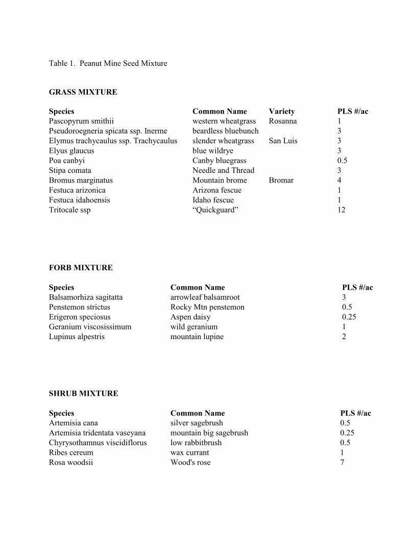
Table 1. Peanut Mine Seed Mixture
GRASS MIXTURE
Species Common Name Variety PLS #/ac
Pascopyrum smithii western wheatgrass Rosanna 1
Pseudoroegneria spicata ssp. Inerme beardless bluebunch 3
Elymus trachycaulus ssp. Trachycaulus slender wheatgrass San Luis 3
Elyus glaucus blue wildrye 3
Poa canbyi Canby bluegrass 0.5
Stipa comata Needle and Thread 3
Bromus marginatus Mountain brome Bromar 4
Festuca arizonica Arizona fescue 1
Festuca idahoensis Idaho fescue 1
Tritocale ssp “Quickguard” 12
FORB MIXTURE
Species Common Name PLS #/ac
Balsamorhiza sagitatta arrowleaf balsamroot 3
Penstemon strictus Rocky Mtn penstemon 0.5
Erigeron speciosus Aspen daisy 0.25
Geranium viscosissimum wild geranium 1
Lupinus alpestris mountain lupine 2
SHRUB MIXTURE
Species Common Name PLS #/ac
Artemisia cana silver sagebrush 0.5
Artemisia tridentata vaseyana mountain big sagebrush 0.25
Chyrysothamnus viscidiflorus low rabbitbrush 0.5
Ribes cereum wax currant 1
Rosa woodsii Wood's rose 7
as part of the construction specifications dovetailed with the requirements of the plan. Therefore,
if construction proceeded as required in the reclamation contract, the site would remain in
compliance with the stormwater permit.
CONCEPTUAL RECLAMATION PLANNING
The reclamation product that the Division and PMI envisioned for the Peanut Mine was a
geomorphically stable landform that included isolation of silver mill wastes and reduction of coal
spontaneous combustion potential, while accommodating eventual use of the area as public open
space for non-motorized recreation. A multifaceted approach to reclamation of the site was
adopted in order to meet the post reclamation site goals:
- Consolidate all waste materials into a disposal facility for the purpose of isolating the
silver mill wastes from the environment and to reduce acid generation potential;
- Dilute and compact the coal wastes in the disposal facility in order to reduce spontaneous
combustion potential;
- Create geomorphically stable landforms at the disposal area and at the former locations of
the coal and silver waste materials;
- Accommodate overland flow of snowmelt and stormwater runoff through creative
placement of channels;
- Encourage wetlands development at specific portions of the site;
- Create a plant growth medium capable of sustaining vegetative growth;
- Establish species capable of replicating the characteristics of adjacent vegetative
communities.
In order to comprehensively address the environmental issues at the site, a reclamation plan was
developed that accommodated the geochemistry of the various materials and the topography of
the site.
Pre-Reclamation Analysis
Geochemical testing of the waste materials when mixed indicated that the coal refuse would
buffer the acid generation potential of the mill wastes. Analysis of the testing results indicated
that mixing the materials at a ratio of two parts silver mill waste to one part coal refuse would
sufficiently buffer the mill waste materials. Analysis of the material volume balances indicated
that using this mixture ratio would allow for a minimum five feet thick compacted coal refuse
cover to be applied over the mixed waste materials. This compacted coal refuse cover would act
as a cap to minimize water infiltration to the mixed wastes while providing a rooting medium for
vegetation.
Geotechnical testing of the mixed materials demonstrated that combining the wastes at the
specified ratio, and compacting them on a one foot vertical interval would provide sufficient
structural strength for a free standing disposal area approaching thirty five feet in height at a
2H:1V or steeper outslope angle.
Evaluation of various physical and topographic characteristics of the site revealed that a canyon
used as a mill waste disposal area would provide adequate capacity for the disposal of the mixed
waste materials. This location allowed the fill to be buttressed on three sides by the canyon
walls, minimized the potential for overland flow to encroach on the disposal area, and provided
an opportunity to design a geomorphically functional fill surface.
Because the Peanut was severely disturbed by past mining and milling operations, virtually no
topsoil or topsoil substitute was available for reclamation purposes. Initial reclamation concepts
envisioned adding organic material to remnant coal refuse and revegetating that material.
However, local housing and commercial construction activity accelerated between 2002 and
2004. A large quantity of fill dirt was generated in the upper Gunnison valley due to excavation
of building sites. The Peanut Mine site was offered as a place to dispose of this relatively clean
fill dirt, and eventually approximately 15,000 cubic yards of fill was stockpiled at the site.
Additionally, the Town of Crested Butte provided approximately 500 cubic yards of EPA
approved bio-solids to the site.
Conceptual Reclamation Plan
The reclamation concept evolved as analysis of the various physical characteristics of the site
was completed. The final reclamation design contemplated construction of a mine- and mill-
waste repository in the horse-shoe shaped canyon located at the southern portion of the Peanut
property. Construction of a waste disposal repository in this location would entail removal of
silver mill tailings from the canyon floor, shaping and compacting the exposed base of the
canyon. An acid-neutralizing underdrain system would be built to form the basement of the
disposal facility. Mill tailings and coal refuse were to be placed at a specified mixture and
compacted to 90% dry density at 15% optimal moisture content. A five to six feet thick cover of
coal refuse, compacted to the same specifications, would be placed over the top of the mixed
materials.
The reclamation concept for the site included components of the following concepts:
- Coal refuse was to be excavated until natural ground was encountered;
- Two feet of native ground surface below the mill tailings was to be excavated;
- Construct channels to accommodate mine adit drainage, snowmelt and stormwater
runoff;
- Use plant materials to aid in channel stabilization and runoff velocity control;
- Establish or re-establish wetlands areas;
- Imported fill distributed at a nominal twelve-inch depth across the site;
- Organic material (certified weed free straw mulch, dry cow manure and bio-solids) to be
incorporated into fill material prior to revegetation;
- Shrub islands to be established in small but distinct areas across the site;
- Grass and forb seed to be hand distributed outside the shrub islands;
- Seedling trees planted in clusters around the site following completion of all other
reclamation operations.
Once completed in draft form, public meetings were held in Crested Butte so that the public had
an opportunity to review the plan, make comments or recommendations and to ask questions.
The meetings also served as a vehicle to educate the public as to what they could expect to occur
at the site during construction, and for the years following completion of the project.
CONSTRUCTION
Reclamation construction was planned to begin during the summer of 2003. A slower than usual
contracting process, and a long delay in processing the EPA Brownfields grant resulted in
construction being delayed until 2004.
During site characterization work, three previously unknown underground petroleum storage
tanks were discovered. Exploratory excavation around the periphery of the tanks suggested that
some amount of leakage had occurred. The Colorado Geologic Survey (CGS), the State
authority in mitigation of underground storage tank contamination, was contacted by the
Division to assess the site and develop a remediation plan. Under CGS supervision, the
underground storage tanks, along with associated stained soils were excavated and removed from
the site in the late summer of 2003.
During the winter of 2003 / 2004, the Division, PMI and the reclamation contractor agreed to
begin construction in early July 2004. In mid-June 2004 the contractor notified the Division that
it was financially unable to conduct the work, was on the verge of filing for bankruptcy
protection and would not begin the project. The second lowest bidder was contacted in an effort
to salvage the summer construction season, but that contractor declined to honor the prices bid
the previous year. As a result, reclamation construction did not begin as planned in 2003.
However, this delay provided the Division with an opportunity to further refine the reclamation
plan, and allowed the Land Trust the chance to secure additional funds to help fund their portion
of the work. The project was again put out to bid in the fall of 2004 in anticipation of 2005
construction.
Equipment arrived on the site in July, 2005. Site preparation included construction of a safety
fence on both sides of the Lower Loop Trail for the length of the project area, placement of silt
fence below the waste disposal area, stripping of soil and vegetation from the canyon side slopes
at the disposal area, removal of tailings from the footprint of the planned disposal area, and
application of magnesium chloride on the Lower Loop between Crested Butte and the project
area for dust control purposes.
In order to prepare the disposal area to receive the mixed wastes, a french drain was constructed
along the westerly margin of the disposal area perpendicular to the ground water flow path in
order to intercept near surface ground water and allow that captured water to drain to a surface
channel built at the southern margin of the area. The drain was constructed so that it gradually
decreased in depth as the ground surface elevation fell, with the base of the drain being relatively
horizontal. Therefore, at its outlet, the elevation of the base of the drain coincided with the
ground surface elevation, allowing for a free draining system.
When removal of the tailings from the footprint of the disposal area was completed, shaping and
compaction of the canyon base was accomplished. The area beneath the tails had supported a
drainage channel prior to tailings deposition. This former drainage channel now formed a groin-
like inflection sloping from north to south through the area. This old drainage footprint was used
to create the primary segment of an underdrain system meant to capture and convey any water
which would percolate through the waste materials once placed in the repository. Five lateral
interceptor drains were built to extend westerly from the central drain to capture drainage from
the western periphery of the disposal area, and deliver this drainage to the central drain, which
daylighted at the southern toe of the disposal facility.
The drainage system trenches were excavated into the graded and compacted base of the disposal
area to one foot below ground surface. Geotextile was placed within the cuts, and crushed
limestone was placed within the geotextile so that the excavations were filled to about one foot
above ground surface elevation. The geotextile was wrapped over the top of the limestone, so
that the rock was completely enclosed by the geotextile.
Following underdrain construction, the base of the disposal area was ready for placement of
limestone base material. Permeable geotextile fabric was placed over the base of the compacted
disposal area, with a six inch lift of crushed limestone placed over it. This limestone layer acts
as a final acid buffer should pockets of undiluted mill wastes within the disposal area come into
contact with percolating water, thus encouraging acidic drainage. A permeable geotextile was
then placed over the limestone lift.
Coal and silver waste materials were then transported to the disposal area as the limestone
placement was completed. Coal Refuse and mill waste materials were trucked to the disposal
area and were mechanically mixed on the pad using a dozer at a ratio of two parts mill waste to
one part coal refuse. The mixed material was pushed out over the pad in one-foot thick lifts.
Compaction and moisture testing of the mixed waste material occurred on a predetermined
schedule. Twenty tests were conducted per foot of elevation gain for each of the first five lifts.
Ten tests per lift were completed at about five feet elevation intervals between lifts five and
twenty two.
In some areas, excavation of the mill waste from the former tailings disposal areas resulted in
creation of large enclosed depressions, varying from six to eight feet in depth. These depressions
were not conducive to the post reclamation land use. In order to create a more functional
landform, coal refuse was placed and compacted into these depressions to create a more
desirable topography and drainage pattern.
The silver mill waste material became increasingly saturated as excavation of the material
deepened. Saturation became so severe that the material oozed water immediately when cut with
a track excavator. While this was not an unexpected condition, it caused some disposal area
stability concerns, due to the plasticity of the material, its apparent lack of strength and the
elevated moisture content. In order to accommodate this situation, coal refuse was added in
sufficient volumes to the wet mill waste in order to stiffen the mixture so that it would not cause
structural problems within the fill. Approximately three to four parts of coal were added to every
part of saturated mill waste to create a material sufficiently dry to compact appropriately.
Additionally, this material was preferentially placed so that it was located no closer than
approximately eighty feet from the face of the disposal area so as to minimize the potential of
near surface slope failure.
Periodically, the contractor was directed to selectively take certain coal materials to use in the
mixing process. It was preferred that specific materials, such as coal clinker, be buried deeper
within the disposal area, as they are a poor growth medium, while fine grained coal refuse
material appeared to be better suited to support vegetation, and thus were more desirable for
placement in the upper reaches of the disposal area.
Following completion of the fifteen foot lift, all of the mill wastes had been mixed and placed in
the disposal area. The Division then re-surveyed the disposal area and the remaining coal refuse
materials to be placed in the fill. The survey revealed that the disposal area contained excess
design volume; that is, the volume of remaining coal refuse materials was insufficient to meet the
design elevations of the disposal area.
One important consideration in the disposal area design parameters was to construct the back
slopes of the disposal area to an elevation equivalent to that of the adjacent canyon margins.
This was an important consideration in order that the volume of run-on water from off-site areas
was minimized, and so that a functional landform in the context of adjacent areas was created
during the reclamation process. In order to accomplish this, given the apparent material
shortage, the outslope angle of the disposal area was relaxed from 3H:1V to 6H:1V beginning at
the sixteen foot lift. Changing the outslope angle allowed the surface elevation of the fill to rise
more rapidly toward the canyon walls so that when completed, the surface of the fill would
match the elevation of the adjacent canyon rims.
Excavation and disposal of all coal refuse and mill wastes was completed by mid-October, 2005.
Approximately 87,000 cubic yards of mine waste material had been excavated and placed in the
disposal area by that time.
Approximately 15,000 cubic yards of clean fill that had been imported to the site was evenly
distributed over final cut and fill land surfaces of the project area. This volume of material
allowed an average placement of one foot of dirt over most of the project area. Because most of
the imported fill was essentially devoid of organic materials, and lacked any soil-like
characteristics, organic materials were incorporated into the fill dirt after it was distributed across
the site.
Project specifications required that two tons of certified weed free straw per acre be distributed
over the sixteen acre project area. Other organics were added to the imported fill, including dry
cow manure at three tons per acre, Biosol Mix (7-2-3) at 1,200 pounds per acre, and
approximately 500 cubic yards of bio-solids.
The straw mulch was hand distributed over the site, while the manure, BioSol and bio-solids
were mixed using the track excavator, placed in a manure spreader, and distributed. A dozer was
used to rip the organic materials into the imported fill at the flatter portions of the area until all
the materials were completely incorporated. Final ripping occurred parallel to contour, so as to
encourage disruption of surface water drainage in order to slow overland flow velocities and
reduce erosion potential.
The organic materials were incorporated into the imported fill distributed over steeper slopes
using a track excavator. To do this, the operator pushed the teeth of the bucket into the dirt to a
depth of about eight to twelve inches, and then curled the bucket toward the machine to create an
upslope depression and down slope mound in the dirt surface. This process occurred so that an
eighteen to twenty four inch separation between gouges was created parallel to contour. The
gouges were constructed in an offset pattern, so that a gouge was constructed immediately above
and below any open space between two horizontal gouges. This created an extremely disrupted
landscape, which severely inhibits overland water flow patterns.
Concurrently with surface roughening, channels were built to convey water across the site. A
site drainage concept to support a diversity of land uses and eco-types was devised. The
drainage plan allowed for water to move through the site at the slowest possible velocities while
providing water to existing wetlands or to areas that were targeted for wetlands development.
Whenever possible, topographic relief was constructed that allowed for dispersed overland flow
of snowmelt without promoting concentrated flow patterns. This also allowed for accumulation
of water in some areas in order to promote a diversity of vegetation throughout the site.
Following surface roughening and incorporation of organic material, shrub island areas were
established. In order to create the shrub islands, approximately three shrub areas per acre were
designated. Only shrub seed was planted in these approximately thirty feet diameter areas.
Following shrub seed distribution, grass and forb seed was planted outside of the shrub island
margins. In addition to the reclamation grasses, a sterile, quick growing wheat – rye cross was
also planted as a cover crop.
When all of the seed had been distributed, two tons per acre of certified weed free straw mulch
was applied to the ground surface. Hand crimping was required in the contract, but rather than
using hand-crimping tools the contractor fitted ski boots with sharpened metal plates constructed
to drive the mulch into the ground. The crew walked the area with the crimping boots, which
served to firmly secure the mulch to the ripped ground surface.
Approximately 1,200 willows were planted at the site. Five hundred of the willows were
containerized, while the remainder of the willows were obtained from cuttings collected on site.
Willows were preferentially planted along the margins of the constructed channels and at
appropriately moist areas throughout the site. Plantings along the channel sides serve to anchor
the channel slopes, and when planted within the channel, serve to reduce flow velocities.
The contractor was required to provide 5,600 seedling trees to the site. Approximately 1,866
trees each of Quaking aspen (Populus tremuloides), Blue Spruce (Picea pungens) and Engelmann
Spruce (Picea engelmannii) were delivered to the site in mid-October, 2005.
In order to keep the public informed of reclamation progress, weekly reclamation tours were
conducted. During construction, a public site tour was conducted each Tuesday evening by
Division or PMI staff. Weekly progress reports were made and questions regarding the
reclamation process or work progress were answered. This simple but effective tool went a long
way toward promoting project benefits, and in educating the public regarding environmental
restoration concepts.
The Division, in conjunction with Peanut Mine Inc and the Crested Butte Land Trust, hosted a
public tree-planting day at the site following completion of all other revegetation activities.
Trees were planted in designated areas that were located so that they complimented the shrub
islands and took advantage of site micro-topography. Seventy five volunteers helped plant
approximately 4,500 trees on October 22, 2005.
RECLAMATION SUCCESS
Reclamation at the Peanut Mine succeeded in accomplishing the two primary technical goals of
the project; isolating acid producing silver mill wastes from the environment to prevent acidic
drainage, and eliminating the potential for coal waste products to spontaneously combust.
A number of subsidiary goals were also achieved during and as a result of the project. A
previously unused, blighted area was reclaimed into a useable public open space. Sediment
transport from the site was eliminated. An aesthetically pleasing and geomorphically stable
landform was created. Enabling the reclamation class at the Community School provided an
opportunity for students to become involved in natural sciences in a practical way, and to utilize
their knowledge to help solve a local problem. The general public was actively involved with
the project, providing the opportunity for them to not only become aware of reclamation
processes, but to assume an ownership in the project.
Vegetatively, reclamation was very successful. Pre-reclamation vegetative ground cover was
estimated to vary from zero to five percent, which was essentially composed of annual weeds
with interspersed perennial grasses and some willows in wetter areas. Prior to reclamation
beginning, reference areas were established at nearby undisturbed areas with similar aspect,
relief and environmental conditions. Following completion of reclamation work, revegetation
sample plots were established at the disposal area in order to measure long term reclamation
success.
Mean live, non-noxious herbaceous and woody vegetation in the reclaimed area was estimated at
47.2% (Table 2) in 2009, while mean cover of live, non-noxious herbaceous vegetation in the
reference area was estimated to be 46.6%. Mean total ground cover was estimated at 78.9%
(Table 2), while mean total ground cover in the reference area was estimated to be 86.7%.
Ten non-noxious perennial grass species met or exceeded 20 percent frequency. The most
prevalent grasses based on frequency of occurrence were mountain brome, Idaho fescue, western
wheatgrass, slender wheatgrass, blue wildrye, Kentucky bluegrass, Thurber’s fescue, subalpine
needlegrass, beardless bluebunch wheatgrass, and common timothy.
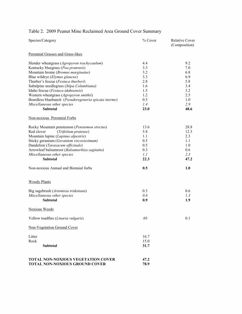
Table 2. 2009 Peanut Mine Reclaimed Area Ground Cover Summary
Species/Category % Cover Relative Cover
(Composition)
Perennial Grasses and Grass-likes
Slender wheatgrass (Agropyron trachycaulum) 4.4 9.2
Kentucky bluegrass (Poa pratensis) 3.3 7.0
Mountain brome (Bromus marginatus) 3.2 6.8
Blue wildrye (Elymus glaucus) 3.3 6.9
Thurber’s fescue (Festuca thurberi) 2.8 5.8
Subalpine needlegrass (Stipa Columbiana) 1.6 3.4
Idaho fescue (Festuca idahoensis) 1.5 3.2
Western wheatgrass (Agropyron smithii) 1.2 2.5
Beardless bluebunch (Pseudoregeneria spicata inerme) 0.5 1.0
Miscellaneous other species 1.4 2.9
Subtotal 23.0 48.6
Non-noxious Perennial Forbs
Rocky Mountain penstemon (Penstemon strictus) 13.6 28.8
Red clover (Trifolium pratense) 5.8 12.3
Mountain lupine (Lupinus alpestris) 1.1 2.3
Sticky geranium (Geranium viscosissimum) 0.5 1.1
Dandelion (Taraxacum officinale) 0.5 1.0
Arrowleaf balsamroot (Balsamorhiza sagitatta) 0.3 0.6
Miscellaneous other species 1.1 2.3
Subtotal 22.3 47.2
Non-noxious Annual and Biennial forbs 0.5 1.0
Woody Plants
Big sagebrush (Artemisia tridentata) 0.3 0.6
Miscellaneous other species 0.6 1.3
Subtotal 0.9 1.9
Noxious Weeds
Yellow toadflax (Linaria vulgaris) .05 0.1
Non-Vegetation Ground Cover
Litter 16.7
Rock 15.0
Subtotal 31.7
TOTAL NON-NOXIOUS VEGETATION COVER 47.2
TOTAL NON-NOXIOUS GROUND COVER 78.9
Ten non-noxious perennial forbs met or exceeded 20% frequency. In order of occurrence, these
species were Rocky Mountain penstemon, sticky geranium, red clover, dandelion, mountain
lupine, arrowleaf balsamroot, a native aster species, an herbaceous native cinquefoil, aspen
daisy, and curly dock.
Big sagebrush frequency was 50%, while two other shrubs (silver sagebrush, wax currant, and
Douglass rabbitbrush) met or exceeded 10% frequency, along with three planted tree species
(blue spruce, Engelmann spruce, and quaking aspen).
Table 3 illustrates some selected shrub island (patch) plant numbers and composition. Within-
patch total shrub count ranged from 51 to 402, averaging 145 shrubs per patch. Within-patch
mountain big sagebrush count ranged from 8 to 278, averaging 66 big sagebrush plants per
patch.
Erosion at the reclaimed area has essentially been eliminated as a result of the reclamation
process. Visual evaluations of the site are conducted on an annual basis. No evidence of rilling
or gullying has been observed at the site.
CONCLUSIONS
The Peanut Mine reclamation project provides many examples of how a dedicated collaborative
process coupled with a variety of reclamation strategies can lead to highly successful results.
The technical difficulties presented by the mixed waste site were solved using sound scientific
principles and careful planning. The materials that, at first blush, appeared to present great
technical difficulties, were eventually found to work in tandem to mitigate site issues. The
landforms created at the cut and disposal areas appear to be extremely stable in terms of
functionality and by supporting a variety of micro ecosystems for long-term vegetative success.
In the case of the Peanut project, the Division had committed to a reclamation planning and
implementation process that provided for the involvement of not only the landowner, but the
entire community. The Division felt that community involvement in the entire process was
extremely important in order to ensure a successful reclamation outcome at the Peanut due to the
proximity of the site to town, because the Lower Loop trail, which bisects the Project Area, is an
important and highly used hiking and biking path, and because community interest in the local
environment is strong. The agency desired to facilitate a community based solution to the
environmental issues presented by the Peanut, rather than compel a solution.
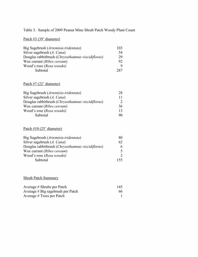
Table 3. Sample of 2009 Peanut Mine Shrub Patch Woody Plant Count
Patch #3 (39’ diameter)
Big Sagebrush (Artemisia tridentata) 103
Silver sagebrush (A. Cana) 54
Douglas rabbitbrush (Chrysothamnus viscidiflorus) 29
Wax currant (Ribes cereum) 92
Wood’s rose (Rosa woodsi) 9
Subtotal 287
Patch #7 (22’ diameter)
Big Sagebrush (Artemisia tridentata) 28
Silver sagebrush (A. Cana) 11
Douglas rabbitbrush (Chrysothamnus viscidiflorus) 2
Wax currant (Ribes cereum) 36
Wood’s rose (Rosa woodsi) 13
Subtotal 90
Patch #10 (25’ diameter)
Big Sagebrush (Artemisia tridentata) 80
Silver sagebrush (A. Cana) 62
Douglas rabbitbrush (Chrysothamnus viscidiflorus) 6
Wax currant (Ribes cereum) 5
Wood’s rose (Rosa woodsi) 2
Subtotal 155
Shrub Patch Summary
Average # Shrubs per Patch 145
Average # Big sagebrush per Patch 66
Average # Trees per Patch 1
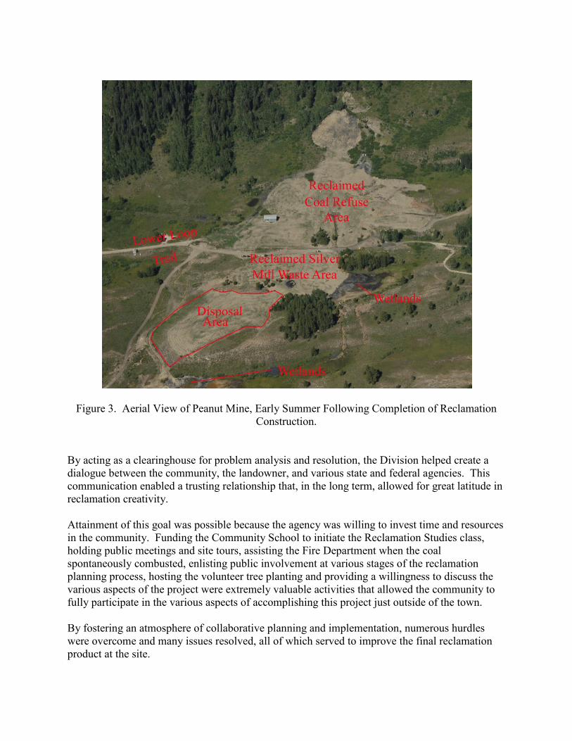
Figure 3. Aerial View of Peanut Mine, Early Summer Following Completion of Reclamation
Construction.
By acting as a clearinghouse for problem analysis and resolution, the Division helped create a
dialogue between the community, the landowner, and various state and federal agencies. This
communication enabled a trusting relationship that, in the long term, allowed for great latitude in
reclamation creativity.
Attainment of this goal was possible because the agency was willing to invest time and resources
in the community. Funding the Community School to initiate the Reclamation Studies class,
holding public meetings and site tours, assisting the Fire Department when the coal
spontaneously combusted, enlisting public involvement at various stages of the reclamation
planning process, hosting the volunteer tree planting and providing a willingness to discuss the
various aspects of the project were extremely valuable activities that allowed the community to
fully participate in the various aspects of accomplishing this project just outside of the town.
By fostering an atmosphere of collaborative planning and implementation, numerous hurdles
were overcome and many issues resolved, all of which served to improve the final reclamation
product at the site.
The Peanut Mine Reclamation Project was awarded the Excellence in Abandoned Mined Land
Reclamation National Award by the U. S. Office of Surface Mining at the 2008 National
Association of Abandoned Mine Land Programs annual conference.
ACKNOWLEDGEMENTS
Daniel Mathews, former Environmental Protection Specialist with the Colorado Division of
Reclamation, Mining and Safety was responsible for developing the seed mixtures used at the
Peanut Mine. Dan also coordinated all vegetation studies and inventories, and reduced and
collated all of the vegetation data.
Jim Starr and John Hess, former members of the Crested Butte Land Trust, were instrumental in
all phases of the project. Without their help and foresight, this project would not have been
possible.