capital club,capital towers, 19thfloor jackson...
TRANSCRIPT

3 5933 0025 7052 2
Petroleum Technology Transfer CouncilEastern Gulf Region
Report on the
Focused Technology Workshop
^'Drilling and Production Units and Well Spacing
Capital Club, Capital Towers, 19th Floor125 South Congress Street
Jackson, MississippiMarch 26,1997
tt
Workshop Sponsored By
The U.S. Department of Energy, National Petroleum Technology Office,Federal Energy Technology Center,
BDM-Oklahoma, Inc.,and
Petroleum Technology Transfer Council
Prepared By
The Eastern Gulf Producer Advisory Groupand
Eastern Gulf Region Lead Organizationof the
Petroleum Technology Transfer Council

FOCUSED TECHNOLOGY WORKSHOP
'̂Drilling and Production Units and Well Spacing**
Introduction
The Fourth Focused Technology Workshop hosted by the Eastern Gulf Region
Producer Advisory Group and Eastern Gulf Region Lead Organization of the Petroleum
Technology Transfer Council was held at the Capital Club, Capital Towers, Jackson,
Mississippi. The title of the workshop was "Drilling and Production Units and Well
Spacing." The workshop was sponsored by the U.S. Department of Energy, National
Petroleum Technology Office, Federal Energy Technology Center, BDM-Oklahoma,
Inc., and Petroleum Technology Transfer Council.
The workshop focused on oil and gas regulatory practices of establishing drilling
and production units and setting well spacing in the Mississippi Interior Salt Basin and
related sub-basins. Presentations were made regarding practices of establishing drilling
and production units and well spacing by the regulatory agencies in the Gulf Coastal
states. A case study at Southwest Excel Field, Monroe County, Alabama was presented
by oil and gas consultants. A panel discussion, which included the state regulators, was
held to review the field case study.
Eastern Gulf Region
The Eastern Gulf Region consists of the states of Mississippi, Alabama and
Florida (MAFLA area). A considerable number of small and medium-sized producers
operate in the region. The MAFLA area has been and will continue to be an important oil
and gas producing area. The discovery of the Amory Field in Mississippi in 1926 initiated
production in the region. Cumulative production from the region is approximately
11 trillion cubic feet of gas and 3 billion barrels of oil. The region is a mature oil and gas
province with over 2,200 established fields. Oil and gas are produced from a host of
DE 19 '97

(*1
m
fm
Paleozoic, Mesozoic and Cenozoic reservoirs in Mississippi, Alabama and Florida. Major
reservoirs include the Jurassic Norphlet, Smackover and Haynesville formations; the
Upper Jurassic-Lower Cretaceous Cotton Valley Group; the Lower Cretaceous Hosston,
Rodessa, and Fredericksburg-Washita units; the Upper Cretaceous Tuscaloosa, Eutaw
and Selma units; and the Tertiary Wilcox and Miocene strata.
Technical Report
P^rpose
The purpose of the workshop was to review the regulatory practices of establishing
drilling and production units and well spacing in the Eastem Gulf Region. The workshop
is part of the national program of the Petroleum Technology Transfer Council to
accelerate the dissemination of oil and gas technology to domestic producing companies.
The workshop was designed to transfer technology and knowledge to producers regarding
certain regulatory practices in the Gulf Coastal states. With this information, it is
anticipated that domestic producers could, with the assistance from regulators, improve
operating efficiency, improve ultimate field recovery, and add to the domestic oil and gas
reserves.
Problem Identification
At the First Problem Identification Workshop held in Jackson, Mississippi, on
August 22, 1995, the producers in the Eastem Gulf Region identified the following areas
as priority for resolution: regulations goveming naturally occurring radioactive materials
(NORM), availability and archiving of basic well data and associated databases,
waterflood and pressure maintenance projects, review of existing regulations and rules,
and operating costs associated with salt water disposal. The NORM issue was addressed
at the First Focused Technology Workshop hosted by the Eastem Gulf Region Producer
Advisory Group and Eastem Gulf Region Lead Organization in Orange Beach, Alabama,
on October 11, 1995. The second workshop, which was held in Tuscaloosa, Alabama, on

r!
(m,
March 26, 1996, focused on the archiving and dissemination of oil and gas information in
the region. The Third Focused Technology Workshop, which was held in Jackson,
Mississippi, on August 13, 1996, concentrated on successful waterflood and pressure
maintenance projects. This fourth workshop focused on certain oil and gas regulatory
practices.
Technologies Addressed at the Workshop
Overview
The workshop was organized into three major sessions. The major sessions
included the following topics: regulatory practices of establishing drilling and production
units and well spacing in the Gulf Coastal states, a case study of Southwest Excel Field,
Monroe County, Alabama, and a panel discussion about the field case study. In addition,
" an overview of the functions and goals of the Petroleum Technology Transfer Council
were reviewed briefly at the start of the workshop. Also, the ongoing process of problem
identification in the region was discussed at the end of the workshop.
rm
Sessions
Harry Spooner, Chair of the Producer Advisory Group for the Eastern Gulf
Region, welcomed the participants to the workshop. He provided an overview of the
functions and goals of the Petroleum Technology Transfer Council. He also updated the
group on the joint proposal prepared by the Mississippi Office of Geology and the
Mississippi Oil and Gas Board to make available oil and gas exploration and production
data to producers in an electronic format. The proposal was prepared in response to the
producers' needs to have access to this type of information.
The first session was entitled "Drilling and Production Units and Well Spacing."
This session included presentations regarding practices of establishing drilling and
production units and well spacing from the oil and gas regulatory agencies in the Gulf
Coastal states. Speakers included Walter Boone (Oil and Gas Supervisor for Mississippi),

m
tm
m
m
David Curry (Administrator, Oil & Gas Section, Florida Geological Survey), Michael
Killeen (Director, Geological Oil & Gas Division, Louisiana Office of Conservation),
David Triana (Engineer, Oil& Gas Division, Permitting Services Section, Texas Raikoad
Commission), and Gary Wilson (Deputy Oil and Gas Supervisor, Alabama State Oil and
Gas Board).
Walter Boone discussed Rule 7 (Spacing of Oil Wells), Rule 8 (Spacing of Gas
Wells) and Rule 9 (Exceptions to Spacing Rules) of the Mississippi State Oil and Gas
Board. He reviewed the size of drilling units for oil wells (40, 80,160 acres) and for gas
wells (160, 320, 640 acres) which are related to subsurface depths. He also discussed the
spacing of oil and gas wells and the distance the well is required to be from other wells
and the exterior boundaries of the drilling unit.
David Curry reviewed Florida statutes on well spacing and drilling units, field
wells, exploratory wells, routine drilling units, horizontal wells and associated drilling
units, and non-routine units and wells. In Florida, drilling units, production units, and
well spacing are ahnost synonymous. There are no production units different from the
original drilling units except where special field or unitization rules were adopted
subsequent to the discovery well. These units may be based on geographical, geological
or other considerations. Most units are geographical quarter sections.
Michael Killeen discussed Louisiana Statewide Order 29-E which addresses well
spacing for oil, gas and field order spacing. Spacing is set for oil and gas wells from
property lines and between wells in the same reservoir zone. He reviewed the formation
of geographic, geologic and reservoirwide units and the unitization procedure. He
discussed the special rules being considered for horizontal wells being drilled in the
Austin Chalk.
David Triana reviewed drilling and production units and well spacing in Texas.
All assignments of acreage for drilling or proration in Texas are- voluntai"y in that an
application for Railroad Commission action must originate with an operator or working

interest owner. Adrilling unit is the minimum acreage (well density) required toreceive a
(-1^ wildcat or field permit to drill. The drilling unit may consist of stand-up acreage, legal
subdivision, pooled unitor density exception. The well location mustmeetwell spacing
^ requirements from the lease line and between wells on the same lease or field. The well
spacing pattern addresses the number and location of wells overa reservoir and includes
spacing, density and diagonal. A proration unit is the acreage assigned to a well for the
^ purpose of allocating production. Unitization and horizontal wells were also discussed.
The hearing process in Texas was reviewed.
^ Gary Wilson discussed Alabama's Rule 400-1-2-.02 (Spacing of Wells). He
reviewed drilling units in southwest Alabama, in the Black Warrior Basin, in the coastal
waters area, and for coalbed methane development. A well is spaced on a unit based on
„ the maximum area which may be efficiently and economically drained by the well. The
spacing for a well to be drilled to a pool in an established field is governed by special
^ field rules for the field. The final spacing for a producing well is determined at the time
the field is established. A wildcat well may be drilled on a unit consisting of a
governmental quarter-quarter section (40 acres) or a governmental quarter section
(160 acres), In southwest Alabama, a wildcat deep gas well may be drilled on a unit
consisting of a governmental section (640 acres). Spacing for offshore wildcat wells can
be on units consisting of 40, 160, 320 or 640 acres. In the Black Warrior Basin, a wildcat
gas well may be drilled on a unit consisting of a governmental half section (320 acres).
Permits for wells to be drilled on non-governmental units may be approved. A well
drilled adjacent to a field (productive extension) is normally in accordance with the
spacing provisions in the special field rules. The unit size may be increased by an amount
not to exceed 30% of the original unit size.
The second session concentrated on a field case study located in a sub-basin
associated with the Mississippi Interior Salt Basin. The case study was Southwest Excel
jm

n
m
m
Field, Monroe County, Alabama. Brian Sims, consultant, and Robert Wood, Tom Joiner
& Associates, made presentations.
Brian Sims reviewed the history of the Frisco City Sandstone play and the regional
^ geology of the area. He discussed the petroleum characteristics of the play. He
emphasized the relationship of reservoir distribution to pre-Jurassic paleotopographic
features and the significance of 3-D seismic in defining prospects. He showed examples
^ of the importance of selecting a well location through the use of 3-D seismic. He also
illustrated why the establishment of drilling and production units should include
^ consideration of 3-D seismic data.
Robert Wood presented the history of development of the Frisco City Sandstone
reservoir at Southwest Excel Field, Monroe County, Alabama, from the original prospect
to the final field configuration. He discussed the events leading up to the drilling of the
wildcat well for the field which was drilled as a seismic prospect over a Paleozoic
basement feature. He reviewed the field development from the drilling of first offset well
to the discovery well to enlargement of the original drilling and production units. The
field presently consists of three drilling and production units. The unit for the Nettles 9-
12 No. 1 well consists of 208 acres. The unit for the Nail 16-3 No. 1 ST well consists of
172 acres, and the unit for the Nail 16-6 No. 1 well consists of 160 acres. The unit
enlargements were approved because the added acreage was in imminent danger of being
drained from the producing wells in Southwest Excel Field.
The third session consisted of a panel discussion on key technical and regulatory
criteria for establishing drilling and production units and well spacing. The panel
included the state oil and gas regulators. The panel was moderated by S. Cragin Knox,
State Geologist for Mississippi. Each state regulator commented on the Southwest Excel
Field case study. Workshop participants then had the opportunity to comment on the case
study and to ask questions of the regulators. The discussion focused primarily on the

m
merits of geologic units as opposed to geographical units and the advantages of
considering 3-D seismicdata in establishing drilling and production units.
Ernest A. Mancini, Eastern Gulf Region Director, reviewed the problem
identification process for the region. He discussed the results of the First Problem
Identification Workshop held on August 22, 1995. He emphasized that problem iden
tification was an ongoing process and that the focused technology workshops were
designed to address the problems identified by the producers. He discussed the process
for selecting the topics for focused technology workshops.
The workshop concluded with a discussion of topics for future focused technology
workshops. Participants agreed the next workshop should focus on computers and their
applications in the oil industry.
Producers' Response to Workshop
General
Overall, the producers' response to the workshop was very favorable. Suggestions
were made for improving the next workshop. These suggestions included: do more one-
on-one contacts to increase small operators participation in the workshop and have more
follow-up with operators after the workshop to assist with the implementation of the
technology.
New Insights
The producers continue to point out that the accessibility of data for the Eastern
Gulf Region is the single most important factor that the Petroleum Technology Transfer
Council can assist them with.

r-1
m
8
Evaluation of the Workshop
Present Workshop
Participants were reminded during the workshop to fill out an evaluation form.
Only two participants returned the evaluation form. The comments were favorable. In
addition, a number of participants provided comments about the workshop during the
panel discussion. Many of the comments related to geologic units and the use of
advanced technologies, such as 3-D seismic data, in establishing drilling and production
units.
Fumre Workshops
p-< For the immediate future, the Focused Technology Workshops will be held in
Jackson, Mississippi. This location appears to be best for the producers in the region.
^ Continued emphasis will be placed on having industry experts with first-hand knowledge
as the principal presenters. Participants decided that the next workshop should focus on
computers and their applications in the oil industry.
Administrative Report
Announcement
The announcement for the Focused Technology Workshop was mailed to over 400
individuals involved with the production of oil and gas in the Eastem Gulf Region. Direct
contacts were made to industry requesting the workshop be announced in newsletters and
at meetings. Members of the Producer Advisory Group were personally contacted.
m
Attendees
There were 41 registered to attend the workshop, including 21 producers and
industry consultants. The remaining participants were from government and professional
and business organizations.

I ! Materials
Materials related to the workshop are attached and the handouts from thej 1
workshop are enclosed.
ni i Financial Report
j*| This report will be mailed ata later date.
m
n
1 'l

n
n
n1
n
n ATTACHMENTS
r
n
n

rm
m
Petroleum Technology Transfer Council
Eastern Gulf RegionFourth Focused Technology Workshop
Sponsored by: Drilling andProduction Units and• Petroleum Technology Transfer Council, WellSpacing
Eastern Gulf Region Capital Club, Capital Towers, 19th Hoor125 South Congress Street
• National Petroleum Technology Office ^. Federal Energy Technology Center Jackson, Mississippi 39201
• BDM - Oklahoma, Inc. (601) 969-7101
The Eastern Gulf Producer Advisory Group and the Eastern GulfRegion of the Petroleum Technology Transfer Council invite oiland gas producing and related companies operating inMississippi, Alabama, and Florida
^ to participate in a Focused Technology Workshop on drilling and productionunits andwell spacing in the Mississippi Interior Salt Basin and related sub-
^ basins. The workshop is designed to examine the technical and regulatorycriteria for establishing drilling andproduction units andin determining well
r» spacing. The workshop will include presentations regarding practices ofestablishing drilling and production units and well spacing from the regula-
M tory agencies in the Gulf Coastal states. A case study will be presented forthe Mississippi Interior Salt Basin and related sub-basins. Apanel discussion
^ focusing on the key technical and regulatory criteria for establishing drillingand production units and well spacing will follow the case study presentation.
^ It isessential that we have anaccurate accounting ofthose who plan toattend and participate in the workshop. Therefore, please complete andreturn the attached registration form (found on other side) to us by March 12,1997.
m
We look forward to your participation.
n

PETROLEUM TECHNOLOGY TRANSFER COUNCIL,EASTERN GULF REGION
announces a
Focused Technology Workshop
Tuesday, March 26,1996at
Tom BevillEnergy, Mineral, and Material ScienceBuildingRoom 101
The University of AlabamaTuscaloosa, Alabama
The Eastern Gulf Producer Advisory Group and the Petroleum Technology Transfer Council invite oil, natural gasand coalbed methane companies operating in Mississippi, Alabama, andFlorida to participate in a Focused TechnologyWorkshop entitled Archiving and Dissemination of Oiland GasInformation, The workshop is to introduce operators totechnical solutions to thehigh priority problems ofexploration, production and regulatory compliance in theEastern GulfRegion. The subject of this workshop is one of the areas identified as priority issues by the industry at the Problem
^ Identification Workshop of August 22, 1995 inJackson, Mississippi. The Focused Technology Workshop is part of thenational program of the Petroleum Technology Transfer Council, designed to accelerate the dissemination of oil andnatural gas technology to domestic producing companies.
This Focused Technology Workshop will address the information needs of the oil and gas producers in the EasternGulf Region. The focus of the workshop will be to make producers aware of available information from state agencies,federal agencies, professional organizations, and the private sector. Producers will also learnhowthese data are archived
f*! and how the information can be accessed and acquired. The workshop will conclude with a discussion on establishing astrategy for improved dissemination and accessibility of oil and gas information.
It is essential that we have an accurate accounting of those who plan to attend and participate in the workshop.Therefore, pleasecomplete and return the attachedregistration form to us by March 22,1996.
We look forward to your participation.
WORKSHOP REGISTRATION FORM
Name:Last First Initial
Preferred Name on Badge:
Affiliation:
Mailing Address:
City: State: Zip: _
Telephone: Fax:
Please complete form and return by mail, Fax, or E-mail transmittal to:
Ernest A. ManciniDepartment of GeologyUniversity of AlabamaBox 870338Tuscaloosa, AL 35487-0338
Telephone: (205) 348-4319 Fax: (205) 348-0818 E-mail: [email protected]
There is no cost to attend any session of tills conference,
n PLEASE RETURN BY MARCH 22,1996

PETROLEUM TECHNOLOGY TRANSFER COUNCIL, EASTERN GULF REGIONFOCUSED TECHNOLOGY WORKSHOP
Archiving and Dissemination of Oiland Gas Information
Tom BevillEnergy, Mineral, andMaterial Science Research Building,Room 101,The University of Alabama, Tuscaloosa, Alabama 35487 ^
(205)348-4319
AGENDA
Tuesday, March 26,1996
• 8:00 - 8:30 a.m. Information Needs of the Producers as Identified at theProblem Identification WorkshopPresentation: Ernest Mancini, Eastem Gulf Region Director
• 8:30 - 10:15 a.m. State Agency Panel onInformation Availability andArchiving
Presentations: Alabama Robert Mink, Geological Survey of Alabama ^David Bolin, Alabama State Oil and Gas Board
Mississippi Cragin Knox, Mississippi Officeof Geology ^Richard Lewis, Mississippi State Oil and Gas Board
Florida Edward Garrett, Florida Geological Survey
• 10:15-10:30 a.m. Break
• 10:30 - 11:30 p.m. Department of Energy and Associated Organizations Panel on InformationAvailabilityand Accessibility
Presentations: Betty Felber, DOELance Cole, BDM-OklahomaDeborah Rowell, PTTC ^John Benton, PTTC
• 11:30 - 12:15 p.m. Professional Organizations Panel on Information Accessibility ^Presentations: Robert Graebner, American Geological Institute
DeLayne Perkins, Interstate Oil and Gas Compact Commission
• 12:15 - 1:30 p.m. Lunch P• 1:30 - 3:00 p.m. Private Sector Panel on Information Availability
Presentations: Richard Tucker, PeU-oleum Information Corporation ^Mike Morgan, Dwights EnergydataThomas Smith, Seismic Micro-Technology
• 3:00 - 3:15 p.m. Break ^• 3:15 - 4:15 p.m. Mike Rosenmayer, Schlumberger
Craig Klein, Neuralog, Inc. ^
• 4:15 - 5:00 p.m. Discussion on Strategyfor Improving Dissemination and Accessibility ofInformation
Discussion Moderators: Harry Spooner, Producer Advisory Group ymDeborah Rowell, PTTCErnest Mancini, University of Alabama
m
tm

n
n
r>^
Petroleum Technology Transfer Council
Eastern Gulf RegionFocused Technology Workshop
Drillingand Production Units and Well SpacingJackson, Mississippi
March 26,1997
INDUSTRY
Les Aultman
111 E. Capitol BIdg., Suite 345Jackson, MS 39201
Brian Sims803 Annandale Rd.Madison, MS 39110
Robert WoodTom Joiner & AssociatesP.O. Box 030710Tuscaloosa, AL 35403-0710
Larty BariaJura-Search, Inc.P.O. Box 997Jackson, MS 39205
Harry SpoonerSpooner Energy, Inc.Deposit Guaranty Plaza, Suite 954Jackson. MS 39201
Dave GatePruet Oil Company217 West Capitol St., Suite 201Jackson MS 39201
Andrew Sylte111 E. Capitol St., Suite345Jackson, MS 39201
Paul A. FergusonTaurus Exploration, Inc.2101 Sixth Ave., NorthBirmingham, AL 35216
Thomas W. SylteKelton Oil CompanyBox 230Pensacola, FL 32591-0230
John D. HerlihyHerlihy Oil & GasP.O. Box 13986Jackson, MS 39236
Robert L. ThomsonLloyd &ThomsonP.O. Box 1847Jackson, MS 39215-1847
Todd Mines
Moon-Hines Oil & Gas125 S. Congress, #1804Jackson, MS 39201
Terry TigrettMoon-Hines-Tigrett Operating Co.1806 Capital TowersJackson, MS 39201
David A. Leach
Nuevo Energy Company111 E. Capitol St., Suite 240Jackson, MS 39201
Ron TisdaleTaurus Exploration, Inc.2101 Sixth Ave., NorthBirmingham, AL 35203
Julius RidgwayRidgway Energy, Inc.P.O. Box 16667Jackson, MS 39236-6667
Roger TownsendSpooner Petroleum Company956 Deposit Guaranty Plaza210 East Capitol St.Jackson, MS 39201
Michael A. RyanHowell Petroleum Corporation1111 Fannin St., Suite 1500Houston, TX 77002
Vaughn Watkins1820 Capitol TowersJackson, MS 39201
Robert Schneeflock
Nuevo Energy Company111 East Capitol St.. Suite 240Jackson, MS 39201
William P. WhiteNuevo Energy Company111 East Capitol St., Suite 240Jackson, MS 39201

GOVERNMENT PROFESSIONAL & BUSINESSORGANIZATIONS
ACADEMIC
Walter BooneMississippi State Oil and Gas Board500 Greymont Ave., Suite EJackson, MS 39202
Clinton A. GrahamMid-Continent Oil and Gas Assoc.210 E. Capitol St., Suite 1156Jackson, MS 39201
Ernest A. ManciniDepartment of GeologyBox 870338University of AlabamaTuscaloosa, AL 35487-0338
Steve Champ!inMississippi Office of GeologyP.O. Box 20307Jackson, MS 39289-1307
Chris W. JonesP.O. Box 23146Deposit Guaranty National BankJackson, MS 39225-3146
David CurtyFlorida Geological Survey903 West Tennessee St.Tallahassee, FL 32304
John Land McDavidMcDavid, Noblin & West PLLC820 Trustmaric BIdg.248 E. Capitol St.Jackson, MS 39201
Nancy JohnsonFossil EnergyU.S. Department of Energy1000 Independence Ave., SWWashington, D.C. 20585
William A. PhilipDeposit Guaranty National BankP.O. Box 1200Jackson, MS 39225-3146
Michael KilleenLouisiana Office of ConservationGeological Oil & Gas DivisionP.O. Box 94275
Baton Rouge, LA 70804-9275
Jerry SheldonGerald & BrandBox 158Jackson, MS 39205
Cragin KnoxMississippi Office of GeologyP.O. Box 20307Jackson, MS 39289-1307
Joe SimsMid-Continent Oil & Gas Assoc.210 E. Capitol St., Suite 1156Jackson, MS 39201-2301
Robert M. Mink
Geological Survey of AlabamaP.O. Box 0Tuscaloosa, AL 35486-9780
Watts UeltscheyBrunini, Grantham, Grower & HewesP.O. Drawer 119Jackson, MS 39205
Jack MoodyMississippi Office of GeologyP.O. Box 20307Jackson, MS 39289-1307
Don OltzGeological Survey of AlabamaP.O. Box OTuscaloosa, AL 35486-9780
Viola Rawn-SchatzingerBDM-OklahomaP.O. Box 2565
Bartlesville, OK 74005
David C. TrianaOil & Gas Division, Permitting SectionTexas Railroad CommissionP.O. Box 12967Austin, TX 78711-2967
Gary WilsonState Oil and Gas Board of AlabamaP.O. Box OTuscaloosa, AL 35486-9780
-
r»
n
n

PETROLEUM TECHNOLOGY TRANSFER COUNCILEASTERN GULF REGION
FOCUSED TECHNOLOGY WORKSHOP
EVALUATION FORM
1. Your Company —
n Company's Address
^ Contact Telephone
( ) Management ( ) Engineer ( ) GeologistYour Position:
( ) Geophysicist ( ) Support ( ) Other
z. What new drilling or production technologies have you employed in your operations within the last two^ years?
3. What emerging technologies are you aware of, and are most interested in, which will help improve theprofitability of your operation?
4. How can we improve the Focused Technology workshop?
5. Do you haveandneedresponse, on othertechnologies outside of those addressed at this meeting?
.. Suggest other possible additional means the PTTC can use to address technology needs.
rm
. General and additional comments:
n

n
PETROLEUM TECHNOLOGY TRANSFER COUNCIL, EASTERN GULF REGIONfourth FOCUSED TECHNOLOGY WORKSHOP
Sponsored By
rm Petroleum Technology Transfer Council, Eastern Gulf RegionU.S. Department of Energy
National Petroleum Technology OfficeFederal Energy Technology Center
^ BDM-Oklahoma, Inc.
Drilling and Production Units and Well Spacing
Capital Club, Capital Towers, 19th Floor125 South Congress Street
Jackson, Mississippi 39201^ (601) 969-7101
PROGRAM
Wednesday, March 26,1997
• 8:30 - 9:00 a.m. WelcomeHarry Spooner, Chair, PTTC, Eastern Gulf Region, I*roducer Advisory Group
Presentations bv Gulf Coastal States
• 9:00 - 9:30 a.m. MississippiWalter Boone, Oil and Gas Supervisor, Mississippi Oil and Gas Board
• 9:30 - 10:00 a.m. FloridaDavid Curry, Administrator, Oil and Gas Section, Florida Geological Survey
fmy *10:00 -10:15 a.m. Break
•10:15 -11:00 a.m. TexasDavid Triana, Engineer, Oil and Gas Division, Permitting Services Section,
m Texas Railroad Commission
• 11:00 - 11:30 a.m. LouisianaMichael Killeen, Director, Geological Oil and Gas Division,
^ Louisiana Office of Conservation
• 11:30 - 12:00 p.m. AlabamaGary Wilson, Deputy Oil and Gas Supervisor, Alabama Oil and Gas Board
^ * 12:00 - 1:00 p.m. Lunch
Case Smdv: Drilling and Production Units and Well Spacing in the Mississippi Interior Salt Basinand Related Sub-Basins
• 1:00 - 2:00 p.m. Presentation: Southwest Excel Field, Monroe County, AlabamaBrian Sims, Consultant
jm, Robert Wood, Tom Joiner & Associates
• 2:00 - 2:45 p.m. Discussion
^ • 2:45 - 3:00 p.m. BreakPanel Discussion: Key Technical and Regulatory Criteria for Establishing Drilling and Production Units
and Well Spacing
rm • 3:00 - 4:00 p.m. Moderator:Cragin Knox, State Geologist, Mississippi Office of Geology
• 4:00 - 4:30 p.m. Future Focused Technology Workshopsm Ernest A. Mancini, University of Alabama

n
PI
rn
r-1
Eastern Gulf Region
Petroleum Technology Transfer Council
Focused Technology Workshop
"Drilling and Production Units and Well Spacing"
Walter Boone,Oil and Gas Supervisor,
Mississippi Oil and Gas Board

r»
RULE 7. Spacing of Oil Wells
1. With respect to each pool occurring in the discovery well, the top of which is encountered below ameasured depth of 12,000 feet below the surface, and in the Pennsylvanian and older formations withrespect to each pool occurring in the discovery well, the top of which is encountered below a measured
^ depth of 3,500 feet below the surface, every oil well:(a) Shall be located on a drilling unit consisting of eighty (80) contiguous surface acres, or two (2)
contiouous govemmental quarter-quarter sections containing not less than seventy-two (72) acres or more^ than eighty-eight (88) acres, upon which no other drilling or producible well is located. The word
'contiguous' as used herein shall mean borderino each other at more than one point:
(b) Anydrilling unit not composed of two (2) governmental quarter-quarter sections must be completelyencompassed by the perimeter of a rectangle 1600 feet by 2725 feet. Provided, however, no unit shall bepermitted which will create Island acreage;
(c) The well shall be located at least 1,000 feet from every other drilling well or well completed in orproducing from the same pool located in conformity with this rule; and
m (d) The well shall be located at least 500 feet from every exterior boundary of the drilling unit.
2. However, with respect to each pool occurring in the discovery well, the top of which is encounteredbelow a measured depth of 12,000 feet below the surface, the State Oil and Gas Supervisor may permit 160acre units for such pools if such unit size will promote and encourage the orderly development of the pool.Every oil well drilled in such pool:
a) Shall be located on a drilling unit of four (4) contiguous quarter-quarter sections containingnot less tlian 144 nor more than 176 acres upon which no other well drilling toorproducing from same poolIs located. The word 'contiouous' as used herein shall mean bordering each other at more than one point.
b) Any drilling unit not composed of four (4) contiguous quarter-quarter sections shall contain160 surface acres which must be completely encompassed by perimeter of a rectangle 2640 feet by 3500feet provided, however, no unit shall be permitted which will create island acreage.
c) Each well shall be located at least 1500 feet from every drilling or producible well from thesame pool and not less than 750 feet from every exterior boundary of the drilling unit.
3. With respect to all other pools, every oil well:(a) Shall be located on a drilling unit consisting of forty (40) contiguous surface acres, or a
governmental quarter-quarter section containing not less than thirty-six (36) acres or more than forty-four(44) acres, upon which no other drilling or producible well is located. The word 'contiguous' as used herein
^ shall mean bordering each other at more than one point.
(b) Any drilling unit not a governmental quarter-quarter section must be completely encompassed bythe perimeter of a rectangle 1810 feet by 1445 feet. Provided, however, no unit shall be permitted which will
<** create island acreage.
(c) The well shall be located at least 660 feet from every other drilling well or well completed in orproducing from the same pool located in conformity with this rule; and
(d) The well shall be located at least 330 feet from every exterior boundary of the unit.
4. No portion of the drilling unit upon which a well is located shall be attributed, in whole or in part, to anyother drilling or producible well in the same pool.
5. if any well drilled In conformity with the provisions of this rule, or as an exception thereto, is completedas a gas well, It shall not be produced except for a test period of not exceeding forty-five (45) days, or incompliance with applicable special field rules, or until authorization has been granted by the Board after

notice and hearing.
RULE 8. Spacing of Gas Wells
1. With respect to each pool occurring in the discovery well, the top of which is encountered below ameasured depth of 12,000 feet below the surface, and in the Pennsylvanian and older formations withrespect to each pool occurring in the discovery well, the top ofwhich is encountered below a measureddepth of 3.500 feet below the surface, every gas well:
(a) Shall be located on a drilling unit consisting of (1) 640 contiguous surface acres; or (2) agovernmental section containing not less than 600 acres or more than 680 acres; or (3) sixteen (16)contiguous governmental quarter-quarter sections whose total acreage is not less than 600 acres or morethan680 acres. In anycase, noother well producing from the same pool shall be located onanysuch unit.The word 'contiguous' as used herein shall mean bordering each other at more than one point.
(b) Any gas drilling unit formed undersection 1(a) ofthisrule must be completely encompassedbytheperimeter ofa rectangle 5580 feet by 6245 feet. Provided, however, no unit shall be permitted which willcreate Island acreage.
(c) The well shall be located at least 3,000 feet from every otherdrilling well or well completed in orproducing from the same pool located in conformity with this rule; and
(d) The well shall be located not less than 1,500 feet from every exterior boundary of the drilling unit.
2. With respect to each pool occurring in the Oligocene and younger Formations, the top of which Isencountered In the discovery well above a measured depth of 5,000 feet below the surface, the State Oiland Gas Supervisor may permit one hundred sixty (160) acre units for such pools if such unit size willpromote and encouragethe orderly development of the pool. Every gas well drilled in such pool:
a) shall be on a drilling unit consisting of (1) one hundred sixty (160) contiguous surfaceacres, or(2) a governmental quarter section containing notlessthan one hundred forty-four (144) acres or more thanone hundred seventy-six (176) acres. In any case, no other well producing from the same pool shall belocated on any such unit. Theword 'contiguous' as used herein shall mean bordering each otherat morethan one point.
b) Any gas driiling unit formed under Section 2(a) of this Rule must be completely encompassedbythe perimeter ofa rectangle 2640 feet &3500 feet. Provided, however, no unit shall be permitted whichwill create island acreage;
c) The well shall be located at leastfifteen hundred (1500) feetfrom every otherdrilling well or wellcompleted In or producing from the same pool located In conformity with this Rule; and
d) The well shall be located not less than seven hundred fifty (750) feet from every exteriorboundary of the drilling unit.
3. With respect to all other pools, every gas well:(a) Shall be located on a drilling unit consisting of (1) 320 contiguous surface acres; or (2) a
governmental half-section containing not less than 300 acres or more than 340 acres; or (3) eight (8)contiguous governmental quarter-quarter sections whosetotal acreage is not less than 300 or more than340 acres. In any case, no other well producing from the same pool shall be located on any such unit.The word 'contiguous' as used herein shall mean bordering each other at more than one point.
(b) Any gas drilling unit formed under section 2(a) ofthis rule must be completely encompassed bytheperimeter of a rectangle 3735 feet by5380 feet. Provided, however, no unit shall be permitted which will
m
n

create island acreage.
m (c) The well shall be located at least 1,980 feet from every other drilling well or well completed in orproducing from the same pool located in conformity with this rule; and
(d) The well shall belocated not less than 990 feet from every exterior boundary of the drilling unit.
4. No portion of thedrilling unit upon which a well islocated shall beattributed, In whole or in part, toanyother well drilling in or producing from the same pool.
n
5. If any well Is completed as a gaswell in the gas cap of a pool productive of oil, or if any well drilledasa gaswell isproductive from orcompleted in anoil pool, it shall not beproduced except for a test period
^ not exceeding forty-five (45) days, orin compliance with applicable special field rules, or until authorizationhas been granted by the Board after notice and hearing.
n

RULE 9. Exceptions to Spacing Rules
The Board may grant an exception to any spacing rule whenever ^the Board shall determine, after notice and hearing, and the factsclearly support the determination, that the unit is partly outside thepool. or. for some other reason, a well so located on the unitwould be non-productive or topographical conditions are such asto make the drilling at such location unduly burdensome.Application for an exception on Form 2 shall be accompanied bya plator sketch drawnto the scale of not smallerthan one (1) inch ^equaling 1000 feet, accurately showing to scale the property onwhich the permit is sought, all other completed, drilling andpermitted wells on this property, and all adjoining sun-oundingproperties and wells. The application shall be verified by someperson acquainted with the facts.
Whenever an exception is granted, the Board shall take suchaction as will offset any advantage which the person securing theexception may have over any other producers by reason of thedrilling of the well as an exception, and so that drainage fromdeveloped units to the tract with respect to which the exception isgranted will be prevented or minimized and the producer of thewell drilled as an exception will be allowed to produce no morethan his just and equitable share of the oil and gas in the pool. Ifthe drilling unit Is of less acreage than that prescribed by theapplicable spacing rule as a regular drilling unit, such special unitshall be allowed to produce only in the proportion that the acreagecontent of such special unit bears to the acreage content of theregular prescribed unit.
(*1
n
143|«B|
n

EASTERN GULF REGIONPETROLEUM TECHNOLOGY TRANSFER COUNCIL
^ FOCUSED TECHNOLOGY WORKSHOPJACKSON/ MISSISSIPPI
MARCH 26, 1997
MISSISSIPPI WELL SPACING
MISSISSIPPI OIL AND GAS BOARDWalter Boone, Oil and Gas Supervisor
im
Declaration of Policy-
Statute 53-1-1
Well Spacing and Unit Formation
1^ ADMINISTRATIVE REQUIREMENTS
Statewide Rule 7 - Oil WellsStatewide Rule 8 - Gas WellsSpecial Field Rules - Adopted by Board Order, after
notice and hearing
n
BOARD ORDER PERMITS
Exceptions to statewide and special field rules approved,f-i after notice and hearing.
Horizonal Wells and Units
^ Unitization of Oil and Gas Fields and Pools
UNITIZATION REQUIREMENTS

fHV
(-1
Eastern Gulf Region
Petroleum Technology Transfer Council
Focused Technology Workshop
"Drilling and Production Units and Well Spacing"
David Curry,Administrator, Oil & Gas Section,
Florida Geological Survey

m-
fpfi
(*1
pn
PETROLEUM TECHNOLOGY TRANSFER COUNCIL - EASTERN GULF REGION
FOCUSED TECHNOLOGY WORKSHOP
JACKSON, MISSISSIPPIMARCH 26,1997
FLORIDA WELL SPACING AND DRILLING UNITS
FLORIDA GEOLOGICAL SURVEY
David Curry, Oil and Gas Section
I. Legal References
1. Chapter 377, Part 1, Florida Statutes
2, Chapters 620-25 through 30, Florida Administrative Code
Ch. 620-25, General RegulationsOh. 620-26, PermittingOh. 620-27, DrillingOh. 620-28, Production & Flowlines
PI Oh. 620-29, Injection Wells, Workovers, & AbandonmentsOh. 620-30, Wetlands & Submerged Lands
IT. Well Spacing & Drilling Units
" 1. 620-26.004(1): Field Wells2. 620-26.004(2): Exploratory Wells3. 620-26.004(3): Drilling Units
" 4. 620-26.004(4): Well Locations Within DrilUng Units5. 620-26.004(5): Horizontal Wells & Associated Drilling Units6. 620-26.004(6): Nonroutine Drilling Units & Wells
in. Field Wells: Spaced in accordance with general spacing rules unless special field spacingrules have been adopted.
IV. Exploratory Wells: Spaced in accordance with depth as follows -
< 7,000 feet: 40 acre unit; well no closer than 460 ft. to drillingunit boundary.> 7,000 feet: 160 acre unit; " 920 "
Gas Wells: 640 acre units; " 1320

Focused Technology WorkshopMarch 26,1997Page 2 of2
V. Routine Drilling Units: Based on Township / Range Grid System & using existingSections, 1/4 and 1/4 1/4 Sections as drilling units.
VI. Horizontal Wells & Associated DrillingUnits: Units for horizontal wells include all 10acre blockswithin 920 feet ofthe productive section ofthe well. Wells penetrating thecentralportion ofa routineunit include the entireunit. Subsequent field unitization isrequired
Vn. Nonroutine Units & Wells: Individual units created to solve problems unique to particularwells. ^
1. Adopted whennecessary to protect correlative rights or to preventwaste.2. Supporting data required. ^2. All substantially affected parties contacted; hearing usually required.4. Public input accepted, decision taken, notice ofdecision provided to all parties. ^5. Decision final after 21 daysnoticeunless a legal appeal is filed.
NOTES:
In Florida, drilling units, production units, and well spacing are almost synonymous.There are no production units different fi*om the original drilling units except where special fieldor unitization rules were adopted subsequent to the discovery well. These units may be based ongeographical, geological, or other considerations. Historically, most units have been geographical1/4sections but with the advent of horizontal drilling, geologically based units are becoming morecommon. The process used to create nonroutine drilling or production units is the same processused to consider requests for special field rules, field unitizations, rule waivers, etc. The applicantrequests authorization to deviate firom standard procedure and provides whatever supportingdocumentation he/she thinks necessary. The Department looks at the request and usually,although not always, schedules a hearing to allow input fi*om affected parties (in the case ofunitization, the unit agreement must be ratified by at least 75% of the working interest).Subsequent to the hearing, the Department will review all information provided, take a decision,issue a Final Order, and provide legal notice to all substantially affected parties. TheFinal Orderbecomeseffective 21 days after issueunless a legalchallenge is filed withinthat time.
A copy ofRule 62C-26.004, Well Spacing andDrilling Units, is attached.
/dc
attachmentsa;/pttc-tlk.397
n
n
62C-26.004 Well Spacing and Drilling Units.
(1) Field Wells. Wells drilled inexisting fields shall be spaced inaccordance with the special field rulesadopted as orders by the Department.Where no such orders exist, generalspacing rules 62C-26.004(2) through (5)shall apply.
(2) Exploratory Wells. Exploratory oilwells drilled to a depth ofless than 7000feet shall be located on 40 acre units;exploratory oil wells drilled to a depthgreater than 7000 feet shallbe located on160 acre units. All gas test wells,regardless ofdepth, shall be located on640 acre units.
(3) Drilling Units. Routine drillingunits shall be based on the U.S.
Government Surveyed Township andRange system. This system will beutilized to space wells as specified in62C-26.004(4).
(a) One Well Limit. No drillingunitshall contain more than one currentlyproducing well in the same pool or beattributed in whole or in part to any otherproducingwell in the samereservoirexcept where provided for by specialfield rules or by 62C-26.004(5).
(b) Routine Units. All routinedrilling units shall be shaped so that alldiagonals lie wholly within the unit withthe length ofthe longest diagonal notexceeding 125% ofthe length of adiagonal ofa square containing thesamenumber ofacres as the unit. All
other drilling units shall be created inaccordance with 62C-26.004(5).
(4) Well Locations within DrillingUnits: Surface locations shall be
determined by surface conditions and
shallbe located where they cause theleast surface disturbance and do not
result in drainage or other environmentalproblems.
(a) Oil Well Bhl. Routine oil testwells drilled to a depth of less than 7000feet shall have a bottom hole location nocloser than 460 feet to the nearest drillingunit boundary; oil test wells drilled tomore than 7000 feet shall have a bottom
hole location no closer than 920 feet tothe nearest drilling unit boundary.
(b) Gas Well Bhl. Routine gas testwells or gas condensatewells shall havea bottom hole location no closer than
1320 feet to the nearest drilling unitboundary.
(c) Wandering Bhl. Should thebottom hole location ofany producingwell not meet the spacing requirements in62C-26.004 and where such location was
not approved as a condition ofthedrilling permit, the well shallbeconsidered a nonroutine location as
defined in 62C-26.004(5) and theoperator shall apply for a nonroutinelocation as outlined therein. No such well
shall be produced, except for testing,prior to meetingthe criteriadefined in62C-26.004(5).
(5) Horizontal Wells and AssociatedDrilling Units (Wells Deeper Than7,000 Feet).
(a) Nearest Well. No producingsection ofany well may be closer than1840 feet to another productive well.

62C-26.004(5) Well Spacing (Cont'd)
(b) Unit Construction. All ten acreblocks, each being one-sixteenth ofaroutine 160 acre drillingunit, whosenearest boundary is within 920 feet of theproductive section ofa horizontal wellshall be included in the unit. Horizontal
wells with productive sectionspenetrating the 400 foot square in thecenter of a routine drillmg unit shallinclude the entire 160 acre unit.
(c) Unitization. Productivehorizontal wells shall be unitized as soon
as possible after testing is completed.
(d) Well Numbers. Horizontal wellsshall be numbered according to thequarter section of the entrance to theproducing formation.
(e) Survey. A Directional Surveyshall be run from the surface casing shoeto total depth and shall be filed with theAdministrator within 30 days afterlogging.
(i) Non-Routine Units. The specialrequirements for non-routine drillingunits and wells shall apply to horizontalwells.
(6) Nonroutine Drilling Units andWells. The Department may grantdrilling permits within shorter distancesto adjacent drilling unit boundaries or ondifferent drilling units than thoseprescribed in this rule whenever theDepartment determines that such stepsare necessary to protect correlative rightsor to prevent waste.
(a) Applications. Applicantsseeking permits for nonroutine wells ordrilling units must include in theapplication the names and addresses of
all substantially affected parties(offsetting mineral-interestowners,operators, and lessees).
(b) Necessity. The Department shalldetermine whether the nonroutine well or
unit is necessary to prevent waste asdefined in Section 377.19(10), FloridaStatutes, or to protect correlative rights,and shall grant, deny or condition thepermit on that basis.
(c) Agency Notices. TheDepartment shall advise all substantiallyaffected parties, whose names andaddresses appear on the application orwho have so requested in writing to theDepartment, of its proposed final agencyaction. Such notice shall be given to theaffected parties no later than 28 daysprior to final agency action by theDepartment.
(d) Additional Data. In addition tothe documents required for a routineapplication, the applicant shall submit aletter explicitly stating what action theapplicant wishes the Department to takeand why. Supporting material shallinclude any studies, data, cross sections,maps, plats, or other available documentswhich support or explain the request. Allinterpreted geologic data shall be signedby a geologist licensed under Chapter492, Florida Statutes.
SpecificAuthority377.20,377.22 FS.Law Implemented 377.25,377.26,377.27 FS. History-New11-26-81, Formerly 160-26.04, Amended 6-4-89, 5-12-93,Formerly 16C-26.004, Amended3-24-96.
FW»
I—I
n

1^
tf
f-ft
Eastern Gulf Region
Petroleum Technology Transfer Council
Focused Technology Workshop
Drilling and Production Units and Well Spacing"
Michael Killeen,Director, Geological Oil & Gas Division,
Louisiana Office of Conservation

J—I
Eastern Gulf RegionPetroleum Technology Transfer Council
r-t Workshop on Drilling and Production Units and Well SpacingMarch 26,1997
(-1
Michael Killeen, Director, Geological Oil and Gas DivisionLouisiana Office of Conservation
Office of Conservation Organization
Commissioner of Conservation Regulatory Authority
Title 30 ofthe Louisiana Revised Statutes of 1950
Well Spacing (Statewide Order 29-E)
OIL - 330 feet from property lines and 900 feet between wellscompleted in the same sand/zone
GAS - 330 feet from property lines and 2000 feet between wells in same sand/zone
Field Order Spacing may vary from 29-E spacing
n Formation ofUnits
Definition of a UNIT
Unitization Procedure
Pre-Application Notice" Pre-Application Conference
Unit ApplicationLegal Notice, Posting and Publication ofNotice
" Public HearingStaflfReview
Conunissioner's Order
Geographic Units
rnGeologic Units
— Reservoirwide Units (Act 441)

Page Two
Austin Chalk Horizontal Wells
Special Rules being Considered
Austin Chalk Spacing
Projects with Central Gulf PTTC
Conservation Rules & Regulations available from Central GulfPTTC on CD or Disk
Louisiana Desktop Well Reference CD
n

I«^
STATE OF LOUISIANADEPARTMENT OF CONSERVATION
BATON ROUGP:, LOUISIANA
July 15. 1957.
STATEWIDE ORDER NO. 29-Em
Order establishing rules for spacing ofwells drilled in search of oil and gas inareas of Louisiana for which no spacing
^ regulations have been prescribed by Special Orders.
After considering the desirability of establishing Statewide Rules andRegulations for the drilling of wells in Louisiana in search of oil or gas inareas in which no spacing rules are established by Special Orders, and after
m public hearing on that subject held In New Orleans, Louisia^, on October 10.1955, under Docket No. 55-167 pursuant to proper legal notice:
IT IS ORDERED THAT no permits shall be issued for the drilling offMi wells in search of oil or gas and no well shall be drilled in searchofoil or
gas in areas of Louisiana in which no spacing rules are prescribedby SpecialOrders, unless the location of such well shall comply with the following requirements:
^ (1) No spacing shall be required for wells drilledin search of oil to depths less than 3, 000 feetsubsea, except as provided for in the last para-
^ ' graph of this order.
(2) Wells drilled in search of OIL to depths below3, 000 feet subsea shall not be located closerthan 330 feet from any property line nor closerthan 900 feet from any other well completed in,drilling to, or for which a permit shall have beengranted to drill to, the same pool.
(3) Wells drilled in search of GAS shall not be located closer than 330 feet to any property linenor closer theui 2, 000 feet to any other wellcompleted in, drilling to, or for which a permitshall have been granted to drill to, the same pool.
(4) When an order has been issued creating a patternof drilling or developmental units for a pool, if
^ application is made for a permit to drill a welloutside of the unit pattern which might develop anextension of the pool, the Commissioner may re»quire that such well be located and drilled in
^ compliance with the provisions of orders affecting that pool.
{5) All applications for permits to drill in search ofoil or gas shall contain with such application acommercial ownership map containing such information that is in the possession of the applicantshowing (1) the location of existing producing ordrilling wells, (2) the lease and property owner-
« ship of tracts offsetting or in the vicinity of thewell for which the permit is sought, and (3) thelocation of the proposed well with respect to property and lease lines, as provided for in State-
« wide Order No. 29-B.

s'i-y\ rr: of Louisiana ^DEPARTMENT OF CONSERVATION
BATON ROUr.E, LOUISIANA
September 5. 1957
AMENDMENT TO STATE VVIDC ORDER NO. Z9-E
Pursuant to power deiegatci vmder the laws of the State of Liouisiana,and particularly Title 30 oi Louisiana Revised Statutes of 1950. and based upona hearing held vmder Docket No. 55-167 in New Orleans. Louisiana, October 10,1955, it is ordered that Statewide Order No. 29-E be and it is hereby amended ^as follows:
1. In lieu of the opening paragraph of Order No. 29-E,the following shall b«; substituted:
IT IS ORDERED THAT no permits shallbe issued for t'-e drilling oi wells in searchof oil or gfis auc no well shall be drilled insearch ot oil or gas nor shall a well beabandoned in one pool and recompleted inanother pool in a field in Louisiana in whichno spacing rules are prescribed by specialorders. unJess the location of such wellshall comply with the following requirements:
2. .Subparagraph (4) un the second sheet of said order shallbe renumbered (S) and th«'re shall be included among the excep- '***'tions on Page Id of said order ihc ii-llowing subparagra^^h (4):
(4) Whore a pernrii ib requested for a wildcat well to be drilled in an area in which thesurface or mineral ownership is so dividedtliat the well cannot be located in compliancewith the requirements of this Order and adrilling unit cannot be formed in advance ofdrilling because it is not known whether thewell will be completed as an oil well or agas well, a permit may nevertlieless begranted tor the drilling of the well when theapplicant presents evidence satisfactory tothe Commissioner that the applicant hasavailable for assignment to said well leasesor acreage of area and size to constitute, inthe judgment of the Ctimmissioner, a reason- I 'able producing imit for such well and suchappii- njit aj;r' es to crertte or to apply to theCominissiuner for creation of a reasonable p?|producing unit within a reasonable time aftercompletion of the well.
This Amendment shall be effective from cUid after Septeniber 1, 1957, _
DEPARTMENT OF CONSERVATIONOF THE STATE OF LOUISIANA
BY: (Sgd) John B. HusseyJOHNB. HU55E7
COMMISSIONER OF CONSERVATION

^-1
STATEWIDE ORDER NO. 29-E {Continued) ^
"Property Line" as used herein jhall mean the boundary dividing tractson \vhich mineral rights, royalty, or leases are separately owned, except thatwhere conventional units shall have beei; created for the drilling of the well,the boundairies of the unit shall be considered the "property line".
Exceptions to the above shall be granted when, conforming to the following requirements:
« (1) Where prior to the issucuice of this order,a pool has already been partially developedwith a greater density of wells than that prescribed herein, the Commissioner of Conserva-
tm tion may. without additional public hearing,exempt such pools from the provisions of thisorder. The exemptions for these pools shallbe granted only after application has been madeto the Commissioner of Conservation in writingaccompanied by a map delineating the locationof all existing wells completed and producingfrom the poo^ for which exception is being asked.
(2) Where prior to the issuance of this order a wellhas previously been completed at a location offsetting the property or unit line closer to theproperty or unit line thsm the setback prescribedherein, the Commissioner may, without additionalpublic hearing permit like exception for this offsetting well, such exception to be limited to thepool from which the offsetting well is producing.
(3) The Commissioner may, without additional publichearing exempt from this order wells drilled inareas which ho t:onsi<lors to be affected by pierce-
^ ment type salt domes or other complexly faultedareas to which, in the opinion of the Commissioner.this order would not be properly applicable. Theserequests for exceptions shall also be made in writ-
*** ing to the Commissioner of Conservation accompanied by sufficient evidence to justify the exemptclassification.
(4) In addition to the exceptions provided for in Paragraphs 1, 2 and 3 hereof, the Commissioner may,without additional pubJic hearing, grant an exception to the provisions of this order in any case
fpii where the granting of such an exception appearsto be necessary to pruvent waste, to prevent inequity or loss of property rights. Such an exception shall be considered and granted under this
^ Paragraph only when the applicant shall have furnished the following data and evidence through theDistrict Manager.
^ (a) A letter setting forth all pertinentfacts and reasons why the grantingof the exception is necessary.
(b) A formal application for permitto drill - Form MD - 10 - R.
(c) An ownership map as required bythe provisions of Paragraph 5hereof.
m

m.
STATEWIDE ORDER NO. 29-E (Continued) Page 3
(d) A written certificate that copiesof the letter request provided forin subparagraph (a) hereof and ofthe ownership map have been sentto each lease owner of tract off- ^setting or in the vicinity of the proposed well.
If within ten (10) days after the filing of the application ^no protest shall have been made in writing by any party andif the Commissioner considers that from the evidence submitted the requested permit should be granted, he may issueit forthwith and without a public hearing. If a written protest i»ishould be filed within the ten (10) day period, the Commissioner may in his discretion either (1) issue or deny the permitbased on the available evidence or (2) call a public hearingafter legal notice. If the permit application is denied withouta public hearing, the applicant then may apply for and obtaina public hearing in the manner provided by law.
When the pools covered by this order have had four (4) wells drilled toand completed therein or after one (l) year has elapsed from the completion ofthe first well in the field, whichever occurs first, the operator of wells in thefield shall petition the Commissioner of Conservation for a public hearing forthe purposes of establishing field rules and regulations and the creation ofdrilling imits for the pools in the field. The right is reserved, however, to anyparty in interest to apply for a hearing at an earlier date; and if the Commissioner fmds from an examination of tlie information furnished in connection withany application for a drilling permit that an earlier hearing should be held toestablish rules and drilling units, the Commissioner may impose a condition inthe drilling permit that such an application be filed within a reasonable time, tobe specified by the Commissioner, after the successful completion of the wellin the horizon to which it is projected.
This order is intended only to regulate the spacing of wells prior to theestablishment of special rules and regulations and the creation of drilling units,and it should not be construed as having the effect of unitizing separate ownerships or of creating drilling or spacing units.
This order also is not intended to eliminate pools shallower thsin 3, 000feet trom appropriate rules and regulations, including spacing regulations afternoticepublic hearing. After sufficient geological and engineering evidenceis available with respect to these pools found at depths of 3. 000 feet or less sub-sea t^en the operator or operators owning wells therein are required to petitionthe Commissioner of Conservation for a public hearing for the purpose of establishing rules and regulations and the creation of drilling units for each such pool.
This Order shall be effective from and after August 1, 1957.
DEPARTMENT OF CONSERVATIONOF THE STATE OF LOUISIANA
BY: (Sgd) JohnB. HussevJOHNB. HUSSE7
COMMISSIONER OF CONSERVATION
m
<*1

rn
Eastern Gulf Region
Petroleum Technology Transfer Council
Focused Technology Workshop
"Drilling and Production Units and Well Spacing"
David Triana,Engineer, Oil and Gas Division,
Texas Railroad Commission

n
EGR - PTTC Focused Technology Workshop
"Drilling and Production Units and Well Spacing"
Texas
All assignments of acreage for drilling or proration in Texas arevoluntary in thatan application forCommission action must originatewith an operatoror working interest owner.
Drilling Unit: minimum acreage (well density) required to receive a Wildcator Field "Permit to Drill"
--May consist of: "Stand-up acreage"Legal Subdivision (W-1A)Pooled Unit (Voluntary; P-12)Density Exception (SWR-38)
• waste prevention• correlative rights (drainage)
-Well location on Drilling Unit must meet well spacing:
Lease-line spacingBetween well spacing (same lease/field)
-Well Spacing Pattem - The regulation ofthe number and locationofwells over areservoir as a conservation measure.
-Two sources: Statewide Rules (SWR 37 & 38)
Field Rules - Application/Hearings Process
Proration Unit:Acreage assigned to a well for the purpose ofallocating production. Statement ofProductivity required (P-15).
-Types: "Stand-up"
Substandard:
-Legal Subdivision-Density Exception

m
Pooled Unit:
-Administrative (P-12)-MIPA - "Forced" Pooling
f-i
Well Spacing Pattem: (Spacing, Density,Diagonal)
-Statewide Rules (467' x 1200' on 40 ac.)
-Commission Standards (1x2)
Unitization:
n -not pooling
-operation in commonfor Enhanced Recovery purposes
-in conjunctionwith: Enity for Density
m
Horizontal Wells:
im
-first recognized permit in 1989
^ -drilled to date: 5,587 (1/84 - 1\97)
-completed to date: 4,618 (1/84 - 1/97)
-permitting as directionaldrill (SL,PP, BHL)
m -acreage assignments:
-SWR86
^ -Special Field Rules
Hearing Process:
-Governed by TX Admin. Procedures ACT (TAPA)
-Notice and Opportunity for Hearing (NOA)
-21-day notice required
-administrative grant ifno protest

n
n
m
n
-Notice and Hearing (NAH)
-10-day minimum notice requiredprior to hearing
-Action within 90 days ofhearing ifno protest
-Protestedhearingprocess requires 90-120 days minimum
-Notice
-Hearing
-Proposal for Decision circulated
-Exceptions/Replies
-Presentation ofPFD for Decision
-Motion for Rehearing
-Rehearing or
-Order Finaled

n
n
n
Discussions of Law,
Practice and Procedure
RAILROAD COMMISSIONOF TEXAS
Published by
Oil and Gas Division

f-1
n
m
Part I
Railroad Commission Field Rules
A. Introduction
The Cotnmission adopts or amends field rules to prevent wasteand to protect the correlative rights of owners of interestswithin the field. In the absence of field rules so adopted,statewide rules apply. Applications ror rield^ rules or fieldrule amendments are made in letter form, referring to the rieldin question and briefly listing the particular rules requested.The Commission staff schedules a hearing date and issues notice.The notice of hearing specifically states that the Commission mayenter such rules as it deems justified. The Commission may enterrules requested by the applicant or by a party to the hearingother than the applicant, or may enter Commission-proposed rulessupported by the evidence.
The Railroad Commission notifies interested parties of fieldrule hearings. In a temporary field rule hearing, the Commissiondetermines the identity of interested parties based on the leasetract of the discovery well for the new field. The Commissionnotifies all operators offsetting the lease tract of the^discov-ery well, and any owners of mineral interests on lands offsettingthe drillsite lease. If at the time temporary field rules arerequested, a s.econd operator has completed a well in the field,that operator is given notice. When a hearing is held to consider the establishment of permanent field rules, all operatorswith wells in the field are notified.
A request for field rules is normally made by an operatorwith a well or wells in the lield. On and Gas Docket No.7B-77,425 involved an application for field rules by a workinginterest owner who was not the operator designated to the Commission for any well in the field. In that case, the interests ofthe operating interest owner were determined to be sufficientlydistinct from those of the designated operator to merit standingfor the working interest owner.
Generally the Commission will permit applications i.or fieldrules only by operators in the field. Exceptions may be madewhere a non-operator requires tield ruies in order to pursue anapplication under the Mineral Interest Pooling Act (MIPA), orwhere the Commission determines that the interests of the applicant and the operator are sufficient distinct.
Basic field rules normally address spacing and density.Rules providing for net gas-oil ratio, pressure surveys, ^testingsurve'^'s, and multiple unit associated gas well allowables mayalso be considered for adoption.
B. Documentary Evidence
Documentary evidence submitted in Rai_road Commission fiela

rule hearings normally includes an area map prepared by or underthe supervision of an engineer or geologist. A certified surveyor's map is not usually required. The area map should specifythe scale, show the North direction, and locate and label allwells within the field. The map should show where existing wellsare located in relation to leases and the estimated field limits.Section and survey boundaries should be accurate. Weil information should include name, number, depth, and date of completion.The exam.iner would expect an area map which includes the entirefield area and surrounding fields within two to five miles of thesubject field. Each field should be identified on the map.Testimony concerning the area map should relate the field geologyto the area geology. Submission of a log of a typical well inthe field is generally necessary. A typical well log wouldinclude all zones of interest, would often be taken from thedeepest well in the field to show faulting and other geologicinformation below the subject zone, and would be a log wherefaulting or lenticularity, if any exists in the field, appear.The log submitted should be of a nype that would best identifythe zones being studied. The nearest producible horizon isimportant because comparisons may be drawn concerning whether thesame or different field rules are applicable. An inductionelectrical log is usually submitted.
For gas fields, a copy of the initial potential test for thediscovery well on Railroad Commission Form G-1 is generallyrelevant to show the initial bottom hole pressure in the field.The four-point test is used to estimate the well's deliverability(flow rate) at a given draw-down. For oil fields, a RailroadCommission Form W-2 should be submitted for all wells in thefield to show potential, gas-oil ratio, water production andinitial flowing pressure.
A completed Reservoir Data Sheet (see Appendix "A" to thissection) should be submitted at field rule hearings. A production curve and a monthly production tabulation for the fieldshould also be submitted.
\^ere limited data are available because the field is in itsearly stages of development, a list of nearby established fieldsin the same formation, along with the Railroad Commission fieldrules for those fields, should be submitted as an exhibit.
In unprotesued hearings, a stenographic transcript is uakenand kept for record, but is generally not transcribed. Therefore, it is helpful to the examiner for an applicant to submit asan exhibit a written statement of the reasons the proposed rulesare appropriate and necessary in this area.
C. Temporary Field Rules
Statewide Rule 43 (16 TAC § 3.43) permits applications fortemporary field rules after the first well in a field has beencompleted. The purpose of permitting field rule applicationsbased on limited well data is to encoura.se develoDment to delin-

n
eate more rapidly che limits of the reservoir and to prevent thewasteful clustering of wells near the discovery well. The temporary field rules are effective for a stated time period, general-
n ly 18 months. The effective period set by the Commission variesdepending on the time expected to be needed to attain sufficientwell data to support more precise field rules.
Prior to the expiration of the rules, the Commission schedules a hearing to review the temporary rules. If no one appearsand presents evidence to justify continuation of the temporary
^ rules or adoption of new rules, the temporary rules may be cancelled. When temporary field rules are cancelled, the field isgoverned by statewide rules. When evidence is submitted at the
r» review hearing, che Commission may establish temporary rulesagain or may adopt pemanent rules for the field.
p D. Permanent Rules
Permanent rules are established for a field only whereadequate information is available to determine the drainageabilities of wells in the field.
When requesting permanent rules, applicants should providereservoir voliimecric calculations estimating the recoverable oilor gas in the reservoir as well as a production decline curve forrepresentative wells in the field to estimate production expected
^ from such wells.
Evidence of pressure communication between wells in thefield constitutes evidence of acreage being drained. Applicantsrequesting large proration units should prove that existing wellsare draining the requested number of acres.
m Applicants should provide a structure map-; an isopach mapand p/z curves for several wells in the field. In a p/z curve p(which equals pressure over a factor of gas compressibility) , is
^ plotted against cumulative production.
In gas fields, Railroad Commission Form G-1 and Form G-10should be filed for each well in the field.
m,
E. Well Spacing and Density
„ 1. Generally
The well-spacing rule establishes the minimum distance awell can be located to the nearest lease line, property line, or
^ subdivision line, and to ocher wells on the same lease completedin the same reservoir. The density rule establishes the numberof acres required to be assigned to each well in a given reser-voir. Density and spacing provisions in field rules substitutefor those provisions of Statewide Rules 37 and 38. The exception provisions of Rules 37 and 38 are applicable even where
^ field rules exist:. The shape of proration units is establishedby a diagonal rule, which generally requires that the length of
n 3

the proration unit not exceed two times the width of the unit.This permits rectangular units on which wells are located along
n the center lines of the units, resulting inon cjnuare units Generally, well spacing is closely related todensity. The following well spacing and diagonal requirements
n are usually considered acceptable for the spec'-ried density.Density Well Spacing Diagonal Limit
" 640 acres 1867' - 3735' 8500;320 acres 1320' - 2640; 6500160 acres 933' - 1867 iTcn'
« 80 acres 660 - 1320 3250
- "3^.: : :iir.: \ll' iooS'
i tcr^s 150' - 300- 500'" Deviation from the above parameters is
tain circumstances, including where ^ ^primarily long, narrow leases, where irregu_a- fields)
« occur or numerous surface obstructions exisu (townsite fields),and where reservoir conditions dictate.which may require spacing not comparable to uhe density inciuae
piy lenticularity and faulting-..
Where production will in large part occurcompletion of existing wells formerly
n the field rules may be altered to be consistent with therules in the other field in order to encourage development Oi. thehydrocarbons.
The soacing and density provisions in the field rules areintended to establish regular development in a rield and to avoidclustering of wells to the detriment of the reservoir. In theabsence of field rules specifying the density for a particularfield, operators are subject to Statewide Ruie 3^, which requ resthat 40 acres be assigned to each well. I: special f^eld
^ address only spacing, Rule 38(b) controls -or_ density.drilled to depths of 5000 feet or less in Districts 7B and 9 andin McCulloch County are governed by special cistrict-wide rules,
p known as County Regular rules.The density provision is intended to e_s5ablish the acreage
chat wells in the specific field can drain errectively. At field- rule hearings where density provisions are
pressure and production performance data are presented to ^^di?Itr whether ^the wells are capable ofproration unit size. The supporting data ro. a density "q^"tshould include pressure interference testing or material balancecalculations based on production history or a PJf
_ versus production curve. From these dat=. it is possible toestimate the total volume of hydrocarbons in place under therequested proration unit size and estimate tne recovery efficien-
n

cy and probable ultimate recovery from a proration unit. For newor young reservoirs with few existing wells and short producinghistory, it may be necessary to rely on experience in nearby,similar fields which may be useful in predicting what to expectfrom the new field. The Commission, however, takes into accountthe effect of new completion techniques including fracturing or
^ other stimulation.
In shallow oil fields, the yardstick allowable provided bystatewide rules generally equals or exceeds the wells' abilitiesto produce. For these fields it is recommended that only spacingprovisions be requested and adopted. Density would then bedictated by Statewide Rule 38(b). An acreage-based allowable
'' would not be applicable and the allowable for every well in thefield, regardless of assignment of acreage, would be based on theyardstick statewide rule requirement for that depth and spacing.
^ This eliminates the requirement for filings to establish theproductive acreage. Omission of the density provision will havethis effect in any case, but is particularly appropriate in
p, shallow fields (fields at depths of less than 3,000 feet). TheLuling-Branyon Field is an example of the type of field in whichonly spacing provisions are needed.
^ 2. Optional Density Provisions
In the same reservoir, a less productive portion may needtwo or more wells to drain a unit that in other areas is adequately drained by one well; therefore, an optional unit size isadopted. An operator .may assign acreage ranging anywhere between
^ the two options. Generally one option is one half the otheroptional unit size. Certain fields in the state have greatervariance. The Sonora (Canyon) Field in Sutton County has fieldrules permitting densities ranging between 640 and 160 acres; theSawyer (Canyon) Sand in Sutton County has units ranging in sizebetween 640 and 80 acres.
pii Optional density provisions are appropriate in reservoirswith erratic permeability or lenticularity. For example, in theBoonsville (Bend, Conglomerate, Gas) Field, certain sands do netappear in more than one or two wells. Two wells on the same 320
^ acre proration unit may each drain completely different sands.
Where optional rules are in effect, operators may drill onn the prescribed unit size, and later drill a second well on that
unit without exception to Statewide Rule 38. The first well ispermitted to retain the larger acreage assignment for allowable
^ purposes until completion of the second well and assignment ofacreage to the second well. For example, field rules for theBoonsville (Bend Conglomerate, Gas) Field provide for optionalunits of 320 or 160 acres. An operator wich a 320 acre lease maydrill a first well and assign 320 acres for allowable purposes.Later, that operator may continue to assign 320 acres to thefirst well until the second well is completed and acreage as-
rm signed to it. When a G-I or W-2 completion report, and ForriP-15 , Assignment of Productive Acreage, are filed to obtain ar.
-

" allowable for the second well, the acreage assigned to the firstwell must be reduced accordingly. Double assignment of acreageto producing wells is prohibited by Statewide Rule 40(d) (16 TAG
n § 3 .40) .
The spacing provisions in fields with optional unit sizespi, are based on the smaller of the two optional densities.
3. Tolerance Provisions
^ Tolerance acreage provisions in field rules permit the useof scrap acreage remaining after a lease is drilled to finaldensity under the field rules. For example, in West Texas, some
F* sections consist of more than 640 acres. Therefore, after drilling one well under 640 acre rules or two wells under 320 acrerules, scrap acres remain unassigned. Tolerance acreage pro-
^ visions permit assignment of such scrap acreage to existing wellsor permit an additional well, if the scrap acreage exceeds thetolerance amount, usually 10 percent of the unit size.
The tolerance provision in the field rules specifies amaximum number of acres or percentage of the density provisionwhich may be added to the base density provision and assigned toa well or wells. Generally 10 percent tolerance is permitted forgas wells and 50 percent for oil leases. Thus, with 640 acre gasfield rules and 10 percent tolerance, in the example above, all704 acres could be assigned to the well for allowable purposes.
^ An oil well in- a field with 40 acre rules and 20 acre tolerancecould have 60 acres assigned to the last well on the lease. Theapplication of tolerance acreage varies slightly in oil and gas
P fields in that tolerance may be used for each well in gas fields,but in oil fields tolerance may be assigned only when the proposed well is the last well to be drilled on the lease or the
pi| last well has been drilled.
Where remaining scrap acreage equals or exceeds the tolerance acreage amount provided in the field rules, an operator maydrill an additional well if the tract is a legal subdivision.(See the discussion of Legal Subdivision under Rule 37). Forexample, where a lease consists of 120 acres and the field rules
m require 80 acres per well with a 40 acre tolerance, the operatormay either assign 120 acres to the first well or, if the tract isa legal subdivision, drill a second well. If the tract were 121acres, the operator could assign only 120 acres or, if a legalsubdivision, drill a second well.
If the tract in question is a pooled unit, tolerance acreageprovisions may be used only where all leases in the pooled unitare included in their entiretyj ..
\ J «->c/ •: ; Vc ' •' '1 • . • - ' O'*.f- PcC * 4 i)p, Where no tolerance provision is included in the field rules,
Rule 38(b)(3) provides a tolerance for the lease of one-half thedensity provision. Where optional densities are permitted, thetolerance provision generally is written to apply only to thelarger of the options. Rule 38(b)(3) provides the one-halfdensity tolerance provision for the other optional density.
n

n
4. Exceptions to Diagonal
The diagonal provision in the field rules establishes themaximum distance permitted between the two furthermost points inthe proration unit. ' Exception to the diagonal requirement may berequested and granted administratively if a particular prorationunit has a diagonal greater than that permitted in the fieldrules. Requests for exceptions are reviewed by a Commissionengineer to assure that all acreage proposed to be included in
— the proration unit is reasonably productive and likely to bedrained by production from the field. Drainage by offsettingwells, not necessarily the specific well in question, satisfiesthe drainage requirement. Because the allowable may be based onproductive acreage only, assignment of non-productive acreage isnot permitted. Denial of an application for exception to thediagonal requirement will result in cutting the size of theproration unit for allowable purposes. The well will not berequired to be shut-in. Applications for exception ^to diagonalrequirements are accepted only after completion of the well.Such applications are not permitted prior to drilling or com-pletion because the information available to the Commission forevaluation is inadequate.
F. Allowable
An allocation formula is designed to prevent waste andprotect correlative rights by fairly distributing the availablemarket for production from the reservoir. Depending on the typeof reservoir and data available, the formula may be based onproductive acreage, net acre feet, deliverability, pressure,initial potential, or some combination of these. Productiveacreage is the most common basis. In single-operator fields,deliverability is adopted frequently as a basis.
n
n
When the rules adopted for a field include a density provision and an allocation formula based partially or entirely onacreage, all operators in the field must file with the prorationdepartment in Austin certified plats showing the size and shapeof the unit assigned co each well, along with a signed statementon Form P-15 that all acreage claimed is reasonably productive ofhydrocarbons (16 TAC § 3.31). A plac must be filed for each wellin the field designating the productive acreage assigned to eachwell. Separate plats are generally required unless a large unit
^ exists. The Commission's proration analyst relies on the plat toestablish allowables based on acreage. Operators are expected tofile such plats within a reasonable period of time after theadoption of field rules. If no plat Is filed within 1 month
^ after the adoption of field rules, the proration analyst willattempt to notify the operator and, if no plat is received,cancel the allowable for all wells for which plats have not been
r* filed. Acreage permitted to be included within the productiveacreage includes portions of leases wiihin the probable fieidlimits as known at the time of filing. This would not include
/m, areas condemned by dry holes, areas across faults, and areasbeyond the oil-water contact.
n 7

n
(-1
Part VI
Rule 37 and 38 Exceptions
A. Definitions and Limitations
Rules 37 and 38 are the Commission's spacing and densityrules for oil and gas wells. Rule 37 (16 TAG § 3.37) prohibitsthe drilling of wells less than 467 feet from the nearest leaseline or less than 1200 feet from the nearest well on the samelease completed in the same reservoir, unless an exception isobtained. Rule 38 (16 TAG § 3.38) requires that a minimum of 40acres be assigned as productive acreage to each well. These arethe spacing and density rules of statewide application. Thereare also special field rules and district rules which control formore limited areas and which override Rules 37 and 38 whereverfield or district rules are applicable. The applicable minimumdistance is generally referred to as "the Rule 37 distance."
^ Exceptions to these rules are granted in two situations;1. When, because of unusual conditions on the tract, an
exception is necessary to recover hydrocarbons which will go^ unrecovered if no exception is granted (waste presention) , and
2. When enforcement of the rules will operate to destroy— that right of. a mineral owner, which existed at the time the
applicable spacing rules attached, to recover his fair share orthe minerals beneath his tract or their equivalent (prevention orconfiscation).
Even though a particular exception sought by an applicantmay be an exception to special field rules, the exception isreferred to as a Rule 37 exception (if the proposed well is tooclose to the lease line or nearest well on the lease) or a Rule38 exception (if insufficient acreage will be assigned to thewell) .
There is no guarantee that a mineral owner or lessee will begranted the Rule 37 or 38 exception necessary to drill a well^ onhis or her tract. The owner of a "voluntary subdivision," atract which assumed a shape or size incapable of support a regular location subsequent to the attachment of Rule 37 or Rule 38or special field rules, normally is not entitled to a Rule 37 orRule 38 exception to prevent confiscation. (See discussion ofVoluntary Subdivision Rule, below.) Subdivisions made after theattachment of spacing rules, resulting in mineral tracts of
^ substandard size' or shape, are presumed "o have been made incontemplation of oil and gas development and may not be used as ameans of circumventing the applicable spacing rules. Exceptionsto the spacing rules may be granted to voluntary subdivisions onthe basis of prevention of waste, if proven. The prohibitionagainst granting exceptions for "illegal" or "voluntary" subdi-
^ visions to prevent confiscation, and the "Century Doctrine"exception will be discussed in greater derail in section F(3).
4 i

n
n
B. Obtaining a Rule 37 Exception
1. Filing the W-1
The first step in obtaining a Rule 37 exception is thefiling of the Railroad Commission Form W-1 (drilling application)for the proposed well. The need for a Rule 37 exception shouldbe noted on the application itself. A plat must accompany theX^-1, as well as a list of all offsetting operators or unleasedmineral interest owners and their addresses. This "service list"must include operators and unleased mineral owners for all tractswhich are contiguous to the drill site tract, not just thosewithin the Rule 37 distance to the proposed location. The listshould also include tracts which are not contiguous to the drill-site tract but which are within the Rule 37 distance to theproposed location. If an adjacent tract has been leased by an
^ undivided mineral interest owner, the list must include thelessee-operator and the names and addresses of any unleasedcotenants. If there is more than one lessee or more than onemineral owner, all lessees or mineral owners should be included.
^ The list should refer to the plat in a manner which makes identification of each tract and its operator or mineral owner possible. When, after diligent effort, the applicant determines that
n it is not possible to locate all of the interest holders entitledto notice, the applicant should inform the Commission of thisfact. Notice by publication will be required in such circum-
^ stances. After a hearing date is assigned, the applicant mustcause notice of the hearing to be published in a newspaper ofgeneral circulation in the county where the well is to be located(or in an adjoining county if there is no newspaper in the county
" where the well is to be located). The notice should be publishedonce each week for four consecutive weeks. The first publicationdate must be at least 28 days before the hearing date.
When the W-1 is received by the Commission's permittingsection, it will be forwarded to the legal section as a Rule 37application. If there are errors or omissions in the application, a member of the staff will contact the applicant by letteror telephone.
Complete applications will be set for hearing. Notice ofthe hearing will be sent by the Commission to each of the partieson the list attached to the plat. The applicant may wish toinclude his or her representative or attorney on the list fornotice.
Failure to give notice to all necessary parties may resultin a void or voidable Rule 37 permit.
2. Exception by Waiver
An applicant may obtain a Rule 37 exception without a hearing by including signed waivers from each offsetting operator andoffsetting unleased mineral owner wich the drilling application.A Rule 37 permit will be issued without hearing upon review of a
28

n
n
complece application accompanied by all necessary waivers. See16 TAG § 3.37(h)(2)(b).
There is no prescribed, form for a Rule 37 waiver. Theapplicant may draft waivers for use by the offsets. The text of
„ the waiver should make it readily apparent that the signers know' that they are waiving their right to notice and to the right to
object to the proposed well and know the location of the proposedwell. Notarization is not required.
n
Upon request by the applicant, an examiner may deem a Particular offsetting tract as "unaf_fectedy by the proposed well.
PH Waivers from tracts deemed "unaffected" are not necessary toobtain a Rule 37 exception by waiver. Neither is notice requiredto interest holders in such tracts. The designation of a tractas "unaffected" will be made only upon a showing by the applicantthat great distance in relation to the field rules or previouslyrecognized field conditions make it impossible for a well at theproposed location to drain the "unaffected tract. If the appli-
^ cant is relying on the existence of a rault or other specialgeological condition in the field to establish the impossibilityof drainage, the existence of that condition must have beenestablished in a prior protested Railroad Commission hearing.Although such geological conditions will not be found administratively by the examiner, extreme distance between the well and thetract in question, in relation to the field rules, will oe con-sidered as a basis for a designation by the examiner of a tractas "unaffected."
f-i The applicant seeking an exception by waiver has the optionof "walking" his application through the Commission.^ The applicant may bring the application to the Austin office in person andsubmit the application for review and approval by the permittingdepartment. The application and all necessary waivers shouldthen be submitted to the Rule 37 section personnel who may authorize a Rule 37 permit immediately.
3. Administrative Exceptions without Waiver
An applicant for a Rule 37 exception may obtain an exceptionwithout waivers and without formal hearing if at least 10 daysnotice of a hearing has been given to all affected parties (seeabove) and no protest is made at the hearing. Note that theCommission must'be allotted at least 14 days to effectuate suchnotice. These exceptions are granted administratively after thedocket is called,' pursuant to Rule 37(h)(2)(A). (16 TAG§ 3.37(h)(2)(A)).
An applicant who is certain that no party will appear toprotest an application need not attend the hearing to keep his orher application alive. The application will be noted as unpro-tescea'by the hearings examiner and, in mosc cases, a permit willbe granted.
Protestants and other intervenors are required to give five
29

days notice of their intent to protest or participate in anapplication by filing a written statement with the Commission. Aprotestant who fails to give notice runs the risk of beingdisqualified as a protestant. A protestant who has not givennotice may appear at the hearing and request that the examinerwaive the five day notice requirement. However, under suchcircumstances, an examiner is likely to grant a surprised applicant's request for postponement.
The failure of an applicant to appear at a hearing at whichan unexpected protestant appears is not necessarily fatal to theapplication. The examiner may call a postponement. However, thefailure of an applicant to appear at a hearing for which timelynotice of a protest was received may result in dismissal of theapplication. Dismissal is without prejudice. Applicants mayreapply subject only to the penalties of procedural delays.
C. Obtaining a Rule 38 Exception
As with the Rule 37 exception, the first step in obtaining aRule 38 exception is the filing of the Form W-1, the drillingapplication. A plat showing the drill site tract and all offsetting operators or unleased mineral owners and a Form W-1-A shouldaccompany the W-1.
Information contained in the W-l-A may establish the abilityn of the applicant to obta'in an exception (based on prevention of
confiscation) without the need for a hearing. If this is thecase, a drilling permit.will be granted as a regular permit. The
^ W-l-A is further explained in section D.
If the W-l-A does not establish the right of the applicantto an exception, the matter will be set for hearing. In contrast
n to Rule 37 exceptions, exceptions to Rule 38 are" not granted onthe basis of waiver, nor are they granted administratively whenthe application is unprotested.
At hearing, the applicant must demonstrate through exhibitsand testimony the need for a Rule 38 exception to prevent wasteif the exception is for the initial well on the tract. The
^ definition of waste for Commission purposes is discussed insection ?(2). Second or subsequent wells on a tract may beentitled to exceptions to prevent either confiscation or waste.
Procedures for obtaining Rule 38 exceptions for additionalwells on the lease are based on similar principles. The oneadditional consideration is that of tolerance acreage.
Tolerance acreage is a provision created by the Commissionfor the purpose of allowing utilization of the "odd scraps" ofproductive acreage left over when a tract has been developed toits final density under applicable density and spacing rules.Any tolerance provisions included in the field rules control. Inthe absence of such provisions, the 50 percent tolerance factorpermitted by Rule 38 controls.
30

Utilization of tolerance acreage is dependent on the filingof a valid W-l-A establishing the right of the applicant to
n protection against confiscation. If the W-l-A does not establisha right to protection against confiscation the operator may drilla well on the remaining acreage only pursuant to a Rule 38 excep-tion on the basis of waste. Under these circumstances, an exception may be issued only after notice and hearing.
If the W-l-A does establish the right of the applicant to^ protection against confiscation, the operator's options are
determined by the amount of productive acreage remaining. If theremaining acreage is equal to or greater than the tolerance
P-i acreage amount, the operator may use it to drill an additionalwell. The permit for the well may be issued without a Rule 38exception.
" If the remaining acreage is less than the tolerance acreageamount, it may be assigned to existing wells on the lease, possibly increasing the allovjables of such wells. The tolerance
n acreage amount is the maximum acreage which may be assigned toexisting wells as tolerance acreage. In other words, no pro-ration unit in the field may be larger than the standard unit
m provided for in the field rules, plus the tolerance percentage.For a more detailed discussion of tolerance acreage see Part I,section E(3).
D. The Form W-l-A
An applicant seeking an exception to the spacing or densityn rules because a tract is of substandard acreage or of a size and
shape which will not support a regular spacing location shouldfile a Form W-l-A with the drilling application. The purpose of
„ the W-l-A is to establish, if possible, that the tract assumedits shape and size prior to attachment of the spacing rules tothe tract. The W-l-A may further establish that the tract hasnot been under common ownership and control with an adjoiningtract since the attachment of spacing rules. If so, the form mayserve to establish the owner's right to protection against confiscation.
If the date on which the cract assumed its present shape andsize predates the attachment of spacing rules, the tract's entitlement to a density excepcion is presumed unless specificobjecuion is received by the Commission. As can be seen, theW-l-A is used primarily to establish the right to a Rule 38exception. The information contained in the W-l-A is also ofevidentiary significance in Rule 37 cases where the tract isincapable of supporting a regular location. The form itself maybe subject to u'he hearsay objecuion, but a qualified witness maytestify as to the information contained in the W-l-A. In protested'Rule 37 cases, however, a W-l-A cannot secure the right toan exception. The applicant r.ust still prove by admissibleevidence* that a well 'at the proposed location is necessary togive "he applicanc's lessor the opportunity zo recover his or herfair share of the minerals in place beneath the tract.
31
1*1

n
E. The Voluntary Subdivision Rule
On May 29, 193A, the Commission enacted a rule, now contained in Rule 37 (16 TAG § 3.37) commonly referred to as theVoluntary Subdivision rule or the Rule of May 29th. The practical effect of the rule is that only owners of tracts whichassumed their present shape and size prior to the attachment offield rules are capable of obtaining exceptions based on confiscation for the first well on a tract. A tract of a shape and/orsize that will not support a regular location that was subdividedfrom a larger tract after attachment of spacing and density rulesis not entitled to an exception on the basis of prevention ofconfiscation.
The purpose of the rule is to prevent circumvention of thespacing rules through the voluntary subdivision of tracts. Thebasic test is: was the subdivision performed in contemplation ofoil and gas development. Various potential issues serve to makeapplication of the voluntary subdivision rule a complex matter.Four of these issues are discussed below.
1. When did the spacing rules attach?
In any case involving voluntary subdivision, the date ofsubdivision must be compared to the date of attachment for theapplicable spacing rules. Generally, the spacing rules will
n attach when an area is proven to be productive of oil or gas.Therefore, a date must be determined on which such productivitywas established. The date of attachment is presumptively the
n discovery date listed by the Gommission for the oldest reservoiraccessible from the subject tract. This presumption, however,can be overcome by evidence supporting an earlier or later date.
^ In certain cases, the discovery well and subsequent developmental wells for a given field may have been drilled so far fromthe subject tract that it is plausible to assert that the subject
^ tract was not known to be productive of oil or gas at the time ofor even after the discovery. Under such circumstances, a subdivision which was effected after the discovery date for the oldestaccessible reservoir might not have been in contemplation of oiland gas development. The burden of proof is on the partyattempting to overcome the discovery-well date presumption.
n Pursuant to Railroad Commission of Texas V. Richards, 336S.W.2d 4A9 (Tex. Civ. App.--Austin 1960, no writ), the leasing ofthe subject tract for oil and gas development may cause attach-
n ment of the spacing rules, regardless of whether the area is aproven one.
„ 2. Which spacing rules apply?
The spacing rules in effect at the time of the subdivisionapply for purposes of determining the right of a tract to pro-
" tection against confiscation. Ketail Oil Co., v. Shell Oil Co.,170 S.VJ.2d 253 (Tex. Civ. App.--Austin 1943, no writ) Texas
32

Trading Co. V. Stanolind Oil &Gas Co., 161 S.W.2d 1046 (Tex. Civ. App.--Beaumont 1942, writ ref'd w.o.m.).
" 3. Which subdivisions are voluntary?
In addition to those subdivisions typically regarded as" voluntary, judicial partitions are regarded as voluntary subdi
visions. Humble Oil & Refining Co. V. Lasseter, 120 S.W.2d 541 (Tex. Civ.App.--Austin 1938, writ dism'd w.o.m.).
n
Subdivisions which occur as a result of adverse possessionare also voluntary. The subdivision, however, does not occuruntil the period of limitations has run. Tidewater Ass'd Oil Co. v.Hughes Oil Co., 250 S.W.2d 405 (Tex. Civ. App.--Austin 1952, writref *d' n.r .e.) .
" 4. Have legally subdivided tracts been united under commonownership and control since attachment of the spacingrules?
Substandard tracts united under common ownership and controlsubsequent to attachment of spacing rules are not entitled toseparate consideration for confiscation purposes. Note, however,
^ that the pooling of distinct, legally subdivided tracts to^ form aproduction unit does not automatically extinguish the right orthe individual tracts to protection from confiscation upon disso-
n lution of the pooled unit. Rule 38(A)(5) may require a hearingprior to dissolution if the dissolution is being performed pursuant to separate development.
^ If the parties in a pooled unit successfully effect a cross-conveyance of interests, the right of subsequently subdividedtracts to protection against confiscation may be extinguished,
n (See Veal v. Thomason, 138 Tex. 341, 159 S.W.2d 472 ^1942]).
F. Issues in Rule 37 and Rule 38 Exceptions
1. The Hearing
At a hearing an applicant may present evidence to supporthis or her claim that an exception is necessary to prevent waste,confiscation or both. Definitions of these two bases for exception and discussions of the types of evidence useful to support
n them are included in separate sections, co follow.
At hearings, offsetting operators and unleased mineralr-i owners are given the opportunicy 1:0 cross-examine the applicant's
witnesses and to present their own witnesses and evidence onrelevant issues. Protesting witnesses may be cross-examined by
^ the applicant.
The overall burden of proof in a hearing is always on theparuy seeking an exception to che spacing^ and density rules.However, the issues which must oe addressee in the applicant s
n 33

^ case vary with the circumstances of the application and thechallenges raised by the protestant.
^ The burden of proof must be examined in two different circumstances. When the tract is capable of supporting a regularlocation, the need for protection against confiscation is
^ presumed. The applicant need only show the necessity for theproposed location. However, if the protestant introduces evidence overcoming that presumption and indicating that the appli-cant^ is receiving his fair share from wells in the area, the
" applicant must then establish that a well on this tract is necessary to recover the applicant's fair share.
^ In the second circumstance, an applicant seeking an exception to drill a well on a tract which is either substandard inacreage or of such a size and shape that drilling without a Rule
^ 37 exception is impossible, must establish a prima facie casethat the proposed well is necessary to recover the applicantlessor's fair share of the oil and/or gas in place beneath thelessor's tract or their equivalents in kind. Railroad Commission
" of Texas v. Williams, 163 Tex. 370, 356 S.W.2d 131 (1961).Frequently this issue of fair share is reduced to one question:Does the applicant's lessor have an interest in another well or
1-1 wells in the drainage area of the subject tract sufficient toenable the lessor, without the requested well, to recover thelessor's fair share of the minerals in place beneath the subjecttract or their equivalen^ts in kind? If recovery of the applicant's fair share is possible without the requested well location, no exception is recommended.
n In other words, the issue of fair share must be satisfactorily addressed by the applicant whenever:
n a. The subject tract is substandard acreage orundrillable without a Rule 37 exception, or
b. The protestant makes a prima facie fair sharecase, challenging the applicant's right to an exception.
In the absence of either of these circumstances, the appli-cant need prove only that the an irregular location is necessary
surface or subsurface conditions and that the proposedlocation is a reasonable one. The applicant must negate thereasLbi.lLty of all regular locations for recovering the appli-cant's rair share. o t-K
When 2:air share is a proper element of the case, the examin-n er take evidence regarding the opportunity of the mineral
owner or owners to recover their fair share of the minerals in
^ eneath the tract. Entitlement to an exception based on^ derived from the mineral owner's right to recoverhis or^ in place. Because a lessee's right in thisrespec-^can De no greater than the lessor's, it is the lessor'soppor o recover his or her fair share which is reviewed bythe Coinni^ssion.
n34
n
n
n
When Che exception sought is for the second or third well onthe lease, fair share must be proven as an element ot tneconfiscation case whenever insufficient acreage is assigned tothe well. When the applicant has assigned sufficient acreage tothe well but seeks a Rule 37 exception, the applicant need onlyprove that the location is necessary due to surface or subsurfaceconditions. Subsurface conditions may include uncompensateddrainage from another tract, or the need for structural height orgreater net pay or other circumstances.
2. Waste
To obtain an exception based on the prevention of waste anapplicant must show that due to unusual conditions concerning thetract the ultimate loss of substantial hydrocarbons will occurunless the exception is granted. Hawkins v. Texas Company, 146Tex 51' ^09 S.W.2d 338 (1948), Golf Land Co, v. Atlantic RefiningCo./ 134 Tex. 59, 131 S.W. 2d 73 (1939), Byrd v. Shell OilCo., 178 S.W.2d 573 (Tex, Civ. App.--San Antonio 1944, writref'd. w.o.m.).
As the Texas Supreme Court stated in Railroad Commission v.Shell Oil Co., 139 Tex. 66, 161 S.W.2d 1022, 1026 (1942), "Theremust be some factual basis for classifying some applicants assubject to the general spacing provisions of the rule and otherapplicants as within the exception. This reasonable basis canonly be a showing of unusual conditions peculiar to the areawhere the well is sought to be drilled - not testimony that wouldbe equally applicable to any other part of the field. Therefore,in order to sustain the validity of the rule, we must give it theconstruction that the exception is to be granted only upon ashowing of unusual conditions."
The test was emphasized in Wrather v. Humble Oil & RefiningCompany, 147 Tex. 144, 214 S.W.2d 112 (1948). "The waste exception clause in Rule 37 has no application where ordinary or usualconditions prevail. To justify an exception under that clause itis necessary to show that the conditions affecting the drainageof wells on a particular tract are so peculiar, unusual andabnormal that it is removed rrom the same category of the surrounding area to which the general rule applies. VThen thosepeculiar and unusual conditions are found to exist in a localizedarea, exceptions may then be granted for the drilling of additional wells to the extent necessary to offset the abnormalityand place it on parity, from the standpoint of efficient drainage, with other areas where ordinary and usual reservoir conditions prevail." Id at 117.
The Supreme Court in the case of Exxon Corporation v. RailroadCommission, 571 S.W. 2d 497 (1978), seated that "unusualconditions" are not limited zo subsurface conditions and mayinclude an existing wellbore when a new well drilled ^in compliance wi-h applicable spacing rules will not be drilled due toeconomic reasons.
35

As with all Rule 37 exceptions, the applicant must show thatno regular location is available which will satisfy the goal of
f preventing waste or confiscation.
The applicant should focus his or her efforts on proving the^ existence of unusual conditions, not present throughout the
field; the ultimate loss of substantial amounts of hydrocarbonsin the absence of an exception; and the necessity of the specificproposed location.
A detailed discussion of the types of evidence used toestablish various issues follows the section on confiscation.
m
3. Confiscation
Confiscation can result from either a Railroad Commission^ denial of a permit to recover hydrocarbons below a tract whose
owner is. entitled to a well or from drainage of hydrocarbons froma tract caused by surrounding producing operators.
PI
Frequently the crucial issue in a hearing on confiscation iswhether or not t-he applicant is entitled to protection against
„ confiscation. Two types of tracts are not entitled to protectionagainst confiscation:
a. Voluntary , subdivisions (tracts subdivided to^ substandard acreage or to a shape incapable of supporting a
regular location after attachment of the applicable spacingrules) and
n
b. Substandard tracts whose interest ovmers arecapable of recoverying their fair share by means of wells on
__ neighboring tracts in which they hold an interest.- (See Railroad" Commission V. Williams, 163 Tex. 370, 356 S.W.2d 131 [1962].) If
either of these conditions is established, the applicant may basehis application for an exception on waste, but not on confis-cation,. (See Voluntary Subdivision Rule, above.)
An exception to the general prohibition against confiscationri exceptions for voluntary subdivisions is found in the Century
Doctrine. Railroad Commission of Texas V. Magnolia Petroleum Co., 130 Tex. 484 ,109 S.W. 2d 967 (1937). Under this theory, an applicantholding a substandard acreage tract or tract incapable
^ of support a regular location which is a voluntary subdivisionmay "reconstruct" the tract to its shape and size prior to theattachment of spacing rules. This reconstruction is merelyfigurative. The entire tract is reviewed to determine what theowner would have been entitled to. The applicant need not obtainleases on the additional tracts or bring them under common owner-
^ ship. If a well has not been drilled or permitted for the reconstituted tract the applicant may request that the Railroad Commission issue a permit for the reconstituted tract on the basisof prevention of confiscation. Under this doctrine, the Commis-
^ sion may locate the well at any point on the reconstituted tractthat the evidence indicates will best protect against
n36

" confiscation. Not surprisingly, the applicant's evidence tendsto favor the applicant's tract in this regard. Because the actof granting such a permit affects the development prospects orthe "^entire reconstituted tract, a Century Doctrine applicationmust be noticed as such, with all owners of minerals within thereconstituted tract or their lessees receiving notice.
" 4. Exhibits Commonly Used to Prove Many of the SituationsSet Out Above
a. Waste
(1) Physical:
The operator must prove that due to unusual conditions concerning the tract, a substantial amount of oil or gaswill ultimately be lost and that an irregular location is neededto recover that oil or gas.
(a) Structure Mapsn
A structure map as used in a Rule 37 and/orRule 38 case is generally a contour map of the top of the produc-
p ing formation. This map may show faults and enable one to determine structural dip.
This, type of map is most often used to showthat a proposed location is "up dip" or higher in structuralpositions than existing wells. Especially in a water drivereservoir, this is important because the highest structural well
n will recover more oil and oil that no other well will recover.
(b) Isopachous Maps—
These maps generally show the areal extent orthe net porous interval. In conjunction with structural maps,isopach maps reveal the structural location of the porous inter-val. For Rule 37 purposes, the structural location of the porousinterval will readily reveal ir a well is needed in a Rule 37location to prevent waste.
These maps are constructed by determining thenet porosity-thickness of the zone via resistivity or porositylogs ^and constructing iso-thickness (isopach) contours for allsuch logs which penetrate the zone.
(c) Structural Cross-Sections—
A structural cross-seccion generally consisnsof electric or porosity logs chat are all referenced from^ acommon datum (usually sea level). A structural cross-sectionaids in the confirmation of a scruccure map and the nee productive zone shown on isopachous maps. Structural cross-sectionsalso show formation continuity from well to well.
n
(*l
(d) Drainage Maps—
These maps show the present or ultimatedrainage radii for wells in an area in a common zone. The drainage radius calculation is based on reservoir parameters and canbe done for a well's cumulative production to date or, moremeaningfully, total expected cumulative production per well.
When the ultimate drainage radius of eachwell is drawn around each well, areas may show up that no wellwill drain. The inference is that since no well will drain thisoil, including possible future wells at regular locations onoffset tracts, the subject well is necessary to avoid that ultimate loss. Such a finding will result in a waste exception onlyin connection with proof of unusual conditions. It cannot beassumed that all drainage is radial. In addition, radial drainage analysis is of little value in fractured reservoirs.
(e) Fracture Trend or Seismic Maps—
A fracture trend map extrapolates ^seismicdata and well history and potential data to indicate a fracturetrend in an area. This is of major importance to the AustinChalk formation which consists of fractured chalk. A well encountering the matrix alone will produce little oil because thechalk has very low permeability. A well that encounters a natural oil bearing fracture will have very high permeability andwill produce the oil from that fracture.
Seismic cross-sections are processed seismicdata used by geophysicists to interpret faulting in a formation.Seismic sections give a two dimensional, picture along ^the linewhere they are shot. Geophysicists can interpret these fracturesfor small distances off the shot line.
(2) Economic Factors in Physical Waste-
Cost data are generally used to show that a newwell is too costly to be economic but that a plug back or reentryof an existing well bore at an irregular location will result inan economic completion.
When requesting use of an existing wellbore toprevent waste, an applicant should shov? that the existing wellwas not a subterfuge to get a later Rule 37 location.Exxon Corporation V. Railroad Commission of Texas, 571 S.W. 2d 497 (Tex.1978) .
b. Confiscation—
When confiscation refers to drainage, the^ applicantmust show movement of hydrocarbons across lease lines^. Allfluids move from points of higher pressure to points of lowerpressure.
38

(1) structure Maps—
Structure maps show that structural highs arelocated such that a spacing exception is necessary for the applicant to obtain his or her fair share of the hydrocarbons in thereservoir.
(2) Drainage Maps—
As discussed in the Waste Section, drainage mapsindicate how much of an area has been drained to date or will bedrained eventually. Typically, circles around the well bore areused to depict the drainage. When a drainage area encroacheson another lease, drainage can be inferred.
Circular drainage patterns refer to radial drainage. Many formations do not exhibit radial drainage patterns.One may not be able to tell just what is being drained in theseformations. Even in non-radial drainage formations, however, the
absent overwhelming evidence to the contrary.
(3) Log Cross-Sections—
These are used to show the continuity of theformation. This is important in a confiscation case as one mustshow that the same reservoir extends to the allegedly drainingwell or wells.
Geologists and engineers correlate the logs between wells and can postulate whether there is any break in thecontinuity between wells.
(4) Pressure Data—
Pressure data can be used to show pressure sinksand other variations when collected in such a manner as to makecomparisons meaningful. Pressure data may be used to indicatethe' presence of a water drive, and hence the likelihood of confiscation in the absence of an exception.
(5) Proration—
One effect of the proration system may be to causeone part of a field draining another. This is especially true infields where net acre-feet and gas-in-place determinations havebeen made.
If one part^/ is getting more than thac person'sdetermined percentage of production from che field due to theworkings of the proration system, drainage can be inferred. Useof Rule 3 7 and a confiscation exception to cure this problem is
39

generally inappropriate, as it results in proliferation of wells.The proper cure is to ask for a new proration formula.
^ c. Exhibits-
Attached hereto are typical exhibits showing the fol-^ lowing (each letter below corresponds to the letter found on the
exhibit):
(1) Structure mapn
(2) Isopachous map
p (3) Log cross section
(4) Drainage map
(5) Seismic cross section
(6) Isobaric mapn
(7) Economic waste calculations
n
40

A. Definition
Part Vn
Forced Pooling
Chapter 102 of the Texas Natural Resources Code, generallyknown as the Mineral Interest Pooling Act (MIPA) , authorizes theCommission to force the pooling of adjacent tracts, upon request,and under limited circumstances. Pooling is performed ^for thepurpose of achieving proration units of the size called for inthe applicable field rules.
^ Considering the act's limited applicability and built-inconstraints, it is definitely not a cure-all for operators ormineral o^mers with substandard acreage. The act does,^ aowever,
wm provide a useful tool to eligible applicants for avoiding thedrilling of unnecessary wells, protecting correlative rights, orpreventing waste. The act is presently codified in TEX. NAT.RES. CODE ANN. §§ 102.001 to 102.112 (1978).
n
B. Eligibility
n The applicability of the Act to various interest holders isnot settled. The Commission presently interprets the Act asfollows.
The following persons may apply for forced pooling:
1. With respect to an existing unit, any interest owner^ including a royalty owner and
2. With respect to a proposed unit, the owner of anyn working interest or the owner of an unleased tract, other than a
royalty interest. A person who owns a royalty interest alone canapply for forced pooling only in an existing unit.
Forced pooling is not available to reservoirs discovered andproduced prior to March 8, 1961. Applicants for forced poolingshould check the discovery date listed by the Commission for a
^ given field before applying to force pool in that field.
The Mineral Interest Pooling Act specifically exetipts land„ owned by the State of Texas or land in which the stace has a
direct or indirect interest. Such lands are subject to the actonly with the consent of the Commissioner of the General LandOffice or other board or agency having jurisdiction.
The act may be employed only in fields for which field ruleshave been promulgated by the Commission. Forced pooling is not
n available in wildcat areas or in fields subject only to statewidespacing rules.
The act cannot be used to force pool an unleased mineralowner of a tracc by a leased mineral owner of the same -ract or
49

his lessee. However, a lessee or co-tenant may force pool theunleased owner with an adjacent uract. See TEX. NAT. RES. CODEANN. § 102.011 requiring that there be two or more separately-owned tracts.
C. Limitations
Forced pooling cannot be used to achieve a proration unit inexcess of that provided for in the field rules or, in any case,in excess of 160 acres for oil or 640 acres for gas plus 10percent tolerance.
The Commission is prohibited from force pooling the owner ofproductive acreage thac is equal to or in excess of the standardproration unit size for the reservoir, unless the forced poolingis requested by a person who holds productive acreage smallerthan the standard proration unit size and that person has notbeen provided a reasonable opportunity to pool voluntarily. Ifthese conditions are met, the Commission may pool the smalleracreage with the adjacent large acreage and may authorize alarger than standard allowable for the unit if the resulting unitis greater than the standard proration unit size for thereservoir.
The Commission may pool only acreage which, at the time ofthe Commission order, reasonably appears to be within the productive limits of- the reservoir. The burden is upon the applicantrequesting the forced pooling to show that all of the acreage tobe included in the proposed unit is productive in the commonreservoir. If this burden is not met as to some of the requestedacreage, the Railroad Commission may order the pooling of anamount of acreage less than requested by the applicant, so onlyproductive acreage is included in the resulting unit.
D. Applying for Forced Pooling
The Commission cannot, upon its own motion, order forcedpooling. The Commission may order forced pooling only uponapplication.
Application for forced pooling may be made only after theapplicant has made a reasonable offer for voluntary pooling tothe owners of interests in the subject tract(s) and that offerhas been rejected.
Once the offer has been rejected and the applicant hasdetermined that he or she is eligible for forced pooling, theapplicant should write to the Oil and Gas Division requestingthat a hearing be scheduled on a forced pooling request for thesubject tracts. There is no prescribed form for the application.The request should recire that a reasonable offer was made andrejected and should include the terms of the rejected offer. Theoffer will be examined by the Commission. The application shoulddescribe the tracts to be pooled and identify all interest ownersin those tracts.
50

n
The application will be reviewed by an examiner and, ifappropriate, will be set for hearing. Forced pooling may beordered only after notice and hearing.
The applicable statute requires that at least 30 days noticeof the hearing be given on an application for forced pooling.Note that this time period is greater than the minimum timeperiod required for all other hearings held by the Oil and GasDivision.
The applicant must supply to the Commission a list of interested parties entitled to notice. This list must include allmineral owners, operating or working interest owners and all
^ royalty owners for the applicant's tract and the tract(s) to beforce pooled. Notice to these parties will be issued by theCommission. When all interest holders cannot be located, the
m applicant must utilize notice by publication. Notice by publication is the responsibility of the applicant. If published noticeis not properly given, the hearing will be dismissed. Publica-
^ " tion must be made in a newspaper of general circulation in the^ county where the subject property is located or, if there is no
such newspaper in that county, in a newspaper of an adjoiningcounty. The notice must be published once each week for 4 con-
^ secutive weeks, the first date of publication to be at least 30days before the set hearing date.
An affidavit of publication made by the publisher and aprinted copy of the publication should be directed to the Commission office in Austin prior to the hearing date, to be made a
^ part of the record.
E. Forced Pooling Orders
The Commission may order forced pooling on-ly to accomplishone or more of three purposes; avoiding the drilling of unnecessary wells, protecting correlative rights or preventing waste.
^ Any order issued by the Commission must afford each owner ofan interest in the unit the opportunity to produce or receive hisor her fair share of production from the reservoir. The ordergenerally must provide that production from the pooled unit shallbe allocated to the individual tracts within the unit in theproportion that the number of surface acres of each tract bears
1-^ to the total number of surface acres in the entire unit. However, if the Commission finds that this surface acreage allocation does not allocate a fair share to each tract, the Commission may allocate production on some other basis, provided that
^ no non-consenting owner shall receive less than that owner wouldhave received under a surface acreage allocation.
n When a working interest owner as opposed to a royalty interest owner is force pooled inzo a unit, he is liable for hisproportionate share of the drilling and completion costs whether
M or not che well has already been drilled. A working interest
51

n
n
n
n
owner may elect to pay his share of costs in advance rather thanout of production proceeds. The working interest owner's shareof the costs may, in the alternative, be taken out of his shareof the proceeds, so that he will not begin receiving a share ofthe proceeds of the well until his share of proceeds has exceededhis share of the cost plus the risk penalty. If a working interest owner elects to pay his share of costs out of his share ofproceeds, the Railroad Commission may assess a risk penaltyagainst the working interest owner who is force pooled. The riskpenalty may not exceed 100 percent of the drilling and completioncosts. This means that the force pooled working interest ownermay be required to pay up to twice his proportionate share of thedrilling and completion costs out of his share of the proceeds
^ before he can begin to receive the proceeds from the well.Royalty interests are not subject to a risk penalty or assessmentof costs.
pa*
The Commission does not always assess the maximum riskpenalty. The Commission is authorized to determine the propercosts of drilling and completion if there is a dispute betweenthe parties.
Production from any portion of the force pooled unit will beconsidered production from each separately owned tract within thepooled unit for purposes of maintaining leases. The terms of theindividual leases on the various tracts included within the unitwill determine. whether portions of an individual tract that arenot included in the unit will be held by production on the unit.In other words, a Pugh Clause in an individual lease will controlas to that lease. (A "Pugh Clause" is a clause in a lease whichprovides that upon expiration of the primary term, the lease willremain in effect only for acreage which has been assigned toproducing wells.)
F. Forced Pooling Hearings
The Commission in a hearing on forced pooling will requireevidence or testimony on a number of issues in addition to thoseof waste, correlative rights or avoiding unnecessary wells.These issues involve satisfaction of statutory requirements asearlier discussed and the protection of represented or unrepresented interests.
The following questions included below must be addressed ineach hearing.
1. Were all interested parties given at least 30 daysnotice of the hearing on the application by actual notice or bynewspaper publication?
2. Was the subject reservoir discovered and first producedafter March 8, 1961?
3. Does all of the acreage to be included in the proposed
52

^ unit reasonably appear to lie within the productive limits of thesubject reservoir?
n 4. Are two or more separately owned tracts of land embraced by the proposed unit?
5. Has an offer been made by the applicant to all ovmersof all subject tracts to pool their interests voluntarily?
n 6. Was that offer a fair and reasonable one? (Note: Theapplication will be dismissed by the Commission if _the oifer isnot found to be fair and reasonable. In the case o£ an existing
r-i proration unit, the Commission will find an offer to be fair andreasonable if the offer was to share on the same yardstick basisas the other owners within the existing proration unit are then
^ sharing.)
7. Will the establishment of the proposed unit afford toeach interest owner within such unit receipt of its fair share of
^ the production?
8. Are lands involved in which the state holds an^ interest? If so, has the proper authority consented to forced
pooling?
9. Does the offer to pool or operating agreement contain^ any of the following provisions:
a. preferential right of the operator to purchasen mineral interests in the unit;
b. a call on or option to purchase production from^ the unit;
c. operating charges that include any part of district or central office expense other than reasonable overhead
^ charges; or
d. prohibition against nonoperanors questioning thefm operation of the unit.
If any such provision is includec, the offer or operating^ agreement will not be found to be fair and reasonable.
With the exception of numbers three and seven above, evidence to answer these questions is primarily documentary, i.e.leases and assignments to indicate ownership of interests, affidavits of publication to establish notice, etc.
^ Evidence on the primary issues of waste, correlative rightsor avoiding unnecessary wells will be similar to that usedP.ule 37 and Rule 38 hearings. Refer to the explanation of usefulevidence at the conclusion of that Section for evicentiaryconsiderations.
n 53

n
PI
n
n
n
Appeal from a Railroad Coiranission ruling on forced poolingis to the District Court for the area where the subject tracts,or parts thereof, are located and not necessarily to the DistrictCourt in Travis County.
n
54

A. Definition
Part Vm
Unitization
Unitization is consolidation of tracts on a field-wide basisor, where the field is quite extensive, on a partial field basis.Unitization is generally used for purposes of effecting secondaryrecovery. The need for unitization in secondary recovery operations is readily apparent. A waterflood of a field, for example,will cause water and hydrocarbons to cross from one lease to
^ another. Without agreement of the majority of the interestowners in the field, the operator injeccing the water mightbecome the subject of numerous lawsuits for damages for drainage
^ of a lease caused by the operator.
The statutes granting the Railroad Commission authority overunitizations are codified in TEX. NAT. RES. CODE AWN. §§ 101.001
" to 101.052.
B. The Commission's Authority and Criteria for Approval
Unitization can be accomplished only by voluntary action ofthe parties involved. The Commission cannot compel any interest
p- owner to join in unitization. The Railroad Commission does holdhearings to approve the secondary recovery project and theunitization. The Commission will require that the unitizationagreement provide that'participation of each interest owner will
H be based on the same factors or parameters as every other interest owner's participation, such as by proportionate share in thesurface acres, in net-acre-feet, in past production, or some
rm combination of factors, including use of different factors fordifferent phases of the project.
It is rare for a lease to authorize the lessee to enter intoa unitization agreement without the consent of the mineral interest owner. Thus, in seeking to effect unitization, the royaltyowners as well as the operators or working interest owners niust
-ng . .before the Commission will call a hearing to approve theunitization
If joinder is less than 100 percent of the interest owners,^ the Railroad Commission will still approve the unitization if it
finds that it will prevent waste and that the cost of the secondary recovery project will not be greater than the worth of the
n additional hydrocarbons that will be recovered.
To be effective, the unitization agreement must be filed in_ the courthouse of the county in which the land is located.
00

The Commission will require chat any production through awell on a lease with non-joining owners must be measured andreported separately from unit production. Payments to thoseowners should continue to be made on a lease basis. TheCommission will not permit unit operators to convert a non-consenting landowner's last producing well to an injection well.
of the primary advantages Commission approval ofantitrust laws. Agree-unitizations is immunity from the stace's antitrust laws. Agree
ments, however, may not provide for cooperative refining ormarketing of the hydrocarbons produced. Commission approval doesnot force nonconsenting owners inco the agreement. Agreementsfor unitizations and cooperative facilities do not bind a landowner, royalty owner, lessor, lessee, overriding royalty owner,or any other person who does not execute them.. The agreementsbind only the persons who execute them, their heirs, successors,assigns and legal representatives.
Agreements which attempt to regulate spacing or productionor in other ways attempt to contain or supercede the requirementsof the Commission will not be approved.
C. Obtaining Approval
An applicant may request approval of a specific unitizationagreement by writing to the Oil and Gas Division and asking thata hearing be held on the proposed agreement. The percentages ofworking and royalty interests participating should be indicatedin the request. The application should also include a list orall interest owners, surface owners, offset operators, and theiraddresses.
In addition to the considerations discussed above, thefollowing issues will be examined in a hearing on a unitization:
1. Does all acreage covered by the proposed unit reasonably appear to be productive from the subject reservoir(s)?
2. Have all the owners of interests in oil and gas in thearea to be affected been given an opportunity to enter into theunit on the same yardstick basis as the owners of interests :Lnthe oil and gas under tracts included in the unit?
3. Is the unitization reasonably necessary to preventwaste or promote conservation of oil or gas or both?
As with hearings on forced pooling, evidence will be eitherdocumentary (when relating to ownership of interests or conten"of agreements) or geological (testimony or prepared exhibitsaddressing issues of structure, drainage, etc.). For a discussion of this latter type of evidence, see the secnion onevidence a- the conclusion of the segment on Rule 37 and Rule 38exceptions (Part VI, Section F[4]).

Applicants should review TEX. NAT. RES. CODE . §101.013(1978) before requesciag a Commission hearing on unicizacion.
n
• Entity-for-Density Purposes
Tn waterflood or enhanced recovery projects, operators may" reauer-' thaC che unit be desigtiacad as an encity-ior-densLcy
Dufposes. Onics designaced as such are assignea special spacingrules chat permic flexibility in producing and evaiuacing Che
" injection project for maxiniuiii recovery.
"^he densitv orovision ror entit3-es-ror-density purposesm s-fmplv provides that overall density for the unit may not^exceec
' one* well for the number of acres in a prcration unit appi.LcaDieto the field.
^ 3e"ween-well suacing is generally not applicable to entit:.es- ' are located bevona ttie
n
n
n
for density purposes as long as wells areminimum specified distance from tne unit boundary
n d7

n
§ 3 RULE 5. APPUCATION TO DRDLX, DEEPEN, REENTER, OR PLUG BACK.(Amended Effective September 1, 1992)
(a) Permit requirements for spacing, density and units. An application for a permit todrill, deepen, plug back, or reenter any oil well, gas well, or geothermal resource well, shall
n be made under the provisions of §§ 3.37, 3.38, 3.39 and/or 3.40 of this title (relating toStatewide Spacing Rule; Weil Densities; Prorarion and Drilling Units: Contiguity ofAcreageand Exception Thereto; and Assignment ofAcreage to Pooled Development and Proration
^ Units) (Statewide Rules 37, 38, 39 and 40), or as an exception thereto, or under special rulesgoverning any panicular oil, gas, orgeothermal resource field or as an exception thereto andfiled with the Commission on a form' approved by the Commission. An application must
" be accompanied by any relevant information, form or cenification required by the RailroadCommission or a Commission representative necessary to determine compliance with thisrule and state law.
n
(b) Definitions. The following words and terms, when used in this section, shall have thefollowing meanings, unless the context clearly indicates otherwise.
(1) Application - Request by an organization on the appropriate form for a permit todrill, deepen, plug back, or reenter any oil well, gas well, or geothermal resource well.
(2) Connnission - The Railroad Commission of Texas.
(3) Commission representative - A Commission employee authorized to act for theCommission. Any authority given to a Commission representative is also retained by the
^ Commission. Any action taken by the Commission representative is subject to review bythe Commission.
(4) Organization - Any person, firm, pannership, joint stock association, corporation,or other organization, domestic or foreign, operating wholly or panially within this state,acting as principal or agent for another, for the purpose of performing operations within
t-! the jurisdiction of the Commission.
(5) Outstanding final order- Either a Commission orderagainst anorganization finding^ that the organization has committed a violation and all appeals have been exhausted or an
agreed order entered into by the Commission and an organization relating to an allegedviolation, where:
(A) the conditions that constituted the violation or alleged violation have not beencorrected;
' W-i I,Application to Drill. Deepe.i. Plug Back, or Re-enter)

n
n
(B) all administrative, civil and criminal penalties, if any, relating to the violation oragreed settlement relating to an alleged violation have not been paid; or
(C) all reimbursements of costs and expenses, if any, assessed by the Commissionrelating to the violation or to the alleged violation have not been collected.
(6) Positdon of ownership or control -Aperson holds aposition of ownership or controlin an organization if the person is:
(A) an officer or director of the organization;
(B) a general partner of the organization;
(C) the owner of an organization which is a sole proprietorship;
(D) the owner of more than a 25 percent ownership interest in the organization; or
(E) the designated trustee of the organization.
(7) Violation - Non-compliance with Title 3, Texas Natural Resources Code, or an Commission rule, order, license, permit, or certificate relating to safety or the prevention
or control of pollution.
(c) Organization eligibility to ffle an application. The Commission may not accept anapphcation from an organization, if within the five years preceding the date on which the
^ apphcation is filed:
(1) the applicant organization has any outstanding final orders against it; or
^ (2) any person holding aposition of ownership or control in the applicant organizationalso has held a position ofownership orcontrol inany organization, including the appHcant
„ organization, registered with the Commission that has an outstanding final order againstit relating to a violation during that period of ownership or control.
m (d) Compliance certification.
(1) The Commission or a Commission representative may require an applicantpi organization to file a comphance certification. The cenification shall include a statement
that within the last five years:
n (A) The apphcant organization has no outstanding final orders against it; and
(B) no person in a position ofownership or control of the apphcant organization hasheld a position of ownership or control in any organization, including the named
« 10

organization, that has an outstanding final order against it relating to a violation duringthat period of ownership or control. _
(2) Failure to file a required certification will delay or prevent approval of theapplication. Knowingly filing a false certification may be a violation of the Texas NaturalResources Code §91.143 and may also subject a permit to denial or revocation. A permitthat is issued on the basis of a certification statement that is later determined to beincorrect is also subject to revocation.
(3) If the cenificarion is signed by an agent of an applicant organization, thecertification is binding on the agent and the organization as if signed by a person holdinga position of ownership or control in the organization.
(e) Commencement of operations. Operations of drilling, deepening, plugging back, orreentering shall not be commenced until the permit has been granted by the Conmiissionand the waiting period, if any, has terminated, or authorization has been granted pursuantto subsection (f) of this section.
(f) Testing of existing wells in other reservoirs inside the casing. For an existing well, anoperator may request authorization to commence operations to deepen inside the casing orplug back prior to the granting ofa permit to deepen or plug back.
(1) This authorization shall be requested by filing with the District Office a letter ofintent to deepen inside the casing or plug back. The letter shall include:
(A) the operator name;
(B) the lease name;ri
(C) the lease number or gas identification number;
^ (D) well number;
(E) county;
(F) field name:
(G) a list of all reservoir(s) to be tested;
(H) the casing setting depth and the depth of the deepest reservoir to be tested;
(I) a plat showing the weU location; and
11

n
n
(J) a statement as to whether or not the well location would require an exception to§§ 3.37, 3.38, 3.39 and/or 3.40 of this title (relating to Statewide Spacing Rule; WellDensities; Proration and Drilling Units: Contiguity of Acreage and ^ception Thereto;and Assignment of Acreage to Pooled Development and Proration Units) (StatewideRules 37, 38, 39 and 40) if completed in any of the reservoirs to be tested. If anexception would be required, the letter of intent shall also include a statement that allaffected offsets have been given written notice of the intent to test with the opponunityto witness the testing and the offsets shall be identified on the plat.
(2) Operations of deepening inside the casingor plugging back shall not be commenceduntil the District Office has reviewed and signed the letter of intent. Testing pursuant tothis authorization shall be completed within 90 days from the date the District Office signsthe letter of intent.
(A) No reservoir tested pursuant to the provisions of this subsection shall be testedfor more than 15 davs.
(B) If the operator desires to place the well on production, the operator shall shut-inthe well, with no production being sold, and file a permit application for the testedreservoirs with the appropriate fees. If the permit application for the tested reservoirsrequires an exception to § 3.37, 3.38, 3.39 and/or 3.40 of this title (relating to StatewideSpaping Rules; Well Densities; Proration and Drilling Units: Contiguity of Acreage andInception Thereto; and Assignment of Acreage to Pooled Development and ProrationUnits) (Statewide Rules 37, 38, 39 and 40), no consideration will be given by theComimission to the cost of recomputing and testing the well in determining whether ornot to grant the exception.
(C) Within 30 days of completion of testing, the operator must either file ann application for a permit to produce a reservoir tested pursuant to this subsection or file
an amended completion report in accordance with§ 3.16of this title (relating to Log andCompletion of Plugging Repon) (Statewide Rule 16) with a copy of the intent to test
n signed by the District Office and a statement that a permit to produce a tested reservoiris not being sought, or if the well has been plugged and abandoned, a plugging reportincluding reservoir and perforation data. If a permit is not obtained for the tested
" reservoirs and/or an allowable is not assigned, the producer shall report all testproduction in the producer's monthly report filed for the last permitted reservoir inwhich the weU was completed and may request authorization to sell the test production.The test production may be sold after such authorization is granted.
(g) Exploratory and specialty wells. An application for any exploratory well or cathodicn protection well that penetrates any protection depth, fluid injection well, injection water
source weU, disposal well, brine solution mining well, or underground hydrocarbon storagewell shall be made and filed with the Commission on a form approved by the Commission.
^ Operations for drilling, deepening, plugging back, orreentering shall not be conraienced until
12

p
r-l
n
n
the permit has been granted by the Commission. For an exploratory well, an exception tofiling such form prior to commencing operations may be obtained if an application for a corehole test is filed with the Commission.
(h) Exception permits. If an application for a permit presents a question ofan exceptionto the applicable densiry rule as well as an exception to the spacing rule, the operatorseeking a spacing and density exception must obtain such an exception as required underthe applicable spacing and density rules.
(i) Drilling permit fee. With each application or materially amended application, theapplicant shall submit to the Commission a nonrefundable fee as determined by § 3.76(relating to Fees, Bonds, and Alternative Forms of Financial Security Required to beFiled)(Statewide Rule 78).

§ 3.11. RXJUE 11- INCLINATION AND DIRECTIONAL SURVEYS REQUIRED.(Amended Effective May 23, 1990)
(a) General. All wells shall be drilled as nearly vertical as possible by normal, prudent,practical drilling operations. Nothing in this section shall be construed to permit the drillingof any well in such a manner that the wellbore crosses lease and/or property lines (or unitlines in cases of pooling) without special permission.
(b) Inclination surveys.
(1) Requirements.
(A) An inclination survey made by persons orconcerns approved by the Commissionshall be filed on a form^ prescribed by the Commission for each well drilled or deepenedwith rotary tools, except as hereinafter provided, or when, as a result of any operation,the course of the well is changed. The first shot point of such inclination survey shall bemade at a depth not greater than 500 feet below the surface of the ground, andsucceeding shot points shall be made either at 500-foot intervals or at the nearest drillbit change thereto, but not to exceed 1,000 feet apart.
(B) Inclination surveys conforming to these requirements may be made either duringthe normal course of drilling or after the well has reached total depth. Acceptabledirectional surveys may be filed in lieu of inclination surveys.
(Q Copies of all directional orinclination surveys, regardless ofthe reason for whichthey are run, shall be filed as a part ofor in addition to the inclination surveys otherwiserequired by this section. Ifcomputations are made from dipmeter surveys to determinethe course of the wellbore in' any portion of die surveyed interval, a report of suchcomputations shall be required.
(D) Inclination surveys shall not be required in any well drilled to a total depth of2,000 feet or less on a regular location at least 150 feet from the nearest lease line,provided the well is not intentionally deviated from the vertical in any marmerwhatsoever.
(E) Inclination sui-veys shall not be required on wells deepened with rotary tools ifthewell is deepened no more than 300 feet or the distance from the surface location to thenearest lease or boundary line, whichever is the lesser, and provided that the well wasnot intentionally deviated from the vertical at any time before or after the beginning ofdeepening operations.
W-12 (Inclinaiion Rcpon)
44

M
i-n (F) Inclination surveys will not be required on wells that are drilled and completedas dry holes and are permanently plugged and abandoned. If such wells are reenteredat a later date and completed as producers or injection or disposal wells, incUnation
« reports will be required and must be filed with the appropriate completion form for thewell.
n (G) Inclination survey Slings will not be required on wells that are reentries withincasing of previously producing wells if inclination data are already on file with theRailroad Commission of Texas (Commission). If such data are not on file with the
" Commission, the results of an inclination survey must be reponed on the appropriateform and filed with the completion form, except as provided by subparagraph (D) of thisparagraph.
(2) Reports.
(A) The repon fonn shall be signed and certified by a party having personalknowledge of the facts therein contained. The repon shall include a tabulation of themaximum drifts which could occur between the surface and the first shot point, and eachtwo successive shot points, assuming that all of the unsurveyed hole between any twoshot points has the same inclination as that measured at the lowest shot point, and thetotal possible accumulative drift, assuming that all measured angles of inclination are inthe same direction.
(B) In addition, the repon shall be accompanied by a certified statement of theoperator, or of someone acting at his direction on his behalf, either:
(i) that the well was not intentionally deviated from venical; or
(ii) that the well was deviated at random, with an explanation of thecircumstances.
(C) The report shall be filed in the District Office by attaching one copy to eachappropriate completion form for the well.
(D) Tne Commission may require the submittal of the original chans, graphs, or discsn resulting from the surveys.
rf
I
(c) Directional surveys.
(1) When required.
(A) When the maximum displacement indicated by an inclination survey is greaterthan the actual distance iTora the surface location to the nearest lease line or pooled unitboundary, it wiU be considered lo be a violating well subieci to plugging and to penalty
45

m
n
n
in
action However, an operator may submit adirectional survey, run at his o^bv aCommission-approved surveying company, to show the true bottomed hole locationof th?" ^e E the presc '̂ed Jits. When such directional sumy shows theweU to be bottomed within the confines of the lease, but nearer to awell or le^e toeor pooled unit boundary than allowed by appUcable nile^ or by the
th^weU has been grated an exception to §3J7 of th,s title (relanng to StatewdeSpacing Me), anew^^nnit will be required if it is established that the bottom holelocation or completion location is not a reasonable location.
(B) Directional suirveys shall be required on each weU drilled under die directionaldeviation provisions of this section.
(O No on, gas, or geothennal resource aUowable shall be assigned any weU on whichaSectional survey is required under any provision of this section until adirectionalsurvey has been ffled with and accepted by the Commission.
(2) Filing and type of survey.
rA) Directional surveys required under this section must be run by competentsurveying companies, aoproved by the Commission, signed and cenified by a personh^faLal Lwledge of the fects, in the manner prescribed by the Com^ion m
with §3.12 of this title (relating to Direcnonal Survey Company Repon).
(B) All directional surveys, unless otherwise specified by the Commission, shall beeither single shot surveys or multi-shot surveys with the shot pomts not more than 200feet apart, beginning within 200 feet of the surface, and the bottom hole location mustbe oriented both to the surfece location and to the lease lines (or umt Imes mcases ofpooling).
rC) If more than 200 feet of surface casing has been run, the operator may bc^ihcdirectional survev immediately below the surface casing depth. However, if such methodis used, the inclination drifts from the surface of the ground to themust be added cumulatively and reponed on the appropnate form. Tlus total shaU beassumed to be in the direction least favorable to the operator, and such pomt shall bconsidered the staning point of the directional survey.
(d) Intentional deviation ofwells.
(1) Definitions.
(A) Directional deviation-The intentional deviation of a well from vertical in apredetermined compass direction.
46

(B) Random deviation-The intentional deviation of awell without regard to compassdirection for one of the following reasons:
(i) to straighten a hole which has become crooked in the normal course ofdrilling;
(ii) to sidetrack a portion of a hole because of mechanical difficulty in drilling.
(2) When pennittecL
(A) Directional deviation. Apermit for directionally deviating a well may be grantedby the Commission:
(i) for the purpose of seeking to reach and control another well which is out ofcontrol or threatens to evade control;
(ii) where conditions on the surface of the ground prevent or unduly complicatethe drilling of a well at a regular location;
(iii) where conditions are encountered underground which prevent or undulyhinder the normal completion of the well;
(iv) where it can be shown to be advantageous from the standpoint of mechanicaloperation to drill more than one well from the same surface location to reach theproductive horizon at essentially the same positions as would be reached if the severalwells were normally drilled from regular locations prescribed by the well spacing rulesin effect;
(v) for the purpose of drilling a horizontal drainhole; or
(vi) for other reasons found by the Commission to be sufficient after notice andhearing.
(B) Random deviation. Permission for the random deviation of awell may be grantedby the Commission whenever the necessity for such deviation is shown, as prescribed inparagraph (3)(C) of this subsection.
(3) Applications for deviation.
(A) Applications for wells to be directionally deviated must specify on the applicationto drill, and on the plat anached, both the surface location of the weU and the targetarea within which the bottom hole location is to be made.
47

(B) If the necessity for directional deviation arises unexpectedly after drilling has lbegun, the operator shall give written notice by letter or telegram of such necessity to jthe appropriate District Office and to the Commission office in Austin, and upon giving isuch notice, the operator may proceed with the directional deviation. If the operator \proceeds with the drilling of a deviated well under such circumstances, he proceeds athis own risk. Before any allowable shall be assigned to such well, a permit for thesubsurface location ofeach completion interval shall be obtained from the Commissionunder the provisions set out in the Commission rules. However, should the operator fail
^ to show good and sufficient cause for such deviation, no permit will be granted for thewell-
n (C) If the necessity for random deviation arises unexpectedly after the drilling hasbegun, the operator shall give written notice by letter or telegram of such necessity tothe appropriate District Office and to the Commission office in Austin, and, upon giving
^ such notice, the operator may proceed with the random deviation, subject to compliancewith the provisions of this section on inclination surveys.
(e) Surveys on request of other operators. The Commission, at the written request of anyoperator in a field, shall determine whether a directional survey, an inclination survey, oranyother type of survey approved by the Commission for the purpose ofdetermining bottomhole location of wells, shall be made in regard to a well complained of in the same field.
(i) The complaining party must show probable cause to suspect that the wellcomplained of is not bottomed within its own lease lines.
^ (2) The complaining party must agree to pay all costs and expenses of such survey, shallassume all liability, and shall be required to post bond in a sufficient sum as determinedby the Commission as security against all costs and risks associated with the survey.
(3) The complaining pany and the Conmiission shall agree upon the selection of thewell surveying company to conduct thesurvey, which shall be a surveying company on the
n Conmiission's approved list.
(4) The survey shall be witnessed by the Commission, and may be wimessed by any^ party, or his agent, who has an interest in the field.
(5) Nothing in these rules shall beconstrued to prevent or limit the Commission, actingn on its own authority, from conducting spot checks and surveys at any time and place for
the purpose of determining compliance with the Commission rules and regulations.
n (f) Penalties,
(1) False reports. The filing of a false or incorrect directional survey shall be groundsfor cancellation of the well permit, for pipeline severance of the lease on which the well
n 48

m
is located, for penalty action under the applicable statutes, and/or tor such other andfunher action as may be appropriate.
(2) Other- The same penalties and actions as set fonh in paragraph (1) of thissubsection shall be assessable against any operator who refuses to comply with aCommission order which issues under subsection (e) of this section.
49
§3.1Z RULE 12. DIRECTIONAL SURVEY COMPANY REPORT.
(a) For each well drilled for oil, gas, or geothermal resources for which a directionalsurvey report is required by rule, regulation, or order, there shall be prepared and filed thefollowing information. The information shall be certified by the person having personal
^ knowledge of the facts, by execution and dating of the data compiled:
(1) name of surveying company;m
(2) name of person performing the survey for the company;
iii^ (3) the position the person holds with the company;
(4) the date on which the survey was performed;
(5) type of survey conducted and whether multi-shot;
fm (6) a complete identification of the well so as lo include the name of the operator ofthe well; the fee owner; the Commission lease number, if assigned; the well number; theland survey; the field name; and the county and state;
(7) survey conducted from a depth of feet to feet.
(b) Each directional survey, with its accompanying cenification and a certified plat onwhich the bottom hole location is oriented both to the surface location and to the lease lines(or unit lines in case of pooling) shall be mailed by registered or cenified mail direct to theCommission in Austin by the surveying company making the survey.
50
n

m
§337. RULE 37. STATEWIDE SPACING RULE.(Amended Effective May 23, 1990)
m
(a) Distance requirements.
(1) No well for oil, gas, or geothermal resource shall hereafter be drilled nearer than1,200 feet to any well completed in or drilling to the same horizon on the same tract orfarm, and no well shall be drilled nearer than 467 feet to any property line, lease line, orsubdivision line; provided the Commission, in order to prevent waste or to prevent theconfiscation of property, may grant exceptions to permit drilling within shoner distancesthan prescribed in this paragraph when the Commission shall determine that suchexceptions are necessary either to prevent waste orto prevent the confiscation ofproperty.
(2) When exception to this section is desired, application shall be made by filing then proper fee as provided in §3.76 of this title (relating to Fees Required To Be Filed) and
the appropriate form' according to the instructions on the form, accompanied by a plat^ as described in subsection (c) of this section. For each adjacent tract and each tract nearer
to the well than the prescribed minimum lease-line spacing distance, the applicant shall filea list of the mailing addresses of all affected persons, who include:
(A) the designated operator;
i-r (B) all lessees of record for tracts that have no designated operator; and
(C) all owners of record of unleased mineral interests. Such application shall bem cenified by some person acquainted with the facts, stating that all facts therein are true
and within the knowledge of such person and that the accompanying plat is accuratelydrawn to scale and correctly reflects all pertinent and required data.
n
(3) .Aji exception may be granted pursuant to subsection (h)(2) ofthis section, or aftera public hearing held after at least 10 days notice to all persons described in subsection
^ (aX-) ot section. At any such hearing, the burden shall be on the applicant toestablish that an exception to this section is necessary either to prevent waste or to preventthe confiscation of property. For purposes of giving notice of an application for an
^ exception, the Commission will presume that every person described in subsection (a)(2)of this section will be affected by the application, unless the Oil and Gas Division Directoror the director's delegate determines theyare unaffected. Suchdetermination wiU be made
n only upon written request and a showing by the applicant that:
(A) competent, conclusive geological or engineering data indicate that no drainage ofn hydrocarbons from the particular tract(s) subject to the request will occur due to
^ W-l Application to Drill. Deepen. Plug Back, or Re-enter)
12'

n
production from the applicant's proposed well; and
(B) notice to the panicular operator(s), lessee(s) of record, or owner(s) of record ofunleased mineral interest would be unduly burdensome or expensive.
(b) The distances mentioned in subsection (a) of this section are minimum distances toprovide standard development on a pattern of one well to each 40 acres in areas whereproration units have not been established.
(c) In filing the form, as hereinabove provided, applicant shall attach a plat to each copyof the form. The plat shall be drawn preferably to the scale of one inch equaling 1.000 feet;however, scales of one inch equaling 500 feet or one inch equaling 2,000 feet will beaccepted. On request and approval bythe Division Director or the director's delegate, otherscales may be accepted based on unusual circumstances. The plat must accurately show toscale the property on which the exception is sought; all other completed, drilling, orpermitted wells in the same field(s) on said property: and all adjoining surroundingpropenies and completed wells in the same field(s) within the prescribed minimumbetween-well spacing distance of the applicant's well. The plat must show the entire leaseor unit, indicating the names and offsetting properties of all adjacent offset operators andunleased mineral interest owners, and all operators and unleased mineral interest ownersof tracts nearer to the well than the prescribed minimum lease-line distance requirement.For exceptionally large leases or units, an applicant, onrequest and approval by the DivisionDirector or the director's delegate, may file one plat of the entire lease or unit with theinitial application only. In subsequent applications for the same lease or unit, such applicantshall reference this plat, and file only that ponion of the plat containing the drilling unit andwell site that are the subject of the subsequent application.
(d) In the interest of protecting life and for the purpose of preventing waste andpreventing the confiscation of property, the Commission reserves the right in particular oil,gas, and geothermal resource fields to enter special orders increasing or decreasing theminimum distances provided by this section.
(e) No well drilled in violation of this section without special permit obtained, issued, orgranted in the manner prescribed in said section, and no well drilled under such specialpermit or on the Commission's own order which does not conform in all respects to theterms of such permit shall be permitted to produce either oil, gas, or geothermal resourcesand any such well so drilled in violation of said section or on the Commission's own ordershall be plugged.
(f) No operator shall commence the drilling of a well, either on a regular location or ona Rule 37 exception location, until first having been notified by the Commission that theregular location has been approved, or that the Rule 37 exception location has beenapproved. Failure of an operator to comply with this subsection will cause such well to beclosed in and the holding up of the allowable of such well.
128

(g) Subdivision of property.
w (1) In applying Rule 37 (Statewide Spacing Rule) of statewide application and inapplying every special rule with relation to spacing in every field in this state, nosubdivision of property made subsequent to the adoption of the original spacing rule wiU
n be considered in determining whether or not any property is being confiscated within theterms of such spacing rule, and no subdivision of property wiU be regarded in applying suchspacing rule or in determining the matter of confiscation if such subdivision took place
^ subsequent to the promulgation and adoption of the original spacing rule.
(2) Any subdivision of property creating a tract of such size and shape that it is^ necessary to obtain an exception to the spacing rule before a well can be drilled thereon
is a voluntary subdivision and not entitled to a permit to prevent confiscation of propertyif it were either:
(A) segregated from alarger tract in contemplation of oil, gas, or geothermal resourcedevelopment; or
(B) segregated by fee title conveyance from a larger tract after the spacing rulebecame effective and the voluntary subdivision rule attached.
(3) The date of attachment of the voluntary subdivision rule is the date of discovery of„ oil, gas, or geothermal resource production in acertain continuous reservoir, regardless of
the subsequent lateral extensions of such reservoir, provided that such rule does not attachin the case of a segregation of a small tract by fee title conveyance which is not located inan oil, gas, or geothermal resource field having a discovery date prior to the date of suchsegregation.
n (4) The date of attachment of the voluntary subdivision rule for jnultiple reservoir fieldslocated in the same structural feature and separated venically biit not laterally (i.e., themultiple reservoirs overlap geographically at least in pan), shall be the same date as that
m assigned to the earliest discovery well for such multiple reservoir structure.
(5) If a newly discovered reservoir is located outside the then productive limits of any^ previously discovered reservoirs and is classified by the Commission as anewly discovered
field, then the date of discovery of such newly found reservoir remains the date ofattachment for the voluntary subdivision rule, even though subsequent development may
n result in the extension ofsuch newly discovered reservoir until it overlies orunderlies olderreservoirs with prior discovery dates.
n ^5^ date of attachment of the voluntary subdivision rule for a reservoir that hasbeen developed through expansion of separately recognized fields into a recognized singlereservoir and is merged by Conmiission order is the earliest discovery date of productionfrom such merged resen-oir, and that date will be used subsequent to the date of merger
129

^ of the fields into a single field.
(7) The date of attachment of the voluntan' subdivision rule for a reservoir under any^ special circumstance which the Conmiission deems sufficient to provide for an exception
may be established other than as prescribed in this section, so that innocent panies may^ have their rights protected.
(h) Exceptions to Rule 37.
(1) An order granting an exception to Rule 37 wherein protest is had, shall carry as itslast paragraph the following language: It is further ordered by the Commission that this
^ order shall not be final until 20 days after it is actually mailed to the panies by theCommission; provided that if a motion for rehearing of the application is filed by any partyat interest within such 20-day period, this order shall not become final until such motion
^ is overruled, or if such motion is granted, this order shall be subject to further action bythe Commission. Permits issued pursuant to subsection (h)(2) of this section shall beissued without the 20-day waiting period.
m
(2) The Director of the Oil and Gas Division or a delegate of the Director may issuean exception permit for drilling, deepening, or additional completion, recompletion, or
^ reentry in an existing well bore if:
(A) a notice of at least 10 days has been given, and no protest has been made to them application; or
(B) written waivers of objection are received from all persons to whom notice wouldn be given pursuant to subsection (a)(2) of this section.
(3) Applications filed for drilling, deepening, or additional completion, recompletion,n or reentry will be processed and permit issued in accordance with this regulation, subject
to the Commission's discretion to set any application for hearing. If the Director or adelegate of the Director declines to grant an application, the operator may request a
^ hearing.
(i) Rule 37 permits.
n
r»
(1) Unless otherwise specified in a permit or in a final order granting an exception tothis section, permits issued by the Commission for completions requiring an exception tothis section shall expire two years from the effective date of the permit unless drillingoperations are commenced in good faith within the two-year permit period. The permit
^ period will not be extended.
(2) So long as a Rule 37 exception is in litigation, the two-year permit period will notPI commence. On final adjudication and decree from the last court of appeal the two-year
130

n
permit period will commence, beginning on the date of final decree.
(j) Once an application for a spacing exception has been denied, no new application shallbe entenained except on changed conditions. Changed conditions in the Commission's
n administration of its Spacing Rule 37 and amendments thereto applicable to the variousspecial fields andreservoirs ofTexas and inpassing upon applications for permits under saidrule and amendments shall include, among other things, the following.
(1) Any material changes in the physical conditions of the producing reservoir underthetract under consideration or under the area surrounding said tract which would materially
n affect the recovery of oil, gas, or geothennal resource from the given tract.
(2) Any material changes in the distribution or allocation of allowable production in the^ area surrounding the tract under consideration which would materially affect or tend to
affect the recovery of oil, gas, or geothennal resource from the given tract.
^ (3) Any additional permits granted by the Conmiission for wells drilled in the areasurrounding or on offset tracts to the tract under consideration which would materiallyaffect or tend to affect the recovery of oil, gas, or geothermal resource from the given tract.
(4) Any additional facts or evidence thereofmaterially affecting or tending to affect therecovery of oil, gas, or geothermal resource from the applicant's tract, or the propertyrights of applicant, which were not known of and considered by the Commission at anyprevious hearing or application thereon.
(k) Exceptions to Statewide Rule 37 apply to the total depth for which the permit isgranted or if special field rules are applicable, an exception to the spacing rule shall begranted only for the reservoir or reservoirs or applicable depth .to which the well isprojected. Subsequent recompletion of the well to reservoirs other than that covered by thepermit issued would be granted only after the filing and processing of a new application.
r»(1) Salt dome oil or gas fields.
(1) The provisions of this section shall not apply to cenain approved salt dome oil orgas fields. An application for classification as a salt dome oil or gas field shall include thefollowing:
(A) geological evidence proving that an oil or gas field is a piercement-type salt dome,that faulting has caused the producing formation to be at a 45° angle or greater, and that
n each well is likely to be completed in a separate reservoir;
(B) establishment, by plat or otherwise, of the probable productive limits of the saltr* dome area:
131

n
(C) cenijScarion that notice of the application for salt dome classification withevidence included has been given to all operators in the field, or if a new field, inaccordance with subsection (a)(2) of this section and;
(D) a list of persons notified and the date notice was mailed.
(2) The Director of the Oil and Gas Division, or the director's delegate, mayadministratively grant anapplication for salt dome classification ifthe evidence proves thatthe oil or gas field is a salt dome.
(3) The operator may request a hearing if the Director of the Oil and Gas Division, or^ the director's delegate, declines to approve an application. If an application is protested
within 10 days of notice, it will be set for hearing. After hearing, the examiner shall^ recommend final Commission action.
(4) The amendment providing for administrative approval ofsalt dome oil and gas fields^ does not alter the status of those fields previously approved and listed in this section.
(m) Wells that were deviated, whether intentionally orotherwise, prior to April 1,1949, andiMt are bottomed on the lease where permitted, are legal wells. The Rule 37 Depanment will
develop the record ineach reapplication for such deviated wells so that the Commission candetermine the condition of each such well. The following will be adduced from sworntestimony and authenticated data at each such hearing.
(1) That such well was deviated before April 1, 1949. Proof of completion of the welln prior to that date and its subsequent producing status is not adequate proof ofdeviation.
(2) That such well was completed on the lease where the surface location wasn permitted. Such bottom hole location must be proven by the submission ofan acceptable
authenticated directional survey.
(3) That such bottom hole location is one that either is not in direct violation of acondition or limitation placed in the permit to drill, or is not in violation of a specificCommission order. Example: Denial order for a Rule 37 application for a comparable
^ location.
(4) That the present operator ofsuch well or his predecessor has not filed either a falsen inclination or a false directional survey with the Commission.
(5) A well that is either bottomed off the lease, deviated after April 1, 1949, drilled indirect violation of a specific condition or limitation placed in the Rule 37 permit, or is inviolation ofa specific Commission order, is an illegal well and it shall not be permitted, andsuch well where permit is refused shall not be considered a replaceable well underCoEQmission replacement-well regulation.
132

(6) The provisions of this section do not preclude an operator from applying forapproval ofthe bottom hole location of a deviated well as a reasonable location under the
^ rules and regulations now applicable, provided, that such bottom hole location shall notbeapproved unless the applicant proves that a vertical projection of the permitted surfacelocation for such well is within the productive limits of the reservoir.
n
n
n
p.
n.
n
133

§3.38. RULE 38. WELL DENSITIES.
(Amended Effective November 1, 1989)Pi
(a) Defimtions. The following words and terms, when used in this section, shall have thefollowing meanings, unless the context clearly indicates otherwise.
n(1) Director—Director of the Oil and Gas Division or his staff delegate designated in
writing by the director or the Commission.n
(2) Drilling imit-The acreage assigned to a well and outlined on the plat submitted withan application to drill.
(3) Proration unit—The acreage assigned to a well for the purpose of assigningallowables and allocating allowable production to the well.
(4) Substandard acreage—Less acreage than the smallest amount established forstandard or optional drilling units.
(5) Surplus acreage-Substandard acreage within a lease, pooled unit, or unitized tractthat remains unassigned after the assignment of acreage to each applied for, permitted, orcompleted well in a field, in an amount equaling or exceeding the amount established forstandard or optional drilling units. Surplus acreage is distinguished from the term "tolerance
^ acreage," in that tolerance acreage is defined in context with proration regulation, whilesurplus acreage is defined by this rule only in context with well density regulation.
^ (6) Tolerance acreage-Acreage within a lease, pooled unit, or unitized tract that maybe assigned to a weD for proration purposes pursuant to special field rules in addition tothe amount established for a prescribed or optional proration unit.
n(b) Density requirements.
(1) General prohibition. No well shall be drilled on substandard acreage except ashereinafter provided.
(2) Standard units.
(A) The standard drilling unit for all oil, gas, and geothermal resource fields whereinonly spacing rules, either special, county regular, or statewide, are applicable is herebyprescribed to be the following.
134
n
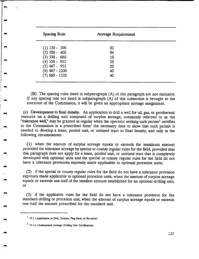
spacing Rule Acreage Requirement
n (1) 150 - 300 02
(2) 200- 400 04
(3) 330- 660 10n (4) 330 - 933 20
(5) 467- 933 20
(6) 467 - 1200 40
(7) 660 - 1320 40
pn
n
(B) The spacing rules listed in subparagraph (A) of this paragraph are not exclusive.If any spacing rule not listed in subparagraph (A) of this subsection is brought to theattention of the Commission, it will be given an appropriate acreage assignment.
(c) Development to final density. An application to drill a well for oil, gas, or geothermalresource on a drilling unit composed of surplus acreage, commonly referred to as the"tolerance well," may be granted as regular when the operator seeking such permit^ certifiesto the Commission in a prescribed form- the necessary data to show that such permit isneeded to develop a lease, pooled unit, or unitized tract to final density, and only in thefollowing circumstances:
(1) when the amount of surplus acreage equals or exceeds the maximum amountprovidedfor tolerance acreage by special or county regular rules for the field, provided thatthis paragraph does not apply for a lease, pooled unit, or unitized tract that is completelydeveloped with optional units and the special or county regular rules for the field do nothave a tolerance provisions expressly made applicable to optional proration units;
(2) if the special or county regular rules for the field do not have a tolerance provisionexpressly made applicable to optional prorationunits, when the amount of surplus acreageequals or exceeds one-half of the smallest amount established for an optional drilling unit;or
(3) if the applicable rules for the field do not have a tolerance provision for thestandard drilling or proration unit, when the amount of surplus acreage equals or exceedsone-half the amount prescribed for the standard unit.
' W-l (Application to Drill. Deepen, Plug Back, or Re-eater)->
W-lA (Substandard Acreage Dnlling Unit Certification)
135

n
n
(d) Applications invdving the voluntaiy subdivision rule.
(1) Density exception not required. An exception to the minimum density provision isnot required for the first weU in afield on alease, pooled unit, or unitized tract composedof substandard acreage, when the leases, or the drillsite tract of a pooled unit or unitizedtract:
(A) took its present size and shape prior to the date of attachment of the voluntary„ subdivision rule (§ 3.37(g) of this title (relating to Statewide Spacing Rule)); or
(B) took its present size and shape after the date of attachment of the voluntary_ subdivision rule (§ 3.37(g) of this title (relating to Statewide Spacing Rule)) and was not
composed of substandard acreage in the field according to the density rules in effect atthe time it took its present size and shape.
(2) Density exception required. An exception to the density provision is required, andmay be granted only to prevent waste, for awell on a lease, pooled unit, or unitized tract
n that is composed ofsubstandard acreage and that:
(A) took its present size and shape after the date of attachment of the voluntaryn subdivision rule (§ 3.37 of this title (relating to the Statewide Spacing Rule)); and
(B) was composed of substandard acreage in the field according to the density rulesn in effect at the time it took its present size and shape.
(3) Division after joinder or unitization. If two or more separate tracts are joined or^ unitized for oil, gas, or geothermal development and accepted by the Commission, the
joined or unitized tracts may not thereafter be divided into the separate tracts with therules of the Commission applicable to each separate tract, if the division results in any tract
^ composed of substandard acreage at the time of division, unless and until the Commissionapproves such division after application, notice to all current lessees and unleased mineralinterest owners of each tract within the joined or unitized tract, and an opportunity forhearing. If wrinen waivers are filed or if a protest is not filed within the time set forth mthe notice of application, the application wiU be granted administratively.
^ (e) Application involving unitized areas with entity for density orders. An exception to theminimum density provision is not required for a well in a unitized area for which theCommission has granted an entity for density order, if the sum of all apphed for, permitted,or completed producing wells in the field within the unitized area, multiplied by theapplicable density provision, does not exceed the total number of acres in the unitized area.The operator must indicate the docket number of the entity for density order on the
136
n
n
n
n
application form.*
(f) Exceptions to density provisions authorized. The Commission, in order to preventwaste or, except as provided insubsection (d)(2) of this section, to prevent the confiscationofproperty, may grant exceptions to the density provisions set forth in this section. Such anexception may be granted only after notice and an opponuniry for hearing.
(g) General filing requirements-
(1) Application. An application for permit to drill shall include the fees required in§ 3.76 of this title (relating to Fees Required To Be FOed) and shall be certified by someperson acquainted with the facts, stating that all information in the application is true andcomplete to the best of that person's knowledge and that the accompanying plat isaccurately drawn to scale and correctly reflects all peninent and required data.
(2) Plat. The required platmust depict the lease, pooled unit, or unitized tract, showingthereon the acreage assigned to the drilling unit for the proposed well and the acreageassigned to all current applied for, permiited, or completed wells on the lease, pooled unit,or unitized tract. A permit to drill a well for oil, gas, or geothermal resource will not begranted until such plat has been attached to and made a part of such form.
(A) On large leases, pooled units, or unitized tracts, if the established density is notexceeded as shown on the face of the form, a plat will suffice that depicts the acreageassigned to the well for which the permit is sought and to the immediately adjacent wellson the lease, pooled unit, or unitized tract.
(B) On plats of leases, pooled units, or unitized tracts from which production issecured from more than one field, the plat shall depict the acreage assigned to the wellsin each field that is the subject of the current application.
(3) Substandard acreage. An application for a permit to drill on a lease, pooled unit,^ or unitized tract composed of substandard acreage must include a cenification in a
prescribed form indicating the date the lease, or the drillsite tract of a pooled unit orunitized tract, took its present size and shape.
n
(4) Surplus acreage. An application for permit to drill on surplus acreage pursuant tosubsection (c) of this section must include a certification in a prescribed form" indicating
fP!) the date the lease, pooled unit, or unitized tract took its present size and shape.
' W-l (Application to Drill. Deepen. Plug Back, or Re-enter)
" W-l A (Substandard Acreage Drilling Unit Cenification)
137

n
PI
n
(h) Procedure for obtaining exceptions to the density provisions.
(1) Filing requirements. If a permit to drill requires an exception to the applicabledensity provision, the operator must file, in addition to the items required by subsection(g) of this section:
(A) a list of the names and addresses of all affected persons. For the purpose ofgiving notice of application, the Commission presumes that affected persons include the
fm operators and unleased mineral interest owners of all adjacent offset tracts, and theoperators and unleased mineral interest owners of all tracts nearer to the proposed wellthan the prescribed minimum lease-line spacing distance. The Director may determine
n that such a person is not affected only upon written request and a showing by theapplicant that:
« (i) competent, convincing geological or engineering data indicate that drainage ofhydrocarbons from the panicular tracts subject to the request will not occur due toproduction from the proposed well; and
(fii
(ii) notice to the particular operators and unleased mineral interest owners wouldbe unduly burdensome or expensive;
n '
(B) engineering and/or geological data, including awritten explanation of each exhibit,showing that the driUing of a well on substandard acreage is necessary to prevent waste
^ or to prevent the confiscation of property;
(C) additional data requested by the Director.
(2) Notice of application. Upon receipt of acomplete application, the Commission willgive notice of the application by mail to aU affected persons for whom signed waivers have
^ not been submitted.
(3) Approval without hearing. If the Director determines, based on the data submitted,^ that a permit requiring an exception to the applicable density provision is justified
according to subsection (f) of this section, then the application will be presented to the^ Commission for consideration and action, provided that:
(A) signed waivers from all affected persons were submitted with the application,
(B) notice of application was given in accordance with paragraph (2) of this subsectionand no protest was filed within 21 days of the notice; or
(C) no person appeared to protest the application at a hearing scheduled pursuantto paragraph (4)(A) of this subsection.
138

n
3 n
r]
m
(4) Hearing on the application.
(A) If awritten protest is filed within 21 days after the notice of application is givenin accordance with paragraph (2) of this subsection, the appUcation wiU be set forhearing.
(B) If the application is not protested and the Director determines that a permitrequiring an exception to the applicable density provision is not justified accordmg tosubsection (f) of this section, the operator may request a hearing to consider theapplication.
(i) Duration. Apennit is issued as an exception to the applicable density provision shallexpire two years from the effective date of the permit; unless driUing operations arecommenced in good faith within the two year period.
139

n
n
fm\
fm)
n
§3.39. RULE 39. PRORATION AND DRULXJNG UNITS - CONTIGUITY OFACREAGE AND EXCEPTION THERETO.
(a) Proration and drilling units established for individual weUs drilled or to be drilled shallconsist of acreage which is contiguous.
(b) An exception to the contiguous acreage provision may be granted at the operator'srequest if acreage that is to be included in the proration or drilling unit is separated by a
n long, narrow right-of-way tract.
140
§ 3.40. RULE 40. ASSIGNMENT OF ACREAGE TO POOLED DEVELOPMENTAND PRORATION UNITS.
(a) Acreage up to the amount specified in applicable field rules may be pooled into adevelopment or proration unit, provided that an operator must file with the Commission acertified plat delineating the pooled unit, and a certificate of pooling authority^ wherein itisstated that the tracts are pooled by authorityof an agreement between the various interestholders in the several tracts committed to the unit, with such tracts separately identified and
n the gross number of acres in each of said tracts shownseparately, with a total gross acreageallowed not to exceed the unit size authorized by rule.
(b) If a tract to be pooled has an outstanding interest for which pooling authority does notexist, the tract may be assigned to a unit where authority exists in the remaining undividedinterest, provided, that total gross acreage in the tract is included for allocation purposes,and the certificate filed with the Commission shows that a certain undivided interest is
outstanding in the tract. The Commission will not allow an operator to assign only hisundivided interest out of a basic tract, where a nonpooled interest exists.
n
(c) The nonpooled undivided interest holder retains his development rights in his basictract, and should such rights be exercised, authority to develop the basic tract be approved
^ by the Commission, and a well completed as a producer thereon, then the entire interest inthe basic tract must be allocated to said well, and any interest insofar as it is pooled withanother tract must be assigned to the well on the basic tract for allocation purposes.
n Splitting of undivided interest in a basic tract, between two or more wells on two or moretracts is not acceptable.
n
n
f-n
(d) Acreage assigned to a well for drilling and development, or for allocation of allowable,shall not be assigned to any other well or wells projected to or completed in the samereservoir; such duplicate assignment of acreage is not acceptable, provided, however, thatthis limitation shall not prevent the reformation of development or proration units so longas no duplicate assignment of acreage occurs, and further, that such reformation does notviolate other conservation regulations.
P-12 (Ceniiicate of Pooling Authorit\')
141

§3-74. RULE 76. CXDMMISSION APPROVAL OF PLATS FOR MINEELALDEVELOPMENT.
^ (Amended Effective May 1, 1990)
(a) The following words and terms, when used in this section, shall have the following" meanings, unless the context clearly indicates otherwise.
^ (1) Minerals-Oil and/or gas.
(2) Operations site-A surface area oftwo ormore acres that an owner ofa possessory^ mineral interest may use to explore for and produce minerals, which is located in whole
or in part within a qualified subdivision, and designated on the subdivision plat.
(3) Possessory mineral interest-A mineral interest that includes the right to use the landsurface for exploration and production of minerals.
(4) Qualified subdivision-A tract of land not more than 640 acres:
(A) that is located in a county having a population in excess of400,000, or in a countyn having a population in excess of 140,000 that borders a county having a population in
excess of 400,000 or located on a barrier island;
n (B) that has been subdivided in a maimer authorized by law by the surface owners forresidential, commercial, or industrial use; and
n (C) that contains an operations site for each separate 80 acres within the 640-acretract and provisions for roadand pipeline easements to allow use of the operations sites.
^ (5) Barrier island-An island bordering on the Gulf of Mexico and entirely surroundedby water.
" (b) As provided in subsections (e) and (f) of this section, the surface owners of a parcelof land may restrict use of the surface by the possessory mineral owners if the tract is aqualified subdivision and if a plat of the subdivision has been approved by the Railroad
" Commission after notice and hearing and filed with the clerk of the county in which thequalified subdivision is to be located.
(c) An application for a hearing under this section must be made in writing and mailedor delivered to the Director of the Oil and Gas Division. The application must include:
n
n
(1) a jurisdictional statement setting out the facts stated in subsection (a)(4)(A) and (B)of this section;
n 207
PI

n
rn
n
(2) a statement that the applicant has authority to represent and represents all surfaceowners of land contained in the proposed qualified subdivision;
(3) the names and addresses of all owners of possessory mineral interests and allmineral lessors of land contained in the proposed qualified subdivision;
(4) a plat of the proposed subdivision showing each proposed 80-acre tract with itsoperations site, road easements, and pipeline easements and a legible copy thereof nolarger than 8 1/2 inches by 11 inches;
(5) a concise description of mineral development in the area, including the number ofoil and/or gas wells within 2.5 miles of the boundary of the proposed qualified subdivisionand the depths at which each well is completed;
(6) a list of all the Railroad Commission designated oil and/or gas fields, if any, whichunderlie the proposed qualified subdivision; including the spacingand density requirements.If no Railroad Conmiission designated fields underlie the qualified subdivision, theapplication should so state.
n (d) The Railroad Commission shall, on proper notice to the applicant and owners ofpossessory mineral interests and mineral lessors of land contained in the proposed qualifiedsubdivision, hold a hearing on the application to determine the adequacy of the number and
n location of operations sites and road and pipeline easements. At the hearing on theapplication, evidence may be presented by the applicant and the owners of possessorymineral interests and mineral lessors. The applicant must carry the burden of proof. After
n considering the evidence, the Commission may approve, reject, or amend the application toensure that the mineral resources of the subdivision may be fully and effectively developed.
^ (e) An owner of a possessor}' mineral interest within a Railroad Commission approvedqualified subdivision may use only the surface contained in designated operations sites forexploration, development, and production of minerals and only the designated easements
" as necessary to adequately use the operations sites.
(f) The owner of the possessory mineral interest may drill wells or extend well bores from^ an operations site or from a site outside of the qualified subdivision to bottomhole locations
vertically beneath the surface of parts of the qualified subdivision other than the operationsites. Such drilling is subject to other applicable Commission rules and regulations, and ispermissible only to the extent that the operations do not unreasonably interfere with the useof the surface of the qualified subdivision outside the operations site.
(g) Subsections (e) and (f) of this section cease to apply to a subdivision if, by the thirdanniversary of the date on which the order of the Commission becomes final:
208

(1) the surface owner has not commenced actual construction ofroads orutilities withinthe qualified subdivision; and
n
(2) a lot within the qualified subdivision has not been sold to a third party.
n (h) All or any portion ofa qualified subdivision may be amended, replatted, orabandonedby the surface owner. An amendment or replat, however, may not alter, diminish, or impairthe usefulness of an operations site or appurtenant road or pipeline easement unless the
n amendment or replat is approved by the Commission. Railroad Commission approval of areplat or amendment may be administratively granted by the Director of the Oil and GasDivision, or his delegate, upon submission of items required in subsection (c) of this section
n and after notice and opponunity for hearing has been afforded to all possessory mineralinterest owners and mineral lessors of land contained within the original and/or replatted oramended qualified subdivision.
n
n
209
n

r*i
n
n
n
n
n
n
n
n
§3-86. RULE 86. HORIZOOTAL DRAINHOLE WELLS.(Adopted Effective June 1, 1990)
(a) Definitions. The following words and terms, when used in this section, shaD have thefollowing meanings, unless the context clearly indicates otherwise:
(1) Correlative Interval—The depth interval designated by the field rules, by new fielddesignation, or, where a correlative interval has not been designated by the Commission,by other evidence submitted by the operator showing the producing interval for the fieldin which the horizontal drainhole is completed.
(2) Horizontal Drainhole—That portion of the wellbore drilled in the correlative interval,between the penetration point and the terminus.
(3) Horizontal Drainhole Displacement—The calculated horizontal displacement of thehorizontal drainhole from the penetration point to the terminus.
(4) Horizontal Drainhole Well-Any well that is developed with one or more horizontaldrainholes having a horizontal drainhole displacement of at least 100 feet
(5) Penetration Point—The point where the drainhole penetrates the top of thecorrelative interval.
(6) Terminus-The farthest point required to be surveyed along the horizontal drainholefrom the penetration point and within the correlative interval.
(b) Drainhole Spacing.
(1) No point on a horizontal drainhole shall be drilled nearer than 1,200 feet (horizontaldisplacement), or other between-well spacing requirement under applicable rules for thefield, to any point along anyother horizontal drainhole in another well, or to any other wellcompleted or drilling in the same field on the same lease, pooled unit or unitized tract.
(2) No point on a horizontal drainhole shall be drilled nearer than 467 feet, or otherlease-line spacing requirement under applicable rules for the field, from any property line,lease line, or subdivision line.
(3) AH wells developed with horizontal drainholes shall otherwise comply with StatewideRule 37 (16 TAC § 3.37) or other applicable spacing rules.
(c) Well Densities. All wells developed with horizontal drainholes shall comply withStatewide Rule 38 (16 TAC § 3.38) or other applicable density rules.
248

(d) Proration and Drilling Units.
(1) Acreage may be assigned to each horizontal drainhole well for the purpose ofallocating allowable oil or gas production up to the amount specified by applicable rulesfor a proration unit for a vertical well plus the additional acreage assignment as providedin this paragraph-
Additional Acreage AssignmentFor Fields With A Density Rule of 40 Acres Or Less
Horizontal Drainhole Displacement, ft Additional Acreage Allowed, acres
100 to 585 20
586 to 1,170 401,171 to 1,755 601,756 to 2,340 802,341 to 2,925 1002,926 to 3,510 120
etc. - 585 ft increments etc. - 20 acre increments
NAdditional Acreage Assignment
For Fields With A Density Rule Greater Than 40 Acres
Horizontal Drainhole Displacement, ft Additional Acreage Allowed, acres
in
150 to 827 40
i 828 to 1,654 80in 1,655 to 2,481 120 ..; 2,482 to 3,308 160I 3,309 to 4,135 200H 4,136 to 4,962 240-I etc. - 827 ft increments etc. - 40 acre increments
•n
(2) Assignment of acreage to proration and drilling units for horizontal drainhole wellsmust be done in accordance with Statewide Rule 40 (16 TAC § 3.40).
249

" (3) All proration and drilling units shall consist of continuous and contiguous acreage andproration units shall consist of acreage that can be reasonably considered to be productive
^ of oil or gas.
(4) All points on the horizontal drainhole must be within the proration and drilling unit.n
n
n
r»
pn
n
(5) The maximum daily allowable for a horizontal drainhole well shall be determined bymultiplying the applicable allowable for a venical well in the field with a proration unit
H containing the maximum acreage authorized by the applicable rules for the field, exclusiveof tolerance acreage, by a fraction:
n (A) the numerator of which is the acreage assigned to the horizontal drainhole well forproration purposes; and
n (B) the denominator of which is the maximum acreage authorized by the applicable fieldrules for proration purposes, exclusive of tolerance acreage.
^ The daily oil allowable shall be adjusted in accordance with Statewide Rule 49(a) (16 TAC§ 3.49(a)) when applicable.
" (6) The maximum diagonal for each proration unit containing a horizontal drainhole wellshall be the horizontal drainhole displacement of the longest horizontal drainhole for thewell plus:
(A) 2,100 feet for fields that are regulated under Statewide Rules; or
(B) the maximum diagonal aDowed for fields where the special field rules specify amaximum diagonal.
(e) Multiple Drainholes Allowed.
p (1) Asingle well may be developed with more than one horizontal drainhole originatingfrom a single vertical wellbore.
1^ (2) Ahorizontal drainhole well developed with more than one horizontal drainhole shallbe treated as a single well.
rr (3) The horizontal drainhole displacement used for calculating additional acreageassignment for awell completed with multiple horizontal drainholes shall be the horizontaldrainhole displacement of the longest horizontal drainhole plus the projection of any other
n horizontal drainhole on a line that extends in a 180 degree direction from the longesthorizontal drainhole.
250

n
n
in
(f) Dnflling Applications and Required Reports.
(1) Application. Any intent to develop a new or existing well with horizontal drainholesmust be indicated on the application to drill. An application for a permit to drill ahorizontal drainhole shall include the fees required byStatewide Rule 78 (16 TAG § 3.76)and shall be certified by a person acquainted with the facts, stating that all information inthe application is true and complete to the best of that person's knowledge and that theaccompanying plat is accurately drawn to scale and correctly reflects all pertinent andrequired data.
(2) DiiUing Unit PlaL The required plat must depict the lease, pooled unit or unitizedtract, showing the acreage assigned to the drilling unit for the proposed well and theacreage assigned to the drilling units for all current applied for, permitted or completedwells on the lease, pooled unit or unitized tract, the surface location of the proposedhorizontal drainhole well, and the proposed path, penetration point, and terminus of alldrainholes. An amended drilling application permit and plat shall be filed after completionof the horizontal drainhole well if the Commission determines that the drainhole as drilledis not reasonable with respect to the drainhole represented on the plat filed with thedrilling permit application.
(3) Directional Survey. A directional survey from the surface to the farthest pointdrilled on the horizontal drainhole shall be required for all horizontal drainholes. The
n directional survey and accompanying reports shall be conducted and filed in accordancewith Statewide Rules 11 and 12 (16 TAG § 3.11 and § 3.12). No allowable shall beassigned to any horizontal drainhole well until a directional survey and survey plathasbeen
n filed with and accepted by the Conmaission.
(4) Proration Unit Plat The required proration unit plat must depict the lease, pooledn unit or unitized tract, showing the acreage assigned to the proration unit for the horizontal
drainhole well, the acreage assigned to the proration units for ail wells on the lease, pooledunit or unitized tract, and the path, penetration point, and terminus of all drainholes. No
n allowable shall be assigned to any horizontal drainhole well until the proration unit plat hasbeen filed wiih and accepted by the Commission.
(g) Exceptions and Procedure for Obtaining Exceptions.
(1) The Commission may grant exceptions to this rule in order to preventwaste, preventconfiscation, or to protect correlative rights.
(2) If a permit to drill a horizontal drainhole requires an exception to this section, thenotice and opponunity for hearing procedures for obtairJng exceptions to the densityprovisions prescribed in Statewide Rule 38 (16 TAG § 3.38} shall be followed as set forthin Statewide Rule 38(h) (16 TAG § 3.38(h)).
251

n
n
m
rt
n
n
(3) For notice purposes, the Commission presumes that for each adjacent tract and eachtract nearer to any point along the proposed or existing horizontal drainhole than theprescribed minimnm lease-iine spacing distance, affected persons include:
(A) The designated operator;
(B) All lessees of record for tracts that have no designated operator; and
(Q All owners of record of unleased mineral interests.
252

n
n
pn
ri
Eastern Gulf Region
Petroleum Technology Transfer Council
Focused Technology Workshop
"Drilling and Production Units and Well Spacing
Gary Wilson,Deputy Supervisor,
Alabama Oil and Gas Board
tf

STATE OIL & GAS BOARD OF ALABAMA
SPACING OF WELLS (Outline)
400-1-2-.02. Spacing of Wells.
♦ A well is spaced on a unit based on the maximunn area which may be efficiently andecononnically drained by the well.
♦ The spacing for a well to be drilled to a pool in an established field Is governed byspecial field mles for that particular field.
SPACING OF FIELD WELLS
♦ The final spacing for a well completed as a producer is determined by the Board at thetime of field establishment.
♦ The drilling of additional wells for development of a pool may continue prior to fieldestablishment, subject to the approval of the Supervisor.
WILDCAT DRILLING UNITS - STATEWIDE
♦ A well may be drilled on a unit consisting of a govemmental quarter-quarter section(approx. 40 acres).
♦ A well may be drilled on a unit consisting of a govemmental quarter section (approx. 160acres).
DRILLING UNITS
SOUTHWEST ALABAMA
(WILDCATS)(In addition to the 40- & 160-acre option)
♦ A well drilled in search of gas in the Counties of Baldwin, Escambia, Mobile, orWashington may be drilled on a unit consisting of a governmental section for deepprospects (approx. 640 acres).
♦ A permit for a well to be drilled on a unit other than a governmental section or divisionthereof may be approved by the Supervisor.
UNITS FOR OFFSHORE DEVELOPMENT
♦ Spacing for field wells is govemed by special field mles.
♦ Spacing for offshore wildcat wells is the same as for onshore wells in Baldwin andMobile Counties (units can be 40,160, 320, or 640 acres in size).
r*

DRILLING UNITS
WARRIOR BASIN
(WILDCATS) F,(In addition to the 40- &160-acre option)
♦ A well to be drilled in search of gas in the Counties of Fayette, Lamar, Pickens, or „Tuscaloosa may be drilled on a unit consisting of a governmental half section (approx.320 acres).
♦ A permit for a well to be drilled on a unit other than a governmental section or divisionthereof may be approved by the Supervisor.
UNITS FOR COALBED METHANE DEVELOPMENT
♦ The spacing for field wells is governed by special field rules. "
♦ Wildcat wells are drilled on 40-acre units consisting of governmental quarter-quartersections (approx. 40 acres). ^
• Permits for wells to be drilled on non-govemmental units may be approved by the ^Supervisor.
NON-GOVERNMENTAL UNITS
A permit application for a well to be drilled on a unit consisting of approximately 40, 160,320, or 640 contiguous surface acres, other than a govemmental section or division thereof,may be approved by the Supervisor.
PRODUCTIVE EXTENSIONS
♦ The unit for a well drilled adjacent to a field is normally in accordance with the spacingprovisions in the special field rules.
♦ A well located adjacent to an established field may be drilled as a wildcat with writtenjustification.
UNIT ENLARGEMENTS
The Board may Increase unit sizes by an amount not to exceed thirty percent (30%).
(Must be supported by evidence that the acreage to be addedis being drained or Is in imminent danger of being drained.)
STATE OIL & GAS BOARD OF ALABAMA
2
n
p*i

STATE OIL & GAS BOARD OF ALABAMAFROM OIL AND GAS REPORT 1
Rule
400-1-2-.02. Spacing of Wells. (See OGB-1 for the complete rules and regulations ofthe Board and all laws pertaining to oil and gas development).
A well shall be spaced on a unit based upon the maximum area which may be efficiently andeconomically drained by one well. A unitshall not includeany part of another unit establishedfor the same pool. The spacing for a well to be drilled to a pool in an established field shall begoverned by special field rules for that particularfield. With respect to a well to be drilled to apool that is not governed by special field rules, the following spacing provisions shall beapplicable:
(1) A well may be drilled on a unit consisting of a governmental quarter-quarter section(approximately 40 acres). Such well shall be located at least three hundred thirty (330) feetfrom every exterior boundary of the unit.
(2) A well may be drilled on a unit consisting of a govemmental quarter section(approximately 160 acres). The Supervisor may require written justification for the unit. Suchwell shall be located at least six hundred sixty (660) feet from every exterior boundary of theunit.
(3) A well to be drilled in search of gas in the Counties of Fayette, Lamar, Pickens, orTuscaloosa may be drilled on a unit consisting of a govemmental half section (approximately
" 320 acres). Such well shall be located at least six hundred sixty (660) feet from every exteriorboundary of the unit. The operator shall designate on the permit application an altemate forty(40) acre unit, and the well shall be located at least three hundred thirty (330) feet from every
" exterior boundary of the alternate unit. If said well is completed as an oil well, then thespacing for the well shall automatically revert to the designated alternate forty (40) acre unituntil the proper spacing for said well is determined by the Board after notice and hearing.
^ (4) A well to be drilled in search of gas in the Counties of Baldwin, Escambia, Mobile, orWashington may be drilled on a unitconsisting of a govemmental section (approximately 640acres). The Supen/isor may require written justification for the unit. Such well shall be located
n at least one thousand three hundred twenty (1,320) feet from every exterior boundary of theunit. The operator shall designate on the pennit application an altemate one hundred sixty(160) acre unit, and the well shall be located at least six hundred sixty (660) feet from everyexterior boundary of the altemate unit. If said well is completed as an oil well, then thespacing for the well shall automatically revert to the designated altemate one hundred sixty(160) acre unit until the proper spacing for said well is detennined by the Board after notice
i«i and hearing.(5) The Supen/isor, upon receipt of written justification from an operator, may approve a
permit application under paragraphs (1) through (4) above for a well to be drilled on a unitn consisting of approximately 40, 160, 320, or 640 contiguous surface acres other than a
govemmental section or division thereof as set forth herein.(6) The Supervisor may require that a well to be drilled on a unit contiguous to an existing
^ field be drilled and completed as an extension of the field, in accordance with the spacingprovisions in the special field rules thereof. If, however, an operator provides writtenjustification that such proposed well will likely be completed in a pool or pools not defined in
^ thespecial field rules for said field, the Supervisor may approve the drilling and completion ofsuch well in compliance with the spacing provisions as set forth herein.
(7) Pursuant to Section 9-17-12(c) of the Code of Alabama (1975), the Board may grant^ an exception to the spacing rules as may be reasonably necessary where it is shown, after
notice and hearing, and the Board finds, that the unit is partly outside the pool, or for some
1

other reason, that a well located in accordance with applicable rules would be nonproductive,would not be at the optimum position in such drilling or production unit for the most efficientand economic drainage of the unit, or where topographical conditions are such as to makethe drilling at an authorized location on the unit unduly burdensome or where an exception isnecessary to prevent confiscation of property. ^
(8) No well shall be located within 200 feet of any permanent residence, unless othen/viseapproved by the Board.
(9) Fora well completed in a pool for which special field rules have not been adopted, ^the Board shall detemiine, in conjunction with the establishment of special field rulesafter notice and hearing, the proper spacing for the production unit for said well.Subject to the approval of the Supervisor, the drilling of additional wells fordevelopment of a pool may continue prior to the establishment of special field rules forthe pool. No well shall produce, other than on a test basis authorized by theSupervisor or Board, until special field rules applicable to the well are established. Inorder to obtain sufficient technical information to establish the proper spacing, a well ^may be produced on a test basis pursuant to Rule 400-1-6-.01 et seq. for an oil well,or Rule 400-1-7-.01 et seq. for a gas well.
OFFSHORE WELLS
400-3-2-.02. Spacing of Wells. Unless the spacing of wells in oil and gas fields is govemedby special field rules or is othenwise approved by the Board after notice and hearing, anapplication for a drilling permit in submerged offshore lands shall comply with the applicable "requirements of Rule 400-1 -2-.02, Spacing of Wells.
COALBED METHANE WELLS
Rule 400-4-2-.02. Spacing of Wells. A coalbed methane gas well shall be spaced on a unitbased upon the maximum area which may be efficiently and economically drained by onewell. A unit shall not include any part of another unit established for the same pool. Thespacing for a coalbed methane gas well to be drilled to a pool in an established field shall begoverned by special field rules for that particular field. With respect to a coalbed methane gaswell to be drilled to a pool that is not govemed by special field rules, the following shall beapplicable:
(1) Each coalbed methane gas well shall be drilled on a unitconsistingof a governmentalquarter-quarter section (approximately 40 acres). Such well shall be located at least threehundred thirty (330) feet from every exterior boundary of the unit.
(2) The Supervisor, upon receipt of written justification from an operator, may approve a —permit application under paragraph (1) for a unit consisting of approximately 40 contiguoussurface acres other than a govemmental quarter-quarter section as set forth herein.
(3) The Supervisor may require that a coalbed methane gas well to be drilled on a unitcontiguous with an existing field be drilled and completed as an extension of the field, inaccordance with field spacing provisions in the special field rules thereof. If, however, anoperator provides written justification that such proposed well will likely be completed in apool or pools not defined in the special field rules for said field, the Supervisor may approvethe drilling and completion of such well in compliancewith the spacing provisions as set forthherein.
(4) Pursuant to Section 9-17-12(c) of the Code of Alabama (1975), the Board may grantan exception to the spacing mles as may be reasonably necessary where it is shown, after ^
n

notice and hearing, and the Board finds, that the unit is partly outside the pool, or for someother reason, that a coalbed methane gas well located in accordance with applicable ruleswould be nonproductive, would not be at the optimum position in such drilling or productionunit for the most efficient and economic drainage of the unit, or where topographicalconditions are such as to make the drilling at an authorized location on the unit undulyburdensome or where an exception is necessary to prevent confiscation of property.
(5) No coalbed methane gas well shall be located within 200 feet of any permanentresidence, unless othenvise approved by the Board.
(6) For a coalbed methane gas well completed in a pool for which special field rules havenot been adopted, the Board shall determine, in conjunction with the establishment of specialfield rules after notice and hearing, the proper spacing for the production unit for said well.Subject to the approval of the Supervisor, the drilling of additional wells for development of apool may continue prior to the establishment of special field rules for the pool. No well shallproduce, other than on a test basis authorized by the Supervisor or Board, until special fieldrules applicable to the well are established. In order to obtain sufficient technical informationto establish the proper spacing, a coalbed methane gas well may be produced on a test basispursuant to Rule 400-4-6-.01.
(7) Ifany coalbed methane gas well drilled in conformity with the provisions of paragraphone (1) above, or in conformity with the special field rules for a particular field iscompleted as other than a coalbed methane gas well, said well shall not be produced
" other than on a test basis until authorization has been granted by the Board afternotice and hearing. This rule shall not apply to vent holes drilled for safety purposes inconjunction with coal mining operations.
m
FROM OIL & GAS LAWS OF ALABAMA (See OGR 1 for all Laws)
Section 9-17-12. Limitations as to ruies, regulations or orders limiting or proratingpool production generally; establisliment of drilling or production units for pools;
pn locations for drilling of wells witliin drilling or production units; determination ofproducers shares of production and reservoir energy of pools.
(b) For the prevention of waste, to protect and enforce the conrelative rights of the ownersand producers in a pool and to avoid the augmenting and accumulation of risks arising fromthe drilling of an excessive number of wells, the Board shall, after a hearing, establish adrilling or production unit or units for each pool. A drilling or production unit, as contemplatedin this subsection, means the maximum area which may be efficiently and economicallydrained by one well, and such unit shall constitute a developed unit as long as a well islocated thereon which is capable of producing oil or gas in paying quantities, or until theBoard shall determine and order otherwise after notice and hearing. It is provided, however,that the Board shall have no authority to fix a drilling or production unit in excess of either onehundred sixty (160) acres or one governmental quarter section plus ten percent (10%)tolerance for any pool deemed by the Board to be an oil reservoir or in excess of either sixhundred forty (640) acres or one governmental section plus ten percent (10%) tolerance, forany pool, deemed by the Board to be a gas reservoir, the said ten percent (10%) toleranceprovided for so as to allow for in-egular sections; provided however, that the Board may, at itsdiscretion, after notice and hearing, establish drilling or production units for oil and gas inexcess of the aforesaid limitations when it is affirmatively demonstrated that one well canefficiently and economically drain the proposed area and that a larger unit is justified becauseof technical, economic, environmental or safety considerations, or other reasons deemedvalid by the Board. To insure protection of coequal and correlative rights, the Board may.

after notice and hearing, establish units for oil and gas pools by a quantum not to exceedthirty percent (30%) greater than the aforesaid limitation provided such action is justified bysufficient technical data, indicating that such acreage or land in excess of the aforesaidmaximum limitations Is being drained or Is in Imminent danger of being drained and that theowners of such said excess acreage or lands that the persons owning any Interest orcombination of interests in such said excess acreage or lands cannot othenA/lse receive theirjust and equitable share of production from the pool being so drained; provided, however, inthe event such excess lands or Interests are Integrated or pooled by order of the Board, thenthe provisions of Section 9-17-13 of this article shall be applicable to such owners of tracts orinterests In such acreage or land in excess of the aforesaid maximum limitations so that theoperator of the drilling or production unit in which such tracts or interests are included shallhave the right to charge against the Interest of each other owner in the production from thewells drilled by such designated operator the actual expenditures required for such purpose,not in excess of what are reasonable, including a reasonable charge for supervision; and theoperator shall have the right to receive the first production from such wells drilled by himthereon which othenvise would be delivered or paid to the other parties jointly interested inthe drilling of the well so that the amount due by each of them for his share of the expense ofdrilling, equipping and operating the well may be paid to the operator of the well out ofproduction, with the value of production calculated at the market price In the field at the timesuch production is received by the operator or placed to his credit.
Notwithstanding the provisions of this section, ail persons entitled to share in theproduction of oil or gas from a tract or interest or tracts or Interests in land may voluntarilyagree to the creation or establishment of a drilling or production unit, or may authorize one ormore of the persons entitled to share in such production to create or establish a drilling orproduction unit, containing as much or more acreage or land than drilling units established bythe Board for the same pool, but not In excess of 160 acres or one governmental quartersection, plus ten percent (10%) tolerance, in the case of oil and 640 acres or onegovernmental section, plus ten percent (10%) tolerance, in the case of gas; subject to theaforementioned qualifications In this section and up to thirty percent (30%) greater, asprovided hereinabove; a drilling unit so created or established shall, subject to the approval ofthe Board, be valid and binding for all purposes even though such drilling or production unitcontains more acreage or land than the Board has Included, or is authorized by this sectionto Include in a drilling or production unit established by it for the same pool; provided,however, the spacing limitations set forth herein shall not apply to offshore wells and the sizeand configuration of drilling and production units of offshore wells shall be as is determinedproper by the Board.
(*)
n
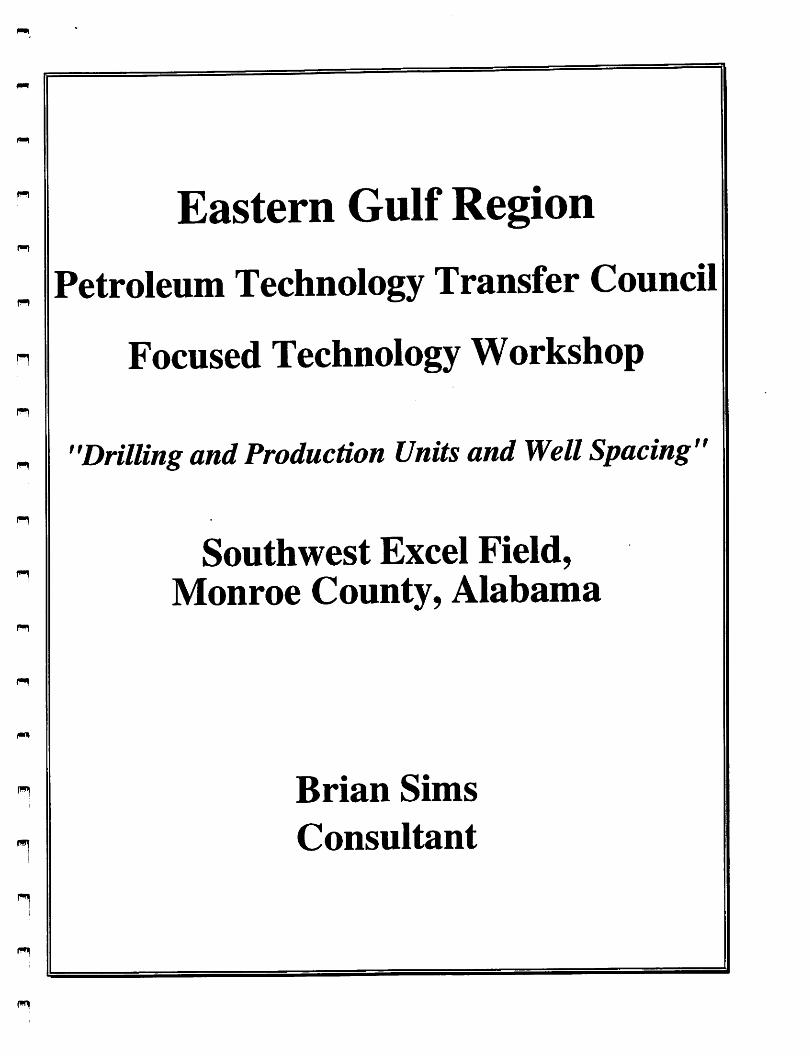
p-l
n
n
n
n!
n1
fW|
Eastern Gulf Region
Petroleum Technology Transfer Council
Focused Technology Workshop
"Drilling and Production Units and Well Spacing
Southwest Excel Field,Monroe County, Alabama
Brian Sims
Consultant
ff

goNoCOHI
-9
gCOCO<a:
UPPER
MIDDLE
COTTON
VALLEY
GROUP
HAYNESVILLE
FORMATION
"Megargel sand""Frisco City sand""Haynesviile sand"
Buckner Anhydrite Mbr.
SMACKOVER
FORMATION
NORPHLET
FORMATION
PlneJj^ill_Anhy^t^l^r
LOUANN SALT
WERNER
FORMATION
EAGLE MILLS
FORMATION
BASEMENT
COMPLEX

JacksonDome
LEGEND
-Approximate updip limit' of the Smackover Formation
-Salt-related anticline
- Basement arch, ridge, or anticline
-Salt-related fault-hachures ondownthrown side
-Salt dome
MISSISSIPPI
A A A AA ^^ ^ AMississippi
Interior SaltBasin
Qraben
Lower MobileFault Syst
Mobile Area
Viosca KnollArea
0 10 20 30 40 Miles
I—I I I I
Manila y\ ^ Embayment
i' >/
'estBwd ^Fault /
AA System /f ^
\ ;-pollard Fault System ^ /
Baldwin High
ALABAMAAe+
Foshee ^Faulty ^
System(
\
ConecuhEmbayment
Pensacola AreaPensacola-De8tlnr^~rTT>^
Fault System ^
Apaiachicoia Basin
Destin Dome Area •
DeSoto CanyonSalt Basin
FLORIDA
ApaiachicoiaEmbayment %
Apaiachicoia Area

1
XVV.
EXPLANATION
Approximats updip tbnhof tiM Smackovmr Formation
Salt-r«l«t«d antlclino
Batmnant arch, rMga, or antlcllna
Salt*raUitad fault-hachuraa ondownlhrown sida
Trand boundary^ (daahad whara Infarrad)
JURASSIC
OIL AND QAS4X)NDEHSATE
TREND
0 10 20 30 40MilM
l_J I—I—I
Seal*
J
FLORIDA

/ X \/
/
.
LEGEND
'\ -Approximate updip limit' of potential Jurassic reservoirs
-Satt-related fault-block on
downthrown side
^ ALABAMA
/ FLORIDA
20 MilesGulf of Mexico
SCALE
PLAYS AND SUBPLAYS
Basement ridge play
A. Choctaw ridge complex subplayB. Conecuh and Pensacola-Decatur
ridge complexes subplay
Regional peripheral fault trend playC. Gilbertown and West Bend fault
systems subplayD. Pollard and Foshee fault systems subplay
••' '•• •[ Mississippi interiorsatt basin play
Mobile graben fault system play
Wiggins arch complex play

nr
'Ill'l
t015'f-U\vJulUeife-INo.l. '.L
•4 F JS
6-2 Mo-1 0^;o757-B
6 ^SOUTT^E^STes 6-11 , _
No.t IFRISCO ctry
I t-|6 No.l
Alf.iriHo
' lObif
to/.J. I B
I KM T ' " "6-ifcNo.i
TT)W
ii>|;i
Curii* ijl'•I III
i:
18
SL
I0tfc2-B
Carpertfer7-1 No. I
EA5T FRISCO 'ICiry FIELD
ff P (iHL
GYf-'i 5-3• No. I
I Nicholas 8-5No.2
5402-AB
\ I SL Nicholos8-5 No.l
F^-k>- 5402-B^BHL<ACTUAL)
• 9883
Peoc-Edge PetroleumATIC 18-12 No.l
8
17
J T6N T 6 N— 1— >
T5N T 5 N
i Vr
107^1-8
b.R.whAtlcyq.f f4e.(
i 1
I0<)&0
Netfles 't-ti fJo.l 'I
r' sOUlHWEST llI EXCEL FIELD ||! ilI sl9 .FilOSOVB >1
II lObO'f-Dt llII Noll lfe-3 Mo.l ST Fl
loqoH- :l' I NoU 'I
I 16 I16
iL ' ji
3— 31^ 11^ 1=!
N
15

fHj
m
n
n
n
1-1
n
n
R.4W. 3 2 R.IW. R.1E.EXPLANATION
MIOCENE
CRETACEOUS
OCX kW2 3 R.4E.
HAYNESVILLE
SMACKOVER
8 !iNORPHLET
M OR.13E.
T.IN
T.IS.
6S Ap()l«(on(oil)T3N.ME91. bitow Bend (Oil) T6N.RSt
23 B«ni«tt{0iI)T4N.R7EJt. BimirtB(gat.tlMn(ion(«l)T».IUE16 B«nytO«m(olI)TI0N.R3W62. B«youlen«<9n)T7S.R2W72. Beniflgmheinl(m(gts)T7S,IUWIS. BigEic*inbi«Crc«k(gncond«nMtc)TlN,
lire
43. BlKltthc((oiDT3N.R4E74. BonSccaurB«y(9n)T8S.R«WBO. BrlghtoCttck(g«)T8S.ME32. B(ic«tunn*Cc(tli(on)TnN.KSW78 Burnt Corn Citek<oiQT3N.R9E
69. Catlwt»t|lc<n9i(oa)TIN.R9E31 Chapp*IIKm(o<l)tltN.K3W12. Chilem{g«tcendenMle)T6N.R4WS4 a«wenCracli(ell)TlN.ftSE
B. Choct<wRidge(on>TiiN.MW21. Otun<hgli{gMcon<JenMt*)TIS,R2W
S. Citn>n«Ot(oiqT2N.R3W38. CeMOeck«l«)Tlf.ll1W64. Coopw'lUndingCgariTSS.UE22. Ceptland (g«(ondcnwte: oil.
abandoa«d)T6N,1UW52. Cypreit Point (gn) TBS, R3E7$. EntBtV0Ul0nat{gat)T7S,lt2WSO. EaMOrttCfB«y(gM)T9S.iME9S. Fttiwty(9n)T9S.iim19. rannyaiurch(oiqT1N.RSE
INDEX TO OIL AND GAS FIELDS IN SOUTHWESTERN ALABAMA^
9. Flom«ton(gM<ondCRUtt)TtN.RtE40. reiev(gn)T7S.R4E
lOa FolhM(0iI)T2N,RSE96. FrhC0CKy{0a)TSN,R6E
1. G<lb«f1own(o(QTI0N.R4W
79. G<nCr«tk(0U)TiaN.R4W106. GrctnBrtnch(gat)m,ft2E56. Gulf SUM Park (gat) m. R4E82. Kali Creek (oil) T2N,RSE
102. Kanbeny Church(oil)T3N.R9E2S. Hatter'tPond(gMCondenutc)T2S.RlWS9. KtaflngSprings(gat cendentate)TBN,
R4W
81. Heton Bayou (gai)raS.R2W61. Hubbard't landing (oO)TIN, R2ES3. Hu>ford(eiqT3N.fttE
3. Langidalc(eil)TUN.R5W66. Latham (oil) T2N.R2CM. littleEtcaRiWaCrcek(oit)TIN.i«9E33. little Mm Oeek(oH)TtON.R3W44. Uttle River (on. abandoned) T3N.R4E
89. little Rock (gat condemate)T2N,R7E47. lovetUCreek(oil)TSN.RSE
41. lower Mobile BayMaiy Ann (gat) T9S.RIW
67. Magnolia River{gai)T7S,R3E30. MeMn(oll)TnN,RSW24. Mill Creek (oil) TtON,R4W87. MonlouH Wand (gat) T7S,R2W49. MovlcO{oa)T1N.RIE
68. North Bayou lonat (gat) T7S.R2W92. North Central Gulf-Mobile Area (gat) T9S.
RIE
17. North Choctaw Ridge (0(1)Tt IN. R3W99. North Cooper't landing (gat) TBS.R3E76. NotthO«lch»mpt{9at)T7S,R2W86. North Heron Bayou(gat) r7S. R2W88. North Monlouitltland (gat) T7S,R2W97. North Swiftt landing (gat) T8S.R3E94. Northwett Gulf-Mobile Area (gat) T9S,
RIW
101. Pace Creek (eil)TlON.RtWS8. Perdido(oil)TIN.RSE4S. Pleatant View(gat) TBS.R4E60. Point Judith (g^TBS. RIW
4. PolUrd{e<l)T1N.RSE34. Putt Cutt Creek (oil, abandoned) T9N.
R4W
SS. Red Creek (gat condentale)T7N,R4w63. St. Paul't Church (gat) T7S.R2W98. Schoolhoute Branch (gat) T7S.R3E26. Stlat(0iqT1IN.R4WS7. Sitemore Creek (oil; gatcondentate) T7H.
R7E
48. Skunk Bayou (gat. alMndoned) TBS.R3EtOS. South Burnt Coin Creek (oil) T3N,ft9E
2. South Carlton(oiOT3N,R2E39. South CoWCreek (oil, abandoned) TIS.
K1W
SI. South Foley (gat) TBS.R4E
howmMpandrangenumbert areprovided at • generalited guidetoruteInlocating fieMt en figure I.
Figure 1.-OH and gas fields In southwestern Alabama
90. South vocation (oil) T4N. R6E46. South Weekt Bay (gat. abandoned) I8S.
R3E
71. South Womack Hill (Oil) ftON.R2W
93. Southeait Mobile Bay (gat) T9S.RIE8$. Southwett Barrytown (oil. abandoned)
TI0N,R3W
3S. Souwllpa Creek (gat condenviie)l9N,R4W
Stave Creek {oiqT7N. RIESugar Ridge(oil)TIIN.R3WSwiftt landing (gat) TBS.R4[Tentaw lake (oil. abandoned) Tin. R2ETo>ev(oil)TltN.R3WTurkey Creek (oil) TtON. R2WTurnervtlle (otq T IS. R1WUriah (oil, abandoned) T4N. RSE
18. vocation (o>qT4N.R6E104. Wallace (olQ T3N. RtE
70. Wallert Creek {oiqt«N.RSE17. Wett Barrytown (oiqi ION.R3W
W«t Bend (OiQTION. R2W
Weil Dauphin Itland (gat) I9S. R3WWett Foley (gat) T7S.R3EWettFoshee(oiqT2N,R8E
28. Wlinbefly(oiOTllN,R3W14. Womack Kill (oil) TION. R2W
29. ZIon Chapel (oil. abandoned) T9N.R4W
36.
20.
84.
6.
7.
10
83
13.
37.
73.
42.
103.
1 J J J 3 1
Alabama Oil & Gas Board Field and Unit MapPortion of Monroe County
iCiUf.
COUNTY* fCLOSi
yoMnc NdtTH rmco mntsce oTv
iccMioasoi/nciiST rmcQ ovtnohtm cxca
MomvuLC.^WTMSTJOItf& lUtL

n
pw)
n
F-i
n
r»
n
31
R7E
SPOONERByr^/32-/3
BHL -r^- «232
IEast Frisco Field
I
C0BKMVe^r6-l„Q
COBRA Walker ^-8\^
Cumulative Production to 1-1-97
37,546 BO, 35,546 MCFGShut-in
COBRAAlbritton 6-16.J2
#1
COBRA Byrd 5-3
-11,800
Cumulative Production to 1:4-97
97,750 BO, 78,390 MCFG ^
Horizontal Scale
1000
STRUCTURE MAP
Top Frisco City Sand
"^^00

PI
n
T
m 6N
n
n
n
n
INTERNATIONAL PAPER
Lancaster 18-14
1000
R7E
SPOONER Beard 18-15I
2.360
I
SEISMICSTRUCTURE
Frisco City Sand
2000

SPOONER PETROLEUM COMPANYCarbon 31-9 #1 (STH)
SPOONER PETROLEUM COMPANYCarlson 31-9 §1
^ +/-150
vdrite Marker
5E±2EE56!£«
Basement
SI Read
Total Oepi
12300
nil Slg (PS)
m
AIT 10 IncMmmtaaasa MTtO)
tlL9 1" (QMIM) looao;
HstaOltadtrmm AIT20Indl InvMtljiUanjATJO;,l«.0! M ^WM) MOOiO:
Air MIncii liiv««l»Ua^nsi_'...jio IM&i- ,M
1
Tohmm) 2000.0
a!o4^
ii&e
AIT H IncO lavt^tDon (ATd8>(OKMIQ SobS#
SP(8P> AIT M tach lavtMlataoa (ATtO). 0 oiv)' 4ae az (OMIM) aoooio
Cumulative Production to 1-1-97
455,033 BO, 631,668 MCFG
Anhydrite Marker
Basement
rtRMAiO
nOOM (LBF) too&a
P
FMRoKlingOal
IU>M RMhtM^^OLO)TSUaa ~ ~

n
n
n
n
n
n
TORCH OPERATING COMPANY
Paramount-McCall 25-7 U111400
^Haynesville11500
11600
11700
11800
^onnn
aihiniirysKaiiUiiriiWwsil
BbE'I9>i"iSnriji
Hkiic
•lllllll•llllili•lllllll
llllllllllllllIII Ml111 111llllllllllllllllllllllllllllllll!llllflilllllll
Frisco City Sand
12100
Basement
12300iiiiii
•lllllll'iiiiiiii
•lllllll•llllili•lllllll•lllllll
n"" ,vy-

n
TORCH OPERATING COMPANYParamount-Lancaster 3(^5 #1
r:
••IIIKiCVBLllllllTT
Haynesville
•mil•mil•mil•••III
•mil•mil•mil•mil
ll
t1600
••••tiiiiii!EZZ«iiidlllll
IVF-:»IIIII
•mil•mil•mil•mil•mil•mil•mil•mil
•IIIIIIHBPr-.:::ilBHHmil•iE:iiw :iiiiiiiHiH^mii•iiiiiiftifr'4iiiiiiHH^mii•iiiiiiHHkk *-T!9i«amii•IIIIIIHlHlli;r'^-^Wrfmil•iiiimHM"!'':^3^mii•IIIIIIHHLL!!<!'^H^mil•IIIIIIHH^r - JiiLl'imil•iiiiiHH^i .•{••••mil•IIIIIIHIE:' MIIIHH^IIIII•IIIIIHH^l^ iniHlH^IIIII•llllimH^V- 'HH^IIIII•IIIIIIHIH^IZ^. V*^H^mil•IIIIIHHVrj -irsa^lllll
•llilllHIH^k^:*<l«iH^mil•IIIIIlHH^ICi'f': -"••mil•iiiniBHBi».'»L^HHiini•iiiiiMHimiiiT.- •^•iiiiiillllllBaHlliikk' ;:3B»IIII•iiiiiiHiHiibiii '•llilllHHIF!>V•IIIIIIHHllllli;:' ;3HIHIII1I
SCO City Sand
Basement trttffl—• IIIIIIBHBBIIIIIliS'.:.
•miiiHiHiiiiiiCL:. -;:p!;•miiiHiH^iiiiiiHiai^L•iiiii]BHai^miiiRr?:7r7:
•iiiiiiaaiP^r^f:: ^aiiiiimi•P!!;v«ift:3::iiimBimiii•ii:ii:ir-:r3c:!i!:T-"!imiii•m.''::^~^SiilfmillHiHIIIIIIIimiillHL::«'>r/'i|i^Hli|||||||iiiiiiiHBaiini x^ijaBiiiiii•IIIIIIHIHIIIIblWHHIIilli

n
m
n
n
TORCH OPERATING COMPANY
Paramount'Boone 30-16 M
•llirimpillllll
•iiiiiiic:3!»-:3iiiii
a<---
Haynesville
iieoo
11700
iigoo
Frisco C
•iimni>«iiiii•IIIIIIBHBr->1111•IIIIIIHIL—lllll•IIIIIIHHk. mil
miiiiii
ty Sand
• t -ailV-zz
mtv' ^iHiiiii•ll>or^«||||||
•iiiiiikr^' --"am•IIIIIIL'.•Illlll^^ *11111
TJ^B
•IIIIIIBBF .illlll•iiiiiir:-«aiiiiii
••iiiiii
sasement12200
oiiiDtiith
• lllllliVlllllll~::3iiiiii
n TOflB
^

U900
iiEiiir'iiii]ii!iiE3
12000
IStlllllllil12100
12200
12300
12U00
CCRE #1
125)'00
ziicia»sii
J J 1 1 1
CLAYTON W. WILLIAMS, JR.Joe Enzor 25-5 U1
Frisco Qty Sand
Sdi clr pnk fti-regr unccp-laly ccr
nhy; who sft-(ijuctlii
Sh: hm rst dk
cry l»lky brit-frrslty ndy mica
An}»y: v;M puV cflxtln xlliJ Tamii-al
:.tl: clr rnK rc.fi \
V rii-rje«l i:r • licot
Irl;/ cnm :;li calcr-/ anliyciritic
l.f?: buff* tail 11 »
I'nl;,- xi h»-yt.l!»>'.rnT>i I«r ?•/ ilnI l(% I > t ' t <'
I.II: f AJ • « • • 11 -I-
xtlii-J'nly *• 111 p/All <hin iintomtl.lr
l|'fi! pnk f'lr rn«

n
n
ENERGY DEVELOPMENT CORP.NaU 16-3 m
12400
^SS!
1
AS• • i * Uj) SPTTl •• • •B.<SHigii:zrmicr^wa
Haynesville
Frisco City Sand
Buckner

ENERGY DEVELOPMENT CORP.NaU 16-3 m
Haynesvilie
12000
12100
12200
12300
12400
risco City Sand12500
Buckner12600
Smackover12700
Basement
12900
•••115^^ ^:-:-rfirrnTrn:
MBIIII
— '""mil
CS7J»««il
SSEEa^H!)
• •KdS?.
••sazE••Ksqa• •KMI
n-OD^B""TTttAvr,.
mt— .•-viMaiHIIII

n
ENERGY DEVELOPMENT CORP.Nettles 9-12
Haynesville
I Frisco City Sand
Wl Buckner

ENERGY DEVELOPMENT CORP.Nettles 9-12 #1
11900
HaynesviUe
12100
12200
12300
12400
Frisco City Sand12500
Buckner
12600
Smackover
12700
Basement
12800
.Aflll
i««BI
• •-•'^^==EE=
••l—igtoi>i:3^r===••I—
•IBEHh^l
wcrrtcdii
•Ba7.«•••fi• vrsiil•HliKS
• •••I• •••I

m Eastern Gulf Region
Petroleum Technology Transfer Council
Focused Technology Workshop
"Drilling and Production Units and Well Spacing"
Southwest Excel Field,Monroe County, Alabama
Robert Wood
Tom Joiner & Associates

ID
h-
ISO •
no •
PALEOZOtpBASEMENT -
LEGEND
— PROPOSED 40 tc. DRILUNQ UMIT
R 7 E
PROPOSED
• 240
• aso
SCALE IN FEET
C.I.- 0.010 SECONDS
Ejllilbll No._^Dook«l Ho^ 8-3-848
Oal«aZZlfiZSlPr«pi««d by RohoH t. wood
10
*-o
Energy Development Corp.
PROPOSED EXCEPTIONAL LOCATIONSOUTH EXCEL PROSPECT
MONROE COUNTY. ALABAMA
STRUCTURE MAPLOWER HAYNESVILLE SEISMIC MARKER
PfSMted ay:Tom Jolnor AndAttoelaf» Inc. Con«ulllt>fl OmIooUU And Englneors

-'2.300'
120 •
LEG B N V
EXISTING 40 ACRE DRILLING UNIT
PROPOSED 160 ACRE PRODUCTION
UNIT
PROPOSED FIELD LIMIT
R 7 E
I0604-e
^ ^^-12.0S1'TVCCmw0**»logm*»l Cotfi.Allrta Noll 16-3 No.l •TO 13061
• 330
• 340
SCALE IN FEET
aoo
2000
Exhibit No._2 Docket No.2-l-0Sll & 2-i-flSi2
Datit 1/18/06 Prttnntttii by R. T. WOOD
Enorgy Development Corp.
PROPOSEDSOUTHWEST EXCEL FIELD
MONROE COUNTY, ALABAMA
STRUCTURE MAPTOP OF FRISCO CITY OIL POOL
Proparad ByTuinJouwr AndAssoclales Inc.Contulling O«olooi*t»AndEnainaofs
C.I. = 100'
t

-»2.aoo
170 •"'2.200
R 7 E
I0604-a
• BKL~
s3«rssr'
PROPOSED EXCEPTIONALLOCATION
LEG EH 1>
O PROPOSED EXCEPTIONAL LOCATION
PROPOSED 160 ACRE DRILLING UNIT
PROPOSED SOUTHWEST EXCEL FIELD
*240
SCAl E III FEET
Exhibit No. Dockol Mn 3-22-9526
Palo 3/8/05 Proomad by R. T. WOOD
Energy Development Corp.
PROPOSED
SOUTHWEST EXCEL FIELD
MONROE COUNTY, ALABAMA
PROPOSED EXCEPTIONAL LOCATION
STRUCTURE MAPTOP OF FRISCO CITV OIL POOL
C.I. = 100*
Prspated Oyluiii JuMKi Anil Abtocljlm liic Conmlltno 0«oloo>kU And tnguiawk

R 7 E170 •
%
s 0180«y
IK °
•140
z •
1-
Eneray Devetogment Corp.Alfred Noll 16-2 No.lTD 1306^ I
-i2.osn ^
1-^
130 • EnergyDtrtlopmenf Cirp,Alfred Nalil6-6 rto.l | y
PROPOSED EXCEPTIONAL
i^QCAflON
120 •
UOENd
O PROPOSED EXCEPTIONAL LOCATION
EXISTING 160 ACRE DRILLING UNIT
EXISTING 160 ACRE PRODUCTION UNIT
EXISTING SOUTHWEST EXCEL FIELD LIMIT
Exhibit No. 6 poBkiH No- 7-17-957
Date Prepared by R.T. WOOD
• 240
1000
Scale In Feet
!?
O/W CON"ACT -12,113'
Energy Devetopment Corp.
SOUTHWEST EXCEL FIELD
MONROE COUNTY. ALABAMA
PROPOSED EXCEPTIONAL LOCATION
STRUCTURE MAPTOP OF FRISCO CITY OIL POOL
C.I. - SO'
Dy:TomJaln«r AndAt«ocl«Ui Inc. ContulHng OMiogttI* AndEnginwd

170 •
•140
/2 •
n LO
130 •
O PROPOSED EXCEPTIONAL LOCATION
— EXISTING 160 ACRE DRILLING UNIT
EXISTING 160 ACRE PRODUCTION UNIT
— EXISTING SOUTHWEST EXCEL FIELD LIMIT
120 •
UGEHd
R 7 E
$ ei8o<y
-12,051 TVD
Energy DttttoemtM Corped Nol13061
.^7O
1-12,042 TVD
10904^'^'"
7T£ti«rgyOevttopmtnt CiAlfred Noll 16-6 No. I | 1
EXCEPTIONAL ( JDolc^ion
• 240
Exhibit Mo._^Oockel No. 12-13-9519
Oete 12/13/95prepered by R.T. WOOD Scale In Feet
n
0/W CON -12,113'
Energy Development Corp
SOUTHWEST EXCEL FIELD
MONROE COUNTY. ALABAMA
PROPOSED EXCEPTIONAL LOCATION
STRUCTURE MAPTOP OF FRISCO CITY OIL POOL
0.1. « 50
PttoMM evTom Jolntf And AttecItU* Inc. CensiiHIng OMteaUlt And Ena>n«w«

SOUTHEASTFRISCO CITY
ESTIMATEDO/W CONTACT -12.113*
LEG B N P
EXISTING 160 ACRE UNIT
EXISTING.40 ACRE DRILLING UNIT
PROPOSED 160-ACRE PRODUCTION UNIT
EXISTING FIELD LIMIT
PROPOSED FIELD LIMIT
-".ISO
-ia.too
-12.098 TVD
-I3.0U Encr<w Oe»eJop«tnni Cwp.Nclllet 9-12 No.1^TO 12 8S0' NN
Im
(J60'l-H
Energy Ocvctopmtni CorpNull Id 2 Nu. I If I IV•,0.3 06r /// b
^ / I\:-12.043
SOUTHWEST EXCEL
Ocvtiopmeni'6 I
1263^
Ealiltill Na._£_Dooh«l Mo.®l2lS22i:22:22:2?
p..-2/21/96i...B...d by ROBERT T. WOOD
Energy Dovolopmont Corp
SOUTHWEST EXCEL FIELD
MONROE COUNTY. ALABAMA
STRUCTURE MAPTOP OF FRISCO CITY OIL POOL
1000'
SCALE IN FEET•••.liu.ll ll>
M A..KIMM M. Con.ultblO OM<llK|l>li
2000I
m

f—\
p-n
n
80UTHBA8T {Fmsco^cmr^
ORIGINAL ESTIMATEDO/W CONTACT -12.113'
LEO B N V
EXISTING 160 ACRE UNIT
PROPOSED 208 ACRE PRODUCTION UNIT
EXISTING FIELD LIMITS
PROPOSED UNIT EXTENSION ANDFIELD LIMIT REDEFINITION
la.^ Efttfffir Devtl^eniNettles
jl0604-8-lEnergy Development Corp.Noll 16-3 Na I ST N
' ia.ooo'
^energy (:!-Noll 16-
-14.16®
t9
0604
-19.010 TVOEnergy Oevclopmefll Corp.Nan 16-2 No. ITO 13 06i:
iCo energy Oevelopmeni CorSV y• il^Noll 16-6 No. I ,40^
TO 12835-
Eiililbll No._E_Dock«t Mo. 6-16-965.066
n... a/7/Ba Prcparad by ROBERT T. WOOD
Knergy Dovetopment Corp
SOUTHWEST EXCEL FIELD
MONROE COUNTY. ALABAMA
STRUCTURE MAPTOP OF FRISCO CITY OIL POOL
(JyIwm M A«»OCl*l«t IM. CentwItlM U^eteuliU Att4 kMmt»
1000'
SCALE IN FEET
2000'I
SOUTHEASTFRISCO CITY 0 \:I\C
^HPW (-12.086 TVD)S\ •
ORIGINAL ESTIMATEDO/W CONTACT -12.113*
LEG B N d
EXISTING 160 ACRE PRODUCTION UNIT
PROPOSED 12 ACRE UNIT EXTENSION
EXISTING FIELD LIMITS
MURPHY HEIRS TRACT
-la.iW
-iztoo
-is.osa
Entray De«cWn«nl Cor^.• VwefttM 9-12 No.l^^^TDIZ850* \\N
-B-l <•—-CDevrtopmwt
1ST-12.000
X-12.001TVD,
-12.010TVD ♦bw.• Energy Oevtlopmfnt Corp.
. \r ''on "»-2 No.Energy D^«1cpm«flt,Cfrp. 13 osr,Noll 16- 3 Na I ST
.4S.q4gTyD
ton tnergy De*«<opment•^r^Noil 16-6 No.I V
12835
EHhIbll No.—^•Docket Ma. 7'-17-9613.14
n««- 7/1/96 Pr«n».««i by ROBERT T. WOOD
Mnorgy Dovelopmont Corp.
SOUTHWEST EXCEL FIELDMONROE COUNTY. ALABAMA
STRUCTURE MAPTOP OF FRISCO CITY OIL POOL
SCALE IN FEET
linn MMm A»»ocl»l»l Contudliv OMtaglil. M
im}
r-^
f-»
SOUTHBAST^FRjSCO_C|TV^
8
/7
LB$BH d
EXISTING PRODUCTION UNIT
EXISTING FIELD LIMITS
tUfXlf %u.<•t
'UVUSUVI
F/M4/. 20S ACRE
PRODUCTION UNIT
10960
Encrqy OcMlopmcnl Cor|xNettin 9-12 No. ITO 12 890'
is.-simFmSmSmSni lS»a*M*T«**»rfIT«T
iE
IjI;I:I:
r 10604-
I^We-L-
FINAL 172 ACRE
PRODUCTION UNIT
sto^\ 10604-8V "•♦bKt
'l0604>B-l O Eneray DevelopmentrOevetopmctu Corp. Ngl T6-2 No. IB-3 Na I ST TO 13 061*
'l09?)l%'Energy Development Corp.Noll l6-6 No.ITO 12839'
160 ACRE
PRODUCTION UNIT
16
iiIj
Corp. j;
IjilI:
SOUTHWEST EXCEL gm Avwm m ^miYVavnnnr^mffTV*TmTV{
Extilbll No._!_Dochal W" 7-17-0613.14
n... 7/1/96 Pr«B«r«d by ROBERT T. WOOD
Energy Developmont Corp.
SOUTHWEST EXCEL FIELD
MONROE COUNTY. ALABAMA
FIELD DEVELOPMENTMAP
1000' 2000*
SCALE IN FEET
f»M jQlmf And AVMCUtM IM. COfMUttlAO All4