c.a.p.e. estuaries programme - csirfred.csir.co.za/project/cape_estuaries/documents/breede_draft...
TRANSCRIPT
Breede River Estuary Management Plan
C.A.P.E. Estuaries Programme
Objective 2: Estuary Management Plan for the Breede River
Estuary
Bohlweki SSI Environmental
Postnet suite #200, P/Bag X6590, GEORGE
65 York Street, Bloemhof Building, Suite 101, GEORGE
Tel: 044 802 0600 Fax: 044 802 0650
20 May 2008
Bohlweki SSI Environmental 1
Breede River Estuary Management Plan
Table of Contents Pg
1. Stakeholder workshops 4 2. Vision & Strategic Objectives 4 2.1. Vision 4 2.2. Mission 5 2.3. Motto 5 2.4. Core Values 5 2.5. Strategic Objective 5 3. Management Strategies 6 4. Estuarine Zonation Plan & Operational Objectives 9 4.1. Estuarine Zonation Plan 9 4.2. Operational objectives 11 5. Management Action Plan 14 6. Implementation 19 6.1. Dedicated estuary management office 20 6.2. Estuarine experts 20 6.3. Interim management arrangements 20 6.4. Funding mechanism for EMC/EMA office 21 7. Monitoring and evaluation 23 8. Research 27 9. References 28
List of Figures Pg
Figure 1 - Final Map showing proposed management zones for the Breede River Estuary
8
List of Tables Pg Table 1 - Management Action Plan (MAP) 15 Table 2 - Functions of the EMF 19 Table 3 - Budget for implementation of EstMP (Approximate costing only)
22
Table 4 - Proposed Breede River Estuary Management Plan 25
Bohlweki SSI Environmental 2
Breede River Estuary Management Plan
Acronyms
DEADP Department of Environmental Affairs and Development Planning
DWAF Department of Water Affairs and Forestry CMA Catchment Management Agency CPZ Coastal Protection Zone EstMP Estuary Management Plan EMF Estuary Management Forum EZP Estuary Zonation Plan GIS Geographical Information System ICMB Integrated Coastal Management Bill IDP Integrated Development Plan LBRC Lower Breed River Conservancy LUPO Land-use Planning Ordinance MLRA Marine Living Resources Act MCM Marine and Coastal Management NEMA National Environmental Management Act SDF Structural Development Framework
Bohlweki SSI Environmental 3
Breede River Estuary Management Plan
Estuary Management Plan (EstMP) – Breede River Estuary
Design process of the Estuary Management Plan included the finalization of a Situation Assessment Report (SAP), public consultation process and an evaluation of the SAP. After finalization of objective 1 (Situation Assessment Report), the following stage (Objective 2) was to produce an Estuary Management Plan (EstMP) for the Breede River Estuary. The Estuary Management Plan (EstMP) culminated from various stakeholder and authority engagements, and the Situation Assessment Report. The proposed EstMP must be seen as a living document that must be adapted as new information becomes available and or management priorities change. 1. Stakeholder workshops After Bohlweki SSI Environmental was awarded the contract to draft the Estuary Management Plan (EstMP) for the Breede, the process was started by having a meeting with the relevant authorities. CapeNature, Marine and Coastal Management (MCM), Department of Water Affairs and Forestry (DWAF), South African National Parks (SANParks), Swellendam Municipality, Hessequa Municipality and the Lower Breede Conservancy (LBRC) were invited to the meeting in Swellendam. During this meeting the process to be followed was communicated and authority buy-in was sought. Subsequent to this authorities meeting two stakeholder workshops were held during the compilation of the Situation Assessment as part of the first objective “Situation Assessment”. A second less formal meeting was held between CapeNature, Hessequa Municipalty, Swellendam Municipality and MCM to get agreement on a coordinated approach towards the management of both banks of the Breede River Estuary. Both local authorities agreed to align their bylaws, approach to developments etc, and to ensure that both IDP/SDF processes are informed by the Breede River Estuary Management Plan. It is proposed that a champion be nominated to take this important aspect to fruition (e.g. appoint a task team or consultants to drive this process to conclude in the next quarter).
Bohlweki SSI Environmental 4
Breede River Estuary Management Plan
2. Vision & Strategic Objectives 2.1. Vision: The Breede River Estuary is the pristine pride of South African Estuaries. It is beautiful, rich in plants and animals; attracts visitors, sustains our livelihoods and uplifts our spirits. Its bountiful rewards are the fruits of our love and dedication to its wellbeing now and for future generations. We are the keepers and protectors of our children’s rightful inheritance to this beautiful estuary and joyfully accept this privileged responsibility. 2.2. Mission: We are the keepers and protectors of our children’s rightful inheritance to this beautiful estuary and joyfully accept this privileged responsibility. 2.3. Motto: Teamwork makes Estuaries Work. 2.4. Core Values:
• Unique Tidal Estuary with diverse ecosystems (Flora, Fauna, Avifauna and Aquatic Life).
• Unique Sense of Place and Beauty. • Cultural Heritage and History.
2.5. Strategic Objective To restore and maintain the natural resources and biodiversity of our Estuary in harmonious coexistence with suitable and responsibly managed social and economic progress. Key objectives in achieving the above: The following key objectives have been identified as the corner stone to the achievement of our strategic objective and ultimate vision.
a. Ensure proper management of the estuaries water through meaningful input to the Breede River Catchment Management Agency (CMA).
b. Ensure protection of aquatic life to optimum sustainable levels in line with improved water resources, whilst also eliminating alien invasive species.
c. Eliminate existing activities that are damaging to the environment and against policy – Illegal developments and actions (e.g. Houses, landing strip, jetties, slipways, clearing of indigenous riparian vegetation, illegal fishing etc.).
Bohlweki SSI Environmental 5
Breede River Estuary Management Plan
d. Eradicate, and assist private landowners to eradicate all invasive alien vegetation within the geographically defined estuary boundaries and rehabilitate indigenous flora.
e. Protect indigenous fauna and flora associated with the estuary waters and its defined surrounds. Encourage private landowners and visitors to take hands with the authorities in this objective. Devise strategies to instill a respect for and create an interest in the local fauna and flora.
f. Clearly define the geographic boundaries of the Breede River Estuary (Land, Sea and Air).
g. Establish a competent Estuary Management Forum (EMF) and an estuary management protocol. The EMF should have the required authority and resources to undertake and enforce its allocated responsibilities and which will be held accountable for its performance. Compliance staff should have delegated powers from the various departments and local authorities through an MOU.
h. Allow social and economic development within the defined estuary space, only to the extent that it co-exists in terms of prioritized estuary imperatives. Encourage environmentally friendly development and stimulate sound building design and techniques (energy efficient and water wise).
i. Develop and implement local bylaws that will enable the management authority to give effect to the EstMP objectives and manage its allocated responsibility.
j. Develop an efficient law enforcement/compliance monitoring capability to ensure that both proactive and consequent steps are taken in support of the management authority’s duties and objectives.
k. Develop and implement an ongoing intensive public awareness campaign.
l. Establish a voluntary participating river forum of public stakeholders that are sincerely committed to the Vision and Mission.
m. Establish a priority list of problems and an interim process to identify, monitor, deal with and prevent undesirable and unsuitable developments and activities, whilst the Breede River Management Plan and enabling structures are being put in place.
3. Management Strategies Based on the Vision and Strategic Objectives the following management strategies should be implemented.
Bohlweki SSI Environmental 6
Breede River Estuary Management Plan
Bohlweki SSI Environmental 7
Existing institutional management strategies should be incorporated where appropriate. Management strategies may have to be refined through collaboration with stakeholders if required at the time.
a. Ensure the establishment of the EMF with the required law enforcement capability that will enable both proactive and consequent steps to be taken in support the management authorities duties and objectives.
b. Negotiate permanent representation from the EMF on the Breede River CMA to communicate the freshwater requirements of the Breede River Estuary.
c. Identify and propose regulations to authorities to ensure elimination of activities that are damaging to the environment.
d. Ensure planning, prioritization and eradication of all invasive alien vegetation within the geographically defined estuary boundaries (Coastal Protection Zone - CPZ) including rehabilitation of indigenous flora.
e. Ensure the creation of regulations and actions to protect indigenous fauna and flora associated with the estuary waters and its defined surrounds.
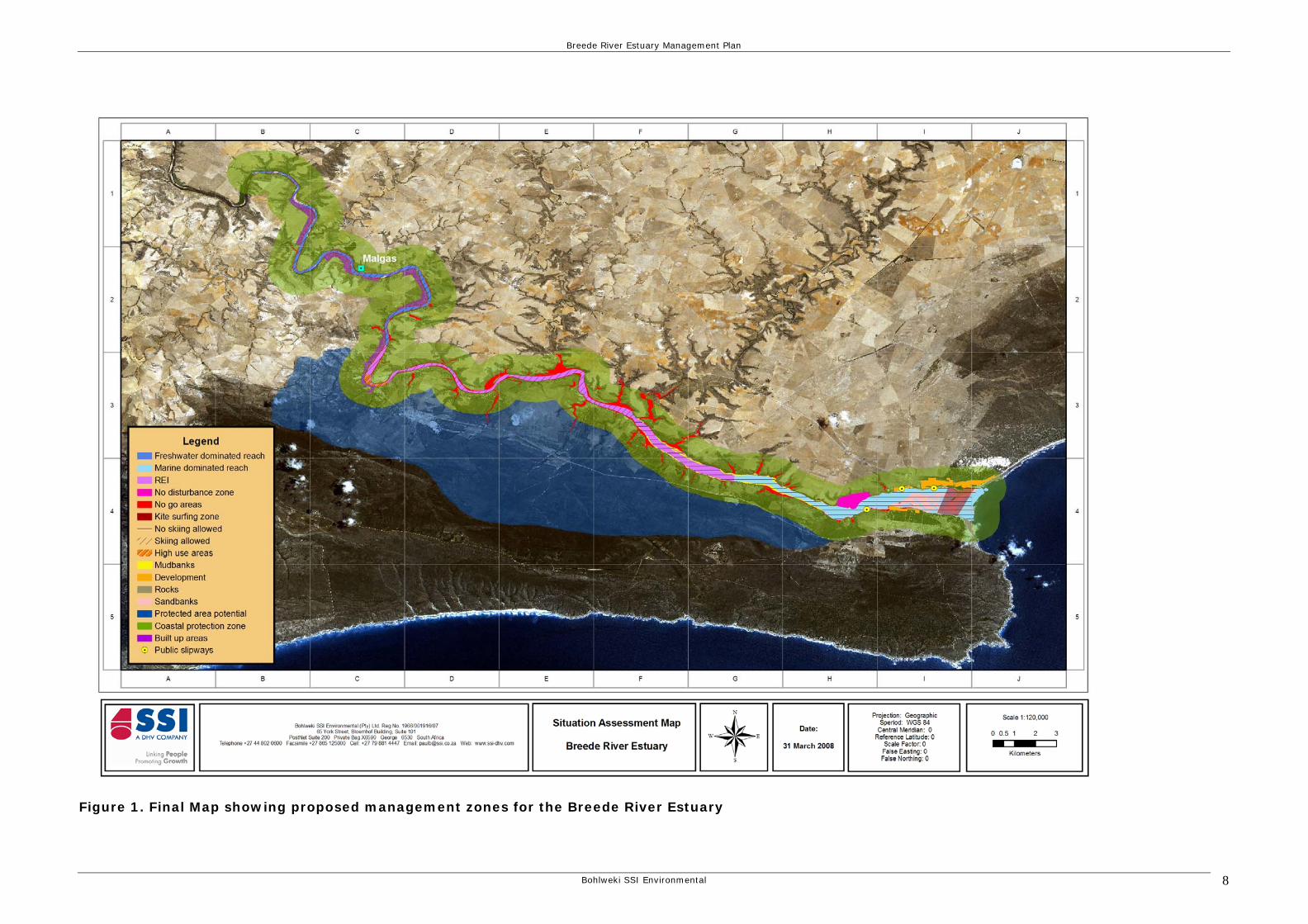
f. Define and map the geographic boundaries of the Breede River Estuary (Land, Sea and Air) in terms of the Integrated Coastal Management Bill (See CPZ on Figure 1).
g. To ensure social and economic development within the defined estuary area or Coastal Protection Zone (CPZ), only to the extent that it co-exists in terms of prioritized estuary imperatives.
h. Ensure that the relevant bylaws are created that will enable the management authority to give effect to the EstMP objectives and manage its allocated responsibility. Train staff and management committee members in the proper and effective application of the promulgated regulations and bylaws.
i. Ensure the development and implementation of an ongoing intensive public awareness campaign and environmental education programme.
j. Ensure that an interim process is created (by the LBRC, CapeNature, DEADP and local authorities) to identify, monitor, deal with undesirable and unsuitable developments and activities, whilst the Breede River Management Plan and enabling structures are being implemented. It is suggested that an experienced consultant be employed to guide the authorities through the first year.
k. Ensure that all new developments are planned to include energy efficient and water wise methods as well as waste management practices.
8
Breede River Estuary Management Plan
Figure 1. Final Map showing proposed management zones for the Breede River Estuary
Bohlweki SSI Environmental
Breede River Estuary Management Plan
4. Estuarine Zonation Plan & Operational Objectives 4.1. Estuarine Zonation Plan Estuaries can be zoned for different activities. These activities include recreational, development, subsistence fishing activities and non-consumptive activities (e.g. water ski). An Estuary Zonation Plan (EZP) for the Breede River Estuary was established through a public participation process where the requirements and rights of all individuals were taken into consideration. Several entry points to the estuary were identified. They are situated at the following localities:
• Malgas point, serving the community of Malgas • Two on the Witsand side serving the Witsand community • One on the Infanta side serving the local Infanta community.
Controlled access at the points listed above facilitate the monitoring of fishing activities in the estuary and give an indication of estuary usage. The following management zones were identified for the EZP and are spatially indicated on Figure 1 (GIS map): a. Coastal Protection Zone (CPZ)
This is an area extending 1km away and inland of the high water mark of the sea including estuarine waters.
b. No-go areas These areas have been highlighted as sensitive habitats that are vulnerable to excessive human movement and activities.
c. No disturbance zones (includes Sensitive eelgrass habitat) These areas have also been pointed out as being sensitive and should not be disturbed in any way by recreational or other activities.
d. Development area The development area is already developed with some scope for further development in terms of the IDP and SDF process that must be informed by the EstMP.
Bohlweki SSI Environmental 9
Breede River Estuary Management Plan
e. No-skiing zone This demarcated area is not suitable for water-ski activities for various reasons. Large areas of the No-Skiing zone are fringed by “No-go” areas that must be adhered to.
f. Skiing zone This area was demarcated for water-skiing activities. This does not mean that indiscriminate beaching of boats on the sides is allowed. As can be seen from GIS map 1, there are “No-go” areas associated with this zone that must be adhered to.
g. High use area The high use area has historically been used intensely due to the high concentration of people in this area. However, this area is also fringed with No-go areas that must be enforced.
h. Kite surfing zone This is the only area suitable for use by kite surfers. This area will be monitored and it may in future be necessary to regulate kite surfing in specific seasons in this area (pending the outcome of proposed research).
i. Rocks The rocky areas are limited to only a small section of the Breede Estuary and are deemed as an important habitat type. Access to the rocky area should be restricted.
j. Sand banks Sand bank habitat is well represented in the lower Breede Estuary. However, over-utilization of this habitat may be detrimental to the functioning of the estuary. Access should be restricted to permanently demarcated areas while sections should be left to act as re-stocking areas for the sand prawn, pencil bait and other invertebrates.
k. Mud banks Mud banks are limited and not readily accessible. Due to the sensitive nature of mud banks access should be restricted to those located on the southern shoreline along the Infanta shoreline.
l. REI The Riverine-Estuarine-Interface area is where incoming marine water wedge in under freshwater. The REI moves up and down with the tidal exchange and also moves up and down in the estuary
Bohlweki SSI Environmental 10
Breede River Estuary Management Plan
according to seasonal freshwater input variations. This is a sensitive ecotone that needs protection.
m. Freshwater dominated reach The freshwater dominated reach extends from the inland side of the REI to the upper freshwater reaches with no tidal influence. Representative sections of this reach must be protected. “No-go” areas located in this river reach are important from a conservation point of view.
n. Marine dominated reach The marine dominated reach extends from the REI to the sea. The ebb and flow habitats of this reach will be dominated by salt marsh, sand and mud bank habitat. “No-go” areas located in this river reach are also important from a conservation point of view.
4.2. Operational objectives The operational objectives are quantitative, measurable standards, target values, limits or thresholds of potential concerns relevant to the different zones and activities for the EZP. a. Coastal Protection Zone (CPZ) The full extent of the CPZ must be declared a sensitive zone in terms of the Integrated Coastal Management Bill ICMB. This area extending 1 km away and inland from the high water mark of the sea must be treated as a special rules area. All activities within the CPZ must adhere to the set criteria. b. No-go areas No access to the “No-go” areas should be allowed from any water craft, and no beaching of boats must be allowed. Permission to access these areas may be granted for emergencies and management only. c. No disturbance zones (including Sensitive eelgrass habitat) These highly sensitive areas should not be disturbed in any way. No activity that can leave any footprint or effect must be allowed. No beaching of boats must be allowed; no access of people must be allowed for any reason; no bait collection must be allowed; no anchoring of boats must be allowed as this will damage the sensitive bottom habitat. The only permissible activity is “no-impact” angling.
Bohlweki SSI Environmental 11
Breede River Estuary Management Plan
d. Development area Developments in this must be allowed within the demarcated areas for development as determined by the SDF. The SDF must recognize the sensitive nature of the CPZ, and be informed by the EstMP. Only developments for which the required municipal infrastructure and services are available should be permitted. No development should be permitted before there is proof of sufficient freshwater and proof of capacity to dispose safely of wet and dry waste. It is also important that special building regulations be passed by both local authorities for any structures to be build outside the development zones and or the SDF. e. No-skiing zone No skiing must be allowed in this zone and the “No-go” areas fringing this zone must be strictly enforced. f. Skiing zone Water ski activities are permissible in this area but fringing “No-go” areas must be enforced. All general water safety rules and measures must be strictly adhered to in this area. g. High use area In this area water recreation activities may be undertaken but only in a safe and environmentally acceptable manner. “No-go” areas should be enforced at all times. All general water safety rules and measures must be strictly adhered to in this area. h. Kite surfing zone Kite surfing activities are allowed in this area provided that the necessary safety rules are enforced. General water safety rules and measures must be enforced at all times. Special care should be taken by kite surfers to avoid immediate threats to birds in this sensitive birding habitat. (See closed season for kite surfing – pending research outcomes). i. Rocks Rock habitat must be protected and access should be restricted. j. Sand banks Sand banks are dynamic habitats that are vulnerable to incorrect harvesting of bait organisms. Bait collection should be controlled and permitted in demarcated areas only. Permits for bait collections must have special rules attached for these areas.
Bohlweki SSI Environmental 12
Breede River Estuary Management Plan
k. Mud banks Similar to sand banks, mud banks are dynamic habitats that are vulnerable to incorrect harvesting of bait organisms. These mud banks are also not easily accessible and may even poise a hazard to the inexperienced. Bait collection should be controlled and permitted in demarcated areas only. Permits for bait collections must have special rules attached for these areas. l. REI The different designated zones above located within the REI must be adhered to. Sensitive habitats located in the REI must be viewed as ecotone areas that are important for ecosystem processes. m. Freshwater dominated reach Designated zones (as described above) located in the freshwater dominated reaches are sensitive, hence the need to strictly enforce the activities permitted in each zone in this section of the Breede River Estuary. n. Marine dominated reach Habitat types in marine dominated reaches are sensitive and under severe pressure. Bait collection and recreational fishing must be properly controlled and enforced together with all the other designated zones. Suggested general considerations within designated zones • Careful consideration must be given to construction site selection
and site, as well as building design (including setback distance from the estuary, tides and flood levels, dune integrity, water and wastewater management systems, drainage, etc.).
• Align developments with agreed zonation for the estuary as stipulated in the local EstMP and IDP.
• Apply standards for resort ambience that are acceptable to local stakeholders (i.e. density, building height, landscaping, etc.).
• Manage construction activities and contractors, with penalties for damaging environmental features outside the development zone.
• Plan and carefully locate supporting infrastructure (transportation and road networks, waste collection and disposal, staff housing, etc.).
• Avoid direct discharge from the development, and associated drains, roadways, and parking areas into estuaries.
• Design wastewater system to allow the separation of grey water from sewage; and adequate treatment and disposal of sewage
Bohlweki SSI Environmental 13
Breede River Estuary Management Plan
Bohlweki SSI Environmental 14
effluent to prevent ground or surface water contamination. Consider the development of reed bed systems, which are low maintenance, require no energy or chemicals, and which provide additional wetland habitat for local fauna.
• Do not remove dune vegetation, sea grasses, reeds or other flora that protects the integrity of the Breede River Estuary (Taljaard 2007).
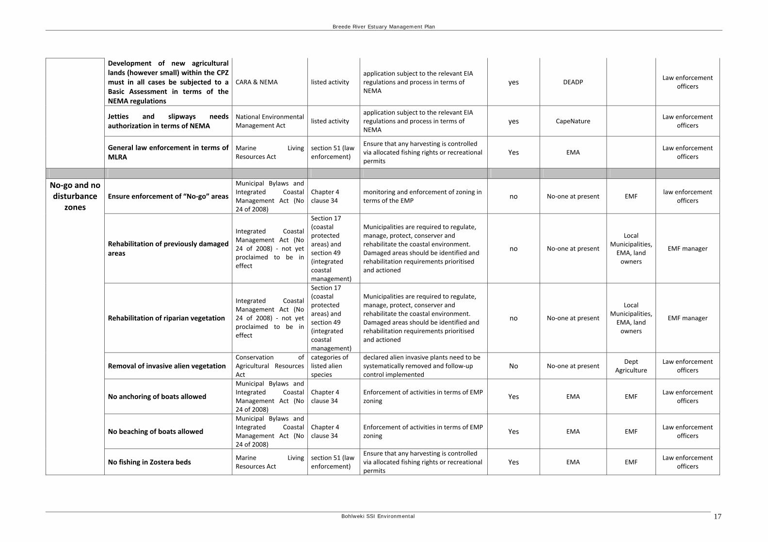
5. Management Action Plan The following management actions were identified to achieve the “operational objectives” set in terms of the EZP. Table 1 lists the proposed management actions for each designated zone.
Breede River Estuary Management Plan
Table 1. Management Action Plan (MAP)
Zone Management action required Applicable legislation Section of the applicable legislation
Actions Is this being addressed at present?
If so, by whom? If not, who is mandated?
What are the resource
requirements from the EMA
Integrated Coastal Management Act (No 24 of 2008) ‐ not yet proclaimed to be in effect
Section 25 Apply for legal status (have gazetted) of the setback line under the Integrated Coastal Management Act
No No‐one at present Minister EMF Manager
Municipal Systems Act (Act 32 of 2000)
Section 26(e) Ensure that setback lines are integrated into IDPs and SDFs
Yes No‐one at present Both district and local
municipalities EMF Manager
National Environmental Management Act
GN 386 activity 1m
Ensure that no development within 32m from the bank or 1:10 year flood line is undertaken without prior environmental authorisation
yes DEAT&/DEADP Law enforcement
officers
Setback line for development in development zone set at 5 meter contour
National Environmental Management Act
GN 386 activities 2,3,4,5,or 6
activities within 100m of the high water mark of the sea or estuary will require prior environmental authorisation
Yes DEAT&/DEADP Law enforcement
officers
Municipal Systems Act (Act 32 of 2000)
Section 26(e) Ensure that development needs and restrictions are integrated into IDPs and SDFs
No No‐one at present DEADP EMF Manager
Conservation of Agricultural Resources Act
Section 26(e) Ensure that sustainable and legal agricultural activities are protected
No No‐one at present Dept
Agriculture Law enforcement
officers
National Environmental Management Act
GN 386 and 387
will require prior authorisation before undertaking the activity
Yes DEADP Law enforcement
officers
“No‐go” areas for development and vegetation transformation
National Forests Act
Ensure that no protected trees or listed vegetation types are removed with the required permits having been obtained from DWAF
yes DWAFLaw enforcement
officers
Altitude restriction for aircraft operations
Ramsar listing adequate monitoring and law enforcement
No No‐one at present CAA Law enforcement
officers
Marine Living Resources Act
section 51 (law enforcement)
Ensure that any harvesting is controlled via allocated fishing rights or recreational permits
Yes EMA Law enforcement
officers
Control of harvesting of living resources Seashore Act
(NEMA:ICMA)
to be repealed by NEMA:ICMA once the act is duly promulgated by the Minister
Ensure that any harvesting is controlled via allocated fishing rights or recreational permits
No EMA Law enforcement
officers
Coastal Protection Zo
ne (C
PZ)
Ensure required freshwater input into Breede Estuary
National Water Act determine the ecological reserve for the river and the estuary
No DWAF DWAF Law enforcement
officers
Bohlweki SSI Environmental 15
Breede River Estuary Management Plan
National Water Act protection of the wetlands and vleis within the catchment area
DWAF DWAF Law enforcement
officers
Get authorization for any groundwater use in CPZ
National Water Act No DWAF DWAF/CMA Law enforcement
officers
National Water Act Yes DWAF Swellendam & Hessequa
Law enforcement officers
National Environmental Management Act
GN 386 Listed activity requiring basic assessment to be undertaken
yes DEADP Law enforcement
officers
Municipal bylaws Yes Swellendam & Hessequa
Law enforcement
officers
LUPO requires appropriate rezoning or consent use
Yes Swellendam & Hessequa
Law enforcement
officers
Waste disposal facilities
Integrated Coastal Management Act (No 24 of 2008) ‐ not yet proclaimed to be in effect
Chapter 8 section 69
Ensure that disposal of water containing waste into the estuarine environment is controlled and a coastal waters discharge permit issued
Yes DWAF DEAT/DWAF Law enforcement
officers
Municipal bylaws building plan approval process Yes Swellendam & Hessequa
Law enforcement
officers
Special building regulations title deed restriction
approval from De Mond (pty) Ltd prior to any buildings for trade or commercial use in the CapeNatue De Mond Reserve
Yes land ownerLaw enforcement
officers
Conservation of Agricultural Resources Act
restoration of degraded agricultural lands No No‐one at present Dept
Agriculture Law enforcement
officers
Rehabilitation of previously damaged areas
Integrated Coastal Management Act (No 24 of 2008) ‐ not yet proclaimed to be in effect
Section 17 (coastal protected areas) and section 49 (integrated coastal management)
Municipalities are required to regulate, manage, protect, conserver and rehabilitate the coastal environment. Damaged areas should be identified and rehabilitation requirements prioritised and actioned
no No‐one at present Local
Municipalities Law enforcement
officers
Rehabilitation of riparian vegetation
Integrated Coastal Management Act (No 24 of 2008) ‐ not yet proclaimed to be in effect
Section 17 (coastal protected areas) and section 49 (integrated coastal management)
Municipalities are required to regulate, manage, protect, conserver and rehabilitate the coastal environment. Damaged areas should be identified and rehabilitation requirements prioritised and actioned
no No‐one at present Local
Municipalities EMF Manager
Conservation of Agricultural Resources Act
categories of listed alien species
declared alien invasive plants need to be systematically removed and follow‐up control implemented
No No‐one at present Dept
Agriculture Law enforcement
officers Removal of invasive alien vegetation particularly in riparian zones and within aquatic ecosystems National Environmental
Management Act
Bohlweki SSI Environmental 16
Breede River Estuary Management Plan
Development of new agricultural lands (however small) within the CPZ must in all cases be subjected to a Basic Assessment in terms of the NEMA regulations
CARA & NEMA listed activity application subject to the relevant EIA regulations and process in terms of NEMA
yes DEADP Law enforcement
officers
Jetties and slipways needs authorization in terms of NEMA
National Environmental Management Act
listed activity application subject to the relevant EIA regulations and process in terms of NEMA
yes CapeNature Law enforcement
officers
General law enforcement in terms of MLRA
Marine Living Resources Act
section 51 (law enforcement)
Ensure that any harvesting is controlled via allocated fishing rights or recreational permits
Yes EMA Law enforcement
officers
Ensure enforcement of “No‐go” areas
Municipal Bylaws and Integrated Coastal Management Act (No 24 of 2008)
Chapter 4 clause 34
monitoring and enforcement of zoning in terms of the EMP
no No‐one at present EMF law enforcement
officers
Rehabilitation of previously damaged areas
Integrated Coastal Management Act (No 24 of 2008) ‐ not yet proclaimed to be in effect
Section 17 (coastal protected areas) and section 49 (integrated coastal management)
Municipalities are required to regulate, manage, protect, conserver and rehabilitate the coastal environment. Damaged areas should be identified and rehabilitation requirements prioritised and actioned
no No‐one at present
Local Municipalities, EMA, land owners
EMF manager
Rehabilitation of riparian vegetation
Integrated Coastal Management Act (No 24 of 2008) ‐ not yet proclaimed to be in effect
Section 17 (coastal protected areas) and section 49 (integrated coastal management)
Municipalities are required to regulate, manage, protect, conserver and rehabilitate the coastal environment. Damaged areas should be identified and rehabilitation requirements prioritised and actioned
no No‐one at present
Local Municipalities, EMA, land owners
EMF manager
Removal of invasive alien vegetation Conservation of Agricultural Resources Act
categories of listed alien species
declared alien invasive plants need to be systematically removed and follow‐up control implemented
No No‐one at present Dept
Agriculture Law enforcement
officers
No anchoring of boats allowed
Municipal Bylaws and Integrated Coastal Management Act (No 24 of 2008)
Chapter 4 clause 34
Enforcement of activities in terms of EMP zoning
Yes EMA EMF Law enforcement
officers
No beaching of boats allowed
Municipal Bylaws and Integrated Coastal Management Act (No 24 of 2008)
Chapter 4 clause 34
Enforcement of activities in terms of EMP zoning
Yes EMA EMF Law enforcement
officers
No‐go and no disturbance
zones
No fishing in Zostera beds Marine Living Resources Act
section 51 (law enforcement)
Ensure that any harvesting is controlled via allocated fishing rights or recreational permits
Yes EMA EMF Law enforcement
officers
Bohlweki SSI Environmental 17
Breede River Estuary Management Plan
No building of any structures allowed in these area below 5 meter contour
Integrated Coastal Management Act (No 24 of 2008) ‐ not yet proclaimed to be in effect
Chapter 4 clause 34
monitoring and enforcement of zoning/ objectives in terms of the EMP
no No‐one at present EMF Law enforcement
officers
Ensure that all new developments are located within the designated zones according to the SDF
Municipal Systems Act (Act 32 of 2000)
Implementation of SDF requirements including monitoring
yes Swellendam & Hessequa
Law enforcement
officers
No developments below the 5 meter contour
Integrated Coastal Management Act (No 24 of 2008) ‐ not yet proclaimed to be in effect
Chapter 4 clause 34
Enforcement of activities in terms of EMP zoning
no No‐one at present EMF Law enforcement
officers
Building plans needs to be approved by local authority
Municipal Bylaws Implementation of town planning scheme requirements including monitoring
yes Swellendam & Hessequa
Law enforcement
officers
SDF must not be in conflict with EstMP and or requirements of the CPZ
Integrated Coastal Management Act (No 24 of 2008) ‐ not yet proclaimed to be in effect
Chapter 4 clause 34
Enforcement of activities in terms of EMP zoning
no No‐one at present EMF Law enforcement
officers
All developments not complying with the SDF must go though a stringent environmental authorization process in terms of NEMA. Additional special planning requirements within the CPZ for developments must be adhered to at all times
National Environmental Management Act
if listed activity application subject to the relevant EIA regulations and process in terms of NEMA
yes DEADP Law enforcement
officers
Proposed new jetties and slipways must complying with NEMA regulations, special planning regulations in the CPZ
National Environmental Management Act
listed activity application subject to the relevant EIA regulations and process in terms of NEMA
yes DEADP Law enforcement
officers
Any developments in rural areas outside the SDF must comply with the special planning and building regulations applicable in the CPZ
Municipal Bylaws & NEMA
possible listed activity
application subject to the relevant EIA regulations and process in terms of NEMA
yes Swellendam &
Hessequa & DEADP
Law enforcement officers
Development zone
Any desalination plants must be authorized through the NWA and NEMA
National Environmental Management Act and National Water Act
listed activity application subject to the relevant EIA regulations and process in terms of NEMA
yes DEADP Law enforcement
officers
High use area Ensure that all general water safety rules and measures are enforced
Municipal Bylaws and Integrated Coastal Management Act (No 24 of 2008)
Chapter 4 clause 34
Enforcement of activities in terms of EMP zoning
yes EMA Law enforcement
officers
Bohlweki SSI Environmental 18
Breede River Estuary Management Plan
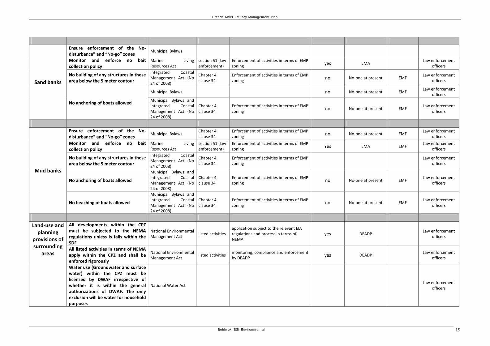
Ensure enforcement of the No‐disturbance” and “No‐go” zones
Municipal Bylaws
Monitor and enforce no bait collection policy
Marine Living Resources Act
section 51 (law enforcement)
Enforcement of activities in terms of EMP zoning
yes EMA Law enforcement
officers
No building of any structures in these area below the 5 meter contour
Integrated Coastal Management Act (No 24 of 2008)
Chapter 4 clause 34
Enforcement of activities in terms of EMP zoning
no No‐one at present EMF Law enforcement
officers
Municipal Bylaws no No‐one at present EMF Law enforcement
officers
Sand banks
No anchoring of boats allowed Municipal Bylaws and Integrated Coastal Management Act (No 24 of 2008)
Chapter 4 clause 34
Enforcement of activities in terms of EMP zoning
no No‐one at present EMF Law enforcement
officers
Ensure enforcement of the No‐disturbance” and “No‐go” zones
Municipal Bylaws Chapter 4 clause 34
Enforcement of activities in terms of EMP zoning
no No‐one at present EMF Law enforcement
officers
Monitor and enforce no bait collection policy
Marine Living Resources Act
section 51 (law enforcement)
Enforcement of activities in terms of EMP zoning
Yes EMA EMF Law enforcement
officers
No building of any structures in these area below the 5 meter contour
Integrated Coastal Management Act (No 24 of 2008)
Chapter 4 clause 34
Enforcement of activities in terms of EMP zoning
Law enforcement
officers
No anchoring of boats allowed
Municipal Bylaws and Integrated Coastal Management Act (No 24 of 2008)
Chapter 4 clause 34
Enforcement of activities in terms of EMP zoning
no No‐one at present EMF Law enforcement
officers
Mud banks
No beaching of boats allowed
Municipal Bylaws and Integrated Coastal Management Act (No 24 of 2008)
Chapter 4 clause 34
Enforcement of activities in terms of EMP zoning
no No‐one at present EMF Law enforcement
officers
All developments within the CPZ must be subjected to the NEMA regulations unless is falls within the SDF
National Environmental Management Act
listed activities application subject to the relevant EIA regulations and process in terms of NEMA
yes DEADP Law enforcement
officers
All listed activities in terms of NEMA apply within the CPZ and shall be enforced rigorously
National Environmental Management Act
listed activities monitoring, compliance and enforcement by DEADP
yes DEADP Law enforcement
officers
Land‐use and planning
provisions of surrounding
areas
Water use (Groundwater and surface water) within the CPZ must be licensed by DWAF irrespective of whether it is within the general authorizations of DWAF. The only exclusion will be water for household purposes
National Water Act Law enforcement
officers
Bohlweki SSI Environmental 19
Breede River Estuary Management Plan
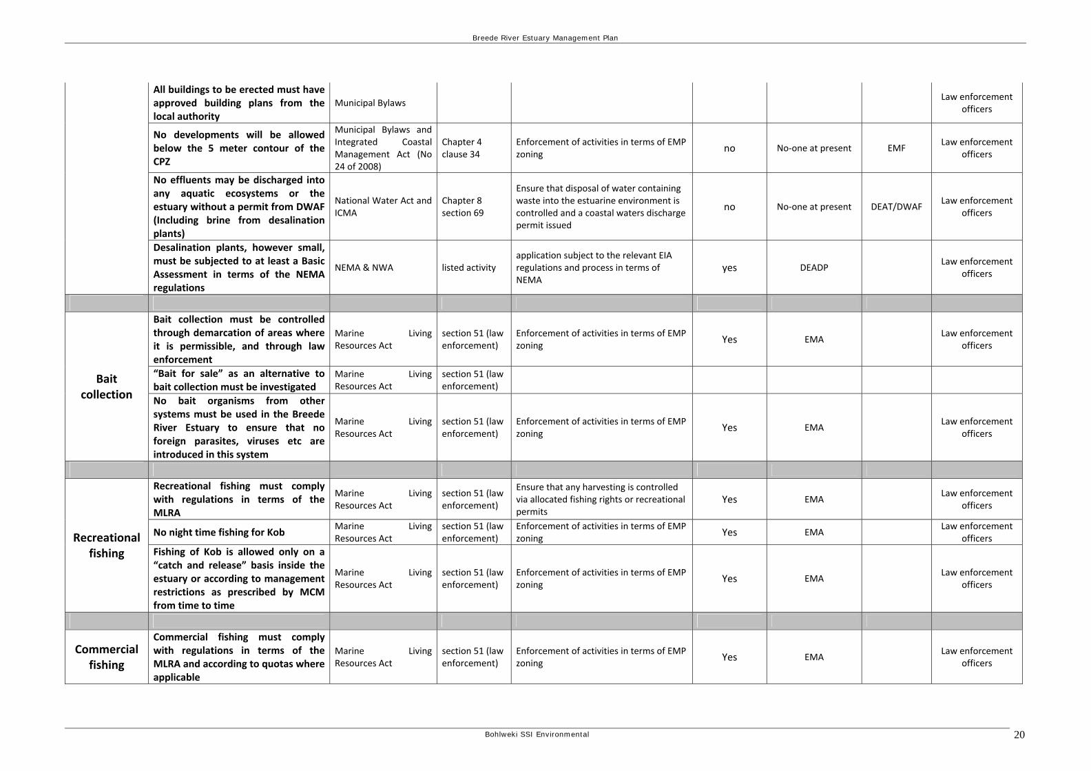
All buildings to be erected must have approved building plans from the local authority
Municipal Bylaws Law enforcement
officers
No developments will be allowed below the 5 meter contour of the CPZ
Municipal Bylaws and Integrated Coastal Management Act (No 24 of 2008)
Chapter 4 clause 34
Enforcement of activities in terms of EMP zoning
no No‐one at present EMF Law enforcement
officers
No effluents may be discharged into any aquatic ecosystems or the estuary without a permit from DWAF (Including brine from desalination plants)
National Water Act and ICMA
Chapter 8 section 69
Ensure that disposal of water containing waste into the estuarine environment is controlled and a coastal waters discharge permit issued
no No‐one at present DEAT/DWAF Law enforcement
officers
Desalination plants, however small, must be subjected to at least a Basic Assessment in terms of the NEMA regulations
NEMA & NWA listed activity application subject to the relevant EIA regulations and process in terms of NEMA
yes DEADP Law enforcement
officers
Bait collection must be controlled through demarcation of areas where it is permissible, and through law enforcement
Marine Living Resources Act
section 51 (law enforcement)
Enforcement of activities in terms of EMP zoning
Yes EMA Law enforcement
officers
“Bait for sale” as an alternative to bait collection must be investigated
Marine Living Resources Act
section 51 (law enforcement)
Bait collection No bait organisms from other
systems must be used in the Breede River Estuary to ensure that no foreign parasites, viruses etc are introduced in this system
Marine Living Resources Act
section 51 (law enforcement)
Enforcement of activities in terms of EMP zoning
Yes EMA Law enforcement
officers
Recreational fishing must comply with regulations in terms of the MLRA
Marine Living Resources Act
section 51 (law enforcement)
Ensure that any harvesting is controlled via allocated fishing rights or recreational permits
Yes EMA Law enforcement
officers
No night time fishing for Kob Marine Living Resources Act
section 51 (law enforcement)
Enforcement of activities in terms of EMP zoning
Yes EMA Law enforcement
officers Recreational fishing Fishing of Kob is allowed only on a
“catch and release” basis inside the estuary or according to management restrictions as prescribed by MCM from time to time
Marine Living Resources Act
section 51 (law enforcement)
Enforcement of activities in terms of EMP zoning
Yes EMA Law enforcement
officers
Commercial fishing
Commercial fishing must comply with regulations in terms of the MLRA and according to quotas where applicable
Marine Living Resources Act
section 51 (law enforcement)
Enforcement of activities in terms of EMP zoning
Yes EMA Law enforcement
officers
Bohlweki SSI Environmental 20
Breede River Estuary Management Plan
Bohlweki SSI Environmental 21
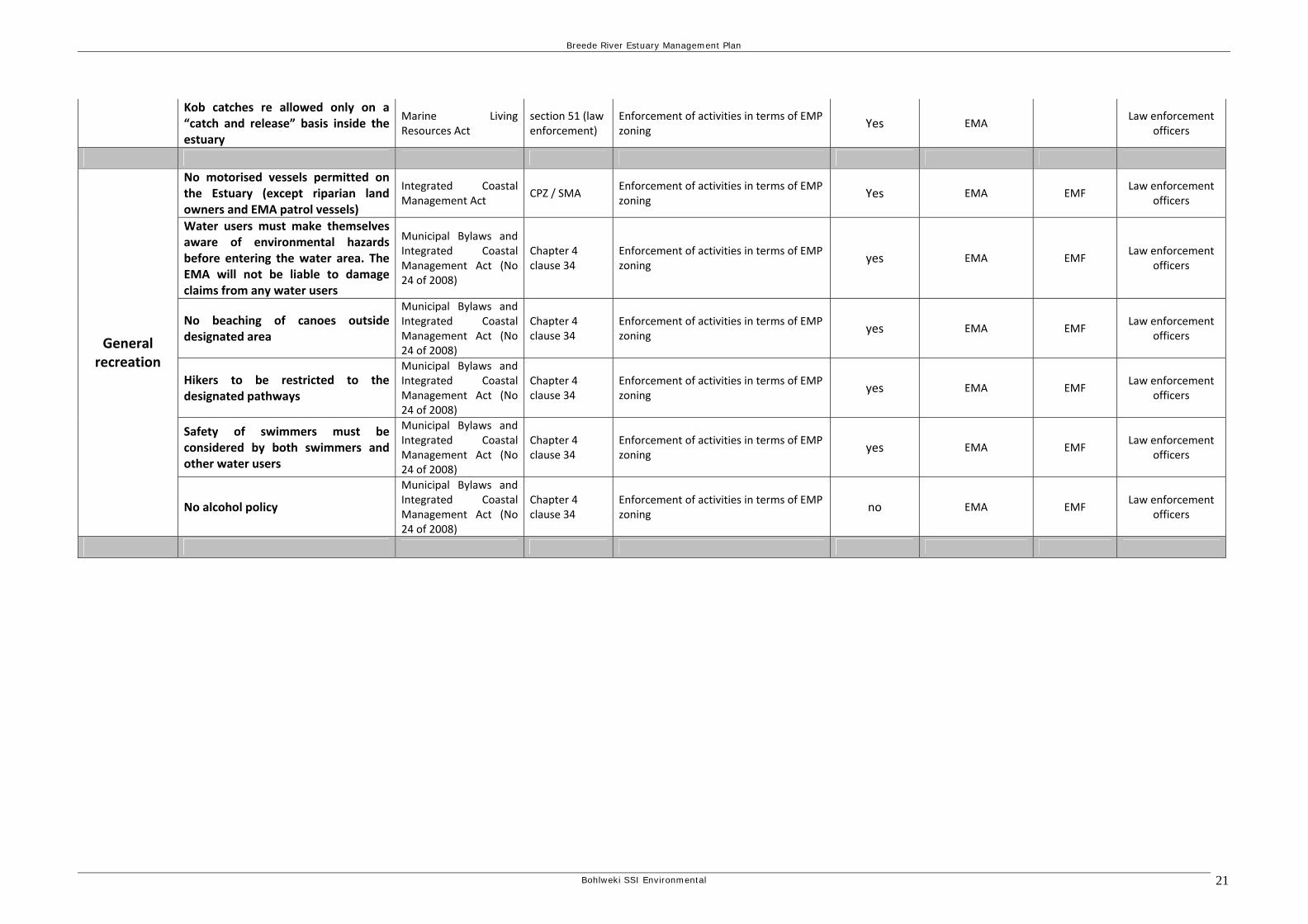
Kob catches re allowed only on a “catch and release” basis inside the estuary
Marine Living Resources Act
section 51 (law enforcement)
Enforcement of activities in terms of EMP zoning
Yes EMALaw enforcement
officers
No motorised vessels permitted on the Estuary (except riparian land owners and EMA patrol vessels)
Integrated Coastal Management Act
CPZ / SMA Enforcement of activities in terms of EMP zoning
Yes EMA EMF Law enforcement
officers
Water users must make themselves aware of environmental hazards before entering the water area. The EMA will not be liable to damage claims from any water users
Municipal Bylaws and Integrated Coastal Management Act (No 24 of 2008)
Chapter 4 clause 34
Enforcement of activities in terms of EMP zoning
yes EMA EMF Law enforcement
officers
No beaching of canoes outside designated area
Municipal Bylaws and Integrated Coastal Management Act (No 24 of 2008)
Chapter 4 clause 34
Enforcement of activities in terms of EMP zoning
yes EMA EMF Law enforcement
officers
Hikers to be restricted to the designated pathways
Municipal Bylaws and Integrated Coastal Management Act (No 24 of 2008)
Chapter 4 clause 34
Enforcement of activities in terms of EMP zoning
yes EMA EMF Law enforcement
officers
Safety of swimmers must be considered by both swimmers and other water users
Municipal Bylaws and Integrated Coastal Management Act (No 24 of 2008)
Chapter 4 clause 34
Enforcement of activities in terms of EMP zoning
yes EMA EMF Law enforcement
officers
General recreation
No alcohol policy
Municipal Bylaws and Integrated Coastal Management Act (No 24 of 2008)
Chapter 4 clause 34
Enforcement of activities in terms of EMP zoning
no EMA EMF Law enforcement
officers
Breede River Estuary Management Plan
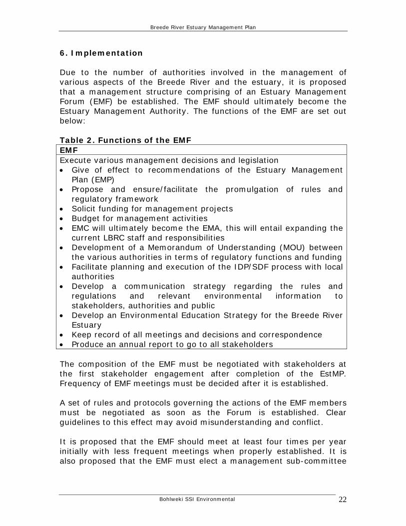
6. Implementation Due to the number of authorities involved in the management of various aspects of the Breede River and the estuary, it is proposed that a management structure comprising of an Estuary Management Forum (EMF) be established. The EMF should ultimately become the Estuary Management Authority. The functions of the EMF are set out below: Table 2. Functions of the EMF EMF Execute various management decisions and legislation • Give of effect to recommendations of the Estuary Management
Plan (EMP) • Propose and ensure/facilitate the promulgation of rules and
regulatory framework • Solicit funding for management projects • Budget for management activities • EMC will ultimately become the EMA, this will entail expanding the
current LBRC staff and responsibilities • Development of a Memorandum of Understanding (MOU) between
the various authorities in terms of regulatory functions and funding • Facilitate planning and execution of the IDP/SDF process with local
authorities • Develop a communication strategy regarding the rules and
regulations and relevant environmental information to stakeholders, authorities and public
• Develop an Environmental Education Strategy for the Breede River Estuary
• Keep record of all meetings and decisions and correspondence • Produce an annual report to go to all stakeholders The composition of the EMF must be negotiated with stakeholders at the first stakeholder engagement after completion of the EstMP. Frequency of EMF meetings must be decided after it is established. A set of rules and protocols governing the actions of the EMF members must be negotiated as soon as the Forum is established. Clear guidelines to this effect may avoid misunderstanding and conflict. It is proposed that the EMF should meet at least four times per year initially with less frequent meetings when properly established. It is also proposed that the EMF must elect a management sub-committee
Bohlweki SSI Environmental 22
Breede River Estuary Management Plan
consisting of not more than four members to attend to urgent ad hoc management matters. 6.1. Dedicated estuary management office When the EMF is functional a dedicated office with staff should be established. This may easily be achieved in the Breede River Estuary by expanding the current LBRC staff and responsibilities. The staff composition for this proposed management structure should consist of the following minimum staff and expertise:
• Office manager for the EMF office • Secretary/receptionist • Law enforcement officers - 4 minimum (Compliance officers) • Land-use planning and building inspector – 1 minimum • Extention/information officer (Stewardship) – 1 minimum
6.2. Estuarine experts Estuarine experts for fish, birds, vegetation, aquatic ecosystems etc. should be employed in an Estuary Management Unit to collectively service all estuaries in the C.A.P.E. domain. This may be contractual positions or permanent depending on funding. It may be necessary to employ a town and regional planner to assist with planning issues around developments in sensitive zones. This team could become permanently involved in priority research programmes as identified by the C.A.P.E. Estuaries Programme. It is proposed that the estuarine experts should determine and describe the “threshold of acceptable change” for each relevant parameter to be monitored. 6.3. Interim management arrangements The development and implementation of the Breede River Estuary Management Plan will not happen overnight. In the meantime, undesirable and unsuitable developments and activities will continue and even increase in anticipation of future controls. (The current official structures and enforcement capabilities are severely lacking in ability to deal with both formal applications and illegal developments). The potential degradation that can take place in the interim period may take years to rectify or in many cases may not be reversible at all. It is suggested that an interim process be put in place incorporating the following: (Hessequa Municipality has already
Bohlweki SSI Environmental 23
Breede River Estuary Management Plan
taken the lead and is in the process of establishing “Co-Operative Eden Compliance Forum”)
• The formation of a committee which, during the implementation period, will monitor any formal applications or unauthorized activities that occur within the Breeder River Estuary.
• This committee shall meet monthly with relevant authorities and stakeholders to review developments and co- ordinate actions.
• An important function of the committee will be to assess current National, Provincial, and Local legislation, in context of its effectiveness to support the identified objectives of the BRMP. It shall where necessary motivate changes at all levels of legislation, but particularly in respect of Local Bylaws.
• The first actions of this committee should be to compile a detailed list of developments, activities and impacts that need priority attention. Action plans need to be developed and urgently implemented, including appropriate interventions.
• The composition of the committee could be made up of the following parties. Municipal Environmental Managers (Swellendam and Hessequa), Chairman Lower Breede River Conservancy, Town Planners (Swellendam and Hessequa), CapeNature
• Participating Authorities/Parties should include: DEA&P, Cape Nature, DWAF, Department of Agriculture, CSIR, Marine and Coastal Management, Rate Payers Association (Swellendam and Hessequa)
• It may be expedient to hire a suitable qualified contract worker/consultant to guide the committee through the initial year (There are a large number of legal and environmental issues at stake that has to be considered).
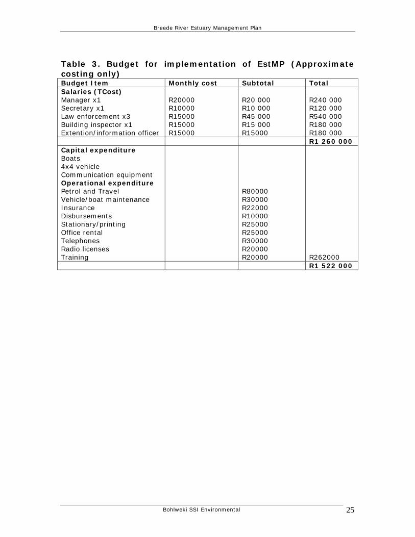
6.4. Funding mechanism for EMF office Funding the full time positions will be a challenge but is going to be of fundamental importance if the EstMP is to be implemented properly. The ideal is that all the relevant authorities investigate ways of co-funding the implementation of the EstMP through dedicated office with staff. The existing funding should be supplemented initially but funding should be split on a percentage basis into the future. This may release money from certain sectors for specific projects. A proposed total budget to get a solid team of dedicated staff going with running expenses would be the following:
Bohlweki SSI Environmental 24
Breede River Estuary Management Plan
Table 3. Budget for implementation of EstMP (Approximate costing only) Budget Item Monthly cost Subtotal Total Salaries (TCost) Manager x1 Secretary x1 Law enforcement x3 Building inspector x1 Extention/information officer
R20000 R10000 R15000 R15000 R15000
R20 000 R10 000 R45 000 R15 000 R15000
R240 000 R120 000 R540 000 R180 000 R180 000
R1 260 000 Capital expenditure Boats 4x4 vehicle Communication equipment Operational expenditure Petrol and Travel Vehicle/boat maintenance Insurance Disbursements Stationary/printing Office rental Telephones Radio licenses Training
R80000 R30000 R22000 R10000 R25000 R25000 R30000 R20000 R20000
R262000
R1 522 000
Bohlweki SSI Environmental 25
Breede River Estuary Management Plan
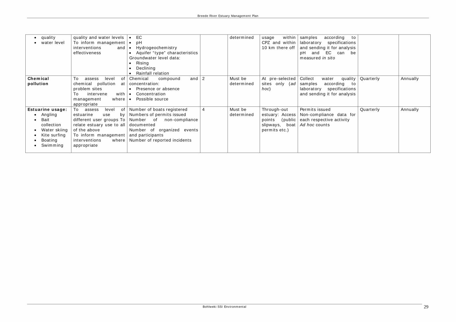
7. Monitoring and evaluation To enable sustainable management of estuaries, it is imperative to collection and analyze appropriate and reliable quantitative data. The requirements for monitoring are estuary specific. The following is the proposed monitoring and evaluation plan. The key elements of the monitoring and evaluation plan are:
• Monitoring objectives • The selection of monitoring parameters (indicators) • The required staff and/or qualified personnel • The required budget • Refinement of spatial and temporal scales • Appropriate sampling and analytical techniques • Evaluation and Reporting • Integration of results into MAP • Dissemination of information to Interested and Affected Parties
The following aspects were identified as a minimum in terms of the monitoring plan: a. Monitoring of biota as an indication of ecosystem health:
• Microalgae • Zooplankton • Macrophytes • Macrobentos • Ichthyofauna • Birds
b. Monitoring exploitation of living resources • Fish • Bait
c. Monitoring water quality in the: • Freshwater dominated reach • Marine dominated reach • REI reach
d. Bacteriological monitoring at pre-selected sites of potential concern e. Monitoring sedimentation in pre-selected problem areas f. Monitor groundwater
• quality • water level
g. Monitor chemical pollution on an ad hoc basis h. Monitor estuarine usage in different zones – carrying capacity
• Angling • Bait collection • Water skiing
Bohlweki SSI Environmental 26
Breede River Estuary Management Plan
Bohlweki SSI Environmental 27
• Kite surfing • Boating • Swimming
Because evaluation of the EMP will become the responsibility of the EMF, the evaluation process must consist of a number of technical working groups or a single working group consisting of people from the different fields. Fields of expertise required for this purpose must consist of the following:
• Conservation, • Social (and cultural) issues, • Land-use and infrastructure development, • Water quality and quantity (water supply/demand and waste) • Exploitation of living resources • Stewardship
Table 4 contains the proposed monitoring plan for the Breede River Estuary.
Breede River Estuary Management Plan
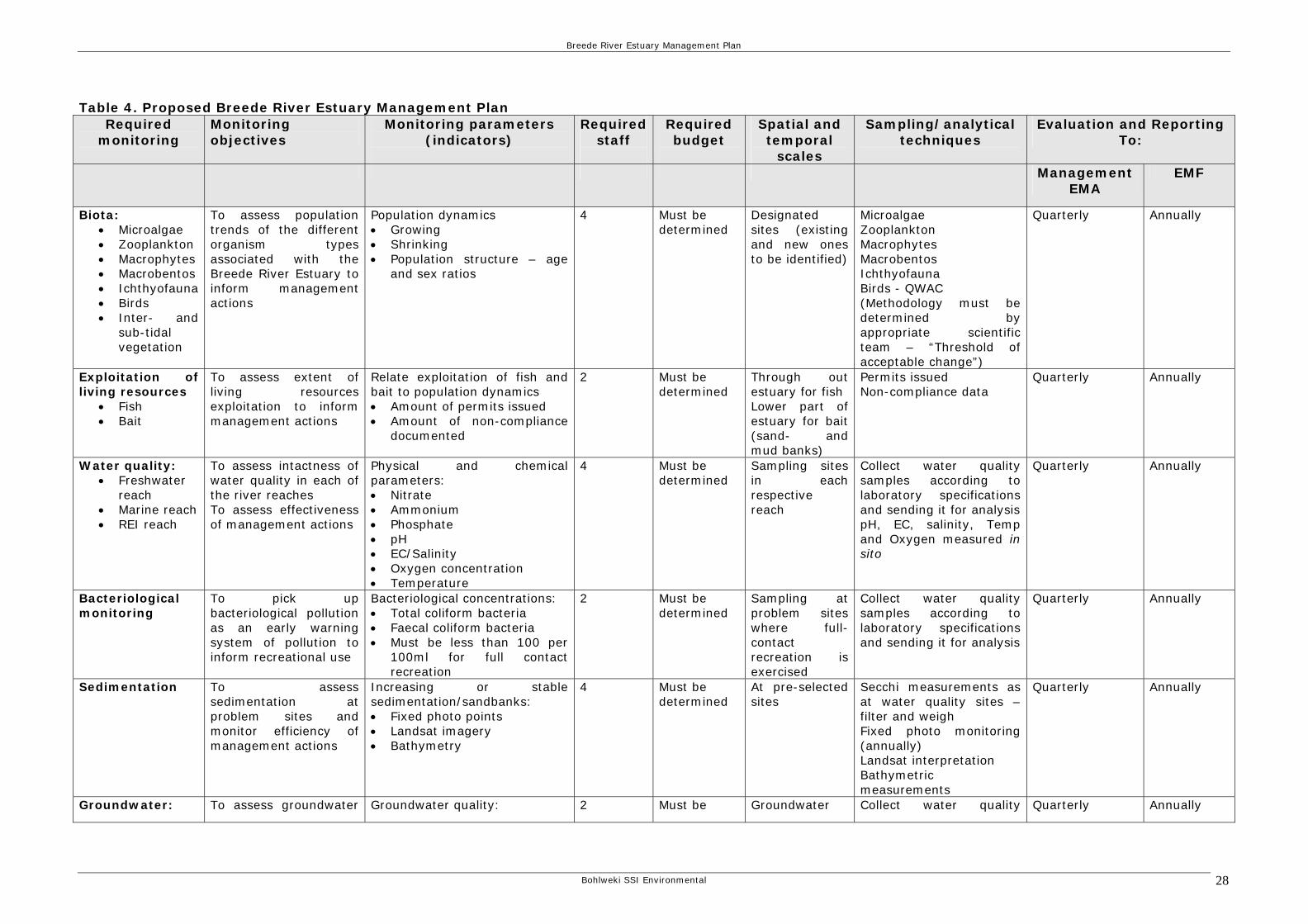
Table 4. Proposed Breede River Estuary Management Plan Required
monitoring
Monitoring objectives
Monitoring parameters (indicators)
Required staff
Required budget
Spatial and temporal
scales
Sampling/analytical techniques
Evaluation and Reporting To:
Management EMA
EMF
Biota: • Microalgae • Zooplankton • Macrophytes • Macrobentos • Ichthyofauna • Birds • Inter- and
sub-tidal vegetation
To assess population trends of the different organism types associated with the Breede River Estuary to inform management actions
Population dynamics • Growing • Shrinking • Population structure – age
and sex ratios
4 Must be determined
Designated sites (existing and new ones to be identified)
Microalgae Zooplankton Macrophytes Macrobentos Ichthyofauna Birds - QWAC (Methodology must be determined by appropriate scientific team – “Threshold of acceptable change”)
Quarterly Annually
Exploitation of living resources
• Fish • Bait
To assess extent of living resources exploitation to inform management actions
Relate exploitation of fish and bait to population dynamics • Amount of permits issued • Amount of non-compliance
documented
2 Must be determined
Through out estuary for fish Lower part of estuary for bait (sand- and mud banks)
Permits issued Non-compliance data
Quarterly Annually
Water quality: • Freshwater
reach • Marine reach • REI reach
To assess intactness of water quality in each of the river reaches To assess effectiveness of management actions
Physical and chemical parameters: • Nitrate • Ammonium • Phosphate • pH • EC/Salinity • Oxygen concentration • Temperature
4 Must be determined
Sampling sites in each respective reach
Collect water quality samples according to laboratory specifications and sending it for analysis pH, EC, salinity, Temp and Oxygen measured in sito
Quarterly Annually
Bacteriological monitoring
To pick up bacteriological pollution as an early warning system of pollution to inform recreational use
Bacteriological concentrations: • Total coliform bacteria • Faecal coliform bacteria • Must be less than 100 per
100ml for full contact recreation
2 Must be determined
Sampling at problem sites where full-contact recreation is exercised
Collect water quality samples according to laboratory specifications and sending it for analysis
Quarterly Annually
Sedimentation To assess sedimentation at problem sites and monitor efficiency of management actions
Increasing or stable sedimentation/sandbanks: • Fixed photo points • Landsat imagery • Bathymetry
4 Must be determined
At pre-selected sites
Secchi measurements as at water quality sites – filter and weigh Fixed photo monitoring (annually) Landsat interpretation Bathymetric measurements
Quarterly Annually
Groundwater: To assess groundwater Groundwater quality: 2 Must be Groundwater Collect water quality Quarterly Annually
Bohlweki SSI Environmental 28
Breede River Estuary Management Plan
Bohlweki SSI Environmental 29
• quality • water level
quality and water levels To inform management interventions and effectiveness
• EC • pH • Hydrogeochemistry • Aquifer “type” characteristics Groundwater level data: • Rising • Declining • Rainfall relation
determined usage within CPZ and within 10 km there off
samples according to laboratory specifications and sending it for analysis pH and EC can be measured in sito
Chemical pollution
To assess level of chemical pollution at problem sites To intervene with management where appropriate
Chemical compound and concentration: • Presence or absence • Concentration • Possible source
2 Must be determined
At pre-selected sites only (ad hoc)
Collect water quality samples according to laboratory specifications and sending it for analysis
Quarterly Annually
Estuarine usage: • Angling • Bait
collection • Water skiing • Kite surfing • Boating • Swimming
To assess level of estuarine use by different user groups To relate estuary use to all of the above To inform management interventions where appropriate
Number of boats registered Numbers of permits issued Number of non-compliance documented Number of organized events and participants Number of reported incidents
4 Must be determined
Through-out estuary: Access points (public slipways, boat permits etc.)
Permits issued Non-compliance data for each respective activity Ad hoc counts
Quarterly Annually
Breede River Estuary Management Plan
8. Research Research is an integral part of any management approach. With management actions and monitoring, existing and new questions will arise that needs to be addressed through proper research. The following is a preliminary list of the basic research required for effective monitoring of the Breede River Estuary. Research is listed in priority order.
• Determine the impact of fishing activities on fish stocks, particular focus of Kob (Dusky kob)
• Determine the sediment dynamics within the Breede River Estuary, both marine and catchment sediments
• Determine the reason for the perceived erosion in the catchment by assessing land-use through landsat to indicate sediment yields
• Determine the freshwater requirement for the Breede River Estuary
• Determine the quality of the water entering the Breede • Determine ground water surface water interface with Breede
River Estuary. Map aquifer types and potential yields of groundwater discharge or recharge to and from the estuary
• Determine the importance of sub-surface water input for the health of the river
• Determine the impacts of existing farming activities on the water quality and sediment yields in the estuary
• Determine the impact of boats on the river and river banks • Determine the impacts of aquatic recreation activities on the
estuary (carrying capacity must be determined) Research funding mechanisms must be investigated as part of the implementation phase of the EstMP. It is proposed that a team of experts be identified to form a research unit/consortium to undertake the baseline and other priority research in all estuaries within the C.A.P.E. domain. Relevant scientific and management information must be made accessible to the general public. Use information brochures, posters and web site to distribute information. Some workshops can be arranged to introduce the community to the use of scientific information in applied management.
Bohlweki SSI Environmental 27
Breede River Estuary Management Plan
9. References: Lamberth S.J. 2007. Sustainable Fishing in Estuaries. C.A.P.E. Estuaries Guideline 7, Version1. Taljaard S, Van Niekerk L & Huizinga P.2001. Breede River Estuary EFR/RDM Study. Specialist report on physical dynamics and water quality. CSIR report ENV-S-C 2001. Taljaard S. 2002. Intermediate Determination of Resource Directed Measures for the Breede River Estuary. CSIR Report ENV-S-C 2002-020/A. Taljaard S. 2007. Interpretation of Legislation pertaining to Management of Environmental Threats within Estuaries. C.A.P.E. Estuaries Guideline 1, Version 1. Taljaard S. and Van Niekerk L. 2007. Promoting appropriate Water Quantity and Quality Management in Estuaries. C.A.P.E. Estuaries Guideline 5, Version1. Taljaard S. and Van Niekerk L. 2007. Monitoring Programmes for Implementation in South African Estuaries. C.A.P.E. Estuaries Guideline 6, Version1 Theron A. 2007. Preliminary zoning of human use in Cape Estuaries based on sensitivity mapping and carrying capacity. C.A.P.E. Estuaries Guideline 4, Version 1.
Van Niekerk L and Taljaard S. 2007. Proposed Generic Framework for Estuarine Management Plan. C.A.P.E. Generic Estuary Management Plan, Version 1. Wooldridge T. 2007. Collection of Bait Organisms in Estuaries. C.A.P.E. Estuaries Guideline 3, Version1.
Bohlweki SSI Environmental 28