campaspe, greater shepparton and moira regional rural land ... · campaspe, greater shepparton and...
TRANSCRIPT
Melbourne Water
Campaspe, Greater Shepparton and MoiraRegional Rural Land Use Strategy
FINAL REPORT OCTOBER 2008
Shire of CampaspeGreater Shepparton City Council
Shire of Moira
in association with
2120250A
Supported bythe Victorian Government
October 2008
Greater Shepparton City Council Shire of Campaspe Shire of Moira
2120250A-RPT-002-F NB:ab (M08246)
Campaspe, Greater Shepparton and Moira Regional Rural Land Use Strategy
Parsons Brinckerhoff Australia Pty Limited ABN 80 078 004 798
41-43 Myers Street Bendigo VIC 3550 PO Box 146 Bendigo VIC 3550 Australia Telephone +61 3 5430 3400 Facsimile +61 3 5430 3401 Email [email protected] NCSI Certified Quality System ISO 9001
Parsons Brinckerhoff supports the Environment by printing on 100% recycled paper
© Parsons Brinckerhoff Australia Pty Limited (PB) [2008].
Copyright in the drawings, information and data recorded in this document (the information) is the property of PB. This document and the information are solely for the use of the authorised recipient and this document may not be used, copied or reproduced in whole or part for any purpose other than that for which it was supplied by PB. PB makes no representation, undertakes no duty and accepts no responsibility to any third party who may use or rely upon this document or the information. The Draft Regional Rural Land Use Strategy has been prepared by Parsons Brinckerhoff Australia on behalf of and with support from the Shires of Campaspe and Moira, and the Greater Shepparton City Council. Parsons Brinckerhoff Australia acknowledges the funding support of the Victorian Government and the Department of Planning & Community Development for preparation of this publication. Parsons Brinckerhoff Australia also acknowledges that the statements and opinions expressed in the Regional Rural Land Use Strategy are those of Parsons Brinckerhoff Australia and are not necessarily endorsed by the Department of Planning & Community Development.
Author: C Stephenson; N Byrne ...............................................................
Signed: .........................................................
Reviewer: N. Byrne .......................................................................................
Signed: ..................................................................
Approved by: D. Bergin ......................................................................................
Signed: ...........................................................................
Date: October 2008 ...............................................................................
Distribution: Client, NByrne & PB Lib (MO8246),.............................................

Campaspe, Greater Shepparton and Moira - Draft Regional Rural Land Use Strategy
Final October 2008
PARSONS BRINCKERHOFF 2120250A-RPT-002-F NB:ab (M08246) Page ii
Contents
Page Number
1. Introduction ..........................................................................................................................................1 2. Developing a vision for managing the rural landscape in this region ...........................................2
2.1 Strong productive region 2 2.1.1 The Irrigation base 3 2.1.2 Dryland farming 4
2.2 Decision time for the region 5 2.2.1 Steady as it goes 5 2.2.2 Bold future 5 2.2.3 Growth areas 6 2.2.4 Remaining areas 7
2.3 Planning Scheme provisions 8 3. The strategy development process .................................................................................................10
3.1 Key project team members 10 3.2 Study brief 10 3.3 Project stages 11
4. Agriculture in the region ...................................................................................................................14 4.1 The region in a national context 14
4.1.1 Soil types 15 4.1.2 Land capability 15 4.1.3 Climate 16 4.1.4 Water supply 17
4.2 Agriculture overview 18 4.2.1 Dairy industry 22 4.2.2 Horticulture 23 4.2.3 Livestock production and processing 26 4.2.4 Fodder and crop production 26
4.3 Irrigation 26 4.3.1 Surface water 26 4.3.2 Groundwater 27
4.4 Challenges and opportunities for agriculture 28 4.4.1 Challenges 28 4.4.2 Opportunities 30 4.4.3 Outlook for agriculture in the region 31 4.4.4 Implications for land use planning 31
4.5 Local profiles 32 4.5.1 Farm business analysis 32
4.6 Land capability and productive agricultural land 33 4.7 Moira Shire 33
4.7.1 Overview of agriculture 33 4.7.2 Agricultural industries 33 4.7.3 Irrigation infrastructure and efficiency 35 4.7.4 Farm businesses 36 4.7.5 Productive agricultural land 37 4.7.6 Summary of agriculture in Moira 39
4.8 City of Greater Shepparton 39 4.8.1 Agricultural industries 40 4.8.2 Irrigation infrastructure and irrigation efficiency 41 4.8.3 Farm businesses 42 4.8.4 Productive agricultural land 43 4.8.5 Summary of agriculture in Greater Shepparton 45
4.9 Campaspe Shire 45 4.9.1 Agricultural industries 45 4.9.2 Farm businesses 49 4.9.3 Irrigation infrastructure and irrigation efficiency 49 4.9.4 Productive agricultural land 51 4.9.5 Productive agricultural land conclusions 52
Campaspe, Greater Shepparton and Moira - Rural Land Use Strategy
Final October 2008
Contents (continued) Page Number
PARSONS BRINCKERHOFF 2120250A-RPT-002-F NB:ab (M08246) Page iii
4.9.6 Summary of agriculture in Campaspe 52 5. Population and settlement................................................................................................................53
5.1 Strategic elements for consideration 53 5.2 Rural property and trends in housing 61 5.3 Land supply in specific rural living precincts 62
5.3.1 Echuca 62 5.3.2 Kyabram 63 5.3.3 Shepparton 63 5.3.4 Barmah 63 5.3.5 Yarrawonga 63 5.3.6 Rushworth Region 63 5.3.7 Nathalia and Numurkah Environs 63 5.3.8 Summary of rural living zone trends 64
5.4 Strategic directions 64 6. Environmental values and threats ...................................................................................................65
6.1 Environmental considerations 65 6.1.1 Remnant vegetation 65 6.1.2 Significant Flora and Fauna 67 6.1.3 Water 69 6.1.4 Flooding 70 6.1.5 Salinity 71 6.1.6 Soil health 71 6.1.7 Climate change 71
6.2 Implications for Planning Policy and Practice 72 7. Planning policy ..................................................................................................................................74
7.1 Strategic work 74 7.1.1 Campaspe 74 7.1.2 Greater Shepparton 75 7.1.3 Moira 75
7.2 Planning schemes 76 7.2.1 State Planning Policy 76 7.2.2 Campaspe, Moira and Shepparton Planning Schemes 77
7.3 Implementation issues 79 7.3.1 Rural dwellings 79 7.3.2 Subdivision and excisions 79 7.3.3 Rural industry 80 7.3.4 Whole farm plans 80 7.3.5 VCAT 81 7.3.6 Alternative approaches 81 7.3.7 New rural zones 84
7.4 Conclusion 85 8. Consultation .......................................................................................................................................86
8.1 Methods of engagement 86 8.2 Strategy Development 86
8.2.1 Councillor Workshops 86 8.2.2 Agency workshops 87 8.2.3 Surveyors and real estate agents 87 8.2.4 Community consultation 87 8.2.5 Community open days 87 8.2.6 Key issues addressed 89 8.2.7 Submissions 90 8.2.8 Key issues 90 8.2.9 Summary 92
8.3 Draft RRLUS Public Display 93 8.3.1 Key Issues arising from Public Display 94 8.3.2 Summary 97
9. The strategic regional setting...........................................................................................................98 9.1 Background 98
Campaspe, Greater Shepparton and Moira - Rural Land Use Strategy
Final October 2008
Contents (continued) Page Number
PARSONS BRINCKERHOFF 2120250A-RPT-002-F NB:ab (M08246) Page iv
9.2 Strategic alignment 99 9.3 Planning controls 100
10. Rural land use strategy ...................................................................................................................101 10.1 Agricultural future 101 10.2 Councillor vision 102 10.3 Implementation 104
10.3.1 Agriculture 104 10.3.2 Rural living 110 10.3.3 Rural amenity precincts 112
10.4 Indicative zoning maps 112 11. Recommendations...........................................................................................................................114
11.1 Key recommendations 114 11.2 Planning scheme changes 114
11.2.1 State Planning Policy Framework (SPPF) 114 11.2.2 Municipal Strategic Statement (MSS) 115 11.2.3 Local Planning Policy Framework (LPPF) 115 11.2.4 Zones / overlays 116 11.2.5 Other matters 117
12. References........................................................................................................................................118 13. Limitations of report ........................................................................................................................120 List of tables Table 4-1: Total farm gate gross value of production, by industry and municipality, 2001
(Department of Primary Industry 2006) and 2006 (Australian Bureau of Statistics, 2008) ($000) 20
Table 4-2: Employment in agriculture, forestry and fishing by local government areas 2006 (Australian Bureau of Statistics 2007, http://www.abs.gov.au/) 21
Table 4-3: Employment in the study area: 1996-2006(Australian Bureau of Statistics 2007, http://www.abs.gov.au/) 21
Table 4-4: Fruit type by area and volume of production across the region in 2001 and 2006 (ABS 2006) 25
Table 4-5 Metered groundwater use in the Katunga Groundwater Supply Area (GMW 2006a) 28 Table 4-6: Customers, water use and agricultural production in the Goulburn Murray Irrigation
District (compiled by RMCG from Goulburn Murray Water data) 29 Table 4-7 Number of horse properties and horse numbers in the region (Australian Bureau
Statistics Agricultural Census Data 2001 and 2006) 31 Table 4-8 Commodity Trends in Moira (Australian Bureau of Statistics Agricultural Census Data
2006) 34 Table 4-9: Distribution of water use in the Murray Valley (http://www.g-mwater.com.au/) 36 Table 4-10: Distribution of farm incomes (estimated value of agricultural operations) in Moira (ABS
2006) 37 Table 4-11: Distribution of farm incomes (estimated value of agricultural operations) in Moira (ABS
2001) 37 Table 4-12: Temperature and rainfall data from Yarrawonga (http://www.bom.gov.au) 38 Table 4-13: Irrigated Agriculture in Greater Shepparton (Australian Bureau of Statistics Agricultural
Census Data 2001) 41 Table 4-14 Production, business size and water use by major industries in the Shepparton
Irrigation Region (compiled by RMCG from Goulburn Murray Water data) 42 Table 4-15: Distribution of farm incomes (estimated value of agricultural operations) in Greater
Shepparton (ABS 2001) 43 Table 4-16: Distribution of farm incomes (estimated value of agricultural operations) in Greater
Shepparton (ABS 2006) 43 Table 4-17: Temperature and rainfall data from Tatura (http://www.bom.gov.au) 44 Table 4-18: Irrigated agriculture in Campaspe Shire (ABS 2001 and 2006) 46
Campaspe, Greater Shepparton and Moira - Rural Land Use Strategy
Final October 2008
Contents (continued) Page Number
PARSONS BRINCKERHOFF 2120250A-RPT-002-F NB:ab (M08246) Page v
Table 4-19: Distribution of farm incomes (estimated value of agricultural operations) in Campaspe (ABS 2006) 49
Table 4-20: Distribution of farm incomes (estimated value of agricultural operations) in Campaspe (ABS 2001) 49
Table 4-21: Distribution of water use in the Rochester-Campaspe irrigation district (compiled by RMCG from Goulburn Murray Water data) 50
Table 4-22: Temperature and rainfall data from Echuca (http://www.bom.gov.au) 51 Table 5-1: Population – Statistical local areas 1996-2006. Source: ABS Census 55 Table 5-2: Population – Urban Centres 1996-2006. Source: ABS Census 55 Table 5-3: Households – Statistical Local Areas 1996-2006. Source: ABS Census 57 Table 5-4 Property Size Ranges (Rural Zones) – Based on Council Maintained Cadastral Data 61 Table 5-5: Property Size Ranges (ha) – Rural Addresses. Based on Council Maintained
Cadastral Data 62 Table 6-1: State significant species of plant with potential habitat within the region 67 Table 6-2: State significant species of plant with potential habitat within the region 68 Table 7-1: Summary of Rural Planning Provisions 78 Table 8-1: Regional Rural Land Use Strategy Consultation Sessions 88 Table 8-2: Draft RRLUS Public Display – Regional Community meetings 94 Table 10-1: Values and constraints associated with Proposed Farming Zone Schedules 105 Table 10-2: Planning response for key rural activities within the regions Farming Zone 108 Table 10-3: Estimate of viable farm size and area for 25% growth* 109 List of figures Figure 2-1: The Region including City of Greater Shepparton and Shires of Campaspe and Moira 2 Figure 4-1: Gross value of agricultural production ($million) from major agricultural industries
across the three municipalities (ABS 2006) 19 Figure 4-2: Gross value of horticultural production from major industries in the Moira Shire
(Australian Bureau of Statistics Agricultural Census Data 2006) 35 Figure 4-3: Irrigation districts in Moira Shire (Goulburn Murray Water 2006b) 35 Figure 4-4: Gross $ value of agricultural production from major industries in the City of Greater
Shepparton (Australian Bureau of Statistics Agricultural Census Data 2006) 40 Figure 4-5: Irrigation in Greater Shepparton (Goulburn Murray Water 2006b) 42 Figure 4-6: Gross $ value of agricultural production from major industries in Campaspe Shire
(Australian Bureau of Statistics Agricultural Census Data 2006) 47 Figure 4-7: Heathcote Wine Region (Based on data from www.heathcotewinegrowers.com.au) 48 Figure 4-8: Irrigation districts in Campaspe (Goulburn Murray Water 2006b) 50 Figure 5-1: Age Profile (%) - 2006. Source: ABS Census 56 Figure 5-2: Employment in Agriculture (% of all employment), 2006. Source: ABS Census 57 Figure 5-3: Employment in Agriculture (% over 55 years), 2006. Source: ABS Census 58 Figure 5-4: Net Population Movement: 2001-2006. Source: ABS Census 58 Figure 5-5: Age Profile and Population Movement (Study Region) - 2001-2006. Source: ABS
Census 59 List of appendices Appendix A Planning Scheme Summary and Comparison – Rural Land Use Appendix B VCAT Review Appendix C Cowra (NSW) Rural Planning Review Appendix D Agricultural Maps Appendix E Land use trends development and Planning Maps Appendix F Farming Zone Implementation Appendix G Subdivision & Excisions Appendix H Response to Submissions Appendix I Response to Public Display Submissions
Campaspe, Greater Shepparton and Moira - Rural Land Use Strategy
Final October 2008
PARSONS BRINCKERHOFF 2120250A-RPT-002-F NB:ab (M08246) Page 1
1. Introduction Parsons Brinckerhoff, in conjunction with RM Consulting Group, have been engaged by the Shires of Campaspe and Moira and the Greater Shepparton City Council to prepare a rural land use strategy for the three municipalities that provides a consistent regional response to the management of rural land.
The key objective of this rural strategy is to secure and promote the future of agriculture across the region through the respective Council planning schemes. This strategy will ensure that the planning schemes of the three municipalities are responsive to rural issues, and in particular support agricultural growth and change.
Currently the three planning schemes recognise the value, significance and challenges facing agriculture and rural land. The planning schemes also consistently recognise the general directions required to support ongoing agricultural viability. Inconsistencies presently exist in terms of specific controls for subdivision and dwellings. This strategy will provide a consistent basis to a revised approach.
Further, the strategy will review the ongoing role of agriculture in the region. It is considered pertinent to review the direction and value of agriculture in light of recent changes and challenges such as drought and the opportunity for a new approach to managing the irrigation system on which the region is dependant.
The study area includes the three municipalities of Campaspe, Greater Shepparton City Council and Moira. As well as being Victoria’s key agricultural area in terms of productivity and diversity, the region produces a significant proportion of the country’s dairy and horticulture product. Incorporating the Goulburn Valley, known as the Foodbowl of Victoria, the study area also includes a diverse landscape that is predominantly agricultural land including large dryland agricultural areas. The study area is dissected by both the Campaspe and Goulburn Rivers that support riparian vegetation and provide opportunities for irrigation. Significant areas of remnant vegetation are also located within the study area including both the Box Iron bark forests of Rushworth, the Pathos Plains north west of Echuca and the Red Gum forests of Barmah. The study area is framed along its northern boundary by the Murray River that runs the length of Moira Shire and the northern extent of the Shire of Campaspe. In addition to on-farm production, processing and packing of agricultural produce is the core of the regional economy. Recent years have also seen some rural land placed under pressure for conversion to rural residential and tourism uses.
This plan needs to determine the appropriate location and balance between these rural land uses, and contribute to managing the social, economic and environmental implications of landscape change.
Campaspe, Greater Shepparton and Moira - Rural Land Use Strategy
Final October 2008
PARSONS BRINCKERHOFF 2120250A-RPT-002-F NB:ab (M08246) Page 2
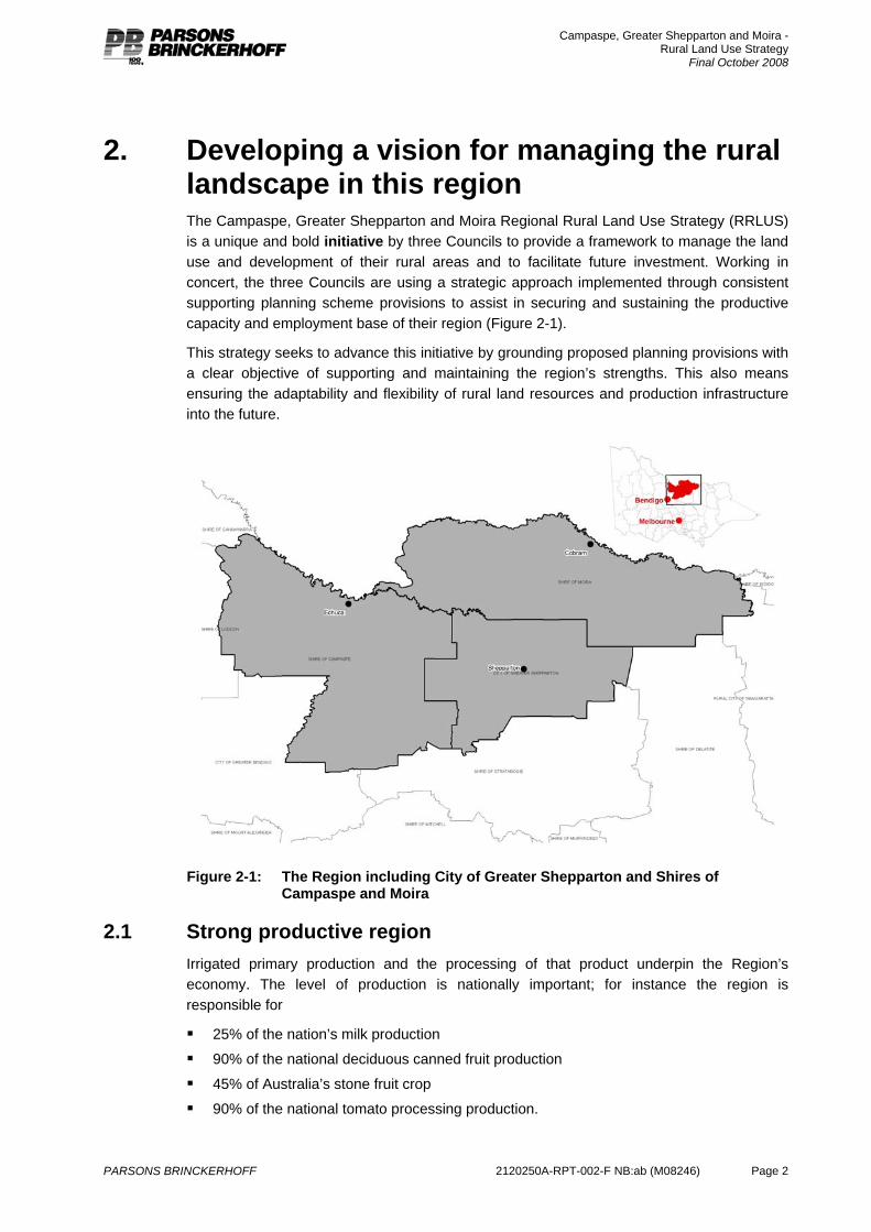
2. Developing a vision for managing the rural landscape in this region The Campaspe, Greater Shepparton and Moira Regional Rural Land Use Strategy (RRLUS) is a unique and bold initiative by three Councils to provide a framework to manage the land use and development of their rural areas and to facilitate future investment. Working in concert, the three Councils are using a strategic approach implemented through consistent supporting planning scheme provisions to assist in securing and sustaining the productive capacity and employment base of their region (Figure 2-1).
This strategy seeks to advance this initiative by grounding proposed planning provisions with a clear objective of supporting and maintaining the region’s strengths. This also means ensuring the adaptability and flexibility of rural land resources and production infrastructure into the future.
Figure 2-1: The Region including City of Greater Shepparton and Shires of
Campaspe and Moira
2.1 Strong productive region Irrigated primary production and the processing of that product underpin the Region’s economy. The level of production is nationally important; for instance the region is responsible for
25% of the nation’s milk production
90% of the national deciduous canned fruit production
45% of Australia’s stone fruit crop
90% of the national tomato processing production.

Campaspe, Greater Shepparton and Moira - Rural Land Use Strategy
Final October 2008
PARSONS BRINCKERHOFF 2120250A-RPT-002-F NB:ab (M08246) Page 3
The annual total value of agricultural production at the farm gate is in the order of $1.2 billion. The food-processing sector produces an additional $1.7 billion in income for the regional economy (Goulburn Broken Catchment Management Authority 2006). This sector alone invested around $1 billion during the 1990s in processing and handling equipment, infrastructure and refitting.
The region’s workforce is heavily dependent on the whole agricultural sector with about 8,500 people directly involved in agricultural production on farms, and an estimated similar number involved directly and indirectly in the processing of that product. An example of a service industry indirectly related to the production and processing of agricultural product is the transport sector that has grown in the region to become the nation’s greatest concentration of employment and equipment in the trucking industry accounting for 4% of employment in the Goulburn Murray region (Department of Victorian Communities 2006).
2.1.1 The Irrigation base Despite the economic prominence of the whole agricultural production and processing sector the region’s irrigation infrastructure, upon which much of this production is dependent, is ageing and inefficient. But that infrastructure must continue to be competitive with other regions, such as areas downstream along the River Murray and interstate, or it will become unviable for those remaining businesses and the economic base of the region will diminish. In order to address this situation a package of modernisation, known as the Northern Victorian Irrigation Renewal Project (NVIRP), will encompass reforms and initiatives relating to land use, resource management and further investment in water infrastructure that are designed to ensure the long term future of the region.
Fundamentally this modernisation is proposed to involve a massive transformation of an irrigation system, essentially designed for agriculture in the early 1900s, to a system that will support an automated, low energy and regionally competitive system. This new system will supply large volumes of water to strategic areas and at service levels that match the customer’s needs, particularly those that drive the economic engine of the region and thereby facilitate continued growth and major new investment in agribusiness. Dairy and horticultural activity based on irrigation are likely to continue to be the foundation industries in the regional economy, and grazing and cropping on dryland are, and will remain, very important elements.
In terms of irrigation, the region’s economic performance, scale and value of production is generated by around 20% of water users who use over 80% of the water. Others on the irrigation supply system rely on these larger volumes of water to be delivered into the system to retain their own cost competitiveness.
In both irrigation and dryland production the drivers of future successful agribusinesses, regardless of the scale of enterprise, are likely to be:
Continuing current trends for significantly increased scale of production (to spread increased overhead costs and to justify investment in technology). Increased scale is achieved by expanding the land area of production and/or by increasing the intensity of the production system
A shift to individual management of their own business risks (e.g. consolidation into contiguous properties to manage all their own water supply).
Agribusinesses that seek to minimize the number of neighbours (to reduce negotiation over land management and production processes and health and safety restrictions).
Campaspe, Greater Shepparton and Moira - Rural Land Use Strategy
Final October 2008
PARSONS BRINCKERHOFF 2120250A-RPT-002-F NB:ab (M08246) Page 4
Agribusinesses that expand into land that is priced competitively because it is used for agriculture rather than having inflated land values because it has been subdivided for hobby farms.
Successful agribusinesses of the future will need lower production costs than currently prevail; this will be achieved through further increases in the scale of operation. Increased scale will help businesses meet requirements for enhanced reporting on duty of care, as well as greater needs to manage their own marketing and risks, including financial risk. In addition, agribusinesses of the future will need to become even more globally competitive and operate in a demonstrated environmentally sustainable manner. In order to meet these future requirements, agribusinesses will need to maintain an adequate water supply and will be likely to construct and manage their own water distribution. They will require an irrigation supply system that increases the efficiency of supply and provides the flexibility needed for changes to scale of operation and land use. These initiatives, while specifically relating to the land use and management of the region’s rural areas, directly impact on the future profile and prosperity of the whole region.
The RRLUS is predicated on five key elements
1. The region is Australia’s productive food bowl based primarily on dairy products and fruit production.
2. The scale of production has resulted in Australia’s greatest regional concentration of food processing industries and workforce.
3. The economy and the liveability of the region are integrated with and dependent on agriculture and its continuation.
4. The series of water reforms and the potential for new areas to be opened up for intensive production provide opportunity for expansion in the level of agricultural production.
5. The region natural assets and ecosystem services provide significant contribution to the productivity and sustainability of the region.
In order to maintain the region’s pre-eminent position and to provide the climate under which future investment will take place various economic, resource and development factors need to be in place. One is obviously securing the region’s long term water resources (that, in itself, relies on securing the agricultural base), another is providing the conditions under which new privately led water infrastructure investment to service the expansion of agricultural production can take place. It is increasingly evident that such prospective agricultural investment is jeopardized, deterred, or completely lost by land uses and developments that have the potential to compromise the scale and location of such investment. Large-scale multi million-dollar investment in agricultural investment is far less likely if prospective investors are confronted with land that is already fragmented in ownership with housing dispersed throughout or adjoining it.
2.1.2 Dryland farming A substantial proportion of the land area supports dryland farming enterprises. These are mostly mixed farm businesses producing livestock and growing cereals (usually wheat, oats or barley) and some legumes and oil seeds. Sheep raising for wool or fat lamb production and cattle for beef production, are the main dryland livestock enterprises.
Regional data on output and gross value of agricultural production (by commodity) does not differentiate between dryland and irrigation production which means that it is difficult to report on the significance of the dryland contribution to the region as a whole. Dryland farming is,

Campaspe, Greater Shepparton and Moira - Rural Land Use Strategy
Final October 2008
PARSONS BRINCKERHOFF 2120250A-RPT-002-F NB:ab (M08246) Page 5
however, substantial and it should be noted that much of the commentary and discussion in this strategy is applicable to both irrigation and dryland businesses because they are similarly impacted by planning and land use pressures occurring throughout the region.
Farm Business Structures
In common with other agricultural regions, farm business within the three Shires comprise a mix of single family, multi family and corporate owned businesses producing a single commodity or a variety of commodities that may or may not have some level of on-farm processing. This diversity of business structures is a reality of modern agriculture and demonstrates that there are many different models for running a profitable agricultural business. The RRLUS does not suggest that there is any one preferred model but is based on land use planning principles that will accommodate a variety of businesses models and ensure that from a land use perspective businesses can adapt to change such as new markets, new technology and emerging risks.
2.2 Decision time for the region Essentially the region finds itself early in the twenty first century at a fork in the road in relation to the future rural landscape, its productivity and its capacity to drive and deliver substantial investment in agriculture and in turn in local processing and production. One path secures the future by strengthening the existing agricultural and economic base; the other path will lead to the erosion of that base and an increasing reliance on new but uncertain sources of prosperity. In essence, to a significant degree, the long-term prosperity of the region is directly linked to the choices made in respect to the key elements of the RRLUS, because the RRLUS has the capacity to considerably strengthen the chances of the expected agricultural investment occurring. Conversely if the strategy is not pursued, particularly in respect to managing proposals for the subdivision of agricultural areas, the building and location of new dwellings and other non-agricultural uses and developments, the future could be quite different.
2.2.1 Steady as it goes The least contentious path may appear to be a continuation of current arrangements and past practices. Generally it involves supporting the continued fragmentation of agricultural land in many localities and the development of housing and other non agricultural uses with little or no regard as to whether it will impact on current farming and horticulture and the likelihood of future investment, adaptability and flexibility. That decision-making regime is largely driven by short-term horizons, local activism and parochialism. Its outcome is the cumulative impact of small-scale decisions. Each individual decision will not alter the destiny of the region. However over time the collective impact of these decisions will continue to reshape the region because of the increasing likelihood that large-scale investors in food production will look to other regions where they can find much greater certainty and situations that are more conducive to risking large amounts of capital. This will, in time, reduce the level of production from the region, reduce the importance of the region compared to other areas and reduce the level of investment in processing and services with consequent impacts across the whole economy and social fabric.
2.2.2 Bold future The alternative path is tougher. It means being much more decisive when options for development are advocated. Choices are about long-term and region-wide gains against short-term individual concerns and individual financial outcomes. It means looking beyond
Campaspe, Greater Shepparton and Moira - Rural Land Use Strategy
Final October 2008
PARSONS BRINCKERHOFF 2120250A-RPT-002-F NB:ab (M08246) Page 6
individual speculative expectations and supporting a large-scale investment climate, which will produce flow-on impacts with wider beneficial regional outcomes. It means recognizing that the RRLUS is a core component of a wider set of measures and initiatives that collectively can much better secure the economic future of the region. The political will needed to carry this out now and into the future should not be underestimated.
The RRLUS and the planning scheme provisions that assist its implementation cannot, alone, bring about this substantial regional change and the anticipated level of continued and new investment in agriculture. But the whole package of reforms associated with the NVIRP has a much greater chance of failing to come to fruition and deliver its projected benefits if the RRLUS is not effectively adopted and then appropriately implemented through planning scheme provisions and, finally, administered in a way that is consistent with the objectives of the strategy. Without the RRLUS and its implementation through a new planning scheme regime, particularly in respect to certain key decisions on land use and development in various areas, it will be practically impossible to realise the benefits of the modernisation project.
2.2.3 Growth areas The core of the RRLUS is to ensure that those large-scale areas where major future agricultural investment is likely to occur are not compromised by ad hoc land uses and developments including the subdivision of land and its fragmentation in ownership. For the purposes of the RRLUS this area has been termed Growth. Future investors do not want operations that may be limited or compromised by countless neighbours and residential amenity issues. Therefore the RRLUS has at its central piece the identification and zoning of areas that are and should remain essentially exclusive farming areas and have the capacity and potential for significant further agricultural development. These are areas where substantial future investment in horticulture and large scale agriculture both irrigation based and dry is likely because it is attractive to both existing and new major agricultural producers and business consortiums. In addition these areas include land previously identified as Prime Development Zones1 for agriculture either with access to irrigation or operated as dryland properties.
The level of planning control required to be delivered in these areas by the respective Councils will be to effectively prevent any further fragmentation of this land, to not provide for inappropriate dwellings to be constructed and to prevent any other uses and developments that are not consistent with agriculture. In terms of the planning scheme provisions this will in essence mean that there will be no basis for the further subdivision of any more lots, no new dwellings will be required and uses that are not related to or support agricultural production will not be required. This may be seen as a restrictive regime but it reflects the outcomes of the strategy and the importance of the regional goals. In terms of the manner in which the provisions of planning schemes are expressed this will mean statements in the Municipal Strategic Statement (MSS) to this effect, a Local Planning Policy encapsulating this in terms of decision making guidelines and relating the provisions in the Schedule to the Farming Zone to this policy, in order to complement expanded minimum lot provision. The experience in the exercise of planning scheme provisions has been that minimum requirements become the standard. To address this, the RRLUS intends to prescribe larger minimum lot sizes and
1 Prime Development Zones are detailed in Section 4.4.2 of the report. These areas are land that have been
identified as capable of accommodating new investment into high-value irrigation development. To ensure clarity with reference to other land use zones (in accordance with the Victorian Planning Provisions) these areas are referred to as Agricultural Development Areas.
Campaspe, Greater Shepparton and Moira - Rural Land Use Strategy
Final October 2008
PARSONS BRINCKERHOFF 2120250A-RPT-002-F NB:ab (M08246) Page 7
promote development standards that ensure the development proposals must be justified against strategy and the policy – that is implementing a full performance based approach to the implementation of a planning scheme.
2.2.4 Remaining areas At the second tier level the regional RRLUS encompass areas where agriculture is significant but where large-scale major investment in agriculture and water infrastructure is far less likely. These are productive areas both irrigated and dryland. But these areas comprise one or more and usually many of the following characteristics; comparatively smaller agricultural holdings, fragmented ownerships, dispersed residential properties with limited relationship to agricultural use, non agricultural uses and developments, outmoded or inefficient water infrastructure, highly productive land parcels amidst non agricultural uses, conflicts between competing and non-compatible land uses, rural holdings primarily used for lifestyle reasons, and some areas where land values considerably exceed the productive value of the land.
While these areas are often complex in their range and mixture of land uses and development and display significant variation in productivity they can be broadly divided into four areas based on the dominant land uses and relationships to agricultural land uses.
1. Areas where productive agriculture is the predominant land use. Further investment in agriculture is likely in these areas, but the relatively smaller size of most of the holdings, the fragmented pattern of land ownership and the older irrigation infrastructure is likely to make these areas far less attractive for large scale agricultural investment. For the purposes of the RRLUS this area has been termed the Consolidation area. Under the Victorian planning system these areas should be zoned Farming and include necessary minimum lot size provisions in the accompanying Schedule to the Farming Zone.
2. Areas where productive agriculture is a significant land use but there are many properties that do not rely on a productive agricultural return and they are often increasingly hosting a range of urban related uses. While there may be some further investment in productive agriculture it is increasingly unlikely as the cost of purchasing land far exceeds a productive return from the area and the amenity impacts of further agricultural uses limit opportunities. Investment in agriculture will be largely based on the existing lot configuration and is likely to increasingly involve niche and specialist products. They are farming areas but they are being transformed by demand into areas where the dominant household basis is a form of rural living. For the purposes of the RRLUS this area has been termed the Niche Area. The most appropriate zone for these areas is Farming but the detailed provisions of the zone should recognise the reality of the current land uses and the transition in role and function that is occurring in these areas and therefore to provide for flexibility in terms of further development of an appropriate scale and intensity.
3. Areas in rural settings where ownership is heavily fragmented, properties are small – often too small to support independently viable agricultural use other than at a hobby scale. Essentially these areas have become rural living or rural residential areas regardless of their formal zoning under the current planning schemes. The most appropriate zone for these areas is Rural Living.
4. Areas where there is agricultural land use but it is essentially providing a setting or background land use and landscape for a variety of tourist and recreational developments that have located in the area. These areas are generally relatively small in area against the total area of the region and are often nearby to urban areas and major
Campaspe, Greater Shepparton and Moira - Rural Land Use Strategy
Final October 2008
PARSONS BRINCKERHOFF 2120250A-RPT-002-F NB:ab (M08246) Page 8
tourist and recreation areas like rivers and forests. Under the provisions of the Victorian planning system these areas would be generally zoned Rural Activity.
5. The region’s biodiversity values have been placed under considerable pressure through land clearance and fragmentation of vegetation as a result of land use and development. A number of areas contain significant conservation values on private land. These areas also provide opportunities for limited residential activity and some low intensity agriculture activity. Principally these areas long term future is concerned with maintaining and enhancing areas of biodiversity. These areas have been recommended to be zoned for Rural Conservation.
2.3 Planning Scheme provisions The specific planning scheme provisions that would derive from the RRLUS relate to the Rural type zones. These are expressed through three proposed schedules to the Farming Zone; Growth; Consolidation; and, Niche, they include:
Subdivision minimum sizes are recommended for enlargement and would be supported by a performance based approach. Each subdivision proposal would have to provide the justification and demonstrated need for the further creation of lots. The current situation is generally that an arbitrary subdivision size is set in the planning scheme provisions, Councils receive applications to subdivide land into lots of that size and because it complies with the provisions the application is granted. The lot size often bears no relationship to the intended land use and development of the land and its only virtue is that it complies with an arbitrary size based on a long forgotten historical rationale. It would be preferred to specify no minimum lot and rely on applications that justify their proposal against the strategy. However, the prescription of a minimum lot requirement is required to ensure the trigger for a planning permit. Proposals will be required to provide the justification for the subdivision against the Strategy and then Councils apply the decision making criteria consistent with the Strategy the result will be that there will be few if any subdivisions in the Growth and Consolidation areas and only a modest number in the Niche area.
Excision2 of existing houses from agricultural properties will not be necessary in the Growth area. There may be some situations in the Consolidation area where an excision will assist in the development of farming enterprises and far less likely in the Niche area because these areas are already extensively fragmented with supporting houses. In all three proposed farming zones, applications for excisions will be required to demonstrate how an excision will positively contribute to the strategic agricultural future of the subject property.
New dwellings in the Farming Zone that do not meet the ‘as of right’ minimum lot requirement would require a planning permit and would need to be assessed against the purpose of the zone. In the Growth area there is no need or justification for additional dwellings, there are unlikely to be situations in the Consolidation area where a new dwelling will assist in the development of farming enterprises, but in the Niche area further dwellings may be needed to support the productive use of land.
Tourism and recreation based development including accommodation and hospitality enterprises would need planning permits but there would be no basis for such uses in
2 Subdivisions, excisions, and re-subdivisions can often be misinterpreted, particularly as all planning tools
may achieve the same outcome of an ‘excised’ dwelling from a farming operation. However, statutory planning instruments do clearly delineate the three. A plain English discussion outlining the difference in these statutory tools, and visual examples are included in Appendix G.

Campaspe, Greater Shepparton and Moira - Rural Land Use Strategy
Final October 2008
PARSONS BRINCKERHOFF 2120250A-RPT-002-F NB:ab (M08246) Page 9
either the Growth area nor the Consolidation area but they may be justified in the Niche area where they do not compromise agricultural operations and production. Land where tourism and recreational based activities are the primary activity are more suitably located within the Rural Activity Zone.
Ultimately, the RRLUS is a core element among a suite of other policy and process that will impact across a wide range of issues that affect the whole region. That range of issues includes; the use of land, the allocation of water, the prospects for significant agribusiness investment, the long term future of industries that process local product, the jobs of the region’s largest employment sector and all the businesses that depend on them. The scale of these issues and their relationships with the regional economy are at such a level that they are beyond regional significance and they impact at a state and national level.
Campaspe, Greater Shepparton and Moira - Rural Land Use Strategy
Final October 2008
PARSONS BRINCKERHOFF 2120250A-RPT-002-F NB:ab (M08246) Page 10
3. The strategy development process This study was undertaken by Parsons Brinckerhoff (PB) in collaboration with RM Consulting Group. The project team included expertise in strategic and statutory planning, agriculture and land capability.
3.1 Key project team members Key project team members were:
Trevor Budge – Project Director, PB
Carolyn Stephenson – Principal Planner, PB
Nick Byrne – Planner, PB
Andrew Butt – Senior Planner, PB
Felicity Brown – Senior Planner, PB
Jessie Keating – Planner, PB
Roger Standen - Agricultural Consultant, RM Consulting Group
Shelley McGuinness – Agricultural Consultant, RM Consulting Group
Greg Hughes –Greater Shepparton City Council
Colin Kalms - Greater Shepparton City Council
David Becroft – Shire of Moira
Richard Whiting – Shire of Campaspe/Moira
Andrew Cowin – Shire of Campaspe
3.2 Study brief According to the Study Brief, the aims of this project are to:
Provide each Council with a “Rural Land Use Strategy” that will, when taken with the “Rural Land Use Strategy” of the other Councils, secure and promote the future of agriculture across the Region.
Provide the data, strategic justification and analytical basis for planning scheme amendments to give effect to the strategy.
Implement the “Rural Land Use Strategy” as part of each Council’s Planning Scheme.
The objectives of the project are to:
Develop a common vision, role and purpose for rural land to apply to each Council and Municipality.
Investigate opportunities, constraints and options for diversifying land uses in the rural areas in suitable locations to support high value rural industries, intensive agricultural production, accommodate tourism demands and other appropriate uses which are compatible with the primary purpose of the rural areas.
Investigate and identify sub-regions in each of the three Municipalities that require different strategies to support and promote appropriate and sustainable agricultural enterprises.
Campaspe, Greater Shepparton and Moira - Rural Land Use Strategy
Final October 2008
PARSONS BRINCKERHOFF 2120250A-RPT-002-F NB:ab (M08246) Page 11
Investigate options and develop strategies for those areas where water is no longer available.
Develop a common set of policies and zone provisions that prevent the fragmentation of agricultural land as appropriate to the sub-regions.
Develop policies and zone provisions, including the revision of existing schedules, to implement each Council’s “Rural Land Use Strategy”.
Accurately map the outcome of each Council’s “Rural Land Use Strategy” and provide justification for any Planning Scheme mapping modification.
Investigate opportunities, constraints and options during the application of rural zones, in particular the Rural Conservation, for the protection of significant environmental areas or assets from inappropriate development or use.
3.3 Project stages The methodology for this project involved review of existing material, primary data collection and consultation. One of the unique approaches adopted for this project was the significant involvement of the Councillors of the three Councils in the development of the direction for the strategy and the involvement of Council Officers of the three municipalities in the development of the implementation initiatives for the strategy.
The project methodology is outlined below.
1. Research and Investigation of Issues This stage of the project involved:
Document review
Investigations – Agriculture and Settlement
Application of Investigations
Councillor Workshop 1
Planners Workshop 1
The purpose of this stage of the project was to gain an understanding of the issues facing the study area.
2. Community Consultation The community consultation consisted of a series of open days, where members of community could drop in and view initial research findings and discuss their issues and concerns one on one with a member of the consultancy team and Council representative.
As well as these general community sessions, a number of targeted sessions were also conducted on particular issues including water and the environment and economic development. Relevant agency staff were invited to these sessions as well heads of industry groups.
3. 1st Joint Councillor Workshop – Regional Vision The key aim of this project is to secure and promote the future of agriculture across the region through the development of consistent strategies and Objective 3.4 of the Project Brief required that the study develop a common vision, role and purpose for rural land to apply to each Council and Municipality. The study team recognised the significant challenge in bringing together the three groups of Councillors to develop a common position for the region.
Campaspe, Greater Shepparton and Moira - Rural Land Use Strategy
Final October 2008
PARSONS BRINCKERHOFF 2120250A-RPT-002-F NB:ab (M08246) Page 12
A workshop was conducted on 4th September, 2007 at which the Councillors were presented with information about the challenges and values of rural land use across the region. At this workshop they developed some agreed principles for the region which enabled the project to proceed to the next stage.
4. Joint Planners Workshop – Implementation Following on from the Councillors workshop a workshop was held with the Council Planning Staff to discuss and develop options to implement the direction set by the Councillors.
This workshop provided information to planning staff about the challenges and values of rural land use across the region, the role of strategy, the direction and principles adopted by Councillors and implementation initiatives to enable identification of suitable options to deliver the strategy. In conducting this workshop it was recognised that an understanding of the issues and the strategic regional context was a significant element of effective implementation of the strategy, along with the development of statutory planning tools.
5. 2nd Joint Councillor Workshop – In principal approval The Councillors met for a third time in late February 2008 to confirm their commitment to the adopted vision and provide in principle approval for the Draft Strategy.
6. Agency Workshop/Briefing A targeted workshop took place in March 2008 to discuss the proposed implementation of the strategy and outline the broad findings of the research that is encompassed in the RRLUS. This workshop included representatives from DSE, the Department of Primary Industries (DPI), Goulburn Murray Water and the DPCD with elected representatives and staff members from each of the partner Councils.
7. Preparation of the Strategy document This stage of the project involved preparing the draft strategy including supporting documentation to justify the recommendations. This strategy document is to be initially prepared as a draft which was placed on public display for community feedback.
This strategy document includes sections addressing; agricultural issues and trends, processes of change in housing and population in the region, a discussion of environmental issues for consideration and an overview of the existing planning process with reference to limitations and alternatives and the process of community consultation. The final section of the report provides a strategic direction and recommendations based on the analysis and the context introduced in Chapter One above. A series of appendices provides further material for consideration.
8. Public Display and Consultation The Draft RRLUS was placed on display for a 28 day period. During this time a series of information sessions were undertaken throughout the region. These sessions targeted consultant surveyors and planners, Council Officers; land management agencies and the regions community. During this period a total of 72 submissions were received. A summary of these submissions and responses are located in Appendix I.
9. Finalisation of Strategy document A number of issues were raised during the public display period. These included clarification regarding the consultation program; ABS commodities data update and analysis; information regarding the alignment of agricultural principles that form the basis

Campaspe, Greater Shepparton and Moira - Rural Land Use Strategy
Final October 2008
PARSONS BRINCKERHOFF 2120250A-RPT-002-F NB:ab (M08246) Page 13
for the RRLUS and the application to agricultural enterprise of all scales and whether it is dryland or irrigation.
Campaspe, Greater Shepparton and Moira - Rural Land Use Strategy
Final October 2008
PARSONS BRINCKERHOFF 2120250A-RPT-002-F NB:ab (M08246) Page 14
4. Agriculture in the region This chapter provides an analysis and discussion of the importance of agriculture across the region and within each municipality. It will also document trends and issues relevant to agricultural production such as irrigation infrastructure modernisation, water reform and agricultural development areas.
Sections 4.1 - 4.6 of the chapter provide an overview of the study area. Sections 4.7 - 4.9 provide a more detailed analysis and discussion of agriculture in each municipality. The ‘region’ or ‘the study area’ is used to describe the three municipalities as a single entity. The ‘Shepparton Irrigation Region’ refers to the combined irrigation districts across the three municipalities.
Throughout this report, data from the Australian Bureau of Statistics has been used to provide a picture of the current status and trends in agriculture across the region.
4.1 The region in a national context Agricultural production and food processing is an important segment of the local economies in the Shires of Moira and Campaspe and the City of Greater Shepparton but are also significant nationally. For example, Victoria produces 65% of the national milk production. Twenty five percent of national milk production comes from the northern irrigated area of the state much of which is located in the study area (Dairy Australia 2006);
The region grows:
90% of the national deciduous canned fruit production;
85% of the national pear crop;
45% of the national stone fruit crop;
14% of the national fresh stone fruit crop;
16% of the national apple crop;
90% of the national kiwifruit crop (Department of Primary Industry 2006)
90% of Australia’s tomato processing capacity is located in the study area (Department of Sustainability and Environment and Department of Innovation, Industry and Regional Development 2007).
Agricultural produce is consumed and processed locally as well as being exported. Food processing and manufacturing in the study area3 is estimated to generate $1.7 billion annually (Goulburn Broken Catchment Management Authority 2006) as well as providing a significant amount of employment across the region.
3 Figures are based on data generated from the GBCMA that commissioned a study into the food processing
and manufacturing across the Goulburn Broken Catchment area and the entire area of the Shire of Campaspe.
Campaspe, Greater Shepparton and Moira - Rural Land Use Strategy
Final October 2008
PARSONS BRINCKERHOFF 2120250A-RPT-002-F NB:ab (M08246) Page 15
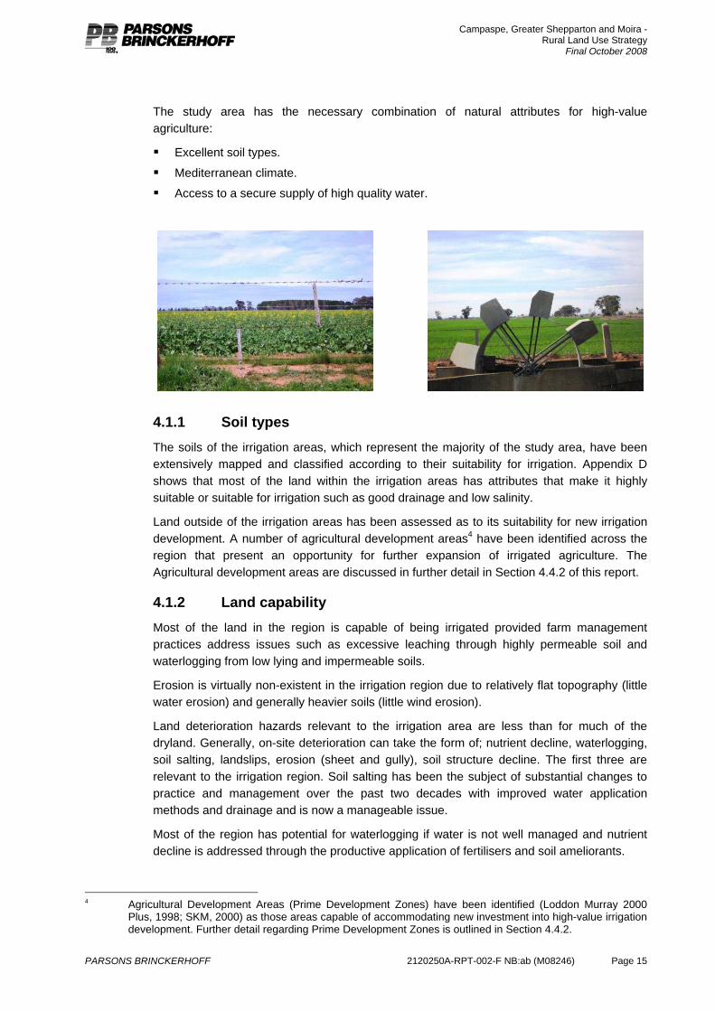
The study area has the necessary combination of natural attributes for high-value agriculture:
Excellent soil types.
Mediterranean climate.
Access to a secure supply of high quality water.
4.1.1 Soil types The soils of the irrigation areas, which represent the majority of the study area, have been extensively mapped and classified according to their suitability for irrigation. Appendix D shows that most of the land within the irrigation areas has attributes that make it highly suitable or suitable for irrigation such as good drainage and low salinity.
Land outside of the irrigation areas has been assessed as to its suitability for new irrigation development. A number of agricultural development areas4 have been identified across the region that present an opportunity for further expansion of irrigated agriculture. The Agricultural development areas are discussed in further detail in Section 4.4.2 of this report.
4.1.2 Land capability Most of the land in the region is capable of being irrigated provided farm management practices address issues such as excessive leaching through highly permeable soil and waterlogging from low lying and impermeable soils.
Erosion is virtually non-existent in the irrigation region due to relatively flat topography (little water erosion) and generally heavier soils (little wind erosion).
Land deterioration hazards relevant to the irrigation area are less than for much of the dryland. Generally, on-site deterioration can take the form of; nutrient decline, waterlogging, soil salting, landslips, erosion (sheet and gully), soil structure decline. The first three are relevant to the irrigation region. Soil salting has been the subject of substantial changes to practice and management over the past two decades with improved water application methods and drainage and is now a manageable issue.
Most of the region has potential for waterlogging if water is not well managed and nutrient decline is addressed through the productive application of fertilisers and soil ameliorants.
4 Agricultural Development Areas (Prime Development Zones) have been identified (Loddon Murray 2000
Plus, 1998; SKM, 2000) as those areas capable of accommodating new investment into high-value irrigation development. Further detail regarding Prime Development Zones is outlined in Section 4.4.2.
Campaspe, Greater Shepparton and Moira - Rural Land Use Strategy
Final October 2008
PARSONS BRINCKERHOFF 2120250A-RPT-002-F NB:ab (M08246) Page 16
There is limited land capability data for areas outside of the Agricultural Development Areas and the irrigation districts. There is, however, broad scale land capability information available for parts of the dryland region5. Basic information on landform, soil type, climate and susceptibility to degradation risk (erosion and soil compaction) provide an overall assessment of the land’s capability in supporting agricultural and other land uses. More detailed land capability data is not required to verify the suitability of various dryland farming activities in the farming zones specified in this land use strategy.
4.1.3 Climate The region has a Mediterranean climate with generally hot dry summers with an average temperature of 30°C between December and February (Bureau of Meteorology, http://www.bom.gov.au/). In winter, June to August, the average temperature is 14°C with sufficient cold days to achieve the necessary chilling requirement for bud initiation in fruit crops. The average rainfall is around 450mm, just over half of which falls between May and October.
The Department of Sustainability and Environment (2004) assessed the likely impacts of climate change on the Goulburn Broken Region. The repost summarized the projected climate change for Goulburn Broken as follows:
Annual warming of 0.3 to 1.6ºC by 2030 and 0.8 to 5.0ºC by 2070 - Day time maximum temperatures and night time minimum temperatures to rise at similar rate, with warming to be similar throughout the seasons.
A 10 to 50% increase in the number of hot summer days (over 35ºC) by 2030 and 20 to 400% by 2070.
A 10 to 70% reduction in the number of frost days by 2030 and a 35 to 100% decrease in frost days by 2070.
Annual precipitation decreases likely (changes of +3 to -15% by 2030 and +10 to -40% by 2070). Decreases likely in all seasons, but less so in summer and extreme heavy rainfall events may become more intense.
Runoff in the Goulburn is estimated to decrease by 0 to 25% and 0 to 35% in the Broken by 2030. By 2070 the decreases in both river systems is estimated to be 5% to more than 35%.
Droughts are likely to become more frequent and longer with dry conditions that currently occur on average on in every five years may increase to up to one in three years by 2030. Due to hotter conditions, droughts are also likely to be become more intense.
Increased evaporation rates and drier soil likely, even if precipitation increases, with decreased average run-off in streams.
Hotter, drier conditions likely to increase bushfire risk.
The report also assessed the potential impacts on farming systems and irrigation:
Warmer temperatures, changing rainfall patterns, the fertilizing effect of increased atmospheric carbon dioxide levels, increased demand for water and fewer frosts will impact on productivity and the types of crops that can be grown.
Farmers may be faced with more weeds and other invasive species as well as changing domestic and international markets.
5 Refer to A Study of the Land in the Campaspe River Catchment (1987) published by Department of
Conservations, Forests and Lands, Land Protection Division, Victoria
Campaspe, Greater Shepparton and Moira - Rural Land Use Strategy
Final October 2008
PARSONS BRINCKERHOFF 2120250A-RPT-002-F NB:ab (M08246) Page 17
Dryland grazing and broad acre cropping in the Goulburn-Broken region are likely to benefit from higher CO2 concentrations, but this may be offset by the effect of higher temperatures. An overall negative impact on production is more likely if substantial rainfall decreases accompany the warming.
Irrigated agriculture is very significant in the region and includes cropping, dairy and horticulture (fruit, vegetables, wine grapes). Likely reductions in overall water resources will reduce the volumes available for irrigation. In addition, crop water requirements will increase as temperatures and evaporation rates rise. These impacts will increase the need for more efficient use of water. Higher temperatures will also reduce winter chilling which is important for some fruit trees for setting fruit, and it may become necessary to consider low chill varieties and alternative management options. Viticulture in the region will be affected by possible reductions in grape quality due to higher temperatures. However, in some cases there will be opportunities to shift production to varieties that are better adapted to warmer climates. Warmer temperatures will also increase heat stress in dairy cattle, reducing milk production, unless management measures such as shade sheds and sprinklers are adopted.
All surface water resources north of the Great Divide are fully allocated, and water for new development must be transferred (traded) from existing entitlements. Any reduction in resource availability as a result of climate change has the potential to change the balance between consumptive uses and environmental entitlements and adjustments to entitlements may be required to restore this balance.
Based on the projected range of regional rainfall and potential evaporation changes, run-off has been estimated to decrease by up to 25% in the Goulburn and up to 35% in the Broken by 2030. By 2070 the decreases in both river systems are estimated to range from 5% to more than 35% by 2070. Climate change modelling indicates that the actual reduction in stream flows experienced over the last 10 years are (for most systems) similar to or greater that the reductions expected by 2055 as a result of medium to high climate change scenarios (Sustainable Water Strategy Northern Region, 2008).
While demand for water can be expected to increase as a result of increases in temperature and evaporation, this does not take into account possible offsetting impacts of changes in the seasonal patterns of rainfall. For example, if summer rainfall were to increase, it would help offset potential increases in irrigation demand as a result of increased summer temperatures.
It will be important that agribusiness has the flexibility to respond to the opportunities and threats brought about by climate change.
4.1.4 Water supply Goulburn Murray Water (GMW) manages the water storages and irrigation supply and drainage system across the region. The Goulburn and Murray River systems, which supply the water to the study area, have historically had a very secure water supply with 100% or more of water right and licensed volume supplied in 97 years out of 100. This is due to the relative conservative approach taken to management of water allocation via application of the seasonal allocation principles (http://g-mwater.ddsn.com).
Over recent years, increased awareness about the river environment has seen several programs introduced to enable more water to remain in the river system. This impacts on water available for extraction for productive use, but is generally being accessed through the introduction of greater efficiency measures.
Campaspe, Greater Shepparton and Moira - Rural Land Use Strategy
Final October 2008
PARSONS BRINCKERHOFF 2120250A-RPT-002-F NB:ab (M08246) Page 18
Ultimately, less sales water will be available for agriculture than historically was available. The recent extended dry period has seen inflows fall to record lows leaving allocations well below full entitlement.
There are two important groundwater resource areas in the region. These are the Campaspe Deep Lead Water Supply Protection Area, which covers 950 km2 and includes parts of the floodplains of the Campaspe and Murray Rivers in the Rochester and Echuca areas (GMW 2007a). Secondly, the Katunga Water Supply Protection Area comprises 2100 km2 and is located in the Murray and Goulburn Valleys extending from Yarrawonga in the east to Barmah in the west (GMW 2007b).
In the Campaspe groundwater resource area, the annual metered use increased from 23,112 ML in 2005/06 to 34,762 ML in 2006/07, which represented 87% of total allocation (GMW 2007a), while in the Katunga resource area, annual metered use increased from 21,614 ML in 2005/06 to 30,801 ML in 2006/07, which represented 74% of total allocation (GMW 2007b).
Groundwater resources within these protection areas are managed by Goulburn Murray Water in an equitable manner to ensure the long-term sustainability of those resources. Each Water Supply Protection Area is divided into allocation zones for management purposes (five in Campaspe and three in Katunga). Demand in many zones has been consistently high over the last four seasons due to prolonged drought.
4.2 Agriculture overview Agriculture across the three municipalities includes both dryland and irrigated enterprises. The study area covers about 500,000 ha, of which approximately 317,000 ha is irrigated and around 1.5 million megalitres of water is used for irrigation annually, depending on seasonal allocations.
The irrigated area of the study area is known as the Shepparton Irrigation Region (SIR). Appendix D (Figure AD-2) shows the land use across the SIR (note that this does not include all dryland agriculture in the study area). Irrigation is clustered in two main areas in the northern and central parts of the study area. The SIR comprises the Central Goulburn, Shepparton and Rochester-Campaspe Irrigation Areas which are supplied from Lake Eildon, and the Murray Valley irrigation area which is supplied with irrigation water from the Murray River. There are extensive areas of dryland farming to the east, west and south of the irrigation districts in the study area.
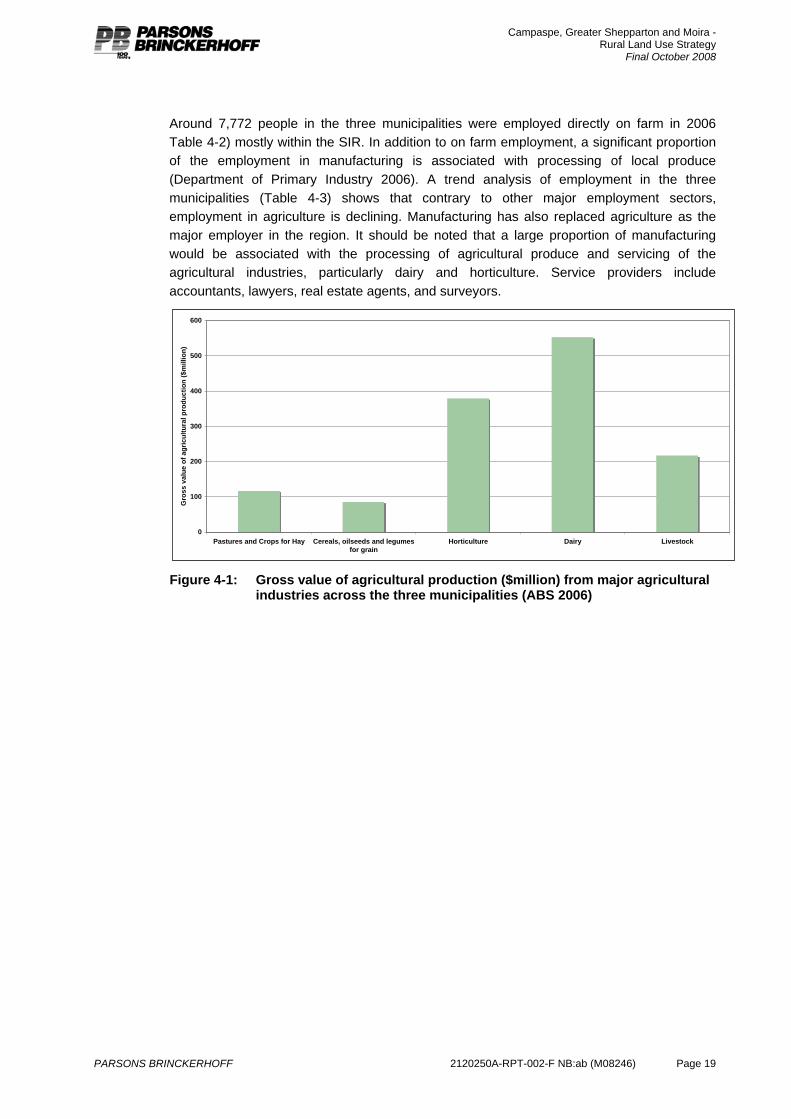
The major agricultural industries across the three municipalities are dairy, horticulture, particularly pome (apple and pears) and stone fruit production and sheep and cattle grazing for meat production (Figure 4-1). The total farm gate value of production for the three municipalities was $1.4 billion in 2006 up from $1.2 billion dollars in 2001. Forty one percent of this came from milk production, 16% from livestock and 28% from fruit and vegetables (ABS 2006).
In addition to the gross value of farm production, it is estimated that the food processing sector, particularly dairy, fruit and vegetables in the SIR produces an additional $1.7 billion gross value of production and processing (Goulburn Broken Catchment Management Authority 2006). The major food processing sector and food manufacturers in the SIR invested over $1billion in processing and handling infrastructure between 1990 and 2000 (Young 2001). There are also meat processing facilities and winemaking businesses across the study area.
Campaspe, Greater Shepparton and Moira - Rural Land Use Strategy
Final October 2008
PARSONS BRINCKERHOFF 2120250A-RPT-002-F NB:ab (M08246) Page 19
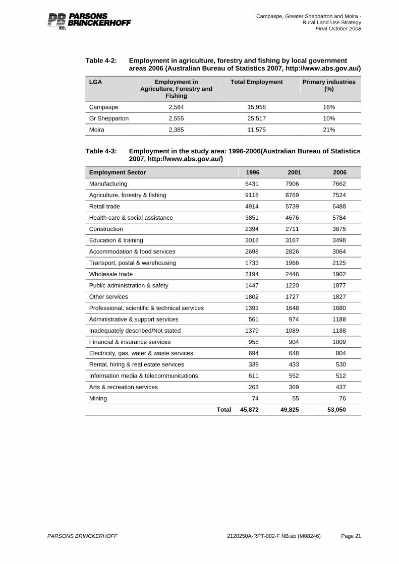
Around 7,772 people in the three municipalities were employed directly on farm in 2006 Table 4-2) mostly within the SIR. In addition to on farm employment, a significant proportion of the employment in manufacturing is associated with processing of local produce (Department of Primary Industry 2006). A trend analysis of employment in the three municipalities (Table 4-3) shows that contrary to other major employment sectors, employment in agriculture is declining. Manufacturing has also replaced agriculture as the major employer in the region. It should be noted that a large proportion of manufacturing would be associated with the processing of agricultural produce and servicing of the agricultural industries, particularly dairy and horticulture. Service providers include accountants, lawyers, real estate agents, and surveyors.
0
100
200
300
400
500
600
Pastures and Crops for Hay Cereals, oilseeds and legumesfor grain
Horticulture Dairy Livestock
Gro
ss v
alue
of a
gric
ultu
ral p
rodu
ctio
n ($
mill
ion)
Figure 4-1: Gross value of agricultural production ($million) from major agricultural
industries across the three municipalities (ABS 2006)
Campaspe, Greater Shepparton and Moira - Rural Land Use Strategy
Final October 2008
PARSONS BRINCKERHOFF 2120250A-RPT-002-F NB:ab (M08246) Page 20
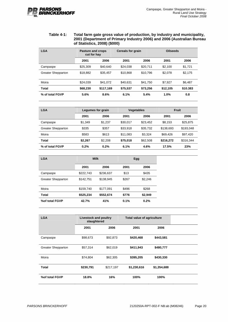
Table 4-1: Total farm gate gross value of production, by industry and municipality, 2001 (Department of Primary Industry 2006) and 2006 (Australian Bureau of Statistics, 2008) ($000)
Pasture and crops cut for hay
Cereals for grain Oilseeds LGA
2001 2006 2001 2006 2001 2006
Campaspe $25,309 $40,640 $24,038 $20,711 $2,100 $1,721
Greater Shepparton $18,882 $35,457 $10,868 $10,796 $2,078 $2,175
Moira $24,039 $41,072 $40,631 $41,750 $7,927 $6,487
Total $68,230 $117,169 $75,537 $73,256 $12,105 $10.383
% of total FGVP 5.6% 8.6% 6.1% 5.4% 1.0% 0.8
Legumes for grain Vegetables Fruit LGA
2001 2006 2001 2006 2001 2006
Campaspe $1,349 $1,237 $30,017 $23,452 $8,153 $25,875
Greater Shepparton $335 $357 $33,918 $35,732 $138,693 $193,048
Moira $583 $613 $11,083 $3,324 $69,426 $97,420
Total $2,267 $2,208 $75,018 $62,508 $216,272 $316,344
% of total FGVP 0.2% 0.2% 6.1% 4.6% 17.5% 23%
Milk Egg LGA
2001 2006 2001 2006
Campaspe $222,743 $236,637 $13 $435
Greater Shepparton $142,751 $138,945 $267 $2,246
Moira $159,740 $177,091 $496 $268
Total $525,234 $552,674 $776 $2,949
%of total FGVP 42.7% 41% 0.1% 0.2%
Livestock and poultry slaughtered
Total value of agriculture LGA
2001 2006 2001 2006
Campaspe $98,673 $92,873 $420,468 $443,581
Greater Shepparton $57,314 $62,019 $411,943 $480,777
Moira $74,804 $62,305 $395,205 $430,330
Total $230,791 $217,197 $1,230,616 $1,354,688
%of total FGVP 18.8% 16% 100% 100%
Campaspe, Greater Shepparton and Moira - Rural Land Use Strategy
Final October 2008
PARSONS BRINCKERHOFF 2120250A-RPT-002-F NB:ab (M08246) Page 21
Table 4-2: Employment in agriculture, forestry and fishing by local government areas 2006 (Australian Bureau of Statistics 2007, http://www.abs.gov.au/)
LGA Employment in Agriculture, Forestry and
Fishing
Total Employment Primary industries (%)
Campaspe 2,584 15,958 16%
Gr Shepparton 2,555 25,517 10%
Moira 2,385 11,575 21%
Table 4-3: Employment in the study area: 1996-2006(Australian Bureau of Statistics 2007, http://www.abs.gov.au/)
Employment Sector 1996 2001 2006
Manufacturing 6431 7906 7662
Agriculture, forestry & fishing 9118 8769 7524
Retail trade 4914 5739 6488
Health care & social assistance 3851 4676 5784
Construction 2394 2711 3875
Education & training 3018 3167 3498
Accommodation & food services 2698 2826 3064
Transport, postal & warehousing 1733 1966 2125
Wholesale trade 2194 2446 1902
Public administration & safety 1447 1220 1877
Other services 1802 1727 1827
Professional, scientific & technical services 1393 1648 1680
Administrative & support services 561 974 1188
Inadequately described/Not stated 1379 1089 1188
Financial & insurance services 958 904 1009
Electricity, gas, water & waste services 694 648 804
Rental, hiring & real estate services 339 433 530
Information media & telecommunications 611 552 512
Arts & recreation services 263 369 437
Mining 74 55 76
Total 45,872 49,825 53,050
Campaspe, Greater Shepparton and Moira - Rural Land Use Strategy
Final October 2008
PARSONS BRINCKERHOFF 2120250A-RPT-002-F NB:ab (M08246) Page 22
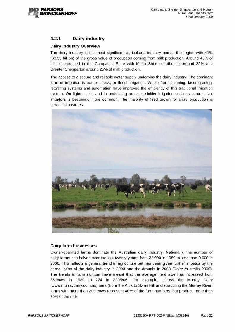
4.2.1 Dairy industry Dairy Industry Overview The dairy industry is the most significant agricultural industry across the region with 41% ($0.55 billion) of the gross value of production coming from milk production. Around 43% of this is produced in the Campaspe Shire with Moira Shire contributing around 32% and Greater Shepparton around 25% of milk production.
The access to a secure and reliable water supply underpins the dairy industry. The dominant form of irrigation is border-check, or flood, irrigation. Whole farm planning, laser grading, recycling systems and automation have improved the efficiency of this traditional irrigation system. On lighter soils and in undulating areas, sprinkler irrigation such as centre pivot irrigators is becoming more common. The majority of feed grown for dairy production is perennial pastures.
Dairy farm businesses Owner-operated farms dominate the Australian dairy industry. Nationally, the number of dairy farms has halved over the last twenty years, from 22,000 in 1980 to less than 9,000 in 2006. This reflects a general trend in agriculture but has been given further impetus by the deregulation of the dairy industry in 2000 and the drought in 2003 (Dairy Australia 2006). The trends in farm number have meant that the average herd size has increased from 85 cows in 1980 to 224 in 2005/06. For example, across the Murray Dairy (www.murraydairy.com.au) area (from the Alps to Swan Hill and straddling the Murray River) farms with more than 200 cows represent 40% of the farm numbers, but produce more than 70% of the milk.
Campaspe, Greater Shepparton and Moira - Rural Land Use Strategy
Final October 2008
PARSONS BRINCKERHOFF 2120250A-RPT-002-F NB:ab (M08246) Page 23
The trend towards larger dairy farms may be further accelerated by the current drought. A report prepared by RM Consulting Group (2006) for Murray Dairy found that as a result of the current drought, milk production from the Murray Dairy area would drop by 25% compared to the 2005/06 season with flow on impacts predicted on seasonal work in factories and farms and the wider economy. The report also noted that:
“From a land use planning perspective, it is likely that there will be a continuing trend to larger dairying properties, which can be supported by minimising the risks of conflicting adjoining land uses.”
As dairy farms grow in size, the herd structure may change and in the future a dairy farm may comprise 4 to 6 herds of 500 cows based around a single rotary dairy. For farms to expand, they will require access to land that is unencumbered by unnecessary infrastructure such as housing. Farming should also be well buffered from urban areas, as future production systems are likely to see an increased level of mechanisation and shift to 24 hour operations.
Dairy processing and manufacturing The value of dairy processing in the SIR was estimated at $1.6 billion in 2005 (Department of Primary Industry 2006). Milk processing is undertaken at a number of milk factories including Fonterra Foods (Stanhope), Murray Goulburn (Cobram and Rochester) and Tatura Milk Industries. These milk factories also supply Nestle in Tongala and Echuca, Meiji-MGC Dairy Company in Cobram, Kraft in Strathmerton and Snow Brand Tatura Dairies for further processing, producing a range of products including yoghurt and infant milk formula. Dairy Farmers Cooperative also undertakes milk product packaging and distribution in this region.
Since 1995 milk processing factories have expanded capacity in response to the annual growth in milk production of between 5%and 7% and the long-term positive outlook for dairy product exports (Department of Primary Industry 2006).
4.2.2 Horticulture Across the study area, there are approximately 800 horticultural properties covering an area of almost 16,000 hectares. Pome and stone fruits (including apples, pears, apricots, peaches, nectarines and plums) are the most significant, with smaller areas of citrus, nuts vegetables and grapes.
The horticultural industry (fruit and vegetables) accounts for 28% of the gross value of agricultural production of the region but takes place on less than 5% of the total irrigated area. Many of the horticultural businesses are located close to the urban centres of Shepparton, Mooroopna and Cobram. Urban encroachment into these areas should be prevented to ensure that farm businesses can continue to grow and expand and to minimise urban –rural conflict as farm businesses become more mechanised, 24 hour operations.
Perennial horticulture Perennial horticulture is centred in the Goulburn Valley with the combination of suitable climate and soil types and a reliable water supply. The major orchard crops are pears, apples, nectarines, apricots, plums, kiwifruit and cherries for the fresh market and processing.
The region grows:
90% of the national deciduous canned fruit production
85% of the national pear crop

Campaspe, Greater Shepparton and Moira - Rural Land Use Strategy
Final October 2008
PARSONS BRINCKERHOFF 2120250A-RPT-002-F NB:ab (M08246) Page 24
45% of the national stone fruit crop
14% of the national fresh stone fruit crop
16% of the national apple crop
90% of the national kiwifruit crop (DPI 2006).
Approximately half the produce is sold in the fresh markets and the remainder is processed (Table 4-4). From 1997 to the 2002/03 drought, there was significant new development, particularly stone fruit, representing an investment of between $9million and $16million depending on the trellis and irrigation system installed (Department of Primary Industry 2006).
While the average orchard property size is estimated at 25ha anecdotally it has been reported that there is a trend towards larger properties and that this is occurring through farm amalgamation.
A major limitation to expansion of horticulture outside existing irrigation areas is access to a reliable water supply. Accessing irrigation water outside the existing irrigation area is negotiated on a case-by-case basis and is subject to New Irrigation Development Controls, with a water entitlement purchased through the usual water trading facilities and the entitlement transferred to the development site. This will be of particular significance to the future land use options in the dryland areas of the three municipalities.
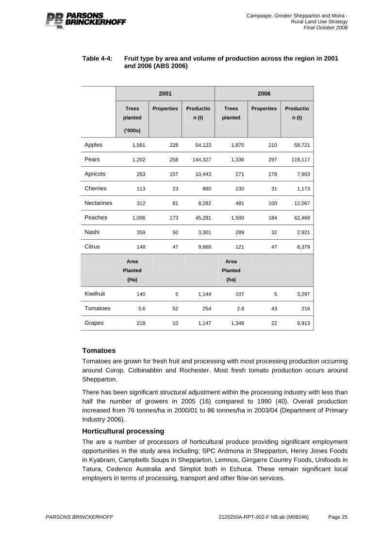
Campaspe, Greater Shepparton and Moira - Rural Land Use Strategy
Final October 2008
PARSONS BRINCKERHOFF 2120250A-RPT-002-F NB:ab (M08246) Page 25
Table 4-4: Fruit type by area and volume of production across the region in 2001 and 2006 (ABS 2006)
2001 2006
Trees
planted
(‘000s)
Properties Productio
n (t)
Trees
planted
Properties Productio
n (t)
Apples 1,581 228 54,123 1,870 210 58,721
Pears 1,202 258 144,327 1,336 297 119,117
Apricots 253 157 10,443 271 178 7,903
Cherries 113 23 880 230 31 1,173
Nectarines 312 81 8,282 481 100 12,067
Peaches 1,006 173 45,281 1,500 184 62,468
Nashi 359 50 3,301 289 32 2,921
Citrus 148 47 9,868 121 47 8,379
Area
Planted
(Ha)
Area
Planted
(ha)
Kiwifruit 140 5 1,144 107 5 3,297
Tomatoes 3.6 52 254 2.8 43 216
Grapes 218 10 1,147 1,348 22 9,913
Tomatoes Tomatoes are grown for fresh fruit and processing with most processing production occurring around Corop, Colbinabbin and Rochester. Most fresh tomato production occurs around Shepparton.
There has been significant structural adjustment within the processing industry with less than half the number of growers in 2005 (16) compared to 1990 (40). Overall production increased from 76 tonnes/ha in 2000/01 to 86 tonnes/ha in 2003/04 (Department of Primary Industry 2006).
Horticultural processing The are a number of processors of horticultural produce providing significant employment opportunities in the study area including; SPC Ardmona in Shepparton, Henry Jones Foods in Kyabram, Campbells Soups in Shepparton, Lemnos, Girrgarre Country Foods, Unifoods in Tatura, Cedenco Australia and Simplot both in Echuca. These remain significant local employers in terms of processing, transport and other flow-on services.
Campaspe, Greater Shepparton and Moira - Rural Land Use Strategy
Final October 2008
PARSONS BRINCKERHOFF 2120250A-RPT-002-F NB:ab (M08246) Page 26
4.2.3 Livestock production and processing Livestock slaughtering represents 16% of the farm gate value of production from the study area (ABS2006). Cattle and sheep are grazed on both irrigated and dryland properties. Increasing cost associated with irrigation along with competition for water from other industries has seen a reduction in livestock on irrigated properties over the past decade. Low wool prices and fluctuating meat prices have also seen a shift to cropping in recent times. There will continue to be a role for grazing as in mixed farming businesses as a risk management strategy and it plays a role in management of cropping rotations and utilising areas of less arable land.
There are a number of abattoirs in the study area that provide significant employment opportunities, such as JBS Swift in Cobram, HW Greenhams in Tongala, Riverside Meats in Echuca, Ryans Wholesale Meat in Nathalia, Auld’s Knackery in Stanhope and Numurkah Knackery.
4.2.4 Fodder and crop production Hay, pasture, grain, oilseed and legume production represents approximately 14% of the farm gate value of production from the three municipalities. Most of this is produced under irrigation. Irrigated fodder cropping plays an important role in providing supplementary feed to the dairy industry as well as supplying the lucrative export market.
4.3 Irrigation
4.3.1 Surface water Irrigation underpins agriculture in the study area. The Shepparton Irrigation Region comprises the Central Goulburn, Shepparton and Rochester-Campaspe Irrigation Areas which are supplied from the Goulburn River via Lake Eildon, and the Murray Valley Irrigation Area which is supplied with irrigation water from the Murray River.
The Central Goulburn Irrigation Area covers 173,053 hectares (113,106 hectares irrigated) and is one of the largest irrigated areas in northern Victoria. Approximately 2,800 irrigated holdings are serviced in this area and the water right totals 385,000 megalitres.
The Shepparton Irrigation Area covers 81,750 hectares (51,000 hectares irrigated). Approximately 1,500 irrigated holdings are serviced in this area and the water right totals 181,500 megalitres.
Approximately 1,300 customers in the Rochester-Campaspe area are serviced in this area and the major sources of water supply are Lake Eildon and Lake Eppalock (Campaspe River) with supplementary supplies taken from Greens Lake. Water rights in the area total 187,396 megalitres in the Rochester Area and 20,202 megalitres in the Campaspe Irrigation District. The Rochester Irrigation Area has a total area of 107,750 (61,700 Ha irrigated) and the Campaspe Irrigation Area has a total Area of 9,300 Ha (5,010 Ha irrigated).
The Murray Valley Irrigation Area covers 128,372 hectares (88,969 hectares irrigated).
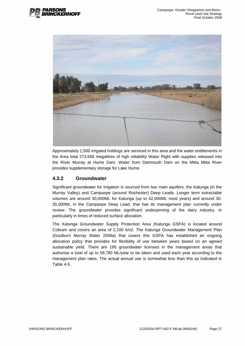
Campaspe, Greater Shepparton and Moira - Rural Land Use Strategy
Final October 2008
PARSONS BRINCKERHOFF 2120250A-RPT-002-F NB:ab (M08246) Page 27
Approximately 1,500 irrigated holdings are serviced in this area and the water entitlements in the Area total 273,656 megalitres of high reliability Water Right with supplies released into the River Murray at Hume Dam. Water from Dartmouth Dam on the Mitta Mitta River provides supplementary storage for Lake Hume.
4.3.2 Groundwater Significant groundwater for irrigation is sourced from two main aquifers, the Katunga (in the Murray Valley) and Campaspe (around Rochester) Deep Leads. Longer term extractable volumes are around 30,000ML for Katunga (up to 42,000ML most years) and around 30-35,000ML in the Campaspe Deep Lead, that has its management plan currently under review. The groundwater provides significant underpinning of the dairy industry, in particularly in times of reduced surface allocation.
The Katunga Groundwater Supply Protection Area (Katunga GSPA) is located around Cobram and covers an area of 2,100 km2. The Katunga Groundwater Management Plan (Goulburn Murray Water 2006a) that covers this GSPA has established an ongoing allocation policy that provides for flexibility of use between years based on an agreed sustainable yield. There are 195 groundwater licenses in the management areas that authorise a total of up to 59,780 ML/year to be taken and used each year according to the management plan rates. The actual annual use is somewhat less than this as indicated in Table 4-5.
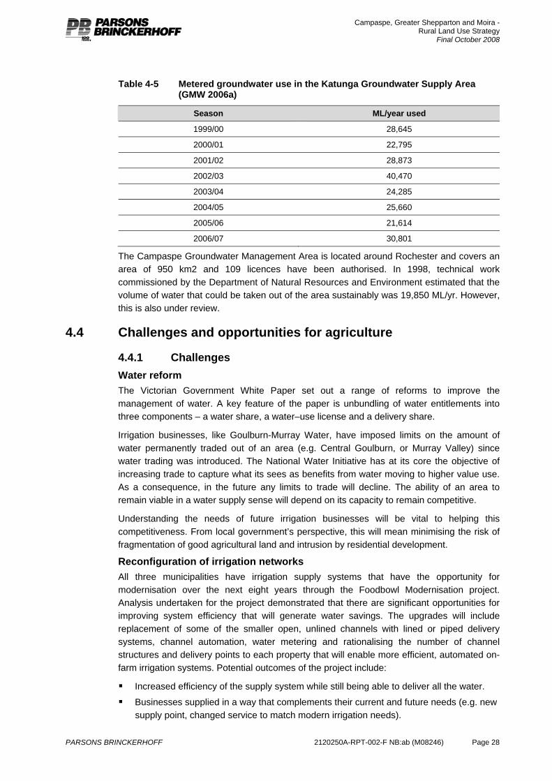
Campaspe, Greater Shepparton and Moira - Rural Land Use Strategy
Final October 2008
PARSONS BRINCKERHOFF 2120250A-RPT-002-F NB:ab (M08246) Page 28
Table 4-5 Metered groundwater use in the Katunga Groundwater Supply Area (GMW 2006a)
Season ML/year used 1999/00 28,645
2000/01 22,795
2001/02 28,873
2002/03 40,470
2003/04 24,285
2004/05 25,660
2005/06 21,614
2006/07 30,801
The Campaspe Groundwater Management Area is located around Rochester and covers an area of 950 km2 and 109 licences have been authorised. In 1998, technical work commissioned by the Department of Natural Resources and Environment estimated that the volume of water that could be taken out of the area sustainably was 19,850 ML/yr. However, this is also under review.
4.4 Challenges and opportunities for agriculture
4.4.1 Challenges Water reform The Victorian Government White Paper set out a range of reforms to improve the management of water. A key feature of the paper is unbundling of water entitlements into three components – a water share, a water–use license and a delivery share.
Irrigation businesses, like Goulburn-Murray Water, have imposed limits on the amount of water permanently traded out of an area (e.g. Central Goulburn, or Murray Valley) since water trading was introduced. The National Water Initiative has at its core the objective of increasing trade to capture what its sees as benefits from water moving to higher value use. As a consequence, in the future any limits to trade will decline. The ability of an area to remain viable in a water supply sense will depend on its capacity to remain competitive.
Understanding the needs of future irrigation businesses will be vital to helping this competitiveness. From local government’s perspective, this will mean minimising the risk of fragmentation of good agricultural land and intrusion by residential development.
Reconfiguration of irrigation networks All three municipalities have irrigation supply systems that have the opportunity for modernisation over the next eight years through the Foodbowl Modernisation project. Analysis undertaken for the project demonstrated that there are significant opportunities for improving system efficiency that will generate water savings. The upgrades will include replacement of some of the smaller open, unlined channels with lined or piped delivery systems, channel automation, water metering and rationalising the number of channel structures and delivery points to each property that will enable more efficient, automated on-farm irrigation systems. Potential outcomes of the project include:
Increased efficiency of the supply system while still being able to deliver all the water.
Businesses supplied in a way that complements their current and future needs (e.g. new supply point, changed service to match modern irrigation needs).
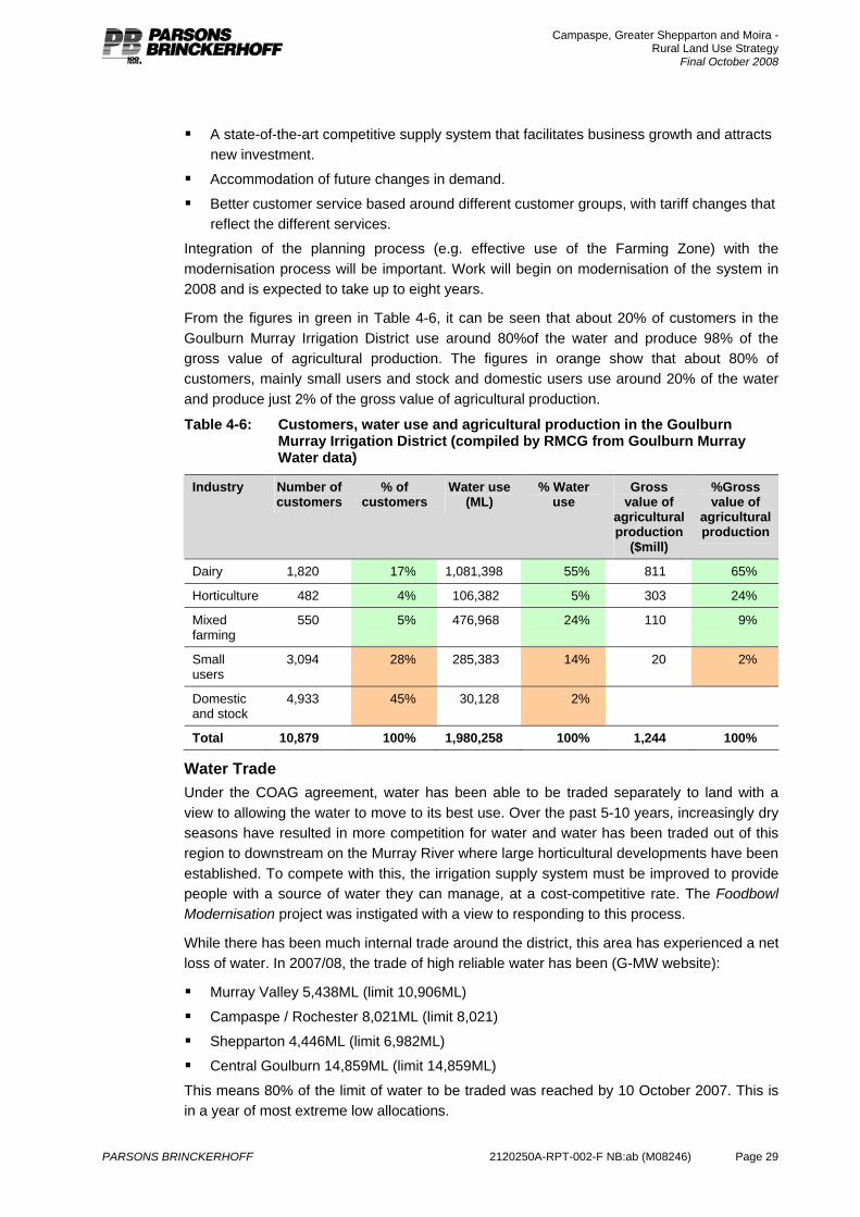
Campaspe, Greater Shepparton and Moira - Rural Land Use Strategy
Final October 2008
PARSONS BRINCKERHOFF 2120250A-RPT-002-F NB:ab (M08246) Page 29
A state-of-the-art competitive supply system that facilitates business growth and attracts new investment.
Accommodation of future changes in demand.
Better customer service based around different customer groups, with tariff changes that reflect the different services.
Integration of the planning process (e.g. effective use of the Farming Zone) with the modernisation process will be important. Work will begin on modernisation of the system in 2008 and is expected to take up to eight years.
From the figures in green in Table 4-6, it can be seen that about 20% of customers in the Goulburn Murray Irrigation District use around 80%of the water and produce 98% of the gross value of agricultural production. The figures in orange show that about 80% of customers, mainly small users and stock and domestic users use around 20% of the water and produce just 2% of the gross value of agricultural production.
Table 4-6: Customers, water use and agricultural production in the Goulburn Murray Irrigation District (compiled by RMCG from Goulburn Murray Water data)
Industry Number of customers
% of customers
Water use (ML)
% Water use
Gross value of
agricultural production
($mill)
%Gross value of
agricultural production
Dairy 1,820 17% 1,081,398 55% 811 65%
Horticulture 482 4% 106,382 5% 303 24%
Mixed farming
550 5% 476,968 24% 110 9%
Small users
3,094 28% 285,383 14% 20 2%
Domestic and stock
4,933 45% 30,128 2%
Total 10,879 100% 1,980,258 100% 1,244 100%
Water Trade Under the COAG agreement, water has been able to be traded separately to land with a view to allowing the water to move to its best use. Over the past 5-10 years, increasingly dry seasons have resulted in more competition for water and water has been traded out of this region to downstream on the Murray River where large horticultural developments have been established. To compete with this, the irrigation supply system must be improved to provide people with a source of water they can manage, at a cost-competitive rate. The Foodbowl Modernisation project was instigated with a view to responding to this process.
While there has been much internal trade around the district, this area has experienced a net loss of water. In 2007/08, the trade of high reliable water has been (G-MW website):
Murray Valley 5,438ML (limit 10,906ML)
Campaspe / Rochester 8,021ML (limit 8,021)
Shepparton 4,446ML (limit 6,982ML)
Central Goulburn 14,859ML (limit 14,859ML)
This means 80% of the limit of water to be traded was reached by 10 October 2007. This is in a year of most extreme low allocations.
Campaspe, Greater Shepparton and Moira - Rural Land Use Strategy
Final October 2008
PARSONS BRINCKERHOFF 2120250A-RPT-002-F NB:ab (M08246) Page 30
It is expected that considerable numbers of people will not be returning to the levels of irrigation prior to the drought, but many of the 20% of farm businesses that already use 80% of the water will be expected to continue in irrigation.
Providing a cost competitive supply system in areas where business can grow will be critical to the long-term future of irrigation in the region.
Native Vegetation The implications of Victoria’s Native Vegetation Management Framework, provides the strategic approach to protecting, enhancing and vegetating Victoria’s native vegetation. The key priority of the framework includes a policy of net gain in native vegetation.
As outlined in Section 6, there are significant areas of native vegetation within the region and the impacts of previous agricultural and urban activity have resulted in a severe reduction of native vegetation. Agricultural activities have the potential to impact on existing areas of high value remnant vegetation. This is particularly the case within the northern grassland regions of the study area.
4.4.2 Opportunities Prime development zones Within the irrigation areas, resources are being moved from lower value grazing enterprises to higher value enterprises such as dairy and horticulture. Prime Development Zones have been identified (Loddon Murray 2000 Plus, 1998; SKM, 2000) as those areas capable of accommodating new investment into high-value irrigation development. Delivery of water will be a key to the development of the prime development zones (Appendix E – Map 1). For the purposes of this report and to ensure no confusion with Land Use Zones in accordance the Victorian Planning Provisions, prime development zones will be referred to as Agricultural Development Areas.
However, a number of areas where good land exists in sufficient scale to warrant new development have already been identified around the edge of the irrigation area. What many new businesses are looking for is a site that is unencumbered by existing infrastructure (e.g. old dairies, homes), where they can get a single water supply point and manage all their own water supply/application system as well as confidence that they can continue to run their businesses without undue interference from boundary interaction with non-agricultural residents.
Irrigation futures project An extensive consultative project looking at future scenarios for irrigation in the Goulburn Broken region was conducted over several years. It has been valuable in alerting the region to potential futures and challenged thinking about the capacity of organisations to deal with these scenarios. Essentially, the future scenarios include:
1. Dairy being the mainstay for irrigation land and water use under all scenarios.
2. Horticulture remaining a strong user of water
3. Cropping to vary but generally hold its own
4. Livestock to generally diminish under all scenarios (except the drying up scenario)
5. Continued uncertainty over where and when water would be needed across the region.
Under the ‘drying up’ scenario, livestock increased as other industries left. Dairy and horticulture were seen to be the main economic engine for the area.

Campaspe, Greater Shepparton and Moira - Rural Land Use Strategy
Final October 2008
PARSONS BRINCKERHOFF 2120250A-RPT-002-F NB:ab (M08246) Page 31
Niche industries It has been reported anecdotally that the equine industry is emerging as a significant industry in the region. Table 4-7 outlines the ABS data available on the equine industry across the three municipalities. While 480 farms indicated that they kept horses as part of the farming business, only 48 of these indicated the major source of farm income was derived from horse management. Of these 48 businesses, seven are generating more than $500,000 per annum. No ABS data is available of the farm gate value of production generated from the equine industry. The data suggests that the industry is relatively small with a number of hobby based operators in the industry and a very small group operating as genuine equine businesses.
The industry is supported by the National Centre for Equine Education with a Cluster Coordinator based in Euroa, the North East Thoroughbred Industry Alliance based in Wangaratta and the Goulburn Valley Equine Hospital in Shepparton.
The Shire of Strathbogie has invested significant resources to market and position itself as a hub for the equine industry based on its natural attributes and accessibility to the Melbourne racing venues.
Table 4-7 Number of horse properties and horse numbers in the region (Australian Bureau Statistics Agricultural Census Data 2001 and 2006)
Number of farms*
Horse number (excluding
stud horses)
Stud horse numbers
Number of farms
businesses generating the
majority of their income from horses
Income >$500,000
Municipality
2001 2001 2001 2001 2006 2001 2006
Campaspe 171 397 978 14 23 1 2
Greater Shepparton
149 321 833 26 30 3 1
Moira 160 544 944 8 17 3 0
Totals 480 1,262 2,755 48 70 7
4.4.3 Outlook for agriculture in the region Recent trends and outlook suggest that dairy and horticulture will remain strong and competitive industries. Strong global economic growth is keeping demand for commodities (wheat, wool, corn, dairy products) sound.
Increased interest in alternative fuels, including biofuel could see changes in cropping due to competition for plant products. At the 2007 ABARE Outlook Conference, Peter Anderton (Agri Energy Ltd) noted that while the ethanol market was immature, it was poised for growth, (e.g. production company projected to go from 216ML/ann in 2007 to 1,288ML/ annum in 2010), while biodiesel was salvageable from a faltering position (e.g. production 623ML/annum 2007 to 1,043ML/annum in 2010).
4.4.4 Implications for land use planning Land use planning can support existing agricultural industries and ensure that there will be opportunity for new and emerging industries by: retaining allotments in larger parcels and preventing subdivision so that the farms can continue to grow and expand as required; limiting land from being encumbered with unwanted infrastructure, particularly housing,
Campaspe, Greater Shepparton and Moira - Rural Land Use Strategy
Final October 2008
PARSONS BRINCKERHOFF 2120250A-RPT-002-F NB:ab (M08246) Page 32
which can drive up land values beyond productive value and render it unavailable for farm expansion; restricting urban expansion into high value agricultural areas; and preventing cross-boundary conflicts by ensuring that there are buffers between urban (and urban-type) development and agricultural areas particularly irrigation development where farm operations occur 24 hours a day, seven days a week and may produce noise and odours. Careful management is also required throughout the region to ensure land use and development does not impact on biodiversity and is managed in a environmentally sustainable manner.
In productive agricultural areas, the prevention of ad hoc rural living development by managing dwelling development on small allotments is critical. Equally, planning has a role in the integrated modernisation and reconfiguration of the irrigation network and the expansion of irrigated agriculture into the Agricultural development areas.
4.5 Local profiles This section of the report provides a more detailed analysis and discussion of agriculture in each of the local governments. The following sections outline the methodology used to assess farm businesses and productive agricultural land in the municipalities. These are common to the discussion on each municipality and presented here to prevent duplication.
4.5.1 Farm business analysis Analysing farm business income provides information on the types of farm businesses, for example whether a farm businesses is fulltime, part time or for lifestyle purposes. This can be useful to understand issues, such as right to farm and the needs of agriculture such as minimum lot size and infrastructure.
Benchmarking of farm businesses over the last fifteen years has established a guideline for the minimum gross turnover at average cost control that enables sufficient profit to support a family and provide sufficient funds for redevelopment and growth for establishing the next generation. At 2006 values, the minimum gross turnover required, over the long term, is approximately $300,000 per business.
Those with a gross turnover below $300,000 and wanting to run full time farming business will need to consider increasing farm scale or profitability to increase farm turnover. Opportunities for increasing production efficiency come mainly through increasing scale to allow capital costs to be spread over more units of production. For example, all dairy businesses require a milking shed but greater production efficiency will come from spreading the capital cost of the milking shed across a larger dairy herd compared to a smaller herd.
In this rural strategy, an analysis of turnover of farm business assists in understanding current farming models and the land use planning requirements to underpin these industries into the future. It is important that the strategy reflects the diversity of farm businesses - small scale, large scale, family run, corporate owned, single commodity, multiple commodity – and notes that there are different approaches to running a profitable farm business. It is essential that land use and development in the long term does not impede the capacity of farm business to respond to market signals and remain profitable in the future, regardless of business structure.
From a land use planning perspective it is important to ensure that land is retained in allotments that will facilitate farm expansion. It also important that land does not become compromised with unwanted infrastructure (e.g. dwellings) that can inflate land prices above its productive value. This is a particular issue for farming land close to urban centres where the primary use is shifting to farming for lifestyle purposes.
Campaspe, Greater Shepparton and Moira - Rural Land Use Strategy
Final October 2008
PARSONS BRINCKERHOFF 2120250A-RPT-002-F NB:ab (M08246) Page 33
4.6 Land capability and productive agricultural land The State Planning Policy Framework Objective for Agriculture (Clause 17.05) states that “productive farmland of strategic significance in the local or regional context should be protected.” The VPP Planning Practice Note: Applying the rural zones (DSE 2007) provides the following definition of productive agricultural land:
Productive agricultural land generally has one or more of the following characteristics:
Suitable soil type;
Suitable climatic conditions;
Suitable agricultural infrastructure, in particular irrigation and drainage systems;
A present pattern of subdivision favourable for sustainable agricultural production.
Soils in the irrigation areas have been extensively surveyed, classified and mapped in a number of studies undertaken between 1942 and 1975. These studies have been compiled into a single map by Goulburn Murray Water (2006) and reproduced in Appendix E – Map 1 of this report.
In 2000, the Department of Natural Resources and Environment undertook an assessment of land to identify suitable sites for development of sustainable irrigated agriculture and horticulture. These Agricultural development areas (GMW 2006) included areas that are currently not irrigated and indicate how the future irrigation area may look.
With the soil suitability mapping, identification of Agricultural development areas, identification of the irrigation areas and understanding of the climatic conditions, we have an excellent picture of the attributes of the land for agriculture. This will be combined with an assessment of the subdivision pattern, undertaken by others for this study, to identify land to be retained for farming.
In the dryland parts of the study area, there is very little documentation or mapping of soil types. However, for these areas, land use can be used as an indicator of soil type that is more than satisfactory for strategic planning purposes. Generally speaking, land used for dryland cropping with some grazing tends to have better soil or land characteristics such as slope, than land that is used for grazing only. In this report, land use in combination with climatic conditions is used to assess agricultural land outside the irrigation areas.
4.7 Moira Shire
4.7.1 Overview of agriculture Agriculture in Moira is centred on the Murray Valley irrigation district and the northern reaches of the Shepparton irrigation district. Agricultural production is worth approximately $431 million in gross value of agricultural production per annum (Figure 4-2) Dairy is the most significant industry and is worth approximately $177 million in gross value of agricultural production per annum. About 21% of all employment in Moira is associated with agriculture in on farm jobs.
4.7.2 Agricultural industries Dairy is the most significant agricultural industry in Moira generating $177million per annum or over 40% of the gross value of agricultural production in the Shire and also the most significant in terms of land area. Figure AD-5 (Appendix D) shows that dairying in Moira occurs in a band through the middle of the irrigation area between Strathmerton and Nathalia
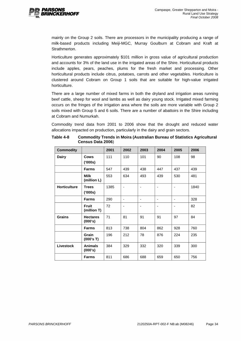
Campaspe, Greater Shepparton and Moira - Rural Land Use Strategy
Final October 2008
PARSONS BRINCKERHOFF 2120250A-RPT-002-F NB:ab (M08246) Page 34
mainly on the Group 2 soils. There are processors in the municipality producing a range of milk-based products including Meiji-MGC, Murray Goulburn at Cobram and Kraft at Strathmerton.
Horticulture generates approximately $101 million in gross value of agricultural production and accounts for 3% of the land use in the irrigated areas of the Shire. Horticultural products include apples, pears, peaches, plums for the fresh market and processing. Other horticultural products include citrus, potatoes, carrots and other vegetables. Horticulture is clustered around Cobram on Group 1 soils that are suitable for high-value irrigated horticulture.
There are a large number of mixed farms in both the dryland and irrigation areas running beef cattle, sheep for wool and lambs as well as dairy young stock. Irrigated mixed farming occurs on the fringes of the irrigation area where the soils are more variable with Group 2 soils mixed with Group 5 and 6 soils. There are a number of abattoirs in the Shire including at Cobram and Numurkah.
Commodity trend data from 2001 to 2006 show that the drought and reduced water allocations impacted on production, particularly in the dairy and grain sectors.
Table 4-8 Commodity Trends in Moira (Australian Bureau of Statistics Agricultural Census Data 2006)
Commodity 2001 2002 2003 2004 2005 2006
Dairy Cows (‘000s)
111 110 101 90 108 98
Farms 547 439 438 447 437 439
Milk (million L)
553 634 493 439 530 481
Horticulture Trees (‘000s)
1385 - - - - 1840
Farms 290 - - - - 328
Fruit (million T)
72 - - - - 82
Grains Hectares (000’s)
71 81 91 91 97 84
Farms 813 738 804 862 928 760
Grain (000’s T)
196 212 78 876 224 235
Livestock Animals (000’s)
384 329 332 320 339 300
Farms 811 686 688 659 650 756
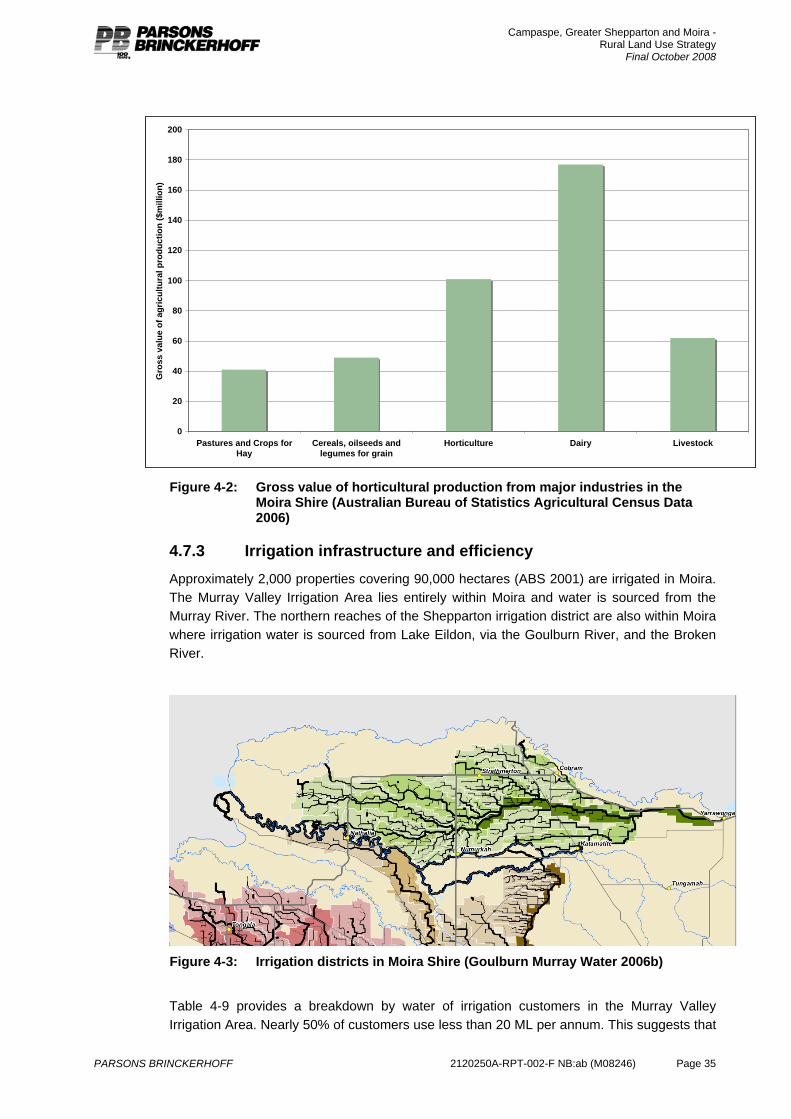
Campaspe, Greater Shepparton and Moira - Rural Land Use Strategy
Final October 2008
PARSONS BRINCKERHOFF 2120250A-RPT-002-F NB:ab (M08246) Page 35
0
20
40
60
80
100
120
140
160
180
200
Pastures and Crops forHay
Cereals, oilseeds andlegumes for grain
Horticulture Dairy Livestock
Gro
ss v
alue
of a
gric
ultu
ral p
rodu
ctio
n ($
mill
ion)
Figure 4-2: Gross value of horticultural production from major industries in the
Moira Shire (Australian Bureau of Statistics Agricultural Census Data 2006)
4.7.3 Irrigation infrastructure and efficiency Approximately 2,000 properties covering 90,000 hectares (ABS 2001) are irrigated in Moira. The Murray Valley Irrigation Area lies entirely within Moira and water is sourced from the Murray River. The northern reaches of the Shepparton irrigation district are also within Moira where irrigation water is sourced from Lake Eildon, via the Goulburn River, and the Broken River.
Figure 4-3: Irrigation districts in Moira Shire (Goulburn Murray Water 2006b)
Table 4-9 provides a breakdown by water of irrigation customers in the Murray Valley Irrigation Area. Nearly 50% of customers use less than 20 ML per annum. This suggests that
Campaspe, Greater Shepparton and Moira - Rural Land Use Strategy
Final October 2008
PARSONS BRINCKERHOFF 2120250A-RPT-002-F NB:ab (M08246) Page 36
about a quarter of the customers use about 90% of the water. This is a stark illustration of the need to protect and service the needs of this source of growing businesses.
Table 4-9: Distribution of water use in the Murray Valley (http://www.g-mwater.com.au/)
Distribution of water use in the Murray Valley
<20ML 20-100ML 100-300ML 300-1000ML
>1,000ML
Number of customers 662 90 316 303 29
Proportion of customers % 47 6 23 22 2
4.7.4 Farm businesses The breakdown by farm incomes in 2006 (Table 4-16) reveals that 33% of farms are generating less than $100,000 gross farm income. Over half of these are livestock businesses and are likely to be part time businesses with other income coming off-farm.
Those generating between $100,000 and $200,000 per annum (22% of farm businesses) will be under significant economic pressure (if relying on the farm business alone) and in the near future may need to consider increasing farm scale, introducing a more intensive production system or increasing the off farm income. A large proportion of these are dairy businesses and for those looking to increase farm scale they will need access to land in larger allotments and unencumbered by unnecessary infrastructure such as housing.
Horticultural businesses close to the urban fringe of Cobram looking to expand may be constrained by access to affordable land. There is a tendency for small blocks close to the town and river to be purchased for lifestyle purposes which drives land values above productive value.
A comparison of farm incomes in 2001 and 2006 indicates that the total number of farm business has declined by around 200 businesses. Most of these were from businesses generating less than $500,000 per annum. There has also been a small increase in the number of businesses generating over $500,000. This suggests that some businesses have left farming and that there has been increased productivity, possibly by farm expansion amongst other farm businesses.

Campaspe, Greater Shepparton and Moira - Rural Land Use Strategy
Final October 2008
PARSONS BRINCKERHOFF 2120250A-RPT-002-F NB:ab (M08246) Page 37
Table 4-10: Distribution of farm incomes (estimated value of agricultural operations) in Moira (ABS 2006)
Farm income range
Farm businesses type
< $100k $100k to $200k
$200 to $500k
$500 to $1mill
$1mill to $2mill
>2mill Total number of properties
Horticulture 31 23 29 17 12 9 121
Dairy 48 121 231 65 8 1 474
Livestock 195 46 13 - 3 - 257
Cropping 38 13 28 18 1 - 98
Mixed cropping/grazing
50 39 29 9 1 - 128
Total 362 242 330 109 25 10 1,078
Table 4-11: Distribution of farm incomes (estimated value of agricultural operations) in Moira (ABS 2001)
Farm Income Range
Farm businesses type
< $100k $100k to $200k
$200 to $500k
$500 to $1mill
$1mill to $2mill
>2mill Total number of properties
Horticulture 69 25 43 16 10 6 169
Dairy 58 218 270 41 8 - 595
Livestock 167 30 9 2 1 1 210
Dryland cropping
39 24 29 8 1 1 102
Mixed cropping/grazing
84 45 34 4 - - 167
Total 417 342 385 71 20 8 1,243
4.7.5 Productive agricultural land Productive agricultural land is established based on an evaluation of the soil types, subdivision pattern, climate and irrigation infrastructure.
Soil types Group 1 and Group 2 soils are found south and east of Cobram and north of Katamatite and around Invergordon North. These soils have few disabilities for irrigation and suitable for horticultural crops, vegetables, perennial and annual pastures and summer fodder crops.
Elsewhere, especially towards the fringes of the irrigation areas, the soils are more variable with Group 1 and Group 2 soils interspersed with Group 5 and Group 6 soils. This variability limits the agricultural options and these areas are commonly used for mixed farming.
The Agricultural development areas (Appendix E – Map 1) in Moira are located north of Nathalia around Picola, south of Nathalia along the irrigation channel between the Goulburn River and Broken Creek and west and south west of Yarrawonga.
Campaspe, Greater Shepparton and Moira - Rural Land Use Strategy
Final October 2008
PARSONS BRINCKERHOFF 2120250A-RPT-002-F NB:ab (M08246) Page 38
There is no soils data for the dryland areas of the Shire, however, the agricultural industry data shows that dryland cropping of winter cereals and grains is significant as is dryland livestock production. This suggests that dryland areas have soils suited to agricultural production.
Subdivision patterns The pattern of property sizes in the area (shown in Appendix E – Map 2) indicates that within the irrigation areas a most properties are between the 40 ha and 100 ha in area and consist of a number of separate allotments. Around Cobram along the Murray River, there are a number of small properties comprised of a number of quite small allotments. As noted previously, these properties are at risk of becoming lifestyle properties due to their small size and proximity to the river and town. Properties in the dryland areas of the Shire are generally larger than 100ha in size and comprised of a number allotments. The subdivision pattern in the rural areas is considered to be suited for continuing agriculture.
Climate Moira has a Mediterranean climate with hot dry summers and cool winters with most rainfall falling between May and October. The winters also have cold nights with sufficient hours when temperatures fall below 2oC to meet the chilling requirement for bud initiation in fruit crops. This climate is suited to production of a range of agricultural commodities.
Table 4-12: Temperature and rainfall data from Yarrawonga (http://www.bom.gov.au)
J F M A M J J A S O N D Annual
Mean max temp oC
32.1 31.6 27.6 22.9 18.2 14.5 13.5 15.3 18.2 21.8 26.5 29.9 22.7
Mean Min temp oC
15.5 15.5 12.2 8.7 6.2 4.0 3.4 3.6 5.3 7.1 10.6 12.8 8.7
Mean days < 2oC
0 0 0 0.6 5.2 9.5 10.7 10.4 7.2 2.8 0.4 1 46.8
Mean rainfall mm
28.4 39.4 24.5 27.9 35.5 43.7 49.0 38.3 50.4 37.9 41.2 32.5 449.1
Irrigation Infrastructure Land that has access to the irrigation network has a wider range of agricultural options than dryland. Without access to the irrigation network dairying and horticulture could not be undertaken in Moira. A process is underway to develop a modernised irrigation supply that is critical to the Shire for the next 50 years and beyond.
Productive agricultural land conclusions Based on the assessment of soil types, subdivision patterns, irrigation infrastructure and climate, land in the rural areas is generally considered to be productive agricultural land that is of strategic importance to Shire economy. It is important that planning controls reflect this value and they encourage protection and retention of land for agriculture both now and in the future, particularly Group 1 and 2 soils around urban centres.
It is recognised that to secure some parts of the shire for agriculture, other parts, even though they may have good soils, will need to be available to lifestyle living. Existing constraints to furthering agricultural objectives in these areas may include the arrangement
Campaspe, Greater Shepparton and Moira - Rural Land Use Strategy
Final October 2008
PARSONS BRINCKERHOFF 2120250A-RPT-002-F NB:ab (M08246) Page 39
of adjacent property, access to infrastructure and conservation values. However, this will be determined by further analysis of rural living needs.
4.7.6 Summary of agriculture in Moira Agriculture is a significant land use in the Shire and underpins the local economy directly through on farm employment and through the associated manufacturing and food processing and industries servicing agriculture.
Dairy is the most significant agricultural industry in terms of land use and gross value of agricultural production. Along with horticulture, the dairy industry is dependant on access to a secure water supply via the irrigation network. Land use planning controls need to protect the irrigation areas to secure their future for farming but also integrate with the modernisation and reconfiguration of the systems and expansion into the agricultural development areas.
Farm businesses generally need to grow and expand over time. Access to affordable land unencumbered by unnecessary infrastructure is essential to provide the opportunity for farm growth of both irrigated and dryland businesses.
Horticultural production, and to a lesser extent dairy, requires soils with high suitability for irrigation. Moira has substantial areas of Class 1 soil (highly suitable for irrigation), some of which is in close proximity to Cobram. Land use planning controls need to ensure that sufficient areas of these soils are protected from urban expansion and are available to agriculture in the long term.
Land in the rural areas of the Shire is productive agricultural land based on the soil types, subdivision pattern and climate and the significant level of irrigation infrastructure, protection and retention of this land for agriculture is of primary strategic importance to the Shire and it is recommended that it should be included in the Farming Zone.
The boundaries of the farming zone will be modified based on subsequent strategic work in relation to town boundaries and rural living.
4.8 City of Greater Shepparton Agriculture in Greater Shepparton is a mix of dryland and irrigation production systems. Agricultural production was worth approximately $481 million in 2006 up from $410 million in 2001. Most production comes from perennial horticulture and dairy associated with the Shepparton and Central Goulburn Irrigation Areas (Figure 4-4). Approximately 10% of all employment in Greater Shepparton is associated with agriculture in the form of on-farm jobs. There is also significant employment associated with the manufacturing and processing of locally produced food.
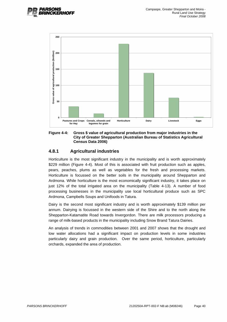
Campaspe, Greater Shepparton and Moira - Rural Land Use Strategy
Final October 2008
PARSONS BRINCKERHOFF 2120250A-RPT-002-F NB:ab (M08246) Page 40
0
50
100
150
200
250
Pastures and Cropsfor Hay
Cereals, oilseeds andlegumes for grain
Horticulture Dairy Livestock Eggs
Gro
ss v
alue
of a
gric
ultu
ral p
rodu
ctio
n ($
mill
ion)
Figure 4-4: Gross $ value of agricultural production from major industries in the
City of Greater Shepparton (Australian Bureau of Statistics Agricultural Census Data 2006)
4.8.1 Agricultural industries Horticulture is the most significant industry in the municipality and is worth approximately $229 million (Figure 4-4). Most of this is associated with fruit production such as apples, pears, peaches, plums as well as vegetables for the fresh and processing markets. Horticulture is focussed on the better soils in the municipality around Shepparton and Ardmona. While horticulture is the most economically significant industry, it takes place on just 12% of the total irrigated area on the municipality (Table 4-13). A number of food processing businesses in the municipality use local horticultural produce such as SPC Ardmona, Campbells Soups and Unifoods in Tatura.
Dairy is the second most significant industry and is worth approximately $139 million per annum. Dairying is focussed in the western side of the Shire and to the north along the Shepparton-Katamatite Road towards Invergordon. There are milk processors producing a range of milk-based products in the municipality including Snow Brand Tatura Dairies.
An analysis of trends in commodities between 2001 and 2007 shows that the drought and low water allocations had a significant impact on production levels in some industries particularly dairy and grain production. Over the same period, horticulture, particularly orchards, expanded the area of production.
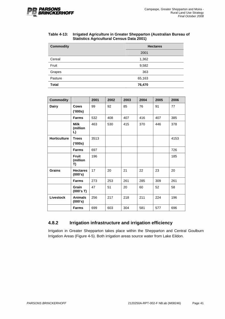
Campaspe, Greater Shepparton and Moira - Rural Land Use Strategy
Final October 2008
PARSONS BRINCKERHOFF 2120250A-RPT-002-F NB:ab (M08246) Page 41
Table 4-13: Irrigated Agriculture in Greater Shepparton (Australian Bureau of Statistics Agricultural Census Data 2001)
Hectares Commodity
2001
Cereal 1,362
Fruit 9,582
Grapes 363
Pasture 65,163
Total 76,470
Commodity 2001 2002 2003 2004 2005 2006
Dairy Cows (‘000s)
99 92 85 76 91 77
Farms 532 408 407 416 407 385
Milk (million L)
463 530 415 370 446 378
Horticulture Trees (‘000s)
3513 4153
Farms 697 726
Fruit (million T)
196 185
Grains Hectares (000’s)
17 20 21 22 23 20
Farms 273 253 261 285 309 261
Grain (000’s T)
47 51 20 60 52 58
Livestock Animals (000’s)
256 217 218 211 224 196
Farms 699 603 304 581 577 696
4.8.2 Irrigation infrastructure and irrigation efficiency Irrigation in Greater Shepparton takes place within the Shepparton and Central Goulburn Irrigation Areas (Figure 4-5). Both irrigation areas source water from Lake Eildon.
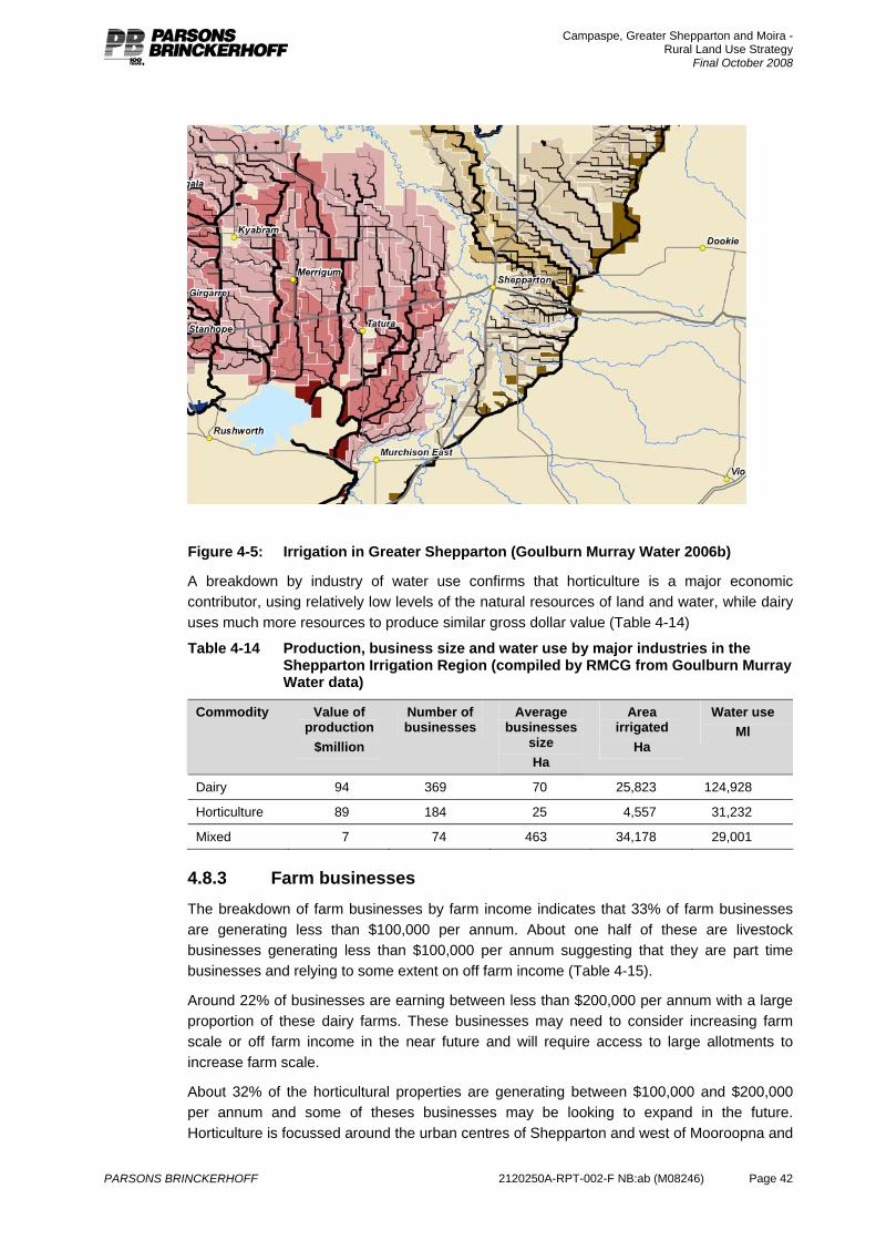
Campaspe, Greater Shepparton and Moira - Rural Land Use Strategy
Final October 2008
PARSONS BRINCKERHOFF 2120250A-RPT-002-F NB:ab (M08246) Page 42
Figure 4-5: Irrigation in Greater Shepparton (Goulburn Murray Water 2006b)
A breakdown by industry of water use confirms that horticulture is a major economic contributor, using relatively low levels of the natural resources of land and water, while dairy uses much more resources to produce similar gross dollar value (Table 4-14)
Table 4-14 Production, business size and water use by major industries in the Shepparton Irrigation Region (compiled by RMCG from Goulburn Murray Water data)
Commodity Value of production
$million
Number of businesses
Average businesses
size Ha
Area irrigated
Ha
Water use Ml
Dairy 94 369 70 25,823 124,928
Horticulture 89 184 25 4,557 31,232
Mixed 7 74 463 34,178 29,001
4.8.3 Farm businesses The breakdown of farm businesses by farm income indicates that 33% of farm businesses are generating less than $100,000 per annum. About one half of these are livestock businesses generating less than $100,000 per annum suggesting that they are part time businesses and relying to some extent on off farm income (Table 4-15).
Around 22% of businesses are earning between less than $200,000 per annum with a large proportion of these dairy farms. These businesses may need to consider increasing farm scale or off farm income in the near future and will require access to large allotments to increase farm scale.
About 32% of the horticultural properties are generating between $100,000 and $200,000 per annum and some of theses businesses may be looking to expand in the future. Horticulture is focussed around the urban centres of Shepparton and west of Mooroopna and
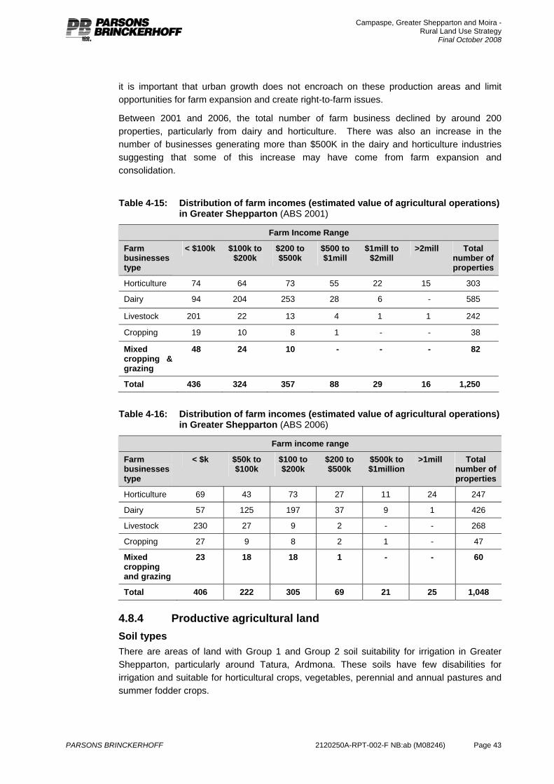
Campaspe, Greater Shepparton and Moira - Rural Land Use Strategy
Final October 2008
PARSONS BRINCKERHOFF 2120250A-RPT-002-F NB:ab (M08246) Page 43
it is important that urban growth does not encroach on these production areas and limit opportunities for farm expansion and create right-to-farm issues.
Between 2001 and 2006, the total number of farm business declined by around 200 properties, particularly from dairy and horticulture. There was also an increase in the number of businesses generating more than $500K in the dairy and horticulture industries suggesting that some of this increase may have come from farm expansion and consolidation.
Table 4-15: Distribution of farm incomes (estimated value of agricultural operations) in Greater Shepparton (ABS 2001)
Farm Income Range
Farm businesses type
< $100k $100k to $200k
$200 to $500k
$500 to $1mill
$1mill to $2mill
>2mill Total number of properties
Horticulture 74 64 73 55 22 15 303
Dairy 94 204 253 28 6 - 585
Livestock 201 22 13 4 1 1 242
Cropping 19 10 8 1 - - 38
Mixed cropping & grazing
48 24 10 - - - 82
Total 436 324 357 88 29 16 1,250
Table 4-16: Distribution of farm incomes (estimated value of agricultural operations) in Greater Shepparton (ABS 2006)
Farm income range
Farm businesses type
< $k $50k to $100k
$100 to $200k
$200 to $500k
$500k to $1million
>1mill Total number of properties
Horticulture 69 43 73 27 11 24 247
Dairy 57 125 197 37 9 1 426
Livestock 230 27 9 2 - - 268
Cropping 27 9 8 2 1 - 47
Mixed cropping and grazing
23 18 18 1 - - 60
Total 406 222 305 69 21 25 1,048
4.8.4 Productive agricultural land Soil types There are areas of land with Group 1 and Group 2 soil suitability for irrigation in Greater Shepparton, particularly around Tatura, Ardmona. These soils have few disabilities for irrigation and suitable for horticultural crops, vegetables, perennial and annual pastures and summer fodder crops.

Campaspe, Greater Shepparton and Moira - Rural Land Use Strategy
Final October 2008
PARSONS BRINCKERHOFF 2120250A-RPT-002-F NB:ab (M08246) Page 44
Elsewhere the soils are generally Group 3 and Group 4 which are more suited to irrigated pasture and crop production and are generally used for dairy and irrigated mixed farming (Appendix E – Map 1).
The Agricultural development areas in Greater Shepparton (Appendix D – Figure AD-10) are located around Bunbartha in the north and east of the main channel of the Shepparton Irrigation Area.
There is no soils data for the dryland areas of the Shire, however, the agricultural industry data shows that dryland cropping of winter cereals and grains is significant as is dryland livestock production. This suggests that dryland areas have soils suited to agricultural production.
Subdivision patterns
Analysis indicates that in the irrigation areas east of Shepparton and around the towns, properties are generally 8 to 20 ha. This is associated with the horticultural development in Shepparton East. These properties will be at risk of becoming lifestyle properties due to their small size and proximity to the town (See Appendix E – Map 2).
Elsewhere in the irrigation areas properties are generally 20 to 40 ha or 40 to 100 ha and larger properties would be comprised of a number of allotments. Dryland properties tend to be mainly over 100 ha in size and would be comprised of a number of allotments. This subdivision pattern is considered favourable for agriculture.
Climate Greater Shepparton has a Mediterranean climate with a hot dry Table 4-17). The winters have cold nights with sufficient hours when temperatures fall below 2oC to meet the chilling requirement for bud initiation in fruit crops. This climate is suited to production of a range of agricultural commodities.
Table 4-17: Temperature and rainfall data from Tatura (http://www.bom.gov.au)
J F M A M J J A S O N D Annual
Mean max temp oC
29.3
29.5
26.2
21.6
17.2
13.9
13.0
14.7
17.3
20.8
24.4
27.3
21.3
Mean Min temp oC
14.0
14.4
11.7
8.2 5.8 3.6 2.9 3.8 5.5 7.6 10.0
12.1
8.3
Mean days < 2oC
0 0 0 1.0 5.9 10.6
13.0
10.0
5.8 1.6 0.2 0 48.1
Mean rainfall mm
32.5
32.5
32.2
34.6
46.6
44.4
48.3
47.1
44.2
48.4
39.0
32.9
482.8
Irrigation infrastructure Land that has access to the irrigation network has a wider range of agricultural options than dryland. Without access to the irrigation network dairying and horticulture could not be undertaken in Shepparton. A modernised supply system is planned and about to be designed and implemented.
Productive agricultural land conclusions Based on the assessment of soil types, subdivision patterns, irrigation infrastructure and climate, land in the rural areas is generally considered to be productive agricultural land that is of strategic importance to Shire economy. It is important that planning controls reflect this value and they encourage protection and retention for agriculture both now and in the future, particularly the Group 1 and 2 soils close to urban centres.
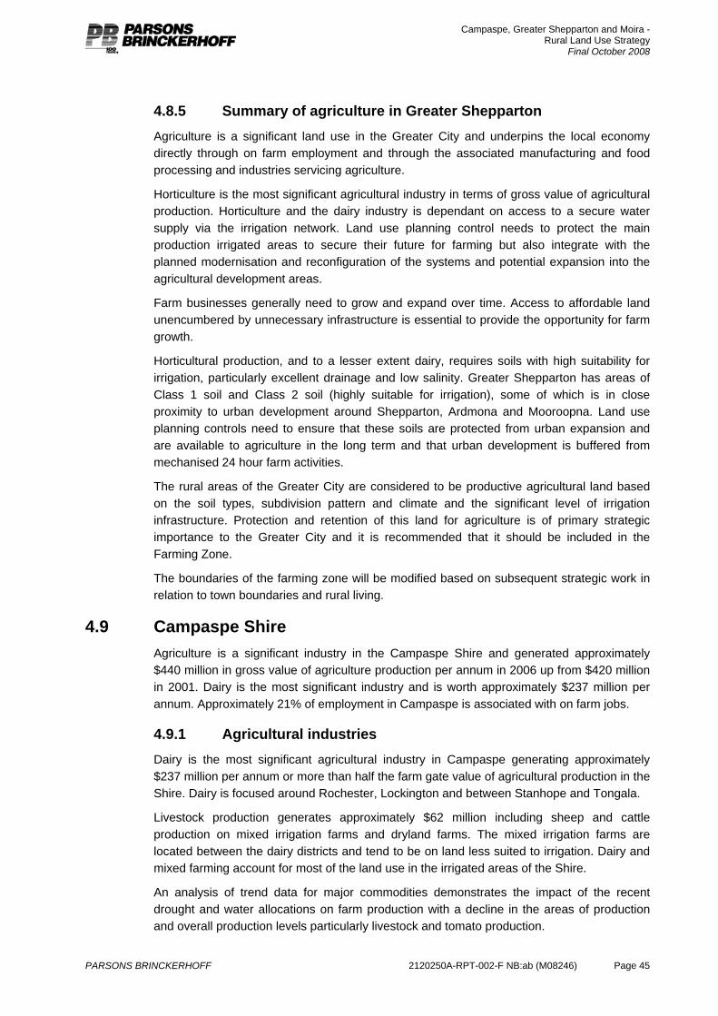
Campaspe, Greater Shepparton and Moira - Rural Land Use Strategy
Final October 2008
PARSONS BRINCKERHOFF 2120250A-RPT-002-F NB:ab (M08246) Page 45
4.8.5 Summary of agriculture in Greater Shepparton Agriculture is a significant land use in the Greater City and underpins the local economy directly through on farm employment and through the associated manufacturing and food processing and industries servicing agriculture.
Horticulture is the most significant agricultural industry in terms of gross value of agricultural production. Horticulture and the dairy industry is dependant on access to a secure water supply via the irrigation network. Land use planning control needs to protect the main production irrigated areas to secure their future for farming but also integrate with the planned modernisation and reconfiguration of the systems and potential expansion into the agricultural development areas.
Farm businesses generally need to grow and expand over time. Access to affordable land unencumbered by unnecessary infrastructure is essential to provide the opportunity for farm growth.
Horticultural production, and to a lesser extent dairy, requires soils with high suitability for irrigation, particularly excellent drainage and low salinity. Greater Shepparton has areas of Class 1 soil and Class 2 soil (highly suitable for irrigation), some of which is in close proximity to urban development around Shepparton, Ardmona and Mooroopna. Land use planning controls need to ensure that these soils are protected from urban expansion and are available to agriculture in the long term and that urban development is buffered from mechanised 24 hour farm activities.
The rural areas of the Greater City are considered to be productive agricultural land based on the soil types, subdivision pattern and climate and the significant level of irrigation infrastructure. Protection and retention of this land for agriculture is of primary strategic importance to the Greater City and it is recommended that it should be included in the Farming Zone.
The boundaries of the farming zone will be modified based on subsequent strategic work in relation to town boundaries and rural living.
4.9 Campaspe Shire Agriculture is a significant industry in the Campaspe Shire and generated approximately $440 million in gross value of agriculture production per annum in 2006 up from $420 million in 2001. Dairy is the most significant industry and is worth approximately $237 million per annum. Approximately 21% of employment in Campaspe is associated with on farm jobs.
4.9.1 Agricultural industries Dairy is the most significant agricultural industry in Campaspe generating approximately $237 million per annum or more than half the farm gate value of agricultural production in the Shire. Dairy is focused around Rochester, Lockington and between Stanhope and Tongala.
Livestock production generates approximately $62 million including sheep and cattle production on mixed irrigation farms and dryland farms. The mixed irrigation farms are located between the dairy districts and tend to be on land less suited to irrigation. Dairy and mixed farming account for most of the land use in the irrigated areas of the Shire.
An analysis of trend data for major commodities demonstrates the impact of the recent drought and water allocations on farm production with a decline in the areas of production and overall production levels particularly livestock and tomato production.
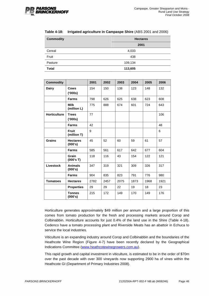
Campaspe, Greater Shepparton and Moira - Rural Land Use Strategy
Final October 2008
PARSONS BRINCKERHOFF 2120250A-RPT-002-F NB:ab (M08246) Page 46
Table 4-18: Irrigated agriculture in Campaspe Shire (ABS 2001 and 2006)
Hectares Commodity
2001
Cereal 4,033
Fruit 438
Pasture 109,134
Total 113,605
Commodity 2001 2002 2003 2004 2005 2006
Dairy Cows (‘000s)
154 150 138 123 148 132
Farms 798 626 625 638 623 608
Milk (million L)
775 888 674 601 724 643
Horticulture Trees (‘000s)
77 106
Farms 42 48
Fruit (million T)
9 6
Grains Hectares (000’s)
45 52 60 59 61 57
Farms 585 561 617 642 677 604
Grain (000’s T)
118 116 43 154 122 121
Livestock Animals (000’s)
347 319 321 309 326 317
Farms 904 835 823 791 776 980
Tomatoes Hectares 2782 2457 2075 1873 1968 1921
Properties 29 29 22 19 18 23
Tonnes (000’s)
215 172 149 170 149 176
Horticulture generates approximately $49 million per annum and a large proportion of this comes from tomato production for the fresh and processing markets around Corop and Colbinabbin. Horticulture accounts for just 0.4% of the land use in the Shire (Table 4-18). Cedenco have a tomato processing plant and Riverside Meats has an abattoir in Echuca to service the local industries.
Viticulture is an expanding industry around Corop and Colbinabbin and the boundaries of the Heathcote Wine Region (Figure 4-7) have been recently declared by the Geographical Indications Committee (www.heathcotewinegrowers.com.au).
This rapid growth and capital investment in viticulture, is estimated to be in the order of $70m over the past decade with over 300 vineyards now supporting 2900 ha of vines within the Heathcote GI (Department of Primary Industries 2008).
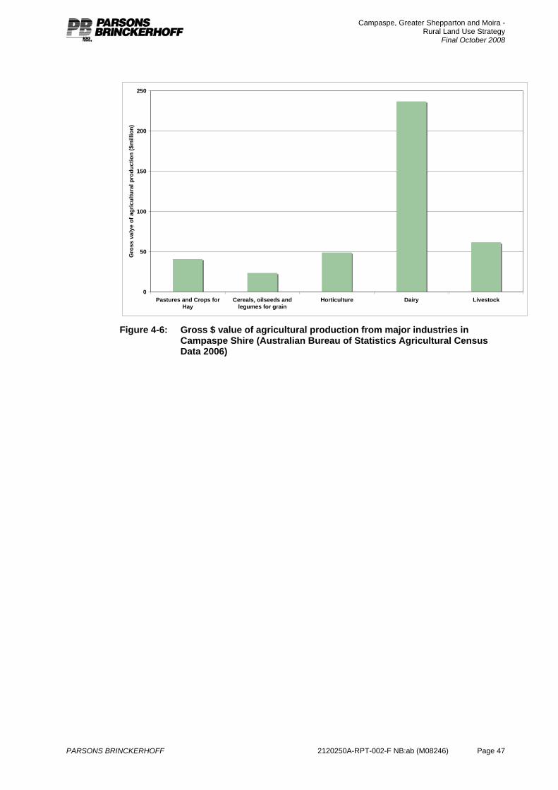
Campaspe, Greater Shepparton and Moira - Rural Land Use Strategy
Final October 2008
PARSONS BRINCKERHOFF 2120250A-RPT-002-F NB:ab (M08246) Page 47
0
50
100
150
200
250
Pastures and Crops forHay
Cereals, oilseeds andlegumes for grain
Horticulture Dairy Livestock
Gro
ss v
alye
of a
gric
ultu
ral p
rodu
ctio
n ($
mill
ion)
Figure 4-6: Gross $ value of agricultural production from major industries in
Campaspe Shire (Australian Bureau of Statistics Agricultural Census Data 2006)
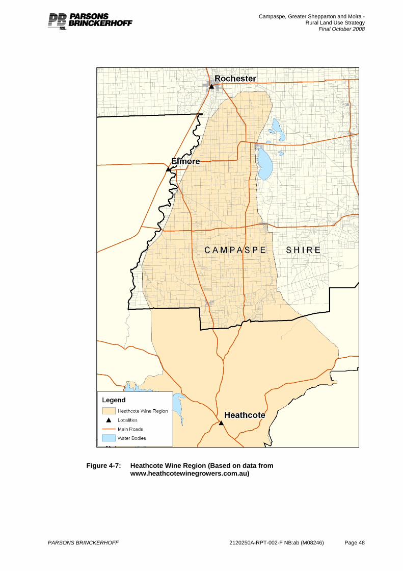
Campaspe, Greater Shepparton and Moira - Rural Land Use Strategy
Final October 2008
PARSONS BRINCKERHOFF 2120250A-RPT-002-F NB:ab (M08246) Page 48
Figure 4-7: Heathcote Wine Region (Based on data from
www.heathcotewinegrowers.com.au)
Campaspe, Greater Shepparton and Moira - Rural Land Use Strategy
Final October 2008
PARSONS BRINCKERHOFF 2120250A-RPT-002-F NB:ab (M08246) Page 49
4.9.2 Farm businesses The breakdown of farm businesses shows that 41% of farms are generating less than $100,000 farm income and a large proportion of these are livestock businesses suggesting that they are part time businesses supported by off farm income (Table 4-19).
About 42% of dairy businesses are generating less than $200,000 per annum. Without off farm income these businesses will be under some financial pressure and will be looking to expand, intensify or increase off farm income in the short term. From a land use planning perspective, growth of these businesses can be assisted by ensuring land is retained in larger allotments, is not encumbered with unnecessary infrastructure and that land values reflect the agricultural value and not inflated by the existence of or potential for a dwelling.
Table 4-19: Distribution of farm incomes (estimated value of agricultural operations) in Campaspe (ABS 2006)
Farm income range
Farm businesses type
< $100k $100k to $200k
$200 to $500k
$500 to $1mill
$1mill to $2mill
>2mill Total number of properties
Horticulture 87 20 12 8 8 4 139
Dairy 102 177 299 74 12 3 667
Livestock 296 41 21 7 5 6 376
Cropping 43 12 15 5 2 - 77
Mixed cropping and grazing
36 24 23 4 - - 27
Total 564 274 370 98 27 13 1,346
Table 4-20: Distribution of farm incomes (estimated value of agricultural operations) in Campaspe (ABS 2001)
Farm income range
Farm businesses type
< $100k $1000k to $200k
$200 to $500k
$500 to $1mill
$1mill to $2mill
>2mill Total number of properties
Horticulture 64 9 16 15 12 2 118
Dairy 139 285 373 65 12 - 874
Livestock 245 25 9 5 2 4 290
Cropping 43 12 15 2 2 - 77
Mixed cropping & grazing
36 24 23 4 - - 87
Total 527 355 436 94 28 6 1,446
4.9.3 Irrigation infrastructure and irrigation efficiency Irrigation in Campaspe takes place in the Campaspe Rochester Irrigation Area, the western side of the Central Goulburn Irrigation Area and the far eastern end of the Torrumbarry
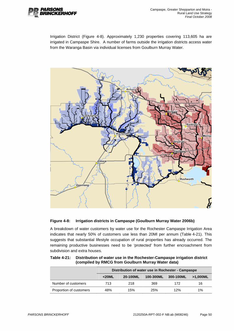
Campaspe, Greater Shepparton and Moira - Rural Land Use Strategy
Final October 2008
PARSONS BRINCKERHOFF 2120250A-RPT-002-F NB:ab (M08246) Page 50
Irrigation District (Figure 4-8). Approximately 1,230 properties covering 113,605 ha are irrigated in Campaspe Shire. A number of farms outside the irrigation districts access water from the Waranga Basin via individual licenses from Goulburn Murray Water.
Figure 4-8: Irrigation districts in Campaspe (Goulburn Murray Water 2006b)
A breakdown of water customers by water use for the Rochester Campaspe Irrigation Area indicates that nearly 50% of customers use less than 20Ml per annum (Table 4-21). This suggests that substantial lifestyle occupation of rural properties has already occurred. The remaining productive businesses need to be ‘protected’ from further encroachment from subdivision and extra houses.
Table 4-21: Distribution of water use in the Rochester-Campaspe irrigation district (compiled by RMCG from Goulburn Murray Water data)
Distribution of water use in Rochester - Campaspe
<20ML 20-100ML 100-300ML 300-100ML >1,000ML
Number of customers 713 218 369 172 16
Proportion of customers 48% 15% 25% 12% 1%
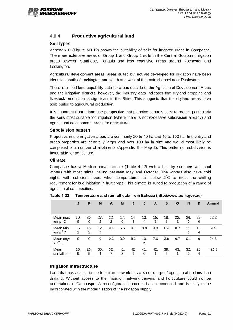
Campaspe, Greater Shepparton and Moira - Rural Land Use Strategy
Final October 2008
PARSONS BRINCKERHOFF 2120250A-RPT-002-F NB:ab (M08246) Page 51
4.9.4 Productive agricultural land Soil types Appendix D (Figure AD-12) shows the suitability of soils for irrigated crops in Campaspe. There are extensive areas of Group 1 and Group 2 soils in the Central Goulburn irrigation areas between Stanhope, Tongala and less extensive areas around Rochester and Lockington.
Agricultural development areas, areas suited but not yet developed for irrigation have been identified south of Lockington and south and west of the main channel near Rushworth.
There is limited land capability data for areas outside of the Agricultural Development Areas and the irrigation districts, however, the industry data indicates that dryland cropping and livestock production is significant in the Shire. This suggests that the dryland areas have soils suited to agricultural production.
It is important from a land use perspective that planning controls seek to protect particularly the soils most suitable for irrigation (where there is not excessive subdivision already) and agricultural development areas for agriculture.
Subdivision pattern Properties in the irrigation areas are commonly 20 to 40 ha and 40 to 100 ha. In the dryland areas properties are generally larger and over 100 ha in size and would most likely be comprised of a number of allotments (Appendix E – Map 2). This pattern of subdivision is favourable for agriculture.
Climate Campaspe has a Mediterranean climate (Table 4-22) with a hot dry summers and cool winters with most rainfall falling between May and October. The winters also have cold nights with sufficient hours when temperatures fall below 2oC to meet the chilling requirement for bud initiation in fruit crops. This climate is suited to production of a range of agricultural commodities.
Table 4-22: Temperature and rainfall data from Echuca (http://www.bom.gov.au)
J F M A M J J A S O N D Annual
Mean max temp oC
30.8
30.6
27.2
22.2
17.6
14.2
13.4
15.2
18.3
22.2
26.0
29.0
22.2
Mean Min temp oC
15.1
15.2
12.9
9.4 6.6 4.7 3.9 4.8 6.4 8.7 11.1
13.4
9.4
Mean days < 2oC
0 0 0 0.3 3.2 8.3 10.6
7.6 3.8 0.7 0.1 0 34.6
Mean rainfall mm
26.9
26.5
30.4
32.7
41.3
42.9
41.0
42.1
39.5
43.1
32.0
28.4
426.7
Irrigation infrastructure Land that has access to the irrigation network has a wider range of agricultural options than dryland. Without access to the irrigation network dairying and horticulture could not be undertaken in Campaspe. A reconfiguration process has commenced and is likely to be incorporated with the modernisation of the irrigation supply.
Campaspe, Greater Shepparton and Moira - Rural Land Use Strategy
Final October 2008
PARSONS BRINCKERHOFF 2120250A-RPT-002-F NB:ab (M08246) Page 52
4.9.5 Productive agricultural land conclusions Based on the assessment of soil types, subdivision patterns, irrigation infrastructure and climate, land in the rural areas is generally considered to be productive agricultural land that is of strategic importance to Shire economy. It is important that planning controls reflect this value and they encourage protection and retention for agriculture both now and in the future.
4.9.6 Summary of agriculture in Campaspe Agriculture is a significant land use in the Shire and underpins the local economy directly through on farm employment and through the associated manufacturing and food processing and industries servicing agriculture.
Dairy is the most significant agricultural industry in terms of land use and gross value of agricultural production. The dairy industry is dependant on access to a secure water supply via the irrigation network. Land use planning controls needs to protect the irrigation areas to secure their future for farming but also integrate with the modernisation and reconfiguration of the systems and expansion into the agricultural development areas.
Farm businesses generally need to grow and expand over time. Access to affordable land unencumbered by unnecessary infrastructure is essential to provide the opportunity for farm growth.
The rural areas of the Shire are considered to be productive agricultural land based on the soil types, subdivision pattern and climate and the significant level of irrigation infrastructure. Protection and retention of this land for agriculture is of primary strategic importance to the Shire and it is recommended that it should be included in the Farming Zone.
Increasing development of intensive agricultural industries within areas of Campaspe have also occurred. These are commonly in locations that are associated with large areas of native grasslands. Strategic policy instruments are required to ensure that existing and future intensive industries can coexist in a sustainable way with the protection of significant native grassland ecosystems.
Campaspe, Greater Shepparton and Moira - Rural Land Use Strategy
Final October 2008
PARSONS BRINCKERHOFF 2120250A-RPT-002-F NB:ab (M08246) Page 53
5. Population and settlement The study region encompasses a number of distinct landscapes and communities, each following varied trajectories in land use modification, population change and economic transition. These trends present the core challenges for future planning as they indicate new pressures and motivations for development in both urban and rural areas.
Given that the study area includes productive irrigation areas, valuable riverine and forest environments and areas where rural landscapes have attracted new and emerging forms of (often urban-generated) living, it is important to consider social and economic trends as they are reflected in each of these location types. Land use and population trends in the area should also be seen in a broader context of change in the region and beyond. In general the following broad trends can be identified across rural Australia, including in the study area:
Declining rural and small-town populations, particularly in dryland agricultural areas, but also in many established irrigation regions.
A centralisation of services (a ‘sponge city’ effect) in most agricultural regions.
Rapid growth within the expanding commuter field of larger urban centres, this is evident in both rural landscapes and in established settlements.
Growth of population and housing in valued localities where leisure landscapes, comparative housing affordability and lifestyle perceptions combine. This appears to be driven by both local population movement and more general ‘tree change’ trends.
Concurrent and divergent pathways of large and expanding commercial agricultural holdings and increasing small, niche and sub-commercial farming – and effective, but long term, trend of the ‘hollowing-out’ of mid-range farm businesses, leaving only large and small (or sub-commercial) farms as predominant in the landscape.
In the case of the study region each of these processes can be identified in various localities, presenting an often contradictory set of dynamics at the regional level: larger urban centres such as Shepparton and Echuca continue to grow, a number of small towns are characterised by population decline, towns and rural areas on the River Murray and its broader environs show strong population and development growth, while the character of farming landscapes show a mixed process of change relating to farm business size, transition to non-commercial land uses and the continued emergence of newer forms of agricultural activity.
Exploring these issues, and offering strategic approaches to future land management, requires consideration of the existing context of policy and land use planning, a review of trends in population at a regional and local level, and an appraisal of land use trends, especially trends in housing and subdivision. This chapter outlines each of these elements and offers a strategic basis for directing broad land use objectives in the regions rural landscapes.
5.1 Strategic elements for consideration Various existing elements of strategy and policy guide the direction for development in the study area. The include the Moira Rural Living Strategy (2004), Echuca Low Density Residential and Rural Living Review (2003), as well as elements of broader strategy such as the Greater Shepparton 2030 Strategy Plan which have been prepared at a local government level, as well as the Local and State Planning Policy contained within each of the three planning schemes.
Campaspe, Greater Shepparton and Moira - Rural Land Use Strategy
Final October 2008
PARSONS BRINCKERHOFF 2120250A-RPT-002-F NB:ab (M08246) Page 54
In general, there is recognition that many rural localities are experiencing land use change, whether within a context of agricultural restructure, or through a transition to residential development in a rural setting. Even within these different processes of change, existing policy offers a framework for the form and management of new development and land use change.
The Echuca Low Density Residential and Rural Living Strategy (2003) are concerned directly with land on the fringes of urban Echuca. The strategy sought to determine the appropriate distribution and form of rural residential opportunities in areas including Wharparilla Drive and sites on the immediate fringe of the existing urban area such as the racecourse precinct. In general this strategy, which was largely supported with the eventual approval of Amendments C34, C35 and C36 to the Campaspe Planning Scheme, recognised the need to provide for rural lifestyle development as a genuine market segment, but to do this within a framework that supported locations where development was strategically desirable, and in forms that met a range of market opportunities. The study also ensured that the supply of such land was suited to anticipated levels of demand.
The Moira Rural Living Strategy (2004) assesses capacity and demonstrated demand for residential development in rural areas, specifically within the environs of six areas of Moira: Cobram, Numurkah, Nathalia, Yarrawonga, Barmah and Bundalong. This resulted in specific analysis of opportunities for such development in localities near Yarrawonga and Numurkah, although the proposed changes at Numurkah were not supported by the Panel6 reviewing the subsequent amendment proposal. In the case of Moira, the strategy and subsequent amendment recognised the role of rural residential (low density and rural living) development, especially near the River Murray towns, but the existing levels of supply were also assessed and the need to ensure that any land use transition was managed to meet location constraints, risks to existing rural activities, and anticipated levels of demand was recognised in the strategy and in the subsequent assessment of the proposed amendment to the Moira Planning Scheme.
In Shepparton, while no specific rural land strategy has been prepared in recent years, the Greater Shepparton 2030 Strategy Plan (2006) provides a framework for some lifestyle development in rural landscapes close to existing urban centres. The strategy focussed strongly on the role of rural living development within the spectrum of urban-generated housing choices, especially where servicing and environmental constraints limit the development at urban residential densities. In general, this policy framework considers rural residential housing as a component of the broader urban and urban-generated settlement process, rather than as a distinct land use in the rural landscape. This reflects the productive nature of rural landscapes in Greater Shepparton, and that population growth is not necessarily linked to specific landscape features.
At the 2006 Census the study area recorded a population of 118,105 – this represents a net population growth of 2,109 since 2001 (Table 5-1). At the local level, the pattern of population change was varied, with some areas and urban centres recording significant levels of growth and others in decline. Generally, it is apparent that levels of growth since 2001 have not been as high as the experience of the 1990s, with some areas recording population decline subsequent to increases during the period between 1996 and 2001.
6 The Panel, or The Planning and Environment List is part of the Victorian Civil and Administrative Tribunal (VCAT), an independent tribunal, which hears and decides applications by permit applicants, objectors and others.

Campaspe, Greater Shepparton and Moira - Rural Land Use Strategy
Final October 2008
PARSONS BRINCKERHOFF 2120250A-RPT-002-F NB:ab (M08246) Page 55
Table 5-1: Population – Statistical local areas 1996-2006. Source: ABS Census
1996 2001 2006 Av. Annual Change 1996-
2006
Campaspe - Echuca 10,014 10,955 12,401 2.16
Campaspe - Kyabram 11,750 11,981 11,646 -0.09
Campaspe - Rochester 7,865 7,990 7,791 -0.09
Campaspe - South 3,691 3,685 3,619 -0.20
Gr. Shepparton - Pt A 39,694 42,749 43,999 1.03
Gr. Shepparton - Pt B East 3,832 3,846 3,590 -0.65
Gr. Shepparton - Pt B West
8,376 8,615 8,525 0.18
Moira - East 7,374 7,870 8,558 1.50
Moira - West 17,339 17,605 17,976 0.36
Total 109,935 115,296 118,105 0.72
The highest levels of population growth were recorded in Echuca, Shepparton and Moira – East (which includes localities such as Yarrawonga and its environs), while agricultural areas of the study region experienced low growth or population decline. Areas such as Shepparton Part B East and Campaspe – Rochester had experienced moderate growth in the later 1990s prior to a decline in population.
The divergent trends in population are more evident in the urban centres in the region. Centres including Echuca, Shepparton and Yarrawonga have experienced considerable growth (at level above averages for Victoria and Regional Victoria), while some smaller centres have declined in population (Table 5-2).
Table 5-2: Population – Urban Centres 1996-2006. Source: ABS Census
1996 2001 2006 Av. Annual Change 1996-2001
Shepparton-Mooroopna 31,945 35,828 38,797 1.96
Echuca 10,014 10,955 12,401 2.16
Yarrawonga 3,435 4,025 5,731 5.25
Kyabram 5,738 5,534 5,615 -0.22
Cobram 3,865 4,554 5,066 2.74
Numurkah 3,128 3,382 3,683 1.65
Tatura 2,826 2,931 3,534 2.26
Rochester 2,553 2,624 2,832 1.04
Nathalia 1,455 1,416 1,425 -0.21
Tongala 1,164 1,179 1,257 0.77
Rushworth 976 1,001 1,039 0.63
Murchison 633 672 787 2.20
Stanhope 565 514 520 -0.83
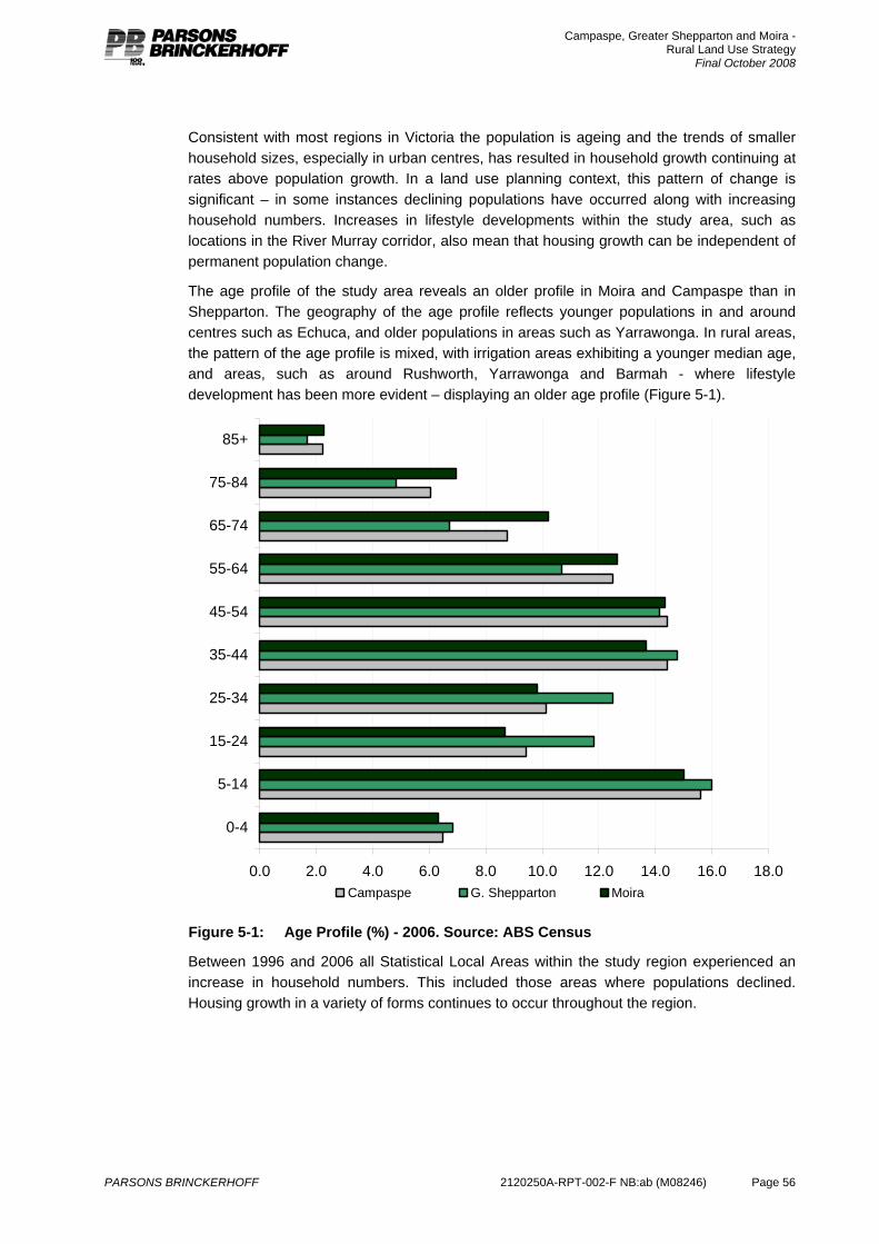
Campaspe, Greater Shepparton and Moira - Rural Land Use Strategy
Final October 2008
PARSONS BRINCKERHOFF 2120250A-RPT-002-F NB:ab (M08246) Page 56
Consistent with most regions in Victoria the population is ageing and the trends of smaller household sizes, especially in urban centres, has resulted in household growth continuing at rates above population growth. In a land use planning context, this pattern of change is significant – in some instances declining populations have occurred along with increasing household numbers. Increases in lifestyle developments within the study area, such as locations in the River Murray corridor, also mean that housing growth can be independent of permanent population change.
The age profile of the study area reveals an older profile in Moira and Campaspe than in Shepparton. The geography of the age profile reflects younger populations in and around centres such as Echuca, and older populations in areas such as Yarrawonga. In rural areas, the pattern of the age profile is mixed, with irrigation areas exhibiting a younger median age, and areas, such as around Rushworth, Yarrawonga and Barmah - where lifestyle development has been more evident – displaying an older age profile (Figure 5-1).
0.0 2.0 4.0 6.0 8.0 10.0 12.0 14.0 16.0 18.0
0-4
5-14
15-24
25-34
35-44
45-54
55-64
65-74
75-84
85+
Campaspe G. Shepparton Moira
Figure 5-1: Age Profile (%) - 2006. Source: ABS Census
Between 1996 and 2006 all Statistical Local Areas within the study region experienced an increase in household numbers. This included those areas where populations declined. Housing growth in a variety of forms continues to occur throughout the region.
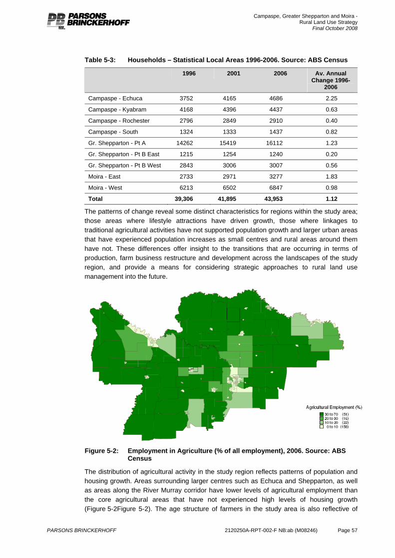
Campaspe, Greater Shepparton and Moira - Rural Land Use Strategy
Final October 2008
PARSONS BRINCKERHOFF 2120250A-RPT-002-F NB:ab (M08246) Page 57
Table 5-3: Households – Statistical Local Areas 1996-2006. Source: ABS Census
1996 2001 2006 Av. Annual Change 1996-
2006
Campaspe - Echuca 3752 4165 4686 2.25
Campaspe - Kyabram 4168 4396 4437 0.63
Campaspe - Rochester 2796 2849 2910 0.40
Campaspe - South 1324 1333 1437 0.82
Gr. Shepparton - Pt A 14262 15419 16112 1.23
Gr. Shepparton - Pt B East 1215 1254 1240 0.20
Gr. Shepparton - Pt B West 2843 3006 3007 0.56
Moira - East 2733 2971 3277 1.83
Moira - West 6213 6502 6847 0.98
Total 39,306 41,895 43,953 1.12
The patterns of change reveal some distinct characteristics for regions within the study area; those areas where lifestyle attractions have driven growth, those where linkages to traditional agricultural activities have not supported population growth and larger urban areas that have experienced population increases as small centres and rural areas around them have not. These differences offer insight to the transitions that are occurring in terms of production, farm business restructure and development across the landscapes of the study region, and provide a means for considering strategic approaches to rural land use management into the future.
Figure 5-2: Employment in Agriculture (% of all employment), 2006. Source: ABS
Census
The distribution of agricultural activity in the study region reflects patterns of population and housing growth. Areas surrounding larger centres such as Echuca and Shepparton, as well as areas along the River Murray corridor have lower levels of agricultural employment than the core agricultural areas that have not experienced high levels of housing growth (Figure 5-2Figure 5-2). The age structure of farmers in the study area is also reflective of
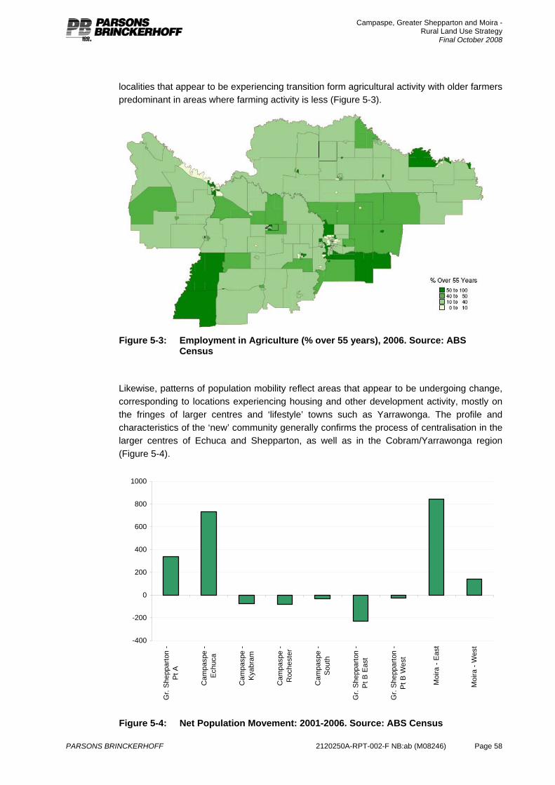
Campaspe, Greater Shepparton and Moira - Rural Land Use Strategy
Final October 2008
PARSONS BRINCKERHOFF 2120250A-RPT-002-F NB:ab (M08246) Page 58
localities that appear to be experiencing transition form agricultural activity with older farmers predominant in areas where farming activity is less (Figure 5-3).
Figure 5-3: Employment in Agriculture (% over 55 years), 2006. Source: ABS
Census
Likewise, patterns of population mobility reflect areas that appear to be undergoing change, corresponding to locations experiencing housing and other development activity, mostly on the fringes of larger centres and ‘lifestyle’ towns such as Yarrawonga. The profile and characteristics of the ‘new’ community generally confirms the process of centralisation in the larger centres of Echuca and Shepparton, as well as in the Cobram/Yarrawonga region (Figure 5-4).
-400
-200
0
200
400
600
800
1000
Gr.
She
ppar
ton
-P
t A
Cam
pasp
e -
Ech
uca
Cam
pasp
e -
Kya
bram
Cam
pasp
e -
Roc
hest
er
Cam
pasp
e -
Sou
th
Gr.
She
ppar
ton
-P
t B E
ast
Gr.
She
ppar
ton
-P
t B W
est
Moi
ra -
Eas
t
Moi
ra -
Wes
t
Figure 5-4: Net Population Movement: 2001-2006. Source: ABS Census
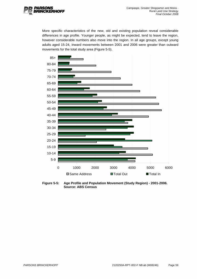
Campaspe, Greater Shepparton and Moira - Rural Land Use Strategy
Final October 2008
PARSONS BRINCKERHOFF 2120250A-RPT-002-F NB:ab (M08246) Page 59
More specific characteristics of the new, old and existing population reveal considerable differences in age profile. Younger people, as might be expected, tend to leave the region, however considerable numbers also move into the region. In all age groups, except young adults aged 15-24, inward movements between 2001 and 2006 were greater than outward movements for the total study area (Figure 5-5).
0 1000 2000 3000 4000 5000 6000
5-9
10-14
15-19
20-24
25-29
30-34
35-39
40-44
45-49
50-54
55-59
60-64
65-69
70-74
75-79
80-84
85+
Same Address Total Out Total In
Figure 5-5: Age Profile and Population Movement (Study Region) - 2001-2006. Source: ABS Census
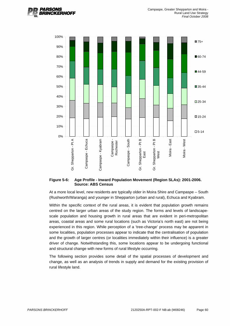
Campaspe, Greater Shepparton and Moira - Rural Land Use Strategy
Final October 2008
PARSONS BRINCKERHOFF 2120250A-RPT-002-F NB:ab (M08246) Page 60
0%
10%
20%
30%
40%
50%
60%
70%
80%
90%
100%
Gr.
She
ppar
ton
- Pt A
Cam
pasp
e - E
chuc
a
Cam
pasp
e - K
yabr
am
Cam
pasp
e -
Roc
hest
er
Cam
pasp
e - S
outh
Gr.
She
ppar
ton
- Pt B
Eas
t
Gr.
She
ppar
ton
- Pt B
Wes
t
Moi
ra -
Eas
t
Moi
ra -
Wes
t
75+
60-74
44-59
35-44
25-34
15-24
5-14
Figure 5-6: Age Profile - Inward Population Movement (Region SLAs): 2001-2006.
Source: ABS Census
At a more local level, new residents are typically older in Moira Shire and Campaspe – South (Rushworth/Waranga) and younger in Shepparton (urban and rural), Echuca and Kyabram.
Within the specific context of the rural areas, it is evident that population growth remains centred on the larger urban areas of the study region. The forms and levels of landscape-scale population and housing growth in rural areas that are evident in peri-metropolitan areas, coastal areas and some rural locations (such as Victoria’s north east) are not being experienced in this region. While perception of a ‘tree-change’ process may be apparent in some localities, population processes appear to indicate that the centralisation of population and the growth of larger centres (or localities immediately within their influence) is a greater driver of change. Notwithstanding this, some locations appear to be undergoing functional and structural change with new forms of rural lifestyle occurring.
The following section provides some detail of the spatial processes of development and change, as well as an analysis of trends in supply and demand for the existing provision of rural lifestyle land.
Campaspe, Greater Shepparton and Moira - Rural Land Use Strategy
Final October 2008
PARSONS BRINCKERHOFF 2120250A-RPT-002-F NB:ab (M08246) Page 61
5.2 Rural property and trends in housing Patterns of rural land use and housing development reflect the differentiated rural changes occurring in the study region. Existing patterns of landholdings reflect a range of historical drivers of development; larger dryland holdings, irrigation holdings developed at various phases and reflecting horticulture and dairying and smaller rural residential holdings on urban fringes and in desirable landscapes.
The distribution of smaller properties (Appendix E – Map 2) reflects an historical pattern of land settlement in irrigated farming areas, such as close to Shepparton, along a band from Cobram to Nathalia and around Bamawm and Lockington. The riverine corridors within the study are also characterised by smaller holdings. There are implications for future planning resulting from this property size distribution; while in some localities productive farming continues on single holdings in others multi-property farm businesses are a more typical response to pressures for increased scale, while in other places these properties have become an opportunity for non-farm rural development.
Patterns of existing housing, as reflected through rural address data indicate a predominance of housing on smaller holdings (Table 5-5). The capacity for these smaller properties to be operated and traded as an element of larger agricultural holdings is potentially limited by the existing residential nature of them.
Table 5-4 Property Size Ranges (Rural Zones) – Based on Council Maintained Cadastral Data
Campaspe Moira Gr. Shepparton Total
0-4ha 3,135 1,796 1,925 6,856
4-8ha 668 354 495 1,517
8-20ha 1,103 528 836 2,467
20-40ha 987 557 849 2,393
40-100ha 1,609 1,270 1,146 4,025
>100ha 1,239 1,206 590 3,035
Total 8,741 5,711 5,841 20,293
Recent trends in housing development (reflected through building permits) and subdivision reflects trends towards the generation of smaller land units and their development (Appendix E – Map 3). This would appear to imply development pressures not related to commercial agriculture. Higher levels of new rural housing on smaller properties in localities including Strathmerton, Katamatite and along the River Murray near Cobram suggest that these areas are undergoing change at a landscape scale, presenting risks for land markets based on agricultural values, and creating development patterns that are not fully reflective of existing planning objectives in the area. Overall, however, the area is typified by larger holdings and lower levels of development in genuine rural landscapes (Table 5-4).
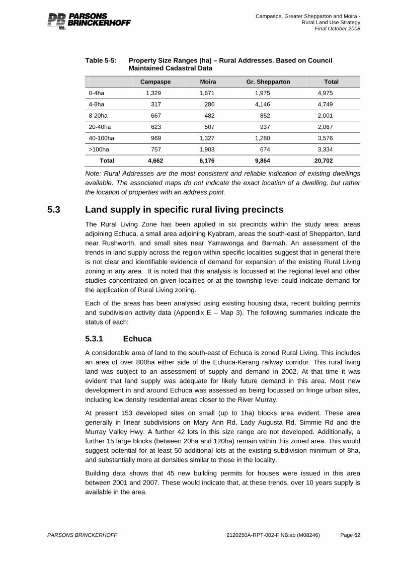
Campaspe, Greater Shepparton and Moira - Rural Land Use Strategy
Final October 2008
PARSONS BRINCKERHOFF 2120250A-RPT-002-F NB:ab (M08246) Page 62
Table 5-5: Property Size Ranges (ha) – Rural Addresses. Based on Council Maintained Cadastral Data
Campaspe Moira Gr. Shepparton Total
0-4ha 1,329 1,671 1,975 4,975
4-8ha 317 286 4,146 4,749
8-20ha 667 482 852 2,001
20-40ha 623 507 937 2,067
40-100ha 969 1,327 1,280 3,576
>100ha 757 1,903 674 3,334
Total 4,662 6,176 9,864 20,702
Note: Rural Addresses are the most consistent and reliable indication of existing dwellings available. The associated maps do not indicate the exact location of a dwelling, but rather the location of properties with an address point.
5.3 Land supply in specific rural living precincts The Rural Living Zone has been applied in six precincts within the study area: areas adjoining Echuca, a small area adjoining Kyabram, areas the south-east of Shepparton, land near Rushworth, and small sites near Yarrawonga and Barmah. An assessment of the trends in land supply across the region within specific localities suggest that in general there is not clear and identifiable evidence of demand for expansion of the existing Rural Living zoning in any area. It is noted that this analysis is focussed at the regional level and other studies concentrated on given localities or at the township level could indicate demand for the application of Rural Living zoning.
Each of the areas has been analysed using existing housing data, recent building permits and subdivision activity data (Appendix E – Map 3). The following summaries indicate the status of each:
5.3.1 Echuca A considerable area of land to the south-east of Echuca is zoned Rural Living. This includes an area of over 800ha either side of the Echuca-Kerang railway corridor. This rural living land was subject to an assessment of supply and demand in 2002. At that time it was evident that land supply was adequate for likely future demand in this area. Most new development in and around Echuca was assessed as being focussed on fringe urban sites, including low density residential areas closer to the River Murray.
At present 153 developed sites on small (up to 1ha) blocks area evident. These area generally in linear subdivisions on Mary Ann Rd, Lady Augusta Rd, Simmie Rd and the Murray Valley Hwy. A further 42 lots in this size range are not developed. Additionally, a further 15 large blocks (between 20ha and 120ha) remain within this zoned area. This would suggest potential for at least 50 additional lots at the existing subdivision minimum of 8ha, and substantially more at densities similar to those in the locality.
Building data shows that 45 new building permits for houses were issued in this area between 2001 and 2007. These would indicate that, at these trends, over 10 years supply is available in the area.
Campaspe, Greater Shepparton and Moira - Rural Land Use Strategy
Final October 2008
PARSONS BRINCKERHOFF 2120250A-RPT-002-F NB:ab (M08246) Page 63
5.3.2 Kyabram Three areas totalling 250 ha are zoned Rural Living on the fringes of Kyabram. At present these comprise 53 properties ranging in size from under 0.5ha to 26ha. At present, 17 of these properties do not have a dwelling on them, representing 32% of all properties. Additionally, at least three properties have potential for further subdivision at the existing 8ha minimum. Building data since 2001 shows 6 new permits issued, suggesting over 20 years supply at current trends.
5.3.3 Shepparton Around 1000ha of land on the south-eastern fringes of Shepparton is zoned Rural Living. This comprises 130 properties ranging in size from under 1ha to over 80ha with 120 houses on them. A number of larger blocks have significant development constraints resulting from identified flood risks on some of the property. At present the 8ha subdivision minimum could result in application for subdivision on approximately 7 lots where land is not subject to Flood Overlay. In recent years there has been 8 building permits approved for new dwellings in the area, and one approved subdivision created three lots (each over 20ha).
5.3.4 Barmah Two small areas of Rural Living land exist in Moira Shire; at Barmah and at Yarrawonga. Both have an 8ha subdivision minimum.
The Barmah site includes 15 houses on 20 properties at the edge of the existing urban area. In recent years two building permits have been granted in this area. In total five properties have potential for further subdivision within the existing planning provisions.
5.3.5 Yarrawonga The Yarrawonga site includes 19 houses on 29 properties immediately adjoining the urban area. In recent years only one building permit has been approved in the area. There is limited scope for further subdivision in this area.
5.3.6 Rushworth Region A considerable area (over 6000 ha) of land to the south east and south west of Rushworth is zoned Rural Living. This zoning applies to five separate areas, mostly adjoining public land near the Tait & Hamilton Rd, the Heathcote-Rochester Rd and in the Waranga Basin environs. These areas do commonly contain natural and cultural values that can inhibit development potential. These sites mostly comprise properties of about 20ha, although a number of smaller ‘formal’ subdivisions are evident to the east of Rushworth. The areas include 286 properties with 152 houses. Within these areas 83 properties are large enough for further subdivision at the existing 8ha minimum. A total of 49 building permits were issued for the various localities in this area between 2001 and 2007.
5.3.7 Nathalia and Numurkah Environs At present, no land has been zoned for Rural Living in the environs of Nathalia or Numurkah. In the environs of each town a small area of Low Density Residential land and some areas of small lots within the Farming Zone exist.
East of Numurkah an area zoned LDRZ (Brooke Crt and Ashley Crt) includes 38 lots of approximately 0.5ha. Based on building permit data, in this area 22 houses have recently been approved and 4 lots remain vacant. South of the golf course a cluster of small lots, of
Campaspe, Greater Shepparton and Moira - Rural Land Use Strategy
Final October 2008
PARSONS BRINCKERHOFF 2120250A-RPT-002-F NB:ab (M08246) Page 64
around 1ha, are within the Farming Zone. These are also largely developed for housing with a number of recent building approvals. No distinct areas of development are evident at the typical scale of Rural Living development (4-8ha).
An area to the west of the Broken Creek at Nathalia is zoned LDRZ. This includes lots ranging from 0.5ha to 7ha. While many of the smaller lots are developed, a significant area remains in larger holdings. Land form constraints, including land subject to flooding present some limitations for further development here. Some smaller lots in the Farming Zone, such as land north-west of Scott Lane, have also developed on small lots. Again, no distinct areas of development at the Rural Living scale are evident
Previous planning consideration resulting from the Moira Rural Living Strategy (2004) did not consider there to be a demonstrated level of demand for rural living development in either town. The preparation of the Numurkah Strategy and Nathalia Strategy has commenced and will inform the appropriateness of developing town fringe areas at suitable densities for urban settlement in both towns.
5.3.8 Summary of rural living zone trends Considerable scope exists for further rural living development in each of the existing precincts. In many cases this includes considerable scope for additional subdivision within the existing provisions. Recent trends do not indicate that any area requires additional provision of rural living to meet current trends in development and development demand.
Trends in development in some areas however suggest the de facto creation of rural living areas, with the corridor between Cobram and Yarrawonga being the most evident example.
5.4 Strategic directions Population change and development trend in the region suggest likely continued growth in larger centres and in riverine environments. Trends in this growth to date do not indicate any considerable pressure for significant provision of locations for rural lifestyle development in a broader context.
It is evident that the rural landscapes in the region will have varied prospects and futures resulting from past patterns of development, access to water, patterns of land holdings and the risk and opportunities resulting from land use change. The drivers of population change (and consequent development pressures) are also varied. Planning for these processes requires the development of a desired land use future that recognises these drivers, but which also manages the flexibility and scope to meet future land use and production needs.
Essentially, the trends described suggest that population and housing change in rural areas is most strongly associated with land on the fringe of the larger urban centres in the study area and development in a few, highly valued, rural landscapes. Consequently, an exploration of past trends in population and settlement suggests that managing scope for appropriate agricultural futures is the central need of this strategy. Clarity in planning strategy and controls should be seen as a mechanism to ensure that competing land use trends and property markets do not distort the policy intent in the rural areas of this region, especially given the existing comparative low intensity of new small lot development beyond the influence of larger centres in this region.
Campaspe, Greater Shepparton and Moira - Rural Land Use Strategy
Final October 2008
PARSONS BRINCKERHOFF 2120250A-RPT-002-F NB:ab (M08246) Page 65
6. Environmental values and threats The environmental agenda of the region is primarily set by the following regional policy documents:
North Central Regional Catchment Strategy, (NCRCS)
Goulburn Broken Regional Catchment Strategy, 2003 (GBRCS)
Moira Planning Scheme
Campaspe Planning Scheme
Greater Shepparton Planning Scheme.
In addition to these documents there are numerous other land, water and vegetation strategy documents that build upon the above regional strategies. The following section does not provide an exhaustive review of existing regional strategies. Rather, alignment at a policy level and with respect to planning scheme implementation is the focus of the RRLUS.
The five documents reviewed have been selected as they identify the environmental values and challenges of the region and the strategic response to them. In terms of planning for rural land use, they provide guidance about constraints and limitations. The GBRCS highlights the ongoing importance of agriculture in the region’s economy and the role of farmers in enhancing the environmental condition of the region in pursuit of agricultural viability.
The following section of the report outlines the key drivers across the region with respect to environmental values and threats including remnant vegetation, fauna, water, flooding, salinity, soil health and climate change. Following a broad outline of these key factors, policy implications and recommendations are provided.
6.1 Environmental considerations The key environmental considerations of the region include:
6.1.1 Remnant vegetation Most of the region has been heavily modified for settlement and agriculture, and as a result minimal native vegetation remains. Significant remnant vegetation has been preserved along roadsides and along adjacent riparian areas. Policy dictates that this should be preserved.
In addition to areas of remnant vegetation on public land, pockets of remnant vegetation exist on private land (Appendix E – Map 4, 5 & 6). Of particular note in this region are areas of remnant grasslands in the west of the region around Patho Plains and Gunbower7. The vegetation communities of the Victorian Northern Plains have been severely degraded since European settlement and now only small remnant areas remain. As a result, all vegetation communities on the Northern Plains are of considerable conservation significance. Northern Plains Grasslands are recognised as one of the most endangered vegetation communities in Victoria with less than 1% of their original extent remaining. Northern Plains Grasslands are listed under the Victorian Flora and Fauna Guarantee Act 1988, and have been nominated under the Commonwealth's Environmental Protection and Biodiversity Conservation Act 1999. These are highly significant due to their minimal representation across the region and
7 Designated by Australia to the List of Wetlands of International Importance - The Convention on Wetlands (Ramsar, Iran, 1971)
Campaspe, Greater Shepparton and Moira - Rural Land Use Strategy
Final October 2008
PARSONS BRINCKERHOFF 2120250A-RPT-002-F NB:ab (M08246) Page 66
the locally indigenous nature of the species within this area. In addition, the native grasslands within these areas are also highly threatened as they are not as obvious as larger species such as trees and can be lost without being recognised. In particular, cropping and inappropriate levels of grazing are significant threats to grasslands.
Box Ironbark forest is also a significant vegetation type present in the region. The Whroo-Rushworth State Forest is part of the largest block of Box Ironbark habitat remaining in Victoria.
The region also includes Barmah Forest, the largest River Red Gum forest in Australia that is located adjacent the Murray river between Echuca, in Victoria and Tocumwal in New South Wales. While significant areas of this forest is located within reserved land managed by Parks Victoria, the Ecological Vegetation Class that includes River Red Gum extends into private land and it is on this land that is poorly represented.
The State Government has adopted a policy of net gain for native vegetation across the landscape. Any proposal to clear remnant vegetation is subject to a strict assessment to determine the appropriateness of the clearance proposal, with avoidance of the need to clear the preferred position especially in the case of significant, rare or threatened species, or high quality remnants. Any clearance approved is subject to an offset requirement to compensate for the vegetation lost and contribute to net gain. This offset may take the form of protection and enhancement of another area of remnant vegetation, or replanting of an area.
While the region seeks to promote and protect opportunities for agriculture, legislation and policy also requires remnant vegetation, in particular significant remnant vegetation, should be protected.
Where significant areas of remnant vegetation are zoned Farming Zone, it is recommended that these areas are reviewed with consideration of application of the Rural Conservation Zone. The extent of these proposed Rural Conservation Zones extend beyond identified values to to incorporate a contiguous area incorporating existing private parcels that also contain ecological significant values. This is particularly the case in the Dookie Hills, Box-Ironbark forests within the Shire of Campaspe and City of Greater Shepparton that are to the east of Rushworth and adjacent the township to its west and south. In addition there are significant tracts of remnant River Red Gum forests adjacent the Murray River.
In addition to the application of RCZ, it is recommended that the application of a Vegetation Protection Overlay (VPO) is consistently applied throughout the region based on assessment of both priority Ecological Vegetation Community (EVC) Mapping8and existing mapping developed through the Biodiversity Action Planning partnership process developed between the Catchment Management Authorities, Department of Sustainability & Environment, Trust for Nature, Local Government and Parks Victoria. Appendix E – Map 4, 5 & 6 demonstrates these priority areas throughout the region and it is recommended that the application of these mapping as a basis for across the region will ensure future planning decisions are made in accordance with the requirements of Victoria’s Native Vegetation Framework.
The Northern Grasslands within the Shire of Campaspe present a different rural land use challenge. There is recognition within this area that intensive agricultural industries have the potential to pursue sustainable agricultural practices if well managed and contained without impact on significant tracts of native grasslands. Therefore it is recommended that this area remain within the Growth Farming Zone and that the application of a Environmental Significance Overlay (ESO) across the region will ensure decision making is based on
8 EVC Mapping has been prepared by Department of Sustainability & Environment, 2008.
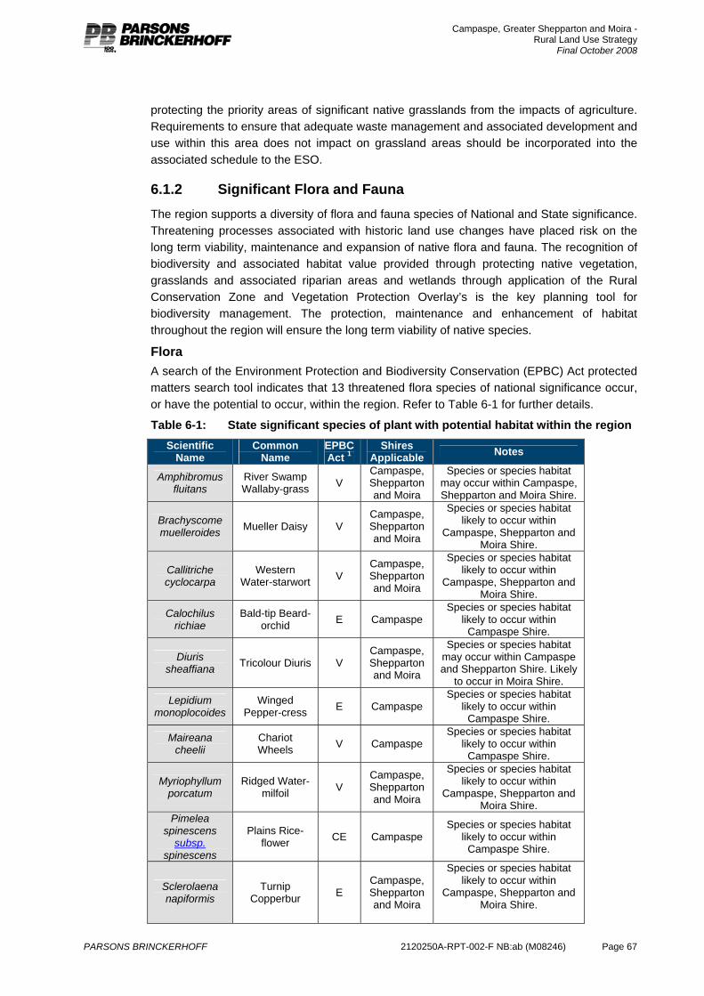
Campaspe, Greater Shepparton and Moira - Rural Land Use Strategy
Final October 2008
PARSONS BRINCKERHOFF 2120250A-RPT-002-F NB:ab (M08246) Page 67
protecting the priority areas of significant native grasslands from the impacts of agriculture. Requirements to ensure that adequate waste management and associated development and use within this area does not impact on grassland areas should be incorporated into the associated schedule to the ESO.
6.1.2 Significant Flora and Fauna The region supports a diversity of flora and fauna species of National and State significance. Threatening processes associated with historic land use changes have placed risk on the long term viability, maintenance and expansion of native flora and fauna. The recognition of biodiversity and associated habitat value provided through protecting native vegetation, grasslands and associated riparian areas and wetlands through application of the Rural Conservation Zone and Vegetation Protection Overlay’s is the key planning tool for biodiversity management. The protection, maintenance and enhancement of habitat throughout the region will ensure the long term viability of native species.
Flora A search of the Environment Protection and Biodiversity Conservation (EPBC) Act protected matters search tool indicates that 13 threatened flora species of national significance occur, or have the potential to occur, within the region. Refer to Table 6-1 for further details.
Table 6-1: State significant species of plant with potential habitat within the region Scientific
Name Common
Name EPBC Act 1
Shires Applicable Notes
Amphibromus fluitans
River Swamp Wallaby-grass V
Campaspe, Shepparton and Moira
Species or species habitat may occur within Campaspe, Shepparton and Moira Shire.
Brachyscome muelleroides Mueller Daisy V
Campaspe, Shepparton and Moira
Species or species habitat likely to occur within
Campaspe, Shepparton and Moira Shire.
Callitriche cyclocarpa
Western Water-starwort V
Campaspe, Shepparton and Moira
Species or species habitat likely to occur within
Campaspe, Shepparton and Moira Shire.
Calochilus richiae
Bald-tip Beard-orchid E Campaspe
Species or species habitat likely to occur within
Campaspe Shire.
Diuris sheaffiana Tricolour Diuris V
Campaspe, Shepparton and Moira
Species or species habitat may occur within Campaspe and Shepparton Shire. Likely
to occur in Moira Shire.
Lepidium monoplocoides
Winged Pepper-cress E Campaspe
Species or species habitat likely to occur within
Campaspe Shire.
Maireana cheelii
Chariot Wheels V Campaspe
Species or species habitat likely to occur within
Campaspe Shire.
Myriophyllum porcatum
Ridged Water-milfoil V
Campaspe, Shepparton and Moira
Species or species habitat likely to occur within
Campaspe, Shepparton and Moira Shire.
Pimelea spinescens
subsp. spinescens
Plains Rice-flower CE Campaspe
Species or species habitat likely to occur within
Campaspe Shire.
Sclerolaena napiformis
Turnip Copperbur E
Campaspe, Shepparton and Moira
Species or species habitat likely to occur within
Campaspe, Shepparton and Moira Shire.
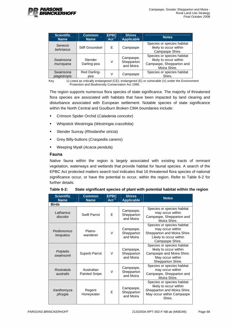
Campaspe, Greater Shepparton and Moira - Rural Land Use Strategy
Final October 2008
PARSONS BRINCKERHOFF 2120250A-RPT-002-F NB:ab (M08246) Page 68
Scientific Name
Common Name
EPBC Act 1
Shires Applicable Notes
Senecio behrianus Stiff Groundsel E Campaspe
Species or species habitat likely to occur within
Campaspe Shire.
Swainsona murrayana
Slender Darling-pea V
Campaspe, Shepparton and Moira
Species or species habitat likely to occur within
Campaspe, Shepparton and Moira Shire.
Swainsona plagiotropis
Red Darling-pea V Campaspe Species or species habitat
Shire. Key 1) Listed as critically endangered (CE); endangered (E) or vulnerable (V) under the Environment
Protection and Biodiversity Conservation Act 1999.
The region supports numerous flora species of state significance. The majority of threatened flora species are associated with habitats that have been impacted by land clearing and disturbance associated with European settlement. Notable species of state significance within the North Central and Goulburn Broken CMA boundaries include:
Crimson Spider Orchid (Caladenia concolor)
Whipstick Westringia (Westringia crassifolia)
Slender Sunray (Rhodanthe stricta)
Grey Billy-buttons (Craspedia canens)
Weeping Myall (Acacia pendula)
Fauna Native fauna within the region is largely associated with existing tracts of remnant vegetation, waterways and wetlands that provide habitat for faunal species. A search of the EPBC Act protected matters search tool indicates that 16 threatened flora species of national significance occur, or have the potential to occur, within the region. Refer to Table 6-2 for further details.
Table 6-2: State significant species of plant with potential habitat within the region Scientific
Name Common
Name EPBC Act 1
Shires Applicable Notes
Birds
Lathamus discolor Swift Parrot E
Campaspe, Shepparton and Moira
Species or species habitat may occur within
Campaspe, Shepparton and Moira Shire.
Pedionomus torquatus
Plains-wanderer V
Campaspe, Shepparton and Moira
Species or species habitat may occur within
Shepparton and Moira Shire. Likely to occur within
Campaspe Shire.
Polytelis swainsonii Superb Parrot V
Campaspe, Shepparton and Moira
Species or species habitat likely to occur within
Campaspe and Moira Shire. May occur within
Shepparton Shire.
Rostratula australis
Australian Painted Snipe V
Campaspe, Shepparton and Moira
Species or species habitat may occur within
Campaspe, Shepparton and Moira Shire.
Xanthomyza phrygia
Regent Honeyeater E
Campaspe, Shepparton and Moira
Species or species habitat likely to occur within
Shepparton and Moira Shire. May occur within Campaspe
Shire.
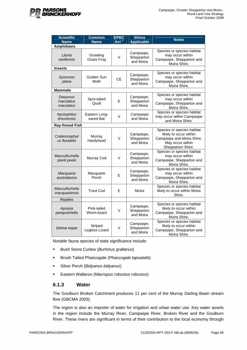
Campaspe, Greater Shepparton and Moira - Rural Land Use Strategy
Final October 2008
PARSONS BRINCKERHOFF 2120250A-RPT-002-F NB:ab (M08246) Page 69
Scientific Name
Common Name
EPBC Act 1
Shires Applicable Notes
Amphibians
Litoria raniformis
Growling Grass Frog V
Campaspe, Shepparton and Moira
Species or species habitat may occur within
Campaspe, Shepparton and Moira Shire.
Insects
Synemon plana
Golden Sun Moth CE
Campaspe, Shepparton and Moira
Species or species habitat may occur within
Campaspe, Shepparton and Moira Shire.
Mammals
Dasyurus maculatus maculatus
Spot-tailed Quoll E
Campaspe, Shepparton and Moira
Species or species habitat may occur within
Campaspe, Shepparton and Moira Shire.
Nyctophilus timoriensis
Eastern Long-eared Bat V Campaspe
and Moira
Species or species habitat may occur within Campaspe
and Moira Shire. Ray-finned Fish
Craterocephalus fluviatilis
Murray Hardyhead V
Campaspe, Shepparton and Moira
Species or species habitat likely to occur within
Campaspe and Moira Shire. May occur within
Shepparton Shire.
Maccullochella peelii peelii Murray Cod V
Campaspe, Shepparton and Moira
Species or species habitat may occur within
Campaspe, Shepparton and Moira Shire.
Macquaria australasica
Macquarie Perch E
Campaspe, Shepparton and Moira
Species or species habitat may occur within
Campaspe, Shepparton and Moira Shire.
Maccullochella macquariensis Trout Cod E Moira
Species or species habitat likely to occur within Moira
Shire. Reptiles
Aprasia parapulchella
Pink-tailed Worm-lizard V
Campaspe, Shepparton and Moira
Species or species habitat likely to occur within
Campaspe, Shepparton and Moira Shire.
Delma impar Striped Legless Lizard V
Campaspe, Shepparton and Moira
Species or species habitat likely to occur within
Campaspe, Shepparton and Moira Shire.
Notable fauna species of state significance include:
Bush Stone Curlew (Burhinus grallarius)
Brush Tailed Phascogale (Phascogale tapoatafa)
Silver Perch (Bidyanus bidyanus)
Eastern Wallaroo (Macropus robustus robustus)
6.1.3 Water The Goulburn Broken Catchment produces 11 per cent of the Murray Darling Basin stream flow (GBCMA 2003).
The region is also an importer of water for irrigation and urban water use. Key water assets in the region include the Murray River, Campaspe River, Broken River and the Goulburn River. These rivers are significant in terms of their contribution to the local economy through
Campaspe, Greater Shepparton and Moira - Rural Land Use Strategy
Final October 2008
PARSONS BRINCKERHOFF 2120250A-RPT-002-F NB:ab (M08246) Page 70
provision of water for agriculture. They are also significant tourism and recreation assets. They obviously also play a significant role in the biodiversity of the region.
Groundwater from the Murray Basin is also a water source for the region.
A number of significant wetlands exist in the region associated with the significant rivers, these include the Barmah-Millewa Forest9 and Kow Swamp.
The quality of water in the region has been compromised by run off from urban and rural areas, increasing nutrient loads, salinity levels, turbidity and allocation levels. Given the region’s dependence on water for agriculture it is fundamental that water quality be protected. Initiatives to protect water quality include maintaining remnant vegetation (particularly riparian vegetation), effective effluent management (urban areas and that from rural areas including animal waste), managing salinity, maintaining natural flood processes and protecting environmental flows.
The application of VPO throughout the region is key to ensuring management of remnant vegetation and maintenance of water quality throughout waterways and wetlands.
6.1.4 Flooding Associated with the region’s values based on water assets, a significant proportion of the region is subject to flooding.
Flooding can limit land use prospects for agriculture and more specifically development within an urban context. However, flooding is an important process in terms enhancing the environmental health of the river system. Where possible, natural flooding processes should be protected. In some areas drainage has been enhanced to promote movement of floodwaters and minimise risk of water table recharge and increase of soil salinity. Drainage systems are a significant part of the infrastructure of the region to enhance agricultural productivity.
Flooding is managed in the region by a number of localised floodplain management plans and planning controls that seek to minimise development in the floodplain.
Campaspe have highlighted the environmental significance of their main flood paths through application of the Rural Conservation Zone (RCZ) to these areas, as well as the Floodway Overlay (FO). Moira and Shepparton have relied on the Floodway Overlay. All three Councils use the Land Subject to Inundation Overlay for the balance of the floodplain. The different approach that Campaspe has adopted indicates that farming is not their intended land use for these flood paths, and the environmental role should take precedence. In Moira and Shepparton, although the area is flood prone and development should respond to this, farming still remains the preferred land use. The application of the RCZ within Campaspe therefore requires review to ensure a consistent approach across the region, particularly where agricultural activity is the primary objective across the land. The use of FO in areas subject to flooding is considered a more appropriate planning instrument as it will ensure that building, works and development are considered through the planning process.
9 Designated by Australia to the List of Wetlands of International Importance - The Convention on Wetlands (Ramsar, Iran, 1971)
Campaspe, Greater Shepparton and Moira - Rural Land Use Strategy
Final October 2008
PARSONS BRINCKERHOFF 2120250A-RPT-002-F NB:ab (M08246) Page 71
6.1.5 Salinity Salinity presents the biggest threat to the Catchment’s natural assets10. Salinity continues to affect the productive value of the soil, detrimentally affects water quality and threatens the health of native vegetation, even as process of farm practice and land management are addressing this issue.
Soil salinity is caused through the water table rising to the surface and bringing with it dissolved salts which then contaminate the soil. Due to changes in vegetation cover, drainage and irrigation practices water tables in the region have risen over the period of settlement. Programs over the last 10-20 years have improved the situation significantly, but it is an ever present threat. In 2001, 23.5 per cent of the Shepparton Irrigation Region was underlain by a water table within two metres of the surface (this varies from year to year depending on seasonal conditions).
The ongoing productivity of the region is dependant on managing water table levels.
Detailed assessment of the implications of salinity are required to ensure that the application of the Salinity Management Overlay across the region is adequate. A detailed assessment of salinity levels, associated impacts and implications for planning policy is outside the scope of this regional strategy.
6.1.6 Soil health Farming land across the region has suffered from inappropriate past practices. Soil issues in the region include compaction, water logging, sodicity and salinity. These issues affect productivity and current farming practice generally seek to avoid these problems. These problems are managed by appropriate cultivation and grazing practices, drainage management and protection of vegetation.
6.1.7 Climate change The climate of the region is expected to change as a result of increased concentrations of greenhouse gases in the atmosphere. Climate change may affect the growing conditions for agriculture through increased average temperatures and changes in rainfall patterns (further information in relation to climate is located at Section Error! Reference source not found.). In particular it is considered likely that climate change will affect the amount of water available to the region for agriculture. The ongoing agricultural viability of the region is dependant on the improved efficiency of water delivery and use. As discussed above, this presents significant challenges and some opportunity for agriculture in the region.
City of Greater Shepparton joined the Cities for Climate Protection Program in 2000 and has committed to evaluate and set targets for greenhouse gas emissions for Council and community and promote energy efficient subdivision and house design.
Although the effect of climate change is relatively unknown, is it considered prudent to be planning for farming in a dryer climate, with a less reliable rainfall and more limited water supply. The potential negative impacts on horticulture and dairying from diminishing water supplies provides further catalyst for aligning land use policy with significant investment around water security across the region. Importantly, the uncertainty associated with changes in climatic conditions require land use policy to provide flexibility throughout the
10 GBRCS (2003) Summary, page 11.
Campaspe, Greater Shepparton and Moira - Rural Land Use Strategy
Final October 2008
PARSONS BRINCKERHOFF 2120250A-RPT-002-F NB:ab (M08246) Page 72
rural zoned land to respond to different opportunities and constraints associated with Climate Change.
6.2 Implications for Planning Policy and Practice The management and enhancement of the condition of the environment is significant in terms of supporting agricultural growth and development. In particular:
Native vegetation is required to be preserved to maintain biodiversity and manage water tables.
Floodplains and flood events are required to flush waterways and enhance water quality.
Fauna is required to maintain biodiversity and manage pest plants and animals.
Presently, the application of environmental controls in the region varies with a limited use of available overlays, specifically to manage significant vegetation, landscape and habitat. The range of remnant vegetation, from riverine to significant Box-Ironbark forests is indicated in the map of Ecological Vegetation Classes in Appendix E (Map 4). Importantly, the application of appropriate zoning to reflect important landscapes, amenity values and habitat is limited to small forest inliers (except in the case of Campaspe, where area of river corridor and landscape features have the Rural Conservation Zone applied). Consideration of Biodiversity Action Planning processes being completed by Catchment Management Authorities are key to this decision making (See Appendix E – Map 5). The BAP11 reporting and associated mapping outlines priority ecological areas.
From the perspective of this study, the crucial issues for consideration are:
1. The need to create a consistent application of overlays (Vegetation Protection Overlay, Environmental Significance Overlay, Significant Landscape Overlay) across each of the three planning scheme areas based on EVC and BAP prioritisation;
2. The need to adopt a consistent approach to planning in floodways and floodplains. In this respect, the application of either the FO or LSIO is considered the most appropriate mechanism to limit the impact of agricultural development on the natural operation of floodways or floodplains. This approach should be applied consistently across the region as a whole;
3. The need to apply the Rural Conservation Zone widely to those areas where environmental features and landscape/amenity values suggest the need to manage development type, scale and intensity so as to support these values.
Where significant values are identified the choice of selecting an appropriate overlay, or the use of the RCZ (perhaps with overlays) should be guided by the following principles:
If the identified value can be considered to exist at a landscape scale, the RCZ should be applied.
Specific features, habitat areas and flood related landscapes should be subject to an appropriate overlay.
Consequently, this study recommends that the RCZ is applied more widely across the region including areas around Rushworth in Campaspe and Greater Shepparton, and particularly in parts of Moira. Examples include the River Murray corridor area where fragmentation of land ownership and trends in housing limit opportunity for agricultural expansion, but significant
11 Biodiversity Action Planning is a coordinated program between DSE, CMA’s, Trust for Nature, Local Government and
Parks Victoria to ensure priority areas of native biodiversity are identified, mapped and managed at bioregional scales (Source: http://www.dpi.vic.gov.au/DPI/Vro/vrosite.nsf/pages/biodiversity_bap .
Campaspe, Greater Shepparton and Moira - Rural Land Use Strategy
Final October 2008
PARSONS BRINCKERHOFF 2120250A-RPT-002-F NB:ab (M08246) Page 73
landscape and amenity values can be identified. In these areas, the objective of environmental enhancement should have primacy, but may well be delivered through conditions on planning approvals that allow housing and other development at appropriate intensities, while improving vegetation and habitat linkages across the landscape.
In addition to the application of RCZ, it is recommended that the application of a Vegetation Protection Overlay (VPO) is consistently applied throughout the region based on existing mapping developed through the Biodiversity Action Planning partnership and relevant EVC Mapping.
The exception to this approach is the Northern Grasslands located within Campaspe. Recent strategic work completed by the Shire of Campaspe has highlighted the increasing importance of intensive agricultural industries within this region. It is recommended that the application of an ESO across the native grasslands of the Pathos Plains is applied. The ESO should reflect the most recent EVC Mapping undertaken by the Department of Sustainability and Environment. This is recommended to ensure protection of the high value non-forest vegetation that has been identified and to enable the long term sustainable agricultural development of both existing and future farms within the region.
And finally, the consistent approach of a Flood Overlay (FO) is recommended throughout the region. This entails removal of the broad application of the Rural Conservation Zone from areas identified with flood risk within the Shire of Campaspe. This recommendation should not be considered to diminish the significance of areas of high value vegetation where the ESO should be applied. However, the application of the FO recognises that often the primary purpose of these areas is agriculture and that the use of this land for agriculture would be preferable to some non agricultural uses that could be considered within the Rural Conservation Zone.
Campaspe, Greater Shepparton and Moira - Rural Land Use Strategy
Final October 2008
PARSONS BRINCKERHOFF 2120250A-RPT-002-F NB:ab (M08246) Page 74
7. Planning policy The key purpose of this study is to provide a strategic pathway to update the three planning schemes (Campaspe, Greater Shepparton and Moira) with respect to rural land use management and to provide for consistent application of the new rural zones across each area12. This section of the report presents the current policy position on rural land use, and provides an assessment of the consistency of controls across the region and the effectiveness of these controls and the decision making environment to achieve the objectives of this project.
7.1 Strategic work Each of the Councils has undertaken a range of strategic planning projects over recent years to contribute to their Municipal Strategic Statements and enhance their planning schemes.
A brief overview of the elements of the key strategic planning projects that are relevant to this project is provided below.
7.1.1 Campaspe Echuca Low Density Residential and Rural Living Land Review, 2003 This review provided for the growth and consolidation of the low density and rural living areas around Echuca. It recommended that low density and rural living growth be directed to areas to the south, south east and north west of Echuca, building on existing development.
Staged release of land identified in this strategy would provide for up to 20 years supply of low density and rural living land. Some of this land has been rezoned.
Campaspe Shire – Rural Policy Development The purpose of this project was to improve rural planning controls to ensure that they respond to and accommodate the needs of current agricultural practice. This project involved a survey of farmers with the objective of identifying the developments they believed they need to facilitate the ongoing operation of their business, as well as the development they believed would compromise their ongoing operation. This project highlighted the different planning requirements of different agricultural industries and identified that generally the current planning regime is appropriate but there is need for clearer direction in relation to the future location of rural living and matters such as house lot excisions as under certain circumstances they create problems.
Campaspe Shire – C44 MSS Review Council has recently completed a review of their MSS and Rural Planning Policy based on the above research. This review did not provide for any significant policy shift. It provides for strategy and policy to be more clearly expressed. The revised rural policy further reinforces the need to prevent non agricultural land uses within rural areas to protect the local economy, and promotes consolidation of farming properties. Council has retained its strategy of encouraging intensive animal industries to establish on the Patho Plains.
Amendment C44 includes the recommended changes to the MSS and includes consolidation of the Agricultural Policies and Non-Agricultural Uses in Rural Areas Policy to appear as Agricultural Policy. This amendment was placed on exhibition on 24th January 2008.
12 In 2004 the Victorian Government introduced a new suite of rural zones pursuant to the Planning & Environment Act 1987
and implemented through the Victorian Planning Provisions. Further information DSE (2007) Applying the Rural Zones. VPP Practice Note. State of Victoria.

Campaspe, Greater Shepparton and Moira - Rural Land Use Strategy
Final October 2008
PARSONS BRINCKERHOFF 2120250A-RPT-002-F NB:ab (M08246) Page 75
7.1.2 Greater Shepparton City of Greater Shepparton Housing Strategy (in progress) The Draft Greater Shepparton Housing Strategy (GSHS) has been adopted in principle by the Council and will be on public display over October and November 2008. It has been developed to respond to existing and future housing needs in the municipality to the year 2031. The draft GSHS establishes objectives, strategies and actions to guide housing delivery and sets long-term direction for future residential growth. Important components of the proposed Development Framework include providing for appropriately located rural living and supporting the future viability of small towns through both township and rural living opportunities.
City of Greater Shepparton Strategy Plan, 1996 This strategy plan recommended the use land capability as the basis for the application of the rural planning controls, and appears to be the basis for the current controls.
This strategy also highlighted the risks of unplanned rural housing.
Greater Shepparton 2030 Strategy Plan, 2006 This strategy seeks to enhance the viability of the agricultural sector through protecting productive agricultural land and supporting ongoing agricultural business viability. It promotes the need to diversify the agricultural base and support vertical integration of farm businesses. It raises concerns about land fragmentation and the affect of this on the long term strategy for agriculture in the region.
City of Greater Shepparton Economic Development Strategy, 2006 This strategy offers a number of initiatives to assist the ongoing growth of the agricultural sector. These initiatives include involvement in water reform, development of an agribusiness network, skills development and business planning. These strategies are complementary to land use planning strategies to support agriculture.
7.1.3 Moira Cobram Strategy Plan (2007) This Strategy Plan recognises the importance and value of the agricultural industry to the economic, and employment, base of Cobram. The Strategy Plan seeks to provide a high degree of certainty for agricultural operations located at or near the urban/rural fringe. This should assist in the planning and decision making for investment in stock, infrastructure, plants and the like, contributing to the continued strength of the agricultural base. In particular the strategy highlights the need to manage the urban rural interface to minimise constraints on agricultural operations.
This strategy includes recommendations for future low density residential areas to the south of the town.
Bundalong Strategy Plan (2007) The Bundalong Strategy Plan was developed to address issues and provide a future direction for the small settlement of Bundalong located on the Ovens River. The Strategy provides a vision for sustainable growth within the 2030 Growth Boundary based on application of the Township and Low Density Residential Zones. Provision of Business zoning and protection of environmental areas for conservation and passive recreation is also recommended.
Campaspe, Greater Shepparton and Moira - Rural Land Use Strategy
Final October 2008
PARSONS BRINCKERHOFF 2120250A-RPT-002-F NB:ab (M08246) Page 76
Woodlands to Bundalong Strategy (Draft, 2006) This vision of this strategy involves preserving the rural appearance of the land between Yarrawonga and Bundalong, but recognising this area has a value over and above traditional agricultural uses. The strategy seeks to preserve the significant landscape associated with the lake frontage, provide for the use of the area for innovative agricultural uses with some tourism uses operating in this context. The strategy recommends the use of the Rural Activity Zone for this area.
Moira Rural Living Strategy (2004) This strategy sought to provide for the supply of rural residential land in the Shire, in response to a supply and demand assessment, around the key townships. The study determined that there was no need for additional rural residential land at Cobram and Nathalia as the existing supply was adequate for estimated demand at the time. The study recommended additional supply be provided at Numurkah and Yarrawonga. These recommendations were tested at a panel hearing in March, 2006 (Amendment C20). The panel generally accepted the proposals for Yarrawonga but had concerns in relation to the proposals for Numurkah due to constraints on the proposed sites (currently under review as part of the Numurkah Strategy).
The study focussed on the provision of low density residential land (average size of 0.4ha), as the demand assessment indicated this was the preferred market option for rural residential development. The study also determined that existing small lots in the Rural Zone acted as a supply for larger rural living lots.
7.2 Planning schemes
7.2.1 State Planning Policy The Campaspe, Greater Shepparton and Moira Planning Schemes are developed within the context of State Planning Policy. Of relevance to this project, there are a number of State planning policies that apply to rural land:
Agriculture (17.05) Protect the State’s agricultural base. Ensure productive agricultural land is not lost due to permanent changes to land use.
Intensive animal industries (17.06) Support their establishment and expansion provided they are consistent with relevant Codes of Practice and protection of the environment.
Forestry and timber production (17.07) Council should identify appropriate areas for this use. Forestry and timber production uses required to be consistent with the National Forest Policy Statement and relevant Codes of Practice.
Rural Living and Rural residential development (16.03) Control development in rural areas to protect agriculture and the natural resource base. Encourage further development in existing settlements and discourage isolated small lots in rural zones.
Within this context each municipality has identified the unique values and opportunities that the planning scheme must manage, and has developed appropriate planning controls and strategies.
Campaspe, Greater Shepparton and Moira - Rural Land Use Strategy
Final October 2008
PARSONS BRINCKERHOFF 2120250A-RPT-002-F NB:ab (M08246) Page 77
7.2.2 Campaspe, Moira and Shepparton Planning Schemes As identified in the brief for this project, the respective planning schemes all recognise the value and significance of agriculture in terms of the economy and as a land use at the strategic level. They also all include largely consistent strategies in relation to the protection and enhancement of agricultural opportunities, including minimising the fragmentation of farmland, avoiding non-agricultural uses in rural areas (in particular dwellings), supporting farm consolidation, enhancing the natural resource base and directing rural residential development to planned areas. The Campaspe MSS specifically identifies that rural living should not occur on irrigated land and highlights that intensive animal industries should be located on the Patho Plains.
The table in Appendix A to this report provides a summary and comparison of each of the three planning scheme’s strategic basis, strategic objectives and strategies in relation to rural land issues.
Developing a consistent approach to planning across the region’s rural landscapes needs to recognise two issues; that the existing policy and strategies are broadly similar in purpose and intent, and that planning decisions should necessarily be locally responsive, both within and between municipalities, to varied agricultural conditions, local patterns of settlement and development and processes of agricultural change. Hence planning should be consistent, yet responsive.
Table 7-1 identifies the response of each of the planning schemes to key rural land use issues. The particularly apparent inconsistency relates to subdivision controls and the basis of the minimum lot size, and the associated controls for dwelling development. It is intended that this project provide a consistent basis for subdivision of rural land across the region. This may include a range of sizes, and the areas that are subject to different sizes may extend across municipal boundaries.
The key aim of these planning controls is to manage land use conversion from agricultural uses to other land uses, specifically housing and providing lot sizes for productive agriculture. Yet it is widely recognised that these nominated sizes do not generally relate to a viable farm size, as in most cases farming properties consist of much larger areas than those identified above and comprise multiple lots. The subsequent agricultural assessment within this report identifies that, within the Shepparton Irrigation Area, the average size of a dairy property is 70ha (and growing), the average size of a horticulture property is 25ha and the average size of a mixed property is 463ha. The sizes in the Farming Zone schedule also don’t relate to a size that would necessarily discourage demand from rural lifestylers. In any case, local experience indicates that if the location or amenity of a property is considered to be appropriate, rural lifestylers will purchase larger lots than may be preferable for that land use.
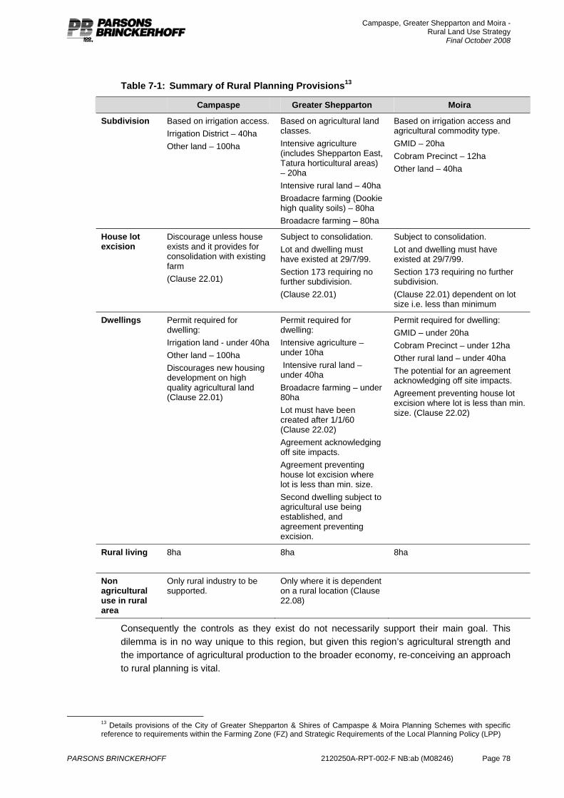
Campaspe, Greater Shepparton and Moira - Rural Land Use Strategy
Final October 2008
PARSONS BRINCKERHOFF 2120250A-RPT-002-F NB:ab (M08246) Page 78
Table 7-1: Summary of Rural Planning Provisions13
Campaspe Greater Shepparton Moira
Subdivision Based on irrigation access. Irrigation District – 40ha Other land – 100ha
Based on agricultural land classes. Intensive agriculture (includes Shepparton East, Tatura horticultural areas) – 20ha Intensive rural land – 40ha Broadacre farming (Dookie high quality soils) – 80ha Broadacre farming – 80ha
Based on irrigation access and agricultural commodity type. GMID – 20ha Cobram Precinct – 12ha Other land – 40ha
House lot excision
Discourage unless house exists and it provides for consolidation with existing farm (Clause 22.01)
Subject to consolidation. Lot and dwelling must have existed at 29/7/99. Section 173 requiring no further subdivision. (Clause 22.01)
Subject to consolidation. Lot and dwelling must have existed at 29/7/99. Section 173 requiring no further subdivision. (Clause 22.01) dependent on lot size i.e. less than minimum
Dwellings Permit required for dwelling: Irrigation land - under 40ha Other land – 100ha Discourages new housing development on high quality agricultural land (Clause 22.01)
Permit required for dwelling: Intensive agriculture – under 10ha Intensive rural land – under 40ha Broadacre farming – under 80ha Lot must have been created after 1/1/60 (Clause 22.02) Agreement acknowledging off site impacts. Agreement preventing house lot excision where lot is less than min. size. Second dwelling subject to agricultural use being established, and agreement preventing excision.
Permit required for dwelling: GMID – under 20ha Cobram Precinct – under 12ha Other rural land – under 40ha The potential for an agreement acknowledging off site impacts. Agreement preventing house lot excision where lot is less than min. size. (Clause 22.02)
Rural living 8ha
8ha 8ha
Non agricultural use in rural area
Only rural industry to be supported.
Only where it is dependent on a rural location (Clause 22.08)
Consequently the controls as they exist do not necessarily support their main goal. This dilemma is in no way unique to this region, but given this region’s agricultural strength and the importance of agricultural production to the broader economy, re-conceiving an approach to rural planning is vital.
13 Details provisions of the City of Greater Shepparton & Shires of Campaspe & Moira Planning Schemes with specific reference to requirements within the Farming Zone (FZ) and Strategic Requirements of the Local Planning Policy (LPP)
Campaspe, Greater Shepparton and Moira - Rural Land Use Strategy
Final October 2008
PARSONS BRINCKERHOFF 2120250A-RPT-002-F NB:ab (M08246) Page 79
7.3 Implementation issues
7.3.1 Rural dwellings Overall, this region is experiencing strong residential growth. This is related to the high amenity values of certain areas and the solid regional economy. One element of this residential growth is the demand for rural living development. This rural living development is planned to occur in appropriately zoned locations, but the strength of the demand also results in applications for dwellings on Farming Zoned (previously Rural Zoned) land. These dwellings may or may not be associated with some form of agricultural enterprise, but the small size of many properties (see analysis of settlement trends Section 5) suggests that any new rural dwellings are primarily residential in nature.
The difficulty that the Councils have identified is directing this demand to appropriate locations, as well as assessing the appropriateness of the proposed dwelling in a farming context.
Many of the proposals received by Council include a justification that the land use is agricultural and that the dwelling is required to support that use. Calf raising is a commonly used proposed use. Based on experience, Council staff are aware that although the land use proposal may be legitimate in the short term, it often is not maintained. In many cases, it may be unlikely that there is any intention to establish the use. Council staff understand that the prevailing land use trend for key agricultural industries is one of expansion and consolidation and genuine new farm housing is rarely required or applied for, especially on smaller lots.
Inappropriate rural housing displaces agricultural activities and can hinder ongoing operation through amenity complaints. The Councils have advised of complaints being received about sprays, dust, odour and noise, and farmers, during the consultation, advised of issues with dogs and weeds from neighbouring rural living properties. Those seeking to expand within or into the region with new agricultural investment have advised of the need to have minimal neighbours. Unplanned rural housing also imposes a burden on Council in terms of infrastructure and service provision such as roads and waste management.
Improved direction is required to determine the appropriateness of new dwellings in rural areas to ensure that unplanned rural living is not displacing agriculture or preventing flexibility and adaptability for farm businesses. In particular, existing minimum lot requirements that allow ‘as of right’ planning approval for dwellings within the Farming Zone require review. This review is required to ensure that any introduction of new dwellings within the farming zone does not inhibit the long term productive land use of farming land.
7.3.2 Subdivision and excisions Subdivisions and house lot excisions within the region are associated with the ongoing demand for rural property for lifestyle reasons, and well as with legitimate farm restructure activity.
The prevailing trend in the region across the main agricultural industries is one of expansion and consolidation to, both contiguous and non-contiguous, larger farms. Consequently, requests for house lots excisions (subdivisions that separate the house from the balance of the farming lot) have been used to enable farming properties to be more readily purchased by neighbouring farmers supporting consolidation as the property is not burdened by the price of the dwelling. House lot excisions can be problematic as they often introduce a new non-farming neighbour into a farming area which can result in complaints and conflict and impact on farming operations. The benefits of house lot excisions need to be balanced
Campaspe, Greater Shepparton and Moira - Rural Land Use Strategy
Final October 2008
PARSONS BRINCKERHOFF 2120250A-RPT-002-F NB:ab (M08246) Page 80
against the risk to ongoing farming activity on the balance of the land. Where possible it is preferable to promote a re-subdivision of the land which does not create an additional title but assists in removing the residential value of the land to promote restructure and consolidation of farming properties.
Larger lot subdivisions of rural land are also occurring in the region and appear to be largely driven by the lifestyle market or, less often, those seeking to pursue newer or alternative forms of agriculture. As with dwellings, the legitimacy and value of such proposals is difficult to assess. Assessment is heightened by the problem of ensuring in the long term land is not lost to agriculture. These patterns of change are described in the Settlement Trends analysis chapter below.
The Moira MSS Review (2007) identified the very high demand for rural subdivision within Moira, in particular small lot subdivisions. This review also determined that decision making in accordance with local planning policy and strategy had improved in recent times, with a better understanding of the intent of the local planning policy particularly with reference to limiting the introduction of non-agricultural uses and reducing the fragmentation of agricultural land. This improved application of the local planning policy has resulted in an increase in recommendation for refusals, and these refusals have generally been supported by Council. Recent strategic work completed for Cobram has identified areas of land currently within the Farming Zone that will provide a staged development for land within both the Residential 1 Zone and Low Density Residential Zones.
7.3.3 Rural industry The introduction of the Farming Zone (replacing the Rural Zone) has limited the potential for rural land to be used generally for industry, although most of the planning schemes used planning policy to limit the use of rural land for industry to that defined as Rural Industry in any case.
Issues or concerns have arisen in relation to the use of existing smaller rural lots for warehousing and storage, or the expansion of existing industrial-type land uses in rural areas that cannot be defined as a Rural Industry14.
7.3.4 Whole farm plans Whole farm planning is a process of macro assessment at the Farm scale. This includes a stocktake of existing natural farm assets, including soil, water, vegetation, crops, pastures and topography. The physical component of the farm is incorporated into financial operations to prioritise strategies and develop and property management plan. Within the study area, whole farm planning often relates to irrigation and drainage layout, and is utilised as a strategy within the region to minimise salinity and support appropriate drainage.
“Planning Controls for Earthworks in the Shepparton Irrigation Region” applies in the three subject municipalities. This document sets out a consistent approach to the approval of whole farm plans in the region.
The schedule to the Farming Zone in the three municipalities advises that planning approval is not required for earthworks that have been approved under the above document. This
14 The Victorian Planning Provisions intrinsically link Rural Industry with agricultural activity, Rural Industry is defined as
Land used to: a) handle, treat, process, or pack agricultural produce; or b) service or repair plant, or equipment, used in agriculture. Conflict can arise between Responsibility Authorities and proponents who operate “industries” within rural areas that cannot be defined as a Rural Industry and therefore effectively maintain an illegal land uses.
Campaspe, Greater Shepparton and Moira - Rural Land Use Strategy
Final October 2008
PARSONS BRINCKERHOFF 2120250A-RPT-002-F NB:ab (M08246) Page 81
process enables a whole series of earthworks to be approved together and developed over time. A staged approval such as this process prevents the need to go back on a number of occasions for subsequent approvals.
Although the process generally works well, and facilitates appropriate farm development, concerns with the process include:
The need to be clear about which elements of the plan are subject to the planning approval.
Ensuring appropriate notification at the time of approval of the plan.
7.3.5 VCAT A number of Victorian Civil and Administrative Appeals Tribunal (VCAT) cases have been assessed to determine how well each Council’s position is being supported under appeal.
A list of the cases reviewed is included in Appendix B to this report.
This review determined that VCAT are generally supporting the thrust of the schemes in terms of minimising fragmentation of farmland and non-farm housing. This indicates that the schemes are largely clear in terms of the desired direction, and that appropriate decisions are being made.
VCAT have recently considered, in depth, the matter of house lot excisions at Mildura. These cases are also listed in Appendix B.
The key messages that came from these decisions are:
i. There needs to be a significant benefit in term of agricultural prospects, including land available for agriculture over and above the current situation.
ii. Consolidation is not always a significant benefit.
iii. The benefit needs to be balanced against the disbenefit.
iv. Smaller agricultural lots still have a productive value that is not necessarily significantly enhanced through consolidation as farms can be compromised of a number of lots.
v. There is not an automatic entitlement to have a dwelling on every farm lot therefore processes of consolidation and restructure need not compensate for an assumed lost development opportunity.
vi. Small vacant residential lots are clearly inappropriate as they will lead to non agricultural land use.
7.3.6 Alternative approaches The brief for this project directed that consideration be given to alternative planning approaches that have been adopted to protect agricultural land and support agricultural growth.
The alternative approaches considered were:
NSW Planning System
Indigo Shire
NSW Planning System Farm land in NSW, like Victoria, is subject to competition from rural residential development and is prone to land use change due to the marginal farming conditions and the desire by rural local government to capitalise on the “tree change” trend.
Campaspe, Greater Shepparton and Moira - Rural Land Use Strategy
Final October 2008
PARSONS BRINCKERHOFF 2120250A-RPT-002-F NB:ab (M08246) Page 82
Appendix C contains a paper on the NSW approach to rural planning.
In summary, NSW State Government has recently introduced a standard approach for rural land zoning, and is seeking to address the inappropriate fragmentation of rural land through the development of minimum subdivision sizes based on sustainable agricultural enterprises taking into account the biophysical environment. In particular, they are seeking to phase out “concessional lots”. Concessional lots are defined by the NSW Department of Planning as ‘a privilege within some Local Environmental Plans that allows the potential to subdivide small allotments intended to facilitate farm succession to enable retiring farmers to remain on their land, subject to merit based assessment’. Concessional lots were initially intended to provide for farming families to continue to stay in their house on a small acreage while on-selling the remainder as a farming enterprise. The concessional lot opportunity has since been misused and is now viewed as a rural lifestyle opportunity in rural areas, much as the excisions provisions of the Rural Zone have been used in various parts of Victoria.
Two recent panel hearings on proposed changes to rural planning controls have highlighted issues, concerns and competing positions on farm land management in NSW.
The Independent Review Panel at Cowra Shire was appointed to review certain planning matters in the Cowra Shire in December 2005. Of particular interest in the inquiry, was whether an Interim Local Environmental Plan 1990 (Amendment No.14) should be made which specifies the minimum subdivision requirements for agricultural land.
With the encouragement of the NSW Director-General of Planning, the Council had prepared, exhibited and adopted draft Cowra Local Environmental Plan (Amendment 14) which was exhibited with a minimum lot size of 400 hectares but was adopted with a minimum lot size of 100 hectares for a dwelling entitlement as an interim measure to restrict subdivision of Rural 1(a) lands. The Panel recommended that the Cowra Local Environmental Plan 1990 (Amendment 14) be made by the Minister as a matter of priority with the minimum lot area for a dwelling entitlement set at 400 hectares. The panel also supported a minimum lot size of 40 hectares for intensive agriculture and recommended further detailed assessment be undertaken by Council in relation to the potential for niche agricultural pursuits to be developed in smaller lots in specified locations.
The NSW Department of Primary Industries has established a methodology to determine break-even farm sizes for NSW. The methodology determines minimum lot sizes and provides an indication of what could be regarded as a commercial farm size. PB was engaged to prepare the comprehensive Land Use Strategy and draft Local Environmental Plan for the Mid-Western Regional local government area in Central West NSW. As part of the Strategy PB determined the minimum lot sizes for the local government area based on the methodology prepared by the Department of Primary Industries.
However, the Independent Review Panel Central West Rural Lands Inquiry (August, 2007) determined that the Department of Primary Industries’ methodology for determining lot sizes in rural zones is an ‘inappropriate planning tool and should therefore be abandoned for that purpose’. One of the main reasons for the methodology no longer being used is that the methodology doesn’t recognise off-farm income which is becoming an increasing trend in rural areas of NSW.
The panel stated that ‘there is no substantial evidence to indicate that current LEPs (Local Environment Plans) are causing any major land use planning threat to the ongoing viability of agriculture in the Central West or that current minimum lot sizes have resulted in the fragmentation of rural land’. This position contradicts previous research that has indicated
Campaspe, Greater Shepparton and Moira - Rural Land Use Strategy
Final October 2008
PARSONS BRINCKERHOFF 2120250A-RPT-002-F NB:ab (M08246) Page 83
that the smaller lot sizes are in fact contributing to rural fragmentation and many other rural land use issues. As the Department of Primary Industries (NSW) methodology will no longer be used and the panel has decided that the existing lot sizes are appropriate, it is likely the existing lot sizes in Central West NSW will not to be changed. Nonetheless, minimum lot sizes remain a key feature of Victorian rural planning.
These recent experiences highlight the problems of determining a defensible minimum lot size. It is also apparent from reviewing the NSW approach to rural planning that it is still heavily focussed on size triggers and other entitlements as opposed to ensuring strategic outcomes. This approach in essence is the premise of the Victorian system. However, it is widely accepted that the Victorian planning system, that has such a strong strategic basis, has the capacity to be a more advanced system for land use planning in rural areas.
Indigo Shire Indigo Shire is a rural municipality in the North East of Victoria. This municipality determined that the selection of a set minimum lot size was not responsive to farming trends in that area. It determined that while a lot of farming properties were getting larger, there were also opportunities for smaller, more intensive farms that would also contribute to the productive value of the area.
They determined that a performance-based minimum lot size was an appropriate response to allow for flexibility to changing agricultural opportunities in that part of the State. This system required that, rather than respond to an arbitrary minimum size based on what was considered appropriate for the majority of properties, each subdivision application and proposed lot size had to be justified based on the actual agricultural outcome. This approach prevented the selection of the default minimum regardless of its suitability. The MSS that underpins this approach clearly identifies the importance of agriculture to the Shire’s economy, and recognises the significance of, and need to protect, high quality agricultural land. A local planning policy (Clause 22.02-2) was developed to guide the assessment of such applications to ensure the appropriate level of information was provided and the outcome supported intensive agriculture and diversification and would not result in non agricultural land use or inappropriate land fragmentation.
A review15 of this approach by Peter O’Dwyer (formerly of the Indigo Shire) determined that:
In the three years previous to the introduction of the no-minimum approach there were 108 applications for subdivision.
In the first three years (January, 1999 to December, 2001) there were only 65 subdivision applications received (19% decrease per annum).
In the following three year period only 43 applications for subdivision were processed (including six refusals). This represented a further 38% decrease per annum in the number of subdivision applications received for rural subdivisions.
The performance based approach hasn’t “opened the floodgates” as was speculated prior to the introduction of this system.
The former tenement controls which simply saw subdivisions being processed on a mathematical basis were abandoned.
The former “family excision” provisions were dropped.
15 “Managing Rural Land Uses” , presentation by Peter O’Dwyer
Campaspe, Greater Shepparton and Moira - Rural Land Use Strategy
Final October 2008
PARSONS BRINCKERHOFF 2120250A-RPT-002-F NB:ab (M08246) Page 84
The practice of filling out a form and attaching a crude plan indicating the proposed subdivision layout was now a thing of the past.
Planners are no longer in the “betterment” industry which had seen significantly increasing land values through the issue of “no brainer” permits.
The complexity of applications/pre-application advice has significantly increased workloads on Council officers.
Increased complexity from a public perspective sees some people bamboozled.
Some people feel forced into seeking out professional assistance to put an application together.
Applications are withdrawn prior to processing when it becomes obvious to the applicant that the arguments supporting the proposal were not sustainable.
The key finding is that the end result has generally been better land use decision making.
Accordingly, the success of the performance based approach can be measured by:
The ability to deal with a greater range of development proposals without the need to resort to amendments of the planning scheme.
Significantly higher quality of information being supplied to accompany applications than previously was the case.
Significantly less occurrence of permits aimed simply at increasing the value of land prior to sale.
Tighter control of house lot excisions and other subdivision related primarily to residential purposes rather than the purposes of the Rural Zone.
The performance based approach clearly relies upon:
A high level of Council support for planning officer recommendations.
A clearly articulated MSS and related policies within the LPPF.
Consistent decision making.
Support of VCAT for Council decisions.
Although the minimum lot size approach that most municipalities use is meant to be a minimum lot size, with any size including the minimum be justified based on the purpose of the zone, it more often than not becomes the default size for all subdivisions. Land owners seek to maximise returns from their land, and the Planning Authority and VCAT struggle to justify that default to the minimum size is inappropriate as that size is adopted based on the (often spurious) premise that this land area reflects a reasonable size for the farming systems in the district. In reality, it is often a translation of former controls that are now outdated, or simply a round number that is considered large enough to discourage non-agricultural subdivision. It is difficult to determine an appropriate minimum subdivision size for an area as there are so many variables in agriculture including new industries, different property structures and soil types. Further, the size of the lot doesn’t guarantee it will be used for agriculture.
7.3.7 New rural zones The Victorian Government developed and released a new set of rural zones in 2004. A significant element of the revised set of rural zones was to better identify agricultural areas and secure the right-to-farm. It was considered that the previous Rural Zone was too general
Campaspe, Greater Shepparton and Moira - Rural Land Use Strategy
Final October 2008
PARSONS BRINCKERHOFF 2120250A-RPT-002-F NB:ab (M08246) Page 85
in its intentions and didn’t promote agricultural use adequately. The new rural zones also replaced the Environmental Rural Zone with a revised Rural Conservation Zone for areas with an environmental preservation focus. The new rural zones introduced the Rural Activity Zone which maintains agriculture as the underlying land use, but also provides opportunity for tourism and commercial uses including rural industries. Uses must be consistent with the farming activity in the area. This zone has not, to date, been used widely, and there remains some ambiguity and inconsistency in its use with limited guidance and clarity from State Government.
Campaspe, Greater Shepparton and Moira all have the new rural zones in place, although they have been applied as a result of a direct translation from the previous rural controls. The purpose of this strategy is to provide a strategic basis for the use of these new zones.
7.4 Conclusion At the strategic level the planning schemes do recognise the role, value and requirements of current agricultural businesses. Subdivision and dwelling controls, however, are not consistent across the region and not reflective of the needs of industry for growth and development.
Importantly, it is evident that the existing provisions, specifically with reference to subdivision minima, do not, in themselves, provide an adequate approach to achieving the aim of providing certainty and flexibility for ongoing agricultural activity. The State Planning Policy Framework, and local policies in each planning scheme, each seek to maintain scope for ongoing agriculture. The risk of a minimum lot size model for subdivision and development is that these minima become a default position for the granting of permits. The emerging position in the NSW example is that this is not an adequate mechanism to achieve land use outcomes as these are not a defensible approach to preventing non-farm use. In the Indigo Shire case study, it is evident that the removal of minimum lot sizes, coupled with a clear strategic process for managing the risk of land use conversion, has been generally successful, notwithstanding the long-term process of change this entails.
These examples, coupled with the processes of landscape change, social trends and farm business restructure, suggest the limitations of a system that focuses on subdivision minima to manage land use change. The Victorian planning system offers significant scope for a nuanced policy-based approach to assessing development, and in many ways the retention of the blunt instrument of minimum lot sizes masks that potential.
However, the key trigger for utilisation of the State and Local Policy Planning Framework’s is the requirement for a planning permit. Therefore in it’s current format the Farming Zone requires the specification of a minimum lot to ensure that the strategic policy based instruments proposed in the RRLUS can be implemented in assessment of subdivision, dwellings and excisions across the region.
In this study region, unlike many peri-metropolitan areas, the integrity of rural areas to offer flexibility and certainty to future farming has not yet been compromised. This offers a distinct competitive advantage to the region’s economy.
Campaspe, Greater Shepparton and Moira - Rural Land Use Strategy
Final October 2008
PARSONS BRINCKERHOFF 2120250A-RPT-002-F NB:ab (M08246) Page 86
8. Consultation An integrated process of consultation has been undertaken throughout the development of the RRLUS that has included information bulletins, targeted meetings and discussion and consultation with sub regional communities has been undertaken to inform the development of rural regional issues.
The program of consultation has also involved focussed Council Officer and Councillor workshops; facilitated discussion and workshops with agencies and land management authorities.
This section of the report outlines the various phases of consultation and key feedback and issues that arose from the consultation activities. This section also outlines how submissions and issues raised throughout the consultation are addressed through the RRLUS.
8.1 Methods of engagement The main objectives of the consultation were
to inform and share information with the local communities within the three municipalities,
to engage in cooperative decision making between Councillors and Council staff within the three municipalities, and
to collaborate with key stakeholders (including other land management authorities and agencies) to identify key issues and ensure consistency in planning and policy development.
The methodology for consultation activities was developed on the basis of these objectives and designed to meet the type of information required and level of participation sought. Key activities included workshops with Councillors and Council staff, targeted meetings with government agencies and community drop in sessions in various towns throughout the region.
8.2 Strategy Development
8.2.1 Councillor Workshops Throughout the RRLUS project consultation with Councillors and Senior management across the three municipal areas was undertaken. This was staged to coincide with milestones and progress of the RRLUS.
Initial consultation in June/July of 2007 outlined the scope and methodology of the project and provided an opportunity for highlighting key issues for the RRLUS. Subsequent consultation conveyed preliminary research findings to the Councillors during September 2007. The key outcome from this workshop with Councillors was the development of a regional vision (further information is provided in Section 10.2).
The Councillors met for a third time in late February 2008 to confirm their commitment to the adopted vision and provide in principle approval for the Draft Strategy.
Campaspe, Greater Shepparton and Moira - Rural Land Use Strategy
Final October 2008
PARSONS BRINCKERHOFF 2120250A-RPT-002-F NB:ab (M08246) Page 87
8.2.2 Agency workshops The project team consulted with a variety of agency representatives including Economic Development representatives, water authorities, agricultural industry groups and land management agencies such as the Department of Sustainability and Environment (DSE), Department of Planning and Community Development (DPCD) and Regional Development Victoria (RDV). An initial meeting was held in July 2007 with agency representatives to identify issues and ensure strategic alignment with existing programs and planning.
A second targeted workshop took place in March 2008 to discuss the proposed implementation of the strategy and outline the broad findings of the research that is encompassed in the RRLUS. This workshop included representatives from DSE, the Department of Primary Industries (DPI), Goulburn Murray Water and the DPCD with at least one elected representative and staff member from each of the partner Councils.
8.2.3 Surveyors and real estate agents The consultation activities also aimed to engage with property consultants and surveyors in the region. A survey was developed and distributed in July-August 2007. Surveyors and real estate agents were also invited to attend the community drop in sessions. Although no completed surveys were returned to the project team a number of written submissions were received from surveyors both representing clients and providing comment in their own capacity. These comments are contained in Section 8.6 of this report. There was limited attendance, if any, by this group at the community drop in sessions.
8.2.4 Community consultation In designing the consultation program for this project, the study team were mindful of the substantial amount of community consultation that has been undertaken in this region in relation to the future of agriculture in recent times. These projects include Irrigation Futures, drought forums, Goulburn Murray Water Reconfiguration and Modernisation Project, the Foodbowl Project and the Shire of Campaspe Rural Zones Review.
In addition to the findings of the consultation conducted as a part of this project, findings from these other projects have also been considered to enhance understanding of the community’s position on the future of agriculture and inform the development of the RRLUS.
The community consultation program was designed to be accessible and inclusive and based on the needs to the respective communities. It was determined that the most appropriate form of consultation for these communities was an open house or drop-in session format. These sessions provided for flexibility in terms of the time of day that people could attend as well as providing for ready access to project team members. The objective of the drop in sessions was to provide the opportunity for one-on-one discussions with the project team so that individual members could participate in the information sharing process.
8.2.5 Community open days The Community Open Days enabled interested community members to attend at their convenience, view information about the project, speak to the study team about their ideas about the future of rural land or particular issues that they think should be considered, and record in writing their contribution to the project.
Table 8-1 sets out the venues and times of the consultation sessions conducted.
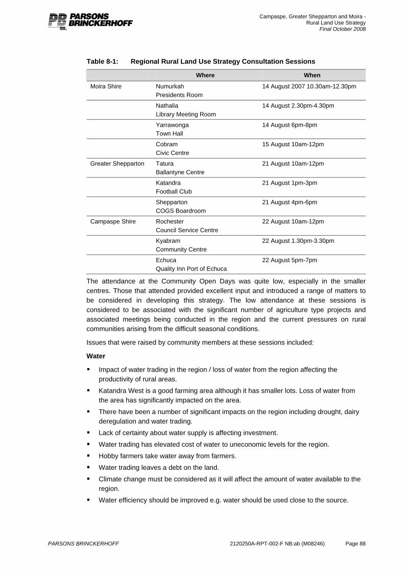
Campaspe, Greater Shepparton and Moira - Rural Land Use Strategy
Final October 2008
PARSONS BRINCKERHOFF 2120250A-RPT-002-F NB:ab (M08246) Page 88
Table 8-1: Regional Rural Land Use Strategy Consultation Sessions
Where When
Moira Shire Numurkah Presidents Room
14 August 2007 10.30am-12.30pm
Nathalia Library Meeting Room
14 August 2.30pm-4.30pm
Yarrawonga Town Hall
14 August 6pm-8pm
Cobram Civic Centre
15 August 10am-12pm
Greater Shepparton Tatura Ballantyne Centre
21 August 10am-12pm
Katandra Football Club
21 August 1pm-3pm
Shepparton COGS Boardroom
21 August 4pm-6pm
Campaspe Shire Rochester Council Service Centre
22 August 10am-12pm
Kyabram Community Centre
22 August 1.30pm-3.30pm
Echuca Quality Inn Port of Echuca
22 August 5pm-7pm
The attendance at the Community Open Days was quite low, especially in the smaller centres. Those that attended provided excellent input and introduced a range of matters to be considered in developing this strategy. The low attendance at these sessions is considered to be associated with the significant number of agriculture type projects and associated meetings being conducted in the region and the current pressures on rural communities arising from the difficult seasonal conditions.
Issues that were raised by community members at these sessions included:
Water
Impact of water trading in the region / loss of water from the region affecting the productivity of rural areas.
Katandra West is a good farming area although it has smaller lots. Loss of water from the area has significantly impacted on the area.
There have been a number of significant impacts on the region including drought, dairy deregulation and water trading.
Lack of certainty about water supply is affecting investment.
Water trading has elevated cost of water to uneconomic levels for the region.
Hobby farmers take water away from farmers.
Water trading leaves a debt on the land.
Climate change must be considered as it will affect the amount of water available to the region.
Water efficiency should be improved e.g. water should be used close to the source.
Campaspe, Greater Shepparton and Moira - Rural Land Use Strategy
Final October 2008
PARSONS BRINCKERHOFF 2120250A-RPT-002-F NB:ab (M08246) Page 89
Farm size and lot arrangement Restructure of existing properties being hindered by existing farm infrastructure.
Existing dwellings on farm holdings can be a burden on farmer’s who want to focus on farming activities not property maintenance and tenant management.
The 12ha minimum lot size at Cobram should be reviewed.
Flexibility is needed in subdivision controls to respond to agricultural change.
House lot excisions support restructure and provide for new residents, including farm staff, to live in the area.
Closer settlement areas (e.g. Lockington) need consolidation.
Rural activity, farming & residential activity Horticulture around the fringes of the towns is hindered by concerns about sprays and
other farming operations. Any further residential growth of the towns needs to include buffers.
The Farming zone is affecting opportunities for rural industry, accommodation and produce sales.
Rural living / low density residential opportunities are considered important in terms of attracting and retaining population.
People should be able to retire on-farm.
House lot excisions in some areas cause problems through introducing incompatible land uses.
Lifestyles will outbid farmers for land in quality areas.
Opportunities for rural living around various townships.
8.2.6 Key issues addressed The three key issues arising from the community workshops were
1. security of water and associated impacts from climate change
2. providing flexibility in farm size and lot arrangement in response to change in the agricultural industry
3. residential growth in rural areas and associated land use conflicts between residential and farming activities.
The RRLUS seeks to address the three issues through the following mechanisms:
Water – the RRLUS is one component across a broad policy and regulatory environment affecting rural land in Victoria. The proposed land use planning initiatives contained within the RRLUS seek to align opportunities for consolidation and growth of agricultural properties with proposed water infrastructure investment. However, the policies are consistent with achieving sustainable agriculture in the region whether the land is managed as an irrigated or dryland enterprise.
Farm size and lot arrangement – the RRLUS provides alternative solutions for the arrangement of farms and existing rural parcels through recognising existing subdivision pattern and other constraints and opportunities. The RRLUS has reviewed the existing suite of rural zoning across the region and suggests a method of implementation that provides for Niche, Consolidation and Growth Farming Zone Schedules as well as adoption of the Rural Activity Zone and Rural Conservation Zone. The proposed development controls for subdivision and development of dwellings throughout the three

Campaspe, Greater Shepparton and Moira - Rural Land Use Strategy
Final October 2008
PARSONS BRINCKERHOFF 2120250A-RPT-002-F NB:ab (M08246) Page 90
proposed Farming zone schedules seek to respect opportunities and constraints of existing land use patterns as well as promote flexibility and opportunities for appropriate development to match changes in agriculture.
Rural Activity, Farming & Residential activity – the RRLUS recognises that the rural landscape across the region provides for a combination of agriculture, residential and tourism opportunities. Importantly, the RRLUS seeks to ensure that management and application of zones to land and zone controls provide an appropriate interface between diverse land uses that minimises potential conflicts. This objective is aligned with farming activity (the core economic driver in the region), opportunities for tourism and dwellings within rural environments. The RRLUS has included an assessment of available land within the Rural Living Zone and determined that sufficient land is already zoned for this purpose. The RRLUS recognises that the core regional economic driver must be protected through adoption of three Schedules for managing use and development within the Farming Zone. Where appropriate opportunities for excision of dwellings to restructure properties is recommended, similarly existing rural land that affords opportunities for tourism and development of land is catered for through application of the Rural Activity Zone, Rural Conservation Zone and Rural Living Zone respectively.
8.2.7 Submissions Written submissions were called for during the project and a “community feedback form” provided which offered suggestions about matters that the community may wish to comment on. The purpose of the feedback forms was to gather information about particular rural land use issues.
The following provides an overview of the matters raised in the written submissions received. Responses to the submissions are included in Appendix H.
Sixteen submissions were received including a significant proportion by surveyors and developers seeking development opportunities on behalf of clients. This strategy is unable to consider the detailed merits of requests to consider opportunities (i.e. proposals) for low density or rural living development.
This strategy can highlight areas where agricultural prospects are limited and alternative land uses may be considered. This strategy can also comment on the current suitability and capacity of the existing rural living land supply. The location and amount of land dedicated to alternative forms of residential development (such as low density residential and rural living) must be subject to a residential / settlement strategy. Greater Shepparton is presently commencing such a project and as such many of these submissions will be referred to that study. Future strategic studies to be undertaken by the Shires of Campaspe and Moira will need to undertaken to ascertain the appropriate location of rural living within these municipalities.
8.2.8 Key issues General Water unbundling will deplete the region of water as it is transferred downstream to larger properties that enjoy tax breaks.
Struggling farmers have been forced to sell water to remain viable.
Rural zones are too restrictive and do not allow rural landholders to subdivide and sell lots to raise capital or exit with dignity.
Campaspe, Greater Shepparton and Moira - Rural Land Use Strategy
Final October 2008
PARSONS BRINCKERHOFF 2120250A-RPT-002-F NB:ab (M08246) Page 91
It will be difficult to determine the areas with agricultural prospects and the suitable commodities due to the current challenges and changes such as climate change.
The region has a high resource of agricultural land and most of it can be made more valuable through the provision of irrigation water, efficient irrigation systems, soil and biological improvements.
Planning system needs to be flexible to respond to changing circumstances.
Areas of good quality soil and where there is access to water should be protected for agriculture. Other rural land should also be protected for green space and environmental benefit.
Climate change and the impact it will have on water storages that feed irrigation systems must be considered.
Efficient delivery of water is a critical consideration in determining the agricultural prospects of areas.
The strategy should secure land for agriculture and identify other areas that may perform a broader role in promoting other related activities.
The Shepparton Irrigation Region should be protected from residential development.
Control of rural dwellings is more important strategically than the subdivision of land as this has the potential to permanently alter the use of the land.
Higher permit triggers for dwellings are required. A suitable policy would be better to guide the development of dwellings than the scheduled minimums do.
Rural living should not be included within the urban growth boundary. It is very difficult to convert rural living area to more intensive residential development.
Particular issues (town or area basis) Katandra
Sale / trade of water from the district has reduced productive potential of land. Land could be more productively utilised for intensive agriculture or horticulture e.g. olives, horse farms.
Torrumbarry
Land between Echuca and Torrumbarry is heavily fragmented with lifestyle blocks and remaining farmers are subject to complaints about normal operations, which is compromising their right to farm. The area between Echuca and Torrumbarry should be rezoned Rural Activity or Rural Living.
Lemnos
Land to the north of the Lemnos township is suitable for low density residential development due to its proximity to Lemnos and Shepparton.
Kialla/Kialla Central
Land adjoining Kialla Central is suitable for low density residential development due to its proximity to Kialla Central and Shepparton and community demand for this residential style.
Land between Shepparton Trotting Track and Kialla Central township should be rezoned for development as this area has lower agricultural prospects, infrastructure is available, demand is evident and the area would be attractive to skilled workers from Melbourne.
Campaspe, Greater Shepparton and Moira - Rural Land Use Strategy
Final October 2008
PARSONS BRINCKERHOFF 2120250A-RPT-002-F NB:ab (M08246) Page 92
Opportunities for agriculture in this area are limited.
Rural living should not be included in the urban growth corridor to protect its integrity for future urban growth.
The area south of the Broken River and east of Doyles Road should be considered for rural living as its agricultural prospects are limited due to fragmentation and surrounding residential development, it is outside the urban growth boundary but still close to and connected to Shepparton and already exhibits rural living characteristics of small lots and dwelling development.
Rochester
Land to the south east of Rochester (south side of Pascoe Street) is suitable for low density residential development as it adjoins an existing low density residential area and is on the fringe of Rochester. The land is separated from the balance of the existing farm by a floodway.
Numurkah
Land to the south east of Numurkah is suitable for low density residential development as it is of lower agricultural value and is close to town.
Land to the south west of Numurkah is suitable for low density residential development as it is of lower agricultural value and is close to town.
Nathalia
Rural living should be supported around Nathalia as water has been transferred out of the region from smaller properties and there is a demonstrated demand. This would also support growth of the town. Suitable areas include along the Broken Creek.
Echuca
Block on O’Dwyer Road Echuca should be rezoned for development as it is too small to be considered viable for agriculture.
Bundalong
Environmental Wood at Bundalong should be protected.
Tatura
Land east of Tatura on Dhurringile Road on the town boundary is no longer suitable for agriculture due to conflicts with adjoining urban land uses include complaints about spraying and pest plants and animals affecting crops. Any new development should build in buffers to remaining farming properties to protect their right to farm.
Dookie
Land to the north of Dookie is suitable for rural residential development, including small boutique and niche farming operations.
8.2.9 Summary The consultation suggests that there is generally a desire to continue to farm in the area. However current challenges, in particular drought and the associated availability and cost of water, are limiting short term prospects and forcing some land owners to look at other options. There are some farmers who are seeking to exit the industry given the current challenges, but there are others who see a long term future in farming in the region and wish
Campaspe, Greater Shepparton and Moira - Rural Land Use Strategy
Final October 2008
PARSONS BRINCKERHOFF 2120250A-RPT-002-F NB:ab (M08246) Page 93
to expand their existing activities. There is a need to provide strong direction in terms of appropriate activity in farming areas to provide certainty and minimise impacts on an already stressed industry. It is also necessary to avoid decisions being made in response to a short term difficult situation that may impact on the long term prospects of the area. It is clear that a range of strategies are required to support agriculture in the region that respond to the needs of the different industries and the different areas as well as change in the agricultural industry. It is also clear that there is a need to provide for rural living in appropriate locations to minimise this land use competition and provide for opportunities for alternative land uses in areas where there may be less opportunity for farming activity.
8.3 Draft RRLUS Public Display The Draft RRLUS was adopted for public display by all three member municipalities in late August 2008. The Draft RRLUS was placed on public display for a period of 28 days between the 4th August and the 1st September. The document was made available at the offices of each of the municipalities and was placed on each website in a downloadable format.
The public display period was also informed through a series of information workshops and public consultation sessions to further highlight to agencies, surveyors, consultant planners, Council staff and the community aware the strategic intent of the RRLUS and provide information about making a submission.
Two workshops were held at the City of Greater Shepparton on the 12th August and targeted agencies, surveyors and consultant planners. Twenty one professionals working within the private fields of surveying, consultant planning, Real Estate and Building Design attended the morning session, with thirty four Council Officers and professionals from amongst water authorities, state government agencies and Catchment Management Authorities.
In addition ‘drop-in sessions and public meetings were co-ordinated by the three Councils throughout the region (Table 8-2). Attendance at these meetings provided another opportunity for additional information and clarification regarding the public display of the RRLUS.
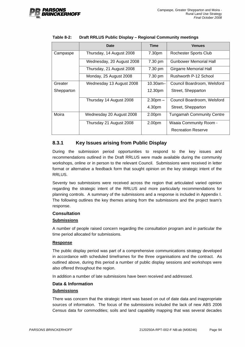
Campaspe, Greater Shepparton and Moira - Rural Land Use Strategy
Final October 2008
PARSONS BRINCKERHOFF 2120250A-RPT-002-F NB:ab (M08246) Page 94
Table 8-2: Draft RRLUS Public Display – Regional Community meetings
Date Time Venues
Thursday, 14 August 2008 7.30pm Rochester Sports Club
Wednesday, 20 August 2008 7.30 pm Gunbower Memorial Hall
Thursday, 21 August 2008 7.30 pm Girgarre Memorial Hall
Campaspe
Monday, 25 August 2008 7.30 pm Rushworth P-12 School
Wednesday 13 August 2008 10.30am–
12.30pm
Council Boardroom, Welsford
Street, Shepparton
Greater
Shepparton
Thursday 14 August 2008 2.30pm –
4.30pm
Council Boardroom, Welsford
Street, Shepparton
Wednesday 20 August 2008 2.00pm Tungamah Community Centre Moira
Thursday 21 August 2008 2.00pm Waaia Community Room -
Recreation Reserve
8.3.1 Key Issues arising from Public Display During the submission period opportunities to respond to the key issues and recommendations outlined in the Draft RRLUS were made available during the community workshops, online or in person to the relevant Council. Submissions were received in letter format or alternative a feedback form that sought opinion on the key strategic intent of the RRLUS.
Seventy two submissions were received across the region that articulated varied opinion regarding the strategic intent of the RRLUS and more particularly recommendations for planning controls. A summary of the submissions and a response is included in Appendix I. The following outlines the key themes arising from the submissions and the project team’s response.
Consultation Submissions
A number of people raised concern regarding the consultation program and in particular the time period allocated for submissions.
Response
The public display period was part of a comprehensive communications strategy developed in accordance with scheduled timeframes for the three organisations and the contract. As outlined above, during this period a number of public display sessions and workshops were also offered throughout the region.
In addition a number of late submissions have been received and addressed.
Data & Information Submissions
There was concern that the strategic intent was based on out of date data and inappropriate sources of information. The focus of the submissions included the lack of new ABS 2006 Census data for commodities; soils and land capability mapping that was several decades
Campaspe, Greater Shepparton and Moira - Rural Land Use Strategy
Final October 2008
PARSONS BRINCKERHOFF 2120250A-RPT-002-F NB:ab (M08246) Page 95
old and the lack recognition of drought years. In addition concern was raised regarding the application of Biodiversity Action Planning Mapping as a basis for planning decisions.
Response
At the time of preparation and prior to the public display period, all commodities data collected during the 2006 Census was unavailable. This data was obtained in early September and has subsequently been included in the RRLUS (See Section 4). While some reduction in overall farms did take place during this time they were concentrated around the small to medium sized properties. During this period overall production value increased throughout the region based on enlarged enterprises.
Rural Living Opportunities Submissions
A number of submissions suggested that the RRLUS did not adequately address the issue of Rural Living within the region. In addition the recommendation to retain the existing land zoned Rural Living was considered inadequate treatment of this issue. A number of submissions highlighted specific properties that were considered suitable for rural living opportunities rather than the proposed application of the Farming Zone.
Response
Chapter 5 of the RRLUS outlines a detailed assessment of population and settlement trends across the region. The findings of this assessment suggested that existing supply of land currently zoned for Rural Living adequately addressed the market demand. The recommendations of the RRLUS therefore recommended that as the Rural Living Zone (RLZ) is fundamentally a component of residential housing provision, detailed assessment that outlines recommendation for rezoning of rural areas to RLZ should be incorporated into a Housing or Settlement Strategy. This is the approach of Greater Shepparton who are undertaking a thorough assessment of broad settlement needs within urban areas, existing townships and rural settings that could be considered RLZ. The Shires of Campaspe and Moira will need to undertake this broad strategic work to provide a sustainable settlement strategy for their municipalities.
Generally, the submissions regarding isolated properties that should be considered for RLZ did not provide sufficient information to justify a specified departure from the recommendation to consider RLZ in a broad approach to housing and settlement requirements.
Corporate Farming and decline in Rural Communities Submissions
Several submissions raised a concern that the proposed planning controls for new dwellings and subdivision with the Farming Zone would impact on the rural landscape by removing people living in the area and causing a decline in rural communities. In addition this concern was heightened through interpretation that the RRLUS was focussed on large corporate farming enterprises at the expense of local communities and family farming.
Response
As identified in Section 5 of the RRLUS, the general trend toward declining rural communities is not a new phenomenon or limited to the prescriptions of the RRLUS. This is particular the case in dryland areas. The intent of the RRLUS is to manage the conflict that can arise from expanding agriculture and additional dwellings that are not associated with agriculture. This strategy is based on strengthening and growing the existing foundation of

Campaspe, Greater Shepparton and Moira - Rural Land Use Strategy
Final October 2008
PARSONS BRINCKERHOFF 2120250A-RPT-002-F NB:ab (M08246) Page 96
the regional economy which in turn will assist with economic development opportunities throughout the region.
The intention of the RRLUS is to provide land use planning mechanisms that respond to the diversity of enterprises throughout the region. The region is not dissimilar to other areas across the state that contain a mix of single family, multi family and corporate owned businesses producing a single commodity or a variety of commodities that may or may not have some level of on-farm processing. This diversity of businesses demonstrate the variety of successful business models. The RRLUS seeks to ensure planning controls that will not impede diversity but allow for consolidation and growth of agricultural enterprise as required.
Flexibility Submissions
A common theme regarding the proposed development controls for the Farming Zone was a concern around the restrictive nature of the proposed Schedules. This included limitations on development of dwellings, ability to have flexibility to use land for farming and other opportunities and restrictions on people being able to enter the market or expand due to large lots.
Response
The RRLUS is focussed on providing a balance within the Farming Zone through application of three Schedules. The Schedule recognise existing patterns of allotments and development, opportunities to expand, access to Agricultural Development Areas through a balanced land use planning approach. The ability to proactively respond to shifts in markets, new technologies and access to water infrastructure within Farming areas is based on management of non-agricultural uses that may enter this area. The intent of the Farming Zone includes:
To provide for the use of land for agriculture.
To encourage the retention of productive agricultural land.
To ensure that non-agricultural uses, particularly dwellings, do not adversely affect the use of land for agriculture.
While the RRLUS does not attempt to provide flexibility for all manner of uses and development, the primary purpose of agricultural areas is to further the agricultural based that is the fundamental foundation for the region. The RRLUS does seek to provide flexibility for rural land holders through a consistent application of the Farming Zone across the region that ensures opportunities activities that are encompassed through Niche; restructure and Consolidation and Growth or enterprises.
Water Submissions
The final focus of submissions included concern around the trading of water out of the region that will effectively undermine the intent of the RRLUS.
Response
The RRLUS is one component within the suite of Rural Policy that controls outcomes within the region. While the RRLUS is unable to control the trading of water, the strategic alignment with the proposed series of water reforms to take place within Northern Victoria is a core component of the RRLUS. It is considered that without ensuring agricultural land
Campaspe, Greater Shepparton and Moira - Rural Land Use Strategy
Final October 2008
PARSONS BRINCKERHOFF 2120250A-RPT-002-F NB:ab (M08246) Page 97
remains unfettered by non agricultural uses through planning policy, the preconditions for ensuring investment of more efficient water infrastructure could be restricted.
The principles of limiting non agricultural uses and providing opportunities for consolidation and growth of agricultural enterprise apply regardless of the scale of the property and whether it is dryland or irrigated.
8.3.2 Summary The public display period provided adequate opportunity for further information regarding the RRLUS and an opportunity for input. A number of concerns were raised regarding consultation; data and information; assessment of rural living and the restriction of people living within rural areas; lack of flexibility in proposed planning controls; and, the trading of water undermining the intent of the strategy.
A summary of the submissions and the project team’s responses is contained in Appendix I. The Final RRLUS has been modified to include:
An update to available ABS commodities data and Ecological Vegetation Classes including implementation to recommendations for environmental Overlays;
Clarification regarding the assessment of rural living;
The applicability of the strategy to the broad diversity of farming enterprises;
Confirmation that the RRLUS provides flexibility for farming within agricultural areas;
Alignment with water infrastructure investment.
Campaspe, Greater Shepparton and Moira - Rural Land Use Strategy
Final October 2008
PARSONS BRINCKERHOFF 2120250A-RPT-002-F NB:ab (M08246) Page 98
9. The strategic regional setting 9.1 Background
The region embraces major irrigation districts centred on the Goulburn Valley and include other irrigation districts such as the Shepparton Irrigation Region and extensive dryland farming areas. This region is one of the nation’s major agricultural areas in terms of productivity, economic value of production and diversity of product. The region produces a significant proportion of the country’s dairy and horticultural product. As a result on-farm production, processing and packing are core sectors of the regional economy.
In recent years various areas of rural land in production have been placed under pressure for conversion to non agricultural uses including further subdivision of land for residential land uses and excision of existing dwellings. One of the roles of the RRLUS is to determine the appropriate balance between these competing rural land uses, an ensure consistency with state wide policies and the region’s significant role in agriculture to effectively manage the social, economic and environmental implications of landscape change.
In part the RRLUS is designed to reinforce the outcomes being sought in the water reform agenda. The following outlines key findings relevant to both the detailed assessment and consultation process:
Strong productive region Irrigated and dryland primary production and the processing of that product underpin the Region’s economy. The level of production is nationally important - for instance the region is responsible for:
25% of the nation’s milk production.
90% of the nation’s deciduous canned fruit production.
45% of the nation’s stone fruit crop.
90% of the nation’s tomato processing production.
The annual total value of agricultural production at the farm gate is in the order of $1.2 billion. The food-processing sector produces an additional $1.7 billion in income for the regional economy, including:
The agriculture sector alone invested around $1 billion during the 1990s in processing and handling equipment, infrastructure and refitting.
A workforce of about 8,500 people are directly involved in agricultural production on farms, and an estimated similar number involved directly and indirectly in the processing of that product.
The Irrigation base Despite the economic prominence of the whole agricultural production and processing sector the region’s irrigation infrastructure, is ageing and inefficient. In order to address this situation a package of modernisation, known as the Foodbowl Modernisation Project, will encompass reforms and initiatives relating to land use, resource management and further investment in water infrastructure that are designed to ensure the long term future of the region.
All three municipalities have irrigation supply systems that have the opportunity for modernisation over the next eight years through the Foodbowl Modernisation project. The
Campaspe, Greater Shepparton and Moira - Rural Land Use Strategy
Final October 2008
PARSONS BRINCKERHOFF 2120250A-RPT-002-F NB:ab (M08246) Page 99
upgrades will include replacement of some of the smaller open, unlined channels with lined or piped delivery systems, channel automation, water metering and rationalising the number of channel structures and delivery points to each property that will enable more efficient, automated on-farm irrigation systems.
Within the irrigation areas, resources are being moved from lower value grazing enterprises to higher value enterprises such as dairy and horticulture. Agricultural development areas have been identified by Goulburn Murray Water as those areas capable of accommodating new investment into high-value irrigation development. In addition, a number of areas where suitable land exists in sufficient scale to warrant new development have been identified near or adjacent the edge of the irrigation area.
Providing opportunities for emerging intensive agricultural businesses to expand within areas is core to the ongoing viability of the regional economy. The provision of land suitable for irrigation and unencumbered by constraints of neighbouring non-agricultural uses, significant landscape or conservation value or fragmented titles is vital for the region. Strategic alignment of land use planning policy and statutory instruments provides significant opportunities for the existing agricultural economic base of the region to expand in association with the improved water infrastructure proposed through the Foodbowl Modernisation project.
9.2 Strategic alignment As previously detailed, agriculture provides the region’s primary economic base and this is reflected in the large amount of land that is subject to the provisions of the Farming Zone. However, it is the diversity of the regions landscape that has attracted new and emerging forms of rural living, including within areas of productive irrigation, valuable riverine and forest environments. The development of these ‘residential’ properties, based on a set of inconsistent land use planning provisions across the region provides challenges for the largest economic driver of the region.
In terms of ensuring agricultural and horticultural activities are able to provide a net community benefit through a process of expanding and diversifying their operations in line with the package of government water reform, land use planning must endeavour to retain allotments in larger parcels and prevent inappropriate subdivision. The conversion of productive land to accommodate housing can introduce undesirable infrastructure, drive land values beyond production value and fetter the potential for long term agricultural industry expansion as a result of land use amenity conflict. The increased concentration of residential land use in agricultural areas can inhibit farming activities which is essentially an industrial activity that is focussed on primary production. Ensuring that land use planning controls urban and rural residential expansion and provides adequate attenuation between agricultural activity and areas of residential development is fundamental to providing surety for both agricultural businesses and ensuring residential amenity. Councils have a responsibility for protecting core agricultural areas and planning for settlements that are not isolated from physical and social services
Preventing ad-hoc rural living development through appropriately managed rural land is critical when considering the long term opportunities for ongoing agricultural expansion across the region. Importantly, it is the alignment of land use planning provisions with the modernisation and reconfiguration of the irrigation network and the expansion of irrigated agriculture into land capable of intensification that will drive the region’s long term future.

Campaspe, Greater Shepparton and Moira - Rural Land Use Strategy
Final October 2008
PARSONS BRINCKERHOFF 2120250A-RPT-002-F NB:ab (M08246) Page 100
Essentially, the trends isolated during development of the RRLUS suggest that population and housing change in rural areas is most strongly associated with land on the fringe of the larger urban centres in the study area and development in a few, highly valued, rural landscapes. The review of past trends in population and settlement highlights the need for appropriate management of agricultural activities as the primary focus of the strategy across the region. The provision of rural living residential development should be seen within the context of a settlement strategy for the region. However, the RRLUS has identified that the region is not unique when compared with broad population trends witnessed across rural Australia. This includes: a centralisation of services in most agricultural regions; growth in the commuter field of larger urban centres and growth of population and housing in rural settings that are aligned with both affordability and lifestyle opportunities. Population change and development trend in the region suggest likely continued growth in larger centres and in riverine environments. Trends in this growth to date do not indicate heightened pressure for additional provision of locations for rural lifestyle development across the region.
The analysis of trends in commercial agriculture indicates both concurrent and diametrically opposed futures for rural holdings. These trends are typified by large and expanding agricultural properties and increasing small, niche and sub-commercial farming. The real challenge for land use planning is to effectively transform the mid range farm businesses that are experiencing a ‘hollowing-out’. Providing flexible planning tools that recognise the opportunities and constraints of these mid size properties is vital to promote the vision adopted in the RRLUS. This process will slowly transform these mid range holdings to either areas of consolidation where adjacent other productive land or adjacent to contiguous agricultural property; or rearranging existing titles to allow for small (or sub-commercial) farms to operate.
9.3 Planning controls The development of the RRLUS has placed an emphasis on reviewing the Farming Zone to effectively ensure the intent of the State Planning Policy Framework and further the objectives of the region’s Local Planning Policy Framework. It is evident that the existing provisions, specifically with reference to subdivision minima, do not, in themselves, provide an adequate approach to achieving the aim of providing certainty and flexibility for ongoing agricultural activity.
The State Planning Policy Framework, and local policies in each planning scheme, each seek to maintain scope for ongoing agriculture. The risk, and often the outcome, of a minimum lot size model for subdivision and development is that these minima are maintained as the default position for the granting of permits when assessed against the provision of the zone. The emerging position in rural land use policy indicates that this is not an adequate mechanism to achieve good land use outcomes as these are not a defensible approach to preventing non-farm use. The process of ensuring a clear strategic process for managing the risk of land use conversion and removal of minimum lot sizes has generally been successful as discussed earlier in Section 7 of this report.
As previously outlined, the reliance on subdivision minima to effect land use change alone is problematic. It is considered that an approach to achieving sustainable agriculture development within the region should be based on a strategic policy approach. This calls for reliance on modifications to the existing State and Local policy frameworks to recognise the significance of the region at a National and State level. Assessment of applications for development and use within the Farming Zone of the study area is considered to be best served through a policy-based approach with associated performance based measures.
Campaspe, Greater Shepparton and Moira - Rural Land Use Strategy
Final October 2008
PARSONS BRINCKERHOFF 2120250A-RPT-002-F NB:ab (M08246) Page 101
10. Rural land use strategy 10.1 Agricultural future
Despite current challenges it is widely agreed that there is an expanded future for agriculture in the region. This will only be strengthened by a clear land use planning strategy.
The region is a significant player at the State and National level in terms of certain agricultural products, and agriculture is central to the economy, employment and settlement in the region. Without a strong agricultural sector in this region, economic prospects and social structures would be threatened.
Although the number of farmers and farms has decreased, there have been significant increases in productivity and value. The annual growth in milk production is 5-7% and prior to the 2003 drought new horticulture development (excl. grapes) was occurring at a rate of 450ha per annum.
Although it is likely that new farming industries will emerge over time to enhance the region’s output, growth and adaptation of the existing key industries is most likely to be the focus for ongoing viability and economic development. Dairy and horticulture in the irrigation areas, and grazing and cropping in the dryland areas are and will remain the economic engine of the region. There is the potential to expand high value horticulture using under utilised land and water. Drivers of agricultural growth are a secure water supply, larger properties and lack of fragmentation in agricultural holdings, fewer neighbours and opportunities for vertical integration (horticulture).
Water has traded out of the region due to challenging seasonal conditions over the past few years. The loss of water from the region is causing considerable community angst about the future of the region and its ability to compete with other areas in terms of long term agricultural prospects. One of the main reasons water has been traded out (rather than within the region) is because of lack of competitiveness due in part to the inefficiency of local irrigation infrastructure and limited opportunities for larger scale investment and development.
This region does retain many competitive advantages including good quality soils and climate, but the ability to secure large properties within or on the fringe of the irrigation areas able to be fully developed for large scale projects with world class efficient irrigation systems is fundamental in securing new agricultural investment and retaining and returning water to the region.
It is considered that redevelopment of existing properties, expansion of production further investment in horticulture and potentially the return of water to the region is much more likely to occur if there is certainty in terms of the future role of agricultural land, and if agricultural land is retained in larger parcels. New irrigation schemes in other Victorian regions have relied on high levels of investment and development at a large scale (on large holdings) utilising sophisticated water supply and application systems.
It is recognised that some farmers wish to leave the industry and exit with dignity, or realise some capital in the short term to enable them to stay in the industry. To compromise the agricultural potential of the region through subdivision or conversion of individual parcels to residential use is a short sighted response that would be at the long term expense of the farming potential of the area, the ongoing viability of remaining farmers and the regional economy. Land should only be used or developed in such a way that the agricultural

Campaspe, Greater Shepparton and Moira - Rural Land Use Strategy
Final October 2008
PARSONS BRINCKERHOFF 2120250A-RPT-002-F NB:ab (M08246) Page 102
potential is reduced if it is clear there are limited or no agricultural prospects remaining, and there are other more appropriate land use options.
Farm land has retained its value as has water, and as such farmers wishing to leave the industry will realise capital through the sale of these assets. Should additional support be required for leaving (or in fact remaining) in the industry this should be sought through means other than pursuing non-agricultural development options on farm land. Some options are available through Federal Government Drought Support for example. The implications of seeing the realisation of a speculative non-agricultural resource as a means to address these individual issues creates a significant detriment for the region’s economy as a whole.
In considering the future of agriculture in the region, the 80/20 rule should be kept in mind. That is about 20% of the region’s farmers use about 80% of the water and about 20% of the region’s farmers produce about 80% of the product. These 20% will drive the future of the industry and therefore need to be supported. Consequently, the planning system needs to clearly recognise the needs of the small number of large operations in its Farming Zone. In addition, the planning system must also recognise that while other perspectives have been offered through the various consultation processes, the net community benefit and existing social and economic structures of the region are fundamentally realised through a productive agricultural future.
10.2 Councillor vision A workshop was conducted with the Councillors of the three municipalities on 4th September, 2007 at Shepparton. The purpose of this workshop was to develop a vision for the future of the rural areas of the region.
The workshop commenced with the provision of a range of information to the Councillors about the value and significance of agriculture to each of the municipalities, the region, the State and Australia as a whole. The significant role that agriculture in the region contributes at a national level, and the fundamental role that agriculture plays in terms of local employment, both directly and indirectly provided the context for the development of a regional vision.
At this workshop, the Councillors adopted the following joint position:
agriculture is and will remain the major economic driver of the region
facilitate growth of existing farm businesses
facilitate growth of new agricultural investment (existing agricultural industries / unknown agricultural industries)
provide for hobby farming.
Further, the Councillors identified and endorsed the following requirements for the key land uses to be accommodated in rural areas.
Requirements for agriculture
Water security.
Minimal fragmentation.
Efficient irrigation set up.
Efficient infrastructure envelope (dwelling/shed location).
Complementary infrastructure (roads, power etc).

Campaspe, Greater Shepparton and Moira - Rural Land Use Strategy
Final October 2008
PARSONS BRINCKERHOFF 2120250A-RPT-002-F NB:ab (M08246) Page 103
Limited incompatible land uses/sensitive land uses – including tourism and non-farm housing.
Requirements for amenity living / hobby farming
Close to existing residential areas.
Good amenity - water views, trees, undulating landscape.
Buffer to agriculture.
Efficient service provision.
Protect landscape values.
Requirements for tourism need to be recognised.
High amenity areas need to be well managed and the need to avoid areas with agricultural infrastructure such as hail guns, frost fans that are likely to compromise tourist operation but are also likely to lead to measures that will result in agricultural production being compromised.
In order to realise the adopted tri Council vision, the provision of land throughout the region must recognise the different landscape characteristics, settlement patterns and infrastructure requirements for sustainable development throughout the rural land of the region. While non-farm land uses in rural areas remain a legitimate land use and market preference, the capacity for agriculture to grow and adapt should be the fundamental concern for the region. Moreover, the types of locations most suited to non-farm uses are unlikely to be in areas where the attributes and requirements of agriculture listed above are to be found. Accordingly, The draft RRLUS is predicated on four key elements:
1. The region is Australia’s productive food bowl based primarily on dairy products
and fruit production. 2. The scale of production has resulted in Australia’s greatest regional
concentration of food processing industries and workforce. 3. The economy and the liveability of the region are integrated with and dependent
on agriculture and its continuation. 4. The series of water reforms and the potential for new areas to be opened up for
intensive production provide opportunity for expansion in the level of agricultural production.
Campaspe, Greater Shepparton and Moira - Rural Land Use Strategy
Final October 2008
PARSONS BRINCKERHOFF 2120250A-RPT-002-F NB:ab (M08246) Page 104
10.3 Implementation
10.3.1 Agriculture At the Councillors Workshop and further developed at the Planners’ Workshop, it was determined that one approach for facilitating agriculture could not effectively address the requirements of industry, provide opportunities for agricultural growth and investment or realise the management of non agricultural uses within the Farming Zone. Importantly the strategy identified the importance of providing a consistent approach across the region to land use planning within the Farming Zone.
In recognition of the strategic setting, agricultural opportunities, aspirations to reside in rural areas and the diversity of economic development opportunities across the region, three scenarios, based on existing conditions and informed by the requirements for growth and investment have been adopted.
The Planning Scheme is but one mechanism amongst a range of government policy and land management initiatives across the regions rural land. However, the strategic alignment of land uses through changes to the planning scheme can assist by:
providing pre-conditions suitable for regional economic development
recognising the package of water reform and infrastructure improvements
ensuring management of natural values and protection of biodiversity
appropriately managing diverse land use and development to reduce conflict between adjacent properties.
It is not considered appropriate to highlight, focus on or plan for specific new industries. Investment opportunities, including new agricultural businesses come and go, some develop and some fall by the wayside. Recognising that such opportunities will also develop faster than the planning scheme can respond, land use policy must seek to further the strategic objectives at both a State and Local level to provide flexibility for appropriate development. The appropriate land use strategy includes protecting as many opportunities as possible and providing a variety of environments in which different rural enterprises can develop in accordance with the principles of sustainable development.
The modern requirements of an agricultural or horticultural operation dictate a more intensive form of farming practice. Constraints of farming operations include Occupational Health and Safety requirements, viable scale of operation, management of pests and weeds and hours of operations. These constraints influence the most suitable location for both maintaining and providing optimal conditions to ensure expansion of agricultural businesses. The strategy has established that the requirements of most agricultural industries are consistent with the drivers of growth, including: reliable water supply; larger properties and a lack of fragmentation; fewer neighbours; and, opportunities for vertical integration (horticulture). Simultaneously the provision of suitable land for expansion is linked with ensuring levels of rural amenity that are better suited to smaller holdings, less intense agricultural uses and ancillary business opportunities such as tourism.
The importance of agriculture to the region in terms of net community benefit and broader regional economic development has been clearly identified through development of the RRLUS. Fundamentally all three of the municipalities are Rural Councils where the largest area of land across the region is suitably located within the Farming Zone. The objective of the RRLUS is to ensure that the substantive analysis of existing agricultural industry, ancillary tourism operations, rural living aspirations and emerging industries is synthesised
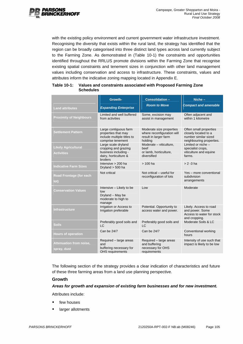
Campaspe, Greater Shepparton and Moira - Rural Land Use Strategy
Final October 2008
PARSONS BRINCKERHOFF 2120250A-RPT-002-F NB:ab (M08246) Page 105
with the existing policy environment and current government water infrastructure investment. Recognising the diversity that exists within the rural land, the strategy has identified that the region can be broadly categorised into three distinct land types across land currently subject to the Farming Zone. As demonstrated in (Table 10-1) the constraints and opportunities identified throughout the RRLUS promote divisions within the Farming Zone that recognise existing spatial constraints and tenement sizes in conjunction with other land management values including conservation and access to infrastructure. These constraints, values and attributes inform the indicative zoning mapping located in Appendix E.
Table 10-1: Values and constraints associated with Proposed Farming Zone Schedules
Land attributes
Growth-
Expanding Enterprise
Consolidation –
Room to Move
Niche –
Compact and amenable
Proximity of Neighbours Limited and well buffered from activities
Some, excision may assist in management
Often adjacent and within 1 kilometre
Settlement Pattern Large contiguous farm properties that may include multiple titles to comprise tenement
Moderate size properties where reconfiguration will result in larger farm holding
Often small properties closely located to a number similar sized neighbouring properties.
Likely Agricultural
Activities
Large scale dryland cropping and grazing business including - dairy, horticulture & broilers
Moderate – viticulture, beef or lamb, horticulture, diversified
Limited or niche – specialist crops, viticulture and equine farms.
Indicative Farm Sizes Intensive > 200 ha Dryland > 500 ha
> 100 ha > 2 -3 ha
Road Frontage (for each
lot)
Not critical Not critical – useful for reconfiguration of lots
Yes – more conventional subdivision arrangements
Conservation Values Intensive – Likely to be low Dryland – May be moderate to high to manage
Low Moderate
Infrastructure Irrigation or Access to Irrigation preferable
Potential. Opportunity to access water and power.
Likely. Access to road and power. Some Access to water for stock and cropping.
Soils Preferably good soils and LC
Preferably good soils and LC
Moderate Soils & LC
Hours of operation Can be 24/7 Can be 24/7 Conventional working
hours
Attenuation from noise,
spray, dust
Required – large areas and buffering necessary for OHS requirements
Required – large areas and buffering necessary for OHS requirements
Intensity of use such that impact is likely to be low
The following section of the strategy provides a clear indication of characteristics and future of these three farming areas from a land use planning perspective.
Growth Areas for growth and expansion of existing farm businesses and for new investment.
Attributes include:
few houses
larger allotments
Campaspe, Greater Shepparton and Moira - Rural Land Use Strategy
Final October 2008
PARSONS BRINCKERHOFF 2120250A-RPT-002-F NB:ab (M08246) Page 106
world class irrigation system (for irrigation areas), including opportunity for access to water on call
appropriate infrastructure (roads, power, drainage)
appropriate soil types.
Growth areas will include those areas that have been retained in larger properties and provide the opportunity for large scale, stand alone new agricultural development as well as for consolidation of existing farm properties wishing to grow. These areas will include the Agricultural development areas (See Chapter 4). For those developments dependant on irrigation, ready access to water (i.e. being on a main channel or a river) via a modern system will be critical. Properties with older irrigation set ups based on the requirements of a previous farming generation will not be as attractive to investors suited to the Growth area. As addressed elsewhere in this report, although soil type or land class will be a factor in decisions about agricultural growth and investment, it is not the critical factor, as soil conditions can be managed to support production in most cases. Where possible, good or better soils should be retained in the Growth areas but if these areas have been compromised through previous development decisions they will be more appropriately located in other categories. Subject to the soil conditions being reasonable, opportunities for unhindered growth and access to water are considered more critical than soil types in most cases.
When implemented the future of Growth areas will be to provide opportunities for substantive expansion and growth of agricultural enterprises to ensure the long term viability of the region. As demonstrated in Appendix F, the RRLUS seeks to limit the establishment of future dwellings and where possible encourage farm tenements and property boundaries to consolidate and enlarge in line with the trends in agriculture associated with productivity and viability.
Consolidation Support existing farm businesses to operate and grow.
Attributes include:
smaller lot / property sizes than the Growth areas but with the capacity for consolidation
productive soils
irrigation infrastructure (for irrigation areas)
appropriate infrastructure (roads, power, drainage).
These areas will include many of the former closer settlement areas that were based on the good soil types, but lot sizes are no longer reflective or current farm sizes. The strategy for these areas seeks to retain the productive soils for farming use and support existing farmers to grow their properties within these areas and prevent these areas becoming further compromised.
Appendix F demonstrates the strategy for effectively creating greater farm holdings through a process of restructure and consolidation. New dwellings within the consolidation zone are not promoted. These areas are considered to provide opportunity for development of growing agricultural enterprise that can, over time, expand and consolidate through a process of property restructure. The further development of additional dwellings threatens the future of growing agricultural enterprises. Planning tools such as excision’s and preferably boundary realignments, when utilised in association with evidence of farm business activity provide opportunities for restructuring of holdings to enable development of larger scale farms. Promoting the use of re-subdivisions and excisions within Consolidation
Campaspe, Greater Shepparton and Moira - Rural Land Use Strategy
Final October 2008
PARSONS BRINCKERHOFF 2120250A-RPT-002-F NB:ab (M08246) Page 107
areas is in recognition that the removal of a residential dwelling from a farming property can provide developing businesses an opportunity consolidate property holdings based on the value of land for agriculture.
Niche Productive potential based on existing lot configuration: opportunity for smaller scale and specialized agriculture.
Attributes include:
smaller lots
most with existing housing
basis for tourism / gourmet trail – good amenity
productive soils
irrigation infrastructure (for irrigation areas)
appropriate infrastructure (roads, power, drainage).
These areas will include those rural areas that still retain some productive potential due to soil type, property size or water access, but the opportunity for properties within these areas to expand in response to general market trends is limited due to land value and existing development (i.e. Most lots are smaller with dwellings). It is important to note that these areas are still productive farming areas and not rural living areas (where the main land use is residential). Rural living is to be catered for separately as these niche areas may still involve some activities (e.g. Spraying, frost fans etc) that is not consistent with residential land use.
Appendix F demonstrates the strategy for managing areas of existing fragmentation amongst the Farming Zone effectively creating greater farm holdings through a process of restructure and consolidation. New dwellings within the Niche zone can be supported where possible and associated with evidence of farm business activity. Restructuring of these areas will provide holdings of a larger scale with some smaller excised lots that may assist.
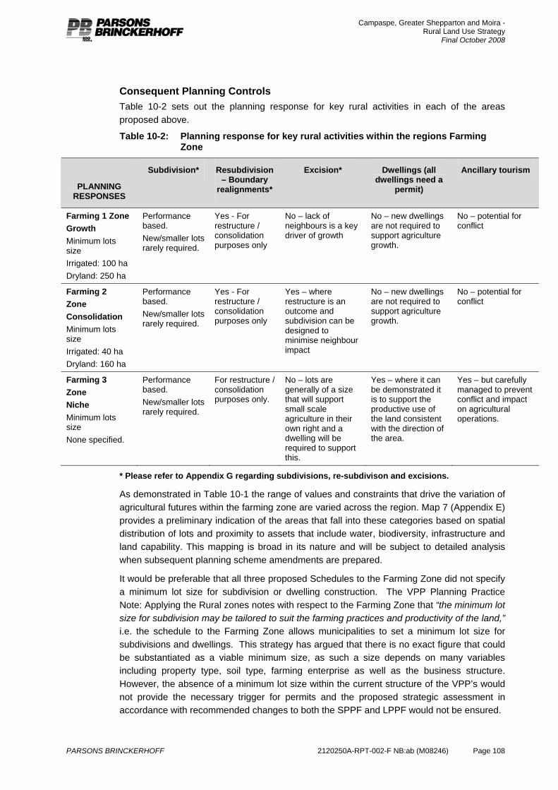
Campaspe, Greater Shepparton and Moira - Rural Land Use Strategy
Final October 2008
PARSONS BRINCKERHOFF 2120250A-RPT-002-F NB:ab (M08246) Page 108
Consequent Planning Controls Table 10-2 sets out the planning response for key rural activities in each of the areas proposed above.
Table 10-2: Planning response for key rural activities within the regions Farming Zone
PLANNING RESPONSES
Subdivision* Resubdivision – Boundary
realignments*
Excision* Dwellings (all dwellings need a
permit)
Ancillary tourism
Farming 1 Zone Growth Minimum lots size Irrigated: 100 ha Dryland: 250 ha
Performance based. New/smaller lots rarely required.
Yes - For restructure / consolidation purposes only
No – lack of neighbours is a key driver of growth
No – new dwellings are not required to support agriculture growth.
No – potential for conflict
Farming 2 Zone Consolidation Minimum lots size Irrigated: 40 ha Dryland: 160 ha
Performance based. New/smaller lots rarely required.
Yes - For restructure / consolidation purposes only
Yes – where restructure is an outcome and subdivision can be designed to minimise neighbour impact
No – new dwellings are not required to support agriculture growth.
No – potential for conflict
Farming 3 Zone Niche Minimum lots size None specified.
Performance based. New/smaller lots rarely required.
For restructure / consolidation purposes only.
No – lots are generally of a size that will support small scale agriculture in their own right and a dwelling will be required to support this.
Yes – where it can be demonstrated it is to support the productive use of the land consistent with the direction of the area.
Yes – but carefully managed to prevent conflict and impact on agricultural operations.
* Please refer to Appendix G regarding subdivisions, re-subdivison and excisions.
As demonstrated in Table 10-1 the range of values and constraints that drive the variation of agricultural futures within the farming zone are varied across the region. Map 7 (Appendix E) provides a preliminary indication of the areas that fall into these categories based on spatial distribution of lots and proximity to assets that include water, biodiversity, infrastructure and land capability. This mapping is broad in its nature and will be subject to detailed analysis when subsequent planning scheme amendments are prepared.
It would be preferable that all three proposed Schedules to the Farming Zone did not specify a minimum lot size for subdivision or dwelling construction. The VPP Planning Practice Note: Applying the Rural zones notes with respect to the Farming Zone that “the minimum lot size for subdivision may be tailored to suit the farming practices and productivity of the land,” i.e. the schedule to the Farming Zone allows municipalities to set a minimum lot size for subdivisions and dwellings. This strategy has argued that there is no exact figure that could be substantiated as a viable minimum size, as such a size depends on many variables including property type, soil type, farming enterprise as well as the business structure. However, the absence of a minimum lot size within the current structure of the VPP’s would not provide the necessary trigger for permits and the proposed strategic assessment in accordance with recommended changes to both the SPPF and LPPF would not be ensured.
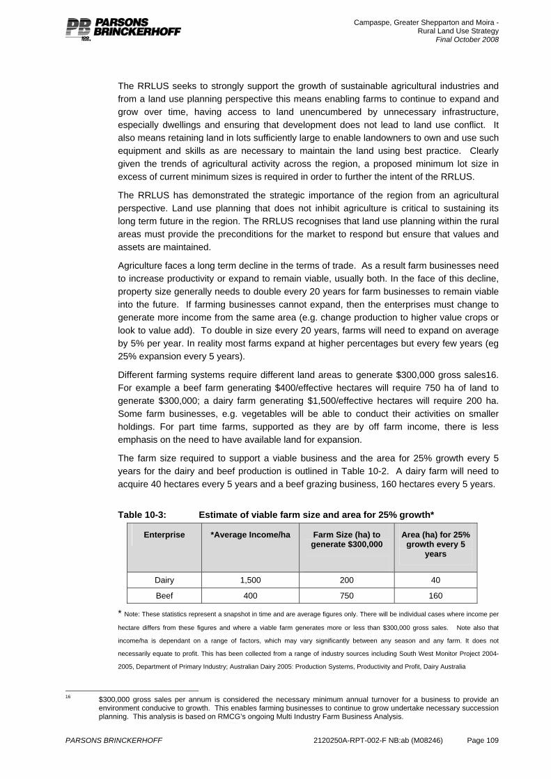
Campaspe, Greater Shepparton and Moira - Rural Land Use Strategy
Final October 2008
PARSONS BRINCKERHOFF 2120250A-RPT-002-F NB:ab (M08246) Page 109
The RRLUS seeks to strongly support the growth of sustainable agricultural industries and from a land use planning perspective this means enabling farms to continue to expand and grow over time, having access to land unencumbered by unnecessary infrastructure, especially dwellings and ensuring that development does not lead to land use conflict. It also means retaining land in lots sufficiently large to enable landowners to own and use such equipment and skills as are necessary to maintain the land using best practice. Clearly given the trends of agricultural activity across the region, a proposed minimum lot size in excess of current minimum sizes is required in order to further the intent of the RRLUS.
The RRLUS has demonstrated the strategic importance of the region from an agricultural perspective. Land use planning that does not inhibit agriculture is critical to sustaining its long term future in the region. The RRLUS recognises that land use planning within the rural areas must provide the preconditions for the market to respond but ensure that values and assets are maintained.
Agriculture faces a long term decline in the terms of trade. As a result farm businesses need to increase productivity or expand to remain viable, usually both. In the face of this decline, property size generally needs to double every 20 years for farm businesses to remain viable into the future. If farming businesses cannot expand, then the enterprises must change to generate more income from the same area (e.g. change production to higher value crops or look to value add). To double in size every 20 years, farms will need to expand on average by 5% per year. In reality most farms expand at higher percentages but every few years (eg 25% expansion every 5 years).
Different farming systems require different land areas to generate $300,000 gross sales16. For example a beef farm generating $400/effective hectares will require 750 ha of land to generate $300,000; a dairy farm generating $1,500/effective hectares will require 200 ha. Some farm businesses, e.g. vegetables will be able to conduct their activities on smaller holdings. For part time farms, supported as they are by off farm income, there is less emphasis on the need to have available land for expansion.
The farm size required to support a viable business and the area for 25% growth every 5 years for the dairy and beef production is outlined in Table 10-2. A dairy farm will need to acquire 40 hectares every 5 years and a beef grazing business, 160 hectares every 5 years.
Table 10-3: Estimate of viable farm size and area for 25% growth*
Enterprise *Average Income/ha Farm Size (ha) to generate $300,000
Area (ha) for 25% growth every 5
years
Dairy 1,500 200 40
Beef 400 750 160
* Note: These statistics represent a snapshot in time and are average figures only. There will be individual cases where income per
hectare differs from these figures and where a viable farm generates more or less than $300,000 gross sales. Note also that
income/ha is dependant on a range of factors, which may vary significantly between any season and any farm. It does not
necessarily equate to profit. This has been collected from a range of industry sources including South West Monitor Project 2004-
2005, Department of Primary Industry; Australian Dairy 2005: Production Systems, Productivity and Profit, Dairy Australia
16 $300,000 gross sales per annum is considered the necessary minimum annual turnover for a business to provide an
environment conducive to growth. This enables farming businesses to continue to grow undertake necessary succession planning. This analysis is based on RMCG’s ongoing Multi Industry Farm Business Analysis.
Campaspe, Greater Shepparton and Moira - Rural Land Use Strategy
Final October 2008
PARSONS BRINCKERHOFF 2120250A-RPT-002-F NB:ab (M08246) Page 110
It is recommended therefore that a graded approach throughout the three Farming Zones is provided to ensure a flexible planning approach that is aligned with the industry requirement of growth. It is proposed that a minimum lot requirement of 40 ha in irrigated areas and 160 ha in dryland areas enables consolidation and opportunities for expansion. These sizes are the basis for restructure in the Farming Zone and therefore reflect the intent of the Consolidation areas. Where farming tenements are considerably larger and continue to expand they are recommended for the Growth area. In these Growth areas the strategy recommends minimum lot sizes of 100ha and 250 ha to facilitate farm growth and expansion, enable implementation of best practice management and minimise risk of land use conflict.
Given the diversity of uses, combination of both on and off farm incomes and unconventional characteristics of the Niche Farming Zone areas, it is difficult to propose a minimum lot size within this area. It is recommended that the minimum lot size is not prescribed in the Schedule and defaults to the State requirements of the Farming Zone.
It is important to note that this minimum lot size regime does not automatically apply to dwellings. As established in the strategy, most farm businesses consist of multi-lot tenements and entitlement to a house on every lot would threaten the long term viability of farming. A major priority of the strategy is to ensure that dwelling proliferation is prevented. The Strategy therefore recommends that in most cases a new dwelling will not be supported in the Farming Zone regardless of the lot size. It is no longer reasonable to accept that dwellings on lots over a certain size would be associated with a farming land use given the strength of demand for rural living in some parts of the region. It will also be made clear in policy that other than in the Niche areas, new dwellings will rarely be required based on industry trends and requirements for growth.
It is recognised that this may increase the work load of Councils as not only will a significant number of new dwellings require planning approval, but so will some buildings and works associated with existing dwellings. House lot excisions will be limited to the Consolidation area, as within the Growth and Niche area they are considered contrary to the strategy. Tourism activity is also considered a land use that requires careful management as it may also be incompatible with agricultural opportunities. Tourism activities, even those associated with agriculture, require a certain standard of amenity that may not be suited to some commercial farming areas. It is recognised that there are some tourism activities that can occur without planning approval within the Farming Zone (e.g. Smaller Bed and Breakfasts), and this is considered inappropriate within a context of supporting agricultural growth.
10.3.2 Rural living The strategy for agricultural growth and development in this region recognizes the strength of demand for rural living and the legitimacy of this land use as a part of the residential opportunities of the region. However, this land use should occur where the benefits to potential residents can be maximized, and where the risks to farming minimized.
Rural living is the residential use of rural land. It may or may not include some agricultural activity but the primary land use is residential. As such, residents of these areas expect residential amenity and services.
Minister’s Direction No.6 provides guidance from the State level about planning for rural residential development.
Campaspe, Greater Shepparton and Moira - Rural Land Use Strategy
Final October 2008
PARSONS BRINCKERHOFF 2120250A-RPT-002-F NB:ab (M08246) Page 111
The objective of Minister’s Direction No. 6 is to manage the provision of sustainable rural residential development so that it supports sustainable housing and settlements and does not compromise Victoria’s agricultural, natural, environmental, landscape and infrastructure resources.
Minister’s Direction No 6 requires a planning authority to demonstrate that proposed rural residential development:
is consistent with the housing needs and settlement strategy of the area
is supported by and supports sustainable and viable settlements and communities
does not compromise the sustainable future use of existing natural resources, including productive agricultural land, water, mineral and energy resources
protects existing visual and environmental qualities of the area, such as landscape, water quality, native vegetation, habitat and biodiversity values
avoids predictable adverse environmental processes and effects, such as flooding, erosion, landslip, salinity or wildfire
can efficiently be serviced by social and physical infrastructure, at an acceptable and sustainable community cost.
The Rural Residential Development Guidelines (DSE, 2006) have been developed to assist with the implementation of Minister’s Direction No. 6.
The planning of rural living should be undertaken as a part of a settlement strategy as it is part of the residential land supply. This project can, however, identify gaps in rural living supply and identify areas that are no longer suited to agricultural use and therefore may be suited to rural living or another land use.
Contrary to the position of the Moira Rural Living Strategy, existing smaller lots within the Farming Zone should not form part of the supply of rural living land. A reliance on existing small lots throughout the Farming Zone heightens expectations for further consolidation of non-agricultural uses. The intent of the RRLUS is to avoid further clustering of non-residential uses that can have the potential to create land use amenity conflicts between agricultural activity and residential use. Ongoing fragmentation through clustering of smaller lots with non-agricultural use and development is contrary to the strategy of supporting agricultural growth and expansion Many existing small lots are usually a result of past subdivisions that may not be consistent with current agricultural activity or settlement patterns.
As identified in the vision, rural living should be located close to existing residential / urban areas. This is consistent with Minister’s Direction No. 6. It is also important that attractive options are provided as otherwise such a supply will not be considered a realistic option.
The assessment undertaken in Section 5 indicates that there is not a demonstrated under-supply of Rural Living Zone land, although it is possible that a clearer policy-based planning approach in farming areas may increase demand in existing Rural Living areas. Importantly, however, this is most appropriately considered in the context of local housing markets for residential, low density residential and rural living housing. In assessing the need for any future rural living areas (through rezoning) the potential risks to agricultural investment and flexibility should be central.

Campaspe, Greater Shepparton and Moira - Rural Land Use Strategy
Final October 2008
PARSONS BRINCKERHOFF 2120250A-RPT-002-F NB:ab (M08246) Page 112
PLANNING RESPONSES
Subdivision Dwellings (all dwellings need a
permit)
Ancillary tourism
Rural Living Specified Minimum based on site characteristics (waste disposal etc) and market
Yes . Yes
Rural Amenity Precincts (Rural Conservation Zone or Rural Activity Zone)
Performance based. To meet objectives of maintaining environmental values and landscape characteristics
Yes – Where objectives of maintaining environmental values and landscape characteristics are met
Yes – Where objectives of maintaining environmental values and landscape characteristics are met
10.3.3 Rural amenity precincts The region contains a number of key tourist attractions that deliver significant economic benefit. These key attractions include the Murray River, in particular at Echuca, and Lake Mulwala at Yarrawonga. In addition a number of forested landscapes, such as near Rushworth and Murchison exhibit important landscape values. It is important that opportunities for tourism and appropriate lifestyle development based on these assets are provided. It is also important to recognise that agriculture cannot compete against the demand for land for such high value uses in these key locations, and that in many instances environmental assets and landscape characteristics are barriers to larger scale farm management. Although some of the land along the Murray River at Echuca and on Lake Mulwala has agricultural value, these areas are also considered to have significant tourism value that may outweigh the agricultural value. These areas are also compromised for agricultural use due to existing development patterns, for example smaller lots and existing dwellings. This surrounding development limits expansion opportunities and restricts operating conditions due to amenity complaints. Although the area may not be suited to agricultural land use, the value of the landscape and rural amenity of the area should be recognised and protected. Any change in land use should be carefully managed to ensure that the environmental and landscape features of these areas are maintained and an urban appearance does not result.
These key areas and attractions are in addition to smaller scale, more general rural based tourism such as farm stays and bed and breakfasts. As discussed elsewhere in the report, although at the moment many of these smaller tourism ventures are as of right in farming areas, they may not necessarily be consistent with the strategy of unhindered agricultural growth and operation, as tourism, like residential land use has certain amenity requirements.
In these areas the environmental values and associated landscape characteristics should be the central issue for land management, while appropriate development opportunities for tourism, housing and agriculture should be considered when these do not compromise the environmental values.
10.4 Indicative zoning maps Appendix E – Map 7 provides a first pass indicative rezoning for the entire region. The mapping does not include land that is not subject to the suite of rural zoning provisions. However, where rural zones interface with urban areas and other non-rural zoning and planning provisions, care has been taken to incorporate existing planning scheme policies, for example restructure plans or growth boundaries into the proposed indicative zoning
Campaspe, Greater Shepparton and Moira - Rural Land Use Strategy
Final October 2008
PARSONS BRINCKERHOFF 2120250A-RPT-002-F NB:ab (M08246) Page 113
maps. The purpose of the indicative zoning maps is to provide a ‘first pass’ across the three local government areas demonstrating where the proposed Farming Zone schedules, Rural Conservation Zone and Rural Activity Zone should apply. It is recognised that further detail, and refinement of the zoning maps will take place during preparation of the Planning Scheme Amendments.
The indicative zoning mapping is based on analysis of the attributes outlined in Table 10-2 and existing planning policy on adjacent land. The key attributes through this analysis were the combination of tenement size and lot arrangement, protection of environmental values and alignment of agricultural Growth areas with land previously identified for agricultural development (Agricultural Development Areas). Recognition of existing irrigation areas and planned upgrades for expansion of water infrastructure was also a key consideration. The opportunity to consolidate farming properties is based on analysis of existing property holdings in recognition that expansion of agricultural properties is more likely to occur on properties adjacent to existing farming operations. This analysis has formed the basis for division amongst the proposed Schedules to the Farming Zone expressed through the first pass indicative zoning maps. Mapping does not delineate dryland or irrigated areas within the region, however textual changes to the proposed Farming Zone Schedules will include declared or licensed irrigation areas within the municipality.
In addition, recommendations for the application of zoning from other strategic planning work has also been considered. The existing strategic planning work that includes Structure Plans and associated Urban Growth Boundary's or Settlement Boundary's and Strategy Plans are demonstrated on mapping included in Map 7 (Appendix E). However, the Indicative First Pass Rezoning Map does not reflect, to a local property level. The proposed recommendations of this work (i.e. If existing Structure Plans recommend LDRZ this is not shown). Rather the fundamental analysis across the region and resulting zoning has been demonstrated with an indication of the strategic planning and associated mapping that is either incorporated into existing Municipal Strategic Statement's or adopted by Council.
Campaspe, Greater Shepparton and Moira - Rural Land Use Strategy
Final October 2008
PARSONS BRINCKERHOFF 2120250A-RPT-002-F NB:ab (M08246) Page 114
11. Recommendations The vision and strategic position developed in this report recommends the broad application of the Farming Zone (with three forms) to support the continued scope for agricultural activity, investment and development, particularly in irrigations areas. The report also recommends the application of the Rural Conservation Zone to areas with identified environment and landscape values and the application of the Rural Activity Zone in areas associated with access to water where fragmentation of Farming Zone has occurred through major road infrastructure and proliferation of smaller lots. The RRLUS also recommends the continued use of the Rural Living Zone in existing areas, and in the future as a part of a settlement growth strategy in individual centres.
11.1 Key recommendations In summary the recommendations are:
The application of the Farming 1 Zone (Agricultural Growth Areas) and supporting policy to most rural farming areas in the three planning schemes
The application of the Farming 2 Zone (Consolidation) and supporting policy to areas with smaller lots and some existing property fragmentation, but where the consolidation of properties into larger holdings should be a long-term goal
The application of the Farming 3 Zone (Niche Farming) and supporting policy to areas with smaller lots and higher levels of housing in rural areas. Agricultural activity is still the anticipated land use in the area, but the scale and form of this will differ to the other farming areas.
The application of the Rural Living Zone to remain as present
The application of the Rural Conservation Zone to various areas on the River Murray Corridor, forested landscapes near Rushworth and Murchison, and parts of the Dookie Hills area.
The application of the Rural Activity Zone on identified parcels of land adjacent the Murray River within Moira and Campaspe.
The application of Environmental Significant Overlay across regional areas where there is significant natural values and existing intensive agriculture.
11.2 Planning scheme changes
11.2.1 State Planning Policy Framework (SPPF) It is evident that the findings of the project and the implications of the planning scheme changes that are recommended that the approach needs to be resolved with the Department of Planning and Community. In particular the scale and significance of agricultural production from the region should be noted in the SPPF, the link between long term water security in the region, investment in a new irrigation infrastructure and the implications of a specific approach to planning scheme provisions should be recognised and facilitated by actions of the Department.
Recommend inclusion of a statement in the SPPF. This statement needs to read along the following lines
“The municipalities of Campaspe, Moira and Shepparton comprise the Foodbowl of Australia. This region contributes over $3b annually to the State’s economy
Campaspe, Greater Shepparton and Moira - Rural Land Use Strategy
Final October 2008
PARSONS BRINCKERHOFF 2120250A-RPT-002-F NB:ab (M08246) Page 115
through its agricultural sector. There is significant investment in agricultural and irrigation infrastructure in this region to support the ongoing growth and investment in agriculture. Further water reforms in line with the Foodbowl Modernisation Project will lead to changes in land use and aggregation and consolidation of properties. This structural change will require a supported transition as will the facilitation of investment that will arise from a more secure and robust water supply. The Northern Region Sustainable Water Strategy provides the basis for strengthening the region’s water security.
Inappropriate development and unplanned land use change will compromise the future of agriculture and undermine this investment. The Campaspe, Moira Shepparton Region Rural Land Use Planning Strategy has been developed for this region to support agricultural growth.”
11.2.2 Municipal Strategic Statement (MSS) The MSS in each planning scheme will need to be updated to reflect the regional values and the opportunities associated with agricultural investment and other rural land use from this report and the rural land use strategy.
Policies or directions in the MSS will be required for:
Clarity on purpose and objectives for each of the three Farming Zone areas (Growth, Consolidation, Niche).
House lot excisions – identifying that they should only be supported in Restructure/Consolidation areas in return for consolidation.
Subdivisions –based on farming trends in the region smaller lots are generally not required. Subdivision should generally not create additional lots, should be clearly based on an improved productive farming outcome that cannot be achieved with the current lot size, should be able to demonstrate why the proposal could not occur on an existing lot in the area or elsewhere in the region, should provide for productive, economic agriculture.
Dwellings - identifying that based on farming trends in the region new dwellings are generally not required (other than in Niche areas). Any new dwelling within the Farming Zone must: provide for improved farming outcomes; must be required to promote / support agriculture on the land; follow the establishment of agricultural use and provide benefit to the generation of income; and, must not threaten agriculture use on adjacent and adjoining land.
Rural amenity areas – may need a policy or detailed discussion in the MSS to address the scale of development that should be supported in these areas.
11.2.3 Local Planning Policy Framework (LPPF) In respect to Local policies there is only a need to include local planning policies if the issue cannot be adequately addressed in the SPPF, MSS, zone and overlay provisions. Recent directions from the DPCD suggest the need to limit the volume of Local Policies.
Consideration also needs to be given to removing or revising some existing rural local policies to ensure consistency across the region.
Specific policies should address:
Specific Policies for each of the Farming Zones to clarify the basis of these, to provide a policy basis for any development (including subdivisions, dwellings, excisions and consolidations).
Campaspe, Greater Shepparton and Moira - Rural Land Use Strategy
Final October 2008
PARSONS BRINCKERHOFF 2120250A-RPT-002-F NB:ab (M08246) Page 116
Specific Policies for the RCZ including the strategic objectives of the application of the zone, a policy basis for any development and environmental objectives to deliver an environmental gain from conditions associated with development.
11.2.4 Zones / overlays The strategy recommends the adoption of the Farming Zone, Rural Conservation Zone and Rural Activity Zone across the land subject to the provisions of existing rural zoning. First pass indicative rezoning for the entire region are located in Appendix E (Map 7).
This approach will ensure that the adopted vision can be implemented through statutory controls.
Farming zone
As described throughout the RRLUS, for the purposes of the region whose existing and long term future is inextricably linked with the agricultural activities, the redefining of the Farming Zone through changes to the associated Schedule to the Farming Zone is recommended.
The Farming Zone incorporates the majority of the region across the three municipalities.
The application of the three variations of the farming zone include:
Farming 1 Zone (Agricultural Growth Areas)
Farming 2 Zone (Consolidation)
Farming 3 Zone (Niche Farming).
Rural Activity Zone (RAZ)
Mapping within Appendix E (Map 7) highlight areas of Rural Activity Zone. These areas require more detailed review but are considered more appropriate for RAZ than. The RAZ zone can be applied where farming and agriculture is the primary activity but other uses can be supported such as tourist ventures or agribusiness that seek or need a rural setting. This zone is appropriate in areas where commercial, tourism or recreational development will complement existing agricultural pursuits, natural resources and landscape values. This zone provides for strict control on use and development to avoid potential conflicts.
Proposed areas are associated with Lake Mulwala and between Cobram and Bundalong that has been identified in previous strategic work. In addition areas north of Murray Valley Highway to the west of Echuca have been recommended for RAZ as the area has strong links to the landscape values and recreational opportunities of the Murray River, contains existing tourism ventures and consists of a fragmented agricultural lot arrangement.
Rural Conservation Zone (RCZ)
RCZ areas in Campaspe Shire that are purely based on flooding should be rezoned FZ if the intended land use is farming. The LSIO and FO should be used to control development within these areas. However, to strengthen existing reserved areas around Rushworth the strategy recommends the application of RCZ in areas around Box-Ironbark forests in the southwest of the Study.
There should be wider application of the RCZ in Shepparton and parts of Moira (in addition to existing RCZ areas) particularly in association with the River Murray corridor and the Dookie Hills.
Consequently, this study recommends that the RCZ is applied more widely in Shepparton, and particularly in parts of Moira. Examples include the River Murray corridor area where
Campaspe, Greater Shepparton and Moira - Rural Land Use Strategy
Final October 2008
PARSONS BRINCKERHOFF 2120250A-RPT-002-F NB:ab (M08246) Page 117
fragmentation of land ownership and trends in housing limit opportunity for agricultural expansion, but significant landscape and amenity values can be identified. In these areas, the objective of environmental enhancement should have primacy, but may well be delivered through conditions on planning approvals that allow housing and other development at appropriate intensities, while improving vegetation and habitat linkages across the landscape.
Vegetation Protection & Environmental Significance Overlay
It is recommended that the application of a Vegetation Protection Overlay (VPO) is consistently applied throughout the region based on existing mapping developed through the Biodiversity Action Planning and recent updates to EVC Mapping undertaken by DSE. In addition the application of an Environmental Significance Overaly is recommended for the Northern Grasslands within Campaspe based on updated mapping of these important areas of natural assets completed by DSE (2008). The application of the ESO is recommended to ensure the prioritisation of high value native grasslands in conjunction with the long term sustainable agricultural development across Campaspe that is suitable located within the Farming Zone.
Floodway Overlay
A consistent approach to the application of the Floodway Overlay (FO) is recommended across the region. As mentioned above this requires removal of RCZ that has been applied based on recognised flood areas within the Shire of Campaspe. The application of FO should be used as the primary tool for limiting use and development within areas subject to flooding.
11.2.5 Other matters There needs to be a monitoring, auditing and review system agreed between the between three Councils so that information on applications, permits and the basis of decision making is shared to ensure consistency in application of the strategy. In the event that a proposal is likely to lead to a challenge to the strategy the three Councils need to share information in order to maintain the integrity of the strategy.
Campaspe, Greater Shepparton and Moira - Rural Land Use Strategy
Final October 2008
PARSONS BRINCKERHOFF 2120250A-RPT-002-F NB:ab (M08246) Page 118
12. References 1. Anderton, Peter (2007) Prospects for biofuel production in Australia presentation as
ABARE Outlook Conference.
2. City of Greater Shepparton Strategy Plan 1996.
3. Greater Shepparton 2030 Strategy Plan, 2006.
4. Cobram Strategy Plan Draft, 2007.
5. Dairy Australia (2006) Dairy Industry in Focus.
6. Department of Victorian Communities (2006). Regional Skills Shortage Survey Summary, Goulburn Murray Region.
7. Department of Primary Industry (2006) Socio-economic profiles of the Goulburn Broken Catchment including all the Shepparton Irrigation Region.
8. Department of Primary Industries (2008). Bendigo and Heathcote Grape Phylloxera Exclusion Zone (PEZ) Re-zoning Project. Information Manual 2006 – 2009. Department of Primary Industries, Bendigo, Victoria.
9. Department of Sustainability and Environment (2004) Climate Change in Goulburn Broken.
10. Department of Sustainability and Environment (2007) VPP Practice Note: Applying the Rural Zones.
11. Department of Sustainability and Environment and Department of Innovation, Industry and Regional Development (2007) Our Water, Our Future. Modernising Victoria’s Foodbowl. Capital Project Division, Department of Sustainability & Environment and Department of Innovation, Industry & Regional Development.
12. Department of Sustainability and Environment (2008) Sustainable Water Strategy Northern Region Discussion Paper.
13. GBCMA (2003) Goulburn Broken Regional Catchment Strategy Summary. Goulburn Broken Catchment Management Authority.
14. GMW (2007a). Campaspe Deep Lead Water Supply Protection Area Management Plan (Groundwater). Report for year ended June 2007. Goulburn Murray Water, Victoria.
15. GMW (2007b). Katunga Deep Lead Water Supply Protection Area Management Plan (Groundwater). Report for year ended June 2007. Goulburn Murray Water, Victoria.
16. City of Greater Shepparton Economic Development Strategy (2006).
17. Goulburn Broken Catchment Management Authority (2006) Shepparton Irrigation Region – Why investing in the sustainability of the Shepparton Irrigation Region pays dividends.
18. Goulburn Murray Water (2003) Campaspe Deep Lead Water Supply Protection Area Management Plan (Groundwater).
19. Goulburn Murray Water (2006a) Groundwater Management Plan for the Katunga Water Supply Protection Area.
20. Goulburn Murray Water (2006b) Shepparton Irrigation Region Atlas.
21. Moira Rural Living Strategy 2004.
Campaspe, Greater Shepparton and Moira - Rural Land Use Strategy
Final October 2008
PARSONS BRINCKERHOFF 2120250A-RPT-002-F NB:ab (M08246) Page 119
22. O’Dwyer, P. (n.d.) Managing Rural Land Uses. Presentation by Peter O’Dwyer.
23. O’Neil Pollock & Associates (2004) Moira Rural Living Strategy.
24. RPD Group (2003) Echuca Low Density Residential and Rural Living Land Review. Research Planning & Design Group, Bendigo.
25. RM Consulting Group (2006) Season 2006-07 – Drought Impacts.
26. Young (2001) 'An economic profile of the Goulburn Broken Catchment (including all of the Shepparton Irrigation Region) 2000: Executive summary'. Goulburn Broken Catchment Management Authority, Shepparton.
27. Woodlands to Bundalong Strategy (Draft, 2006).
Campaspe, Greater Shepparton and Moira - Rural Land Use Strategy
Final October 2008
PARSONS BRINCKERHOFF 2120250A-RPT-002-F NB:ab (M08246) Page 120
13. Limitations of report Scope of services and reliance of data This report has been prepared in accordance with the scope of work/services set out in the contract, or as otherwise agreed, between PB and the client. In preparing this report, PB has relied upon data, surveys, analyses, designs, plans and other information provided by the client and other individuals and organisations, most of which are referred to in the report (the data). Except as otherwise stated in the report, PB has not verified the accuracy or completeness of the data. To the extent that the statements, opinions, facts, information, conclusions and/or recommendations in this report (conclusions) are based in whole or part on the data, those conclusions are contingent upon the accuracy and completeness of the data. PB will not be liable in relation to incorrect conclusions should any data, information or condition be incorrect or have been concealed, withheld, misrepresented or otherwise not fully disclosed to PB.
Study for benefit of client This report has been prepared for the exclusive benefit of the client and no other party. PB assumes no responsibility and will not be liable to any other person or organisation for or in relation to any matter dealt with in this report, or for any loss or damage suffered by any other person or organisation arising from matters dealt with or conclusions expressed in this report (including without limitation matters arising from any negligent act or omission of PB or for any loss or damage suffered by any other party relying upon the matters dealt with or conclusions expressed in this report). Other parties should not rely upon the report or the accuracy or completeness of any conclusions and should make their own inquiries and obtain independent advice in relation to such matters.
Other limitations To the best of PB’s knowledge, the facts and matters described in this report reasonably represent the conditions at the time of printing of the report. However, the passage of time, the manifestation of latent conditions or the impact of future events (including a change in applicable law) may have resulted in a variation to the conditions.
PB will not be liable to update or revise the report to take into account any events or emergent circumstances or facts occurring or becoming apparent after the date of the report.
APPENDICES

Campaspe, Greater Shepparton and Moira - Rural Land Use Strategy
Final October 2008
PARSONS BRINCKERHOFF 2120250A-RPT-002-F NB:ab (M08246) Page A-1
Appendix A
Planning Scheme Summary and Comparison – Rural Land Use
Campaspe, Greater Shepparton and Moira - Rural Land Use Strategy
Final October 2008
PARSONS BRINCKERHOFF 2120250A-RPT-002-F NB:ab (M08246) Page A-2
Appendix A: Planning Scheme Summary and Comparison – Rural Land Use Campaspe Greater Shepparton Moira
Strategic basis In terms of employment, agricultural production is the largest industry in the Shire. Agriculture (in a variety of forms) will remain the economic driving force of the Shire. The Shire of Campaspe lies within one of Australia’s most productive and developed agricultural regions. High quality agricultural land is a finite resource. Farm consolidation is fundamental to the long term viability of the agricultural base of the Shire. The fragmentation of existing farms is inconsistent with the trend towards the consolidation of larger and more viable agricultural parcels. Fragmentation leads to rural living where the expectations of the rural living dweller are quite different to the expectations of the farmer. Adequate land has been allocated throughout the Shire to accommodate rural living demand. Uncontrolled rural living opportunities means that high quality agricultural land is taken out of production. One way to encourage farm consolidation is to allow for the excision of existing houses from farms.
Municipality makes a significant contribution to Victoria’s agricultural productivity. Economy based on irrigated and dry land agriculture and in the value-adding manufacturing and processing of agricultural produce. The region is often described as the “food bowl” of Australia providing 25% of horticultural produce in the state. Expansion and amalgamation of primary producers. Availability and management of water is one of the highest priorities. Intergenerational equity. Focus on strengthening the agricultural economy. Economic performance of Shepparton is largely dependant on the rural section and associated value adding industries. City’s agricultural sector is a major contributor to the economic wealth of Victoria and Australia. Protection of productive agricultural land and securing of water are of paramount importance. Farm holdings are becoming larger. Rural house lot excisions pose a threat to the long term viability of the agricultural sector by reducing the size of farms and causing friction between land uses. Land within rural zones should not be used for non rural activities that can be accommodated in towns. Some tourism development is appropriate in rural areas. Organic produce is a key opportunity. Rural residential development which relies on irrigation water should be avoided. Demand for low density and rural living environments should be tempered by greater concern to protect natural features, the productive capacity of soils, areas of native vegetation, provide services efficiently and reduce dependence on fossil fuels to access facilities. Demand for low density residential development and rural living opportunities should be satisfied by planned supply. New residential development should include ‘buffers’ to protect the amenity of residents and also protect the continued agricultural operations on adjoining land.
Towns are supported by a diverse agricultural base heavily reliant on irrigation farming for the production and processing of a range of agricultural products. The Shire is located within the broader Shepparton Irrigation Region in the heart of the Goulburn and Murray Valleys, which is one of the most important dairy and fruit production areas in Australia. Local producers and processors play a significant role in the food industry of the local, regional, state and national economy. Peaches, pears, viticulture crops, tomatoes and vegetables are recognised as key elements for the long-term prosperity in the irrigation region; The dairy industry is also a major contributor to the economy of the Shire and the broader region. The tourism industry is a growing contributor to the Shire’s economy. Consolidate rural lifestyle areas around townships Protection of the agricultural land resource from inappropriate use, development and subdivision; Viable agricultural land use is the most important economic asset to the community of Moira. The economic strength of the Moira Shire lies in intensive irrigated agricultural production and associated food processing industries.
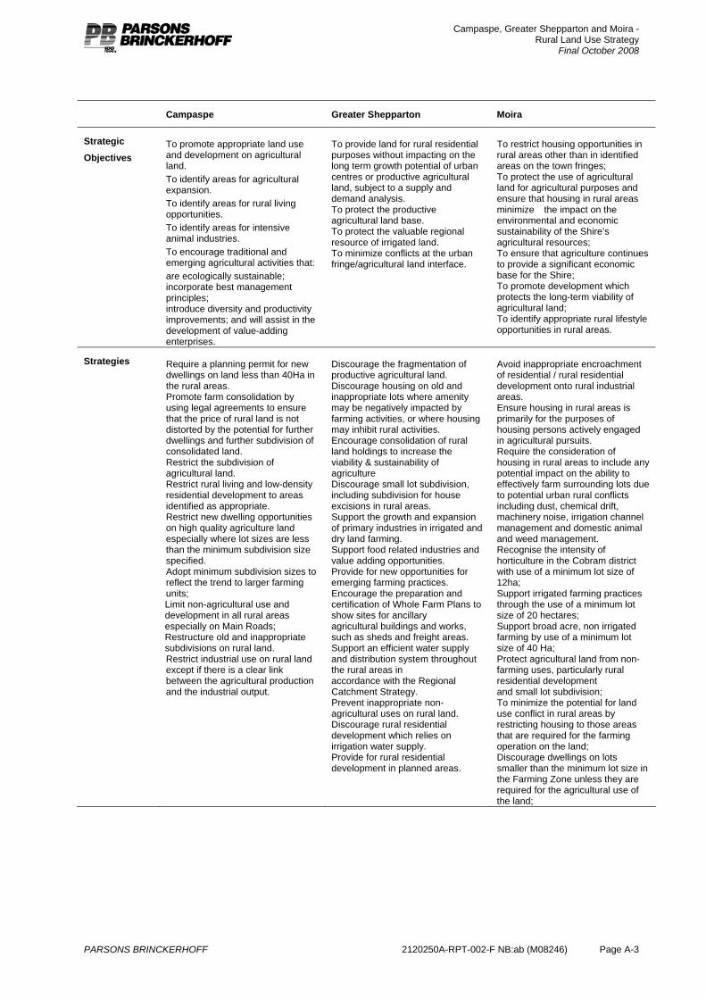
Campaspe, Greater Shepparton and Moira - Rural Land Use Strategy
Final October 2008
PARSONS BRINCKERHOFF 2120250A-RPT-002-F NB:ab (M08246) Page A-3
Campaspe Greater Shepparton Moira
Strategic
Objectives
To promote appropriate land use and development on agricultural land. To identify areas for agricultural expansion. To identify areas for rural living opportunities. To identify areas for intensive animal industries. To encourage traditional and emerging agricultural activities that: are ecologically sustainable; incorporate best management principles; introduce diversity and productivity improvements; and will assist in the development of value-adding enterprises.
To provide land for rural residential purposes without impacting on the long term growth potential of urban centres or productive agricultural land, subject to a supply and demand analysis. To protect the productive agricultural land base. To protect the valuable regional resource of irrigated land. To minimize conflicts at the urban fringe/agricultural land interface.
To restrict housing opportunities in rural areas other than in identified areas on the town fringes; To protect the use of agricultural land for agricultural purposes and ensure that housing in rural areas minimize� the impact on the environmental and economic sustainability of the Shire’s agricultural resources; To ensure that agriculture continues to provide a significant economic base for the Shire; To promote development which protects the long-term viability of agricultural land; To identify appropriate rural lifestyle opportunities in rural areas.
Strategies Require a planning permit for new dwellings on land less than 40Ha in the rural areas. Promote farm consolidation by using legal agreements to ensure that the price of rural land is not distorted by the potential for further dwellings and further subdivision of consolidated land. Restrict the subdivision of agricultural land. Restrict rural living and low-density residential development to areas identified as appropriate. Restrict new dwelling opportunities on high quality agriculture land especially where lot sizes are less than the minimum subdivision size specified. Adopt minimum subdivision sizes to reflect the trend to larger farming units; Limit non-agricultural use and development in all rural areas especially on Main Roads; Restructure old and inappropriate subdivisions on rural land. Restrict industrial use on rural land except if there is a clear link between the agricultural production and the industrial output.
Discourage the fragmentation of productive agricultural land. Discourage housing on old and inappropriate lots where amenity may be negatively impacted by farming activities, or where housing may inhibit rural activities. Encourage consolidation of rural land holdings to increase the viability & sustainability of agriculture Discourage small lot subdivision, including subdivision for house excisions in rural areas. Support the growth and expansion of primary industries in irrigated and dry land farming. Support food related industries and value adding opportunities. Provide for new opportunities for emerging farming practices. Encourage the preparation and certification of Whole Farm Plans to show sites for ancillary agricultural buildings and works, such as sheds and freight areas. Support an efficient water supply and distribution system throughout the rural areas in accordance with the Regional Catchment Strategy. Prevent inappropriate non-agricultural uses on rural land. Discourage rural residential development which relies on irrigation water supply. Provide for rural residential development in planned areas.
Avoid inappropriate encroachment of residential / rural residential development onto rural industrial areas. Ensure housing in rural areas is primarily for the purposes of housing persons actively engaged in agricultural pursuits. Require the consideration of housing in rural areas to include any potential impact on the ability to effectively farm surrounding lots due to potential urban rural conflicts including dust, chemical drift, machinery noise, irrigation channel management and domestic animal and weed management. Recognise the intensity of horticulture in the Cobram district with use of a minimum lot size of 12ha; Support irrigated farming practices through the use of a minimum lot size of 20 hectares; Support broad acre, non irrigated farming by use of a minimum lot size of 40 Ha; Protect agricultural land from non-farming uses, particularly rural residential development and small lot subdivision; To minimize the potential for land use conflict in rural areas by restricting housing to those areas that are required for the farming operation on the land; Discourage dwellings on lots smaller than the minimum lot size in the Farming Zone unless they are required for the agricultural use of the land;
Campaspe, Greater Shepparton and Moira - Rural Land Use Strategy
Final October 2008
PARSONS BRINCKERHOFF 2120250A-RPT-002-F NB:ab (M08246) Page B-1
Appendix B
VCAT Review
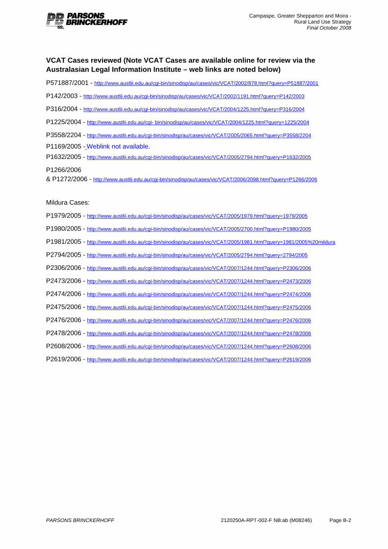
Campaspe, Greater Shepparton and Moira - Rural Land Use Strategy
Final October 2008
PARSONS BRINCKERHOFF 2120250A-RPT-002-F NB:ab (M08246) Page B-2
VCAT Cases reviewed (Note VCAT Cases are available online for review via the Australasian Legal Information Institute – web links are noted below)
P571887/2001 - http://www.austlii.edu.au/cgi-bin/sinodisp/au/cases/vic/VCAT/2002/878.html?query=P51887/2001
P142/2003 - http://www.austlii.edu.au/cgi-bin/sinodisp/au/cases/vic/VCAT/2002/1191.html?query=P142/2003
P316/2004 - http://www.austlii.edu.au/cgi-bin/sinodisp/au/cases/vic/VCAT/2004/1225.html?query=P316/2004
P1225/2004 - http://www.austlii.edu.au/cgi- bin/sinodisp/au/cases/vic/VCAT/2004/1225.html?query=1225/2004
P3558/2204 - http://www.austlii.edu.au/cgi-bin/sinodisp/au/cases/vic/VCAT/2005/2065.html?query=P3558/2204
P1169/2005 - Weblink not available. P1632/2005 - http://www.austlii.edu.au/cgi-bin/sinodisp/au/cases/vic/VCAT/2005/2794.html?query=P1632/2005
P1266/2006 & P1272/2006 - http://www.austlii.edu.au/cgi-bin/sinodisp/au/cases/vic/VCAT/2006/2098.html?query=P1266/2006
Mildura Cases:
P1979/2005 - http://www.austlii.edu.au/cgi-bin/sinodisp/au/cases/vic/VCAT/2005/1979.html?query=1979/2005
P1980/2005 - http://www.austlii.edu.au/cgi-bin/sinodisp/au/cases/vic/VCAT/2005/2700.html?query=P1980/2005
P1981/2005 - http://www.austlii.edu.au/cgi-bin/sinodisp/au/cases/vic/VCAT/2005/1981.html?query=1981/2005%20mildura
P2794/2005 - http://www.austlii.edu.au/cgi-bin/sinodisp/au/cases/vic/VCAT/2005/2794.html?query=2794/2005
P2306/2006 - http://www.austlii.edu.au/cgi-bin/sinodisp/au/cases/vic/VCAT/2007/1244.html?query=P2306/2006
P2473/2006 - http://www.austlii.edu.au/cgi-bin/sinodisp/au/cases/vic/VCAT/2007/1244.html?query=P2473/2006
P2474/2006 - http://www.austlii.edu.au/cgi-bin/sinodisp/au/cases/vic/VCAT/2007/1244.html?query=P2474/2006
P2475/2006 - http://www.austlii.edu.au/cgi-bin/sinodisp/au/cases/vic/VCAT/2007/1244.html?query=P2475/2006
P2476/2006 - http://www.austlii.edu.au/cgi-bin/sinodisp/au/cases/vic/VCAT/2007/1244.html?query=P2476/2006
P2478/2006 - http://www.austlii.edu.au/cgi-bin/sinodisp/au/cases/vic/VCAT/2007/1244.html?query=P2478/2006
P2608/2006 - http://www.austlii.edu.au/cgi-bin/sinodisp/au/cases/vic/VCAT/2007/1244.html?query=P2608/2006
P2619/2006 - http://www.austlii.edu.au/cgi-bin/sinodisp/au/cases/vic/VCAT/2007/1244.html?query=P2619/2006
Campaspe, Greater Shepparton and Moira - Rural Land Use Strategy
Final October 2008
PARSONS BRINCKERHOFF 2120250A-RPT-002-F NB:ab (M08246) Page C-1
Appendix C
Cowra (NSW) Rural Planning Review