cambridge - learner guide for as and a level geography
TRANSCRIPT
Learner Guide
Cambridge Advanced
Cambridge International AS & A LevelGeography
9696

Cambridge International Examinations retains the copyright on all its publications. Registered Centres are permitted to copy material from this booklet for their own internal use. However, we cannot give permission to Centres to photocopy any material that is acknowledged to a third party even for internal use within a Centre.
© Cambridge International Examinations 2014
Contents
How to use this guide ........................................................................................................... 3Section 1: How will you be tested?Section 2: Examination tips Section 3: What will you be tested on?Section 4: What you need to knowSection 5: Useful websites
Section 1: How will you be tested? ..................................................................................... 51.1 The examination you will take1.2 About the papers1.3 Detailed information about each paper
Section 2: Examination tips ................................................................................................. 9How to use these tipsGeneral advicePaper 1 tipsPaper 2 tipsPaper 3 tips
Section 3: What will you be tested on? ............................................................................. 17
Section 4: What you need to know ................................................................................... 19How to make full use of the tablePaper 1: Core Geography: Physical CorePaper 1: Core Geography: Human CorePaper 2: Advanced Physical Geography OptionsPaper 3: Advanced Human Geography Options
Section 5: Useful websites ................................................................................................55

2 Cambridge International AS and A Level Geography 9696
How to use this guide
3 Cambridge International AS and A Level Geography 9696
How to use this guide
The guide explains what you need to know about your Cambridge International AS & A Level Geography examination. It will help you plan your revision programme and will help to show what we are looking for in the answers you write.
It can also help you revise by ticking off topics you have been taught and you have learned for the examination.
The guide contains the following sections:
Section 1: How will you be tested?This section will give you information about the different types of examination papers that are available.
Section 2: Examination tips This section gives you advice to help you do as well as you can. Some of the tips are general advice and some are based on the common mistakes that learners make in exams.
Section 3: What will you be tested on?This section describes the areas of knowledge, understanding and skills that you will be tested on.
Section 4: What you need to knowThis section shows the syllabus content in a simple way so that you can check:
• which topics you need to know
• details about each topic in the syllabus
• how much of the syllabus you have covered
Section 5: Useful websites

How to use this guide
4 Cambridge International AS and A Level Geography 9696
Section 1: How will you be tested?
5 Cambridge International AS and A Level Geography 9696
Section 1: How will you be tested?
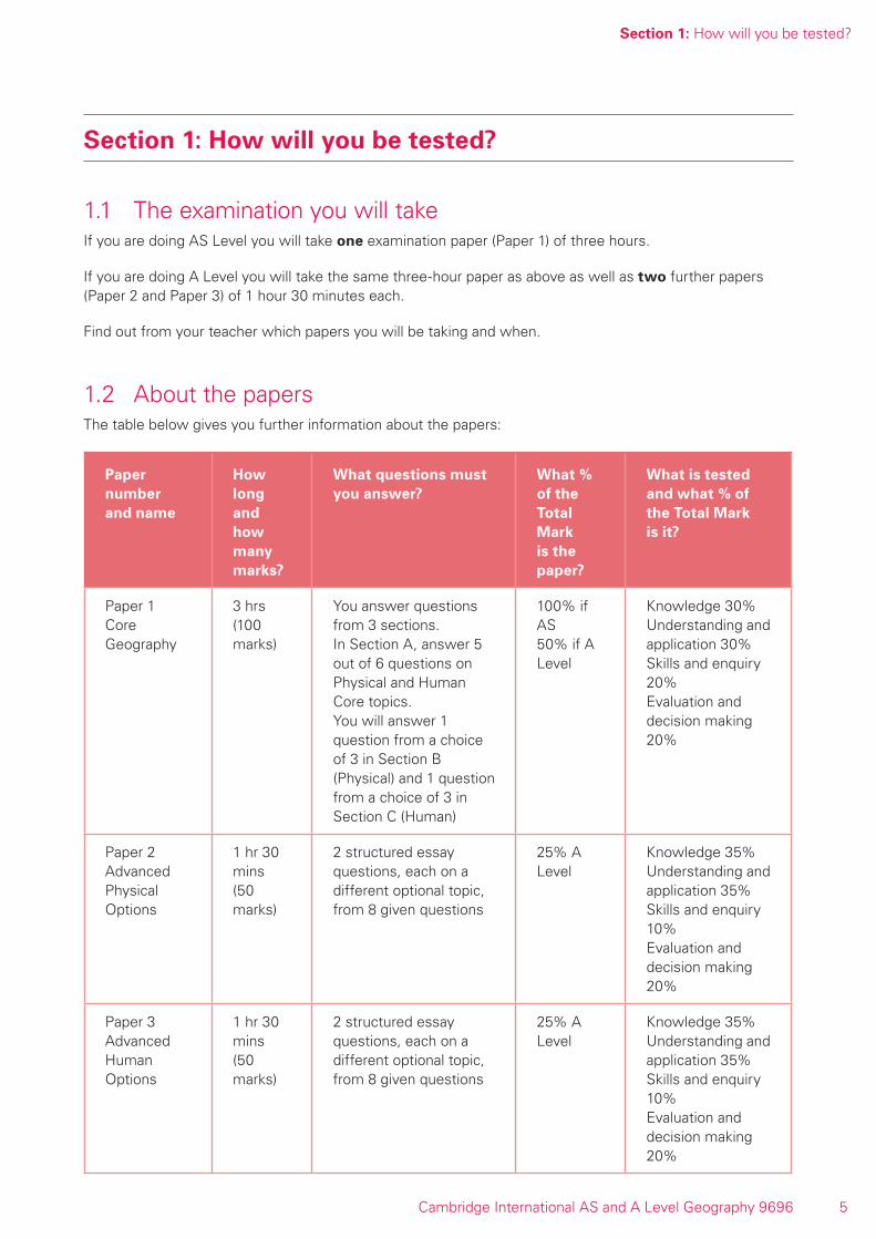
1.1 The examination you will takeIf you are doing AS Level you will take one examination paper (Paper 1) of three hours.
If you are doing A Level you will take the same three-hour paper as above as well as two further papers (Paper 2 and Paper 3) of 1 hour 30 minutes each.
Find out from your teacher which papers you will be taking and when.
1.2 About the papersThe table below gives you further information about the papers:
Paper number and name
How long and how many marks?
What questions must you answer?
What % of the Total Mark is the paper?
What is tested and what % of the Total Mark is it?
Paper 1 Core Geography
3 hrs(100 marks)
You answer questions from 3 sections.In Section A, answer 5 out of 6 questions on Physical and Human Core topics.You will answer 1 question from a choice of 3 in Section B (Physical) and 1 question from a choice of 3 in Section C (Human)
100% if AS50% if A Level
Knowledge 30%Understanding and application 30%Skills and enquiry 20%Evaluation and decision making 20%
Paper 2 Advanced Physical Options
1 hr 30 mins(50 marks)
2 structured essay questions, each on a different optional topic, from 8 given questions
25% A Level
Knowledge 35%Understanding and application 35%Skills and enquiry 10%Evaluation and decision making 20%
Paper 3Advanced Human Options
1 hr 30 mins(50 marks)
2 structured essay questions, each on a different optional topic, from 8 given questions
25% A Level
Knowledge 35%Understanding and application 35%Skills and enquiry 10%Evaluation and decision making 20%
Section 1: How will you be tested?
6 Cambridge International AS and A Level Geography 9696
1.3 Detailed information about each paperPaper 1Paper 1 tests the six core topics:
Physical Core:
• Hydrology and fluvial geomorphology
• Atmosphere and weather
• Rocks and weathering
Human Core
• Population
• Migration
• Settlement dynamics
There are three sections:
Section A (50 marks)
This contains six questions. You must choose and only answer five of them.
Three questions will be set on the Physical Core and three on the Human Core.
Be careful because although there are six core topics, this does not mean that there will always be one question on each topic. Sometimes questions will be on just one topic, sometimes on a combination of topics.
Each question is worth 10 marks and is fairly short. You must try to answer each question equally well.
The questions make use of resources such as maps, graphs, photographs, diagrams and sometimes survey maps (1:25 000 and 1:50 000) so you should practice your skills and ability to understand and write about these.
Section B (25 marks) Physical Core topics
This contains three longer structured questions. You must answer only one of them.
There will be a question on each physical core topic.
Section C (25 marks) Human Core topics
This contains three longer structured questions. You must answer only one of them.
Here questions may cover two or more topics because there are strong interrelationships between all three topics (you really must revise all topics fully).
You are expected to use case studies from LEDCs (less economically developed countries) and MEDCs (more economically developed countries).
Section 1: How will you be tested?
7 Cambridge International AS and A Level Geography 9696
In this section and in Section B the questions are structured, usually in two or three parts, and give you the opportunity to express your answer in extended writing of longer paragraphs. Again, some questions may make use of maps, graphs, photographs and diagrams.
Paper 2 and Paper 3These are separate question papers but are timetabled on the same day and session. You will complete Paper 2 and hand in your answers. Then you will have a short break (maximum 15 minutes) before starting Paper 3. So, both papers must be sat together on the same date, on the same morning or the same afternoon.
Paper 2 has eight questions on the Advanced Physical Geography topics below (two on each topic). You must answer two questions. Be very careful as each must be on a different topic.
The topics are:
• Tropical environments
• Coastal environments
• Hazardous environments
• Arid and semi-arid environments
Paper 3 has eight questions on the Advanced Human Geography topics below (two on each topic). Again you must answer two questions, being very careful as each must be on a different topic.
The topics are:
• Production, location and change
• Environmental management
• Global interdependence
• Economic transition
In both papers the questions are worth 25 marks each and will be structured. You will be given the chance to write extended answers and one question in each topic will make use of resources such as maps, graphs, photographs or diagrams. You will be asked to use these resources to show your understanding of geographical ideas. It will not matter if you have not studied the place/example used in a resource as you are only expected to interpret information from it and show ideas that can be used in any similar situation. Usually, to gain the highest marks, you will need to organise your writing well and use relevant case studies or developed examples. The part (b) questions will usually require some evaluation based on evidence.
Learning suggestionMake sure you study and revise enough to really have a choice of topics and questions in the examination. Perhaps the best compromise is to revise everything in a basic manner, so you are prepared for any question, but then specialise in your strongest topics.

Section 1: How will you be tested?
8 Cambridge International AS and A Level Geography 9696
Section 2: Examination tips
9 Cambridge International AS and A Level Geography 9696
Section 2: Examination tips
How to use these tipsThese tips are to help you revise and prepare for the examinations. They are divided into general advice where the tips are for all papers and Paper 1, 2 and 3 tips where the ideas are more specific.
General adviceBefore the examination• Find out when the examinations are and plan your revision so you have time to revise everything
properly. It may be helpful to draw up a revision timetable and divide it into sections to cover each topic. This will ensure that you allow plenty of time to revise each section of the syllabus in detail.
• Find out how long each paper is and how many questions you have to answer. Find out how many marks there are for each question and so work out how long you have for each question. For example, if you have to answer 5 questions in section A (each worth 10 marks) and 2 questions from the other sections (each worth 25 marks) then section A needs to take half the total time as it is worth half the total marks.
• Find out what choice you have on each paper. Make sure you know how many sections there are and which sections you should answer from.
• When there is a choice of questions in a section, make sure you revise fully enough to actually have a choice in the examination.
• Revise small sections of the syllabus at a time. Work for short periods then have a break.
• Make revision notes. You could try bullet point notes, annotated maps, diagrams, mind maps etc. Experiment and find out what works best for you. You can look through these notes more easily just before the exam.
• Test yourself by writing out key points, redrawing diagrams etc. Perhaps you can work with a fellow student and talk about ideas to make sure you really understand them.
• Know the meaning of the major command words used in questions and also how to apply them to the information given. These are some of the most common:
° ‘Describe’ means you should say what something is like – what it looks like, what dimensions it has etc. Give a detailed picture. If there are photographs and diagrams for the question, use them.
° ‘Explain’ means that you need to give the reasons for something, to say why something is as it is.
° ‘Define’ means that you need to give a clear and precise account of a term.
° ‘Annotate’ means you have to label fully with notes that describe and/or explain, depending on what the question asks.
° ‘Evaluate’ means that you need to make an appraisal of an argument or concept by weighing up the nature of the evidence available and identifying and discussing the convincing aspects of the argument as well as the limitations and implications.
° Instead of ‘evaluate’ you might be asked ‘to what extent? ’ or something similar.
• Make a list of all the command words you can find and find out what they mean.
Section 2: Examination tips
10 Cambridge International AS and A Level Geography 9696
• Know the meaning of, and be able to define, geographical terms accurately and fully. E.g. deforestation is not simply ‘cutting down trees’, it is ‘the total deliberate removal or clearance of forest/trees by cutting and/or burning at rates faster than natural regeneration or without replanting’.
• Definitions must not reuse the words to be defined. For example, land pollution means the contamination (pollution) of the earth’s surface (land) by the unplanned or illegal disposal of waste substances or materials.
• Make your own dictionary or draw up a glossary of key terms for each section of the syllabus. Ask your teacher for help to make a list of all the terms you should know. Each glossary could be organised alphabetically to help you.
• Practise looking at as many different maps, diagrams, tables etc. as you can and ‘read’ them to find out what they show.
• Practise drawing clear, simple, neat, fully-labelled diagrams and maps.
• Practise describing patterns. Make sure you have the correct vocabulary such as north/south rather than top/bottom. Use words such as dispersed, concentrated, groupings.
• Look at photographs of whatever you are studying. Practise sketching and describing what you see.
• Practise recognising landforms, settlement patterns etc. on topographical maps.
• Know models and theories e.g. urban land-use models.
• Learn your case studies thoroughly. They can be from textbooks, fieldwork or other sources. Think about what they show and how you might use them. Know where in the world they are and whether they are local, regional, international or global scale. It would be useful to draw up a list of case studies that are needed for each section of the syllabus. It is also helpful to summarise the content of case studies, perhaps using an A3 revision sheet divided into sub-headings such as location, causes, effects etc. Have a look at a range of past questions and decide which case study would be best to answer each one.
• Know your own home area and local case studies whenever possible.
• Learn to spell geographical terms correctly.
• Have a look at a range of past questions so that you are clear of what to expect in an examination. You should practise these under timed conditions so that you get used to the amount of time available. Consider the range of resources used and practise using resources that are unfamiliar to you.
• Looking at mark schemes will also help you to understand how the marks are awarded for each question. It will also give you guidance about the content required for each question.
In the examination• Read the instructions carefully and answer the right number of questions from the right sections.
• If you are only allowed to answer one question from a section with two questions, do not answer both! It sounds obvious but some people still make this sort of mistake and lose all the marks for one of the questions.
• Plan your time. If you are running out of time and have to rush you might mis-read a question. Notes and bullet points, although better than nothing, will not get many marks.
• Plan according to the marks for each question. For example, a question worth three marks requires less time and a shorter answer than one worth ten marks. If a question has several parts, then the parts with more marks will need more time and more developed answers.
• Do not leave out questions or parts of questions. Remember, no answer - no chance of any mark.

Section 2: Examination tips
11 Cambridge International AS and A Level Geography 9696
• Read each question very carefully.
° Identify the command words – you could underline or highlight them.
° Identify the other key words and perhaps underline them too.
° Try to put the question into your own words to understand what it is really asking.
• Read all parts of a question before starting to write your answer. You must think carefully about what is needed for each part as you will not need to repeat material. Even if information is accurate and true, it will not get marks if it is in the wrong part of an answer.
• Look very carefully at the resource material you are given.
° Read the title, key, axes of graphs etc. to find out exactly what it is showing you.
° Look for dates, scale, and location.
° Try using coloured pencils or pens to pick out or shade in anything that the question asks you about – this might help you see patterns, see trends, appreciate locations etc.
• Answer the question. This is so very, very important!
° Use your knowledge and understanding.
° Do not just write out all you know, only write what is needed to answer the question.
° Do not try to repeat answers you might have practised from previous papers, they are unlikely to fit your question.
° Do not ‘explain’ if the question says ‘describe’ etc.
• Plan your answers. Clear, concise, well-ordered, well-argued, well-supported answers get more marks than long, rambling, muddled, repetitious answers. Quality is better than quantity.
• Use geographical terms in your answers as much as possible.
• Use the appropriate technical vocabulary to describe patterns.
• Use the resource material given in the question to support your answer.
• Annotated maps, diagrams and graphs can aid you and be used instead of lines of writing. Use them whenever possible but do not then repeat the information in words.
• Use case-study material even when it is not required specifically by the question.
• Use case studies that are familiar to you, e.g. from your home area, where possible.
• Remember that change is an important part of all geographical processes, both physical and human. Questions often ask about changes, so make sure that you understand this term.
• Make sure your writing is legible. It is no good writing a brilliant answer if the examiner cannot read it!
Paper 1 tips• Make sure you are familiar with all the core topics.
• Work out how much time you have for each section and keep to it.
• If a question asks, for example, for two challenges faced by a city, then avoid writing about more than two because the level of detail and explanation in your answer will not be as good.
• Be prepared to use map reading, graph reading, diagram reading skills.
• Use diagrams to describe: a well-labelled diagram can show the characteristics of a landform such as a delta. Try to make your diagrams as accurate and informative as possible.
Section 2: Examination tips
12 Cambridge International AS and A Level Geography 9696
• Where a labelled sketch of a photograph is required you must base it on the photograph given and not on a textbook diagram.
• Use data to support your answer in the data response questions. This adds substance and therefore achieves marks. When given a resource, try to use it as fully as you can in your answers.
• Make sure you know your case studies and can use these to demonstrate your understanding of a concept when required.
• Description of the characteristics of landforms can be as important as explanations of their formation, and the character of migrants as important as the nature of the migration.
• Make sure you understand terms such as sector, zone, decade, trends, items of information, layout, and positive and negative effects when used in questions.
• Make sure you understand and are able to explain (if required)
° geology (rock hardness, strength, chemical composition, texture, jointing, bedding, dip, faulting)
° sub-surface hydrology and the recharge concept
° hydraulic action and solution
° braided channels
° the landforms associated with meanders
° form (shape, steepness, uniformity) of slope
° the relationship between rock type and structure and slope stability
° energy exchanges
° lapse rates and what happens to rising air
° conditional instability
° fog and dew formation
° urban heat islands
° processes of mass movement
° functional zones
° urbanisation
° residential segregation
° spatial competition
° infrastructure (transport, utilities, water, sewage systems)
These are only some of the terms that are poorly understood. There are many more terms on which you would be tested.
• Know the difference between
° rate and amount
° volcanoes and fold mountains
° island arcs and volcanic hot spots
° river channel and catchment (drainage basin)
° carbonation and solution
° hydrolysis and hydration
° solution and suspension, etc.

Section 2: Examination tips
13 Cambridge International AS and A Level Geography 9696
• Know the difference between a cross-section, a plan and a profile.
• Know urban processes such as gentrification, filtering.
• Know examples, especially from your home area; you will write more convincingly if you are familiar with an area.
• Use general concepts and key ideas to help you to consider all factors. For example, if a question asks about population change, think about natural increase (birth rate and death rate) and migration. For landforms consider rocks (type and structure), processes and time. Think about environmental, social, economic, and political factors.
• Be clear about command words such as overall, relationships and trend.
• Try to make your answers as detailed as possible, particularly when explaining a process.
• Try to be precise when giving definitions of key geographical terms.
Paper 2 tips• Spread your time between parts (a) and (b) according to the mark allocation of 9 and 16 marks
respectively. Read both parts carefully so you are clear about the level of detail required for each part of the question.
• Develop your skills in producing fully annotated diagrams and use them in your text. Make sure they are relevant to the question you are answering.
• Understand the relationship between the physical and human environment. You will need to know about the physical geography as well as the human impact on the physical environments of your particular areas of study.
• Use and integrate case studies and examples, particularly from your home country, wherever possible, even if the question does not specifically ask for them, but make sure your case study is relevant to the question being asked.
• Take note of the command words – be sure that you are clear whether you have to explain or evaluate, for example. Don’t just write all you know about a topic – make sure you apply this to the question you have been asked.
• If you are given resource material in questions – use it! You probably need to explain and develop what it shows in your answer.
• Be able to describe a distribution and give specific aspects of a distribution.
• Be clear what the key term characteristics means.
• Sketch maps of coastlines are very useful to show relative locations, transport processes, geology etc.
• Know about salt marshes and how they develop for the Coastal Environments option.
• Understand and be able to explain how physical processes work. Try to be as precise as possible in your explanations.
• Be able to relate physical processes to their outcome in the landscape as landforms.
• Be able to explain human impacts in terms of how they affect physical processes.
• Link your knowledge of sustainable management to how it is put into practice.
• Evaluation is an essential skill; make sure you understand how to tackle questions such as those that ask to what extent or assess the ...
Section 2: Examination tips
14 Cambridge International AS and A Level Geography 9696
• Be aware that the scale of landforms affects their importance in a characteristic landscape. For instance, tower karst and dolines are more significant than stalagmites in limestone scenery.
• Know about weathering and the products of weathering.
• Understand how geology relates to landforms.
• Tropical climates require knowledge of humid, seasonally humid (savanna) and monsoon climates.
• Know about soils - what their profiles look like, what characteristics they have and how the soil forming processes work to produce these characteristics.
• Know how soils relate to vegetation, climate, parent materials and human activities.
• Arid and Semi-Arid Environments requires you to be able to explain the process of desertification as a result of both human and physical factors.
• Knowledge of and ability to draw Gersmehl diagrams are very useful for explanation of nutrient cycling in ecosystems and for explaining the impact of human activities in ecosystems.
• Know about sources of water supply in deserts and be able to link this to the nature of rainfall.
• The scale of a landform is a useful characteristic, especially for desert landforms.
• Understand the difference between plan and profile, especially in relation to coasts and be able to explain different cliff profiles.
• Know how sediment is transported in relation to Coastal Environments
• Know about the causes of earthquakes and what volcanic hotspots are. Be able to explain the factors that determine the nature of volcanic eruptions for Hazardous Environments.
• Be aware of the physical nature and prediction of natural hazards as well as their impact and the management of them.
Paper 3 tips• Use examples wherever possible, especially those from your home country. Effective use of examples
will help you to access the higher marks.
• Write precisely and in detail focusing on the central requirements of the question. Do not write vague, generalised comments that are not related to the content of the question.
• Look at each question carefully and break it down – for example, look at the command word, the key idea and the scale/context of the question.
• Look at the wording of past questions and check for terms that may be unfamiliar, such as to monitor (observe and check impacts), to exploit (use), conflicts of interest, agricultural system, agricultural productivity, etc.
• Pay particular attention to data or a resource given in a question. Read it and familiarise yourself with it, think analytically about it and then use it to support your answer. Do not just rewrite the contents of a resource – process it to answer the question.
• Consider the number of marks awarded to each question and allocate your time accordingly.
• If asked, for example, for a specific number of reasons in a question, you do not need to write about more than the specified number. Doing so will mean that you have less time to write about each and your answer will be less detailed.
• Be able to produce detailed, annotated maps and diagrams to illustrate your answer. Practise these when revising.
Section 2: Examination tips
15 Cambridge International AS and A Level Geography 9696
• Use as much geographical terminology in your answer as you can. Try to be as precise as possible if a question asks you to explain a key term.
• Hone your evaluative/assessment skills; they are needed throughout the paper. You can assess in terms of degree of success or failure, the past versus the present, unforeseen results, different spatial outcomes, and different effects on different groups of people.
• If a question is about a specific place, do not assume you need to have studied that place. You probably you just need to use your skills and geographical understanding.
• Expect unusual and unfamiliar data sets and resources.
• Understand the different command words compare and contrast.
• Know key terms that are used in questions e.g. relationships, factors, character etc.
• Keep up to date with events that are happening in the news as these can provide material for recent examples to use in your answers.
• ‘Scale’ is important. Make sure you know the difference between global, national, regional and local, and answer accordingly if these terms are used in a question.
• Effects can be long term or short term; physical, economic, social and political; positive and negative.
• Physical, economic, social and political factors influence human activities. They can operate as positive and/or negative factors. Be able to discuss these in relation to each option you have studied.
• Trade and tourism are closely-linked topics and you should be aware of this relationship.
• Know how fieldwork is carried out so you can use your understanding of how data is collected.
• ‘Development’ includes economic, social and political development.
• Know the difference between Fair Trade and free trade for Global Interdependence.
• Understand the terms diseconomies and deindustrialisation as part of Economic Transition.

Section 2: Examination tips
16 Cambridge International AS and A Level Geography 9696
Section 3: What will you be tested on?
17 Cambridge International AS and A Level Geography 9696
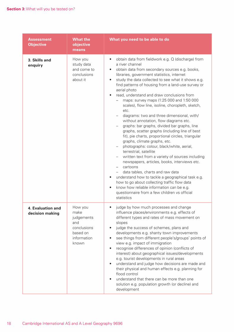
Section 3: What will you be tested on?
The examiners take account of the following skills areas in your examination papers
1. Knowledge: the facts and ideas you remember
2. Understanding and application: how you use what you know and apply it to unfamiliar situations
3. Skills and enquiry: how you handle data and draw conclusions from it
4. Evaluation and decision-making: how you judge and are critical of facts and situations
These skills areas are called Assessment Objectives. They are explained further in the table below. Your teacher will be able to provide you with more detailed information on each one.
Assessment Objective
What the objective means
What you need to be able to do
1. Knowledge Remembering facts and ideas
• define and explain geographical terms and concepts e.g. bifurcation ratio ideas, urbanisation
• describe and explain certain principles, e.g. granite weathers much faster in the Tropics, and theories, e.g. Malthus models, e.g. rural-urban migration
• describe where selected places or environments are and what they are like e.g. Sahel
• describe and explain how physical and human processes operate e.g. soil creep or gentrification
2. Understanding and application
How you use what you know and relate it to other situations
• understand that physical and human environments are made up in a complex way, and that each part of one influences a part of another e.g. valley slopes will be affected by rivers and rivers will in turn be affected by the slopes
• understand that when geographical processes occur they cause changes in environments and distributions at that place and/or other places e.g. rivers erodes mountain valleys but deposit alluvium downstream
• understand that places/environments have both things in common and unique differences e.g. urban areas have Central Business Districts but different arrangements of land-use zones
• understand how looking at areas of different size or scale may change the relevance or importance of factors, change the patterns etc. e.g. population density of a city or a country
• understand the importance of changes taking place over time periods and the effects of different lengths of time e.g. demographic transition, wave action on a beach in a day compared with waves building a spit over years
• relate your understanding to new situations/places not necessarily learnt by you e.g. drainage basin inputs in a semi-arid region
Section 3: What will you be tested on?
18 Cambridge International AS and A Level Geography 9696
Assessment Objective
What the objective means
What you need to be able to do
3. Skills and enquiry
How you study data and come to conclusions about it
• obtain data from fieldwork e.g. Q (discharge) from a river channel
• obtain data from secondary sources e.g. books, libraries, government statistics, internet
• study the data collected to see what it shows e.g. find patterns of housing from a land-use survey or aerial photo
• read, understand and draw conclusions from – maps: survey maps (1:25 000 and 1:50 000
scales), flow line, isoline, choropleth, sketch, etc.
– diagrams: two and three dimensional, with/without annotation, flow diagrams etc.
– graphs: bar graphs, divided bar graphs, line graphs, scatter graphs (including line of best fit), pie charts, proportional circles, triangular graphs, climate graphs, etc.
– photographs: colour, black/white, aerial, terrestrial, satellite
– written text from a variety of sources including newspapers, articles, books, interviews etc.
– cartoons– data tables, charts and raw data
• understand how to tackle a geographical task e.g. how to go about collecting traffic flow data
• know how reliable information can be e.g. questionnaire from a few children vs official statistics
4. Evaluation and decision making
How you make judgements and conclusions based on information known
• judge by how much processes and change influence places/environments e.g. effects of different types and rates of mass movement on slopes
• judge the success of schemes, plans and developments e.g. shanty town improvements
• see things from different people’s/groups’ points of view e.g. impact of immigration
• recognise differences of opinion (conflicts of interest) about geographical issues/developments e.g. tourist developments in rural areas
• understand and judge how decisions are made and their physical and human effects e.g. planning for flood control
• understand that there can be more than one solution e.g. population growth (or decline) and development

Section 4: What you need to know
19 Cambridge International AS and A Level Geography 9696
Section 4: What you need to know
In the table below you will find the things you may be tested on in the examination. They are arranged in the order they occur in the syllabus under Syllabus Content. If there any words or terms you do not understand, ask your teacher.
How to make full use of the tableThe table has columns which give you information and which you can use.
Unit: The core topics and advanced physical and human option topics – they are called units in the main syllabus
Topic: Subdivisions of the core and option topics - use throughout the course to check what you have covered
You should be able to: Here you can check in detail what you know/are able to do
Checklist: Here you can tick off what you have done or what you have learned well (use a pencil for later re-use)
Comments: Here you can:i. add further information of your own, such as names of case studies neededii. add learning aids, such as “winds blow from high to low pressure”iii. pinpoint areas of difficulty you need to check further with your teacher or
textbooks
N.B. the table below cannot contain absolutely everything you need to know, but it does use examples wherever it can.

Sectio
n 4: W
hat you need to know
20C
ambridge International A
S and A
Level Geography 9696
Paper 1: Core Geography: Physical Core
Unit Topic You should be able to Checklist Comments
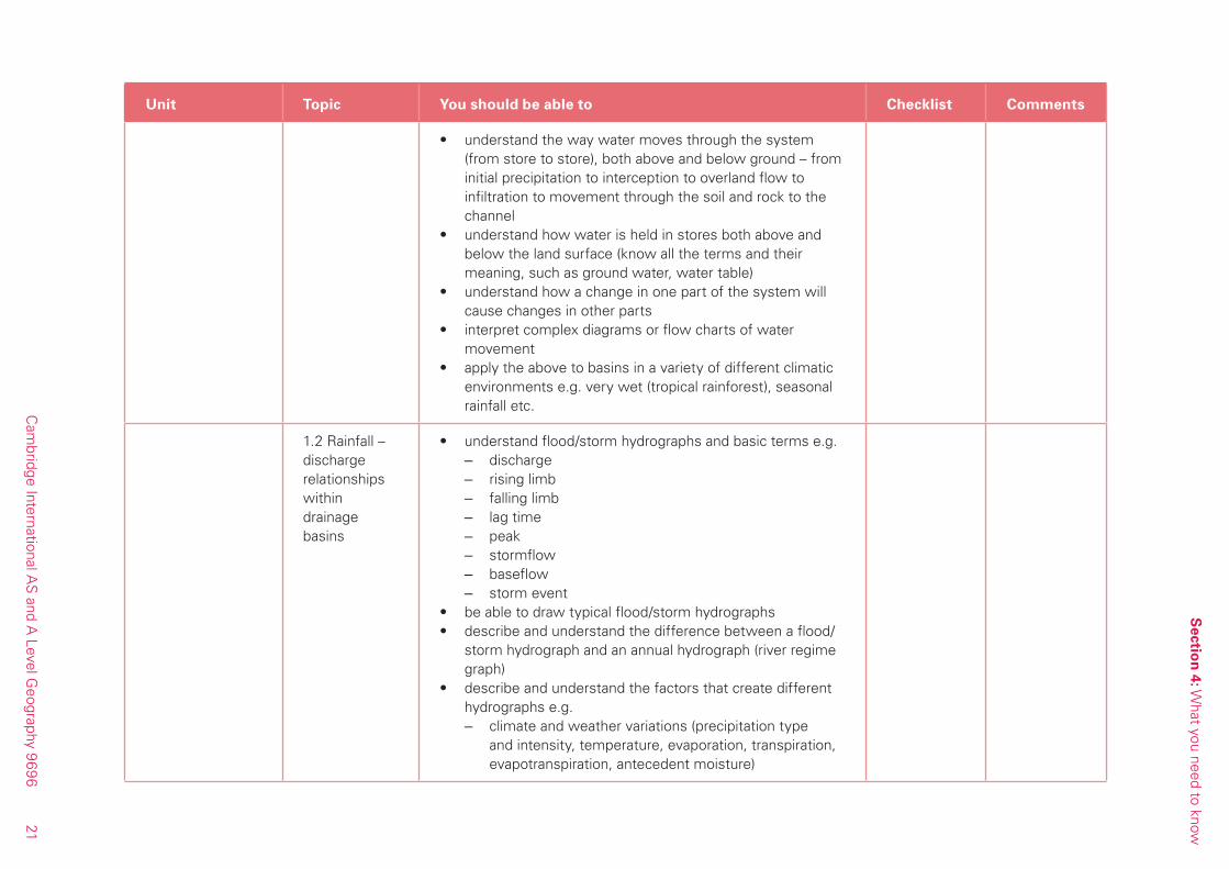
1. Hydrology and Fluvial Geomorphology
1.1 The drainage basin system
• understand the hydrological cycle as it is applied to drainage basins.
• understand the terms that are used e.g.– watershed– drainage basin– drainage density– stream ordering– bifurcation ratio
• describe and explain the processes at work in a drainage basin
• understand the drainage basin as a system with inputs, outputs, stores and flows which include:– precipitation– evaporation– evapotranspiration– interception– throughfall– stemflow– overland flow– infiltration– percolation– throughflow– baseflow– groundwater– recharge– springs– water tables
• know what inputs and outputs are and how they affect and are affected by stores and the flows
Sectio
n 4: W
hat you need to know
21
Cam
bridge International AS
and A Level G
eography 9696
Unit Topic You should be able to Checklist Comments
• understand the way water moves through the system (from store to store), both above and below ground – from initial precipitation to interception to overland flow to infiltration to movement through the soil and rock to the channel
• understand how water is held in stores both above and below the land surface (know all the terms and their meaning, such as ground water, water table)
• understand how a change in one part of the system will cause changes in other parts
• interpret complex diagrams or flow charts of water movement
• apply the above to basins in a variety of different climatic environments e.g. very wet (tropical rainforest), seasonal rainfall etc.
1.2 Rainfall – discharge relationships within drainage basins
• understand flood/storm hydrographs and basic terms e.g. – discharge – rising limb – falling limb – lag time – peak – stormflow – baseflow – storm event
• be able to draw typical flood/storm hydrographs• describe and understand the difference between a flood/
storm hydrograph and an annual hydrograph (river regime graph)
• describe and understand the factors that create different hydrographs e.g.
– climate and weather variations (precipitation type and intensity, temperature, evaporation, transpiration, evapotranspiration, antecedent moisture)
Sectio
n 4: W
hat you need to know
22C
ambridge International A
S and A
Level Geography 9696
Unit Topic You should be able to Checklist Comments
– drainage basin characteristics (size, shape, drainage density, slope)
– geology, soils and vegetation (porosity and permeability of soils, rock type, vegetation type, land-use).
• understand how the factors above affect where water is stored and how it moves (flows)
1.3 River channel processes and landforms
• describe and explain the main types of river processes of – erosion, (abrasion/corrasion, solution, hydraulic action,
attrition) – transport (traction, saltation, suspension and solution) – deposition and sedimentation
• describe and understand where and when they operate • relate them to other river factors like velocity and
discharge• read such graphs as Hjulstrom Curve and scatter graphs
such as velocity vs. discharge • describe and explain how rivers flow:
– velocity variations – laminar, turbulent, helicoidal – thalweg
• reasons for differences in flow patterns• draw, describe and understand the types of channel
patterns – in plan i.e. straight, braided, meandering – in cross-section
• describe and explain a range of ‘river’ features: – inside the channel e.g. riffle and pool, river cliff, point
bar, meander, oxbow – on the channel edge e.g. levée, floodplain, – along the course e.g. gorge, rapids, waterfall, bluff,
alluvial fan, deltas • describe and understand examples

Sectio
n 4: W
hat you need to know
23
Cam
bridge International AS
and A Level G
eography 9696
Unit Topic You should be able to Checklist Comments
1.4 The human impact
• describe and explain what changes occur in a drainage basin caused by
– land-use change – urban development – people taking water from the river – storage by dams, barrages etc.
• understand how these changes affect the flows and stores in;
– the drainage basin generally – the channel particularly
• understand the following about floods and flooding: – causes – effects – predicting and forecasting – recurrence – methods of preventing – methods of lessening the impact
• understand the same as the above about drought
2. Atmosphere and Weather
2.1 Local energy budgets
• understand how energy comes to and leaves Earth in the daytime e.g. incoming solar radiation, reflected solar radiation, energy absorbed into the surface and subsurface, sensible heat transfer, long wave earth radiation, latent heat transfer –evaporation.
• understand how energy comes to and leaves Earth in the night e.g. long wave earth radiation, latent heat transfer – dew, sensible heat transfer, absorbed energy returned to earth
• describe and understand the weather phenomena associated with these energy transfers e.g. mist, fog, dew, temperature inversions, land and sea breezes
Sectio
n 4: W
hat you need to know
24C
ambridge International A
S and A
Level Geography 9696
Unit Topic You should be able to Checklist Comments
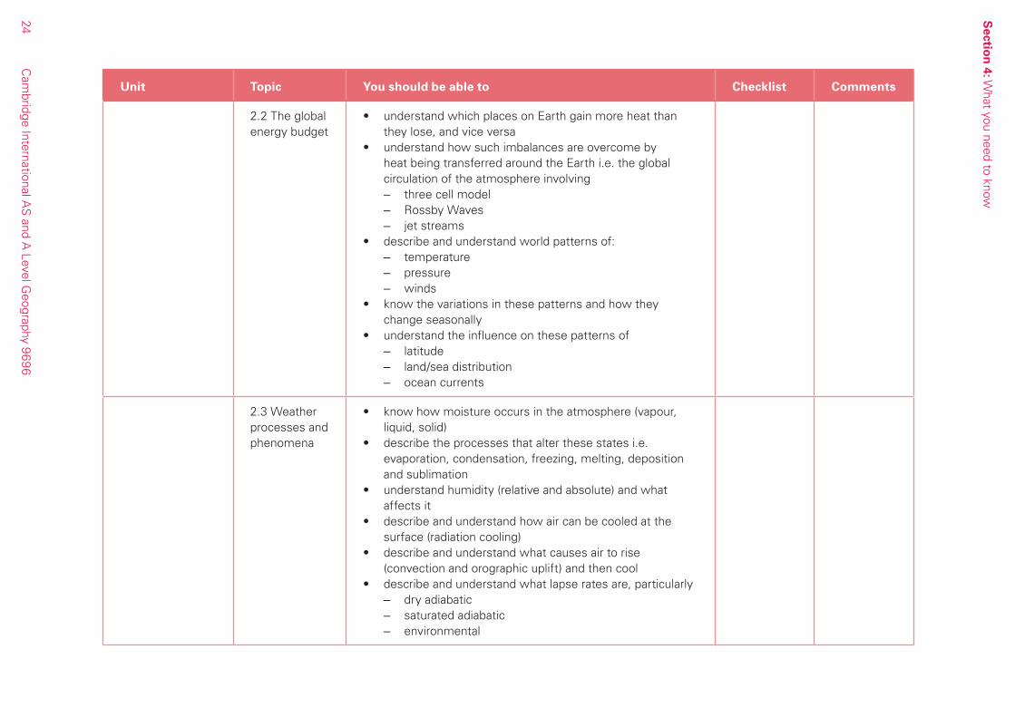
2.2 The global energy budget
• understand which places on Earth gain more heat than they lose, and vice versa
• understand how such imbalances are overcome by heat being transferred around the Earth i.e. the global circulation of the atmosphere involving
– three cell model – Rossby Waves – jet streams
• describe and understand world patterns of: – temperature – pressure – winds
• know the variations in these patterns and how they change seasonally
• understand the influence on these patterns of – latitude – land/sea distribution – ocean currents
2.3 Weather processes and phenomena
• know how moisture occurs in the atmosphere (vapour, liquid, solid)
• describe the processes that alter these states i.e. evaporation, condensation, freezing, melting, deposition and sublimation
• understand humidity (relative and absolute) and what affects it
• describe and understand how air can be cooled at the surface (radiation cooling)
• describe and understand what causes air to rise (convection and orographic uplift) and then cool
• describe and understand what lapse rates are, particularly – dry adiabatic – saturated adiabatic – environmental
Sectio
n 4: W
hat you need to know
25
Cam
bridge International AS
and A Level G
eography 9696
Unit Topic You should be able to Checklist Comments
• understand how lapse rates relate to latent heat release and the state of the atmosphere:
– stable – unstable – conditionally unstable
• be able to draw or interpret simple graphs to show stability and lapse rates
• understand how the above relates to precipitation (including ideas of relative humidity, saturation, dew point, condensation level, condensation nuclei)
• be able to relate lapse rates and stability to cooling and weather phenomena
– particularly clouds and rain, – but also hail, snow, frost, dew, fog
2.4 The human impact
• know the difference between greenhouse effect and global warming – possible causes and consequences (greenhouse gases and the energy budget; climatic and other impacts)
• know and understand the effect on climate of an urban area compared with the surrounding rural area; temperature – heat island, humidity, precipitation, pollution, winds
3. Rocks and Weathering
3.1 Elementary plate tectonics
• recognise the global pattern of plate boundaries (world map knowledge useful)
• understand the different types of plate boundary, why they occur and the processes that operate there:
– constructive boundary – destructive boundary – collision boundary – passive/conservative/transform
• understand sea floor spreading
Sectio
n 4: W
hat you need to know
26C
ambridge International A
S and A
Level Geography 9696
Unit Topic You should be able to Checklist Comments
• describe and explain the landforms formed at boundaries, such as:
– fold mountains – ocean ridges/rift valleys – ocean trenches – island arcs – volcanoes and earthquakes (generally –
are studied in depth in Paper 2 Hazardous environments)
• draw, or interpret, maps or diagrams of boundaries and landform formation
3.2 Weathering and rocks
• describe and understand the types of: – physical (mechanical) weathering (freeze-thaw,
heating/cooling, wetting/drying, exfoliation, crystal growth, pressure release)
– chemical weathering (hydrolysis, hydration, carbonation, solution, oxidation, organic action – humic acids and chelation)
• understand why different types of weathering occur in different climatic zones (Peltier diagram)
• describe and understand the effectiveness of weathering in different environments – rates and consequences
• understand the factors that influence weathering: – rock type – structure – climate – vegetation – soil – relief (gradient of slope, shelter or exposure/direction
slope is facing)• know the properties of granite and limestone (chemical
and physical)• understand how these rocks react to weathering and
erosion
Sectio
n 4: W
hat you need to know
27
Cam
bridge International AS
and A Level G
eography 9696
Unit Topic You should be able to Checklist Comments
3.3 Slope processes and development
• know how slope form differs (shape, steepness, uniformity)
• know and understand how slopes develop and change their form depending on the factors of:
– rock type – structure – climate – vegetation – soil – relief (gradient of slope, shelter or exposure/direction
slope is facing)• know and understand slope processes of mass
movement: – heave – flow – slide – fall
• know the conditions for each of the mass movements to occur
• know the effects of these on slope form and change with time
• demonstrate good examples and diagrams
3.4 The human impact
• describe and understand how human activities influence: – rocks – rates of weathering – slope form – slope processes
as a result of e.g. quarrying, mining, pollution, acid rain, dumping materials on land.
Throughout this section it is important to know examples and case studies comparing and contrasting more economically developed countries (MEDCs) with less economically developed countries (LEDCs)
Sectio
n 4: W
hat you need to know
28C
ambridge International A
S and A
Level Geography 9696
Paper 1: Core Geography: Human CoreYou should illustrate your answers, where appropriate, with reference to case studies drawn from LEDCs (less economically developed countries) and MEDCs (more economically developed countries) since 1970.
There are strong interrelationships between the three topics in the Human Core and questions spanning two or more topics may be set in both Sections A and C.
Unit Topic You should be able to Checklist Comments
1. Population 1.1 Natural Increase as a component of population change
• describe and understand how population increases naturally (without migration) in relation to:
– birth rate – death rate – fertility rate – infant mortality rate
• describe and understand the factors affecting levels of births and deaths, fertility and mortality
• interpret age/sex pyramids• understand how a population group is made up i.e. its
structure, and know some of the component parts: – age – gender – dependency – dependency ratio
1.2 Demographic transition
• know and understand how and why birth rates and death rates change with time
• draw, interpret and explain the demographic transition model through stages 1-5
• be critical in describing and understanding the model’s uses, limitations and extensions
• know and understand issues of ageing populations• describe and understand various development indices
such as: Gross National Product (GNP), income per capita, life expectancy, health, education, Human Development Index (HDI), etc.
Sectio
n 4: W
hat you need to know
29
Cam
bridge International AS
and A Level G
eography 9696
Unit Topic You should be able to Checklist Comments
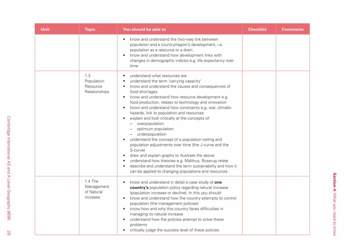
• know and understand the two-way link between population and a country/region’s development, i.e. population as a resource or a drain.
• know and understand how development links with changes in demographic indices e.g. life expectancy over time
1.3 Population-Resource Relationships
• understand what resources are • understand the term ‘carrying capacity’• know and understand the causes and consequences of
food shortages• know and understand how resource development e.g.
food production, relates to technology and innovation• know and understand how constraints e.g. war, climatic
hazards, link to population and resources• explain and look critically at the concepts of:
– overpopulation – optimum population – underpopulation
• understand the concept of a population ceiling and population adjustments over time (the J-curve and the S-curve)
• draw and explain graphs to illustrate the above• understand how theories e.g. Malthus, Boserup relate• describe and understand the term sustainability and how it
can be applied to changing populations and resources
1.4 The Management of Natural increase
• know and understand in detail a case study of one country’s population policy regarding natural increase (population increase or decline). In this you should:
• know and understand how the country attempts to control population (the management policies)
• know how and why this country faces difficulties in managing its natural increase
• understand how the policies attempt to solve these problems
• critically judge the success level of these policies
Sectio
n 4: W
hat you need to know
30C
ambridge International A
S and A
Level Geography 9696
Unit Topic You should be able to Checklist Comments
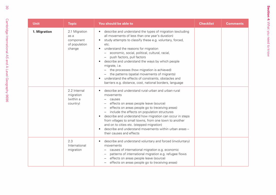
1. Migration 2.1 Migration as a component of population change
• describe and understand the types of migration (excluding all movements of less than one year’s duration)
• study attempts to classify these e.g. voluntary, forced, etc.
• understand the reasons for migration – economic, social, political, cultural, racial, – push factors, pull factors
• describe and understand the ways by which people migrate, i.e.
– the processes (how migration is achieved) – the patterns (spatial movements of migrants)
• understand the effects of constraints, obstacles and barriers e.g. distance, cost, national borders, language
2.2 Internal migration (within a country)
• describe and understand rural-urban and urban-rural movements
– causes – effects on areas people leave (source) – effects on areas people go to (receiving areas) – include the effects on population structures
• describe and understand how migration can occur in steps from villages to small towns, from one town to another and on to cities etc. (stepped migration)
• describe and understand movements within urban areas – their causes and effects
2.3 International migration
• describe and understand voluntary and forced (involuntary) movements
– causes of international migration e.g. economic – patterns of international migration e.g. refugee flows – effects on areas people leave (source) – effects on areas people go to (receiving areas)
Sectio
n 4: W
hat you need to know
31
Cam
bridge International AS
and A Level G
eography 9696
Unit Topic You should be able to Checklist Comments
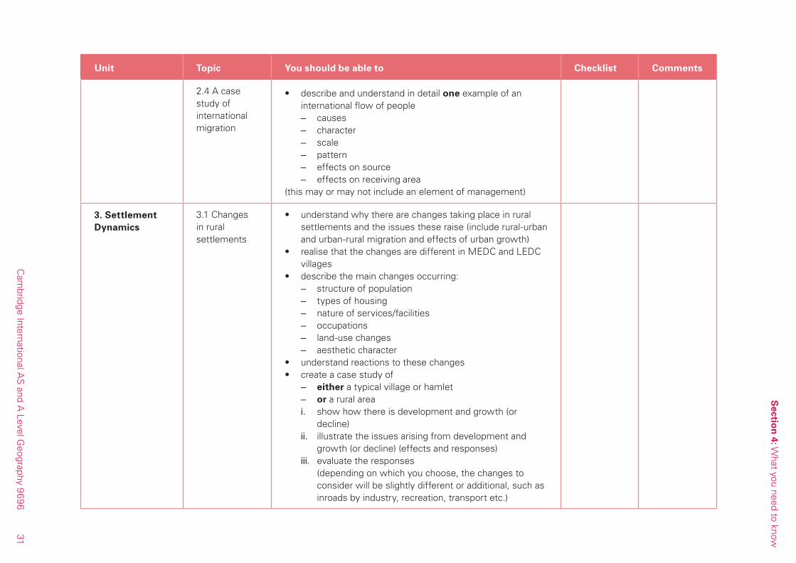
2.4 A case study of international migration
• describe and understand in detail one example of an international flow of people
– causes – character – scale – pattern – effects on source – effects on receiving area
(this may or may not include an element of management)
3. Settlement Dynamics
3.1 Changes in rural settlements
• understand why there are changes taking place in rural settlements and the issues these raise (include rural-urban and urban-rural migration and effects of urban growth)
• realise that the changes are different in MEDC and LEDC villages
• describe the main changes occurring: – structure of population – types of housing – nature of services/facilities – occupations – land-use changes – aesthetic character
• understand reactions to these changes • create a case study of
– either a typical village or hamlet – or a rural area i. show how there is development and growth (or
decline)ii. illustrate the issues arising from development and
growth (or decline) (effects and responses)iii. evaluate the responses (depending on which you choose, the changes to
consider will be slightly different or additional, such as inroads by industry, recreation, transport etc.)
Sectio
n 4: W
hat you need to know
32C
ambridge International A
S and A
Level Geography 9696
Unit Topic You should be able to Checklist Comments
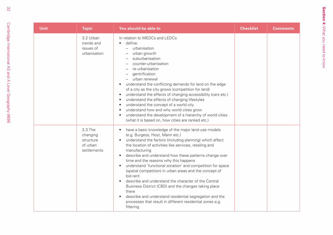
3.2 Urban trends and issues of urbanisation
In relation to MEDCs and LEDCs• define:
– urbanisation – urban growth – suburbanisation – counter-urbanisation – re-urbanisation – gentrification – urban renewal
• understand the conflicting demands for land on the edge of a city as the city grows (competition for land)
• understand the effects of changing accessibility (cars etc.)• understand the effects of changing lifestyles• understand the concept of a world city• understand how and why world cities grow• understand the development of a hierarchy of world cities
(what it is based on, how cities are ranked etc.)
3.3 The changing structure of urban settlements
• have a basic knowledge of the major land-use models (e.g. Burgess, Hoyt, Mann etc.)
• understand the factors (including planning) which affect the location of activities like services, retailing and manufacturing
• describe and understand how these patterns change over time and the reasons why this happens
• understand ‘functional zonation’ and competition for space (spatial competition) in urban areas and the concept of bid-rent
• describe and understand the character of the Central Business District (CBD) and the changes taking place there
• describe and understand residential segregation and the processes that result in different residential zones e.g. filtering.

Sectio
n 4: W
hat you need to know
33
Cam
bridge International AS
and A Level G
eography 9696
Unit Topic You should be able to Checklist Comments
3.4 The management of urban settlements
• for each of the following: 1. LEDC squatter settlement and/or shanty town2. MEDC inner city area (not CBD)3. providing infrastructure for any city4. strategies for reducing urbanisation in LEDCs
describe a case study in terms of:– showing the difficulties and problems of management
– judging how well the solutions suggested are working
Paper 2: Advanced Physical Geography OptionsQuestions may require the use of case studies, so it is essential that real, rather than theoretical, examples are studied.
Unit Topic You should be able to Checklist Comments
1. Tropical Environments
1.1 Tropical climates
• describe the characteristics of air masses found between the Tropics of Cancer and Capricorn and how they move
• understand the concept of the heat equator and how it influences pressure belts and winds
• describe and explain how its location varies at any one time
• describe and explain how its location changes through the year
• be aware of the influence of ocean currents• describe and explain the ITCZ and the characteristics of
weather associated with it and its seasonal movements• describe and explain the subtropical anticyclones and
their associated weather• describe and explain the resulting main climate types i.e.
equatorial, seasonally humid (savanna), monsoon – varying patterns, in time and location, of rainfall – varying patterns, in time and area, of temperature
• use examples and case studies
Sectio
n 4: W
hat you need to know
34C
ambridge International A
S and A
Level Geography 9696
Unit Topic You should be able to Checklist Comments
1.2 Tropical Ecosystems
• know and understand the components and links of an ecosystem
• define and understand these terms: – plant community – climax vegetation – plagioclimax vegetation – plant succession – sere – nutrient cycling – energy flows – trophic level – soil catena – soil fertility
• for tropical rainforest and savanna – know (with diagrams) the vegetation structure – understand how the vegetation has developed
with time (particularly in relation to climate, soil and human influences, but also other factors such as relief and drainage)
– know where, how and why the structure of each vegetation type varies
– understand how nutrients move and are stored – understand energy flows and trophic levels – use Gersmehl diagrams – draw and interpret a wide range of sketches,
diagrams, photos• understand soil-forming processes in the Tropics e.g.
laterisation• relate processes to soil types and profiles (with
diagrams): – latosols/oxisols – tropical red earth – tropical brown earth
• know examples of tropical soil catenas and explain the effect of slope on processes forming them

Sectio
n 4: W
hat you need to know
35
Cam
bridge International AS
and A Level G
eography 9696
Unit Topic You should be able to Checklist Comments
• understand how and why soil fertility varies (think about effects on soil processes)
• use examples and case studies
1.3 Tropical landforms
• recap on weathering processes in equatorial and savanna climatic regions
• understand these processes in terms of – what happens – where they occur (i.e. under, as well as on, the
surface) – how fast they occur (rate) – what factors affect them e.g. temperature, rock type
and structure etc., • describe and explain how deep weathering profiles and
the basal surface of weathering develop• describe and explain how landforms develop in granite –
tors, inselbergs, etchplains, pediplains – think about weathering processes (include deep
weathering) – erosion (include regolith removal) – rock characteristics (such as jointing) – time scale of process operation
• describe and explain the development of landforms in limestone – tropical karst (cockpit karst and tower karst)
• think about the same ideas as for granite• draw diagrams, interpret photographs• use examples and case studies
1.4 Sustainable management of tropical environments
• understand what is meant by sustainable management• make one case study on the sustainable management of
either the tropical rainforest ecosystem or the savanna ecosystem in terms of:
– detailing the problems faced/threats to the ecosystem and
– judging how these problems are being tackled and how effective the attempted solutions are

Sectio
n 4: W
hat you need to know
36C
ambridge International A
S and A
Level Geography 9696
Unit Topic You should be able to Checklist Comments
2. Coastal Environments
2.1 Wave, marine and sub-aerial processes
• describe and explain how waves are created in the open ocean
• understand the basic terminology of waves e.g. wave length, period, frequency etc.
• be aware of factors that cause waves to differ in size/strength e.g. fetch
• describe and understand what happens to waves when they approach the shore:
– breaking waves – swash and backwash – clapotis – refraction
• describe the different types of waves: – low energy/high energy – constructive/destructive – wave trains
• explain wave action on cliffs: – hydraulic action – quarrying – corrasion/abrasion – solution – attrition
• explain the action of sub-aerial weathering on cliffs • describe the sources of beach sediment:
– cliffs – offshore seabed – rivers – drift along coast – human action
• describe the characteristics of beach sediments: – types e.g. cobbles, coarse sand fine sand, mud – particle size – particle roundness – particle distribution on beach
• understand the concept and operation of a sediment cell
Sectio
n 4: W
hat you need to know
37
Cam
bridge International AS
and A Level G
eography 9696
Unit Topic You should be able to Checklist Comments
• explain how sediments are transported: – along the beach (longshore drift etc.) – up and down the beach – in relation to sediment size and wave energy
• explain where and why sediments are deposited e.g. on beaches, in estuaries
2.2 Coastal landforms of cliffed and constructive coasts
• describe and explain the development of cliffs – retreat of cliff face over time and the lengthening of the wave-cut platform until cliff becomes “dead”
• N.B. differentiate between this development of a typical cliff face on its own (cliff profile) and the changes over time along a typical coastline of variable geology e.g. headland and bays
• understand that these retreats will vary according to the rocks, the processes acting, both wave and sub-aerial and the time factor
i.e. structure, rock type, fetch, exposure, wave direction etc.
• understand the variations found in cliff profiles (side view/cross section) at the present, caused by such factors as: structure, rock type, fetch, wave energy and direction,
offshore depth, sub-aerial weathering and erosion, mass movement, human influences etc.
• explain landforms created at cliffs e.g. cave, arch, stack, stump, geo, wave-cut platform
• draw and describe different beaches in profile, explaining their characteristics in relation to sediment types and the waves affecting them
• describe and explain how and why the profile changes in the short term/seasonal/long term
• understand that beaches also vary in plan• describe and explain small scale features of a beach e.g.
beach cusps, sand ripples
Sectio
n 4: W
hat you need to know
38C
ambridge International A
S and A
Level Geography 9696
Unit Topic You should be able to Checklist Comments
• describe and explain the location, characteristics and formation of different types of beaches and depositional landforms:
– drift and swash aligned beaches – spits – simple and compound – tombolos – offshore bars – barrier beaches/islands – coastal dunes – estuarine features (sand/mud banks) – salt marsh/mangrove swamp
• be aware of landforms caused by changes in sea level e.g. raised beaches, rias, islands
• use examples and case studies
2.3 Coral reefs • demonstrate knowledge of where in the world coral reefs are found (fringing, barrier and atoll)
• describe the characteristics of the three main types: – fringing e.g. Tahiti – barrier e.g. Great Australian – atoll e.g. Bikini Atoll
• understand the conditions necessary for coral growth and development
• describe and illustrate the different theories put forward for the development of reefs around the world
• understand and explain the causes of sea level change• relate the effects of sea level change to changes on coral
reefs• demonstrate knowledge of the problems facing reefs
(see 2.4) and possible management strategies• use examples and case studies

Sectio
n 4: W
hat you need to know
39
Cam
bridge International AS
and A Level G
eography 9696
Unit Topic You should be able to Checklist Comments
2.4 Sustainable management of coasts
• develop a detailed case study to show the problems facing sustainable management, using either one coastline or a number of coastlines e.g.
– coastal erosion (hard and soft engineering solutions), managed retreat
– tourism pressures – rising sea-level – human activity offshore – land-use changes on the coastline
• critically judge the effectiveness and outcomes of attempted solutions
3. Hazardous Environments
3.1 Hazardous environments resulting from crustal movement
• recap on elementary plate tectonics• describe and explain the relationship of volcanoes/
earthquakes to the world’s plate boundaries (convergent, divergent, conservative) and hot spots
• realise that different boundaries have different types of hazard or differing intensity, and why
• describe and understand the details of earthquakes, such as wave types, epicentre, focus, seismic scales, frequency, length
• describe and explain the effects of earthquakes and related hazards
– land shaking – liquefaction – landslides – tsunami
• describe and explain the main types of volcanoes and volcanic eruptions
• demonstrate knowledge of the products of eruption: – nuées ardentes – lava flows – mudflows (lahars) – pyroclasts – ash, – steam and poisonous gas emission
Sectio
n 4: W
hat you need to know
40C
ambridge International A
S and A
Level Geography 9696
Unit Topic You should be able to Checklist Comments
• describe how earthquakes and volcanoes can be monitored and hence predicted, and to what level of success
• consider different perceptions of risk by people in varied world locations
• appreciate the effects of earthquakes and eruptions on lives and property
• use examples and case studies
3.2 Hazardous environments resulting from mass movement
• recap of slope processes• describe the nature of those mass movements which
lead to hazardous impact• explain the causes of them, especially in relation to
stability and instability of slopes• consider the effect (impact) in scale and time• describe the nature of avalanches• explain the causes of them and the hazards produced• for each hazard describe how it can be monitored and
hence predicted, and to what level of success• consider different perceptions of risk by people in varied
world locations• appreciate the effects on lives and property• use examples and case studies
3.3 Hazard resulting from atmospheric disturbance
NB: Be aware the syllabus restricts itself totropical storms, (i.e. storms found between the tropics), and tornadoes• know the difference between tropical storms and
tornadoes• demonstrate knowledge of regional names for tropical
storms e.g. cyclones• understand where storms start and the normal track
they take (be able to analyse a world map)
Sectio
n 4: W
hat you need to know
41
Cam
bridge International AS
and A Level G
eography 9696
Unit Topic You should be able to Checklist Comments
• understand the ways in which storms: – originate – develop (or not) and the role of latent heat – have typical cross-section characteristics – take particular directions – quickly “die” over land
• be familiar with a case study like the Caribbean area and one famous hurricane
• appreciate how and why tropical storms cause hazards e.g.:
– storm surges – coastal flooding – severe river floods (especially in lower course), – landslides, – high winds, – air pressure imbalances
• describe and explain similar material for tornadoes – where they are found – their characteristics – what causes them – how they are hazardous
• for both tropical storm and tornado hazards, describe how they can be monitored and hence predicted, and with what level of success
• consider different perceptions of risk by people in varied world locations
• appreciate the effects on lives and property• use examples and case studies
3.4 Sustainable management in hazardous environments
• develop a single, detailed case study of any one hazardous environment from your studies above (not an actual hazard type or single event hazard)
• appreciate the problems of managing such a hazardous area
• describe the methods so far attempted to solve these problems, and make judgements on them
• critically consider other possible solutions
Sectio
n 4: W
hat you need to know
42C
ambridge International A
S and A
Level Geography 9696
Unit Topic You should be able to Checklist Comments
4. Arid and Semi-Arid Environments
4.1 The distribution and climatic characteristics of hot arid and semi-arid environments
• define and describe differing levels of aridity • understand ideas such as effective precipitation, water
balance, potential evapotranspiration• demonstrate knowledge of the limitations of standard
definitions• causes of aridity• find and name hot arid and semi-arid areas on a world
map• understand why and how these areas are found in such
limited locations – influence of: – world pressure belts e.g. sub-tropical high pressure – world wind patterns – pattern of world ocean currents – cold currents – rain shadow effects – effective precipitation
• describe and understand the climate characteristics of these areas
– degrees of aridity – strong desiccating winds – daily (diurnal) and seasonal insolation patterns – diurnal and seasonal precipitation variations – diurnal and seasonal temperature variations
• describe what the climatic conditions were like in the past, especially the wetter phases (Pleistocene pluvials)
• recognise the evidence for past wetter climates• use examples and case studies
4.2 Processes producing desert landforms
• revise the types of weathering that take place e.g. – thermal fracture – exfoliation – chemical weathering – pressure release – freeze-thaw (but only at high altitudes or places
where temperatures fluctuate about 0ºC with water available)
Sectio
n 4: W
hat you need to know
43
Cam
bridge International AS
and A Level G
eography 9696
Unit Topic You should be able to Checklist Comments
• describe and understand what the weathering does to rocks and the products it creates i.e. block and granular disintegration
• demonstrate knowledge of the major erosion agents operating in these areas, now and in the past
• describe and explain the action by wind: wind erosion
– abrasion/corrasion – deflation
wind transport – critical velocities – traction – saltation – suspension/sandstorms
wind deposition – reduced wind velocity – behind obstacles – lee of hills/ridges
Landforms/features – small scale e.g. ventifacts – larger scale e.g. yardang, zeugen, pedestals/
mushroom rocks, deflation hollows – depositional sand dune types – landscapes
• explain the occurrence and action (erosion, transport and deposition) of water
– isolated storms, low occurrence, changing climate, flash floods – sheet floods and stream floods
• describe and explain the development of landforms associated with water action e.g. wadi/arroyo
• draw, describe and explain the development of landscapes and landforms in the piedmont zone: wadis, boulder-controlled slopes, inselbergs, mesa and butte, residual plateaux, mountain front, alluvial fans, pediment, bahadas, playas, salt lakes, development of sand dune landscapes
Sectio
n 4: W
hat you need to know
44
Cam
bridge International AS
and A Level G
eography 9696
Unit Topic You should be able to Checklist Comments
• critically examine ideas of which processes formed a landscape or landform
• critically examine the effects of present climates and past climates
• use examples and case studies
4.3 Soils and vegetation
• realise the variety of flora and fauna in arid and semi-arid areas (biodiversity).
• understand biomass productivity and why it is limited here
• describe and understand the main problems facing such ecosystems
• understand how fragile it is and how easily it can be damaged naturally or by human intervention
• understand why its nutrient cycle is so limited• show how flora and fauna adapt to the extreme
conditions (temperatures, physical and physiological drought)
• describe the main soil types – their profiles, and characteristics
• explain how the soil forming processes. e.g. upward capillary movement of water and minerals, develop these characteristics
• describe desertification and understand what is meant by soil degradation
• explain the process of desertification• know the causes and effects of these processes in
different areas• use examples and case studies
4.4 Sustainable management
• relate in detail one case study of sustainable management in an arid or semi-arid area such as
– growth pole settlement – new irrigation farming – mining settlement – tourist township
Sectio
n 4: W
hat you need to know
45
Cam
bridge International AS
and A Level G
eography 9696
Unit Topic You should be able to Checklist Comments
• be aware of the problems faced (including desertification) and make a critical assessment of the solutions attempted or possible solutions
Paper 3: Advanced Human Geography OptionsCase studies should be chosen from both LEDCs and MEDCs since 1970.
Unit Topic You should be able to Checklist Comments
1. Production, Location and Change
1.1 Agricultural systems and food production
• describe and understand the factors influencing agricultural practices and land-use on farms:
physical e.g. temperature/sun/rainfall variations, soil and drainage social e.g. education of farmer, land tenure economic e.g. demand, distance from markets political e.g. government subsidies, trading bloc policies• understand the role of irrigation, land tenure, nature
of demand and distance from markets, agricultural technology
• understand the idea of an agricultural system with – inputs, – throughputs – subsystems – outputs
• study in detail one arable system and one pastoral system.
Sectio
n 4: W
hat you need to know
46C
ambridge International A
S and A
Level Geography 9696
Unit Topic You should be able to Checklist Comments
• understand the ideas of production methods and associated productivity:
– intensive – extensive
• demonstrate knowledge of the issues involved in attempts to intensify production e.g.
– replace slash and burn in Indonesia – the Green Revolution – small-scale self-help schemes
• demonstrate knowledge of the issues involved in extending cultivation in LEDCs e.g.
– irrigating oases – draining swamplands – fish farming
1.2 The management of agricultural change
• develop a single case study for one country: – title: the need for agricultural change – scale: at the scale of both the individual farmer and
the country itself – content:
– why changes are needed, – why changes are difficult, – attempts made to bring about change by
management – critical evaluation of the success of these
attempted solutions
1.3 Manufacturing and related service industry
• recall the factors affecting the location of manufacturing industry and related service industry:
– suitability and cost of land – raw material origin – power source – labour supply – capital available
Sectio
n 4: W
hat you need to know
47
Cam
bridge International AS
and A Level G
eography 9696
Unit Topic You should be able to Checklist Comments
– location of markets – technology – economies and diseconomies of scale – transport – infrastructure – inertia – government policies – linkages available
• demonstrate knowledge of some of the main places where industries develop:
– break of bulk sites (e.g. deepwater ports) – riversides for heavy plants – suburban trading estates on routeways and near
market – in or next to CBD for services (and later relocation
outside city)• understand where and why industries tend to develop
together – industrial agglomeration – functional linkages – industrial estates – export processing zones (EPZ)
• understand the informal sector of manufacturing and services:
– causes – characteristics – location – impact
• use examples and case studies
1.4 The management of industrial change
• develop a single case study: for one country – title: industrial policy and consequent changes
Sectio
n 4: W
hat you need to know
48C
ambridge International A
S and A
Level Geography 9696
Unit Topic You should be able to Checklist Comments
– content: – description and explanation of the policy – following the setting up of the policy, the
changes in the location, character and organisation of industrial production
– description of some of the issues faced and a judgement on the success of the solutions to these issues and problems
2. Environmental Management
2.1 Sustainable energy supplies
• for energy, define and give examples of: – renewable resources – non-renewable resources
• describe, at a country level, the factors affecting: – the level of demand for energy – the supply of energy – the balance between energy sources
• consider ideas such as: – level of country’s development – how many resources country has – capital available for national scale projects – technology available – laws governing pollution – government policy, priorities and future plans for
energy• compare trends between MEDCs and LEDCs
consumption of: – fossil fuels – nuclear power – renewables: wind power, wave power, hydro-electric
power (HEP), solar, biofuels, geothermal
Sectio
n 4: W
hat you need to know
49
Cam
bridge International AS
and A Level G
eography 9696
Unit Topic You should be able to Checklist Comments
• describe at the local scale the effects on the environment of:
– energy production – transport of energy – usage of the power
• describe at the global scale the effects on the environment of:
– energy production – transport of energy – useage of the power
• use examples and case studies
2.2 The management of energy supply
• develop a case study of one country’s overall electrical energy strategy (plans for producing and distributing electricity)
• develop a case study of one named, located scheme within that country (e.g. a power station):
• for these studies consider issues of: – changes in demand and supply – actual production of electricity – location
• make critical assessments of the success of the overall strategy and of the selected scheme
2.3 Environmental degradation
• describe and understand the causes, magnitude and effects of the major forms of pollution of:
– land – air – water – inland, ocean
• understand how and why the demand and supply of water varies
– in different places – with changes in time
Sectio
n 4: W
hat you need to know
50C
ambridge International A
S and A
Level Geography 9696
Unit Topic You should be able to Checklist Comments
• understand the effects on the environment of supplying water
• understand issues such as water quality• understand how and why rural environments can be
damaged using contrasting examples. – overpopulation – poor agricultural practices e.g. overgrazing – deforestation – quarrying – military training grounds – golf courses in rainforest etc.
• understand how and why urban environments can be damaged (use contrasting examples such as Rio de Janeiro or London) e.g.
– too rapid urban growth – unchecked industrial growth – old industrial areas in decline – inadequate services and facilities – inadequate infrastructure – residential segregation problems – no-go crime zones etc.
• understand the problems and difficulties faced in attempts to improve the quality of these degraded environments
• identify environments most at risk (physical and human) e.g.
– wetlands – coastlines – polar and tundra areas – areas of rapidly increasing population
• describe and explain why they need protecting and the ways of protecting them
• look at the outcomes of the protection measures and assess their effectiveness
• use examples and case studies
Sectio
n 4: W
hat you need to know
51
Cam
bridge International AS
and A Level G
eography 9696
Unit Topic You should be able to Checklist Comments
2.4 The management of a degraded environment
• choose one degraded environment and show: – the causes of its degradation – the problems faced by the area – attempts to improve the area – problems of these improvement attempts – judgement on the success of these attempts to solve
the problems
3. Global Interdependence
3.1 Trade flows and trading patterns
• demonstrate knowledge of – visible and invisible imports – visible and invisible exports
• appreciate the uneven flows of trade around the world• understand the factors affecting global trade and so
causing these flows e.g. – resource endowment – locational advantage – historical factors such as colonial links – political isolation of certain countries – trading blocs and agreements – changes in the global market
• demonstrate knowledge and understanding of the World Trade Organisation (WTO)
• demonstrate knowledge and understanding of Fair Trade• describe and explain the role of Fair Trade• use examples and case studies
3.2 Debt and aid and their management
• at the national scale, describe and explain debt – its nature – its causes – the problems it creates

Sectio
n 4: W
hat you need to know
52C
ambridge International A
S and A
Level Geography 9696
Unit Topic You should be able to Checklist Comments
• describe and explain – the debt crisis (countries affected, causes, problems
created etc.) – debt relief (organisations involved, actions, issues
etc.)• describe and explain different types of aid and donors
– relief aid – development aid – tied aid – bilateral or multilateral aid
• describe and explain the effects of aid on receiving countries
• critically assess these effects• use examples and case studies
3.3 Development of international tourism
• understand the reasons for growth in world tourism• describe and explain the trends in this growth• demonstrate knowledge and understanding of
– carrying capacity – multiplier effect
• describe the impacts, at both local and national scale, of tourism on the destination’s:
– environment – peoples (society) – economy
• explain and critically examine the life cycle model of tourism, and apply it to case studies
• describe recent developments in world tourism e.g. – ecotourism – adventure tourism – extreme tourism
• use examples and case studies
Sectio
n 4: W
hat you need to know
53
Cam
bridge International AS
and A Level G
eography 9696
Unit Topic You should be able to Checklist Comments
3.4 The management of a tourist destination
• develop one case study of a tourist area or actual resort to include:
– its growth – reasons for its development – its ability to sustain itself – your judgement on how tourism here affects the
local environment, the people and their economy
4. Economic Transition
4.1 National development
• demonstrate knowledge of primary, secondary, tertiary and quaternary sectors of an economy and their roles in economic development
• understand that global differences in social and economic wellbeing exist, and know where the differences are
• explain the causes (physical and human) of these differences in wellbeing
• explain and comment on indicators of social/economic inequality e.g. HDI
• use examples and case studies
4.2 The globalisation of industrial activity
• demonstrate a basic knowledge of world patterns of: – resource distribution – production – markets
• describe and explain foreign direct investment (FDI)
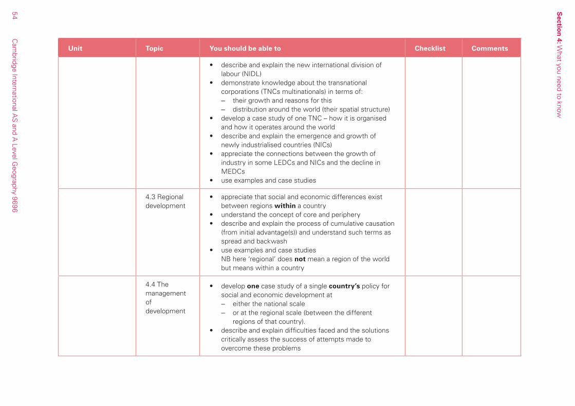
Sectio
n 4: W
hat you need to know
54C
ambridge International A
S and A
Level Geography 9696
Unit Topic You should be able to Checklist Comments
• describe and explain the new international division of labour (NIDL)
• demonstrate knowledge about the transnational corporations (TNCs multinationals) in terms of:
– their growth and reasons for this – distribution around the world (their spatial structure)
• develop a case study of one TNC – how it is organised and how it operates around the world
• describe and explain the emergence and growth of newly industrialised countries (NICs)
• appreciate the connections between the growth of industry in some LEDCs and NICs and the decline in MEDCs
• use examples and case studies
4.3 Regional development
• appreciate that social and economic differences exist between regions within a country
• understand the concept of core and periphery• describe and explain the process of cumulative causation
(from initial advantage(s)) and understand such terms as spread and backwash
• use examples and case studies NB here ‘regional’ does not mean a region of the world
but means within a country
4.4 The management of development
• develop one case study of a single country’s policy for social and economic development at
– either the national scale – or at the regional scale (between the different
regions of that country).• describe and explain difficulties faced and the solutions
critically assess the success of attempts made to overcome these problems

Section 5: Useful websites
55 Cambridge International AS and A Level Geography 9696
Section 5: Useful websites
The websites listed below are useful resources to help you study for your A Level Geography.
http://www.geographyalltheway.comThis is a wide-ranging site which includes good coverage of many of the AS/AL topics in 9696 Geography, which will be useful both to teachers and learners. The approach is lively and there is basic no-nonsense text as well as some good photos, maps, diagrams and links to YouTube. However you need to take out a subscription to use this site.
http://www.georesources.co.uk A well-established site that is excellent for topics and case studies. It contains links to other sites, photographs and outline maps.
http://www.geo-file.com This is essentially a subscription site, providing series of articles on topical issues for students. There is some free sample material.
http://www.geography.learnontheinternet.co.uk A site relevant for teachers and learners that provides maps, photos, links and tasks. It organises resources into different categories.
http://www.geographynewsroom.co.uk This site provides links to geography related events in the news.
http://www.interactivegeography.co.ukMainly aimed at younger geographers
http://www.geographyphotos.com A subscription website that offers high quality digital images for use in lessons. There is also a samples gallery.
http://www.bbc.co.uk This well-known website provides a good search engine for suitable topics.
http://www.guardian.co.ukA newspaper website with news and articles on environmental topics.
http://www.metoffice.comThis site provides weather data and maps, and education resources for both learners and teachers, including case studies.
http://www.memory.loc.gov/frd/cs/This is part of the Library of Congress website and has country studies useful for case studies.
http://www.google.co.ukFor photographs go to Google Images by selecting Images from the google menu bar
http://www.globalurban.orgThis has a magazine that looks at global urban issues. The articles provide up-to-date case study material.
http://www.uwsp.edu/geo/faculty/ritter/geog101/textbook/contents.htmlA website, that also includes links to others, with a range of physical geography resources.

Cambridge International Examinations1 Hills Road, Cambridge, CB1 2EU, United KingdomTel: +44 (0)1223 553554 Fax: +44 (0)1223 553558Email: [email protected] www.cie.org.uk
© Cambridge International Examinations 2014 v1 4Y02
*2696246795*