cambridge as geography revision: hydrology and fluvial geomorphology - 1.2 rainfall discharge...
TRANSCRIPT
ASGEOGRAPHYREVISIONHYDROLOGYANDFLUVIALGEOMORPHOLOGY
1.2 RIVERDISCHARGERELATIONSHIP

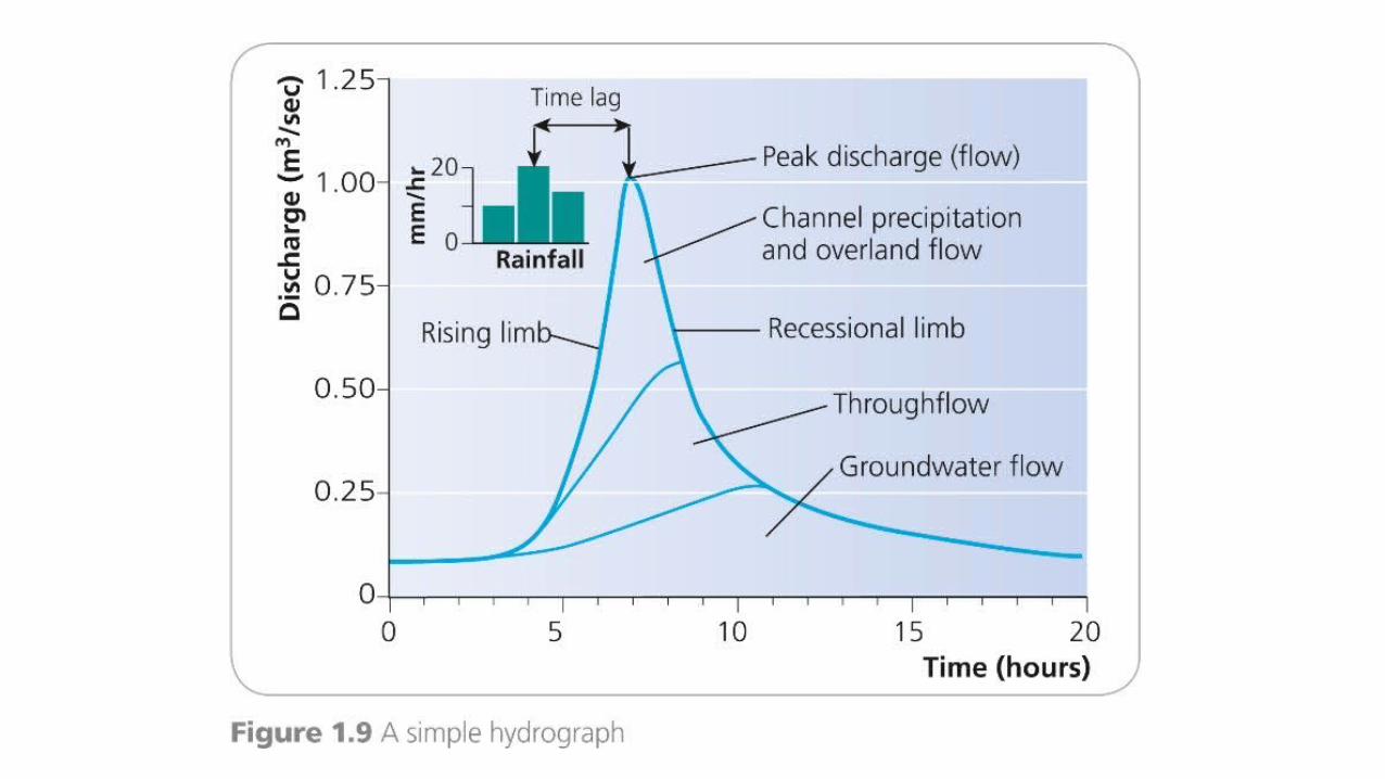
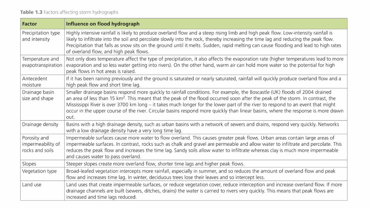
KEYTERMSANDDEFINITIONSA river regime is the annual variation in the flow of a river.A flood or storm hydrograph shows the short-term changes in river discharge, over a day or a couple of days. Usually it is drawn to show how a river reacts to an individual storm. Each storm hydrograph has a series of parts.The rising limb shows us how quickly the flood waters begin to rise.The peak flow is the maximum discharge of the river as a result of the storm.The time lag is the time between the peak rainfall and peak discharge.The recessional limb is the speed with which the water level in the river declines after the peak.
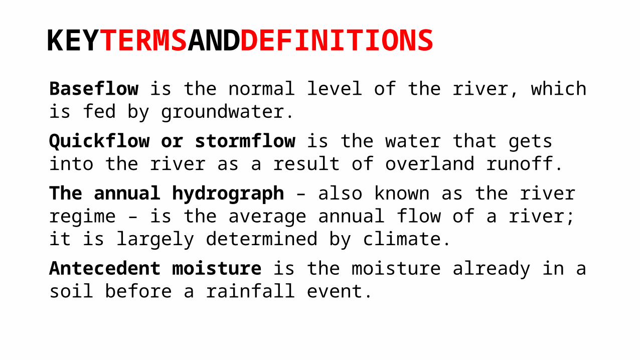
KEYTERMSANDDEFINITIONS
Baseflow is the normal level of the river, which is fed by groundwater.Quickflow or stormflow is the water that gets into the river as a result of overland runoff.The annual hydrograph – also known as the river regime – is the average annual flow of a river; it is largely determined by climate.Antecedent moisture is the moisture already in a soil before a rainfall event.
TOPICSUMMARYA river regime is the annual variation in the flow of a river.On an annual basis the most important factor determining stream regime is climate. Regimes can be simple or complex.A flood hydrograph shows how the discharge of a river varies over a short time.The effect of urban development on hydrographs is to increase peak flow and decrease time lag.Highly intensive rainfall is likely to produce overland flow and a steep rising limb and high peak flow.If the ground is saturated or near saturated, rainfall will quickly produce overland flow and a high peak flow and short time lag.
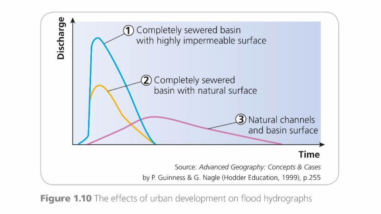

TOPICSUMMARYImpermeable surfaces cause more water to flow overland.Steeper slopes create more overland flow, shorter time lags and higher peak flows.Broad-leafed vegetation intercepts more rainfall, especially in summer, and so reduces the amount of overland flow and peak flow and increases time lag.Land uses that create impermeable surfaces or reduce vegetation cover reduce interception and increase overland flow.If more drainage channels are built (sewers, ditches, drains) the water is carried to rivers very quickly, thus peak flows are increased and time lags reduced.
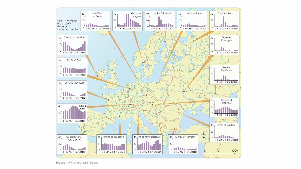
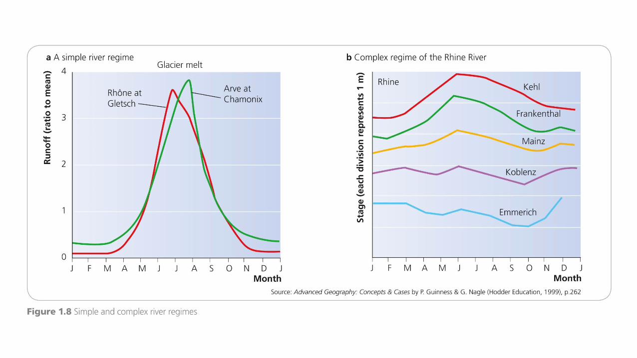
ADDITIONALWORK1. Examine the factors that cause variations in storm hydrographs.2. Describe, and suggest reasons for, variations in river regimes in
Europe, as shown in Figure 1.7.3. Examine the role of human activity in the modification of
hydrographs in urban areas.
SUGGESTEDWEBSITESFor a list of rivers arranged by discharge visit:http://en.wikipedia.org/wiki/List_of_rivers_by_average_dischargewww.s-cool.co.uk/gcse/geography/rivers/hydrology.html#flood-hydrographs
for a simple hydrograph, and:www.s-cool.co.uk/alevel/geography/river-profiles/stormhydrographs-and-river-discharge.html
for differences in urban and rural hydrographs.www.nohrsc.noaa.gov/technology/gis/uhg_manual.html
For the US National Weather Service’s National Operational Hydrologic Remote Sensing Center’s Hydrologic Technical Bulletin on Hydrographs.