callendar farm phase 2, nuneaton - nuneaton and...
TRANSCRIPT
Callendar Farm Ltd
Callendar Farm Phase 2, Nuneaton
Travel Plan
January 2017
Project Code: 2266
Phil Jones Associates Ltd Seven House
High Street, Longbridge Birmingham B31 2UQ
t: 0121 475 0234 philjonesassociates.co.uk

Travel Plan
Callendar Farm Ltd Callendar Farm Phase 2, Nuneaton
Version Control and Approval
Version Date Main Contributors Issued by Approved by
A 30 November 2016 BL SB ME
B 06 January 2017 BL SB ME
Prepared for
Callendar Farm Ltd
5 The Priory
Old London Road
Sutton Coldfield
West Midlands
B75 5SH

Travel Plan
Callendar Farm Ltd Callendar Farm Phase 2, Nuneaton
Contents
Section Page
1 Introduction 2
1.1 Background 2
1.2 The Development 2
1.3 Travel Plan Purpose 2
1.4 Structure of Report 3
2 Policy and Guidance 4
2.1 National Planning Policy Framework (March 2012) 4
2.2 Planning Practice Guidance 2014 (PPG 2014) 4
2.3 Warwickshire Local Transport Plan 2011-2026 5
3 Baseline Transport Conditions 7
3.1 Site Location 7
3.2 Local Highway Network 7
3.3 Accessibility 8
3.4 Sustainable Transport Opportunities 12
3.5 Summary 19
4 Proposed Development 20
4.1 Development Mix 20
4.2 Vehicular Access Strategy 20
4.3 Internal Road Layout 20
4.4 Multi-modal trip generation 21
4.5 Parking Provision 21
5 Movement Strategy 22
5.1 Introduction 22
5.2 Public Transport 22
5.3 Pedestrian and Cycle Strategy 24
6 Travel Plan Management and Coordination 26
6.1 Introduction 26
6.2 Travel Plan Coordinator 26
6.3 Travel Plan Liaison 27
7 Travel Plan Initiatives and Action Plan 28
7.1 Travel Plan Measures 28
7.2 Measures to Promote and Encourage Walking and Cycling 28
7.3 Measures to Promote and Encourage Public Transport Use 29
7.4 Measures to Promote and Encourage Car Sharing 29
7.5 Measures to Reduce the Need to Travel 29
7.6 Marketing and Promotion of the Travel Plan Measures 30
7.7 Personalised Travel Planning 31
7.8 Smartphone Apps 31
8 Targets and Monitoring 33
8.1 Introduction 33
8.2 Travel Plan Targets 33
8.3 Trip Generation, Targets and Modal Share 33
8.4 Monitoring 34
9 Action Plan 35
9.1 Action Plan 35

Callendar Farm Phase 2, Nuneaton Callendar Farm Ltd Travel Plan
1 Introduction
1.1 Background
1.1.1 Phil Jones Associates (PJA) has been commissioned by Callendar Farm Ltd to prepare a Travel Plan
to accompany an outline planning application for a residential led development located at Callendar
Farm, Nuneaton.
1.1.2 A separate Transport Assessment has been prepared by PJA and this report should be read in
conjunction with the document, dated November 2016.
1.2 The Development
1.2.1 The development forms Phase 2 of the Callendar Farm site. The Callendar Farm Phase 1 site is
located directly to the south-east of Phase 2 and was granted planning permission in March 2016
for up to 150 dwellings (outline application number 032578).
1.2.2 The Callendar Farm Phase 2 development proposals are for:
Up to 850 dwellings – a mixture of sizes and types including affordable housing;
New primary school (reserving land for two-form entry);
Community Hub/Local Centre;
Open Space for both active and passive recreation; and
Retention and enhancement of existing boundary trees and hedgerows.
1.3 Travel Plan Purpose
1.3.1 This Travel Plan sets out the various travel-related measures and strategies that will be
implemented to encourage residents of the site to consider the use of a range of travel modes. The
key objectives of the Travel Plan are to:
Deliver a long-term and sustained commitment to changing and widening travel choice;
Address the access needs of residents by enabling walking, cycling, public transport and car
sharing;
Promote healthy lifestyles and raise awareness about the benefits of utilising sustainable travel
opportunities; and
Build upon good urban design principles that promote the permeability of development,
encouraging walking and cycling as the first choice for local trips.
Callendar Farm Ltd Callendar Farm Phase 2, Nuneaton Travel Plan
1.3.2 This travel plan details the residential travel plan initiatives. It is understood that the school and
commercial travel plans will be covered by a planning condition and therefore do not feature in this
report.
1.4 Structure of Report
1.4.1 Following this chapter, the report is structured as follows:
Chapter 2: Policy and Guidance;
Chapter 3: Baseline Transport Conditions;
Chapter 4: Development Proposals;
Chapter 5: Travel Plan Management and Coordination;
Chapter 6: Residential Travel Plan Initiatives;
Chapter 7: Commercial Travel Plan Initiatives;
Chapter 8: Targets, Review and Monitoring; and
Chapter 9: Action Plan
Callendar Farm Phase 2, Nuneaton Callendar Farm Ltd Travel Plan
2 Policy and Guidance
2.1 National Planning Policy Framework (March 2012)
2.1.1 In March 2012, the Government published the National Planning Policy Framework (NPPF). Two of
the core planning principles held in the NPPF as set out in paragraph 17, include actively managing
“patterns of growth to make the fullest possible use of public transport, walking and cycling, and
focus significant development in locations which are or can be made sustainable” and to “take
account of and support local strategies to improve health, social and cultural wellbeing for all, and
deliver sufficient community and cultural facilities and services to meet local needs.”
2.1.2 Additionally, in promoting sustainable transport, paragraph 31 states that “Local authorities should
work with neighbouring authorities and transport providers to develop strategies for the provision
of viable infrastructure necessary to support sustainable development” and also that “All
developments that generate significant amounts of movement should be supported by a Transport
Statement or Transport Assessment. Plans and decisions should take account of whether:
The opportunities for sustainable transport modes have been taken up depending on the nature
and location of the site, to reduce the need for major transport infrastructure;
Safe and suitable access to the site can be achieved for all people; and
Improvements can be undertaken within the transport network that cost effectively limit the
significant impacts of the development. Development should only be prevented or refused on
transport grounds where the residual cumulative impacts of development are severe.”
2.1.3 Paragraph 36 goes on to state that “A key tool to facilitate this will be a Travel Plan. All
developments which generate significant amounts of movement should be required to provide a
Travel Plan.”
2.1.4 In reinforcing the principle of supporting sustainable development, paragraph 197 states that “In
assessing and determining development proposals, local planning authorities should apply the
presumption in favour of sustainable development.”
2.1.5 The proposed development will support the sustainable objectives set out in the NPPF; details of
which are provided in this Travel Plan.
2.2 Planning Practice Guidance 2014 (PPG 2014)
2.2.1 PPG 2014 provides information on:
When a Travel Plan is required;
Callendar Farm Ltd Callendar Farm Phase 2, Nuneaton Travel Plan
How the need for and scope of a Travel Plan is established;
What information should be included in Travel Plans; and
How Travel Plans can be monitored.
2.2.2 PPG 2014 states that “Travel Plans should identify the specific required outcomes, targets and
measures, and set out clear future monitoring and management arrangements all of which should
be proportionate. They should also consider what additional measures may be required to offset
unacceptable impacts if the targets should not be met.
Travel Plans should set explicit outcomes rather than just identify processes to be followed (such
as encouraging active travel or supporting the use of low emission vehicles). They should address
all journeys resulting from a proposed development by anyone who may need to visit or stay and
they should seek to fit in with wider strategies for transport in the area.”
2.2.3 They should evaluate and consider:
Benchmark travel data including trip generation databases;
Information concerning the nature of the proposed development and the forecast level of trips
by all modes of transport likely to be associated with the development;
Relevant information about existing travel habits in the surrounding area;
Proposals to reduce the need for travel to and from the site via all modes of transport; and
Provision of improved public transport services.
2.2.4 With regard to monitoring, PPG 2014 states that:
“The length of time over which monitoring will occur and the frequency will depend on the nature
and scale of the development and should be agreed as part of the Travel Plan with the developer
or qualifying body for neighbourhood planning. Who has responsibility for monitoring
compliance should be clear.
Monitoring requirements should only cease when there is sufficient evidence for all parties to be
sure that the travel patterns of the development are in line with the objectives of the Travel Plan.
This includes meeting the agreed targets over a consistent period of time. At this point the Travel
Plan would become a voluntary initiative.”
2.3 Warwickshire Local Transport Plan 2011-2026
2.3.1 The 2011-2026 Warwickshire Local Transport Plan is the third incarnation of the document, written
by Warwickshire Country Council and sets out the County’s transport strategy and policies for the
Callendar Farm Phase 2, Nuneaton Callendar Farm Ltd Travel Plan
fifteen-year period. It has been produced in accordance with the Local Transport Plan Guidance
issued by the Department for Transport in 2009.
2.3.2 The overall objectives given in the Local Transport Plan are as follows:
“To promote greater equality of opportunity for all citizens in order to promote a fairer, more
inclusive society;
To seek reliable and efficient transport networks which will help promote full employment and a
strong, sustainable local and sub-regional economy;
To reduce the impact of transport on people and the [built and natural] environment and improve
the journey experience of transport users;
To improve the safety, security and health of people by reducing the risk of death, injury or illness
arising from transport, and by promoting travel modes that are beneficial to health;
To encourage integration of transport, both in terms of policy planning and the physical
interchange of modes; and
To reduce transport’s emissions of carbon dioxide and other greenhouse gases, and address the
need to adapt to climate change.”
2.3.3 The plan gives more specific strategy objectives for the Nuneaton and Bedworth Urban Area, an
area it describes as having “strong links with a number of towns and cities located outside the
county” but “performs below average in socio-economic terms”. The objectives are as follows:
“Support the regeneration of Nuneaton and Bedworth town centres and the stability and growth
of the local economy;
Support future housing and employment growth within the Borough, including development
within the Coventry to Nuneaton Regeneration Zone;
Support access to services and facilities, particularly for those without access to a car; and
Reduce the environmental impact of traffic within the Borough and improve local air quality.”
Callendar Farm Ltd Callendar Farm Phase 2, Nuneaton Travel Plan
3 Baseline Transport Conditions
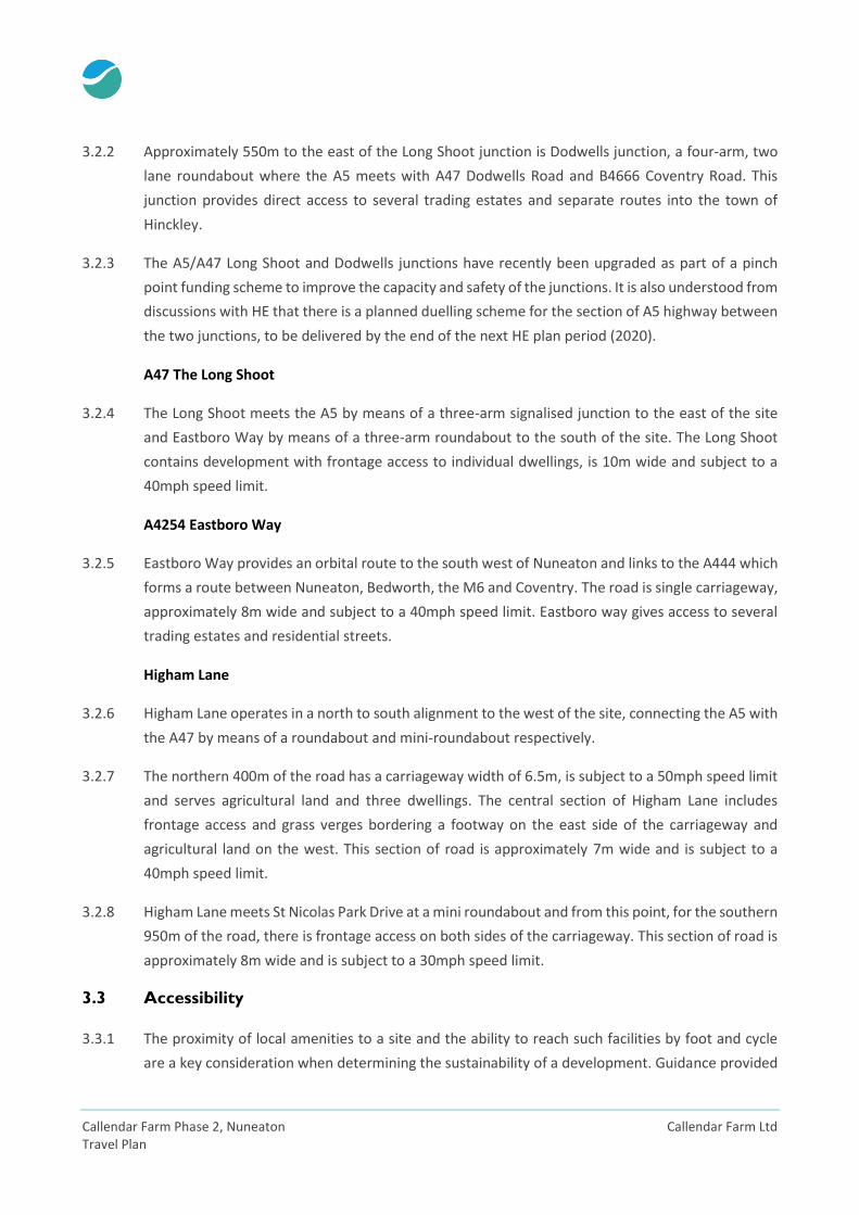
3.1 Site Location
3.1.1 The site is located approximately two and a half kilometres to the north east of Nuneaton and three
kilometres to the south of Hinckley on what is currently agricultural land. The site is bounded to the
north by the A5 trunk road, which also marks the boundary between Warwickshire to the south
and Leicestershire to the north. St Nicolas Park residential estate bounds the site to the west, whilst
The A47 Long Shoot is to the east.
Figure 3-1: Site Location
3.2 Local Highway Network
A5 Watling Street
3.2.1 A 21km stretch of the A5 trunk road links M69 Junction 1 (5km to the east of the site) with M42
Junction 10 (16km to the west of the site), bypassing Atherstone town centre. Close to the site, the
A5 is a single carriageway road, 9.5m wide and is subject to a 50mph speed limit. On the approach
to the Long Shoot junction there is frontage access to individual dwellings, this section is subject to
a 40mph speed limit.
Callendar Farm Phase 2, Nuneaton Callendar Farm Ltd Travel Plan
3.2.2 Approximately 550m to the east of the Long Shoot junction is Dodwells junction, a four-arm, two
lane roundabout where the A5 meets with A47 Dodwells Road and B4666 Coventry Road. This
junction provides direct access to several trading estates and separate routes into the town of
Hinckley.
3.2.3 The A5/A47 Long Shoot and Dodwells junctions have recently been upgraded as part of a pinch
point funding scheme to improve the capacity and safety of the junctions. It is also understood from
discussions with HE that there is a planned duelling scheme for the section of A5 highway between
the two junctions, to be delivered by the end of the next HE plan period (2020).
A47 The Long Shoot
3.2.4 The Long Shoot meets the A5 by means of a three-arm signalised junction to the east of the site
and Eastboro Way by means of a three-arm roundabout to the south of the site. The Long Shoot
contains development with frontage access to individual dwellings, is 10m wide and subject to a
40mph speed limit.
A4254 Eastboro Way
3.2.5 Eastboro Way provides an orbital route to the south west of Nuneaton and links to the A444 which
forms a route between Nuneaton, Bedworth, the M6 and Coventry. The road is single carriageway,
approximately 8m wide and subject to a 40mph speed limit. Eastboro way gives access to several
trading estates and residential streets.
Higham Lane
3.2.6 Higham Lane operates in a north to south alignment to the west of the site, connecting the A5 with
the A47 by means of a roundabout and mini-roundabout respectively.
3.2.7 The northern 400m of the road has a carriageway width of 6.5m, is subject to a 50mph speed limit
and serves agricultural land and three dwellings. The central section of Higham Lane includes
frontage access and grass verges bordering a footway on the east side of the carriageway and
agricultural land on the west. This section of road is approximately 7m wide and is subject to a
40mph speed limit.
3.2.8 Higham Lane meets St Nicolas Park Drive at a mini roundabout and from this point, for the southern
950m of the road, there is frontage access on both sides of the carriageway. This section of road is
approximately 8m wide and is subject to a 30mph speed limit.
3.3 Accessibility
3.3.1 The proximity of local amenities to a site and the ability to reach such facilities by foot and cycle
are a key consideration when determining the sustainability of a development. Guidance provided
Callendar Farm Ltd Callendar Farm Phase 2, Nuneaton Travel Plan
by the Institution of Highways and Transportation (IHT) in their publication ‘Guidelines for Providing
for Journeys on Foot’ (2000) suggests that in terms of commuting, walking to school and
recreational journeys; walk distances of up to 2km can be considered as a preferred maximum with
‘desirable’ and ‘acceptable’ distances being 500m and 1,000m respectively. It should however be
noted that journeys of a longer length are often undertaken.
3.3.2 For non-commuter journeys, the Guidance suggests that walk distances of up to 1,200m can be
considered as a preferred maximum, with the ‘desirable’ and ‘acceptable’ distances being 400 and
800m respectively. Again, it should be noted that journeys of a longer length are often undertaken.
Table 3-1: Walk Journey Distance and Time Thresholds
IHT Standard
Distance (m) Walk Time (mins)
Commuting, Walking to School and Recreation
Other, non-commuter journeys
Commuting, Walking to School and Recreation
Other, non-commuter journeys
Desirable 500 400 6.25 5
Acceptable 1000 800 12.25 10
Preferred Maximum 2000 1200 25 15
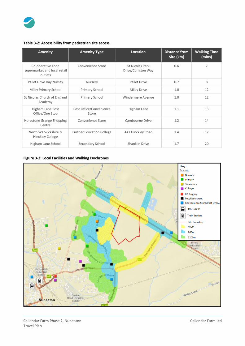
3.3.3 As illustrated in Figure 3-2 overleaf, there are a number of local facilities within walking/cycling
distance of the site providing a wide range of services for everyday needs. The Government’s index
of multiple deprivation statistics includes an indicator of ‘Transport Inclusion’, which is defined in
terms of access to four essential types of facilities, which are:
Primary Schools;
Health Centres;
Convenience Stores; and
Post Offices.
3.3.4 To the west of the site, there are several local amenities including shops and schools. These
amenities and their calculated walking time from a pedestrian site access on the western boundary
of the site (on Public Right of Way N30) are given in the table overleaf. The walking time assumes
a typical walking speed of approximately 1.4m/second, as set out in the IHT ‘Guidelines for
Providing for Journeys on Foot’ (2000).
Callendar Farm Phase 2, Nuneaton Callendar Farm Ltd Travel Plan
Table 3-2: Accessibility from pedestrian site access
Amenity Amenity Type Location Distance from Site (km)
Walking Time (mins)
Co-operative Food supermarket and local retail
outlets
Convenience Store St Nicolas Park Drive/Coniston Way
0.6 7
Pallet Drive Day Nursey Nursery Pallet Drive 0.7 8
Milby Primary School Primary School Milby Drive 1.0 12
St Nicolas Church of England Academy
Primary School Windermere Avenue 1.0 12
Higham Lane Post Office/One Stop
Post Office/Convenience Store
Higham Lane 1.1 13
Horestone Grange Shopping Centre
Convenience Store Cambourne Drive 1.2 14
North Warwickshire & Hinckley College
Further Education College A47 Hinckley Road 1.4 17
Higham Lane School Secondary School Shanklin Drive 1.7 20
Figure 3-2: Local Facilities and Walking Isochrones
Callendar Farm Ltd Callendar Farm Phase 2, Nuneaton Travel Plan
Local Centres and Key Employment Areas
3.3.5 The local shops on St Nicolas Park Way/Coniston Way include a Co-operative Food supermarket, a
Boots Pharmacy a Newsagents and Hairdressers. These shops therefore act as a regional local
centre and are situated within an ‘acceptable’ walking distance as defined by IHT. Two primary
schools and a nursey are located within an ‘acceptable’ walking distance and a post office is located
within the ‘preferred maximum’ distance.
3.3.6 The Long Shoot Public House, Aldi Supermarket and Dodwells service station are all located to the
north east of the site. These are all within 1km of the site, and therefore within an ‘acceptable’
walking distance. These facilities are can be accessed using existing footpaths, shared
footway/cycleway and the upgraded pedestrian crossing facilities provided as part of the pinch
point scheme at the A5/A47 Long Shoot junction.
3.3.7 Further local facilities are also located within a reasonable walking distance to the south of the site
in the form of the Horeston Grange Shopping Centre, whilst all the facilities in the town centre are
easily accessible by bus, as are the various other employment and education facilities located along
the bus routes in Nuneaton, Hinckley, Coventry and Leicester.
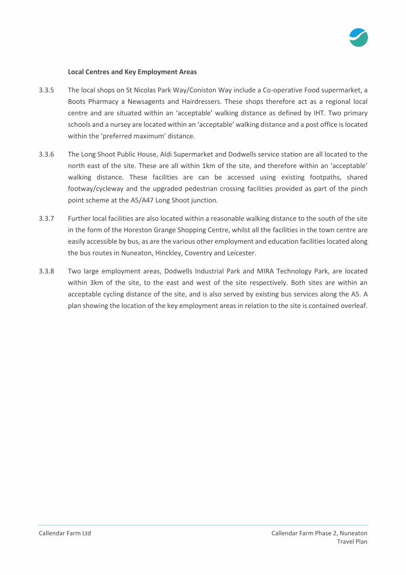
3.3.8 Two large employment areas, Dodwells Industrial Park and MIRA Technology Park, are located
within 3km of the site, to the east and west of the site respectively. Both sites are within an
acceptable cycling distance of the site, and is also served by existing bus services along the A5. A
plan showing the location of the key employment areas in relation to the site is contained overleaf.
Callendar Farm Phase 2, Nuneaton Callendar Farm Ltd Travel Plan
Figure 3-3: Local Centres and Key Employment Areas
3.4 Sustainable Transport Opportunities
3.4.1 Planning guidance highlights the emphasis placed on the integration of land use, transport and
planning decisions, with the NPPF stating:
“Plans and decisions should ensure developments that generate significant movement are
located where the need to travel will be minimised and the use of sustainable transport modes
can be maximised…”
3.4.2 In order to achieve good integration, development should be encouraged in areas with good
accessibility to local facilities, employment opportunities and public transport. This section
demonstrates the amenities that can be accessed from the site by sustainable modes as well as
describing the existing public transport, pedestrian and cycle connections.
Employment Areas
1. MIRA Technology Park
2. Dodwells
Local Centres
3. St Nicolas Park Drive Local
Centre
4. Horestone Grange Park
Shopping Centre
5. Nuneaton Town Centre
Callendar Farm Ltd Callendar Farm Phase 2, Nuneaton Travel Plan
Pedestrian Facilities
The Long Shoot
3.4.3 There are wide continuous footways on both sides of the carriageway on the Long Shoot with grass
verges providing enhanced separation from vehicular traffic. These footways are lit and are
appropriate for gaining access to the wider area.
Watling Street (A5)
3.4.4 There are wide footways, measuring approximately 2.5m in width on both sides of the carriageway
on Watling Street (A5) outside existing residential properties. As part of the recently implemented
pinch point scheme at the Long Shoot and Dodwells junctions, pedestrian crossing facilities have
been improved which provide an attractive and safe route to local facilities to the north east of the
site and onwards to Hinckley.
Public Right of Way N30
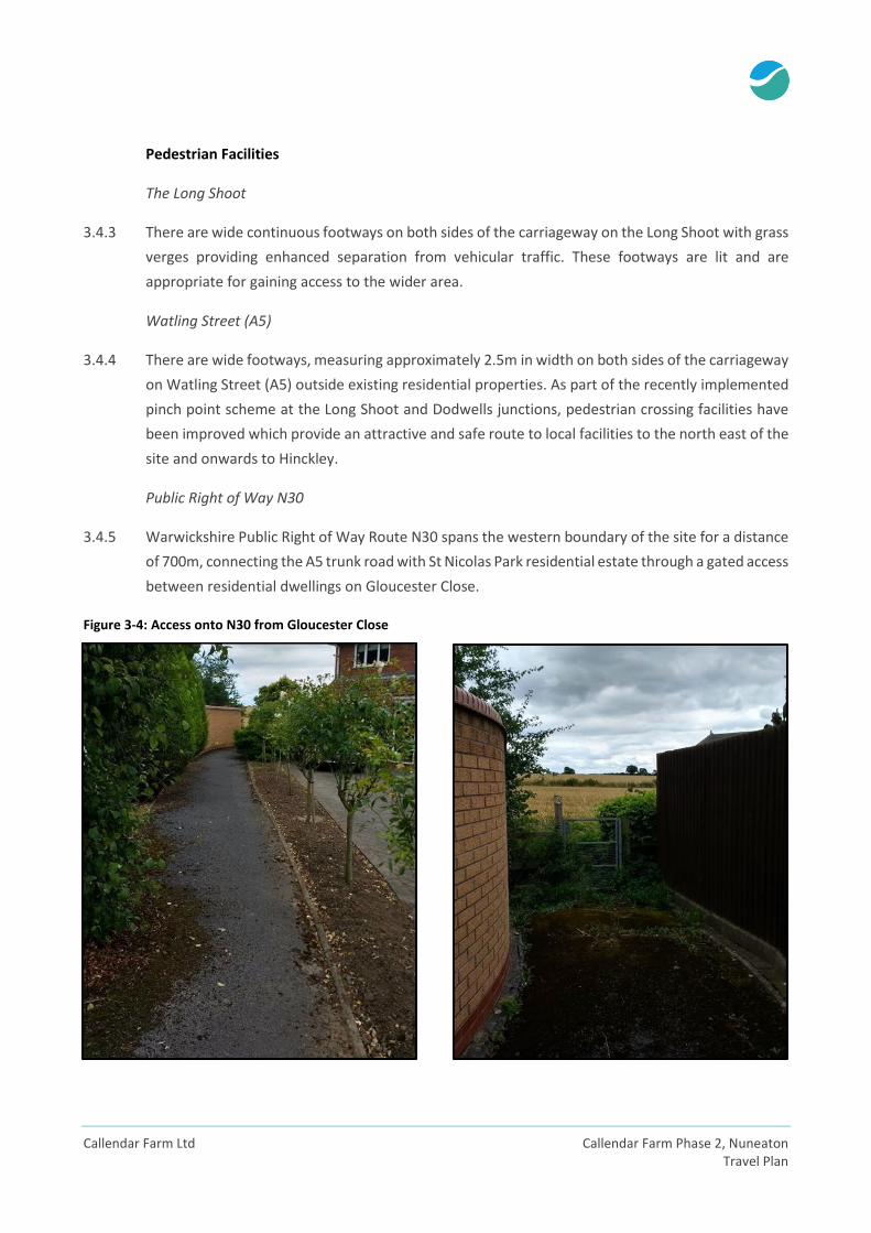
3.4.5 Warwickshire Public Right of Way Route N30 spans the western boundary of the site for a distance
of 700m, connecting the A5 trunk road with St Nicolas Park residential estate through a gated access
between residential dwellings on Gloucester Close.
Figure 3-4: Access onto N30 from Gloucester Close
Callendar Farm Phase 2, Nuneaton Callendar Farm Ltd Travel Plan
3.4.6 N30 continues southwards on Gloucester Close, connecting to Callendar Close via a pedestrian link
and to Pallet Drive through an alleyway at a point 90m to the north of the Pallet Drive/St Nicolas
Park Drive mini-roundabout.
Hinckley Road
3.4.7 Hinckley Road is a principal route into Nuneaton town centre. There are 2m wide grass verges on
the south side of the carriageway adding extra protection for pedestrians. There are also formal
crossings provided on this route:
Signalised pedestrian crossing near A47/A4254 roundabout;
Signalised pedestrian crossing outside North Warwickshire & Hinckley College;
Two pedestrian refuge islands between the two pedestrian crossings;
Pedestrian refuge across priority junction with St Nicolas Park Drive; and
Pedestrian refuge across priority junction with Tiverton Drive.
3.4.8 These crossings listed above ensure that pedestrians can safely access bus stops on Hinckley Road,
North Warwickshire & Hinckley College as well as a small retail park off A4254.
Other Pedestrian Facilities to the West of the Site
3.4.9 There are several routes that connect the site along key desire lines to local amenities to the west
of the site, including footways on the following roads:
Milby Drive;
Pallet Drive;
Coniston Way;
Windermere Avenue; and
St Nicolas Park Drive.
3.4.10 All the above routes have consistent good quality footways, at least 2m in width on both sides of
the carriageway, many with additional grass verges. It is therefore considered that they are suitable
for walking to local amenities to the west of the site.
Callendar Farm Ltd Callendar Farm Phase 2, Nuneaton Travel Plan
Cycle Facilities
A5 Watling Street
3.4.11 Directly to the north of the site, an existing shared footway/cycleway links the MIRA employment
site to the west with the Weddington trail/NCN52 and the Dodwells junction to the east. The quality
of the shared footway/cycleway varies with wide, high quality infrastructure between Higham Lane
and MIRA to the west, and the A5/A47 Long Shoot junction to Dodwells junction to the east (as part
of a pinch point funding scheme), providing direct, safe and attractive routes to local employment
facilities.
3.4.12 However, immediately to the north of the site (between the Higham Lane roundabout and the A47
Long Shoot junction) the shared footway/cycleway is of lower quality, with widths of circa 1.2m
(reducing to 0.6m adjacent to the existing lay-bys) and poorly maintained surfacing.
A47 Dodwells Road
3.4.13 A stepped cycle track is provided along the eastern side of the A47 between Dodwells junction and
Brindley Road which becomes a shared footway/cycleway between Brindley Road and the Triumph
Motorcycle factory. This route therefore provides safe and direct access to employment
opportunities on the south western border of Hinckley.
National Cycle Network route 52
3.4.14 Route 52 of the National Cycle Network (NCN) can be accessed from approximately 2km to the
north west and 3km to the south west of the site. NCN 52 connects Hinckley to a number of nearby
towns and cities including Coalville, Market Bosworth, Bedworth, Coventry and Warwick.
Callendar Farm Phase 2, Nuneaton Callendar Farm Ltd Travel Plan
Cycle Accessibility
3.4.15 LTN 2/08 ‘Cycle Infrastructure Design’ notes that cycling is generally considered suitable for
distances of up to 5km for regular journeys in urban areas, and 8km for commuting journeys. The
towns of Nuneaton and Hinckley are compact in nature; therefore, most of their facilities fall within
these thresholds, as illustrated in Figure 3-5 below.
Figure 3-5: Cycling Isochrones
Public Transport – Bus
3.4.16 Bus stops are located within close proximity to the site on the Long Shoot, with continuous
footways between the site and the bus stops. Five services stop adjacent to the site (7, 10, 48, 158)
and combine to provide at least six buses per hour in each direction during peak hours. An
occasional peak hour service operates on the A5 providing services to the MIRA employment site
approximately 1km west of the site.
Callendar Farm Ltd Callendar Farm Phase 2, Nuneaton Travel Plan
Figure 3-6: Existing Bus Services
3.4.17 The bus services provide connections to a wide variety of destinations including Leicester, Hinckley,
Nuneaton town centre and Coventry. All of the services call at Nuneaton Bus Station, which is
located 300m from the railway station, therefore enabling connections to further afield
destinations by rail. Table 3-1 summarises the existing services, routes and frequencies.
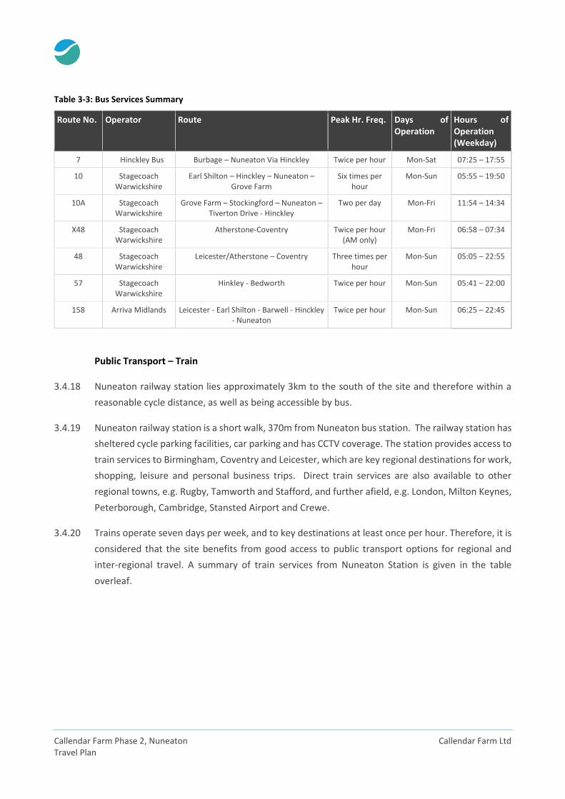
Callendar Farm Phase 2, Nuneaton Callendar Farm Ltd Travel Plan
Table 3-3: Bus Services Summary
Route No. Operator Route Peak Hr. Freq. Days of Operation
Hours of Operation (Weekday)
7 Hinckley Bus Burbage – Nuneaton Via Hinckley Twice per hour Mon-Sat 07:25 – 17:55
10 Stagecoach Warwickshire
Earl Shilton – Hinckley – Nuneaton – Grove Farm
Six times per hour
Mon-Sun 05:55 – 19:50
10A Stagecoach Warwickshire
Grove Farm – Stockingford – Nuneaton – Tiverton Drive - Hinckley
Two per day Mon-Fri 11:54 – 14:34
X48 Stagecoach Warwickshire
Atherstone-Coventry Twice per hour (AM only)
Mon-Fri 06:58 – 07:34
48 Stagecoach Warwickshire
Leicester/Atherstone – Coventry Three times per hour
Mon-Sun 05:05 – 22:55
57 Stagecoach Warwickshire
Hinkley - Bedworth Twice per hour Mon-Sun 05:41 – 22:00
158 Arriva Midlands Leicester - Earl Shilton - Barwell - Hinckley - Nuneaton
Twice per hour Mon-Sun 06:25 – 22:45
Public Transport – Train
3.4.18 Nuneaton railway station lies approximately 3km to the south of the site and therefore within a
reasonable cycle distance, as well as being accessible by bus.
3.4.19 Nuneaton railway station is a short walk, 370m from Nuneaton bus station. The railway station has
sheltered cycle parking facilities, car parking and has CCTV coverage. The station provides access to
train services to Birmingham, Coventry and Leicester, which are key regional destinations for work,
shopping, leisure and personal business trips. Direct train services are also available to other
regional towns, e.g. Rugby, Tamworth and Stafford, and further afield, e.g. London, Milton Keynes,
Peterborough, Cambridge, Stansted Airport and Crewe.
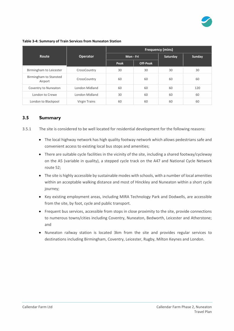
3.4.20 Trains operate seven days per week, and to key destinations at least once per hour. Therefore, it is
considered that the site benefits from good access to public transport options for regional and
inter-regional travel. A summary of train services from Nuneaton Station is given in the table
overleaf.
Callendar Farm Ltd Callendar Farm Phase 2, Nuneaton Travel Plan
Table 3-4: Summary of Train Services from Nuneaton Station
Route Operator
Frequency (mins)
Mon - Fri Saturday Sunday
Peak Off-Peak
Birmingham to Leicester CrossCountry 30 30 30 30
Birmingham to Stansted Airport
CrossCountry 60 60 60 60
Coventry to Nuneaton London Midland 60 60 60 120
London to Crewe London Midland 30 60 60 60
London to Blackpool Virgin Trains 60 60 60 60
3.5 Summary
3.5.1 The site is considered to be well located for residential development for the following reasons:
The local highway network has high quality footway network which allows pedestrians safe and
convenient access to existing local bus stops and amenities;
There are suitable cycle facilities in the vicinity of the site, including a shared footway/cycleway
on the A5 (variable in quality), a stepped cycle track on the A47 and National Cycle Network
route 52;
The site is highly accessible by sustainable modes with schools, with a number of local amenities
within an acceptable walking distance and most of Hinckley and Nuneaton within a short cycle
journey;
Key existing employment areas, including MIRA Technology Park and Dodwells, are accessible
from the site, by foot, cycle and public transport.
Frequent bus services, accessible from stops in close proximity to the site, provide connections
to numerous towns/cities including Coventry, Nuneaton, Bedworth, Leicester and Atherstone;
and
Nuneaton railway station is located 3km from the site and provides regular services to
destinations including Birmingham, Coventry, Leicester, Rugby, Milton Keynes and London.
Callendar Farm Phase 2, Nuneaton Callendar Farm Ltd Travel Plan
4 Proposed Development
4.1 Development Mix
4.1.1 The development proposals are as follows:
Up to 850 dwellings – a mixture of sizes and types including affordable housing;
New two form entry primary school;
Community Hub/Local Centre;
Open Space for both active and passive recreation; and
Retention and enhancement of existing boundary trees and hedgerows.
4.2 Vehicular Access Strategy
4.2.1 Two primary vehicular access points will be provided:
A new three-arm signal controlled junction onto the A47 Long Shoot (an upgrade of the priority
access permitted as part of Phase 1); and
A new three-arm signal controlled junction on the A5.
4.2.2 Given the surrounded permitted developments, a further link into the proposed development
would occur via the Bellway Homes development which forms an access onto the A47 Long Shoot
approx. 500m to the south of the proposed access.
4.3 Internal Road Layout
4.3.1 As part of the comprehensive masterplan, the site accommodates the route of the Northern
Distributor Road and will enable connections to adjacent parcels of the development. The two
primary access points will connect via an internal principal street, which is designed to facilitate the
delivery of the Draft Nuneaton and Bedworth Borough Plan.
4.3.2 As the application is outline, the alignment and design details are not considered at this stage,
however, it is anticipated that the principal street specification will as follows:
Minimum 6.75m vehicle carriageway; and
2m verges on either side of carriageway;
3.5m shared footway/cycleway; and
2m footway.
Callendar Farm Ltd Callendar Farm Phase 2, Nuneaton Travel Plan
4.3.3 A connection to the Bellway Homes development, via Callendar Farm Phase 1 links to the principal
street and has the following specification:
Minimum 6m carriageway; and
2m footway on both sides.
4.4 Multi-modal trip generation
4.4.1 The development is predicted to generate the following level of peak hour trips, based on current
model split percentages, extracted from the 2011 Census for the St Nicolas Ward.
Table 4-1: Multi-modal trip generation
Land Use AM Peak (08:00-09:00) PM Peak (17:00-18:00)
Arrivals Departures Arrivals Departures
Train 4 12 12 7
Bus 2 6 6 3
Taxi 0 1 1 0
Car Driver 126 343 330 194
Car Passenger 8 21 20 12
Motorcycle 1 3 3 2
Bicycle 3 8 8 5
On foot 13 35 34 20
Other 0 1 1 0
Total 158 431 414 243
4.5 Parking Provision
4.5.1 As the application is only in outline, the number and design of parking spaces has yet to be
determined. It is proposed that both car and cycle parking for the site will be agreed with each
reserved matters application.
Callendar Farm Phase 2, Nuneaton Callendar Farm Ltd Travel Plan
5 Movement Strategy
5.1 Introduction
5.1.1 A movement strategy has been developed to promote and encourage sustainable travel to and
from the site, via public transport, walking and cycling.
5.2 Public Transport
5.2.1 A public transport strategy has been developed in liaison with WCC. At this stage, the aim of the
public transport strategy is to ensure that there is at least one public transport option that:
Meets policy requirements;
Is appropriate the expected travel demands arising from the development;
Is physically deliverable;
Would be financially sustainable when the development is completed; and
Is financially affordable for the development to fund during the build-out period.
5.2.2 Following a review of the existing accessibility of the site via public transport and initial positive
discussions with WCC’s Public Transport team, it is proposed that one of the existing Nuneaton bus
services is diverted into the site.
5.2.3 WCC Public Transport team has identified that:
The development is to be served by a bus service running through the site during the core
bus travel period, i.e. Working Weekdays 7am to 7pm and Saturdays 8am to 6pm;
The service should operate at a minimum of two departures per hour in each direction;
The service should run between Hinckley town centre and Nuneaton town centre, and
possibly points beyond at either or both ends, in order that it should have a sufficient
patronage base to be commercially viable from fare revenue; and
The development's internal highway layout should be configured to allow a bus service to
run through to that part of the Local Plan proposed allocation to the west, to enable a bus
service to serve the whole of HSG1 should have be the preferable service pattern at a later
stage in development.
5.2.4 Two staged service options have been identified, and positive discussions have been held with the
operators to confirm they are, in principle, happy to divert existing bus services. The services
identified are:
Callendar Farm Ltd Callendar Farm Phase 2, Nuneaton Travel Plan
Arriva [Hinckley Bus] service 7 Burbage – Hinckley – Nuneaton town centre – George Eliot
Hospital; and
Stagecoach service 10 Earl Shilton – Hinckley – Nuneaton town centre – Stockingford.
5.2.5 Figure 5-1 illustrates the potential routing options of these services, based on a two staged
approach, whereby the development and link between the A47 Long Shoot and the A5 is partially
built and fully built.
Figure 5-1: Potential Bus Service Options
5.2.6 The options presented above would provide frequent public transport services within an acceptable
walking distance of all dwellings on site.
5.2.7 The public transport strategy note includes an indicative financial appraisal of the bus service
options, which identifies that the service options are likely to be financially viable. However, it is
noted that post-application discussions will be held with WCC’s Public Transport team and the
network operators to establish the final strategy, highway configuration and financial appraisal.
Callendar Farm Phase 2, Nuneaton Callendar Farm Ltd Travel Plan
5.3 Pedestrian and Cycle Strategy
5.3.1 The safety, attractiveness and accessibility of pedestrian and cycle movements will be improved as
follows:
Principal Street
5.3.2 The primary access corridor running through the site will incorporate:
A 3.5m shared footway/cycleway (separated from the carriageway by a 2m wide verge); and
A 2m wide footway on the opposite side of the carriageway.
A5 Watling Street
5.3.3 Within the extents of the A5 site access design, the following improvements will be provided:
Widen the shared footway/cycleway on the northern side of the A5, to a minimum of 2.5m. This
will be aided, in part, by the removal of the two existing laybys. All widening will be within the
highway boundary controlled by HE;
Incorporate a toucan crossing on all arms (with central refuge islands) of the A5 site access
junction, facilitating the movement of pedestrians and cyclists between the principal street
within the site and the widened shared footway/cycleway.
A47 Long Shoot
5.3.4 The A47 Long Shoot is the primary highway in the north-east of Nuneaton, and provides an
important route between Nuneaton and Hinckley. As such, it forms a key movement corridor
between the two towns.
5.3.5 Following discussions with WCC, it is understood that the A47 Long Shoot is already identified as a
route for development in Warwickshire County Council’s cycle plan for Nuneaton & Bedworth. A
National Cycle Route is proposed along the western edge of the Long Shoot, forming a shared
footway/cycleway. As such, the strategic route will be facilitated by incorporating a toucan crossing
over the A47 Long Shoot site access arm.
5.3.6 It is also understood that WCC will seek contributions from developers towards the delivery of the
strategic cycle route, this is acknowledged and is acceptable in principle to the applicant.
Public Right of Way N30
5.3.7 Public Right of Way N30 currently spans the western boundary of the site. It is anticipated that the
section of the route within the site red line boundary will be upgraded into a suitable pedestrian
Callendar Farm Ltd Callendar Farm Phase 2, Nuneaton Travel Plan
and cycle facility, to allow permeability to local facilities within the residential areas to the west of
the site. Furthermore, the provision of this link to the west facilitates safe and attractive cycle
routes between the site and Nuneaton railway station.
Further Pedestrian Routes Within the Site
5.3.8 Several traffic-free routes will permeate the site, including:
A ‘Trim Trail Green Walk’ that circulates the centre of the site;
A foot/cycle ‘Green Link’ that connects the centre of the site to both Callendar Farm Phase 1
and Bellway Phase 2 to the south of the site;
A foot/cycle ‘Green Link’ that connects the centre of the site to Footpath N30 and the pedestrian
site access onto Gloucester Close in the south west corner of the site;
A foot/cycle ‘Green Link’ that connects the centre of the site to Footpath N30 to the west of the
site; and
A foot/cycle ‘Green Link’ that connect the centre of the site to Footpath N30 and the link into
the proposed Persimmon Homes development in the north-west corner of the site.
Callendar Farm Phase 2, Nuneaton Callendar Farm Ltd Travel Plan
6 Travel Plan Management and Coordination
6.1 Introduction
6.1.1 This section sets out guidance for the management and co-ordination of the Travel Plan.
6.2 Travel Plan Coordinator
6.2.1 It will be fundamental to the success of the Travel Plan that sufficient resources are allocated to
develop and implement the measures in the plan; this will be the responsibility of the Travel Plan
Coordinator (TPC). It is anticipated that the TPC role will be undertaken by a member of the sales
staff team initially before an appropriate TPC is appointed.
6.2.2 The TPC will be appointed by the developer prior to the occupation of the first dwelling to ensure
that the Travel Plan is established and engrained into the development from the beginning. The
TPC will remain in the role for a period of five years post first occupation.
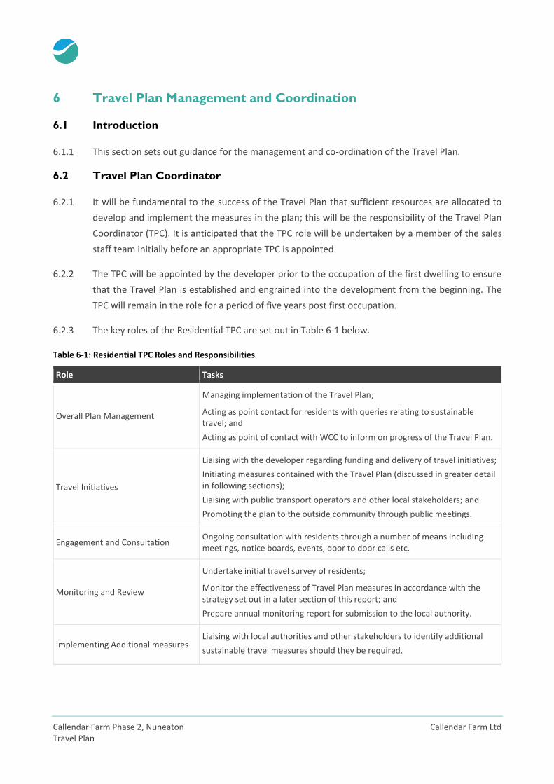
6.2.3 The key roles of the Residential TPC are set out in Table 6-1 below.
Table 6-1: Residential TPC Roles and Responsibilities
Role Tasks
Overall Plan Management
Managing implementation of the Travel Plan;
Acting as point contact for residents with queries relating to sustainable travel; and
Acting as point of contact with WCC to inform on progress of the Travel Plan.
Travel Initiatives
Liaising with the developer regarding funding and delivery of travel initiatives;
Initiating measures contained with the Travel Plan (discussed in greater detail in following sections);
Liaising with public transport operators and other local stakeholders; and
Promoting the plan to the outside community through public meetings.
Engagement and Consultation Ongoing consultation with residents through a number of means including meetings, notice boards, events, door to door calls etc.
Monitoring and Review
Undertake initial travel survey of residents;
Monitor the effectiveness of Travel Plan measures in accordance with the strategy set out in a later section of this report; and
Prepare annual monitoring report for submission to the local authority.
Implementing Additional measures Liaising with local authorities and other stakeholders to identify additional
sustainable travel measures should they be required.
Callendar Farm Ltd Callendar Farm Phase 2, Nuneaton Travel Plan
6.3 Travel Plan Liaison
6.3.1 The TPC will liaise regularly with WCC to ensure the Travel Plan is implemented effectively. When
appointed, the contact details of the TPC including a postal address, telephone number and email
address will be supplied to WCC at the earliest possible date.

Callendar Farm Phase 2, Nuneaton Callendar Farm Ltd Travel Plan
7 Travel Plan Initiatives and Action Plan
7.1 Travel Plan Measures
7.1.1 In order to meet the aims and objectives for sustainable travel set out in this Travel Plan, a number
of measures will be implemented. The proposed measures are split into the following categories:
Measures to promote and encourage walking and cycling;
Measures to promote and encourage public transport use;
Measures to promote and encourage car sharing;
Measures to reduce the need to travel;
Marketing and Promotional Measures;
Personalised Travel Planning; and
Smart Phone Apps.
7.1.2 The majority of measures will be aimed at promoting and encouraging the use of existing and
proposed travel facilities in the area (walking, cycling and public transport), but also car sharing
where appropriate. Measures to promote and encourage each form of sustainable travel mode are
outlined in more detail below.
7.2 Measures to Promote and Encourage Walking and Cycling
7.2.1 The following measures are to be implemented to promote and encourage residents to walk and
cycle from the proposed development:
Local maps showing walking routes, which will be disseminated through the welcome pack
outlined under the marketing and promotional measures section;
Information on local and national walking events, such as Walk to Work Week, disseminated
through the welcome pack;
Website links to the County Council’s sustainable travel webpage, and links to national websites
such as SUSTRANS, disseminated through the welcome pack;
Information on Bicycle User Groups (BUG) that may be operating within the local area,
disseminated through the welcome pack. The Travel Plan Coordinator will also look to set up a
BUG for the site. This will encourage potential cyclists to cycle for journeys within an 8km radius;
Information on cycling events such as ‘National Bike Week’, disseminated through the welcome
pack; and
Information on the economic, social, environmental and health benefits of cycling, disseminated
through the Welcome Pack.
Callendar Farm Ltd Callendar Farm Phase 2, Nuneaton Travel Plan
7.3 Measures to Promote and Encourage Public Transport Use
7.3.1 In order to maximise the benefits of the site’s location in terms of proximity to bus services,
including the potential diversion of an existing service through the development, the TPC will have
the responsibility to ensure that current bus timetables and associated information are readily
available to all residents.
7.3.2 The following measures are to be implemented to promote and encourage residents to use public
transport when travelling to and from the proposed development:
Links to journey planning websites such as Traveline, disseminated through the welcome pack;
Bus route maps and timetables disseminated through the welcome pack; and
Information on the benefits of public transport use disseminated through the Welcome Pack.
7.4 Measures to Promote and Encourage Car Sharing
7.4.1 Car sharing can be an effective means of easing traffic congestion and facilitating the achievement
of sustainable travel objectives. For residents with common journey requirements, car sharing can
represent an effective mechanism for reducing the volume of trips to and from work, school, and/or
recreational activities.
7.4.2 The following measures are to be implemented to promote and encourage residents to car share:
Information on the free to use public car sharing schemes including Warwickshire ‘Liftshare’
(https://carsharewarwickshire.liftshare.com/), enabling potential car share users to get in touch
with each other will be disseminated through the welcome pack;
Information on what car sharing is and its potential benefits, will be disseminated through the
welcome pack; and
Information on ‘car sharing’ events such as Liftshare week, will be disseminated through the
welcome pack.
7.5 Measures to Reduce the Need to Travel
7.5.1 Encouraging home working where appropriate can be effective in reducing traffic congestion and
facilitating the achievement of sustainable travel objectives. The following measures are to be
implemented to facilitate and encourage residents of the proposed development to work from
home:
Infrastructure for broadband access will be provided to facilitate remote home working; and
Callendar Farm Phase 2, Nuneaton Callendar Farm Ltd Travel Plan
Information on what home working is and its potential benefits, will be disseminated through
the welcome pack.
7.6 Marketing and Promotion of the Travel Plan Measures
7.6.1 In order to deliver the behavioural change required to meet the targets, there will need to be a
sustained commitment to communicating and marketing the Travel Plan objective to the residents
of the proposed development.
7.6.2 Welcome Packs will be made available to all new residents immediately on occupation to ensure
that they have all the information to make their travel choices before habits for using the car are
formed.
7.6.3 The packs will include the following:
Details on the Travel Plan and its purpose;
Contact details of the Travel Plan Coordinator;
Information leaflets on the benefits of adopting more sustainable travel practices;
Details of any incentives;
Local walking and cycling route maps where appropriate;
A map showing key local facilities and amenities;
Information on local Bicycle User Groups that may be operating in the local area and details of
opportunities to join a dedicated site Bicycle User Group;
Information on public transport services including schedules and maps;
Information on key sustainable travel events such as ‘National Bike Week’ and ‘Liftshare Week’;
Information and marketing material on relevant car share schemes;
Information on the social, environmental, but particularly economic, and health benefits of
travelling by sustainable modes, as evidence has shown these are the most effective;
Information on home delivery services;
Information on working at home and its potential benefits;
Website links to, for example, the County Council’s sustainable travel page and national
websites such as SUSTRANS; and
Feedback survey forms.
Callendar Farm Ltd Callendar Farm Phase 2, Nuneaton Travel Plan
7.7 Personalised Travel Planning
7.7.1 Personalised travel planning is a process where, working with households, individualised travel
marketing and tailor-made information on sustainable travel in their local area is provided, enabling
people to walk, cycle, car share and use public transport more often. It delivers measurable and
sustained reductions in car use by enabling people to make a few changes to their daily travel
choices when and where it suits them best. It is envisaged that personalised travel planning will be
delivered in a web-based format and administered by the TPC.
7.8 Smartphone Apps
7.8.1 Residents will be made aware of numerous smartphone apps such as National Rail Enquiries,
National Cycle Network, Walkit and MapMyRide. These apps can help plan/map out journeys via
foot, cycle and public transport within the local area.
National Rail Enquiries
This app gives real time departure and arrivals at any Railway Station in the UK. Select your
favourite stations and plan your rail journey.
CycleStreets:
Cycle journey planner with clear itinerary and maps. Add your photos of cycle-related
problems and good practice.
National Cycle Network:
Travel on 25,000 miles of the walking and cycling network. Find your nearest cycle route; see
this on a clear map with local points of interest such as schools, shops, sports facilities. See bus
stops and find stop codes to text for details of next arriving bus.
MapMyRide:
Live route map with distance, elevation, calories burnt and Voice prompts. Search common
rides and post times and records to twitter and Facebook. Register with www.mapmyride.com
to join sponsored challenges, connect with other riders and win prizes for riding.
Callendar Farm Phase 2, Nuneaton Callendar Farm Ltd Travel Plan
Strava Cycling:
Top rated app. Track your rides. See your progress. Compare your performance against others,
disaggregated by age and weight. Join sponsored challenges. Register with www.strava.com.
Walk4Life:
Plan your walk on a map. Record and save your favourite walks, as you walk. Measure walk
duration, distance, speed, calories burnt. Register online with www.walk4life.info. Set new local
walks, join in walk events, take up challenges and add photos of interesting things.

Callendar Farm Ltd Callendar Farm Phase 2, Nuneaton Travel Plan
8 Targets and Monitoring
8.1 Introduction
8.1.1 The overall Travel Plan objective for the development is to reduce the number of single occupancy
car journeys. This chapter provides an indication as to the overall impact that this Travel Planning
could have on reducing car trips.
8.2 Travel Plan Targets
8.2.1 Targets are used to monitor whether the Travel Plan is meeting its objectives. These targets are
‘SMART’ in nature:
Specific, to say precisely what is being achieved;
Measurable over the duration of the target;
Appropriate and linked the overall objectives of the local authority accessibility strategy;
Realistic in terms of the potential for being achieved; and
Time bound - the target must define a date by which it is expected to be achieved.
8.2.2 It is considered that an appropriate ‘SMART’ target for the Travel Plan would be a 10% reduction in
single occupancy car journeys over a five-year period. Targets have therefore been calculated based
on a 10% reduction in predicted trip generation.
8.3 Trip Generation, Targets and Modal Share
8.3.1 The Transport Assessment sets out the predicted vehicle trip generation estimates for the
development. These are summarised in the table overleaf along with the relevant 10% trip
reduction targets.
Callendar Farm Phase 2, Nuneaton Callendar Farm Ltd Travel Plan
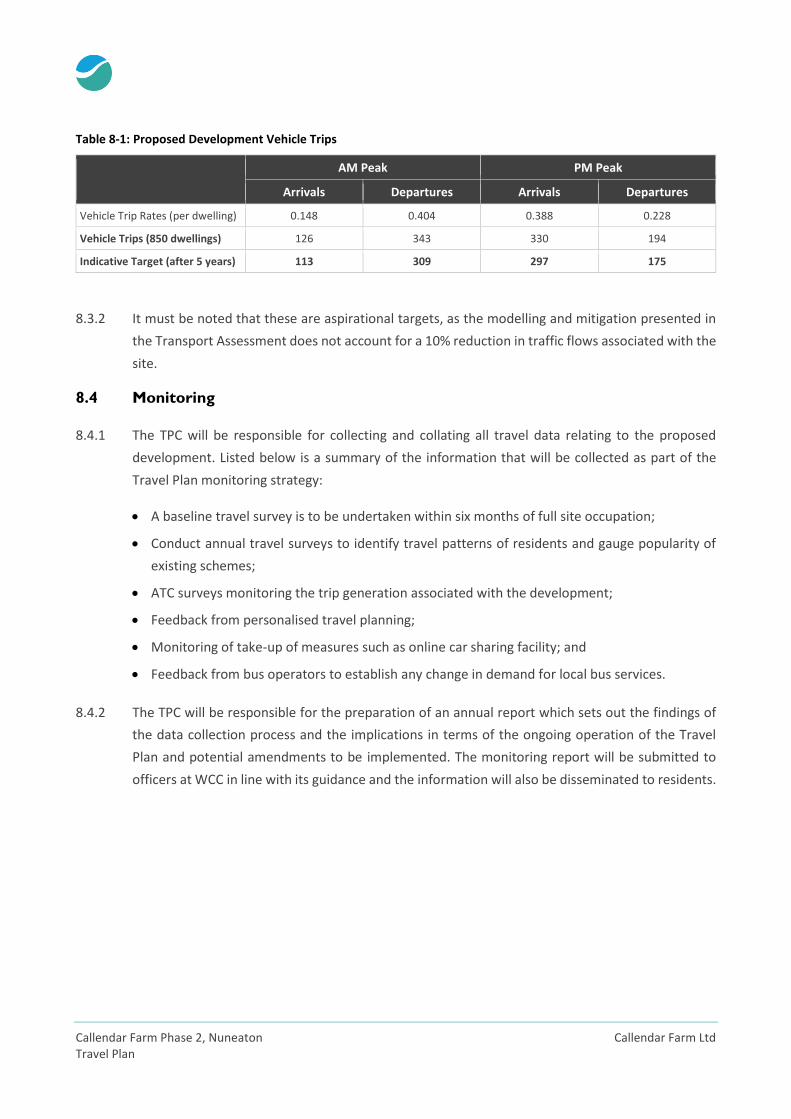
Table 8-1: Proposed Development Vehicle Trips
AM Peak PM Peak
Arrivals Departures Arrivals Departures
Vehicle Trip Rates (per dwelling) 0.148 0.404 0.388 0.228
Vehicle Trips (850 dwellings) 126 343 330 194
Indicative Target (after 5 years) 113 309 297 175
8.3.2 It must be noted that these are aspirational targets, as the modelling and mitigation presented in
the Transport Assessment does not account for a 10% reduction in traffic flows associated with the
site.
8.4 Monitoring
8.4.1 The TPC will be responsible for collecting and collating all travel data relating to the proposed
development. Listed below is a summary of the information that will be collected as part of the
Travel Plan monitoring strategy:
A baseline travel survey is to be undertaken within six months of full site occupation;
Conduct annual travel surveys to identify travel patterns of residents and gauge popularity of
existing schemes;
ATC surveys monitoring the trip generation associated with the development;
Feedback from personalised travel planning;
Monitoring of take-up of measures such as online car sharing facility; and
Feedback from bus operators to establish any change in demand for local bus services.
8.4.2 The TPC will be responsible for the preparation of an annual report which sets out the findings of
the data collection process and the implications in terms of the ongoing operation of the Travel
Plan and potential amendments to be implemented. The monitoring report will be submitted to
officers at WCC in line with its guidance and the information will also be disseminated to residents.
Callendar Farm Ltd Callendar Farm Phase 2, Nuneaton Travel Plan
9 Action Plan
9.1 Action Plan
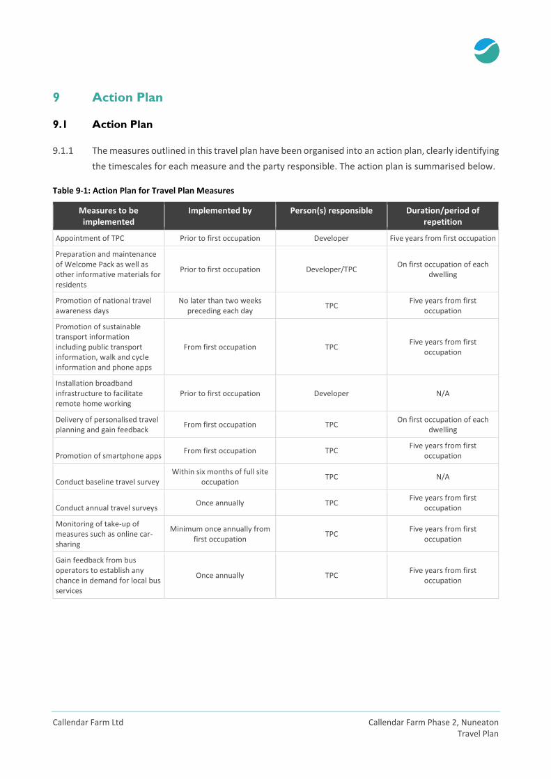
9.1.1 The measures outlined in this travel plan have been organised into an action plan, clearly identifying
the timescales for each measure and the party responsible. The action plan is summarised below.
Table 9-1: Action Plan for Travel Plan Measures
Measures to be implemented
Implemented by Person(s) responsible Duration/period of repetition
Appointment of TPC Prior to first occupation Developer Five years from first occupation
Preparation and maintenance of Welcome Pack as well as other informative materials for residents
Prior to first occupation Developer/TPC On first occupation of each
dwelling
Promotion of national travel awareness days
No later than two weeks preceding each day
TPC Five years from first
occupation
Promotion of sustainable transport information including public transport information, walk and cycle information and phone apps
From first occupation TPC Five years from first
occupation
Installation broadband infrastructure to facilitate remote home working
Prior to first occupation Developer N/A
Delivery of personalised travel planning and gain feedback
From first occupation TPC On first occupation of each
dwelling
Promotion of smartphone apps From first occupation TPC
Five years from first occupation
Conduct baseline travel survey Within six months of full site
occupation TPC N/A
Conduct annual travel surveys Once annually TPC
Five years from first occupation
Monitoring of take-up of measures such as online car-sharing
Minimum once annually from first occupation
TPC Five years from first
occupation
Gain feedback from bus operators to establish any chance in demand for local bus services
Once annually TPC Five years from first
occupation