cadd systems & services pvt. ltd. corporate profile.pdf · cadd systems & services pvt....
TRANSCRIPT
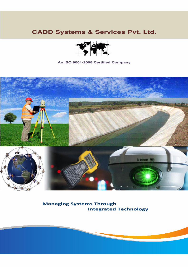
An ISO 9001-2008 Certified Company
Managing Systems Through
Integrated Technology
CADD Systems & Services Pvt. Ltd.

CADDCADDCADDCADD SystemsSystemsSystemsSystems &&&& ServicesServicesServicesServices Pvt.Pvt.Pvt.Pvt. Ltd.Ltd.Ltd.Ltd. (CSSPL)(CSSPL)(CSSPL)(CSSPL)
Integration of Experienced Professionals
The company is alsospecialized in developingAutomatic Crime MappingSystem and other softwaresolutions of Law andEnforcement.
CSSPL is a "Preeminent"company focused on the long-term growth and developmentneeded to deliver customersuccess year after year.
CSSPL Clients are thebeneficiaries of the Company’sunmatched commitment to theSEI CMM level. Our softwaredevelopment, maintenance andoutsourcing customers rely on ussustained track record ofdelivering high-quality, majorsoftware projects on time and onbudget
We are committed to thework and clients. Our aim isto build long-termpartnerships/alliance withour clients with the beliefthat their comfort is the keyto our success.
An ISO 9001-2008 Company
IntroductionIntroductionIntroductionIntroduction…………
CSSPL began operation inthe year 2001 with the aim toprovide Civil Consultancy& Survey to the industry anddevelop better softwaresolutions for them.
Today we are into variousbusiness areas such asTopographical Survey,Supervision & QualityControl, Web GIS/MISSoftware Development,DGPS Survey, Datacollection, Help Desk,Corporate Training, WebApplication Development,and ERP Implementation.

CSSPL mission is to provide totalend-to-end solutions withInformation and CommunicationTechnology which covers entiregamut of services ranging fromSurvey, Analysis, GIS SoftwareDevelopment, Web Integrationand Networking.
MissionMissionMissionMission…………
We intend to provide productsthat stand head and shouldersabove the rest, delivering thedesired impact upon ourcustomers and their targetaudiences to be:
- Global company of highrepute, working on cutting-edge technologies anddelivering high-qualitysolutions and products tobusinesses all across theIndia & World.
- Company, which challengesits people to continually gobeyond their limits ofthought and action, and insuch endeavor have itspeople derive satisfactionfrom the fulfillment of thetasks assigned to them.
What comes from the people must
go back to the people many times over…

The perfect solution,this is our mainapproach in WEB-GISAPPLICATIONDEVELOPMENT andINTEGRATION that weare proposing to mostof our clients, toprovide quick andsecure access to theright informationanytime within thedepartment ororganization anywherein the world — and thatcalls for SYSTEMINTEGRATION.
We have newstandards forintegrating hundreds ofdistributedheterogeneous legacysystems and creatingbetter access toinformation. Integratedsystems we designedand implemented havewon accolades and bigcost savings for bothour government andcommercial clients.
CSSPL combines time-proven systemsintegration expertisewith moderntechnologies to helpour clients keep pacewith change. Oursoftware tools that helpenterprises achievesoftware and dataintegration.
We believe that thesetechnologies present thefoundation for new andsuccessful businessprocesses and/orprocesses that useinformation technologyto achieve strategicadvantage and offersmany advantages
As one of the successfulsystem integrators in thefield of Information andCommunicationTechnology, CSSPLhas crafted customizedsolutions to complexintegration problems fora diverse range ofclients.
We understand thatevery organization musthave a strategy that isfocused on near-termbusiness results andalso responsive to thedynamic organizationallandscape and rapidlyemerging competitivethreats.
Our Strategy Consultingservices are designed toassist our customers torapidly progress fromstrategy to results.
ApproachApproachApproachApproach…………
We utilize RAPID PROTOTYPING as theconnection between strategy formationand implementation planning to providevisual linkages between e-Government ore-Business objectives and theimplementation of your initiatives.
Our services are provided byseasoned professionals who haveyears of practical experiencedelivering best solutions for customInternet applications to support ourclients’ operational excellence.
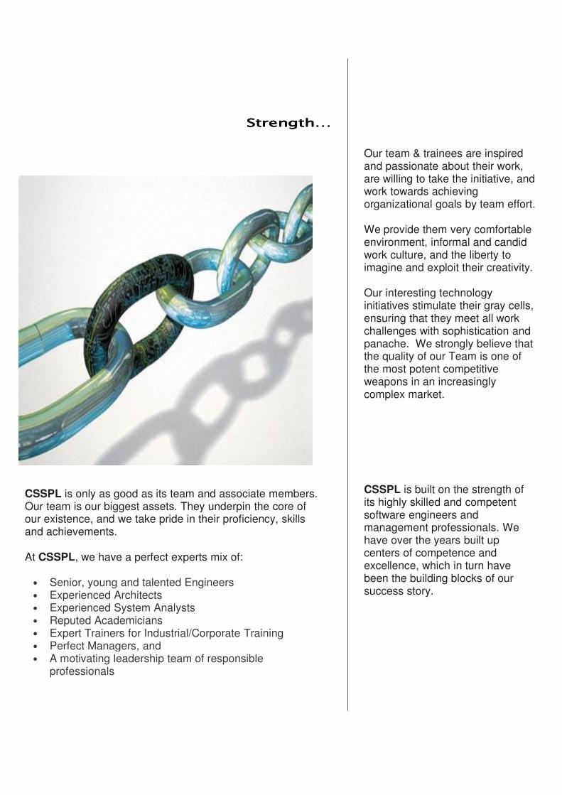
StrengthStrengthStrengthStrength…………
CSSPL is only as good as its team and associate members.Our team is our biggest assets. They underpin the core ofour existence, and we take pride in their proficiency, skillsand achievements.
At CSSPL, we have a perfect experts mix of:
• Senior, young and talented Engineers• Experienced Architects• Experienced System Analysts• Reputed Academicians• Expert Trainers for Industrial/Corporate Training• Perfect Managers, and• A motivating leadership team of responsible
professionals
Our team & trainees are inspiredand passionate about their work,are willing to take the initiative, andwork towards achievingorganizational goals by team effort.
We provide them very comfortableenvironment, informal and candidwork culture, and the liberty toimagine and exploit their creativity.
Our interesting technologyinitiatives stimulate their gray cells,ensuring that they meet all workchallenges with sophistication andpanache. We strongly believe thatthe quality of our Team is one ofthe most potent competitiveweapons in an increasinglycomplex market.
CSSPL is built on the strength ofits highly skilled and competentsoftware engineers andmanagement professionals. Wehave over the years built upcenters of competence andexcellence, which in turn havebeen the building blocks of oursuccess story.
•MPPWD
•MPAKVN
•NHDC
•NVDA
•NWDA
•MPWRD
•MPRRDA
•PMGSY
•MPRDC
•MPPCB
•MP Housing Board
•Western Railways
•Airport Authority of India
•Municipal Corporations
•Indore Development Authority
•MAHINDRA Two Wheeler'sLtd.
•TCS Ltd.
•SSA Mission, Gujarat
•NTPC
•Reliance
•Airtel
•L&T
•SAHARA
•BSNL
•OMAXE
•LASA
•IPCL
•STUP Consultants
•RITES Ltd.
•IIM, Indore
•NCCGL
•IVRCL
•e-gisIndia
•TRANSSTROY
and many more…
Our Prestigious Clients
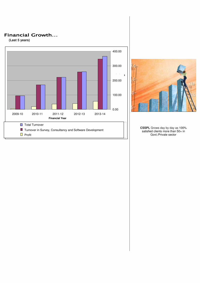
FinancialFinancialFinancialFinancial GrowthGrowthGrowthGrowth…………(Last 5 years)
0.00
100.00
200.00
300.00
400.00
2011-122010-112009-102008-092007-08
Financial Year
In Lacs
Total Turnover (in Lacs)
Turnover in Survey/Geospatial Services Business (in Lacs)
Profit (in Lacs)
CSSPL Grows day by day as 100%satisfied clients more than 50+ in
Govt./Private sector
2009-10 2010-11 2011-12 2012-13 2013-14
Total Turnover
Turnover in Survey, Consultancy and Software Development
Profit
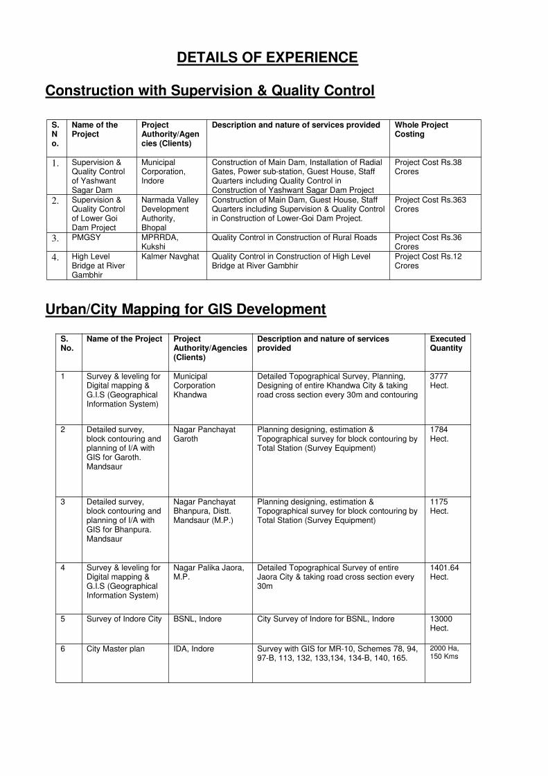
DETAILS OF EXPERIENCE
Construction with Supervision & Quality Control
Urban/City Mapping for GIS Development
S.No.
Name of theProject
ProjectAuthority/Agencies (Clients)
Description and nature of services provided Whole ProjectCosting
1. Supervision &Quality Controlof YashwantSagar Dam
MunicipalCorporation,Indore
Construction of Main Dam, Installation of RadialGates, Power sub-station, Guest House, StaffQuarters including Quality Control inConstruction of Yashwant Sagar Dam Project
Project Cost Rs.38Crores
2. Supervision &Quality Controlof Lower GoiDam Project
Narmada ValleyDevelopmentAuthority,Bhopal
Construction of Main Dam, Guest House, StaffQuarters including Supervision & Quality Controlin Construction of Lower-Goi Dam Project.
Project Cost Rs.363Crores
3. PMGSY MPRRDA,Kukshi
Quality Control in Construction of Rural Roads Project Cost Rs.36Crores
4. High LevelBridge at RiverGambhir
Kalmer Navghat Quality Control in Construction of High LevelBridge at River Gambhir
Project Cost Rs.12Crores
S.No.
Name of the Project ProjectAuthority/Agencies(Clients)
Description and nature of servicesprovided
ExecutedQuantity
1 Survey & leveling forDigital mapping &G.I.S (GeographicalInformation System)
MunicipalCorporationKhandwa
Detailed Topographical Survey, Planning,Designing of entire Khandwa City & takingroad cross section every 30m and contouring
3777Hect.
2 Detailed survey,block contouring andplanning of I/A withGIS for Garoth.Mandsaur
Nagar PanchayatGaroth
Planning designing, estimation &Topographical survey for block contouring byTotal Station (Survey Equipment)
1784Hect.
3 Detailed survey,block contouring andplanning of I/A withGIS for Bhanpura.Mandsaur
Nagar PanchayatBhanpura, Distt.Mandsaur (M.P.)
Planning designing, estimation &Topographical survey for block contouring byTotal Station (Survey Equipment)
1175Hect.
4 Survey & leveling forDigital mapping &G.I.S (GeographicalInformation System)
Nagar Palika Jaora,M.P.
Detailed Topographical Survey of entireJaora City & taking road cross section every30m
1401.64Hect.
5 Survey of Indore City BSNL, Indore City Survey of Indore for BSNL, Indore 13000Hect.
6 City Master plan IDA, Indore Survey with GIS for MR-10, Schemes 78, 94,97-B, 113, 132, 133,134, 134-B, 140, 165.
2000 Ha,150 Kms

Software Development / Web-GIS Projects
S.No.
Name of theProject
ProjectAuthority/Agencies(Clients)
Description and nature of servicesprovided
ExecutedQuantity
1 a ConsultancyServices forWeb-enabledMap-basedWaterManagementSystem forNarmada Basin
NVDA, Bhopal.
Software/Web-GIS Development forNVDA including Data collection from allWRDn comes in Narmada Basin, GISMapping of all Major/Medium/MinorProjects including WSS and LIS.Observed flow of Narmada at 6 diff.cardinal Sites on Web-based WaterManagement System. Narmada Riversurvey using motor boats and vehicles forcounting of private pumps installed onboth banks of holy river Narmada and itstributaries. Digitization of sub-basinboundaries of Narmada basin withtributaries with local nala & commandarea of Major and Medium sizeDams/Projects.
85149Sq. km
b Establishedwell equippedData Center atNVDA, Bhopal
NVDA, Bhopal Established a well equipped Data Centerfor NVDA, Bhopal including preparationof Hardware & Softwarerequirement/specifications with leasedline Internet required for hassle freeoperations.
c TrainingScheduled forDepartmentOfficials
NVDA, Bhopal Corporate Training scheduled & providedto NVDA officials for better monitoringand management.
180Officials
2 Help Deskservices toTCS Ltd.
Bhopal (M.P.) Profession Services for implementation ofe-Procurement application software withTeam of Helpdesk and Trainings for MPe-Procurement for 5 years.
All GovtDepartments inMadhyaPradesh.
3 Web-GISSoftware forMPAKVN
Indore (MP) Design, Survey & Development of Web-GIS for ISEZ Pithampur includingCrystal IT Park for MPAKVN(I) Ltd.including training to department officials
1100Hect
4 MonitoringSoftwaredevelopmentfor MPAKVNIndore
Indore (MP) Development of Web-GIS Software forPithampur Industrial Area Sector -1, 2,3 and Kheda for web-based monitoring.
2000Hect
5 Airtel Web-GIS Ujjain (MP) GIS System for Airtel, Ujjain 3000Hect
6 Airtel Web-GIS Dewas (MP) GIS System for Airtel, Dewas 2000Hect
7 Airtel Web-GIS Mandsour (MP) GIS System for Airtel, Mandsour 2500Hect
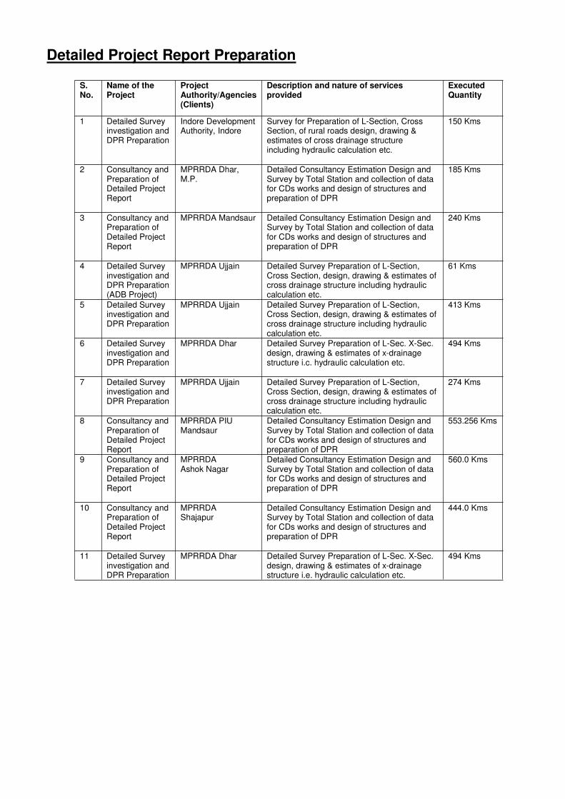
Detailed Project Report Preparation
S.No.
Name of theProject
ProjectAuthority/Agencies(Clients)
Description and nature of servicesprovided
ExecutedQuantity
1 Detailed Surveyinvestigation andDPR Preparation
Indore DevelopmentAuthority, Indore
Survey for Preparation of L-Section, CrossSection, of rural roads design, drawing &estimates of cross drainage structureincluding hydraulic calculation etc.
150 Kms
2 Consultancy andPreparation ofDetailed ProjectReport
MPRRDA Dhar,M.P.
Detailed Consultancy Estimation Design andSurvey by Total Station and collection of datafor CDs works and design of structures andpreparation of DPR
185 Kms
3 Consultancy andPreparation ofDetailed ProjectReport
MPRRDA Mandsaur Detailed Consultancy Estimation Design andSurvey by Total Station and collection of datafor CDs works and design of structures andpreparation of DPR
240 Kms
4 Detailed Surveyinvestigation andDPR Preparation(ADB Project)
MPRRDA Ujjain Detailed Survey Preparation of L-Section,Cross Section, design, drawing & estimates ofcross drainage structure including hydrauliccalculation etc.
61 Kms
5 Detailed Surveyinvestigation andDPR Preparation
MPRRDA Ujjain Detailed Survey Preparation of L-Section,Cross Section, design, drawing & estimates ofcross drainage structure including hydrauliccalculation etc.
413 Kms
6 Detailed Surveyinvestigation andDPR Preparation
MPRRDA Dhar Detailed Survey Preparation of L-Sec. X-Sec.design, drawing & estimates of x-drainagestructure i.c. hydraulic calculation etc.
494 Kms
7 Detailed Surveyinvestigation andDPR Preparation
MPRRDA Ujjain Detailed Survey Preparation of L-Section,Cross Section, design, drawing & estimates ofcross drainage structure including hydrauliccalculation etc.
274 Kms
8 Consultancy andPreparation ofDetailed ProjectReport
MPRRDA PIUMandsaur
Detailed Consultancy Estimation Design andSurvey by Total Station and collection of datafor CDs works and design of structures andpreparation of DPR
553.256 Kms
9 Consultancy andPreparation ofDetailed ProjectReport
MPRRDAAshok Nagar
Detailed Consultancy Estimation Design andSurvey by Total Station and collection of datafor CDs works and design of structures andpreparation of DPR
560.0 Kms
10 Consultancy andPreparation ofDetailed ProjectReport
MPRRDAShajapur
Detailed Consultancy Estimation Design andSurvey by Total Station and collection of datafor CDs works and design of structures andpreparation of DPR
444.0 Kms
11 Detailed Surveyinvestigation andDPR Preparation
MPRRDA Dhar Detailed Survey Preparation of L-Sec. X-Sec.design, drawing & estimates of x-drainagestructure i.e. hydraulic calculation etc.
494 Kms
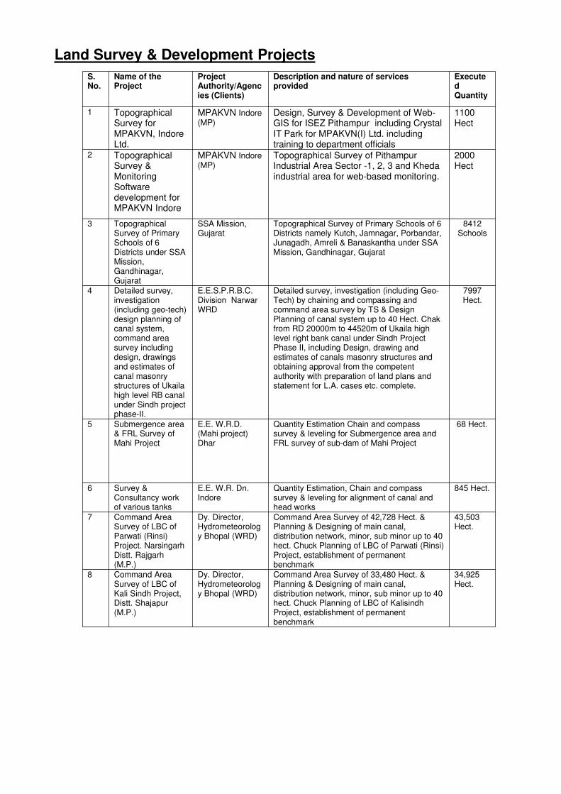
Land Survey & Development Projects
S.No.
Name of theProject
ProjectAuthority/Agencies (Clients)
Description and nature of servicesprovided
ExecutedQuantity
1 TopographicalSurvey forMPAKVN, IndoreLtd.
MPAKVN Indore(MP)
Design, Survey & Development of Web-GIS for ISEZ Pithampur including CrystalIT Park for MPAKVN(I) Ltd. includingtraining to department officials
1100Hect
2 TopographicalSurvey &MonitoringSoftwaredevelopment forMPAKVN Indore
MPAKVN Indore(MP)
Topographical Survey of PithampurIndustrial Area Sector -1, 2, 3 and Khedaindustrial area for web-based monitoring.
2000Hect
3 TopographicalSurvey of PrimarySchools of 6Districts under SSAMission,Gandhinagar,Gujarat
SSA Mission,Gujarat
Topographical Survey of Primary Schools of 6Districts namely Kutch, Jamnagar, Porbandar,Junagadh, Amreli & Banaskantha under SSAMission, Gandhinagar, Gujarat
8412Schools
4 Detailed survey,investigation(including geo-tech)design planning ofcanal system,command areasurvey includingdesign, drawingsand estimates ofcanal masonrystructures of Ukailahigh level RB canalunder Sindh projectphase-II.
E.E.S.P.R.B.C.Division NarwarWRD
Detailed survey, investigation (including Geo-Tech) by chaining and compassing andcommand area survey by TS & DesignPlanning of canal system up to 40 Hect. Chakfrom RD 20000m to 44520m of Ukaila highlevel right bank canal under Sindh ProjectPhase II, including Design, drawing andestimates of canals masonry structures andobtaining approval from the competentauthority with preparation of land plans andstatement for L.A. cases etc. complete.
7997Hect.
5 Submergence area& FRL Survey ofMahi Project
E.E. W.R.D.(Mahi project)Dhar
Quantity Estimation Chain and compasssurvey & leveling for Submergence area andFRL survey of sub-dam of Mahi Project
68 Hect.
6 Survey &Consultancy workof various tanks
E.E. W.R. Dn.Indore
Quantity Estimation, Chain and compasssurvey & leveling for alignment of canal andhead works
845 Hect.
7 Command AreaSurvey of LBC ofParwati (Rinsi)Project. NarsingarhDistt. Rajgarh(M.P.)
Dy. Director,Hydrometeorology Bhopal (WRD)
Command Area Survey of 42,728 Hect. &Planning & Designing of main canal,distribution network, minor, sub minor up to 40hect. Chuck Planning of LBC of Parwati (Rinsi)Project, establishment of permanentbenchmark
43,503Hect.
8 Command AreaSurvey of LBC ofKali Sindh Project,Distt. Shajapur(M.P.)
Dy. Director,Hydrometeorology Bhopal (WRD)
Command Area Survey of 33,480 Hect. &Planning & Designing of main canal,distribution network, minor, sub minor up to 40hect. Chuck Planning of LBC of KalisindhProject, establishment of permanentbenchmark
34,925Hect.
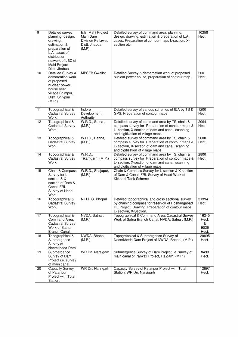
9 Detailed survey,planning, design,drawing,estimation &preparation ofL.A. cases ofdistributionnetwork of LBC ofMahi ProjectDistt. Jhabua
E.E. Mahi ProjectMain DamDivision PetlawadDistt. Jhabua(M.P)
Detailed survey of command area, planning,design, drawing, estimation & preparation of L.A.cases. Preparation of contour maps L-section, X-section etc.
10258Hect.
10 Detailed Survey &demarcation workof proposednuclear powerhouse nearvillage Bhimpur,Distt. Shivpuri(M.P.)
MPSEB Gwalior Detailed Survey & demarcation work of proposednuclear power house, preparation of contour map.
200Hect.
11 Topographical &Cadastral SurveyWork
IndoreDevelopmentAuthority
Detailed survey of various schemes of IDA by TS &GPS, Preparation of contour maps
1200Hect.
12 Topographical &Cadastral SurveyWork
W.R.D., Satna ,(M.P.)
Detailed survey of command area by TS, chain &compass survey for Preparation of contour maps &L- section, X-section of dam and canal, scanningand digitization of village maps
2964Hect.
13 Topographical &Cadastral SurveyWork
W.R.D., Panna,(M.P.)
Detailed survey of command area by TS, chain &compass survey for Preparation of contour maps &L- section, X-section of dam and canal, scanningand digitization of village maps
2600Hect.
14 Topographical &Cadastral SurveyWork
W.R.D.,Tikamgarh, (M.P.)
Detailed survey of command area by TS, chain &compass survey for Preparation of contour maps &L- section, X-section of dam and canal, scanningand digitization of village maps
2800Hect.
15 Chain & CompassSurvey for L-section & X-section of Dam &Canal, FRLSurvey of HeadWork
W.R.D., Shajapur,(M.P.)
Chain & Compass Survey for L-section & X-sectionof Dam & Canal, FRL Survey of Head Work ofKitkhedi Tank Scheme
-
16 Topographical &Cadastral SurveyWork
N.H.D.C. Bhopal Detailed topographical and cross sectional surveyby chaining compass for reservoir of HoshangabadHE Project. Drawing. Preparation of contour mapsL- section, X-Section.
31394Hect.
17 Topographical &Command Area,Cadastral SurveyWork of SatnaBranch Canal,
NVDA, Satna ,(M.P.)
Topographical & Command Area, Cadastral SurveyWork of Satna Branch Canal, NVDA, Satna , (M.P.)
16245Hect.
&9026Hect.
18 Topographical &SubmergenceSurvey ofNeemkheda Dam
NWDA, Bhopal,(M.P.)
Topographical & Submergence Survey ofNeemkheda Dam Project of NWDA, Bhopal, (M.P.)
20895Hect.
19 SubmergenceSurvey of DamProject i.e. surveyof main canal
WR Dn. Narsigarh Submergence Survey of Dam Project i.e. survey ofmain canal of Parwati Project, Rajgarh, (M.P.)
8490Hect.
20 Capacity Surveyof PatanpurProject with TotalStation.
WR Dn. Narsigarh Capacity Survey of Patanpur Project with TotalStation. WR Dn. Narsigarh
12897Hect.
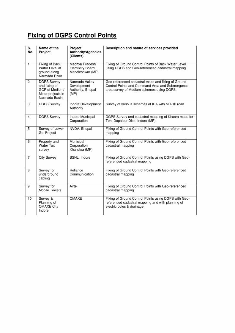
Fixing of DGPS Control Points
S.No.
Name of theProject
ProjectAuthority/Agencies(Clients)
Description and nature of services provided
1 Fixing of BackWater Level atground alongNarmada River
Madhya PradeshElectricity Board,Mandleshwar (MP)
Fixing of Ground Control Points of Back Water Levelusing DGPS and Geo-referenced cadastral mapping
2 DGPS Surveyand fixing ofGCP of Medium/Minor projects inNarmada Basin
Narmada ValleyDevelopmentAuthority, Bhopal(MP)
Geo-referenced cadastral maps and fixing of GroundControl Points and Command Area and Submergencearea survey of Medium schemes using DGPS.
3 DGPS Survey Indore DevelopmentAuthority
Survey of various schemes of IDA with MR-10 road
4 DGPS Survey Indore MunicipalCorporation
DGPS Survey and cadastral mapping of Khasra maps forTeh: Depalpur Distt: Indore (MP)
5 Survey of LowerGoi Project
NVDA, Bhopal Fixing of Ground Control Points with Geo-referencedmapping
6 Property andWater Taxsurvey
MunicipalCorporationKhandwa (MP)
Fixing of Ground Control Points with Geo-referencedcadastral mapping
7 City Survey BSNL, Indore Fixing of Ground Control Points using DGPS with Geo-referenced cadastral mapping
8 Survey forundergroundcabling
RelianceCommunication
Fixing of Ground Control Points with Geo-referencedcadastral mapping
9 Survey forMobile Towers
Airtel Fixing of Ground Control Points with Geo-referencedcadastral mapping.
10 Survey &Planning ofOMAXE CityIndore
OMAXE Fixing of Ground Control Points using DGPS with Geo-referenced cadastral mapping and with planning ofelectric poles & drainage.
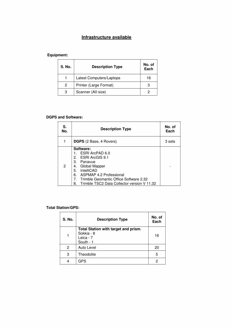
Infrastructure available
Equipment:
S. No. Description TypeNo. ofEach
1 Latest Computers/Laptops 16
2 Printer (Large Format) 3
3 Scanner (A0 size) 2
DGPS and Software:
S.No.
Description TypeNo. ofEach
1 DGPS (2 Base, 4 Rovers) 3 sets
2
Software:1. ESRI ArcPAD 6.02. ESRI ArcGIS 9.13. Panavue4. Global Mapper5. IntelliCAD6. ASPMAP 4.2 Professional7. Trimble Geomantic Office Software 2.328. Trimble TSC2 Data Collector version V 11.32
-
Total Station/GPS:
S. No. Description TypeNo. ofEach
1
Total Station with target and prism.Sokkia - 8Leica - 7South - 1
16
2 Auto Level 20
3 Theodolite 5
4 GPS 2

CSSPL clients are thebeneficiaries of the Company’sunmatched commitment to the SEICMM level.
Our software development,maintenance and govt. customersrely on us sustained track record ofdelivering high-quality, majorsoftware projects on time and onbudget.
Our approach to Development andMaintenance is an extensive set ofprocess and practice guidance thatdrives our employees towardcontinuous process improvement,for more reliable and higher-qualitydelivery of services to ourcustomers.
In addition, this approachincorporates implementation andtailoring guidance facilitating ourclose relationships with our clients.It comprises written documentationand courseware on software policyand processes for:
- Topographical Land Survey- DGPS Survey- Civil Construction- Supervision & Quality Control- Web-GIS Development- Cadastral Mapping- Urban/City Mapping- Detailed Project Report- Maintenance- Material Testing- Industrial/Corporate Training
CommitmentCommitmentCommitmentCommitment
Our philosophy and dedication allows us to deliver value-driven software solutions characterized by:
• High quality, no defects
• Predictable schedules and price with less re-work andmore re-use
• Qualified software engineers that possess theappropriate skill mix for the task.
We offer our clients the right ingredients…
"BEST"BEST"BEST"BEST PRACTICESPRACTICESPRACTICESPRACTICES””””
approach founded upon leading industrystandards with the right mixes of
skilled engineers and business analystsand the technology know-how.
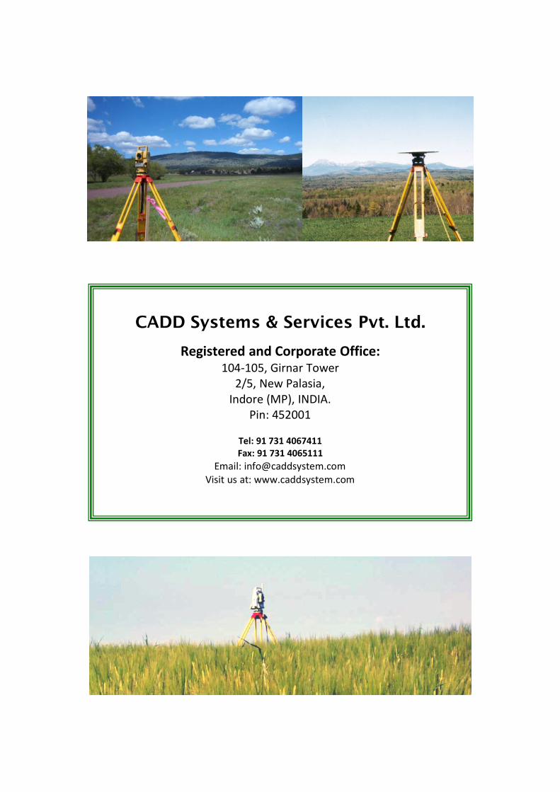
CADD Systems & Services Pvt. Ltd.
Registered and Corporate Office:
104-105, Girnar Tower
2/5, New Palasia,
Indore (MP), INDIA.
Pin: 452001
Tel: 91 731 4067411
Fax: 91 731 4065111
Email: [email protected]
Visit us at: www.caddsystem.com