butte area one restoration planning process and draft ... · the metro storm drain, silver bow...
TRANSCRIPT
DRAFT
STATE OF MONTANA’S CONCEPTUAL RESTORATION PLAN and PROPOSED PLANNING
PROCESS FOR BUTTE AREA ONE GROUNDWATER AND SURFACE WATER RESOURCES
Prepared by Montana Department of Justice
Natural Resource Damage Program
With Assistance From:
Peccia and Associates, Helena, Montana
Bighorn Environmental Sciences, Dillon, Montana
Montana Bureau of Mines and Geology, Butte Montana
November 2007
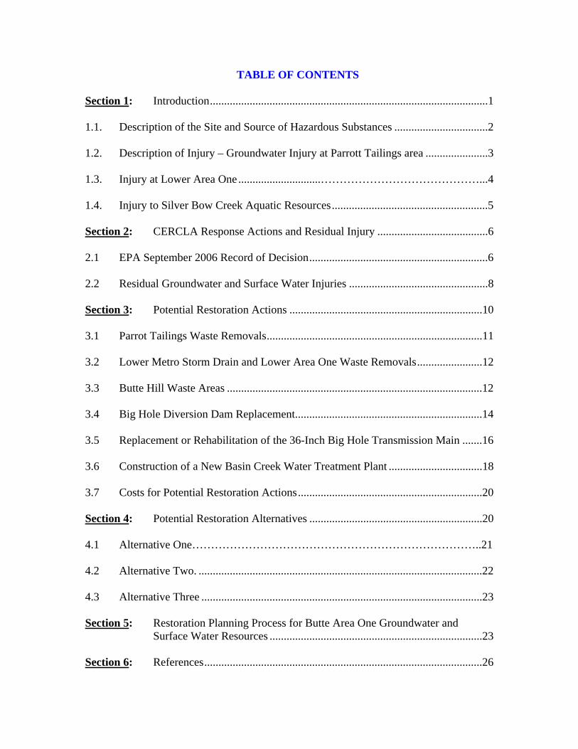
TABLE OF CONTENTS Section 1: Introduction..................................................................................................1 1.1. Description of the Site and Source of Hazardous Substances .................................2 1.2. Description of Injury – Groundwater Injury at Parrott Tailings area ......................3 1.3. Injury at Lower Area One .............................……………………………………...4 1.4. Injury to Silver Bow Creek Aquatic Resources.......................................................5 Section 2: CERCLA Response Actions and Residual Injury .......................................6 2.1 EPA September 2006 Record of Decision...............................................................6 2.2 Residual Groundwater and Surface Water Injuries .................................................8 Section 3: Potential Restoration Actions ....................................................................10 3.1 Parrot Tailings Waste Removals............................................................................11 3.2 Lower Metro Storm Drain and Lower Area One Waste Removals.......................12 3.3 Butte Hill Waste Areas ..........................................................................................12 3.4 Big Hole Diversion Dam Replacement..................................................................14 3.5 Replacement or Rehabilitation of the 36-Inch Big Hole Transmission Main .......16 3.6 Construction of a New Basin Creek Water Treatment Plant .................................18 3.7 Costs for Potential Restoration Actions.................................................................20 Section 4: Potential Restoration Alternatives .............................................................20 4.1 Alternative One…………………………………………………………………..21 4.2 Alternative Two. ....................................................................................................22 4.3 Alternative Three ...................................................................................................23 Section 5: Restoration Planning Process for Butte Area One Groundwater and Surface Water Resources ...........................................................................23 Section 6: References..................................................................................................26
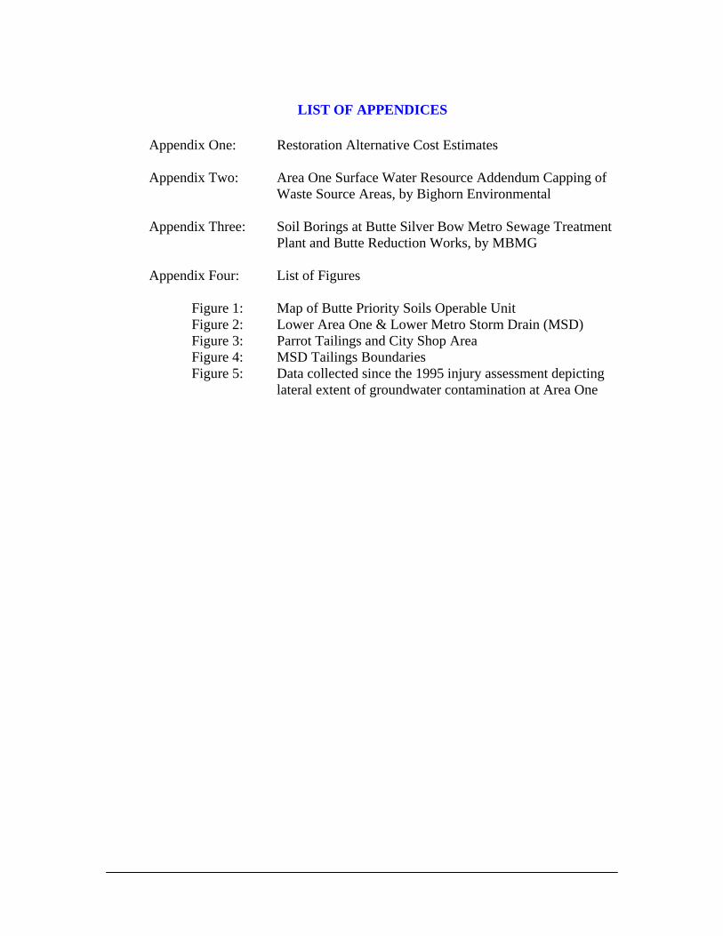
LIST OF APPENDICES
Appendix One: Restoration Alternative Cost Estimates
Appendix Two: Area One Surface Water Resource Addendum Capping of Waste Source Areas, by Bighorn Environmental
Appendix Three: Soil Borings at Butte Silver Bow Metro Sewage Treatment
Plant and Butte Reduction Works, by MBMG Appendix Four: List of Figures
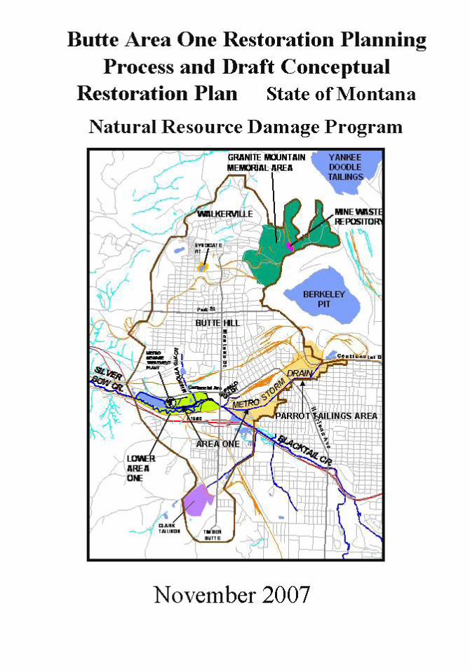
Figure 1: Map of Butte Priority Soils Operable Unit
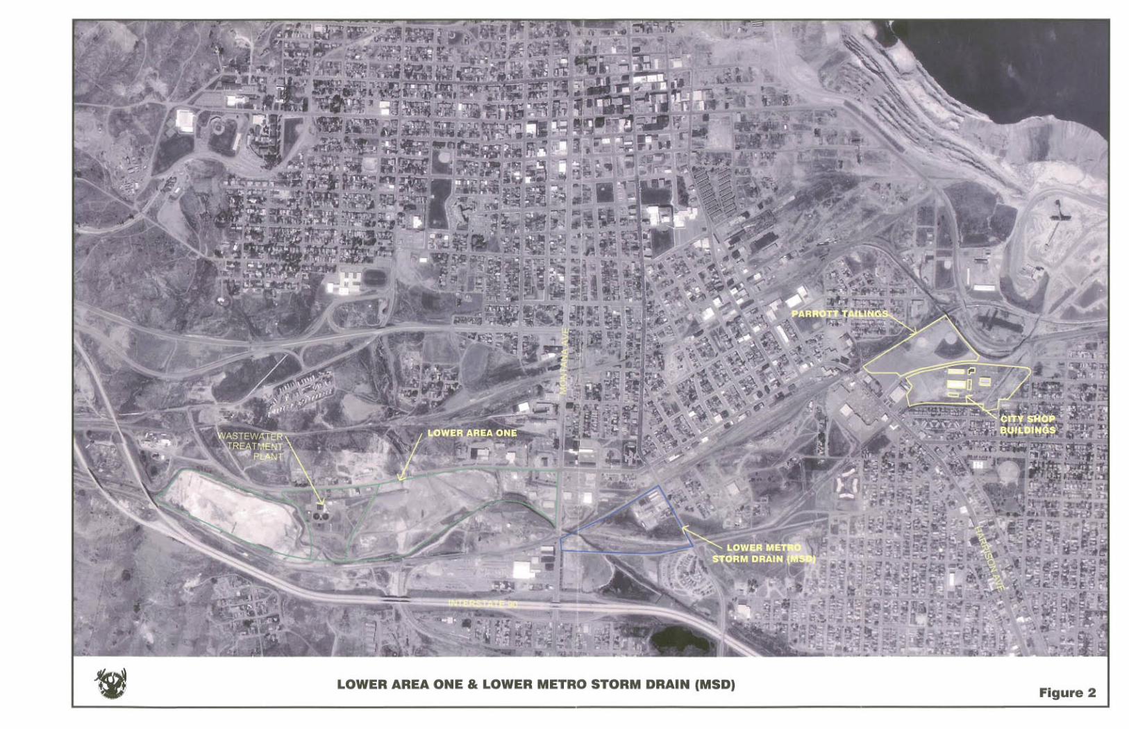
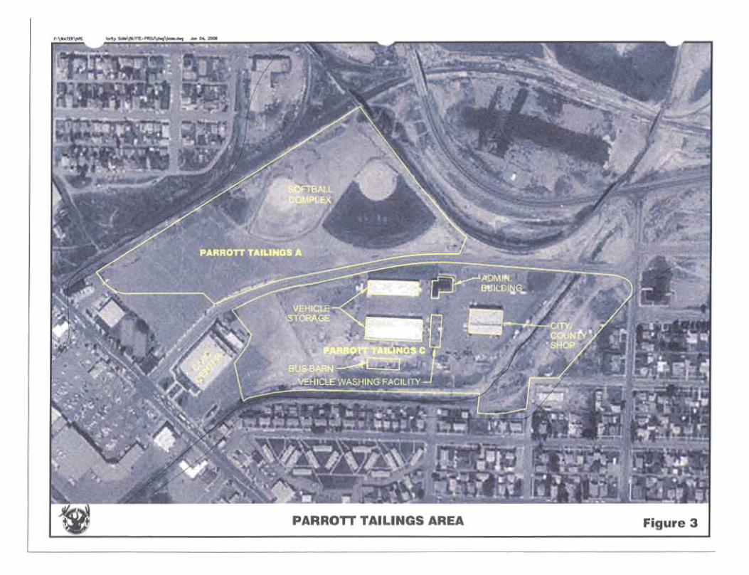
Figure 2: Lower Area One & Lower Metro Storm Drain (MSD) Figure 3: Parrot Tailings and City Shop Area
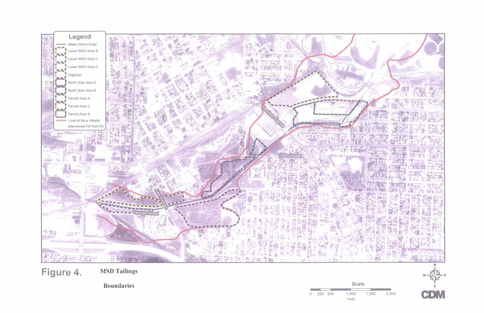
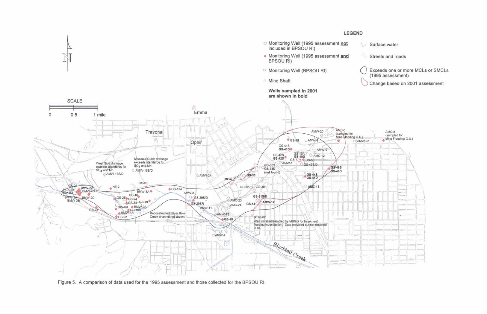
Figure 4: MSD Tailings Boundaries Figure 5: Data collected since the 1995 injury assessment depicting
lateral extent of groundwater contamination at Area One
1
Section 1: Introduction Natural resource damages under the Comprehensive Environmental Response, Compensation and Liability Act, 42 U. S. C. ~ 9601 et seq., (CERCLA) are designed to compensate trustees1 for injury2 to natural resources3 that are residual to CERCLA response actions.4 In 1983, the State of Montana filed a lawsuit in federal court against the Atlantic Richfield Company (ARCO) for natural resource damages that have arisen as a result of ARCO’s and its predecessors’ mining and smelting operations in the Upper Clark Fork River Basin (UCFRB), particularly around Butte and Anaconda. In 1995, as a part of that litigation, the State issued a Restoration Determination Plan (RDP). Based on information then available about the projected EPA response actions to be undertaken at UCFRB site, the RDP quantified natural resource damages to which the State was entitled in order to restore the injured natural resources at the UCFRB. Among other resources, the RDP identified Butte Area One groundwater and surface water resources as needing restoration (see Figure 1).5 In 1999, the federal court approved a partial settlement of the Montana v. ARCO lawsuit. That settlement, however, did not resolve the State’s restoration damages claims for the “Step 2 Sites.” One of these Step 2 sites is the Butte Area One Groundwater and Surface Water Resources. The State, the United States, and ARCO recently lodged additional consent decrees with federal district court, which, among other things, would settle the State’s outstanding restoration damages claim for the Step 2 Sites. Upon the effective date of these consent decrees, ARCO has agreed to pay $72.5 million plus interest, to resolve the State’s natural resource damage claims for the Step 2 Sites. The consent decree allocates 41.25% of the settlement money, after payment of assessment and litigation costs, i.e. approximately $28 million, to the Butte Area One State Restoration Account to restore, rehabilitate, replace, or acquire the equivalent of the injured natural resources at Butte Area One.
1 The State of Montana is a trustee of natural resources within the state. CERCLA Section 107 (f)(l), 42 U.S.C. ~ 9607(f)(1). 2 As trustee, the State is entitled to “damages for injury to, destruction of, or loss of natural resources, including the reasonable costs of assessing such injury, destruction, or loss resulting from” the release of a hazardous substance CERCLA Section 107(a)(4)(C), 42 U.S.C~ 9607(a)(4)(C). 3 “The term natural resources means land, fish, wildlife, biota, air, water, ground water, drinking water supplies, and other such resources belonging to, managed by, held in trust by, appertaining to, or otherwise controlled by” the State. CERCLA Section 101(16), 42 U.S.C.~ 9601(16). 4 “The terms respond or response means remove, removal, remedy, and remedial action.” CERCLA Section 101(25), 42 U.S.C. ~ 9601 (25). 5 “Area One” is an area in South-central Butte, which encompasses a contaminated alluvial aquifer and the confluence of Silver Bow and Blacktail Creeks.
2
In September of 2006, the United States Environmental Protection Agency (EPA) issued a Record of Decision6 for the Butte Priority Soils Operable Unit (BPSOU).7 A revision of the 1995 RDP for Butte Area One is now appropriate because the Record of Decision more definitely sets forth the expected nature and extent of EPA’s response actions to be undertaken in this area than were previously estimated by the State in 1995. This added certainty regarding response actions now enables the State and the local community to craft restoration actions that not only mesh with EPA’s remedy, but also, take into account the pending settlement with ARCO, including the amount of natural resource damages to be received by the State for restoration in the Butte area. It should be emphasized that this is a conceptual restoration plan. It is not the State’s intention that the potential restoration actions and alternatives described in this plan are set in stone. The State believes that, before adopting a final restoration plan for utilizing the $28.0 million in settlement money earmarked for the Butte Area One Ground and Surface Water Resources, the community of Butte should have a say in the planning process and determination of appropriate restoration actions to be taken utilizing this amount. Accordingly, in Section 5 of this conceptual plan, the State suggests a restoration planning process that would involve the Butte community, with the understanding that the State’s Governor, as Trustee, will continue to have the final say as to how the restoration dollars are to be spent. 1.1 Description of the Site and Sources of Hazardous Substances The deposition of wastes in the city of Butte from mining and mineral-processing operations has resulted in injury to groundwater resources and the surface water of Silver Bow Creek. The injured alluvial groundwater and surface water in Butte is located in the south central area of the BPSOU referred to as “Area One.” Area One extends from the upper end of the Metro Storm Drain (MSD)8 to the west to the east end of the former Colorado Tailings at the I-90 Bridge. Silver Bow Creek is formed by the confluence of Blacktail Creek and the Metro Storm Drain. Blacktail Creek flows year-round and comprises a large part of the flow of Silver Bow Creek. Since the late 1800s, disposal practices from mining and mineral-processing operations in Butte have resulted in the presence of tailings and other mining-related wastes along parts of the Metro Storm Drain, Silver Bow Creek, and in the city of Butte. Much of the waste is associated with four facilities – the Parrot Smelter, the Butte Reduction Works, the Colorado Smelter, and the Berkeley Pit. The Parrot Tailings lie under and around the Butte city shop northeast of the Civic Center. Under order from EPA as part of the response action program,
6 EPA, September 2006. Record of Decision, Butte Priority Soils Operable Unit Silver Bow Creek/Butte Area NPL Site. 7 The Butte Priority Soils Operable Unit, which is approximately 7 square miles, includes the town of Walkerville, the part of Butte north of Silver Bow Creek, including Area One and west of the Berkeley Pit, and an area that extends south from Silver Bow Creek to Timber Butte. See Figure 1. 8 The watercourse known as the “Metro Storm Drain” generally follows the historic channel of Silver Bow Creek.
3
the Butte Reduction Works Tailings and the Colorado Tailings were mostly removed from the lower west Butte area in the 1990’s. Highly contaminated tailings – laden water from the Berkeley Pit operation, which for many years was disposed of down the Metro Storm Drain, also played a role in contaminating Area One. Surface water and streambed contamination results from the discharge of contaminated groundwater and from contaminated surface runoff. Alluvial groundwater discharges to Silver Bow Creek. Surface runoff from storms and snowmelt carries hazardous substances from dispersed waste sources in Butte to Silver Bow Creek through surface drainages and the Butte stormwater collection system. 1.2 Description of Injury Groundwater Injury at the Parrott Tailings Area: Injury to groundwater has been demonstrated by the occurrence of concentrations of heavy metals (including cadmium, zinc, iron, lead, and copper) arsenic, and sulfate that exceed drinking water standards in the alluvial aquifer in Butte. The areal extent of contamination of the alluvial aquifer is about a square mile and extends from the Parrott Tailings area at the Butte City-County shop downgradiant towards Silver Bow Creek (See Figure 5). The highest concentrations of dissolved constituents in groundwater in the MSD area coincide with waste from the Parrott mill and smelter.9 The Parrott smelter wastes have a volume of approximately 660,000 cubic yards.10 The concentration of copper in wells completed within the Parrott Tailings area exceeds 900,000 parts per billion (ppb). Similarly, the concentration of zinc and cadmium in these wells exceeds 500,000 (ppb) and 2,000 (ppb) respectively.11 These high concentrations are rivaled in the Upper Clark Fork River Basin only by the leach pad operations at the active mining site in Butte and often exceed concentrations found in the Berkeley Pit. The Parrott Tailings is located in the most upgradient parts of the Metro Storm Drain; there are other tailings areas along the MSD known as the “Diggings East,” “Lower MSD” and the “Northside Tailings” areas. The volume of these tailings is about 115,000 cubic yards. Organic rich silts, clays, and/or peat, indicative of the marshy lowland setting along the Silver Bow Creek floodplain on which the tailings were placed, underlie the Parrot Tailings. Drilling and coring throughout the MSD drainage have demonstrated more limited amounts of tailings and other mine related
12 wastes
utside the Parrott Tailings area.
o
9 Summary of Investigation, Upper Silver Bow Creek, Butte Montana, Montana Bureau of Mines and Geology, Open-File Report 507, 2004. 10 Focused Feasibility Study of the Metro Storm Drain, CDM, February 2004. 11 Butte Priority Soils Operable Unit, Phase II Remedial Investigation, Butte PSOU PRP Group, May 2001. 12 Results are presented in a 2001 Montana Bureau of Mines and Geology (MBMG) report Soils Borings, Tailings and Overburden Thickness and Volumes Lower Area One and Upper Metro Storm Drain, James Madison, 8/2001.
4
In early 2004, Montana Bureau of Mines and Geology (MBMG), with funding provided by the EPA and the State, installed monitoring wells at four sites along the groundwater flow path between the Parrott Tailings area and the confluence of Blacktail and Silver Bow Creeks. The wells were drilled deeper than most others in the area; the objective was to fill data gaps about aquifer lithology and groundwater quality in the intermediate and deeper portions of the alluvial aquifer. Previous investigations focused on the upper 20 feet of the alluvial aquifer. This study found higher concentrations of dissolved constituents in the upper portions of the alluvial aquifer than shown in previous work. For example, zinc concentrations in three of the new wells, screened at a depth of 45 feet, was about 200,000 ppm. Concentrations of metals and sulfate in the 100-foot depth wells were considerably
wer than water screened at 45 feet. Sampling of these wells again in 2006 confirmed these
inated areas, the recovery to drinking water standards for groundwater in the rea could be reduced from thousands of years to less than 100 years if the Parrott Tailings
estimates that pproximately 55,000 cubic yards remain in this area at certain locations such as under the
mum contamination vels). Wells in the Butte Reduction Works, where removal of the tailings was incomplete,
indicate that water quality also remains below drinking water standards.
loelevated concentrations. The State’s experts believe that data from the MBMG investigation demonstrates that: 1) contamination from the Parrott Tailings has migrated several thousand feet towards Silver Bow Creek; 2) the highest contamination occurs in an intermediate zone at 50 to 75 feet below the surface; 3) the intermediate groundwater zone is made up of discrete layers of gravel and sand with minor silt and clay; and 4) based on column tests using aquifer material from two contamaare removed.13 1.3 Current Groundwater Injury at the Lower Area One: In the 1990s, under an order from EPA as part of the response action program, approximately 1.2 million cubic yards of tailings were removed from the lower portion of Area One (“Lower Area One”) the Colorado Tailings and the Butte Reduction Works. This removal effort was an important step in the cleanup of the area and along all 22 miles of Silver Bow Creek.14 Not all tailings were removed from this area however. MBMG aslag walls, and at the east end of the Butte Reduction Works (see Appendix 3). Most of the wells used to monitor water quality in the Colorado tailings area were destroyed during the tailings removal; however, several new wells were installed in 1998. Data from these new wells show significant groundwater improvement in this area especially where most tailings were removed. However, most wells still have exceedences of one or more MCL (maximum contamination levels) and SMCL (secondary maxile
13 Summary of Investigation, Upper Silver Bow Creek, Butte Montana. Montana Bureau of Mines and Geology, Open-File Report 507, 2004. 14 MDEQ, in cooperation with EPA, is now in its eighth year of an estimated 12-year remedy/restoration cleanup of Silver Bow Creek.
5
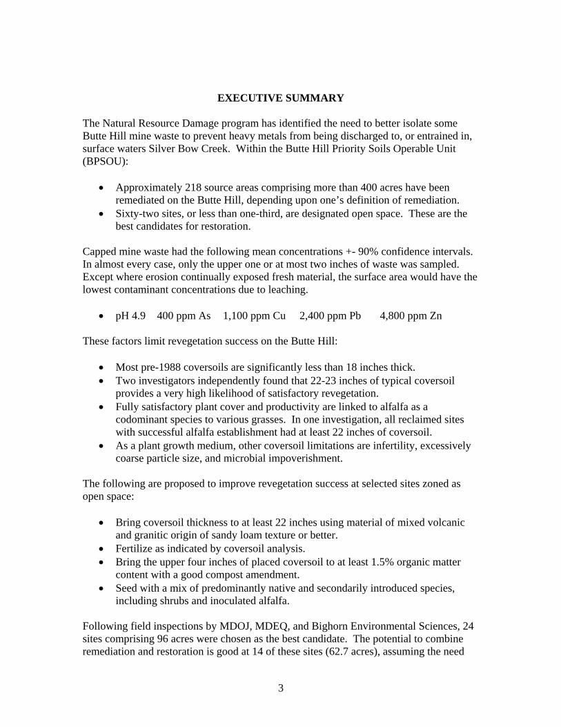
1.4 Current Injury to Silver Bow Creek Aquatic Resources: The primary source of flow in Silver Bow Creek is inflow from Blacktail Creek. The MSD and Silver Bow Creek floodplain also receive storm runoff and snowmelt flow from the city of Butte, which is significantly contaminated. Over 420 acres on 218 wastes sites within the BPSOU area have undergone removal and/or capping remedies from 1988 through 2004 as the result of orders from EPA. Most of these sites are in the northern part of BPSOU. These actions have reduced the runoff loading of contamination in the BPSOU. However, the concentrations of hazardous substances in BPSOU storm water from the wastes sites are still above acute aquatic life standards. Storm water sampling along the MSD in 2001 and 2002 show aquatic life standard exceedences for copper and zinc occurring about 100 percent of the time. Concentrations at Silver Bow Creek sampling station SS-07 were as high as 200 times the total copper acute aquatic life standard levels and 30 times the zinc acute aquatic life standards. (See Appendix 2). Remedial actions under the EPA ROD are expected to significantly reduce these exceedences, especially with the slated upgrade of 40 miles of storm sewer lines. In 2004, 45,000 cubic yards of soils, much was contaminated, were removed from the Metro Storm Drain Channel and a groundwater collection system was installed. This groundwater collection system is also expected to reduce the amount of contamination that historically has gone into Silver Bow Creek. Currently a 10-acre lagoon system is also being used to reduce metal concentrations from entering Silver Bow Creek. A liming facility is currently adding lime to the contaminated water collected in the area, which precipitates metals into the treatment lagoons. Remedial actions taken to date have improved base flow water quality in Silver Bow Creek; however, significant exceedences of water quality standard still occur, especially during storm runoff events. The further remedial actions to be taken are expected to significantly reduce these exceedences. Currently the upper part of Silver Bow Creek contains elevated concentrations of dissolved cadmium, copper, manganese and zinc in surface water and stream sediments. This contamination is preventing or impairing optimal aquatic invertebrate and trout populations in the area. Substantial reductions of concentrations of these metals in surface water are needed to have a self-reproducing trout fishery in Silver Bow Creek. In addition, elevated arsenic and metals present in sediments in the reconstructed portion of Silver Bow Creek are moving downstream.15 Based on the 2001 Baseline Ecological Risk Assessment, the 2004 BPSOU FS report16 outlined the following conclusions that can be drawn regarding ecological risk at the BPSOU:
• Elevated concentrations of arsenic and metals are impacting surface water and sediments and sensitive receptors associated with these media. This is supported by predictive risk estimates and site-specific studies using macroinvertebrates and periphyton.
15 Environmental Protection Agency, 2001. Final Baseline Ecological Risk Assessment Silver Bow Creek/Butte Area NPL Site Butte Priority Soils Operable Unit. 16 Phase II Remedial Investigation /Feasibility Report, Butte PRP group, April 2004.
• Dissolved cadmium, copper, zinc, and possibly manganese are the most important
chemical stressors for aquatic biota throughout most of the site, as represented by salmonid fish, dapnids, benthic macroinvertebrates and periphyton.
• Arsenic, cadmium, copper, lead, and zinc in site sediments are the major chemical
stressors for benthic invertebrates. These metals in sediment are also likely to contribute to the cumulative toxicity experienced by fish and other aquatic biota. Instream sediments also impair physical habitat, especially in depositional areas.
• Waterfowl may be at risk from consumption of water, sediment, aquatic vegetation,
and aquatic invertebrates contaminated with arsenic, cadmium, copper, lead, or zinc.
• Greatly reduced concentrations of certain metals in surface water and sediment in Silver Bow Creek are needed to protect sensitive organisms inhabiting or using these media.
• Certain locations are consistently associated with the highest risk. These include
locations in the MSD and Missoula Gulch (for both surface water and sediment) and surface water station at the downstream extent of the new channel at LAO. These areas can be a continuing source of contaminants to surface water and sediments for downstream reaches.
• Elevated metals are also present in sediments in the reconstructed portion of Silver
Bow Creek. In general, sediments within the more upstream reaches of the reconstructed channel contain higher metals concentration compared to the sediments further downstream, and it appears that metals are moving downstream, probably as a function of flow. This movement is expected to increase seasonally or following major storm events. Sediment-based risks to aquatic biota are significant in and downstream of the MSD, Buffalo Gulch, Missoula Gulch, as well as in the upper reaches of Silver Bow Creek. In the future, significant sediment-based risks may occur in downstream reaches.
Section 2, below, describes the predicted residual injury to these aquatic resources once the EPA ROD is implemented. Section 2: CERCLA Response Actions and Residual Injury 2.1 EPA’s September 2006 Record of Decision The following are among the actions that will be implemented, based on EPA’s 2006 BPSOU Record of Decision. These remedial actions are expected to substantially reduce metal impacts to Silver Bow Creek.
1) Collecting contaminated groundwater throughout Lower Area One and routed to the existing treatment lagoons at Lower Area One for treatment on a probationary basis.
6
The five-year probationary period is deemed adequate to address operation and maintenance issues. A conventional lime treatment facility will be built if the open treatment lagoons prove inadequate in treating contaminated groundwater.
2) A storm water management program is planned to be implemented to prevent
contaminated storm water runoff from harming surface water quality in Silver Bow Creek, Blacktail Creek, and Grove Gulch. Source controls such as routing of storm flows and maintaining covers on the 450 acres of previously reclaimed areas. Also, storm/sewer replacement of 40 miles of pipes is planned. If these controls are not effective in achieving adequate surface water quality in Silver Bow Creek, then storm water will be treated with lime to remove contaminants.
3) Approximately 1300 residential yards are planned to be replaced due to elevated lead
levels over a 14 year period. All residential yards will be sampled.
4) Excavation of contaminated sediments from the stream bed, banks, and adjacent floodplain along Blacktail Creek and Silver Bow Creek, from just above the confluence of Blacktail Creek and MSD to the beginning of the reconstructed Silver Bow Creek floodplain at LAO.
5) Reclamation and enhancement of the Granite Mountain Memorial Area and Syndicate
Pit area and monitoring of groundwater, surface water and previously reclaimed areas on Butte Hill. For ROD costing purposes all monitoring is planned for a 99 year period. However, remedial monitoring of the injured resources may be necessary indefinitely.
6) The Butte Reclamation Evaluation System will evaluate and maintain new and
previously reclaimed sites over the long term. A detailed summary of the ROD’s remedy components can be found on pages D-6 to D-17 of the ROD. These pages are found in Appendix C of Appendix 2. In addition to the above components, approximately $60 million has already been spent on numerous response activities at the BPSOU, including:
• Removal of 1.2 million cubic yards of tailings and impacted soil from LAO during the 1990’s. Silver Bow Creek was elevated, with the placement of 560,000 cubic yards of backfill, and relocated to facilitate control of groundwater and surface water within the area;
• Construction of engineered caps over contaminated mine waste at numerous locations on Butte Hill covering some 420 acres;
• Residential yard replacement at numerous locations on Butte Hill,
• Railroad bed removals in the city of Butte;
7
8
• Construction of storm water controls at numerous locations on Butte Hill;
• Excavation along the Metro Storm Drain channel in 2004 to install a groundwater
collection system. A summary of past actions can be found on pages D-3 through D-4 of the ROD, these pages can be found in Appendix C of Appendix 2 of this report. 2.2 Residual Groundwater and Surface Water Injuries Residual injury is the injury to natural resources that remains substantially unaddressed following implementation of the remedy. This concept is predicated on the fact that response actions can improve the condition of injured natural resources and thereby lessen natural resource injury. The selected remedy is not intended to and will not restore natural resources in Butte to baseline conditions.17 Upper and Lower Metro Storm Drain Groundwater Residual Injury: The Parrott Tailings will remain in the Upper Metro Storm Drain following remedial actions. These tailings will continue to release hazardous substances to groundwater in this area for many centuries, if not thousands of years. The Parrott Tailings is the most significant source of contamination to the alluvial aquifer in the MSD area, both because of its high leachable concentrations and because it is located a longer distance from downgradent surface water and, therefore, contaminates more groundwater than tailings located immediately upgradient of the MSD. Cleanup of the aquifer could be expedited by pumping the aquifer after tailings removal. This has been shown by column tests performed by the 2004 MBMG investigations. In the lower parts of the MSD there are about 115,000 cubic yards of tailings, which are also impacting groundwater in the area; these tailings are known as the Diggings East, Northside, and Lower MSD tailings. Lower Area One Groundwater and Silver Bow Creek Aquatic Residual Injuries: Surface water resources in Lower Area One and the beginning of Silver Bow Creek have significantly improved since the removal of 1.2 million cubic yards of tailings in the 1990’s. Aquatic life, such as macroinvertibrates and waterfowl use, has also significantly improved. However, there are hazardous substances remaining at LAO. Groundwater contamination at LAO remains, although improvement in groundwater quality has occurred in area groundwater wells.18 According to a 2005 investigation19 by MBMG, 17 DOI regulations define the term, “baseline,” as the condition of the resource had the release of hazardous substances not occurred. (43C.F.R. ~11.14 (e). 18 See Figure 5 in Appendix 4, which compares the extent of groundwater injury in Area One in 1995 to 2001. 19 Soil Borings at Butte Silver Bow Metro Sewage Treatment Plant and Butte Reduction Works, Butte, Montana. James Madison, Montana Bureau of Mines and Geology, January, 2006, 9 pages. Appendix 3 in this plan.

9
approximately 55,000 cubic yards of tailings remain under slagwalls and various other locations at LAO. No tailings were found under or around the wastewater treatment plant, as described in Appendix 3. Sediment sampling, at Silver Bow Creek station SS-07, which is under the eastbound I-90 and I-15 underpass at the far west end of Lower Area One, has very elevated concentrations of cadmium, copper and zinc. This contamination is clearly coming from BPSOU sources such as the metro storm drain and Silver Bow Creek between Blacktail Creek and SS-07.20 Concentrations from six sampling periods over two years (June 2002 to August, 2004) showed average fine grain sediment21 cadmium, copper, and zinc concentrations of 26, 2,376, and 4,343 parts per million respectively. These concentrations are orders of magnitude higher than average samples found in nearby streams. It is expected that the EPA ROD will address these sediments, but it is unclear whether they will be addressed to the point of restoring the resources and eliminating all exceedences above baseline. The elevated metals found in Silver Bow Creek sediments in Lower Area One are being released into the newly remediated and restored Silver Bow Creek. The MBMG Silver Bow Creek sediment sampling station a few miles downstream from Butte, SS-08 at Rocker, contained average fine grain sediment cadmium, copper and zinc concentrations of 19, 2,041 and 3,133 parts per million respectively during a 2002-2004 sampling period.22 At this time it is not clear if the remedial actions planned in Butte will eliminate the elevated sediment contamination in the newly restored and remediated Silver Bow Creek. Waste Areas on Butte Hill: Remedial actions since 1988 included covering with soil about 420 acres of waste areas mostly in upper Butte. Some remediated waste areas on Butte Hill are in need of better quality and more quantity of soil cover and vegetation diversity in order to restore the natural resources at the site. Vegetative cover protects the cover soil from wind and water erosion by minimizing areas of bare ground, reducing surface water runoff velocity, and by increasing infiltration.23
20 Post-Remediation Monitoring and Data Collection SSTOU Annual Report, MBMG, February 2005. 21 Average concentrations for the clay sediment fraction are presented. Concentrations for the silt, sand and composite samples are significantly lower. Clay fraction is significant to fish because benthic macroinvertebrates ingest fine-grained sediments during feeding, and through digestion can accumulate hazardous substances. 22 In stream copper sediment concentrations of only 300 ppm and zinc concentrations of 260 ppm are known to have major impacts to benthic communities. 23 From a MSU masters thesis by Cole Mayn, Assessment of Land Reclamation Characteristics and Maintenance Techniques to Promote Long-Term Sustainability of Reclaimed Areas in Butte, Montana. April 2001.
10
Runoff storm waters from Butte Hill are significantly elevated in metal concentrations.24 The estimated volume of storm-water runoff from the 10-year, 24-hour storm event on the West-Side drainage area is approximately 21.6 million gallons and the runoff volume from the East-Side drainage area is about 16.5 million gallons. See drainage maps of these areas in Appendix 2. The estimated total volume of the 10-year, 24-hour storm water runoff from both the east and west side drainage areas is about 38 million gallons. If water quality standards are not met in Silver Bow Creek in the future then EPA’s ROD calls for storm water treatment in order to meet water quality standards in Silver Bow Creek and other relevant waters. The costs for a remedial storm water treatment plant and annual O & M costs are estimated at $47 million. Based on storm water quality over the last several decades it is possible that this storm water treatment plant will be necessary, however it is difficult to estimate the exact time frame when this decision may be made. Section 3: Potential Restoration Actions There are two types of restoration actions presented in this conceptual restoration plan. Some actions are centered on direct restoration of resources by removing or mitigating wastes that are injuring groundwater and surface water resources. Other proposed actions addresses injuries at Area One with replacement projects. All restoration and replacement actions are outlined below and associated costs are presented in Table 1 and in Appendix 1. Potential Restoration Actions: The major components of the direct restoration actions by the Montana Natural Resource Damage Program (NRDP) proposed are:
1) Removal and reconstruction of the City-County vehicle shop, located east of the civic center and excavation of 666,000 cubic yards of the Parrot Tailings;
2) Excavate accessible tailings at Lower Area One and Lower Metro Storm Drain,
estimated at 162,000 cubic yards;
3) Disposal of the excavated Area One wastes to a Butte area location such as the Butte Mine Waste Repository or possibly to Montana Resources or the Butte mine waste repository if access is obtained;
4) Placement of additional vegetative capping material on approximately 35 acres of
previously reclaimed waste sites; and
5) Coordination with future remedial actions and enhanced restoration capping of 60 acres of unreclaimed waste areas.
Even though hazardous substances will remain in the BPSOU area, these restoration actions would expedite the recovery time for aquatic and groundwater resources at the site. A map 24 Appendix Two contains data summary sheets, which depict storm water metal exceedences from the Draft Data Summary and Interpretation Report, Base Flow and Wet Weather Data, ARCO. September 2005.
11
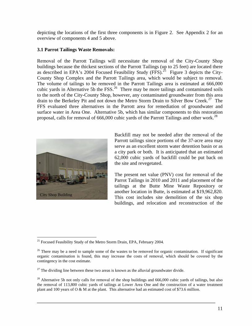
depicting the locations of the first three components is in Figure 2. See Appendix 2 for an overview of components 4 and 5 above. 3.1 Parrot Tailings Waste Removals: Removal of the Parrott Tailings will necessitate the removal of the City-County Shop buildings because the thickest sections of the Parrott Tailings (up to 25 feet) are located there as described in EPA’s 2004 Focused Feasibility Study (FFS).25 Figure 3 depicts the City-County Shop Complex and the Parrott Tailings area, which would be subject to removal. The volume of tailings to be removed in the Parrott Tailings area is estimated at 666,000 cubic yards in Alternative 5b the FSS.26 There may be more tailings and contaminated soils to the north of the City-County Shop, however, any contaminated groundwater from this area drain to the Berkeley Pit and not down the Metro Storm Drain to Silver Bow Creek.27 The FFS evaluated three alternatives in the Parrott area for remediation of groundwater and surface water in Area One. Alternative 5b, which has similar components to this restoration proposal, calls for removal of 666,000 cubic yards of the Parrott Tailings and other work.28
Backfill may not be needed after the removal of the Parrott tailings since portions of the 37-acre area may serve as an excellent storm water detention basin or as a city park or both. It is anticipated that an estimated 62,000 cubic yards of backfill could be put back on the site and revegetated.
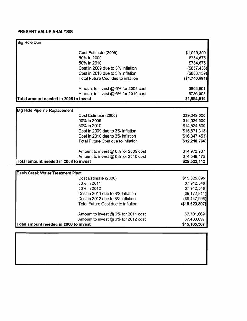
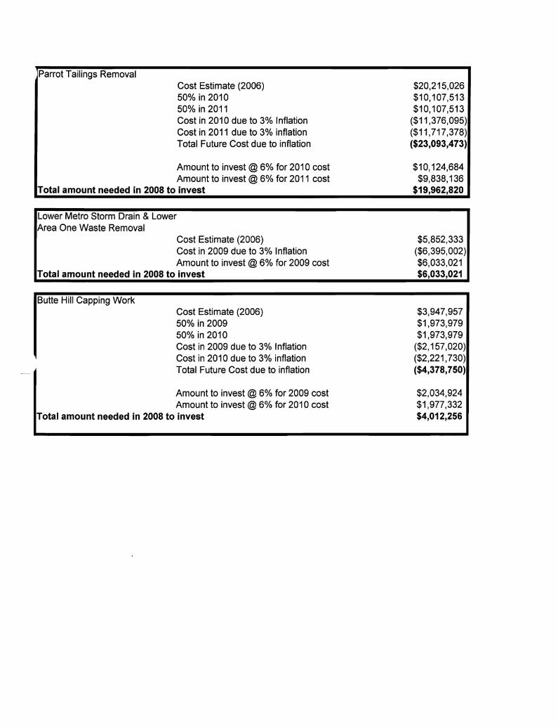
The present net value (PNV) cost for removal of the Parrot Tailings in 2010 and 2011 and placement of the tailings at the Butte Mine Waste Repository or another location in Butte, is estimated at $19,962,820. This cost includes site demolition of the six shop buildings, and relocation and reconstruction of the
25 Focused Feasibility Study of the Metro Storm Drain, EPA, February 2004. 26 There may be a need to sample some of the wastes to be removed for organic contamination. If significant organic contamination is found, this may increase the costs of removal, which should be covered by the contingency in the cost estimate. 27 The dividing line between these two areas is known as the alluvial groundwater divide. 28 Alternative 5b not only calls for removal of the shop buildings and 666,000 cubic yards of tailings, but also the removal of 113,800 cubic yards of tailings at Lower Area One and the construction of a water treatment plant and 100 years of O & M at the plant. This alternative had an estimated cost of $73.6 million.
City Shop Building
12
shop complex, which is about 45% of the total cost. The estimated cost also includes engineering and contingency of 15% each. A detailed breakdown of this cost estimate is provided in Appendix 1.29 3.2 Lower Metro Storm Drain and Lower Area One Waste Removals: Lower Metro Storm Drain waste is also proposed for removal. These wastes are known as 1) Northside Tailings, a 10-acre area; 2) Diggings East, a 19-acre area; and 3) Lower MSD, a 10-acre area. See Figure 4, taken from EPA’s 2004 FFS report, which depicts these 3 contaminated areas. The volume of these tailings is estimated to be 113,800 cubic yards, according to EPA’s FFS. Removal of these wastes is expected to enhance groundwater quality in the area. At Lower Area One, additional tailings are proposed for removed as part of the restoration action. Approximately 47,700 cubic yards are proposed for removal and hauled by rail to the Butte Mine Waste Repository or another location in Butte. Of this amount, approximately 23,800 cubic yards of tailings are located under the slag walls. Removal of contaminated material under the slag walls may be difficult because of BSB’s desire not to destroy these walls and because of their historic status. Care will be taken to keep the walls intact. Another 23,900 cubic yards of tailings are located at the east end of the former Butte Reduction Works. These tailings, called the BRW slag pile, are near the surface and are easily accessible. Figure One in Appendix 3, provides more details about the location of these wastes. The estimated cost for removing the tailings from the Lower Metro Storm Drain and Lower Area One in 2009 with final disposal in Butte is $6,033,021. A detailed cost estimate is included in Appendix 1. The cost estimate includes costs for loading, haul, unloading and spreading, revegetation, engineering and a contingency of 15%. 3.3 Butte Hill Waste Areas: There are 218 different waste areas on approximately 420 acres that have been reclaimed during the last two decades on Butte Hill and on other areas in Butte. Sixty-two sites, or less than one-third, are designated by BSB as open space. These areas are the best candidates for restoration since the open space status will ensure the caps will not be paved over or removed for infrastructure. The State’s experts believe that approximately 35 acres of these open space capped areas need additional cover soil to insure a restoration vegetation cover.30 Proposed under this restoration action is for these 35 acres to be capped with an additional 12 inches of soil to enhance vegetative cover and to potentially further reduce contaminated 29 This net present value estimate of cost assumes 3% inflation and a net 3% return on investment. The impact of rising energy costs may have to be considered at the time of construction. This cost may be lower if the tailings could be removed to a local repository. 30 These 35 acres, which is about one-half of the area of the following sites that are proposed for additional capping/restoration are located within: Anselmo Dump, Anselmo Mineyard, Anselmo timberyard, Bonanza Dump and Shaft, NE Syndicate, Original Mineyard, Star West, Washoe Sampling Works, West Gagnon, Moscow Dump, NW Syndicate, Steward Mineyard, Syndicate Pit Dumps, and Upper Missoula Gulch.
13
runoff from these areas to SBC. These areas will also be fertilized and organic matter placed in the upper four inches of the cap. The areas will be seeded and vegetated with a mix of predominantly native species. Weed control and cap maintenance would be a component of this work.31 Also proposed is additional capping and restoration on 60 acres of uncapped areas in which remedial revegetation is slated to occur.32 A report, which outlines this work, was prepared in May of 2005 by Rich Prodgers of Bighorn Environmental Sciences. This report, which is in Appendix 2, is entitled Area One Surface Water Resource Addendum Capping of Waste Source Sites.33 Map A-1 in the report depicts the areas proposed for restoration. This work will be done in coordination with EPA and its efforts under the ROD to remediate these areas. EPA’s remedial capping efforts are ongoing under the ROD and some areas may be remediated prior to finalization of this plan. The estimated PNW cost for capping the described areas in years 2009 and 2010 is $4,012,256. This estimate includes costs for purchasing fill material from Butte-Silver Bow (from a fill site located near the city landfill) loading, hauling and placement of the fill material and organic matter, and revegetation of the capped area with native vegetation. A detailed break down of the cost estimate is provided in Appendix 1. Potential Replacement Actions A number of replacement restoration actions are being proposed that consist of improvements to the Butte-Silver Bow water system. Jean Pentecost, former Butte-Silver Bow Public Works Department chief engineer, indicated that the following water system improvements projects are being considered by the Butte-Silver Bow Water Department. The projects are listed in order of priority:34
1. Replacement of the Diversion Dam at the Big Hole Pump Station; 2. Replacement of the impaired sections of the Big Hole 36-Inch Transmission Main; 35
31 It is assumed that weed control costs will be covered by the contingency in the cost estimates. 32 The contaminated waste sites that are proposed for revegetation in coordination with remedy are Lower Area One (30 acres), Grove Creek (5 acres), Clark Tailings (13 acres), Mountain Con 1-3 and Mineyard at the Granite Mountain Memorial Area (10 acres) and 2 acres along upper SBC. 33 Mr. Prodgers has 20 years of experience in mining reclamation, including working for BSB as a reclamation consultant on the Butte Hill wastes sites. 34 The listed projects are not the only water projects that are vital for Butte’s complex water system. For example the County is attempting to replace the 100-year old water distribution system in the city of Butte. Sections of the water main distribution system have been repaired with NRD funds over the past 6 years with almost $9 million in grants. BSB estimates at least another $15 million will be necessary to repair only 40% of the total system. Additional replacement is expected to be necessary for the entire system. BSB ratepayers have invested over $47 million in the past decade to restore and replace its drinking water system. These investments were necessary, in part, because the local groundwater is significantly injured. 35 An NRD grant application to replace 10,000 feet of the 100,000 foot Big Hole transmission line was submitted by BSB in 2007. Approval of this grant is expected before the end of this year.
14
3. Provide partial funding to construct a new water treatment plant for the Basin Creek surface water source.
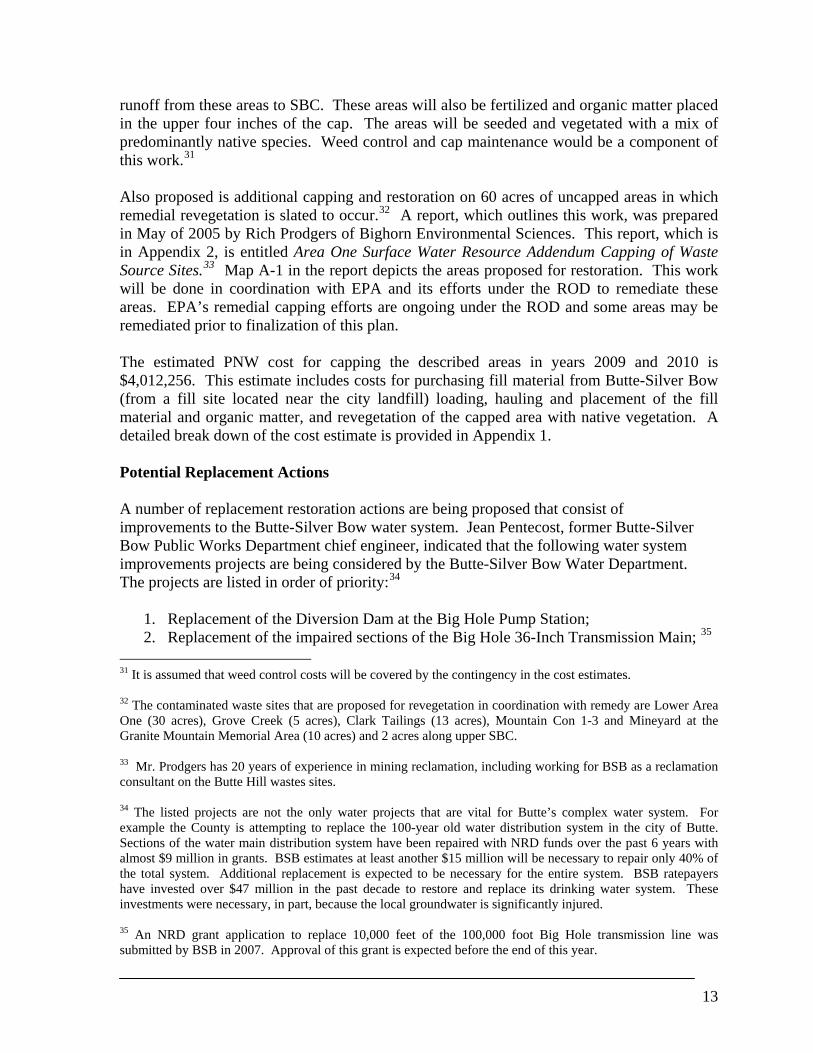
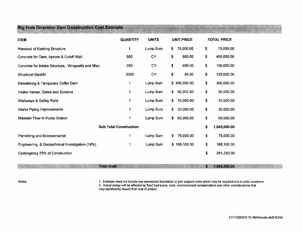
A description of each project is provided below, and the estimated cost for each project is detailed in Appendix 1.36 3.4 Big Hole Diversion Dam Replacement: The existing Big Hole diversion dam was constructed in the early 1900’s. There are records of improvements made to the dam in 1917, 1919, and 1927. The Big Hole dam is four-to-five feet in height and creates a pool that surcharges the intake piping for the existing pumping station. Improvements to the Big Hole pump station were made in 1994. The improvements included the installation of five 500-horsepower pumps with related piping and controls. The maximum capacity of the pump station is approximately 14 million gallons per day. Water is pumped through an existing 36-inch steel pipeline to the Big Hole Water Treatment Plant at Feeley. Problems with the existing dam and intake include the formation of “slush” ice in the winter, which clogs the intake structure. The dam itself is no longer structurally sound. Butte-Silver personnel have had to perform emergency repair work on more than one occasion to prevent the dam from failing (see photos below). The existing intake structure’s concrete is in poor condition. Butte Silver Bow personnel have had to perform repairs on the structure to keep it intact. If the dam were to fail, Butte would lose its major source of drinking water until temporary pumping measures could be implemented and a new diversion dam constructed. The existing dam also poses a hazard to river floaters. The existing dam and diversion structure needs to be removed and a new concrete diversion dam and intake structure constructed in its place. The cost to construct a new dam and intake structure is estimated to be about 1.6 million dollars. A detailed breakdown of the cost estimate for the dam is presented in Appendix 1. A contingency of 25% has been included in the cost estimate due to uncertain conditions at the dam site. An engineering analysis should be undertaken in order to verify existing geology and soils at the site and to evaluate flood flows and other conditions that will affect the final design and construction of the new diversion dam and intake. The design for the new diversion dam will have to take into consideration icing problems at the intake, safety considerations for recreational floaters, and environmental considerations.
36 The replacement restoration costs and other components of this plan were prepared with the assistance of Gary Swanson with Robert Peccia and Associates. Mr. Swanson has been an engineer for 25 years, with much of his career focused on Butte water projects.
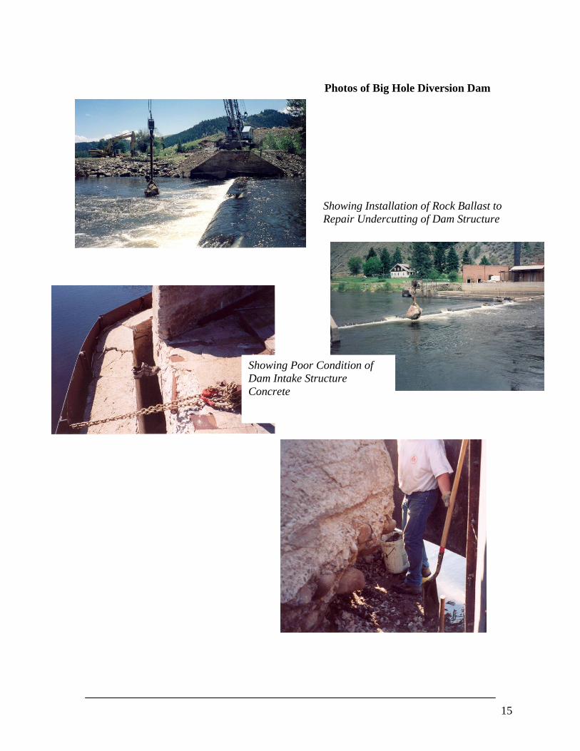
Photos of Big Hole Diversion Dam
Showing Installation of Rock Ballast to Repair Undercutting of Dam Structure
Showing Poor Condition of Dam Intake Structure Concrete
15
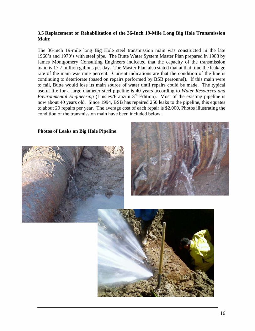
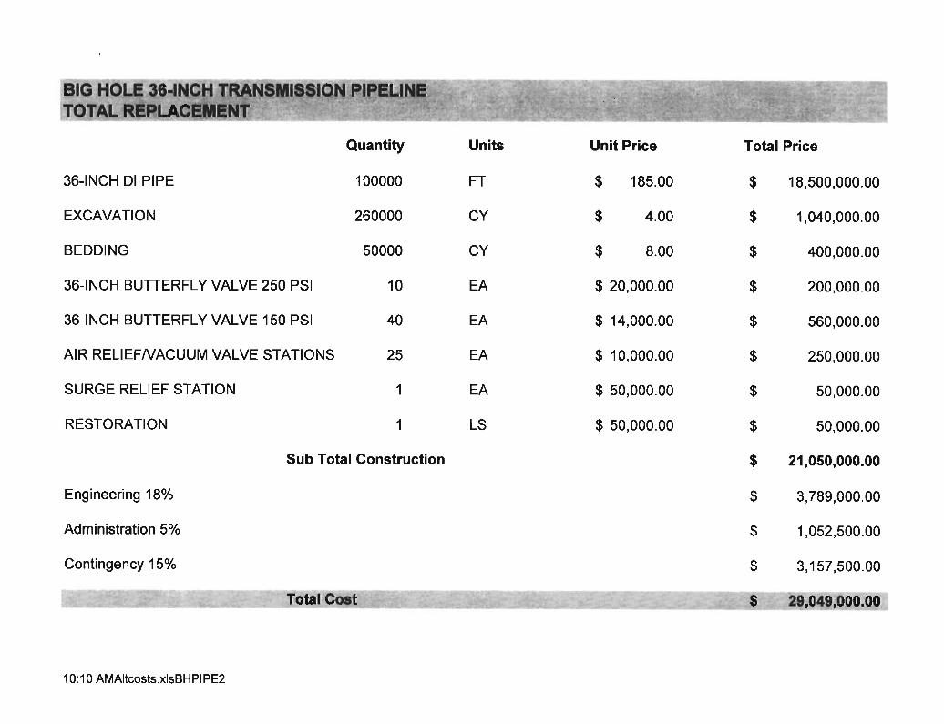
3.5 Replacement or Rehabilitation of the 36-Inch 19-Mile Long Big Hole Transmission Main: The 36-inch 19-mile long Big Hole steel transmission main was constructed in the late 1960’s and 1970’s with steel pipe. The Butte Water System Master Plan prepared in 1988 by James Montgomery Consulting Engineers indicated that the capacity of the transmission main is 17.7 million gallons per day. The Master Plan also stated that at that time the leakage rate of the main was nine percent. Current indications are that the condition of the line is continuing to deteriorate (based on repairs performed by BSB personnel). If this main were to fail, Butte would lose its main source of water until repairs could be made. The typical useful life for a large diameter steel pipeline is 40 years according to Water Resources and Environmental Engineering (Linsley/Franzini 3rd Edition). Most of the existing pipeline is now about 40 years old. Since 1994, BSB has repaired 250 leaks to the pipeline, this equates to about 20 repairs per year. The average cost of each repair is $2,000. Photos illustrating the condition of the transmission main have been included below. Photos of Leaks on Big Hole Pipeline
16
The pipeline was coated with very substandard material which consisted of hand painting coal tar on the inside pipe with brushes. The outside of the pipeline was coated only in areas where the pipe was below groundwater. There is no corrosion protection or cathodic protection system installed on the pipeline to protect it from corrosive soils. For these and the above reasons sections of this pipeline needs to be rehabilitated. The estimated average cost to rehabilitate one mile of pipeline is $1.5 million including engineering and a 15% contingency. It is not clear, at this point in time, how much of the pipeline will require rehabilitation or replacement. A corrosion evaluation should be performed on the pipeline to determine it’s the overall condition. This study would entail the following steps:
1. Performing soil resistivity tests along the pipeline alignment to determine the corrosivity of the soils.
2. Excavate and expose the pipeline at locations where the resistivity testing indicates the most corrosive soil conditions.
3. Perform ultrasonic testing to verify the thickness of the pipe at the excavation sites. If necessary, circular samples of the pipeline (approximately 2-inches in diameter) would be cut out at various locations to provide visual verification of the pipeline condition. This sampling would occur in the fall or winter months when water demands are low and the pipeline can be taken out of service for a short period of time.
4. Install test stations at selected locations to determine if it is possible to install a corrosion protection system on the pipeline to protect and extend the useful life of the sections of pipeline that are still in serviceable condition.
The results of this study would provide data to determine what sections of pipeline need to be replaced and what sections that could remain in place if the appropriate protection is provided. The cost of performing the required study is estimated at $35,000. This conceptual restoration plan in one of the restoration alternatives discussed below, is proposing to fund this study and one-half of the pipeline replacement and corrosion protection system once the required improvements are identified by the corrosion control study. The NRD funding can be used as a match if Butte-Silver Bow needs to acquire additional funding to complete any necessary Big Hole Pipeline improvements. This replacement project may be eligible to receive grant funding from other sources such as the Montana Treasure State Endowment Program (TSEP), Renewable Resource Grant and Loan Program (RRGL), the State and Tribal Assistance Grant program (STAG) and the Water Resources Development Act (WRDA). Each of these sources is described briefly below:
TSEP. Up to $750,000 in grant funding is available from the TSEP program, however, a 50% match is required from other sources. Matching funds can come from other grant and loan sources. Criteria for TSEP grant awards include urgent threats to health and safety, regulatory compliance, economic development and
17
financial need. Applications are competitive, and funding is available on a biannual basis, subject to legislative approval. Applications are typically due in May of even numbered years. RRGL. Up to $100,000 in grant funding is available from the RRGL program. Eligible projects must promote conservation of the water resource. Any governmental entity is eligible to apply. STAG and WRDA Grants. Both of these programs require a congressional appropriation. The WRDA program is administered by the Army Corps of Engineers and the STAG program by the Environmental Protection Agency. Applications for these grant programs are available through the offices of each of Montana’s congressional delegates. Typically the application is not specific to the SRDA versus the STAG program, and a funding request is assigned by the delegation to either program at its discretion. WRDA grants require a 45% match, none of which can be other federal dollars. STAG grants require a 25% match, which also cannot include other federal money. Municipal water projects are eligible under both grant programs. Strong local advocacy through repetitive and ongoing lobbying by local leaders and residents is important in obtaining WRDA or STAG funds.
3.6 Construction of a New Basin Creek Water Treatment Plant: Butte currently obtains up to seven million gallons of drinking water per day from the Basin Creek source. The Basin Creek source is currently under a filtration waiver and the only treatment it receives is chlorine disinfection. The Basin Creek source enters Butte’s distribution system by gravity and is the community’s most economical source of water. Upcoming EPA drinking water regulations for surface water sources will have an affect on the Basin Creek source. These regulations include:
Long Term 1 Enhanced Surface Water Treatment Rule. Unfiltered sources such as Basin Creek must update their watershed control programs to include cryptosporidium as a pathogen of concern. Cryptosporidium is a protozoan parasite that is resistant to disinfectants like chlorine and can cause acute gastrointenstinal illness including the risk of death in sensitive subpopulations such as infants and the elderly. Long Term 2 Enhanced Surface Water Treatment Rule. This Rule requires that all unfiltered systems provide at least 99 or 99.9 percent inactivation of cryptosporidium depending upon monitoring results for cryptosporidium in the water source. The purpose of this rule is to reduce disease incidence associated with cryptosporidium and other pathogenic organisms in drinking water. Unfiltered systems must meet the combined cryptosporidium, giardia lamblia, and virus inactivation requirements using a minimum of two disinfectants. Unfiltered systems not able to meet the required inactivation levels may be required to filter their water. Additionally, if the Basin Creek source fails to meet any of the requirements of its filtration waiver, Butte will have to construct a treatment plant. At a minimum, to
18
meet the requirements of this rule a second source of disinfection will have to be incorporated. A combination of ultraviolet light disinfection and chlorination may meet the requirements for two disinfectants.
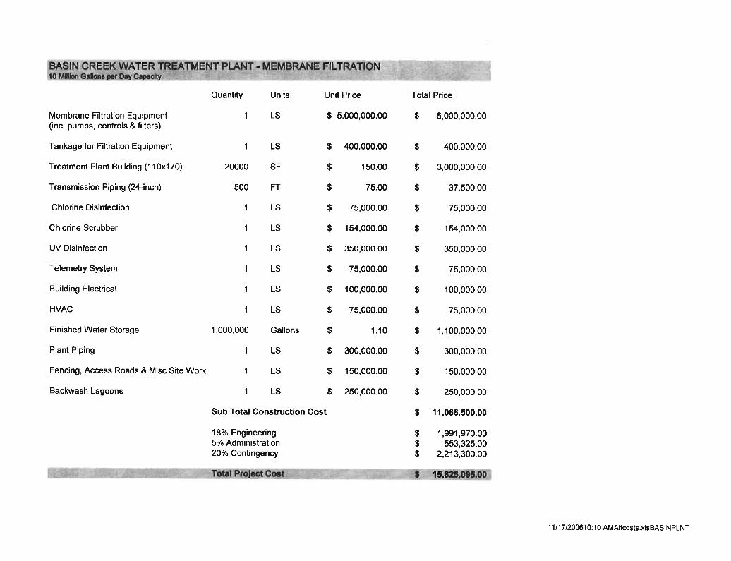
Filtration waiver requirements include the following: source water turbidity measurements must stay below 5 NTU and total and fecal coliform concentrations must not exceed 20 per 100 milliliters and 100 per 100 milliliters, respectively. The Basin Creek watershed is heavily timbered and the forest is suffering from a pine beetle infestation that has killed a significant portion of the trees in the watershed. The watershed is currently very susceptible to fire. If a fire were to occur, the existing reservoirs would more than likely become contaminated with runoff with high loads of sediment and microbiological contaminants. Such an event would make very difficult if not impossible for the Basin Creek supply to meet the requirements of its filtration waiver. Therefore, there is a possibility that Butte will be required to construct a filtration plant for the Basin Creek source. New regulations, such as those discussed above, and the susceptibility of the drainage to contamination from fire and other sources create the possibility that the county will not be able maintain the filtration waiver for Basin Creek in the long term and, perhaps, in the short term. Detailed cost estimates for the construction of a new water treatment plant utilizing membrane filtration, and for the construction of a combination ultraviolet/chlorine disinfection system, are provided in Appendix 1. The estimated total PNW cost for a new water treatment plant built in 2011 and 2012 is $15.2 million, which includes engineering and a 20% contingency. The actual cost of the treatment plant will be dependent upon the final treatment technology that is selected. It is difficult to predict when a new water treatment plant will be needed to treat the Basin Creek source. In some of the alternatives in this conceptual restoration plan below, the State proposes partial funding of the cost to construct a new water treatment plant for the Basin Creek source and/or install a second disinfection process to meet the requirements of the upcoming Long Term 2 Enhanced Surface Water Treatment Rule. These funds can be used to leverage other funding sources as described under Section 3.6 above.
19
20
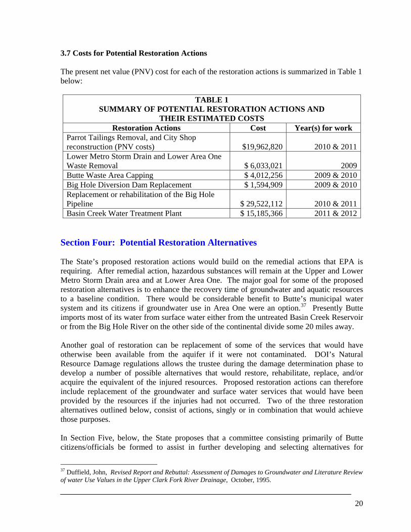
3.7 Costs for Potential Restoration Actions The present net value (PNV) cost for each of the restoration actions is summarized in Table 1 below:
TABLE 1 SUMMARY OF POTENTIAL RESTORATION ACTIONS AND
THEIR ESTIMATED COSTS Restoration Actions Cost Year(s) for work
Parrot Tailings Removal, and City Shop reconstruction (PNV costs) $19,962,820 2010 & 2011Lower Metro Storm Drain and Lower Area One Waste Removal $ 6,033,021 2009Butte Waste Area Capping $ 4,012,256 2009 & 2010Big Hole Diversion Dam Replacement $ 1,594,909 2009 & 2010Replacement or rehabilitation of the Big Hole Pipeline $ 29,522,112 2010 & 2011Basin Creek Water Treatment Plant $ 15,185,366 2011 & 2012
Section Four: Potential Restoration Alternatives The State’s proposed restoration actions would build on the remedial actions that EPA is requiring. After remedial action, hazardous substances will remain at the Upper and Lower Metro Storm Drain area and at Lower Area One. The major goal for some of the proposed restoration alternatives is to enhance the recovery time of groundwater and aquatic resources to a baseline condition. There would be considerable benefit to Butte’s municipal water system and its citizens if groundwater use in Area One were an option.37 Presently Butte imports most of its water from surface water either from the untreated Basin Creek Reservoir or from the Big Hole River on the other side of the continental divide some 20 miles away. Another goal of restoration can be replacement of some of the services that would have otherwise been available from the aquifer if it were not contaminated. DOI’s Natural Resource Damage regulations allows the trustee during the damage determination phase to develop a number of possible alternatives that would restore, rehabilitate, replace, and/or acquire the equivalent of the injured resources. Proposed restoration actions can therefore include replacement of the groundwater and surface water services that would have been provided by the resources if the injuries had not occurred. Two of the three restoration alternatives outlined below, consist of actions, singly or in combination that would achieve those purposes. In Section Five, below, the State proposes that a committee consisting primarily of Butte citizens/officials be formed to assist in further developing and selecting alternatives for
37 Duffield, John, Revised Report and Rebuttal: Assessment of Damages to Groundwater and Literature Review of water Use Values in the Upper Clark Fork River Drainage, October, 1995.
21
spending the settlement money earmarked for the Butte Area One.38 Three potential restoration alternatives are presented here by the State. These alternatives are proposed as projects to be included in a Final Butte Area One Restoration Plan to be completed within one or two years of the effective date of the consent decrees, after input from the Butte committee and a public comment period. 4.1 Alternative One: Alternative One would remove known primary waste sources to reduce releases of hazardous substances to ground and surface water. The major components for this alternative are:
1) Removal and reconstruction of the City-County vehicle shop, located east of the civic center;
2) Excavate and removal of an estimated 666,000 cubic yards at the Parrot Tailings;
3) Excavate and removal of accessible tailings at Lower Area One and Lower Metro
Storm Drain, estimated at 162,000 cubic yards;
4) Placement of 12 inches of vegetative capping material on approximately 35 acres of previously reclaimed waste sites; and
5) Coordination with future remedial actions and enhanced restoration capping of 60
acres of unreclaimed waste areas.
The goals of Alternative One are primary restoration of the injured groundwater and alluvial aquifer, and restoration of Silver Bow Creek, within Butte, including its surface water. Without removal of the Parrott tailings and other MSD and LAO wastes, the groundwater will not recover for several hundreds to thousands of years. The State believes that this alternative will reduce the time frame for recovery to 100 years or less and, therefore, greatly benefit the alluvial aquifer and injured groundwater resource.39 It also believes that removals in Area One will also reduce the loading of hazardous substances into Silver Bow Creek and, therefore, protect the aquatic resources in and along the creek. The State is presently conducting a multi million-dollar remedial/restoration effort to remove hazardous substances from the creek. Reduction of metal loading from Area One sources will benefit this cleanup effort. The estimated total cost for the Area One source removals and replacement of the shop buildings is $25,995,841. The proposed time frame for this work is between 2009 and 2011. Placement of additional soil and seeding on the capped or future capped Butte waste areas will be coordinated with the remedial actions and would enhance the water quality of storm
38 It is estimated that several million dollars in interest earning will accrue from this $28.0 million settlement amount while restoration is being planned, designed and performed. 39 Installation of a pump and treat system in this area could further reduce the recovery time to about 30 years.
22
water before it reaches Silver Bow Creek. The enhanced capping effort will increase the total area of wastes caped with permanent vegetation covers, which will also reduce future remedial maintenance costs.40 The cost for capping the proposed 95 acres at 21 separate waste sites is $4,012,256. The proposed time frame for this action is during years 2009 and 2010, unless remedy occurs at these areas at a different time. The Restoration work proposed above is expected greatly reduce the likelihood that a treatment plant will be necessary in perpetuity at the site, thereby saving many years of expensive treatment plant operation and maintenance. Total estimated PNV costs for Alternative One are estimated to be $30,008,097. 4.2 Alternative Two Alternative Two would remove known primary waste sources to reduce releases of hazardous substances to groundwater and surface water. The alternative also includes a replacement action, the construction of a water treatment plant for the Basin Creek drinking water supply. The major components for this alternative are:
1) Removal and reconstruction of the City-County vehicle shop, located east of the civic center;
2) Excavate and removal of 666,000 cubic yards of the Parrot Tailings;
3) Placement of 12 inches of vegetative capping material on approximately 35 acres of
previously reclaimed waste sites; 4) Coordination with future remedial actions and enhanced restoration capping of 60
acres of unreclaimed waste areas;
5) Funding of one-third of the money needed for a water treatment plant for the Basin Creek Reservoir.
The goals of Alternative Two are three-fold; 1) primary restoration of the injured groundwater and alluvial aquifer; 2) restoration of Silver Bow Creek, within Butte, including its surface water; 3) enhancement of Butte’s drinking water infrastructure. Like Alternative One, this alternative reduces the impacts to surface water and groundwater with the removal of some of the major wastes source in Area One and by addressing some of the wastes piles on Butte Hill. Like Alternative One, this alternative will reduce the length of time remedy will have to treat contaminated water. The replacement action chosen for Alternative Two focuses on the Basin Creek Reservoir drinking water source, which makes up 30 percent of Butte’s supply. Construction of a water
40 The ROD calls for a water treatment plant for treating storm water if BMPs and existing treatment ponds are not effective in achieving surface water quality standards in Silver Bow Creek. The cost for this lime treatment plant is estimated at $18 million.
treatment plant will be needed because the source is currently under a filtration waiver and the only treatment it receives is chlorine disinfection. Due to promulgated surface water treatment rules, and the susceptibility of the Basin Creek drainage to be contaminated, as explained in section 3.6, it is expected that the present filtration waiver will expire and a water treatment plant will be necessary. The total PNV costs for Alternative Two are estimated to be $28,986,246. 4.3 Alternative Three Under Alternative Three only replacement and waste capping actions are proposed. These actions are: 1) Replacement of 12 inches of vegetative capping material on approximately 35 acres of
previously reclaimed waste sites; 2) Coordination with future remedial actions and enhanced restoration capping of 60 acres
of unreclaimed waste areas; 3) Rehabilitate the Diversion Dam at the Big Hole Pump Station in 2009 and 2010;
4) Rehabilitate one-half of the Big Hole 36-Inch Transmission Main in 2010 and 2011; and
5) Funding of one-half of the money needed for a Basin Creek Reservoir water treatment
plant.
In this alternative, no further action is taken to enhance the recovery of injured Area One ground and surface water resources beyond the work to be completed under remedy, with the exception of the capping work which should reduce contaminated runoff to Silver Bow Creek. Under this scenario it will take many centuries to thousands of years before the groundwater contamination would eventually decrease as leaching mechanisms deplete the supply of hazardous substances from the Parrott Tailings, MSD tailings, and LAO tailings. With the major contamination sources left in place, it will likely be necessary to leave the remedial water treatment operations for many centuries. The above replacement actions are intended to replace the services that an uncontaminated alluvial aquifer could otherwise provide. The estimated PNV cost for the replacement and enhanced capping actions proposed under Alternative Three is estimated to be $27,960,903. The time frame proposed for these actions is between 2009 and 2012. Section Five: Restoration Planning Process for Butte Area One Groundwater and Surface Water Resources As noted above, the restoration alternatives discussed in this draft conceptual restoration plan are only recommended alternatives. Ultimately these projects may or may not be implemented. After the settlement is finally approved by the Court, a specific restoration
23
planning process will be developed to determine how the $28 million in settlement money allocated to Butte Area One will be utilized to restore or replace the injured resources. This process will be formalized in a document which, in certain respects, would be similar to the planning process set forth in the State’s Upper Clark Fork River Basin Restoration Plan Procedures and Criteria (RPPC), which the State utilizes in its restoration grant program. However, the goal of this new process would be different; the goal would be to develop a final restoration plan that would utilize the entire $28 million, plus interest, on Butte restoration projects. A “Butte NRD Restoration Council” would be created and, for purposes of Butte Area One restoration planning, take the place of the Governor’s Advisory Council in the RPPC process. Other parts of that process, however, would be retained. For example, some of the criteria in the RPPC for selecting appropriate restoration projects would be retained, including the legal requirement that the settlement money be used only to restore, replace, or acquire the equivalent of the injured natural resources. Also, the Butte NRD Restoration Council would make its recommendation to the Governor’s Trustee Restoration Council (consisting of the Directors of the State’s natural resource agencies, the Attorney General, and the Governor’s Chief of Staff) and then that council would make a recommendation to the Governor, who, as trustee of the settlement money, would approve the final restoration plan for the Butte Area One injured resources. (Referring to this as a “final” restoration plan is not meant to imply that additional NRD funded restoration projects that are outside the scope of this final plan could not be approved for the Butte area under the established RPPC restoration grant process.) As indicated above, the major difference between the Butte and RPPC restoration planning processes would be that under the Butte planning process, there would be determination of a final restoration plan over a one to two year period and there would not be an on-going, annual restoration planning and grant process. (This is not to say that the Butte restoration plan could not subsequently be amended.) The final Butte restoration plan would allocate the entire $28.0 million settlement amount earmarked for the Butte Area One injured resources, plus the interest earned on that amount, to specific restoration projects in the Butte area that would be thereafter implemented. This $28.0 million will be held in an interest bearing, State special revenue account invested by the Montana Board of Investments. (For tax, trust and other legal and policy considerations, this requirement is mandated by the Consent Decree.) The State envisions that the Butte NRD Restoration Council would be appointed by the Butte-Silver Bow Chief Executive, the Butte Silver Bow County Commissioners and the Governor. In order to facilitate an orderly and efficient planning process, the State believes that the Council should consist of approximately seven qualified Butte citizens or local officials appointed by the Chief Executive and approved by the Commission, and three qualified citizens or government officials appointed by the Governor, who would reflect more State-wide rather than local interests. The Butte Restoration Council will be staffed by Montana’s NRD Program and one new staff member would be added to the Program and located in the Butte office. This new staff member’s time would initially be devoted to the development of the Butte Restoration Plan and to servicing the Butte NRD Restoration
24
25
Council. It is expected that members of the Council will participate in the selection process for this new position. Once a Butte restoration plan was developed and approved by the Governor, this position would be responsible for overseeing the implementation of that plan, including design and construction oversight and ensuring the proper accounting of all expended restoration funds. It is assumed that Butte Silver-Bow County would take the lead in implementing the Butte restoration plan pursuant to an MOU with the State providing for State oversight and funding from the $28 million restoration fund held by the Board of Investments. Accordingly, the county would be responsible for procuring or hiring any needed employees, contractors and consultants needed to implement the plan and conduct the work. All costs of the development and implementation of the Butte restoration plan, including administrative costs, would come from the $28 million, plus interest, earmarked for the Butte restoration.
Section 6: References ARCO, September 2005. Draft Data Summary and Interpretation Report. Base Flow and Wet Weather Data October 2003-September 2004. Camp Dresser and McGee, (CDM) February 2004. Phase II Remedial Investigation/Feasibility Study Final Feasibility Study Report. Final Focused Feasibility Study of the Metro Storm Drain. Prepared for EPA. CTEC (Citizens Technical Environmental Committee) August 5, 2005. Comments on the Groundwater Technical Impracticability Evaluation for Butte Priority Soils Operable Unit. Duffield, John, W., October, 1995. Revised Report and Rebuttal Assessment of Damages to Groundwater and Literature Review of Water Use Values in the Upper Clark Fork River Drainage. Environmental Protection Agency, December 2004. Superfund Program Cleanup Proposal, Butte Priority Soils Operable Unit/Silver Bow Creek/Butte Area Superfund Site. Environmental Protection Agency, September 2006. Record of Decision: Butte Priority Soils Operable Unit, Silver Bow Creek/Butte Area NPL Site. James M. Montgomery, March 1988. Butte Water Master Plan. Mayn, C.M. Assessment of Land Reclamation Characteristics and Maintenance Techniques to Promote Long-Term Sustainability of Reclaimed Areas in Butte, Montana. MSU M.S. Thesis April 2001. Madison, J. January 2006. Soil Borings at Butte Silver Bow Metro Sewage Treatment Plant and Butte Reduction Works, Butte, Montana. Montana Bureau of Mines and Geology. Maest, A.S., Metesh, J.J., and Brand R. J., 1995. Butte Groundwater Injury Assessment Report, Clark Fork River Basin NPL sites, Montana. Report prepared for Natural Resource Litigation Program. MBMG. 2005 Surface Water Data via e-mail from Pete Norbeck to Gregory Mullen. Metesh, J.J., and Madison, J.P., 2004. Summary of Investigation, Upper Silver Bow Creek, Butte, Montana. Butte: Montana Bureau of Mines and Geology. OFR 507.6p. Natural Resource Damage Program, 1995. State of Montana Natural Resource Damage Program Restoration Determination Plan Upper Clark Fork River Basin. Montana Department of Justice. October 1995. PRP Group, April 2002, Phase II Remedial Investigation Report for the Butte Priority Soils Operable Unit.
26
27
PRP Group, April 2004. Butte Priority Soils Operable Unit Phase II Feasibility Study Report. PRP Group, August 2001. Response Action Summary Document, Butte Priority Soils Operable Unit. United States Environmental Protection Agency, 2004. Superfund Program Cleanup Proposal, Butte Priority Soils Operable Unit of the Silver Bow Creek/Butte Area Superfund Site (the “Proposed Plan”). U.S. EPA Region 8, Helena, MT. Water & Environmental Technologies, June 2004. Technical review Comments for: Focused Feasibility Study of the Metro Storm Drain & Upper Silver Bow Creek Investigation.
Appendix 1
Restoration/Replacement Alternative Cost Estimates
LIST OF RESTORATION ACTION COST SHEETS
1) Remove Parrot Tailings, haul and place, relocate buildings
2) Remove tailings from MSD and LAO, haul and place 3) Capping cost estimate
4) Big Hole diversion dam construction cost estimate
5) Big Hole 36-inch transmission pipeline
6) Basin Creek water treatment plant – membrane filtration
7) Present Value Analysis for restoration actions
REMOVE PARROT TAILINGS, HAUL AND PLACE, RELOCATE BUILDINGS
ITEM QUANTITY UNIT UNIT PRICE TOTAL PRICE
PROJECT START-UP/ENVIRONMENTALMobilization, Start-up, Bonding & Insurance 1 LS 400,000.00$ $550,000Testing/Environmental 1 LS 350,000.00$ $350,000
Sub total $900,000
SITE DEMOLITIONShop 363000 CF 0.26$ $94,380Office 125000 CF 0.26$ $32,500Vehicle Storage (small) 259200 CF 0.26$ $67,392Vehicle Storage (large) 421200 CF 0.26$ $109,512Wash Building 55440 CF 0.28$ $15,523Bus Barn 114048 CF 0.26$ $29,652
Pavement Removal 55000 SY 4.00$ $220,000Fence Removal 3500 LF 2.50$ $8,750Misc. Demolition/Removal 1 LS 30,000.00$ $30,000
Sub Total $607,710
TAILINGS REMOVAL
Stock Pile & Re-Spread Overburden 62683 CY 6.15$ $385,500
Parrott AExcavate, Short Haul & Load* 222200 CY 4.15$ $922,130
Haul 222200 CY 3.00$ $666,600Unload /Spread 222200 CY 2.90$ $644,380
Site Deewatering 1 LS 111,000.00$ $111,000Revegetate 17 ACRES 9,900.00$ $168,300
Parrott CExcavate & Load 444000 CY 4.15$ $1,842,600
Haul 444000 CY 3.00$ $1,332,000Unload /Spread 444000 CY 2.90$ $1,287,600Site Dewatering 1 LS 575,000.00$ $575,000
Revegetate 21 ACRES 9,900.00$ $207,900Sub Total $8,143,010
RELOCATE/RECONSTRUCT BLDGS
Shop 16500 SF 85.00$ $1,402,500Office 10000 SF 110.00$ $1,100,000Vehicle Storage (cold storage) 14400 SF 40.00$ $576,000Vehicle Storage (warm storage) 23400 SF 50.00$ $1,170,000Wash Building 2520 SF 75.00$ $189,000Bus Barn 6336 SF 50.00$ $316,800Pavement 55000 SF 15.00$ $825,000Fencing 4000 LF 20.00$ $80,000Landscaping 1 LS 20,000.00$ $20,000Misc. Site Work 1 LS 20,000.00$ $20,000Purchase Land 20 ACRES 10,000.00$ $200,000
Sub Total $5,899,300
TOTAL CONSTRUCTION $15,550,020Contingency @ 15% $2,332,503Engineering @ 15% $2,332,503
TOTAL PROJECT COST $20,215,026
*Excavation and Haul by Scrapers
Costs based on RS Means Cost Estimating Guides: Heavy Construction Cost Data 2004, Site Work and Landscape Cost Data 2004 &Square Foot Costs 2005 and CDM Table CS-5b
Dewatering Costs from Table CS-5b
Note : RS Means Dewatering Cost is $174 per foot for well point system 1000 ft long for first month and $57.50 for each subsequent monthCDM using $119.29 per foot plus 23% O&P which is $146.73
REMOVE TAILINGS FROM MSD AND LAO, HAUL AND PLACE
6-Dec-05ITEM QUANTITY UNIT UNIT PRICE TOTAL PRICE
PROJECT START-UP/ENVIRONMENTALMobilization, Start-up, Bonding & Insurance 1 LS 76,000.00$ 76,000Testing/Environmental 1 LS 150,000.00$ 150,000
Sub total 226,000
TAILINGS REMOVAL
Stock Pile & Re-Spread Overburden 41051 CY 6.15$ 252,464
Lower Metro Storm Drain (East and West)Excavate, Short Haul & Load* 114000 CY 4.15$ 473,100
Haul 114000 CY 3.00$ 342,000Unload /Spread 114000 CY 2.90$ 330,600
Dewatering* 1 LS 745,000.00$ 745,000Revegetate 40 ACRES 9,900.00$ 396,000
Lower Area OneExcavate & Load 47730 CY 4.15$ 198,080
Haul 47730 CY 3.00$ 143,190Unload /Spread 47730 CY 2.90$ 138,417
Dewatering** 1 LS 700,000.00$ 700,000Revegetate 15 ACRES 9,900.00$ 148,500
Sub Total 3,867,350
Total Construction Cost 4,093,350
Engineering 18% 736,803Contingency 15% 614,003
TOTAL ESTIMATED PROJECT COST 5,444,156
* From CDM Table CS-5b** gross estimate based on cost from MSD; see foot note on Parrot Cost Estimate
1/23/20083:11 PMParrott Tailings r (2)Lower MSD & LAO
APPENDIX 2
AREA ONE SURFACE WATER RESOURCE ADDENDUM
CAPPING OF WASTE SOURCE SITES
May 2005
Bighorn Environmental Sciences 610 Monroe Ave. Dillon, MT 59725
(406) 683-9718
2
TABLE OF CONTENTS for Appendix 2
Executive Summary ...........................................................................................................3 Section 1.0: Introduction ..................................................................................................4 1.1: Selecting Candidate Sites for Restoration ...................................................................5 1.2: Capping Waste in Place ...............................................................................................6 Section 2.0: Status of Current Capped Wastes on Butte Hill .......................................6 2.1: Coversoil Characteristics for Satisfactory Caps and Revegetation .............................8 Section 3.0: Improving Butte Hill Revegetation on Capped Waste Piles ..................14 3.1: Specific Recommendations........................................................................................15 References .........................................................................................................................17 Appendix A: Candidate Sites, Acreages and Other Information1 Appendix B: Restoration Seed Mixes 1 In this appendix are: 1) the list of sites and corresponding acreages proposed for restoration. 2) Six color photos of mine sites proposed for restoration. 3) Information about the reclamation history at the major sites. 4) A color BPSOU map, which depicts the 22 restoration sites. 5) A cost table for capping/removal of wastes sites. 6) Storm water figure, which portrays copper and zinc concentrations at Silver Bow Creek over a 20-year period. 7) Storm water figure from the 2006 ROD which portrays copper and zinc concentration at SBC over a 20-year period. 8) A storm water data summary table, which summarizes storm water exceedences along the MSD and SS-07 from 2001 to 2002. 9) Figure from ROD depicting Butte hill storm water drainage basins. 10) A figure, which outlines the various drainage areas along Butte Hill and illustrates the location of a potential storm water treatment plant.
3
EXECUTIVE SUMMARY The Natural Resource Damage program has identified the need to better isolate some Butte Hill mine waste to prevent heavy metals from being discharged to, or entrained in, surface waters Silver Bow Creek. Within the Butte Hill Priority Soils Operable Unit (BPSOU):
• Approximately 218 source areas comprising more than 400 acres have been remediated on the Butte Hill, depending upon one’s definition of remediation.
• Sixty-two sites, or less than one-third, are designated open space. These are the best candidates for restoration.
Capped mine waste had the following mean concentrations +- 90% confidence intervals. In almost every case, only the upper one or at most two inches of waste was sampled. Except where erosion continually exposed fresh material, the surface area would have the lowest contaminant concentrations due to leaching.
• pH 4.9 400 ppm As 1,100 ppm Cu 2,400 ppm Pb 4,800 ppm Zn These factors limit revegetation success on the Butte Hill:
• Most pre-1988 coversoils are significantly less than 18 inches thick. • Two investigators independently found that 22-23 inches of typical coversoil
provides a very high likelihood of satisfactory revegetation. • Fully satisfactory plant cover and productivity are linked to alfalfa as a
codominant species to various grasses. In one investigation, all reclaimed sites with successful alfalfa establishment had at least 22 inches of coversoil.
• As a plant growth medium, other coversoil limitations are infertility, excessively coarse particle size, and microbial impoverishment.
The following are proposed to improve revegetation success at selected sites zoned as open space:
• Bring coversoil thickness to at least 22 inches using material of mixed volcanic and granitic origin of sandy loam texture or better.
• Fertilize as indicated by coversoil analysis. • Bring the upper four inches of placed coversoil to at least 1.5% organic matter
content with a good compost amendment. • Seed with a mix of predominantly native and secondarily introduced species,
including shrubs and inoculated alfalfa. Following field inspections by MDOJ, MDEQ, and Bighorn Environmental Sciences, 24 sites comprising 96 acres were chosen as the best candidate. The potential to combine remediation and restoration is good at 14 of these sites (62.7 acres), assuming the need
4
for remediation is recognized for all sites. Photos of some of these sites are in Appendix A of this report. Our goal is healthy plant communities that are functioning biotic components of the Upper Clark Fork ecosystem, producing biomass, cycling nutrients, providing wildlife habitat, minimizing water infiltration into harmful subsoil strata, preventing soil erosion and abetting soil genesis, and providing aesthetically pleasing landscape components in predominantly urban areas where property values reflect, in part, the attractiveness of neighborhoods. Revegetated plant communities are expected to be self-sustaining and self-repairing.
Butte-Silver Bow Planning Department, Reclamation Goals and Proposed Standards for the Butte Hill.
“Coversoil depth was the most important variable driving reclamation success in the reclaimed sites studied.” (p. 43)
Cole Mayn’s 2001 master’s thesis on BPSOU reclamation 1.0 Introduction Past operations of Butte’s mines, mills, concentrators, and smelters generated tailings and a variety of other hazardous substances. The resulting waste piles are scattered throughout the city of Butte where they have eroded and contaminated surface water. In the 1990’s the severe erosion to Silver Bow Creek from these waste piles were reduced, but not eliminated, by remedial actions. In addition to preserving human health, keeping toxic waste from entering Silver Bow Creek is a major objective of Priority Soils CERCLA remediation. Approximately 218 individual waste areas within the Butte Priority Soils Operable Unit (BPSOU, often referred to here as the Butte Hill), comprising more than 400 acres, have been capped with dirt over the last 10-20 years under various remedial actions to isolate hazardous mine waste, sometimes with partial waste removal. Urbanization of the Butte Hill and paving of large areas increased storm water runoff relative to pre-urbanization levels (Arco 2003). Silver Bow Creek receives the surface and storm water runoff from many waste source areas on the Butte Hill. The major ephemeral sub-drainages from Butte Hill are called Warren Avenue, Anaconda Road/Butte Brewery, Buffalo Gulch, Montana Street, Idaho Street, Upper Missoula
5
Gulch, and West Side. Grove Gulch north of Timber Butte also feeds contaminants into Silver Bow Creek. Many of these sub-drainages are in areas where metals may potentially be discharged to, or entrained in, surface waters (Arco 2003). Hazardous elements reaching Silver Bow Creek from the Butte Hill include aluminum, arsenic, cadmium, copper, lead, mercury, silver, and zinc. The majority of storm water measured during 13 different events in 2001 and 2002 exceeded WQB-7 standards for aquatic life or human health at compliance stations along Silver Bow Creek in Butte. (See Table 7a from Arco 2003). Past remedial actions have reduced metal concentrations in storm water; however, concentrations of copper and zinc still remain significantly above aquatic life standards. (See Figure 32 from Arco 2005.) Continuing significant metal loading of Silver Bow Creek from the Butte Hill is evident from recent storm water data collected during remedial investigations. Past mining activities, including air pollution from ore smelting, also devastated the Butte Hill’s terrestrial ecosystem. As a result, Butte’s urban open spaces lack terrestrial ecosystem components that are normally present in other Montana communities of similar size. EPA recognized these impacts in the 2004 BPSOU Proposed Plan:
Mining in Butte left an urban landscape littered with unvegetated or sparsely vegetated mine wastes, often containing elevated concentrations of contaminants. (p. 12).
NRDP proposes to augment future reclamation by combining elements of restoration with those of remediation. In other cases, NRDP proposes improving upon past remediation. This investigation: 1) Summarizes typical remediation activities on Butte Hill and identifies past remediation shortcomings, 2) Identifies waste sites where restoration is most appropriate, and 3) Outlines reclamation/revegetation activities designed to more permanently isolate toxic substances at unremediated and partially remediated source areas and improve runoff water quality while enhancing vegetation and wildlife habitats. These activities are expected to reduce metal loading in Silver Bow Creek and thereby increase the rate of recovery of Silver Bow Creek, which is currently being remediated and restored. Not only will hazardous substance releases be reduced by the efforts proposed in this plan, but also, the recapped areas will support more diverse vegetation and will require less future maintenance than is presently required. 1.1 Selecting Candidate Sites for Restoration Butte-Silver Bow Master Plan and Walkerville’s Land Use Plan were used to select candidate restoration sites. Only those 62 sites (about 30% of all source areas) in areas designated open space or public were considered. Preserving open space is a standard urban-planning conservation practice in which natural and aesthetic resources are
6
recognized and protected as important community amenities. On the Butte Hill, many treated open spaces remain aesthetically and ecologically impaired. Restoration can increase both their attractiveness and functions. Another important reason to restore only open space/public sites is to assure that restoration won’t be undone by conversion to another land use. That is exactly what happened at the Colorado Stamp Mill site, now better known as the BSB Correctional Facility or the county jail. The County improved on standard (minimal) remediation by removing more waste, adding cap material, building a retaining wall, and planting trees and shrubs in addition to seeding. These improvements, which cost about $10,000, were excavated. To prevent this from happening to restoration sites, only those source areas in areas designated open space or public are viable candidates. 1.2 Capping Waste in Place The role of caps or covers – the material that covers urban mine waste and is intended to isolate it from harmful pathways – is critical if “waste in place” is to be a permanent solution. In Butte Priority Soils “remediation,” the caps are borrowed material (dirt). Only through satisfactory revegetation can the integrity of the caps be maintained. The Natural Resources Conservation Service considers soil erosion exceeding one ton/acre/year to be the maximum acceptable for shallow soils, a category into which many of the older Butte Hill covers fail. Any visible indication of erosion would greatly exceed that limit, which is less than 0.01 inches of soil/year. Isolating mine waste following grading could be done several ways, e.g., asphalt or rock covers. The remedy selected was the cheapest one: covering contaminated materials with a thin layer of limerock and one foot or so of dirt, then seeding it. The theoretical role of revegetation is to prevent erosion while transpiring water before it contacts underlying toxic mine waste. Satisfactory revegetation is necessary for the covers to function as intended without eroding away. The next section explains why good covers are a prerequisite for satisfactory revegetation. 2.0 Status of Current Capped Wastes on Butte Hill Remediation thresholds on the Butte Hill in nonresidential areas are 1,000 ppm (= 1,000 mg/kg) arsenic (As) and 2,300 ppm lead (Pb). However, the lead levels in an open space residential area is 250 ppm. On page 20, the Proposed Plan states that human health and ecological risks determine whether remedial action is warranted but metals such as cadmium, copper, and zinc were not used to identify waste dumps for remediation. Recognized ecological risks were almost solely confined to surface water and discharges to Silver Bow Creek. For restoration, the phytotoxicity of waste material is an important issue – a very complicated one. The effect of heavy-metal contaminants such a copper (Cu) and zinc
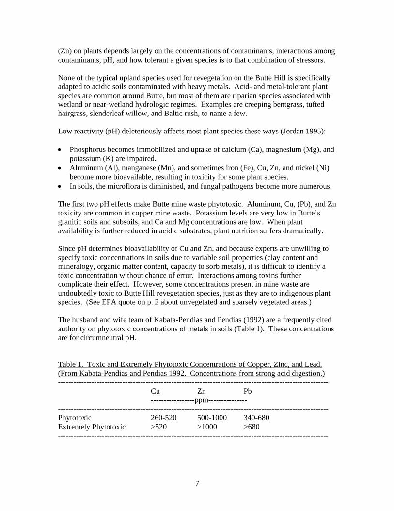
7
(Zn) on plants depends largely on the concentrations of contaminants, interactions among contaminants, pH, and how tolerant a given species is to that combination of stressors. None of the typical upland species used for revegetation on the Butte Hill is specifically adapted to acidic soils contaminated with heavy metals. Acid- and metal-tolerant plant species are common around Butte, but most of them are riparian species associated with wetland or near-wetland hydrologic regimes. Examples are creeping bentgrass, tufted hairgrass, slenderleaf willow, and Baltic rush, to name a few. Low reactivity (pH) deleteriously affects most plant species these ways (Jordan 1995): • Phosphorus becomes immobilized and uptake of calcium (Ca), magnesium (Mg), and
potassium (K) are impaired. • Aluminum (Al), manganese (Mn), and sometimes iron (Fe), Cu, Zn, and nickel (Ni)
become more bioavailable, resulting in toxicity for some plant species. • In soils, the microflora is diminished, and fungal pathogens become more numerous. The first two pH effects make Butte mine waste phytotoxic. Aluminum, Cu, (Pb), and Zn toxicity are common in copper mine waste. Potassium levels are very low in Butte’s granitic soils and subsoils, and Ca and Mg concentrations are low. When plant availability is further reduced in acidic substrates, plant nutrition suffers dramatically. Since pH determines bioavailability of Cu and Zn, and because experts are unwilling to specify toxic concentrations in soils due to variable soil properties (clay content and mineralogy, organic matter content, capacity to sorb metals), it is difficult to identify a toxic concentration without chance of error. Interactions among toxins further complicate their effect. However, some concentrations present in mine waste are undoubtedly toxic to Butte Hill revegetation species, just as they are to indigenous plant species. (See EPA quote on p. 2 about unvegetated and sparsely vegetated areas.) The husband and wife team of Kabata-Pendias and Pendias (1992) are a frequently cited authority on phytotoxic concentrations of metals in soils (Table 1). These concentrations are for circumneutral pH. Table 1. Toxic and Extremely Phytotoxic Concentrations of Copper, Zinc, and Lead. (From Kabata-Pendias and Pendias 1992. Concentrations from strong acid digestion.) --------------------------------------------------------------------------------------------------------- Cu Zn Pb -----------------ppm--------------- --------------------------------------------------------------------------------------------------------- Phytotoxic 260-520 500-1000 340-680 Extremely Phytotoxic >520 >1000 >680 ---------------------------------------------------------------------------------------------------------
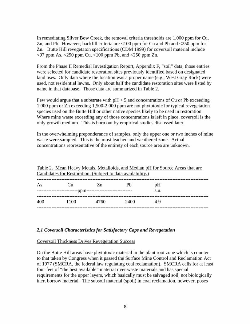
8
In remediating Silver Bow Creek, the removal criteria thresholds are 1,000 ppm for Cu, Zn, and Pb. However, backfill criteria are <100 ppm for Cu and Pb and <250 ppm for Zn. Butte Hill revegetaton specifications (CDM 1999) for coversoil material include <97 ppm As, <250 ppm Cu, <100 ppm Pb, and <250 ppm Zn. From the Phase II Remedial Investigation Report, Appendix F, “soil” data, those entries were selected for candidate restoration sites previously identified based on designated land uses. Only data where the location was a proper name (e.g., West Gray Rock) were used, not residential lawns. Only about half the candidate restoration sites were listed by name in that database. Those data are summarized in Table 2. Few would argue that a substrate with pH < 5 and concentrations of Cu or Pb exceeding 1,000 ppm or Zn exceeding 1,500-2,000 ppm are not phytotoxic for typical revegetation species used on the Butte Hill or other native species likely to be used in restoration. Where mine waste exceeding any of those concentrations is left in place, coversoil is the only growth medium. This is born out by empirical studies discussed later. In the overwhelming preponderance of samples, only the upper one or two inches of mine waste were sampled. This is the most leached and weathered zone. Actual concentrations representative of the entirety of each source area are unknown. Table 2. Mean Heavy Metals, Metalloids, and Median pH for Source Areas that are Candidates for Restoration. (Subject to data availability.) --------------------------------------------------------------------------------------------------------- As Cu Zn Pb pH -------------------------ppm---------------------------- s.u. --------------------------------------------------------------------------------------------------------- 400 1100 4760 2400 4.9 --------------------------------------------------------------------------------------------------------- 2.1 Coversoil Characteristics for Satisfactory Caps and Revegetation Coversoil Thickness Drives Revegetation Success On the Butte Hill areas have phytotoxic material in the plant root zone which is counter to that taken by Congress when it passed the Surface Mine Control and Reclamation Act of 1977 (SMCRA, the federal law regulating coal reclamation). SMCRA calls for at least four feet of “the best available” material over waste materials and has special requirements for the upper layers, which basically must be salvaged soil, not biologically inert borrow material. The subsoil material (spoil) in coal reclamation, however, poses
9
far less risk to human health and is much less phytotoxic than the hardrock mine waste capped on the Butte Hill. The plan for the wastes on Butte Hill calls for placing two inches of crushed limestone (only where pH was below 5.5 s.u.) and 18 inches of borrow material over mine waste exceeding As and Pb threshold concentrations. Almost all of the species used for Butte Hill revegetation root deeper than 18 inches if not constrained by substrate, and many root deeper than four feet if not constrained by substrate. The ability of 18 inches of coarse coversoil to support satisfactory plant cover is a concern. However, when Prodgers (1994) first summarized coversoil thickness using data collected by ARCO’s consultant (Keammerer and others 1992), the average coversoil thickness was just 12.7 inches. Eighteen inches or more of coversoil was observed at two of nine sites, indicating 22% compliance with a nominal requirement. Prodgers (2000) later sampled 13 sites with five soil samples each. Average coversoil thickness was 13.7 inches. Only 15% of sites had a mean coversoil thickness equaling or exceeding 18 inches. Even many of the as-built records indicate applying six or 12 inches of coversoil. The 1999 Butte Hill revegetation specifications state that “eighteen inches is considered the minimum thickness required for long-term vegetation success.” This is true for sites reclaimed after 1988, the majority of the sites with less than 18 inches were reclaimed before prior to 1988. Coversoil thickness turned out to be critically important for satisfactory revegetation. Prodgers (2000, p. 11) regressed plant cover on coversoil thickness for 27 BPS sites. A strong relationship (p=0.000) was found. The coefficient of determination was 0.59, indicating that 59% of the variance in plant cover could be accounted for by differences in coversoil thickness. However, it was obvious that three very coarse 16-inch-thick coversoils associated with low plant cover weakened a potentially stronger relationship. Each inch of coversoil correlated with about 2.6 percent plant cover measured using a point-intercept method. Butte-Silver Bow City-County government adopted 30% point-intercept live plant cover as the minimal amount necessary for satisfactory revegetation (Prodgers 1995). Thirty percent plant cover correlated with 15 inches of coversoil (Prodgers 2000). However, a site with 15 inches of coversoil is just as likely to have less than 30% live plant cover as more. For a 90% probability of at least 30% plant cover, coversoils should be approximately 23 inches thick across the site. The revegetation goal, of course, is not to attain the minimum plant cover but to exceed it. Some Butte Hill sites have more than 60% live plant cover – twice the amount necessary for a satisfactory rating. Every one of them had covers >18 inches thick. Following this lead, Mayn (2001) discovered that coversoil thickness and several co-linear measures of texture/particle size were the site factors most closely related to
10
revegetation success (plant cover). “Coversoil depth was the most important variable driving reclamation success in the reclaimed sites studied” (p. 43). The coefficient of determination for coversoil thickness and plant cover (r2 = 0.59, identical to Prodgers 2000) was improved to 0.63 when desirable plant cover (rather than total plant cover including weeds) was the dependent variable. This means that poor coversoils have more weeds than thicker ones. Mayn (2001) found that each additional centimeter of coversoil was associated with about 0.6% additional canopy coverage. Sites with >22.6 inches of coversoil had statistically higher total and desirable plant cover than reclaimed sites with shallower coversoils. A 95% probability of satisfactory revegetation (>60% plant cover measured by a different method than Prodgers 2000) correlated with 22 inches of coversoil. Alfalfa is codominant with grasses in really good revegetation on the Butte Hill – sites where plant cover is twice the standard. It has long been known that nitrogen fixation can supply plants’ nitrogen needs to a useful degree in growth media that otherwise provide no mineral N. But once again, coversoil thickness is an issue. “Alfalfa establishment on Butte reclaimed sites with less than 22 inches of coversoil has proved difficult due to limited available root zone” (Mayn 2001, p. 58). Native shrubs and forbs have not been seeded on the Butte Hill except in some special projects sponsored by Butte-Silver Bow, e.g., the aforementioned Colorado Stamp Mill site where more coversoil was added. However, alfalfa is probably a good indicator of many forbs as the roots of tap-rooted varieties penetrate several meters deep in suitable substrates, yet is has prospered on the deepest Butte Hill coversoils. Rubber rabbitbrush, a ubiquitous volunteer locally, and mountain big sagebrush will probably do well too. Conifers are a long shot and will not be used in restoration. Riparian shrubs are expected to survive if the hydrologic regime is appropriate and substrate clean. Other Important Coversoil Characteristics for Satisfactory Revegetation In terms of plant growth and long-term revegetation success, coversoil properties in addition to thickness are important. Granite weathers to a coarse material called gruss, the material of most pre-1997 coversoils. Coversoil texture was supposed to be at minimum sandy loams, but some were loamy sands – little more than sand. Four of 14 coversoils sampled by Mayn (2001) held less water than stipulated; Mayn was probably the first to actually measure this parameter. Moreover, some covers contain cobble-size rocks (Prodgers 2000, see Figures C31 and C33) that were not included in samples when Mayn calculated water retention, so a greater percentage of droughty soils is actually present. When Mayn applied multiple linear regression, the three combinations of factors with coefficients of determination >0.65 all had coversoil thickness as the primary independent variable. The three other variables that improved the coefficient of determination from 0.59 to 0.65-0.72 were plant-available N and percent clay (positive
11
relationships) and percent coarse fragments (negatively related to satisfactory revegetation). Mayn (2001) calculated a fine-earth index by subtracting the amount of coarse fragments from the coversoil. The coefficient of determination was similar to that of coversoil thickness (r2 = 0.59). One can easily understand that the effectiveness of coversoil thickness in determining plant cover is reduced by the inert content. Rock fragments have almost no ability to hold water or retain nutrients. However, successful plant cover can be established on typical Butte Hill coversoils if adequate thickness is maintained. Pre-1998 coversoil requirements did not address fertility, although infertile coversoils are a major cause of declining and unsatisfactory revegetation in soils with essentially no organic matter – another parameter unaddressed in constructing pre-1997 covers. “One-time fertilizer application during initial construction activities and occasional applications appear to have been inadequate as nitrogen levels were seriously depleted on the reclaimed sites assessed” (Mayn 2001, p. 57). As-built records reveal no correlation of fertilization application to unamended coversoil fertility. An important difference between borrow material used as coversoil and real soil is the organic content and microorganisms in real soil. They are critical for nutrient cycling. Nitrogen especially has to be continually supplied for good plant growth. Prodgers (1999) found that every Butte Hill coversoil he sampled (n = 9) had <1.0 ppm nitrate, which is essentially zero in terms of plant nutrition. When coversoils associated with satisfactory and unsatisfactory revegetation were compared, the satisfactory sites also had more phosphorus and potassium. Phosphorus and potassium can be brought to satisfactory levels through initial fertilization during seedbed preparation, although this can take a lot of potassium for gruss. The initial fertilization also should bring mineral N to 30-40 ppm, which will quickly be immobilized by establishing plants. The critical need at that point is for nitrogen to cycle between the soil, soil microbes, vascular plants, and the atmosphere. In cold environments such as Butte, slow decomposition of dead plant material places a major restriction on nutrient mobility. The subject of fertility and nutrient mobility and cycling relative to Butte Hill revegetation and coversoils was reviewed by Prodgers (1999). The subject is too complicated to explain completely here, but insofar as it determines long-term revegetation success, some key points are listed next. Nitrogen provides the best example of a macronutrient because one-time fertilization of borrow material cannot provide enough N to satisfy plant needs for more than a few years, and certainly not after the initial generation of plants die. Where one perceives the cycle as “starting” is immaterial.
• Any reasonable initial N fertilization will be taken up by establishing plants in a year or two, making it temporarily unavailable for other plants. Nitrogen is carefully conserved and withdrawn into storage organs so above-ground plant
12
litter contains little N. Each year, a small amount of N is added to the soil from the atmosphere, but this becomes important only after it has accumulated in organic matter over decades or centuries.
• While N is conserved to the extent possible within plants, they put carbon and other elements into the soil through root exudates, senescing and dead root tissue, and to a lesser extent above-ground plant litter, which decomposes slower than organic material within the soil.
• Without microorganisms to decompose organic matter, life on earth would quickly end in a thicket of dead plant and animal matter. Organic nitrogen (e.g., amino acids, protein) is not directly accessible to plants. Microorganisms are necessary to transform N into a mineral form that plants can take up, i.e., nitrates and ammonium.
• Fresh dead organic matter has a lot of easily and quickly decomposed (labile) constituents, the initial hydrolysis of which can be accomplished by a rather wide array of microbes via their enzymes. “Recalcitrant” organic matter, such as soil humus, is turned over slowly, limited by a small amount of nitrogen relative to carbon and large, complex compounds requiring specific, uncommon enzymes. The rate of decomposition is further limited in semiarid environments.
• Nitrogen fixation can provide a useful annual N input into the soil-plant system, although the vascular symbiont does its best not to share the N with other vascular plants. Otherwise, both a reservoir of carbon and nutrients (i.e., organic matter) and a rather broad array of decomposers are necessary for nutrient cycling.
• Adding good compost is one of the best ways to provide moderately recalcitrant organic matter and a useful diversity of healthy soil microbes. In contrast, amendments such as manure provide an early flush of nutrients followed by continually diminishing amounts. One precept of successful revegetation is to establish plants in an environment as similar as possible to the normal (long-term) condition.
Summing up revegetation implications, coversoil thickness is extremely important to revegetation success, which can be further enhanced by decent texture (e.g., sandy loam with >8% clay*) and adequate fertility. Prodgers (2000) and Mayn (2001) showed that two feet of coversoil has a high probability of supporting satisfactory revegetation with typical Butte Hill coversoil material. Too many rock fragments (>2 mm), too much sand/too little clay, and infertility also limit plant performance when thickness is accounted for. An organic amendment can have many benefits for revegetation, including acting as a microbial inoculant to biologically inert borrow material. Why Coversoil Thickness and Particle Size Matter The long-term average annual precipitation for Butte is about 12.7 inches. The term for this is semiarid. The average combined precipitation for May and June averages 4.2 inches. Those are the two wettest months. When combined, the average precipitation for the two hottest months, July and August, is 2.7 inches. Therefore, the capacity of the coversoil to store water is very important for plant performance as well as preventing water from reaching the capped material, putting contaminants into solution.
13
* Particle size and thickness interact. The Golden Sunlight Mine has shown that up to 50% coarse fragments in coversoil can support satisfactory revegetation if the soil is deep (two to three feet at GSM) and the fine-earth fraction contains plenty of silt and clay. “Plant available water at field capacity ranged from 0.03 to 0.11 cm of water per cm of soil on the fourteen reclaimed sites” (Mayn 2001, p. 59). A 14-inch-thick coversoil would hold 0.4” to 1.5” of water available for plant growth if there were no coarse fragments. My reading of Mayn (2001, p.33) is that field capacity and permanent wilting point were determined for sieved samples, i.e., the fine-earth fraction. Since coarse fragments comprised an average 1/5th of coversoils by volume, the actual amount of water held in coversoils is even less. Focusing on average coversoil thickness also obscures the fact that some coversoils are only six or seven inches thick. See Figures C32 and C33 in Prodgers (2000) to see just how inadequate some covers were. Still quoting Mayn, “Soil moisture often falls below the permanent wilting point for extended periods of time during the late growing season and early fall, conditions that can severely reduce total plant canopy cover.” Again, this is related to texture and coarse fragment content as much as precipitation. A 1997 field survey of previously reclaimed areas (FSPRA) found 29 of 95 sites (30%) hadn’t followed reclamation protocols and required further remediation (CDM 2002). Many other sites were not evaluated for compliance. The chosen 29 were reclaimed again (CDM 2002). Construction shortcomings were tacitly acknowledged by changes in reclamation practices around 1998. Since then, reclamation substrates and practices differ from earlier covers by virtue of:
• More attention to providing 18” of coversoil • In general, better coversoil texture • Use of organic amendment (manure or more rarely compost) • A new seed mix, but one still lacking any native forbs or shrubs.
The 1999 Butte Hill Revegetation Specifications were not formally approved until after the great majority of sites were “remediated.” Compliance based on independent sampling of remediated sites has not been performed. The older sites, which comprise the vast majority of source areas, have been officially grandfathered. The 2000 draft Butte Reclamation Evaluation System (CDM 2000) stated that “…all reclaimed lands in the BPSOU are currently considered to be reclaimed adequately and are now designated for long-term Monitoring and Maintenance (M&M).” The Proposed Plan states that “Based on the Response Action Summary Document and the administrative record for past response actions, EPA granted a conditional, limited
14
no-further-action status to all past response action sites, except the Colorado Smelter removal site, Lower Railroad Yard Site 1, and the Lower Area One removal site.” In summary, compliance with construction guidelines at many Butte Hill source areas remains questionable. Whether future fundamental improvements will occur is unknown. Restoring baseline vegetation, not to mention more protective covers over toxic material, hinges first on providing adequate covers. Plant Roots in Contact with Phytotoxic Material with Shallow Coversoils
Coal reclamation always places at least four feet of suitable material at the surface. In coal reclamation at Colstrip, Keck (1998, p. 60) found that:
Native soils at the Rosebud Mine vary in depth to underlying
sedimentary rocks. Spoil beneath the replaced materials presents less of a barrier to water movement or root growth than the original predisturbance sedimentary rock. As a result, spoil must be
considered as part of the soil profile. The mine soils, although varying in depth of salvaged material over spoil, are uniformly deep as a rooting medium. In this scenario, little relationship would be found between coversoil thickness and plant cover. On the Butte Hill, the material immediately below the coversoil is phytotoxic, so coversoil thickness is crucial to revegetation success. What happens to plant roots that contact underlying mine waste? While sampling Butte Hill coversoils that had been revegetated for at least several years, I often observed roots in contact with phytotoxic material. No doubt the phytotoxicity of the underlying substrate plays a role, but what I have seen in every case is that the plant roots turned and grew laterally above the contact in shallow coversoils. In relatively deep coversoils, root elongation stopped at the contact without a noticeable increase in root density near the contact. See Figure 4 in Prodgers (1996) for a photograph of an alfalfa plant with 29” taproot perfectly matching the 29” depth of coversoil where it grew. It should come as no surprise that empirical evidence of plant rooting characteristics corroborates statistical analyses indicating the coversoil thickness is the best predictor of plant performance, and that it alone accounts for more than half the observed variance in plant cover. 3.0 Improving Butte Hill Revegetation on Capped Waste Piles Continual Energy Supplements
15
Revegetation is better now in many older fields than it was in the latter half of the 1990s. This is the result of one-time, post-remedy treatments (e.g., applying manure and interseeding) or annual maintenance (e.g., mineral fertilization and herbicide application). Compared to fundamental improvements in covers, these measures are inexpensive, even though repeated treatments are required to keep fields looking good. Based on inspections by Matt Vincent and Rich Prodgers, both of whom are familiar with the sites over about one decade, plant cover has increased, diversity has decreased, alfalfa is much less abundant, and a tendency toward monoculture (crested wheatgrass) or at most a few introduced grasses (crested wheatgrass, sheep fescue, and Canada bluegrass) is evident. Whether repeated energy supplements can create self-sustaining plant communities composed of introduced species is debatable. It is hard to trust “permanent” isolation of waste-in-place that is dependent on continual maintenance. The prevalence of poorly vegetated, weedy, eroding parcels within and around Butte leaves the suspicion that vegetation will decline at some point in the future, caps will erode, and mine waste will again flow into storm drains or in unforeseen ways endanger human health. Fundamental Improvements Given what we know about the limitations of remediated or partially remediated covers to support satisfactory revegetation, the course that restoration must take on the Butte Hill is clear:
• Identify BPSOU sites unlikely to be removed by future construction. • Select those sites that would benefit the Butte community most if restored. • Sample coversoil thickness and bring it to a target depth of two feet (24 inches)
using borrow material with at least eight percent clay content and meeting other specifications in Appendix C. (A good organic amendment can improve water- and nutrient-holding capacity if borrow material with sufficient clay content cannot be found.)
• Fertilize based on inherent fertility of the coversoil material. • Amend with a good compost product, bringing the surficial four inches to
approximately 1.5% to 2% organic matter content. • Seed with predominantly native species including forbs, shrubs, and subshrubs,
including a drought-adapted variety of alfalfa. • Monitor and manage properly.
3.1 Specific Recommendations Sixty-two BPSOU sites were identified in open space/public areas. Twelve sites comprising 33 acres were unreclaimed as of 2/2005. Twenty-three sites comprising 219 acres were remediated using 1999 Butte Hill Reclamation Standards. These presumably have more satisfactory covers and vegetation than the final category: 27 sites reclaimed before 1998.
16
NRD and DEQ personnel visited a number of sites in March 2005. Many sites appeared satisfactory and were removed from the candidate list. Other sites where restoration could greatly improve the function and appearance of source areas were identified. In some yet unremediated sites, the potential exists to combine remediation and restoration. This has proven optimally efficient in Silver Bow Creek remediation/restoration. After field investigation and follow-up measures, 24 sites were identified as prime candidates, comprising less than one quarter of the total acreage of source area sites within the BPSOU.
• 10 were in the category of being reclaimed prior to 1988; • Six were included during post 1998 reclamation activities and were either left
partially unreclaimed or did not receive standard reclamation measures; and • Eight were unreclaimed as of April 2005.
The latter two of the above categories are good candidates for combining remediation and restoration. In estimating acreages suitable for restoration, half the total acreage of sites in the first two categories above was deemed suitable for restoration based upon the judgment of representatives from NRDP, MDEQ, and Bighorn Environmental Sciences. In total, approximately 96 acres were determined appropriate for restoration implementation. Of these 96 acres 60 acres are yet to be reclaimed under remedy and 36 acres have had little or no reclamation. Coordination with remedy on these sites is proposed to occur during 2008 and 2009. These dates were chosen for costing purposes. Final coordination with proposed restoration may occur at other dates depending on remedial action schedules. A capping cost sheet, which outline the costs associated with this restoration action, is in Appendix One and in Appendix A of this Appendix. The main components of this effort are the purchase, haul, spreading of a foot of borrow on these sites. Also, organic matter placement, seeding and transplants or trees and shrubs are proposed under this restoration action. Candidate sites, acreages, and photos of these sites, and other information are in Appendix A. A restoration seed mix and associated seeding practices are in Appendix B.
17
REFERENCES Atlantic Richfield Co. (ARCO). August 2003. Data Summary and Interpretation Report,
Base Flow and Wet Weather Data October 2001 - September 2002. Atlantic Richfield. September 2005. Data Summary and Interpretation Report, Base
Flow and Wet Weather Data October 2003 – September 2004. CDM Federal Programs Corporation. 2002. Draft Final Butte Reclamation Evaluation
System, Priority Soils Operable Unit, Butte, Montana. Prepared for the EPA Region 8 Montana Office by CDM and the Reclamation Research Unit, Montana State University. Pages not numbered consecutively.
CDM Federal Programs Corporation, 2001. Baseline Ecological Risk Assessment, Butte
Priority Soils Operable Unit, Butte, Montana. Prepared for EPA by CDM. CDM Federal Programs Corporation. 2000. Revision 0, Butte Reclamation Evaluation
System. Prepared for the EPA by CDM and the Reclamation Research Unit, Montana State University.
CDM Federal Programs Corporation, 1999. Draft Butte Hill Reclamation Standards.
Prepared for EPA Region 8. Jordan, W. 1995. Restoration ecology: a synthetic approach to ecological research. In:
Rehabilitating damaged ecosystems. J. Cairns ed. CRC Press. Boca Raton, FL. 425 pp.
Kabata-Pendias, A., and H. Pendias. 1992. Trace elements in soils and plants. 2nd Ed.
CRC Press. Boca Raton, FL. Keck, Thomas J. 1998. Spatial analysis of reconstructed mine soils: soil survey,
statistical modeling, and terrain analysis for land resource inventory. Ph. D. thesis, Montana State University. 242 pp.
Keammerer, W., Arthur, D., and A. Kuenstling. 1992. Anaconda long-term vegetation
monitoring project, 1988-1990. In-house publication. Pages not consecutively numbered.
Mayn, Cole. 2001. Assessment of land reclamation characteristics and maintenance
techniques to promote long-term sustainability of reclaimed land in Butte, Montana. M.S. thesis, Montana State University. 214 pp.
Prodgers, R. 2000. Butte Hill revegetation monitoring 1999. Prepared for the Butte-
Silver Bow Planning Department. 29 pp. + appendices.
18
Prodgers, R. 1999. Butte Hill revegetation monitoring 1998. Prepared for the Butte-Silver Bow Planning Department. 35 pp. + appendices.
Prodgers, R. 1996. Butte Hill revegetation monitoring 1996. Prepared for the Butte-
Silver Bow Planning Department. 16 pp. + appendices. Prodgers, R. 1995. Reclamation Goals and Proposed Standards for the Butte Hill.
Prepared for the Butte-Silver Bow Planning Department. 17 pp. Prodgers, R. 1994. Butte Hill revegetation and monitoring evaluation. Prepared for the
Butte-Silver Bow Planning Department. 27 pp. + appendices. United States Environmental Protection Agency. 2004. Superfund Program Cleanup
Proposal, Butte Priority Soils Operable Unit of the Silver Bow Creek/Butte Area Superfund Site (the “Proposed Plan”). U.S. EPA Region 8, Helena, MT. 55 pp.
APPENDIX A
1) Inventory table of BPSOU sites for restoration
2) Three color pages of areas slated for additional capping or removal
3) Reclamation history summary for proposed restoration sites
4) Map A-1 candidate sites for restoration of capped sites
5) Cost table for capping of waste sites
6) Copper and zinc concentrations at SS07 (Rocker on SBC) from 1986-
2004 (Figure 32)
7) Copper and zinc concentrations following storm water events at SS07
(Figure 5-21 and 5-22)
8) Storm water exceedences table
9) Figure from ROD depicting Butte Hill storm water drainage basins
10) Figure depicting a potential plan for lime treatment of collected storm
water
Inventory of BPSOU sites for restoration planning. *Note: Only sites zoned "Public/Open Space" under the BSB Masterplan or "Open Space" under the Walkerville Land Ues Plan are considered, with the exception of sites with a long-term land use in place conducive to restoration activities. All sites naturally drain to Silver Bow Creek and/or have the potential to under high flow conditions.
Table A-1. BPSOU sites reclaimed prior to 1998-developed Butte Hill Reclamation Standards.*Note: It was determined that sites listed in A-1 and A-2 do not need restoration components implemented over the entire acreage. Therefore acreages listed in Table A-1 do not reflect the acreage to receive restoration. A percentage of 50% of the total acreage listed in Tables A-1 and A-2 was used for calculating the Overall Total for restoration activities (cell no.50).
Site Name Site No. Notes Upland Riparian/wetland AcreageAnselmo Dump 70 Vegetation marginal; <18" X 2.3Anselmo Mineyard 71 Vegetation marginal; <18" X 7.2Anselmo Timberyard 71N Staging area will need reclamation X 5.45Bonanza Dump 120 Unreclaimed X 4.85Bonanza Shaft 120A Vegetation marginal; <18" X 0.02NE Syndicate 160 Vegetation marginal; <18" X 3.85Original Mineyard 78 Unreclaimed areas; <18" X 5.16Star West 134 Vegetation marginal; <18" X 3.99Washoe Sampling Works 135 Vegetation marginal; <18" X 2.1West Gagnon 74 Vegetation marginal; ~6" X 2.68
TOTAL AC = 37.6
Table A-2. BPSOU sites reclaimed with 1998-developed Butte Hill Reclamation Standards.*Note: LAO acreage is not to be subject to the arbitrary 50% factor used for other sites in Tables A-1 and A-2. Acreage for LAO was surveyed with BSB GIS GPS and reflects the true acreage of a large unreclaimed area.
Site Name Site No. Notes Upland Riparian/wetland AcreageLower Area One (LAO)* NA Unvegetated/unreclaimed areas X X 29.5Moscow Dump 52 Unvegetated/unreclaimed areas X 4.97NW Syndicate 159 Vegetation mariginal; <18" X 7.54Steward Mineyard 83 Unreclaimed area on souteast X 1.51Syndicate Pit Dumps 160S Unvegetated/unreclaimed areas X 6.23Upper Missoula Gulch 175 No cap; vegetation marginal X 12.61
TOTAL AC = 62.4
Table A-3. BPSOU sites unreclaimed as of 4/2005.
Site Name Site No. Notes Upland Riparian/wetland AcreageGrove Creek NA Unreclaimed; waste in water X X 5.25Clark Tailings 155 Unreclaimed; wast at surface X 12.7Mountain Con 1 (GMMIA) NA Unreclaimed X 1.76Mountain Con 2 (GMMIA) NA Unreclaimed X 0.47Mountain Con 3 (GMMIA) NA Unreclaimed X 4.03Mountain Con Mineyard (GMMIA) NA Unreclaimed X 4.04Westside drainage ditch NA Unreclaimed; waste in water X X 0.75Silver Bow Creek NA Unreclaimed; waste in water X X 2.5
TOTAL AC = 31.5OVERALL TOTAL = 96.2
Total acres (96.2) is the addition of:1) half of 70.5 acres=35 acres (A-1+ A-2)2) plus 31.5 acres from table A-33) plus the 29.5 LAO acres in A-2
35.2+31.5+29.5=96.2 acres
Bonanza Dump 1 (Site 120). Unreclaimed/failed reclamation prevalent throughout the site. View looking west. Runoff and sediments from site drain directly to West Side Drainage.
Syndicate Pit. View looking north at the Syndicate Pit unreclaimed area. Site will be specified for remedial action in the BPSOU ROD. Other sites in the photo are the Missoula Gulch concrete channel, the Anselmo Dump in the foreground and the Tullamore Dumps/Northeast Syndicate above the Syndicate Pit. All sites drain to the Missoula Gulch system.
Upper Missoula Gulch. View looking west, downgradient at Upper Missoula Gulch at its “headwaters” just below B Street in Walkerville. Unreclaimed area in the foreground is the site of a demolished house. The left (south) side has not been reclaimed since 1988, however, work was done in 1997 near the channel.
Butte Reduction Works/Lower Area One. View looking east of the unreclaimed area at the SBC/HCC diversion. Centennial Avenue lies directly on the other (north) side of the slag wall.
Mountain Con Mineyard. View looking east of the large, unreclaimed dumps above the Mountain Con headframe. Area drains to the Buffalo and Kelley ditch systems, which are designed to carry the 10-year, 24-hour storm event. Dumps are to be reclaimed under the BPSOU ROD and are proposed to have restoration components added during remedial design.
Moscow Dump. View looking south at the Moscow Dump, reclaimed in 1985. Site received no revegetation efforts and is likely a constant loader of sediment and metals to the Missoula Gulch system. Work is expected under remedy in the future. Tullamore subdivision is the housing development below the dump.

Reclamation History for Proposed Restoration Sites The following is the as-built information for all previously reclaimed sites listed in Appendix A, Tables A-1 and A-2. Table A-1 sites. Anselmo Dump (70). Southern and eastern portions of the site was reclaimed by ARCO in 1985. Some waste was removed and hauled to the Syndicate Pit. Remaining waste was graded to 14-degree slopes, capped with 200-300 tons/acre of coarse limerock and 18 inches of borrow from the Ryan Mine, seeded at 35 lbs/acre with ATP 185 (?) seed mix and fertilized with 20-20-10 mix. Remainder of the site was done by ARCO in 1993 and consisted of grading waste, placement of 350 tons/acre limerock and 18 inches of unspecified coversoil. Straw was crimped in at 2 tons/acre. Cap was seeded with 1992 EPA seed mix (?) and 300 lbs/acre of unspecified fertilizer mix was applied. Anselmo Timberyard (71N). Site reclaimed by ARCO in 1993. Waste graded to 4:1 slopes, capped with 350 tons/acre limerock, 18 inches of unspecified borrow material, seeded with 20.5 lbs/acre of 1992 EPA seed mix, fertilized at 300 lbs/acre with an 11-52-0 fertilizer and straw crimped at 2 tons/acre. Bonanza Dump (120/120A). No as-built information was available, but it is believed the site was reclaimed in the late 1980s/early 1990s by the State Abandoned Mines Program. NE Syndicate (160). Site reclaimed in 1986 by Montana Department of State Lands. Waste was “leveled”, covered with 2,000 tons of crushed limerock, capped with 12 inches of Ryan Mine borrow, seeded at 35 lbs/acre with ATP185 mixture, fertilized at 300 lbs/acre with 20-20-10 fertilizer and straw crimped at 2 tons/acre. Original Mineyard (78). Site reclaimed by ARCO in 1985. Waste was recontoured to 14 degree slopes, approximately 1,200 tons of crushed limerock was applied, 12 inches of Ryan Mine borrow was applied, seeded at 35 lbs/acre with an unspecified seed mix, fertilized at 300 lbs/acre with 20-20-10 fertilizer and straw crimped at 2 tons/acre. West Gagnon (74). Site originally reclaimed by MDSL in 1987. 19,200 cubic yards of waste was removed and hauled to the Syndicate Pit. The site was recontoured and mulched with straw at 1.5 tons/acre and seeded with an unspecified seed mix at an unknown rate. Some portions of the site were limed at 15 tons/acre. Due to vegetation failure, MDSL applied 300 tons/acre limerock to the entire site in 1991 and capped with 6 inches of unspecified borrow material. Area was mulched, fertilized and seeded in unspecified terms.
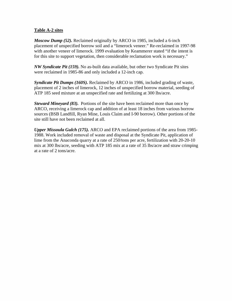
Table A-2 sites Moscow Dump (52). Reclaimed originally by ARCO in 1985, included a 6-inch placement of unspecified borrow soil and a “limerock veneer.” Re-reclaimed in 1997-98 with another veneer of limerock. 1999 evaluation by Keammerer stated “if the intent is for this site to support vegetation, then considerable reclamation work is necessary.” NW Syndicate Pit (159). No as-built data available, but other two Syndicate Pit sites were reclaimed in 1985-86 and only included a 12-inch cap. Syndicate Pit Dumps (160S). Reclaimed by ARCO in 1986, included grading of waste, placement of 2 inches of limerock, 12 inches of unspecified borrow material, seeding of ATP 185 seed mixture at an unspecified rate and fertilizing at 300 lbs/acre. Steward Mineyard (83). Portions of the site have been reclaimed more than once by ARCO, receiving a limerock cap and addition of at least 18 inches from various borrow sources (BSB Landfill, Ryan Mine, Louis Claim and I-90 borrow). Other portions of the site still have not been reclaimed at all. Upper Missoula Gulch (175). ARCO and EPA reclaimed portions of the area from 1985-1988. Work included removal of waste and disposal at the Syndicate Pit, application of lime from the Anaconda quarry at a rate of 250/tons per acre, fertilization with 20-20-10 mix at 300 lbs/acre, seeding with ATP 185 mix at a rate of 35 lbs/acre and straw crimping at a rate of 2 tons/acre.
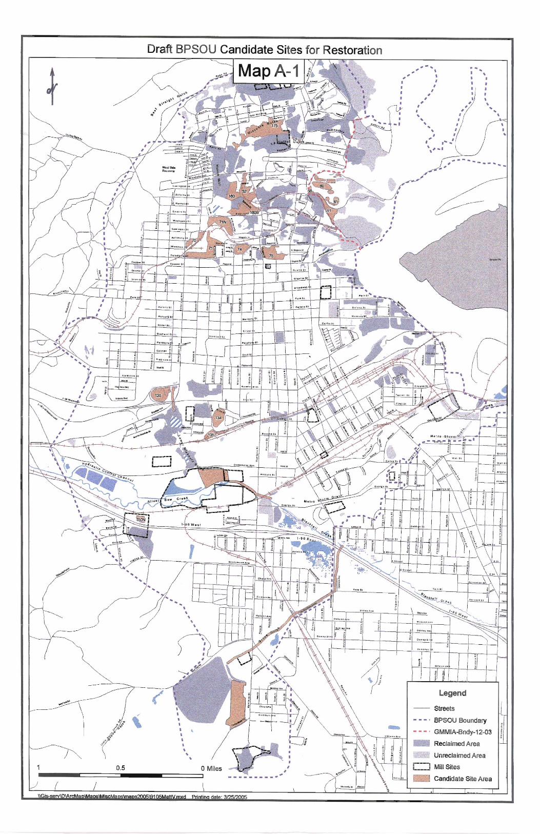
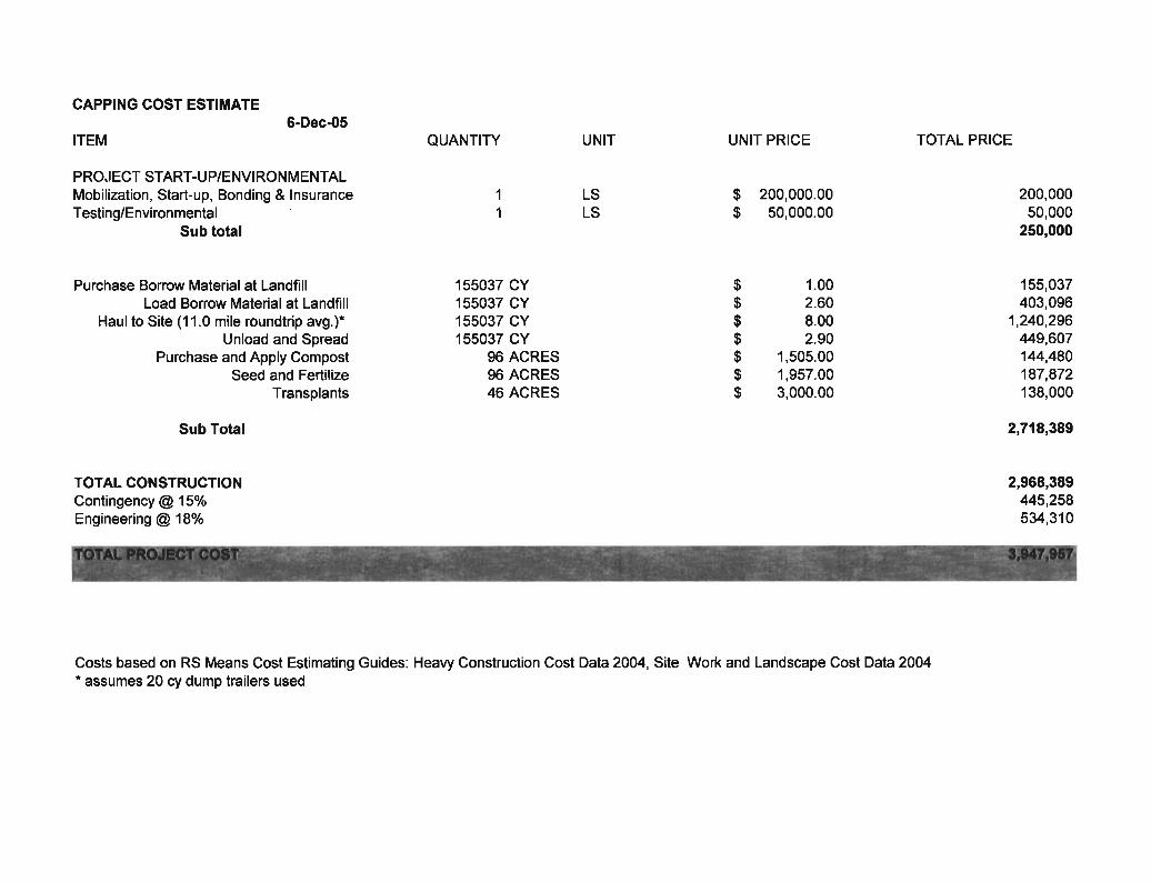
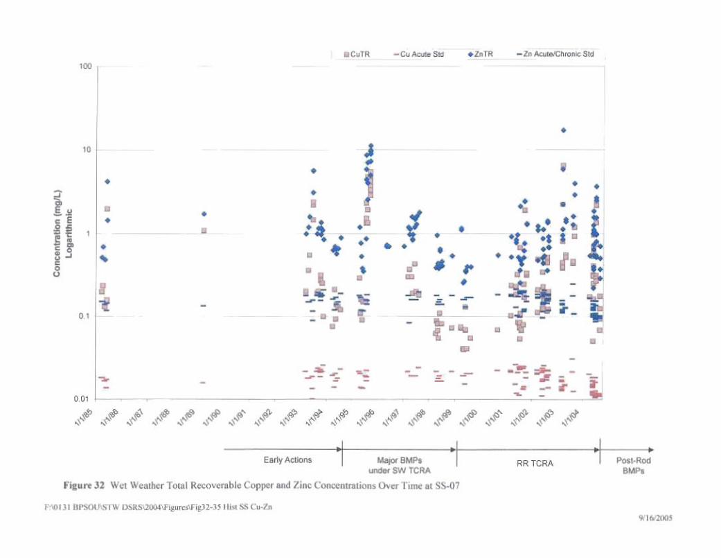
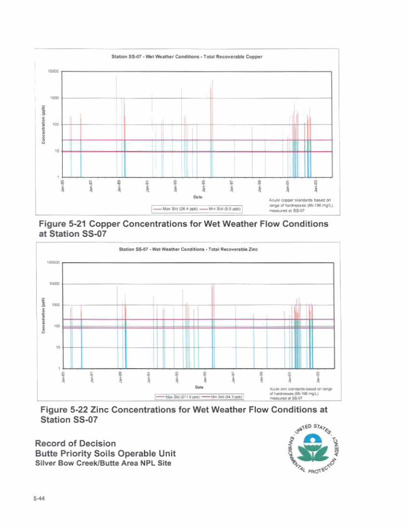
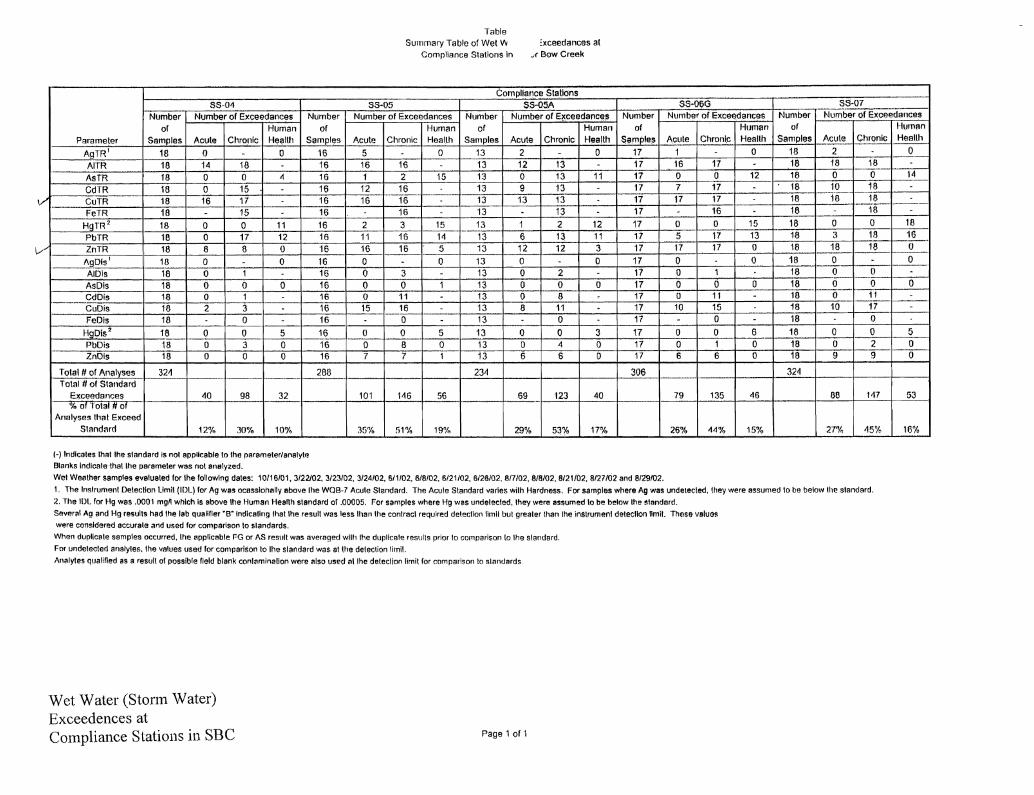
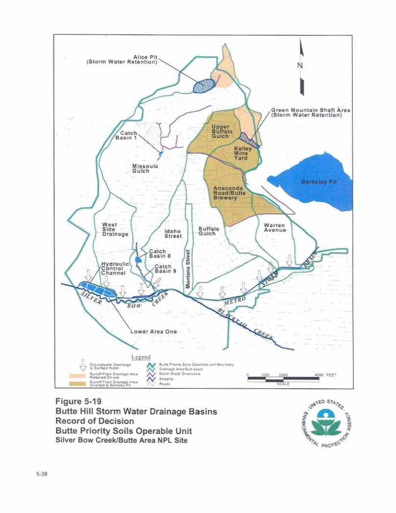
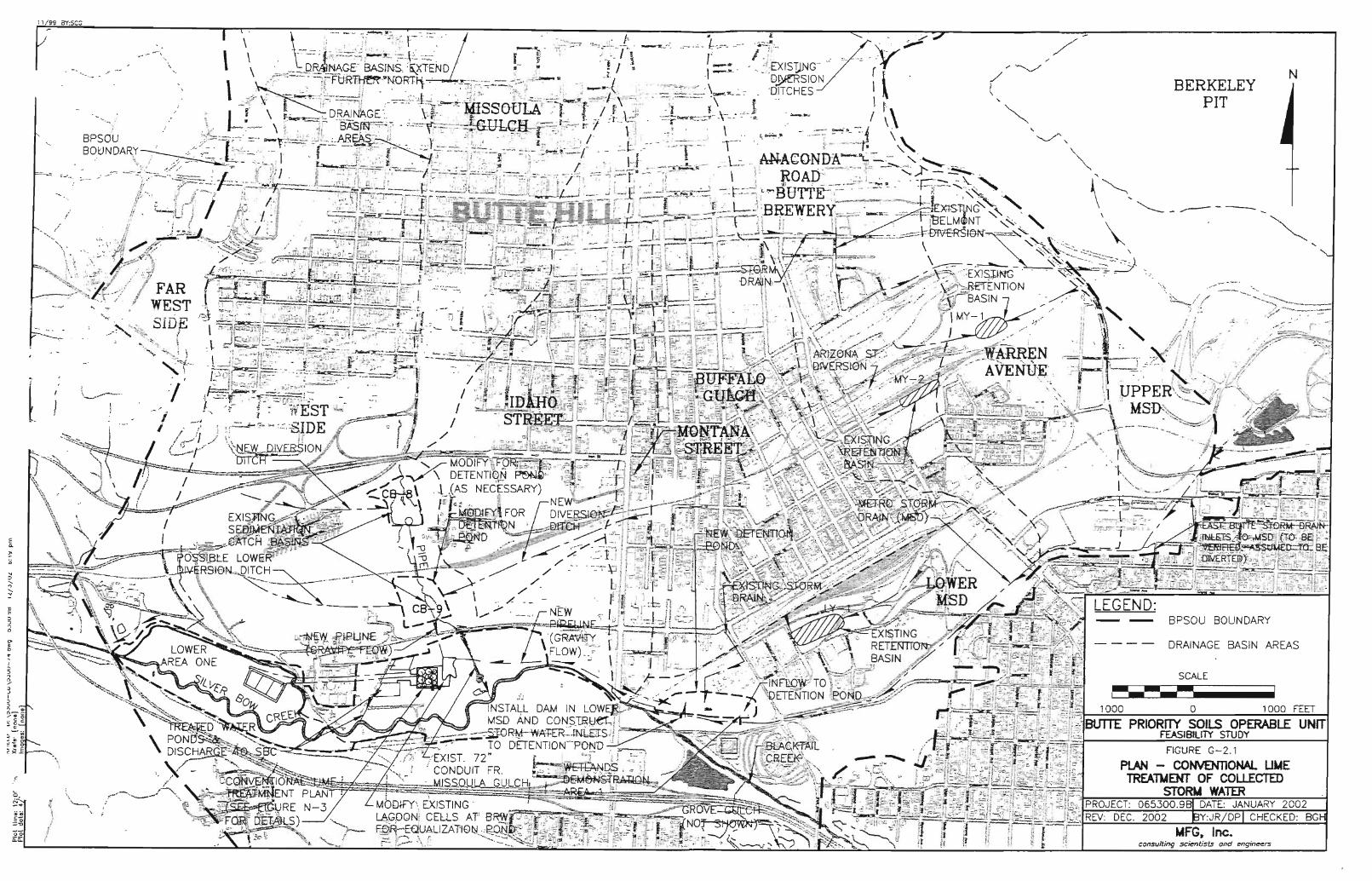
APPENDIX B
RESTORATION SEED MIXES
RESTORATION SEED MIXES Restoration is directed at creating near-baseline conditions, in this case plant communities. The two seed mixes that follow, one for uplands and one for riparian areas or moist sites, consist of native species that are typical of minimally impacted sites near the Butte Hill. The exception are introduced legumes that have proven important to satisfactory revegetation using deep borrow material as opposed to topsoil. Inoculated seed of alfalfa, red clover, and birdsfoot trefoil supply nitrogen to drive production until something like real soil with organic matter and diverse microbes develop. A federal directive mandates native species, although in actuality a few introduced species dominate almost all Butte Hill revegetation. A 4/26/94 EPA memorandum to federal Heads of Executive Departments and Agencies states that regionally native plants should be used for federally funded projects employing landscaping practices to conserve water and prevent pollution (http://www.epa.gov/glnpo/ecopage/landscape/seeds/memo.html). Seeding success depends heavily on effective implementation. The condition of the seedbed and how seeding complements that condition are critical concerns. Following coversoil application, typical practices include ripping severely compacted areas, applying fertilizer according to coversoil characteristics to provide good plant nutrition, discing, and seeding. Table 1. Upland Native Seed Mix for the Butte Hill. ---------------------------------------------------------------------------------------------------------- DRILL SEEDED* BROADCAST SEEDED* --------------------lbs. PLS/Acre---------------------------- ---------------------------------------------------------------------------------------------------------- Bluebunch wheatgrass (Goldar) 3 Big bluegrass (Sherman) ½ Western wheatgrass (Rosana) 1 ½ Fourwing saltbush (northern) 1 Basin wildrye (Trailhead) 1 Yellow-flower alfalfa 1 ½ Canada wildrye 1 Pacific aster ½ Yellow-flower alfalfa 1 ½ Yarrow (native) ¼ Thickspike wheatgrass (Critana) 1 ½ Cudweed sagewort ¼ Rocky Mountain bee plant 1 Rubber rabbitbrush ½ Blanketflower ½ Mtn. big sagebrush ½ Prairie junegrass ½ --- --- 11 5 ½ * After fertilization and discing, if the seedbed is firm the heavy seed should be drilled followed by broadcasting the light seed on the surface. If the seedbed is too soft (fluffy) for drill seeding, broadcast the heavy seed, harrow lightly, then broadcast the light seed and finish with a roller packer to lightly compact.
Table 2. Riparian Seed Mix for the Butte Hill. ---------------------------------------------------------------------------------------------------------- HABITAT DRILL SEEDED* BROADCAST SEEDED* TYPE --------------------lbs. PLS/Acre---------------------------- ---------------------------------------------------------------------------------------------------------- Slender wheatgrass, Pryor 1 Alkali sacaton 1 ½ Western wheatgrass 2 Tufted hairgrass 1 ½ Canada wildrye 1 Birdsfoot trefoil 1 Rocky Mtn. iris 1 Red clover, medium 1 Red clover, medium 1 Nebraska sedge ¼ Basin wildrye, Magnar 1 Alkaligrass ¾ Canada milkvetch ½ Golden currant 1 Rocky Mountain bee plant 1 --- --- 8.5 7 * After fertilization and discing, if the seedbed is firm the heavy seed should be drilled followed by broadcasting the light seed on the surface. If the seedbed is too soft (fluffy) for drill seeding, broadcast the heavy seed, harrow lightly, then broadcast the light seed and finish with a roller packer to lightly compact.
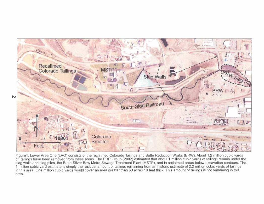
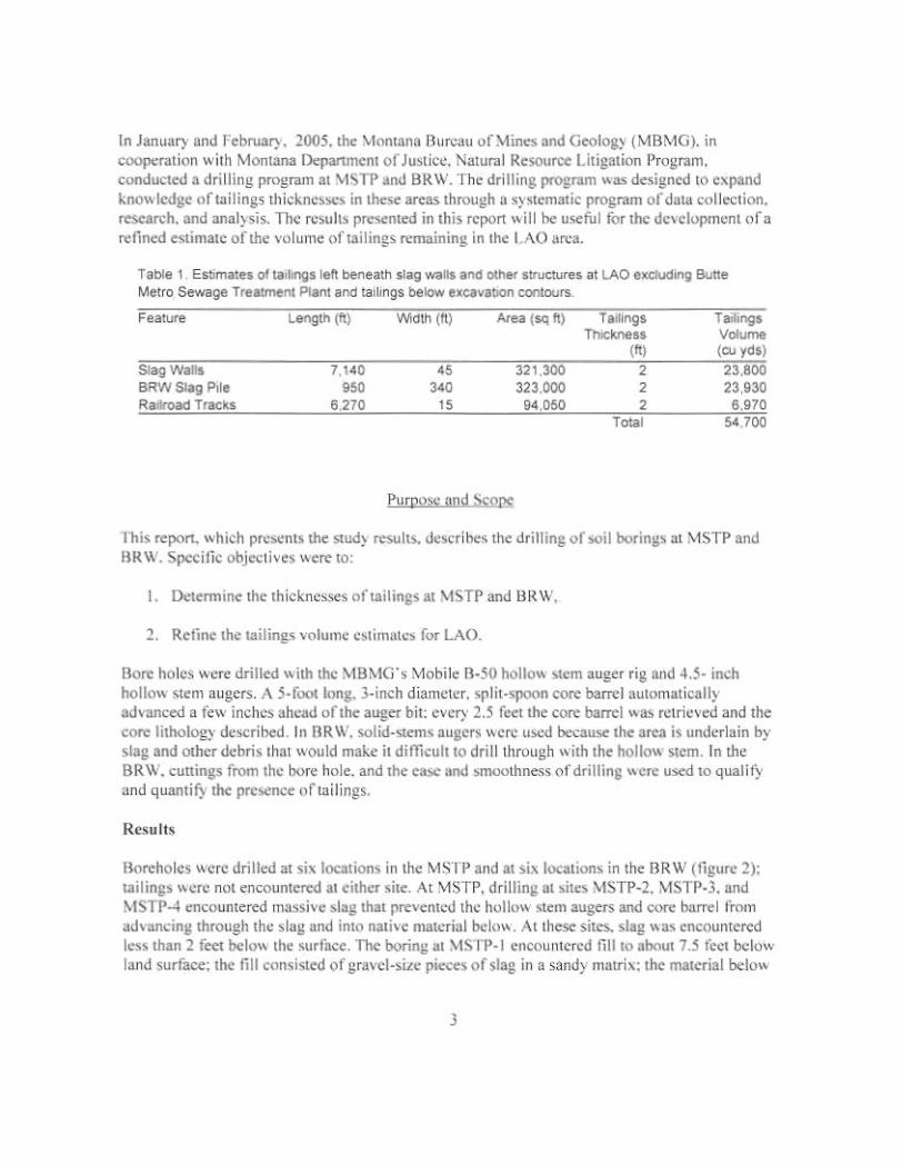
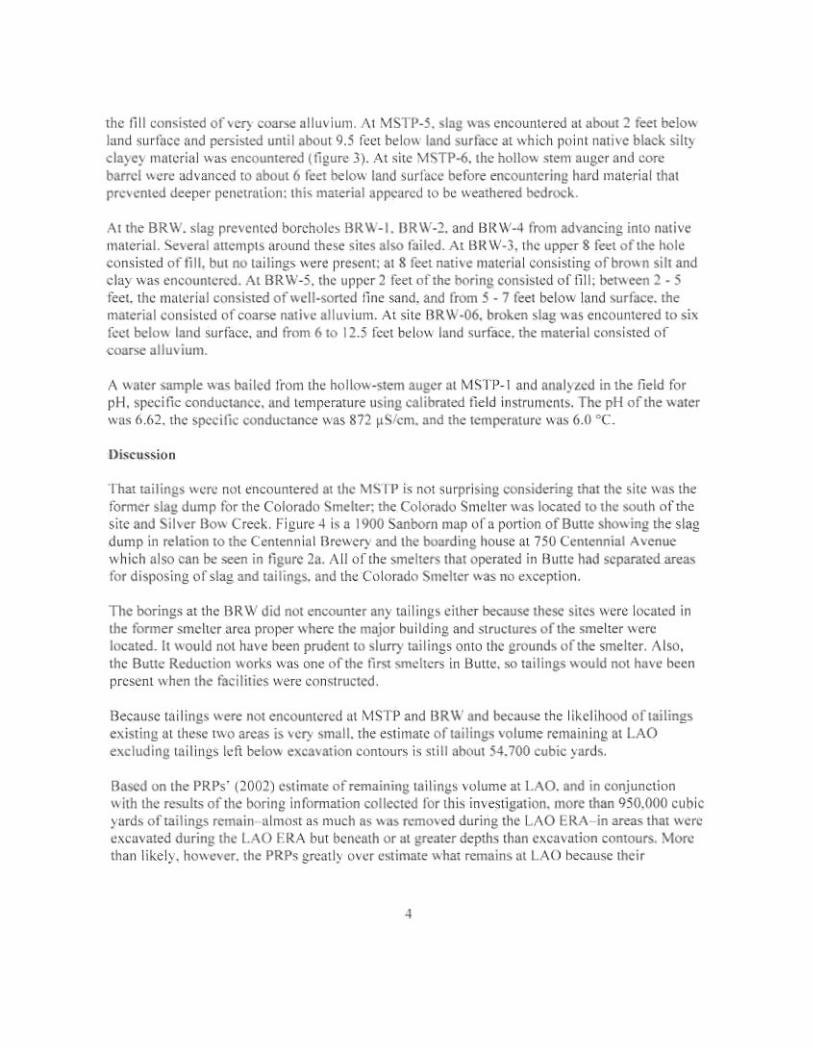
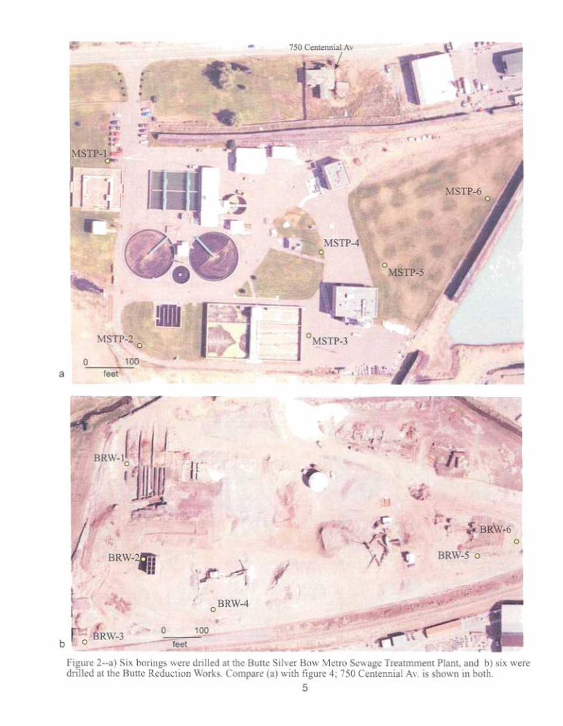
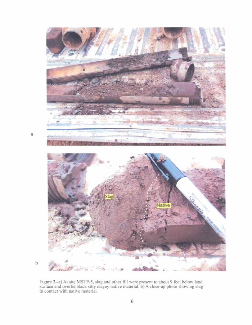
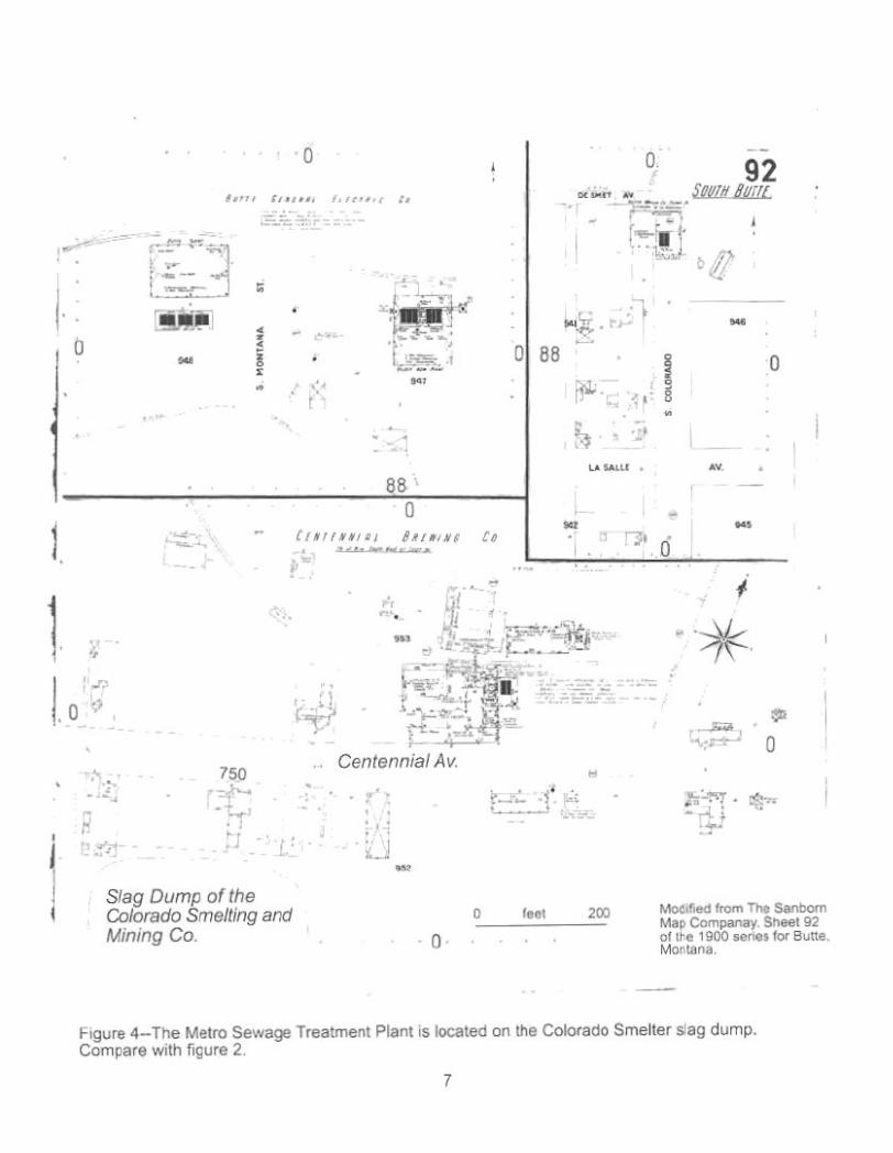

Appendix 4
Figures