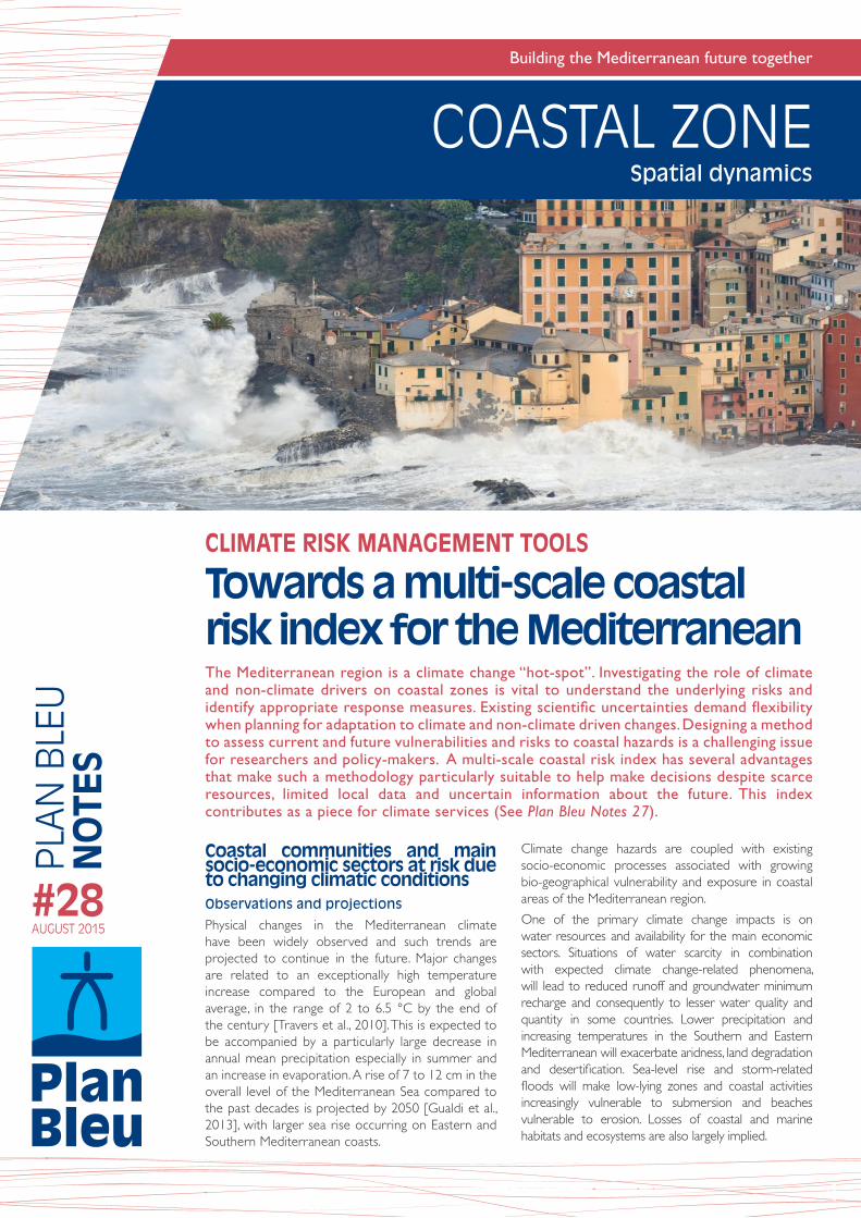
building the mediterranean future together coastal...
TRANSCRIPT
COASTAL ZONEP
LAN
BLE
U
NO
TES
#28AUGUST 2015
Spatial dynamics
Building the Mediterranean future together
Coastal communities and main socio-economic sectors at risk due to changing climatic conditionsObservations and projections
Physical changes in the Mediterranean climate have been widely observed and such trends are projected to continue in the future. Major changes are related to an exceptionally high temperature increase compared to the European and global average, in the range of 2 to 6.5 °C by the end of the century [Travers et al., 2010]. This is expected to be accompanied by a particularly large decrease in annual mean precipitation especially in summer and an increase in evaporation. A rise of 7 to 12 cm in the overall level of the Mediterranean Sea compared to the past decades is projected by 2050 [Gualdi et al., 2013], with larger sea rise occurring on Eastern and Southern Mediterranean coasts.
Climate change hazards are coupled with existing socio-economic processes associated with growing bio-geographical vulnerability and exposure in coastal areas of the Mediterranean region.
One of the primary climate change impacts is on water resources and availability for the main economic sectors. Situations of water scarcity in combination with expected climate change-related phenomena, will lead to reduced runoff and groundwater minimum recharge and consequently to lesser water quality and quantity in some countries. Lower precipitation and increasing temperatures in the Southern and Eastern Mediterranean will exacerbate aridness, land degradation and desertification. Sea-level rise and storm-related floods will make low-lying zones and coastal activities increasingly vulnerable to submersion and beaches vulnerable to erosion. Losses of coastal and marine habitats and ecosystems are also largely implied.
1
CLIMATE RISK MANAGEMENT TOOLS
Towards a multi-scale coastal risk index for the Mediterranean The Mediterranean region is a climate change “hot-spot”. Investigating the role of climate and non-climate drivers on coastal zones is vital to understand the underlying risks and identify appropriate response measures. Existing scientific uncertainties demand flexibility when planning for adaptation to climate and non-climate driven changes. Designing a method to assess current and future vulnerabilities and risks to coastal hazards is a challenging issue for researchers and policy-makers. A multi-scale coastal risk index has several advantages that make such a methodology particularly suitable to help make decisions despite scarce resources, limited local data and uncertain information about the future. This index contributes as a piece for climate services (See Plan Bleu Notes 27).
COASTAL ZONESpatial dynamics
Need for adaptation and coordinated action on Integrated Coastal Zones Management (ICZM) to cope with climate change
Climate change impacts put coastal communities and assets at risk. Relevant authorities are encouraged to undertake adaptation measures that are compliant with the Protocol on Integrated Coastal Zone Management in the Mediterranean (Barcelona Convention) and national ICZM strategies. Moreover, the Mediterranean Action Plan (UNEP/MAP) is developing a Regional Climate Change Adaptation Framework aimed at providing enhanced regional coordination. This will assist stakeholders and policy-makers to take action in order to increase the resilience of the coastal natural and socio-economic sectors to the impacts of climate change.
Scientists and practitioners advise that the identification of adaptation actions be made ad hoc, based on the assessment of local conditions of impacts and risk/vulnerability and the analysis of costs and benefits of options to adapt. Consolidated inventories of possible adaptation measures, such as those accessible through the Mediterranean Integrated Climate Information platform (MedICIP) as well as the European portal Climate-ADAPT can offer inspiration when planning for adaptation although this is no substitute for developing ad hoc responses.
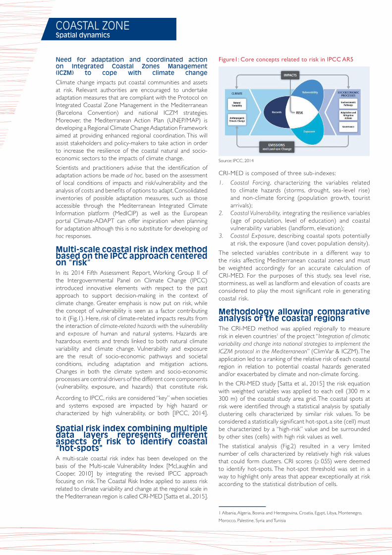
Multi-scale coastal risk index method based on the IPCC approach centered on “risk”In its 2014 Fifth Assessment Report, Working Group II of the Intergovernmental Panel on Climate Change (IPCC) introduced innovative elements with respect to the past approach to support decision-making in the context of climate change. Greater emphasis is now put on risk, while the concept of vulnerability is seen as a factor contributing to it (Fig.1). Here, risk of climate-related impacts results from the interaction of climate-related hazards with the vulnerability and exposure of human and natural systems. Hazards are hazardous events and trends linked to both natural climate variability and climate change. Vulnerability and exposure are the result of socio-economic pathways and societal conditions, including adaptation and mitigation actions. Changes in both the climate system and socio-economic processes are central drivers of the different core components (vulnerability, exposure, and hazards) that constitute risk.
According to IPCC, risks are considered “key” when societies and systems exposed are impacted by high hazard or characterized by high vulnerability, or both [IPCC, 2014].
Spatial risk index combining multiple data layers represents different aspects of risk to identify coastal “hot-spots” A multi-scale coastal risk index has been developed on the basis of the Multi-scale Vulnerability Index [McLaughlin and Cooper, 2010] by integrating the revised IPCC approach focusing on risk. The Coastal Risk Index applied to assess risk related to climate variability and change at the regional scale in the Mediterranean region is called CRI-MED [Satta et al., 2015].
Figure1: Core concepts related to risk in IPCC AR5
CRI-MED is composed of three sub-indexes:
1. Coastal Forcing, characterizing the variables related to climate hazards (storms, drought, sea-level rise) and non-climate forcing (population growth, tourist arrivals);
2. Coastal Vulnerability, integrating the resilience variables (age of population, level of education) and coastal vulnerability variables (landform, elevation);
3. Coastal Exposure, describing coastal spots potentially at risk, the exposure (land cover, population density).
The selected variables contribute in a different way to the risks affecting Mediterranean coastal zones and must be weighted accordingly for an accurate calculation of CRI-MED. For the purposes of this study, sea level rise, storminess, as well as landform and elevation of coasts are considered to play the most significant role in generating coastal risk.
Methodology allowing comparative analysis of the coastal regions The CRI-MED method was applied regionally to measure risk in eleven countries1 of the project “Integration of climatic variability and change into national strategies to implement the ICZM protocol in the Mediterranean” (ClimVar & ICZM). The application led to a ranking of the relative risk of each coastal region in relation to potential coastal hazards generated and/or exacerbated by climate and non-climate forcing.
In the CRI-MED study [Satta et al., 2015] the risk equation with weighted variables was applied to each cell (300 m x 300 m) of the coastal study area grid. The coastal spots at risk were identified through a statistical analysis by spatially clustering cells characterized by similar risk values. To be considered a statistically significant hot-spot, a site (cell) must be characterized by a “high-risk” value and be surrounded by other sites (cells) with high risk values as well.
The statistical analysis (Fig.2) resulted in a very limited number of cells characterized by relatively high risk values that could form clusters. CRI scores (≥ 0.55) were deemed to identify hot-spots. The hot-spot threshold was set in a way to highlight only areas that appear exceptionally at risk according to the statistical distribution of cells.
1 Albania, Algeria, Bosnia and Herzegovina, Croatia, Egypt, Libya, Montenegro,
Morocco, Palestine, Syria and Tunisia
Source: IPCC, 2014
COASTAL ZONESpatial dynamics
Figure 2: Statistical distribution of risk classes used for the CRI-MED method
Risk maps representing the visualization and intrinsic prioritization of risk
The Regional Risk Assessment Map of coastal risk to climate and non-climate forcing, displays the result in terms of qualitative risk classes in the coastal zones investigated (Fig.3).
The map shows the values of risk assumed by each location (cell) by applying the equation defined for the method CRI-MED. Sites that assume “extremely high risk” values are indicated in red and in the context of the study these are defined as “hot-spots”.
Noting that areas at extremely high risk are relatively few and predominantly located in the southern Mediterranean region, the countries primarily concerned by coastal risk include Morocco, Algeria, Libya, Egypt, Palestine, and Syria.
High vulnerability and exposure do not necessarily correspond to high levels of risk
The risk assessment approach highlights some substantial differences with traditional vulnerability assessment methods.
Risk depends on the interaction of vulnerability, forcing and exposure. If vulnerability is high but forcing and/or exposure are low, risk is low.
The main lesson emerged from the regional risk assessment based on CRI-MED is that hot-spots are also areas of extremely high vulnerability. But at the same time, not all areas presenting extremely high vulnerability can be considered hot-spots, as the related values of forcing and exposure range from extremely low to moderate.
List of national coastal hot-spots identified
Morocco: Tetouan, Nador, Saidia
Algeria: Ain El Bia, Tenes, Zeralda, Tassoust, Annaba
Libya: Tripoli, Misrata, Benghazi, Daryanah, Tocra, Ad Dirsiyah
Egypt: Sidi Barrani, Marsa Matrouth, Alexandria, Baltim, Ras El Bar, Port Said, Al Arish
Palestine: the Northern shore of Gaza Strip
Syria: the shore from Al Hamidiyah to Tartus, the shore from Tartus to Marqueh, Baniyas, the shore from Jable to Latakia, Om Al Toyour, Ummetli
Multi-scale coastal risk index applied at the regional and local scale
The application of a multi-scale coastal risk index for the risk assessment at the local spatial scale is called CRI-LS [Satta et al., 2015]. Tetouan, Morocco, already identified as a hot-spot in the CRI-MED assessment was selected as a case study.
Differences between the two scales of application include the definition of the coastal unit based on the coastal hazard zone, and the choice of variables used to describe the three sub-indexes.
Moreover, higher resolution is required at the local scale.
Figure 3: Regional Risk Assessment Map for the Mediterranean based on CRI-MED method
Source: Satta et al., 2015
Source: Satta et al., 2015
2
The main advantages of multi-scale coastal risk index methods include the following: 1. non expensive and easy calculation process, 2. consideration of physical as well as socio- economic variables, 3. presence of three separated sub-indices representing
vulnerability, exposure and forcing,4. possible expansion of the index to include additional data sets, 5. integration of the risk concept as proposed by IPCC AR5, 6. risk and vulnerability maps can also be produced, 7. potential for replicability and application at various scales.
These methods imply challenges when weighting the variables, since this choice will ultimately affect the visualization and interpretation of results. The involvement of an expert panel to assign weights to the variables of CRI-MED could refine the methodology. Providing the ability to alter the weights and show the changes to politicians and the general public can be valuable.
Methodological improvements can be obtained by increasing the number of variables for the sub-indexes and building more accurate geo-referenced standardized databases validated at the regional/local level.
PLAN BLEUUNEP/MAP Regional Activity Centre 15 rue Beethoven - Sophia Antipolis 06560 Valbonne - FRANCETel. : +33 4 92 38 71 30 Fax : +33 4 92 38 71 31e-mail : [email protected]
Editor: Plan Bleu Head of publication: Hugues Ravenel Authors: Sara Venturini, Alessio Satta, Manuela Puddu, John Firth, Antoine Lafitte Editorial board: Julien Le Tellier, Jean-Pierre Giraud Design and production: Hélène Rousseaux
Printed by: nis photoffsetLegal deposit: in progress - ISSN 1954-9350
BibliographyIPCC, 2014. Summary for policymakers. In: Climate Change 2014: Impacts, Adaptation, and Vulnerability. Part A: Global and Sectoral Aspects. Contribution of Working Group II to the Fifth Assessment Report of the Intergovernmental Panel on Climate Change [Field, C.B., & al. (eds.)]. Cambridge University Press, pp. 1-32.
Gualdi S., Somot S., May W., .[..,] and Xoplaki E., 2013. Future Climate Projections. Chapter 3. Volume 1: Air, Sea and Precipitation and Water. Regional Assessment of Climate Change in the Mediterranean. Antonio Navarra and Laurence Tubiana (Eds).
McLaughlin, S. and Cooper J.A.G., 2010. A multi-scale coastal vulnerability index: A tool for coastal managers? Environmental Hazards, Volume 9, Number 3. pp. 233-248(16).
Satta A., Venturini S., Puddu M., Firth J., Lafitte A., 2015. Strengthening the Knowledge Base on Regional Climate Variability and Change: Application of a Multi-Scale Coastal Risk Index at Regional and Local Scale in the Mediterranean. Plan Bleu Report.
Travers A., Elrick C. and Kay R., 2010. Position Paper: Climate Change in Coastal Zones of the Mediterranean. Split, Priority Actions Programme (PAP/RAC).
COASTAL ZONESpatial dynamics
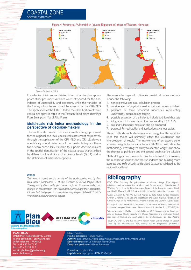
Figure 4: Forcing (a), Vulnerability (b), and Exposure (c) maps of Tetouan, Morocco
Note: This work is based on the results of the study carried out by Plan Bleu under Component 2 of the ClimVar & ICZM Project titled “Strengthening the knowledge base on regional climate variability and change” in collaboration with Acclimatise, Climalia and their associates. ClimVar & ICZM project is a complementary project of the GEF/UNEP/World Bank MedPartnership project.
In order to obtain more detailed information to plan appro-priate strategies, more variables were introduced for the sub-indexes of vulnerability and exposure, while the variables of the forcing sub-index remained the same as for the CRI-MED. The application of the CRI-LS led to the identification of three coastal hot-spots located in the Tetouan flood plains (Restinga Plain, Smir plain, Martil Alila Plain).
Multi-scale risk index methodology in the perspective of decision-makersThe multi-scale coastal risk index methodology, proposed for the regional and local coastal risk assessment respectively through the application of the CRI-MED and CRI-LS, allows a scientifically sound detection of the coastal hot-spots. These tools seem particularly valuable to support decision-makers in the spatial identification of the coastal areas characterized by different vulnerability and exposure levels (Fig. 4) and in the definition of adaptation options.
Source: Satta et al., 2015