brisbane water drive safety review community consultation ... · brisbane water drive safety review...
TRANSCRIPT

Brisbane Water Drive Safety Review
Community Consultation Report
January 2017

THIS PAGE LEFT INTENTIONALLY BLANK
Executive summary
This Community Consultation Report provides a summary of the community consultation carried out by Roads and Maritime Services in November 2016 for the Brisbane Water Drive Safety Review.
Roads and Maritime Services invited feedback on potential future safety improvements on Brisbane Water Drive between Glenrock Parade and Manooka Road, Point Clare. The potential safety improvements had been identified and prioritised in a route safety investigation.
Key issues raised by the community include:
• Request for reduced speed limits along Brisbane Water Drive, including adjacent to Point Clare Public School
• Request for a right turn bay into Penang Street instead of banning movements
• Lack of support for the proposal to install a roundabout at Collard Road and Welwyn Grove
• Request for slip lane on Brisbane Water Drive into Talinga Avenue to be left turn only
• Support for the proposed traffic lights at Jirrah Avenue and Koolinda Avenue
• Support for banning the right turn out at Penang Street
• Request for the proposed footpath between Collard Road and Jirrah Avenue be installed on the southern side of Brisbane Water Drive.
The decision We have considered these issues to prioritise the improvements and will now move ahead with further planning, design and construction of the some of the projects identified in the safety review.
The projects that have been prioritised are outlined in Appendix A and further explained in Section 3.2.
1
Contents
Executive summary ..................................................................................................................... 1 1. Introduction .......................................................................................................................... 3
1.1. Background .................................................................................................................. 3 1.2. The proposal ................................................................................................................. 3
2. Consultation approach ......................................................................................................... 4 2.1. Consultation objectives ................................................................................................. 4 2.2. Values .......................................................................................................................... 4 2.3. How consultation was done .......................................................................................... 5
3. Consultation summary ......................................................................................................... 5 3.1. Overview ....................................................................................................................... 5 3.2. Recommendations ...................................................................................................... 17 3.3. Next steps ................................................................................................................... 17
Figures and tables
Table 1 ........................................................................................................................................... 5 Table 2 ........................................................................................................................................... 6
2 Document name
1. Introduction
1.1. Background Brisbane Water Drive is a State Road connecting the Central Coast Highway at West Gosford to Railway Street and Blackwall Road at Woy Woy. It is the primary link between Woy Woy and Gosford.
In 2015 the NSW Government announced $2 million for safety upgrades at three intersections along Brisbane Water Drive. The intersections are at Jirrah Avenue, Lorraine Avenue and Penang Street.
Initial work has involved completing a route safety investigation to ensure safety issues are identified and addressed for this section of Brisbane Water Drive.
The community has previously provided feedback to Roads and Maritime about this section of Brisbane Water Drive and some of the long-standing issues raised by the community include:
• Difficulties for pedestrians trying to cross Brisbane Water Drive
• Safety concerns for motorists entering and exiting side streets due to lack of formal turning lanes
• Safety concerns caused by sight distance and road design issues
• Concerns about the safety of children around Point Clare Public School.
The route safety investigation has been carried out to determine the safety performance of the route and identify road safety improvements and priorities along this section of Brisbane Water Drive.
Roads and Maritime has identified priorities for improvement to this section of the road in the short, medium and long term to address safety deficiencies that are identified.
The potential safety improvement work will be prioritised based on a range of criteria, including traffic volumes, crash data, road design constraints, economic analysis and community feedback.
1.2. The proposal The proposed safety improvements for which comment was sought from the community included:
• Providing right turning bays at Sunshine Drive, Sunnyside Avenue and Takari Avenue
• Installing new traffic lights, including removing existing mid-block signals at the Koolinda Avenue and Jirrah Avenue intersection
• Building a pedestrian footpath from Collard Road to Jirrah Avenue
• Improving sight distance at Lorraine Avenue and banning the right turn in
• Improving safety at Penang Street by banning the right turn in and right turn out movements
3
• Installing a roundabout at the Collard Road and Welwyn Grove intersection to serve as a u-turn facility for motorists entering Penang Street and Lorraine Street, due to the banned right turn movements.
The $2 million that has been allocated by the NSW Government to the Brisbane Water Drive safety review will be used to develop options, prepare funding submissions and start work on some of the upgrades.
The total cost estimate for all of the proposed safety improvements identified in the safety review is in excess of $10 million. The remaining improvements will be considered for future funding if made available.
2. Consultation approach
2.1. Consultation objectives Our consultation objectives were to: • Inform the community and stakeholders of the Brisbane Water Drive Safety Review and the
proposed potential safety improvements
• Seek feedback on the proposed potential safety improvements and issues of concern from the community and stakeholders for consideration
• Build a database of interested and concerned community members with whom we can continue to engage with.
2.2. Values Our organisational values underpin our decisions and behaviours when working with customers, colleagues, stakeholders and partners. They include: 1. Customer focus – We place the customer at the centre of everything we do
2. Collaboration – We value each other and create better outcomes by working together
3. Solutions – We deliver sustainable and innovative solutions to NSW’s transport needs
4. Integrity – We take responsibility and communicate openly
5. Safety – We prioritise safety for our people and our customers.
We consulted with the community during November 2016 to update local residents, businesses, road users and the community on the Safety Review and seek comment, feedback, ideas and suggestions for us to consider.
4 Document name
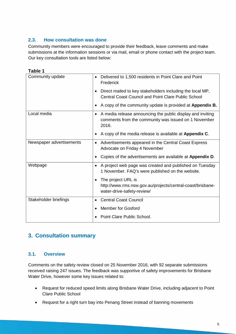
2.3. How consultation was done Community members were encouraged to provide their feedback, leave comments and make submissions at the information sessions or via mail, email or phone contact with the project team. Our key consultation tools are listed below:
Table 1 Community update • Delivered to 1,500 residents in Point Clare and Point
Frederick
• Direct mailed to key stakeholders including the local MP, Central Coast Council and Point Clare Public School
• A copy of the community update is provided at Appendix B.
Local media
• A media release announcing the public display and inviting comments from the community was issued on 1 November 2016.
• A copy of the media release is available at Appendix C.
Newspaper advertisements
• Advertisements appeared in the Central Coast Express Advocate on Friday 4 November
• Copies of the advertisements are available at Appendix D.
Webpage • A project web page was created and published on Tuesday 1 November. FAQ’s were published on the website.
• The project URL is http://www.rms.nsw.gov.au/projects/central-coast/brisbane-water-drive-safety-review/
Stakeholder briefings • Central Coast Council
• Member for Gosford
• Point Clare Public School.
3. Consultation summary
3.1. Overview
Comments on the safety review closed on 25 November 2016, with 92 separate submissions received raising 247 issues. The feedback was supportive of safety improvements for Brisbane Water Drive, however some key issues related to:
• Request for reduced speed limits along Brisbane Water Drive, including adjacent to Point Clare Public School
• Request for a right turn bay into Penang Street instead of banning movements
5

• Lack of support for the proposal to install a roundabout at Collard Road and Welwyn Grove
• Request for slip lane on Brisbane Water Drive into Talinga Avenue to be left turn only
• Support for the proposed traffic lights at Jirrah Avenue and Koolinda Avenue
• Support for banning the right turn out at Penang Street
• Request for the proposed footpath between Collard Road and Jirrah Avenue be installed on the southern side of Brisbane Water Drive
In determining priorities for upgrades and funding on Brisbane Water Drive, Roads and Maritime examines the issues raised throughout the consultation period and then uses a fact based assessment process to determine priorities for funding. This means that sometimes issues that are raised the most are not necessarily considered the most important to address in the short term. Table 2 provides responses to issues raised during the consultation period.
Table 2 Issue Category
Number of Issues Issue raised Roads and Maritime response
General comments along the study area
1 Is the $2 million to be used for some roadworks? When will the funding be available?
The $2 million is being spent on developing options for the potential safety improvements, preparing funding submissions and starting some of the proposed intersection upgrades. The total cost estimate for all of the proposed safety improvements identified in the safety review is in excess of $10 million. The improvements will be prioritised on a needs basis, with some being considered for future funding.
1 There has been an increase in mobile speed camera activity on Brisbane Water Drive. Has that been a result of the concerns raised by the Point Clare Progress Association?
The community has raised concerns about speeding on Brisbane Water Drive with Roads and Maritime. As a result, Roads and Maritime submitted a request to the NSW Government’s Centre of Road Safety to carry out mobile speed camera enforcement along Brisbane Water Drive.
1 Seeking improvements to cyclist facilities and added separation between cyclists and vehicles.
Investigations are being carried out to build a pedestrian pathway along Brisbane Water Drive, and where possible, provisions for cyclists will be considered. Facilities to separate cyclists and vehicles have not been prioritised in
6 Document name

this safety review, due to design constraints associated with the topography and driveway accesses along this section of Brisbane Water Drive and the cost of widening Brisbane Water Drive to accommodate new facilities.
1 What is ’competitive basis’?
Each proposed project will be prioritised based on a benefit/cost analysis. This analysis considers the total benefits to the community, for example reducing crashes and improving traffic efficiency, across the life of a project compared to the cost of the project.
9 There should be a permanent reduction in the speed limit on Brisbane Water Drive, from 60km/h to 50 km/h, between Glenrock Parade and Koolinda Avenue/ Jirrah Avenue.
The existing 60km/h speed limit on this section of Brisbane Water Drive has been assessed and is considered appropriate for the environment and function of the road.
4 Request to bypass West Gosford and run traffic to Gosford behind Point Clare Railway Station or alternatively widen Brisbane Water Drive to dual carriageway in both directions.
The Brisbane Water Drive safety review is focused on priorities for potential safety improvements in the short-term with low-medium cost options. These projects are currently unfunded and will need to be considered against other projects around the state for funding. Roads and Maritime is also carrying out a broader study to look at future priorities for the Central Coast road network, including Brisbane Water Drive. The strategy will identify the current and future transport demands and challenges, identify future land use changes and impacts, and assess the current and future performance of the State Road network against planning targets. The network strategy will primarily focus on the performance and possible enhancement of existing corridors. The rail corridor adjacent to Brisbane Water Drive will not be recommended as a future alternate
7
road corridor, as there would be significant environmental issues associated with road widening and no suitable connection to the Central Coast Highway.
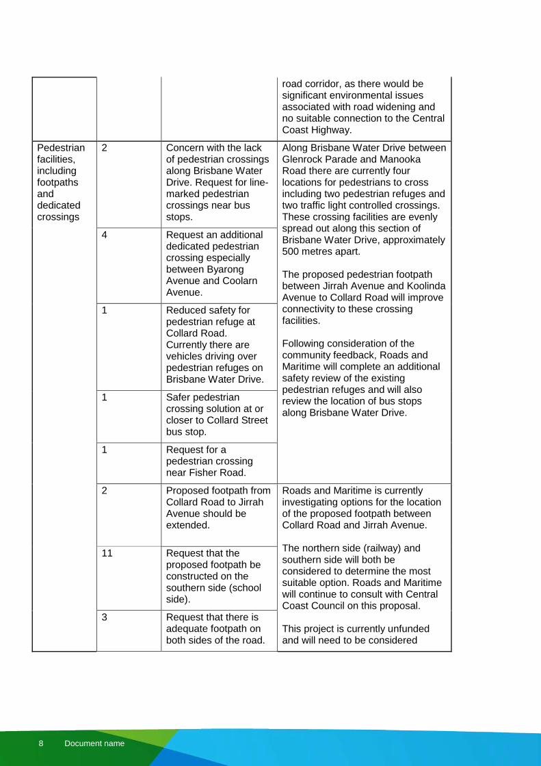
Pedestrian facilities, including footpaths and dedicated crossings
2 Concern with the lack of pedestrian crossings along Brisbane Water Drive. Request for line-marked pedestrian crossings near bus stops.
Along Brisbane Water Drive between Glenrock Parade and Manooka Road there are currently four locations for pedestrians to cross including two pedestrian refuges and two traffic light controlled crossings. These crossing facilities are evenly spread out along this section of Brisbane Water Drive, approximately 500 metres apart. The proposed pedestrian footpath between Jirrah Avenue and Koolinda Avenue to Collard Road will improve connectivity to these crossing facilities. Following consideration of the community feedback, Roads and Maritime will complete an additional safety review of the existing pedestrian refuges and will also review the location of bus stops along Brisbane Water Drive.
4 Request an additional dedicated pedestrian crossing especially between Byarong Avenue and Coolarn Avenue.
1 Reduced safety for pedestrian refuge at Collard Road. Currently there are vehicles driving over pedestrian refuges on Brisbane Water Drive.
1 Safer pedestrian crossing solution at or closer to Collard Street bus stop.
1 Request for a pedestrian crossing near Fisher Road.
2 Proposed footpath from Collard Road to Jirrah Avenue should be extended.
Roads and Maritime is currently investigating options for the location of the proposed footpath between Collard Road and Jirrah Avenue. The northern side (railway) and southern side will both be considered to determine the most suitable option. Roads and Maritime will continue to consult with Central Coast Council on this proposal. This project is currently unfunded and will need to be considered
11 Request that the proposed footpath be constructed on the southern side (school side).
3 Request that there is adequate footpath on both sides of the road.
8 Document name

1 Between Penang Street and Takari Ave on the Eastern side (train line) pedestrian footpath is broken bitumen and hard to walk on.
against other projects for funding. Footpaths are generally the responsibility of Councils, however given the difficult terrain along Brisbane Water Drive Roads and Maritime will continue to manage and seek funding for this project. The maintenance issues raised about the existing footpaths have been referred to Central Coast Council.
Parking 1 Proposed right turning lanes at Sunnyside Drive and Sunnyside Avenue should have 'no parking' opposites these intersections.
Parking concerns raised during the community consultation will be further reviewed and considered as planning continues for the potential safety improvements.
1 Consider improvements to parking on Brisbane Water Drive adjacent Fagan Park.
1 Ban parking to improve access and sight distance for vehicle exiting their driveways along Brisbane Water Drive between Tania Drive and Lorraine Avenue.
1 Investigate recent changes to no stopping signs that have been installed between 144 to 148 Brisbane Water Drive.
2 Request for 'no stopping' on western shoulder of Brisbane Water Drive at Byarong Avenue.
1 Request for 'no stopping' on eastern shoulder of Brisbane Water Drive opposite the entry to Fairhaven.
Sunshine Drive / Sunnyside Avenue
1 Request a roundabout at Brisbane Water Drive and Sunnyside Avenue (instead of the
The proposed right turn bays at Sunshine Avenue and Sunnyside Street will improve safety by providing protection for turning
9

current proposal of a right turn bay).
vehicles by removing them from the through lane. This proposal for the right turn bays into Sunshine Avenue and Sunnyside Street is currently unfunded and will be submitted for funding against other priority projects. Higher cost options including a roundabout and traffic lights were not economically viable for these locations.
2 Request for traffic lights.
4 Agree with the proposal to install right turn bays at these intersections.
Jirrah Avenue/ Koolinda Avenue
14 Agree with the proposal for traffic lights at Jirrah Avenue and Koolinda Avenue.
Traffic lights have been identified as the preferred option for Jirrah Avenue and Koolinda Avenue due to the traffic movements at this intersection and the subsequent improvements to pedestrian safety. Roads and Maritime has completed a strategic design and cost estimate for traffic lights, however there is currently no funding for traffic lights. Roads and Maritime will seek additional funding for this project. Any further detailed design will consider right lanes and any restrictions to movements at the intersection. Koolinda Avenue is a local road managed by Central Coast Council. Maintenance of the trees obstructing the view of motorists is the responsibility of Council. Community feedback has been referred to Council and the trees at this location are included on their tree removal list.
1 Proposes a roundabout at Jirrah Avenue and Koolinda Avenue.
1 Concerns traffic lights at Jirrah Avenue and Koolinda Avenue will decrease traffic efficiency along Brisbane Water Drive, which has improved since the completion of the West Gosford intersection upgrade.
3 The proposed traffic lights at Koolinda Avenue and Jirrah Avenue should have right turn bays.
2 Suggested the proposed traffic lights should have "left turn on red after stopping" out of Jirrah Avenue.
2 Trees obstructing the view of drivers between Koolinda Avenue and Tania Drive.
Lorraine Avenue
1 Supports the proposal to ban the right turn into Lorraine Avenue.
Following consideration of the community feedback, the proposal to ban the right turn into Lorraine Avenue will not proceed. Investigations into improving sight 5 Request for the right
turn into Lorraine
10 Document name
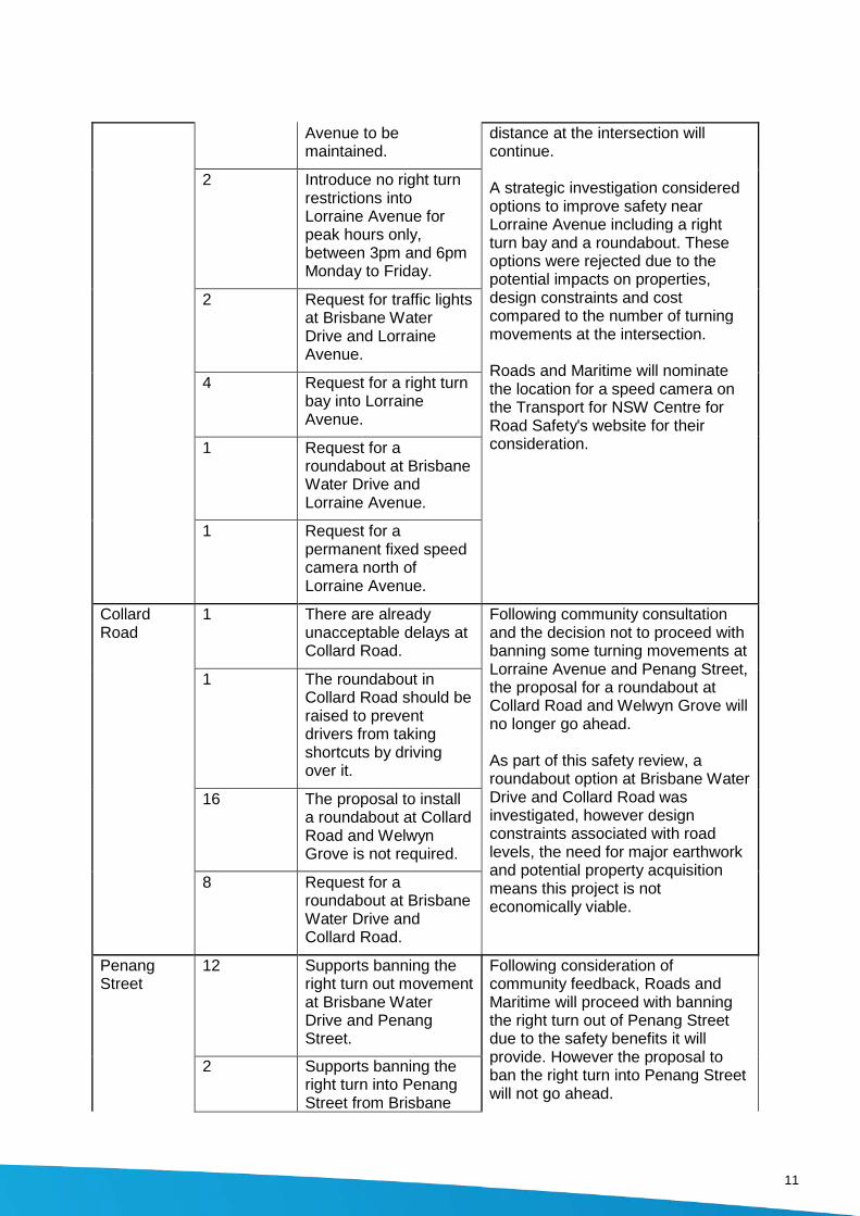
Avenue to be maintained.
distance at the intersection will continue. A strategic investigation considered options to improve safety near Lorraine Avenue including a right turn bay and a roundabout. These options were rejected due to the potential impacts on properties, design constraints and cost compared to the number of turning movements at the intersection. Roads and Maritime will nominate the location for a speed camera on the Transport for NSW Centre for Road Safety's website for their consideration.
2 Introduce no right turn restrictions into Lorraine Avenue for peak hours only, between 3pm and 6pm Monday to Friday.
2 Request for traffic lights at Brisbane Water Drive and Lorraine Avenue.
4 Request for a right turn bay into Lorraine Avenue.
1 Request for a roundabout at Brisbane Water Drive and Lorraine Avenue.
1 Request for a permanent fixed speed camera north of Lorraine Avenue.
Collard Road
1 There are already unacceptable delays at Collard Road.
Following community consultation and the decision not to proceed with banning some turning movements at Lorraine Avenue and Penang Street, the proposal for a roundabout at Collard Road and Welwyn Grove will no longer go ahead. As part of this safety review, a roundabout option at Brisbane Water Drive and Collard Road was investigated, however design constraints associated with road levels, the need for major earthwork and potential property acquisition means this project is not economically viable.
1 The roundabout in Collard Road should be raised to prevent drivers from taking shortcuts by driving over it.
16 The proposal to install a roundabout at Collard Road and Welwyn Grove is not required.
8 Request for a roundabout at Brisbane Water Drive and Collard Road.
Penang Street
12 Supports banning the right turn out movement at Brisbane Water Drive and Penang Street.
Following consideration of community feedback, Roads and Maritime will proceed with banning the right turn out of Penang Street due to the safety benefits it will provide. However the proposal to ban the right turn into Penang Street will not go ahead.
2 Supports banning the right turn into Penang Street from Brisbane
11

Water Drive. A right turn bay into Penang Street was considered as part of the safety review. Initial designs show providing a right turn bay on the existing road would not meet road design standards and would require significant work to meet standards. Due to potential costs this treatment was not prioritised as part of the safety review.
Roads and Maritime will investigate widening the road shoulders on the approach to Penang Street to provide a safe passing width from a stationary car. This option will be investigated further and the work may be funded using the $2 million already allocated to the review. The community will be notified before any work begins.
Strategic investigations were completed for other options at Penang Street including a roundabout and right turn bay into Penang Street.
The investigations determined a roundabout would not be an effective treatment at this intersection due to the unbalanced traffic flows, with approximately 10 vehicles turning into Penang Street compared to 1000 vehicles travelling on Brisbane Water Drive during peak hour periods. Construction of a roundabout would also be very difficult and costly due to property acquisitions, design issues relating to road levels and sight distance issues.
Concerns about sight distance at Penang Street have been referred to Roads and Maritime’s Asset Maintenance section. Any trees or shrubs obstructing sight distance at the intersection will be trimmed or removed. Roads and Maritime will also review the need for improved
17 Request for a right turn bay/widening of the southbound lane into Penang Street instead of banning movements.
8 Request for a roundabout into Penang Street instead of banning movements.
1 Request for traffic lights at Brisbane Water Drive and Penang Street.
4 Left turn out of Penang Street needs to be addressed.
1 Request to install a left turn slip lane at Penang Street.
2 If we ban movements at Penang street what will be the alternative route?
4 Request to improve sight distance at Penang Street.
1 Install a concrete barrier between the lanes around the sharp turn adjacent to Penang Street.
1 Request for improved signage.
1 Alternative route - Connect local roads Penang Street to Takari Ave using an easement (proposed future road.
3 Alternative route - New link between Penang Street and Scott Street.
12 Document name
1 There are drainage issues at Penang Street.
signage at this location.
Penang Street is a local road managed by Central Coast Council and submissions relating to connecting local roads as an alternate route and drainage issues on Penang Street have been referred to Council. Roads and Maritime will continue to manage drainage on Brisbane Water Drive and carry out ongoing maintenance as required.
Safety concerns near Point Clare Public School (Scott Street to Talinga Avenue)
2 Request turning lanes into Scott Street.
Roads and Maritime has considered the community feedback and will be providing a right turn bay into Takari Avenue. This project will be funded as part of the $2 million already allocated to the improvements. This funding will also be used to improve pedestrian safety around the school by installing roadside safety barrier and pedestrian fencing near both Talinga Avenue and Takari Avenue on the western side of the road. Parking and bus stop locations will be considered as part these changes. Further consultation will be carried out when a design has been developed.
Roads and Maritime generally provides 40km/h school zones where there is direct access to the school via an opened gate. Pedestrian access via a local road is a safer option for school children as Brisbane Water Drive has higher traffic volumes than local streets. Investigations into the implementation of a 40km school zone along Brisbane Water Drive at Point Clare are continuing based on recent discussions with the school regarding the schools consideration of installing a pedestrian access gate onto Brisbane Water Drive. It is our understanding the gate is proposed to only be opened by teachers escorting children on and off buses and will be closed at all other times.
1 Request to ban right turn out from Scott Street during school pick up times.
12 Request for a 40km/h speed limit around the School.
1 Request for 'go slow' signs on Brisbane Water Drive in the vicinity of the school.
3 The map in the "have your say" did not identify Point Clare School.
1 Request to make Nioka Avenue one way direction between Takari Avenue and Talinga Avenue.
4 Supports the proposed right turn bay into Takari Avenue.
1 Need to consider the bus stops around Takari Avenue as part of the right turn bay design.
1 Request for a left turn turning bay at Takari Avenue.
1 Request for a roundabout at Takari Avenue.
13
2 Do not require a right turn bay into Takari Avenue.
Point Clare Public School was included as part of the safety review. While Roads and Maritime normally only include street names, rather than specific uses and locations on road maps, we will include Point Clare Public School on any future maps. Nikola Avenue is a local road, and the issues raised have been referred to Central Coast Council for a response.
Traffic modelling indicates that there will be excessive queuing if Talinga Avenue is changed to left turn only, so no changes will be made to movements at this intersection. To improve pedestrian safety at this location roadside safety barrier and pedestrian fencing is proposed to be installed on the approach and departure of Talinga Avenue.
Roads and Maritime has nominated this location near Talinga Avenue for a speed/red light camera on the Transport for NSW Centre for Road Safety's website for their consideration.
The safety review did consider a right turn bay into Scott Street, however due to challenges associated with the need for road widening, the existing road alignment and the close proximity to the rail corridor this option was not continued.
1 Concern over pedestrian safety on the footpath due to vehicles running off the road between Talinga Avenue and Takari Avenue.
15 Request for Talinga Avenue to be left turn only (currently it's a through and left), except buses.
3 Request for a red light/speed camera near Brisbane Water Drive and Talinga Avenue.
2 Northbound traffic should be merged before the railway station traffic lights not after.
Request for improvements near Glenrock Parade
1 Request to install speed humps on approach to Glenrock Parade Roundabout.
The trees are within the rail corridor and Roads and Maritime has no authority to do any work in the rail corridor. Roads and Maritime will refer this issue to Sydney Trains. Roads and Maritime has nominated the location for a speed/red light camera on the Transport for NSW Centre for Road Safety's website for their consideration Roads and Maritime will investigate
1 Request for the trees and shrubs on both sides of the railway line be removed to improve sight distance of vehicles coming across the railway line near Alukea Avenue.
14 Document name
1 Request for a permanent or regular mobile speed camera on both sides of the four lane section of Brisbane Water Drive approaching the rail overbridge.
a safety barrier to protect pedestrians near Glenrock Parade.
1 Request for a safety barrier at Glenrock Parade to protect pedestrians.
Other issues within the study area
2 Widen on Brisbane Water Drive Bridge over Coorumbine Creek to two lanes in each direction.
Widening of the bridge to four lanes would require substantial work and is therefore outside the scope of the Brisbane Water Drive safety review.
1 Request for traffic calming options to commence prior to a bridge over Coorumbine Creek.
As Brisbane Water Drive is a busy arterial road, provision of traffic calming devices is not appropriate for this road environment.
1
There should be a roundabout or traffic lights at Brisbane Water Drive and Coolarn Avenue
The option to provide a roundabout at the intersection of Brisbane Water Drive and Coolarn Avenue was investigated as part of the safety review. This option was not continued, after reviewing the existing layout, completing an economic assessment (safety and traffic benefits vs the cost of building a roundabout) and acknowledging that vehicles turning right into Coolarn Avenue should decrease with a right turn bay facility at Sunshine Drive. Constructability of traffic lights would be difficult due to the close proximity to Manooka Road.
2 Concerns about crashes as a result of turning into and out of Byarong Avenue.
In the five year period between January 2011 and December 2015, there were seven crashes including three injury crashes at the Brisbane Water Drive and Byarong Avenue intersection, Point Clare. Of the seven crashes, one involved a vehicle turning right out of Byarong Avenue. Right turn movements at this intersection will be investigated further if the proposed traffic lights at Jirrah Avenue and Koolinda Avenue
15
are funded for further development.
1 Request for waiting bay for vehicles turning right out of Girralong Avenue.
Further investigations will be carried out to consider options near Girralong Avenue.
1 Request to have a right turn bay at Girralong Avenue.
1 Between Tania Drive and Koolinda Avenue the road surface westbound breaks up following the rain, and a result of no drainage for the water to escape.
Concerns regarding maintenance of the road surface between Tania Drive and Koolinda Avenue have been referred to our Asset Maintenance section, who has scheduled investigations into the issue.
1 Request for a no right turn in Matthews Parade/ Fisher Road.
The suggestion to ban the right turn into Matthews Parade and Fisher Road has been noted. This intersection will be considered in future reviews.
Other issues outside the study area
1 Request for a waiting bay to turn right onto Brisbane Water Drive from Kurrawa Avenue.
Due to the proximity of this location to Glenrock Parade roundabout and the need for four travel lanes at this location, the provision of an acceleration lane out of Kurrawa Avenue is not feasible.
2 Reduce speed from Tascott to Point Clare from 70kph to 60kph.
Roads and Maritime is currently completing a review of this section of Brisbane Water Drive. The community will be advised of the outcome of the review on completion.
16 Document name

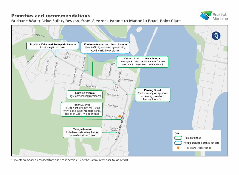
3.2. Recommendations Following consideration of the community consultation, we have decided to move ahead with further planning, design and construction of the some of the upgrades identified in the safety review.
The $2 million that has been allocated by the NSW Government to the Brisbane Water Drive safety review will be used to develop options, prepare funding submissions and start work on some of the identified upgrades.
The funded projects have been outlined in Appendix A and include:
• Installing roadside safety barrier and pedestrian fencing on the western side of Brisbane Water Drive near Talinga Avenue to provide protection for pedestrians
• Improving safety near Takari Avenue, by providing a dedicated right turn bay and installing roadside safety barrier and pedestrian fencing on the western side of road
• Banning the right turn out of Penang Street and investigating widening the road shoulders on the approach to Penang Street to provide a safe passing width from a stationary car and banning the right turn out
• Improvements to sight distance near Lorraine Avenue • Investigating options for the proposed pedestrian footpath between Collard Road and Jirrah
Avenue, including options for either side of the road. Further investigations and community feedback have determined that we will no longer be going ahead with banning the right-turn movements into Lorraine Avenue and Penang Avenue, and building a roundabout at Collard Road and Welwyn Grove. The total cost estimate for all of the proposed safety improvements identified in the safety review is in excess of $10 million. The remaining improvements will be prioritised and considered for future funding.
3.3. Next steps We have considered all responses will ensure that issues highlighted by stakeholders and the community are appropriately addressed as further investigations are carried out and proposals are progressed.
We will consult with the community on each project when funding is made available for further development.
17

Appendix A
18 Document name
Manooka Road
Coola
rn A
venu
e
Sun
shin
e D
rive
Sun
nysi
de A
venu
e
Girr
alon
g A
venu
e
Col
lard
Roa
d
Welwyn Grove
Penang Street
Scott Street
Takari Avenue
TalingaAvenue
Koo
linda
Ave
nue
Jirr
ah A
venu
eTania Drive
Bya
rong
Ave
nue
Lorr
aine
Ave
nue
Mat
the
ws
Para
de
Bris
bane
Wat
er D
rive
Collard Road to Jirrah AvenueInvestigate options and locations for new
footpath in consultation with Council
Penang StreetRoad widening on approach
to Penang Street and ban right turn out
Takari AvenueProvide right turn bay into Takari
Avenue and install roadside safety barrier on western side of road
Lorraine AvenueSight distance improvements
Sunshine Drive and Sunnyside AvenueProvide right turn bays
Koolinda Avenue and Jirrah AvenueNew traffic lights including removing
existing mid-block signals
Talinga AvenueInstall roadside safety barrier
on western side of roadProjects funded
Future projects pending funding
Point Clare Public School
Key
Priorities and recommendations Brisbane Water Drive Safety Review, from Glenrock Parade to Manooka Road, Point Clare
*Projects no longer going ahead are outlined in Section 3.2 of the Community Consultation Report.

Appendix B
19

November 2016
Have your say – Safety review of Brisbane Water Drive between
Glenrock Parade and Manooka Road, Point Clare
The NSW Government has provided $2 million to investigate safety
improvements along this section of Brisbane Water Drive.
Roads and Maritime Services is seeking your feedback on potential future safety improvements on
Brisbane Water Drive between Glenrock Parade and Manooka Road, Point Clare.
Roads and Maritime has carried out a route safety investigation to identify and prioritise potential safety
improvements.
The community has previously told us about existing issues on this section of Brisbane Water Drive,
including:
Difficulties for pedestrians crossing Brisbane Water Drive, which has limited formal crossing facilities
Safety concerns for motorists entering and exiting side streets due to lack of formal turning lanes
Safety concerns caused by sight distance and road design issues
Concerns about the safety of children around Point Clare primary school.
The potential future safety improvements will be prioritised based on a range of criteria, including traffic
volumes, crash data, road design constraints, economic analysis and community feedback.
The proposed safety improvements include:
Providing right turning bays at Sunshine Drive, Sunnyside Avenue and Takari Avenue
Installing new traffic lights, including removing existing mid-block signals at the Koolinda Avenue and
Jirrah Avenue intersection
Building a pedestrian footpath from Collard Road to Jirrah Avenue
Improving sight distance at Lorraine Avenue and banning the right turn in
Improving safety at Penang Street by banning the right turn in and right turn out movements
Installing a roundabout at the Collard Road and Welwyn Grove intersection. This roundabout will
serve as a u-turn facility for motorists entering Penang Street and Lorraine Street, due to the banned
right turn movements.

The total cost estimate for the proposed safety improvements along this section of Brisbane Water Drive
is $10 million. This work is currently unfunded and will be considered on a competitive basis as funding
becomes available.
The $2 million of announced funding will be used to further investigate options, prepare funding
proposals and design this high priority work.
We have included a map to outline the locations of the potential future safety improvements.
How can you give feedback?
We encourage you to send us your comments by Friday 25 November 2016 to:
Bronwyn Bosse
Network Optimisation Analyst – Safety
Roads and Maritime Services
Locked Bag 2030
Newcastle, NSW 2300
or
We will carefully consider your feedback and continue to keep you updated.
The community will be invited to comment further on individual projects when funding is available and
designs have been developed.
Contact
If you have any questions, please call our Project Manager Bronwyn Bosse on 02 4924 0658 or email
For more information on our projects, visit rms.nsw.gov.au.

Manooka Road
Coola
rn A
venu
e
Sun
shin
e D
rive
Sun
nysi
de A
venu
e
Girr
alon
g A
venu
e
Col
lard
Roa
d
Welwyn Grove
Penang Street
Scott Street
Takari Avenue
TalingaAvenue
Koo
linda
Ave
nue
Jirr
ah A
venu
eTania Drive
Bya
rong
Ave
nue
Lorr
aine
Ave
nue
Mat
the
ws
Para
de
Bris
bane
Wat
er D
rive
Sunshine Drive and Sunnyside AvenueProvide right turning bays
Koolinda Avenue and Jirrah AvenueNew traffic lights including removing
existing mid-block signals
Collard Road to Jirrah AvenueBuild pedestrian footpath
Collard Road and Welwyn GroveBuild roundabout in Collard Road
for u-turn facility
Penang StreetBan right turn in and out
Takari AvenueProvide right turning bay
Lorraine AvenueImprove sight distance at the
intersection and ban right turn in
Safety review of Brisbane Water Drive, from Glenrock Parade to Manooka Road, Point Clare

Appendix C
20 Document name
MEDIA RELEASE
1 NOVEMBER 2016
HAVE A SAY ON BRISBANE WATER DRIVE SAFETY REVIEW
Roads and Maritime Services is inviting the community to have a say on potential future safety improvements on Brisbane Water Drive between Glenrock Parade and Manooka Road at Point Clare. A Roads and Maritime spokesperson said the NSW Government provided $2 million to complete a route safety investigation identifying and prioritising potential safety improvements along this section of Brisbane Water Drive. “Taking community feedback into consideration, the safety review identified potential improvements to pedestrian facilities and intersections to improve safety for road users,” the spokeperson said. “Potential safety improvements identified in the review have been prioritised on criteria including traffic volumes, crash data, road design constraints, economic analysis and community feedback. “The review identified potential projects including providing right turning bays at Sunshine Drive, Sunnyside Avenue and Takari Avenue and installing traffic lights at Koolinda Avenue and Jirrah Avenue to improve traffic movements.” The Roads and Maritime spokesperson said proposed changes also include restricting turning movements at Lorraine Avenue and Penang Street to improve safety and providing a new roundabout at the Collard Road and Welwyn Grove intersection to provide for U-turns. “Pedestrian safety was also a focus of the safety review with a new footpath from Collard Road to Jirrah Avenue identified as a potential future project,” the spokesperson said. “Work will continue to investigate these options, prepare funding proposals and start designing the high priority improvements.
“The safety improvements are currently unfunded and will be considered on a competitive basis as funding becomes available.” Comments on the safety review can be provided by emailing [email protected] or writing to Bronwyn Bosse, Roads and Maritime Services, Locked Bag 2030, Newcastle 2300 by Friday 25 November.
To view further information about the safety review and the potential future safety improvements, please visit www.rms.nsw.gov.au.
ROADS AND MARITIME SERVICES MEDIA UNIT 8588 5999 or [email protected]

Appendix D
21
Have your sayBrisbane Water Drive safety review
You are invited to have your say on potential future safety improvements on Brisbane Water Drive between Glenrock Parade and Manooka Road, Point Clare.
Roads and Maritime Services has carried out a route safety investigation to identify and prioritise potential safety improvements along this section of Brisbane Water Drive.
To learn more about the safety review and the proposed potential safety improvements please visit rms.nsw.gov.au.
Feedback is invited until Friday 25 November 2016.
For more information contact Project Manager Bronwyn Bosse on (02) 4924 0658,
email [email protected] or visit rms.nsw.gov.au
A03
412
A03412_92x85_HR (KE)

rms.nsw.gov.au
13 22 13
Customer feedback Roads and Maritime Locked Bag 2030 Newcastle NSW 2300
January 2017 RMS 17.007
ISBN: 978-1-925582-40-6