bong hydro power
TRANSCRIPT

SUMMARY INITIAL ENVIRONMENTAL EXAMINATION
NEW BONG ESCAPE HYDROPOWER PROJECT
IN
PAKISTAN
August 2005

CURRENCY EQUIVALENTS (as of 30 July 2005)
Currency Unit – Pakistan rupee/s (PRe/PRs)
PRe1.00 = $ .0168 $1.00 = PRs 59.66
ABBREVIATIONS
ADB – Asian Development Bank AJ&K – Azad Jammu and Kashmir BC – before construction CC – civil contractor CC ESO – civil contractor's ESO DC – during construction EC – electrical contractor EC ESO – electrical contractor's ESO EMP – environmental management plan EPC – engineering, procurement and construction EPC ESS – EPC contractor's environment and social supervisor EPC PM – EPC project manager ESI – environmental and social inspector ESO – environmental and social officer ESS – environmental and social supervisor ESSA – environmental and social soundness assessment IEE – initial environmental examination LEL – Laraib Energy Limited LEL CEO – LEL chief executive officer LEL ESI – LEL environmental and social inspector LEL PM – LEL project manager LEL SR – LEL site representative MC – mechanical contractor MC ESO – mechanical contractor's ESO UJC – Upper Jhelum Canal
WEIGHTS AND MEASURES
cusec – cubic feet per second km – kilometer km2 – square kilometer kV – kilovolt m – meter m3/sec – cubic meter per second MCUM – million m3 mm – millimeter MW – megawatt
NOTE
In this report, “$” refers to US dollars and ¢ to US cents.
CONTENTS
Page MAPS iii I. INTRODUCTION 1 II. DESCRIPTION OF THE PROJECT 1 A. Technical Features 1 B. Implementation Arrangements and Schedule 3 III. DESCRIPTION OF THE ENVIRONMENT 3 A. Project Site and Land Use 3 B. Physical Environment 3 C. Biological Resources 5 D. Socioeconomic Environment 6 E. Physical Cultural Resources 7 IV. SCREENING OF POTENTIAL ENVIRONMENTAL IMPACTS AND MITIGATION MEASURES 7 A. Impacts During Construction 7 B. Impacts During Operation 8 V. INSTITUTIONAL REQUIREMENTS AND ENVIRONMENTAL MONITORING PLAN 9
A. Organizational Structure, Roles and Responsibilities 9 B. Mitigation Plan 10 C. Monitoring Plan 10 D. Communication and Documentation 10 E. Environmental Training 11 F. Cost Estimates 11
VI. PUBLIC CONSULTATION AND INFORMATION DISCLOSURE 11 A. Consultations with Representatives of Government Agencies Concerned 11 B. Consultations with Villagers of the Two Communities 11 VII. FINDINGS AND RECOMMENDATIONS 12 VIII. CONCLUSIONS 12 APPENDIXES 1. Organizational Structure 13 2. Summary Initial Environmental Examination – Mitigation Measures
during Construction 14

Tarbela Dam
Mangla Dam
Indus R
.
Nal R
.
Dasni R.
Ravi R.
Chenab R.
Jhelum
R.
Indus
R.
Kabul R.
Kunar R.
Swat R
.
Sutlej R.
A R A B I A N S E A
Chenab River
Jhelum River
ManglaReservoir
NEW BONG ESCAPEHYDROPOWERPROJECT
ISLAMABAD
Rahimyar Khan
Liaqatpur
Multan
Leiah
Bhakkar
Khanewal
Vehari
Hasilpur
BahawalpurRajanpur
Lodhran Bahawalnagar
Okara
Pakpattan
Kasur
Sahiwal
KhushabSargodha Hafizabad
Bhalwal
Mandi Bhauddin
GujranwalaSialkot
Narowal
JhelumChakwal
Gujar Khan
Mianwali
Talagang
Gujrat
Jhang SadarShorkot
Faisalabad
Toba Tek Singh
Sheikhupura
Kohat
Karak
Parachinar
Bannu
LakkiTank
AttockHaripur
Rawalpindi
Mansehra
Batgram
Nowsehra
Dasu
Saidu Sharif
Dir
Chitral
Malakand
CharsaddaBatkhela Mardan
Buner
Swabi
Peshawar
Abbottabad
Dera Ghazi Khan
Kot Addu
Muzaffargarh
Zhob
M.K. Bazar
Loralai
Sibi
Kohlu
Dera Bugti
Barkhan
Mastung
PishinChammanZiarat
NushkiDadhar
Jacobabad
LarkanaKakar
Ratodero
Kharan
Kalat
Panjgur
Pasni
Turbat
Khuzdar
Gwadar
Uthel
Awaran
Dadu
KarachiThatta
Port Qasim
Badin
Hyderabad
Mirpur Khas
Sanghar
Sukkur
Shikarpur
Nawabshah
Lahore
Quetta
Federally AdministeredTribal Areas
Dera IsmailKhan
Khairpur
Ghotki
Naushahro
Umarkot
Mithi
Jafarabad
JhapatJhal Magsi
Bhera
Rasul
GujratGujranwala
Dina
Mangla Mirpur
Jhelum
Gujar Khan
ISLAMABADRawalpindi
BALOCHISTAN
PUNJAB
NORTH - WEST FRONTIER
SINDH
I N D I A
I R A N
AFGHANISTAN
AFGHANISTAN
Project LocationNational CapitalProvincial CapitalCity/TownNational RoadOther RoadRailwayRiverProvincial BoundaryInternational Boundary
Boundaries are not necessarily authoritative.
PAKISTANNEW BONG ESCAPE HYDROPOWER PROJECT
1000 20050
Kilometers
N
73 00'Eo
73 00'Eo
35 00'No35 00'No
26 00'No
64 00'Eo
64 00'Eo
26 00'No
05-2102a HR
Map 1 iii

Upper Jhelum Canal
New BongEscape Channel
JhelumRiver
Bong Pond
ContractorCamp and Yard
PermanentStaff Colony
Headrace IntakeNew Bong Escape Regulator
Power House
Embankment forNew Bong Escape Tailrace
UJC Regulator
Existing Old BongEscape Regulator
Headrace
Flood Protection Embankment
Subsidiary Outfall
ExistingTransmission Line
Grazing Areas inRiver Flood Plain
Ferozabad Village
Lehri Village
Mangla-Mirpur Road Existing Recreation Area
Switchyard
Headrace IntakePower HouseContractor Camp and YardEscape RegulatorPermanent Staff ColonySubsidiary OutfallSwitchyardFlood Protection EmbankmentEmbankment for New Bong EscapeRiverExisting Transmission Line
Note: The above layout plan of the Project is subject to minor modifications during the detailed design stage.
PAKISTANNEW BONG ESCAPE HYDROPOWER PROJECT
LAYOUT OF PROJECT FACILITIES
N
05-2102c HR
Map 2

Mangla Reservoir
Jhelum River
Upper Jhelum Canal
Old Upper Jhelum
Bong Canal
SpillwayEmergency Spillway
New Mirpur
Dina
Wapda Colony
ChichianProposedPower House Site
to Rawalpindi
to Lahore
Dina-M
angla
Roa
d
Mangla Dam
City/TownVillagePower HouseSpillwayNational RoadOther RoadCanalRiver
PAKISTANNEW BONG ESCAPE HYDROPOWER PROJECT
LOCATION OF NEW BONG HYDROPOWER
N
05-2102d HR
Map 3

Old BongEscape RegulatorNew Bong
Escape Regulator
Gauge No. 2
Gauge No. 1
Gauge No. 5
Gauge No. 6Gauge No. 3
Gauge No. 4
Flow f
romSu
rat Sy
phon
Flow
from
Surat
Syp
hon
SurveyedLimit Line
SurveyedLimit Line
Bong Head Works
Escape RegulatorGaugeRiver
PAKISTANNEW BONG ESCAPE HYDROPOWER PROJECT
LOCATION OF JHELUM RIVER FLOOD PLAIN
N
05-2102e HR
Map 4

I. INTRODUCTION
1. The New Bong Escape Hydropower Project was originally conceived as a 45 MW run-of-the-river hydropower project. It received no objection certificates on 20 August 1996 from the environmental protection agency of Pakistan and on 6 January 1997 from the environmental protection agency of Azad Jammu and Kashmir (AJ&K), based on an environmental and social soundness assessment (ESSA) report submitted in April 1996. However, the AJ&K environmental protection agency required sewage from the residential quarters and offices to be adequately treated before being discharged into the Jhelum River. The AJ&K environmental protection agency subsequently reconfirmed its no objection on 23 August 2004 for the project capacity of 79 MW. The Project is classified by the Asian Development Bank (ADB) as environmental category B. No people reside in the Project site and no indigenous peoples live in the surrounding area. Therefore, relocation and indigenous people are not at issue.
2. Considering the time that has passed since the ESSA in 1995–1996 and the increase in the generation capacity of the Project from 49 MW to 79 MW, ADB asked the project sponsors, Ranhill Laraib Energy Limited (the company) to prepare an initial environmental examination (IEE). The IEE updated the information on baseline environmental and social conditions of the project area and the environmental and social impact assessment presented in the ESSA report. The IEE confirmed that the previous findings and conclusions of the ESSA report were still valid. The IEE is summarized below, following the outline recommended in ADB’s Environmental Assessment Guidelines 2003, Appendix 3, Table A3.3.
II. DESCRIPTION OF THE PROJECT A. Technical Features
3. The project facilities will consist of an inlet; a headrace channel; a powerhouse; a tailrace channel; a switchyard; a housing complex for about 50 staff; public utilities; including a sewage treatment plant for the housing complex; and a bridge crossing the headrace channel. Map 2 shows the layout of the project facilities. Table 1 summarizes technical features of the facilities.
Table 1: Project Description
Project Facility Technical Features Purpose/Function
Headrace Channel Capacity: 38,000 cusecs (1,080 m3/sec)
Length: 500 m
Bed width: 78 m
Bed slope: 1:6,000
Concrete lining
To connect the Bong pond and the proposed powerhouse
Road Bridge Ordinary reinforced concrete road bridge spanning the Headrace Channel.
To provide the crossing over the Headrace Channel for the Mangla-Mirpur road

2
Project Facility Technical Features Purpose/Function
Tailrace Channel Capacity: 49,000 cusecs (1,392 m3/sec)
Length: 4,136 m
Bed width: 91 to 152 m
Bed slope: 1:4,000
To connect the proposed powerhouse and the Hari channel
Tailrace Embankment Length: 4,663 m
Height: 20 feet (6 m)
Width at the top: 400 feet (122 m)
Side slope: 1:1.75
Stone pitching
To protect Tailrace Channel from floodwater
Powerhouse Width: 216 feet (66 m)
Length: 221 feet (67 m)
Operating head: 33–43 feet (10–13 m)
Design flow: 30,000 to 40,000 cusecs (1,023 to 1,136 m3/sec)
To house 4 sets of turbo-generators and associated systems, auxiliaries, control room, offices, workshop, etc
Switchyard Length: 410 feet (125 m)
Width: 328 feet (100 m)
To connect the powerhouse with the existing 132 kV transmission line
Subsidiary Outfall Width: 129 feet (39 m)
Length: 234 feet (71 m)
To reinforce the existing Old Bong Escape Channel
New Bong Escape Channel Embankment
Length: 3,414 feet (1,040 m)
Width: 200 feet (61 m)
To redirect the flow of the New Bong Escape Channel away from the Tailrace Channel and Powerhouse
cusec = cubic feet per second, kV = kilovolt, m = meter, m3/sec = cubic meter per second. Technical details given in the Table 1 are subject to minor changes during the detailed design stage. Source: Compiled from Initial Environment Examination (November 2004).
4. The Project will divert part of the flow of the Bong Canal, which currently discharges into the Jhelum River through the New Bong escape channel, into the new project headrace channel to drive four sets of low-head bulb turbine generators before discharging into the Jhelum River through the Project tailrace channel. The electricity generated will be fed into the existing 132 kV Mangla–Kharian transmission lines passing over the site. The project tailrace channel will be constructed by excavating the Hari channel to drop its water level to create enough head, about 10–13 m, to operate the turbines. For flood protection, an embankment will be constructed running parallel to the project tailrace channel.
5. The existing New Bong escape channel structure will be improved to protect the embankment of the tailrace channel. This will involve building an embankment along the New Bong escape channel to guide the flow to the main channel of the Jhelum River. Likewise, the Project will reinforce the Old Bong escape channel against any possible erosion caused by the

3
drop in the water level in the Hari channel after it begins operating as the tailrace channel. This will be achieved by realigning the channel and building a subsidiary outfall.
B. Implementation Arrangements and Schedule
6. The project cost is estimated at about $125 million equivalent. The Project will be constructed on a design and build basis. One contractor will be awarded a comprehensive contract covering detailed design, civil works construction, installation of mechanical and electrical equipment and machines, test run, and commissioning. The contract award for the engineering, procurement and construction (EPC) contractor is anticipated in late July 2005. Construction is expected to begin in December 2005 with a targeted commercial operation date of December 2008.
III. DESCRIPTION OF THE ENVIRONMENT
A. Project Site and Land Use
7. The 21.3-ha project site, owned and leased to the Project by the Government of AJ&K, is bordered by the existing road between Mangla and Mirpur to the north, the New Bong escape channel to the west, the Old Bong escape channel to the east, and the Jhelum river flowing in an east–west direction to the south (Map 3). The project site is vacant land with shrubs and few trees. Some families in the two adjacent communities, Ferrozabad and Lehri, use parts of the project site, without authorization from Water and Power Development Authority (WAPDA) (previous lessee of the site), for occasional cultivation, mostly of fodder. The strip of land between the Bong pond and Mangla-Mirpur road contains trees, mostly eucalyptus. This part of the site is occasionally used for recreational purposes by the local communities. B. Physical Environment
1. Geology and Geomorphology
8. The project area is a part of the Jhelum Valley and is the flood plain of the Jhelum River. The area is dissected by several artificial drains and natural streams that drain into the Jhelum River. The prevailing geological conditions at the project site are a result of extensive erosion of the hills of the lower Himalayas from the Pleistocene to the subrecent period, and transportation and deposition of this eroded material southward. Construction records from the Mangla dam and the Bong canal indicate that the rock exposures nearest to the site are about 1,300–1,400 m downstream of the Mangla tailrace and about 6,000 m northwest from the proposed site.
9. Downstream of the Bong canal, the surface in the north and western part is covered with from 2.4 m to 3 m of spoil from the excavation of the Bong canal and the New Bong escape channel. The spoil consists of gravel boulders with some fine silt sand. In the southern part, about 600 m from the Old Bong canal, at the site of the proposed powerhouse, the surface is covered with about 3 m of very fine silt sand. The fine sand also extends north and westward underneath the spoil.
2. Seismic Activities
10. The project area is an active seismic area as it is near the Mangla and Jhelum faults. The 120-km Jhelum fault could produce an earthquake of a significant magnitude.

4
Consequently, an earthquake return period of 1,000 years will be adopted in the design of the powerhouse and other major project facilities.
3. Climate
11. The project area is semi-arid and characterized by four distinct seasons: winter from mid-November to February, spring during March and April, summer from May to mid-September, and autumn from mid-September to mid-November. Average annual rainfall is about 850 mm (30-year records) with maximum rainfall of 131.38 mm observed on 5 August 1994. Average maximum temperature is 40.5 °C. The maximum temperature recorded so far is 48.37 °C on 17 June 1995 and minimum is 0.9 °C on 7 February 1994.
4. Soils
12. At the project site the topsoil consists of loose, yellowish brown, sandy silt, loose yellowish brown silt fine sand, and traces of gravel. It extends to depths from 1.5 to 3 m. The topsoil is underlain by layers of rounded to subrounded gravel, cobbles, and boulders with voids filled with sandy silts and silt sands. This material extends to the maximum investigated depth of 50 m.
5. Water Resources
a. Groundwater
13. Groundwater in the Project site was encountered at depths from 0.8 m to 2.45 m from the existing ground level in confined aquifer conditions.
b. Surface Water
14. The Jhelum River is the principal natural watercourse in the Project area. It is a part of the Indus River system that drains the southwestern parts of Himalayan Mountains. With a catchment area of 32,947 km2, the Jhelum River has a mean annual flow of about 28,371 MCUM. The Jhelum River is perennial and is characterized by a great fluctuation in its discharge, with large flows during monsoons. Following the construction of Mangla Dam in 1967, the Jhelum River drains into the Mangla Dam reservoir. The reservoir has a gross storage capacity of 7,253 MCUM and a surface area of about 256 km2. Its shoreline has a total length of about 400 km, extending about 64 km into the Jhelum River upstream of the dam. The reservoir’s capacity is expected to increase by another 3,550 MCUM after construction of the Mangla Raise has been completed.
15. The water in the reservoir is used to generate electricity in the Mangla powerhouse, which has a total generation capacity of 1,000 MW. The water from the Mangla Dam powerhouse is discharged into a tailrace, the Bong canal. Part of the flow of the Bong canal is fed into the upper Jhelum canal (UJC) to meet the lower Chenab canal system requirements. The remaining flow is discharged into the Jhelum River through a canal called the New Bong Escape. Before construction of the Mangla Dam, the surplus flow of the Jhelum River, after meeting irrigation requirements, discharged into the Old Bong Escape, a canal constructed in 1905. After construction of the New Bong Escape, the Old Bong Escape is no longer used for normal flow diversion, apart from silt exclusion and draining exceptional floods beyond the capacity of the New Bong Escape.

5
16. The diversion of the water from the Mangla powerhouse into the Bong canal means that the stretch of the Jhelum River downstream from the dam to the New Bong Escape is almost completely dry, except when it receives water from the dam spillways during monsoons and heavy rains. When it is completed, the Mangla Raise project will further reduce the spillway operation.
17. Downstream of Mangla dam, the Jhelum River has a very broad flood plain, several kilometers wide in some locations, like other rivers in the region. The Jhelum River floodplain adjacent to the Project site is more than 1,800 m in width. During low flows, the river branches into several channels that meander over the broad floodplain. One of the channels is called the Hari channel. This channel will be used as tailrace of the project powerhouse. Map 4 shows the Jhelum River floodplain adjacent to the project site. The Hari channel represents only a very small portion of the entire floodplain.
18. In addition to the Jhelum River, a natural drainage channel in the vicinity of the Project site is Jabbar Nullah. This natural drainage channel is on the western bank of the Jhelum River. It drains a catchment area of about 32 km2 in the Pabbi hills north of the project site. The Jabbar Nullah is nonperennial, and is dry for most of the year; during monsoons, however, flash floods can occur and the flows in the Jabbar Nullah can reach up to 566 m3/sec. The Jabbar Nullah drains into the Jhelum River through the New Bong Escape.
6. Environmental Quality
a. Ambient Air Quality
19. There are no ambient air quality data at the project site. There are no major air pollution sources, such as large industries, heavy vehicular traffic, or brick kilns, in the surrounding area.
b. Water Quality 20. Complete information on groundwater quality of the project area is not available. A limited analysis was carried out during the geotechnical investigations as part of the project’s feasibility study. The groundwater was found to be neutral, with low solids content, and clean. 21. There are no water quality data on the Jhelum River at the project site. The water quality is believed to be good because of the lack of industry and the low population density. C. Biological Resources 22. The project site is situated in an area which has been subjected to human intervention for decades. There are no areas that could be considered ecological or biologically sensitive.
23. The project site and the area within 10 km are no longer original tropical thorn forest. The habitat has been modified by agricultural use, urban areas with both endemic and exotic trees, and canals and roads with side plantations of delbergia and acacia. The project site has only a few trees, mostly eucalyptus. The riverine belt is badly degraded and contains no trees of ecological or economic importance, except for some old banyan trees, which should be preserved. The edge vegetation includes mostly grasses, primarily Typha angustata, Saccharium spontanarum, saccharum munja, Tammarix aphylla, etc.

6
24. Because of the degraded habitat, the project site and its surroundings do not support any fauna of ecological or economic significance. The pattern of mammalian fauna has changed because of the disappearance of the tropical thorn forest and great changes to riverine tract habitats. There are few species of small mammals, but the area includes musk shrew, fruit bat, tat-tailed bat, and yellow bat. Indian pangolin, jackal, small Indian mongoose, jungle cat, wild boar, five-stripped squirrel, porcupine and white-footed fox are also found in the surrounding area.
25. The predominant avian species at the project site and its immediate vicinity are crows and myna. Other common birds include Indian kite, shikra or Indian sparrow hawk, black partridge, grey partridge, blue rock pigeon, Indian ring dove, little brown dove, white-cheeked bulbul, and Indian tree pie. In the riverbed wherever there is some seepage water it is visited in winter by waders. However, the nearby Mangla reservoir provides a habitat for such species, and is visited by large flocks of wintering waterfowl. There are also some Himalayan birds in winter in agricultural areas. In summer, in addition to local birds there are summer breeders from the south, including the monsoon arrivals. In autumn, passage migrants stay for a short time. D. Socioeconomic Environment 26. The 1996 ESSA study included a detailed socioeconomic survey of 21 communities within a 5-km radius of the Project and there has been no significant change since that period. During the IEE exercise, it was established that the Project could have impacts on only two communities adjacent to the Project site, Ferozabad and Lehri. Some families in these two communities have been using some parts of the project site without authorization from WAPDA for grazing and cultivation of fodder.
1. Lehri
27. Lehri is the larger of the two villages and is situated on the western bank of New Bong Escape. Its human settlement pattern comprises clusters within the village premises. The village has about 150 households, about a dozen of which are involved in unauthorized use of parts of the project site. An overwhelmingly majority of households subsist on remittances from migrant workers, mostly in the United Kingdom. Local trade and government and private employment is a secondary source of income. Agriculture and livestock are fringe activities, practiced at below subsistence levels. The general affluence resulting from foreign remittances is apparent from the lavish appearance of most of the houses in the village. However, educational and social amenities are poor. Schools, hospitals, paved streets and other infrastructure are almost nonexistent.
2. Ferozabad
28. Ferozabad is a small settlement of around 12 houses situated on the eastern bank of Old Bong Escape. The people of Ferozabad consist of one extended local family and some other families who have come to the area after being displaced due to conflict in their native northeastern AJ&K. The primary source of livelihood for these families is employment in the government and private sectors. Agriculture is a secondary economic activity. Young men from two families work abroad and remit money from there. The social infrastructure is poor. The road is unpaved and there is no school or clinic. Most of the agricultural land sown by the inhabitants of Ferozabad is located deep on the northern of the Old Bong Escape and will not be affected by the Project.

7
E. Physical Cultural Resources 29. The project site contains no archaeological sites, graveyards or mosques. By its nature, the Project will not have any adverse impacts on existing archeological sites, shrines, and religious sites in the surrounding areas.
IV. SCREENING OF POTENTIAL ENVIRONMENTAL IMPACTS AND MITIGATION MEASURES
A. Impacts During Construction 30. Construction activities will invariably create environmental impacts. A review of the construction of project facilities identified potential environmental and social impacts and proposed mitigation measures (Appendix 1). These are summarized below.
1. Environmental Impacts 31. Environmental impacts include the following:
(i) Ecological impacts. The Project will have no ecological impacts since the project site is small, not very biodiverse, and contains no flora or fauna of ecological importance. The construction of the embankment, the subsidiary outfall, and the excavation of the tailrace channel will have no ecological impacts, since it will take place in only a small part of the broad floodplain. The Hari channel is one of several channels of the Jhelum River at the project site.
(ii) Disposal of excavated materials. All the excavated materials from the construction of the headrace and tailrace channels will be used in constructing the embankment and in filling up the project site. Surplus excavated materials, if any, will be disposed of in areas to be designated by the environmental and social inspector of the company.
(iii) Soil erosion and degradation. Good engineering design will protect erosion of the embankment. Effective mitigation measures and sound environmental management practices will be specified in the contracts to ensure minimum soil erosion and degradation.
(iv) Air quality. Air quality in the project site and the surrounding area could be affected by dust generated during excavation, by movement of vehicles, or by gaseous emissions of vehicles and construction equipment. Effective mitigation measures and sound environmental management practices will be specified in the contracts to ensure minimum air pollution. The two nearest communities, Lehri and Ferozabad, are about 900 m and 300 m from the project site. The residual impacts on these two communities would be insignificant.
(v) Noise. Noise will be kept to a minimum by avoiding construction during night time and by minimizing the use of noisy equipment. As Ferozabad is about 300 m away, the residual noise impacts on the community will not be significant.
(vi) Waste management. Effective waste management measures and practices will be prescribed in the contracts to ensure pollution of soil, ground water and surface water by human wastes and construction wastes is insignificant.
(vii) Water turbidity. Hari channel is one of several channels of the Jhelum River formed during low flows. The excavation of the channel for construction of the tailrace channel may increase water turbidity in the Hari channel. The turbid

8
water would eventually drain into the main channel of the Jhelum River. However, this turbidity problem would be significant only during low flows, when the background turbidity in the river is low. During high flows, the background turbidity in the Jhelum River is high because of the discharge of turbid floodwater from the seasonal streams (such as Jabbar Nullah). One mitigation measure being considered is closing both ends of the Hari channel, this would mean that the flow from the New Bong Escape would enter the main channel of the Jhelum River. The Hari channel would then have no flow and could be excavated without turbid water escaping into the main channel of the Jhelum River.
2. Social Impacts
32. Social impacts include the following:
(i) Unauthorized cultivation and grazing. Although the current use of some locations in the Project site for cultivation and grazing by families in the two adjacent communities is unauthorized, the company is willing to pay compensation to the affected families.
(ii) Blocked access. The construction of the headrace channel crossing the existing road could cause inconvenience to vehicles. A temporary bypass road will be provided during construction of the channel and the bridge that crosses it. The construction contracts will require the contractor to avoid blocking access to other project facilities.
(iii) Safety and public health hazards. The contractors will be required to implement safety measures to avoid accidents and protect workers. Health precautions need to be undertaken to minimize health risks to construction workers and nearby communities.
(iv) Loss of recreational site. An area between Bong canal and the road is currently used by local people for recreation. This area will be used for the construction of the headrace channel. A new recreational site will be provided to compensate for the loss of the existing area.
(v) Population influx. The Project (and the much larger Mangla Raise project) may lead to in-migration from other parts of AJ&K and Pakistan to provide services to construction workers. The two projects are likely to cause a general uplift in the infrastructure of the area and to increased economic activity. However, there is a general trend of out-migration to larger towns and cities so in-migration may not be a serious problem. During the detailed design stage, the company should consult with the local administration to ensure adverse impacts of population in-migration are minimized.
33. Although the Project will not have significant adverse social impacts, the company intends to contribute to community development in collaboration with the concerned local agencies. B. Impacts During Operation 34. The Project will have no adverse environmental and social impacts during the operational phase. It will use surplus water which is currently released back in the Jhelum River. It will not affect water availability in the upper Jhelum canal, and will not reduce the flows in the Jhelum River downstream of the New and Old Bong Escapes. The only visible impact will be on the New Bong Escape channel, which will receive water only if the proposed powerhouse shuts

9
down. However, this 1,200 m channel is a constructed rather than a natural feature, has no ecological significance, and is not used by local communities. Therefore, the drying up of this short reach of the channel will not have significant environmental or social impacts. 35. To ensure the Project is in harmony with the environment, the company will employ sound environmental management practices, including:
(i) waste management at residential complexes and offices, particularly sewage treatment to the required standard and reuse of treated effluents for gardening;
(ii) waste management at warehouses, workshops and motor pools; (iii) landscaping and plantations; (iv) environmentally responsible conduct of personnel, covering such practices as
hunting and tree cutting; and (v) noise and other public nuisance abatement.
36. The above practices will be institutionalized in the environmental management system of the company.
V. INSTITUTIONAL REQUIREMENTS AND ENVIRONMENTAL MONITORING PLAN A. Organizational Structure, Roles and Responsibilities
1. Construction Phase 37. The project environmental management plan (EMP) includes an organizational structure, roles and responsibilities of the various entities, an impact mitigation plan, an environmental monitoring plan, communication and documentation, and environmental training. 38. The organizational structure for the construction phase is in Appendix 1. The company will assume overall responsibility for compliance with environmental and social management requirements of the government of AJK and the lenders. The engineering, procurement and construction (EPC) contractor will assume overall responsibility for the environmental performance of all the subcontractors, i.e., it will ensure that they effectively implement all environmental management measures stipulated in the EMP and in the contracts. 39. The company’s project manager will discharge the company’s environmental and social responsibility as part of project implementation management. The company will appoint an environmental and social inspector to assist the project manager and provide policy support on all environmental and social matters. The company will coordinate with relevant government departments (e.g., the AJ&K environmental protection agency) and other stakeholders through the environmental and social inspector. 40. The EPC contractor will appoint an environmental and social supervisor to assist its project manager in overseeing and monitoring the environmental performance of all subcontractors. Each subcontractor will appoint an environmental and social officer to help its resident engineer to implement the EMP and provisions specific to its contract.

10
2. Operational Phase 41. Considering the nature of the Project, environmental and social management during the operational phase of the powerhouse will be minimal and routine. Management of wastes from residential quarters and offices will be the main task. The management of the powerhouse should include one environmental and social officer. B. Mitigation Plan
42. A detailed mitigation plan for the construction phase was prepared as part of the EMP and presented as an appendix to the IEE. In essence, the mitigation plan contains:
(i) a comprehensive listing of mitigation actions, (ii) the persons responsible for ensuring full implementation of the action, (iii) the persons responsible for monitoring the action, and (iv) a timescale for the implementation of the action to ensure that the objectives of
mitigation are fully met. 43. The mitigation measures will be translated into environmental requirements and specifications for detailed design and construction, with legally binding effect. C. Monitoring Plan 44. Two types of monitoring will be conducted: compliance monitoring and impact or effect monitoring. Compliance monitoring will be the responsibility of all organizations involved in the field activities, i.e., the company, the EPC contractor, and the subcontractors. It will be carried out by the company’s environmental and social inspector, the EPC contractor’s environmental and social supervisor, and the subcontractors’ environmental and social officer. 45. The effects monitoring will be carried out in line with the requirements in the mitigation plan focusing on soil erosion, water quality (covering suspended solids, turbidity, biological oxygen demand, and dissolved oxygen), air quality (covering suspended particulate matters), noise (to be measured at selected sensitive receivers during construction creating noise), and socioeconomic aspects (covering complaints and employment created by the project). A detailed monitoring plan will be developed during the design phase of the Project, when specific information on field activities is known. The monitoring schedule will be linked to the construction schedule. D. Communication and Documentation 46. An effective mechanism for storing and communicating environmental information will be established. The data and information will be systematically filed and stored in a central location. Periodic meetings will be held involving the company, the EPC contractor, and subcontractors’ environmental and social officers to review the implementation of the EMP and monitoring results, and to resolve any problems. The EPC contractor’s environmental and social supervisor will produce periodic monitoring and evaluation reports. At the end of the construction phase, the EPC’s contractor will prepare a final monitoring and evaluation report which will be part of a project completion report. 47. In addition, at the project site the EPC contractor will establish a social complaint register to document all complaints received from local communities. The register will also record the

11
measures taken to mitigate these concerns. All complaints will be sent to the company’s environmental and social inspector and project manager for their information and further action. E. Environmental Training 48. The EPC contractor’s environmental and social supervisor will train company staff, subcontractors, and other staff engaged for the Project. Training will cover the requirements of the IEE and the EMP and will emphasize sensitizing project staff to environmental and social aspects. A training program will be prepared during the detailed design phase. F. Cost Estimates 49. As the mitigation measures under the Project are part of construction works, the costs will be included in the contract cost of the EPC and will therefore be difficult to separate out. The cost of a sewage treatment plant serving about 50 operating personnel will be included in the contract cost of the EPC, although these costs will be small in relation to the total project cost. Once the EPC contract has been finalized, it will be possible to estimate the cost of the sewage treatment plant and some environmental management costs, such as those relating to the administrative arrangements proposed by the EPC contractor and its subcontractors. The company has budgeted about PRe 7.4 million ($133 million as of 5 July 2005) to cover the cost of environmental staff, including a full-time environmental manager, and other operating expenses over the construction period. Certain environmental commitments are covered under the company’s obligations. These include payment of compensation, including capital and operating and maintenance costs of the educational and health facilities to be established by the company under the project.
VI. PUBLIC CONSULTATION AND INFORMATION DISCLOSURE
A. Consultations with Representatives of Government Agencies Concerned 50. A consultation was held on 30 October 2004 with representatives of government agencies, including WAPDA, the Irrigation Department of the Government of Punjab, and the revenue department of the Government of AJK. All the representatives expressed their support for the Project and their willingness to cooperate. B. Consultations with Villagers of the Two Communities 51. Two rounds of public consultation were held with villagers in the two adjacent communities.
1. Ferozabad 52. In Ferozabad, house-to-house visits were carried out. On 1 November 2004, the public consultation team visited seven houses whose residents had been using the project site. The team explained the project layout, scope, and requirements as well as the impacts, particularly on the unauthorized grazing and occasional cultivation on the project site practiced by some families. The villagers’ reactions were sought in a semi-structured discussion and they showed no concerns about environmental disturbances. It was noted that villagers had had similar experiences with much larger projects in the past. The affected households expressed their

12
willingness to discontinue their unauthorized use of the project site, but said they would expect some compensation.
2. Lehri 53. A group consultation was held on 2 November 2004 with the representatives of the houses situated in the upper reaches of the western bank of New Bong Escape. About 16 household representatives participated. The results were similar to those of Ferrozabad. 54. Following the consultations it was concluded that the Project would have no significant social impacts. The extent of unauthorized cultivation and grazing did not significantly contribute to the income of the residents of Lehri and Ferozabad villages. The grazing activity could be conveniently moved to adjacent areas.
VII. FINDINGS AND RECOMMENDATIONS 55. The IEE found that the Project, being a run-of-the-river hydropower project, is unlikely to cause any significant, lasting environmental and social impacts. Environmental disturbances normally associated with construction activities will be minimized through an EMP, which will include a mitigation plan that defines mitigation actions, specifies persons responsible for ensuring implementation and for monitoring actions, and includes a timescale. An environmental monitoring plan will be included in the EMP, in addition to communication and documentation requirements, and training needs. Sound environmental management practices and effective mitigation measures will be included in EPC contracts for detailed design and construction. 56. There are no remaining issues that warrant further investigation. The IEE is considered adequate environmental and social justification for the Project.
VIII. CONCLUSIONS 57. It is concluded that the IEE is adequate to justify environmental and social clearance of the Project. There is no need for further analysis and the environmental and social assessment of the Project is considered complete.

Appendix 1
13

14 Appendix 2
SUMMARY INITIAL ENVIRONMENTAL EXAMINATION MITIGATION MEASURES DURING CONSTRUCTION
Responsibility Project
Activities Impact Mitigation Measures Execution Monitoring
Timing
1 Site preparation 1.1 Blocked access
• Location of construction camp and residential colony to be selected in a manner that minimizes disruption of local routes.
LEL SR LEL PM BC
1.2 • Consultation with the communities to be undertaken if necessary regarding the location of the construction camp and residential colony.
LEL SR, LEL ESI
LEL PM BC
1.3 • Alternate routes to be provided if routes are blocked because of construction activities.
CC; CC ESO
LEL SR, EPC ESS
DC
1.4 Loss of cultivation
• Discussion with the affected households to be initiated as soon as possible to reach agreement on the appropriate mode of compensation.
LEL PM LEL CEO BC
1.5 • Jobs to be offered to the affected persons during the construction and operation phases of the project.
CC, MC
EPC ESS DC
1.6 • The project’s health and educational facilities to be made available to local communities.
LEL ESI LEL PM DC
1.7 Recreational sites
• A recreational site to be developed as part of the proposed project.
• A planned tree plantation to be carried out at the proposed recreational site.
• The recreational site to have a play area for children.
EPC PM LEL PM DC
2 Transportation of powerhouse equipment
2.1 Air quality deterioration
• Dust emissions to be minimized by spraying water on soil, where required and appropriate.
• Vehicular traffic through the communities to be avoided as far as possible. Vehicle speeds to be kept low.
CC MC
CC ESO EPC ESS
DC
2.2 Noise • Vehicles to have exhaust mufflers to minimize noise.
• Nighttime traffic to be avoided near the communities. Local population to be informed if such work is unavoidable.
• Vehicular traffic through the
EPC ESS LEL SR BC DC

Appendix 2 15
Responsibility Project
Activities Impact Mitigation Measures Execution Monitoring
Timing
communities to be avoided as far as possible. Vehicle speeds to be kept low, and horns not to be used while passing through or near the communities.
2.3 Safety hazards
• Road signage to be fixed at appropriate locations to reduce safety hazard associated with project-related vehicular traffic.
• Project drivers to be trained on defensive driving.
• Vehicle speeds near/within the communities to be kept low, to avoid safety hazard and dust emissions.
EPC ESS LEL SR BC DC
2.4 Damage to infrastructure
• All damaged infrastructure to be restored to original or better conditions.
CC LEL SR DC
3. Contractor mobilization
3.1 Air quality deterioration
• Vehicles to be kept in good working condition and properly tuned to minimize exhaust emissions.
• Dust emissions to be minimized by spraying water on soil, where required and appropriate.
• Vehicular traffic through the communities to be avoided as far as possible. Vehicle speeds to be kept low.
CC MC EC
CC ESO MC ESO EC ESO
BC DC
3.2 Noise • Same as 2.2. CC MC EC
CC ESO MC ESO EC ESO
BC DC
3.3 Safety hazards
• Same as 2.3. CC MC EC
CC ESO MC ESO EC ESO
BC DC
3.4 Damage to infrastructure
• Same as 2.4. CC LEL SR DC
4 Construction camp establishment and operation
4.1 Soil erosion and/or contamination
• Vehicle and construction machinery movement very close to the canal and/or channel banks to be minimized, as these may cause soil erosion.
• Management practices to be employed to minimize leakage and spillage of oils, chemicals and fuels. To include building containment dikes around fuels, oils, and/or chemical storage, storing these in covered areas, constructing a concrete pad for
CC MC EC
CC ESO MC ESO EC ESO
BC DC

16 Appendix 2
Responsibility Project
Activities Impact Mitigation Measures Execution Monitoring
Timing
machinery and/or vehicle maintenance areas, inspecting machinery and vehicles for any leakage, and removing contaminated soils for appropriate disposal.
4.2 Air quality deterioration
• Equipment and vehicles to be kept in good working condition and properly tuned to minimize exhaust emissions.
• Fugitive dust emissions to be minimized by spraying water on soil, where required and appropriate.
CC MC EC
CC ESO MC ESO EC ESO
BC DC
4.3 Surface water contamination
• Septic tanks and soaking pits to be constructed having adequate capacity.
• The recyclable waste to be sold to recycling contractors.
• Segregation of solid waste into recyclable and nonrecyclable material.
• Disposing of the recyclable material to the recycling contractors.
• Composting the biodegradable waste.
• Land filling the remaining waste.
CC MC EC
CC ESO MC ESO EC ESO
BC DC
4.4 Loss of vegetation
• Cutting of trees and other natural vegetation to be avoided as far as possible.
• Construction crew to be provided with LPG as cooking (and heating, if required) fuel. Use of fuel wood not to be allowed.
CC MC EC
CC ESO MC ESO EC ESO
BC DC
4.5 Blocked access
• See 1.1.
4.6 Noise • Generators and vehicles to have exhaust mufflers to minimize noise.
• Noise to be measured at Lehri and Ferozabad. If found more than 65 dB, appropriate sound reduction mechanisms to be put in place.
CC MC EC
CC ESO MC ESO EC ESO
BC DC
4.7 Safety hazards
• Protective fencing to be installed around the camp to avoid accidents.
CC MC EC
CC ESO MC ESO EC ESO
BC DC
4.8 Gender issues
• Camp location to be decided in consultation with the local
CC ESO MC ESO
EPC ESS BC DC

Appendix 2 17
Responsibility Project
Activities Impact Mitigation Measures Execution Monitoring
Timing
population. • Camp to be minimum 1,500 feet
from the nearest community. • Construction crew to avoid
entering the villages and settlements.
EC ESO
5 Excavation and construction of Headrace Channel
5.1 Soil erosion and/or contamination
• Excavated slopes will not be left untreated and/or unattended for long durations. Appropriate slope stabilization measures to be taken (e.g., stone pitching). Temporary measures may also be needed.
• Temporary soil stockpiles to be placed where there is no risk of soil erosion.
• Vehicle and construction machinery movement very close to the canal and/or channel banks to be minimized, as these may cause soil erosion.
CC
CC ESO
DC
5.2 Air quality deterioration
• Construction machinery and vehicles to be kept in good working condition and properly tuned to minimize the exhaust emissions.
• Dust emissions to be minimized by spraying water on soil, where required and appropriate.
CC
CC ESO
DC
5.3 Surface water contamination
• Vehicles and construction machinery movement very close to the canal and/or channel banks to be minimized, as these may cause water contamination.
• Management practices to be employed to minimize leakage and spillage of oils, chemicals and fuels.
• Vehicles and equipment will not be repaired in the field. If unavoidable, impervious sheathing to be used to avoid soil and water contamination.
CC CC ESO
DC
5.4 Loss of Vegetation
• A tree and shrub plantation plan to be developed and implemented at suitable locations within the project site. Local species to be used for this purpose.
• A least five times the number of trees cut down as part of the
CC
CC ESO
DC

18 Appendix 2
Responsibility Project
Activities Impact Mitigation Measures Execution Monitoring
Timing
construction activities to be planted.
5.5 Blocked access
• Road bridge to be constructed over the headrace.
• Temporary alternate routes to be provided if required.
CC
CC ESO
DC
5.6 Noise • Construction machinery and vehicles to have exhaust mufflers to minimize noise.
• Noise to be measured at Ferozabad and Lehri. If found more than 65 dB, appropriate sound reduction mechanisms to be put in place.
CC
CC ESO
DC
5.7 Safety hazards
• Protective fencing to be installed around key project components to avoid any accidents.
CC
CC ESO
DC
5.8 Damage to infrastructure
• Same as 2.4.
6 Excavation and construction of powerhouse
6.1 Soil erosion and/or contamination
• Same as 5.1.
6.2 Air quality deterioration
• Same as 5.2.
6.3 Surface water contamination
• Same as 5.3.
6.4 Safety hazards
• Same as 5.7.
7 Excavation of and construction of Tailrace Channel
7.1 Soil erosion and/or contamination; increased turbidity in Hari channel
• Excavated slopes will not be left untreated and/or unattended for long durations. Appropriate slope stabilization measures to be taken (e.g., stone pitching). Temporary measures may also be needed.
• The embankment filling operation to be carried out in a manner that minimizes chances of soil erosion. This may include construction of the embankment in stages, and completing the side slopes of each segment before moving to the next segment.
• Temporary soil stockpiles to be placed where there is no risk of soil erosion.
• Vehicle and construction machinery movement very
CC
CC ESO
DC

Appendix 2 19
Responsibility Project
Activities Impact Mitigation Measures Execution Monitoring
Timing
close to the canal and/or channel banks to be minimized, as these may cause soil erosion.
• Measures to be adopted to minimize increased turbidity in the Hari channel. These will include minimizing excavation and/or dredging work in flowing water and building coffer dams.
7.2 Air quality deterioration
• Same as 5.2.
7.3 Surface water contamination
• Same as 5.3
7.4 Loss of vegetation
• Same as 5.4.
7.5 Loss of aquatic biota
• Same as 5.3.
8 Excavation and construction of subsidiary outfall
8.1 Soil erosion and/or contamination
• Same as 5.1.
8.2 Air quality deterioration
• Same as 5.2.
8.3 Surface water contamination
• Same as 5.3.
8.4 Loss of vegetation
• Same as 5.4.
8.5 Loss of aquatic biota
• Same as 5.3.
8.6 Blocked access
• Temporary alternate routes to be provided if required.
CC CC ESO DC
8.7 Noise • Construction equipment and vehicles to have exhaust mufflers to minimize noise generation.
• Noise to be measured at Lehri and Ferozabad. If found more than 65 dB, appropriate sound reduction mechanisms to be put in place.
• Nighttime work to be avoided near the communities. Local population to be kept informed if such work is unavoidable.
• Vehicular traffic through the communities to be avoided as far as possible. Vehicle speeds to be kept low, and horns not to be used while passing through
CC
CC ESO
DC
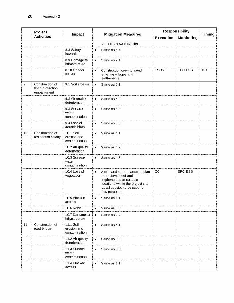
20 Appendix 2
Responsibility Project
Activities Impact Mitigation Measures Execution Monitoring
Timing
or near the communities.
8.8 Safety hazards
• Same as 5.7.
8.9 Damage to infrastructure
• Same as 2.4.
8.10 Gender issues
• Construction crew to avoid entering villages and settlements.
ESOs EPC ESS DC
9 Construction of flood protection embankment
9.1 Soil erosion • Same as 7.1.
9.2 Air quality deterioration
• Same as 5.2.
9.3 Surface water contamination
• Same as 5.3.
9.4 Loss of aquatic biota
• Same as 5.3.
10 Construction of residential colony
10.1 Soil erosion and contamination
• Same as 4.1.
10.2 Air quality deterioration
• Same as 4.2.
10.3 Surface water contamination
• Same as 4.3.
10.4 Loss of vegetation
• A tree and shrub plantation plan to be developed and implemented at suitable locations within the project site. Local species to be used for this purpose.
CC EPC ESS
10.5 Blocked access
• Same as 1.1.
10.6 Noise • Same as 5.6.
10.7 Damage to infrastructure
• Same as 2.4.
11 Construction of road bridge
11.1 Soil erosion and contamination
• Same as 5.1.
11.2 Air quality deterioration
• Same as 5.2.
11.3 Surface water contamination
• Same as 5.3.
11.4 Blocked access
• Same as 1.1.

Appendix 2 21
Responsibility
Project Activities Impact Mitigation Measures
Execution MonitoringTiming
11.5 Noise • Same as 5.6.
11.6 Damage to infrastructure
• Same as 2.4.
11.7 Safety hazards
• Same as 5.7.
12 Construction of access road
12.1 Soil erosion and contamination
• Same as 5.1.
12.2 Air quality deterioration
• Same as 5.2.
12.3 Surface water contamination
• Same as 5.3.
12.4 Blocked access
• Same as 1.1.
12.5 Noise • Same as 5.6.
12.6 Safety hazards
• Same as 5.7.
12.7 Damage to infrastructure
• Same as 2.4.
13 Vehicular Traffic 13.1 Air quality deterioration
• Same as 3.1.
13.2 Noise • Same as 2.2.
13.3 Safety hazards
• Same as 2.3.
13.4 Damage to infrastructure
• Same as 2.4.
BC = before construction, CC = civil contractor, CC ESO = civil contractor’s ESO, DC = during construction, EC = electrical contractor, EC ESO = electrical contractor’s ESO, EPC ESS = EPC contractor’s environment and social supervisor, EPC PM = EPC project manager, ESO = environmental and social officer, LEL = Laraib Energy Limited, LEL CEO = LEL chief executive officer, LEL PM = LEL project manager, LEL ESI = LEL environmental and social inspector, LEL SR = LEL site representative, MC ESO = mechanical contractor’s ESO, MC = mechanical contractor. Source: Compiled from Initial Environment Examination (November 2004).