boise system review boise river teacup river teacup . ... boise system review . for the week of ....
TRANSCRIPT

Boise System Review For the Week Ending
January 10, 2014 Boise River Teacup
http://www.usbr.gov/pn/hydromet/boipaytea.html http://www.usbr.gov/pn-bin/graphwy2.pl?boisys3_af
Boise River system (Anderson Ranch, Arrowrock, Lucky Peak) is at 39 % of capacity. Total space available: 583996 AF Total storage capacity: 949700 AF Natural Flow: 867 CFS NRCS Water & Climate Center Snow-Precipitation Update United States Natural Resources Water and Climate Center Department of Conservation Portland, Oregon Agriculture Service S N O W - P R E C I P I T A T I O N U P D A T E Based on Mountain Data from NRCS SNOTEL Sites As of THURSDAY: JANUARY 9 , 2014 ------------------------------------------------------------------------------ BASIN ELEV. SNOW WATER EQUIVALENT TOTAL PRECIPITATION Data Site Name (Ft) % % Current Median Median Current Average Avg ------------------------------------------------------------------------------ BOISE BASIN ATLANTA SUMMIT 7580 8.4 14.7 57 8.6 17.5 49 BOGUS BASIN 6340 6.2 12.7 49 7.4 12.8 58 CAMAS CREEK DIVIDE 5710 1.7 6.3 27 3.7 9.7 38 DOLLARHIDE SUMMIT 8420 -M 11.5 * 6.1 13.6 45 GRAHAM GUARD STA. 5690 3.4 6.8 50 8.8 12.4 71 JACKSON PEAK 7070 7.6 13.1 58 9.0 17.3 52 MORES CREEK SUMMIT 6100 8.9 14.4 62 10.2 18.8 54 PRAIRIE 4800 .9 3.1 29 4.4 8.1 54 TRINITY MTN. 7770 8.9 18.9 47 8.5 21.0 40 VIENNA MINE 8960 9.7 15.4 63 9.9 15.8 63 ----- ----- Basin Index (%) 53 52 * = Data may not provide a valid measure of conditions.
ftp://ftp.wcc.nrcs.usda.gov/data/snow/update/id.txt
Here's an initial look at the weekly consolidated runoff forecast for 2014. Too early to tell if we can expect a significant runoff event for 2014. The season is still young, and currently there's not much use in getting your hopes up. The reservoir system is 39% percent full, holding a little over 370,000 ac-ft. The 30-year average is a tad over 500,000 ac-ft, so we're running 130,000 ac-ft in the hole at the start of the season. To exacerbate matters, accumulated precipitation is only a little over 50% of normal for this time of the year. Pray for snow. Cheers, Steve Sweet
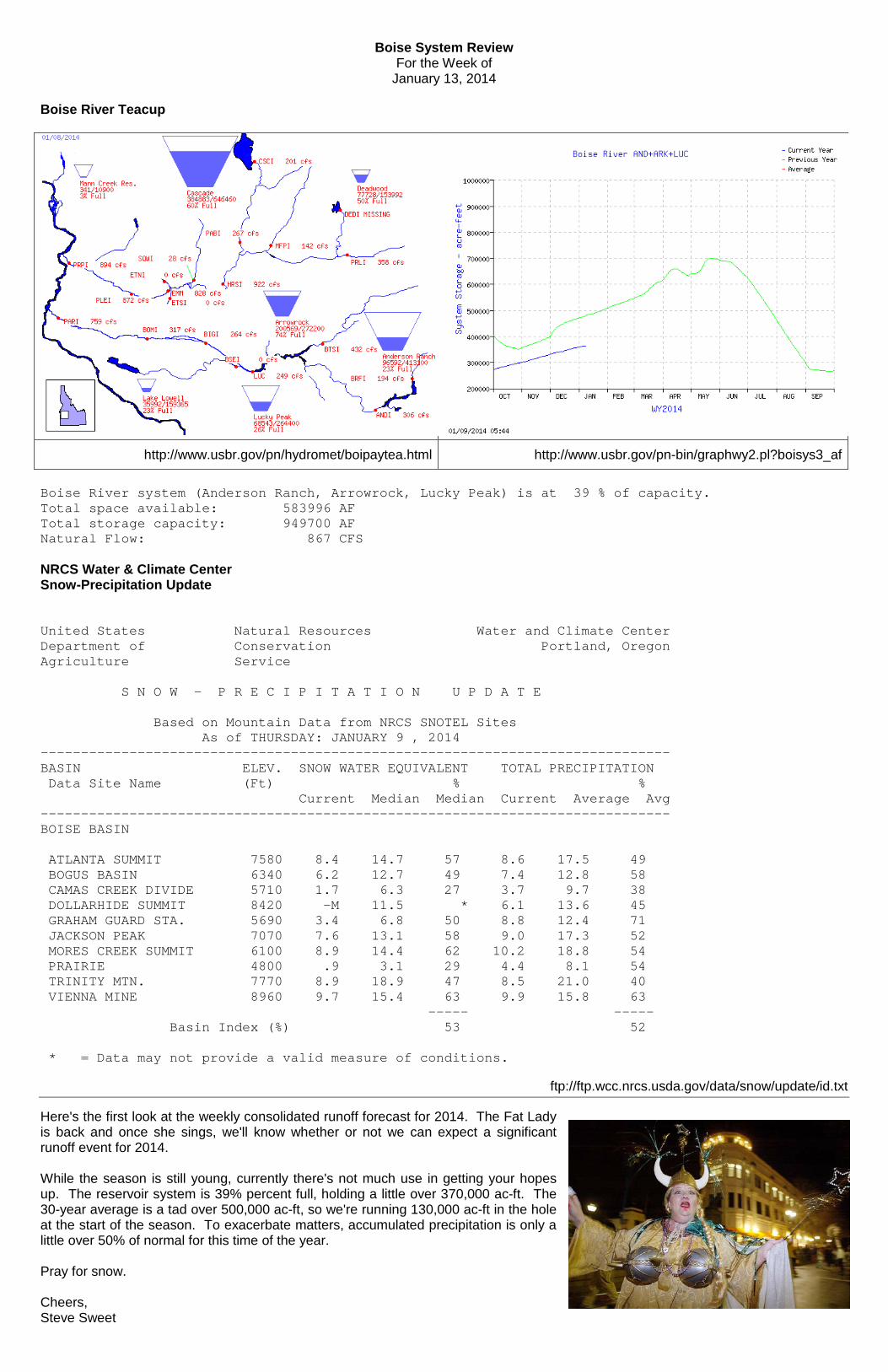
Boise System Review For the Week of
January 13, 2014 Boise River Teacup
http://www.usbr.gov/pn/hydromet/boipaytea.html http://www.usbr.gov/pn-bin/graphwy2.pl?boisys3_af
Boise River system (Anderson Ranch, Arrowrock, Lucky Peak) is at 39 % of capacity. Total space available: 583996 AF Total storage capacity: 949700 AF Natural Flow: 867 CFS NRCS Water & Climate Center Snow-Precipitation Update United States Natural Resources Water and Climate Center Department of Conservation Portland, Oregon Agriculture Service S N O W - P R E C I P I T A T I O N U P D A T E Based on Mountain Data from NRCS SNOTEL Sites As of THURSDAY: JANUARY 9 , 2014 ------------------------------------------------------------------------------ BASIN ELEV. SNOW WATER EQUIVALENT TOTAL PRECIPITATION Data Site Name (Ft) % % Current Median Median Current Average Avg ------------------------------------------------------------------------------ BOISE BASIN ATLANTA SUMMIT 7580 8.4 14.7 57 8.6 17.5 49 BOGUS BASIN 6340 6.2 12.7 49 7.4 12.8 58 CAMAS CREEK DIVIDE 5710 1.7 6.3 27 3.7 9.7 38 DOLLARHIDE SUMMIT 8420 -M 11.5 * 6.1 13.6 45 GRAHAM GUARD STA. 5690 3.4 6.8 50 8.8 12.4 71 JACKSON PEAK 7070 7.6 13.1 58 9.0 17.3 52 MORES CREEK SUMMIT 6100 8.9 14.4 62 10.2 18.8 54 PRAIRIE 4800 .9 3.1 29 4.4 8.1 54 TRINITY MTN. 7770 8.9 18.9 47 8.5 21.0 40 VIENNA MINE 8960 9.7 15.4 63 9.9 15.8 63 ----- ----- Basin Index (%) 53 52 * = Data may not provide a valid measure of conditions.
ftp://ftp.wcc.nrcs.usda.gov/data/snow/update/id.txt
Here's the first look at the weekly consolidated runoff forecast for 2014. The Fat Lady is back and once she sings, we'll know whether or not we can expect a significant runoff event for 2014. While the season is still young, currently there's not much use in getting your hopes up. The reservoir system is 39% percent full, holding a little over 370,000 ac-ft. The 30-year average is a tad over 500,000 ac-ft, so we're running 130,000 ac-ft in the hole at the start of the season. To exacerbate matters, accumulated precipitation is only a little over 50% of normal for this time of the year. Pray for snow. Cheers, Steve Sweet

Boise System Review For the Week Ending
January 24, 2014 Boise River Teacup
http://www.usbr.gov/pn/hydromet/boipaytea.html http://www.usbr.gov/pn-bin/graphwy2.pl?boisys3_af
Boise River system (Anderson Ranch, Arrowrock, Lucky Peak) is at 40 % of capacity. Total space available: 572794 AF Total storage capacity: 949700 AF Natural Flow: Unavailable CFS NRCS Water & Climate Center Snow-Precipitation Update United States Natural Resources Water and Climate Center Department of Conservation Portland, Oregon Agriculture Service S N O W - P R E C I P I T A T I O N U P D A T E Based on Mountain Data from NRCS SNOTEL Sites As of TUESDAY: JANUARY 21 , 2014 ------------------------------------------------------------------------------ BASIN ELEV. SNOW WATER EQUIVALENT TOTAL PRECIPITATION Data Site Name (Ft) % % Current Median Median Current Average Avg ------------------------------------------------------------------------------ BOISE BASIN ATLANTA SUMMIT 7580 11.0 16.4 67 10.9 19.7 55 BOGUS BASIN 6340 8.6 14.1 61 8.0 14.0 57 CAMAS CREEK DIVIDE 5710 2.3 7.5 31 4.4 11.0 40 DOLLARHIDE SUMMIT 8420 6.9 12.8 54 7.4 15.5 48 GRAHAM GUARD STA. 5690 5.1 8.3 61 10.2 14.0 73 JACKSON PEAK 7070 9.9 15.6 63 11.5 19.6 59 MORES CREEK SUMMIT 6100 12.3 17.3 71 13.3 21.7 61 PRAIRIE 4800 1.6 4.0 40 4.8 9.2 52 TRINITY MTN. 7770 12.3 21.8 56 11.5 23.8 48 VIENNA MINE 8960 12.1 17.4 70 12.5 18.0 69 ----- ----- Basin Index (%) 61 57 * = Data may not provide a valid measure of conditions.
ftp://ftp.wcc.nrcs.usda.gov/data/snow/update/id.txt
Not much has changed since the prior edition. What little snow that is out there is holding in the hills. Inflow into the reservoirs is making a minor contribution to overall storage. In two weeks, net storage has only increased 1.2%. Whoopee. The snow storm two weeks ago gave a nice bump, but with each day of sunshine (or inversion, depending on where you are) the percentage of normal precipitation continues to wane. Pray for snow. Cheers, Steve Sweet

Boise System Review For the Week Ending
February 7, 2014 Boise River Teacup
http://www.usbr.gov/pn/hydromet/boipaytea.html http://www.usbr.gov/pn-bin/graphwy2.pl?boisys3_af
Boise River system (Anderson Ranch, Arrowrock, Lucky Peak) is at 41 % of capacity. Total space available: 559530 AF Total storage capacity: 949700 AF Natural Flow: 834 CFS NRCS Water & Climate Center Snow-Precipitation Update United States Natural Resources Water and Climate Center Department of Conservation Portland, Oregon Agriculture Service S N O W - P R E C I P I T A T I O N U P D A T E Based on Mountain Data from NRCS SNOTEL Sites As of MONDAY: FEBRUARY 3 , 2014 ------------------------------------------------------------------------------ BASIN ELEV. SNOW WATER EQUIVALENT TOTAL PRECIPITATION Data Site Name (Ft) % % Current Median Median Current Average Avg ------------------------------------------------------------------------------ BOISE BASIN ATLANTA SUMMIT 7580 12.7 19.0 67 12.3 21.8 56 BOGUS BASIN 6340 9.7 15.5 63 8.9 15.8 56 CAMAS CREEK DIVIDE 5710 3.0 9.1 33 5.1 12.4 41 DOLLARHIDE SUMMIT 8420 -M 14.6 * 8.5 17.4 49 GRAHAM GUARD STA. 5690 6.5 9.6 68 11.9 15.5 77 JACKSON PEAK 7070 11.3 17.9 63 13.0 21.9 59 MORES CREEK SUMMIT 6100 14.1 19.9 71 15.2 24.2 63 PRAIRIE 4800 2.0 4.4 45 5.8 10.3 56 TRINITY MTN. 7770 14.0 24.1 58 13.2 26.5 50 VIENNA MINE 8960 13.6 20.3 67 13.7 20.2 68 ----- ----- Basin Index (%) 62 58
ftp://ftp.wcc.nrcs.usda.gov/data/snow/update/id.txt
Not much has changed since the prior edition. In two weeks, net storage has only increased 1.4%. Pray for snow. Cheers, Steve Sweet

Boise System Review For the Week Ending
February 14, 2014 Boise River Teacup
http://www.usbr.gov/pn/hydromet/boipaytea.html http://www.usbr.gov/pn-bin/graphwy2.pl?boisys3_af
Boise River system (Anderson Ranch, Arrowrock, Lucky Peak) is at 42 % of capacity. Total space available: 551678 AF Total storage capacity: 949700 AF Natural Flow: 1136 CFS NRCS Water & Climate Center Snow-Precipitation Update
Idaho SNOTEL Snow/Precipitation Update Report Based on Mountain Data from NRCS SNOTEL Sites
**Provisional data, subject to revision** Data based on the first reading of the day (typically 00:00) for Sunday, February 09, 2014
Basin Elev Snow Water Equivalent Water Year-to-Date Precipitation
Site Name (ft) Current Median Pct of Current Average Pct of
(in) (in) Median (in) (in) Average
BOISE BASIN ATLANTA SUMMIT 7580 16.1 19.9 81 15.5 22.7 68
BOGUS BASIN 6340 12.9 16.2C 80 10.6 16.2C 65 CAMAS CREEK DIVIDE 5710 5.3 9.7C 55 7.4 12.8C 58 DOLLARHIDE SUMMIT 8420 -M 15.3 * 10.4 18.0 58 GRAHAM GUARD STA. 5690 8.9 10.0 89 14.1 16.0 88 JACKSON PEAK 7070 14.2 18.6 76 16.0 22.8 70 MORES CREEK SUMMIT 6100 17.7 20.9 85 18.4 25.1 73 PRAIRIE 4800 -M 4.5 * 7.8 10.6 74 TRINITY MTN. 7770 18.2 25.5 71 17.0 27.4 62 VIENNA MINE 8960 16.9 20.6 82 16.4 21.0 78 Basin Index (%) 78 69
http://tinyurl.com/mzbxhau Now this report is a breath of fresh air. The Snow Water Equivaent has increased 16% in a week, while the Percent of Average Precipitation is up 11%. The forecast is for a wet week ahead, so perhaps things will keep looking up. The reservoirs continue their slow upward climb, continuing the 1½% increase over two weeks (0.83% last week). With the system at only 42% of capacity, there's plenty of room behind the dams. Everybody should continue to pray for snow. Cheers, Steve Sweet PS: The typical Snow Precipitation Update went gunny-bag, so Idaho SNOTEL data from a different source has been substituted in this version.

Boise System Review For the Week Ending
February 21, 2014 Boise River Teacup
http://www.usbr.gov/pn/hydromet/boipaytea.html http://www.usbr.gov/pn-bin/graphwy2.pl?boisys3_af
Boise River system (Anderson Ranch, Arrowrock, Lucky Peak) is at 45 % of capacity. Total space available: 522224 AF Total storage capacity: 949700 AF Natural Flow: 2778 CFS NRCS Water & Climate Center Snow-Precipitation Update United States Natural Resources Water and Climate Center Department of Conservation Portland, Oregon Agriculture Service S N O W - P R E C I P I T A T I O N U P D A T E Based on Mountain Data from NRCS SNOTEL Sites As of MONDAY: FEBRUARY 17 , 2014 ------------------------------------------------------------------------------ BASIN ELEV. SNOW WATER EQUIVALENT TOTAL PRECIPITATION Data Site Name (Ft) % % Current Median Median Current Average Avg ------------------------------------------------------------------------------ BOISE BASIN ATLANTA SUMMIT 7580 20.9 21.2 99 18.3 24.4 75 BOGUS BASIN 6340 14.9 17.5 85 13.2 17.2 77 CAMAS CREEK DIVIDE 5710 6.9 10.2 68 9.9 13.3 74 DOLLARHIDE SUMMIT 8420 -M 16.3 * 13.3 19.2 69 GRAHAM GUARD STA. 5690 10.7 10.9 98 17.6 17.1 103 JACKSON PEAK 7070 18.0 21.1 85 19.5 24.4 80 MORES CREEK SUMMIT 6100 22.5 23.9 94 23.8 26.5 90 PRAIRIE 4800 4.9 4.7 104 10.3 11.3 91 TRINITY MTN. 7770 23.3 28.3 82 21.5 29.6 73 VIENNA MINE 8960 22.2 22.0 101 17.7 22.3 79 ----- ----- Basin Index (%) 90 80
ftp://ftp.wcc.nrcs.usda.gov/data/snow/update/id.txt
Well, isn't that something? There's a significant uptick of flows into the three reservoirs - over twice as much coming is as compared to last week's report. Most of the flow is coming past Twin Springs (North Fork & Middle Fork). The South Fork at Featheville isn't moving much, meaning the the snow is holding the precipitation on the South Fork. The storage jumped three points in a week. Previously, we were looking at three points in a month. The storms last week are bringing us to close to normal for precitation accumulation - up 11 or so percentage points over last week. Let's all continue to pray for snow, apparently it worked last week. Amazing! Cheers, Steve Sweet

Boise System Review For the Week Ending
February 28, 2014 Boise River Teacup
http://www.usbr.gov/pn/hydromet/boipaytea.html http://www.usbr.gov/pn-bin/graphwy2.pl?boisys3_af
Boise River system (Anderson Ranch, Arrowrock, Lucky Peak) is at 46 % of capacity. Total space available: 511881 AF Total storage capacity: 949700 AF Natural Flow: 1272 CFS NRCS Water & Climate Center Snow-Precipitation Update United States Natural Resources Water and Climate Center Department of Conservation Portland, Oregon Agriculture Service S N O W - P R E C I P I T A T I O N U P D A T E Based on Mountain Data from NRCS SNOTEL Sites As of SUNDAY: FEBRUARY 23 , 2014 ------------------------------------------------------------------------------ BASIN ELEV. SNOW WATER EQUIVALENT TOTAL PRECIPITATION Data Site Name (Ft) % % Current Median Median Current Average Avg ------------------------------------------------------------------------------ BOISE BASIN ATLANTA SUMMIT 7580 22.3 22.5 99 18.7 25.8 72 BOGUS BASIN 6340 15.6 18.2 86 13.7 17.7 77 CAMAS CREEK DIVIDE 5710 7.3 10.6 69 10.2 13.8 74 DOLLARHIDE SUMMIT 8420 -M 17.2 * 14.3 20.4 70 GRAHAM GUARD STA. 5690 11.9 11.4 104 18.6 17.9 104 JACKSON PEAK 7070 19.2 22.1 87 20.6 25.7 80 MORES CREEK SUMMIT 6100 23.8 24.9 96 24.8 28.0 89 PRAIRIE 4800 5.1 4.8 106 10.6 11.9 89 TRINITY MTN. 7770 24.6 29.6 83 22.4 31.3 72 VIENNA MINE 8960 24.0 23.8 101 -M 23.6 * ----- ----- Basin Index (%) 92 80
ftp://ftp.wcc.nrcs.usda.gov/data/snow/update/id.txt
The blue line is still heading for the red (Where we is vs where we has been on the 30-yr average). Unfortunately, we've only gained one percentage point on reservoir storage and are still less than half-full. Twin Springs (North Fork & Middle Fork) dropped off significantly recently. The South Fork at Featheville still isn't moving much, meaning the the snow is holding the precipitation on the South Fork. It's been pretty quiet on the precipitation front, as the Basin summary is very close to the same as the week before. Let's all get back to praying for snow, as some of you were apparently dogging it last week. We need more. Cheers, Steve Sweet

Boise System Review For the Week Ending
March 7, 2014 Boise River Teacup
http://www.usbr.gov/pn/hydromet/boipaytea.html http://www.usbr.gov/pn-bin/graphwy2.pl?boisys3_af
Boise River system (Anderson Ranch, Arrowrock, Lucky Peak) is at 48 % of capacity. Total space available: 491094 AF Total storage capacity: 949700 AF Natural Flow: 2129 CFS NRCS Water & Climate Center Snow-Precipitation Update United States Natural Resources Water and Climate Center Department of Conservation Portland, Oregon Agriculture Service S N O W - P R E C I P I T A T I O N U P D A T E Based on Mountain Data from NRCS SNOTEL Sites As of SUNDAY: MARCH 2 , 2014 ------------------------------------------------------------------------------ BASIN ELEV. SNOW WATER EQUIVALENT TOTAL PRECIPITATION Data Site Name (Ft) % % Current Median Median Current Average Avg ------------------------------------------------------------------------------ BOISE BASIN ATLANTA SUMMIT 7580 22.9 23.6 97 22.0 27.0 81 BOGUS BASIN 6340 16.6 21.7 76 14.3 18.8 76 CAMAS CREEK DIVIDE 5710 7.0 11.4 61 10.4 14.3 73 DOLLARHIDE SUMMIT 8420 -M -M * 14.5 21.4 68 GRAHAM GUARD STA. 5690 10.8 11.8 92 19.2 18.5 104 JACKSON PEAK 7070 20.3 22.3 91 22.3 26.9 83 MORES CREEK SUMMIT 6100 25.1 26.2 96 26.3 29.2 90 PRAIRIE 4800 4.1 5.0 82 10.9 12.4 88 TRINITY MTN. 7770 25.2 30.8 82 24.0 32.6 74 VIENNA MINE 8960 24.9 24.8 100 23.8 24.7 96 ----- ----- Basin Index (%) 88 83
ftp://ftp.wcc.nrcs.usda.gov/data/snow/update/id.txt
If this keeps up, the blue line could intercept the red (Where we is vs where we has been on the 30-yr average) next week. Last week we gained two percentage points on reservoir storage. However, we still remain just under half-full. Twin Springs' flow (North Fork & Middle Fork) doubled over the prior week's, which fits with the low snow we've been seeing disappear on the Boise Front. The South Fork at Featheville bumped up 30% over the week earlier, meaning that some of the precipitation landing on the South Fork is the liquid type. We had one report of a cheery Leprechaun dancing for precipitation, which apparently can account for the slight uptick in snow water equivalent. However, the rest of you must have been sitting it out. Get to work. ;^) Cheers, Steve Sweet

Boise System Review For the Week Ending
March 14, 2014 Boise River Teacup
http://www.usbr.gov/pn/hydromet/boipaytea.html http://www.usbr.gov/pn-bin/graphwy2.pl?boisys3_af
Boise River system (Anderson Ranch, Arrowrock, Lucky Peak) is at 52 % of capacity. Total space available: 456713 AF Total storage capacity: 949700 AF Natural Flow: 3805 CFS NRCS Water & Climate Center Snow-Precipitation Update United States Natural Resources Water and Climate Center Department of Conservation Portland, Oregon Agriculture Service S N O W - P R E C I P I T A T I O N U P D A T E Based on Mountain Data from NRCS SNOTEL Sites As of SUNDAY: MARCH 9 , 2014 ------------------------------------------------------------------------------ BASIN ELEV. SNOW WATER EQUIVALENT TOTAL PRECIPITATION Data Site Name (Ft) % % Current Median Median Current Average Avg ------------------------------------------------------------------------------ BOISE BASIN ATLANTA SUMMIT 7580 25.7 24.9 103 25.4 28.2 90 BOGUS BASIN 6340 18.3 22.5 81 16.1 19.6 82 CAMAS CREEK DIVIDE 5710 6.0 11.8 51 11.5 14.7 78 DOLLARHIDE SUMMIT 8420 -M -M * 16.7 22.5 74 GRAHAM GUARD STA. 5690 10.2 12.7 80 21.2 19.2 110 JACKSON PEAK 7070 22.8 23.0 99 25.4 28.1 90 MORES CREEK SUMMIT 6100 28.1 27.1 104 29.6 30.5 97 PRAIRIE 4800 1.7 4.4 39 12.1 13.0 93 TRINITY MTN. 7770 29.4 31.5 93 28.5 34.1 84 VIENNA MINE 8960 28.6 26.6 108 26.9 26.0 103 ----- ----- Basin Index (%) 93 90
ftp://ftp.wcc.nrcs.usda.gov/data/snow/update/id.txt
More people obviously got around to doing a little rain dancing last week. Total precipitation jumped 7 percentage points to 90% of average and, for the first time this season, that pesky blue line crossed the red line. Total system reservoir storage is now officially ahead of the 30-year average. Storage bumped up 4% last week - one of the best increases of the season. Curretly, natural flow into the reservoir system is up to 3,800 cfs. Last week, we were only looking at 2,100 cfs, so we're presently enjoying an 80% increase in natural flow. Obviously, we're seeing the effects of the upper basin rain. The consensus on the street is that Anderson Ranch, at only 27% full, likely won't fill this year. Considering that we're at average, let's take a look at just Arrowrock ( at 87% full) and Lucky Peak (at 55% full). Between the two of them, those two ponds are 76% full. We'll be keeping an eye on the combination of these two for the forseable future. There is the possibility that while Anderson Ranch won't fill, the lower two reservoirs may reach the point where we could see flood control operations this Spring. Stay tuned. Cheers, Steve Sweet

The Arrowrock current year (blue line) is well ahead of the 30-year average (red line). Lucky Peak is also trending ahead of the historical runoff. Anderson Ranch is the only reservoir lagging behind the historic trend.

Boise System Review For the Week Ending
March 21, 2014 Boise River Teacup
http://www.usbr.gov/pn/hydromet/boipaytea.html http://www.usbr.gov/pn-bin/graphwy2.pl?boisys3_af
Boise River system (Anderson Ranch, Arrowrock, Lucky Peak) is at 57 % of capacity. Total space available: 410131 AF Total storage capacity: 949700 AF Natural Flow: 3065 CFS NRCS Water & Climate Center Snow-Precipitation Update United States Natural Resources Water and Climate Center Department of Conservation Portland, Oregon Agriculture Service S N O W - P R E C I P I T A T I O N U P D A T E Based on Mountain Data from NRCS SNOTEL Sites As of SUNDAY: MARCH 16 , 2014 ------------------------------------------------------------------------------ BASIN ELEV. SNOW WATER EQUIVALENT TOTAL PRECIPITATION Data Site Name (Ft) % % Current Median Median Current Average Avg ------------------------------------------------------------------------------ BOISE BASIN ATLANTA SUMMIT 7580 27.5 25.6 107 27.1 29.3 92 BOGUS BASIN 6340 19.9 22.3 89 18.4 20.3 91 CAMAS CREEK DIVIDE 5710 5.3 11.5 46 12.3 15.2 81 DOLLARHIDE SUMMIT 8420 -M -M * 17.8 23.4 76 GRAHAM GUARD STA. 5690 11.8 12.8 92 22.5 19.8 114 JACKSON PEAK 7070 24.0 24.1 100 27.4 29.2 94 MORES CREEK SUMMIT 6100 28.5 27.2 105 31.5 31.6 100 PRAIRIE 4800 .4 3.3 12 13.0 13.5 96 TRINITY MTN. 7770 31.3 31.8 98 30.9 35.4 87 VIENNA MINE 8960 30.5 27.7 110 27.4 26.9 102 ----- ----- Basin Index (%) 96 93
ftp://ftp.wcc.nrcs.usda.gov/data/snow/update/id.txt
Last week, the Snow-Precipitation Udate showed another 3% increase in both Snow Water Equivalent and Total Precipitation. Two more weeks at this rate, and we'll be at average. That pesky blue line has crossed the red line in earnest since the last report. System infill as of this report has dropped 27% to 3,100 cfs. That will fluctuate with the upper basin temperatures. If we get more high elevation rain or warmer days, inflow can change. Anderson Ranch bumped from 27% to 31% percent full in a week, while the other two nudged only 1% to 77% full. Lake Lowell is reporting 42% full, inferring an additional 92 k-ac-ft of storage available, 33 k-ac-ft more than the 30-yr average. Re: flood control operations for 2014: We're not out of the woods yet. Stay tuned. Cheers, Steve Sweet

The Arrowrock current year (blue line) is well ahead of the 30-year average (red line).
Lucky Peak is also trending ahead of the historical runoff.
Anderson Ranch continues to lag behind the historic trend.

Boise System Review For the Week Ending
March 28, 2014 Boise River Teacup
http://www.usbr.gov/pn/hydromet/boipaytea.html http://www.usbr.gov/pn-bin/graphwy2.pl?boisys3_af
Boise River system (Anderson Ranch, Arrowrock, Lucky Peak) is at 58 % of capacity. Total space available: 394677 AF Total storage capacity: 949700 AF Natural Flow: 2298 CFS NRCS Water & Climate Center Snow-Precipitation Update United States Natural Resources Water and Climate Center Department of Conservation Portland, Oregon Agriculture Service S N O W - P R E C I P I T A T I O N U P D A T E Based on Mountain Data from NRCS SNOTEL Sites As of FRIDAY: MARCH 21 , 2014 ------------------------------------------------------------------------------ BASIN ELEV. SNOW WATER EQUIVALENT TOTAL PRECIPITATION Data Site Name (Ft) % % Current Median Median Current Average Avg ------------------------------------------------------------------------------ BOISE BASIN ATLANTA SUMMIT 7580 28.3 26.1 108 27.6 30.1 92 BOGUS BASIN 6340 20.7 22.2 93 18.8 20.8 90 CAMAS CREEK DIVIDE 5710 5.4 11.4 47 12.5 15.5 81 DOLLARHIDE SUMMIT 8420 -M -M * 18.0 24.0 75 GRAHAM GUARD STA. 5690 11.7 13.2 89 22.7 20.3 112 JACKSON PEAK 7070 24.2 24.6 98 28.0 30.0 93 MORES CREEK SUMMIT 6100 29.1 27.8 105 32.2 32.4 99 PRAIRIE 4800 .0 2.0 0 13.2 14.0 94 TRINITY MTN. 7770 32.3 32.5 99 31.5 36.3 87 VIENNA MINE 8960 30.9 28.5 108 28.9 27.5 105 ----- ----- Basin Index (%) 97 93
ftp://ftp.wcc.nrcs.usda.gov/data/snow/update/id.txt
Last week, the Snow-Precipitation Update essentially held steady in both Snow Water Equivalent and Total Precipitation. System infill as of this report has dropped 25% to 2,300 cfs. Anderson Ranch nudged up 1% to 32% percent full in a week, while the other two bumped 2% to 72% full. Apparently, according to a report from the well-informed Boise River Watermaster, that's enough to catch the attention of the reservoir operation managers (USBoR & USACE). They're apparently staying tuned. Beginning April 1, while the system is at less than 60% of capacity and with an average snow pack, flood control operations will begin on the Boise River. When the New York Canal shuts down on the 1st, the flow will be diverted into the Boise River, as the Corps is looking to create 60,000 ac-ft hole in Lucky Peak. By April 1 or 2, flows are anticipated to reach 1,500 - 2,000 cfs at Glenwood. There is some thinking that flows may reach 2,000-2,500 cfs, tops. Of course, all bets are off, if we see April precipitation similar to 2012. Stay tuned. Cheers, Steve Sweet

The Arrowrock current year (blue line) is well ahead of the 30-year average (red line) and holding steady at full.
Lucky Peak is also trending ahead of the historical runoff, continuing to fill.
Anderson Ranch continues to lag behind the historic trend. The rate of fill has tapered slightly, reflecting the falloff in natural flow. Tip to you intrepid water watchers: Keep an eye on the blue line this year. If possible, we're likely to see the blue line (2014) shift well to the right of the green line (2013), closer to the red line (30-yr average) - or even to the right of the red. Flood control operations this year, while the upper system is not at capacity, will likely encourage irrigators to demand that the water is saved high in the system and not moved down to Lucky Peak for recreational use in the late summer. Once again: "Stay tuned."

Boise System Review For the Week Ending
April 4, 2014 Boise River Teacup
http://www.usbr.gov/pn/hydromet/boipaytea.html http://www.usbr.gov/pn-bin/graphwy2.pl?boisys3_af
Boise River system (Anderson Ranch, Arrowrock, Lucky Peak) is at 61 % of capacity. Total space available: 372787 AF Total storage capacity: 949700 AF Natural Flow: 3479 CFS NRCS Water & Climate Center Snow-Precipitation Update United States Natural Resources Water and Climate Center Department of Conservation Portland, Oregon Agriculture Service S N O W - P R E C I P I T A T I O N U P D A T E Based on Mountain Data from NRCS SNOTEL Sites As of MONDAY: MARCH 31 , 2014 ------------------------------------------------------------------------------ BASIN ELEV. SNOW WATER EQUIVALENT TOTAL PRECIPITATION Data Site Name (Ft) % % Current Median Median Current Average Avg ------------------------------------------------------------------------------ BOISE BASIN ATLANTA SUMMIT 7580 30.7 27.5 112 29.8 31.6 94 BOGUS BASIN 6340 24.0 25.0 96 21.0 22.2 95 CAMAS CREEK DIVIDE 5710 3.1 10.5 30 13.7 16.2 85 DOLLARHIDE SUMMIT 8420 -M -M * 18.9 25.4 74 GRAHAM GUARD STA. 5690 12.9 12.0 108 24.4 21.3 115 JACKSON PEAK 7070 26.5 27.0 98 30.8 31.7 97 MORES CREEK SUMMIT 6100 32.7 30.6 107 35.4 34.0 104 PRAIRIE 4800 .0 .0 * 14.8 15.0 99 TRINITY MTN. 7770 36.1 35.1 103 34.4 38.2 90 VIENNA MINE 8960 33.4 30.1 111 30.8 29.2 105 ----- ----- Basin Index (%) 101 96
ftp://ftp.wcc.nrcs.usda.gov/data/snow/update/id.txt
Last week, the Snow-Precipitation Update made a signifiant jump in both Snow Water Equivalent and Total Precipitation. With last week's precipitation, the snow water equivalent jumped 4% and first time this season is above average. System infill has rebounded 50% from last week, to 3,500 cfs. Anderson Ranch nudged up 3% to 35% percent full in a week, while the other two bumped 9% to 81% full. As a result, late, late last week the flood operation managers have started trying to maintain a 60,000 ac-ft "hole" in Lucky Peak for the end of April. That means that between April Fool's Day and the end of the month, the net increase storage in Lucky Peak will only increase 8,200 ac-ft. And that means that the inflow into Lucky Peak will only exceed an average 136 cfs over the outflow. Stay tuned. Due to precipitation projections, flood control releases began last Saturday night, three days earlier than previously projected. With irrigation season on the immediate horizon, hope springs eternal that the the proper balance between inflow and outflow will be maintained. Cheers, Steve Sweet
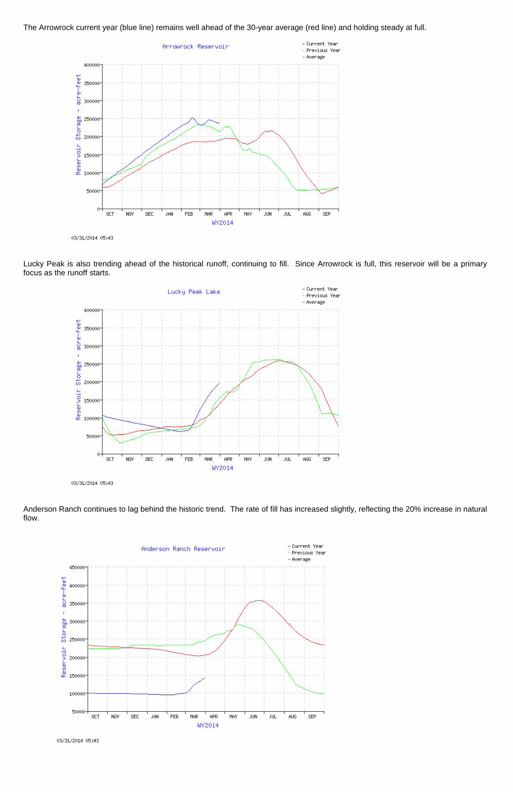
The Arrowrock current year (blue line) remains well ahead of the 30-year average (red line) and holding steady at full.
Lucky Peak is also trending ahead of the historical runoff, continuing to fill. Since Arrowrock is full, this reservoir will be a primary focus as the runoff starts.
Anderson Ranch continues to lag behind the historic trend. The rate of fill has increased slightly, reflecting the 20% increase in natural flow.

Boise System Review For the Week Ending
April 18, 2014 Boise River Teacup
http://www.usbr.gov/pn/hydromet/boipaytea.html http://www.usbr.gov/pn-bin/graphwy2.pl?boisys3_af
Boise River system (Anderson Ranch, Arrowrock, Lucky Peak) is at 65 % of capacity. Total space available: 334361 AF Total storage capacity: 949700 AF Natural Flow: 5684 CFS NRCS Water & Climate Center Snow-Precipitation Update United States Natural Resources Water and Climate Center Department of Conservation Portland, Oregon Agriculture Service S N O W - P R E C I P I T A T I O N U P D A T E Based on Mountain Data from NRCS SNOTEL Sites As of MONDAY: APRIL 14 , 2014 ------------------------------------------------------------------------------ BASIN ELEV. SNOW WATER EQUIVALENT TOTAL PRECIPITATION Data Site Name (Ft) % % Current Median Median Current Average Avg ------------------------------------------------------------------------------ BOISE BASIN ATLANTA SUMMIT 7580 30.9 26.6 116 31.3 33.4 94 BOGUS BASIN 6340 23.6 23.1 102 22.2 24.0 92 CAMAS CREEK DIVIDE 5710 .0 5.2 0 14.2 16.9 84 DOLLARHIDE SUMMIT 8420 -M -M * -M 26.9 * GRAHAM GUARD STA. 5690 9.5 8.2 116 25.0 22.5 111 JACKSON PEAK 7070 26.4 26.8 99 32.3 33.6 96 MORES CREEK SUMMIT 6100 32.0 27.9 115 37.1 35.7 104 PRAIRIE 4800 .0 .0 * 15.5 16.3 95 TRINITY MTN. 7770 35.5 35.8 99 35.6 40.2 89 VIENNA MINE 8960 -M 31.5 * -M 30.8 * ----- ----- Basin Index (%) 103 96
ftp://ftp.wcc.nrcs.usda.gov/data/snow/update/id.txt
Last week, the Snow-Precipitation Update started falling off by a few percentage points. As a result of the warm Spring weather, flows into the system increased by more than 220%. The spring runoff has started, just in time to fill the irrigation ditches. Presently, the system operators have increased flow at the Glenwood gage to nearly 2,000 cfs in order to maintain space in the system. With any luck, we could make it until the first of June before going onto regulation. Anderson Ranch bumped up nicely 4% to 40% full, while the other two reservoirs nudged another 2% to 84% full. This week that pesky blue line in the Lucky Peak graph definitely started heading southeast, while increased storage in Arrowrock increased the combined storage in the lower two reservoirs by 8,400 ac-ft. Stay tuned. Cheers, Steve Sweet

The Arrowrock current year (blue line) remains well ahead of the 30-year average (red line). In the last week, total storage in Arrowrock increased by 9,600 acre-feet.
Lucky Peak, while still trending ahead of the historical runoff, is starting to decline as irrigation and flood control releases kick in. Total storage is down 1,200 acre-feet compared to last week.
Anderson Ranch continues to climb as flows in the South Fork triple over last week's measurements. Storage has increased 17,600 acre-feet in a week.

Boise System Review For the Week Ending
April 25, 2014
Boise River Teacup
http://www.usbr.gov/pn/hydromet/boipaytea.html http://www.usbr.gov/pn-bin/graphwy2.pl?boisys3_af
Boise River system (Anderson Ranch, Arrowrock, Lucky Peak) is at 67 % of capacity.Total space available: 317559 AFTotal storage capacity: 949700 AFNatural Flow: 6087 CFS
NRCS Water & Climate Center Snow-Precipitation Update
United States Natural Resources Water and Climate Center Department of Conservation Portland, Oregon Agriculture Service
S N O W - P R E C I P I T A T I O N U P D A T E
Based on Mountain Data from NRCS SNOTEL Sites As of SUNDAY: APRIL 20 , 2014
------------------------------------------------------------------------------ BASIN ELEV. SNOW WATER EQUIVALENT TOTAL PRECIPITATION Data Site Name (Ft) % %
Current Median Median Current Average Avg ------------------------------------------------------------------------------
BOISE BASIN
ATLANTA SUMMIT 7580 30.5 26.0 117 31.6 34.2 92 BOGUS BASIN 6340 20.6 21.5 96 22.5 24.3 93 CAMAS CREEK DIVIDE 5710 .0 2.8 0 14.5 17.2 84 DOLLARHIDE SUMMIT 8420 -M -M * 19.7 27.6 71 GRAHAM GUARD STA. 5690 5.7 5.5 104 25.5 23.0 111 JACKSON PEAK 7070 25.7 25.6 100 32.5 34.2 95 MORES CREEK SUMMIT 6100 29.6 26.8 110 37.5 36.3 103 PRAIRIE 4800 .0 .0 * 15.6 16.8 93 TRINITY MTN. 7770 35.3 35.8 99 35.8 41.1 87 VIENNA MINE 8960 34.0 31.9 107 32.4 31.4 103
----- ----- Basin Index (%) 103 94
ftp://ftp.wcc.nrcs.usda.gov/data/snow/update/id.txt
The Total-Precipitation fell off by a few percentage points. Flows into the system increased up by less than 10% compared to the prior week, and Lucky Peak discharges only rose 10% compared to the previous report. Overall, the system operators have decreased flow at the Glenwood gage by 50% to 1,300 cfs. Maybe, we're over the hump and the highwater threat has passed. Maybe not.
Total combined storage in Lucky Peak/Arrowrock is holding at 84%, off only 400 ac-ft from last week. Anderson Ranch bumped another 17,000 ac-ft and has increased total storage in that reservoir to 44% full. Total system capacity has increased 2% to 67% in a week.
Stay tuned.
Cheers, Steve Sweet

Boise System Review For the Week Ending
May 2, 2014 Boise River Teacup
http://www.usbr.gov/pn/hydromet/boipaytea.html http://www.usbr.gov/pn-bin/graphwy2.pl?boisys3_af Boise River system (Anderson Ranch, Arrowrock, Lucky Peak) is at 70 % of capacity. Total space available: 288593 AF Total storage capacity: 949700 AF Natural Flow: 5234 CFS NRCS Water & Climate Center Snow-Precipitation Update United States Natural Resources Water and Climate Center Department of Conservation Portland, Oregon Agriculture Service S N O W - P R E C I P I T A T I O N U P D A T E Based on Mountain Data from NRCS SNOTEL Sites As of SUNDAY: APRIL 27 , 2014 ------------------------------------------------------------------------------ BASIN ELEV. SNOW WATER EQUIVALENT TOTAL PRECIPITATION Data Site Name (Ft) % % Current Median Median Current Average Avg ------------------------------------------------------------------------------ BOISE BASIN ATLANTA SUMMIT 7580 31.6 24.6 128 33.5 35.0 96 BOGUS BASIN 6340 21.1 18.9 112 24.1 24.9 97 CAMAS CREEK DIVIDE 5710 .0 .0 * 14.8 17.8 83 DOLLARHIDE SUMMIT 8420 -M -M * 20.7 28.2 73 GRAHAM GUARD STA. 5690 2.7 .5 540* 26.9 23.7 114 JACKSON PEAK 7070 -M 24.8 * 34.6 35.3 98 MORES CREEK SUMMIT 6100 30.0 24.4 123 39.0 37.1 105 PRAIRIE 4800 .0 .0 * 16.3 17.4 94 TRINITY MTN. 7770 36.6 35.2 104 37.3 42.1 89 VIENNA MINE 8960 35.4 32.0 111 33.9 32.3 105 ----- ----- Basin Index (%) 116 96
ftp://ftp.wcc.nrcs.usda.gov/data/snow/update/id.txt
In the last week, the Total-Precipitation rebounded by 2 percentage points, while the Snow Water Equivalent posted a robust 13% rise. Been a while since we've seen that.. Flows into the system decreased by 14% compared to the prior week, as precipitation accumulates in the hills as snow. Lucky Peak discharges held steady at 3,800 cfs. The Glenwood gage is sticking at the 1,300 cfs range. Total combined storage in Lucky Peak/Arrowrock nudged up to 84%, up 6,500 ac-ft from last week. Anderson Ranch bumped another 22,500 ac-ft and has increased total storage in that reservoir by 6% to 50% full. Total system capacity has increased 3% to 70% in the week. Stay tuned. Cheers, Steve Sweet

Boise System Review For the Week Ending
May 9, 2014 Boise River Teacup
http://www.usbr.gov/pn/hydromet/boipaytea.html http://www.usbr.gov/pn-bin/graphwy2.pl?boisys3_af Boise River system (Anderson Ranch, Arrowrock, Lucky Peak) is at 71 % of capacity. Total space available: 276259 AF Total storage capacity: 949700 AF Natural Flow: 7369 CFS NRCS Water & Climate Center Snow-Precipitation Update United States Natural Resources Water and Climate Center Department of Conservation Portland, Oregon Agriculture Service S N O W - P R E C I P I T A T I O N U P D A T E Based on Mountain Data from NRCS SNOTEL Sites As of SUNDAY: APRIL 27 , 2014 ------------------------------------------------------------------------------ BASIN ELEV. SNOW WATER EQUIVALENT TOTAL PRECIPITATION Data Site Name (Ft) % % Current Median Median Current Average Avg ------------------------------------------------------------------------------ BOISE BASIN ATLANTA SUMMIT 7580 31.6 24.6 128 33.5 35.0 96 BOGUS BASIN 6340 21.1 18.9 112 24.1 24.9 97 CAMAS CREEK DIVIDE 5710 .0 .0 * 14.8 17.8 83 DOLLARHIDE SUMMIT 8420 -M -M * 20.7 28.2 73 GRAHAM GUARD STA. 5690 2.7 .5 540* 26.9 23.7 114 JACKSON PEAK 7070 -M 24.8 * 34.6 35.3 98 MORES CREEK SUMMIT 6100 30.0 24.4 123 39.0 37.1 105 PRAIRIE 4800 .0 .0 * 16.3 17.4 94 TRINITY MTN. 7770 36.6 35.2 104 37.3 42.1 89 VIENNA MINE 8960 35.4 32.0 111 33.9 32.3 105 ----- ----- Basin Index (%) 116 96 Note: As of 6 am, Cinco de Mayo, Current Snow Water Equivalent and Total Precipitation data were missing. Either someone stole all the snow up in the hills or there's been a system crash. In response, the most recent (last week's) data is presented.
ftp://ftp.wcc.nrcs.usda.gov/data/snow/update/id.txt
We're missing the Total-Precipitation and the Snow Water Equivalent for the week. Based on Spring weather arriving last week, the best we can do is assume that the runoff season is rolling. Flows into the system increased by 41% compared to the prior week, with the warm weather. Lucky Peak discharges held steady at 3,800 cfs, while there are rumors to the West (Walla2) that we may see a minor increase early this week. With increasing irrigation demand, the Glenwood gage is has dropped to the 900 cfs range. Total combined storage in Lucky Peak/Arrowrock is staying even at 84%. Anderson Ranch bumped a respectable 17,400 ac-ft and has increased total storage in that reservoir by 4% to 54% full. Total system capacity has increased 1% to 71% in the week. Stay tuned. Cheers, Steve Sweet

Boise System Review For the Week Ending
May 16, 2014 Boise River Teacup
http://www.usbr.gov/pn/hydromet/boipaytea.html http://www.usbr.gov/pn-bin/graphwy2.pl?boisys3_af Boise River system (Anderson Ranch, Arrowrock, Lucky Peak) is at 75 % of capacity. Total space available: 237,812 AF Total storage capacity: 949,700 AF Natural Flow: 5,541 CFS NRCS Water & Climate Center Snow-Precipitation Update United States Natural Resources Water and Climate Center Department of Conservation Portland, Oregon Agriculture Service S N O W - P R E C I P I T A T I O N U P D A T E Based on Mountain Data from NRCS SNOTEL Sites As of MONDAY: MAY 12 , 2014 ------------------------------------------------------------------------------ BASIN ELEV. SNOW WATER EQUIVALENT TOTAL PRECIPITATION Data Site Name (Ft) % % Current Median Median Current Average Avg ------------------------------------------------------------------------------ BOISE BASIN ATLANTA SUMMIT 7580 27.4 22.2 123 34.8 36.7 95 BOGUS BASIN 6340 13.4 13.6 99 25.4 26.1 97 CAMAS CREEK DIVIDE 5710 .0 .0 * 15.3 18.7 82 DOLLARHIDE SUMMIT 8420 -M -M * 21.0 29.7 71 GRAHAM GUARD STA. 5690 .0 .0 * 27.4 24.9 110 JACKSON PEAK 7070 29.9 19.1 157 36.2 36.9 98 MORES CREEK SUMMIT 6100 21.7 19.3 112 40.6 38.7 105 PRAIRIE 4800 .0 .0 * 17.4 18.3 95 TRINITY MTN. 7770 34.4 33.6 102 38.6 43.9 88 VIENNA MINE 8960 34.2 27.6 124 34.9 33.8 103 ----- ----- Basin Index (%) 119 95
ftp://ftp.wcc.nrcs.usda.gov/data/snow/update/id.txt
The 2014 runoff season is rolling. Although flows into the system decreased compared to the prior week, the Snow Water Equivalent increased. Lucky Peak discharges held steady at 3,800 cfs, with no minor increases during the week. With increasing irrigation demand, the Glenwood gage is has dropped off 200 cfs to the 700 cfs range. Total combined storage in Lucky Peak/Arrowrock bumped up to 86%. Anderson Ranch increased a respectable 26,800 ac-ft. Over the week, total storage has increased in Anderson by 6% to 60% full. Total system capacity for the 3 reservoirs has increased 4% to 75% over the week. With a modicum of luck, we just might see the system fill, as those pesky blue lines seem to be pointing in the general direction. Stay tuned. Cheers, Steve Sweet

Boise System Review For the Week Ending
May 30, 2014 Boise River Teacup
http://www.usbr.gov/pn/hydromet/boipaytea.html http://www.usbr.gov/pn-bin/graphwy2.pl?boisys3_af Boise River system (Anderson Ranch, Arrowrock, Lucky Peak) is at 85 % of capacity. Total space available: 141,588 AF Total storage capacity: 949,700 AF Natural Flow: 9,200 CFS NRCS Water & Climate Center Snow-Precipitation Update United States Natural Resources Water and Climate Center Department of Conservation Portland, Oregon Agriculture Service S N O W - P R E C I P I T A T I O N U P D A T E Based on Mountain Data from NRCS SNOTEL Sites As of TUESDAY: MAY 27 , 2014 ------------------------------------------------------------------------------ BASIN ELEV. SNOW WATER EQUIVALENT TOTAL PRECIPITATION Data Site Name (Ft) % % Current Median Median Current Average Avg ------------------------------------------------------------------------------ BOISE BASIN ATLANTA SUMMIT 7580 10.3 11.5 90 35.3 38.2 92 BOGUS BASIN 6340 .3 .0 * 25.6 27.1 94 CAMAS CREEK DIVIDE 5710 .0 .0 * 15.3 19.5 78 DOLLARHIDE SUMMIT 8420 -M -M * 21.3 31.1 68 GRAHAM GUARD STA. 5690 .0 .0 * 26.6 26.2 102 JACKSON PEAK 7070 14.4 12.4 116 36.3 38.5 94 MORES CREEK SUMMIT 6100 3.0 3.0 100* 40.9 40.1 102 PRAIRIE 4800 .0 .0 * 17.7 19.2 92 TRINITY MTN. 7770 22.0 28.0 79 39.2 45.6 86 VIENNA MINE 8960 23.6 22.1 107 35.3 35.3 100 ----- ----- Basin Index (%) 96* 91
ftp://ftp.wcc.nrcs.usda.gov/data/snow/update/id.txt Notes: * Site -- Either: (a) the current value is missing; (b) the median or average for the day is not available or is zero; or (c) for snow water equivalent, the median for the day is less than 10% of the maximum median value for the year. * Basin - More than half of the sites within the basin are flagged with *, preventing the calculation of a meaningful basin index. The basin index is calculated as the sum of the valid current values divided by the sum of the corresponding medians (for snow water equivalent) or averages (for precipitation) and the resulting fraction multiplied by 100.
The low snow's gone and the warm weather's bringing the rest down. Lucky Peak discharges bumped up to 3,900 cfs. The Glenwood gage is holding in the 700 cfs range. Total combined storage in Lucky Peak/Arrowrock bumped up to 92%. Anderson Ranch continues to fill and with any luck, we should see that one top out. Over the past two weeks, total storage has increased in Anderson by 16% to 76% full. Total system capacity for the 3 reservoirs has increased 10% to 85% over the same two weeks. Those pesky blue lines continue upward and to the right. Listen closely and you just might hear the Fat Lady, roaming around the back country, working on clearing her throat. Stay tuned. Cheers, Steve Sweet

Boise System Review For the Week Ending
June 13, 2014 Boise River Teacup
http://www.usbr.gov/pn/hydromet/boipaytea.html http://www.usbr.gov/pn-bin/graphwy2.pl?boisys3_af Boise River system (Anderson Ranch, Arrowrock, Lucky Peak) is at 96 % of capacity. Total space available: 40,247 AF Total storage capacity: 949,700 AF Natural Flow: 6,028 CFS NRCS Water & Climate Center Snow-Precipitation Update United States Natural Resources Water and Climate Center Department of Conservation Portland, Oregon Agriculture Service S N O W - P R E C I P I T A T I O N U P D A T E Based on Mountain Data from NRCS SNOTEL Sites As of MONDAY: JUNE 9 , 2014 ------------------------------------------------------------------------------ BASIN ELEV. SNOW WATER EQUIVALENT TOTAL PRECIPITATION Data Site Name (Ft) % % Current Median Median Current Average Avg ------------------------------------------------------------------------------ BOISE BASIN ATLANTA SUMMIT 7580 .0 .0 * 35.3 39.4 90 BOGUS BASIN 6340 .2 .0 * 25.5 28.3 90 CAMAS CREEK DIVIDE 5710 .0 .0 * 15.3 20.3 75 DOLLARHIDE SUMMIT 8420 -M -M * 21.4 32.5 66 GRAHAM GUARD STA. 5690 .0 .0 * 25.8 27.3 95 JACKSON PEAK 7070 2.5 .0 * 36.3 40.0 91 MORES CREEK SUMMIT 6100 .0 .0 * 40.9 41.5 99 PRAIRIE 4800 .0 .0 * -M 20.0 * TRINITY MTN. 7770 4.5 16.8 27 39.2 47.2 83 VIENNA MINE 8960 9.0 14.9 60 34.8 36.8 95 ----- ----- Basin Index (%) 51* 88
ftp://ftp.wcc.nrcs.usda.gov/data/snow/update/id.txt
We're on the backside. Lucky Peak discharges have held at 3,900 cfs for three weeks. The Bureau of Reclamation begins release for Flow Augmentation with increases of 300 cfs on June 9 and 400 cfs on June 10, continuing for 30 days, says the Watermaster.
Total combined storage is 96%. The over-all pesky blue line continues upward, tipping ever so slightly, and with luck we'll fill.
The Fat Lady's been roaming around the back country, clearing her throat. Then, to everyone's surprise, Walla2 Jeremy, begins channeling her with last Friday's dispatch: "Based on current snowpack and inflow conditions the Corps and Reclamation feel the majority of flood risk potential has past. Starting today all release changes for irrigation and flow augmentation will come from the Boise River Watermaster until next flood season." There you have it: The Fat Lady's singing!
Until next season, Orenout Steve Sweet