biological assessment -...
TRANSCRIPT

BIOLOGICAL ASSESSMENT
For
CATTLE GRAZING
Within the
DESERT GRAZING ALLOTMENT PROJECT
Prepared by: /s/Leeann Murphy Date: June 17, 2013
Leeann Murphy
Wildlife Biologist
Inyo National Forest

Biological Assessment
Desert Allotment Grazing Project 2
I. INTRODUCTION
The purpose of this Biological Assessment (BA) is to analyze the potential effects of the Desert
Grazing Allotment Project on Federally listed threatened, endangered, and proposed terrestrial
vertebrate and invertebrate species within the Inyo National Forest (Forest). For Federally listed
threatened, endangered, and proposed species, this document analyzes potential effects and
makes determinations based on the best science to ensure compliance under the Endangered
Species Act (as amended 1973).
Based on the U.S. Fish and Wildlife list of threatened, endangered, proposed, and candidate
species for Inyo County
(http://ecos.fws.gov/tess_public/countySearch!speciesByCountyReport.action?fips=06027
updated on June 3, 2013) the following species that occur in the vicinity of the project area are:
Sierra Nevada Bighorn Sheep (Ovis canadensis sierrae) Endangered
This BA will meet the requirements set forth under Section 7 of the Endangered Species Act of
1973, as amended, and implementing regulations [19 U.S.C. 1536 (c), 50 CFR 402.12 (f) and
402.14 (c)] and standards established in Forest Service Manual direction (FSM 2672.42). Any
consultation and/or conferencing requirements with the U.S. Fish and Wildlife Service (Service)
or National Marine Fisheries Service for species listed as threatened, endangered, or proposed
will be completed prior to publication of the Mono Basin Grazing Allotment Project Finding of
no Significant Impact.
II. DESCRIPTION OF PROPOSED PROJECT
There are five grazing allotments in the Desert Grazing Allotment group which vary in size from
5,110 acres to 80,160 acres. These allotments include: Alabama Hills, George Creek, Ash Creek,
Olancha, and Tunawee. These allotments are grazed in conjunction with Bureau of Land
Management (BLM), Bishop Field Office allotments. The Forest manages only 18% of these
allotments, the remaining 82% occur on BLM managed lands.
The Mt. Whitney Ranger District of the Inyo National Forest proposes to continue to permit
livestock grazing by incorporating adaptive management strategies on the five grazing allotments
(see Table 1 for a list of the allotments) within the Desert Allotments Group while meeting
Forest Plan direction. The proposed action is designed to maintain or improve trends in
vegetation and watershed conditions where current conditions are satisfactory and functioning.
Collectively, these five allotments cover approximately 195,895 acres of lands managed by the
U.S. Forest Service (35,510 acres) and BLM (160,385 acres). Management of BLM lands is not
covered by this Proposed Action.
The Proposed Action would:
A. Authorize the continued grazing of livestock on the Desert Allotments Group within the
analysis area through issuance of a permit for each allotment.

Biological Assessment
Desert Allotment Grazing Project 3
B. Implement an adaptive management system to maintain defined desired conditions
through design criteria1, monitoring, and constrained flexibility.
Adaptive Management System
The proposed Adaptive Management System (AMS) is designed to maintain or improve trends in
rangeland vegetation condition, stream condition, and forage utilization and to allow management
the flexibility to accomplish this through a variety of management actions. The AMS is based on
design criteria and monitoring. Design criteria provide the constraints that are applied to
management activities, such as the maximum number of livestock, duration of grazing, and forage
utilization. Monitoring indicates whether actions are being implemented as planned, whether they
are meeting design criteria, and whether they are effective in meeting or moving towards desired
resource conditions. Adaptive management is flexible, allowing for a variety of actions, triggered
by monitoring of results, within the defined management constraints. The following sections
detail the design criteria, monitoring, management actions, and desired conditions proposed for
the implementation of an AMS for the five allotments within the project area.
Design Criteria
The design criteria define the limits that guide management activities in the five allotments, including
the proposed grazing season, stocking rates, range readiness, and utilization levels. This information
will be included in the individual Allotment Management Plans (AMP).
Design criteria common to all allotments under the Proposed Action are as follows:
The number of livestock as measured by number of cow-calf pairs and period of use by
grazing allotment will be determined yearly as part of the adaptive management plan. The
season of use will be set based on results from range readiness checks conducted prior to turn
on and utilization levels monitored throughout the grazing season. Stocking rates and grazing
seasons under the previous permit will be included in the Range Specialist Report.
Base on-dates on plant phenology, soil moisture level, annual climate variation, or other
site-specific constraints for each key area. Off-date is dependent on level of forage
utilization.
Distribute livestock as evenly as possible throughout suitable rangelands by managing
rotation of livestock through pastures or herd areas during the specified time periods.
Use the Forest Plan Amendment #6 forage utilization matrices to adjust allowable use
levels based on vegetation composition as measured through methods such as toe point
inventories at five-year intervals.
Allowable use levels outside of key areas would follow Forest Plan Amendment #6
protocols for the key areas (see Appendix A)
1 Design criteria provide the sideboards to management and define the “constrained flexibility” that adaptive
management provides. Design criteria state what constraints will be applied to management.

Biological Assessment
Desert Allotment Grazing Project 4
Follow Forest Plan Amendment #6 in order to “maintain or enhance the integrity of key
winter ranges, holding areas, migration routes, and fawning areas for mule deer” (USFS,
1988).
The allowable browse utilization level would be 20% of annual leader growth of mature
riparian shrubs and trees. No more than 20% of seedlings would be browsed (USDA,
2004, pg. 359).
Remove livestock from any area of the allotment when browsing indicates a change in
livestock preference from grazing herbaceous vegetation to browsing woody riparian
vegetation (USDA, 2004, pg. 359).
Streambanks would not exceed 20% disturbance per reach.2 Disturbance includes bank
sloughing, chiseling, trampling, and other means of exposing bare soil or cutting plant
roots (USDA, 2004b, pg.63)
Equipment (trailers, water drafting equipment) and clothing shall be cleaned before
arriving on Forest land. Equipment will be considered clean when visual inspection of
tires, tracks, and underbody does not reveal soil, seeds, plant material or other such
debris. Disassembly of equipment components or specialized inspection equipment is not
required.
Allotment specific actions, restrictions, or mitigations are as follows:
Utilization levels would be prescribed according to the Forest Plan Amendment #6 protocol for
desert shrub and sagebrush/bunchgrass vegetation communities. The current grazing permits
used the standards for sagebrush/bunchgrass communities for Alabama Hills, Ash Creek,
Olancha, and Tunawee. George Creek was analyzed as a bitterbrush community. After data
collection in 2012, it was determined that the Alabama Hills, George Creek, and Olancha key
areas are in sagebrush/bunchgrass communities, but that Ash Creek and Tunawee key areas are
in desert shrub communities. Thus, utilization standards for the Ash Creek and Tunawee
Allotments would be lower under the Proposed Action than under current management.
Table 1 Proposed Utilization Standards Key
Area
Range Type/Location Desired
Plants/ Total
Herbacious
Am. 6
Matrices
Tier
Forest Plan Amendment
#6 Watershed data
shows area to be at
PFC?
Forest Plan
Amendment
#6 Standards
Utilization Levels Specific to the Alabama Hills Allotment
1 Sagebrush-
Bunchgrass/Upland
between Diaz and
Tuttle Creeks
45/48 1 Yes 50%
Utilization Levels Specific to the Ash Creek Allotment
2 Earth disturbance is defined as complete removal of vegetation or a percentage of bare ground resulting from the disturbance
(USDA 1995).

Biological Assessment
Desert Allotment Grazing Project 5
Key
Area
Range Type/Location Desired
Plants/ Total
Herbacious
Am. 6
Matrices
Tier
Forest Plan Amendment
#6 Watershed data
shows area to be at
PFC?
Forest Plan
Amendment
#6 Standards
1 Desert Shrub/Upland
north of Ash Canyon
51/69 1 Yes 30%
New
Key
Area
Desert Shrub/Upland
south of Cottonwood
Creek
46/68 1 Yes 30%
Utilization Levels Specific to the George Creek Allotment
1 Sagebrush-
Bunchgrass/Upland
between Hogback and
George Creeks
49/56 1 Yes 50%
Utilization Levels Specific to the Olancha Allotment Early Late
1 Sagebrush-
Bunchgrass/Upland,
southeast of the
junction of Falls and
Walker Creeks
25/61 2 Yes 40% 60%
Utilization Levels Specific to the Tunawee Allotment Early Late
1 Desert Shrub/Upland
between Johnson and
Talus Canyons
46/61 1 Yes 40% 30%
Table 2 summarizes possible actions that could be used in an adaptive management approach. Table 2 Possible Management Actions Employed in Adaptive Grazing Management
Grazing Management Actions*
Use of salt or supplement to draw livestock toward or away from specific areas
Rest from livestock grazing for one or more seasons
Constructing temporary electric fence to control livestock distribution patterns or to
exclude livestock from specific areas
Adjusting the grazing season (livestock turn-on and removal dates)
Adjusting the stocking rate (AUMs per acre)
Adjust utilization levels based on the current vegetation and watershed condition, per
Forest Plan Amendment #6 protocol
Resting areas from livestock grazing for one or more seasons
Do not allow livestock grazing
Implementing rest-rotation grazing system**
Implementing a once-over grazing system***
Implement a deferred rotation grazing system****
Removing existing water development (pipeline, tanks, windmill, well, stock dam)
Enhancing native grasses by inter-seeding
Enhance riparian shrub regeneration by planting native shrubs
Implement a high-intensity/short duration grazing system (by riding, herding, temp.
fence, etc.)
Implement a low-intensity/short duration grazing system
Biological Assessment
Desert Allotment Grazing Project 6
Grazing Management Actions* * Possible management practices are designed to be used alone or in combinations in order to achieve management objectives. **Rest-rotation includes only the two-pasture rest rotation system in which there would be total rest on one pasture and season-
long use on the other.
***Once over grazing refers to a duration of approximately five days for cattle, within a given management unit.. ****Deferred rotation grazing involves dividing the allotment into pastures. One or more of the pastures would be rested each year.
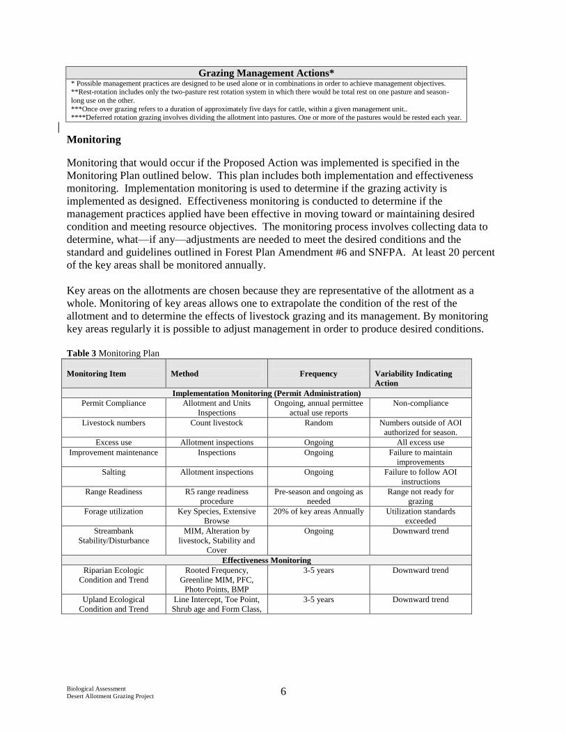
Monitoring
Monitoring that would occur if the Proposed Action was implemented is specified in the
Monitoring Plan outlined below. This plan includes both implementation and effectiveness
monitoring. Implementation monitoring is used to determine if the grazing activity is
implemented as designed. Effectiveness monitoring is conducted to determine if the
management practices applied have been effective in moving toward or maintaining desired
condition and meeting resource objectives. The monitoring process involves collecting data to
determine, what—if any—adjustments are needed to meet the desired conditions and the
standard and guidelines outlined in Forest Plan Amendment #6 and SNFPA. At least 20 percent
of the key areas shall be monitored annually.
Key areas on the allotments are chosen because they are representative of the allotment as a
whole. Monitoring of key areas allows one to extrapolate the condition of the rest of the
allotment and to determine the effects of livestock grazing and its management. By monitoring
key areas regularly it is possible to adjust management in order to produce desired conditions.
Table 3 Monitoring Plan
Monitoring Item
Method
Frequency
Variability Indicating
Action
Implementation Monitoring (Permit Administration)
Permit Compliance Allotment and Units
Inspections
Ongoing, annual permittee
actual use reports
Non-compliance
Livestock numbers Count livestock Random Numbers outside of AOI
authorized for season.
Excess use Allotment inspections Ongoing All excess use
Improvement maintenance Inspections Ongoing Failure to maintain
improvements
Salting Allotment inspections Ongoing Failure to follow AOI
instructions
Range Readiness R5 range readiness
procedure
Pre-season and ongoing as
needed
Range not ready for
grazing
Forage utilization Key Species, Extensive
Browse
20% of key areas Annually Utilization standards
exceeded
Streambank
Stability/Disturbance
MIM, Alteration by
livestock, Stability and
Cover
Ongoing Downward trend
Effectiveness Monitoring
Riparian Ecologic
Condition and Trend
Rooted Frequency,
Greenline MIM, PFC,
Photo Points, BMP
3-5 years Downward trend
Upland Ecological
Condition and Trend
Line Intercept, Toe Point,
Shrub age and Form Class,
3-5 years Downward trend

Biological Assessment
Desert Allotment Grazing Project 7
III. CONSULTATION TO DATE
The Inyo National Forest has informally consulted with the U.S. Fish and Wildlife Service on
several occasions regarding domestic sheep grazing in proximity to Sierra Nevada bighorn sheep
and has closed several allotments to minimize potential contact between the two species. In the
vicinity of the Northern Recovery Unit, the Forest closed all allotments located west of Highway
395 (Bloody Canyon, Algier Lake and June Lake West). The Forest informally consulted
regarding continued sheep grazing within several pastures of the Rock Creek Allotment (near the
Convict Creek herd unit). The Forest determined that continued sheep grazing of the Hilton Unit
would not pose an unacceptable risk of disease transmission and the Service concurred. When
the Forest obtained new information regarding movement of Sierra Nevada bighorn sheep into
the Convict Creek herd unit a decision was made to discontinue domestic sheep grazing within
the Hilton Unit.
The Forest signed a decision in 2012 that authorized the use of helicopters in capturing Sierra
bighorn sheep within Wilderness areas over the next 10 years. This decision included the
authorization of releasing Sierra bighorn sheep into the un-occupied herd units Taboose Creek
and Olancha Peak herd units on the Inyo National Forest and removing sheep from the Inyo
National Forest to be introduced into the Laurel Creek and Big Arroyo herd units in the Sequoia
and Kings Canyon National Parks. This analysis included the impacts of this reintroduction on
the adjacent livestock grazing allotments (all cattle) and determined that there would be no
impacts to livestock operations from this activity (Barron 2012 and Authorizing Helicopter
Landings by the California Department of Fish and Wildlife in Wilderness Areas for Capturing
Sierra Nevada Bighorn Sheep May, 2012). The analysis also included effects of livestock
grazing on Sierra bighorn and determined that there would be no effect to re-introduced Sierra
bighorn in the Olancha Peak herd unit (Murphy 2012).
The U.S. Fish and Wildlife Service issued a 5-year review on Sierra bighorn recovery which
stated that disease transmission from cattle grazing in the eastern Sierra Nevada was not
considered to be a major threat to SNBS at this time (USDI, 2008). Furthermore, the
translocation plan developed by the California Department of Fish and Wildlife (CDFW) for re-
introductions of Sierra bighorn into the Olancha Peak herd unit did not analyze effects of
adjacent cattle grazing, only domestic sheep grazing, leading the Forest to believe that CDFW
does not believe that effects from cattle grazing pose a risk to the recovery of Sierra bighorn.
IV. SPECIES ACCOUNT AND HABITAT DESCRIPTION
The Sierra Nevada distinct population segment (DPS) of California bighorn sheep was
emergency listed on April 20, 1999. At the time of the emergency listing, the population was
thought to total no more than 125 animals. The final rule to list this DPS as endangered was
published on January 3, 2000. Notice of Availability of the Final Recovery Plan for SNBS
(USDI Fish and Wildlife Service 2007) was published in the Federal Register on February 13,
2008. On August 5, 2008 the U.S. Fish and Wildlife Service published the final rule on critical
habitat designation for SNBS and a taxonomic name change to Ovis canadensis sierrae (USDI
Fish and Wildlife Service 2008).

Biological Assessment
Desert Allotment Grazing Project 8
Bighorn sheep select open habitats that allow detection of predators at sufficient distances to
allow adequate lead-time to reach the safety of precipitous terrain. Optimal bighorn sheep
habitat is visually open and contains steep, generally rocky, slopes. Sierra Nevada bighorn sheep
avoid forests and thick brush, but will use open woodland habitats on rocky slopes. Bighorn
sheep in the Sierra Nevada utilize a wide range of elevations, from alpine peaks in excess of
4,000 meters (13,120 feet) to the base of the eastern escarpment as low as 1,450 meters (4,760
feet) (Wehausen 1980). Within this elevational range, there is a wide variety of vegetation
communities, including (from lowest to highest): (1) Great Basin sagebrush-bitterbrush-
bunchgrass scrub; (2) pinyon-juniper woodland and mountain mahogany scrub; (3) mid-
elevation and subalpine forests, woodlands, and meadows; and (4) alpine meadows and other
alpine habitats varying from cliffs to plateaus.
SNBS inhabit the alpine and subalpine zones during the summer, using open slopes where the
land is rough, rocky, sparsely vegetated and characterized by steep slopes and canyons. During
the summer months SNBS can be found at elevations between 10,000 and 14,000 feet (USDA
Forest Service 2001). In winter, they occupy high, windswept ridges, if weather conditions
allow, or migrate to the lower elevation sagebrush-steppe habitat as low as 4,800 feet (USDA
Forest Service 2001).
Bighorn sheep behavior has adapted to avoid predators. Bighorn sheep tend to live in groups,
which allow for more visual awareness of predators and allow members of the group to spend
more time feeding than watching for predators. SNBS generally avoid forests and thick brush, as
these habitats do not allow for the open areas needed to watch for predators (USDA Forest
Service 2001). Bighorn sheep are primarily diurnal and daily activity can show some predictable
patterns that consist of feeding and resting periods (USDA Forest Service 2001). Nights are
spent on rocky slopes, but feeding activities may occur short distances away from rocky escape
terrain. This distance to escape terrain can be influenced by visual openness of vegetation or
weather, wind, gender, season and abundance of predators. Male and female groups of bighorn
utilize different habitat types throughout the year. Both sexes utilize the same winter ranges, but
during the summer the two sexes move to different habitats. Females use alpine environments
along the crest during the summer and males are often found at lower elevations in subalpine
habitats. Males join the females during the breeding season in late fall (USDI Fish and Wildlife
Service 2007).
Bighorn sheep in the Sierra Nevada begin birthing season as early as the end of April and end as
late as early July, with most of the births occurring in May and June (USDI Fish and Wildlife
Service 2007). The gestation period for a bighorn sheep is about 174 days. The breeding or
rutting season in the Sierra Nevada occur during late fall and early winter, mostly November and
December, when bighorn are usually at higher elevations.
On August 5, 2008, the U. S. Fish and Wildlife Service designated approximately 417,577 acres
of critical habitat for this species in Tuolumne, Mono, Fresno, Inyo and Tulare Counties.
Approximately 272,000 acres of designated critical habitat are within the boundaries of the Inyo
National Forest. In this analysis, suitable habitat is considered to be synonymous with areas
designated as critical habitat by the USFWS. A total of 12 critical habitat units were designated,
10 of which overlap the Inyo National Forest. These include, from north to south; 1) Mount

Biological Assessment
Desert Allotment Grazing Project 9
Warren, 2) Mount Gibbs, 3) Convict Creek, 4) Wheeler Ridge, 5) Taboose Creek, 6) Sawmill
Canyon, 7) Mount Baxter, 8) Mount Williamson, 9) Mount Langley, and 10) Olancha Peak. At
present, all but the Taboose Creek herd unit is occupied. In 2010, a group of bighorn sheep were
located near Nevahbe Ridge in the Convict Creek critical habitat unit. In March 2013, the
California Department of Fish and Wildlife (CDFW) successfully released 14 Sierra bighorn in
the Olancha Peak herd unit, including 10 ewes and 4 rams. Three ewes were also released in the
Convict Creek and Mt. Gibbs herd units.
The USFWS also identified primary constituent elements (PCEs), which are physical or
biological features considered essential to the conservation of the species and that may require
special management considerations or protection. The PCEs identified for the Sierra Nevada
bighorn sheep include:
1. Non-forested habitats or forest opening within the Sierra Nevada from 4,000 feet to
14,500 feet in elevation with steep (greater than or equal to 60 percent slope), rocky
slopes that provide for foraging, mating, lambing, predator avoidance, and bedding as
well as seasonal elevational movements between these areas.
2. Presence of a variety of forage plants, as indicated by the presence of grasses (e.g.,
Achnanthera spp.; Elymus spp.) and browse (e.g., Purshia spp.) in winter, and grasses,
browse, sedges (e.g.. Carex spp.) and forbs (e.g., Eriogonum spp.) in summer.
3. Presence of granite outcroppings containing minerals such as sodium, calcium, iron, and
phosphorus that could be used as mineral licks in order to meet nutritional needs.
All five Desert Grazing allotments are permitted for cattle grazing, domestic sheep are not
permitted for grazing within these allotments. Four of these allotments are located within or
immediately adjacent to the Mount Williamson, Mount Langley, and Olancha Peak herd units,
all of which are occupied by Sierra bighorn (Figure 1). Based on GPS and VHF collar location
data monitored by CDFW, Sierra bighorn in the Mount Langley herd unit have utilized portions
of the Alabama Hills allotment (Figure 2) and the newly released Sierra bighorn in the Olancha
Peak herd unit have utilized portions of the Olancha allotment (Figure 3). Although portions of
the Mount Williamson herd unit are adjacent to the Alabama Hills and George Creek allotments,
no Sierra bighorn have utilized these portions of the herd unit that fall within the allotments. The
portions of the Mount Langley and Olancha Peak herd units within the Ash Creek allotment have
also not been used by Sierra bighorn; however, bighorn may begin using the northern portion of
the Olancha herd unit that falls within the Ash Creek allotment once the herd establishes their
home and seasonal ranges.
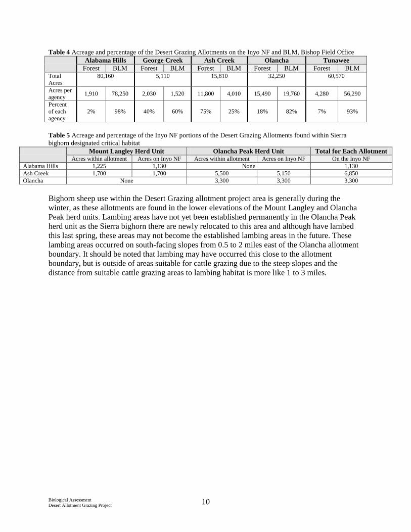
The following tables (Table 4 and 5) display the acreage and percentage of the allotments on the
Inyo NF and BLM and the portion of the allotments that occur within Sierra bighorn designated
critical habitat. The George Creek and Tunawee allotments do not occur within designated
critical habitat and are therefore not included in Tables 4and 5.
Biological Assessment
Desert Allotment Grazing Project 10
Table 4 Acreage and percentage of the Desert Grazing Allotments on the Inyo NF and BLM, Bishop Field Office
Alabama Hills George Creek Ash Creek Olancha Tunawee
Forest BLM Forest BLM Forest BLM Forest BLM Forest BLM Total
Acres
80,160 5,110 15,810 32,250 60,570
Acres per
agency 1,910 78,250 2,030 1,520 11,800 4,010 15,490 19,760 4,280 56,290
Percent
of each
agency
2% 98% 40% 60% 75% 25% 18% 82% 7% 93%
Table 5 Acreage and percentage of the Inyo NF portions of the Desert Grazing Allotments found within Sierra
bighorn designated critical habitat
Mount Langley Herd Unit Olancha Peak Herd Unit Total for Each Allotment Acres within allotment Acres on Inyo NF Acres within allotment Acres on Inyo NF On the Inyo NF
Alabama Hills 1,225 1,130 None 1,130
Ash Creek 1,700 1,700 5,500 5,150 6,850
Olancha None 3,300 3,300 3,300
Bighorn sheep use within the Desert Grazing allotment project area is generally during the
winter, as these allotments are found in the lower elevations of the Mount Langley and Olancha
Peak herd units. Lambing areas have not yet been established permanently in the Olancha Peak
herd unit as the Sierra bighorn there are newly relocated to this area and although have lambed
this last spring, these areas may not become the established lambing areas in the future. These
lambing areas occurred on south-facing slopes from 0.5 to 2 miles east of the Olancha allotment
boundary. It should be noted that lambing may have occurred this close to the allotment
boundary, but is outside of areas suitable for cattle grazing due to the steep slopes and the
distance from suitable cattle grazing areas to lambing habitat is more like 1 to 3 miles.

Biological Assessment
Desert Allotment Grazing Project 11
Figure 1 Sierra Nevada bighorn sheep critical habitat within the Desert Grazing Allotment Project Area

Biological Assessment
Desert Allotment Grazing Project 12
Figure 2 Sierra bighorn sheep locations from the Mount Langley herd unit within the Alabama Hills allotment
within the Desert Grazing Allotment Project Area

Biological Assessment
Desert Allotment Grazing Project 13
Figure 3 Sierra bighorn sheep locations from the Olancha Peak herd unit within the Olancha allotment within the
Desert Grazing Allotment Project Area

Biological Assessment
Desert Allotment Grazing Project 14
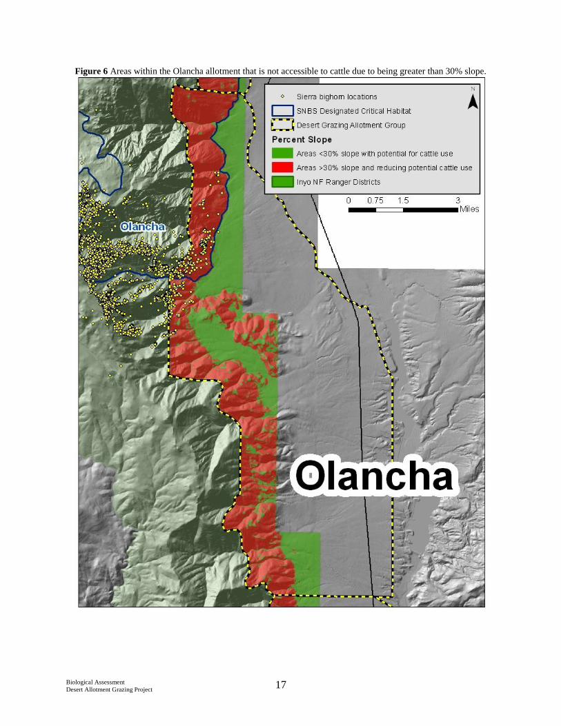
The habitat present in the Alabama Hills, Ash Creek, and Olancha allotments include very steep
slopes ( >30%) which provide for escape terrain and suitable foraging vegetation for Sierra
bighorn (Figures 4, 5 and 6). Cattle use within this type of habitat is extremely limited due to the
steep slopes, cattle do not tend to use slopes steeper than 30% unless driven there by a food
source (feeding trough, etc.) or available water (Ganskopp and Vavra 1987). The areas which are
steep (>30% slope) do not contain water sources suitable for cattle, including artificial sources
like water troughs. Approximately 7,930 acres (or 27%) of the forest portion of the Alabama
Hills, Ash Creek, and Olancha Peak allotments are less than 30% slope and include water
sources that may be accessible to cattle. Approximately 21,255 acres (or 73%) do not support
livestock grazing due to the steepness of the slopes and lack of water. Table 6 displays the acres
of each allotment and herd unit greater and less than 30% slope within the project area.
Table 6 Acres of areas greater and less than 30% slope within the Desert Grazing Allotment project area and within
Sierra bighorn designated critical habitat
Acres per Allotment (INF) Mount Langley Herd Unit Olancha Peak Herd Unit
Less than 30% Greater than 30% Acres less than 30% Acres greater than
30%
Acres less than
30%
Acres greater
than 30%
Alabama
Hills 570 1,340 170 960 --- ---
Ash Creek 1,600 10,195 120 1,580 220 4,930
Olancha 5,760 9,720 --- --- 80 3,220
Total 7,930 21,255 290 2,540 300 8,150

Biological Assessment
Desert Allotment Grazing Project 15
Figure 4 Areas within the Alabama Hills allotment that is not accessible to cattle due to being greater than 30%
slope.

Biological Assessment
Desert Allotment Grazing Project 16
Figure 5 Areas within the Ash Creek allotment that is not accessible to cattle due to being greater than 30% slope.
Biological Assessment
Desert Allotment Grazing Project 17
Figure 6 Areas within the Olancha allotment that is not accessible to cattle due to being greater than 30% slope.

Biological Assessment
Desert Allotment Grazing Project 18
Current Cattle Grazing: All of the allotments except the Olancha Allotment are managed as
term grazing permits with on/off provisions. This means that the allotment as a whole comprises
lands managed by the Inyo NF and the BLM, Bishop Field Office. The total number of animals
allowed is based on that combined acreage. The number of animals permitted by the USFS is a
percentage of that total number and is determined according to the relative amount of USFS
acreage. The number of animals permitted by the USFS is called the “on provision” and the
number permitted by the BLM is the “off provision.” This analysis only evaluates the Forest
portion (or “on portion”) of the allotments.
All of the allotments except for the Olancha Allotment receive only incidental use, as the
majority of grazing takes place on the BLM portion of the allotments. The National Forest
portion of the allotments is permitted in order to cover the permittees in the case of cattle
wandering off of the BLM portion. On the Olancha Allotment, the Forest’s portion receives
about one third of the use of the allotment as a whole.
The allotments experience frequent nonuse due to drought—they are very sensitive to the timing
and amount of precipitation. The portions of the allotments on the Inyo NF can receive slightly
higher moisture levels than the BLM portion because these areas are at a slightly higher
elevation. However, if the BLM does not allow turn-out, then the Forest does not permit
livestock grazing as well. In this case, conditions on the BLM portion dictate whether or not any
of these allotments will be grazed.
Records show that the Alabama Hills allotment has been grazed since 1923, although the area
was most likely grazed for many years prior to record keeping. From 1923 to 1945 the allotment
was grazed by sheep. Cattle began grazing there in 1943. Currently, the permitted use is 7
cow/calf pairs (14 individual cows), and grazing is permitted from February 1st to June 30
th, with
the actual off-date around May 15th
. The current grazing system is continuous season-long use,
which means that the cows can occur throughout the entire allotment at any time during the
grazing season. Allowable use is currently 40% for early grazing and 60% for late grazing on the
ricegrass and needlegrass spp. and 40% for early grazing and 30% for late grazing on hopsage.
Records for the Olancha Allotment begin in 1923. Only 81 cow/calf pairs (162 cows) are
permitted on the forest between April 1st and June 30
th. In 2012 the permittee took non-use on
this allotment due to drought conditions (Personal communication Barron 2013). The current
grazing system is deferred rotation, meaning the permittee uses the northern half of the allotment
one year and the southern half of the allotment the following year (Personal communication
Barron 2013). The current allowable use is 40% in wet meadows, 50% on herbaceous vegetation
and 45% on browse in upland areas and 45% herbaceous and 20% on annual leader growth in
riparian areas.
Cattle use of areas within each of these allotments is based on the availability of water. Cattle use
is evenly distributed throughout these allotments by the placement of or natural occurrence of
water (Personal communication Barron 2013). In general cattle limit their use of hillsides when
grades approach 30% (Ganskopp and Vavra 1987).

Biological Assessment
Desert Allotment Grazing Project 19
Changes from current livestock use under the Proposed Action: The proposed action would
change some aspects of grazing management for the Desert Grazing Allotments. These changes
where determined using the Forest Plan Amendment #6 standards for specific vegetation
communities and based on the current condition of vegetation communities and watershed
conditions. Through adaptive management, further livestock grazing management changes may
be implemented to allow for vegetation communities or watershed conditions to meet the desired
conditions for each allotment. Table 7 outlines the differences, if any, on season of use,
allowable use standards, numbers of livestock, and grazing system.
Table 7 Changes to livestock grazing under the proposed action from current conditions for the Desert Grazing
Allotment Project
Season of Use Allowable Use Numbers of
Livestock
(# of individuals)
Grazing System
Current Proposed Current Proposed Current Proposed Current Proposed
Alabama
Hills
2/1- 6/30 No
change
Ricegrass:
40% early
60% late
Hopsage:
40% early
30% late
50%
sagebrush-
bunchgrass
uplands
14 No
change
Continuous
Season-
long
No
change
George
Creek
4/1-6/30 No
change
Ricegrass:
40% early
30% late
Bitterbrush:
50% early
40% late
50%
sagebrush
bunchgrass
uplands
70 No
change
Continuous
Season-
long
No
change
Ash
Creek
2/1-5/31 No
change
Ricegrass:
40% early
60% late
Hopsage:
40% early
30% late
30% desert
shrub
uplands
160 No
change
Continuous
Season-
long
No
change
Olancha 4/1-6/30 No
change
Wet
Meadow:
40%
Uplands:
50%
herbaceous
45%
browse
Riparian:
45%
herbaceous
20% annual
leader
growth
40% early
and 60%
late for
sagebrush
bunchgrass
uplands
162 No
change
Deferred
rotation
No
change
Tunawee 2/16-
5/31
No
change
Ricegrass:
30% early
50% late
Hopsage:
30% early
20% late
40% early
and 30%
late for
desert
shrub
uplands
80 No
change
Deferred
rotation
No
change
Biological Assessment
Desert Allotment Grazing Project 20
Under the proposed action there would be no changes to the season of use, numbers of livestock
or grazing systems. Changes to these management actions can be made if monitoring shows that
desired conditions are not being reached under the proposed action. Utilization levels would be
prescribed according to the Forest Plan Amendment #6 protocol for desert shrub and
sagebrush/bunchgrass vegetation communities. The current grazing permits used the standards
for sagebrush/bunchgrass communities for Alabama Hills, Ash Creek, Olancha, and Tunawee.
George Creek was analyzed as a bitterbrush community. After data collection in 2012, it was
determined that the Alabama Hills, George Creek, and Olancha key areas are in
sagebrush/bunchgrass communities, but that Ash Creek and Tunawee key areas are in desert
shrub communities. Thus, utilization standards for the Ash Creek and Tunawee Allotments
would be lower under the Proposed Action than under current management. The utilization for
the Olancha allotment would be changed to a different standard than current grazing; changing
based on the time of season instead of having one standard for the whole season. Utilization
under the proposed action would be a little lower in the early season and a little higher in the late
season then under current conditions. Utilization standards are also established so that suitable
forage is available for wild ungulates, such as mule deer, elk and bighorn sheep. If wild
ungulates move into an area and forage on the vegetation, this use is taken into account at the
beginning of the grazing season and if wild ungulates have grazed the area to the utilization
standard established, then the cattle would not move onto the allotment. Drought conditions also
affect cattle use of the allotments. If drought conditions have caused a reduction in the available
forage, then the permittee may choose to take non-use on an allotment, or the Forest Service can
restrict use on the allotment.
V. EFFECTS OF THE PROPOSED ACTION
Direct and Indirect Effects
Factors limiting Sierra Nevada bighorn sheep recovery include disease, predation, low
population numbers and limited distribution, availability of open habitat, and potential further
loss of genetic diversity due to small population sizes and inadequate migration between them.
The Recovery Plan identifies disease transmission from domestic to bighorn sheep as a major
threat to this species and one of the key factors in listing the species.
Effects of cattle grazing on bighorn sheep can include changes in bighorn sheep behavior due to
the presence of cattle on the landscape (King and Workman 1984, Brown et al 2010, and
Bissonette and Steinkamp 1996), increase risk of some communicable diseases (Wolfe et al
2010, Robinson et al 1967, Noon et al 2002, Foreyt and Lagerquist 1996, Singer et al 1997, and
Clark et al 1993), and forage competition (Brown et al 2010).
Displacement of Sierra bighorn
The presence of livestock has had documented effects to wildlife distribution and movements on
species, including wild ungulates like elk, deer, and bighorn sheep (Bissonette and Skeinkemp
1996, Jenks and Leslie 2003, and Mishra et al 2004). Bissonette and Steinkemp (1996) studied
cattle grazing on newly reintroduced populations of California bighorn sheep in Idaho and their
study showed that when cattle (up to 400) where purposefully moved to within 800 m (2,624
feet) of bighorn sheep, the sheep responded by immediately vacating the area and creating new

Biological Assessment
Desert Allotment Grazing Project 21
core areas of use. These results may also have been caused due to the presence of humans on
horseback moving the animals (Bissonette and Steinkemp 1996). They noted that newly
reintroduced bighorn sheep are more sensitive to disturbance, perhaps resulting from recent
transplant activities, and react differently than do established undisturbed populations (Bissonette
and Steinkemp 1996). They also concluded that the sensitivity of these populations to
disturbance may diminish over time as populations become established (Bissonette and
Steinkemp 1996). Brown et al (2010) also conducted studies to better understand bighorn sheep
reactions to the presence of cattle. They observed bighorn sheep and their reactions to cattle in
Alberta, Canada and noted that bighorn did notice cattle on the landscape and move away from
the area. However, their results showed that bighorn sheep appeared to neither avoid nor prefer
cattle during close encounters. On a few occasions when cattle and sheep came into close
contact, they observed that the cattle always approached the bighorn sheep (Brown et al 2010).
Brown et al also found that if bighorn were bedded prior to contact, they would get up and move
away when the cows moved closer (2010). No chasing or aggressive interactions were observed,
nor did they observe complete avoidance of winter ranges due to the presence of cattle (Brown et
al 2010).
The recent re-introduction of Sierra bighorn to the Olancha Peak herd unit may mean that this
population is more sensitive to disturbances. The on-date for cattle on the Olancha allotment is
April 1st
and on the Alabama Hills and Ash Creek allotments its February 1st. Bighorn sheep that
occur in low elevation winter ranges remain on this range until late May (for ewes) and early
June (for rams) (Personal communication with Few 2013). Although there is potential for
overlap in the season of use between cattle and Sierra bighorn on low elevation winter range, the
potential for bighorn sheep to purposefully move into a new area or lead to complete changes in
herd use of low elevation winter range is extremely low. This is due to the following: 1) Limited
cattle use of suitable Sierra bighorn sheep habitat, 2) Limited number of cows on the forest
portion of the allotment, 3) Sierra bighorn have become accustomed to cattle use.
As noted above, approximately 21,255 acres of the forest portion of the allotment are not used by
cattle; this is due to the steep slopes and lack of water in these areas. The Alabama Hills
allotment is grazed in a continuous pattern, with incidental use occurring on the forest, as the
Forest portion of the allotment comprises only 2% of the entire allotment. This reduces the
likelihood of cattle being present on the forest portion of the allotment. Furthermore, the number
of cattle present on the landscape (14 to 162) is far less than the 400 or more used in the
Bissonette and Steinkemp study which showed extreme movements of bighorn sheep due the
presence of this many cows (1996). Sierra bighorn that have been utilizing low elevation winter
range in the Mount Langley herd unit have become accustomed to the presence of cattle on the
landscape, as cattle have been grazing this area since 1923. Bighorn sheep in the Olancha herd
unit may be new to the herd unit, but these bighorn came from the Mount Baxter herd unit where
cattle grazing occurred within low elevation winter range. It is assumed that, using Bissonette
and Steinkemp’s (1996) conclusion, bighorn sensitivity to the presence of disturbances, such as
cattle on the landscape, would diminish over time once they establish their home and seasonal
ranges and due to these bighorn sheep already accustomed to seeing cattle on the landscape, this
disturbance would not cause permanent displacement of bighorn sheep.

Biological Assessment
Desert Allotment Grazing Project 22
Ewes that are lambing may be more susceptible to disturbances than rams or non-lambing ewes.
Lambing areas in the Olancha Peak herd unit have not yet been permanently established, but this
last year it appears lambing occurred on south-facing, steep slopes in the Falls Creek canyon
area. This is located approximately 0.5 to 2 miles from the Olancha allotment boundary, but in
reality it’s more like 1 to 3 miles from where cattle occur on the Olancha allotment because
lambing areas occur on extremely steep slopes and outside suitable grazing areas for cattle.
Furthermore, cattle grazing in the Independence allotment does not appear to be effecting
lambing in the Mount Baxter herd unit, but this could again be due to the steep slopes in which
lambing occurs and the distance from suitable cattle grazed areas (approximately one to five
miles).
The presence of cattle on the landscape may lead to an individual or small groups of Sierra
bighorn to move closer to escape terrain or out of the immediate vicinity of cattle (Brown et al
2010), but this effect is limited to specific areas of low elevation winter range where Sierra
bighorn move into areas where cattle are present. The presence of cattle on the landscape would
not have long-term detrimental effects (Brown et al 2010) to Sierra bighorn use of low elevation
winter ranges or affect the recovery of Sierra bighorn.
Disease Transmission
Disease transmission from cattle to bighorn sheep have been documented in many studies (Wolfe
et al 2010, Robinson et al 1967, Noon et al 2002, Foreyt and Lagerquist 1996, Singer et al 1997,
and Clark et al 1993). As discussed in the 2007 Recovery Plan, the potential for cross species
transmission of diseases between cattle and wild ungulates may vary with local environmental
conditions (USFWS). Bovine viral diarrhea causes a complex of respiratory diseases,
gastrointestinal diseases, and reproductive failure and may be transmitted between species
(USFWS 2007). Hemorrhagic disease and pneumonia resulting from bluetongue virus (BTV)
infection have been reported in bighorn sheep (Robinson et al 1967 and Noon et al 2002). Singer
et al (1997) concluded that cattle, deer, and bighorn sheep did not share similar patterns of
exposure to the three pathogens and, thereby, proposed that cattle did not constitute a health risk
for bighorn sheep in that area. Although cattle may carry Pastueurella spp. that are pathogenic to
bighorn sheep, Foreyt and Lagerquist (1996) hypothesized that “the nose to nose contact required
for transmission of Mannheimia haemolytica is less likely to occur between bighorn sheep and
cattle” than with domestic sheep because the social interactive behavior between bighorn sheep
and domestic cattle.
A recent occurrence of disease outbreaks in bighorn sheep due to cattle was studied in Colorado
(Wolfe et al 2010). In this case, 21 bighorn sheep were found dead in winter range between
December 13, 2007 and February 2008. Death was determined to be caused by a pasteurellosis
epizootic wherein a Pasteurellaceae strain carried by cattle contributed to a pneumonia outbreak.
However, the causes for this outbreak were attributed to the severe winter conditions that
occurred in this area. The winter of 2007-08 was one of the most severe in recorded history for
the Gunnison Basin (where the bighorn sheep herd occurred); almost two feet of snow fell within
one day, burying mountain shrub communities and the below average temperatures ranged from
-4 degrees F to 19 degrees F precluded any appreciable snowmelt. These weather conditions may
have led to cattle having more interactions with bighorn sheep and the cumulative stress of the
weather conditions may have caused bighorn to be more susceptible to diseases (Wolfe et al

Biological Assessment
Desert Allotment Grazing Project 23
2010). Wolfe et al (2010) also concluded that intimate interactions between bighorn sheep and
cattle (use of shared feed lines or troughs) should be discouraged.
On the Alabama Hills allotment, although bighorn sheep utilize portions of this allotment during
the winter, the cattle use that would be permitted is only for 14 cows, as this allotment receives
incidental use as cattle move through the BLM portion of the allotment. The opportunity for
cattle to interact with bighorn in this area is extremely limited not only to the low number of
cattle present, but the steep slopes and lack of water which would attract cattle into suitable
Sierra bighorn habitat; 960 acres (or 84%) over 30% slope out of 1,130 acres within the Mount
Langley herd unit. Bighorn sheep have not been observed using the Ash Creek allotment. Cattle
use in this allotment is restricted due to the large amount (6,500 acres out of 6,850 acres) of
terrain that is over 30% slope within the portions of the allotment found in the Mount Langley
and Olancha Peak herd units. Bighorn sheep may begin utilizing this allotment after they
establish their home and seasonal ranges in a few years.
Currently Sierra bighorn have not utilized the Ash Creek allotment, but the newly introduced
herd in the Olancha Peak herd unit may begin utilizing the northern portion of the herd unit
within the Ash Creek allotment after they establish their home and seasonal ranges over the next
several years. Cattle and Sierra bighorn interactions within this portion of the Ash Creek
allotment is expected to be very low due to the majority of this portion of the allotment being
greater than 30% slope; 4,930 acres (or 95%) out of 5,150 acres of the allotment within the
Olancha Peak herd unit.
The Olancha Peak herd unit only makes up 3,300 acres of the 34,250 acres of the Olancha
allotment. Of this, only 80 acres are less than 30% slope which offer suitable habitat for cattle.
The likelihood of cattle and Sierra bighorn interacting is incredibly low due to the low potential
of cattle moving into Sierra bighorn habitat. Although there is potential for Sierra bighorn to
move into areas less than 30% slope, and therefore move into areas where cattle do occur, the
limited number of cows within this allotment (162), the proposed grazing strategy (deferred
rotation) and the short duration in which cattle grazing overlaps with potential bighorn use (two
months) limits the risk of interaction between cattle and bighorn sheep. Furthermore, there are no
artificial watering or feeding areas on the forest that could attract both cattle and bighorn and the
weather conditions in this area would not become so extreme it would force cattle and bighorn to
use the same areas for a long period of time, as was seen by Wolfe et al (2010).
In addition, the 2007 Recovery Plan (USFWS), 5-year Recovery review (USFWS 2008) and
Translocation Plan (Few et al 2013) has not listed cattle grazing as a risk to the recovery of
Sierra bighorn sheep. Personal communication with Ben Gonzales on the risk of disease
transmission from cattle concluded with him stating that behaviorally he believes cattle are much
less of a risk to bighorn sheep than domestic sheep, but cattle do appear to carry infections that
are pathogenic to bighorn and that cattle are more of a displacement problem for bighorn sheep
than a disease issue (email received 6/3/2013). He also acknowledges that to his knowledge
there have been no occurrences of cattle transmitting diseases to Sierra bighorn (email received
6/12/2013).
Biological Assessment
Desert Allotment Grazing Project 24
Overall, the risk of disease transmission due to interactions between cattle and Sierra bighorn
sheep is low due to the limited number of cattle found on the forest portions of the allotments,
the lack of artificial watering and feeding troughs, and the limited suitable habitat for cattle
within Sierra bighorn herd units.
Forage competition
The competition between cattle and native ungulates is a common concern (Pickford and Reid
1943). Grazing by high density of cattle can alter grassland ecosystems (Fleischner 1994) and
negatively affect native ungulates (Jenks and Leslie 2003 and Mishra et al 2004). Sierra bighorn
sheep forage on needlegrass, buckwheat spp., sagebrush, ephedra, blackbrush, bitterbrush and
bush beardtongue during the winter (Wehausen 1980). Cattle generally forage on bunchgrasses
such as Indian ricegrass and needlegrass and desert shrubs like hopsage, bitterbrush and
buckwheat during the winter. Although there may be some overlap between the species being
chosen during the winter by both these species, the forest manages livestock use by establishing
utilization levels. Utilization standards are determined based on vegetation and watershed
conditions, as directed by Amendment 6 of the Inyo NF LRMP (1995). The proposed action
would change the current utilization standards in the Alabama Hills, Ash Creek, and Olancha
allotments by establishing standards that would maintain the allotment in desired condition or
restoring the area to desired conditions, as well as providing forage for native wildlife species
such as mule deer and Sierra bighorn.
As Table 6 shows, the utilization standards were changed to address the vegetation present in the
allotments, which is a change from the current conditions. These new standards would allow for
the continuance of suitable browse species in sagebrush, bunchgrass, and desert scrub habitats.
On the Alabama Hills allotment utilization levels would be established at a standard of 50%
grazing on sagebrush and bunchgrasses in upland habitats throughout the Forest portion of the
allotment. As noted above, the Forest only comprises 2% of this allotment and is grazed by only
14 cows, which is considered incidental use when cows wander onto the Forest, but return to the
BLM portion of the allotment.
The utilization standards for Ash Creek would be reduced to 30% in the desert scrub habitat.
However, Sierra bighorn have not been documented utilizing this allotment. If Sierra bighorn
from the Olancha herd unit move north and begin wintering on portions of the Ash Creek
allotment, the large amount of acres of terrain greater than 30% would reduce the cattle use in
these areas and forage availability would not be effected in these areas and the low utilization
standard of 30% would still allow for forage for wintering bighorn.
On the Olancha allotment utilization standards would be changed to match the season of use,
rather than having one standard for the entire allotment. Use would be a lower in the early
season, 40%, and a little higher later in the season, 60%. However, cattle are not authorized on
the Olancha allotment until April 1st, which is near the end of bighorn sheep use of winter range.
Therefore the increase in use during the late season on the allotment would not affect the
availability of forage for bighorn sheep during the winter and cattle use of this allotment is in a
deferred rotation pattern, in which cattle utilize the northern portion of the allotment one year
and the southern portion the next year, allowing for foraging opportunities by Sierra bighorn on
winter range.

Biological Assessment
Desert Allotment Grazing Project 25
Furthermore, the adaptive management strategy of the proposed action allows for changing
livestock management if the proposed action is not allowing for vegetation conditions to meet
desired conditions. The use of the Forest portion of the allotments is determine by the use of the
BLM portion of the allotments; if BLM does not authorize use due to drought or other reasons,
then the Forest portion of these allotments is not grazed.
Drought conditions may lead to bighorn sheep utilizing areas further from escape terrain and
therefore moving further into the areas grazed by cattle, such as in the Olancha allotment.
Drought conditions alter livestock grazing several ways; cattle may not be authorized to entire
the allotment by the Forest Service, or the permittee may take non-use and cattle would not
entire the allotment. These management actions are considered when the range is being
determined ready for use at the beginning of the grazing season. Range readiness is determined
by the amount of suitable forage available at that time and the prediction of how long grazing
may occur; drought conditions may mean livestock come off the allotment sooner than
permitted. The utilization standards remain the same during a drought year, so if Sierra bighorn
have moved into the Olancha allotment before the cattle have arrived, they would have the
opportunity to forage in the area first. If they move into the area after cattle are present,
utilization levels are checked and once the level has been reached the cattle are removed from the
allotment. Although drought conditions may lead to Sierra bighorn moving further into the
allotment, forage would still be available under the proposed action due to the new utilization
standards, season of use, and limited number of cattle in the allotment.
Overall, forage competition between Sierra bighorn and cattle would not result in a risk to the
recovery of Sierra bighorn by limiting the availability of foraging areas on low elevation winter
ranges, even in drought conditions.
Designated Critical Habitat
The PCEs identified for the Sierra Nevada bighorn sheep include the presence of a variety of
forage plants, as indicated by the presence of grasses (e.g., Achnanthera spp.; Elymus spp.) and
browse (e.g., Purshia spp.) in winter. Within the Desert Grazing Allotment project area; these
plant species are present, including others, which offer suitable winter forage for Sierra bighorn.
Under the proposed action these species would remain on the landscape and would not be
removed permanently or modified in such a way that they would not be available for foraging, or
would not be available the following year for forage. This is due to the changes in the utilization
standards under the proposed action, which in some allotments lower the utilization level, and
that these utilization levels still provide forage for wild ungulates, such as Sierra bighorn. These
utilization standards are designed to allow for the continuance of these species on the landscape
so use would not lead to a complete loss of these species. Although there may be a reduction in
specific areas of forage, if cattle are grazing in that area, the steepness of slopes throughout these
allotments still allows for 21,255 acres (or 72%) out of 29,200 acres to be grazed by Sierra
bighorn and not cattle.
Cumulative Effects

Biological Assessment
Desert Allotment Grazing Project 26
The species was emergency listed in 1999 as endangered by the U. S. Fish and Wildlife Service
because of the dramatic population decline in the late 1990s attributable to predation by
mountain lions, failure of sheep to utilize favorable low elevation winter range habitat because of
the presence of mountain lions, and the threat of large-scale mortality that could occur if
domestic sheep transmitted disease to a bighorn population. The inability of existing regulatory
mechanisms to deal with the issues of lion predation and disease transmission was also noted as a
major reason for the listing of the species.
Domestic sheep grazing within the high risk portions of the Inyo NF have been eliminated, with
sheep grazing not being authorized recently on the Hilton Unit of the Rock Creek allotment due
to the presence of Sierra bighorn in the Convict Creek herd unit. Six of the seven allotments
located west of Highway 395 have been vacated or closed to domestic sheep grazing. The 7th
allotment (Sherwin/Deadman) is partially within high risk area; however the areas of overlap are
either not grazed by domestic sheep, or are separated from occupied Sierra Nevada bighorn
sheep habitat by a highly developed area (Town of Mammoth Lakes) and large contiguous
forested areas. There is one domestic sheep allotment located nine miles from the Olancha Peak
herd unit and it was determined in the Translocation Plan (Few et al 2013) that the presence of
the Los Angeles Department of Water and Power aqueduct and fencing of the aqueduct would
provide a suitable barrier from domestic sheep and bighorn sheep and the time of year domestic
sheep grazing occurs, spring, would reduce the risk of bighorn sheep rams becoming attracted to
domestic sheep ewes.
Cattle grazing occurs on the west side of the Sierra crest in the Kern Plateau area on the Mulkey
and Monache allotments. The Templeton and Whitney allotments are currently not grazed and
haven’t been grazed since 2001. These allotments are grazed during the summer, when bighorn
sheep occur at higher elevations and not when they are on low elevation habitat on the eastside
of the Sierra crest. There would be no cumulative effects due to grazing on these allotments
because of the season of use on theses allotments. Cattle grazing also occurs during the winter
months in the Independence allotment adjacent to the Mount Baxter and Mount Williamson herd
units. Displacement of Sierra bighorn from low elevation winter ranges has not been
documented, only that cattle have been observed grazing near Sierra bighorn sheep in this
allotment (personal communication Few).
Approximately 29 miles of roads exist within designated critical habitat. Several of these routes
are the primary means of accessing popular recreation sites, including Lundy Canyon, Pine
Creek, Laurel Lakes, Onion Valley and Horseshoe Meadow. Such primary access roads account
for 14 of the 29 miles. The Forest recently issued a motorized travel management decision
which closed three miles of road and seasonally closed an additional three miles to reduce
potential disturbance of Sierra Nevada bighorn sheep.
Mountain lion predation continues to be a risk factor for Sierra Nevada bighorn sheep; however
recent efforts by CDFG to monitor lion movements and remove lions known to prey on bighorn
are helping to mitigate this risk.
No other projects or activities are identified in designated critical habitat with the potential to
affect Sierra Nevada bighorn sheep or PCEs of critical habitat.

Biological Assessment
Desert Allotment Grazing Project 27
VI. DETERMINATION
Based on the information presented above it is my determination that the Desert Grazing
Allotment proposed action MAY AFFECT, BUT IS NOT LIKELY TO ADVERSELY AFFECT
SIERRA NEVADA BIGHORN SHEEP and would NOT EFFECT SIERRA NEVADA
BIGHORN SHEEP DESIGNATED CRITICAL HABITAT. This is due to the following:
1) The Desert Grazing Allotment project area includes 24,500 acres of terrain greater than
30% slope. This reduces the areas in which cattle would graze, leaving suitable forage for
bighorn sheep using this area during the winter, reducing the disturbance caused by cattle
to bighorn sheep, as cattle would not occur in these areas, and reducing the opportunity
for risk of disease transmission.
2) There is no water or feeding troughs located on the Forest that would attract large
numbers of cattle to an area and provide an area where bighorn sheep and cattle could co-
mingle.
3) Cattle are grazed in a dispersed pattern, grazing on both the Forest and BLM managed
portions of the allotments.
4) Utilization standards would be lowered under the proposed action, allowing for suitable
forage for wintering Sierra bighorn.
5) Sierra bighorn have the potential to become accustomed to the presence of cattle on the
landscape, as bighorn in the Mount Langley herd unit have not changed winter range use
due to the presence of cattle. Sierra bighorn removed from the Sawmill Canyon herd unit
occurred on low elevation ranges where cattle are present and were moved to the Olancha
Peak herd unit. It is likely these sheep will be accustomed to cattle when they determine
their home and seasonal ranges.
6) The 2013 Translocation Plan (Few et al), 5-Year Recovery Review (USFWS 2008), and
Recovery Plan (USFWS 2007) did not list cattle grazing as a threat to the recovery of
Sierra bighorn sheep.
7) No disease outbreaks have been documented due to transmission from cattle in Sierra
bighorn sheep.
8) Suitable foraging species identified as a PCE for winter range would not be permanently
removed or modified in such a way that it would prevent suitable forage from returning
the following year.

Biological Assessment
Desert Allotment Grazing Project 28
VII. LITERATURE CITED
Bissonette, J.A. and Melanie J. Steinkamp. 1996. Bighorn Sheep Response to Ephermeral
Habitat Fragmentation by Cattle. Great Basin Naturalist 55(4): 319-325.
Brown, Natalia A., Kathreen E. Ruckstuhl, Steve Donelon, Corey Corbett. 2010. Changes in
vigilance, grazing behavior and spatial distribution of bighorn sheep due to cattle presence in
Sheep River Provincial Park, Alberta. Agriculture, Ecosystems and Environment 135 (2010)
226-231.
Clark, Richard K, Cecelia A. Whetstone, Anthony E. Castro, Mark M. Jorgensen, Jill F. Jensen,
and David A. Jessup. 1993. Restriction Endonuclease Analysis of Herpesviruses Isolated from
Two Pennisular Bighorn Sheep. Journal of Wildlife Diseases 29(1): 50-56.
Few, Alexandra P., David W. German, John D. Wehausen, Becky M. Pierce, and Thomas R.
Stephenson. 2013. Translocation Plan for Sierra Nevada Bighorn Sheep, February, 2013.
Few, Alexandra. 2013. Personal communication regarding winter seasonal use of Sierra Nevada
bighorn sheep. Email dated 06/03/2013.
Fleischner, T. L. (1994). Ecological costs of livestock grazing in western North America.
Conservation Biology, 8(3), 629-644.
Foreyt, William J. and John E. Lagerquist. 1996. Experimental Contact of Bighorn Sheep (Ovis
canadensis) with Horses and Cattle, and Comparison of Neutrophil Sensitivity to Pasteurella
Haemolytica Cytotoxins. Journal of Wildlife Diseases 32(4):594-602.
Ganskopp, David and Martin Vavra. 1987. Slope Use by Cattle, Feral Horses, Deer, and Bighorn
Sheep. Northwest Science 6(2): 74-81.
Gonzales, Ben. 2013. Personal communication regarding disease risk between cattle and bighorn
sheep, any new literature on the subject and documented cases of disease outbreaks in bighorn
sheep due to cattle. Emails dated 06/03/2013 and 6/12/2013.
Jenks, J.A., D.M. Leslie Jr. 2003. Effect of domestic cattle on the condition of female white-
tailed deer in southern pine-bluestem forests, USA. Acta Theiologica 48, 131-144.
King, M. M., & Workman, G. M. (1984). Cattle grazing in desert bighorn sheep habitat. Desert
Bighorn Council Transactions, 28, 18-22.
Mishra, C., S.E. Van Wieren, P. Ketner, I.M.A Heitkonig, and H.H.T. Prins. 2004. Competition
between domestic livestock and wild bharal Pseudois nayaur in the Indian Trans-Himalaya.
Journal of Applied Ecology 41, 344-354.

Biological Assessment
Desert Allotment Grazing Project 29
Noon, Ted H., Shannon Lynn Wesche, Dave Cagle, Daniel G. Mead, Edward J. Bicknell,
Gregory A. Bradley, Shawnee Riplog-Peterson, Dave Edsall, and Carlos Reggiardo. 2002.
Hemorrhagic Disease in Bighorn Sheep in Arizona. Journal of Wildlife Diseases 38(1):172-176.
Pickford, G.D and E.H. Reid. 1943. Competition of elk and domestic livestock for summer range
forage. The Journal of Wildlife Management 7, 328-332.
Robinson, R.M., T.L. Hailey, C.W. Livingston, and J.W. Thomas. 1967. Bluetongue in the
Desert Bighorn Sheep. The Journal of Wildlife Management 31(1): 165-168.
Singer, Randall S., David A. Jessup, Ian A. Gardner, and Walter M. Boyce. 1997. Pathogen
Exposure Patterns among Sympatric Populations of Bighorn Sheep, Mule Deer and Cattle.
Journal of Wildlife Diseases 33(2): 377-382.
Stephenson, Tom. 2013. Personal communication regarding documentation of any changes to
Sierra bighorn sheep use due to the presence of cattle. Phone conversation on 06/10/2013.
USDA, Forest Service. 1995. Inyo National Forest Land and Resource Management Plan.
Amendment #6: Forest-Wide Range Utilization Standards
USDA, Forest Service. 2004. Sierra Nevada Forest Plan Amendment Volume 3.
USDI, Fish and Wildlife Service. 2007. Recovery Plan for the Sierra Nevada Bighorn Sheep.
Sacramento, California, xiv + 199 pages.
USDI, Fish and Wildlife Service. 2008. Endangered and Threatened Wildlife and Plants;
Designation of Critical Habitat for the Sierra Nevada Bighorn Sheep (Ovis canadensis
californiana) and Taxonomic Revision. August 5, 2008. In Federal Register Vol. 73 No. 151,
45534-45604.
USDI, Fish and Wildlife Service. 2008. Sierra Nevada Bighorn Sheep: Five-Year Review
Summary and Evaluation.
Wehausen, J. D. 1980. Sierra Nevada bighorn sheep: history and population ecology. Ph.D.
Thesis, University of Michigan, Ann Arbor.
Wolfe, Lisa L., Brandon Diamond, Terry R. Spraker, Michael A. Sirochman, Daniel P. Walsh,
Chandra M. Machin, Donald J. Bade, and Michael W. Miller. 2010. A Bighorn Sheep Die-off in
Southern Colorado Involving a Pasteurellaceae Strain that May Have Originated from Syntopic
Cattle. Journal of Wildlife Diseases 46(4): 1262-1268.