best practices for water harvesting and...
TRANSCRIPT
March 2008
BEST PRACTICES FOR WATER HARVESTING AND IRRIGATION
Efficient Water Use for Agricultural Production
(EWUAP) Project
Mamoun Ibrahim Dawelbeit, Consultant
SUDAN
Sudan
LIST OF TABLES
Table 1.1 The Agro-climatic zones of the Sudan
Table 3.1 Best practices in water harvesting
Table 3.2 Best practices in small scale irrigation
Table 3.3 Best practices in large scale irrigation
Table 4.1 Research institutions
Table 4.2 Universities of higher education
Table 4.3 Non-government organizations
Table 4.4 Government institutions
Table 4.5 Evaluation of centers of excellence
LIST OF FIGURES
Figure A Map of the Sudan

Figure 1.1 Mean annual rainfall in the Sudan
Figure 1.2 The agro-climatic zones of the Sudan
Figure 1.3 Classification of irrigation systems in the Sudan
LIST OF ACRYNOMS
ARC Agricultural Research Corporation
EWUAP Efficient Water Use for Agricultural production
GDP Gross Domestic Product
GS Gezira Scheme
HRS Hydraulic Research Station
NBI Nile Base Initiative
SGB Sudan Gezira Board
TTEA Technology Transfer and Extension Administration
UCWR-SD UNESCO CHAIR IN WATER RESOURCES, SUDAN
WH Water Harvesting
WUS Water User Association
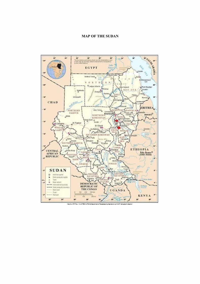
MAP OF THE SUDAN
CHAPTER ONE: INTRODUCTION
Agro-Climatic Zones of the Sudan
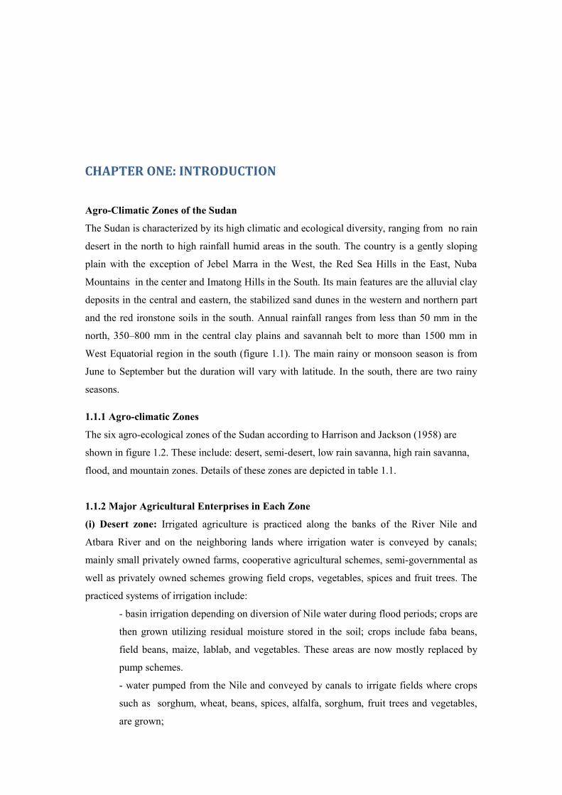
The Sudan is characterized by its high climatic and ecological diversity, ranging from no rain
desert in the north to high rainfall humid areas in the south. The country is a gently sloping
plain with the exception of Jebel Marra in the West, the Red Sea Hills in the East, Nuba
Mountains in the center and Imatong Hills in the South. Its main features are the alluvial clay
deposits in the central and eastern, the stabilized sand dunes in the western and northern part
and the red ironstone soils in the south. Annual rainfall ranges from less than 50 mm in the
north, 350–800 mm in the central clay plains and savannah belt to more than 1500 mm in
West Equatorial region in the south (figure 1.1). The main rainy or monsoon season is from
June to September but the duration will vary with latitude. In the south, there are two rainy
seasons.
1.1.1 Agro-climatic Zones
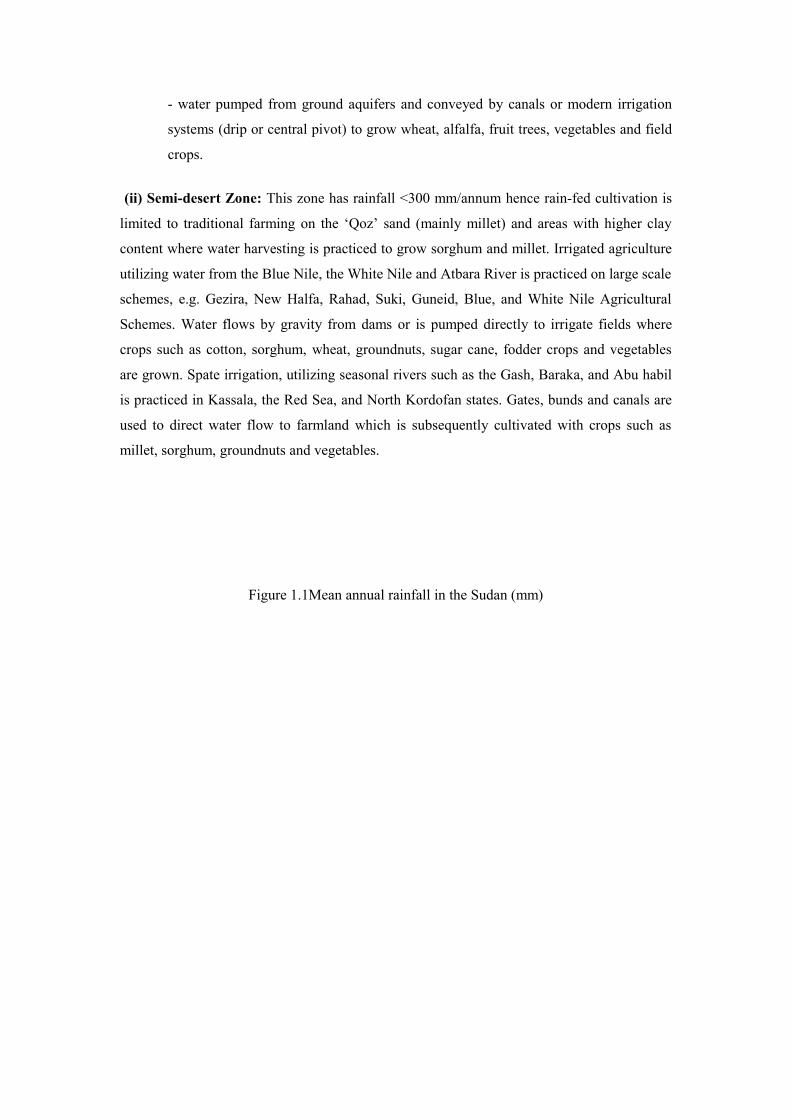
The six agro-ecological zones of the Sudan according to Harrison and Jackson (1958) are
shown in figure 1.2. These include: desert, semi-desert, low rain savanna, high rain savanna,
flood, and mountain zones. Details of these zones are depicted in table 1.1.
1.1.2 Major Agricultural Enterprises in Each Zone
(i) Desert zone: Irrigated agriculture is practiced along the banks of the River Nile and
Atbara River and on the neighboring lands where irrigation water is conveyed by canals;
mainly small privately owned farms, cooperative agricultural schemes, semi-governmental as
well as privately owned schemes growing field crops, vegetables, spices and fruit trees. The
practiced systems of irrigation include:
- basin irrigation depending on diversion of Nile water during flood periods; crops are
then grown utilizing residual moisture stored in the soil; crops include faba beans,
field beans, maize, lablab, and vegetables. These areas are now mostly replaced by
pump schemes.
- water pumped from the Nile and conveyed by canals to irrigate fields where crops
such as sorghum, wheat, beans, spices, alfalfa, sorghum, fruit trees and vegetables,
are grown;
- water pumped from ground aquifers and conveyed by canals or modern irrigation
systems (drip or central pivot) to grow wheat, alfalfa, fruit trees, vegetables and field
crops.
(ii) Semi-desert Zone: This zone has rainfall <300 mm/annum hence rain-fed cultivation is
limited to traditional farming on the ‘Qoz’ sand (mainly millet) and areas with higher clay
content where water harvesting is practiced to grow sorghum and millet. Irrigated agriculture
utilizing water from the Blue Nile, the White Nile and Atbara River is practiced on large scale
schemes, e.g. Gezira, New Halfa, Rahad, Suki, Guneid, Blue, and White Nile Agricultural
Schemes. Water flows by gravity from dams or is pumped directly to irrigate fields where
crops such as cotton, sorghum, wheat, groundnuts, sugar cane, fodder crops and vegetables
are grown. Spate irrigation, utilizing seasonal rivers such as the Gash, Baraka, and Abu habil
is practiced in Kassala, the Red Sea, and North Kordofan states. Gates, bunds and canals are
used to direct water flow to farmland which is subsequently cultivated with crops such as
millet, sorghum, groundnuts and vegetables.
Figure 1.1Mean annual rainfall in the Sudan (mm)

Figure 1.2 The agro-climatic zones of the Sudan
DESERT
SEMI-DESERT
LOW RAINFALL SAVANNA
FLOOD REGION
HIGH RAINFALL SAVANNA
MOUNTAIN
MOUNTAIN

Table 1.1 Ecological Zones of the Sudan*
Zone % of
Sudan
area
Mean
annual
rainfall
(mm)
Wet season Dry season Main land use types
Desert 28.9 <75 July to
September
October to
June
Irrigated agriculture
Grazing along
seasonal water courses
Semi-desert 19.6 75-300 July-
September-
November-
January
November-
June
March-
September
Irrigated agriculture
Dry land farming in
conjunction with water
harvesting-Pastoral
Low rainfall
savanna
27.6 300-800 May-
September
November-
April
Irrigated agriculture
Rain-fed traditional
cultivation
Mechanized farming
Pastoral
Forestry
High rainfall
savanna
13.8 800-1500 April-
October
December-
February
Rain-fed traditional
cultivation
Mechanized farming
Pastoral
Forestry
Flood region 9.8 600-1000 May-
October
December-
April
Traditional
cultivation
Pastoral
Wild life
Mountain
vegetation
0.3 300-1000 Variable Variable Traditional
cultivation
Pastoral
Forestry –
Horticulture
* Source: Harrison, M.N. and J.K. Jackson (1958). Ecological Classification of the Sudan,
Forest Department, Forest Bulletin No. 2, Ministry of Agriculture, the Republic of the Sudan
(iii) Low Rainfall Savanna Zone: This zone hosts irrigated agriculture as the large scale
schemes such as Gezira extend south into this Zone. Other large irrigated projects include
Suki, Rahad, Blue Nile Agricultural Schemes, White Nile Agricultural Schemes and the large
scale sugar cane plantations of Kenana, Guneid, New Halfa, Asalaya and West Sennar.
Traditional farming on clay soils produces sorghum and sesame while on sandy soil millet,
sesame, groundnuts, Roselle and water melon grow. This Zone is also the major producer of
gum Arabic from Acacia Senegal trees. Mechanized farming is practiced, particularly towards
the southern part of the zone; this is mostly large scale commercial rain-fed cultivation where
agricultural operations are partially or totally mechanized; production units are 400 ha in size
and main crops grown include sorghum, cotton, sesame and lately guar and sunflower.
Recently zero tillage (ZT) technologies were introduced to the mechanized rainfall sector.
These ZT technologies involve using direct seeding, herbicides, improved varieties,
fertilizers, and modern machinery.
(iv) High Rainfall Savanna: Traditional cultivation as well as mechanized farming are
practiced, as in the Low Rainfall Savanna Zone; however, in the higher rainfall areas in the
south west two crops may be produced per year due to the bimodal nature of the rainfall.
Forestry is an important activity producing fuel wood and wood for local industries.
(v) The flood plain: This zone is also known as the Sudd, where the land is flooded to
different degrees and for variable periods; is one of the largest fresh water swamps in the
world. The conditions of the Sudd environment made transhumant pastoralism inevitable and
has given rise to a mixed economy of herding, traditional cultivation, fishing and hunting.
Main crops grown are maize, sorghum, cowpeas, tobacco and pumpkins.
(vi) Mountains: Jabel Marra is the area utilized for agricultural production on a reasonable
scale; important for horticultural production e.g. citrus, mangoes, potatoes, other vegetables
and field crops such as wheat and sorghum, and timber.
1.2 Agricultural Production in the Sudan
Although production and export of oil are growing significantly in importance, agriculture
still remains the major source of income for most of the country’s population, 70% of who
live in rural areas. In the period 2002-2006, agriculture contributed between 38.8% and 46%
to GDP, employed 57% of the total economically active population and contributed about
90% of the non-oil export earnings (Ministry of Finance and national Economy). Sorghum is
the principal crop; livestock, cotton, sesame and groundnuts comprise the major agricultural
exports. Millet, wheat, gum Arabic, sugar cane and cassava are also grown. Within the
agricultural sector, crop production accounts for 53% of agricultural output, livestock 38%
and forestry and fisheries 9%.
Agriculture is generally divided, based on source of water, to irrigated and rain-fed. The most
salient features of agricultural production in Sudan are low productivity, low value of crops,
high fluctuation in areas and low water use efficiency (WUE).
1.2.1 Irrigated Agriculture
The total area of the irrigated sub-sector is about 1.9 Million hectare. It includes the Verisols
of Eastern and Central Sudan, the banks of the Nile (Blue, White, and main Nile) in additions
to Toker, Gash deltas, and Abu Habil. The irrigated sub-sector contributes 10.5-12.7 % of the
GDP. This sub-sector produces long and medium staple cotton, sorghum, groundnuts, wheat,
vegetables, legumes, fodders, sunflower, and maize. This sub-sector contributes to 100% of
sugar, 99% of cotton produced in the country in addition to 20-30% of sorghum, 30-40% of
groundnut produced in the Sudan. The irrigated sub-sector is characterized by its stable
production that forms a unique combination with the rain fed sub-sector. The irrigated sub-
sector played a key role during drought years and saved the country from major famines.
Irrigated agriculture could be divided, based on level of technology used, into modern and
traditional. Traditional agriculture is practiced along banks of the River Nile mainly in
Khartoum, Nile, and Northern States. In traditional irrigated agriculture surface irrigation and
flood irrigation are practiced. Tillage operations are performed by animals as well as tractors.
Seeding, weeding, and harvesting are manually performed. Recently small stationary
threshers were introduced to thresh wheat, sorghum, and legumes. Fertilizers and pesticides
are used in a limited manner. In modern irrigated agriculture higher levels of mechanization
are practiced. These include seed bed preparation, harvesting, and pest management using
tractor mounted field sprayers as well as knap sack sprayers. Mechanical seeding is recently
adopted with appreciable levels. Inputs are largely used in modern irrigated agriculture. These
include improved seeds, fertilizers, herbicides, pesticides, and growth hormones in sugar
projects. In modern irrigated agriculture a wide range of irrigation systems is used. These
include: surface irrigation, furrow irrigation, long furrow irrigation, gated pipes, drip
irrigation, as well as center pivot and linear sprinkler systems.
1.2.2 Rain fed Agriculture
The total area of the rain fed sub-sector amounts to about 15 Million ha depending on the
rainfall. All the rain fed areas lie south of 300 mm rain line and extend to the Southern
borders of the Sudan where the mean annual rainfall amount to 1500 mm. The rain fed sub-
sector contributes to about 6.8-9.9% of the GDP. The cultivated rain fed areas of the Sudan
amount to about 80% of the total cultivated area. This sub-sector contributes to about 70-80%
of sorghum produced in the Sudan, almost all the millet and all the sesame, and 60-70% of
produced groundnut.
The rain fed sub-sector is characterized by its huge potential for horizontal expansion. A
three-fold increase in the area is possible. There is also great potential for a vertical increase
in productivity. It is estimated that a three to four fold increase in yield is possible if by new
and improved technologies were adopted. Further more the rain fed sub-sector is
characterized by its low investment costs compared to the irrigated sub-sector. The rain fed
sub-sector could be divided into two: mechanized and traditional. The mechanized sub-sub-
sector uses tractors, disc harrows, mechanical seeders, combine harvesters and herbicides.
The mechanized sub-sub-sector is located on the Central Clay Plain of Eastern, central, and
Western Sudan, south of 500 mm rainfall line. The traditional sub-sub-sector a labor-intensive
system using hand tools and is located in the sands of Western Sudan in addition to Southern
Sudan.
1.3 Irrigation systems in the Sudan
Due to the diversity of climatic zones, soils, and farming systems a wide range of irrigation
systems are found in the Sudan. These irrigation systems could be classified according to type
of delivery of water from source to final field to three main categories: pump, gravity, and
flood. These categories are further divided according to size, source of water, or final field
type. Figure 1.- shows these systems.
A. Pump System: This system includes large, medium, and small pump schemes:
1. Large pump systems (area more than 20000 ha). This could be further divided into
public and private
a. Large public irrigation pumps systems: These include New Halfa, Rahad, and
Suki agricultural schemes that depend on electric pumps. These schemes are
owned and managed by the government. The federal government is responsible
for management of the irrigation system that includes the pumps as well as the
canals. The government delivers and avails irrigation water to farmers at cost.
Farmers manage water at the field levels.
b. Large private irrigation pump systems: These are owned by private companies
such as White Nile Sugar Company and Kenana Sugar Company in White Nile
state. The company owns and operates the irrigation system that includes the
pumps and the canalization system. The company also manages water at the field
level. Sugar Estates are owned by a government company, Sudanese Sugar
Company and managed as a para-statal. The company owns Guneid, New Halfa,
Sennar, and Assalaya sugar factories. The company owns and operates the
irrigation system that includes the pumps as well as the canalization system. The
company also manages water at the field levels using direct labor; no farmers are
involved in this system (except Guneid).
2. Medium irrigation pump systems (Area between 20000 ha and 420 ha)
a. Medium pump systems: Along the White, Blue and main Nile scatter a number
of small and medium size irrigation schemes. These are mainly located in
Northern, Nile, White Nile, Blue Nile, Sennar, and Khartoum states. Some of
these agricultural schemes are managed by cooperatives. The scheme
management is responsible for management of the irrigation and also responsible
for providing inputs such as seeds and fertilizers and also for availing mechanized
agricultural services such seed bed preparation and harvesting. The cooperative
sometimes avail credit for these inputs and services.
3. Small pump schemes (area less than 420 ha): In small pump schemes farmers
sometimes share the same pump or the pump is owned by an individual but farmers
are sharing and managing the water distribution by themselves. This system is
common in Nile and Northern states. Farmers have the freedom to cultivate what they
decide. The cost of water delivery is collected as cash or sometimes in kind as a share
of the harvested crop.
a. Small irrigation pumps from rivers: Large numbers of small size irrigation
projects privately owned are found along the Blue Nile, White Nile, and the main
Nile. Diesel and electric pumps are used to pump water to cultivate a variety of
crops. Theses include field crops, vegetables, and fruit trees.
b. Small irrigation pumps from ground aquifers: This privately owned system is
the most widely spread all around the Sudan in the desert, light and heavy
Savanna zones. Small size diesel or electric water pumps are used to cultivate
different types of crops.
B. Gravity irrigation:
The Gezira scheme is considered the largest irrigation system in the world under one
management. The irrigation system that includes Sennar Dam and the canals is jointly
managed by the Ministry of Irrigation and Sudan Gezira Board. Farmers are
responsible to manage water at the field level. Recently, after the implementation of
the Gezira Act for 2005, the Management of the lower irrigation system (minor
canals and field canals) was agreed to be transferred to farmers groups in the form of
water user associations (WUA). These associations will maintain the canals, control
weeds, clean sedimentation, and distribute water to farmers. The cost of management
will be paid by farmers and fees will be collected by these associations. Today the
Gezira Scheme is passing through a transitional stage in which preparatory activities
are going on, such as building the capacities of farmers and preparing the irrigation
system to be handed to the WUAs.
C. Flood system: This system is divided to flood and spate systems.
a. Flood system could be divided furthermore according to type of final field into:
i. Flood irrigation on river banks: Traditional flood irrigation takes place on
banks of rivers, mainly the Nile, in Khartoum, Nile, and Northern states.
During the flood season, water covers the cultivated agricultural land for
some time and then resides. The period of inundation varies with seasons
depending on the flood. After the end of the flood, the soil is covered with a
water saturated silt layer. Farmers using hand tools, perform seeding
operations. The majority of these lands are privately owned.
ii. Flood irrigation on seasonal rivers banks: After flooding of seasonal
streams such Atbara River, a flood plain is formed. This plain is cultivated by
individual private farmers to grow sorghum and vegetables. The same
technologies used in flood irrigation on rivers are adopted here.
iii. Flooded islands: A number of islands on the main Nile north of Khartoum
practice flood cultivation. These islands are inundated by water totally or
partially during the flood season. After the flood, farmers use residual water
to cultivate legumes, field crops, cereals, in addition to aromatic and
medicinal crops. Sometimes supplementary irrigation is applied using pumps.
iv. Seasonal streams water courses: This takes place after the end of the season
in some seasonal streams and tributaries of the Nile, such as Dinder and
Rahad in Eastern Sudan, and in some Wadis of Eastern and Western Sudan.
Farmers use residual soil moisture to cultivate vegetables and fruits mainly
tomatoes, cucurbits, and legumes.
v. Banks of Reservoirs: After the emptying periods of Roseiris, Sennar, and
Jebel Aulia reservoirs, fertile and water saturated areas on the banks are
formed. Theses areas are utilized by small farmers to grow different types of
vegetables and fruits. The same simple technologies used in flood systems
are also used here.
vi. Basin irrigation: basin irrigation is practiced in locations where there is a
low land is inundated by the Nile during the flood season. This found in
Seleim basin in Northern State, in Salawa and Wad Hamid basins in Nile
state. Farmers in these basins collectively organize themselves, work together
to facilitate flood water movement in their lands. After water resides, crops
such as wheat, legumes, fodders, and vegetables are sown. No additional
irrigation is needed. Recently, small pumps were introduced to supplement
basin irrigation. In some place like Seleim (Northern State) large pumps
replaced the traditional basin irrigation.
b. Spate system: Three locations practice spate irrigation in the Sudan. These are
Gash in Kassala State irrigated by Gash River, Toker in Red Sea State irrigated
by Khor Baraka, and Abu habil in North Kordofan state. The roaring water from
the seasonal rivers is directed by diverting structures and canals to flood
demarcated areas. The irrigable area is decided every year by the volume of water
carried by the river. This area is divided by the community in a well defined
system by the tribes to farmers. Farmers perform the seeding operation and
control weeds using manual tools. The crop grows on residual moisture in the soil
and no irrigation is needed. Sometimes two crops are grown in one season.
Cultivated crops include sorghum, millet, vegetables, watermelons, and recently
sunflowers were introduced to these areas.


Figure 1.3 Classification of irrigation systems in the Sudan
ةثية
18
IRRGATION SYSTEMS IN THE SUDAN
GRAVITY PUMPFLOOD
LARGE MEDIUM SMALL
PUBLICPRIVATE PRIVATE AQUIFER RIVERPUBLIC
SPATERESIDUAL
RIVER COURSEDAM LAKEISLANDBASINRIVER BANK SEASONAL RIVER BANK

1.
19
CHAPTER TWO: BEST PRACTICES
In this chapter currently used water harvesting and irrigation practices and technologies adopted at
different agricultural systems of production in the Sudan will be identified and listed. Some of these
are traditional, some are developed locally or in the region, while some are modern, transferred and
adopted through importation or from research findings.
Best Practices in Water Harvesting
Water harvesting (WH) is practiced at wide areas across the Sudan in low rainfall and high rainfall
Savanna regions in traditional agriculture, human and animal use, as well as forest production in
places having rainfall starting from 75 mm per annum. Water harvesting practices are actually found
in all the states of the Sudan. The effectiveness and efficiency of WH practices depend on factors
such as soil type, rainfall, and crop.
a. Bunds or terraces: This is one of the traditional technologies that had been used for
hundreds of years in low rainfall areas. Bunds are built to collect water in sloping areas
according to the contour. Seeding of crops starts when there is enough moisture in the soil.
The rain water is collected and efficiently used by the crops. The main crops cultivated are
sorghum and millet. Contour bunds are mainly found in eastern, central, and northern regions
of the Sudan. These include states of Red Sea, Kassala, Gedarif, Khartoum, Gezira, White
Nile, Sennar, and Nile.
b. Ridges: Four body ridging machines fully mounted on tractors were introduced in large
irrigated areas in the Central clay plane of the Sudan to build ridges in surface furrow
irrigation systems. The use of these machines extended to neighboring rain-fed areas. After
the on set of rains, the hard soils become workable for tillage tools. Ridgers are used to break
the soil, control weeds, and build ridges. This is followed by manual seeding in the furrow.
Farmers put the seeds in the open furrows and cover these seeds by foot pressing.
c. Tied ridge: Tied ridge is an improved ridge system. In the ridge system furrows are open
built without any consideration to slope and are left open-ended. In the tied ridge system
ridges are built at right angles to slopes and closed (tied) by cross ridges to prevent water run-
off.
d. Sayreen: This is a new innovation by farmers in Sennar state. It is a modification to the ridge
system. Two persons holding seeds will ride on the back of the tractor carrying the ridging
machine. During the ridging operation the two persons start manually drilling the seeds in the
20
furrows. This combined operation of ridge formation and seeding saves much time and effort.
It helped farmers catch early rain showers and resulted in a good harvest.
e. Micro-catchments: These practices are newly tested and developed by research in the Sudan.
A number of techniques were evaluated including triangular, rectangular, and semi-circular
shapes. Results showed that rectangular and triangular shapes are suited for trees and field
crops while semi-circular shapes are best for range production. These improved technologies
are being transferred in many development projects and are now spreading across the country
especially in the low rain savanna zone.
f. Small dams: Small dams are now found in greater Kordofan, greater Darfur, Gedarif, White
and Blue Nile, Sennar, kassala, Nile, and in Red Sea states. These are used for drinking water
and for crops cultivated by communities and individual farmers depending on size of the dam.
Small dams are also constructed in some places to help recharging ground aquifers. Federal,
United Nations Agencies, NGOs, as well as state governments had allocated large funds for
establishment of small dams.
g. Boabab trees: In North Kordofan state, the stems of the baobab tree (Adansonia digitata) is
engraved and used as a tank to store rain water. This proved to avail clean water for drinking
during the dry season. The stored volume of water ranges between 3 m3 and 5 m3 depending
on tree size.
h. Haffirs: A haffir is an artificial excavation into which surface water run-off is converged
during the rainy season to be stored and used during the dry season. The size of haffirs varies
much depending on location, hydrology, soils, rainfall and ranges between 5000 and 30000
m3. Haffirs are divided into traditional and standard. Traditional Haffirs go back to more than
hundred years. Standard Haffirs were developed using modern engineering design.
Components of standard Haffirs include: stilling pool, inlet and outlet wells, inlet and outlet
valves, energy dissipater, stainer, Haffir pond, embankments, pump units, animal troughs,
filters, drainage canal, and fencing. Haffir water is used for drinking by humans and animals.
Best Practices in Small scale irrigation
b. Surface irrigation: Is practiced in almost all irrigation systems except flood systems.
Depending on the type of cultivated crop, the tilled land is either left flat, or shaped in ridges
or beds. Ridges vary in width between 60 cm to 90 cm, while beds vary from 1.0 m to 1.5 m.
c. Basin irrigation: basin irrigation is practiced in locations where there is a low lands
inundated by the Nile during the flood season. This found in Seleim basin in Northern State,
in Salawa and Wad Hamid basins in Nile state. Farmers in these basins collectively organize
21
themselves, work together to facilitate flood water movement in their lands. After water
resides, crops such as wheat, legumes, fodders, and vegetables are sown. No additional
irrigation is needed. Recently, small pumps were introduced to supplement basin irrigation. In
some place like Seleim (Northern State) large pumps replaced the traditional basin irrigation.
d. Spate irrigation: Three locations practice large flood or flush or spate small scale irrigation
in the Sudan. These are Gash in Kassala State irrigated by Gash River, Toker in Red Sea State
irrigated by Khor Baraka, and Abu habil in North Kordofan state. The roaring water from the
seasonal rivers is directed by diverting structures and canals to flood demarcated areas. The
irrigable area is decided every year by the volume of water carried by the river. This area is
divided by the community in a well defined system by the tribes to farmers. Farmers perform
the seeding operation and control weeds using manual tools. The crop grows on residual
moisture in the soil and no irrigation is needed. Sometimes two crops are grown in one
season. Cultivated crops include sorghum, millet, vegetables, watermelons, and recently
sunflowers were introduced to these areas.
e. Flood irrigation on river banks: Traditional flood irrigation takes place on banks of rivers,
mainly the Nile, in Khartoum, Nile, and Northern states. During the flood season, water
covers the cultivated agricultural land for some time and then resides. The period of
inundation varies with seasons depending on the flood. After the end of the flood, the soil is
covered with a water saturated silt layer. Farmers using hand tools, perform seeding
operations. The majority of these lands are privately owned.
f. Flood irrigation on seasonal rivers banks: After flooding of seasonal streams such Atbara
River, a flood plain is formed. This plain is cultivated by individual private farmers to grow
sorghum and vegetables. The same technologies used in flood irrigation on rivers are adopted
here.
g. Flooded islands: A number of islands on the main Nile north of Khartoum practice flood
cultivation. These islands are inundated by water totally or partially during the flood season.
After the flood, farmers use residual water to cultivate legumes, field crops, cereals, in
addition to aromatic and medicinal crops. Sometimes supplementary irrigation is applied
using pumps.
h. Seasonal streams water courses: This takes place after the end of the season in some
seasonal streams and tributaries of the Nile, such as Dinder and Rahad in Eastern Sudan, and
in some Wadis of Eastern and Western Sudan. Farmers use residual soil moisture to cultivate
vegetables and fruits mainly tomatoes, cucurbits, and legumes.
i. Banks of Reservoirs: After the emptying periods of Roseiris, Sennar, and Jebel Aulia
reservoirs, fertile and water saturated areas on the banks are formed. Theses areas are utilized
22
by small farmers to grow different types of vegetables and fruits. The same simple
technologies used in flood systems are also used here.
j. Bubbler systems: These are used in a very limited scale in orchards to irrigate vegetables and
fruits. Examples could be seen in Khartoum and kassala States.
Best Practices in Large scale irrigation
c. Long furrow: long furrow irrigation was first largely introduced to the Sudan in Rahad
Agricultural Project in eastern Sudan in mid 1970's but was abolished for many reasons.
Today long furrows are only largely used in Kenana Sugar fields in the White Nile state.
Long furrows that reach 2.75 km are established after the land is prepared and laser leveled.
Siphons are used to deliver water from the canals to the furrows.
d. Gated pipes: The gated pipes system was introduced lately and adopted largely in Kenana
sugar fields in the White Nile state. This system helped in reducing irrigation water delivery
losses and also reduced time and cost of irrigation of sugar fields.
e. Stationary sprinkler systems: These systems are used in limited areas of vegetable
production and commonly used in landscaping to irrigate turfs and ornamental plots in
Khartoum state.
f. Center pivot sprinkler irrigation: This type is practiced in Khartoum, Nile, and Northern
states. It is mainly used by modern investment companies to cultivate alfalfa for export and
other field crops such as wheat. Source of water for these systems is either from the Nile or
from ground aquifers.
g. Linear sprinkler irrigation: Is used in Khartoum and Nile states by modern investment
companies. These systems, same as center pivot systems, are used to cultivate wheat, alfalfa,
and vegetables.
h. Drip irrigation systems: Are largely used in landscaping and to irrigate house gardens. Drip
irrigation is used in orchards to irrigate trees and also used in green houses to produce
vegetables in Khartoum and Gezira states.
23
CHAPTER THREE: SELECTED SITES
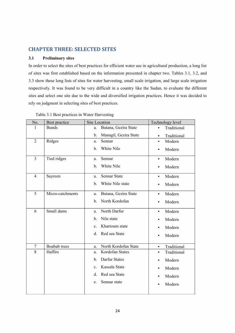
3.1 Preliminary sites
In order to select the sites of best practices for efficient water use in agricultural production, a long list
of sites was first established based on the information presented in chapter two. Tables 3.1, 3.2, and
3.3 show these long lists of sites for water harvesting, small scale irrigation, and large scale irrigation
respectively. It was found to be very difficult in a country like the Sudan, to evaluate the different
sites and select one site due to the wide and diversified irrigation practices. Hence it was decided to
rely on judgment in selecting sites of best practices.
Table 3.1 Best practices in Water Harvesting
No. Best practice Site Location Technology level1 Bunds a. Butana, Gezira State
b. Managil, Gezira State
• Traditional
• Traditional2 Ridges a. Sennar
b. White Nile
• Modern
• Modern
3 Tied ridges a. Sennar
b. White Nile
• Modern
• Modern
4 Sayreen a. Sennar State
b. White Nile state
• Modern
• Modern
5 Micro-catchments a. Butana, Gezira State
b. North Kordofan
• Modern
• Modern
6 Small dams a. North Darfur
b. Nile state
c. Khartoum state
d. Red sea State
• Modern
• Modern
• Modern
• Modern
7 Boabab trees a. North Kordofan State • Traditional8 Haffirs a. Kordofan States
b. Darfur States
c. Kassala State
d. Red sea State
e. Sennar state
• Traditional
• Modern
• Modern
• Modern
• Modern
24
Table 3.2 Best practices in Small scale irrigation
No. Best practice Site Location Technology level1 Surface irrigation a. Gezira Scheme
b. New halfa Scheme
c. Rahad project
d. Suki project
• Traditional
2 Basin irrigation a. Wad Hamid, Nile State • Traditional3 Spate irrigation a. Gash
b. Toker
c. Abu Habil
• Traditional
4 Flood on river banks a. Nile state
b. Khartoum State
• Traditional
5 Flood on seasonal
river banks
a. Atbara River • Traditional
6 Flooded islands a. Northern State • Traditional7 Seasonal streams
water courses
a. Rahad
b. Dindir
• Traditional
• Traditional8 Banks of Reservoirs a. Roseirs
b. Sennar
c. Jabel Aulia
• Traditional
• Traditional
• Traditional9 Bubbler system a. Khartoum State
b. Kassala State
• Modern
• Modern
Table 3.3 Best practices in Large scale irrigation
No. Best practice Site Location Technology level1 Long furrow Kenana • Modern2 Gated pipes Kenana • Modern3 Stationary sprinkler
systems
Khartoum State • Modern
4 Center pivot
sprinkler irrigation
a. Nile state
b. Northern State
• Modern
• Modern5 Lateral sprinkler
irrigation
a. Khartoum State
b. Nile state
• Modern
• Modern6 Drip irrigation
systems
a. West Omdurman
b. African/Malaysian
• Modern
• Modern
Selected site for water harvesting
Looking at the different sites of best practices in WH, and recognizing the diversity of
practices and the distribution of these sites, it appears that selecting one specific site would
25
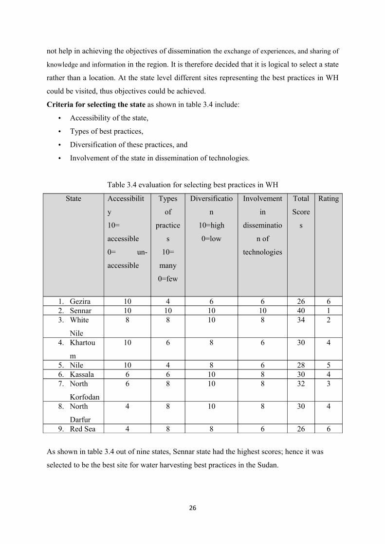
not help in achieving the objectives of dissemination the exchange of experiences, and sharing of
knowledge and information in the region. It is therefore decided that it is logical to select a state
rather than a location. At the state level different sites representing the best practices in WH
could be visited, thus objectives could be achieved.
Criteria for selecting the state as shown in table 3.4 include:
• Accessibility of the state,
• Types of best practices,
• Diversification of these practices, and
• Involvement of the state in dissemination of technologies.
Table 3.4 evaluation for selecting best practices in WH
State Accessibilit
y
10=
accessible
0= un-
accessible
Types
of
practice
s
10=
many
0=few
Diversificatio
n
10=high
0=low
Involvement
in
disseminatio
n of
technologies
Total
Score
s
Rating
1. Gezira 10 4 6 6 26 62. Sennar 10 10 10 10 40 13. White
Nile
8 8 10 8 34 2
4. Khartou
m
10 6 8 6 30 4
5. Nile 10 4 8 6 28 56. Kassala 6 6 10 8 30 47. North
Korfodan
6 8 10 8 32 3
8. North
Darfur
4 8 10 8 30 4
9. Red Sea 4 8 8 6 26 6
As shown in table 3.4 out of nine states, Sennar state had the highest scores; hence it was
selected to be the best site for water harvesting best practices in the Sudan.
26
Selected Site for small scale irrigation The Gezira Scheme is considered as the largest irrigation project under one management in the world.
This uniqueness of the Gezira qualified it to be the site for best practices in small scale irrigation
systems.
The Gezira Scheme (GS), located between the Blue and White Nile was established in 1925 when the
Sennar Dam across the Blue Nile was completed. In 1959-63 the original Gezira Scheme was
extended to include the Managil area. The combined Gezira/Managil Scheme now covers a command
area about 2.1 million feddan (about 882,000 hectares) under gravity irrigation. Estimates of the total
potential cultivable area under irrigation in Sudan within the Nile Basin vary, but it is approximately
between four and five million feddan . Hence the GS represents about a quarter of all irrigation area in
Sudan and half the area of irrigation schemes drawing water from the Nile system. It uses about 35
percent of Sudan's current allocation of Nile water, About 55% of the GS is the property of the central
Government. The remainder of about 45% of the land is still owned by previous landholders and with
whom the central government has a long term rental agreement. Designed for a cropping intensity of
0.75 the achieved cropping intensity is usually no more than 0.50 which is very low by any
international standard.
Irrigation water is supplied from the Blue Nile reservoirs at Roseires and Sennar. The Blue Nile has
an average annual flow of 50-billion cubic meters at Roseires, with large seasonal and annual
variations. The flow of the Blue Nile rises steeply from the end of June to an end-of-August peak,
followed by a sharp decline, to a minimum flow of about two percent of the peak, at the end of April.
The Blue Nile carries large quantities of silt as a result of its steep gradient and heavy seasonal rainfall
in its upper catchment area. The silt load in the Nile is heaviest during July and August and as a result
of an increase in irrigation during these months.
Water is diverted from the Sennar reservoir by means of twin main canals with a combined maximum
daily discharge capacity of 31.5 million cubic meters (354 cubic meters per second), running north to
the first group of canal regulators 57 kilometers from the dam. From there four branch canals convey
water to the Managil extension, while the Gezira main canal runs north for another 137 kilometers.
Major canals take off from main and branch canals and supply water to minor canals. These canals
flow continuously throughout the growing season. The network consists of 2,300 kilometers of branch
and major canals, and over 8,000 kilometers of minor canals. Minor canals supply water via gated
outlet pipes to field channels (Abu Ishrin) each irrigating 90 feddans, (38 hectare), called "Numbers".
Each number is divided into 18 tenant fields of 5 feddans (called hawasha). Water flows in the
primary canal network (main, branch and majors) continuously during the irrigation season - July
through April. Minor canals were designed to store water at night as irrigation was to be carried out
27
only during the hours of daylight but this is no longer practiced. The water is released based on an
indenting procedure whereby at the beginning of each cropping season the demand at each minor
canal and the delivery losses are calculated for various reaches of the canals up to the Sennar Dam.
The volume of water released is regulated by various control structures throughout the system. The
major canals have peak design capacity of 20 cubic meters/feddan/day (equivalent to 0.55
liter/second/feddan) in Managil and between 13.5 and 15 cubic meters/feddan/day in Gezira
(equivalent to between 0.37 and 0.41 liter/second/feddan). These capacities were based on the peak
water requirement of the cropping pattern and intensity envisioned at the design stage. They
determine the optimum capability of the irrigation system for water delivery and distribution and crop
diversification and intensification, which indicates that there is greater flexibility at Managil
extension. The minor canals are grossly over designed for the flows (0.5 to 1.5 cubic meters/second)
that they are intended to carry. Minor canals are set at very slight slopes, 0 to 5 cm per kilometer, and
flow with very low water velocities, and thus have a very limited sediment transporting capacity.
They act as sediment traps particularly at the head reaches of the canals. Weed growth reduces
velocities further, enhancing rates of sediment deposition. The result is a massive de-silting
requirement as part of annual maintenance.
In the Gezira scheme seepage losses are virtually nil due to the extremely impermeable nature of the
soil and subsoil. Irrigation water does not contribute to the deep groundwater table underlying the
scheme. Evaporation and breakage from the canals to the roads and fallow areas are the major sources
of water losses from the system. Therefore, the water use efficiency of the irrigation network is
potentially very high.
The present drainage system consists of 1,500 km of major drains and about 6, 000 km of minor
drains. There are no on-farm drainage facilities due to the nature of the soil and absence of high
groundwater table. The main purpose of the drainage is to remove the surface runoff due to rain or
excess irrigation.
The Gezira scheme was built with the primary objective of producing cotton. The land is divided into
about 138,000 tenancies with an average size of 20 feddan (about 8 ha). Each tenant has plots in five
numbers (tertiary units) and has to plant according to the approved rotation so that all the cotton fields
are together, all the fallow together in another "Number" and so on. In the very early days a six-course
rotation was practiced, but following some failures, this was changed in the early 1930's to an eight-
course rotation (cotton, fallow, fallow, cotton, fallow, sorghum, lubia, and fallow) with nominal
cropping intensity of 50%. This kept the demand for water within the capacity of the irrigation system
to deliver. Since that time there has been further diversification and intensification. Until recently, the
main Gezira scheme had a nominal intensity of 75% in a five-course rotation of cotton, sorghum,
28
groundnuts, wheat with one fallow, while the Managil extension had 100% with no fallow. At the
present, however, fallow has also been introduced in Managil where the target cropping intensity is
75% throughout, although various problems have kept the actual intensity well below that figure in
recent years.
Current water management in the Gezira Scheme is substantially different from the original design,
which was used satisfactorily prior to the 1960's. The two-fold expansion of the irrigation area and
successive crop intensification in mid-1960's following completion of Managil extension required
additional quantities of water to be diverted and distributed. Accordingly, the volume of water
released to the system at Sennar increased by more than three-fold from 2,000 million cubic meters in
1957-58 to 7,100 million cubic meters in 1997-98.
The management of the GS in respect to irrigation water has always been divided between the
Ministry of Irrigation and Water Resources (MOIWR) and Sudan Gezira Board (SGB). MOIWR is
responsible for supply and delivery of water to the minor canals. In 1995, MOIWR established the
Irrigation Water Corporation (IWC), a financially independent parastatal, to operate and maintain the
irrigation system in the GS and other large central Government-owned.
In practice the tenants are involved in operation and maintenance of the smallest field canals (Abu
Sittas) control of the operation of the larger tertiary canals (Abu xx). On the other hand maintenance
of Abu xx canals is carried out by SGB at the tenant's expense. The Gezira Scheme is now passing
through a transformation process in which farmers are starting to manage the lower level system
(minors and field canals) through the Water User Associations established by the new Gezira Act for
2005.
The visitor to Gezira Scheme will be able to see the extensive irrigation system, know how it was
designed, and how it is managed and maintained.
3.3 Selected site for large scale irrigationKenana Sugar Estate is one of the best examples of adoption of new technologies especially in
irriation. It is also recognized as one of the best managed agricultural projects. This is why Kenana
Sugar Estate was selected to represent best practices site for private irrigation in the Sudan. Kenana
Sugar Estate (latitude 13ºN 3, longitude 30º East) is located in the Central Clay Plain of the Sudan
about 300 km south of the capital Khartoum near the town of Rabak (White Nile State) on the eastern
bank of the White Nile. The total area of the project is 70 000 hectares, the cultivated area amounts to
45 000 hectares.
29
Six pumps are connected in series along the main canal to lift irrigation water to 46 meters above the
White Nile level. The first two Pump stations were designed to pump 42m3/s. the main canal is
branched into primary canal to divert irrigation water to the field canal via off take pipes. Each field
canal is designed to irrigate one field (40-90 hectare), which is split into two sectors and each sector
consists of 60 furrows with 1.55 m spacing. Furrows run perpendicular to contour lines with lengths
ranging from 300 to 2750 meters.
Irrigation practice in Kenana was subjected to many changes. In 1981 the water indenting was based
on fixed days per cycle, and different sizes of siphons were used in the same field to maintain the
cycle regardless of the field gradient of furrow length. An irrigation system bases on evapo-
transpiration 910 mm/day) was introduced in 1983. In 1987 an indenting system of irrigation based on
the number of operating pumps was adopted. Recently, the Estate field was divided into three
categories (A, B, and C) based on steepness and furrow length. These categories received water every
12, 10, and 7 days respectively. In 2002 the open channel furrow irrigation system was gradually
changed to the close system of gated pipes. Today about 75% of the planted area is using the closed
irrigation system.
The visitor to Kenana will observe the high efficiency of management and the modern technology
adoption in seed bed preparation, laser leveling and will also observe the modern irrigation systems
such as gated pipes and long furrow systems.
30
CHAPTER FOUR
NATIONAL INSTITUTIONS4.1 Identification of institutionsThe objectives of this chapter is to identify, list and describe potential institutions in the Sudan to be
used in organizing capacity building activities and other field related activities such as demonstrations
and dissemination of technologies in the fields of water harvesting, irrigation, efficient use of water
for Agriculture, watershed management, and integrated water resources management. The target
institutions are categorized into:
A. Research institutions
B. Universities and institutions of higher learning
C. Non-government organizations
D. Public institutions
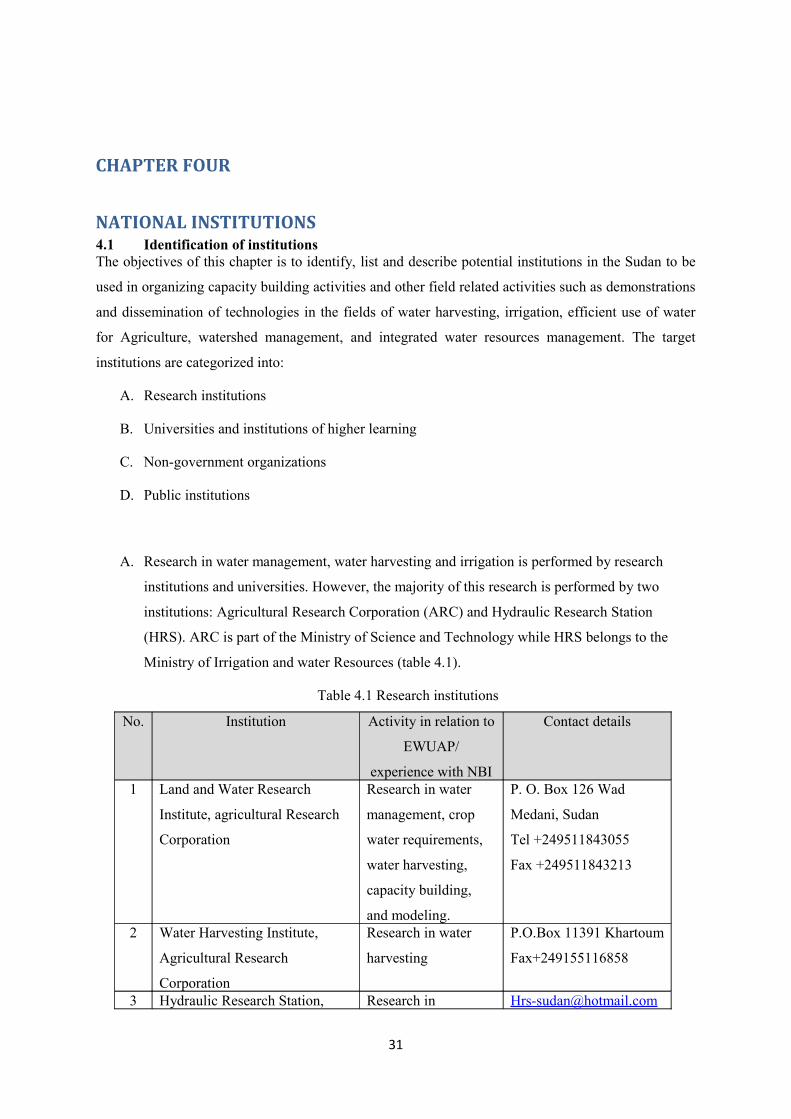
A. Research in water management, water harvesting and irrigation is performed by research
institutions and universities. However, the majority of this research is performed by two
institutions: Agricultural Research Corporation (ARC) and Hydraulic Research Station
(HRS). ARC is part of the Ministry of Science and Technology while HRS belongs to the
Ministry of Irrigation and water Resources (table 4.1).
Table 4.1 Research institutions
No. Institution Activity in relation to
EWUAP/
experience with NBI
Contact details
1 Land and Water Research
Institute, agricultural Research
Corporation
Research in water
management, crop
water requirements,
water harvesting,
capacity building,
and modeling.
P. O. Box 126 Wad
Medani, Sudan
Tel +249511843055
Fax +249511843213
2 Water Harvesting Institute,
Agricultural Research
Corporation
Research in water
harvesting
P.O.Box 11391 Khartoum
Fax+249155116858
3 Hydraulic Research Station, Research in [email protected]
31

Ministry of irrigation hydrology, hydraulics
and irrigation.
P.O.Box 318 wad
Medani, Sudan
+249511842222
B. Universities and institutions of higher learning: In the Sudan there are about 25 universities.
A survey was conducted to identify institutions that teach irrigation and water management
subjects. These included water harvesting, irrigation, advanced irrigation, and irrigation
management. Results of the survey shown in table 4.2 revealed that eight institutions are
involved in these activities.
Table 4.2 Universities and institutions of higher learning
No. Institution Activity in relation
to
EWUAP/experienc
e with NBI
Contact details
1 Department of Agricultural
Engineering, faculty of Agriculture,
University of Khartoum
Under graduate and
post graduate
studies in irrigation
P.O. Box 32
Postal Code 13314
Khartoum North - Sudan
Tel: +24918513310101
Fax:
email: [email protected] 2 Department of Agricultural
Engineering, faculty of Engineering,
University of Khartoum
Under graduate
studies in irrigation
P.O. Box 321
Postal Code 11115
Khartoum- Sudan
Tel: +249183776973
Fax: +249183771516
Email: [email protected] Department of Agricultural
Engineering, College of Agricultural
Studies, Sudan University of Science
and Technology
Under graduate and
post graduate
studies in irrigation
+249185311007
+2491853110824 Department of Agricultural
Engineering, faculty of Agriculture,
Omdurman Islamic University
Under graduate and
post graduate
studies in irrigation
P. O. Box 382 Omdurman,
Sudan
Tel +249 875115365 Agricultural engineering department,
faculty of agriculture, university of
Under graduate
studies in irrigation
P. O. Box 47 Dongola,
Northern State
32
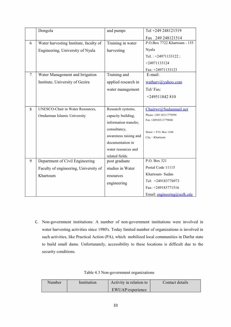
Dongola and pumps Tel +249 248121519
Fax _249 2481215146 Water harvesting Institute, faculty of
Engineering, University of Nyala
Training in water
harvesting
P.O.Box 7722 Khartoum - 155
Nyala
Tel. : +24971133122 ;
+24971133124
Fax: +249711331237 Water Management and Irrigation
Institute, University of Gezira
Training and
applied research in
water management
E-mail:
Tel/ Fax:
+249511842 810
8 UNESCO-Chair in Water Resources,
Omdurman Islamic University
Research systems,
capacity building,
information transfer,
consultancy,
awareness raising and
documentation in
water resources and
related fields.
Phone +249 18311779599
Fax +24918311779604
Street - P.O. Box 1244
City – Khartoum
9 Department of Civil Engineering
Faculty of engineering, University of
Khartoum
post graduate
studies in Water
resources
engineering
P.O. Box 321
Postal Code 11115
Khartoum- Sudan
Tel: +249183776973
Fax: +249183771516
Email: [email protected]
C. Non-government institutions: A number of non-government institutions were involved in
water harvesting activities since 1980's. Today limited number of organizations is involved in
such activities, like Practical Action (PA), which mobilized local communities in Darfur state
to build small dams. Unfortunately, accessibility to these locations is difficult due to the
security conditions.
Table 4.3 Non-government organizations
Number Institution Activity in relation to
EWUAP/experience
Contact details
33
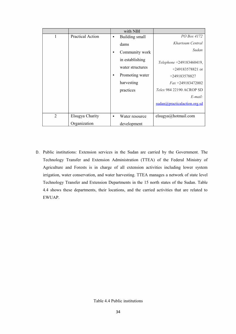
with NBI1 Practical Action • Building small
dams
• Community work
in establishing
water structures
• Promoting water
harvesting
practices
PO Box 4172
Khartoum Central
Sudan
Telephone +249183460419,
+249183578821 or
+249183578827
Fax +249183472002
Telex 984 22190 ACROP SD
E-mail:
2 Elsugya Charity
Organization
• Water resource
development
D. Public institutions: Extension services in the Sudan are carried by the Government. The
Technology Transfer and Extension Administration (TTEA) of the Federal Ministry of
Agriculture and Forests is in charge of all extension activities including lower system
irrigation, water conservation, and water harvesting. TTEA manages a network of state level
Technology Transfer and Extension Departments in the 15 north states of the Sudan. Table
4.4 shows these departments, their locations, and the carried activities that are related to
EWUAP.
Table 4.4 Public institutions
34
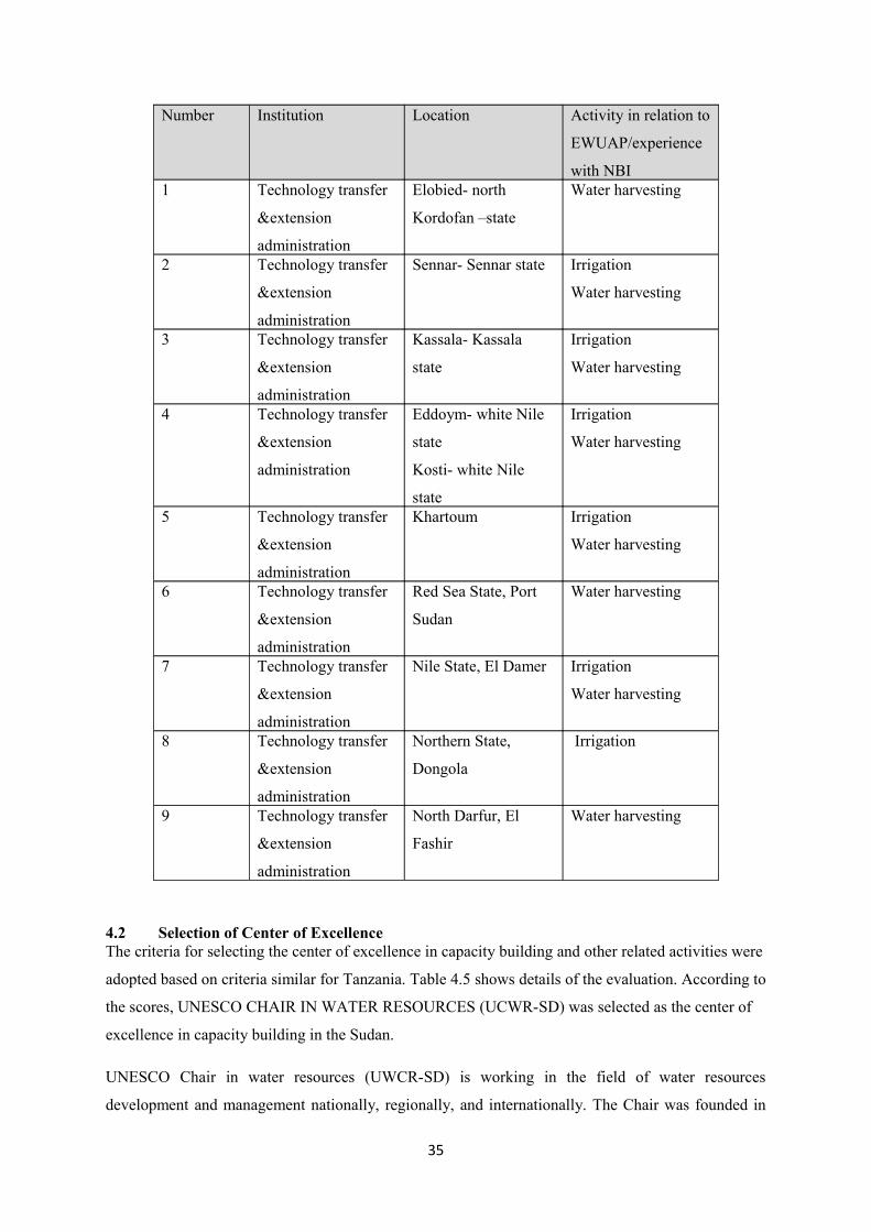
Number Institution Location Activity in relation to
EWUAP/experience
with NBI 1 Technology transfer
&extension
administration
Elobied- north
Kordofan –state
Water harvesting
2 Technology transfer
&extension
administration
Sennar- Sennar state Irrigation
Water harvesting
3 Technology transfer
&extension
administration
Kassala- Kassala
state
Irrigation
Water harvesting
4 Technology transfer
&extension
administration
Eddoym- white Nile
state
Kosti- white Nile
state
Irrigation
Water harvesting
5 Technology transfer
&extension
administration
Khartoum Irrigation
Water harvesting
6 Technology transfer
&extension
administration
Red Sea State, Port
Sudan
Water harvesting
7 Technology transfer
&extension
administration
Nile State, El Damer Irrigation
Water harvesting
8 Technology transfer
&extension
administration
Northern State,
Dongola
Irrigation
9 Technology transfer
&extension
administration
North Darfur, El
Fashir
Water harvesting
4.2 Selection of Center of ExcellenceThe criteria for selecting the center of excellence in capacity building and other related activities were
adopted based on criteria similar for Tanzania. Table 4.5 shows details of the evaluation. According to
the scores, UNESCO CHAIR IN WATER RESOURCES (UCWR-SD) was selected as the center of
excellence in capacity building in the Sudan.
UNESCO Chair in water resources (UWCR-SD) is working in the field of water resources
development and management nationally, regionally, and internationally. The Chair was founded in
35
1994 following the Agreement between UNESCO Director General and the Vice Chancellor of
Omdurman Islamic University on behalf of the Sudan Government.
The main objectives of UCWR-SD are to promote integrated research, systems, capacity building,
technology and information transfer, consultancy, awareness and documentation and dissemination of
critical issues in water resources and related fields.
UCWR-SD offers several capacity building programs in collaboration with Omdurman Islamic
university, University of Khartoum, Sudan University of Science and Technology, in addition to
many national and international institutions. Postgraduate programs include: M. Sc. in Hydrology, M.
Sc. And Diploma In Water resources Development and management. The Chair also offers
postgraduate studies leading to Ph. D. degree by research and a number of non-degree professional
short training courses specially designed to suit institutional needs in the area of water.
UCWR-SD employs about 20 full time staff members in addition to More than 50 Collaborators from
National, Regional and international Universities and Institutes.
UCWR-SD has its own Headquarters. It is considered by the Omdurman Islamic University as a
separate Institute. It has good logistics and well equipped with computers, plotters, digitizers, printers,
lecture rooms, projectors, etc. It has a good library and a decent computer lab with sufficient
computers well connected in a network with direct access to Internet and a video Conference hall.
Also it has water quality laboratory for water quality management from physical, chemical and
biological points of views.
The collaboration and networking programs of UCWR-SD were designed to strengthen the
institutional interrelations among the different institutions in the country, region and worldwide to
provide grounds for exchanging experience. Accordingly, the Chair started to formulate networks
within the region to serve this purpose and participate in other regional and international network
programs. A list of such networks include, Friend Nile Networking Project, Nile Basin Capacity
Building Network for River Engineering (NBCBN-RE) Network, Groundwater Protection Network in
the Arab Region (GWPN), Wadi Hydrology Network in the Arab Region (WHN), Arab Network for
Water Researchers, Consultative Group for International Agriculture Research (CGIAR),
International Network for Capacity Building in IWRM (Cap-net), TIGER Initiative, SWMnet/IMWI,
HELP Program, and Nile Basin Initiative, NBI, in applied training and research studies.
The UCWR-SD meets the need for expertise in the real world by providing consultancy services.
Several water-related consultancy projects were done annually.
36

In recognition to its excellent performance in the field of water resources and capacity building
UCWR-SD was awarded the UNESCO UNITWIN Distinction Award, UNESCO HQ, Paris,
November. 2002. It was also awarded Appreciation award for outstanding performance and
distinguished efforts, The National Water Research Centre.
37

Table 4.5 Evaluation for center of excellence in centers for excellence in capacity building
38
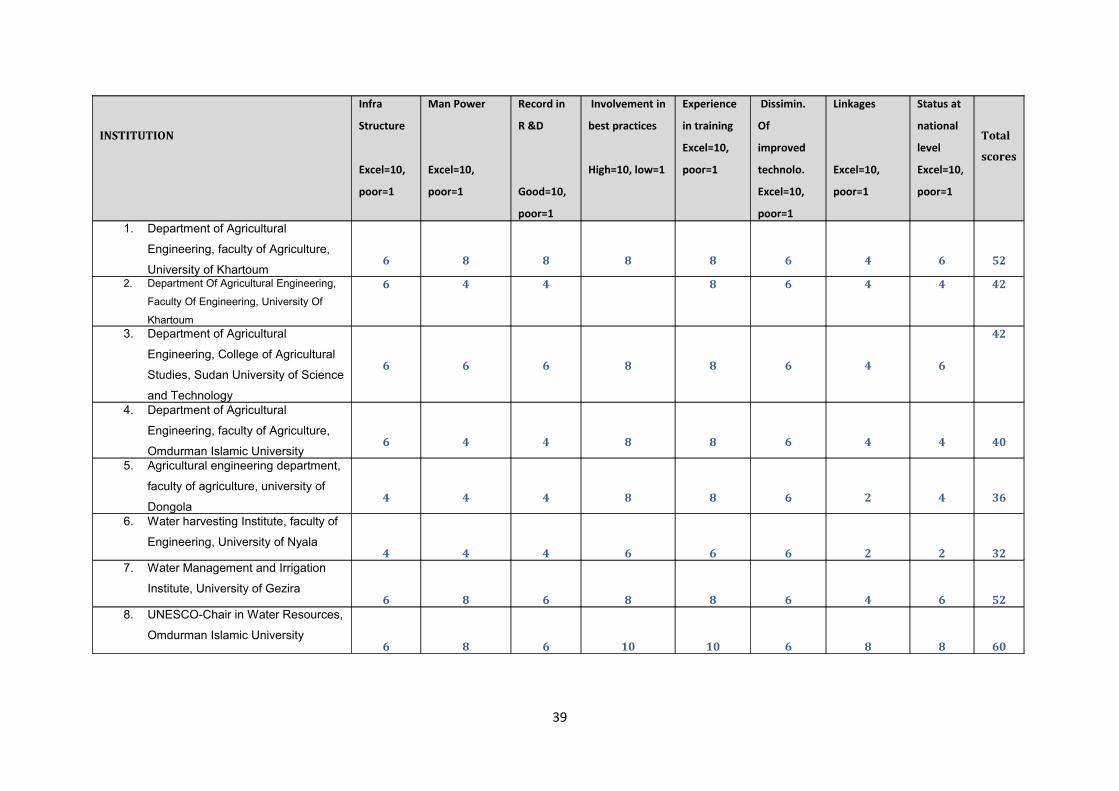
Total
scores
Status at
national
level
Excel=10,
poor=1
Linkages
Excel=10,
poor=1
Dissimin.
Of
improved
technolo.
Excel=10,
poor=1
Experience
in training
Excel=10,
poor=1
Involvement in
best practices
High=10, low=1
Record in
R &D
Good=10,
poor=1
Man Power
Excel=10,
poor=1
Infra
Structure
Excel=10,
poor=1
INSTITUTION
5264688886
1. Department of Agricultural
Engineering, faculty of Agriculture,
University of Khartoum4244684462. Department Of Agricultural Engineering,
Faculty Of Engineering, University Of
Khartoum42
64688666
3. Department of Agricultural
Engineering, College of Agricultural
Studies, Sudan University of Science
and Technology
4044688446
4. Department of Agricultural
Engineering, faculty of Agriculture,
Omdurman Islamic University
3642688444
5. Agricultural engineering department,
faculty of agriculture, university of
Dongola
3222666444
6. Water harvesting Institute, faculty of
Engineering, University of Nyala
5264688686
7. Water Management and Irrigation
Institute, University of Gezira
608861010686
8. UNESCO-Chair in Water Resources,
Omdurman Islamic University
39
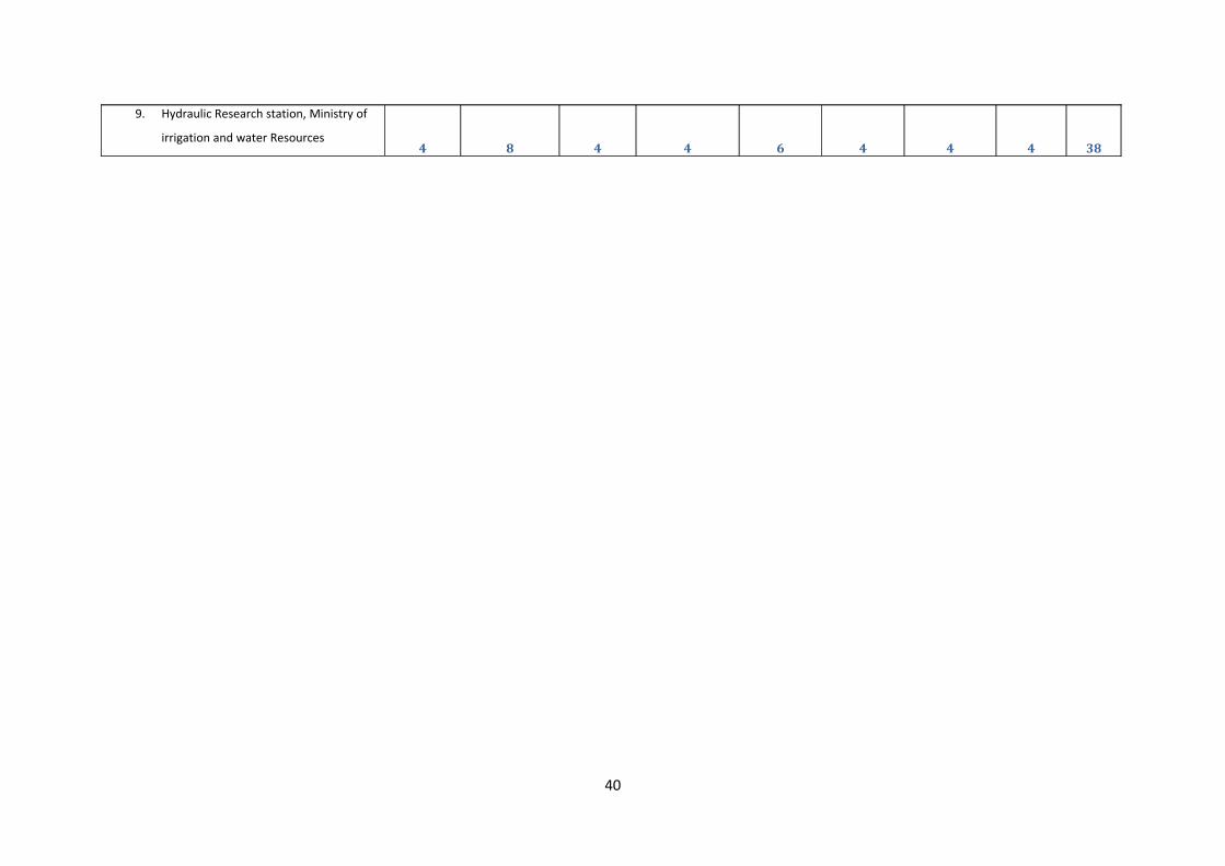
3844464484
9. Hydraulic Research station, Ministry of
irrigation and water Resources
40
CONCLUSIONS1. Best practices sites:
a. Water harvesting: according to the criteria shown in table 3.4, out of nine states,
Sennar State had the highest scores; hence it was selected to be the best site for
water harvesting best practices in the Sudan.
b. Small scale irrigation: The Gezira Scheme was selected as the best site for small
irrigation.
c. Large scale irrigation: Kenana Sugar was selected as the best site for large scale
irrigation.
2. Center of excellence in capacity building: According to the evaluation of Sudanese centers
for excellence in capacity building shown in table 4.5, the UNESCO Chair in Water
Resources (UWCR-SD) got the highest marks. Hence it was selected as the center of
excellence for capacity building in water harvesting and irrigation in the Sudan.
41