beod traffic the smart cit challege orlando.pdfbeod traffic the smart cit challege - vision...
TRANSCRIPT
BEYOND TRAFFIC: THE SMART CITY CHALLENGE - VISION NARRATIVE FOR ORLANDO, FLORIDA
Table of Contents – Application Content Part 1
Section 1: Vision .............................................................................................................................. 1
Section 2: Qualifying Characteristics .............................................................................................. 5
Section 3: Characteristics Aligning with Smart City ........................................................................ 6
Section 4: Annotated Preliminary Site Map..................................................................................... 8
Section 5: US DOT Aligned Vision Elements................................................................................... 9
Section 6: Smart City Risk Analysis .............................................................................................. 17
Section 7: Outline Team Partners, Key Stakeholders and Governance Procedures ..................... 19
Section 8: Overview of Existing Transportation Infrastructure and System Features ................... 21
Section 9: Data Management and Application .............................................................................. 23
Section 10: Emerging Technologies Standards, Architectures and Certification Processes ........ 25
Section 11: Vision Performance Measures and Metrics ............................................................... 28
Section 12: City Commitment and Resources .............................................................................. 30
Section 13: Opportunities for Cost Share, In-kind donations and Partnering ............................... 30
Letters of Commitment
BEYOND TRAFFIC: THE SMART CITY CHALLENGE - VISION NARRATIVE FOR ORLANDO, FLORIDA
- 1 -
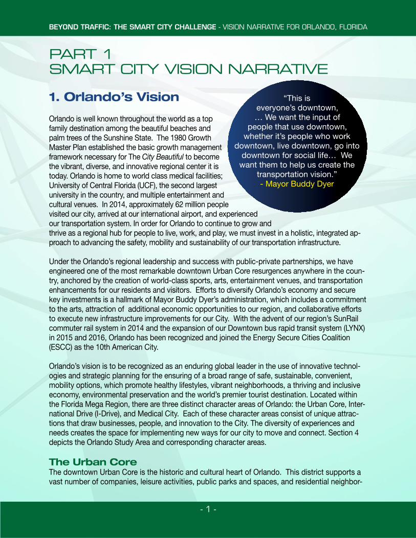
PART 1 SMART CITY VISION NARRATIVE
1. Orlando’s Vision
Orlando is well known throughout the world as a top family destination among the beautiful beaches and palm trees of the Sunshine State. The 1980 Growth Master Plan established the basic growth management framework necessary for The City Beautiful to become the vibrant, diverse, and innovative regional center it is today. Orlando is home to world class medical facilities; University of Central Florida (UCF), the second largest university in the country, and multiple entertainment and cultural venues. In 2014, approximately 62 million people visited our city, arrived at our international airport, and experienced our transportation system. In order for Orlando to continue to grow and thrive as a regional hub for people to live, work, and play, we must invest in a holistic, integrated ap-proach to advancing the safety, mobility and sustainability of our transportation infrastructure.
Under the Orlando’s regional leadership and success with public-private partnerships, we have engineered one of the most remarkable downtown Urban Core resurgences anywhere in the coun-try, anchored by the creation of world-class sports, arts, entertainment venues, and transportation enhancements for our residents and visitors. Efforts to diversify Orlando’s economy and secure key investments is a hallmark of Mayor Buddy Dyer’s administration, which includes a commitment to the arts, attraction of additional economic opportunities to our region, and collaborative efforts to execute new infrastructure improvements for our City. With the advent of our region’s SunRail commuter rail system in 2014 and the expansion of our Downtown bus rapid transit system (LYNX) in 2015 and 2016, Orlando has been recognized and joined the Energy Secure Cities Coalition (ESCC) as the 10th American City.
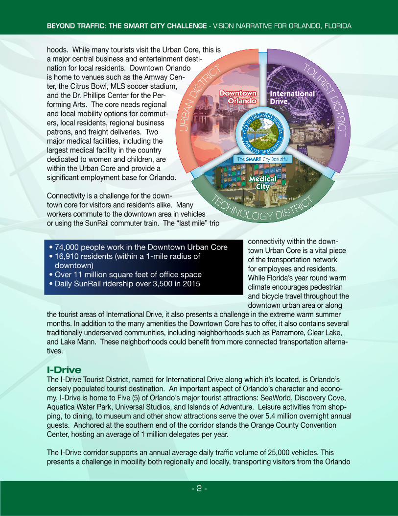
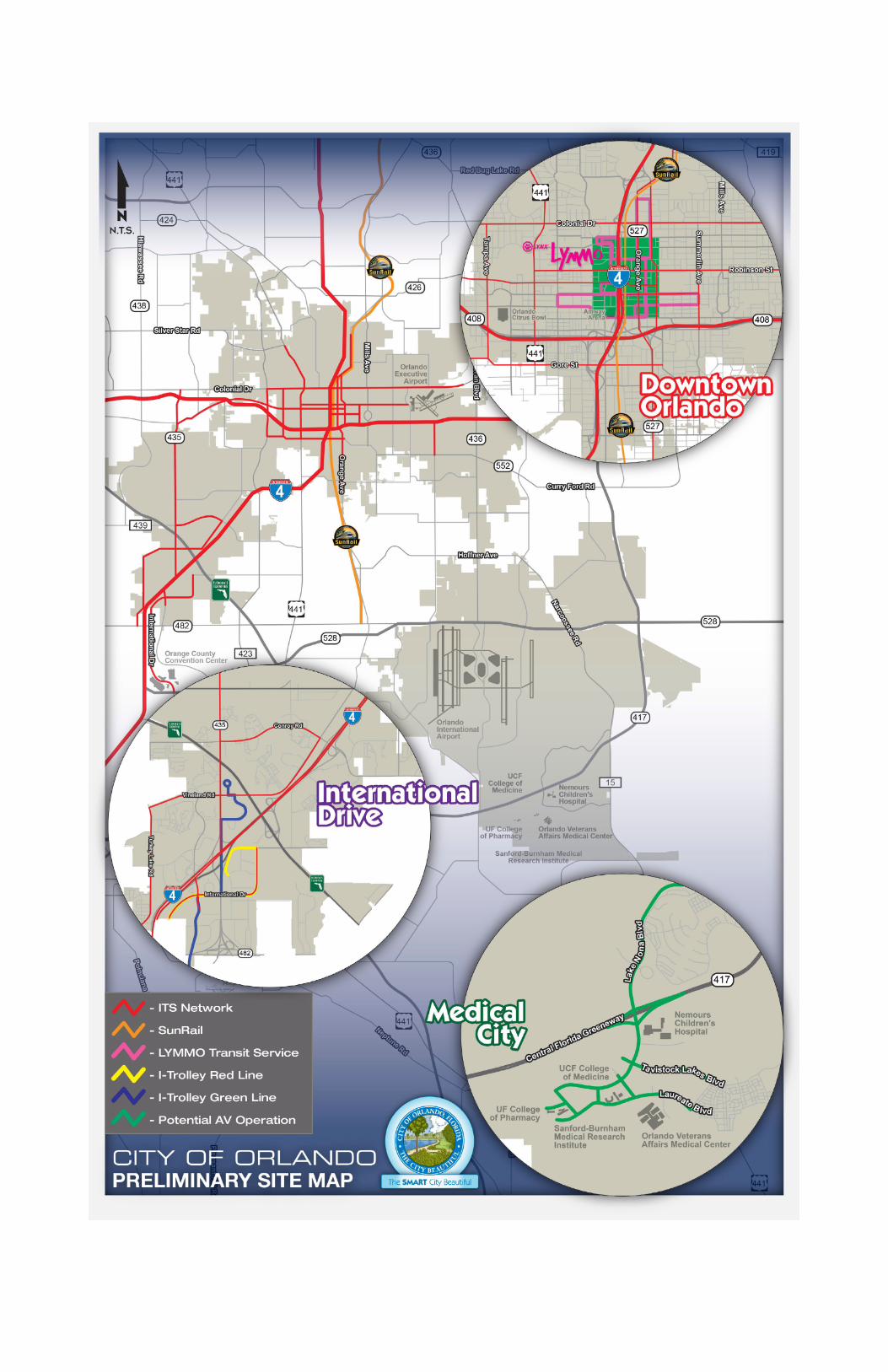
Orlando’s vision is to be recognized as an enduring global leader in the use of innovative technol-ogies and strategic planning for the ensuring of a broad range of safe, sustainable, convenient, mobility options, which promote healthy lifestyles, vibrant neighborhoods, a thriving and inclusive economy, environmental preservation and the world’s premier tourist destination. Located within the Florida Mega Region, there are three distinct character areas of Orlando: the Urban Core, Inter-national Drive (I-Drive), and Medical City. Each of these character areas consist of unique attrac-tions that draw businesses, people, and innovation to the City. The diversity of experiences and needs creates the space for implementing new ways for our city to move and connect. Section 4 depicts the Orlando Study Area and corresponding character areas.
The Urban CoreThe downtown Urban Core is the historic and cultural heart of Orlando. This district supports a vast number of companies, leisure activities, public parks and spaces, and residential neighbor-
“This is everyone’s downtown, … We want the input of
people that use downtown, whether it’s people who work
downtown, live downtown, go into downtown for social life… We
want them to help us create the transportation vision.”- Mayor Buddy Dyer
BEYOND TRAFFIC: THE SMART CITY CHALLENGE - VISION NARRATIVE FOR ORLANDO, FLORIDA
- 2 -
hoods. While many tourists visit the Urban Core, this is a major central business and entertainment desti-nation for local residents. Downtown Orlando is home to venues such as the Amway Cen-ter, the Citrus Bowl, MLS soccer stadium, and the Dr. Phillips Center for the Per-forming Arts. The core needs regional and local mobility options for commut-ers, local residents, regional business patrons, and freight deliveries. Two major medical facilities, including the largest medical facility in the country dedicated to women and children, are within the Urban Core and provide a significant employment base for Orlando.
Connectivity is a challenge for the down-town core for visitors and residents alike. Many workers commute to the downtown area in vehicles or using the SunRail commuter train. The “last mile” trip
connectivity within the down-town Urban Core is a vital piece of the transportation network for employees and residents. While Florida’s year round warm climate encourages pedestrian and bicycle travel throughout the downtown urban area or along
the tourist areas of International Drive, it also presents a challenge in the extreme warm summer months. In addition to the many amenities the Downtown Core has to offer, it also contains several traditionally underserved communities, including neighborhoods such as Parramore, Clear Lake, and Lake Mann. These neighborhoods could benefit from more connected transportation alterna-tives. I-DriveThe I-Drive Tourist District, named for International Drive along which it’s located, is Orlando’s densely populated tourist destination. An important aspect of Orlando’s character and econo-my, I-Drive is home to Five (5) of Orlando’s major tourist attractions: SeaWorld, Discovery Cove, Aquatica Water Park, Universal Studios, and Islands of Adventure. Leisure activities from shop-ping, to dining, to museum and other show attractions serve the over 5.4 million overnight annual guests. Anchored at the southern end of the corridor stands the Orange County Convention Center, hosting an average of 1 million delegates per year.
The I-Drive corridor supports an annual average daily traffic volume of 25,000 vehicles. This presents a challenge in mobility both regionally and locally, transporting visitors from the Orlando
• 74,000 people work in the Downtown Urban Core• 16,910 residents (within a 1-mile radius of
downtown) • Over 11 million square feet of office space• Daily SunRail ridership over 3,500 in 2015
BEYOND TRAFFIC: THE SMART CITY CHALLENGE - VISION NARRATIVE FOR ORLANDO, FLORIDA
- 3 -
International Airport and along the 10 mile I-Drive corridor. Over 2 million riders used the I-RIDE trolley in 2012 between local destinations, hotels, and the Convention Center. To address these challenges, initiatives such as a light rail transit system from Orlando International Airport to the I-Drive area, and an expanded circulator for the area are in the works. The existing I-RIDE trolley serves 20 miles of roadway within the district, connecting hotels, major theme park attractions, and shopping centers.
Medical CityOrlando is also home to the 650-acre health care and life sciences park known as Lake Nona Medi-cal City, or simply Medical City. With continued commitment to growth and cutting edge technology, Medical City started in 2005 as a Life Sciences Campus to house the College of Medicine of UCF. In the last ten years, both Medical City and the UCF College of Medicine have grown. The 2016 class is expected to have 480 doctoral students. Similarly, Medical City has grown and become a resi-dential, commercial, and recreation center, anchored by a focus on healthcare and medical research. Admittedly with this growth comes transportation challenges but it also provides opportunities to be innovative and forward thinking. Similar to I-Drive, Medical City needs to connect with other regional areas such as the Core and the Airport. Opportunities exist in implementing connected and automat-ed vehicles bicycle and pedestrian infrastructure additions, and smart development.
Vision for Orlando The strength of Orlando relies on the transportation system within each of these character areas. There is an opportunity to provide better con-nections both locally and regionally. With our diverse ability to emulate national and worldwide conditions, the City has a demonstrated track record partnering on the TravTek program advancing the GPS in-car navigation system that is seen in vehicles today. While being uniquely positioned by our national and international exposure and visibility, we as a City provide an ideal testbed for what a mid-sized city could accomplish with smart technology and policy. Orlando will advance the initiatives and challenges outlined in “Be-yond Traffic 2045”. The number of annual visitors to our City provides the highly visible platform to demonstrate innovation and advanced ideas. Visitors to Orlando can leave with more than a tan and fond memories; they can leave with ideas on how to advance safety and mobility in their cities, towns, and States.
Smart Mobility (How we move…)Many locations in Orlando serve a high volume of both pedestrian activity and vehicle commuters with significant recurring congestion. Orlando’s Smart City initiative will build upon the existing intelligent, sensor-based infrastructure to make real time operational adjustments, monitor performance, track assets in the field, and collect data. It would also support the goal of having an organized data sharing system available to the public for information on best routes and current status of the transportation network. To align with our goal of mobility options, the Bike Share program sponsored by the City is an excellent example of strides we’ve already made to provide alternate modes for short local trips within the downtown area. From their smartphones, users reserve a bike, get real-time data on bike availabil-
Orlando is:• A transferable test bed• Worldwide visibility• Committed to investing in advanced technology• Diverse in demographic characteristics for pilot
BEYOND TRAFFIC: THE SMART CITY CHALLENGE - VISION NARRATIVE FOR ORLANDO, FLORIDA
- 4 -
ity, and find bike parking stands. Similarly, Orlando’s public transit provides user-fo-cused mobility choices by providing real time traveler information on their hand held devices and displayed digitally at bus stops.
Orlando is undertaking efforts to extend us-er-focused mobility to vehicle users through providing real-time data. We are currently expanding our smart lot system to provide real-time information on the location and amount of available parking. Our goal is that every public parking location will provide data in real time. Our goal is to expand this
user-focused mobility data to include electric vehicle charging stations and emerging technology such as automated vehicles. We envision the system will involve to include a smart reservation system that will balance resources and promote sustainability.
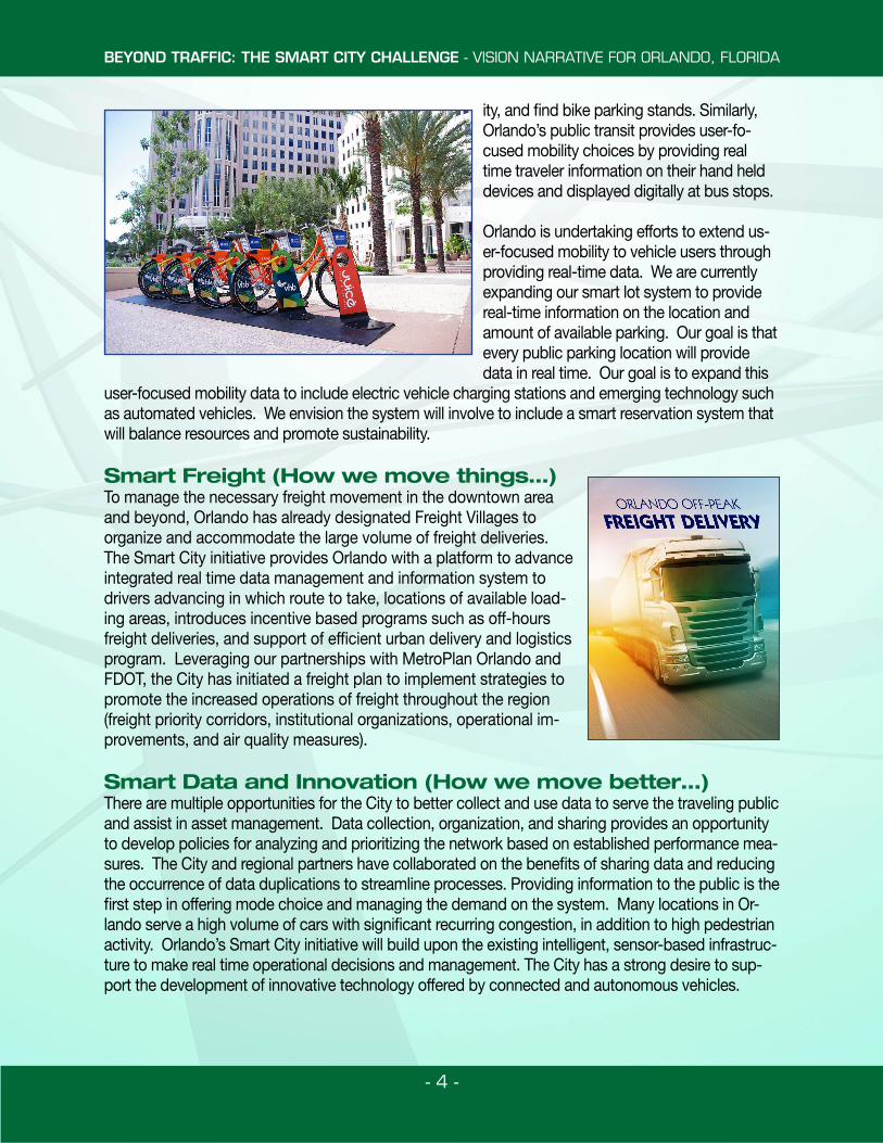
Smart Freight (How we move things…)To manage the necessary freight movement in the downtown area and beyond, Orlando has already designated Freight Villages to organize and accommodate the large volume of freight deliveries. The Smart City initiative provides Orlando with a platform to advance integrated real time data management and information system to drivers advancing in which route to take, locations of available load-ing areas, introduces incentive based programs such as off-hours freight deliveries, and support of efficient urban delivery and logistics program. Leveraging our partnerships with MetroPlan Orlando and FDOT, the City has initiated a freight plan to implement strategies to promote the increased operations of freight throughout the region (freight priority corridors, institutional organizations, operational im-provements, and air quality measures).
Smart Data and Innovation (How we move better…)There are multiple opportunities for the City to better collect and use data to serve the traveling public and assist in asset management. Data collection, organization, and sharing provides an opportunity to develop policies for analyzing and prioritizing the network based on established performance mea-sures. The City and regional partners have collaborated on the benefits of sharing data and reducing the occurrence of data duplications to streamline processes. Providing information to the public is the first step in offering mode choice and managing the demand on the system. Many locations in Or-lando serve a high volume of cars with significant recurring congestion, in addition to high pedestrian activity. Orlando’s Smart City initiative will build upon the existing intelligent, sensor-based infrastruc-ture to make real time operational decisions and management. The City has a strong desire to sup-port the development of innovative technology offered by connected and autonomous vehicles.
BEYOND TRAFFIC: THE SMART CITY CHALLENGE - VISION NARRATIVE FOR ORLANDO, FLORIDA
- 5 -
Smart Advancement and Integration (How we adapt…)The City is committed to investing in technologies to build upon our currently progress in the expansion of the existing BRT route, including upgrades to the existing bus fleet to electric or CNG buses, using a smart grid to produce clean energy and reduce emissions, and implement-ing vehicle-to-vehicle and vehicle-to-infrastructure communications. UCF has a satellite campus located in the I-Drive District which can be connected to the Rosen School of Hospitality. BRT lines between UCF’s main campus and the Rosen School will provide the perfect opportunity to expand the City’s Electric Bus fleet. In addition, there is an opportunity to build upon the land use and development policies we currently have in place to combat climate change and promote green building. Requirements on Transit Oriented Development (TOD), energy consumption and alternative energy guidelines, in addition to incentives for developers to include electric car charging stations and alternative energy sources are among some of the initiatives that the US-DOT Smart City’s Grant could assist in advancing.
Smart Policies and Commitment (How we align decisions…)In addition to providing the public with traveler information, operators will provide real-time data to make operational and network decisions, using data is critical in tracking the performance of the system and the status of network assets. The Smart City grant will provide the City with the means to better collect and analyze data currently being collected to extract business intelligence for making transportation network enhancements and funding decisions. Utilizing the data in this manner will support Orlando’s goal to coordinate planning and decision making so that invest-ments are made on a performance based priority list. This would ensure that investments in the transportation network will address critical needs. Orlando is well positioned with the leadership support from the City Council via Referendum, to provide all the necessary guidance policies and staff resource commitments throughout the duration of this project and beyond.
Smart Projects and Economic Vitality (How we build community…)One of Orlando’s goals for the Smart City initiative is to continue addressing environmental concerns, and ensure that adverse human health, social and/or environmental effects do not fall disproportionately upon minority or low-income populations. Our initiative is committed to increasing job creation, redevelopment of historically underserved communities and a balanced economy for all of Orlando’s citizens.
2. Qualifying Characteristics
Orlando is diverse in population and characteristics. An exemplary figure of what defines an American mid-sized city, Orlando has major tourist attraction areas, dense urban residential areas, a thriving central business district and peaceful suburban residential communities. Our residents and visitors are proud people who support our City and create an environment conducive to innovation and creativity. According to the US Census Bureau, Orlando’s population in 2010 was 235,992 citizens, which accounts for 15.6% of the Orlando regional population. With 121,254 housing units, the City accounts for 18.53% of the Orlando region’s housing. As demonstrated above, and on the Smart City Challenge website, Orlando has the appropriate qualifying characteristics.
BEYOND TRAFFIC: THE SMART CITY CHALLENGE - VISION NARRATIVE FOR ORLANDO, FLORIDA
- 6 -
3. City Characteristics
Orlando is an innovative and evolving region with diverse transportation infrastructures and systems, offering 1,159 total miles of roadway, seven available transit services, seven Shared-Use Mobility Services, established Information and Communication Technology systems and Intelligent Transportation Systems (ITS) including TMCs and field equipment, and Smart Grid Infrastructure (including electric vehicle charging infrastructure). Orlando also boasts the highest tourism numbers in the U.S., with 62 million visitors in 2014 alone. Orlando has initiated, and in some cases, led the nation in several Smart City elements. Much of this is driven by the volume of tourists and the need for transportation enhancements for these visitors. Additionally, as the home to world class sports and medical facilities, the second largest university in the country, multiple cultural settings and massive entertainment venues, Orlando has a strong commitment to diversity and economic security for its residents.
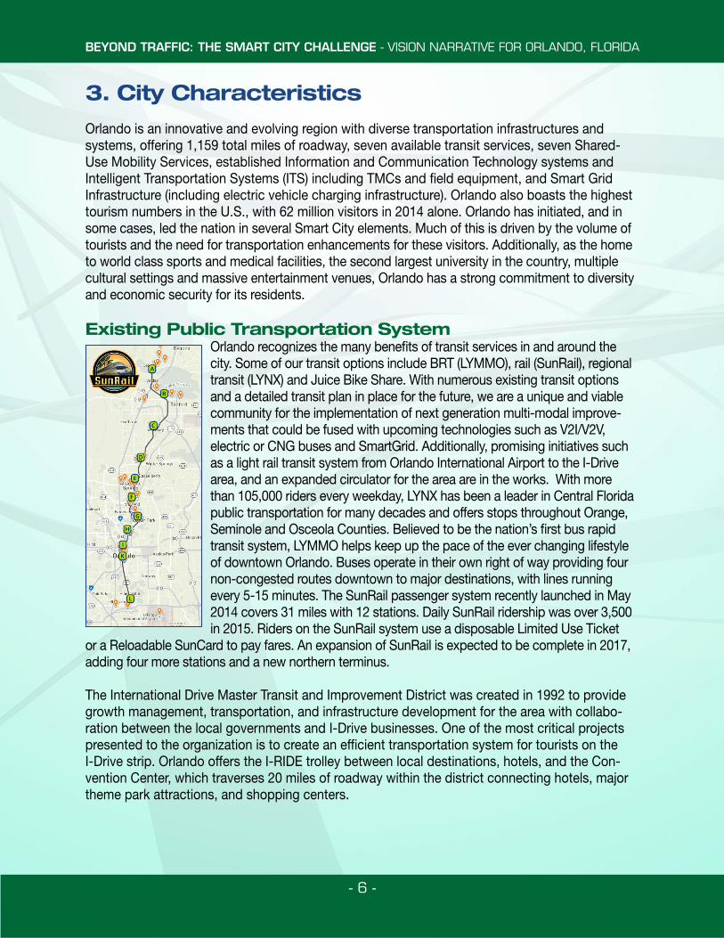
Existing Public Transportation SystemOrlando recognizes the many benefits of transit services in and around the city. Some of our transit options include BRT (LYMMO), rail (SunRail), regional transit (LYNX) and Juice Bike Share. With numerous existing transit options and a detailed transit plan in place for the future, we are a unique and viable community for the implementation of next generation multi-modal improve-ments that could be fused with upcoming technologies such as V2I/V2V, electric or CNG buses and SmartGrid. Additionally, promising initiatives such as a light rail transit system from Orlando International Airport to the I-Drive area, and an expanded circulator for the area are in the works. With more than 105,000 riders every weekday, LYNX has been a leader in Central Florida public transportation for many decades and offers stops throughout Orange, Seminole and Osceola Counties. Believed to be the nation’s first bus rapid transit system, LYMMO helps keep up the pace of the ever changing lifestyle of downtown Orlando. Buses operate in their own right of way providing four non-congested routes downtown to major destinations, with lines running every 5-15 minutes. The SunRail passenger system recently launched in May 2014 covers 31 miles with 12 stations. Daily SunRail ridership was over 3,500 in 2015. Riders on the SunRail system use a disposable Limited Use Ticket
or a Reloadable SunCard to pay fares. An expansion of SunRail is expected to be complete in 2017, adding four more stations and a new northern terminus.
The International Drive Master Transit and Improvement District was created in 1992 to provide growth management, transportation, and infrastructure development for the area with collabo-ration between the local governments and I-Drive businesses. One of the most critical projects presented to the organization is to create an efficient transportation system for tourists on the I-Drive strip. Orlando offers the I-RIDE trolley between local destinations, hotels, and the Con-vention Center, which traverses 20 miles of roadway within the district connecting hotels, major theme park attractions, and shopping centers.
BEYOND TRAFFIC: THE SMART CITY CHALLENGE - VISION NARRATIVE FOR ORLANDO, FLORIDA
- 7 -
Committed Leadership and Performance CapacityOrlando is committed and involved in the advancement of the Smart City vision, but involved. For the past decade, Orlando has been a leader in pioneering technology to increase the safety, mobility and environmental stewardship of our city. From “net zero” parking garages to one of the first connected vehicle infrastructures, Orlando has shown its commitment and ability to han-dle the challenge that the Smart City Challenge is proposing. Our City’s leadership and commu-nity leaders understand the importance of the principles in this challenge and welcome adapting to new ideas that benefit our city and its citizens.
Environment Conducive to Demonstrating Proposed StrategiesThe City’s infrastructure and systems are needed to support, not only the number of tourists, but also the natural lack of familiarity that they have with our City. These needs further extend to our robust citizenship and the downtown that supports them, as well as the numerous events (e.g. amusement parks, sports venues, and performing arts center) that the City supports. These factors result in an innate variability of transportation needs at all times of the year and with all modes of transportation. For this reason, the City is constantly been willing to innovate and evolve as illustrated by our success in implementing past initiatives. Some of these initiatives that have been tested and used in Orlando include:
1. The first connected mapping GPS system trial (Travtek in 1992) 2. A major USDOT ITS Model Deployment (iFlorida in 2003) that included
security systems, arterial and freeway travel time systems, Transit Dynamic Network Communications
3. Connected Vehicles Demonstration Project in 20114. Dynamic Parking Demonstration Project in 20115. Transit Signal Priority Project Demo in 20126. Regional Transit Signal Priority Projects in 2015 7. Active Arterial Management Projects in 20158. Active Arterial Management TMC Services in 20159. Two ITS World Congresses (in 1996 and 2011)
Data AccessibilityThe City has introduced a web-based platform where data can be accessed by its citizens and shared in an open environment. This program has made available several data sets with informa-tion about the City that is available for commercial use as well as public use. The web portal also contains powerful analysis tools allowing the public to analyze and report data without the need for data processing and mapping programs. The City will continue its commitment to open data as more data becomes available and new sensor technology is integrated into its infrastructure.Our partners utilize the data we make available to fuel their business and research. This allows them to create a user based community that can contribute back to the City with valuable input and analysis that would otherwise be unavailable. Futhermore, by creating this open platform, the City will promote collaboration with the community and a “sharing economy” approach.
BEYOND TRAFFIC: THE SMART CITY CHALLENGE - VISION NARRATIVE FOR ORLANDO, FLORIDA
- 9 -
5. USDOT Vision Elements
The vision for the City’s urban future is holistic and integrated, and places emphasis on creating a sustainable future through environmental stewardship, mobility and safety initiatives.
Element 1 | Urban AutomationOrlando has a substantial history with development and innovation in urban transportation infra-structure and a vision for its transportation future with a heavy emphasis on automation. Orlando has taken strides to improve the safety, mobility and environmental stewardship of its transpor-tation network. Our vision for the future includes automating many of the transit lines serving our city. Several technologies such as MobileEye and other driver assistive devices are in use today. These devices significantly increase the safety for vehicles and pedestrians sharing the roadway with transit services and provide real time data to fleet management centers providing the ability to predict peak times and real time mapping for end users of transit services. The existing BRT line within the central business district is a prime candidate for automation. The vehicle uses dedicated lanes and shared roadways that provide five and ten minute headways during peak hours. An automated BRT line would add safety and efficiency to the transit line providing multi-ple benefits across the board.
Orlando will provide incentives to support autonomous ride share and taxi fleets, as well as privately owned autonomous vehicles. Orlando and its partners are researching the impacts of the autonomous vehicle and are currently developing practices to sustain autonomous vehicles and provide development code based on adoption rates nationwide. The I-4 corridor has been a standing test bed for connected vehicles in the State since legislation House Bill 1207 was passed on July 1, 2012 to allow test vehicles on public roadways. FDOT has utilized this corri-dor and two others within Orlando to test roadside communication devices and a system wide management system, known as SunGuide®. The SunGuide® provides travelers and vehicles with dedicated short range communications (DSRC) capabilities to receive traffic, weather and emer-gency alert information in their vehicle. Orlando hopes to expand on this connected infrastruc-ture within the City limits to allow for vehicle-to-infrastructure (V2I) connections and access to the SunGuide® network providing information to travelers for optimal routing and mobility.
Element 2 | Connected VehiclesA major component of a Smart City is communication and sharing of information. Orlando’s vision involves numerous technologies and development practices that will allow its users and infrastructure to be connected, providing mode choice information to the City, its visitors and residents.
USDOT has established test beds for hosting vendors to test their applications and devices against the infrastructure that was deployed. One of these driver clinics was conducted at Walt Disney World’s speedway following the completion of the 2011 18th World Congress (WC) intel-ligent transportation systems (ITS) in Orlando, Florida. As part of the USDOT initiative, approxi-mately 3,000 vehicles, which include passenger, transit and commercial vehicles, were outfitted with connected vehicle devices to exchange data to be logged and downloaded periodically. These connected vehicle devices communicate with roadside equipment (RSE) and can obtain signal phasing and timing (SPaT) information.
BEYOND TRAFFIC: THE SMART CITY CHALLENGE - VISION NARRATIVE FOR ORLANDO, FLORIDA
- 10 -
As part of the WC technology showcase, FDOT enhanced its statewide advanced transportation management system (ATMS) software, SunGuide®, to exchange data with the connected vehicle infrastructure and utilize it for future applications. Currently there are 26 RSEs along Interstate 4, Or-ange County Convention Center and John Young Parkway. Through the Smart City initiative, Orlando will be a test-bed for Safety, Mobility, Real Time Capture, Local Hazard Warning, Basic Safety Mes-sage (BSM) and specifically SPaT which is considered one of the most imperative applications.
SPaT data can be broadcast from a RSE unit located at the traffic signal controller to a connected ve-hicle using the DSRC technology for two-way communication. This application can be coupled with a “ride share” concept such as Uber, where it can transform Orlando from an auto ownership oriented environment to an urban environment where vehicle ownership is no longer a necessity.
Element 3 | Intelligent, Sensor-Based InfrastructureOrlando’s current infrastructure is host to numerous intelligent sensors already. Our current sensor network is collecting and processing information from basic utilities usage (water, electricity and gas) to advanced intersection operations and vehicle video detection systems. Leveraging the technology made available by our partners, Orlando has integrated smart meter technology to pro-vide usage data for residential and commercial utility use. This usage provides the City with metrics used to estimate peak demands based on historical information and to know when resources can be conserved, eliminating the need for overuse of power plants and water reservoirs.
The City has replaced all parking meters with smart meters that are used to track parking trends and provide information to the public on available parking spots. This technology is also used to alert parking officials when a meter has expired but a vehicle is still present. The parking availability is accessed through a smart phone and web based application. Using this type of sensor can lead to reduced congestion from the decrease in vehicles searching for parking. In addition, Orlando is col-lecting real-time traveler information from the network of Bluetooth sensors and intersection monitor-ing cameras. This data is used for emergency response, signal retiming and analytics to ensure that the network is operating as safely and efficiently as possible.
Orlando’s vision for the future incorporates a broad use of various “smart” sensors that will allow for a highly advanced, safe and efficient infrastructure. Sensors such as air quality monitors and noise monitors will be coupled with LED street lights to measure ambient aesthetics. Pedestrians and cyclists will be accounted for by utilizing in-pavement and pole mounted radar systems cou-pled with Bluetooth readers. Bike and Pedestrian travel times and anonymous origin-destination information can be collected and analyzed to understand major pedestrian areas and the needs around them. Pavement condition sensors will allow the City to understand current surface con-ditions and respond quickly to localized flooding during major rainfall periods, dispatch mainte-nance crews prior to a major failure. Since Orlando has a major freight rail line through its central business district, vibration monitors can be placed on major horizontal structures and bridges as well as foundations to measure fatigue due to rail line vibrations. Utilizing and testing new sensor technology will allow the City to detect major issues not only in the transportation network, but its entire infrastructure before a major malfunction or accident occurs.
BEYOND TRAFFIC: THE SMART CITY CHALLENGE - VISION NARRATIVE FOR ORLANDO, FLORIDA
- 11 -
Element 4 | Urban AnalyticsOrlando is actively participating in Big Data with our partners. The data we are collecting to-day will not only assist us in planning but allow us to create discrete analytics. Using informa-tion gathered from connected pedestrians and vehicles, the City will have the ability to analyze essential metrics. Traffic detection cameras and loop sensors in approach lanes to intersec-tions provide information regarding volumes and lane occupancy. Information such as travel time along corridors and arterials as well as dwell times and delay at intersections are captured through the use of Bluetooth reading devices, and backend data analysis to match unique device identifiers known as MAC addresses. Traffic congestion and travel speeds at intersections are also calculated using Inrix/HERE traffic data. These types of analytics allow Orlando to calculate its network efficiency and identify areas that may need operational improvements.
The Orlando autonomous vehicle / connected vehicle (AV/CV) program will extract data from connected vehicles to the roadside devices that will be leveraged into the dynamic signal sys-tems that control signal timings and optimize the coordination of traffic along arterials. Informa-tion from these systems will also be fed into the ITS infrastructure to display travel information on dynamic message signs to alert motorists of congestion, detours or accidents ahead. The Orlan-do AV/CV program would allow for full integration of these systems across the City, to produce an increase in network efficiency and a decrease in fuel consumption and emissions.
Element 5 | User-Focused Mobility Services and ChoicesOrlando’s vision for a connected city starts with its residents and the users of our transportation systems. The future of transportation means better access and more options. With our partners, Orlando is committing to a sustainable and attainable future where users can take precedence on modal choices. Our infrastructure today offers multiple modal choices for travel (bus, bikeshare, commuter rail, taxi, and vehicle). The users of our transportation systems will also have the ability to access public services through smart phone applications to plan their trips ahead of time. A single payment system will also allow regional travelers to use a smart phone or a single payment card to pay for transit services. This type of user-focused service will allow for ease of travel and will simplify trip planning for everyday trips, save time and promote transit and ride share services to better our environmental stewardship. Orlando has partnered with Juice Bike Share who offers bikes that can be rented or reserved from a smartphone application or browser interface. Element 6 | Urban Delivery and LogisticsOrlando is a major freight driven city and our partners and communities thrive on freight. Our vision focuses on increasing the efficiency of freight services within urbanized areas and offer greater ac-cess for freight in our industrial areas. While outside of the city limits of Orlando, an integral partner of the region’s freight movement is Port Canaveral. The Port is leveraging its location, growth potential, expertise and resources to expand its world-class cargo operations. It is increasing capacity, building new facilities, and improving its channel to establish the deepest, most accessible East Coast port in Central Florida by 2020. Florida East Coast Railway access is available via an intermodal terminal located just 15 minutes from Port Canaveral or via a private intermodal facility approximately 10 miles from the Port’s cargo facilities. The Port Authority is working to establish critical on-dock rail service by 2017/2018 that will link the Port to the mainline East Coast north-south rail lines and connections.
BEYOND TRAFFIC: THE SMART CITY CHALLENGE - VISION NARRATIVE FOR ORLANDO, FLORIDA
- 12 -
Orlando envisions a future where our technology and sensor based environments will allow logis-tics operators to see where freight parking is available and real time congestion is on surrounding highways to supply the best and most efficient route to their drivers. Delivery programs such as off-hours delivery or on-time programs will allow carriers to make deliveries to businesses partic-ipating outside of peak traffic hours, providing faster travel times, and safer stops in traffic prone areas. Together, with our partners, Orlando will implement an AV/EV program that will use small autonomous or electric vehicles to complete last mile deliveries into the central business district.
Element 7 | Strategic Business Models and Partnering OpportunitiesThe City understands the strategic use of partnerships and what they can bring to our com-munity to fulfill this vision. The City will leverage the partnerships identified in Section 7. These partners have provided a commitment letter showing their support to the City. Our partners are also offering substantial in-kind donations to assist with the development and implementation of various technologies through this grant. Our partnership with UCF, a University Transportation Center (UTC) member, has been strategic in assisting the City with various components of our existing transportation technology infrastructure. Our vision includes a much larger relationship starting with the construction of the new UCF Downtown Orlando campus. Our unique relation-ship with MetroPlan Orlando, a Metropolitan Planning Organization (MPO), has proven crucial throughout the transportation ITS network updates. MetroPlan Orlando has supplied funds to Orlando for a network wide ITS implementation. Our partners are committed to Orlando!
Element 8 | Smart Grid, Roadway Electrification, and Electric VehiclesWith major investments in electric vehicle infrastructure, bus rapid transit lines, alternative fuels/renewable resources and an autonomous future, Orlando is on the forefront of transportation technology. Our commitment has established one of a leading electric vehicle programs in the nation. Drive Electric Orlando (DEO) is a first-of-its kind partnership between more than 50 of Or-lando’s leading rental car agencies, hotels, and attractions to provide the region’s visitors with an extended test drive of an electric vehicle (EV) during their car rental experience. A leader in EV charging infrastructure, Orlando is an ideal location for an EV rental program, because the City can bring together the biggest names in the tourism industry while hosting the largest rental car market in the world. More than 300 charging stations are available throughout Orlando and more than 20,000 hotel rooms have charging access. DEO is on track to becoming the nation’s largest electric vehicle rental program with the recent award of $400,000 from the U.S. Department of Energy’s (DOE) Clean Cities Program and Enterprise Rent-A-Car’s recent addition of 14 Chevy Volts to its fleet. The DOE grant is a collaboration between DEO, the Florida Office of Energy and the Central Florida Clean Cities program at the UCF. Plug-in electric vehicles can help to sub-stantially improve urban air quality because they have zero (or very limited) tailpipe emissions—emissions like CO2, carbon monoxide, sulfur dioxide, and nitrogen oxides that are produced by conventional vehicles.
The UCF Downtown Campus will encompass all the aspects of a future Smart City to showcase alternative transportation, an autonomous shuttle system, ride-sharing, Photovoltaics (PV), EV charging infrastructure, and incentives for electrification, all available to the user through smart phone apps. Electric vehicles will be utilized for most personal and public transportation with
BEYOND TRAFFIC: THE SMART CITY CHALLENGE - VISION NARRATIVE FOR ORLANDO, FLORIDA
- 13 -
sufficient infrastructure for parking and charging. PV will offset electric vehicle transportation fu-els, and can be directly used by transportation, stored for later use, or directed back to the utility grid. This effort will begin to develop a method to determine the most cost-effective use of solar energy production. Electrified public transportation will be a significant component to enable an efficient, low-emission, and higher level automation transportation. Orlando transit authority LYNX will replace a portion of its 300 coaches with two types of market-leading electric buses.
A level of automation has already been demonstrated in the electric bus technologies with overhead charging stations using Bluetooth communication so the buses can take control of a nearby bus and automatically direct the bus to assume the charging connectivity with the char-ger. Similar technology will be implemented, and coupled with wireless charging to demonstrate a Level 2 automation, on a route where both overhead chargers and ground buried wireless charging pad are strategically placed. This will lay the ground for higher level automation in col-laboration with this grant for both buses and consumer vehicles.
Bus-to-grid power transfer may also be capable of assisting the local grid to remain stable as an increased amount of PV is added to the system. There may be operational modes of transit agen-cies which parallel PV production (PV production and public transit needs are both high during daylight hours). Periods of high demand on the grid may be partially offset by using energy from the fleet of buses. However, a control algorithm may be developed which could benefit the grid as much as the transportation sector. The combination of higher power charge rates and near-term advancements in battery technology are linchpins to the accelerated EV adoption, providing signif-icant environmental and societal benefits. Using high-power wireless and automated EV charging will allow a seamless refueling opportunity for the EV and transit driver.
Element 9 | Connected, Involved CitizensOpen data is an important part of a connected city. Without the ability to interact with data being collected, information becomes stifled. In an effort to make data available to its citizens, Orlando is launching an open source data platform via a web mapping portal that allows access to data for analysis and reporting. This platform is the first of its kind for the region and will also leverage other data made available from state sources such as the Florida Department of Transportation (FDOT) and the Florida Department of Environmental Protection. The data will be readily available for public use and open source data processing, allowing application developers to create web based and smartphone applications.
Enhancing our transportation infrastructure, data gathered from a connected vehicle infrastruc-ture, transit network and roadway condition reporting sensors will be provided. This data can be used to produce real time transit and congestion maps that will be used for modal choice selec-tion by citizens. This information can also be supplied to emergency services to provide routing options while responding to calls. Mobility and safety can be enhanced using open source data, providing information on modal choice and avoiding heavily congested or blocked areas.
Element 10 | Architecture and StandardsOrlando is one of 300 metropolitan areas captured in the National ITS Architecture as a part of the Central Florida (FDOT, District 5) Regional Architecture. The Central Florida Regional Ar-chitecture is jointly maintained by the MPO (MetroPlan) and FDOT, where current projects, as
BEYOND TRAFFIC: THE SMART CITY CHALLENGE - VISION NARRATIVE FOR ORLANDO, FLORIDA
- 14 -
well as projects identified in the work program, are captured via the Central Florida Regional Architectures/Turbo File. The majority of the proposed Smart City products within this letter are already identified within the regional architecture (Please see http://www.consystec.com/florida/d5/web/index.htm) per the Connected Vehicle Reference Implementation Architecture (CVRIA). Communication standards and interoperability are established and monitored by the ITS Region-al Working Group (RWG), comprised of the local municipalities and government agencies within the Orlando Region. The RWG has adopted open communication protocols in which the City and entire region are consistent. Finally, the City’s Information Technology standards (including police and fire) are generated and maintained by the Office of Information Technology (OIT). Therefore, the City’s Transportation Office, as well as other city departments, follow the guidance set forth by OIT to ensure consistency within the City.
It is the City’s intent to utilize the CVRIA system architecture tools, existing ITS Standards, the regional, statewide and national architectures and a certification process for ITS and Connect-ed Vehicles whenever possible. Due to the nature of this project, development of additional ITS Standards and certifications for various Smart City products may be required. We anticipate that some of these products would include: transportation information systems (data, security and communications), connected vehicles (build upon the SE Michigan pilot), and the overall regional fusion of data from various data sources and types to develop a data warehouse of relevant data for the region to facilitate more informed decisions. To accomplish this, some of the anticipated data interfaces are likely to include connections to the region’s ATMS system (SunGuide®), the Security Credential Management Software, roadside equipment, the traveler, and the data ware-house. Lessons learned will be shared with the ITS community.
Element 11 | Low-Cost, Efficient, Secure, and Resilient Information and Communications Technology To manage the communication of a Smart City Orlando will leverage existing fiber assets. Indus-try best practices for security and resiliency will be used to ensure that connections are reliable for end users. Privacy will be ensured by obscuring personal information as close to the edge of the network as possible. Additionally, the City is ready to incorporate the secure credential management system, or SCMS, as provided by USDOT.
Cost Effective: Orlando has an expansive fiber network. The system has been built through the cooperation and sharing of resources with the City, County, State, and surrounding municipal-ities. For over a decade, these agencies have had a practice of placing higher standard count fiber than is required for individual applications at little or no additional cost. The fiber / commu-nication is then made available to any agency that needs it for transportation purposes.
Security: Security of a communication system begins with restricting access. Fiber intercept-ing communications requires accessing a cable and reducing light levels to a device, alerting the City of an intrusion. The next point of vulnerability is at the cabinet. The City will work with the State to match the locking system currently in use on limited access facilities. It allows the restriction of user access through an electronic key and lock. The key includes a unique identi-fier plus updated permission information. The permission information is transmitted to the lock upon use, allowing a centrally managed system to regulate access to the individual tumbler for each key. The City’s TMC and OIT equipment is housed in rooms that similarly record and restrict
BEYOND TRAFFIC: THE SMART CITY CHALLENGE - VISION NARRATIVE FOR ORLANDO, FLORIDA
- 15 -
access at the user and lock level. Intrusion from the internet and other transportation networks will be restricted through the use of multiple firewalls. A demilitarized zone (DMZ) will be created for content that needs to be available on the web. Certificates will be used to ensure these exposed services are further protected.
Resiliency: The resiliency of the City’s network is maintained through the use of industry stan-dard protocols and physically redundant routes. Because of the fiber sharing in the area, fiber is available will multiple physical routes back to network aggregation switches. Spanning Tree Pro-tocol, or STP, can ensure failover occurs to the aggregation switches in the event of a fiber cut or failed switch. The aggregation switches will use open shortest path first, or OSPF, to ensure failover to the core switch/servers. Using industry standards ensure competitive acquisitions and allows for technology upgrades without being tied to a single vendor.
Connected Vehicle: Orlando participated in the 2011 ITS WC. As part of that effort, a Connected Vehicle pilot was established and maintained long after WC had ended. The City is aware of the network needs of connected vehicles and is ready to support them. In addition to bandwidth and IPv6 needs, the City is prepared to work with USDOT to establish a secure credential management system (SCMS). The City has the IT staff and expertise needed to fully support USDOT in the es-tablishment of the system and the management of the system moving forward.
Open Data: The City is already working with Socrata to meet the White House Open Data Intia-tive, by making City data available via a web portal. The Socrata portal will be active by the time this proposal is submitted. The site meets industry standards for security.
Element 12 | Smart Land UseOrlando has a typical development pattern for a sunbelt city, with the majority of growth occur-ring after 1980. There is a compact, walkable downtown, but most jobs and housing are dis-persed across the region. Since 1985, the City has promoted walkable, dense, mixed use activity centers. In some locations, the market has responded well, creating notable successes such as Baldwin Park and Medical City in Lake Nona. Since 2011, Orlando has seen a boom in apart-ment construction in it’s downtown, a phenomenon that took 20 years of planning, economic development incentives and transportation improvements to entice development Orlando. The City can build off of these and other successes to create urban villages that are hubs of activity and walkability. Over time, suburban areas can be retrofitted into urban villages that each have their own character. The following proposed projects will assist with this process:
Unique Projects and Phasing
Immediate (1 year)• Add electric-assist bikes to bike share program • Update bike path and bike lane rules to allow bikes with electric motors and
robot delivery • Require EV charging stations for new development• Create a technology element in the City’s comprehensive plan to identify and
prioritize projects, provide direction on how to incorporate new technology into existing infrastructure, and create policy support for innovation
BEYOND TRAFFIC: THE SMART CITY CHALLENGE - VISION NARRATIVE FOR ORLANDO, FLORIDA
- 16 -
• Available city garage parking spaces will be included with the available on-street parking meter spaces on the PARKME mobile application. The garage operation software coming online in FY16 will have the capability to feed into an open source data sharing site showing real-time data
Medium Term (5 year)• Incentives to convert parking lots to other uses in City Tourist Areas • Reduce minimum parking requirements • Create neighborhood-based incentives for residents to install EV charging stations• Require preferred parking for alternative electric vehicles: NEVs, scooters, etc.• Robot package delivery - create satellite warehouses by leveraging existing uses• Reserve strategic locations within parking garages for autonomous vehicles• Install Solar Panels on roofs of four of the City’s garages and one surface lot pro-
viding power to the Electric Vehicle charging stations and garage lighting (which has already been retrofitted to LED). The excess power can be sold back to OUC. The use of solar power will significantly reduce the carbon emissions in the Down-town Business District. The panels will require maintenance and replacement at the end of a typical life cycle, which will be funded by the savings
Long Term• Road diets to reclaim larger streetscape• Redevelopment incentives along premium transit corridors• Re-purpose city garages for car share• Autonomous vehicle program for school pickup in areas not served by buses • Underground utilities• Smart Infrastructure Corridors - in Main Streets, solar umbrellas, charging station• Tourist area as location for energy efficiency showcase• Create green spaces or tiny house development in under-used parking lots or
abandoned car dealerships• Partner with Universal/Disney to adapt their crowd control tools to move people
through autonomous vehicles• Revive the 2006 downtown transportation plan idea for a freight hub, but adapt for
autonomous deliveries, robots and small scale storage of freight.
The development of best practices for supporting EV through land use and transportation plan-ning is a key element in the above projects successful adoption and deployment. The develop-ment of this methodology can be used in the planning process to determine capital, operating and maintenance costs and help meet the increasing demand for EVs. This approach can also provide important information to accelerate electric vehicle adoption. Development of these guidelines can also be extended as EV technology begins to merge with (AV/CV) technologies. Adopting an integrated planning approach that accommodates all forms of electric vehicle trans-portation will provide useful strategies in the development and enhancement of transportation planning, urban automation and smart roadways.
BEYOND TRAFFIC: THE SMART CITY CHALLENGE - VISION NARRATIVE FOR ORLANDO, FLORIDA
- 17 -
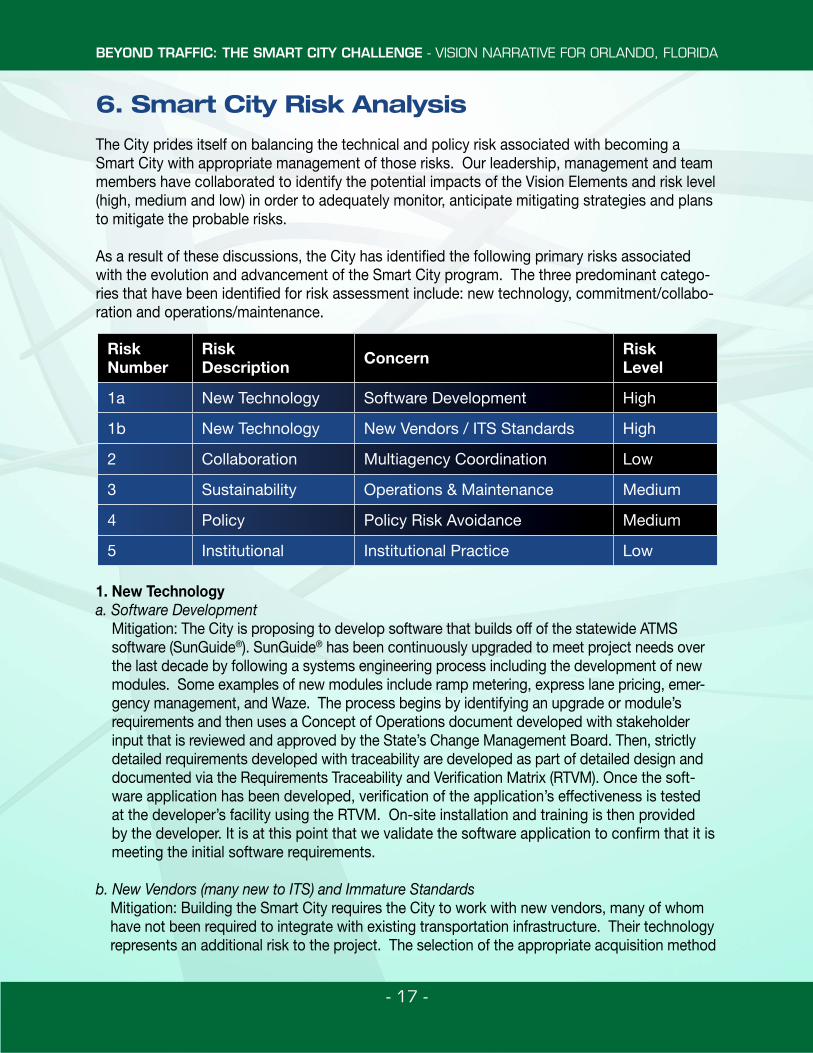
6. Smart City Risk Analysis
The City prides itself on balancing the technical and policy risk associated with becoming a Smart City with appropriate management of those risks. Our leadership, management and team members have collaborated to identify the potential impacts of the Vision Elements and risk level (high, medium and low) in order to adequately monitor, anticipate mitigating strategies and plans to mitigate the probable risks.
As a result of these discussions, the City has identified the following primary risks associated with the evolution and advancement of the Smart City program. The three predominant catego-ries that have been identified for risk assessment include: new technology, commitment/collabo-ration and operations/maintenance.
1. New Technologya. Software Development
Mitigation: The City is proposing to develop software that builds off of the statewide ATMS software (SunGuide®). SunGuide® has been continuously upgraded to meet project needs over the last decade by following a systems engineering process including the development of new modules. Some examples of new modules include ramp metering, express lane pricing, emer-gency management, and Waze. The process begins by identifying an upgrade or module’s requirements and then uses a Concept of Operations document developed with stakeholder input that is reviewed and approved by the State’s Change Management Board. Then, strictly detailed requirements developed with traceability are developed as part of detailed design and documented via the Requirements Traceability and Verification Matrix (RTVM). Once the soft-ware application has been developed, verification of the application’s effectiveness is tested at the developer’s facility using the RTVM. On-site installation and training is then provided by the developer. It is at this point that we validate the software application to confirm that it is meeting the initial software requirements.
b. New Vendors (many new to ITS) and Immature StandardsMitigation: Building the Smart City requires the City to work with new vendors, many of whom have not been required to integrate with existing transportation infrastructure. Their technology represents an additional risk to the project. The selection of the appropriate acquisition method
Risk Number
Risk Description Concern Risk
Level
1a New Technology Software Development High
1b New Technology New Vendors / ITS Standards High
2 Collaboration Multiagency Coordination Low
3 Sustainability Operations & Maintenance Medium
4 Policy Policy Risk Avoidance Medium
5 Institutional Institutional Practice Low
BEYOND TRAFFIC: THE SMART CITY CHALLENGE - VISION NARRATIVE FOR ORLANDO, FLORIDA
- 18 -
that allows incremental check points can minimize the City’s exposure and allow course correc-tion. Clear requirements generated via a systems engineering process for each component, as well as the integrated subsystem, establishes the goal for the vendor and the City.
2. Multiagency / Multidepartment CoordinationMitigation: The Smart City will be integrated with its regional partners. As a result, multiagency coordination is critical to the success of the project. Working across jurisdictions can add com-plication and risk. For the Central Florida region, this risk is minimized by existing relationships and strong support for this project. The region has a history of working together on large com-plex projects. This history has resulted in regularly scheduled Regional Working Group Meet-ings (Technical Meeting) and a regional TSM&O Consortium meeting (Management Meeting). Communication between the agencies is open and active and each agency’s roles and respon-sibilities will be clearly defined via the Concept of Operations for this project. These roles and responsibilities will identify ownership for any particular element of the Smart City deployment. The Central Florida region is united behind the Smart City grant opportunity. Letters of support have been provided from all the involved stakeholders.
3. Operation and Maintenance after Grant (Sustainability)Mitigation: This grant provides an opportunity to jump start a Smart City, but its funding is for capital deployment. A traditional gap in funding and budgeting is longer term operations and maintenance funding. Orlando recognizes the long-term costs that will come as a result of being selected as the Smart City. As a part of the Concept of Operations, the long term costs will be identified and funded through the budgeting process. These costs will include operations, main-tenance and life cycle replacement.
4. Policy Risk AvoidanceMitigation: Mayor Dyer, Orlando’s Chief Executive, recently re-elected and is committed to the great leap that the USDOT’s funding partnership will facilitate during his next four years in service to the citizens of Orlando. The City Council unanimously approved the resolution which en-dorses Orlando’s application and the larger Smart City concept. Orlando’s Comprehensive Plan includes all the elements of the Smart City Concept and will be further amended to specifically mention all 12 USDOT Smart City Challenge elements. The amendment will include measures to ensure pursuit and achievement of the Smart City principles throughout the four years of the grant opportunity and for decades to come. The City’s Land Development Code will be amend-ed, on a continuing basis, to ensure the implementation of the tactics associated with Smart City principles, and that they are the most state of the art improvements. 5. Institutional RisksMitigation: Initial and continuing leadership team and partnership meetings will be mandated and include team-building techniques, challenge resolution procedures, and continued focus on the Smart City Vision. The City will ensure that there will be redundant staff coverage by appropriate-ly trained and compensated personnel, who are required and audited to perform at the highest levels of competence. Regular reviews and audits will be performed by internal and external agents to ensure compliance with the City’s Smart City mission. Regular reporting will be provid-ed to the City’s senior staff leadership, the City’s executive leadership, and the City Council.
BEYOND TRAFFIC: THE SMART CITY CHALLENGE - VISION NARRATIVE FOR ORLANDO, FLORIDA
- 19 -
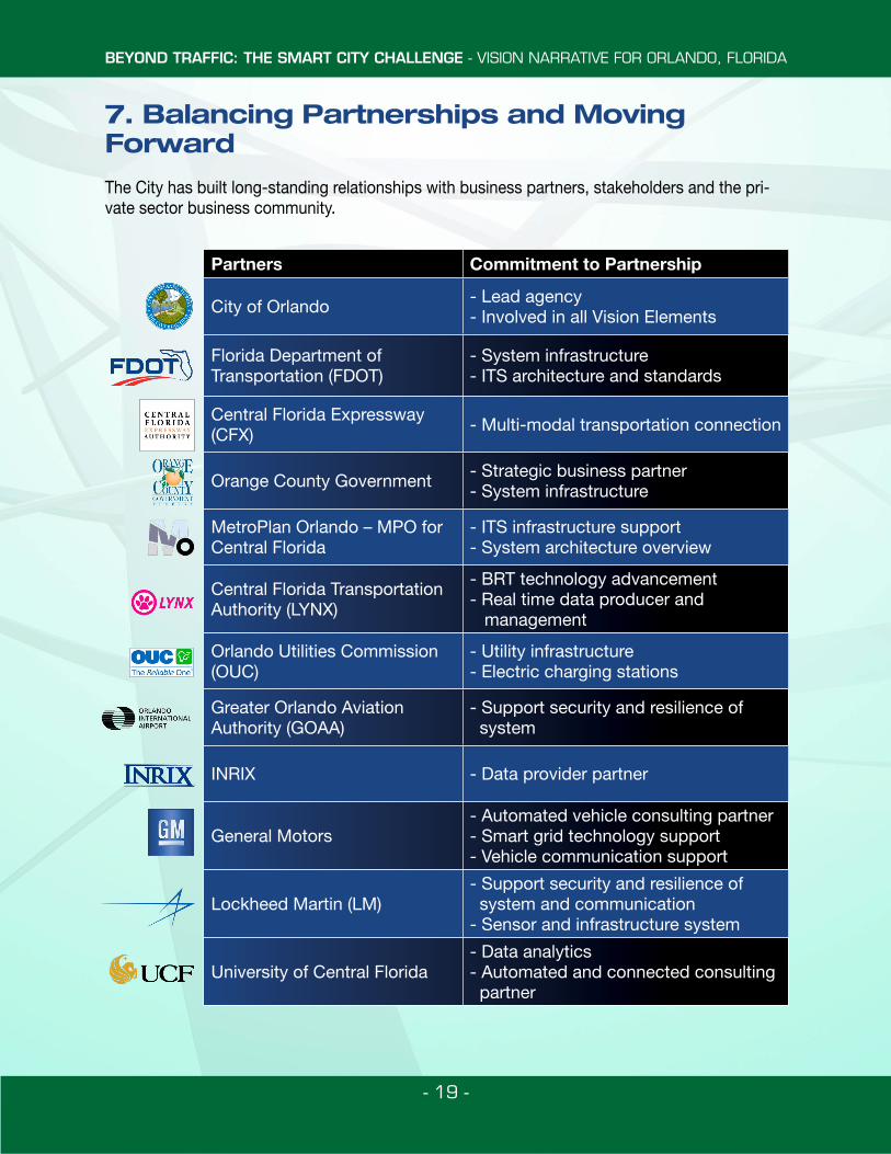
7. Balancing Partnerships and Moving Forward
The City has built long-standing relationships with business partners, stakeholders and the pri-vate sector business community.
Partners Commitment to Partnership
City of Orlando - Lead agency- Involved in all Vision Elements
Florida Department of Transportation (FDOT)
- System infrastructure - ITS architecture and standards
Central Florida Expressway (CFX) - Multi-modal transportation connection
Orange County Government - Strategic business partner- System infrastructure
MetroPlan Orlando – MPO for Central Florida
- ITS infrastructure support- System architecture overview
Central Florida Transportation Authority (LYNX)
- BRT technology advancement- Real time data producer and management
Orlando Utilities Commission (OUC)
- Utility infrastructure- Electric charging stations
Greater Orlando Aviation Authority (GOAA)
- Support security and resilience of system
INRIX - Data provider partner
General Motors- Automated vehicle consulting partner- Smart grid technology support- Vehicle communication support
Lockheed Martin (LM)- Support security and resilience of system and communication- Sensor and infrastructure system
University of Central Florida- Data analytics- Automated and connected consulting partner
BEYOND TRAFFIC: THE SMART CITY CHALLENGE - VISION NARRATIVE FOR ORLANDO, FLORIDA
- 20 -
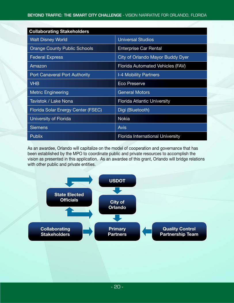
Collaborating Stakeholders
Walt Disney World Universal Studios
Orange County Public Schools Enterprise Car Rental
Federal Express City of Orlando Mayor Buddy Dyer
Amazon Florida Automated Vehicles (FAV)
Port Canaveral Port Authority I-4 Mobility Partners
VHB Eco Preserve
Metric Engineering General Motors
Tavistok / Lake Nona Florida Atlantic University
Florida Solar Energy Center (FSEC) Digi (Bluetooth)
University of Florida Nokia
Siemens Avis
Publix Florida International University
As an awardee, Orlando will capitalize on the model of cooperation and governance that has been established by the MPO to coordinate public and private resources to accomplish the vision as presented in this application. As an awardee of this grant, Orlando will bridge relations with other public and private entities.
USDOT
City ofOrlando
State Elected Officials
CollaboratingStakeholders
PrimaryPartners
Quality Control Partnership Team
BEYOND TRAFFIC: THE SMART CITY CHALLENGE - VISION NARRATIVE FOR ORLANDO, FLORIDA
- 21 -
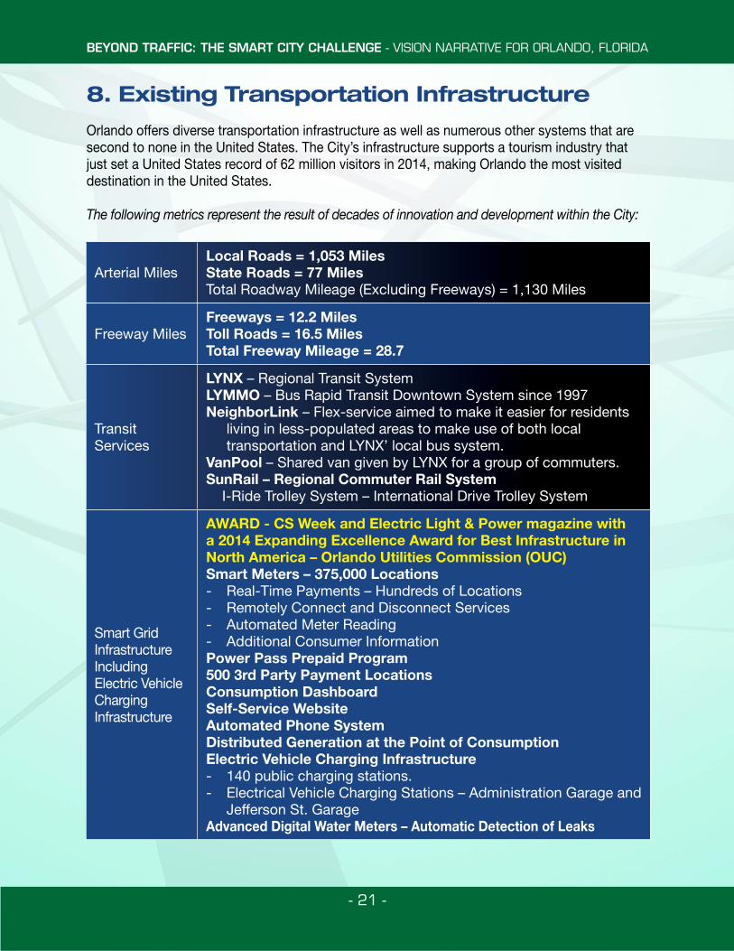
8. Existing Transportation Infrastructure
Orlando offers diverse transportation infrastructure as well as numerous other systems that are second to none in the United States. The City’s infrastructure supports a tourism industry that just set a United States record of 62 million visitors in 2014, making Orlando the most visited destination in the United States.
The following metrics represent the result of decades of innovation and development within the City:
Arterial MilesLocal Roads = 1,053 MilesState Roads = 77 MilesTotal Roadway Mileage (Excluding Freeways) = 1,130 Miles
Freeway MilesFreeways = 12.2 MilesToll Roads = 16.5 MilesTotal Freeway Mileage = 28.7
Transit Services
LYNX – Regional Transit SystemLYMMO – Bus Rapid Transit Downtown System since 1997NeighborLink – Flex-service aimed to make it easier for residents
living in less-populated areas to make use of both local transportation and LYNX’ local bus system.
VanPool – Shared van given by LYNX for a group of commuters.SunRail – Regional Commuter Rail System I-Ride Trolley System – International Drive Trolley System
Smart Grid Infrastructure Including Electric Vehicle Charging Infrastructure
AWARD - CS Week and Electric Light & Power magazine with a 2014 Expanding Excellence Award for Best Infrastructure in North America – Orlando Utilities Commission (OUC)Smart Meters – 375,000 Locations- Real-Time Payments – Hundreds of Locations- Remotely Connect and Disconnect Services- Automated Meter Reading- Additional Consumer InformationPower Pass Prepaid Program500 3rd Party Payment LocationsConsumption DashboardSelf-Service WebsiteAutomated Phone SystemDistributed Generation at the Point of ConsumptionElectric Vehicle Charging Infrastructure- 140 public charging stations. - Electrical Vehicle Charging Stations – Administration Garage and
Jefferson St. GarageAdvanced Digital Water Meters – Automatic Detection of Leaks
BEYOND TRAFFIC: THE SMART CITY CHALLENGE - VISION NARRATIVE FOR ORLANDO, FLORIDA
- 22 -
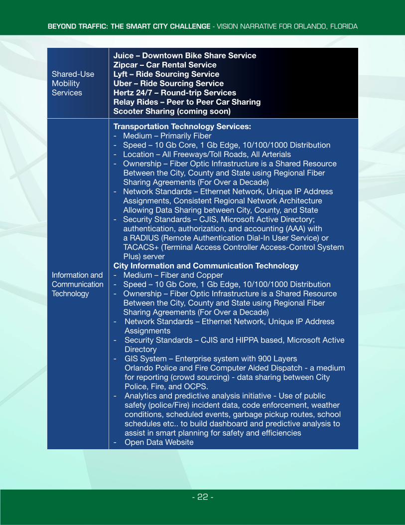
Shared-Use Mobility Services
Juice – Downtown Bike Share ServiceZipcar – Car Rental ServiceLyft – Ride Sourcing ServiceUber – Ride Sourcing ServiceHertz 24/7 – Round-trip ServicesRelay Rides – Peer to Peer Car SharingScooter Sharing (coming soon)
Information and Communication Technology
Transportation Technology Services: - Medium – Primarily Fiber- Speed – 10 Gb Core, 1 Gb Edge, 10/100/1000 Distribution- Location – All Freeways/Toll Roads, All Arterials- Ownership – Fiber Optic Infrastructure is a Shared Resource
Between the City, County and State using Regional Fiber Sharing Agreements (For Over a Decade)
- Network Standards – Ethernet Network, Unique IP Address Assignments, Consistent Regional Network Architecture Allowing Data Sharing between City, County, and State
- Security Standards – CJIS, Microsoft Active Directory; authentication, authorization, and accounting (AAA) with a RADIUS (Remote Authentication Dial-In User Service) or TACACS+ (Terminal Access Controller Access-Control System Plus) server
City Information and Communication Technology- Medium – Fiber and Copper- Speed – 10 Gb Core, 1 Gb Edge, 10/100/1000 Distribution- Ownership – Fiber Optic Infrastructure is a Shared Resource
Between the City, County and State using Regional Fiber Sharing Agreements (For Over a Decade)
- Network Standards – Ethernet Network, Unique IP Address Assignments
- Security Standards – CJIS and HIPPA based, Microsoft Active Directory
- GIS System – Enterprise system with 900 Layers Orlando Police and Fire Computer Aided Dispatch - a medium
for reporting (crowd sourcing) - data sharing between City Police, Fire, and OCPS.
- Analytics and predictive analysis initiative - Use of public safety (police/Fire) incident data, code enforcement, weather conditions, scheduled events, garbage pickup routes, school schedules etc.. to build dashboard and predictive analysis to assist in smart planning for safety and efficiencies
- Open Data Website
BEYOND TRAFFIC: THE SMART CITY CHALLENGE - VISION NARRATIVE FOR ORLANDO, FLORIDA
- 23 -
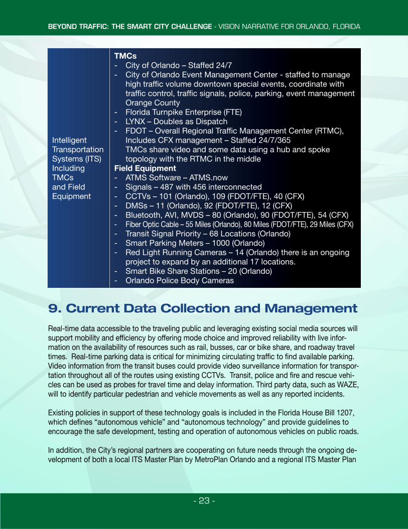
Intelligent Transportation Systems (ITS) Including TMCs and Field Equipment
TMCs- City of Orlando – Staffed 24/7- City of Orlando Event Management Center - staffed to manage
high traffic volume downtown special events, coordinate with traffic control, traffic signals, police, parking, event management
Orange County- Florida Turnpike Enterprise (FTE)- LYNX – Doubles as Dispatch- FDOT – Overall Regional Traffic Management Center (RTMC),
Includes CFX management – Staffed 24/7/365 TMCs share video and some data using a hub and spoke
topology with the RTMC in the middleField Equipment- ATMS Software – ATMS.now- Signals – 487 with 456 interconnected- CCTVs – 101 (Orlando), 109 (FDOT/FTE), 40 (CFX)- DMSs – 11 (Orlando), 92 (FDOT/FTE), 12 (CFX)- Bluetooth, AVI, MVDS – 80 (Orlando), 90 (FDOT/FTE), 54 (CFX)- Fiber Optic Cable – 55 Miles (Orlando), 80 Miles (FDOT/FTE), 29 Miles (CFX)- Transit Signal Priority – 68 Locations (Orlando)- Smart Parking Meters – 1000 (Orlando)- Red Light Running Cameras – 14 (Orlando) there is an ongoing
project to expand by an additional 17 locations.- Smart Bike Share Stations – 20 (Orlando)- Orlando Police Body Cameras
9. Current Data Collection and Management
Real-time data accessible to the traveling public and leveraging existing social media sources will support mobility and efficiency by offering mode choice and improved reliability with live infor-mation on the availability of resources such as rail, busses, car or bike share, and roadway travel times. Real-time parking data is critical for minimizing circulating traffic to find available parking. Video information from the transit buses could provide video surveillance information for transpor-tation throughout all of the routes using existing CCTVs. Transit, police and fire and rescue vehi-cles can be used as probes for travel time and delay information. Third party data, such as WAZE, will to identify particular pedestrian and vehicle movements as well as any reported incidents.
Existing policies in support of these technology goals is included in the Florida House Bill 1207, which defines “autonomous vehicle” and “autonomous technology” and provide guidelines to encourage the safe development, testing and operation of autonomous vehicles on public roads.
In addition, the City’s regional partners are cooperating on future needs through the ongoing de-velopment of both a local ITS Master Plan by MetroPlan Orlando and a regional ITS Master Plan
BEYOND TRAFFIC: THE SMART CITY CHALLENGE - VISION NARRATIVE FOR ORLANDO, FLORIDA
- 24 -
by FDOT. Agency partners meet regularly for the Central Florida ITS Consortium and Regional Working Groups to discuss regional issues and efforts. In addition, these partners are collabo-rating together on several ongoing regional projects which include:
• Decision Support Tool and ATMS – currently funded for implementation, and will include development of the Concept of Operations and the detailed requirements of a software platform for arterial management and a decision support system
• Big Data – development of five data use cases to serve as a proof of concept for the implementation of a central data collection and processing hub
• Data Fusion Center – consists of scrubbing the existing data sets for data structure issues, creation of new adaptors, and visualization of data, all hosted locally by FDOT
• Active Arterial Management – Two ongoing contracts• Transit Signal Priority – Two ongoing projects
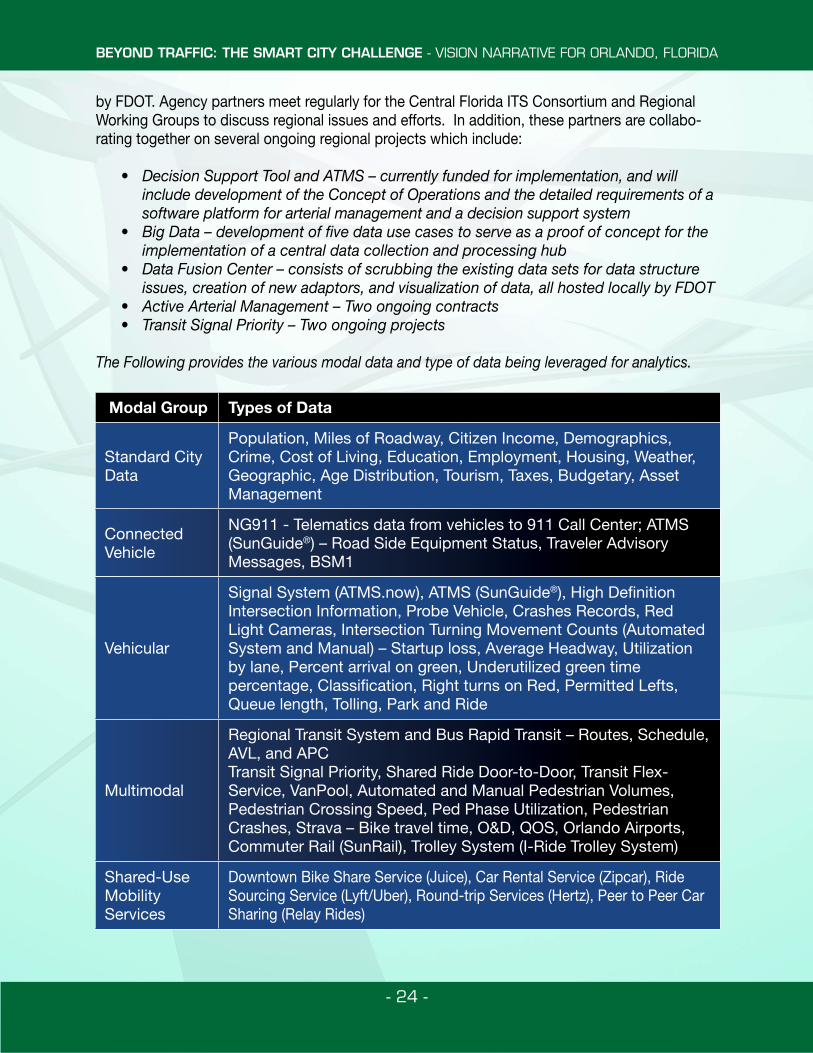
The Following provides the various modal data and type of data being leveraged for analytics.
Modal Group Types of Data
Standard City Data
Population, Miles of Roadway, Citizen Income, Demographics, Crime, Cost of Living, Education, Employment, Housing, Weather, Geographic, Age Distribution, Tourism, Taxes, Budgetary, Asset Management
Connected Vehicle
NG911 - Telematics data from vehicles to 911 Call Center; ATMS (SunGuide®) – Road Side Equipment Status, Traveler Advisory Messages, BSM1
Vehicular
Signal System (ATMS.now), ATMS (SunGuide®), High Definition Intersection Information, Probe Vehicle, Crashes Records, Red Light Cameras, Intersection Turning Movement Counts (Automated System and Manual) – Startup loss, Average Headway, Utilization by lane, Percent arrival on green, Underutilized green time percentage, Classification, Right turns on Red, Permitted Lefts, Queue length, Tolling, Park and Ride
Multimodal
Regional Transit System and Bus Rapid Transit – Routes, Schedule, AVL, and APCTransit Signal Priority, Shared Ride Door-to-Door, Transit Flex-Service, VanPool, Automated and Manual Pedestrian Volumes, Pedestrian Crossing Speed, Ped Phase Utilization, Pedestrian Crashes, Strava – Bike travel time, O&D, QOS, Orlando Airports, Commuter Rail (SunRail), Trolley System (I-Ride Trolley System)
Shared-Use Mobility Services
Downtown Bike Share Service (Juice), Car Rental Service (Zipcar), Ride Sourcing Service (Lyft/Uber), Round-trip Services (Hertz), Peer to Peer Car Sharing (Relay Rides)
BEYOND TRAFFIC: THE SMART CITY CHALLENGE - VISION NARRATIVE FOR ORLANDO, FLORIDA
- 25 -
10. Existing Architecture and ITS
Orlando has established regional structures and initiatives that are used to provide standards, architectures and a uniform certification process for many of its existing functions. It is anticipated that the City will build on this already solid foundation for the ITS and connected vehicle based technologies for documenting experience and improving Smart City products based on lessons learned. Some of these structures and initiatives are identified below.
The City’s Information Technology standards (including police and fire) are generated and main-tained by the Office of Information Technology (OIT). Therefore, the City’s Transportation Office, as well as other City Departments, follow the guidance set forth by OIT to ensure consistency. In addition, the City strives to provide the most recent and relevant technology for its citizens. Ex-amples include being an early adopter of the White House Cloud First Policy (SaaS email system, laaS Internet and Intranet hosting and SaaS ERP in the Cloud); Strong participation in the White House Open Data Initiative as a part of the City’s transparency; and the City’s Open Data Initiative. Finally, the City is adopting a cloud-based mobile PaaS and is creating government to citizens ap-plications as well as crowd sourcing using both City employees (mobile workers, police and fire),
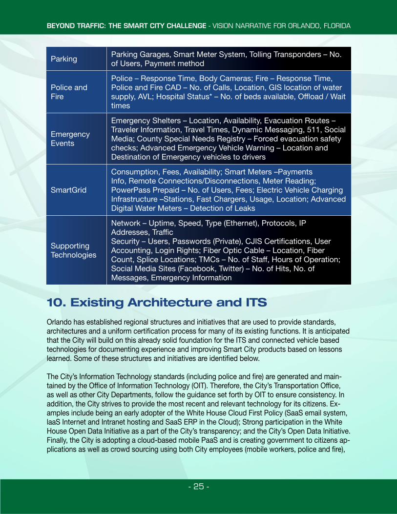
Parking Parking Garages, Smart Meter System, Tolling Transponders – No. of Users, Payment method
Police and Fire
Police – Response Time, Body Cameras; Fire – Response Time, Police and Fire CAD – No. of Calls, Location, GIS location of water supply, AVL; Hospital Status* – No. of beds available, Offload / Wait times
Emergency Events
Emergency Shelters – Location, Availability, Evacuation Routes – Traveler Information, Travel Times, Dynamic Messaging, 511, Social Media; County Special Needs Registry – Forced evacuation safety checks; Advanced Emergency Vehicle Warning – Location and Destination of Emergency vehicles to drivers
SmartGrid
Consumption, Fees, Availability; Smart Meters –Payments Info, Remote Connections/Disconnections, Meter Reading; PowerPass Prepaid – No. of Users, Fees; Electric Vehicle Charging Infrastructure –Stations, Fast Chargers, Usage, Location; Advanced Digital Water Meters – Detection of Leaks
Supporting Technologies
Network – Uptime, Speed, Type (Ethernet), Protocols, IP Addresses, TrafficSecurity – Users, Passwords (Private), CJIS Certifications, User Accounting, Login Rights; Fiber Optic Cable – Location, Fiber Count, Splice Locations; TMCs – No. of Staff, Hours of Operation; Social Media Sites (Facebook, Twitter) – No. of Hits, No. of Messages, Emergency Information
BEYOND TRAFFIC: THE SMART CITY CHALLENGE - VISION NARRATIVE FOR ORLANDO, FLORIDA
- 26 -
local technology community and citizens. These applications all require strong existing standards and architecture to ensure success.
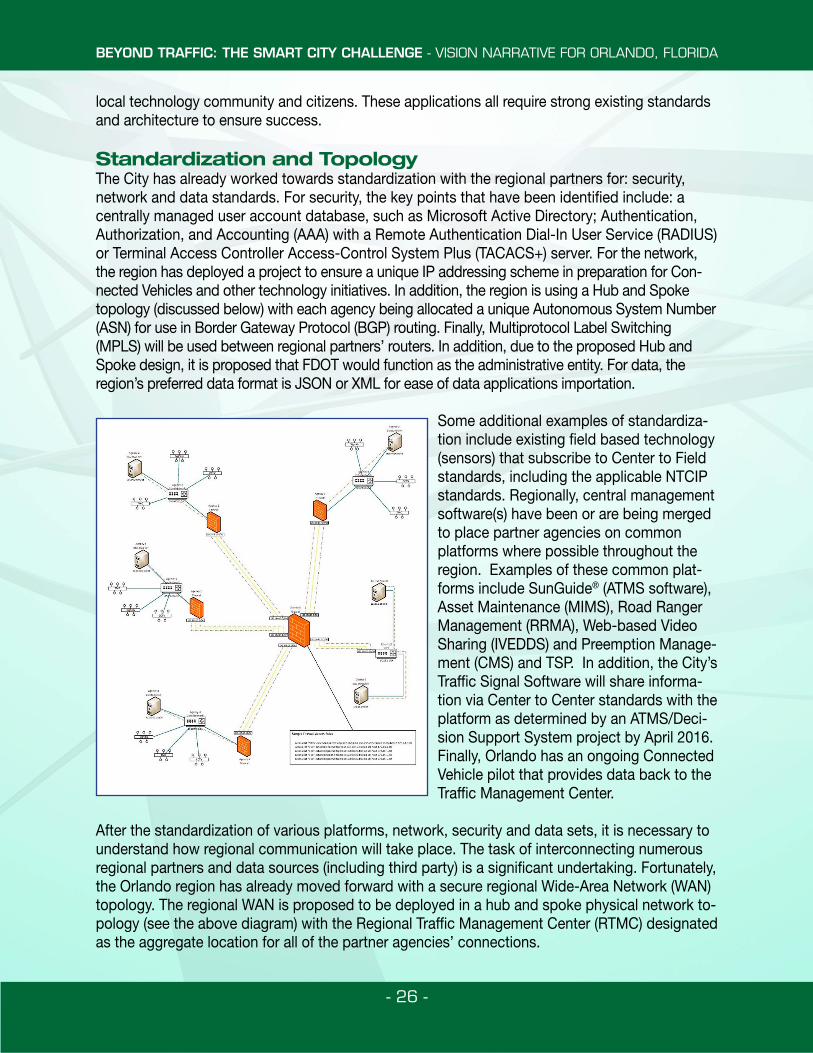
Standardization and TopologyThe City has already worked towards standardization with the regional partners for: security, network and data standards. For security, the key points that have been identified include: a centrally managed user account database, such as Microsoft Active Directory; Authentication, Authorization, and Accounting (AAA) with a Remote Authentication Dial-In User Service (RADIUS) or Terminal Access Controller Access-Control System Plus (TACACS+) server. For the network, the region has deployed a project to ensure a unique IP addressing scheme in preparation for Con-nected Vehicles and other technology initiatives. In addition, the region is using a Hub and Spoke topology (discussed below) with each agency being allocated a unique Autonomous System Number (ASN) for use in Border Gateway Protocol (BGP) routing. Finally, Multiprotocol Label Switching (MPLS) will be used between regional partners’ routers. In addition, due to the proposed Hub and Spoke design, it is proposed that FDOT would function as the administrative entity. For data, the region’s preferred data format is JSON or XML for ease of data applications importation.
Some additional examples of standardiza-tion include existing field based technology (sensors) that subscribe to Center to Field standards, including the applicable NTCIP standards. Regionally, central management software(s) have been or are being merged to place partner agencies on common platforms where possible throughout the region. Examples of these common plat-forms include SunGuide® (ATMS software), Asset Maintenance (MIMS), Road Ranger Management (RRMA), Web-based Video Sharing (IVEDDS) and Preemption Manage-ment (CMS) and TSP. In addition, the City’s Traffic Signal Software will share informa-tion via Center to Center standards with the platform as determined by an ATMS/Deci-sion Support System project by April 2016. Finally, Orlando has an ongoing Connected Vehicle pilot that provides data back to the Traffic Management Center.
After the standardization of various platforms, network, security and data sets, it is necessary to understand how regional communication will take place. The task of interconnecting numerous regional partners and data sources (including third party) is a significant undertaking. Fortunately, the Orlando region has already moved forward with a secure regional Wide-Area Network (WAN) topology. The regional WAN is proposed to be deployed in a hub and spoke physical network to-pology (see the above diagram) with the Regional Traffic Management Center (RTMC) designated as the aggregate location for all of the partner agencies’ connections.
BEYOND TRAFFIC: THE SMART CITY CHALLENGE - VISION NARRATIVE FOR ORLANDO, FLORIDA
- 27 -
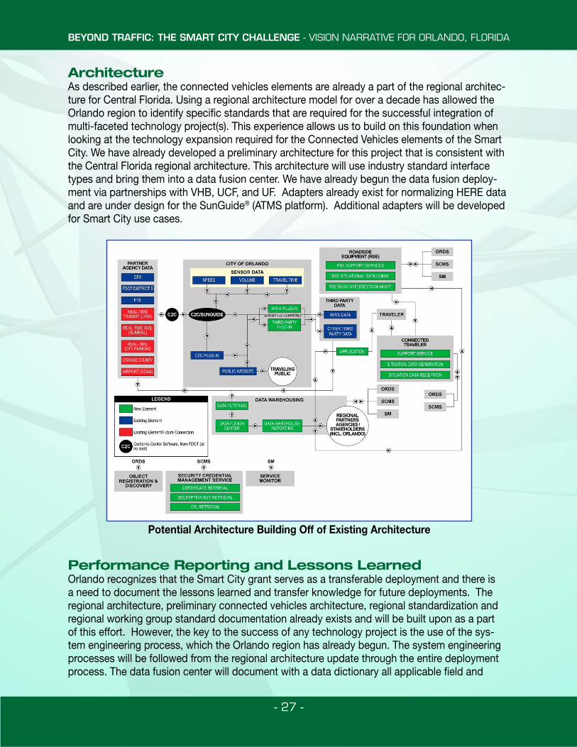
ArchitectureAs described earlier, the connected vehicles elements are already a part of the regional architec-ture for Central Florida. Using a regional architecture model for over a decade has allowed the Orlando region to identify specific standards that are required for the successful integration of multi-faceted technology project(s). This experience allows us to build on this foundation when looking at the technology expansion required for the Connected Vehicles elements of the Smart City. We have already developed a preliminary architecture for this project that is consistent with the Central Florida regional architecture. This architecture will use industry standard interface types and bring them into a data fusion center. We have already begun the data fusion deploy-ment via partnerships with VHB, UCF, and UF. Adapters already exist for normalizing HERE data and are under design for the SunGuide® (ATMS platform). Additional adapters will be developed for Smart City use cases.
Performance Reporting and Lessons LearnedOrlando recognizes that the Smart City grant serves as a transferable deployment and there is a need to document the lessons learned and transfer knowledge for future deployments. The regional architecture, preliminary connected vehicles architecture, regional standardization and regional working group standard documentation already exists and will be built upon as a part of this effort. However, the key to the success of any technology project is the use of the sys-tem engineering process, which the Orlando region has already begun. The system engineering processes will be followed from the regional architecture update through the entire deployment process. The data fusion center will document with a data dictionary all applicable field and
Potential Architecture Building Off of Existing Architecture
BEYOND TRAFFIC: THE SMART CITY CHALLENGE - VISION NARRATIVE FOR ORLANDO, FLORIDA
- 28 -
metadata to describe data source, extract, load, and transfer processes that have occurred to the data. This will allow for, not only verification of any particular Connected Vehicles product, but also the validation of the product over time. This information will be reported in the form of performance measure reports and dashboards, which in turn will be tied to threshold goals. With regards to coordination with specifications and standards developers, we will be continually updating the Concept of Operations and SEMP documents throughout operations. In addition, we would propose a web site with published reports, performance measurement reporting and lessons learned.
11. Performance Measures and Objectives
Orlando has developed a series of performance measures that will provide control parameters to monitor the holistic impacts associated with the integration of the Smart City Vision Elements outlined in the various sections of this application. Performance measures have been developed based on availability of data sources, performance indicators and desired overall monitoring out-comes for mobility, efficiency, safety, climate change and sustainability.
Objectives / Issues Goals Measures of Success
Mobility
Provide mode choice and network connectivity
- Availability of Real-time Data to Travelers
- Customer satisfaction (user surveys)
Improve mobility for vehicles
- Person Throughput- Average Delay Nonrecurring- Duration of congestion- Congested lane miles (%)
Improve bicycle mobility
- Connected Infrastructure to Support Smart Movement of Bicyclists
- Bike share with ¼ mile of residents and jobs
Improve pedestrian mobility
- Sidewalks on both sides of street with marked crosswalk
- Customer satisfaction (user surveys)
Improve transit options and performance
- Transit ridership- Number of buses in operation- Number in trains in operation
Provide freight mobility- Availability of Real-time Data to
Freight Providers- Number of Off-hour Freight Deliveries
BEYOND TRAFFIC: THE SMART CITY CHALLENGE - VISION NARRATIVE FOR ORLANDO, FLORIDA
- 29 -
The mobility performance measures are intended to evaluate the overall movement to promote mobility for all modes of travel. As a destination city, Orlando has the desire to balance the overall movement of commuter traffic and the significant amount of tourists that visit our City on an annual basis. The City, along with our partners, have committed to monitor these performance measures (and more) in order to enhance the experience visiting Orlando and the Central Florida region.
Objectives /Issues Goals Measures of Success
Efficiency
Provide efficient movement of vehicles
- VMT/VHT by Character Area- Congested Travel Time- Delay- Travel Time Index
Provide reliable transit - Travel time reliability- Schedule adherence
Provide reliable freight movement
- Freight delay- Freight VMT
Safety
Provide effective incident management
- Incident duration- Percent vehicle
Improve safety for pedestrians
- Severity of pedestrian crashes- Number of pedestrians injured
Improve network safety
- Number of crashes- Incident severity
Leveraging technology
- Number of crashes in CV areas- Incident Severity in CV Areas- RSE alerts issued
Climate Change
Reduce negative impact on climate change
- Emissions- Incentives for electric vehicle charging
stations- Availability of Recharging Stations- Alternative Fuel Availability for Transit- Green Land Use and Development
Regulation
Sustainability
Provide Asset Management
- Catalog of existing assets on the network
Maintain a state of good repair on all field assets
- Maintenance records for network assets- Feedback from Public
BEYOND TRAFFIC: THE SMART CITY CHALLENGE - VISION NARRATIVE FOR ORLANDO, FLORIDA
- 30 -
In addition to mobility, the City has committed to increase efficiency for vehicles including of freight mobility through Orlando. The City has continued to build on the Orlando MPO Freight Plan that was developed in 2002 to maximize the efficiency of freight movement from our ports, logistic centers and beyond. Orlando, though our partnerships with FDOT and MetroPlan Orlando, has continued to monitor the opportunities to improve safety conditions for all modes of transportation. Furthermore, the performance measures will build on the commitment to improve the environment in a sustainable manner. The climate change indicators provide for citywide measures of effectiveness that will lever-age our regional partnerships in order to enhance the environmental conditions.
12. Project Implementation CapacityFor the past decade, Orlando has been committed to enhancing and advancing its transportation technology infrastructure. Prior to pursuit of this grant, information regarding the objective and qualifications were brought before City commissioners who issued a referendum of support for the City to pursue the Smart City Challenge grant. As shown by the commitment letters, as well as the executive and legislative staff of the City support, this opportunity will continue to provide the nec-essary resources to ensure the successful advancement of the Smart City initiative. The City, along with our partners, has taken on unprecedented challenges and has become a leader of innovation in transportation technology. Orlando’s visionaries have led the creation of walkable communi-ties in Parramore, an underserved area, the advancement of commuter rail and the I-Ride trolley services along International Drive as well as the state-of-the-art venues such as the Performing Arts Center. These commitments will continue to advance the vision that Orlando has initiated. As a further demonstration of the City’s commitment, Orlando has secured commitment letters from Orlando Commission and key public/private partners to ensure that sufficient resources and com-mitments are available throughout the duration of this contract, and beyond.
13. Leveraging FundsThrough the partnerships that have been described in this applications, we envision that human, cap-ital and monetary resources will be available to fulfill our Smart City vision. In the Orlando Urbanized Area, there is a precedence of staff sharing between the various agencies to bring a federal project to fruition. The TravTek pilot project, a public/private partnership test of an advanced driver information system; the USDOT Beyond Traffic Forums held in several megaregions across the county; work-ing together to host the 2011 ITS WC are illustrations of combining local resources to accomplish a project that has transformed our transportation system for the better. Orlando is also a partner for the Electric Vehicle Transportation Center (EVTC) at UCF, one of the University Transportation Centers (UTC) funded by USDOT. The EVTC is the only UTC focused on electric vehicles and supports US-DOT’s strategic goals of planning for near-term integration of alternative fuel vehicles as a means to build a sustainable transportation system and of enhancing the environment. The EVTC’s research projects evaluate technologies, standards, planning and policies to ensure seamless integration of EVs into a complex transportation network while at the same time, seizing the opportunity these vehicles present to enhance electric grid modernization efforts. EVs provide the unique capability of being able to store energy which allows them to both use and supply energy to the nation’s electric grid. The future use of “smart-grid enabled” inverters and chargers will feature real-time, two-way communications and will be critical in bridging the gap between deployment of electric vehicles and the traditional transportation system. This is a significant component of our focus for Smart City ap-plications in Orlando.