beit fajjar town profile - applied research …vprofile.arij.org/bethlehem/pdfs/vp/beit...
TRANSCRIPT
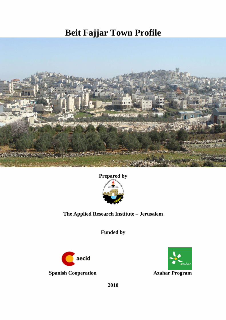
Beit Fajjar Town Profile
Prepared by
The Applied Research Institute – Jerusalem
Funded by
Spanish Cooperation Azahar Program
2010

Palestinian Localities Study Bethlehem Governorate
1
Acknowledgments
ARIJ hereby expresses its deep gratitude to the Spanish agency for International Cooperation for Development (AECID) for their funding of this project through the Azahar Program. ARIJ is grateful to the Palestinian officials in the ministries, municipalities, joint services councils, village committees and councils, and the Palestinian Central Bureau of Statistics (PCBS) for their assistance and cooperation with the project team members during the data collection process. ARIJ also thanks all the staff who worked throughout the past couple of years towards the accomplishment of this work.

Palestinian Localities Study Bethlehem Governorate
2
Background
This booklet is part of a series of booklets, which contain compiled information about each city, town, and village in Bethlehem Governorate. These booklets came as a result of a comprehensive study of all localities in Bethlehem Governorate, which aims at depicting the overall living conditions in the governorate and presenting developmental plans to assist in developing the livelihood of the population in the area. It was accomplished through the "Village Profiles and Azahar Needs Assessment;" the project funded by the Spanish Agency for International Cooperation for Development (AECID) and the Azahar Program. The "Village Profiles and Azahar Needs Assessment" was designed to study, investigate, analyze and document the socio-economic conditions and the needed programs and activities to mitigate the impact of the current unsecure political, economic and social conditions in Bethlehem Governorate with particular focus on the Azahar program objectives and activities concerning water, environment, and agriculture.
The project's objectives are to survey, analyze, and document the available natural, human, socioeconomic and environmental resources, and the existing limitations and needs assessment for the development of the rural and marginalized areas in Bethlehem Governorate. In addition, the project aims at preparing strategic developmental programs and activities to mitigate the impact of the current political, social, and economic instability with the focus on the agricultural sector. All locality profiles in Arabic and English are available online at http://proxy.arij.org/vprofile.

Palestinian Localities Study Bethlehem Governorate
3
Table of Content
Location and Physical Characteristics __________________ 4 History ___________________________________________ 5 Religious and Archaeological Sites_____________________ 6 Population ________________________________________ 7 Education _________________________________________ 7 Health Status ______________________________________ 8 Economic Activities _________________________________ 9 Agricultural Sector ________________________________ 10 Institutions and Services ____________________________ 12 Infrastructure and Natural Resources _________________ 13 Environmental Conditions __________________________ 15 Impact of the Israeli Occupation______________________ 17 Development Plans and Projects______________________ 18 Implemented Projects ______________________________ 18 Proposed Projects__________________________________ 19 Locality Development Priorities and Needs _____________ 19 References:_______________________________________ 21

Palestinian Localities Study Bethlehem Governorate
4
Beit Fajjar Town Profile
Location and Physical Characteristics Beit Fajjar is a Palestinian town in Bethlehem Governorate located 10.3km (horizontal distance) south of Bethlehem City. Beit Fajjar is bordered by Al Maniya village to the east, Marah Rabah and Umm Salamuna villages to the north, Kfar Etzion settlement to the west, and Sa'ir town and Shuyukh al 'Arrub village, within Hebron governorate, to the south (See map 1).
Map 1: Beit Fajjar location and borders
Beit Fajjar is located at an altitude of 929m above sea level with a mean annual rainfall of 621mm. The average annual temperature is 16o C, and the average annual humidity is about 61 percent (ARIJ GIS, 2009). Since 1997, Beit Fajjar has been governed by a municipal council which is currently administrated by 13 members appointed by the Palestinian Authority. There are also 25 employees working in the council. The municipality owns a permanent

Palestinian Localities Study Bethlehem Governorate
5
headquarters, a vehicle to collect solid waste, a truck, a small Hummer for excavation work, and a private car. It is the responsibility of the municipality to provide a number of services to the residents of Beit Fajjar, including:
1. Infrastructure services such as water and electricity. 2. Solid waste collection, road construction and restoration, street cleaning, and
social development services. 3. Protection of religious and archaeological sites. 4. Street lighting. 5. Headquarters for the government services such as post and security. 6. Organization of the construction and licensing processes.
History In the Canaanites era, Beit Fajar town was called Shafasa, which means the supervisor town; however, in Omar Ben El Khattab’s era he changed the name to Beit Fajjar. Beit Fajjar town dates back to 1784 and its residents originate from Bethlehem city.
Photo of Beit Fajjar
Palestinian Localities Study Bethlehem Governorate
6
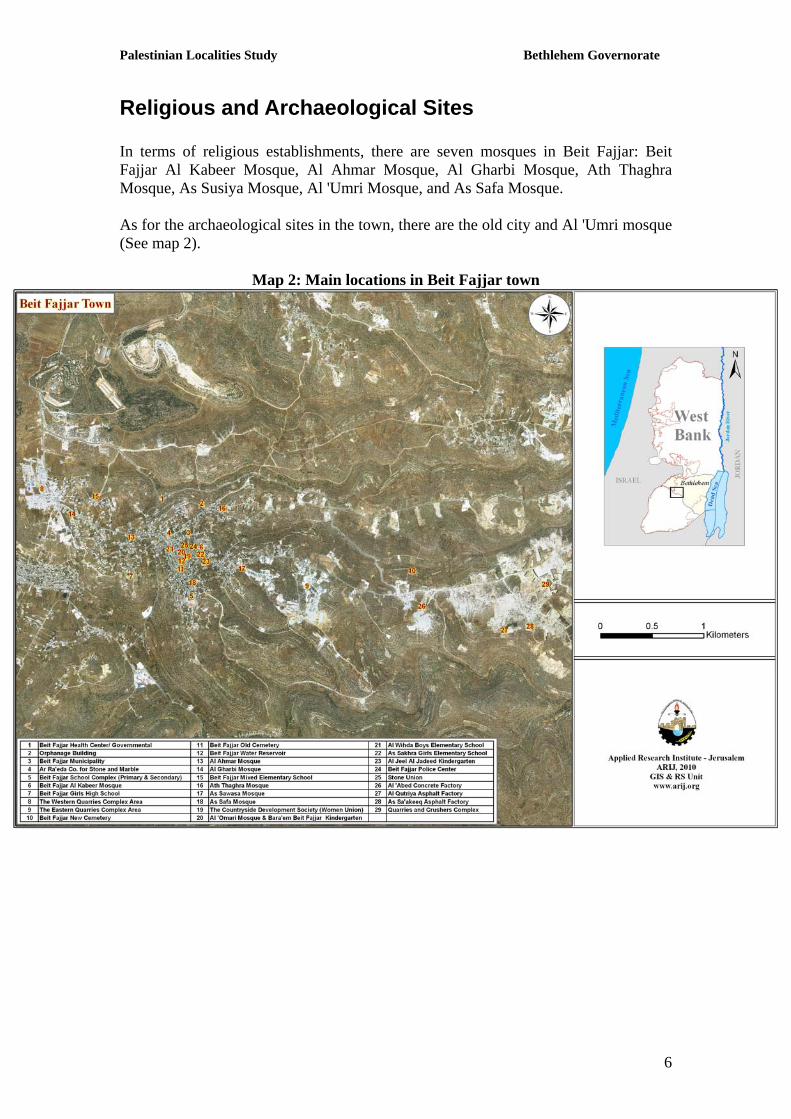
Religious and Archaeological Sites In terms of religious establishments, there are seven mosques in Beit Fajjar: Beit Fajjar Al Kabeer Mosque, Al Ahmar Mosque, Al Gharbi Mosque, Ath Thaghra Mosque, As Susiya Mosque, Al 'Umri Mosque, and As Safa Mosque. As for the archaeological sites in the town, there are the old city and Al 'Umri mosque (See map 2).
Map 2: Main locations in Beit Fajjar town

Palestinian Localities Study Bethlehem Governorate
7
Population According to the Palestinian Central Bureau of Statistics (PCBS), the total population of Beit Fajjar in 2007 was 11,004; of whom 5,634 are males and 5,370 are females. There are 1,808 households living in 2,042 housing units. Age Groups and Gender The General Census of Population and Housing carried out by PCBS in 2007 showed that the distribution of age groups in Beit Fajjar is as follows: 42.1 percent are less than 15 years, 54.6 percent are between 15 - 64 years, and 3 percent are 65 years and older. Data also showed that the sex ratio of males to females in the town is 104.9:100, meaning that males constitute 51.2 percent of the population, and females constitute 48.8 percent of the population. Families The inhabitants of Beit Fajjar town are composed of several families, mainly: At Thawabta, At Takatka, and Deiriyeh.
Education According to the results of the PCBS Population, Housing and Establishment Census-2007, the illiteracy rate among Beit Fajjar population is about 5.6 percent, of whom 73.5 percent are females. Of the literate population, 16.8 percent can read and write, 29.2 percent had elementary education, 31.2 percent had preparatory education, 15.9 percent had secondary education, and 6.85 percent completed higher education. Table 1, shows the educational level in the town of Beit Fajjar, by sex, and educational attainment in 2007.
Table 1: Beit Fajjar population (10 years and above) by sex and educational attainment S E x
Illiterate Can read & write
Elementary Preparatory Secondary Associate Diploma Bachelor Higher
Diploma Master PhD Total
M 112 630 1171 1071 573 131 153 3 13 2 3861 F 311 565 898 1143 554 69 111 - 4 - 3656 T 423 1195 2069 2214 1127 200 264 3 17 2 7517
Source: PCBS, 2009. Population, Housing and Establishment Census-2007, Final Results In regards to the basic and secondary educational institutions and schools in Beit Fajjar in the academic year 2008/2009, there are nine schools in the town, four for girls, four for boys, and one mixed, all run by the Palestinian Ministry of Higher Education (See Table 2).

Palestinian Localities Study Bethlehem Governorate
8
There is a total number of 3538 students, 136 teachers, and 112 classes (Directorate of Education in Bethlehem, 2009). It should be noted here that the average number of students per teacher in the school is nearly 26, while the average number of students per class is approximately 32 (Directorate of Education in Bethlehem, 2009). Table 2: The Schools in Beit Fajjar by name, stage, sex, and supervising authority
School Name Supervising Authority Sex Beit Fajjar Boys High School At Tahreer Boys Elementary School Al Wihda Boys Elementary School Beit Fajjar Boys Elementary School
Government Male
Hifa Girls Elementary School Al Wafa' Girls Elementary School Beit Fajjar Girls High School As Sakhra Girls Elementary School
Government Female
The Mixed Elementary School Government Mixed Source: Directorate of Education in Bethlehem, 2009 Furthermore, there are two kindergartens in Beit Fajjar; one is privately run and the other is run by a charitable organization. Table 3 shows the kindergartens according to their names and supervising authority. Table 3: The Kindergartens in Beit Fajjar by name and supervising authority
Kindergarten Name No. of Children
Supervising Authority
Bara'em Beit Fajjar Kindergarten 250 Charitable Organization Al Jeel Al Jadeed Kindergarten 200 Private Source: Beit Fajjar Municipality, 2010
Health Status There are some health facilities available in Beit Fajjar town; a governmental health center which has a physician’s clinic, X rays center, and a motherhood and childhood center. Beit Fajjar town also has a health center run by a charitable society, a private physician’s clinic, a private specialized doctor clinic, a private dental clinic, in addition to a medical laboratory, several pharmacies, and an ambulance, belonging to the Red Crescent, for emergencies. The major problems that face the health sector in Beit Fajjar town are:
1. The long distance between the health centers and the residents. 2. The health center opens only part time and is not available at all hours. 3. Lack of doctors and medical staff.

Palestinian Localities Study Bethlehem Governorate
9
Economic Activities The economy in Beit Fajjar is dependent mainly on industry; marble and stone, which absorbs 80 percent of the town workforce (See Figure1). The results of a field survey for the distribution of labor by economic activity in Beit Fajjar are the following:
• Industry (80%) • Trade Sector (7%) • Government or Other Employees Sector (5%) • Services Sector (5%) • Agriculture Sector (3%)
Figure 1: Economic Activity in Beit Fajjar Town
Beit Fajjar is considered an industrial town; it has many stone and marble quarries and brick and concrete factories, in addition to 3 bakeries, 5 butcheries, 10 different services stores, 5 different workshops (blacksmith, carpentry, etc), 4 groceries, and 110 grocery stores. The unemployment rate in Beit Fajjar has reached about 60 percent. It was found that the most vulnerable social groups in the town, as a result of Israeli actions, are: 1. Workers in the stone and marble industry. 2. Workers in the agricultural sector.
Labor Force According to the PCBS Population, Housing and Establishment Census-2007, 31.8 percent of Beit Fajjar population was economically active, of whom 91.6 percent were employed, 68.2 percent were not economically active, 50.9 percent were students, and 36.7 percent were housekeepers (See table 4).
Services Sector
5%
Agriculture Sector
3%
Industry80%
Trade Sector7%
Government or Other
Employees Sector
5%

Palestinian Localities Study Bethlehem Governorate
10
Table 4: Beit Fajjar population (10 years and above) by sex and employment status-2007 S E X
Economically Active Not Economically Active Total
Employed Currently Unemployed
Unemployed (Never worked)
Total Students House- keeping
Unable to work
Not working & Not looking for work
Other Total
M 2,044 116 51 2,211 1,242 8 265 43 88 1,646 3,861 F 142 15 19 176 1,368 1,875 214 3 19 3,479 3,656 T 2,186 131 70 2,387 2,610 1,883 479 46 107 5,125 7,517
Source: PCBS, March 2009. Population, Housing and Establishment Census-2007, Final Results
Agricultural Sector Beit Fajjar lies on a total area of about 12,122 dunums of which 10,248 dunums are considered arable land, and 819 dunums are residential land (See table 5 and map 3).
Table 5: Land Use in Beit Fajjar town (dunum) Arable Land
(10,248) Total Area
Built up
Area Seasonal Crops
Permanent Crops Greenhouses Forests
Open Spaces and Rangelands
Area of Industrial,
Commercial & Transport
Unit
Area of Settlements
and Military
Bases 12,122 819 1,270 3,741 4 0 5,233 1,055 0
Source: GIS unit – ARIJ, 2008

Palestinian Localities Study Bethlehem Governorate
11
Map 3: Land use/land cover and Segregation Wall in Beit Fajjar Town
Agricultural production in Beit Fajjar depends mostly on rainwater. As for irrigated fields, they depend on domestic harvesting cisterns and the public water network. Table 6 shows the different types of rain-fed and irrigated open-cultivated vegetables in Beit Fajjar. The most common crop cultivated within this area is tomato.
Table 6: Total area of rain-fed and irrigated open cultivated vegetables in Beit Fajjar town (dunum)
Fruity vegetables
Leafy vegetable
Green legumes Bulbs Other
vegetables Total area
RF Irr. RF Irr. RF Irr. RF Irr. RF Irr. RF Irr. 17 13 0 3 1 2 0 2 0 3 18 23
Rf: Rain-fed, Irr: Irrigated Source: Palestinian Ministry of Agriculture, 2007 There are also 4 dunums of land on which there are greenhouses planted with cucumber.

Palestinian Localities Study Bethlehem Governorate
12
Table 7 shows the different types of fruit trees planted in the area. Beit Fajjar is known for its olive harvesting, as there are 1,752 dunums in the town planted with olive trees. Table 7: Total area of fruit and olive trees in Beit Fajjar Town (dunum) Olives Citrus Stone-
fruits Pome fruits
Nuts Other fruits
Total area
Rf Irr. Rf Irr. Rf Irr. Rf Irr. Rf Irr. Rf Irr. Rf Irr.1,752 0 0 0 44 0 4 0 0 0 1,305 0 3,105 0 Rf: Rain-fed, Irr: Irrigated Source: Palestinian Ministry of Agriculture, 2007 As for the field crops and forage in Beit Fajjar, cereals, in particular, wheat and barley are the most cultivated covering an area of about 200 dunums, while forage crops, such as bitter vetch and common vetch are the second most cultivated crops (See table 8). Table 8: Total area of field crops in Beit Fajjar town (dunum) Cereals Bulbs Dry
legumes Oil crops
Forage crops
Stimulating crops
Other crops
Total area
Rf Irr Rf Irr Rf Irr Rf Irr Rf Irr Rf Irr Rf Irr Rf Irr200 0 0 0 16 0 0 0 19 0 0 0 0 0 235 0 Rf: Rain-fed, Irr: Irrigated Source: Palestinian Ministry of Agriculture, 2007 The field survey shows that 3 percent of the residents in Beit Fajjar are rearing and keeping domestic animals such as sheep, goats, broiler and layer chicken, and bees (See Table 9). Table 9: Livestock in Beit Fajjar town Cows* Sheep
Goats Camels Horses Donkeys
Mules Broilers Layers Bee
Hives0 456 675 0 4 23 18 16,000 5,000 30 *Including cows, bull calves, heifer calves and bulls Source: Palestinian Ministry of Agriculture, 2007 There are about 50 kilometers of agricultural roads in the town suitable for vehicles.
Institutions and Services Beit Fajjar has a security office and a police office, in addition to a number of local institutions and associations that provide services to various segments of society. The services are in the areas of culture, sports and others, including: (Beit Fajjar Municipality, 2010)

Palestinian Localities Study Bethlehem Governorate
13
• Beit Fajjar Municipality: Founded in 1997 by the Ministry of Local Government with the goal of taking care of all the issues in the town and providing various services to its population.
• Beit Fajjar Agricultural Society: It assists and serves the farmers and helps in the development of agriculture.
• Cooperative Agriculture Society: It assists and serves the farmers and helps in the development of agriculture.
• Rural Women Development Society: It provides guidance and awareness courses to women.
• Beit Fajjar Women Society: It takes care of all women’s issues and affairs. • Students Forum • Beit Fajjar Arabic Charitable Society • Beit Fajjar Youth Sport Club: It is interested in all sport activities in the
town. • Young Muslims Society • Beit Fajjar Workers Union • Children House Society • Palestinian Child Development Society: It takes care of all children’s affairs.
Infrastructure and Natural Resources
Electricity and Telecommunication Services: Beit Fajjar has been connected to a public electricity network since 1985; served by Jerusalem Electricity Company, which is the main source of electricity in the town. Approximately 98.7 percent of the housing units in the town are connected to the network, and 1.1 percent are dependent on private generators for electricity, while the remaining units (0.2%) have no source for electricity (Central Bureau of Statistics, 2007). Furthermore, Beit Fajjar is connected to a telecommunication network and approximately 35.8 percent of the housing units within the town boundaries are connected to phone lines.
Transportation Services: Private cars and buses are the two main means of transportation in Beit Fajjar. As for the road network in the town; there are a total of 22km of main roads, which are paved and in good condition, and a total of 5km of secondary roads, which are also paved and in good condition (Beit Fajjar Municipality, 2010).

Palestinian Localities Study Bethlehem Governorate
14
Water Resources: Beit Fajjar is provided with water by the West Bank Water Department, through the public water network established in 1975, and about 98.5 percent of the housing units are connected to the water network, 0.7 percent are dependent on rainwater harvesting cisterns, 0.5 percent are dependent on tanks, and 0.2 percent are dependent on other resources for water, while the source of water supply is unknown for the remaining units (0.1%) (PCBS, 2007). The quantity of water supplied to Beit Fajjar in 2009 was about 420,000 cubic meters/year, therefore the estimated rate of water supply per capita is about 106 liters/day (Beit Fajjar Municipality, 2010). Here it should be noted that many Beit Fajjar citizens do not in fact consume this amount of water due to water losses, which are about 30 percent. The losses happen at the main source, major transport lines, distribution network, and at the household level (Beit Fajjar Municipality, 2010), thus the actually rate of water consumption per capita in Beit Fajjar is 74 liters per day. This is a low rate compared with the minimum quantity proposed by the World Health Organization, which is 100 liters per capita per day. Also, located in Beit Fajjar are 1500 rainwater harvesting cisterns and a public water reservoir with a capacity of 500 cubic meters (Beit Fajjar Municipality, 2010). Sanitation: Beit Fajjar lacks a public sewage network; most of the population uses cesspits as means for wastewater disposal. According to PCBS's Population and Housing Census in 2007 and PWA data, the majority of Beit Fajjar 's housing units (99.5%) use cesspits for wastewater disposal, 0.3 percent of the housing units don’t have any means for wastewater collection and disposal, while the means for waste water disposal is unknown for the remaining units (0.1%). Based on the estimated daily per capita water consumption, the estimated amount of wastewater generated per day is approximately 660 cubic meters, or 240,900 cubic meters annually. At the individual level in the town, it is estimated that the per capita wastewater generation is approximately 60 liters per day. The wastewater collected by cesspits is discharged by wastewater tankers directly to open areas without any regard for the environment. Here it should be noted that there is no wastewater treatment either at the source or at the disposal sites and this poses a serious threat to the environment and the public health. Solid Waste Management: Beit Fajjar Municipality is considered the official body responsible for managing solid waste, i.e. solid waste collection and disposal, generated from the citizens and establishments in Beit Fajjar. Due to the fact that the process of solid waste management is costly, a monthly fee has been charged on the population, serviced by domestic solid waste collection and transportation services, which is about 12 NIS/month. However, the collected fees are not considered sufficient for a good management of solid waste.
Palestinian Localities Study Bethlehem Governorate
15
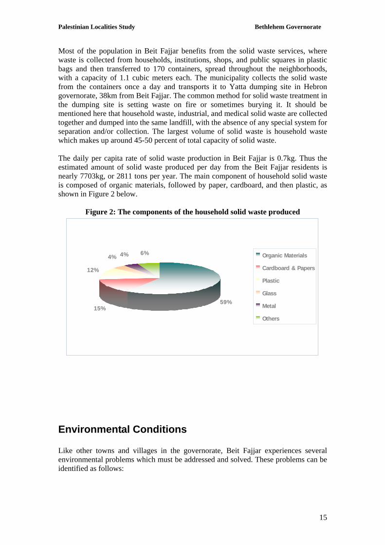
Most of the population in Beit Fajjar benefits from the solid waste services, where waste is collected from households, institutions, shops, and public squares in plastic bags and then transferred to 170 containers, spread throughout the neighborhoods, with a capacity of 1.1 cubic meters each. The municipality collects the solid waste from the containers once a day and transports it to Yatta dumping site in Hebron governorate, 38km from Beit Fajjar. The common method for solid waste treatment in the dumping site is setting waste on fire or sometimes burying it. It should be mentioned here that household waste, industrial, and medical solid waste are collected together and dumped into the same landfill, with the absence of any special system for separation and/or collection. The largest volume of solid waste is household waste which makes up around 45-50 percent of total capacity of solid waste. The daily per capita rate of solid waste production in Beit Fajjar is 0.7kg. Thus the estimated amount of solid waste produced per day from the Beit Fajjar residents is nearly 7703kg, or 2811 tons per year. The main component of household solid waste is composed of organic materials, followed by paper, cardboard, and then plastic, as shown in Figure 2 below.
Figure 2: The components of the household solid waste produced
59%15%
12%
4% 4% 6% Organic Materials
Cardboard & Papers
Plastic
Glass
Metal
Others
Environmental Conditions Like other towns and villages in the governorate, Beit Fajjar experiences several environmental problems which must be addressed and solved. These problems can be identified as follows:

Palestinian Localities Study Bethlehem Governorate
16
Water Crisis: Water is cut off for long periods of time in summer and winter in several neighborhoods of the town for several reasons, including:
• Israeli domination over Palestinian water resources; accordingly, supplying Palestinians communities with insufficient water quantities to cover their domestic needs.
Wastewater Management: The absence of a public sewage network, thus, the use of cesspits for the disposal of wastewater, and the discharge of wastewater in the streets, especially in winter, because the citizens can not afford the high cost of sewage tankers. All of this causes environmental damages, health problems, and the spread of epidemics and diseases in the town. The use of cesspits pollutes the groundwater and water collected in domestic cisterns (rainwater harvesting cisterns) as the wastewater mixes with water and contaminates it and thus makes it inappropriate for human consumption. This is due to the fact that most cesspits are built without lining, which allows wastewater to enter into the ground and avoids the need to use sewage tankers from time to time. Moreover, the untreated wastewater collected from cesspits by sewage tankers is disposed of in open areas without taking into account the damage it causes to the environment and the residents' health. Solid Waste Management: The lack of a central sanitary landfill to serve Beit Fajjar and the other communities in the governorate is due mainly to the obstacles created by the Israeli authorities for local and national institutions, such as the difficulty to obtain licenses to establish such a landfill, because the appropriate land is within Area C, under the Israeli full control. In addition, the implementation of such projects depends on funding from donor countries. Thus, the lack of a sanitary landfill is a hazard risk for the health, and a source of pollution to the groundwater and soil through the leachate produced from the solid waste, and it also produces bad odors and distorts the landscape. It should be noted here that a sanitary landfill is currently under construction in Al Maniya area, south of Bethlehem governorate, to serve Bethlehem and Hebron governorates. There is an absence of a system in the town and the governorate in general that separates hazardous waste from non-hazardous waste, consequently hazardous solid waste is collected with non-hazardous waste and transported to Yatta landfill in Hebron governorate for disposal by burning and burying.

Palestinian Localities Study Bethlehem Governorate
17
Impact of the Israeli Occupation According to the Oslo Interim Agreement, signed in September 1995, between the Palestinian National Authority and the Israeli government, 10,385 dunums of Beit Fajjar lands (85.7 percent of the total area of the town) were classified as area B, in which public order falls under the Palestinian National Authority's responsibility and Israeli has full control over security matters. The remaining part of Beit Fajjar lands, 1736 dunums (14.3 percent of the total area of the town), were classified as area C, an area that is under full security and administrative control of the Israeli government (Table 10).
Table 10: Land classification in Beit Fajjar according to Oslo II Agreement in 1995 % of the Total Area Area (dunums) Land Classification
0 0 Area A 85.7 10385 Area B 14.3 1736 Area C 100 12121 Total Area
Source: GIS unit –ARIJ 2009

Palestinian Localities Study Bethlehem Governorate
18
Development Plans and Projects
Implemented Projects Beit Fajjar municipality has implemented several development projects in Beit Fajjar between 2007 to 2009 (See Table 11).
Table 11: Implemented Development Plans and Projects in Beit Fajjar (2007-2009) Name of the Project
Type Year Donor
Construction and finishing of Beit Fajjar service center
Construction 2007 Cooperative Housing Foundation
Rehabilitation and pavement of the street linking Beit Fajjar to Marah Rabah
Infrastructure2007
Islamic Development Bank
Rehabilitation of Beit Fajjar girls high school's street
Infrastructure 2008 EC
Maintenance of part of the public water network
Infrastructure 2008 USAID & the American Relief for Palestine refugees in the Near East - ANERA
Expanding the public water network Infrastructure 2008 USAID & the American Relief for Palestine refugees in the Near East - ANERA
Construction of new classrooms in Beit Fajjar boys high school
Construction 2008 Palestinian Economic Council for Development and Reconstruction - PECDAR
Pavement and rehabilitation of internal roads
Infrastructure 2009 German Development Bank
Pavement and rehabilitation of internal roads
Infrastructure 2009 Ministry of Works and Housing
Construction of new classrooms to Al Wafa' elementary school
Construction 2009 Japan
Construction of Beit Fajjar mixed elementary school
Construction 2009 Arab African Development Bank & Islamic Development Bank
Finishing the second floor in Haifa girls elementary school
Construction 2009 Cooperative Housing Foundation
Source: Beit Fajjar Municipality, 2010

Palestinian Localities Study Bethlehem Governorate
19
Proposed Projects Beit Fajjar municipality, in cooperation with the civil society organizations in the town and the town residents, looks forward to the implementation of several projects in the coming years. The project ideas were developed during the PRA workshop that was conducted by ARIJ staff in the town. The projects are as follows, in order of priority, from the viewpoint of the participants in the workshop:
1. Establishment of a sewage network or wastewater treatment plants at the household level.
2. Construction of rainwater harvesting cisterns and agricultural wells. 3. Supporting livestock. 4. Supporting farmers and providing agricultural machinery, pesticides,
fertilizers, seeds, and seedlings, and a lending fund for farmers. 5. Construction of agricultural roads in the town. 6. Establishment of agricultural factories. 7. Establishment of home gardens and greenhouses. 8. Providing agricultural guidance courses for men and women and agricultural
advisors. 9. Boycotting settlements' agricultural and food products in order to improve the
marketing of local products. 10. Protection of agricultural lands from the occupation through the construction
of fences and gates. 11. Solving the problem of stray animals. 12. Establishment of a public solid waste landfill.

Palestinian Localities Study Bethlehem Governorate
20
Locality Development Priorities and Needs Beit Fajjar suffers from a significant shortage of infrastructure and services. Table 12 shows the development priorities and needs in the town, according to the municipality's point of view (Beit Fajjar Municipality, 2010):
Table 12: Development Priorities and Needs in Beit Fajjar No. Sector Strongly
Needed Needed Not a
Priority Notes
Infrastructural Needs
1 Opening and Pavement of Roads * 8km 2 Rehabilitation of Old Water Networks 30km 3 Extending the Water Network to Cover New Built up
Areas * 5km
4 Construction of New Water Networks * 5 Rehabilitation/ Construction of New Wells or
Springs *
6 Construction of Water Reservoirs * 1,000m3 7 Construction of a Sewage Disposal Network * 40km 8 Construction of a New Electricity Network * 6km 9 Providing Containers for Solid Waste Collection * 70 containers
10 Providing Vehicles for Collecting Solid Waste * 1 11 Providing a Sanitary Landfill * 1 Health Needs
1 Building of New Clinics or Health Care Centres * 2 Rehabilitation of Old Clinics or Health Care Centres *
3 Purchasing of Medical Equipment and Tools * Educational Needs
1 Building of New Schools * elementary 2 Rehabilitation of Old Schools * 3 Purchasing of New Equipment for Schools * Agriculture Needs
1 Rehabilitation of Agricultural Lands * 5,000 dunums 2 Building Rainwater Harvesting Cisterns * 3 Construction of Barracks for Livestock * 4 Veterinary Services * 5 Seeds and Hay for Animals * 6 Construction of New Greenhouses * 7 Rehabilitation of Greenhouses * 8 Field Crops Seeds * 9 Plants and Agricultural Supplies *
6km internal road and 2km agricultural road

Palestinian Localities Study Bethlehem Governorate
21
References: • Applied Research Institute - Jerusalem (ARIJ). (2008 - 2009).
Bethlehem, Palestine: Geographic Information Systems and Remote Sensing unit Database, 2009.
• Beit Fajjar Municipality. 2010. • Directorate of Education - Bethlehem. 2008/2009. Bethlehem,
Palestine: A database of schools. • Palestinian Central Bureau of Statistics. 2009. Ramallah, Palestine:
General Census of Population and Housing Censuses, 2007. • Palestinian Ministry of Agriculture (MOA). 2007/2008. Bethlehem,
Palestine: Directorate of Agriculture data.