before the county council for montgomery county, maryland · pdf filebefore the county council...
TRANSCRIPT
BEFORE THE COUNTY COUNCIL FOR MONTGOMERY COUNTY, MARYLAND SITTING AS THE DISTRICT COUNCIL FOR THE MARYLAND-
WASHINGTON REGIONAL DISTRICT IN MONTGOMERY COUNTY, MARYLAND
Office of Zoning and Administrative Hearings Stella B. Werner Council Office Building
100 Maryland Avenue, Room 200
Rockville, Maryland 20850
(240) 777-6660
IN THE MATTER OF: * CLARKSBURG MEWS, LLC * Applicant * * Michael Fisher * David Ager * Zoning Application No. G-957 Stephen Crum * Carl Wilson * For the Application * * Jody S. Kline, Esquire * Attorney for the Applicant * * * * * * * * * * * * * * * * * * * * * * * * * * * * * * * * * * Before: Martin L. Grossman, Hearing Examiner
Director, Office of Zoning and Administrative Hearings
HEARING EXAMINER’S REPORT AND RECOMMENDATION
LMA G-957 Page 2
TABLE OF CONTENTS
Page No.
I. CASE SUMMARY ...................................................................................................................... 3
II. STATEMENT OF THE CASE ................................................................................................... 4
III. FACTUAL BACKGROUND .................................................................................................... 6
A. SUBJECT PROPERTY .................................................................................................................. 6 B. SURROUNDING AREA AND ADJACENT DEVELOPMENT .............................................................. 8 C. ZONING HISTORY.................................................................................................................... 11 D. PROPOSED DEVELOPMENT ...................................................................................................... 11
1. Development Concept ........................................................................................................ 11 2. Development Plan & Binding Elements ............................................................................ 13 3. Use of Public Facilities (Transportation, School Capacity and Water & Sewer Service) . 19
a. Transportation ................................................................................................................ 20 b. Impacts on School Capacity ........................................................................................... 28 c. Water and Sewer Service ............................................................................................... 29
4. Environmental Impacts ...................................................................................................... 30 a. Forest Conservation ....................................................................................................... 31 b. Stormwater Management and the Water Quality Plan .................................................. 32 c. Level of Imperviousness ................................................................................................ 35 d. Protecting the Stream Valley Buffer: ............................................................................. 37
E. COMMUNITY CONCERNS ......................................................................................................... 41
IV. SUMMARY OF THE HEARING ........................................................................................... 42
V. FINDINGS OF FACT AND CONCLUSIONS OF LAW ........................................................ 59
A. STANDARDS FOR COUNCIL REVIEW ........................................................................................ 59 B. REQUIRED FINDINGS ............................................................................................................... 61
1. County Plans and Policies .................................................................................................. 61 a. The Applicable Master Plan or Sector Plan ................................................................... 61 b. The General Plan and the County Capital Improvements Program ............................... 64 c. Other County Policies (Subdivision Staging Policy and Adequate Public Facilities) ... 64
2. Zone Requirements, Safety, Convenience and Amenity of Residents and Compatibility 65 a. Compliance with Zone Purposes, Standards and Regulations ....................................... 65 b. Safety, Convenience and Amenity of Residents ............................................................ 77 c. Compatibility with Adjacent Development ................................................................... 77
3. Internal Vehicular and Pedestrian Circulation Systems and Site Access .......................... 77 4. Erosion, Preserving Vegetation, Forest Conservation and Water Resources .................... 78 5. Ownership and Perpetual Maintenance ............................................................................. 79 6. The Public Interest ............................................................................................................. 79
C. CONCLUSION .......................................................................................................................... 80
VI. RECOMMENDATION ........................................................................................................... 81
LMA G-957 Page 3
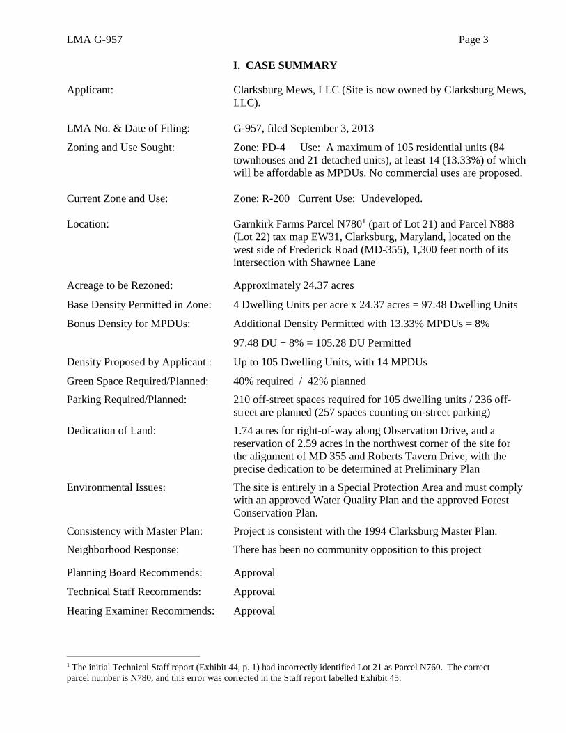
I. CASE SUMMARY
Applicant: Clarksburg Mews, LLC (Site is now owned by Clarksburg Mews,
LLC).
LMA No. & Date of Filing: G-957, filed September 3, 2013
Zoning and Use Sought: Zone: PD-4 Use: A maximum of 105 residential units (84
townhouses and 21 detached units), at least 14 (13.33%) of which
will be affordable as MPDUs. No commercial uses are proposed.
Current Zone and Use: Zone: R-200 Current Use: Undeveloped.
Location: Garnkirk Farms Parcel N7801 (part of Lot 21) and Parcel N888
(Lot 22) tax map EW31, Clarksburg, Maryland, located on the
west side of Frederick Road (MD-355), 1,300 feet north of its
intersection with Shawnee Lane Acreage to be Rezoned: Approximately 24.37 acres
Base Density Permitted in Zone: 4 Dwelling Units per acre x 24.37 acres = 97.48 Dwelling Units
Bonus Density for MPDUs: Additional Density Permitted with 13.33% MPDUs = 8%
97.48 DU + 8% = 105.28 DU Permitted
Density Proposed by Applicant : Up to 105 Dwelling Units, with 14 MPDUs
Green Space Required/Planned: 40% required / 42% planned
Parking Required/Planned: 210 off-street spaces required for 105 dwelling units / 236 off-
street are planned (257 spaces counting on-street parking)
Dedication of Land: 1.74 acres for right-of-way along Observation Drive, and a
reservation of 2.59 acres in the northwest corner of the site for
the alignment of MD 355 and Roberts Tavern Drive, with the
precise dedication to be determined at Preliminary Plan
Environmental Issues: The site is entirely in a Special Protection Area and must comply
with an approved Water Quality Plan and the approved Forest
Conservation Plan.
Consistency with Master Plan: Project is consistent with the 1994 Clarksburg Master Plan.
Neighborhood Response: There has been no community opposition to this project Planning Board Recommends: Approval
Technical Staff Recommends: Approval
Hearing Examiner Recommends: Approval
1 The initial Technical Staff report (Exhibit 44, p. 1) had incorrectly identified Lot 21 as Parcel N760. The correct
parcel number is N780, and this error was corrected in the Staff report labelled Exhibit 45.
LMA G-957 Page 4
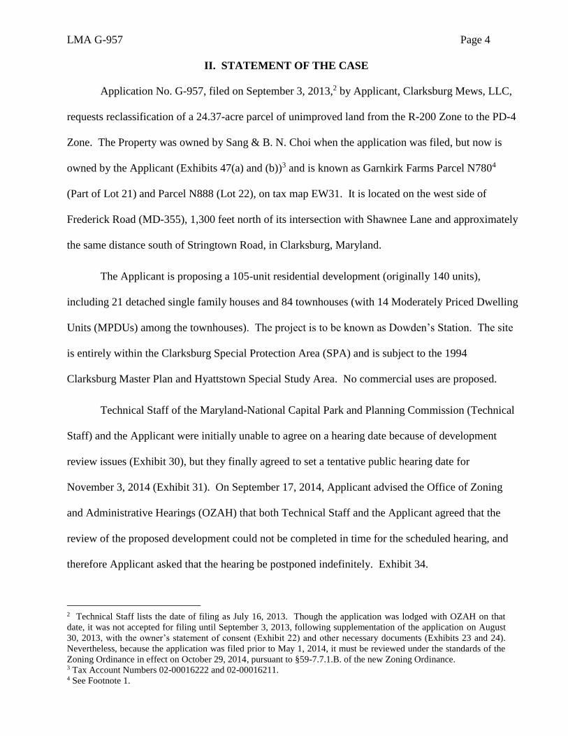
II. STATEMENT OF THE CASE
Application No. G-957, filed on September 3, 2013,2 by Applicant, Clarksburg Mews, LLC,
requests reclassification of a 24.37-acre parcel of unimproved land from the R-200 Zone to the PD-4
Zone. The Property was owned by Sang & B. N. Choi when the application was filed, but now is
owned by the Applicant (Exhibits 47(a) and (b))3 and is known as Garnkirk Farms Parcel N7804
(Part of Lot 21) and Parcel N888 (Lot 22), on tax map EW31. It is located on the west side of
Frederick Road (MD-355), 1,300 feet north of its intersection with Shawnee Lane and approximately
the same distance south of Stringtown Road, in Clarksburg, Maryland.
The Applicant is proposing a 105-unit residential development (originally 140 units),
including 21 detached single family houses and 84 townhouses (with 14 Moderately Priced Dwelling
Units (MPDUs) among the townhouses). The project is to be known as Dowden’s Station. The site
is entirely within the Clarksburg Special Protection Area (SPA) and is subject to the 1994
Clarksburg Master Plan and Hyattstown Special Study Area. No commercial uses are proposed.
Technical Staff of the Maryland-National Capital Park and Planning Commission (Technical
Staff) and the Applicant were initially unable to agree on a hearing date because of development
review issues (Exhibit 30), but they finally agreed to set a tentative public hearing date for
November 3, 2014 (Exhibit 31). On September 17, 2014, Applicant advised the Office of Zoning
and Administrative Hearings (OZAH) that both Technical Staff and the Applicant agreed that the
review of the proposed development could not be completed in time for the scheduled hearing, and
therefore Applicant asked that the hearing be postponed indefinitely. Exhibit 34.
2 Technical Staff lists the date of filing as July 16, 2013. Though the application was lodged with OZAH on that
date, it was not accepted for filing until September 3, 2013, following supplementation of the application on August
30, 2013, with the owner’s statement of consent (Exhibit 22) and other necessary documents (Exhibits 23 and 24).
Nevertheless, because the application was filed prior to May 1, 2014, it must be reviewed under the standards of the
Zoning Ordinance in effect on October 29, 2014, pursuant to §59-7.7.1.B. of the new Zoning Ordinance. 3 Tax Account Numbers 02-00016222 and 02-00016211. 4 See Footnote 1.
LMA G-957 Page 5
On November 12, 2014, OZAH advised the Applicant that the public hearing would be
scheduled for March 6, 2015. Exhibit 35. On February 24, 2015, Applicant wrote to OZAH
requesting an indefinite postponement because complications in the review process made it
impossible to meet the March 6, 2015 hearing date. Exhibit 36. The Applicant and Technical Staff
subsequently agreed to a July 17, 2015 hearing date, and on June 9, 2015, formal notice was issued
scheduling the public hearing for July 17, 2015. Exhibit 37. Notice of the hearing was also
published in two newspapers of general circulation. Exhibits 39 and 41.
On June 17, 2015, Applicant supplemented the record with updated plans (Exhibits 40 and
40(a) through 40(l)). Technical Staff completed its review of the application, and on June 26, 2015,
issued a report (Exhibit 44) recommending approval. The Montgomery County Planning Board
(“Planning Board”) considered the application on July 9, 2015 and, by a vote of 5 to 0, also
recommended approval, as stated in a memorandum dated July 14, 2015 (Exhibit 46). The Planning
Board noted corrections to the Technical Staff report and recommended changes to the proposed
number of parking spaces, reducing them to 2.25 spaces per dwelling unit (i.e., a maximum of 236
off-street spaces) to reduce the amount of impervious area. The corrected version of the Staff report
is in the record as Exhibit 45.5 No opposition to this application has been filed.
The hearing proceeded as scheduled on July 17, 2015. Applicant called four witnesses, and
no opposition witnesses appeared. The record was held open until July 31, 2015, to allow time for
the Applicant to file an amended Development Plan and for review of the changes by Technical
Staff. On July 24, 2015, Applicant filed the revised plan and other materials (Exhibits 60 and 60(a)
through 60(i)). Technical Staff needed more time to review the revised plans, and at the request of
Applicant (Exhibit 61), the Hearing Examiner issued an order keeping the record open until August
6, 2015. Exhibit 62. On August 3, 2015, Technical Staff filed its final comments, noting no
5 The Technical Staff Report is quoted and paraphrased frequently herein.
LMA G-957 Page 6
objections to the minor modifications to the Development Plan. Exhibit 64.
The record closed, as scheduled, on August 6, 2015. However, on September 1, 2015, the
Applicant requested that the record be reopened (Exhibit 65) to allow Applicant to file an original of
the final Development Plan (Land Use Plan) properly sealed and certified by Applicant’s engineer,
but otherwise unchanged. Exhibit 65(a). On September 2, 2015, the Hearing Examiner issued an
Order (Exhibit 66) granting Applicant’s request and reopening the record to receive the properly
sealed Development Plan. Since no substantive changes were made in the Development Plan, no
comment period was needed, and the Order closed the record again on September 2, 2015.
This case was complicated by the fact that the state and County have not yet determined the
final road alignment along the eastern edge of the subject site and because the site is in a special
protection area, with all the environmental concerns generated by that fact. However, after carefully
reviewing the entire record, the Hearing Examiner finds himself in agreement with the
recommendations of Technical Staff and the Planning Board in favor of approving the application.
As stated by Technical Staff (Exhibit 45, p. 36), “the proposed Local Map Amendment with the
associated Development Plan will be consistent with the purpose clause and all applicable standards
for the PD-4 Zone, and . . . will be in accord with the land use recommendations of the 1994
Clarksburg Master Plan and Hyattstown Special Study Area.” For all the reasons discussed below
in this report, the Hearing Examiner recommends that the Council approve this rezoning application
and development plan.
III. FACTUAL BACKGROUND
A. Subject Property
The subject property is adjacent to Frederick Road (MD-355), which is to its east, and
approximately equidistant between Stringtown Road to the north and Shawnee Lane to south, in
Clarksburg, Maryland. The site is also about 2,000 feet east of Interstate 270. Its location can be

LMA G-957 Page 7
seen on the following aerial photo map from the Technical Staff report (Exhibit 45, p. 5):
As described by Technical Staff (Exhibit 45, p. 6), the property is irregularly shaped and
consists of two undeveloped parcels, Part of Lot 21 (Parcel N780) and Lot 22 (Parcel N888), with a
total gross area of 24.37 acres. The site’s topography is generally sloping, and it contains two streams,
several wetland areas and flood plains. Approximately 99 percent (24.19 acres) of the property is
covered with forest, and the entire area is within the Clarksburg Special Protection Area (SPA). It is
also adjacent to the proposed Corridor Cities Transitway (CCT) to its west, and a Master Plan
proposed roadway realignment of MD 355 to its east.
Subject
Site Streams Flowing
Through the Site
LMA G-957 Page 8
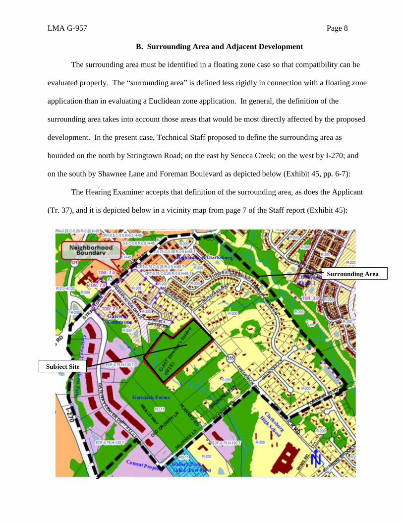
B. Surrounding Area and Adjacent Development
The surrounding area must be identified in a floating zone case so that compatibility can be
evaluated properly. The “surrounding area” is defined less rigidly in connection with a floating zone
application than in evaluating a Euclidean zone application. In general, the definition of the
surrounding area takes into account those areas that would be most directly affected by the proposed
development. In the present case, Technical Staff proposed to define the surrounding area as
bounded on the north by Stringtown Road; on the east by Seneca Creek; on the west by I-270; and
on the south by Shawnee Lane and Foreman Boulevard as depicted below (Exhibit 45, pp. 6-7):
The Hearing Examiner accepts that definition of the surrounding area, as does the Applicant
(Tr. 37), and it is depicted below in a vicinity map from page 7 of the Staff report (Exhibit 45):
Surrounding Area
Subject Site
LMA G-957 Page 9
Technical Staff describes the surrounding area as follows (Exhibit 45, pp. 6-7):
The surrounding area (“neighborhood”) is predominantly residential within the
Gateway Commons, Garnkirk Farms and Clarksbrook Estates subdivisions with a
small area of CRT-0.75 zoned properties along Stringtown Road at the northeast
corner of the neighborhood. The neighborhood also contains a church located on the
west side of MD 355 and a small enclave of employment-office use zoned EOF (the
Gateway 270 Corporate Office) located along the western edge adjacent I-270.
Future development plans for the area include the Master Plan-recommended MD
355 Road alignment and a recently approved 392-unit mixed residential development,
Garnkirk Farms. A large part of the western portion of the Property is within a stream
buffer and the entire neighborhood, as defined by staff, is within the Clarksburg
Special Protection Area.
Nearby residential uses immediately outside of the southwest boundary of the
neighborhood, across Shawnee Road, include the 250-unit Gallery Park townhomes, a
moving company, a Board of Education bus depot and Clarksburg High School.
The zoning in the surrounding area is R-200, TDR 7.0 and R-200 to the north; R-200 to the
east; R-200 and PD-11 to the south; PD-11 (10.5 DU/acre) to the west (Garnkirk Farms
Development); and further west, EOF.075 H100T in the Gateway 270 Industrial Park, which used to
be zoned I-3 (Exhibit 40(j) and Tr. 92-94).
Applicant’s land planner, David Ager, described the surrounding area at the hearing, as
summarized by the Hearing Examiner:
Garnkirk Farms is to the southwest. It was planned as a PD-11 and was ultimately
approved at 10.5 dwelling units per acre. Going in a clockwise pattern around the
subject property, there's a small area that's just to the west which is a part of the
Gateway Center Industrial Complex (called the Gateway 270 Industrial Park) that
touches the property corner to corner. It was I-3 and it's now EOF-0.75 H-100 T,
which is also the same zoning on the Comsat property just outside of the delineated
neighborhood. To the northwest of the property is the Gateway Commons property,
which is zoned R-200 TDR-7. It was approved and has been constructed to
approximately 8.4 dwelling units per acre, with the MPDU bonus on that property.
Immediately adjacent to the subject property, in the notch to the north, is the McCord
property, which is zoned R-200. There are several properties zoned R-200 on both
the southwest and northeast sides of Frederick Road, Maryland Route 355, to the
north, confronting the property to the northeast, and R-200 properties adjacent to the
property to the southeast and further to the south. Within this neighborhood, further
to the north, there's a small property that was formerly zoned RMX-2, but it is now
zoned CRT-0.75 C-0.25 R-0.5 H-65 T. Tr. 92-94.
LMA G-957 Page 10
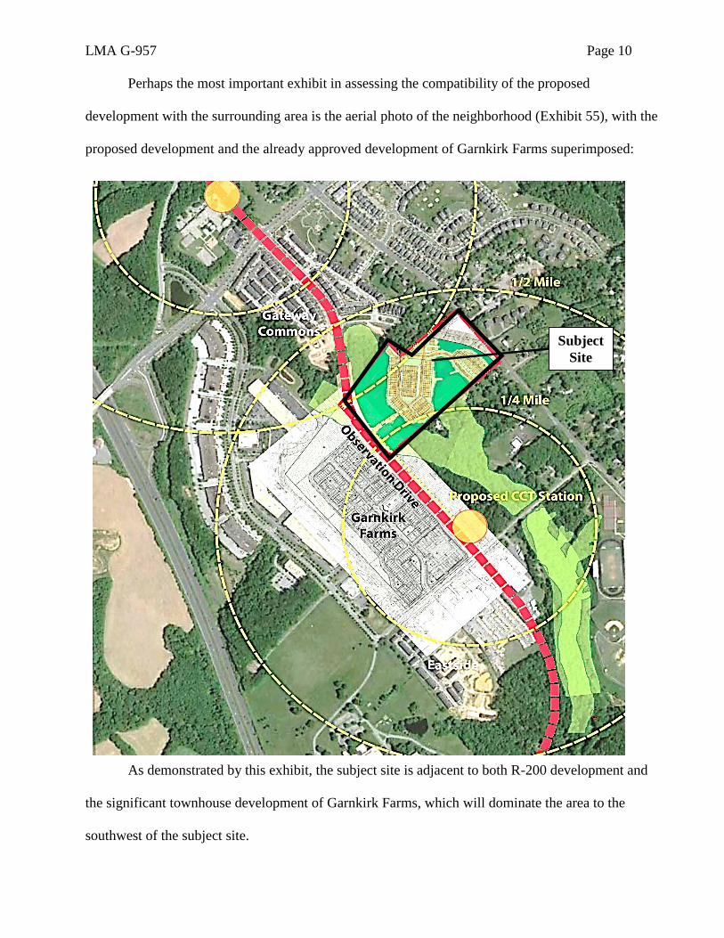
Perhaps the most important exhibit in assessing the compatibility of the proposed
development with the surrounding area is the aerial photo of the neighborhood (Exhibit 55), with the
proposed development and the already approved development of Garnkirk Farms superimposed:
As demonstrated by this exhibit, the subject site is adjacent to both R-200 development and
the significant townhouse development of Garnkirk Farms, which will dominate the area to the
southwest of the subject site.
Subject
Site
LMA G-957 Page 11
C. Zoning History
Technical Staff gave the following zoning history for the subject site (Exhibit 45, p. 7):
The Property was zoned to the R-R Zone during the 1958 Countywide Comprehensive
Zoning. In October of 1973, Text Amendment 73013 renamed the R-R Zone as the R-
200 Zone. The 1994 Clarksburg Master Plan and Hyattstown Special Study Area (G-
710) retained the Property’s R-200 zoning. The land use element of the Master Plan
placed the Property in the Transit Corridor District with recommended residential
development density of two to four units per acre.
The Hearing Examiner would add to Technical Staff’s description the fact that the site’s
zoning was not changed by the District-wide rezoning on October 30, 2014, which resulted from the
District Map Amendment G-956 (adopted July 15, 2014), as modified by Sectional Map Amendment
G-965 and Corrective Map Amendments G-967 through G-973.
D. Proposed Development
1. Development Concept
The Applicant is proposing a 105-unit residential development (originally 140 units),
including 84 townhouses and 21 detached single-family houses to be known as Dowden’s Station.
The development will include 14 Moderately Priced Dwelling Units (MPDUs). One of the unusual
features of this application is that its final contours will have to await the determination by the state
of the alignment of Frederick Road (MD 355) and Roberts Tavern Drive, on the eastern edge of the
site. This case was further complicated by the fact that the site is in a special protection area, with
all its accompanying environmental concerns, including protection of the streams running through
the western portion of the site. As will be discussed below, the Applicant has proposed clever
solutions to both problems, including a flexible access plan to the east and a dual purpose, elevated
culvert to the west, which will carry both pedestrians and a buried sewer line over the streambed.
Applicant’s vision for the development is stated in its Pre-hearing Statement (Exhibit 40(a), pp. 1-3),
. . . The Applicant is requesting the Planned Development zone to accomplish
a coordinated planned development at this location that will provide a mix of housing
LMA G-957 Page 12
types for the community, including up to 21 single-family detached homes and up to
84 townhomes (105 total units), with 14 MPDUs integrated throughout the project.
The Petitioner is providing 13.3 percent moderately priced dwelling units (MPDUs),
above the typical 12.5 percent requirement, to add to the stock of affordable housing
in upper Montgomery County.
. . . The Applicant has also proposed a reservation of land intended to address
the variable, and as yet undetermined, alignment of future roadways in the
transportation network surrounding the subject property, specifically the ultimate
alignment of Frederick Road/Robert Tavern Drive.
Once the ultimate alignment of Frederick Road/Roberts Tavern Drive has
been determined, a dedication of right-of-way to accommodate the desired alignment
will take place and any residual property within the area of reservation will be
released to the Applicant for future development. The ultimate development of this
residual area, and the number of dwellings provided will be determined by whatever
future alignment of Frederick Road is selected by public officials in the future, and
will require a revision to the Development Plan.
The Petitioner has designed a site layout that provides single-family detached
homes along Frederick Road to continue the existing suburban pattern of detached
housing along Maryland Route 355 in this area of the County. Townhomes are
provided within the interior of the site, with generous open spaces, recreation areas,
and natural surface trails and forests integrated throughout the site, providing amenity
spaces and opportunities for residents and pedestrians to enjoy the natural state of the
land. The project incorporates a substantial 100-foot setback from any townhouse or
attached unit provided on the site to the nearest property line. Additionally, the
Petitioner has provided a generous set back that exceeds 300 feet from the future
alignment of Observation Drive (as well as a 1.71-acre right-of-way dedication for
Observation Drive and an area of reservation for the future alignment of Frederick
Road).
The project will provide a network of sidewalks, bike paths, and pedestrian
trails that will serve to increase pedestrian connectivity in Clarksburg. In fact,
capitalizing on the tract’s close proximity to the future Shawnee Lane Transit Station,
(CCT station) the proposal will provide a pedestrian connection that runs throughout
the site, along the future alignment of Observation Drive, and to the CCT station to
encourage residents to utilize public transportation.
The proposed layout guides development and infrastructure away from
environmentally sensitive resources on the property and provides a variety of unit
types that provide differing housing opportunities for Clarksburg. A significant
portion of the property will be preserved as green space. The proposal balances the
Master Plan’s recommendations for future density of development on the property
with the existing suburban pattern of the area and with the desire to create increased
density near a planned Corridors City CC station.
LMA G-957 Page 13
Applicant’s vision for the site layout is best seen on the final version of its Development
Plan (Land Use Plan), Exhibit 65(a), which is reproduced in the next section of this report.
2. Development Plan & Binding Elements
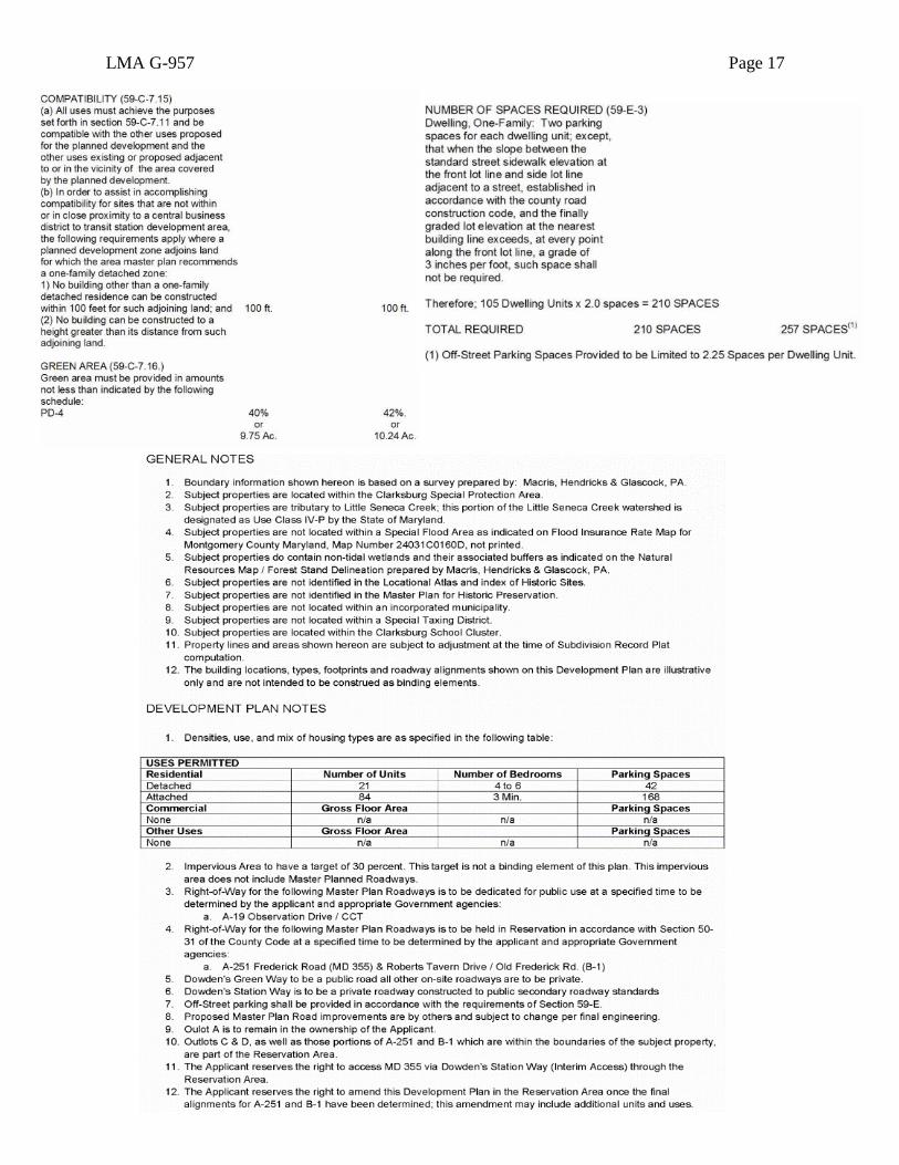
Pursuant to Code § 59-D-1.11, development under the PD-4 Zone is permitted only in
accordance with a development plan that is approved by the District Council when the property is
reclassified to the PD-4 Zone. Under Code §59-D-1.3, this development plan must contain several
elements:
(a) A natural resources inventory;
(b) A surrounding area map, showing the relationship to the site and use of the adjacent land;
(c) A land use plan showing site access; locations and uses of all buildings and structures; a
preliminary classification of dwelling units; locations of parking areas, including number of
parking spaces; location of land to be dedicated to public use; location of land intended for
common or quasi-public use but not intended to be in public ownership; and a preliminary
forest conservation plan;
(d) A development program stating the sequence of proposed development;
(e) The relationship, if any, to the County’s capital improvements program;
(f)&(g) . . . [Inapplicable to the PD-4 Zone];
(h) The density category applied for, as required in subsection 59-C-7.14(a), and where
commercial facilities are included (which is not the case here), an economic analysis
supporting their inclusion; and
(i) If a property proposed for development lies within a special protection area [as it does here],
the applicant must submit water quality inventories and plans and secure required approvals
in accordance with Article V of Chapter 19. The development plan should demonstrate how
any water quality protection facilities proposed in the preliminary water quality plan can be
accommodated on the property as part of the project.
The Development Plan in this case fulfills these requirements. The Development Plan and
the Land Use Plan that constitutes one of its primary parts are binding on the Applicant except where
particular elements are identified as illustrative or conceptual. Illustrative and conceptual elements
may be changed during site plan review by the Planning Board, but the binding elements (i.e., those
that the District Council will consider in evaluating compatibility and compliance with the zone)
cannot be changed without a separate application to the District Council for a development plan
amendment.
LMA G-957 Page 14
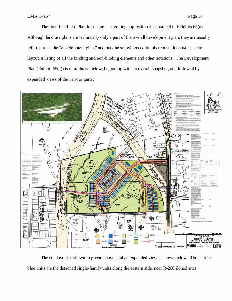
The final Land Use Plan for the present zoning application is contained in Exhibits 65(a).
Although land use plans are technically only a part of the overall development plan, they are usually
referred to as the “development plan,” and may be so referenced in this report. It contains a site
layout, a listing of all the binding and non-binding elements and other notations. The Development
Plan (Exhibit 65(a)) is reproduced below, beginning with an overall snapshot, and followed by
expanded views of the various parts:
The site layout is shown in green, above, and an expanded view is shown below. The darkest
blue units are the detached single-family units along the eastern side, near R-200 Zoned sites:

LMA G-957 Page 15

LMA G-957 Page 16
LMA G-957 Page 17
LMA G-957 Page 18
The above diagrams and text show the proposed locations of all structures, roadways, open
spaces and dedicated areas, as well as additional information regarding the planned development.
However, as noted on the Development Plan, the specific property lines, the building locations, the
types and footprints of buildings, the proposed concrete abutment depicted in the upper left corner of
the development plan and the roadway alignments (depicted on eastern edge of the site) are
illustrative and will be refined and finalized during subsequent proceedings (i.e., subdivision, site
plan and state proceedings to determine final road alignments).
The Development Plan specifies that Applicant will dedicate 75,795 square feet (i.e., 1.74
acres) to the Observation Drive roadway on the western side of the subject site because that right-of-
way alignment has been established and platted in accordance with the Master Plan. Tr. 33-36.
However, on the eastern edge of the site, the Development Plan provides that 2.59 acres will be
placed “in reservation” pursuant to the subdivision regulations (Code Section 50-31, et seq.) which
allow a reservation of land for public use. The reason for this “reservation” and its contours will be
explained in Part III. D. 3. of this report, in connection with Public Facilities. The Applicant specifies
that the dedication of the right-of-way on the eastern edge of the property will take place upon the
determination, by the responsible agencies, of the ultimate right-of-way in relation to the property.
Technical Staff indicated in its report that it would prefer a dedication commitment on the entire site,
but agreed that “The issue of reservation or dedication will be further analyzed and determined at the
Preliminary Plan review stage.” Exhibit 45, p. 8. Staff also observed that “The determination of the
ultimate row [i.e., right-of-way] design could trigger a Development Plan Amendment.” Ex. 45, p. 1.
Applicant also notes that its 30% target for impervious area is not a binding element, and the
plan can be amended to allow additional units and uses in the reservation area once the final road
alignment on the eastern edge of the site is determined. Substantive elements of the plan that are not
designated as illustrative cannot be changed without Council approval. Applicant has specified that
LMA G-957 Page 19
it will provide a minimum of 42% green area and 257 parking spaces. By agreement with the
Planning Board, off-street parking spaces will be limited to 2.25 spaces per dwelling unit in order to
reduce imperviousness. Assuming 105 units are built, as planned, that would result in a total of 236
off-street parking spaces. The remaining 21 spaces would be on the streets.
The base density allowed for a site of this size in the PD-4 Zone is four Dwelling Units per
acre. Multiplying that by 24.37 acres yields a maximum base density of 97.48 Dwelling Units.
However, the Applicant is entitled to a Bonus Density of 8% because it will provide 14 MPDUs (i.e.,
13.33% of the 105 planned dwelling units). Montgomery County Code §25A-5(c). Adding 8% to
the standard density in the PD-4 Zone of 4 units per acre, allows the addition of .32 additional units
per acre, for a total density of up to 4.32 units per acre. Applying that density to the 24.37 acre
property (4.32 X 24.37) allows up to 105.28 units. As noted, Applicant proposes 105 dwelling units
(i.e., within the density permitted).
As stated by Technical Staff (Exhibit 45, p. 9),
The Development Plan in this case fulfills the requirements of Section 59-D-1.3 by
showing access points, approximate location of proposed buildings and structures,
preliminary classifications of dwellings by number of bedrooms, parking areas,
intended right-of-way dedications for MD 355, Roberts Tavern Drive and
Observation Drive as well as internal streets (Dowden Station Way, Dowden Park
Circle and Dowden Green Way), common use areas (recreation areas, forest
conservation and stream buffer areas, playground and seating areas).
3. Use of Public Facilities (Transportation, School Capacity and Water & Sewer Service)
Zoning Ordinance §59-H-2.4(f), requires Applicant to produce “[s]ufficient information to
demonstrate a reasonable probability that available public facilities and services will be adequate to
serve the proposed development under the Growth Policy standards in effect when the application is
submitted.” Public facilities for transportation, schools and water and sewer service are treated
under separate headings, below.
LMA G-957 Page 20
a. Transportation
i. Roadway Alignments:
No concerns about traffic volume impacts were raised by Technical Staff, the community or
any witnesses. However, there are some unusual transportation facility issues in this case. As
mentioned in Part III.D.1. of this Report, the development plan provides that 2.59 acres will be
placed “in reservation” pursuant to the subdivision regulations (Code Section 50-31, et seq.), which
allow a three-year reservation of land for public use. This need for a reservation area derives from
the undecided road alignment on the eastern edge of the site (as distinguished from the western edge,
where 1.74 acres will be dedicated along Observation Drive).
The 1994 Clarksburg Master Plan and Hyattstown Special Study Area calls for a specific
road alignment of MD 355 along the eastern edge of the subject site. The subsequent development
of a portion of Roberts Tavern Drive to the north of the site has created the possibility of an alternate
road alignment for MD 355. A third possibility is that no road realignment of MD 355 will take
place in the foreseeable future, so the Applicant has designed a Development Plan that takes account
of all three possibilities, with an “interim access” from the site to MD 355, which would be called
Dowdens Station Way. That interim access would be removed if a road alignment eventually
connects MD 355 to Roberts Tavern Drive, leaving only a stub of Dowdens Station Way internal to
the site to service a couple of lots. In order to preserve the possibility that the eventual road
alignment will make an additional right-of-way dedication on the eastern edge of the site
unnecessary, Applicant has proposed the aforementioned reservation of 2.59 acres of land, as shown
in Exhibit 52. Tr. 40-45.
The reservation area includes both a gray triangle area in the northeast corner of the site
(comprised of a portion of “Outlot B” a tiny portion of “Outlot C” and 0.72 acres of “Outlot D”)
and the potential right-of-way for the Master Plan alignment (1.73 acres), shown in yellow adjacent

LMA G-957 Page 21
to the grey area on the Development Plan, resulting in a reservation area of 2.59 acres, as shown in
the northeast corner of the site, depicted below, side by side, in Exhibit 65(a) and Exhibit 52:
Technical Staff and the Planning Board did not disagree with this reservation concept,
although Staff pointed out that 0.10 acres of the reservation area appear to be outside of the subject
site (Exhibit 64). Whether or not that is the case is unclear from the Development Plan because the
missing 0.10 acres may be in the yellow strip directly north of Dowdens Station Way. In any event,
as noted by Staff, the difference is negligible and the exact figure will be determined at Preliminary
Plan review.
Using Exhibit 51, which contains a reproduction of page 43 of the 1994 Master Plan, Mr.
Ager described the possible road alignments on the eastern side of the site. This Master Plan
Portion of Exhibit 65(a) Exhibit 52
LMA G-957 Page 22
alignment showed a sweeping curve through the subject property running north and re-associating
with MD 355 north of the historic district. Developments after 1994 have changed the likely road
alignment. What's different today is that there is a new road called Roberts Tavern Drive, which
projects the right-of-way through the property, stopping at Observation Drive in a T intersection.
That alignment for Roberts Tavern Drive was approved through the context of a project just to the
north of the subject property called Gateway Commons. Unlike the Robert’s Tavern alignment, the
Master Plan alignment would continue the road to the north and not end in the T intersection at
Observation Drive. Tr. 37-39.
Mr. Ager also noted that there is a public road in the lighter orange which is referred to as
Dowdens Green Way that connects this property on a generally northwest to southeast configuration
to properties to the southeast and to the McCord property to the northwest of the property. In
addition to that, there is a private road called Dowdens Park Circle which is a semi-circular road in
the darker orange that's internal to the property and is in the general location where the townhouses
are located on the property. That is a private road to service that area and make connections to the
public road, Dowdens Green Way. So in the interim, the project will have an access point on MD
355 for the property. As properties develop to the south, there will be a second access point off of
Dowdens Green Way connecting to the south [and labelled “Future Connection”]. Ultimately, when
Roberts Tavern Drive/Frederick Road (MD 355) is determined and built through the McCord
property and through the subject property, the interim road connection to MD 355, which is referred
to as Dowdens Station Way, will be removed and a connection will be made to Roberts Tavern
Drive, as it is shown through the McCord property. (As mentioned, a stub of Dowdens Station Way
will be left to service the home to be built on Lot 89, but it would no longer connect to MD 355. Tr.
65-66). The connection to Roberts Tavern Drive won't occur unless the Master Plan alignment or
the alternate alignment with Roberts Tavern Drive is completed. Whichever one is determined to be
LMA G-957 Page 23
the final alignment, the connection to the new road from the subject site will be the road labelled
“Future Connection,” which is shown on the north on the McCord property. Tr. 45-49.
On the west side of the subject site is the Observation Drive right-of-way, which has been
platted, but has not yet been constructed on the site. It has been constructed north of the site, and
this property, once it moves forward into subdivision, will complete the Observation Drive right-of-
way. Because that right-of-way and that alignment have been established, Applicant’s land planner,
David Ager, testified that the Applicant will dedicate land 150 feet in width (i.e., 1.74 acres along
the right-of-way) to allow the road construction. The CCT will actually traverse this property in the
future when constructed. Tr. 33-36.
ii, New Traffic Burden (LATR and TAPR):
The amount of new traffic that would be generated by the proposed use was evaluated both
by Applicant’s transportation planner, Carl Wilson, and by Technical Staff. Mr. Wilson’s traffic
study (Exhibit 24) was completed on July 26, 2013, assuming that the project would have 140
dwelling units (14 detached homes and 126 townhomes), as sought in the original application. The
present application is for only 105 dwelling units (21 detached homes and 84 townhomes), and will
therefore generate less traffic.
Mr. Wilson testified that he prepared his traffic impact study for the proposed re-zoning in
accordance with the Planning Board's Local Area Transportation Review (LATR) guidelines. He
noted that the main purpose of the LATR is to study the offsite intersections and the site access point
at Maryland 355, looking at the critical lane volumes (CLV) to determine that those are adequate.
With respect to LATR, he considered a single point of access for this property along Maryland 355.
Using the Montgomery County rates, he projected that the site would produce 75 total trips in the
morning and 111 trips in the evening,6 assuming a development of 140 dwelling units. Using those
6 The court reporter recorded Mr. Wilson’s testimony as stating the evening figure as 100 trips (Tr. 156), but the Hearing
Examiner’s notes indicate that Mr. Wilson gave the figure as 111 trips, consistent with his traffic study (Ex. 24, p. 21).

LMA G-957 Page 24
higher projections, he calculated that the access point would operate at an adequate level of service
under the congestion standard for the policy area, which is a CLV of 1425. Thus, at the proposed
access point, he found a CLV in the morning of 763, and in the afternoon of 877, during the peak
hour of the peak period. A recalculation based on the reduced number of dwelling units would
reduce those projections, as well. Mr. Wilson testified that all of the intersections studied met the
1425 CLV standard. As this application proceeds through preliminary plan, Applicant will have to
update the LATR to obtain more current counts. Tr. 153-156.
Technical Staff provided the following review of LATR (Exhibit 45, pp. 16-17):
The proposed 105 residential unit (21 single-family detached units and 84
attached units) development will generate the following number of peak-hour
trips:
97 peak-hour trips within the weekday morning peak period (6:30 to 9:30
a.m.)
113 peak-hour trips within the evening peak period (4:00 and 7:00 p.m.)
. . . The traffic study was prepared before the current unit mix was determined
and the original unit mix would generate approximately 12 percent more peak-
hour trips than the current unit mix. Based on the traffic study results, the
capacity/Critical Lane Volume (CLV) values at the studied intersections are
shown in Table A for the following traffic conditions:
Table A – Critical Lane Volumes A
As indicated in Table A above, the calculated CLV values do not exceed the
CLV standard of 1,425 for the Clarksburg Policy Area, and, thus, the LATR
test is satisfied for the probable fruition of the future Adequate Public Facilities
(APF) test that will be done when a Preliminary Plan is filed for the site.
Studied Intersection
Traffic Condition
Existing Background Total
AM PM AM PM AM PM
Frederick Road & Stringtown Road
952 1,075 1,104 1,307 1,156 1,343
Frederick Road & Foreman Boulevard
974 998 1,065 1,143 1.072 1,152
Frederick Road & Site Access ---- ---- ---- ---- 763 877

LMA G-957 Page 25
Although the Hearing Examiner is not sure where Technical Staff obtained its trip
generation figures, both Technical Staff and Mr. Wilson agree that the total critical lane volumes
(CLV) will not exceed the CLV standard of 1,425 for the Clarksburg Policy Area at any of the
studied intersections. The Hearing Examiner therefore finds that LATR standards have been
satisfied.
As to Transportation Policy Area Review (TPAR), Technical Staff observed that, “according
to the 2012-2016 Subdivision Staging Policy (SSP), the Clarksburg Policy Area is inadequate under
the transit test; therefore, a TPAR payment of 25 percent of the General District Transportation
Impact Tax is required.” Exhibit 45, p. 18.
The Hearing Examiner agrees with Staff that the adequacy of the roadway and transit will be
reanalyzed at the Preliminary Plan review. The timing and amount of the TPAR payment will be
determined at that time in accordance with the Montgomery County Code.
iii. Safe Access to MD 355 (the Gap Study) and Safe Internal Circulation:
The final transportation issue concerned whether the proposed vehicular and pedestrian
circulation system and points of external access for the proposed development will be safe, adequate
and efficient. The Applicant first addressed the external access issue – i.e., whether vehicles
entering and exiting the subject site will have sufficient time to do so safely, given the proposed
access to MD 355. To evaluate this issue, Technical Staff asked Applicant’s transportation planner
to prepare “a gap study,” which Mr. Wilson did. Exhibit 60(c).
Mr. Wilson testified that in order to do a gap study, tubes are put out on the road to measure
the amount of space that occurs in between vehicles, in effect measuring the time between vehicles
passing the site access point. According to Mr. Wilson, there needs to be a gap for the left turn of
seven-and-a-half seconds and for the right turn of six-and-a-half seconds. He looked at both the
northbound and southbound traffic. It's possible in the future, if the Roberts Tavern Drive extension
LMA G-957 Page 26
project moves forward that there could be a traffic signal, but there is no traffic signal proposed as
part of this project at this time. Mr. Wilson indicated that this site itself would not generate enough
traffic to warrant a traffic signal; however, he concluded that the gap study showed that there are
adequate gaps in both traffic streams, northbound and southbound, for traffic to exit the site and to
enter the site during the peak hours. Tr. 157-161.
Technical Staff agreed and summarized the gap study parameters (Exhibit 45, pp. 17-18):
The policy and standards for gap analyses include the following:
An established Policy Area Review Level of Service (LOS) for the Clarksburg
Policy Area is an LOS of mid-D. An average of mid-D or less corresponds to the
Clarksburg Policy Area standard for roadway adequacy of “suburban.”
The corresponding LOS of mid D is equivalent to 30 seconds of average delay at
unsignalized intersections as specified on Exhibit 17-2, page 17-2, of the
Transportation Research Board’s (TRB) “Highway Capacity Manual.”
The time gaps at designed speed on major road for passenger cars are as follows:
7.5 seconds for left turns from the minor street/access road
6.5 seconds for right turns from the minor street/access road
5.5 seconds for left turns from the major street/Frederick Road
These standards are specified on Table 9-5, page 9-37 in the 2011 American
Association of State Highway and Transportation Official’s (AASHTO) “A Policy on
Geometric Design of Highways and Streets”. These time gaps represent the minimum
acceptable time gaps for turns to/from along the two-lane segment of MD 355 to/from
the site’s interim access road.
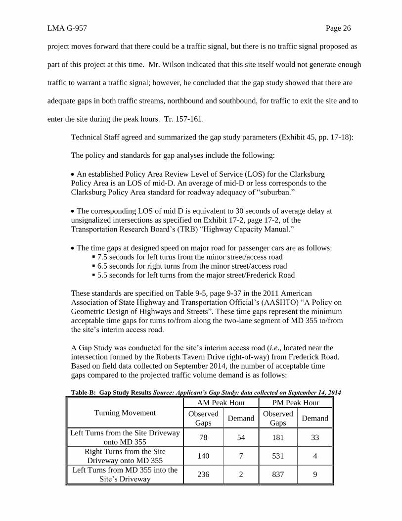
A Gap Study was conducted for the site’s interim access road (i.e., located near the
intersection formed by the Roberts Tavern Drive right-of-way) from Frederick Road.
Based on field data collected on September 2014, the number of acceptable time
gaps compared to the projected traffic volume demand is as follows:
Table-B: Gap Study Results Source: Applicant’s Gap Study: data collected on September 14, 2014
Turning Movement
AM Peak Hour PM Peak Hour
Observed
Gaps Demand
Observed
Gaps Demand
Left Turns from the Site Driveway
onto MD 355 78 54 181 33
Right Turns from the Site
Driveway onto MD 355 140 7 531 4
Left Turns from MD 355 into the
Site’s Driveway 236 2 837 9
LMA G-957 Page 27
Technical Staff concluded (Exhibit 45, p. 18):
Thus, the number of acceptable time gaps exceeds the projected traffic volume
demand; therefore there are sufficient gaps in traffic to accommodate the estimated
vehicle generation associated with the site.
After an exchange of correspondence among the State Highway Administration (SHA),
Technical Staff and the Applicant’s transportation planner (Exhibits 60(d) and (e)), SHA also
accepted the result of the gap analysis, stating in a letter dated January 20, 2015 (Exhibit 60(i)),
“The SHA concurs with the report findings for this project as currently proposed and will not require
the submission of any additional traffic analyses.”
Based on the undisputed evidence, and the evaluation of Technical Staff, SHA and
Applicant’s transportation planner, the Hearing Examiner finds that vehicles entering and exiting the
subject site will have sufficient time to do so safely with the proposed access to MD 355.
Finally, Mr. Wilson testified that, in his opinion, the proposed vehicular and pedestrian
circulation system within the subject site, as well as the points of external access for the proposed
development, are safe, adequate and efficient. According to Mr. Wilson, this proposal is similar to a
typical layout for a residential subdivision, and there are adequate intersections for the vehicles to
enter and exit within the subdivision streets and onto Maryland 355. Tr. 161-163.
Technical Staff agreed (Exhibit 45, p. 34):
The review and analysis of the Application finds the proposed access to the Property,
as shown on the Development Plan, to be safe and adequate. Furthermore, the internal
pedestrian circulation and walkways, as shown on the Development Plan, provide for
a safe and adequate movement of pedestrian traffic.
In sum, given the record in this case, the Hearing Examiner must find that there is a
reasonable probability that the available public transportation facilities and services will be adequate
to serve the proposed development and that the proposed internal vehicular and pedestrian circulation
systems and points of external access will be safe, adequate, and efficient.

LMA G-957 Page 28
b. Impacts on School Capacity
The Property is located within the Clarksburg High School cluster, which includes
Clarksburg Elementary School, Rocky Hill Middle School, and Clarksburg High School. According
to a communication from Zachary Larnard, MCPS Division of Long Range Planning, (Exhibit 45,
Attachment C, 2nd Document), “All three schools are projected to exceed capacity within the six year
CIP.” Mr. Larnard further described the school capacity situation:
A site for a new elementary school in the Clarksburg Cluster has been approved; an
opening date for this school will be determined in a future CIP. A new middle school
is needed to address the middle school space deficit in the cluster; the scheduled
completion date for the new school is August 2016. A classroom addition at
Clarksburg High School is scheduled to open in August 2015. A revitalization/
expansion project for Seneca Valley High School is recommended for completion in
August 2018; the school will be designed with excess capacity to accommodate
students from the Clarksburg cluster. The Seneca Valley High School service area is
adjacent to the Clarksburg High School service area.
According to Mr Larnard’s estimate, “The student generation estimated from the 105-unit
Clarksburg Mews development will be approximately 29 elementary school students, 12 middle
school students, and 14 high school students.” He concluded that the Applicant will have to pay a
school facility payment for the elementary and high school levels:
The FY2015 Subdivision Staging Policy School Test finds school enrollment in the
Clarksburg Cluster to exceed the 105 percent utilization threshold at the elementary
school and high school levels requiring a school facility payment. Enrollment at the
middle school level in the Clarksburg Cluster is below 105 percent utilization
threshold. No school facility payment is required at the middle school level.
Technical Staff noted that such a payment would be required in connection with subdivision,
not at the rezoning stage (Exhibit 45, p. 19). As pointed out by Applicant’s land planner, the fact that
the elementary and high school are below the 120 percent of capacity means that growth is not in a
moratorium, but rather the Applicant would have to pay a school facilities payment. Tr. 101-104.
Given these facts, the Hearing Examiner finds that it is reasonably probable that public
school facilities and services will be adequate to serve the proposed development.
LMA G-957 Page 29
c. Water and Sewer Service
Stephen Crum, Applicant’s civil engineer, testified that there is adequate sewer and water
service available for the property. There is an existing water line in Maryland 355. Applicant is
proposing to make a connection to that line, and it will loop through the project. Applicant will
actually make a water line connection to Observation Drive as well, so the property will be served
from two directions with public water. Each dwelling unit will have an individual connection that
will be metered. Applicant will extend the sanitary sewer all the way up into the alley behind single-
family dwellings that are closest to Maryland 355. There will be a manhole at the intersection of
Dowden's Green Way and that could be extended in the future to serve properties to the south. The
sewer system runs and connects to Observation Drive via the pedestrian crossing that Applicant is
proposing. The water and sewer categories are W-1 and S-3. Tr. 143-144.
Mr. Crum added that the presence of the stream valley and the other elevations made it
difficult to provide sewer service to the development. But he realized that if there was a way to cross
the stream valley, Applicant could actually make gravity work in this location because the receiving
manhole to the west of the property is at an elevation that allows for gravity flow. He talked to
WSSC about building a structure similar to a Roman aqueduct where an aerial sewer was suspended,
but WSSC said it had to be conventional construction, so if it needed repair, it could use a backhoe
and excavate down through the earth and repair the sewer. The solution he came up with was to
create an earth embankment that would cross the stream valley and would allow the sewer to be
within that earth embankment and still reach the elevations that were needed. WSSC has reviewed
this proposal in a very preliminary manner and didn’t have any objections (Exhibit 45, Attachment C,
3rd Document). Mr. Crum’s plan would provide a very direct pedestrian connection with the west of
the site as well, with very little impact to the stream. When the Hearing Examiner raised a question
about the visual impact of the proposed abutment, Mr. Crum testified that eventually, the trees and
LMA G-957 Page 30
the understory in the area will reestablish themselves and it will be hidden. It would have to be
concrete, but Applicant can put in form liners that look like stone. Tr. 145-149.
Technical Staff confirmed the fact that, although the site does not presently have water and
sewer service, it is available to the site (Exhibit 45, p. 20):
The Property is not currently served with public water or sewer. However, the
Property is within the water and sewer service envelope recommended in the Master
Plan (Figure 51, page 202) and the use of public (community) water service for the
project is consistent with the existing W-1 water category designated for this site. The
use of public (community) sewer service is also consistent with the existing S-3 sewer
category designated for the Property. The requested zoning change from R-200 to
PD-4, if approved, should not affect this site’s existing eligibility for public water and
sewer service. Further analysis of adequacy will be part of the review at the time of
application for water/sewer service.
Given Mr. Crum’s testimony, WSSC’s memorandum and Technical Staff’s conclusion, the
Hearing Examiner finds that Applicant has demonstrated a reasonable probability that available
water and sewer facilities and services will be adequate to serve the proposed development under the
applicable standards.
4. Environmental Impacts
Environmental issues are significant in this case because the entire site is within the
Clarksburg Special Protection Area (SPA), and it has streams and forest requiring significant
attention. Technical Staff discussed these concerns in its report (Exhibit 45, pp. 20-23, 34-35):
The Applicant’s Natural Resources Inventory/Forest Stand Delineation (NRI/FSD
#420132130) was approved by Technical Staff on April 21, 2014. [Exhibit 13] The
Property contains a network of stream valleys, wetlands and drainage swales that
direct runoff to the south. Properties containing this stream valley to the north and
west have developed, at which time the stream valleys were placed in conservation
easements to meet forest conservation and environmental buffer guidelines.
The Property is within the Little Seneca Creek watershed and drains to an unnamed
tributary to Little Seneca Creek beginning on the west side of the Property. Stream
valley buffers make up approximately 39 percent of the site. The Property has two
different forest areas. The first, on the western side of the Property is a mature, stable
ecosystem with many specimen trees and is high priority for retention. The eastern
forest is only about 35 years old and has many invasive species. Outside of the stream
and wetland buffer area, this forest is considered a moderate priority for retention.
LMA G-957 Page 31
The unnamed tributary to Little Seneca Creek has two branches that flow from the
north with the confluence on the Property. This confluence area forms a much larger
stream that takes a great deal of flow along a wide, braided stream system. This wide
area of the stream is interlaced with seeps, springs and wetlands. It is in this location
that the Applicant proposes to cross the stream with a 280 foot long, 35-foot wide
bottomless culvert. The opening in the culvert is 40-feet wide to allow the stream
flow to pass through. But due to the wide nature of the stream in this location, its
dynamic character of meandering across the floodplain and the adjacent wetlands, this
structure may have permanent impacts to this system.
As currently designed, the stream will have to be realigned, narrowed, and
channelized to insure that the stream is permanently flowing toward the culvert
opening and remaining within the 40-foot width for a minimum of 35 feet. In order
for this crossing to be approved, the details of the design must be analyzed to avoid or
further minimize impacts to the stream, associated wetlands, and allow the steam to
naturally meander across the floodplain unimpeded . . . .
The Applicant addressed these issues in its Preliminary Forest Conservation Plan (Exhibits
40(e) and (f)), a Water Quality Plan (Exhibits 40(g) and (h)), a grading plan (Exhibit 40(c)), a
drainage area and soils map (Exhibit 40(i)), and a conceptual soil erosion and sediment control plan
(Exhibit 40(j)). Other issues, such as the level of imperviousness and protecting the stream valley
buffer were also the subject of testimony at the hearing, as will be discussed below.
a. Forest Conservation
The Preliminary Forest Conservation Plan (PFCP) has been approved by the Planning Board
(Exhibit 46, p. 2). As described by Technical Staff, “The PFCP shows 13.3 acres of forest clearing
and 8.17 acres forest retention. No forest mitigation is required due to the high level of forest
retentions. . . .” Exhibit 45, p. 23.
Applicant’s civil engineer, Stephen Crum, testified that under the updated forest conservation
plan (Exhibits 40(e) and (f), sheets 1 and 2), the honeycomb hatched areas [shown on the PFCP
reproduced on the next page] will be placed within a Category 1 forest conservation easement.
Applicant will meet all of its forest conservation requirements on site. Although the PFCP does not
require the Applicant to plant trees, Applicant made a commitment to the Planning Commission to
LMA G-957 Page 32
reforest the areas between the approved stream valley buffer and the 175-foot buffer, and to
landscape areas of the stormwater management facilities. Tr. 137-138.
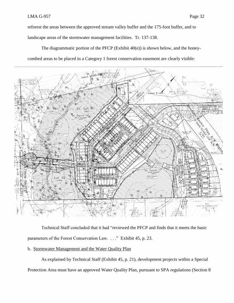
The diagrammatic portion of the PFCP (Exhibit 40(e)) is shown below, and the honey-
combed areas to be placed in a Category 1 forest conservation easement are clearly visible:
Technical Staff concluded that it had “reviewed the PFCP and finds that it meets the basic
parameters of the Forest Conservation Law. . . .” Exhibit 45, p. 23.
b. Stormwater Management and the Water Quality Plan
As explained by Technical Staff (Exhibit 45, p. 21), development projects within a Special
Protection Area must have an approved Water Quality Plan, pursuant to SPA regulations (Section 8
LMA G-957 Page 33
of the Water Quality Inventory of Montgomery County Executive Regulation 29- 95 – Water
Quality Review for Development in Designated Special Protection Areas). There is also a
requirement in Zoning Ordinance §59-D-1.3(i) that an applicant seeking to develop within a special
protection area must submit a water quality plan and secure the required approvals in accordance
with Chapter 19 of the County Code, which governs erosion, sediment control and stormwater
management. The development plan must also demonstrate how any water quality protection
facilities proposed in the preliminary water quality plan can be accommodated on the property as
part of the project.
As mentioned previously, Applicant submitted and revised a Water Quality Plan for the
subject site (Exhibits 40(g) and (h)). Mr. Crum testified that Applicant’s preliminary water quality
plan addresses not only stormwater management but also sediment control during the initial
construction of the project. There is also a water quality monitoring program run by the Department
of Environmental Protection. In special protection areas, the stormwater process is two-stepped,
with a preliminary water quality plan and a final water quality plan. The final water quality plan is a
construction level plan. The preliminary water quality plan is more conceptual, although it does
require submitting more detail than a stormwater management concept plan. In Mr. Crum’s opinion,
the proposed stormwater management controls in Applicant’s water quality plan (Exhibits 40(g) and
(h)) will result in compliance with, and will fully achieve, environmental site design requirements.
Tr. 131-133.
Much of the proposed stormwater management is controlled by bioretention facilities, which
are on average 175 feet from the stream valley buffer, although some will fall within that 175 foot
setback. Mr. Crum described the bioretention facilities that will be within 175 feet of the stream
valley buffer behind lots 17 and 18, and to the southeast of lot 26. These will appear as depressions
in the ground. They will have plant material and a special plant soil mix. There will be two to four
LMA G-957 Page 34
feet of planting media, a six-inch sand layer, and then the underdrain system at the very bottom
which generally is about 15 inches thick. The plant material is tolerant to periodic flooding and
actually takes up any pollutants or nutrients that are in the water before it percolates through and
reaches the underdrain system. The underdrain system is connected to the storm drain system, and
that ultimately outfalls to the stream. There is mulch that goes on the top so there won't be turf grass
growing into it. It will look like a landscaped area, except it will be in a depression. The stormwater
management facilities are 20 to 25 feet in width and 50 feet in length. There will be three such
facilities within 175 feet of the buffer. They can have trees planted in them, and on either side of
them, to reforest the area. They will look like forest with mulch at the surface and understory.
When it rains, they will fill up to about 6 to 8 inches, but the water won't get deeper than 12 inches,
and then that water soaks into the microbioretention facility. Tr. 138-143.
Using the updated grading plan (Exhibit 40(c)), Mr. Crum explained how he minimized the
grading to try and keep as many trees and keep the topography as natural as possible. He worked
very closely with David Ager, Applicant’s land planner, in developing the development pattern,
including the location of units and avoiding the stream valleys to the extent possible. The street
grades are developed based on the criteria that have been established by the Department of
Transportation and the Department of Permitting Services and from that, Applicant grades the lots
out. Over the course of probably a year of going back and forth with the Technical Staff, Applicant
has, to the greatest extent practical, minimized the grading associated with this project. Tr. 124-126.
Mr. Crum further testified, using a partial grading exhibit (Exhibit 57), that in his opinion, by
its design, by minimizing grading and by other means, the proposed development would tend to
prevent erosion of the soil and to preserve natural vegetation and other natural features of the site.
Applicable requirements for forest conservation under Chapter 22A and for water resource
protection under Chapter 19 will also be satisfied. Tr. 128-131.
LMA G-957 Page 35
Technical Staff reviewed the Applicant’s Preliminary Water Quality Plan and recommended
approval, stating (Exhibit 45, p. 21):
Under the SPA law, the MCDPS and the Planning Board have different
responsibilities in the review of the Water Quality Plan. Department of Permitting
Services reviews and conditionally approves the elements of the final Water Quality
Plan under its purview (e.g. stormwater management, sediment and erosion control,
etc.), while the Planning Board determines whether the site imperviousness,
environmental guidelines for special protection areas, and forest conservation
requirements, have been satisfied.
Staff has recommended approval of the Preliminary Water Quality Plan with a
number of conditions. MCDPS conceptually approved the portion of the applicant’s
Preliminary Water Quality Plan under its purview on June 11, 2015. The MCDPS
conceptual approval included a list of performance goals and conditions that the
Applicant must address in the submission of the Final Water Quality Plan. [Exhibit
45, Attachment C, First Document]
As noted earlier, Staff is concerned about potential impacts of the sewer outfall on the
streams the environmental features and ecological quality associated with the
proposed project. Adequacy of the design features proposed to mitigate these impacts
would be analyzed and additional measures and alternative designs would be
evaluated and modified at the Preliminary Plan review of the case, where the scope of
the review process calls for a wider and more extensive participation and coordination
by involved agencies.
The Planning Board approved the Preliminary Water Quality Plan at its July 9, 2015 meeting
(Exhibit 46, p. 2), thereby finding compliance with the applicable standards.
c. Level of Imperviousness
According to Mr. Crum, the appropriate level of imperviousness on the development of a
property varies, and in the Clarksburg Special Protection Area, there is no absolute cap on
imperviousness. Therefore, it is examined on a case-by-case basis at the time the preliminary water
quality plan is reviewed, and again in subdivision. The compromise that Applicant reached with
Technical Staff was that Applicant would subtract from the gross tract area the master plan highways
that were not being constructed, with a goal of achieving a 30 percent imperviousness for the site
based on that tract area. It's not a cap; it's a goal. The development plan itself is actually less than
30 percent impervious as shown on the impervious surface exhibit (Exhibit 58), but Applicant is

LMA G-957 Page 36
asking for some flexibility from staff, which is why it was proposing 32 percent of the gross tract
area. That gave Applicant a cushion for future requirements for other impervious surfaces.
Ultimately, it was agreed that there would be a target of 30% imperviousness, but it is not a binding
element. Tr. 134-137. The Impervious Surface Plan (Exhibit 58) is reproduced below:
LMA G-957 Page 37
Mr. Crum further testified that in an effort to limit imperviousness on the site, the Planning
Board recommended (and Applicant agreed to) a limit on the number of off-street parking spaces to
2.25 spaces per dwelling unit. For the 105 units proposed, that would be a limit of 236 off-street
parking spaces (i.e., spaces that would fall either in a driveway, in a private street or in a private
parking area, not including on-street parking spaces that are available to the general public). Tr.
115-124.
Technical Staff said the following regarding imperviousness (Exhibit 45, p. 21):
The Applicant’s revised Impervious Area Exhibit (May 2, 2015) proposes a post-
development condition with 5.6 acres of impervious surface. The percent impervious
surface shown on the exhibit does not account for right-of-way dedication. Staff has
recalculated the impervious percentage by using the same impervious acreage shown
on the exhibit. The post development impervious percentage of the site is 26.0
percent of the 21.57-acre net tract area. The Applicant anticipates the need for
additional impervious area (up to 32 percent) as the site development process
continues. A future impervious exhibit will include additional elements such as
accel/decel lanes, a turn lane on MD 355, site amenities such as play areas and
pedestrian connections, additional parking spaces, modified dwelling unit size and a
wider pedestrian connection across the tributary of Little Seneca Creek. For these
reasons the Applicant has proposed that the final impervious acreage may increase
from 5.6 acres to a total of approximately 7.8 acres. Staff believes this could bring the
impervious percentage to approximately 36 percent. (see attached Water
Quality/Forest Conservation memorandum of June 26, 2015).
The Water Quality/Forest Conservation memorandum of June 26, 2015, referenced by Technical
Staff, is appended to its report (Exhibit 45) as Attachment B. That memorandum, at page 7, makes it
clear that the 30% imperviousness figure is a “goal” and not a requirement. That goal is based on
Staff’s calculation of imperviousness levels in PD-4 developments in the County.
d. Protecting the Stream Valley Buffer
The final environmental concern raised by the proposed development is protection of the
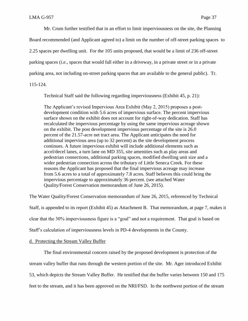
stream valley buffer that runs through the western portion of the site. Mr. Ager introduced Exhibit
53, which depicts the Stream Valley Buffer. He testified that the buffer varies between 150 and 175
feet to the stream, and it has been approved on the NRI/FSD. In the northwest portion of the stream
LMA G-957 Page 38
valley buffer, there is a 175-foot setback and in the southern portion, it is roughly a 150-foot setback.
The portion of Exhibit 53 showing the stream valley buffer is reproduced below:
As pointed out by Mr. Ager, the Clarksburg Master Plan’s environmental section has a
statement that it strongly encourages a 175-foot stream valley buffer for property owners in
Clarksburg, but as noted by Mr. Ager, it is not a requirement. Plan page 144. Mr. Ager testified that
LMA G-957 Page 39
none of the proposed buildings will be within the 175-foot Master Plan recommended stream valley
buffer, and there will be no private ownership of any land within the 175-foot buffer; however, in
some areas, there will be stormwater management facilities located within that buffer. On balance,
the setback will average 175 feet from the stream valley. The language in the Master Plan also
encourages property owners to allow the buffer areas to remain undisturbed (Plan page 144), and
according to Mr. Ager, the Applicant will be “leaving the equivalent area in an undisturbed
character” and will be taking the additional step, where the 175-foot buffer is penetrated, of
reforesting or providing some stormwater facilities. They will be an environmentally sensitive
design with features that include infiltration and bioretention. Applicant had modified its plans to
accommodate Technical Staff’s concerns, and both Technical Staff and the Planning Board approved
the final plan. Tr. 68-78.
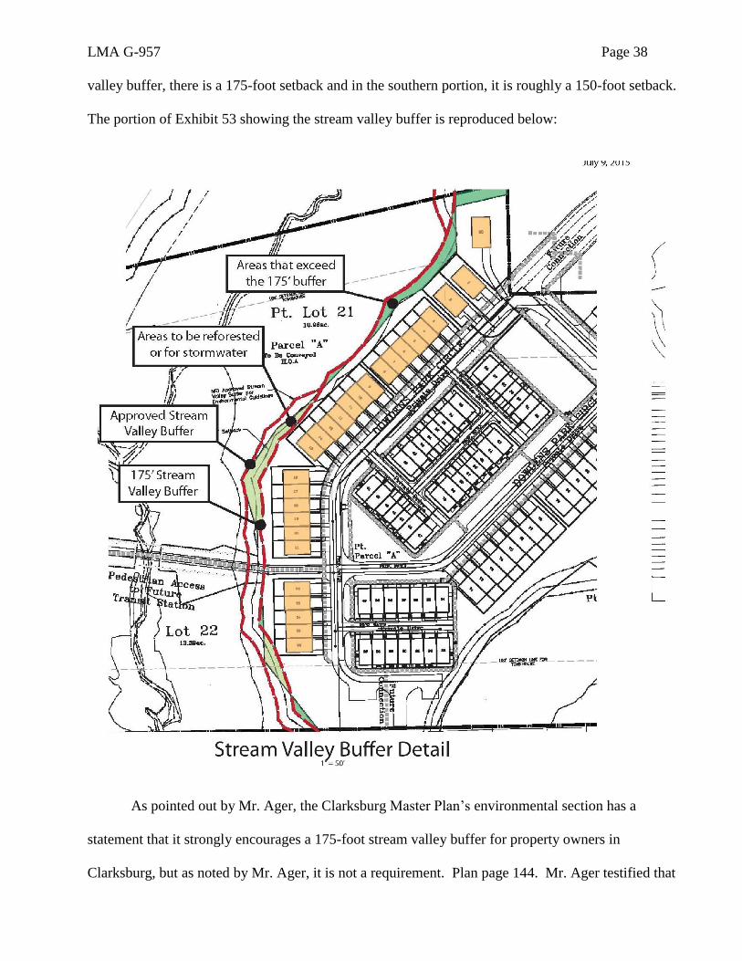
In addition, Mr. Ager testified that Applicant took great care in crossing the stream by
providing “a bottomless culvert” for the crossing. Tr. 57. An illustrative image of that proposed
culvert was included in the Development Plan (Exhibit 65(a)), and it is reproduced below:
LMA G-957 Page 40
According to Mr. Ager, by using this device, Applicant will not be impacting the stream at
the proposed crossing. Any other alignment would have to be very circuitous to come back, go
down the hill and back up again. In his opinion, the proposed culvert is a better connection than
trying to traverse the stream valley, and the development plan will, in conjunction with the natural
features, create a community with a distinctive visual character and identity for the project. In his
opinion, Applicant has taken the greatest possible aesthetic advantage of trees and minimized the
amount of grading necessary to construct the development. Tr. 95-101.
Mr. Ager noted that the abutments for the culvert are very important because they minimize
the grading of the property and are also a way in which to provide a very environmentally sensitive
connection for water and sewer immediately adjacent to the property. It provides a pedestrian
connection from the adjacent neighborhood to the subject site and it also provides a very direct
connection to a future CCT station. Tr. 56-60.
Technical Staff discussed Applicant’s plan for a culvert to cross the stream (Exhibit 45, p.
35):
The issue of a sewer outfall leading from the project will be a major feature of the
Final Water Quality Plan approval process at Preliminary Plan, in terms of design,
impact on the stream and environmental features, capacity and other related issues.
The sewer outfall is proposed to run through an arched culvert arch over the stream
on the southwest side of the site to tie into a sewer main from the Garnkirk Farms
property (east, across the future Observation Drive) that will run along the extension
of Observation Drive. In order for this crossing to be supported by staff, it must be
designed to avoid or minimize impacts to the stream, associated wetlands, and allow
the steam to naturally meander across the floodplain unimpeded.
Direct impact to the stream buffer may also include multiple outfall locations that cut
channels through the forested slopes of the stream valleys. The Final Water Quality
Plan must show this information. Effective resolution of the issues would require
collaboration between several agencies of the county including, the Planning
Department, the Department of Environmental Protection, WSSC, and Department of
Permitting Services. . . .
As mentioned in connection with the sewer service issues, the Hearing Examiner expressed
some concern at the hearing about the visual aspects of the proposed culvert, and Mr. Crum testified
LMA G-957 Page 41
that eventually, the trees and the understory in the area will reestablish themselves and it will be
hidden. It would have to be concrete, but Applicant can put in form liners that look like stone. Tr.
145-149. At the suggestion of the Hearing Examiner (Tr. 164), some language was added to the
caption of the culvert illustration to indicate that the design may be enhanced with coloration and
plant material. The Hearing Examiner concludes that the aesthetic design of this feature is a matter
for consideration of the planners at site plan, rather than the Hearing Examiner at the rezoning stage.
Based on this extensive record, the Hearing Examiner finds that the Applicant has
demonstrated sensitivity to environmental concerns, as recommended by the Master Plan, and has
produced a Preliminary Forest Conservation Plan, a Water Quality Plan, a grading plan, a soil
erosion and sediment control plan, a plan for limiting imperviousness and a plan for protecting the
stream valley buffer, all of which are sufficient at the rezoning stage. Neither Technical Staff nor
the Planning Board reported any environmental issues warranting denial of this application, and the
Hearing Examiner finds none.
E. Community Concerns
As mentioned in Part II of this report, there has been no opposition to this case, nor any
expression of concerns by the neighbors. As reported by Technical Staff (Exhibit 45, p. 36),
The Applicant indicated that presentations [to the community] were made on the
proposed Rezoning and Development Plan in October of 2013 and in September of
2014. Each of these meetings was held in the community and was attended by
approximately a dozen members of the community, as well as at least two MNCPPC
staff members. The sessions included discussions, questions and answers on various
issues and concerns of the Clarksburg community including the following:
Proposed density and types of units
Progress and changes between earlier (PD-5, 140 units) and current plans
(PD-4, 105 units)
Design and layout-open space, environmental areas, pedestrian connections
Alternatives and options regarding the design of the future MD-355 bypass
and Robert Tavern Drive and 355 alignment relative to the Property.
At the time of this writing, no communication has been received from the community
either in support or in opposition of the proposed zoning change.
LMA G-957 Page 42
IV. SUMMARY OF THE HEARING
Applicant called four witnesses, Michael Fisher, a principal of Clarksburg Mews, LLC, the
Applicant; David Ager, a land planner; Stephen Crum, a civil engineer; and Carl Wilson, an expert in
traffic engineering and transportation planning. There was no opposition and there were no other
witnesses.
At the outset of the hearing, the Hearing Examiner noted that the technical staff report
recommending approval was corrected on July 9, 2015, and is now in the record as Exhibit 45. Tr. 7-
8. In response to the Hearing Examiner, Applicant’s attorney, Jody Kline, Esquire, confirmed that
the lots comprising the subject site are now owned by Clarksburg Mews, LLC. The Hearing
Examiner placed Maryland Tax record (SDAT) forms in the record as Exhibits 47(a) for parcel N780
which is lot 21, and Exhibit 47(b) for parcel N888, which is lot 22. An affidavit of sign-notice
posting was received as Exhibit 48. Tr. 8-9.
The Hearing Examiner also noted that the staff report erroneously refers to the application
filing date as July 16, 2013. Actually, it wasn't accepted for filing at that time because there were
some items missing until September 3, 2013, on which date the application was filed. Tr. 15.
Mr. Kline requested that the record be held open for 10 days after the hearing to allow him
time to submit an amended development plan consistent with the water quality plan. Tr. 12-13. That
request was granted, and the record was left open until July 31, 2015, to allow Applicant to file
amended development plan and other documents. Tr. 165-166.
1. Michael Fisher (Tr. 16-27):
Michael Fisher testified that he is a principal of the Applicant, Clarksburg Mews, LLC, and
that the Applicant is now the fee simple owner of the subject property. Tr. 16. He asserted that the
subject property is in a transit corridor and requires infill development. He feels that the property
LMA G-957 Page 43
was not taken into account in the Master Plan, unlike surrounding properties. The property to the
north is Gateway Commons, in a PD-7 zone, and to the west, Garnkirk Farms is in a PD-11 Zone;
Maryland Route 355 is to the east; partially completed Roberts Tavern Road is to the north and
Observation Drive is to the south. Tr. 17.
The site had many issues, and Applicant met with Park and Planning staff and the
community numerous times, which resulted in a reduction in the project from a PD-5 to a PD-4
Zone, in accordance with the Master Plan. Also, the citizens represented by the Clarksburg Alliance
wanted access to the future CCT [i.e., the Corridor Cities Transitway] station which was going to be
located at the corner of Observation Drive and Shawnee Lane. Mr. Fisher kept the Clarksburg
Alliance apprised of the Applicant’s plans. Applicant plans a pedestrian crossing which doubles as a
sewer connection, so it would be an amenity to the community. It is depicted on a rendered land use
plan (Exhibit 49) as a yellow, east-west pathway connecting the property to Observation Drive. Tr.
18-24.
Mr. Fisher also noted that the roadway alignment on the northeast side of the subject site has
not been finalized by the state government, and there may be surplus land that is not needed to
satisfy the transportation requirements, which is depicted as a gray or brown triangle on the right-
hand side of the development plan. That would be surplus land if the state decided to implement the
Rt. 355 Master Plan alignment. The Applicant is showing that land as part of a reservation of land,
so that it can ask for a development plan amendment to put some potential development on that
property if it is not used for the roadway alignment. Tr. 24-27.
2. David Ager (Tr. 28-109):
David Ager testified as an expert in land planning. Using Exhibit 49 (the rendered
development plan), Mr. Ager pointed out that the property is about 100 percent wooded. It has seven
different forest stand types within the property boundary and two valleys. There is a valley that runs
LMA G-957 Page 44
generally north-south paralleling Observation Drive, and there is a ridge immediately to the east of
that valley, where a proposed development is shown. There is a smaller valley to the east of that
ridge, up to existing MD 355, which is on the right-hand side of the exhibit. The older vegetation is
in the valleys, and the newer vegetation is on the ridges because the property was farmed 30 years
ago. The mature forest with sycamores and red maples is in the valleys, and the newer forest is up on
the ridges. The entire property is in a special protection area. The key point is that the established
stream valley buffer, an area of protection, has been honored in the development plan. Tr. 28-32.
Mr. Ager described the surrounding properties. The McCord property is in the notch to the
northeast of the site. There are also three single-family detached homes there, fronting on existing
MD 355. Also, on the development plan exhibit, there are two master plan right-of-ways. On the
west side is the Observation Drive right-of-way, which has been platted, but it has not yet been
constructed to the west of the subject site. It has been constructed north of the site, and this property,
once it moves forward into subdivision, will complete the Observation Drive right-of-way. Because
that right-of-way and that alignment have been established, the Applicant will dedicate land 150 feet
in width to allow the road construction. The future CCT will actually traverse this property in the
future when constructed. Tr. 33-36.
Mr. Ager testified that Applicant accepts the surrounding neighborhood definition contained
on page 7 of the Technical Staff report. Tr. 37. Using Exhibit 51, which contains a reproduction of
page 43 of the 1994 Master Plan, Mr. Agee described the possible road alignments on the eastern side
of the site. This master plan alignment showed a sweeping curve through the subject property and
then continuing south of the historic district and running north and re-associating with MD 355 north
of the historic district. Since 1994, it's been a slight change in that alignment. What's different today
is there's a new road called Roberts Tavern Drive. It takes that right-of-way, continues it through the
property as in the Master Plan alignment but stops at Observation Drive at a T intersection. That

LMA G-957 Page 45
alignment for Roberts Tavern Drive was approved through the context of a project just to the north of
the subject property called Gateway Commons. Both the new alignment proposed and the original
one proposed in the Master Plan would be the same at the area of the subject property. The only
difference is that northwest of the subject property, the present alignment would stop at a T
intersection with Observation Drive. Previously, under the Master Plan, it would continue on north.
Tr. 37-39.
Since it is uncertain whether either of these possible road alignments will be built, the
Applicant proposes to specify on its development plan an “Interim Access” directly to the site from
MD 355, which would be called Dowdens Station Way, and to place 2.59 acres on the east of the site
into a “reservation,” as shown in Exhibit 52.7 [Mr. Kline explained that a provision in the subdivision
regulations (Code Section 50-31) allows a reservation of land for public use. It was intended to do
allow subdivision to go forward, while putting specified land in the reservation. It is then held with
no taxes for up to three years to give the government an opportunity to get organized to acquire the
land. At the end of three years, if the government has not bought it, the owner is allowed to move
forward. It preserves the land for the public acquisition for a three-year period. It can be renewed
until such time the state and the county finally decide what they will do. If that is done in this case,
the record at the time of subdivision will say the Applicant will continue to hold this land in abeyance
until the government decides what it will do and then, if there is any surplus land left, the Applicant
will continue to have ownership.] Tr. 40-45.
Mr. Ager noted that there is a public road in the lighter orange which is referred to as
Dowdens Green Way that connects this property on a generally northwest to southeast configuration
to properties to the southeast and to the McCord property to the northwest of the property. In
7 The reservation area includes both a gray triangle area in the northeast corner of the site (comprised of a portion of
“Outlot B,” a tiny portion of “Outlot C” and 0.72 acres of “Outlot D”) and the potential right-of-way for the Master
Plan alignment (1.73 acres), shown in yellow adjacent to the grey area on the Development Plan, resulting in a
reservation area of 2.59 acres, as shown on Exhibit 52.
LMA G-957 Page 46
addition to that, there is a private road called Dowdens Park Circle which is a semi-circular road in
the darker orange that's internal the property and is in the general location of where the townhouses
are located on the property. That is a private road to service that area and make connections to the
public road, Dowdens Green Way. So in the interim, the project will have an access point on MD
355 for the property. As properties develop to the south, there will be a second access point off of
Dowdens Green Way connecting to the south [and labelled “Future Connection”]. Ultimately, when
Roberts Tavern Drive/Frederick Road Maryland 355 is determined and built through the McCord
property and through the subject property, the interim road connection to MD 355, which is referred
to as Dowdens Station Way, will be removed and a connection will be made to Roberts Tavern Drive,
as it is shown through the McCord property. (A stub of Dowdens Station Way will be left to service
the home to be built on Lot 89, but it would no longer connect to MD 355. Tr. 65-66). The
connection to Roberts Tavern Drive won't occur unless the Master Plan alignment or the alternate
alignment with Roberts Tavern Drive is completed. Whichever one is determined to be the final
alignment, Dowdens Station Way will be completely removed (except for the stub internal to the
subject property) and the connection to the new road from the subject site will be the road labelled
“Future Connection,” which is shown on the north on the McCord property. Tr. 45-49.
The gray area in the northeast corner of the development plan is a smaller portion of the larger
2.59 acre reservation. The grey area is likely to be a residual area if the master plan alignment is
constructed, and Applicant does not have any proposed development within that area at this time.
Applicant would like to come back for a development plan amendment in the future if that residual
area is available after the roads are determined. Tr. 49-50.
Mr. Ager further testified that Applicant is planning to construct 105 residential dwelling
units, 80 percent/20 percent split between townhouses and single-family. It will be in accord with
several master plan elements or guidelines. One is that the single-family detached homes will be

LMA G-957 Page 47
located along the future alignment of the Maryland Route 355 which is referred to A-251 in the
master plan. That was one of the key elements in the master plan. Applicant has also honored the
environmental features of the property and has received preliminary approval of the water quality
plan and preliminary forest conservation plan. The configuration of the townhouses, the location and
configuration of the singles, and the alignments of the street all took into account the topographical
features of the property, forest retention, wetlands and those sorts of natural environmental elements,
to minimize grading and to preserve them to the extent possible and also balance that with the
development of the property. The development will have a density of 4.31 dwelling units per acre
which is consistent with the master plan recommendation of two to four dwelling units per acre, with
the understanding that MPDUs allow an addition to the 4.0 density that's recommended in the master
plan. The master plan actually clarifies that in the technical appendix at page 9. There are 14
MPDUs proposed within the plan. The darker blue townhouse buildings on the development plan are
the market rate units. The lighter blue are the MPDUs and the very dark blue are the single-family
detached homes on individual lots. Tr. 53-55.
Mr. Ager noted that there will be two open spaces planned as common areas that would be
available for general use like just sitting, or things of that nature. Also, on the south of the property
adjacent to townhouse numbers 27 and 26, there will be a multi-age playground and sitting area
adjacent to retained forest. There's a pedestrian system shown within the development plan, and it's a
dashed line in orange on the plan. It includes both sidewalks within the right-of-ways of the public
street, sidewalk within the interim Dowden's Station Way and then sidewalks internal to the
townhouse community and the single-family community, and a connection across from the site
through the stream valley to future Observation Drive. That connection to Observation Drive will be
constructed by the Applicant but Observation Drive will not be constructed by the Applicant. An
illustrative detail of that crossing shown on the development plan, in the upper left-hand corner,
LMA G-957 Page 48
viewed from generally the south looking north, and it indicates an eight-foot wide pedestrian path on
top of a bottomless culvert which spans approximately 40 feet of the stream valley. It has vertical
abutments on the uphill, upstream and downstream side of the crossing. These abutments are very
important because they minimize the grading of the property and is also a way in which to provide a
very environmentally sensitive connection for water and sewer immediately adjacent to the property.
It provides a pedestrian connection from that neighborhood to the subject site and it also provides a
very direct connection to a future CCT station. There is a 15-foot setback from the approved NRI
stream buffer that Applicant agreed to honor. Tr. 56-60.
Mr. Ager introduced Exhibit 53, regarding the Stream Valley Buffer. It varies between 150
and 175 feet to the stream., and it has been approved on the NRI and is on the development plan. In
the northwest portion of the stream valley buffer, there is a 175-foot setback and in the southern
portion is roughly 150-foot. The master plan in the environmental section has a statement that it
strongly encourages a 175-foot buffer for property owners in Clarksburg, but according to Mr. Ager,
it is not a requirement. None of the proposed buildings will be within the 175-foot master plan
recommended stream valley buffer, and there will be no private ownership of any land within the
175-foot buffer; however, in some areas, there will be stormwater management facilities located
within that buffer. On balance, the setback will average 175 feet from the stream valley. Mr. Ager
stated that the language in the master plan asks that the properties owners leave the area in an
undisturbed character, and Applicant will be leaving the equivalent area in an undisturbed character
and will be taking the additional step, where the 175 foot buffer is penetrated, of reforesting or
providing some stormwater facilities. Those facilities will be have environmentally sensitive design
features that include infiltration and bioretention. Applicant had modified its plans to accommodate
Technical Staff’s concerns, and both Technical Staff and the Planning Board approved the final plan,
but the Planning Board asked that the parking be reduced. Tr. 68-78.

LMA G-957 Page 49
Mr. Ager further testified that the Staff report on pages 8 and 33, erroneously states that 1.68
acres would be held in reservation, while the actual number is 2.59 acres, as indicated on the
Development Plan and Exhibit 52. It is a combination of 1.73 acres for the right-of-way, and acreage
of 0.72 acres for the Outlot D, as well as small areas of Outlots B and C. Tr. 80-85.
With respect to master plan conformity, Mr. Ager noted that the property is located within the
Transit Corridor District of the overall Clarksburg Master Plan. On page 43, the Master Plan
designates future development of this property as two-to-four dwelling units per acre. It also calls for
a “private conservation area” along the stream valley and indicates the general alignment for
Maryland 355 (a/k/a, A-251), and Observation Drive and the future CCT alignment that traverses this
property. All of those elements are reflected in the proposed development plan, and Applicant is
asking for the PD-4 Zone, which is consistent with that master plan recommendation. In addition, the
master plan mentions environmental sensitivity, as a reflection of the special protection area.
Applicant has accommodated the master plan on those elements as well. In Mr. Ager’s opinion, the
proposed development plan is very much in conformity with the master plan recommendations. Tr.
88-90.
Using an aerial photo of the general neighborhood (Exhibit 55), Mr. Ager testified that the
proposal would comply with the purpose clause of the PD Zone, Zoning Ordinance, 59-C-7.1, in that
the development is designed to facilitate and encourage a maximum of social and community
interaction and activity among those who live and work in the area. The pedestrian connection to
Observation Drive as proposed on the development plan and the pedestrian system within the
community provide excellent connectivity between the subject property and the Garnkirk Farms
community planned and under construction to the southwest in the PD 11 Zone, and will give
excellent pedestrian access to the future CCT station which is located just north of Shawnee Lane and
just east of Observation Drive. And what's indicated on the exhibit is that the property is within a one
LMA G-957 Page 50
half mile walking radius of essential transit services, which is part of the elements in the master plan,
to make the place interconnected between areas where people work and other residential
neighborhoods, and to provide access to public facilities such as the CCT. Tr. 90-92.
Mr. Ager described the surrounding area: Garnkirk Farms is to the southwest. It was planned
as a PD-11 and was ultimately approved at 10.5 dwelling units per acre. Going in a clockwise pattern
around the subject property, there's a small area that's just to the west which is a part of the Gateway
Center Industrial Complex (called the Gateway 270 Industrial Park) that touches the property corner
to corner. It was I-3 and it's now EOF-0.75 H-100 T, which is also the same zoning on the Comsat
property just outside of the delineated neighborhood. To the northwest of the property is the Gateway
Commons property, which is zoned R-200 TDR-7. It was approved and has been constructed to
approximately 8.4 dwelling units per acre, with the MPDU bonus on that property. Immediately
adjacent to the subject property, in the notch to the north, is the McCord property, which is zoned R-
200. There are several properties zoned R-200 on both the southwest and northeast sides of Frederick
Road, Maryland Route 355, to the north, confronting the property to the northeast, and R-200
properties adjacent to the property to the southeast and further to the south. Within this
neighborhood, further to the north, there's a small property that was formerly zoned RMX-2, but it is
now zoned CRT-0.75 C-0.25 R-0.5 H-65 T. Tr. 92-94.
Mr. Ager stated that, in his opinion, the development shown in the development plan will be
compatible with the surrounding development. It's not only compatible from the general density
standpoint but in accordance with the guidance in the Master Plan, Applicant has transitioned the
density on the property with the single-family units to the east of the property which confront single-
family units and R-200 along Frederick Road (MD 355) and increase the density more towards the
center of the property moving west, closer to the Garnkirk Farms property, the PD-11 property and
the future CCT alignment which runs down Observation Drive. So the project is very much
LMA G-957 Page 51
compatible with the surrounding neighborhood in the design of the development plan. Tr. 95.
Mr. Ager further testified that in his opinion, the development plan is in accordance with
multiple recommendations of the PD purpose clause. The Applicant took great care in crossing the
stream by providing a bottomless culvert, and the project will not impact the stream at the proposed
crossing. Any other alignment would have to be very circuitous to come back, go down the hill and
back up again. In his opinion, the proposed culvert is a better connection than trying to traverse the
stream valley, and the development plan will, in conjunction with the natural features, create a
community with a distinctive visual character and identity for the project. The Applicant designed
the community so that the older forests within the stream valleys are protected and additional forest
beyond that is protected, and the homes will be placed in an environmentally sensitive manner to
minimize grading, essentially, on the ridges. Those ridges will also provide visual opportunity for the
folks in the community to view the open space. The pedestrian connection will be elevated and thus
will provide a scenic overlook into the stream valley. That will be a visual amenity for the property
and will be a distinctive characteristic of the site. The development will offer a variety of housing
types, with both market and MPDU townhomes, of varying sizes and single-family detached homes
of varying construction. In his opinion, Applicant has taken the greatest possible aesthetic advantage
of trees and minimized the amount of grading necessary to construct the development. Tr. 95-101.
A school capacity memo dated February 12, 2015 is attached to the Technical Staff report.
The currently approved subdivision staging policy for schools was adopted on June 30, 2015, and it
indicates that capacity is adequate for the middle school that serves this site and inadequate for the
elementary school and the high school at this time (both at 113.8 percent of capacity). Since that is
over 105 percent, a school facilities payment would be required, but it is below the 120 percent level
that would require a moratorium. An expansion of the Clarksburg high school is planned, as well as
new middle and elementary schools for the cluster. There are also plans to expand the Seneca Valley

LMA G-957 Page 52
High School, and some of that capacity may be used to relieve crowding at the Clarksburg High
School. Tr. 101-104.
Mr. Ager further testified that, in his professional opinion, the development plan is consistent
with the comprehensive, logical and systematic development of the County, and the pedestrian
vehicular circulation system in the proposed development is safe, adequate and efficient for this
property. Tr. 105. The development plan does not conflict with the general plan or any county CIP
program or other applicable county plans and policies to the best of his knowledge. He further
opined that the proposed development will comply with the purposes, standards and regulations of the
zone and the requirements for MPDUs in Chapter 25 A of the Code. The proposal would be within
the density bonus permitted by the number of MPDUs proposed. According to Mr. Ager, this project
will provide for the maximum safety, convenience and amenity of the residents, and Applicant
minimized grading by its design to prevent erosion of soil and preserve natural vegetation and other
natural features of the site. He added that Applicant had taken maximum visual advantage of the site
topography for the benefit of the community. Tr. 106-109.
Finally, Mr. Ager testified that the HOA documents that are part of the record were crafted in
a way to ensure perpetual maintenance of any areas that would be intended for community use. Tr.
109.
3. Stephen Crum (Tr. 110-150):
Stephen Crum testified as an expert in civil engineering, and is so licensed in the state of
Maryland. Tr. 110-113. He indicated that the red arrows annotated as “Future Connections” on the
Development Plan indicate that Applicant would provide a path or a sidewalk to the limits of the
subject application, and that any development that occurs to the southeast or to the northwest or the
northeast would have the ability to connect to those pedestrian connections. Also, the pedestrian
access would connect to a sidewalk system in the future Observation Drive, and that road would lead
LMA G-957 Page 53
to the town center and to the transit station to the south. Also a typo or math error on an earlier
version of the plan identified the reservation area as 1.68 acres, when it is correctly noted as 2.59
acres. Tr. 114.
Mr. Crum further testified that in an effort to limit imperviousness on the site, the Planning
Board recommended (and Applicant agreed to) a limit on the number of off-street parking spaces to
2.25 spaces per dwelling unit. For the 105 units proposed, that would be a limit of 236 off-street
parking spaces (i.e., spaces that would fall either in a driveway, in a private street or in a private
parking area, not including on-street parking spaces that are available to the general public). [After
some discussion, Mr. Kline indicated that Applicant would amend its development plan (then Exhibit
49) to reduce the number of proposed off-street parking spaces to 236 (at 2.25 per dwelling unit).] Tr.
115-124.
Using the updated grading plan (Exhibit 40(c)), Mr. Crum explained how he minimized the
grading to try and keep as many trees and keep the topography as natural as possible. He worked
very closely with Mr. Ager in developing the development pattern, including the location of units and
avoiding the stream valleys to the extent possible. The street grades are developed based on the
criteria that have been established by the Department of Transportation and the Department of
Permitting Services and from that, Applicant grades the lots out. Over a course of probably a year of
going back and forth with the Technical Staff, Applicant has, to the greatest extent practical,
minimized the grading associated with this project. Tr. 124-126.
[Mr. Kline indicated that there's an attachment to the Technical Staff report regarding the
water quality plan and forest conservation plan report, which makes reference to retaining walls, but
they are no longer part of the plan. He sent a letter to the Planning Board so indicating. Tr. 126-
128.]
Mr. Crum further testified, using a partial grading exhibit (57), that in his opinion, by its
LMA G-957 Page 54
design, by minimizing grading and by other means, the proposed development would tend to prevent
erosion of the soil and to preserve natural vegetation and other natural features of the site. Applicable
requirements for forest conservation under Chapter 22A and for water resource protection under
Chapter 19 will also be satisfied. Tr. 128-131.
Mr. Crum confirmed that the site is within the Clarksburg Special Protection Area. In terms
of stormwater management and soil erosion and sediment control, in lieu of submitting a stormwater
concept plan, you submit a preliminary water quality plan. That plan needs to address not only how
the Applicant will produce stormwater management, but also how sediment control is going to be
addressed during the initial construction of the project. The third element is that special protection
areas are part of a water quality monitoring program that the Department of Environmental Protection
runs. In special protection areas, the stormwater process is two-stepped, with a preliminary water
quality plan and a final water quality plan. The final water quality plan is a construction level plan.
The preliminary water quality plan is more conceptual, although it does require submitting more
detail than required for a stormwater concept plan. In Mr. Crum’s opinion, the proposed stormwater
management controls in Applicant’s water quality plan (Exhibits 40(g) and (h)) will result in
compliance with, and will fully achieve, environmental site design requirements. Tr. 131-133.
According to Mr. Crum, the appropriate level of imperviousness on the development of a
property varies, and in the Clarksburg Special Protection Area, there is no absolute cap on
imperviousness, so it is examined on a case-by-case basis at the time of preliminary water quality
plan, and again at subdivision. The compromise that Applicant reached with Technical Staff was that
Applicant would subtract from the gross tract area the master plan highways that were not being
constructed, with a goal of achieving a 30 percent imperviousness for the site based on that tract area.
It's not a cap; it's a goal. The development plan itself has less than 30 percent imperviousness, as
shown on Exhibit 58, but Applicant is asking for some flexibility from staff, which is why it was
LMA G-957 Page 55
proposing 32 percent of the gross tract area. That gave Applicant a cushion for future requirements
for other impervious surfaces. Ultimately, it was agreed that there would be a target of 30%
imperviousness, but it is not a binding element. Tr. 134-137.
Mr. Crum further testified that under the updated forest conservation plan (Exhibits 40(e) and
(f), sheets 1 and 2), the honeycomb hatched areas will be placed within a Category 1 forest
conservation easement. The Applicant will meet all of its forest conservation requirements on site.
Although Applicant wouldn't have to plant a single tree, it made a commitment to the Planning
Commission to reforest the areas in between the approved stream valley buffer and the 175-foot
buffer, and landscape areas of the stormwater management facilities. Tr. 137-138.
Mr. Crum described the bioretention facilities that will be within 175 feet of the stream valley
buffer. There will be a microbioretention facility behind lots 17 and 18, and to the southeast of lot
26. These will appear as depressions in the ground. They have plant material and a special plant soil
mix. There's two to four feet of planting media, a six-inch sand layer, and then there's the underdrain
system at the very bottom which generally is about 15 inches thick. The plant material is tolerant to
periodic flooding and actually takes up any pollutants or nutrients that are in the water before it
percolates through and reaches the underdrain system. The underdrain system is connected to the
storm drain system, and that ultimately outfalls to the stream. There is mulch that goes on the top, so
there won't be turf grass growing into it. It will look like a landscaped area, except it is in a
depression. The stormwater management facilities are 20 to 25 feet in width and 50 feet in length.
There will be three such facilities within 175 feet of the buffer. They can have trees planted in them
and on either side of them to reforest the area. They will look like forest with mulch at the surface and
understory. When it rains, they will fill up to about 6 to 8 inches, but they won't get deeper than 12
inches, and then that water soaks into the microbioretention facility. Tr. 138-143.
Mr. Crum stated that there is adequate sewer and water service available for the property.
LMA G-957 Page 56
There's an existing water line in Maryland 355. Applicant is proposing to make a connection to that
line, and it will loop through the project. The Applicant will actually make a water line connection to
Observation Drive as well, so the property will be served from two directions with public water.
Each dwelling unit obviously will have an individual connection that will be metered. The Applicant
will extend the sanitary sewer all the way up into the alley behind single-family dwellings that are
closest to Maryland 355. There will be a manhole at the intersection of Dowden's Green Way and
that could be extended in the future to serve properties to the south. The sewer system runs and
connects to Observation Drive via the pedestrian crossing that Applicant is proposing. The water and
sewer categories are W-1 and S-3. He is not aware of either pressure or treatment plant prescriptions.
Tr. 143-144.
Mr. Crum added that the presence of the stream valley and the other elevations made it
difficult to provide sewer service to the development. But he realized that if there was a way to cross
the stream valley, Applicant could actually make gravity work in this location because the receiving
manhole to the west of the property is at an elevation that allows for gravity flow. He talked to
WSSC about building a structure similar to a Roman aqueduct where an aerial sewer was suspended,
but WSSC said it had to be conventional construction, so if it needed repair, it could use a backhoe
and excavate down through the earth and repair the sewer. The solution he came up with was to
create an earthen embankment that would cross the stream valley and would allow the sewer to be
within that earth embankment and still reach the elevations that were needed. WSSC has reviewed
this in a very preliminary manner and didn’t have any objections. As Mr. Ager testified, this provides
a very direct pedestrian connection with the west of the site as well, with very little impact to the
stream. When the Hearing Examiner raised a question about the visual impact of the proposed
abutment, Mr. Crum testified that eventually, the trees and the understory in the area will reestablish
themselves and it will be hidden. It would have to be concrete, but Applicant can put in form liners

LMA G-957 Page 57
that look like stone. Tr. 145-149. [The Hearing Examiner suggested that under the picture of the
proposed abutment in the upper left-hand corner of the development plan (land use plan), some
language be added indicating not only that the drawing is for illustrative purposes, but also that the
materials used will take into consideration the forested setting so that it will blend in better with the
natural setting. Tr. 164-165.]
Finally, Mr. Crum testified that the development plan complies with all the requirements and
development standards of the PD Zone and the enhanced environmental scrutiny that the Clarksburg
SPA calls for. In his professional opinion, the proposed use will comply with the purpose, intent and
standards of the PD Zone and will meet all the requirements of Zoning Ordinance §59-D.1 from an
engineering point of view, including the prevention of erosion by redundant sediment control
measures. Tr. 149-150.
4. Carl Wilson (Tr. 151-163):
Carl Wilson testified as an expert in transportation planning and traffic engineering. Tr. 151-
153. He prepared a traffic impact study for the proposed re-zoning in accordance with the Planning
Board's Local Area Transportation Review (LATR) guidelines, which is dated 7/26/13 and is in the
record as Exhibit 24. He noted that the main purpose of the LATR is to study the offsite
intersections and the site access point at Maryland 355, looking at the critical lane volumes (CLV) to
determine that those are adequate. With respect to LATR, he considered a single point of access for
this property along Maryland 355. Using the Montgomery County rates, he projected that the site
would produce 75 total trips in the morning and 111 trips in the evening.8 Those projections would
have to be reduced because they were based on the original larger development proposed for the site
of 140 dwelling units, and the current plan calls for 105 units total. Using those higher projections,
8 The court reporter recorded Mr. Wilson’s testimony as stating the evening figure as 100 trips (Tr. 156), but the Hearing
Examiner’s notes indicate that Mr. Wilson gave the figure as 111 trips, which is consistent with his traffic study (Exhibit
24, p. 21).

LMA G-957 Page 58
he calculated that the access point would operate at an adequate level of service under the congestion
standard for the policy area, which is a CLV of 1425. Thus, at the proposed access point, he found a
CLV in the morning of 763, and in the afternoon of 877, during the peak hour of the peak period. A
recalculation based on the reduced number of dwelling units would reduce those projections, as well.
All of the intersections studied met the 1425 CLV standard. As this application proceeds through
preliminary plan, Applicant will have to update the LATR to obtain more current counts, since his
study was dated 2013. Along those lines, the State Highway Administration is going to have to
approve the MD 355 access point through the access management division. Tr. 153-156.
Mr. Wilson further testified that the Planning staff asked him to prepare “a gap study.” The
gap study is to ensure that there's adequate availability for traffic that would be leaving the site to
enter Maryland 355. In order to do a gap study, tubes are put out on the road to measure the amount
of space that occurs in between vehicles. It's actually measuring the time in between vehicles
passing the site access point. For the gap study, there needs to be a gap for the left turn of seven-
and-a-half seconds and for the right turn of six-and-a-half seconds. He looked at both the
northbound and southbound traffic. If you're turning right, you only need that southbound gap along
Maryland 355. If you're turning left out of the site, you need the same gap to be available at the
same time on both northbound and southbound, so that's something that is considered as part of this
analysis. It's possible in the future, if the Roberts Tavern Drive extension project moves forward
that there could be a traffic signal. As part of this project, a traffic signal is not proposed because the
site itself would not generate enough traffic to warrant a traffic signal. Mr. Wilson concluded that
the gap study showed that there are adequate gaps in the traffic streams, both the northbound and
southbound, for traffic to exit the site and to enter the site as well during the peak hours, and that's
all documented within the analysis that's been reviewed and approved by Park and Planning staff.
Tr. 157-161.
LMA G-957 Page 59
[Applicant’s counsel, Jody Kline, indicated that he would file a copy of the gap study before
the record closed, which he did. See Exhibit 60(c).]
Finally, Mr. Wilson testified that, in his opinion, the proposed vehicular and pedestrian
circulation system and points of external access for the proposed development are safe, adequate and
efficient. This is similar to a typical layout for a residential subdivision. There appear to be
adequate intersections for the vehicles to enter and exit within the subdivision streets and of course
to Maryland 355. Mr. Wilson contacted Montgomery County Department of Transportation just to
confirm what was going on with Roberts Tavern Drive, and the status hasn't changed within the past
three years. The project is on the shelf and the project manager has no time frame as to when that
might move forward. Tr. 161-163.
V. FINDINGS OF FACT AND CONCLUSIONS OF LAW
A. Standards for Council Review
Section 59-D-1.61 of the Zoning Ordinance9 requires the District Council, before it approves
any application for re-zoning, to consider whether the application, including the development plan,
fulfills the “purposes and requirements” set forth in Code Section 59-C for the new zone. In making
this determination, the law expressly requires the District Council to make five specific findings, “in
addition to any other findings which may be necessary and appropriate to the evaluation of the
proposed reclassification.” Therefore, these findings are an essential part of the Hearing Examiner’s
Report and Recommendation.
The five specific findings required by §59-D-1.61 of the Zoning Ordinance are:
(a) [That t]he proposed development plan substantially complies with the
use and density indicated by the Master Plan or sector plan, and does not
conflict with the general plan, the county capital improvements program, or
9 As mentioned in Footnote 2 of this report, because this case was filed prior to May 1, 2014, it must be reviewed
under the standards of the Zoning Ordinance in effect on October 29, 2014, pursuant to §59-7.7.1.B. of the new
Zoning Ordinance.
LMA G-957 Page 60
other applicable county plans and policies . . .10
(b) That the proposed development would comply with the purposes,
standards, and regulations of the zone as set forth in article 59-C, would
provide for the maximum safety, convenience, and amenity of the residents of
the development and would be compatible with adjacent development.
(c) That the proposed internal vehicular and pedestrian circulation
systems and points of external access are safe, adequate, and efficient.
(d) That by its design, by minimizing grading and by other means, the
proposed development would tend to prevent erosion of the soil and to
preserve natural vegetation and other natural features of the site. Any
applicable requirements for forest conservation under Chapter 22A and for
water resource protection under Chapter 19 also must be satisfied. The district
council may require more detailed findings on these matters by the planning
board at the time of site plan approval as provided in division 59-D-3.
(e) That any documents showing the ownership and method of assuring
perpetual maintenance of any areas intended to be used for recreational or
other common or quasi-public purposes are adequate and sufficient.
Because the general requirement of the law – that the application must fulfill the “purposes
and requirements” of the new zone – is subsumed in the language of the five specific required
findings (especially in subsection (b)), a determination that the five findings have been satisfied
would satisfy the Montgomery County Zoning Ordinance. However, in addition to these five
findings, Maryland law also requires that the proposed rezoning be in the public interest. As stated
in Maryland Land Use Article, Code Ann. § 21-101(a)(4)(i) (2012),11
(i) planning, zoning, or subdivision control powers in the regional district [must be
exercised to:]
(1) guide and accomplish a coordinated, comprehensive, adjusted, and systematic
development of the regional district;
(2) coordinate and adjust the development of the regional district with public and
private development of other parts of the State and of the District of Columbia; and
(3) protect and promote the public health, safety, and welfare.
10 The remaining language of this provision addresses additional height and density based on the inclusion of on-site
MPDUs and workforce housing. That language is inapplicable in this case because it pertains to zones permitting a
higher density than that which is permitted in the PD-4 Zone and to workforce housing that is not included in this case. 11 Effective October 1, 2012, the Regional District Act, Article 28, Md. Code Ann., was re-codified, without a
change in substance, into a new “Land Use Article.” Section § 21-101(a)(4)(i) of the Land Use Article contains the
rough equivalent of the previous language in Article 28, Md. Code Ann., § 7-110.

LMA G-957 Page 61
In sum, there are six findings required (§59-D-1.61(a) through (e) and the public interest).
The “Required Findings” in the next part of this report are organized in the order set forth in the
statute to facilitate review.
B. Required Findings
1. County Plans and Policies
The first required finding is:
[That t]he proposed development plan substantially complies with the use and
density indicated by the Master Plan or sector plan, and does not conflict with
the general plan, the county capital improvements program, or other
applicable county plans and policies. . . .
a. The Applicable Master Plan or Sector Plan
The subject property is located in the Transit Corridor District of the 1994 Clarksburg Master
Plan and Hyattstown Special Study Area. The Land Use Plan for the Transit Corridor District is
depicted below (Figure 22, on Plan p. 55):
Subject Site
LMA G-957 Page 62
The Master Plan impacts this proposal in six major ways:
a. It limits the density of development to the recommended 2 to 4 dwelling units per acre (Plan
p. 55), plus allowance for MPDUs (Technical Appendix to the Plan, pp. 9-10);
b. It calls for additional housing in the Transit Corridor District (Plan pp. 54-56);
c. It proposes specific road alignments on the eastern and western edges of the site (Plan p. 57);
d. It endorses strong environmental controls in the area (Plan pp. 137-154);
e. It affects the arrangement of the types of dwelling units on the site by calling for
maintenance of the residential character along MD 355 (Plan pp. 56-57); and
f. It advocates strong pedestrian and bicycle linkages (Plan p. 57).
The Clarksburg Master Plan recommendations are well described in the Technical Staff Report
(Exhibit 45, pp 14-15):12
The Land Use Plan of the 1994 Clarksburg Master Plan and Hyattstown Special
Study Area recommends the site for development at two to four dwelling units per
acre. The Master Plan identifies the Property as part of the Transit Corridor District,
which encompasses 990 acres of land and includes properties traversed by the future
transitway that the Master Plan proposes. The Transit Corridor District includes
properties fronting MD 355 that have developed over many decades in accord with
traditional patterns—single-family detached lots fronting the road. Maintaining this
residential character, while addressing the need for increased traffic capacity along
MD 355, is a significant planning challenge in this District.
The Master Plan recommends the following land use objectives for the Transit
Corridor District:
• Continue the present residential character along MD 355;
• Balance the need for increased carrying capacity along portions of MD 355
with the desire to retain residential character along MD 355;
• Continue the present employment uses along I-270;
• Provide housing at designated areas along the transit-way near significant
employment uses;
• Allow small amounts of office and retail uses at transit stop areas as part of a
mixed-use development pattern;
• Establish strong pedestrian and bicycle linkages to the greenway;
• Improve east-west roadway connections;
• Provide an open space system that includes small civic spaces at the transit
stops.
* * *
The Master Plan also provides guidance in terms of environmental quality. The
Master Plan, through the recommendations of environmental studies, deems it
essential for stream buffers in the watershed to remain forested for water quality
purposes as well as environmental reasons (Master Plan Page 144). In order to
achieve these environmental standards, the Master Plan “strongly encourages” stream
buffers to be extended to 175 feet which exceeds the 125 feet standard steam buffer
12 The Hearing Examiner has rearranged the order of Technical Staff’s text quoted herein.
LMA G-957 Page 63
used in the majority of the county. This buffer increase is also designed to allow trees
to regenerate in areas not presently wooded. . . .
Technical Staff found that the Development Plan proposed by the Applicant conforms to the
recommendations of the Master Plan (Exhibit 45, pp. 14-16):
The Application generally attempts to follow the strong guidance of the Master Plan
by providing the 175 foot buffer and in some case exceeding this standard. However,
there are multiple areas bordering townhouse sites and roads where the standard
cannot be implemented due to topographic constraints.
The Application proposes a pedestrian connection and bike path system through the
environmental buffer to a future section of Observation Drive which will ultimately
provide safe and efficient access to the future Corridor City Transit way (CCT) transit
station.
Because the proposed change in zoning furthers these objectives, the proposal is in
conformance with the 1994 Clarksburg Master Plan and Hyattstown Special Study
Area.
The Development Plan proposes housing in appropriate areas near transit stations.
The Application seeks to introduce development that is compatible with existing
residential uses while providing enough density to support transit. The Property is not
located in the area slated for the highest densities (9-11 units per acre) which are
relegated to the [area] around the transit stop for the Corridor Cities Transitway.
However, development on the Property, which is recommended for two to four
dwelling units per acre (1994 Clarksburg Master Plan and Hyattstown Special Study
Area Figure 22, Page 55) could provide pedestrian access to serve the planned transit
station at the intersection of Shawnee Lane and the future Observation Drive. An
interconnected street system is essential in achieving a walkable and transit
serviceable community that can be logically connected to adjacent properties.
Like many of the properties in the Transit District, the Property has frontage on MD
355. To reinforce residential character, the Master Plan seeks to maintain the
predominant pattern of homes facing MD 355 (Page 55). This proposed Development
Plan conforms to this lot pattern by placing detached homes with frontage along MD
355 and access from the rear through an alley. . . .
It should be noted that the Applicant’s original proposal sought to rezone the property to the
PD-5 Zone (Exhibit 2), but the proposed Zone category was reduced to PD-4, in accordance with the
density recommendation of the Master Plan. The Planning Board, like its Technical Staff, found the
proposed development to be in in substantial compliance with the Master Plan. Exhibit 46.
Based on the evaluation of the Technical Staff and the Planning Board, and the unrebutted

LMA G-957 Page 64
evidence that the proposed development is consistent with the recommendations, guidelines and goals
of the Clarksburg Master Plan, the Hearing Examiner finds that Applicant’s Development Plan meets
the specified objectives and is in substantial compliance with the Master Plan’s use and density
recommendations, as “Finding (a)” requires.
b. The General Plan and the County Capital Improvements Program
The 1994 Clarksburg Master Plan is, by its own terms, an amendment to the General Plan
which carries out, with greater specificity, the General Plan’s “Wedges and Corridors” approach to
planning for the County. See Master Plan, p. vii. Since the proposed development complies with the
recommendations of the Master Plan, it is consistent with the General Plan. There is no evidence that
this proposal conflicts with the County’s capital improvements program, or other County policies.
Technical Staff reports that “[t]he proposed development will not conflict with the County’s Capital
Improvements Program (CIP) or other applicable county plans and policies.” Exhibit 45, p. 23. The
Hearing Examiner so finds.
c. Other County Policies (Subdivision Staging Policy and Adequate Public Facilities)
Under the County’s Adequate Public Facilities Ordinance (“APFO,” Code §50-35(k)), the
Planning Board has the responsibility, when it reviews a preliminary plan of subdivision, to assess
whether the following public facilities will be adequate to support a proposed development:
transportation, schools, water and sewage facilities, and police, fire and health services. The
Planning Board’s application of the APFO is limited by parameters that the County Council sets in
its Subdivision Staging Policy.13 While the ultimate test under the APFO is carried out at
subdivision review, evidence concerning adequacy of public facilities is relevant to the District
Council’s determination in a rezoning case, as spelled out in Zoning Ordinance §59-H-2.4(f).
13 In 2010, the County Council changed the name of the Growth Policy to the Subdivision Staging Policy, but both
Zoning Ordinance §59-H-2.4(f) and APFO Code §50-35(k)) still refer to the Council’s Growth Policy. The
20122016 Subdivision Staging Policy was adopted by the Council on November 13, 2012, in Resolution 17-601.

LMA G-957 Page 65
Section 59-H-2.4(f) requires Applicant to produce “[s]ufficient information to demonstrate a
reasonable probability that available public facilities and services will be adequate to serve the
proposed development under the Growth Policy standards in effect when the application is
submitted.” In this case, the application was filed on September 3, 2013, so the 2012-2016
Subdivision Staging Policy, adopted November 13, 2012, in Resolution 17-601, will apply to the
rezoning determination.
The 2012-2016 Subdivision Staging Policy provides, at p. 21, “[t]he Planning Board and
staff must consider the programmed services to be adequate for facilities such as police stations,
firehouses, and health clinics unless there is evidence that a local area problem will be generated.”
There is no such evidence in this case. The remaining three public facilities – transportation, schools
and water and sewer service – were discussed at length in Part III.D.3 of this report.
Based on that discussion, the Hearing Examiner finds that Applicant has demonstrated a
reasonable probability that available public facilities and services will be adequate to serve the
proposed development under the Growth Policy standards in effect when the application was
submitted. In sum, the requested rezoning does not conflict with “other applicable County plans and
policies.”
2. Zone Requirements, Safety, Convenience and Amenity of Residents and Compatibility with
Adjacent Development
The second required finding is:
That the proposed development would comply with the purposes, standards,
and regulations of the zone as set forth in article 59-C, would provide for the
maximum safety, convenience, and amenity of the residents of the development
and would be compatible with adjacent development.
a. Compliance with Zone Purposes, Standards and Regulations
The requirements for the PD-4 Zone are found in Code §59-C-7.1. The PD-4 Zone is a
“floating zone,” which is a flexible device that allows a legislative body to establish a district for a
particular type of use, with land use regulations specific to that use, without attaching that district to

LMA G-957 Page 66
particular pieces of property. Individual property owners may seek to have property reclassified to a
floating zone by demonstrating that the proposed location is appropriate for the zone, i.e., it satisfies
the purpose and regulations of the zone, the development would be compatible with the surrounding
area, and it would serve the public interest.
PD (Planned Development) zones are a special variety of floating zone with performance
specifications integrated into the requirements of the zone. These zones allow considerable design
flexibility if the performance specifications are satisfied. The applicant is not bound to rigid design
specifications, but may propose site-specific criteria, within the parameters established for the zone,
for elements such as setbacks, building heights and types of buildings. These specifications must be
spelled out on a development plan, however, to assure appropriate zoning oversight by the District
Council. Once it is approved, the development plan provides the design specifications for the site,
much as the Zoning Ordinance provides design specifications for more rigidly applied zones.
i. Purposes of the PD-4 Zone
The purpose clause for the PD-4 Zone (as well as the other PD Zones) is found in Code §59-
C-7.11. It is set forth in full below, with relevant analysis and conclusions following.
It is the purpose of this zone to implement the general plan for the Maryland-
Washington Regional District and the area Master Plans by permitting unified
development consistent with densities proposed by Master Plans. It is intended
that this zone provide a means of regulating development which can achieve
flexibility of design, the integration of mutually compatible uses and optimum
land planning with greater efficiency, convenience and amenity than the
procedures and regulations under which it is permitted as a right under
conventional zoning categories. In so doing, it is intended that the zoning
category be utilized to implement the general plan, area Master Plans and other
pertinent county policies in a manner and to a degree more closely compatible
with said county plans and policies than may be possible under other zoning
categories.
It is further the purpose of this zone that development be so designed and
constructed as to facilitate and encourage a maximum of social and community
interaction and activity among those who live and work within an area and to
encourage the creation of a distinctive visual character and identity for each
LMA G-957 Page 67
development. It is intended that development in this zone produce a balance and
coordinated mixture of residential and convenience commercial uses, as well as
other commercial and industrial uses shown on the area Master Plan, and
related public and private facilities.
It is furthermore the purpose of this zone to provide and encourage a broad
range of housing types, comprising owner and rental occupancy units, and one-
family, multiple-family and other structural types.
Additionally, it is the purpose of this zone to preserve and take the greatest
possible aesthetic advantage of trees and, in order to do so, minimize the amount
of grading necessary for construction of a development.
It is further the purpose of this zone to encourage and provide for open space not
only for use as setbacks and yards surrounding structures and related walkways,
but also conveniently located with respect to points of residential and
commercial concentration so as to function for the general benefit of the
community and public at large as places for relaxation, recreation and social
activity; and, furthermore, open space should be so situated as part of the plan
and design of each development as to achieve the physical and aesthetic
integration of the uses and activities within each development.
It is also the purpose of this zone to encourage and provide for the development
of comprehensive, pedestrian circulation networks, separated from vehicular
roadways, which constitute a system of linkages among residential areas, open
spaces, recreational areas, commercial and employment areas and public
facilities, and thereby minimize reliance upon the automobile as a means of
transportation.
Since many of the purposes of the zone can best be realized with developments of
a large scale in terms of area of land and numbers of dwelling units which offer
opportunities for a wider range of related residential and nonresidential uses, it
is therefore the purpose of this zone to encourage development on such a scale.
It is further the purpose of this zone to achieve a maximum of safety, convenience
and amenity for both the residents of each development and the residents of
neighboring areas, and, furthermore, to assure compatibility and coordination of
each development with existing and proposed surrounding land uses.
This zone is in the nature of a special exception, and shall be approved or
disapproved upon findings that the application is or is not proper for the
comprehensive and systematic development of the county, is or is not capable of
accomplishing the purposes of this zone and is or is not in substantial
compliance with the duly approved and adopted general plan and Master Plans.
In order to enable the council to evaluate the accomplishment of the purposes set
forth herein, a special set of plans is required for each planned development, and
the district council and the planning board are empowered to approve such
plans if they find them to be capable of accomplishing the above purposes and in
compliance with the requirements of this zone.
LMA G-957 Page 68
As discussed in Part V.B.1.b, above, the proposed development will be in substantial
compliance with the 1994 Clarksburg Master Plan. Moreover, as noted by Technical Staff (Exhibit
45, p. 24), the proposed development “provides a mix of unit types with adequate setbacks, shared
private streets and alleyways, protection of the environment and amenities that could not be achieved
under the existing conventional zoning.” Accordingly, the requested reclassification will comply
with the first element of the purpose clause by allowing implementation of applicable Master Plan
objectives and by flexibly designing and integrating compatible uses to achieve greater efficiency,
convenience and amenity than under conventional zoning categories.
The second paragraph of the purpose clause calls for a design which will facilitate social and
community interaction, create a distinctive visual character, and offer a balanced mix of uses. As
observed by Technical Staff (Exhibit 45, p. 25),
The proposed development would encourage and facilitate a maximum of social and
community interaction and activity. The Application provides for a central
community space for social gathering and recreational area, seating areas, a
playground, a trail system and open space. The development is located within a
walking distance to a future transit station and provides a pedestrian access to the
station.
Although the specific details of the proposed culvert at the western portion of the
property, adjacent to the future Observation Drive, will not be determined until the
Site Plan stage of the review, it is designed to provide . . . pedestrian access to the
future transit station that was planned to be located on the east side of Observation
Drive at its intersection with Shawnee Lane south of the Property.
The proposed development would not include commercial uses but it would
contribute to the overall balance of employment and residential uses in the planning
area. It also provides a smooth transition from the higher density residential
developments (Garnkirk Farm and Gallery Park residential developments) west of
MD 355 to the less dense residential developments east of MD 355, within the
neighborhood.
There will be no commercial uses on site because the Master Plan does not envision any on
this site, but there will be a mix of residential and recreational uses. As stated by Applicant’s land
planner, David Ager, the proposal would comply with the purpose clause of the PD Zone in that the
LMA G-957 Page 69
development is designed to facilitate and encourage a maximum of social and community interaction
and activity among those who live and work in the area. The pedestrian connection to Observation
Drive and the pedestrian system within the community provide excellent connectivity between the
subject property and the Garnkirk Farms community planned and under construction to the
southwest in the PD 11 Zone. They will also give excellent pedestrian access to the future CCT
station which will be located just north of Shawnee Lane and just east of Observation Drive. Tr. 90-
92. Thus, the Hearing Examiner finds that the second paragraph of the purpose clause has been
satisfied.
The third paragraph of the purpose clause encourages “a broad range of housing types.” The
proposed development will provide for a range of different sized single-family detached homes, and
townhouse units on differing sized lots. Over thirteen percent of these units will be MPDUs and 67
percent will be market-rate units. It will thus provide a broad range of housing choices. The
Hearing Examiner agrees with Technical Staff’s conclusion (Exhibit 45, p. 26): “Given the size of
the Property and its location within the immediate neighborhood, the proposed mix of housing types
is appropriate and is in accordance to the PD-Zone Category specification.”
The fourth and fifth paragraphs seek to preserve and take aesthetic advantage of trees,
minimize grading and provide open space. Technical Staff addressed these issues as follows (Exhibit
45, p. 26):
The Property is entirely covered by forest. The proposed development would preserve
approximately 37 percent or 7.67 acres of forest in an area between the proposed
development and the adjacent future Observation Drive abutting the property to the
west. About 6.9 acres of the forest is retained within the stream valley buffer. The
project also provides for open space including green areas, a multi-age playground and
a community gathering area. Despite the serious challenges that the slopes throughout
the Property present, significant efforts have been made to minimize grading.
The issues of minimizing grading, preserving the environment and the aesthetics of
Applicant’s proposal were discussed at length in Part III.D.4. of this report. As stated there, the
LMA G-957 Page 70
Hearing Examiner finds that the Applicant has demonstrated sensitivity to environmental concerns,
as recommended by the Master Plan, and has produced a Preliminary Forest Conservation Plan, a
Water Quality Plan, a grading plan, a soil erosion and sediment control plan, a plan for limiting
imperviousness and a plan for protecting the stream valley buffer, all of which are sufficient at the
rezoning stage. Based on this evaluation and Technical Staff commentary on open space, the
Hearing Examiner concludes that the fourth and fifth paragraphs of the purpose clause have been
satisfied.
The sixth paragraph calls for pedestrian circulation networks to minimize reliance upon
automobiles. The development plan here provides for a network of pedestrian paths and
connectivity to transit and other developments which will clearly reduce reliance upon automobiles,
thus satisfying the sixth paragraph of the purpose clause.
The seventh paragraph of the purpose clause encourages, but does not require, “large scale”
developments. As observed by Technical Staff (Exhibit 45, pp. 26-27), the proposed development
would create a 105–unit community on 24.37 acres, with an appropriate mix of townhouses and
single-family detached homes. The Hearing Examiner agrees with Staff’s conclusion that the scale
of the proposed development is large enough to provide forested areas, open spaces and play areas,
and thus “realizes the purpose of the zone . . .”
The eighth paragraph of the purpose clause calls for a development which provides for
safety, convenience, amenity, and compatibility, and the ninth paragraph reiterates the need for a
development that will be proper for the comprehensive and systematic development of the County,
and consistent with the Master Plan and the Zone. Safety was discussed in connection with
transportation facilities in Part III.D.3.a. of this report, and as noted there, the proposed access ways
and internal circulation systems will be adequate and safe. Convenience and amenities include the
pedestrian networks and park areas which were discussed above in this section.

LMA G-957 Page 71
As to compatibility, all the evidence supports the proposition that the proposed development
will fit well with its surroundings. Applicant’s land planner, David Ager, testified that the proposal
will be compatible with the surrounding development not only from the general density standpoint,
but also in the way it transitions the densities of planned development on the site. Specifically, the
Applicant will place the single-family units to the east of the property where they will confront
single-family units in the R-200 Zone along Frederick Road (MD 355), and the denser dwelling units
(i.e., townhouses) will be placed more towards the center of the property moving west, closer to the
Garnkirk Farms property, the PD-11 property and the future CCT alignment which runs down
Observation Drive. So the project is very much compatible with the surrounding neighborhood in the
design of the development plan. Tr. 95.
Technical Staff agrees (Exhibit 45, p. 27):
. . . The provision of single-family detached dwellings along the Property’s frontage
on MD 355 blends well and is compatible with the existing low density residential
character of the area between Stringtown Road to the north and Shawnee Lane to the
south, fronting MD 355 (east), which is defined by detached single-family homes.
Moreover, the project ,which is adjacent to a 392-unit mixed-unit residential
development on a PD-11 zoned property (Garnkirk Farms) to the west provides an
ideal transition from a more intense PD-11 development to the existing single-family
homes on the R-200 TDR and R-200 zoned properties north, south and east (across
MD 355) of the Property.
The Planning Board also adopted Technical Staff’s analysis (Exhibit 46), and there is no
evidence to the contrary in this record. The Hearing Examiner therefore finds that the proposed
development will be compatible with existing and planned surrounding development.
In sum, the proposed development is consistent with the intent and purposes of the PD-4
Zone. We next look to the “standards and regulations” of the PD-4 Zone.
ii. Standards and Regulations of the PD-4 Zone
The standards and regulations of the PD-4 Zone are spelled out in Code Sections 59-C-7.12
through 7.18.
LMA G-957 Page 72
Section 59-C-7.121, Master Plan
Pursuant to Code §59-C-7.121, “no land can be classified in the planned development zone
unless such land is within an area for which there is an existing, duly adopted Master Plan which
shows such land for a density of 2 dwelling units per acre or higher.” The applicable Master Plan,
the 1994 Clarksburg Master Plan, recommends that the subject property be developed at a density of
two to four dwelling units per acre (Figure 22, on Plan p. 55). That meets the minimum density
specified in this section, and the proposed development, at four dwelling units per acre (plus a
density bonus for MPDUs), conforms to the Master Plan’s density recommendation. Accordingly,
this provision is satisfied in this case.
Section 59-C-7.122, Minimum Area
Code §59-C-7.122 specifies several criteria, any one of which may be satisfied to qualify
land for reclassification to the PD Zone. Alternative criterion (a) requires that the site “contain
sufficient gross area to construct 50 or more dwelling units under the density category to be
granted.” The subject property contains 24.37 acres, more than large enough to construct 50
dwelling units at the density proposed, and in fact 105 dwelling units are planned.
Section 59-C-7.13 and 7.131, Residential Uses Permitted
Pursuant to Code §59-C-7.131, single-family attached units (including townhouses) and
detached units are permitted in the PD-4 Zone, as well as multiple-family units of 4 stories or less,
but the section also specifies that if the minimum percentage would yield a total of 150 multi-family
dwelling units or less, this requirement does not apply, and no such multi-family units are required.
In a PD-4 development of less than 200 units, a minimum of 10% of the units must be detached and
a minimum of 40% must be attached or townhouse. Here, the proposed Development Plan provides
for 20% single-family detached units (21 units) and 80% single-family townhouse and/or attached
units (84 units), satisfying the statutory requirement.
LMA G-957 Page 73
Section 59-C-7.132, Commercial Uses
There are no commercial uses proposed here. Commercial uses, with specified maximums,
are permitted but not required in the PD Zones at the discretion of the District Council upon a
finding that they are compatible with the development and are necessary for the service of the
residents of the proposed development and adjacent residential developments. In this case, as stated
by Technical Staff (Exhibit 45, p. 29), “The fact that the development is exclusively residential is in
keeping with the Master Plan’s objectives for the portion of the transit corridor district within which
the Property is located.”
Section 59-C-7.133, Other Uses Permitted
Under subsection (a) of this provision of the PD Zone, recreational facilities intended for the
exclusive use of the residents and their guests are permitted, and all of the proposed recreational
facilities are compliant. The remaining subsections do not appear to be applicable to this case.
Section 59-C-7.14, Density of Residential Development
Three subsections (a), (b) and (c) apply to this case.
Subsection (a) sets forth the available density categories for residential development in a PD Zone
and the permitted densities. In this case, the density category specified in the development plan is
PD-4, and the density of the development will be the permitted 4 dwelling units per acre, plus a
density bonus for MPDUs.
Subsection (b) provides, in relevant part:
(b) The District Council must determine whether the density category applied for
is appropriate, taking into consideration and being guided by the general plan, the
area master or sector plan, the capital improvements program, the purposes of the
planned development zone, the requirement to provide moderately priced dwelling
units in accordance with Chapter 25A of this Code, as amended, and such other
information as may be relevant. . . .
Subsection (c) provides, in relevant part:
(c) The density of development is based on the area shown for residential use on

LMA G-957 Page 74
the master plan and must not exceed the density permitted by the density category
granted. However, the maximum density allowed under subsection (a) may be
increased to accommodate the construction of Moderately Priced Dwelling units and
workforce housing units as follows:
(1) For projects with a residential density of less than 28 dwelling
units per acre, the number of Moderately Priced Dwelling Units must not be less
than either the number of density bonus units or 12.5 percent of the total number of
dwelling units, whichever is greater.
* * *
The density category applied for, PD-4, is consistent with the density recommendations of the
1994 Clarksburg Master Plan. The base density allowed for a site of this size in the PD-4 Zone is
four Dwelling Units per acre. Multiplying that by 24.37 acres yields a maximum base density of
97.48 Dwelling Units. However, the Applicant is entitled to a Bonus Density of 8% because it will
provide 14 MPDUs (i.e., 13.33% of the 105 planned dwelling units). Montgomery County Code
§25A-5(c). Adding 8% to the standard density in the PD-4 Zone of 4 units per acre, allows the
addition of .32 additional units per acre, for a total density of up to 4.32 units per acre. Applying that
density to the 24.37 acre property (4.32 X 24.37) allows up to 105.28 units. As noted, Applicant
proposes 105 dwelling units (i.e., within the density permitted). The Hearing Examiner therefore
finds that the proposed development is compliant with these provisions.
Section 59-C-7.15, Compatibility14
(a) All uses must achieve the purposes set forth in section 59-C-7.11 and
be compatible with the other uses proposed for the planned development and with
other uses existing or proposed adjacent to or in the vicinity of the area covered by
the proposed planned development.
(b) In order to assist in accomplishing compatibility for sites that are not
within, or in close proximity to a central business district or transit station
development area, the following requirements apply where a planned development
zone adjoins land for which the area master plan recommends a one-family detached
zone:
(1) No building other than a one-family detached residence can be
constructed within 100 feet of such adjoining land; and
(2) No building can be constructed to a height greater than its
distance from such adjoining land.
14 Subsections (c) and (d) pertain to waivers, which are not requested in this case.

LMA G-957 Page 75
* * *
(e) Compliance with these requirements does not, by itself, create a
presumption of compatibility.
As previously discussed, Technical Staff, the Planning Board and the Hearing Examiner
found that the proposed development will be compatible with surrounding development. Moreover,
as noted by Technical Staff (Exhibit 45, p. 32),
The proposed development is compatible with existing and future land uses in the
area in terms of use, density and bulk. The adjacent properties to the north, and south
as well as the confronting properties to the east across MD 355 are recommended for,
or developed with, one-family detached homes. Adequate setbacks, existing and
future roads, and stream valley buffer areas provide sufficient distance and buffering
between the development and the adjoining one-family properties. The Development
Plan depicts single-family houses on the periphery of the development with a
minimum of 100 feet setback from the adjoining existing and future one-family
residences and MD 355. The rear portion of the Property (west) backs on to the future
Observation Drive which separates the Property from a 392–unit, PD-11 Zoned,
mixed-unit residential community. A forested area, with a depth of over 250 feet,
including a stream valley buffer area, lays between the back of the proposed
townhouses on the Property and the rear property line that is adjacent to the future
Observation Drive.
There will be no buildings other than single-family detached homes within 100 feet of the adjoining
single-family detached developments, and no buildings are proposed to a height greater than its
distance from such adjoining land. Thus, the Hearing Examiner finds that all the setbacks proposed
for this development are compatible with adjacent development.
Section 59-C-7.16, Green Area
This section of the Ordinance requires 40% green space for the PD-4 Zone, and the
Development Plan satisfies that requirement with a proposal for 42% green space. Exhibit 65(a).
Section 59-C-7.17, Dedication of Land for Public Use
This section requires that land necessary for public streets, parks, schools and other public
uses must be dedicated in accordance with regulations and the Master Plan, with such dedications
shown on all required development plans and site plans. The development plan in this case (Exhibit
LMA G-957 Page 76
65(a)) depicts 1.74 acres of land dedicated to the Observation Drive right-of way on the western side
of the site. As has been previously mentioned, due to the uncertainty of the road alignment on the
eastern side of the site, 2.59 acres of land would be placed “in reservation,” and that land, or a
portion of it, may be dedicated to the right-of-way at subdivision or when the road alignment is
determined. As stated by Technical Staff (Exhibit 45, p. 33):
The Application satisfies all public use dedication requirements. The Development
Plan shows that a total of approximately 1.74 acres of land will be dedicated to public
use along the Property’s frontages on MD 355 Road. The Development Plan also
indicates that the Applicant proposes to put 1.68 acres of land15 in reservation for the
planned road right-of-way alignment. Staff has indicated a preference for dedication
of this area over reservation. As noted earlier, the issue of reservation vs dedication
will be revisited and discussed in detail and a determination will be made when the
case goes through Preliminary Plan review process subsequent to approval of the
Application.
Since Technical Staff indicates that “[t]he Application satisfies all public use dedication requirements,”
and there is no evidence to the contrary, the Hearing Examiner so finds.
Section 59-C-7.18, Parking Facilities
This section requires that off-street parking be provided in accordance with Zoning Ordinance
Article 59-E. Under §59-E-3.7, two parking spaces are required for each single-family dwelling unit.
There will be a maximum of 105 single-family dwelling units, and therefore at least 210 parking
spaces off of the public streets must be provided. As shown on the Development Plan, Applicant’s
plan is to provide a total of 257 parking spaces on the site, but in order to satisfy the Planning Board’s
concern as to imperviousness, off-street parking will be limited to 2.25 spaces per dwelling unit.
Exhibit 65(a). Multiplying 2.25 X 10⁵ dwelling units yields a maximum number of off-street parking
spaces of 236. Thus, the Hearing Examiner finds that the Development Plan meets the minimum
parking requirements of Sections 59-C-7.18 and 59-E-3.7, while also meeting the maximum set by
the Planning Board.
15 The correct figure is 2.59 acres of land in reservation, according to the development plan (Exhibit 65(a)).
LMA G-957 Page 77
In sum, the Hearing Examiner concludes that the proposed rezoning and the Development
Plan will be consistent with the purpose clause and all applicable standards for the PD-4 Zone.
b. Safety, Convenience and Amenity of Residents
The next part of “Finding (b)” required by Section 59-D-1.61 is a determination that the
proposed development would provide the “maximum safety, convenience, and amenity of the
residents.” Since this required finding is practically identical with one of the purpose clause
requirements for the PD-4 Zone, it has been discussed in that context in this report. The Hearing
Examiner finds that Applicant has provided the maximum in safety, convenience and amenities for
the future residents of this development.
c. Compatibility with Adjacent Development
The final required determination under “Finding (b)” is that the proposed development be
compatible with adjacent development. For the reasons discussed above in connection with the
Purpose Clause of the PD-4 Zone and the requirements of Section 59-C-7.15, the Hearing Examiner
concludes that the proposed residential dwelling units will be compatible with other uses existing or
proposed in the vicinity of the planned development.
3. Internal Vehicular and Pedestrian Circulation Systems and Site Access
The third required finding is:
That the proposed internal vehicular and pedestrian circulation systems and
points of external access are safe, adequate, and efficient.
As discussed in Part III.D.3(a) of this report, the evidence clearly indicates that the proposed
internal vehicular and pedestrian circulation systems and points of external access will be safe,
adequate, and efficient. This evidence includes the testimony of Applicant’s transportation planner,
Carl Wilson, regarding the safety and adequacy of both internal circulation and planned site access
LMA G-957 Page 78
points, as well as the evaluation by Technical Staff and SHA of a “gap study,” which demonstrates
that vehicles can safely enter and exit the site onto MD 355. Tr. 157-163. As stated by Technical
Staff stated (Exhibit 45, p. 34),
The review and analysis of the Application finds the proposed access to the Property,
as shown on the Development Plan, to be safe and adequate. Furthermore, the internal
pedestrian circulation and walkways, as shown on the Development Plan, provide for
a safe and adequate movement of pedestrian traffic.
Accordingly, the Hearing Examiner finds that the proposed circulation systems and site
access would be safe, adequate and efficient.
4. Preventing Erosion, Preserving Vegetation, Forest Conservation and Water Resources
The fourth required finding is:
That by its design, by minimizing grading and by other means, the proposed
development would tend to prevent erosion of the soil and to preserve natural
vegetation and other natural features of the site. Any applicable requirements
for forest conservation under Chapter 22A and for water resource protection
under Chapter 19 also must be satisfied. The district council may require more
detailed findings on these matters by the planning board at the time of site plan
approval as provided in division 59-D-3.
The issues of minimizing grading, preserving the environment, and compliance with forest
conservation law and water resource protection regulations were discussed at length in Part III.D.4. of
this report. As stated there, both Technical Staff and the Hearing Examiner found that the Applicant
has demonstrated sensitivity to environmental concerns, as recommended by the Master Plan, and had
produced a Preliminary Forest Conservation Plan, a Water Quality Plan, a grading plan, a soil erosion
and sediment control plan, a plan for limiting imperviousness and a plan for protecting the stream
valley buffer, all of which are sufficient at the rezoning stage. Therefore, the Hearing Examiner
concludes that Applicant has demonstrated the environmental controls called for by the fourth
required finding.

LMA G-957 Page 79
5. Ownership and Perpetual Maintenance
The fifth required finding is:
That any documents showing the ownership and method of assuring perpetual
maintenance of any areas intended to be used for recreational or other
common or quasi-public purposes are adequate and sufficient.
The Applicant is the owner of the subject site. Exhibits 47(a) and (b). Applicant submitted
draft “Articles of Incorporation of Dowden’s Station Homeowners’ Association, Inc.” (Exhibit 17);
“By-Laws for Dowden’s Station Homeowner’s Association, Inc.” (Exhibit 18); and “Declaration of
Covenants, Conditions and Restrictions for Dowden’s Station Homeowner’s Association, Inc.”
(Exhibit 19).
These documents describe the proposed ownership and maintenance of common areas by a
homeowners association, after development. Specifically Article VII, Section 2 of the By-Laws
provides for maintenance of the common areas.
The Hearing Examiner finds that Applicant has sufficiently demonstrated both its interest in
the property and its commitment to perpetual maintenance of all recreational and other common or
quasi-public areas.
6. The Public Interest
The final finding which is required under Maryland law is that the proposed rezoning will be
in the public interest so as to promote the comprehensive and systematic development of the County.
When evaluating the public interest, the District Council normally considers Master Plan
conformity, the recommendations of the Planning Board and Technical Staff, any adverse impact on
public facilities or the environment and public benefits such as provision of affordable housing.
Technical Staff addressed the public interest issue (Exhibit 45, pp. 2 and 36):
Application of the PD-4 Zone at the proposed location is proper for the comprehensive
and systematic development of the County because the proposed development, as
shown on the submitted Development Plan
LMA G-957 Page 80
• Is generally consistent with all applicable standards of the PD-4 zone and
applicable requirements of the Zoning Ordinance;
• Will be in substantial compliance with the land use recommendations of the
1994 Clarksburg Master Plan and Hyattstown Special Study Area.
* * *
Relative to the requested reclassification to the PD-4 Zone, staff finds that the
proposed Local Map Amendment with the associated Development Plan will be
consistent with the purpose clause and all applicable standards for the PD-4 Zone, and
will be in accord with the land use recommendations of the 1994 Clarksburg Master
Plan and Hyattstown Special Study Area. Therefore, staff recommends approval of
the PD-4 Zone and the proposed Development Plan.
The issue of Master Plan conformance was considered in Part V.B.1.a.. of this report. As
outlined therein, Applicant’s proposal is consistent with the recommendations, goals and objectives
of the 1994 Clarksburg Master Plan. The Planning Board and its Technical Staff both support the
proposed rezoning. The impact on public facilities was discussed in Part. III.D.3. of this report. The
evidence indicates that transportation, schools and water and sewer services would not be adversely
affected by the proposed development.
There was no opposition to this rezoning application, and there was no evidence of any
adverse impacts on the surrounding neighborhood.
The proposed project will offer a mix of housing opportunities, including affordable housing,
in a manner which is sensitive to the environment and compatible with the surrounding area.
For the reasons discussed at length in this report, the Hearing Examiner concludes that the
proposed development would be in the public interest.
C. Conclusion
Based on the foregoing analysis, and after a thorough review of the entire record, I
reach the following conclusions:
1. The proposed development satisfies the intent, purpose and standards of the PD-4 Zone,
and meets the requirements set forth in Section 59-D-1.61 of the Zoning Ordinance;
LMA G-957 Page 81
2. The application proposes a development that would be compatible with development in
the surrounding area; and
3. The requested reclassification to the PD-4 Zone has been shown to be in the public
interest.
VI. RECOMMENDATION
I therefore recommend that Zoning Application No. G-957, requesting reclassification from
the R-200 Zone to the PD-4 Zone, of a 24.37-acre parcel of unimproved land, known as Garnkirk
Farms Parcel N780 (Part of Lot 21) and Parcel N888 (Lot 22), on tax map EW31, in Clarksburg,
Maryland, be approved in the amount requested and subject to the specifications and requirements of
the revised Development Plan, Exhibit 65(a). The Applicant must submit to the Hearing Examiner
for certification a reproducible original and three copies of the Development Plan approved by the
District Council within 10 days of approval, as required under Code §59-D-1.64.16
Dated: September 29, 2015
Respectfully submitted,
________________________
Martin L. Grossman
Hearing Examiner
16 A five vote majority is required because six votes are mandated by Zoning Ordinance §59-D-1.62 only when a PD
Zone is sought with a density category greater than that recommended in the Master Plan. That is not the case here.